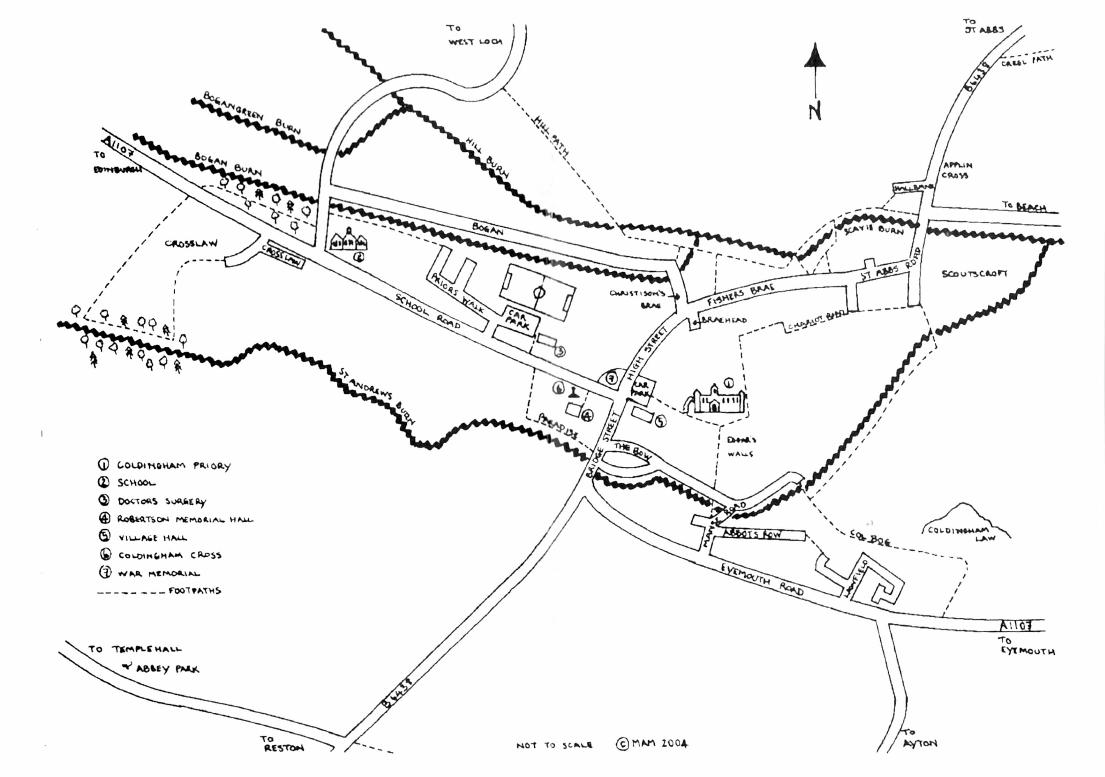
WALKS AROUND & ABOUT COLDINGHAM · WALK 1 Coldingham’s Heritage Trail Distance: approx 2 miles...
23
WALKS AROUND & ABOUT COLDINGHAM INCLUDING THE HERITAGE TRAIL
-
Upload
nguyenminh -
Category
Documents
-
view
214 -
download
1
Transcript of WALKS AROUND & ABOUT COLDINGHAM · WALK 1 Coldingham’s Heritage Trail Distance: approx 2 miles...

WALKS AROUND & ABOUT
COLDINGHAM
INCLUDING
THE HERITAGE TRAIL


CONTENTS 1. Coldingham’s Heritage Trail 2. Cockit Hat circular walk 3. Templehall circular walk 4. The Hill Path circular walk 5. Milldown circular walk*** 6. The Creel Path circular walk 7. Coldingham Moors circular walk 8. Three Burns circular walk 9. Tun Law circular walk 10. Coldingham to the Alewater circular walk including “Around Bee Edge”
alternative route 11. From Coldingham to Eyemouth via Alemill 12. The coastal path from Eyemouth to Coldingham*** 13. St. Abbs Head circular walk 14. “Walking between Coldingham Priory and God’s Mount – Medieval Traces”
by Rennie Weatherhead. This leaflet is for sale in the Priory, see Notice Board for opening times.
***PLEASE NOTE THAT THESE WALKS INVOLVE CROSSING BURNS. IF THERE HAS BEEN HEAVY RAIN THEY MAY BE UNCROSSABLE. WE RECOMMEND YOU CHECK THE CONDITION OF ST ANDREWS BURN BEFORE SETTING OFF. TO DO THIS LEAVE THE CAR PARK TURNING LEFT PAST THE NEW INN AND CONTINUE DOWN PAST THE BUTCHERS SHOP ON YOUR LEFT. THE BURN IS AT THE BOTTOM OF THIS STREET. IF THE WATERS ARE BROWN AND FAST FLOWING WE DO NOT RECOMMEND ATTEMPTING THESE *** WALKS
WE HOPE YOU WILL ENJOY THESE WALKS, BUT ASK THAT DOGS ARE KEPT ON LEADS AT ALL TIMES. LITTER, INCLUDING BAGGED DOG LITTER, SHOULD BE DEPOSITED IN THE LITTER BINS YOU WILL COME ACROSS.
WALK 1 Coldingham’s Heritage Trail Distance: approx 2 miles circular Start and finish: in Coldingham Village Car Park Terrain: Minor roads, unmade track and paths Toilets: Coldingham Village Car Park Coldingham has been a settlement as far back as the 2nd century, when it was marked in Ptolemy’s Roman map of Britain being shown as Colania. The original inhabitants called it Colaun and the final syllable ’ham’ is supposed to have been added by the Saxons. The Venerable Bede called it Coldana or Coludi Urbs, the name used by the monks of that time. St Cuthbert is recorded as visiting whilst on his missionary journeys over 1300 years ago. John of Gaunt was here in 1381 while his Palace of the Savoy in London was being burned by Wat Tyler. . 1. This Heritage Trail starts and finishes at the Village Hall Car Park. 2. Standing in the Car Park looking up the Crossgate you will see the Cross
which was erected in 1815 by the Earl of Home, the chief Superior of the district as regards the feuing of land. Between 1826 and 1833 the town crier, Robin Edgar, made the following Proclamation from the Cross: “Oyez Oyez Oyez! By order of the Right Honourable the Earl of Home Lord Dunglass and Coldingham, all randy beggars, thieves and purse-cutters are debarred from molesting this Fair. God Save the King!” A Charter was granted to Coldingham in 1305 to hold a fair on St Luke’s Eve,18th October, lasting for up to 15 days. As late as 1841, there were two Fairs per year held on the site of the present Cross.
3. Looking behind you towards the Priory gates is the small mortuary or
watch-house in the corner of the graveyard. It was here that vigil was kept by the local men to prevent grave robbers removing bodies to supply the medical schools. A Dr Lowry who lived in the village was convicted and imprisoned in Greenlaw for this crime.
4. Go through the gates and walk down the path under the restored arch
towards the Priory.(THE PRIORY IS OPENED DURING THE SUMMER MONTHS. PLEASE CHECK VILLAGE CAR PARK NOTICE BOARD FOR DETAILS) In A.D.635 a monastic house was founded and burned down in A.D.679, rebuilt and then destroyed in A.D.870 by Danish raiders. It is said that on the approach of these warriors, the nuns cut off their noses and upper lips at the instigation of the Abbess and horrified at such an act, the Danes burned the building to the ground, all within perishing. Thus the saying: ”Cut off your nose to spite your face.”
Little is known between this time and 1098 when King Edgar of Scotland

came to witness the dedication of his new church which he then gave to the monks of St Cuthbert. By 1150, the site had become a monastery. Following its destruction by King John of England, the building of a much larger church was started around 1216. The Priory possessed great wealth and power and held legal sway over the surrounding district. The vicinity of the Priory was a refuge for evil-doers for up to 37 days, the limits of sanctuary being marked by crosses at various points. Though the crosses have disappeared the names are still used today: Whitecross, Cairncross, Friarscross, Crosslaw and Applin Cross.
It is recorded that Mary Queen of Scots and her retinue of one thousand visited in 1566. In 1648, the Priory was besieged by Oliver Cromwell, and only two walls of the Choir were left standing. In the 17th & 18th centuries, many stones from the demolished walls were stolen/removed for private dwellings. A new Church was built incorporating these remaining walls. It had a major restoration in 1855.
5. Standing with your back to the Church doors you will see a path opposite; this is traditionally known as Edgar’s Walls and crosses the site of the old monastic buildings in Chapterhouse and other domestic buildings. Visible to the left is the well and a fireplace-like structure which was probably an aumbry or cupboard. You will also see the remains of night stairs by which the monks would have descended to the Priory for their nightly devotions.
6. Continue on the path (to your left) round the Priory, up through the
Churchyard to a gate in the corner where a pathway leads between two walls. This route is known as the Chariot or Chirrit Way, which is said to have been the road by which the nuns went in covered carts or chariots to bathe in the sea. Continue down this path until you reach the junction with Fishers’ Brae, turn right down to the corner past Scoutscroft Caravan Park and cross over the small bridge..
7. Turn immediately left over this bridge onto the unmade road and continue
towards Burnhall with the Scavie Burn on your left. In 1645, the plague was at Northfield near St Abbs and while this epidemic lasted any communication with the surrounding district was cut off. However, the residents of Coldingham supplied the needs of the stricken village by leaving provisions at Applin Cross near Burnhall Bridge, which were then collected by the folk from Northfield near St Abbs. A mound at Northfield Farm was long avoided by the ploughmen as having been a plague burial ground. Since then, the mound has been opened and skeletons and pieces of clothing unearthed.
8. With the Scavie Burn on your left, cross over the burn by the slatted bridge,
(note picnic area on left which is maintained by a village group known as The Garden Party) follow the path with the burn now on your right until you reach Christison’s Brae on your left. Go up here to the junction with the

Bogan. 9. The Bogan is another historic area in the village. In the mid 19th Century,
this street was called “Weavers Row”. It is said that there were over 50 handloom weavers producing ginghams (striped shirtings), working over 13 hours a day for 6 shillings (30p) per week. However, in 1861 the American Civil War raised the price of cotton so much that handloom weaving ceased to be profitable and the weavers were forced to find other occupations. When the price of cotton fell again, powerloom factories were started. A few weavers, however, continued to work at their trade and supplied a small local demand. The last weaver in the Bogan was John Scott, who died in 1900. You will note that some of these houses are now two storey: these were 20th century alterations. There is also a Victorian water pump or standpipe which brought water from St Andrews Wells, much improving conditions, as previously water had been drawn from the burn.
10. Continue onto an unmade road up to the T junction. On the right you will
notice a fine Georgian house, Bogangreen House. Turn left towards the Primary School, which was built in 1893 at the cost of £2150.
11. Opposite the Primary School Car Park there is an entrance into the
Bogangreen Woodland Walk. The farm landowner has provided use of this for the community and work has been carried out by a group of enthusiasts to provide a pleasant woodland stroll. Following the path you will come to the roadside opposite Crosslaw Caravan Park.
12. Watching for oncoming cars in both directions, cross over the road and
enter Crosslaw Caravan Park at the side of a large metal gate. Keep ahead on the roadway to reach the start of the park’s Woodland Walkway. This initiative was awarded the David Bellamy Silver Conservation Award in 2001. Follow the path down the steps and at a fork keep right on the lower path to walk beside the Buskin Burn. Follow the path beside the burn, climbing the steps. Turn sharp left with the path to return to the main Caravan Park area. Follow the main exit route, turning right back onto the School Road.
13 Going down past the Primary School, pass Priors Walk entrance on the
left, take the pathway just down on your right between the high wall and the bungalow. This takes you down to Paradise and with the burn on your right continue until you come to the main road (note the stone from St Andrew’s Well set into the bridge parapet). In medieval language, ‘a paradise’ was a herb garden. It was on the side of the St Andrew’s Burn that the Benedictine monks had established their gardens. St Andrew’s Well is located further up this burn in the dean west of the village. It was the monks’ water supply channeled through thick leaden pipes.

14. Cross over the road ( looking up to the left, outside the shop front you will see an example of the original pebble road surface). Bear right down towards the burn and follow it round, the newly renovated cottage on the left is where the old slaughterhouse, stables and holding pens were situated. Still keeping the burn on your right, look up between the cottages just before another fine Georgian house and you will see a taller house behind; this is where the “Alms House” was situated. Continue along burnside until you see the road/pathway on your left, go up here through the gates to the Priory and follow the path on your left back to the village Car Park through the Churchyard.
Opposite the Car park is the War Memorial garden. This was redesigned and planted in 1997 as part of the BBC Beechgrove Garden Hit Squad’s ‘Community Corner’ competition. Under the guidance of the Hit Squad’s Walter Gilmour and Jim McKirdy members of the Coldingham Heritage 900, the Community Council and village volunteers carried out all the work which was funded by the programme makers. The Sentinel conifers symbolise the servicemen and the thorny hedging represents the barbed wire of the First World War battles. The Maple tree in the corner is in honour of the Canadian exiles mentioned on the Memorial. The garden is maintained by The Coldingham Society ‘Garden Party’ and was Highly Commended in the Royal British Legion Scotland ‘Best Kept War Memorial’ competition in 2002.
More of Coldingham’s interesting past is to be seen at “The John Wood Collection of Victorian Photographs” exhibited at The Old Smiddy, Northfield Farm, just before St Abbs. Open April to October, 7 days, 10am til 4pm. These photographs were discovered in a potting shed in Coldingham and carefully restored by local resident Bob Thomson. The information herein has been kindly provided by various sources, local and otherwise, for which we thank all those concerned. However, Coldingham Community Council cannot vouch for its accuracy. WALK 2 Cockit Hat Circular Distance: approximately 2 miles Start and finish: in Coldingham Village Car Park Terrain: Minor road , hedgerow’ grassy paths and unmade track Toilets: Coldingham Village Car Park 1. Leave the Car Park through Churchyard gates at the rear, continue under
arch and turn right past Yew trees at front of Priory going through wrought iron gates and go down to junction with road.
2. Turn left with the burn on your right and continue to end where you will
notice over on your right, a wooden bridge crossing the water. 3. Cross this bridge, go up wooden steps and continue up the Colbog Path
(hedgerow path) where you will enjoy lovely sea views over to your left. 4. At the T junction with the Law Farm road turn right and go down until you
come to the main road from Eyemouth. BE AWARE OF TRAFFIC COMING FROM BOTH DIRECTIONS.
5. Turn immediately right onto wide grass verge and walk past the Coldingham stone entry sign, you will now notice a road on your left, cross over to it with care.
6. Walk along this road, round left hand bend and in about 100 yards you will see a route to your right. This is the start of the Cockit Hat.
7. Continue along this grassy then unmade track. Further along there’s a picnic bench in the small wooded area on your right, for a chance to sit and enjoy the view. Walk on until you reach the cross roads.
8. Turn right onto B6438 and with the Templehall Cottages on your left follow the pavement on which is a wooden bench back down to village to junction with A1107 to Eyemouth.
9. Keeping to the left, go over bridge, then cross over to the Butcher’s Shop at this point and continue up towards the New Inn to the Car Park where you started this walk.
WALK 3 Templehall Circular Distance :Approx 3 miles Start and finish: Coldingham Village Car park Terrain: Main road and narrow road Toilets: Coldingham Village Car Park 1. Leave the Car Park and walk up the School Road opposite, passing The
Anchor Pub on your right. Continue up to top with Primary School on your right.
2. To go through the Bogangreen Woodland Walk turn right at the school and opposite before bridge you will see entry to the Woods.
3. Continue along this path which rejoins the main road opposite Crosslaw Caravan Park. Be aware of traffic in both directions.
4. Turn right onto main road and continue up hill past the Caravan Park on your left. You will find a bench at the junction with the Lumsdaine Road on your right, take a moment to view the coastal and inland scenery.
5. Returning to the main road continue for around 400 yards when on your left you will notice a Give Way sign turn into this single track road where you will enjoy spectacular scenery of the coast and the Cheviot Hills.
6. Continuing down this route for about one mile and you will come to a T junction with cottages at Templehall on your left.
7. At this point you have two options, the first to turn left and go back down into the village or the second which is about a mile longer, is to cross over

onto unmade track which is the Cockit Hat (see Walk 2). Continue along this route with lovely views of the village and especially the Priory on your left.
8. In about 300 yards there is a track on your left which will take you back to the road at which you turn left and this will bring you back to the edge of Coldingham.
9. At this point refer to instructions on WALK 2 Cockit Hat Circular and reverse route from junction of Eyemouth Road and Village Entry Sign which will lead you back to the Car Park and the finish of this walk.
WALK 4 The Hill Path Circular Distance: Approx 2 Miles Start and finish: Coldingham Village Car Park Terrain: Main and minor roads and paths Toilets: Coldingham Village Car park 1. Leave the Car Park and turn right along the High Street passing the Spar
shop going down Fishers Brae. 2. At the end of the wall on your left go round to your left and enter a small
Community garden with a picnic bench. 3. Cross burn by wood bridge, up the steps, then turn left crossing burn again
by second wooden bridge. With the burn on your right follow path, passing Christisons Brae on your left, until your reach the wooden bridge.
4. Cross over and climb up steep Hill Path to the top turning left at this point. 5. Follow this road passing the unmade track on your left the ‘Bogan’ and on
past the Primary School to junction with road. 6. Turn left down the School Road to the Car Park in centre of village. WALK 5 The Milldown Circular*** N.B. AS THIS WALK INVOLVES CROSSING A BURN AT TWO POINTS PLEASE SEE FRONT OF BOOKLET FOR INSTRUCTIONS Distance: Approx 3 miles Start and finish: Coldingham Village Car Park Terrain: Main and minor road and grassy paths Toilets: Coldingham Village Car Park and Coldingham Bay 1. Leave Car Park turning right along High Street to Spar Shop. 2. Just past shop turn left down Christison’s Brae and straight down to the
burn. 3. Turn right and follow path with burn on your left until you come to a

wooden bridge. 4. Crossing over this follow the path with the burn now on your right until you
meet the main road junction (Scoutscroft Caravan Park entrance is up on right on opposite side).
5. Cross over this road towards The Sands. At the end of the Caravan Park you will see a narrow single track road to the right, take this.
6. About 500 yards on your right there is a track down to the burn,( IF BURN IS IN SPATE (flood)*** SEE PARAGRAPHS 9,10,11,12 FOR ALTERNATIVE ROUTE) cross over burn and follow the grassy path all the way down to the stoney beach.
7. When arriving on this beach turn left and cross the burn using the large stepping slabs
8. Climb up the steps to the back of the Homelli Knowe (a steep mound). It is said that the monks of the Priory held court here. Another interpretation is Homely Knowe as fishermen coming from the sea were “home now”. At this point you can turn either left or right as both routes will bring you round to the Sands.
9. ***IF THE WATER LEVELS DO NOT PERMIT A SAFE CROSSING OF BURN just continue on single track road, through Milldown Farm Steading. ALL DOGS MUST BE ON A LEAD AND UNDER CONTROL.
10. ***Just past the bungalow on your left you will see a wooden directional sign on your right for the coastal path.
11. ***Taking this path you will see the Youth Hostel on your left and in about 100 yards you will be overlooking the Sands and coastline.
12. ***Follow this path until you come to the Homelli Know, a steep mound. At this point you can turn immediately left to the Sands or follow the path to the right around the Homelli Know which also brings you down onto the sands if the tide permits.
13. Walking along the beach, pass the Café and take road up past the Toilet Block.
14. At top, through the large gate, pass St Vedas and take the path on your right behind hedge.
15. This path will bring you out onto the road at Scoutscroft Caravan Park. 16. BE AWARE OF ONCOMING TRAFFIC FROM BOTH DIRECTIONS. Turn
right and with Scoutscroft Caravan Park on your left continue to the crossroads.
17. Cross over into unmade track with the burn on your left. Continue until you come to the wooden bridge, cross over and with the burn on your right continue until you come to Christison’s Brae on your left.
18. Proceed up Christison’s Brae over junction on right with the Bogan until you reach the High Street.
19. Turn right and proceed back to Car Park.

WALK 6 The Creel Path Circular Distance: Approx 4 miles Start and finish: Coldingham Village Car Park Terrain: Main road,sands and paths Toilets: Coldingham Village Car Park, Coldingham Sands and St Abbs Harbour 1. Leave the Car Park turning right and continue on road and just past the
Spar shop turn left into Christison’s Brae and continue straight down to the burn.
2. Turn right and with the burn on your left proceed to the first wooden bridge and cross over at this point.
3. Continue on this path with burn now on your right and onto unmade road. 4. At the T junction turn left towards St Abbs past Applin Cross Houses on
right. 5. Using the pavement on the right side of the road after these houses,
continue and about 200yards further on you will come to a layby where this pavement runs out. You will see a signpost on the right for the Creel Path. Go down this route between two hedgerows and down at the bottom you will come to a large gate and path to the right, this is the Kinnecker Path. DOGS MUST BE ON LEADS.
6. Follow the Kinnecker Path to the gate at the other end and turn right towards St Vedas Hotel.
7. At St Vedas turn left down towards the sands. There is a fresh water spout on your left, just after which go down a flight of steps on your left before the Toilet Block and onto the beach.
8. Turning left continue to the end of the beach. 9. About 20 yards past the stone cottage on your left you will see a flight of
stone steps, climb these to the top (there is a bench half way up). 10. At the top turn right and walk along the coastal path to St Abbs. 11. At the end you can turn to the right past a large house called Castle Rock
B &B and turn down towards the sea to Seaview Terrace, with a long row of cottages facing the sea .
12. Go to the end of Seaview Terrace and turn right, you will then see the picturesque harbour below with a set of steps leading down towards it.
13. Go down the steps to the harbour where you can purchase refreshments at Springbank Cottage. Returning back up steps, at the top turn right (Red Telephone Box on your right) and follow road with retaining wall on your right. Bear left at end opposite the Village Hall and turn left into Brierylaw. Opposite is the Voluntary Marine Reserve Museum, all ages will find something of interest inside.
14. Continuing along Brierylaw you will pass the Putting Green on your right and at the end turn right.
15. Keep straight ahead up past Creel Court and you will arrive at the end of

the Creel Path which is signposted. 16. Follow this path all the way back to the layby on the Coldingham /St Abbs
road. 17. Turn left and taking this road towards Coldingham, at cross roads turn right
onto unmade track with the burn on your left. Cross over stone bridge and rejoin the main road at the bottom of Fishers Brae.
18. Turn right up Fishers Brae passing the Spar shop and back to the Village Car Park and the finish of this walk.
WALK 7 Coldingham Moors Circular Distance: Approx 6 Miles Start and finish: Coldingham Village Car Park Terrain: Main and minor roads without pavements. Toilets: Coldingham Village Car Park 1. Leaving Car Park go straight ahead past The Anchor pub up the School
Road. 2. Continue past the Primary School on your right and then Crosslaw
Caravan Park on your left. 3. Passing a row of terraced cottages on your left, continue on this road. You
should have lovely coastal views behind you at this stage. 4. You will then pass Edrom Nurseries and then North Falaknowe Farm
buildings on your right. 5. Just past South Falaknowe farm( the next farm on your left) there is a
slight climb to a road junction on your left. Take this road signposted Press Mains Cottages and Cairncross.
6. Continue down this quiet minor road, round the Z bend at Press Castle.(This listed building has now been divided into privately owned apartments).
7. This road will take you through a lovely valley at Press Mains arriving at the crossroads at Cairncross Farm.
8. Turn left onto the B6438 Coldingham/St. Abbs road and follow it all the way back down in the village and Car park. THE FIRST SECTION OF THE B6438 IS NARROW WITH NO VERGE…PLEASE BE AWARE OF TRAFFIC COMING FROM BOTH DIRECTIONS.
WALK 8 Three Burns Circular Distance: 3-4 miles Start and finish: Coldingham Village Car Park Terrain: Main, minor roads and cross country paths Toilets: Coldingham Village Car Park 1. Leave the Car Park turning right down the High Street. 2. Just past the Spar Shop turn left down Christison’s Brae and walk straight
down to the burn. 3. Turn left alongside the burn, crossing it by the footbridge. 4. Proceed up the surfaced path until you reach the T junction of the West
Loch Road which is single tracked. 5. Turn right at this junction and continue up this road for approx 1 mile. 6. You will pass West Loch Farm on the right. Proceed straight past the main
gate to Westloch House (on the right) and the entrance to Whinney Farm immediately opposite.
7. Continue on past he next bungalow on the left (Whinney Lodge) for another 50 yds. And you will find a signpost on the left directing you to the Lumsdaine Road (3/4 mile). Go down through the gate and follow the path through a wooded area. PLEASE KEEP TO THE PATH and KEEP DOGS ON LEADS AT ALL TIMES.
8. Follow this path down past the Conservation Ponds on your right and cross the bridge over the Mo!! Burn.
9. The path then continues straight on uphill towards a coniferous plantation where you turn right and follow an open ride to the far (NE) corner of the conifers.
10. The path then turns left across a ditch and leads uphill along the north edge of the wood, between the conifers and the stone dyke. It emerges by a farm steading onto the Lumsdaine Road.
11. Turn left and continue down this road which will eventually bring you back to the junction of the A1107. There is a bench here.
12. Turning left follow this road down to the village past Crosslaw Caravan Park and down the School Road to the village centre and Car Park.
WALK 9 Tun Law Circular VERY IMPORTANT NOTICE THIS WALK IS NOT OPEN DURING APRIL OR MAY AS THE SHEEP LAMB ON THE HILLSIDES DURING THESE MONTHS

WITH THE KIND PERMISSION OF THE FARM LANDOWNER WE HAVE BEEN GIVEN ACCESS TO THIS SCENIC AND PLEASANT WALK OVER HIS SHEEP GRAZING PASTURES SUBJECT TO THE FOLLOWING UNDERSTANDINGS A) ROUTES WITH DIRECTIONAL ARROWS MUST BE ADHERED TO AT ALL TIMES…. DO NOT LEAVE THESE DESIGNATED PATHS B) DOGS MUST BE ON LEADS AT ALL TIMES C) LITTER MUST NOT BE DROPPED Distance: Approx 5 miles Start and finish: Coldingham Village Car Park Terrain: minor roads and grazing clifftop pastures Toilets: Coldingham Village Car Park 1. Leave Coldingham Car Park and walk straight ahead up School Road for
about 400 yards turning right at the Primary School onto the West Loch Road (single track tarred road)
2. Following this road it drops down into Bogan dean crossing the burn bridge, then climbs to open higher ground. Continue on this road for about a mile.
3. Pass the West Loch Farm on your right directly after which there is a field on your right… before the West Loch House (fishing & self catering cottages) look for the stile over the fence/hedge with a wooden finger post marked FOOTPATH
4. Climbing over this stile, follow the fence on the left, passing timber chalets and a small woodland still on your left.
5. Continue walking down this fence, crossing two further stiles. 6. The jetty and boat house at Coldingham Loch can be seen over to your
left. 7. There is a sign after crossing the second stile directing you to take a sharp
right to lead you to a five-bar gate. 8. Proceed through this gate. (MAKE SURE YOU SECURE IT SHUT AFTER
PASSING) and go onto a farm track with a sign directing you to turn left. 9. Turning left walk up this farm track for about 200 yards until reaching a
gateway, where the track turns sharply to the left. (You will see the Admiralty Distance Posts immediately ahead – a useful marker for the walk).
10. Proceed along this farm track following the fence on your left and Coldingham Loch will come into view again.
11. Continue along this track which follows the right-hand side of the Loch to the furthest end. DO NOT CROSS THE FENCE ALONG THE SHORE OF THE LOCH AS THIS IS A PRIVATELY OWNED FISHING LOCH.
12. Where the track turns sharp right at a gate and fence walk straight ahead through the gate bearing to the right and climb up TUN LAW. The top of

the Law makes a great viewing point for the cliff formations along the coast which are amongst the highest and most ancient in the region. The Law also contains the remains of an ancient settlement.
13. Now proceed in the reverse direction. 14. Following the fence on your left, WHICH BORDERS THE CLIFF EDGE
you arrive down at a ‘kissing gate’, go through this and over a small bridge with the cliffs and sea on your left.
BE ADVISED TO KEEP ON THE LANDWARD SIDE OF THE FENCE FOR THIS ENTIRE STRETCH OF THE WALK 15. Follow the path uphill. The Admiralty Distance Poles will be higher up on
your right where you will find yourself in open pasture usually stocked with sheep. It falls gently towards the sea.
16. Proceed to the bottom left hand corner to a single step stile…THIS CAN BE VERY SLIPPERY WHEN WET…TAKE GREAT CARE.
17. On crossing the stile follow the fence which goes to your right uphill with the Admiralty Distance Poles also on your right.
18. You will then arrive back at the farm track see para 3 . 19. Retracing your steps go through gate on this track and securing it once
more continue down this track going back into field with woodland now on your right. Cross over stiles passing Timber Lodges on your right and back over the last stile onto the road.
20. Turning left continue on this road til you pass the Primary School and at the road junction just past it, turn left back down the School Road to the village centre and Car Park.
WALK 10 Coldingham to the Alewater Circular Walk including “Around Bee Edge” alternative route Distance: approx 4 miles Start and finish: Coldingham Village Car Park Terrain: Roads and grassy footpaths Toilets: Coldingham Village Car Park Recommend strong footwear for this walk 1. Leave the Car Park through the Churchyard gates and down towards the
Priory. 2. Turn right at the Priory door, go through the metal gate and down the path
which leads to The Bow. 3. Cross over the tiny bridge opposite and carry on straight up through
houses to the junction with the main Eyemouth Road. 4. Turning left cross over the road on to the pavement TAKE GREAT CARE
AS THIS IS A FAST STRETCH OF ROAD. Follow the pavement past Lawfield on your left you will note that the pavement ceases to be.
5. Walking along the grass verge you will come to a road to the right take this route.

6. About 500 yards along this road you will see a path on your right with a mobile telephone relay station.
7. Continue down this path which can become a bit overgrown until you come to a small wooden structure over the ditch.
8. The path continues with the ditch on your right, turning sharp left after about 10 yards.
9. KEEPING ALL DOGS ON LEADS follow the fence. There are three stiles to cross on this section.
**AT THIS POINT IF YOU FIND THE ALEWATER UNCROSSABLE GO THE ALTERNATIVE ROUTE ROUND BEE EDGE WHICH IS LISTED AT THE END OF THIS DESCRIPTION.** 10. The path then goes down a slippery slope to the Alewater which can be
crossed with care. If this is not possible please take the directions listed at the end of these walk details.
11. The route then winds its way up hill along the side of a plantation which can be used for shoots in season.
12. Crossing over the ditch at the end of the path stay close to the edge of the field straight ahead until you reach the tarred single road near the Whitfield Cottages (up to right on opposite side).
13. At this point you have two options the first being to turn right and continue to the T junction with the B6438, turning right and continuing on this road back down to Coldingham.
14. The second option is on leaving the field turn left and continue all the way down this road to the T junction.
15. At the T junction turn left over bridge and continue along this road until you reach the outskirts of Coldingham opposite Lawfield at the junction with the Eyemouth Road.
16. Turn left passing Lawfield on your right and then take the first right, Manse Road, and going straight down you will cross a tiny stone foot bridge.
17. Over this bridge you will notice a track opposite leading up to the Priory. 18. Go up this route and in front of Priory turn left taking the path through the
Churchyard back to the Car Park. ** ALTERNATIVE ROUTE ROUND BEE EDGE THIS WALK HAS BEEN KINDLY SUPPLIED BY THE FARMER AT BEE EDGE, IT WOULD THEREFORE BE APPRECIATED IF DOGS ARE KEPT ON LEADS AT ALL TIMES AND WALKERS KEEP TO THE WAYMARKED PATHS PROVIDED.
Crossing over the third and last stile at the end of line of beech trees turn immediately right following the track between gorse bushes and continue keeping the field fence on your right. In about 200 yards, you will see a wooden field gate up further on your right, you will then bear left taking the steep path down between the gorse. You will come down to an open flat area, (note the wildlife pond to your left). Walking ahead keeping the slope and gorse on your right go through the metal gateway at end and turn

immediately right on the path. A small burn will now appear on your left. Continue up this path alongside the burn crossing over it by the slatted bridge and walk towards the wooden fence ahead behind which there is a stand of new trees. Turn left at this point and go up the slope and keeping the field fence on your right continue around this field perimeter. You will notice over on your right Bee Edge Farm and cottages. Continue until you reach a corner with a field gate on your right and fence opposite with hedge. Turn left at this point and further down cross the stile near pole. Keeping the field fence on your right with gorse on your left continue until you come to a wooden fence near an electricity pole and climb over, TAKING CARE IT CAN BE SLIPPERY, and with the fence still on your right (small field below on your left) continue down towards the field corner and trees. Cross over dip and turn immediately right and continue up into this stand of trees with fields on your right and left. At the top, follow the path into wooded area and go towards right field bearing round large gorse clump which will now be on your left. Then crossing over the slatted bridge bear towards the left again and proceed down through the avenue of trees to the gate at the roadside REMEMBERING TO CLOSE THE GATE turn right onto the B6438 TAKE GREAT CARE AS THIS IS A FAST AND BUSY SECTION OF ROAD which will take you back to the village. On reaching the junction in Coldingham with the Eyemouth A1107 keep to your left and go up Bridge Street past the New Inn where the Car Park is on your right.
WALK 11 From Coldingham to Eyemouth via Alemill Distance:4 miles approx Start: Coldingham Village Car Park Finish: Eyemouth Co-op Car Park Terrain: Minor tarred single track roads Toilets: Coldingham Village Car Park and Eyemouth Co-op Car Park This is a lovely scenic walk to Eyemouth taking you inland on very quiet roads, you may wish to take the local bus service back. For the timetable please refer to the details in the bus shelter in Coldingham Village Car Park. 1. FOLLOW THE INSTRUCTIONS ON WALK 10 ‘OVER THE ALE TO
WHITFIELD’ Paras 1 to 6.
2. Do not take the path but staying on the road continue past cottages on your right and down through the farm steading at Whitecross (the road bisects this farm).
3. Climbing up to the top from this farm you will get lovely coastal views and on a clear day you will also catch sight of the Cheviot Hills inland.

4. Passing more cottages on the right and Alemill Farm the road dips down to a small bridge.
5. Just before the bridge, on the left there is a single track road which will take you through rolling countryside down a single track road to Eyemouth.
6. At Eyemouth cross over the main A1107 and go down into Eyemouth Centre.
7. The bus stop is just before Northburn Garage on your right. If you continue down this road for about 50 yards the Co-operative Car Park is on your left with toilets and further on several places for refreshments before the journey back by bus or by Walk 12 using the coastal path.
WALK 12 The coastal path from Eyemouth to Coldingham *** THE MILLDOWN BURN CAN BE DIFFICULT TO CROSS IF THERE HAS BEEN HEAVY RAIN Distance: approx 4 miles Start: Coldingham Village Car Park Terrain: Tracks and paths Toilets: Coldingham Bay and Eyemouth Co-op Car Park BUS TIMETABLE IN COLDINGHAM VILLAGE CAR PARK BUS SHELTER 1. Take a bus from the Car Park in Coldingham to the Co-op Car Park in
Eyemouth. 2. Cross the Car park to the Promenade and turning left cross the beach to
climb the steps to access the path around the Caravan Park. 3. At the end of the Caravan Park go left along the cliff and then take the
footpath on your right . 4. Follow the path around the coastline and across fields (there are three
stiles to cross over). 5. Having crossed the Gully you will then take steps down onto Linkum
Shore. 6. Walk to other end of Shore where there is another set of steps up to the
path which will then take you to Milldown beach accessed by another set of steps.
7. Crossing over this stony beach you will see a grassy path up to the left. Take this and follow it passing the Cole Mill buildings (no longer working) down on your right.
8. You will come to the burn…cross with care when in spate (flood) and at the narrow road turn left.
9. This road joins the main road to the Beach just below Scoutscroft Caravan Park.
10. Continue to the cross roads and cross over into the unmade road opposite following it round over a small bridge to the bottom of the Fishers Brae in

Coldingham. 11. Go up the Fishers Brae, past the Spar shop and back to the Car Park. WALK 13 St Abbs Head Circular Distance: approx 4 miles Start and finish: Northfield Car Park Terrain: Minor roads, rough tracks and coastal paths Toilets: Northfield 1. Leave Car Park going down in front of The Old Smiddy and over stile onto
path down side of field which runs parallel to road. 2. At the end of the path facing high stone wall turn left and follow path to cliff
tops. 3. The route then descends into Wellmouth then along to the stile at the
bottom of Kirk Hill. 4. At this point you can climb Kirk Hill and rejoin the path or walk round it by
the path. 5. Before the Mire Loch climb up towards the Lighthouse going round the
landward side of this joining its access road. The Mire Loch was dug out by St Abbs fishermen. At one time they thought it could be made into a harbour with the sea at both ends.
6. Follow the access road down with the Mire Loch on your left.You will then see a small inlet called Pettico Wick.Take time to notice the structure and strata of the cliff face to the left of this.
7. Go down to the bottom of the road and using the path you can walk along either side of the Mire Loch.
8. At the end of the Loch take the track on your right that leads you back up the road and following this through the gate at the Northfield Cottages. About 100 yards along on the left is the Car Park.
9. Then why not visit the Information Centre or browse through the shops and the John Wood Victorian Photograph Exhibition portraying life in and around the area in Victorian times. Refreshment is also on offer at The Old Smiddy.
* * *

Published 2007 by Coldingham Secondhand Bookshop
The information herein has been kindly provided by various sources, local and otherwise. Our thanks go especially to Peter Knox for providing the excellent front cover drawing and to Linda Russell and her team for their tireless efforts in originating this booklet and keeping it up to date. Our thanks go also to those who have allowed access to their property and those who readily shared their knowledge of the village and its environs. Whilst every effort has been made, ‘Coldingham Secondhand Bookshop’ cannot vouch for the accuracy of the content of this booklet.
WE WOULD LIKE TO THANK THE FOLLOWING BUSINESSES WHO HELPED FINANCE THIS REPRINT IN 2007

number four .... contemporary art and craft gallery an informal and relaxed space, allowing the opportunity to purchase some of the most inspiring and original contemporary artwork from both sides of the border. next to the smiddy coffee shop.
open thursday-sunday 10am-5pm north field farm st.abbs
telephone 018907 71111

www.thesmokehousegallery.com
St. Ellas Place Eyemouth TD14 5HP
018907 52116 07906 064982
The Old Smiddy St. Abbs
Tel. 018907 71707
Morning Coffee - Light Snacks Lunches
Delicious homemade foods featuring local seafood
Pick your own strawberries (in season)
Jennifer Doherty