WALKER’S GUIDE AND THE CHURCHES - The Meon … · WALKER’S GUIDE AND THE CHURCHES Section 1...
24
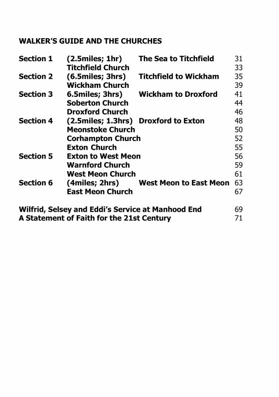
WALKER’S GUIDE AND THE CHURCHES Section 1 (2.5miles; 1hr) The Sea to Titchfield 31 Titchfield Church 33 Section 2 (6.5miles; 3hrs) Titchfield to Wickham 35 Wickham Church 39 Section 3 6.5miles; 3hrs) Wickham to Droxford 41 Soberton Church 44 Droxford Church 46 Section 4 (2.5miles; 1.3hrs) Droxford to Exton 48 Meonstoke Church 50 Corhampton Church 52 Exton Church 55 Section 5 Exton to West Meon 56 Warnford Church 59 West Meon Church 61 Section 6 (4miles; 2hrs) West Meon to East Meon 63 East Meon Church 67 Wilfrid, Selsey and Eddi’s Service at Manhood End 69 A Statement of Faith for the 21st Century 71
Transcript of WALKER’S GUIDE AND THE CHURCHES - The Meon … · WALKER’S GUIDE AND THE CHURCHES Section 1...
WALKER’S GUIDE AND THE CHURCHES
Section 1 (2.5miles; 1hr) The Sea to Titchfield 31 Titchfield Church 33
Section 2 (6.5miles; 3hrs) Titchfield to Wickham 35 Wickham Church 39
Section 3 6.5miles; 3hrs) Wickham to Droxford 41 Soberton Church 44 Droxford Church 46
Section 4 (2.5miles; 1.3hrs) Droxford to Exton 48 Meonstoke Church 50 Corhampton Church 52 Exton Church 55
Section 5 Exton to West Meon 56 Warnford Church 59 West Meon Church 61
Section 6 (4miles; 2hrs) West Meon to East Meon 63 East Meon Church 67
Wilfrid, Selsey and Eddi’s Service at Manhood End 69 A Statement of Faith for the 21st Century 71

SECTION 1
TITCHFIELD HAVEN TO TITCHFIELD CHURCH
Introduction This is a simple 2½ mile walk up a flat public footpath, beside a canal, through the edge of the Titchfield Haven National Nature Reserve. As it takes only about an hour, it is suggested that you combine it with a visit to this excellent Nature Reserve.
Location Head for the coast at Hill Head and follow the brown signs "Bird Reserve". The River Meon flows in to the sea at the tiny Hill Head Harbour, which is now a sailing club. Hampshire County Council runs the National Nature Reserve, where there are a Visitor Centre, several hides for watching the birds, and a restaurant serving light meals. One could spend a whole day here and it is highly recommended. The Reserve is open Wednesday Sunday and, at the time of writing, the entrance fee was about £3. 'Phone: 01329.662 145.
Parking Very near to where the walk starts, there is free parking along the seafront; an alternative is the car park beside the Hill Head Sailing Club.
The Walk The start is about 500 yards to the west of the harbour (GR 530 023). Enter the small gate, beside the "Public Footpath" finger sign.
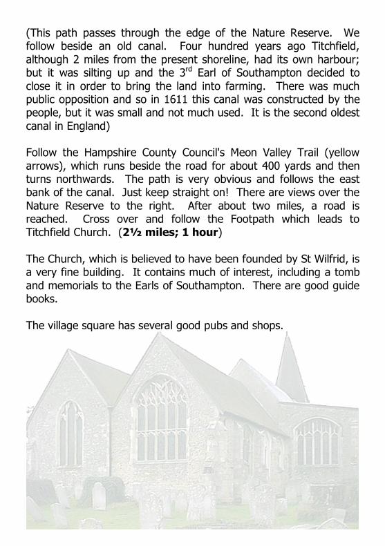
(This path passes through the edge of the Nature Reserve. We follow beside an old canal. Four hundred years ago Titchfield, although 2 miles from the present shoreline, had its own harbour; but it was silting up and the 3 rd Earl of Southampton decided to close it in order to bring the land into farming. There was much public opposition and so in 1611 this canal was constructed by the people, but it was small and not much used. It is the second oldest canal in England)
Follow the Hampshire County Council's Meon Valley Trail (yellow arrows), which runs beside the road for about 400 yards and then turns northwards. The path is very obvious and follows the east bank of the canal. Just keep straight on! There are views over the Nature Reserve to the right. After about two miles, a road is reached. Cross over and follow the Footpath which leads to Titchfield Church. (2½ miles; 1 hour)
The Church, which is believed to have been founded by St Wilfrid, is a very fine building. It contains much of interest, including a tomb and memorials to the Earls of Southampton. There are good guide books.
The village square has several good pubs and shops.
SECTION 2
TITCHFIELD CHURCH TO WICKHAM CHURCH
Introduction This walk of about 6½ miles (10 km) takes us out of Titchfield, passes the Abbey, crosses several roads and involves climbing over numerous stiles. It provides glimpses of the River Meon and of fast roads! It takes about 3 hours.
Parking As you enter the village from the A27, turn right into a small road which leads to the Community Centre where there is plenty of free parking. Opposite the beginning of this small road, there is a sign "Church Path" which takes you through the churchyard to the Church. St Peter's is an impressive building which could have been founded by St Wilfrid in 680 (there are certainly similarities with other churches in Northumbria) and there are important Saxon remains both of Wilfrid's original church and of the 11 th C rebuild. The Church, which is open during the day and has explanatory leaflets, contains much of interest including a fine tomb of one of the Earls of Southampton.
The Walk Start at the Church and walk up Church Street into The Square, where there are several good pubs and shops. Passing the "Queens Head" on your left, go straight on into a small alley; this becomes a path which runs along the back of the Community Centre where you may have parked. This brings you to the busy A27; cross straight over, taking great care! (Alternatively, turn right down the road so as to cross at the traffic lights; go up Titchfield Lane and rejoin the walk at the "Fisherman's Rest"). On the other side of the road

you will find a path. Go over a stile, and along a track through a sports area.
(There is a good view of the 13 th century Titchfield Abbey which, after the Dissolution, became the home of the Earls of Southampton. The 3 rd Earl was a patron of Shakespeare who is believed to have written "Love's Labour's Lost" while staying in the Abbey. The 15 th century timberframed Tithe Barn is said to have been the setting for the first performance of "Romeo and Juliet")
Cross another track; after 50 yards, turn right and go down the lane passing the Abbey Garden Centre to the main road, which is Titchfield Lane; turn left. Across the road is the "Fisherman's Rest", which is recommended. On your left is the Gateway to the Abbey, where times of opening are displayed. Cross the road and go down Fisher's Hill, over the River Meon; after 50 yards, turn left into a Bridleway by Abbey Farm. This is a pleasant treelined lane which goes under a railway bridge, and passes the Henry Cort School buildings and its allweather sports pitches. After about ½ mile, at some tilecoated white cottages on the left, bear left and go past "Fareham Park Cottages". This brings us to a housing estate: go straight on along a lane for ½ mile to a road, and turn half left to join a Bridleway which leads to the M27 (with much car noise!). Go down some concrete steps and under the motorway.
Immediately after the subway, turn left and walk beside the M27 for 150 yards. Beside a gate, the wooded path turns right, away from the motorway, towards a paddock. Fork left, then turn right, passing "Ironmill House". On entering a farmyard, turn left along a tarmac lane. At the river, look right to see an artificial lake this is the site of the old Funtley ironworks and continue on, passing "Ironmaster's House".
(The first record of an ironworks on this site was in the 16 th century. Henry Cort (1740 1800) built up a foundry here and became one of the greatest innovators of the Industrial Revolution. He also

introduced "puddling": a process of packing clay at the bottom and sides of canals, so that they did not leak)
After about 150 yards, look out for a Footpath sign on the right; climb over a stile and follow the footpath through a copse. Following the yellow arrows, climb over a stile and go through a paddock, then over another stile and through a market gardener's junk yard, and over several more stiles and through paddocks (patting friendly horses). Keep following the yellow arrows through several fields, towards Knowle Hospital on the skyline. Eventually, you come to a field beside the rather small River Meon: keep straight on, as the footpath goes through a gap in a hawthorn thicket on the far side of the field. Over yet another stile, you come to a small road which crosses the river by a bridge and joins a major road, Titchfield Lane, at a Tjunction on your left.
Cross the small road and go straight on, keeping to the wide verge beside Titchfield Lane, for about 250 yards. On approaching a farmhouse (Great Funtley Farm), turn right through a steel kissing gate; follow the drive which passes a lovely white house (Funtley Mill), and cross the wooden footbridge over the river. The path then rises through woodland to emerge at Mayles Lane; turn left towards Knowle Village.
(The original Knowle Hospital was a large Victorian mental institution. Recently, it and its grounds have been developed to form a new village, Knowle Village, with about 300 houses and apartments. Walkers choosing to keep to Mayles Lane will pass the hospital cemetery on the left; this was recently restored with a woodland walk, and it contains the graves of over 5500 patients and staff who died in the 100 years of the hospital's existence)
Our walk takes us round this new village. Continue along this road for about 150 yards, and then turn right (Footpath) on to a footbridge over a deep railway cutting (single electric line: Fareham, Botley, Southampton). There are yellow footpath arrows. Immediately after the bridge, turn right along a

narrow path for about 100 yards. At the end, when faced with the choice of two stiles, turn left and follow the wellsigned footpath along the edge of a field for about 700 yards. Turn left again at the next stile and follow this field edge for another 700 yards. Cross the village access road and take the path (yellow arrow) leading into a wood. After 40 yards, bear right; then after 100 yards, at a track junction, turn left and follow the broad path beside a barbed wire fence and passing an electricity pylon. Rejoin Mayles Lane at a kissing gate and turn right along it, for about 950 yards (1km) to Wickham.
Cross the main road and turn left under the railway bridge. There is now a choice: the village, or the watermeadows. For the village, continue on up a slight rise to enter the 13 th century Wickham Square where there are pubs and shops. If you have done this, you can continue to the end of the Square and turn right; go down a hill passing lovely old houses; cross the bridge over the River Meon, and there in front of you is the Church across the other side of the busy A32.
Otherwise, cross the main road and join a path (signposted Water Meadows) running beside the river. This gravelled path crosses the river by a bridge and climbs the steps leading up on to the embankment of the disused Meon Valley railway. Turn left along this embankment and at the first bridge leave the track by the steps on the right, in order to visit Wickham Church.
(The Church of St Nicholas is normally open during the day Monday Saturday, and for Sunday services. Parts of the building date back to 1120. There are historic paintings and monuments, and a memorial to William of Wykeham, Bishop of Winchester, Founder of Winchester College, and Chancellor of England. There are guide books.
Total for Section 2: 6½ miles, allow 3 hours for a leisurely pace.

SECTION 3
WICKHAM CHURCH TO DROXFORD CHURCH
Introduction This walk of about 6½ miles (10 km) follows the disused Meon Valley Railway line for about a third of the distance (it is flat, gives glimpses of the River Meon, is safe, and there is no suitable alternative). This is classified as a National Cycle Track and it is possible to follow it all the way to Droxford. But this walk will make a detour to the west through a private park and across agricultural fields, giving lovely views of the Meon Valley. After crossing the river, it reaches Soberton where there is the possibility of both spiritual and "inner" refreshment! We then follow the river up to Droxford. Allow about 3 hours for the actual walk.
Parking As longterm parking in Wickham Square is restricted, the recommended free carpark is beside the old railway station. If you want to start by visiting Wickham Church, from this carpark, come down to the road and turn left. Go under the old railway bridge, and you will see the Church across the other side of the busy A32. The Church of St Nicholas is mentioned at the end of Section 2.
The Walk From the Church, cross the A32 and climb up the steps on to the old railway embankment; turn right. A bridge takes you over the River Meon, and you will soon come to the spot where Wickham's old railway station was sited (near where you may have parked). Hampshire County Council is responsible for the Meon Valley Trail and they have provided a helpful information board. Cyclists find

this to be a good and safe route, which could be followed all the way from Wickham to West Meon.
(The Meon Valley Railway, which was completed in 1903, ran from Alton to Fareham. Its passenger service ceased in 1955 but the line was used for freight until 1968. In early June 1944, history was made at Droxford station. Winston Churchill and the War Cabinet met with General Eisenhower and his staff, plus General de Gaulle, to make the final plans for the invasion of France on DDay)
The track, which is of course wide enough for people to walk sociably, is enclosed with trees and so there are few views. Having crossed the river, you will eventually go under two bridges carrying minor roads; a third bridge takes you under the A32. You are now on the edge of Bere Forest. The fourth bridge is at the site of the old Mislingford station. The fifth bridge, constructed with metal girders, is where you will leave this Trail.
Immediately after this bridge, turn left up a bank, waymarked with green arrows, "Soberton & Newtown Millennium Walk". Turn right on the road passing Soberton Mill Cottage and the impressive Soberton Mill House, which has the old mill building beside the River Meon, which you cross by a footbridge. Follow the path to the to the A32. Cross carefully over this main road and enter the estate of Holywell House (there is a Footpath finger). Walk up the drive, turning right to go round the side of the house, and pass the stables. Continue on along this other drive, through a wood of oak trees, and so out to a country road (Cotts Lane); turn right for 100 yards and then left at a T junction beside a house called "Dormers". At the end of this small road, pick up a track which goes across an agricultural field; keep to it as it winds, and turn left at a crossing track. There are lovely views of the Meon Valley. Just before a pylon, turn right and follow the path beside the route of the power line down to the A32; cross over.
The path leads to the River Meon which you cross by a footpath; turn left and walk beside the river; go under the old railway bridge and join a country road. After 70 yards at a Y junction, turn left off it through a kissing gate into a field, and walk across this field towards Soberton Church. Aim for the far righthand corner where there is a stile. (Time taken: about 2 hours).
(Now you have to make a decision! To the left is the lovely Church, which is mainly 13th C and is dedicated to St Peter. It is open during the daytime and has an information board. To the right is the "White Lion", which is an excellent country inn serving good snacks and more substantial meals and "real" ales!)
Our route continues across the village green to a minor road; turn left and follow it down a hill (ignoring the "Meon Valley Trail" sign), over a railway bridge, to a bridge over the River Meon. Immediately before this bridge, turn right over a stile following the "Wayfarers' Walk" (a 70 mile regional route from Emsworth to Inkpen Beacon), through lush water meadows. Keep to the "W W" route signs. After about 1000 yards and another stile, turn left over the river; go through a kissing gate into an avenue which takes you up to Droxford Church. Total for Section 3: about 3 hours walk of about 6½ miles.
(Since Norman times Droxford, originally called Drokensford, was the centre of the area and until the 1970s of the Droxford Rural District; so it is fitting that the Church of St Mary & All Saints should be such a fine Norman church. It is open during the daytime and there are information booklets)
On leaving the Church through the churchyard, you enter the little square and pass the village hall to reach the A32. If you are looking for refreshment, there is a choice: turn left and cross over to the pavement for the "White Horse" pub, about 300 yards or turn right for about 400 yards to the "Baker's Arms", which also contains the Post Office.

SECTION 4
DROXFORD CHURCH TO EXTON CHURCH
Introduction This walk of about 2½ miles (4 km) takes in the group of four churches: Droxford, Meonstoke, Corhampton, and Exton. These are four lovely and important churches; each is worth a detailed visit and there are good information guides. Droxford Church is mentioned at the end of Section 3. For the most part, the route is close to the River Meon. Time: 1¼ hrs.
Parking Free parking is available in the little Droxford Square, near the Church and Village Hall.
The Walk Go down the churchyard on the north side of the church, and through a wicket gate and turn left on the indicated "WW" path to the north. Over a stile and pass the fine old mill. This pleasant path widens out to become Mill Lane and, after about 400 yards, reaches a road; turn left for 50 yards, and then right at a Footpath finger beside Brockbridge House. Follow the path through a wood for about 600 yards to a road; continue along this road for about 400 yards, passing Meonstoke House, and after another 100 yards turn left (Footpath sign) through a gate and follow this footpath past Meonstoke School. Walk up the High Street with its pleasant houses; at the top, turn left and go down the hill. Just before the "Bucks Head" (which is recommended for food and drinks), turn right up a lane to the 13 th
C St Andrew's Church.

Coming out of the lichgate of Meonstoke Church, turn right and take the indicated Footpath to the left of the garden hedge belonging to St Andrew's Cottage. After 50 yards, cross over the River Meon by a footbridge and so out to the A32. Turn right and, after 100 yards, keep right into Warnford Road. Cross over the road to the Church.
(Corhampton Church is of national importance, as being one of the best surviving examples in the country of a small almost untouched Saxon church which also contains important 12 th C wall paintings depicting the life of St Swithun. The churchyard contains a famous yew tree which is over 1000 years old and a Roman sarcophagus. The church is open daily and has a detailed guidebook)
After visiting the Church, retrace your steps to the A32 and turn left following the churchyard wall. Just before the bridge, turn left up a drive; then, after 50 yards, fork right up a grassy track between some fine old houses. Climb over a stile (HCC footpath signs) and follow the footpath through a paddock. Keep to the left and go through a metal kissing gate. Follow this grass footpath out to a road (Allens Farm Lane) and turn right along it. At the end, turn right by "Beacon Cottage"; then, after 150 yards, turn left into a road which takes you to the pretty church of SS Peter & Paul, Exton, which was built in the 13 th C and almost completely rebuilt in 1837.
Section 4: 2½ miles; allow 1¼ hrs for the actual walk.

SECTION 5
EXTON CHURCH TO WEST MEON CHURCH
Introduction Warnford Church is set in Warnford Park, which is privately owned. The only entrance, and that for walkers only, is through the Park Gates just off the A32 near the village. The distance between the Exton and Warnford churches is only 1½ miles. But it would be both noisy and dangerous to walk there beside the busy A32 and so is not recommended. Instead, because pleasure and safety are paramount, we suggest a detour to the east. The continuation to West Meon is much easier and quieter, across some fields. For this walk of about 5 miles, allow 2 hours.
Parking On the road near Exton Church, but please consider the local dwellers! The "Shoe" is an excellent country pub, with very good food and drinks, and it has a garden beside the river.
The Walk Exton Church to Warnford Church (3 miles; 1½ hours) Starting from the Church, turn left along the minor road which soon goes round a sharp lefthand bend. Follow this road, beside the River Meon, for about 600 yards. This brings you to the "Grinch" where the river goes under the A32. (From here, the entrance to Warnford Park would be just over a mile taking the road; but, as suggested in the Introduction, we will make a detour to the east along the old railway track)

So cross over the A32 and follow the footpath (yellow arrows; the sign says "No Through Road"!). Cross the river and, after a right hand bend, turn left over some sleepers to follow a small path beside a stream. Head towards Old Winchester Hill on the skyline. This path leads, after about 600 yards, to the old railway line. Stop to admire the brickwork of the railway bridge. Climb up steps on to the embankment; turn left. You are now back on the old Meon Valley Railway, which ran from Alton to Fareham and was closed in 1968.
It is easy and comfortable to walk along this embankment, with views of Old Winchester Hill to the right and of Beacon Hill to the left. After about ½ mile, because the bridge has been removed, it is necessary to come down off the embankment; cross over Peake Farm lane, and climb back up again. After another ¾ mile, we enter a cutting and, soon, will see a bridge carrying a road over this cutting. Go under the bridge and, after 150 yards, turn sharp left up a path which climbs the embankment back towards the bridge. This comes out on to a road; turn right. After rising for a couple of hundred yards, this road drops down into the village of Warnford. Opposite, across the A32, is the "George & Falcon" which provides meals and drinks.
If you feel that you do not yet deserve refreshment and wish to go on to the Church, continue on, passing the 'pub, in a southerly direction, following the pavement beside the A32. Cross over the river bridge and continue as far as the pavement goes. By a grassy area with a lovely tree, cross over the Old Winchester Road and walk along the left hand side of a watercress bed. Continue southwards along the edge of the A32; for safety's sake, please face the traffic and keep in!
After about 200 yards, the Park Gates will be seen on the left. Cross over. This is a private Park but there is a public footpath to the Church. To the right of the big gates, there is a small "wicket gate". Go through and follow the drive and the signs to the Church. But stop at the bridge over the River Meon, to admire the grounds

which are said to have been landscaped by "Capability" Brown in about 1760. This work was done for the owner of an Elizabethan manor which was sited on the plateau to the left; it was knocked down in about 1955.
(The Church of Our Lady of Warnford was founded by St Wilfrid in 682; a few Saxon stones were included in its rebuilding, and a Norman tower was added. A leaflet provides information. Beyond the Church is St Johns House, which is the ruin of an early 13 th century mansion. There is only one other in England, at Oakham in Rutland)
Warnford Church to West Meon Church (2 miles; ½ hour) Retrace your footsteps to the "George & Falcon" you are certainly justified in paying a visit now! Just past the 'pub car park, take the lane to the left; cross the bridge over the River Meon, and turn right in to Lippen Lane. Continue along this lane, passing the village playground and several houses; follow round to the right and pass a lovely thatched house ("Longthatch").
After about 300 yards, look out on the right for a Footpath sign which takes you up a bank and over a stile. This path goes through two fields, with lovely views of the Meon Valley, and over a couple of stiles. Continue eastwards towards West Meon Church. The path drops down into a modern housing development of old farm buildings. Continue virtually straight on (Footpath finger) up a narrow path beside a high wooden fence. Climb over a stone "stile" into the Churchyard and so to the Church.
(Almost straight in front is the large rectangular tomb of Thomas Lord, who founded Lords Cricket Ground and who died in the village. Turn left towards the South door of the Church of St John which was rebuilt in 1846, to replace a medieval church. It was one of the first commissions for the young Giles Gilbert Scott. There is a leaflet. West Meon and Warnford form a joint benefice)
Total for Section 5 : 5 miles in about 2 hrs.

Refreshment can be obtained down in the village where there are two pubs: The "Red Lion" beside the A32 and The "Thomas Lord" in the High Street, where there are a PO and a stores.
SECTION 6
WEST MEON CHURCH TO EAST MEON CHURCH
Introduction The two Meons, which are about 4 miles apart, are connected by a minor road which follows beside the infant River Meon. Our route takes us along a pavement beside the road and river for nearly a mile. Then, on the outskirts of the village, it turns right up Coombe Lane. Instead of following this lane for about 2/3 rd mile, it is suggested that we take a parallel path through Chappett's Copse which is a nature reserve. A gravelled drive leads to Horsedown Farm, where a forestry track is joined. On coming out to a field, there are some glorious views. Eventually, our route joins a footpath which leads to East Meon Church. Allow 2 hours for this walk of about 4 miles.
Parking For individual cars, there is limited parking beside West Meon Church (mentioned in Section 5). If this is full, there is plenty of room in the Village Hall car park which is signposted off the A32 going north out of West Meon village; from here, a footpath takes you back to the Church.
The Walk Coming out of the Church, turn left through the Churchyard entrance to a road; turn right and follow it down the hill past the Village School. Turn left beside The Cross into a short oneway street with pretty houses. Cross over the A32, taking great care, and go down the High Street: Butchers, Post Office, Village Stores, and the "Thomas Lord" pub together, all capable of satisfying most needs!

Continue along this minor road, keeping to the pavement. After about 300 yards, you will see an embankment, which carried the former Meon Valley Railway (which we have encountered several times during this series of walks), using a viaduct, over the road it was demolished in 1955. Continue along the road, keeping beside the river, and then cross over when the pavement continues on the other side. You will see "Hall Place" and its grounds on the right, home for many years of a direct descendant of King Edward VII. The pavement ends near "Home Paddocks", where Thomas Lord lived. Continue on the verge for about 200 yards to the outskirts of the village. As the road bends left, Coombe Lane will be seen on the right.
Turn right into Coombe Lane, cross the river, and follow the road uphill. As the gradient eases, Chappett's Copse is reached on the left, while a narrow valley below on the right leads up to the back of Old Winchester Hill. Chappett's Copse is a nature reserve owned by the Hampshire and Isle of Wight Wildlife Trust. When you come to the Trust's notice board on the left, you can either walk along the road for another 500 yards or enter the Reserve. The latter is recommended, especially in the Spring when there are orchids and helliborines. So, cross the stile, turn right, and follow the track which runs parallel to the road.
At the end of the wide path, turn right for 50 yards and rejoin the road. After 100 yards, as the road bends right, you will see a sign pointing to the Meon Springs Fly Fishery; and, on the left, a gate leading to a gravelled track and a green Horsedown Farm sign which welcomes walkers. Follow this wide track as it rises slightly, bends left downhill, and then makes a climb to arrive above Horsedown Farm. Do not go down to the barn but keep straight on, crossing a grassy patch, towards a corrugated iron shed. Pass it on your left and you have now joined an East Hampshire District Council Countryside Service (yellow arrow) path. Continue your direction (Eastwards) along this designated path. Go down to a forestry track and turn right (Footpath finger) along it for

about 250 yards. Where it bends right, fork left (indicated) down a grass path.
Climb over a stile into a field and turn right. Stop to admire the glorious views this is what you've come for! The path continues down the field keeping to the hedge; over another stile and down a steep hill. Over yet another stile and so into Halnaker Lane; turn left. Pass some cottages and come out on to a road; left. This road crosses a bridge beside the River Meon near Drayton Cottage. Cross over the road and, after about 120 yards, turn right (Footpath finger) just before Drayton Farm.
The signed path goes through fields and over stiles, and there are lovely views. Follow beside the hedge of a fine house with a beautiful garden. Over a stile into a lane and turn right. After only 20 yards, turn left (following the yellow footpath arrow) into part of the drive beside a house called Chalk Dell. Go up the short track to the right.
Over a stile into a field and bear slightly left towards a cattle track; but, going down a dip by a corner of a wood, climb over a stile (last one!) and take the signed path. This goes beside fences which form the back of several gardens and leads to the Churchyard of East Meon Church.
Section 6: 4 miles (6 kms) takes about 2 hours
(All Saints Church, one of the finest in Hampshire, lies in a beautiful and impressive setting. It is 12 th C in origin and contains one of England's treasures in its truly spectacular font. There is an excellent explanatory leaflet in the church. The church's imposing structure stems from the fact that the Bishops of Winchester were Lords of the Manor and had a summer residence here. Nearby, and seen easily by looking left from the church, is their superb Court House, built at the end of the 14 th C)
For refreshment, there are: The nearby "Olde George", a very good country inn; The "Izaak Walton", just round the corner beside the

river (Walton was a renowned trout fisherman, who fished here). The village shop: pass the "George" and turn right.
Parking There is a good free carpark in East Meon by the sports field. On entering the village from the west, turn right. There are also signs on the main road by the Church.

Wilfrid, Selsey and Eddi’s Service at Manhood End
If visitor’s have been interested by this pilgrimage and the accounts of St Wilfrid’s time in the Meon Valley, they may be interested in taking a drive to Selsey to the south east of Chichester, to the vicinity of Wilfrid’s cathedral and to where his mission to the Saxons began. Wilfrid’s first experience of the South Saxons was not good and took place 20 years before his mission to the Meon Valley in 680. He was returning to England after his consecration as a bishop in Paris when he was shipwrecked and only narrowly escaped being put to death by the natives. However, he did return and this time he was welcomed by King Ecfrith at his palace in ‘Selesea’ the island of the seal (you can see a seal at Wilfrid’s feet in the Chichester stained glass window). The king gave Wilfrid land by which he could support himself and his followers and on which he could build a cathedral. Local folklore has it that this cathedral is now under the sea and that its bells may be heard ringing in stormy seas. Others like to think that Wilfrid’s cathedral was on the site of the present parish church in Selsey. It is known with greater certainty that Wilfrid, who was a Benedictine monk as well as a bishop, founded a monastery nearby at what is now Church Norton beside the estuary. According to local information, it seems that Wilfrid was afforded the title of Bishop of Selsey at this time. The research at West Meon refers to him as the Bishop of the South Saxons and the historian Bede, writing just after Wilfrid’s death uses only the title of Bishop of York. However we do know that once Wilfrid was able to return to York in 685 his monastery in Selsey continued to flourish under the abbots Headda and Dan and, in due course, under bishops of Selsey from 709. The See was moved to Chichester by the orders of William the Conqueror, and Stigand, the twenty fourth bishop of Selsey, became the first bishop of Chichester in 1070.
P25 Ch Norton chapel
It is well worth making a visit to Church Norton to see St Wilfrid’s Chapel. The beautiful lonely seashore is evocative of the land Wilfrid encountered. The chapel itself is 13th century and contains a charming stained glass window depicting St Wilfrid as well as other memorabilia of the saint.
The chapel is, in fact, the chancel of the 13th century church. The nave was removed to Selsey to become the parish church at Selsey to meet the needs of the growing population who preferred not to travel two miles to church. Under church law, a church may be moved but not its chancel which explains this strange arrangement at Selsey. There is much of interest to be seen in St Wilfrid’s Chapel and at the Parish Church of St Peter and there is a very good guide book. However, the pilgrim may be amused to finish his or her time travel with St Wilfrid by reading Kipling’s poem which tells the tale of a bleak midwinter service conducted by Eddi Eddius Stephanus, St Wilfrid’s chaplain and biographer. Manhood End is another local name for Church Norton.
Eddi’s Service (AD 687) Rudyard Kipling
Eddi, priest of St. Wilfrid, in his chapel at Manhood End, Ordered a midnight service for such as cared to attend.
But the Saxons were keeping Christmas, and the night was stormy as well. Nobody came to service, though Eddi rang the bell.
“Wicked weather for walking,” said Eddi of Manhood End. “But I must go on with the service for such as care to attend.”
The altarlamps were lighted, an old marshdonkey came, Bold as a guest invited, and stared at the guttering flame.
The storm beat on at the windows, the water splashed on the floor, And a wet, yokeweary bullock pushed in through the open door. “How do I know what is greatest, How do I know what is least?
That is My Father’s business,” said Eddi, Wilfrid’s priest.
“But three are gathered together listen to me and attend. I bring good news, my brethren!” said Eddi of Manhood End. And he told the Ox of a Manger and a Stall in Bethlehem, And he spoke to the Ass of a Rider, that rode to Jerusalem.
They steamed and dripped in the chancel, they listened and never stirred, While, just as though they were Bishops, Eddi preached them The Word, Till the gale blew off on the marshes and the windows showed the day,
And the Ox and the Ass together wheeled and clattered away. And when the Saxons mocked him, said Eddi of Manhood End,
“I dare not shut His chapel on such as care to attend.”

A STATEMENT OF FAITH FOR THE TWENTY FIRST CENTURY
We have looked at the history of the churches and villages of the Meon Valley from a Christian perspective. How should we summarise our faith in Twenty First Century terms? Broadly speaking this is a summary of what most Christians believe today:
We believe that God created all things, some believing literally in the Genesis accounts and others taking them as a figurative way of declaring that there is a creator and a creation process and that God delights in His creation and has plans for it. We believe that God is somehow ‘transcendent’, that is, bigger than and beyond His creation; but He is also ‘immanent’, that is with us and within us through His Holy Spirit.
We believe in God as a person not as energy, a force or love but as a person who somehow lives in unity, or as one person, with His Son, Jesus Christ and His Holy Spirit. That is the mystery of the Trinity; it is a difficult concept but there is no other way of explaining God’s work in creation and His continuing work in us today. Jesus and the Spirit are not afterthoughts or subordinate persons; they were with God and in God and they were God from the very beginning.
We believe that the world has seen God, not only figuratively in the early Genesis stories but as Jesus Christ in relatively recent history, of which there are excellent verifiable accounts both within Scripture and in contemporary literature. The birth, life and death of Jesus fulfilled dozens of prophecies made over five hundred years before and these may be found in the Old Testament of the Bible.
We believe that Jesus came to reconcile us with God. Our behaviour and our sins made us unworthy to be in God’s presence but the painful gesture of crucifixion on the cross at Calvary was Jesus’ way of dispensing with all the old methods of trying to make reparation for wrongdoing and of accomplishing a onceandforall ‘atonement for sin’. We believe that Jesus’ amazing sacrifice was done out of love for us and to enable us to be deemed pure and holy by God to be deemed fit to be called members of His family. We believe that we are now sons and daughters of God. We become members of His family as a consequence of Jesus’ sacrifice and through the rite of baptism.

We believe that as members of God’s family we are part of ‘the communion of saints’ linking all Christians through time and across the world and into the future.
We believe that as Jesus returned to His Father in heaven after His time on earth, He left us His Holy Spirit to guide, comfort and strengthen us. Being a Christian is not just a matter of assenting belief in God and Christ but is essentially a matter of experiencing the work of the Holy Spirit in our lives, transforming us and preparing us for life’s destination heaven.
And we believe that Jesus will return; not as an infant in a humble stable but as a King to bring His people together, to draw this age to a close and to reunite heaven and earth. We believe that there will be a Judgement Day at this time in which we shall all be judged according to our deeds and according to our faith. Those of us who have accepted Jesus as our Saviour need have no fear for Christ has already paid the price for our sins and has won for us a place in His presence.
We believe that there will be a resurrection in which our souls will inhabit new bodies which will not suffer as we do from getting old and sick. God will no longer be remote from us; we will be His people and He will be with us and we with Him.
We believe in the truth of the Bible; it is all we need to know. It tells us of creation; of God slowly revealing Himself, His plans and His ways to the Hebrews through the narratives of the Old Testament; of His preparation for the Incarnation or the coming of Jesus; of Jesus’ life, teaching and ministry and of His death and resurrection; and the Bible foretells the future, reassuring us that all creation and our own lives have a purpose which will be fulfilled in due course. And we believe that the Bible is more than a narrative of past events or the promise of things to come. It is the living Word of God. God continues to speak to us and to transform our broken lives through His holy Word today.
And we believe, as Wilfrid believed, that this socalled Gospel is so wonderful that it requires a response from us. We need to respond to God’s grace, mercy and love in worship and prayers of thanksgiving and praise; and we need to tell others. We must not keep these wonderful truths to ourselves. That is why Wilfrid came to live among the Meonwara; that is what our ancestors have been trying to do in these churches these 1300 years; that is why this pilgrimage has been prepared.