Intermodal Industry Overview - TRAC Intermodal - Chassis Leasing

VTrans Policy, Planning & Intermodal Development Division Mapping Unit
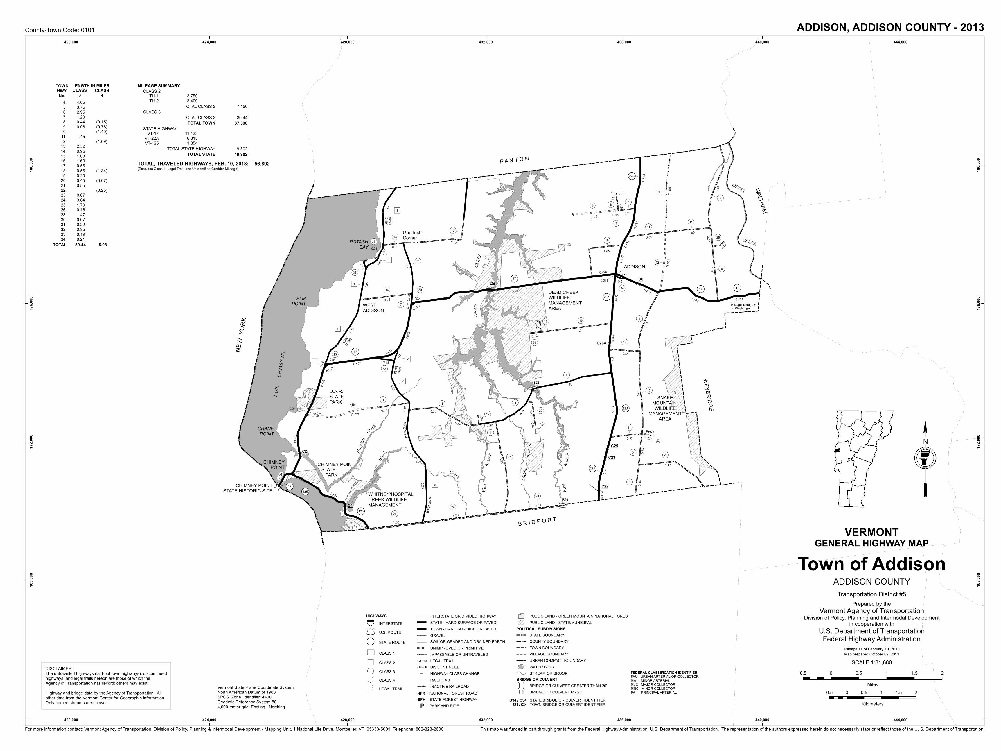
Projects and Accomplishments Light Detection & Ranging (LiDAR) Technology VTrans Mapping is utilizing LiDAR data and technology to support VTrans activities and has acquired high resolution data for 122 miles of highway corridors damaged by TS Irene and the Interstate 89, 91 and 189 corridors. LiDAR data is high resolution terrain data that allows for increased 3D modeling and analysis. Derived products include hill shades, contours, slope & aspect data, and other visualization layers. The primary uses at VTrans are as follows: Project Design and Survey Support Road Centerline Identification and Mapping Environmental and Archeological Assessment Geomorphology and Stormwater Assessment VTrans is working cooperatively with the Vermont Center for Geographic Information and the US Geologic Survey on the acquisition of LiDAR data throughout the State, in support of Agency activities. Highway Mapping System The VTrans Mapping Unit annually produces General Highway Maps, also known as Town Highway Maps for municipalities that have supplied changes on the Certificate of Highway Mileage. Over the course of the last year, Mapping has implemented a new system that allows for the Town Highway Maps to be produced far more rapidly than in the past. In years past, Mapping would only produce the 50 to 60 maps for towns, cities and villages that had changes supplied. In 2013, 243 maps were produced. The goal for 2014 is to produce the full series of Town Highway Maps, which includes roughly 320 maps. Route Log System Mapping is leveraging the same principles with the production of the Route Logs, which are the straight line diagrams of the Federal Aid Highway System. A draft series of the Route Logs have been produced and made available to Agency staff and are under review. Over the course of the next year, a new set of Route Logs will be produced and posted for on-line viewing and download. The Route Logs provide an overview of the highway network and a snapshot of the information pertaining to a specific section of road, including widths, curve & grade, projects, AADT, crashes and other geometric information.
VTrans Mapping Unit – January, 2014

Mapping Unit Contacts
Johnathan Croft AOT GIS Database Administrator 828-2600
Michael Trunzo Transportation Technician III 828-3974
Sara Moulton AOT Mapping & GIS Specialist II 828-2109
Kerry Alley AOT Mapping & GIS Specialist I 828-3666
Gary Smith (50%) and Sarah Kepchar (20%) are also part of the Mapping Unit team, providing part-time assistance and specific expertise to the mapping effort.
On-Line Mapping Resources
• The Mapping Unit has made accessible a substantial amount of data in a digital format on-line. Please find links to the maps and data posted by the VTrans Mapping Unit.
Main Mapping Unit Page – http://vtransplanning.vermont.gov/maps Annual Mileage Summaries - http://vtransplanning.vermont.gov/maps/publications Town Highway Maps - http://vtransplanning.vermont.gov/maps/town_maps Map Archive - http://vtransplanning.vermont.gov/maps/archive Field Assessment Map Series – ftp://vtransmap.aot.state.vt.us./Maps/VTrans_data_Irene/VTrans_District_Maps/Field_Assessment_Series/ Rural Functional Class Map – http://vtransplanning.vermont.gov/sites/aot_policy/files/documents/highwayresearch/RuralFunclStatewide_2013.pdf County-Town Map Series - http://vtransplanning.vermont.gov/maps/publications Bridge & Culvert Inspection Maps - ftp://vtransmap.aot.state.vt.us./Maps/VTrans_data_Irene/Bridge_Inspection_Maps/ Federal Highway Map Series - ftp://vtransmap.aot.state.vt.us./Maps/FederalHighwaySystem/ VTrans District Map - ftp://vtransmaps.vermont.gov/Maps/DistrictMaps/StateMap_Districts_2013.pdf
VTrans Mapping Unit – January, 2014
Vermont LiDAR Initiative: Critical Infrastructure
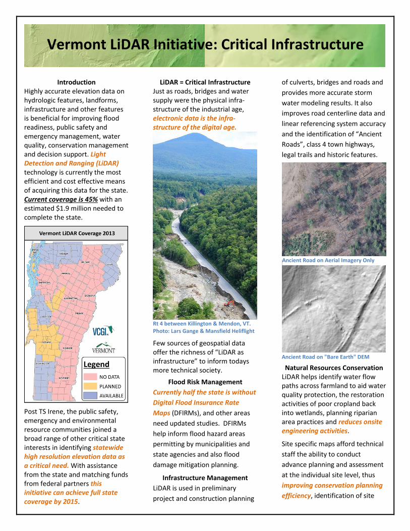
Introduction Highly accurate elevation data on hydrologic features, landforms, infrastructure and other features is beneficial for improving flood readiness, public safety and emergency management, water quality, conservation management and decision support. Light Detection and Ranging (LiDAR) technology is currently the most efficient and cost effective means of acquiring this data for the state. Current coverage is 45% with an estimated $1.9 million needed to complete the state.
Post TS Irene, the public safety, emergency and environmental resource communities joined a broad range of other critical state interests in identifying statewide high resolution elevation data as a critical need. With assistance from the state and matching funds from federal partners this initiative can achieve full state coverage by 2015.
LiDAR = Critical Infrastructure Just as roads, bridges and water supply were the physical infra-structure of the industrial age, electronic data is the infra-structure of the digital age.
Rt 4 between Killington & Mendon, VT. Photo: Lars Gange & Mansfield Heliflight
Few sources of geospatial data offer the richness of “LiDAR as infrastructure” to inform todays more technical society.
Flood Risk Management
Currently half the state is without
Digital Flood Insurance Rate
Maps (DFIRMs), and other areas
need updated studies. DFIRMs
help inform flood hazard areas
permitting by municipalities and
state agencies and also flood
damage mitigation planning.
Infrastructure Management
LiDAR is used in preliminary
project and construction planning
of culverts, bridges and roads and
provides more accurate storm
water modeling results. It also
improves road centerline data and
linear referencing system accuracy
and the identification of “Ancient
Roads”, class 4 town highways,
legal trails and historic features.
Ancient Road on "Bare Earth" DEM
Natural Resources Conservation LiDAR helps identify water flow paths across farmland to aid water quality protection, the restoration activities of poor cropland back into wetlands, planning riparian area practices and reduces onsite engineering activities.
Site specific maps afford technical
staff the ability to conduct
advance planning and assessment
at the individual site level, thus
improving conservation planning
efficiency, identification of site
Ancient Road on Aerial Imagery Only

specific water quality concerns and
focusing outreach.
Water Supply and Quality
Enhanced elevation data also
supports fluvial geomorphic
assessments, river corridor
delineation and informs critical
analyses identifying non-point
phosphorus inputs to Lake
Champlain and other basins.
Renewable Energy
LiDAR derived 3-D Digital Surface
Model (DSM) accounts for tree
canopy, shading, building shape,
rooftops and other infrastructure
affording the ability to model
solar potential for both roof and
ground mount solar photovoltaic
(PV) and thermal arrays.
Solar Potential Mapping
Other renewables such as wind,
biomass, hydro and their support
infrastructure also benefit from
the use of highly accurate Digital
Elevation Models (DEM’s) and
“derivatives” such as slope, aspect
and contour data.
Goals and Benefits Completed in 2011, the National Enhanced Elevation Assessment (NEEA) sponsored by the National
Digital Elevation Program’s (NDEP) 12 Federal member Agency documents the need and value of high quality topographic information, acquired via terrestrial or airborne LiDAR. Subsequently, NDEP created the “3D Elevation Program” initiative adopting the top ten “enhanced elevation data support critical applications” identified in the NEEA that apply to Vermont:
Table 1. Top NEEA business uses
# Business use
1 Flood risk management
2 Infrastructure/constr. mngmnt
3 Natural resources conservation
4 Agriculture and precision farming
5 Water supply and quality
6 Wildfire manage/plan/response
7 Geologic resources and hazard
8 Forest resources management
9 River/stream resource mngmnt
10 Aviation navigation and safety
This initiative was also endorsed by the National States Geographic Information Council and the National Geospatial Advisory Committee. The confluence of support for data acquisition is reflected in the 3DEP primary goal to “systematically collect enhanced elevation data … over the conterminous United States…on an 8-year schedule.”
LiDAR at a Glance LiDAR is a remote sensing method using light in the form of a pulsed laser to measure ranges (variable distances) to the Earth yielding precise elevation data. When combined with other data it generates precise, 3D information about the shape of the Earth, i.e., “Bare Earth” DEMs, DSMs and their “derivatives”. The combined utility of LiDAR elevation products supports such a wide array of applications that it can truly be considered a form of
critical digital infrastructure. For more technical details see the “More Info” section below.
Coordination/Implementation In 2012 the Vermont Center for Geographic Information (VCGI) formed the “LiDAR Workgroup” as a strategic response to Hurricane Irene with the goals of supporting the coordination, acquisition and dissemination of statewide LiDAR. The group is currently comprised of federal, state and local partners: U.S. Geological Survey, National Resource Conservation Service, UVM Spatial Analysis Lab, VT Assoc. of Planning & Dev. Agencies, VCGI, VT Agency of Natural Resources, Lake Champlain Basin Program, U.S. Forest Service, VT Electric Coop, VT Sustainable Jobs Fund and the VT Geological Survey.
Summary As the state GIS coordinating organization, VCGI is committed to the success and long-term support of this effort. Existing and future data from this program will be shared with appropriate federal data portals to provide the public with multiple data access points.
For More Information What is LiDAR? http://tinyurl.com/o7q97fw
“What is LiDAR data?” - http://tinyurl.com/nmxfaqo
Mike Brouillette (VCGI LiDAR Coord.); 58 S. Main St., Waterbury, VT (802) 882-3008; [email protected]; LiDAR Web page - vcgi.vermont.gov/lidar
Old manure pit
Ditch
Graphic courtesy of USGS

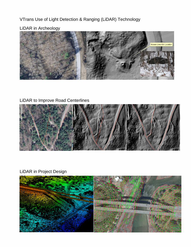
VTrans Use of Light Detection & Ranging (LiDAR) Technology
LiDAR in Archeology
LiDAR to Improve Road Centerlines
LiDAR in Project Design

LiDAR 3D Example
TS Irene Corridor Imagery
Spring 2012
VTrans Mapping
--" "
-- ""
--""
--""
-- ""
--""
--" "
- -" "- -
-
-
- -" "- -
-
-
--" "- -
--
- -""-
-
-
-
DD
D
D D
U U
UU
UU
UU
UU
UU
UU
UU
%
%
%
%
%
%
k!k!
!(k!
!(
!(!(
!(
!(
!(
!(
!(
!(
!!
k!
!(
!(
!(
!!
!!
!(
!(
!!
!(
")
!(
!!!(
!(
!(
!(
!(
!!
!!
!(
!(
!(
!(
!(
!(
!(
!!
k!
!!!!
!(
!(
!(!(
!!
!(
k!
")
!(!(
")!(
")
")")
")
")
!(
!(
!(
k!
!(
LAKE
CH
AMPL
AIN
CREE
KDE
AD
CREEK
Bran
chMi
ddle
West
Bran
ch
Hospi
talCreek
OTTER
Creek
Wards
Bran
chEa
st
0.65
0.17
0.90
0.95
0.823
0.20
0.350.859
(1.40
)
0.30
0.16
0.520
0.194
0.943
0.29(0.78)
1.08
1.00
1.134
0.673
0.852
0.486
1.47
0.55
0.55
1.014
1.50
0.414
0.55
1.70
1.70
0.20
0.221.28
0.30
0.06
0.24
0.01
0.055
0.031
0.07
0.120
0.07
0.138
1.14
1.50
1.00
0.753
0.45(0.07)
0.700.77
0.58
0.041
0.18
0.80
1.15
0.094
3.239
0.426 0.1950.21
0.523
0.06
1.150.32
1.799
1.115
(1.34)
0.754
1.65
0.15
1.174
0.55 (0.25)
0.164
2.20
0.366
2.17
(0.15)
0.10
0.90
0.403
0.09
1.35
0.55
0.44
0.35
(1.09
)
0.56
POTASHBAY
WHITNEY/HOSPITALCREEK WILDLIFEMANAGEMENT
SNAKEMOUNTAIN WILDLIFE
MANAGEMENTAREA
D.A.R.STATEPARK
WESTADDISON
GoodrichCorner
ELMPOINT
DEAD CREEKWILDLIFEMANAGEMENTAREA Mileage listed
in Weybridge
PENT
CHIMNEY POINT STATE PARK
CHIMNEY POINTSTATE HISTORIC SITE
CHIMNEYPOINT
CRANEPOINT
ADDISON
MNCS0638
MNC
S065
2
MNCS06
52
MNCS0638
MNCS0638
P A N T O N
B R I D P O R T
WALTHAM
WEYBRIDGE
NEW
YORK
C1
C22
C23
C25
C26A
C6
C2
B4
B20
B22
108
89
15
1616
31
4
5
28
5
5
22A
20
19
4
25
125
17
4
32
17
14
1
7
17
30
23
24
20
33
22A
22A
33
34
9
26
5
4
17
125
18
1717
6
6
1111
22A
21
22
2
2424
1
8
2
21
1
1
13
7
13
12
18
420,000
420,000
424,000
424,000
428,000
428,000
432,000
432,000
436,000
436,000
440,000
440,000
444,000
444,000
168,0
00
168,0
00
172,0
00
172,0
00
176,0
00
176,0
00
180,0
00
180,0
00
VERMONTGENERAL HIGHWAY MAP
Town of Addison
For more information contact: Vermont Agency of Transportation, Division of Policy, Planning & Intermodal Development - Mapping Unit, 1 National Life Drive, Montpelier, VT 05633-5001 Telephone: 802-828-2600. This map was funded in part through grants from the Federal Highway Administration, U.S. Department of Transportation. The representation of the authors expressed herein do not necessarily state or reflect those of the U. S. Department of Transportation.
ADDISON, ADDISON COUNTY - 2013
Vermont State Plane Coordinate SystemNorth American Datum of 1983SPCS_Zone_Identifier: 4400Geodetic Reference System 804,000-meter grid, Easting - Northing
STATE HIGHWAYVT-17
VT-22A VT-125
11.133 6.315 1.854
TOTAL STATE HIGHWAY 19.302TOTAL STATE 19.302
TOTAL, TRAVELED HIGHWAYS, FEB. 10, 2013:(Excludes Class 4, Legal Trail, and Unidentified Corridor Mileage)
56.892
4 5 6 7 8 9
10 11 12 13 14 15 16 17 18 19 20 21 22 23 24 25 26 28 30 31 32 33 34
4.05 3.75 2.95 1.20 0.44 0.06
1.45
2.52 0.95 1.08 1.60 0.55 0.56 0.20 0.45 0.55
0.07 3.64 1.70 0.16 1.47 0.07 0.22 0.35 0.19 0.21
(0.15) (0.78) (1.40)
(1.09)
(1.34)
(0.07)
(0.25)
MILEAGE SUMMARYCLASS 2
TH-1 TH-2
3.750 3.400
TOTAL CLASS 2 7.150CLASS 3
TOTAL CLASS 3 30.44TOTAL TOWN 37.590
TOWNHWY.No.
LENGTH IN MILESCLASS
3CLASS
4
VERMONT
NC
AT R
SN P O
GAE N
IATR T O N
Y O F
TOTAL 30.44 5.08
County-Town Code: 0101
DISCLAIMER:The untravelled highways (laid-out town highways), discontinuedhighways, and legal trails hereon are those of which theAgency of Transportation has record; others may exist.Highway and bridge data by the Agency of Transportation. Allother data from the Vermont Center for Geographic Information.Only named streams are shown.
Mileage as of February 10, 2013Map prepared October 09, 2013
SCALE 1:31,680
Prepared by theVermont Agency of Transportation
Division of Policy, Planning and Intermodal Developmentin cooperation with
U.S. Department of TransportationFederal Highway Administration
Transportation District #5ADDISON COUNTY
0.5 0 0.5 1 1.5 2
Miles0.5 0 0.5 1 1.5 2
Kilometers
HIGHWAYS
§̈¦ INTERSTATE
£¤ U.S. ROUTE
!! STATE ROUTE
³³ CLASS 1
") CLASS 2
!( CLASS 3
k! CLASS 4
³±ÖÖÖÖ ÖÖÖÖ
L T LEGAL TRAIL
INTERSTATE OR DIVIDED HIGHWAYSTATE - HARD SURFACE OR PAVEDTOWN - HARD SURFACE OR PAVEDGRAVELSOIL OR GRADED AND DRAINED EARTHUNIMPROVED OR PRIMITIVE
U U IMPASSABLE OR UNTRAVELEDL LT T LEGAL TRAILD D DISCONTINUED
% HIGHWAY CLASS CHANGERAILROADINACTIVE RAILROAD
PUBLIC LAND - GREEN MOUNTAIN NATIONAL FORESTPUBLIC LAND - STATE/MUNICIPAL
POLITICAL SUBDIVISIONSSTATE BOUNDARYCOUNTY BOUNDARYTOWN BOUNDARYVILLAGE BOUNDARYURBAN COMPACT BOUNDARYWATER BODYSTREAM OR BROOK
BRIDGE OR CULVERT- -""-- -
-BRIDGE OR CULVERT GREATER THAN 20'
--"" BRIDGE OR CULVERT 6' - 20'
FEDERAL CLASSIFICATION IDENTIFIERFAU URBAN ARTERIAL OR COLLECTORMA MINOR ARTERIALMJC MAJOR COLLECTORMNC MINOR COLLECTORPA PRINCIPAL ARTERIAL
B34 / C34 STATE BRIDGE OR CULVERT IDENTIFIER B34 / C34 TOWN BRIDGE OR CULVERT IDENTIFIERP PARK AND RIDE
NFR NATIONAL FOREST ROADSFH STATE FOREST HIGHWAY

!(0 !(1 !(2 !(3 !(4 !(5 !(6
WINO
OSKI
Base Map
DESCRIPTION BLOCK
For More Information Contact - Vermont Agency of Transportation, Policy, Planning and Intermodal Development Division - Mapping Unit, 1 National Life Drive, Montpelier, VT 05633-5001 Telephone: 802-828-2600.
Stick Diagram
Scale:1in = 2000 FEET
Road Widths
Historic Projects
Curves
Grades
´
Route Log Progress ChartUS-7COLCHESTER5
1 of 1
Date: 11/15/13 ROUTEUS-7
COLCHESTER
TOWNDISTRICT
5
Mileage by Town By SheetMileage by Functional Class By Sheet6.96 of 6.96COLCHESTER - U007-0405
Total Mileage: 6.96 miTotal Mileage: 6.960 mi
5600 14 - Urban - Principal Arterial - Other 6.518 5600 16 - Urban - Minor Arterial 0.442
DRAFTPlease Note: Errors and Omissions May Exist.
Contact the VTrans Mapping Unit with questions or concerns.
?q
?¤
Ie
Im
!"̀$
Ie
MILTON
COLCHESTERBURLINGTON
SOUTHBURLINGTON
WINOOSKI
MILTONU.C.
"
"
"
"
"
"
"
"
"
"
"
"
"
"
"
"
"
"
"
"
"
"
"
"
"
"
"
"
"
"
"
"
"
"
"
"
"
"
"
"
"
"
"
"
"
"
"
"
"
"
"
"
"
"
"
"
"
"
"
"
"
"
"
"
"
"
"
"
"
"
"
"
"
"
"
"
"
"
"
"
"
"
"
"
"
"
"
"
"
"
"
"
"
"
"
"
"
"
"
"
"
"
"
"
"
"
"
"
"
"
"
"
"
"
"
"
"
"
"
"
"
"
"
"
"
"
"
"
"
"
"
"
"
"
"
"
"
"
"
"
"
"
"
"
18" Gravel24" Cr. St. 8" Gravel18" Cr. Rock24" Cr. Stone 24" Crushed Rock SB. SC18" Crushed Stone 4" S.B.
32 334 2 2
404238 665746 34 2255 1869 2566 59 201830 40202448 2018 1820 20
5" P.M.5" P.M. 3" Cr. Gr. P.M.Two 2 1/2" Pen. Mac. Cr. 3" Plant Mix Base Course
36525148 7258 51 3735 24357071 2476 24234066 3660 4862 263740 32 3924 28
157 14 43 56 8 810 410 35 78 5 48 33
+3.2+8.5 +6.0A+10.6-7.0-5.3-6.2A
+6.4
®
®1 126
7811
121416
1719
TWN mileage:0.0 to 6.96
Bridge 151A: Stringer/multi-beam or girder - 1963Structure No. 200089074S04052Length: 152'Height: 0.0'Weight Limit: 0Facility Carried: I 00089 MLBridge Type: 3-SP ROLLED BEAMFeatures Intersected: I 89 OVER U.S.7 Bridge 151B: Stringer/multi-beam or girder - 1963Structure No. 200089074N04052Length: 152'Height: 0.0'Weight Limit: 0Facility Carried: I 00089 MLBridge Type: 3-SP ROLLED BEAMFeatures Intersected: I 89 OVER U.S.7 Culvert 155: Culvert - 1929Structure No. 300285015504051Length: 20'Under Clearance: 20.0'Facility Carried: US7Bridge Type: R. C. BOX CULVERTFeatures Intersected: INDIAN BROOKMaintenance: State Culvert 156: Culvert - 1968Structure No. 300285015604051Length: 9'Under Clearance: 10.0'Facility Carried: US7Bridge Type: MULTI PLATE PIPEFeatures Intersected: POND BROOKMaintenance: State Bridge 157: Tee Beam - 1924Structure No. 200285015704052Length: 34'Width: 31.8'Facility Carried: US 00007 MLBridge Type: T BM WIDEN W ROLL BMFeatures Intersected: MALLETTS CREEKSurface: BituminousMaintenance/Ownership: State Bridge 159: Slab - 1924Structure No. 300285015904051Length: 15'Width: 30.0'Under Clearance: 4.0'Facility Carried: US7Bridge Type: CONCRETE SLABFeatures Intersected: ALLEN BROOKSurface: BituminousMaintenance: State
uu uu
77 7 77 77 777 777 7 777 77 7 77 77
7 77 77 7 777 777 77 77 777 77 77 777 77
úú 7ú7ú 7ú7ú
MILT
ONCO
LCHE
STER
ORCH
ARD
DR (T
H-13
5)
LOW
ER M
OUNT
AIN V
IEW
DR (T
H-11
7)
COON
HILL
RD(T
H-10
)
OLD
SEVE
RANC
E RD
(TH-
200)
INTE
RSTA
TE E
NTAN
CE\E
XIT (
I-89)
HERC
ULES
DR
(TH-
56)
INTE
RSTA
TE E
NTAN
CE\E
XIT (
I-89)
CHAM
PLAIN
DR
(TH-
150)
S PAR
K DR
(TH-
156)
SEVE
RANC
E RD
(TH-
7)
MAIN
ST (V
T-2A)
0 1815
8
1025
1285
MAIN
ST (V
T-127
)
3441
6
1935
0
1549
7
1793989
5514
3643
7
1643
8
1915
8
3232
2939
0
1811
2
3674
9
1049
0
468
1742
9
4411
1112
MUNS
ON R
D (T
H-24
)
BLAK
ELY R
D (TH
-9)
0 ft
2855
6
1779
5
2113
8
1188
2479
4
MOUN
TAIN
VIE
W DR
(TH-
172)
ROOS
EVEL
T HW
Y (US
-2)
INTE
RSTA
TE E
NTAN
CE\E
XIT (
I-89)
BAY R
D (T
H-1)
RATH
E RD
(TH-
55)
BREN
TWOO
D DR
(TH-
191)
POOR
FARM
RD
(TH-
25)
INTE
RSTA
TE E
NTAN
CE\E
XIT (
I-89)
SUND
ERLA
ND W
OODS
RD
(TH-
113)
CREE
K FAR
M RD
(TH-
16)
!(157!(0156 !(0159
!(0155(151B
(151A
Distric
t5 C
himne
yCo
rners
Garag
e
Distric
t5 C
himne
yCo
rners
Garag
e
1 in = 0.5 miles
Historic Projects Road WidthsFunctional Class
Crash Locations
AADT
Speed Zones
Curves
Grades Traffic Counters
tgrade upgrade down
curve leftcurve right
FatalInjury
Property Damage OnlyUnknown Crash Type
"
"
Maintenance Garage District 5 - Chimney Corners Garage
Traffic Counters
Functional Class
Crash Locations
AADT Counts
t tttS6D049 S6D103S6D040S6D595
1614
"
"
"
"
"
"
"
"
"
"
"
"
"
"
"
"
"
"
"
"
"
"
"
"
"
"
"
"
"
"
"
"
"
"
"
"
"
"
"
"
"
"
"
"
"
"
"
"
"
"
"
"
"
"
"
"
"
"
"
"
"
"
"
"
"
"
"
"
"
"
"
"
"
"
"
"
"
"
"
"
"
"
"
"
"
"
"
"
"
"
189002160017200 770014400 1360014500 8000 10800
187002220016300 770014600 1390014900 8000 11200
184002280015400 770014700 1420015300 8000 11500
190002280015600 760014700 1380015300 8100 11600196002270015700 750014600 1340015200 8200 11600
Speed Zone 1238 1239123:
20092008
201020112012
20092008
201020112012
TravellaneRoadway
BaseSubbase
Lane Count
"
"(ft) (count)
(counter ID)
7ú Primary Structures
ú Secondary Structures
7 Stations (Feet)vvvv Railroad CrossingsDivided State HighwayState HighwayDivided Class 1 Town HighwayClass 1 Town HighwayTown BoundaryDistrict Boundaries
-. . State/Town Highway ChangeDivided Highway LimitsGhost Section Boundary
u Streams
u
u
u
u
u
u
u
u
u
u
u
u
u
u
u
u
u
u
u
u
u
u
u
u
u
u
u
u
u
u
u
u
u
u
u
u
u
u
u
u
u
u
u
u
u
u
u
u
u
u
u
u
u
u
u
u
u
u
u
u
u
u
u
u
u
u
u
u
u
u
u
u
u
u
u
u
u
u
1987: RS 0285(11)
1975: BP 019-5-7510
1987: RS 0285(9) 1986: HES ROS 0285(3)S
1955: APP /55
2003: CMG PARK(18)S
1987: RS 0285(9)
1988: HES RS 0285(5)S
1964: I 89-3(14) C/4
1955: APP /55
1963: I 89-3(15)
1981: HMA 2209
1995: MG 5600(7)
1968: BP 019-5-6707
1992: M 5600(8)S
1928: FAP 102-A 1928: FAP 102-A
1972: BP 019-5-7123
1951: APP 6/51
1992: MG SGNL(2)S
1979: CP 1024
1949: APP 21/49
1987: M 5600(4)S
1959: MA 14/59
1924: FAP 41
1981: HMA 2209
1992: STP 9225(1)S
1970: Unknown
1990: HMA 2132
1958: MA 16/58
1981: HMA 2209
1970: Unknown
1949: APP 21/49
1930: ST 102-C
2003: STP 2208(1)S
222222222333333333789:;6=>?
u
u Retreatmentu
u Resurfaceu
u Unknownu
u Bituminous Mixu
u Skinny Mixu
u Bituminous Seal
u
u BituminousConcrete
u
u BituminousMacadam
u
u Cold Plane andBituminousConcrete
u
u Concrete
I Iu
u Gravel
u
u Surface TreatedGravel
u
u Plant Mix
u
u Reclaimed Baseand BituminousConcrete
ETE mileage: 135.633 to 142.593
ROUTETOWNDISTRICT