Virginia Offshore Wind Technology Advancement Project on ...
239
U.S. Department of the Interior Bureau of Ocean Energy Management Office of Renewable Energy Programs OCS EIS/EA BOEM 2015-031 Virginia Offshore Wind Technology Advancement Project on the Atlantic Outer Continental Shelf Offshore Virginia Revised Environmental Assessment
Transcript of Virginia Offshore Wind Technology Advancement Project on ...

U.S. Department of the Interior Bureau of Ocean Energy Management Office of Renewable Energy Programs
OCS EIS/EA
BOEM 2015-031
Virginia Offshore Wind Technology Advancement Project on the Atlantic Outer Continental Shelf Offshore Virginia
Revised Environmental Assessment

OCS EIS/EA BOEM 2015-031
Virginia Offshore Wind Technology Advancement Project on the Atlantic Outer Continental Shelf Offshore Virginia
Revised Environmental Assessment Author Bureau of Ocean Energy Management
Office of Renewable Energy Programs Published by
U.S. Department of the Interior Bureau of Ocean Energy Management
Office of Renewable Energy Programs July 2015


iii
FINDING OF NO SIGNIFICANT IMPACT
Approval of Proposed Wind Energy-Related Research Activities on the Atlantic Outer Continental Shelf (OCS) Offshore Virginia
INTRODUCTION
The United States Department of the Interior (USDOI), Bureau of Ocean Energy Management (BOEM) prepared an environmental assessment (EA) to determine whether the approval of the research activities plan (RAP) for the Virginia Offshore Wind Technology Advancement Project (VOWTAP), as proposed by the Virginia Department of Mines, Mineral, and Energy (DMME) and Dominion Resources, Inc. (Dominion), would have a significant effect on the environment and whether an environmental impact statement (EIS) must be prepared. DMME and Dominion’s proposed project would consist of two 6 megawatt (MW) wind turbine generators (WTGs), a 34.5-kV alternating current (AC) submarine cable interconnecting the WTGs (inter-array cable), a 34.5-kV submarine transmission cable (export cable), and a 34.5-kV underground cable (onshore interconnection cable) that would connect the project with existing infrastructure located in the City of Virginia Beach, Virginia. BOEM conducted its analysis to comply with the National Environmental Policy Act (NEPA), 42 United States Code (U.S.C.) §§ 4321-4370f, the Council on Environmental Quality (CEQ) regulations at 40 Code of Federal Regulations (CFR) 1501.3(b) and 1508.9, USDOI regulations implementing NEPA at 43 CFR 46, and USDOI Manual (DM) Chapter 15 (516 DM 15).
On March 14, 2014, BOEM published a Notice of Intent to Prepare an Environmental Assessment (79 FR 14534) in connection with the VOWTAP RAP, and requested public input regarding important environmental issues and the identification of reasonable alternatives that should be considered in the EA. BOEM held a public scoping meeting on April 3, 2014 in Virginia, Beach, to solicit comments on the scope of the EA. Neither of these comment opportunities provided any alternatives that BOEM should consider during the development of the EA.
On December 2, 2014, BOEM published a Notice of Availability for the Virginia Offshore Wind Technology Advancement Project on the Atlantic Outer Continental Shelf Offshore Virginia Environmental Assessment (79 FR 71446). BOEM hosted a public meeting on December 17, 2014, during which members of the public in attendance provided written and verbal comments on the EA. The 30-day public comment period deadline for the EA was subsequently extended from January 2 to January 16, 2015 (80 FR 53). BOEM has revised the EA to address comments received during the public comment period and public meeting, and the results of consultations. Section 4.1.3 of the revised EA includes a summary of public comments and revisions to the EA.
PURPOSE OF THE PROPOSED ACTION The purpose of approving the RAP (2015) for VOWTAP is to authorize construction,
operation, and maintenance of two WTGs and various project components approximately 24

iv
nautical miles (44.5 kilometers [km]) offshore Virginia. This demonstration project is intended to gather site data and gain experience with new offshore renewable technology, which can support the potential future production and transmission of offshore renewable energy offshore Virginia (30 CFR 585.238).
DESCRIPTION OF THE PROPOSED ACTION The proposed action (Alternative A) is BOEM’s approval of construction, operation,
maintenance, and eventual decommission of VOWTAP by Dominion. DMME and Dominion’s proposed project would consist of two 6 MW WTGs, a 34.5-kV alternating current (AC) submarine cable interconnecting the WTGs (inter-array cable), a 34.5-kV submarine transmission cable (export cable), and a 34.5-kV underground cable (onshore interconnection cable) that would connect the project with existing infrastructure located in the City of Virginia Beach, Virginia. The offshore components of VOWTAP, including the WTGs and the inter-array cable, would be located on the Outer Continental Shelf (OCS) approximately 24 nautical miles (44.5 km) from Virginia Beach, Virginia, while the export cable would traverse both federal and state waters. The onshore components, including the onshore interconnection cable, fiber optic cable, switch cabinet, and interconnection station, would be located entirely within the boundaries of the Camp Pendleton State Military Reservation (Camp Pendleton) in the City of Virginia Beach, Virginia. Construction would be supported by a construction staging area(s) and a construction port. Onshore support facilities would be located at existing waterfront industrial or commercial sites in the cities of Norfolk, Virginia, or Newport News, Virginia. Dominion designed VOWTAP to operate remotely throughout 20-year operational term of the lease. At the end of VOWTAP’s operational phase, the DMME and Dominion would be required by BOEM to decommission the project in its entirety in accordance with a detailed project decommissioning plan that would be developed by DMME and Dominion in compliance with applicable laws, regulations, and best management practices following lease termination. DMME and Dominion expect decommissioning to take place sometime between 2045 and 2047, and to take approximately 3 months (RAP, 2015; Section 3.4). BOEM has identified Alternative A as the preferred alternative. In addition to the proposed action, BOEM considered four other alternatives, including no action (Section 2 of the revised EA).
EA Summary The EA considers the reasonably foreseeable environmental consequences associated
with VOWTAP. In particular, the EA analyzed the impacts of the construction, operation, maintenance, and eventual decommission of the WTGs and cables, including the impacts of noise, presence of structures, bottom disturbance, vessel traffic, and onshore activities. BOEM prepared the EA with the intention to inform all federal decision-makers, the U.S. Department of Energy and the U.S. Army Corps of Engineers, who will need to determine whether and, if so, how the proposed action will proceed (40 CFR 1501.6).
As part of the proposed action and alternatives, BOEM considered several Standard Operating Conditions (SOCs) to reduce or eliminate the potential environmental risks to or conflicts with individual environmental resources. These SOCs were developed through the analyses presented in Section 3 of the revised EA and through consultations with other federal

v
and state agencies (see Section 4 of the revised EA). A brief summary of the SOCs are outlined below. If it approves the RAP, BOEM will require DMME and Dominion to comply with SOCs through terms and conditions of that approval.
• Sections 3.2.1 and 3.2.3 of the revised EA sets forth SOCs to minimize or eliminate potential impacts to avian species and bats, including the use of red-flashing aviation obstruction lights, the use of anti-perching devices, and annual monitoring and reporting requirements.
• BOEM’s April 2015 Finding of No Adverse Effect sets forth conditions for the purposes of meeting its obligations under Section 106 of the National Historic Preservation Act of 1966, as amended (54 U.S.C. 306108). These conditions include required avoidance of identified archaeological sites, coordination with the Virginia Army National Guard, clauses to address any post-review discoveries of archaeological sites, and the requirement to avoid impacts to archaeological sites without prior approval by BOEM.
• Appendix A, Sections A-E of the revised EA sets forth SOCs to minimize or eliminate potential impacts to marine mammals and sea turtles that resulted from BOEM’s Endangered Species Act (ESA) consultation with National Marine Fisheries Service (NMFS) that concluded in July 2015. These conditions include vessel strike avoidance and marine debris awareness measures; protected species observers, exclusion and monitoring zones; sound source verification, ramp up, soft start and shutdown procedures; visibility, seasonal and frequency-dependent restrictions for various activities, as well as multiple reporting requirements.
• Section 3.6.1 of the RAP and Section 3.2.5.2 and Appendix A, Section F of the revised EA sets forth SOCs to minimize or eliminate potential impacts to fish and essential fish habitat that resulted from BOEM’s consultation with NMFS pursuant to Section 305(b) of the Magnuson-Steven Fishery Conservation and Management Act. SOCs included soft start pile driving measures and minimizing impact area for any necessary cable protection systems. Measures to monitor impacts to essential fish habitat include cable and foundation scour monitoring reports and acoustic monitoring reports.
ALTERNATIVES BOEM considered the proposed action (Alternative A) and four alternatives. Alternative
A, the preferred alternative, is the approval of research activities, including the construction, operation, maintenance, and eventual decommission of two WTGs, an export cable to shore, and a cable from landfall to interconnection point offshore Virginia (Section 2.1 of the revised EA) as proposed by DMME. Alternative B (Section 2.2 of the revised EA) and C (Section 2.3 of the revised EA) are identical to Alternative A, with exception of alternate turbine locations resulting in export cables being approximately 1.0 to 1.5 nautical miles longer. Alternative D (Section 2.4 of the revised EA) is identical to Alternative A, with the exception that the export cable landfall would occur at Croatan Beach instead of Camp Pendleton and landfall to interconnection point would be slightly longer. Under Alternative E, the No Action Alternative (Section 2.5 of the revised EA), no research activities in connection with VOWTAP would be approved by BOEM on the OCS offshore Virginia at this time.

vi
Environmental and Socioeconomic Consequences of Alternative A (Preferred Alternative): The Proposed Action
The reasonably foreseeable impacts of Alternative A (the preferred alternative) on environmental resources and socioeconomic conditions are described in detail in Section 3 of the revised EA: air quality (Section 3.1.1.2); water quality (Section 3.1.2.2); bats (Section 3.2.1.2); benthic resources (Section 3.2.2.2); birds (Section 3.2.3.2); coastal habitats (Section 3.2.4.2); fish and essential fish habitat (Section 3.2.5.2); marine mammals and sea turtles (Section 3.2.6.2); terrestrial wildlife (Section 3.2.7.2); archaeological resources (Section 3.3.1.2); recreation resources (Section 3.3.2.2); demographics and employment (Section 3.3.3.2); environmental justice (Section 3.3.4.2); land use and coastal infrastructure (Section 3.3.5.2); commercial and recreation fishing activities (Section 3.3.6.2); and other uses of the OCS (Section 3.3.7.2).
The impact levels BOEM applied throughout the revised EA are derived by BOEM from a four-level classification scheme used to characterize the predicted impacts if the proposal is implemented and activities occur as described. This classification scheme is defined in the Programmatic Environmental Impact Statement for Alternative Energy Development and Production and Alternate Use of Facilities on the Outer Continental Shelf (MMS, 2007). For most resources analyzed in the revised EA, the reasonably foreseeable impacts for the proposed action described in the EA as ranging from negligible to minor. Potential impacts to benthic resources, coastal habitats, fish and essential fish habitat, marine mammals, and sea turtles, would be negligible to moderate.
The majority of the benthic resource impacts following decommissioning are anticipated by BOEM to be temporary because both the physical and biological characteristics are anticipated to return to pre-construction function within 3 months to 2.5 years. However, BOEM anticipates that impacts to benthic resources from the construction of the export and inter-array cables will be moderate due to the permanent loss of unconsolidated sand habitat within the footprint of the two turbine foundations, as well as within the 23.3 acre (9.4 hectare) footprint associated with the additional cable protection.
Disturbance of beaches, dunes, or other coastal habitats by the onshore inter-connection cable and fiber optic cable may result in direct habitat losses from excavation as well as indirect impacts such as the occurrence of pollutants from an accidental loss of drilling fluids from HDD activities. Because onshore facilities would be constructed by Dominion along existing roads and rights-of-way or within previously disturbed areas, impacts from construction of facilities would likely result in negligible to moderate impacts to coastal habitats. Also, due to regulations stipulated within the Virginia Coastal Zone Management Program, onshore facilities would not be located where sensitive coastal resources occur.
The only permanent impact anticipated by BOEM to fish and fish habitat would be the loss of existing habitat within the footprint of the two turbine foundations and along the cable route due to cable protection. BOEM expects no impacts at the population level of any fish or fishery. The proposed action would temporarily adversely affect the quality of essential fish habitat offshore Virginia, but would not substantially affect the quality and quantity of essential fish habitat in the inner shelf zone offshore Virginia over the life of the project. There are no essential fish habitat areas of particular concern in the proposed lease area. Based upon the analysis in the EA, BOEM anticipated that construction, operation, and decommissioning

vii
activities would have moderate temporary impacts to fish and essential fish habitat during construction and minor to negligible impacts over the life of the project.
The primary impact producing factor for marine mammals and sea turtles would be noise generated during pile-driving activities. This noise would only occur during the construction phase, and result in moderate, but temporary, impacts. No population effects are anticipated by BOEM and no critical habitat would be affected by the proposed action, because highly mobile species would leave the construction area.
The incremental impact of the proposed action when added to other past, present, and reasonably foreseeable actions that may affect the environment would be negligible to moderate (Section 3 of the revised EA). Moreover, the proposed action would facilitate the gathering of information related to site data and would allow for the analysis of new offshore wind technology.
BOEM placed heavy weight on public and stakeholder comments, consultations, and information received through BOEM’s outreach efforts. BOEM finds that approving construction, operation, maintenance, and eventual decommission of VOWTAP would have no significant impact on the environment. As a result, the preparation of an EIS is not necessary for BOEM to approve or approve with modifications the RAP.
SUPPORTING DOCUMENTS The following documents support this Finding of No Significant Impact (FONSI) and are
available upon request or at www.boem.gov/:
• DMME’s RAP (2015); • BOEM’s research and review of current scientific and socioeconomic literature; • Public response to the March 14, 2014 NOI to prepare the EA; • Public response during the April 3, 2014 public scoping meeting; • Public response to the December 2, 2014 NOA of the EA; • Public response during the December 17, 2014 public meeting; • Comments received in response to the Request for Competitive Interest; • Consultation and coordination with the members of BOEM’s Virginia Intergovernmental
Renewable Task Force; • Consultation with potentially affected American Indian tribes in Virginia; • Consultation with other federal agencies including the U.S. Fish and Wildlife Service,
NMFS, U.S. Department of Defense, and U.S. Coast Guard; • Relevant material from the Programmatic Environmental Impact Statement for
Alternative Energy Development and Production and Alternative Use of Facilities on the Outer Continental Shelf, Final Environmental Impact Statement (MMS, 2007);
• Relevant material from the Commercial Wind Lease Issuance and Site Assessment Activities on the Atlantic Outer Continental Shelf Offshore New Jersey, Delaware, Maryland and Virginia – Final Environmental Assessment (BOEM, 2012a); and
• Relevant material from the Atlantic OCS Proposed Geological and Geophysical Activities Mid-Atlantic and South Atlantic Planning Areas Final Programmatic Environmental Impact Statement (Atlantic G&G FPEIS) (BOEM, 2014a).


ix
TABLE OF CONTENTS
LIST OF TABLES xiv LIST OF FIGURES xv ACRONYMS, ABBREVIATIONS, AND SYMBOLS xvi 1 INTRODUCTION 1
1.1 Background 1 1.2 Objective of the Environmental Assessment 2
1.2.1 Scope of Analysis 2 1.2.2 Impact Levels for Biological and Physical Resources 2 1.2.3 Impact Levels for Socioeconomic Issues 3 1.2.4 Information Considered 4
1.3 Purpose and Need 4 1.4 DOE’s Purpose and Need 4 1.5 BOEM Authority and Regulatory Process 5 1.6 Description of Proposed Action 5
2 ALTERNATIVES INCLUDING THE PROPOSED ACTION 7 2.1 Alternative A – Proposed Action (Preferred Alternative) 8
2.1.1 Construction 9 2.1.2 Operation and Maintenance 9 2.1.3 Decommissioning 9
2.2 Alternative B – Alternate Turbine Location (adjacent to the Virginia WEA) 10 2.3 Alternative C – Alternate Turbine Location (within the Virginia WEA) 11 2.4 Alternative D – Alternate Export Cable Landfall (Croatan Beach) 12 2.5 Alternative E – No Action 14 2.6 Past, Present and Future Activities on the Atlantic OCS and Adjacent State Waters
and Coastal Areas (hereafter referred to as cumulative activities) 14 2.6.1 Introduction 14 2.6.2 Site Assessment Activities and Other Fixed Structures 14 2.6.3 Wind Energy Development 15 2.6.4 Geological and Geophysical Activities 17 2.6.5 Transmission 19 2.6.6 Marine Minerals Use 19 2.6.7 Dredged Material Disposal 21 2.6.8 Liquefied Natural Gas Terminal 21 2.6.9 Military Range Complexes and Civilian Space Program Use 22 2.6.10 Shipping and Marine Transportation 22 2.6.11 Climate Change 23
3 ENVIRONMENTAL AND SOCIOECONOMIC CONSEQUENCES 25 3.1 Physical Properties 25
3.1.1 Air Quality 25 3.1.1.1 Description of the Affected Environment 25
x
3.1.1.2 Impact Analysis of Alternative A (Preferred Alternative) 26 3.1.1.3 Alternative B – Alternate Turbine Location (adjacent to the Virginia WEA) 33 3.1.1.4 Alternative C – Alternate Turbine Location (within the Virginia WEA) 33 3.1.1.5 Alternative D – Alternate Export Cable Landfall (Croatan Beach) 33 3.1.1.6 Alternative E – No Action 34 3.1.1.7 Cumulative Impacts Analysis 34
3.1.2 Water Quality 35 3.1.2.1 Description of the Affected Environment 36 3.1.2.2 Impact Analysis of Alternative A (Preferred Alternative) 37 3.1.2.3 Alternative B – Alternate Turbine Location (adjacent to the Virginia WEA) 39 3.1.2.4 Alternative C – Alternate Turbine Location (within the Virginia WEA) 40 3.1.2.5 Alternative D – Alternate Export Cable Landfall (Croatan Beach) 40 3.1.2.6 Alternative E – No Action 41 3.1.2.7 Cumulative Impacts Analysis 41
3.2 Biological Resources 42 3.2.1 Bats 42
3.2.1.1 Description of the Affected Environment 42 3.2.1.2 Impact Analysis of Alternative A (Preferred Alternative) 44 3.2.1.3 Alternative B – Alternate Turbine Location (adjacent to the Virginia WEA) 44 3.2.1.4 Alternative C – Alternate Turbine Location (within the Virginia WEA) 44 3.2.1.5 Alternative D – Alternate Export Cable Landfall (Croatan Beach) 44 3.2.1.6 Alternative E – No Action 44 3.2.1.7 Cumulative Impacts Analysis 45
3.2.2 Benthic Resources 45 3.2.2.1 Description of the Affected Environment 45 3.2.2.2 Impact Analysis of Alternative A (Preferred Alternative) 49 3.2.2.3 Alternative B – Alternate Turbine Location (adjacent to the Virginia WEA) 52 3.2.2.4 Alternative C – Alternate Turbine Location (within the Virginia WEA) 53 3.2.2.5 Alternative D – Alternate Export Cable Landfall (Croatan Beach) 53 3.2.2.6 Alternative E – No Action 53 3.2.2.7 Cumulative Impacts Analysis 54
3.2.3 Birds 55 3.2.3.1 Description of the Affected Environment 55 3.2.3.2 Impact Analysis of Alternative A (Preferred Alternative) 65 3.2.3.3 Alternative B – Alternate Turbine Location (adjacent to the Virginia WEA) 72 3.2.3.4 Alternative C – Alternate Turbine Location (within the Virginia WEA) 72 3.2.3.5 Alternative D – Alternate Export Cable Landfall (Croatan Beach) 73 3.2.3.6 Alternative E – No Action 73 3.2.3.7 Cumulative Impacts Analysis 73
3.2.4 Coastal Habitats 74 3.2.4.1 Description of the Affected Environment 74 3.2.4.2 Impact Analysis of Alternative A (Preferred Alternative) 74 3.2.4.3 Alternative B – Alternate Turbine Location (adjacent to the Virginia WEA) 76

xi
3.2.4.4 Alternative C – Alternate Turbine Location (within the Virginia WEA) 76 3.2.4.5 Alternative D – Alternate Export Cable Landfall (Croatan Beach) 77 3.2.4.6 Alternative E – No Action 77 3.2.4.7 Cumulative Impacts Analysis 77
3.2.5 Fish and Essential Fish Habitat 78 3.2.5.1 Description of the Affected Environment 78 3.2.5.2 Impact Analysis of Alternative A (Preferred Alternative) 85 3.2.5.3 Alternative B – Alternate Turbine Location (adjacent to the Virginia WEA) 90 3.2.5.4 Alternative C – Alternate Turbine Location (within the Virginia WEA) 91 3.2.5.5 Alternative D – Alternate Export Cable Landfall (Croatan Beach) 91 3.2.5.6 Alternative E – No Action 91 3.2.5.7 Cumulative Impacts Analysis 92
3.2.6 Marine Mammals and Sea Turtles 93 3.2.6.1 Description of the Affected Environment 93 3.2.6.2 Impact Analysis of Alternative A (Preferred Alternative) 109 3.2.6.3 Alternative B – Alternate Turbine Location (adjacent to the Virginia WEA)125 3.2.6.4 Alternative C – Alternative Turbine Location (within the Virginia WEA) 125 3.2.6.5 Alternative D – Alternate Export Cable Landfall (Croatan Beach) 126 3.2.6.6 Alternative E – No Action 126 3.2.6.7 Cumulative Impacts Analysis 126
3.2.7 Terrestrial Wildlife 129 3.2.7.1 Description of the Affected Environment 129 3.2.7.2 Impact Analysis of Alternative A (Preferred Alternative) 130 3.2.7.3 Alternative B – Alternate Turbine Location (adjacent to the Virginia WEA)131 3.2.7.4 Alternative C – Alternate Turbine Location (within the Virginia WEA) 131 3.2.7.5 Alternative D – Alternate Export Cable Landfall (Croatan Beach) 131 3.2.7.6 Alternative E – No Action 131 3.2.7.7 Cumulative Impacts Analysis 131
3.3 Socioeconomic Considerations 131 3.3.1 Archaeological Resources 131
3.3.1.1 Description of the Affected Environment 131 3.3.1.2 Impact Analysis of Alternative A (Preferred Alternative) 133 3.3.1.3 Alternative B – Alternate Turbine Location (adjacent to the Virginia WEA)135 3.3.1.4 Alternative C – Alternate Turbine Location (within the Virginia WEA) 135 3.3.1.5 Alternative D – Alternate Export Cable Landfall (Croatan Beach) 136 3.3.1.6 Alternative E – No Action 136 3.3.1.7 Cumulative Impacts Analysis 137
3.3.2 Recreational Resources 138 3.3.2.1 Description of the Affected Environment 138 3.3.2.2 Impact Analysis of Alternative A (Preferred Alternative) 140 3.3.2.3 Alternative B – Alternate Turbine Location (adjacent to the Virginia WEA)141 3.3.2.4 Alternative C – Alternate Turbine Location (within the Virginia WEA) 141 3.3.2.5 Alternative D – Alternate Export Cable Landfall (Croatan Beach) 142

xii
3.3.2.6 Alternative E – No Action 142 3.3.2.7 Cumulative Impacts Analysis 142
3.3.3 Demographics and Employment 143 3.3.3.1 Description of the Affected Environment 143 3.3.3.2 Impact Analysis of Alternative A (Preferred Alternative) 145 3.3.3.3 Alternative B – Alternate Turbine Location (adjacent to the Virginia WEA 146 3.3.3.4 Alternative C – Alternate Turbine Location (within Virginia WEA) 146 3.3.3.5 Alternative D – Alternate Export Cable Landfall (Croatan Beach) 146 3.3.3.6 Alternative E – No Action 146 3.3.3.7 Cumulative Impacts Analysis 146
3.3.4 Environmental Justice 147 3.3.4.1 Description of the Affected Environment 147 3.3.4.2 Impact Analysis of Alternative A (Preferred Alternative) 148 3.3.4.3 Alternative B – Alternate Turbine Location (adjacent to the Virginia WEA)149 3.3.4.4 Alternative C – Alternate Turbine Location (within the Virginia WEA) 149 3.3.4.5 Alternative D – Alternate Export Cable Landfall (Croatan Beach) 150 3.3.4.6 Alternative E – No Action 150 3.3.4.7 Cumulative Impacts Analysis 150
3.3.5 Land Use and Coastal Infrastructure 151 3.3.5.1 Description of the Affected Environment 151 3.3.5.2 Impact Analysis of Alternative A (Preferred Alternative) 151 3.3.5.3 Alternative B – Alternate Turbine Location (adjacent to the Virginia WEA)152 3.3.5.4 Alternative C – Alternate Turbine Location (within the Virginia WEA) 152 3.3.5.5 Alternative D – Alternate Export Cable Landfall (Croatan Beach) 152 3.3.5.6 Alternative E – No Action 152 3.3.5.7 Cumulative Impacts Analysis 152
3.3.6 Commercial and Recreational Fishing Activities 153 3.3.6.1 Description of the Affected Environment 153 3.3.6.2 Impact Analysis of Alternative A (Preferred Alternative) 156 3.3.6.3 Alternative B – Alternate Turbine Location (adjacent to the Virginia WEA)159 3.3.6.4 Alternative C – Alternate Turbine Location (within the Virginia WEA) 159 3.3.6.5 Alternative D – Alternate Export Cable Landfall (Croatan Beach) 159 3.3.6.6 Alternative E – No Action 159 3.3.6.7 Cumulative Impacts Analysis 159
3.3.7 Other Uses of the OCS 161 3.3.7.1 Description of the Affected Environment 161 3.3.7.2 Impact Analysis of Alternative A (Preferred Alternative) 163 3.3.7.3 Alternative B – Alternate Turbine Location (adjacent to the Virginia WEA)168 3.3.7.4 Alternative C – Alternate Turbine Location (within the Virginia WEA) 168 3.3.7.5 Alternative D – Alternate Export Cable Landfall (Croatan Beach) 168 3.3.7.6 Alternative E – No Action 169 3.3.7.7 Cumulative Impacts Analysis 169

xiii
4 CONSULTATION AND COORDINATION 171 4.1 Public Involvement 171
4.1.1 Notice of Intent 171 4.1.2 Notice of Availability 171 4.1.3 Summary of Public Comments Received on the EA 171
4.2 Cooperating Agencies 177 4.3 Consultations 177
4.3.1 Endangered Species Act 177 4.3.2 Magnuson Fishery Conservation and Management Act 178 4.3.3 Coastal Zone Management Act 178 4.3.4 National Historic Preservation Act 179
5 REFERENCES 181 6 PREPARERS 205 APPENDIX A – STANDARD OPERATING CONDITIONS FOR PROTECTED SPECIES 207

xiv
LIST OF TABLES
Table 1: Alternatives Considered.................................................................................................... 7 Table 2: Projected Levels of Geological and Geophysical Activities for Renewable Energy Site
Characterization and Assessment in the mid-Atlantic and South Atlantic Planning Areas, 2012-2020 ......................................................................................................................... 18
Table 3: Projected Levels of Miscellaneous Geological and Geophysical Activities for Oil and Gas Exploration in the mid-Atlantic and South Atlantic Planning Areas, 2012-2020 ..... 19
Table 4: Forecasted Restoration Projects ...................................................................................... 20 Table 5: Estimated Construction Emissions ................................................................................. 28 Table 6: Estimated 2017 Operating and Maintenance Emissions ................................................ 29 Table 7: Comparison of Emissions: VOWTAP and Hampton Roads Area ................................. 30 Table 8: Bats of Virginia............................................................................................................... 43 Table 9: Mid-Atlantic Benthic Habitat Types .............................................................................. 48 Table 10: Bird Species Known to be Present within Proposed Project’s Ocean Transit Area ..... 57 Table 11: Screen Shot of the Inputs Used in the Actual Band (2012) Collision Risk Model for
Northern Gannets .............................................................................................................. 69 Table 12: Screen Shot of the Results from the Actual Band (2012) Collision Risk Model for
Northern Gannets .............................................................................................................. 70 Table 13: Major Recurrent Demersal Finfish Assemblages of the mid-Atlantic Bight ............... 80 Table 14: Fish Species and Life Stage for which EFH has been Designated in the Project Area 80 Table 15: Marine Fish Hearing Sensitivity ................................................................................... 83 Table 16: VOWTAP Modeled Distances to NMFS Interim Fish Acoustic Threshold Criteria ... 86 Table 17: Marine Mammal Occurrence in Coastal and Offshore Virginia .................................. 94 Table 18: Sea Turtle Occurrence in Coastal and Offshore Virginia ........................................... 104 Table 19: Hearing Ranges for Sea Turtles .................................................................................. 109 Table 20: Marine Mammal Hearing Groups and Estimated Auditory Bandwidths of
Representative Species that May Occur in the Proposed Action .................................... 113 Table 21: Modeled Range at Three Sound Pressure Levels within the Ensonification Area
Produced by Pile Driving ................................................................................................ 116 Table 22: Virginia Beach Recreational and Historic Resources ................................................. 140 Table 23: Virginia Beach Population Profile .............................................................................. 144 Table 24: Ocean-Related Employment Data for Virginia Beach ............................................... 145 Table 25: Proposed Action Area Demographics and Income Data ............................................ 148 Table 26: Virginia Commercial Fishery Landed Weight and Value 2009-2012 ........................ 154 Table 27: Top Ports with Commercial Fishermen Using Waters in or near Virginia WEA ...... 155 Table 28: Top Gear and Fishery Management Plans Performed Offshore Virginia .................. 157 Table 29: Entities Solicited for Information and Concerns Regarding Historic Properties ....... 180

xv
LIST OF FIGURES
Figure 1: Alternative A – The Proposed Action ........................................................................... 10 Figure 2: Alternative B – Alternate Turbine Location (adjacent to Virginia WEA) .................... 11 Figure 3: Alternative C – Alternate Turbine Location (within the Virginia WEA) ..................... 12 Figure 4: Alternative D – Alternate Export Cable Landfall (Croatan Beach) .............................. 13 Figure 5: Slope and Bathymetry of the Cable Route and Turbine Location ................................ 47 Figure 6: VOWTAP Ship-based Avian Survey Transects, Offshore Survey Area, Transit Survey
Area, and Research Lease Area ........................................................................................ 56 Figure 7: Predicted Average Annual Distribution of Near-shore Bird Species ............................ 58 Figure 8: Predicted Average Annual Distribution of Pelagic Bird Species .................................. 59 Figure 9: Predicted Average Annual Distribution of Gulls and Gannets ..................................... 60 Figure 10: Predicted Average Annual Distribution of Roseate Terns .......................................... 63 Figure 11: Predicted Average Annual Distribution of Northern Gannets .................................... 67 Figure 12: VOWTAP WTGs, Inter-array Cable and Export Cable Located within the Vicinity of
the Right Whale mid-Atlantic Seasonal Management Area at the Mouth of the Chesapeake Bay ................................................................................................................ 99
Figure 13: Decadal Occurrence (1900-2014) of North Atlantic Right Whales (Eubalaena glacialis) along the Virginia Coast ................................................................................. 101
Figure 14: Seasonal occurrence (1900-2014) of North Atlantic Right Whales (Eubalaena glacialis) along the Virginia Coast ................................................................................. 102
Figure 15: Onshore Habitat Types and Proposed Cable Routes ................................................. 130 Figure 16: Twenty-seven Mile Radius around the Proposed Action Area ................................. 139 Figure 17: Recreational Fishing Offshore, 2007-2012 ............................................................... 154 Figure 18: Military Use Areas .................................................................................................... 162 Figure 19: Commercial Vessel Traffic, Automatic Identification Systems (2011) .................... 167

xvi
ACRONYMS, ABBREVIATIONS, AND SYMBOLS
Abbreviation Meaning
AC Alternating current
ACHP Advisory Council on Historic Preservation
AFTT Atlantic fleet training and testing
AOI Area of interest
BOEM Bureau of Ocean Energy Management
BSEE Bureau of Safety and Environmental Enforcement
CAA Clean Air Act
CC Consistency certification
CEQ Council on Environmental Quality
CH4 Methane
CO Carbon monoxide
CO2 Carbon dioxide
COP Construction and operation plan
dB Decibel
DMA Dynamic management area
DMME Department of Mines, Minerals, and Energy
DOE Department of Energy
DOD Department of Defense
Dominion Dominion Resources Inc.
DP Dynamic positioning
DPS Distinct population segment
EA Environmental assessment
ECA Emission control area
EFH Essential fish habitat

xvii
Abbreviation Meaning
EIS Environmental impact statement
ESA Endangered Species Act
ESPreSSO Experimental System for Predicting Shelf and Slope Optics
FEIS Final environmental impact statement
FONSI Finding of no significant impact
GHGs Greenhouse gases
HAPC Habitat areas of particular concern
HDD Horizontal directional drilling
HF High frequency
HRG High-resolution geophysical
Hz Hertz
IBGS Inward-battered guide structure
IHA Incidental harassment authorization
IP Interim policy
ISRP Independent scientific review panel
LNG Liquefied natural gas
MAB mid-Atlantic Bight
MARPOL Maritime Organization Prevention of Pollution from Ships
MBTA Migratory Bird Treaty Act of 1918
MMPA Marine Mammal Protection Act
MMS Minerals Management Service (obsolete term, now BOEM)
MOU Memorandum of understanding
N2O Nitrous oxide
NAAQS National ambient air quality standards
NARW North Atlantic right whale
NEFSC Northeast Fisheries Science Center

xviii
Abbreviation Meaning
NEPA National Environmental Policy Act
NMFS National Marine Fisheries Service
NMFS National Marine Fisheries Service; also known as NOAA Fisheries Service
NO2 Nitrogen dioxide
NOA Notice of availability
NOAA National Oceanic and Atmospheric Administration
NOI Notice of intent
NOX Nitrogen oxide(s)
NRHP National Register of Historic Places
NSR New Source Review
OCS Outer continental shelf
ODMDS Ocean dredged material disposal site
OPAREA Operating area (U.S. Navy)
PA Proposed action
PM10 Particulate matter 10 microns or less in diameter
PSO Protected species observers
PTS Permanent threshold shift
RAP Research activities plan
RMS Root mean squared
RPM Reasonable and prudent measures
SAP Site assessment plan
SHPO State historic preservation office
SMA Seasonal management area
SO2 Sulfur dioxide
SPL Sound pressure level

xix
Abbreviation Meaning
TEWG Turtle Expert Working Group
TOL Third octave level
TSS Traffic separation scheme
TTS Temporary threshold shift
USACE U.S. Army Corps of Engineers
USCG U.S. Coast Guard
USDOC United States Department of Commerce
USEPA (or EPA) Environmental Protection Agency
USFWS U.S. Fish and Wildlife Service
VACAPES Virginia Capes
VADEQ Virginia Department of Environmental Quality
VCP Virginia Coastal Zone Management Program
VOC Volatile organic compound
VOWTAP Virginia Offshore Wind Technology Advancement Project
WEA Wind energy area
WEC Wave energy converter
WTG Wind turbine generator
ZOI Zone of interest

1
1 INTRODUCTION
1.1 Background The Commonwealth of Virginia, Department of Mines, Minerals and Energy (DMME), submitted a research lease application to the Bureau of Ocean Energy Management (BOEM) on February 8, 2013 for the installation and operation of two 6-megawatt (MW) turbines, as well as metocean monitoring equipment, and associated cabling to shore outside of the Virginia wind energy area (WEA). On July 30, 2013, BOEM published a "Public Notice of an Unsolicited Request for an Outer Continental Shelf (OCS) Research Lease, Request for Competitive Interest, and Request for Public Comment" (78 FR 45965) for a 30-day comment period to obtain public input on the research proposal received from DMME, its potential environmental consequences, and the use of the area in which the proposed project would be located. The notice and comments received are published under Docket No. BOEM-2013-0020. In December 2013, BOEM published a Determination of No Competitive Interest. These notices and DMME’s application can be found at http://www.boem.gov/VOWTAP.
BOEM considered the reasonably foreseeable environmental impacts of lease issuance and site assessment activities offshore New Jersey, Delaware, Maryland and Virginia under the Mid Atlantic EA (BOEM, 2012a) and published a Finding of No Significant Impact (FONSI). The Mid Atlantic EA and FONSI can be found at http://www.boem.gov/VOWTAP/. BOEM executed the research lease with DMME on March 24, 2015.
In December 2013, DMME submitted a research activities plan (RAP) for the Virginia Offshore Wind Technology Advancement Project (VOWTAP). The Virginia Electric and Power Company, a wholly owned subsidiary of Dominion Resources, Inc. (Dominion) would be the owner and operator of VOWTAP and would work under the terms of an operator agreement with DMME and the terms of the Section 238 Research lease. DMME requested that BOEM work directly with Dominion on the review leading to approval of the RAP, as well as any associated environmental reviews. Also, the Department of Energy (DOE) is proposing to provide funding to Dominion to support the development of VOWTAP (see Section 1.4 of this revised EA). The RAP details the construction, operation and eventual decommission of the two turbines and cabling to shore, and biological and physical survey information. BOEM required that the RAP be consistent with a construction and operations plan (COP) (30 CFR § 585.620, § 585.638). DMME’s RAP must be approved or approved with modifications by BOEM before DMME and/or Dominion can construct the research facility (30 CFR § 585.628). This environmental assessment (EA) considers whether approval DMME’s RAP would lead to reasonably foreseeable significant impacts on the environment, and thus, whether an Environmental Impact Statement (EIS) should be prepared (40 CFR § 1508.9).
In February 2014, DMME submitted a site assessment plan (SAP) for the installation and operation of two meteorological buoys. The SAP contains DMME’s detailed proposal of the site assessment activities. DMME’s SAP must be approved or approved with modification by BOEM before it conducts these site assessment activities on the leasehold (30 CFR § 585.613). Site assessment activities were not considered in this revised EA rather BOEM will consider approval of the SAP under the Mid Atlantic EA and FONSI.
On March 14, 2014, BOEM published the Notice of Intent (NOI) (79 FR 14534) to prepare an EA to consider the reasonably foreseeable environmental consequences associated with the approval of DMME’s wind energy-related research activities offshore Virginia. BOEM requested public input regarding important environment issues and the identification of reasonable alternatives that should be considered in the EA. BOEM held a public scoping meeting on April 3, 2014 in Virginia Beach, Virginia to solicit comments on the scope of the EA. Neither of these public comment opportunities provided any

2
alternatives that BOEM should consider during the development of the EA. The notice and comments received are published under Docket ID BOEM-2014-0009 (79 FR 14534).
On December 2, 2014, BOEM published the Notice of Availability for the Virginia Offshore Wind Technology Advancement Project on the Atlantic Outer Continental Shelf Offshore Virginia Environmental Assessment (79 FR 71446). The 30-day public comment period on the EA was extended from January 2 to January 16, 2015 (80 FR 53). In addition, BOEM hosted a public meeting on December 17, 2014, during which members of the public in attendance provided written and verbal comments on the EA. To address comments received during the public comment period and public meeting, and the results of consultations, BOEM has revised the EA. Section 4.1.3 of this revised EA includes a summary of public comments and revisions to the EA.
1.2 Objective of the Environmental Assessment BOEM developed this revised EA to assist in determining the appropriate Agency action related to DMME’s request for approval of the RAP pursuant to the National Environmental Policy Act (NEPA) (42 U.S.C. §§ 4321-4370f) and the Council on Environmental Quality (CEQ) regulations (40 CFR § 1501.3). This revised EA considers a number of alternatives (Chapter 2), and evaluates the environmental and socioeconomic consequences (including potential user conflicts) associated with each alternative (Chapter 3).
1.2.1 Scope of Analysis
This revised EA considers the reasonably foreseeable environmental consequences associated with the proposed project, including the impacts of the construction, operation, maintenance, and eventual decommission of the WTGs and cables, including the impacts of noise, presence of structures, bottom disturbance, vessel traffic, and onshore activities. BOEM prepared this revised EA with the intention to inform all federal decisions, including those by DOE and the U.S. Army Corps of Engineers, which need to determine whether and, if so, how the Proposed Action would proceed (40 CFR § 1501.6).
BOEM used the definitions in Sections 1.2.2 and 1.2.3 below, originally developed by BOEM in its Programmatic Environmental Impact Statement for Alternative Energy Development and Production and Alternative Use of Facilities on the Outer Continental Shelf, Final Environmental Impact Statement (MMS, 2007) to provide consistency in its discussion of impacts. BOEM continues to refine theses definitions as part of its NEPA decision making process.
1.2.2 Impact Levels for Biological and Physical Resources
(1) Negligible • No measurable impacts.
(2) Minor • Most impacts to the affected resource could be avoided with proper mitigation, or • If impacts occur, the affected resource would recover completely without any
mitigation once the impacting agent is eliminated. (3) Moderate
• Impacts to the affected resource are unavoidable, and o The viability of the affected resource is not threatened although some impacts
may be irreversible, or o The affected resource would recover completely if proper mitigation is applied
during the life of the Proposed Action or proper remedial action is taken once the impacting agent is eliminated.

3
(4) Major • Impacts to the affected resource are unavoidable, and • The viability of the affected resource may be threatened, and • The affected resource would not fully recover even if proper mitigation is applied during
the life of the Proposed Action or remedial action is taken once the impacting agent is eliminated.
1.2.3 Impact Levels for Socioeconomic Issues
The impact levels for socioeconomic issues are used for the analysis of demography, employment, and regional income; land use, and visual infrastructural impacts; fisheries; tourism and recreation; sociocultural systems; and environmental justice. Although impact levels for direct physical impacts to cultural resources are defined under Section 1.4.3, indirect visual impacts to cultural resources are covered by the criteria below. The four impact levels are defined as follows:
(1) Negligible
• No measurable impacts.
(2) Minor
• Adverse impacts to the affected activity or community could be avoided with proper mitigation, or
• Impacts that would not disrupt the normal or routine functions of the affected activity or community, or
• Once the impacting agent is eliminated, the affected activity or community would return to a condition with no measurable effects from the Proposed Action without requirement for any mitigation.
(3) Moderate
• Impacts to the affected activity or community are unavoidable, and proper mitigation would reduce impact substantially during the life of the Proposed Action, or
• The affected activity or community would have to adjust somewhat to account for disruptions due to impacts of the Proposed Action, or
• Once the impacting agent is eliminated, the affected activity or community would return to a condition with no measurable effects from the Proposed Action if proper remedial action is taken.
(4) Major
• Impacts to the affected activity or community are unavoidable, or
• Proper mitigation would reduce impacts somewhat during the life of the Proposed Action, or
• The affected activity or community would experience unavoidable disruptions to a degree beyond what is normally acceptable, and once the impacting agent is eliminated, the affected activity or community may retain measurable effects of the Proposed Action indefinitely, even if remedial action is taken.

4
1.2.4 Information Considered
Information considered in scoping the NEPA document includes:
1. DMME’s RAP (2015); 2. BOEM’s research and review of current scientific and socioeconomic literature; 3. Public response to the March 14, 2014 NOI to prepare the EA; 4. Public response during the April 3, 2014 public scoping meeting; 5. Public response to the December 2, 2014 NOA of the EA; 6. Public response during the December 17, 2014 public meeting; 7. Comments received in response to the Request for Competitive Interest; 8. Ongoing consultation and coordination with the members of BOEM’s Virginia Intergovernmental
Renewable Task Force; 9. Consultation with potentially affected American Indian tribes in Virginia; 10. Consultation with other federal agencies including the U.S. Fish and Wildlife Service (USFWS),
the National Marine Fisheries Service (NMFS), the U.S. Department of Defense (DOD), and the U.S. Coast Guard (USCG);
11. Relevant material from the Programmatic Environmental Impact Statement for Alternative Energy Development and Production and Alternative Use of Facilities on the Outer Continental Shelf, Final Environmental Impact Statement (MMS, 2007);
12. Relevant material from the Commercial Wind Lease Issuance and Site Assessment Activities on the Atlantic Outer Continental Shelf Offshore New Jersey, Delaware, Maryland and Virginia – Final Environmental Assessment (Mid Atlantic EA[BOEM, 2012a]); and
13. Relevant material from the Atlantic OCS Proposed Geological and Geophysical Activities Mid-Atlantic and South Atlantic Planning Areas Final Programmatic Environmental Impact Statement (Atlantic G&G FPEIS) (BOEM, 2014a).
1.3 Purpose and Need The purpose of approving the RAP (2015) for VOWTAP is to authorize construction, operation, and maintenance of two wind turbine generators (WTGs) and various project components approximately 24 nautical miles (44.5 kilometers [km] offshore Virginia. This demonstration project is intended to gather site data and to gain experience with new offshore renewable energy technology offshore Virginia (30 CFR § 585.238).
1.4 DOE’s Purpose and Need Offshore wind energy can help the nation reduce its greenhouse gas emissions, diversify its energy supply, provide cost-competitive electricity to key coastal regions, and stimulate economic revitalization of key sectors of the economy. However, if the nation is to realize these benefits, key challenges to the development and deployment of offshore wind technology must be overcome, including the relatively high current cost of energy, technical challenges surrounding installation and grid interconnection, and the untested permitting or approval processes. Accordingly, there is a need to reduce the cost of energy through technology development to ensure competitiveness with other electrical generation sources; and to reduce deployment timelines and uncertainties limiting U.S. offshore wind project development. Through the U.S. Offshore Wind: Advanced Technology Demonstration Projects Funding Opportunity Announcement (DE-FOA-0000410), DOE is providing support for regionally-diverse Advanced Technology Demonstration Projects through collaborative partnerships to support DOE’s and Department of the Interior’s (DOI) National Offshore Wind Strategy. The purpose of the Advanced Technology Demonstration Projects is to verify innovative designs and technology developments and validate full performance and cost under real operating and market conditions. The Proposed Action would fulfill DOE’s goals of installing innovative offshore wind systems in U.S. waters in the most rapid and

5
responsible manner possible; and expedite the development and deployment of innovative offshore wind energy systems with a credible potential for lowering the Levelized Cost of Energy (LCOE).
1.5 BOEM Authority and Regulatory Process The Energy Policy Act of 2005, Pub. L. No. 109-58, added subsection 8(p) to the Outer Continental Shelf Lands Act, which grants the Secretary of the Interior the authority to issue leases, easements, or rights-of-way on the OCS for the purpose of renewable energy development. The Secretary delegated this authority to the former Minerals Management Service (MMS), now BOEM. BOEM has the authority to issue leases to other federal agencies and to the states for the purpose of conducting renewable energy research that supports the future production, transportation, or transmission of renewable energy (30 CFR § 585.238). The terms of these types of research leases are negotiated by the Director of BOEM and the head of the federal agency or the governor of the relevant state, or their authorized representative on a case-by-case basis according to provisions in 30 CFR Part 585.
1.6 Description of Proposed Action BOEM’s Proposed Action is to approve construction, operation, maintenance, and eventual decommission of VOWTAP. The proposed project would consist of two 6 MW WTGs, a 34.5-kV alternating current (AC) submarine cable interconnecting the WTGs (inter-array cable), a 34.5-kV AC submarine transmission cable (export cable), and a 34.5-kV underground cable (onshore interconnection cable) that would connect the Project with existing infrastructure located in the City of Virginia Beach, Virginia. Interconnection with the existing onshore infrastructure also would require an onshore switch cabinet, an underground fiber optic cable, and a new interconnection station to be located entirely within the boundaries of the Camp Pendleton State Military Reservation (Camp Pendleton) in the City of Virginia Beach, Virginia.
The offshore components of VOWTAP, including the WTGs and the inter-array cable, would be located in federal waters approximately 24 nautical miles (44.5 km) from Virginia Beach, Virginia, while the export cable would traverse both federal and state waters (Figure 1). The onshore components, including the onshore interconnection cable, fiber optic cable, switch cabinet, and interconnection station would be located entirely within the boundary of Camp Pendleton. Construction would be supported by a construction staging area(s) and a construction port. Onshore support facilities would be located at existing waterfront industrial or commercial sites in the cities of Virginia Beach, Norfolk, or Newport News, Virginia.
At the time of publication of the EA, DOE continued to consider whether to authorize Dominion to expend federal funding to design, construct, operate, maintain and eventually decommission VOWTAP. DOE has previously authorized Dominion to use a percentage of the federal funding for preliminary activities, which include information gathering, site analysis, design simulations, permitting and environmental surveys. Such activities are associated with the Proposed Action and do not significantly impact the environment nor represent an irreversible or irretrievable commitment of resources by DOE in advance of the conclusion of the NEPA process.


7
2 ALTERNATIVES INCLUDING THE PROPOSED ACTION This section describes a number of alternatives for the approval of the construction, operation, maintenance, and eventual decommissioning of VOWTAP (Table 1). These alternatives were developed based primarily on DMME’s RAP (2015). BOEM is required to provide the decision maker reasonable alternatives, or when there are potentially a very large number of alternatives, a reasonable number of examples covering the full spectrum of reasonable alternatives. Each alternative must be rigorously explored and objectively evaluated. In its RAP, DMME analyzed a range of alternatives including several geographic alternatives and various WTG foundation technologies (RAP, 2015; Section 2). Of these, BOEM chose to analyze in this revised EA the most feasible of the geographic alternatives of the WTGs and cable landfall.
BOEM considered DMME’s evaluation of alternative WTG foundation technologies (RAP, 2015; Section 2.4). BOEM determined the inward-battered guide structure (IBGS) foundation (the Proposed Action) would support future production and transmission of renewable energy offshore Virginia because it would bring cost reductions by using less steel for the foundation, and by addressing the lack of infrastructure to support the fabrication, installation, interconnection, operation and maintenance of future systems. The IBGS option would address the lack of site data and experience with projects in federal waters. The other WTG foundation technologies evaluated by DMME were not mature enough to support future commercial development. Therefore, alternatives for other WTG foundation technologies were not included in the range of reasonable alternatives under this revised EA.
BOEM requested public input on alternatives to be considered in the EA through the NOI (79 FR 14534) and a public meeting held on April 3, 2014 in Virginia Beach, Virginia. BOEM received no comments regarding alternatives.
Table 1: Alternatives Considered
Alternative Description
Alternative A – The Proposed Action (Preferred Alternative)
Under Alternative A, the approval of research activities, including the construction, operation, maintenance, and eventual decommission of two turbines within aliquots D, H, and L within OCS Block 6111 offshore Virginia, an export cable to shore (approximately 24 nautical miles [44.5 km]), and a cable from landfall to interconnection point (0.68 nautical miles [1.3 km]), as shown in Figure 1.
Alternative B – Alternate Turbine Location (Adjacent to the Virginia WEA)
Under Alternative B, the approval of research activities including the construction, operation, maintenance, and eventual decommission of two turbines in aliquots H, L, P within OCS Block 6061 offshore Virginia and an export cable to shore that would be1.5 nautical miles longer (2.8 km) (total approximately 25.5 nautical miles [47.2 km]), as shown in Figure 2.
Alternative C – Alternate Turbine Location (within the Virginia WEA)
Under Alternative C, the approval of research activities, including the construction, operation, maintenance, and eventual decommission of two turbines within the Virginia WEA in OCS Blocks 6062 and 6112 and an export cable to shore approximately 1.0 nautical miles (1.85 km) longer (total approximately 25 nautical miles [47.2 km]), as shown in Figure 3.

8
Alternative Description
Alternative D – Alternate Export Cable Landfall (Croatan Beach public parking lot)
Under Alternative D, the construction, operation, maintenance, and eventual decommission of the export cable landfall (0.91 nautical miles (1.7 km) from landfall to the interconnection point) would occur at the Croatan Beach public parking lot, as shown in Figure 4. The two turbines would be located within aliquots D, H, and L within OCS Block 6111 offshore Virginia as in Alternative A.
Alternative E – No Action
Under the No Action Alternative, no research activities, including the construction, operation, maintenance, and eventual decommission of two turbines and an export cable to shore, would be approved on the OCS offshore Virginia at this time.
2.1 Alternative A – Proposed Action (Preferred Alternative) Alternative A, the preferred alternative, is the approval of research activities, including the construction, operation, maintenance, and eventual decommission of two turbines in the southern three aliquots of the proposed research lease area (aliquots D, H, L of OCS block 6111) offshore Virginia, an export cable to shore (approximately 24 nautical miles [44.5 km]), and a cable from landfall to interconnection point (0.68 nautical miles [1.3 km]) as proposed in the RAP (2015). Under Alternative A, as well as all other alternatives except for Alternative E (No Action), the construction activities of the project would occur from May to July of 2017. Upon completion of the construction activities, DMME and/or Dominion would conduct approximately five weeks of commissioning activities that would entail the testing of the two WTGs as well as the offshore and onshore transmission systems. The research term is approximately 30 years, if operations begin in September 2017, they would continue until early 2045. At the end of VOWTAP’s operational phase, DMME and/or Dominion would be required to decommission the project (decommissioning is expected to take approximately 3 months [RAP, 2015; Section 3.4]) in its entirety in accordance with a detailed project decommissioning plan that would be developed in compliance with applicable laws, regulations, and best management practices following lease termination within a time-frame, of two years following the research term.
VOWTAP would include two 6 MW-Alstom Halide (150 m diameter rotor) WTGs, located within the project area approximately 24 nautical miles [44.5 km] off the coast of Virginia, in OCS lease blocks 6111, aliquot H. Each of the WTGs would be installed atop key stone IBGS foundations. The WTGs would be arranged in a north-south configuration spaced approximately 3,445 ft (1,050 m) apart, and would be connected by means of a 34.5-kV AC submarine inter-array cable. Water depths of the WTG installation locations are approximately 81 ft (24.7 m) at the northern WTG, and 83.3 ft (25.4 m) at the southern WTG. The inter-array cable would connect the two WTGs for the total length of approximately 0.62 nautical miles (1.3 km). A separately bundled 34.5-kV AC submarine transmission and communications cable (export cable) would connect the WTGs to the existing onshore electrical grid in Virginia Beach, Virginia. The export cable would originate at the southern WTG and travel approximately 24 nautical miles (44.5 km) to a proposed switch cabinet at a landfall site located at Camp Pendleton (RAP, 2015; Section 3.1). The three phases of the Proposed Action includes construction, operation and maintenance, and eventual decommission, which are described below.

9
2.1.1 Construction
Onshore construction would include the construction of the interconnection station and the installation of the onshore interconnection cable and fiber optic cable via a horizontal directional drill (HDD). Onshore construction would require three months and is anticipated to take place anytime (based on weather and environmental work windows) during the months of February through June (RAP, 2015, Section 3.4). Excavation at the site would be conducted to support the installation of the concrete pad foundations for the proposed equipment as well as for the necessary ducting for the interconnection and fiber optic cables. The export cable landfall construction would be brought to shore through a 12-in (305 mm) diameter conduit installed via HDD. The HDD would extend from the designated temporary onshore HDD work area location in the existing parking lot adjacent to Camp Pendleton.
Offshore Construction would require approximately 12 weeks and is anticipated to take place during the months of May through July. Offshore installation of the IBGS foundations would be carried out by a heavy-lift vessel supported by an eight-point anchoring system. The total duration to install the two IBGS foundation is anticipated to be three weeks, and the total duration of pile driving is anticipated to be seven days per IBGS. The installation of the export and inter-array cables would take 6 weeks and be conducted 24 hours per day using a jet plow or ROV jet trencher to minimize seafloor disturbance (RAP, 2015, Sections 3.3 and 3.4). DMME and/or Dominion propose to bury the inter-array cable at a target burial depth of 1.0 m (3.3 ft) and the export cable at a target burial depth of 2 m (6.6 ft), with burial depths up to 4 m (13.1 ft) in certain high-risk areas of the project route.
2.1.2 Operation and Maintenance
VOWTAP has been designed to operate remotely with minimal day-to-day supervisory input throughout its 20-year operational life. However, standard operation monitoring and preventative maintenance would be required for each of the project’s onshore and offshore facilities. Inspections of the foundations would occur on an annual basis and would initiate no later than 12 months after the projects are commissioned (testing of the two WTGs). The WTGs would be maintained in accordance with a dedicated maintenance plan. It is anticipated that 240 man hours of planned preventative maintenance per WTG per year would be required. Standard maintenance activities would include inspection of safety systems and equipment, high voltage and low voltage elements, lubrication of WTG components, sensor operation, torque of the structural bolts, and replacement of filters and consumables (RAP, 2015, Section 3.6).
The inter-array cable and export cable, the onshore interconnection cable, and the fiber optic cable would have no maintenance needs unless a fault or failure occurs. Maintenance of the interconnection station would consist primarily of periodic visual inspections of equipment installed within the pad-mounted cabins.
2.1.3 Decommissioning
At the end of VOWTAP’s operational life, the project would be decommissioned in accordance with a detailed project decommissioning application that would be developed in compliance with applicable laws, regulations, and best management practices at the time. The decommissioning application would provide a detailed description of the decommissioning process, as well as an assessment of the potential impacts to protected species as a result of these activities (30 CFR 585 Subpart I). The decommissioning application and the impacts assessment will be provided to NMFS for review in order to determine whether the proposed activities fall within the scope of the existing ESA consultation or if re-initiation of consultation would be necessary.
In preparation for decommissioning activities, DMME and/or Dominion would conduct a bathymetric survey to define the standard position to which the foundations would be removed from below the sea

10
bed. In addition, all cables and connections would be uncoupled or cut. Oil and fluids would be secured, and loose items would be either removed or secured to prevent spillages and to increase the safety of the operation. Once these activities are complete the WTGs would be deconstructed using a heavy-lift vessel following the same relative sequences as construction but in reverse (RAP, 2015 Section 3.7).
Figure 1: Alternative A – The Proposed Action
Outer Continental Shelf Block 6111, aliquots D, H, and L (Table 1)
The reasonably foreseeable impacts of Alternative A (Proposed Action) on environmental and socioeconomic resources are described in detail in Chapter 3 of this revised EA.
2.2 Alternative B – Alternate Turbine Location (adjacent to the Virginia WEA) Under Alternative B, BOEM would approve research activities including the construction, operation, maintenance, and eventual decommission of two turbines within the three northern aliquots of the proposed research lease area (aliquots H, L, P of OCS block 6061) that are directly north of the area identified under the Proposed Action (Figure 2). Like the Proposed Action, this alternative includes the construction, operation, maintenance, and eventual decommission of the export cable to shore; however, the export cable would be approximately 1.5 nautical miles (2.8 km) longer (total approximately 25.5 nautical miles [47.2 km]).

11
Figure 2: Alternative B – Alternate Turbine Location (adjacent to Virginia WEA)
Outer Continental Shelf Block 6061 aliquots H, L, and P (Table 1)
The reasonably foreseeable impacts of Alternative B on environmental and socioeconomic resources are described in detail in Chapter 3 of this revised EA.
2.3 Alternative C – Alternate Turbine Location (within the Virginia WEA) Under Alternative C, BOEM would approve research activities including the construction, operation, maintenance, and eventual decommission of two turbines within the Virginia WEA (OCS blocks 6062 and 6112) rather than the proposed research lease area (Figure 3). Like the Proposed Action, this alternative includes the construction, operation, maintenance, and eventual decommission of the export cable to shore, however, the export cable would be approximately 1.0 nautical mile (1.8 km) longer (total approximately 25 nautical miles [47.2 km]). The specific blocks within the WEA were chosen by BOEM as a reasonable alternative because DMME would be more likely to select these for development because they are adjacent to VOWTAP proposed research lease area and have been surveyed by DMME.

12
Figure 3: Alternative C – Alternate Turbine Location (within the Virginia WEA)
Outer Continental Shelf Block 6062 and 6112 (Table 1)
The reasonably foreseeable impacts of Alternative C on environmental and socioeconomic resources are described in detail in Chapter 3 of this revised EA.
2.4 Alternative D – Alternate Export Cable Landfall (Croatan Beach) Under Alternative D, the Croatan Beach public parking lot would be used as the export cable landfall location. In the RAP, DMME considered several criteria when examining potential export cable landfall locations (RAP, 2015, Section 2.3.1). The RAP identified a potential landfall site at the Croatan Beach public parking lot which is owned by the City of Virginia Beach, Virginia (Figure 4). This location is slightly north of the landfall location identified in the Proposed Action (Camp Pendleton). Landfall to interconnection point would be 0.91 nautical miles (1.5 km), slightly longer than the length under the Proposed Action (0.68 nautical miles [1.3 km]). Alternative D also would require crossing Lake Christine. One option (identified as RAP Alternative 3A) extends north along Regulus Road for approximately 400 ft (122 m) and then would require a 1,200 ft (366 m) horizontal directional drill under the Lake Christine to Lake Road. The second option (Alternative 3B; RAP, 2015) angles to the northwest for approximately 620 ft (189 m) and then would require a 750 ft (229 m) HDD to Lake Road. Both RAP Alternatives 3A and 3B include an approximately 0.5 acre (0.2 hectare) temporary workspace at each end of the Lake Christine crossing to accommodate HDD equipment.

13
All the environmental consequences associated with selecting Alternative D would be the same as those associated with Alternative A, except for impacts associated with a longer onshore cable route to connect with existing Dominion electrical infrastructure, increased public access to the site, and required archeological work for the longer onshore cable route. Onshore cable routes from the Croatan Beach location are outlined in Section 3.2.3 of the RAP (2015).
Figure 4: Alternative D – Alternate Export Cable Landfall (Croatan Beach)
Under Alternative D, the construction, operation, maintenance, and eventual decommission of the export cable landfall (0.91 nautical miles (1.7 km) from landfall to the interconnection point) would occur at the Croatan Beach public parking lot (Table 1).
The reasonably foreseeable impacts of Alternative D on environmental and socioeconomic resources are described in detail in Chapter 3 of this revised EA.
14
2.5 Alternative E – No Action Under the No Action Alternative, research activities, including the construction, operation, maintenance, and eventual decommission of two turbines and an export cable to shore, would not be approved on the OCS offshore Virginia at this time. Any potential environmental and socioeconomic impacts, described under Alternative A would not occur or would be postponed.
2.6 Past, Present and Future Activities on the Atlantic OCS and Adjacent State Waters and Coastal Areas (hereafter referred to as cumulative activities)
2.6.1 Introduction
The CEQ regulations for implementing NEPA define cumulative effects as the impact on the environment that results from the incremental impact of the action when added to other past, present, and reasonably foreseeable future actions regardless of what agency (Federal or non-Federal) or person undertakes such other actions (40 CFR § 1508.7). Cumulative effects may result from the accumulation of similar effects, or the synergistic interaction of different effects (CEQ, 1997).
To the extent possible the cumulative activities cover the life of the Proposed Action, 2017 to 2046 (Section 2.1 of this revised EA). BOEM reviewed potential activities that would occur on the Atlantic OCS as well as activities that would take place in state waters. The geographic boundaries for the analysis for marine mammals, sea turtles, fish, and birds include the entire U.S. East Coast given their migratory nature. For resources with more localized impacts, BOEM’s analysis centers on the waters in and around the proposed Research Project area, and Virginia Beach.
The information on existing activities and assumptions about future activities is from existing NEPA documents, along with new information that has become available since their publication. The reasonably foreseeable future activities are described below. BOEM’s impact analysis of these activities and the incremental contribution of VOWTAP are presented by resource in Chapter 3 of this revised EA.
2.6.2 Site Assessment Activities and Other Fixed Structures
The ocean is filled with many obstacles that mariners navigate around. Examples include environmental and oceanographic buoys that monitor weather and wave conditions. NOAA’s National Data Buoy Center deploys dozens of buoys offshore to collect data (NOAA, 2014a). The USCG maintains hundreds of lighthouses and buoys in the mid-Atlantic for coastal navigation (USCG, 2014). Nearest to the proposed action area is the Chesapeake Light platform, which is located 13 nm offshore Virginia Beach, west of the Virginia WEA.
A holder of a BOEM OCS lease can evaluate the meteorological conditions, such as wind resources, with the approved installation of towers and/or buoys. As of October 2014, the only meteorological tower on the OCS is located in Nantucket Sound, off the coast of Massachusetts. Two limited leases offshore New Jersey expired in November 2014. The lessees have one year from expiration to remove the two existing meteorological buoys. Because this would occur prior to construction of VOWTAP, these buoys were not considered in this revised EA.
As of July 2015 BOEM has received plans and applications for data collection devices that could be installed before or during construction of VOWTAP:
• Two meteorological buoys under the Delaware commercial lease; • Two meteorological buoys under the adjacent Virginia commercial lease; • Two meteorological buoys under the proposed research lease for VOWTAP; and • A meteorological tower and/or two meteorological buoys under a proposed limited lease offshore
Georgia.

15
BOEM’s previous Mid Atlantic EA concluded that site assessment activities (construction, operation and decommissioning of meteorological towers and buoys) would have negligible to minor impacts (BOEM, 2012a). All sitings of ocean-deployed assets are completed in consultation with coastal authorities, such as the USCG, so heavily used marine vessel transit corridors are avoided and these structures are charted to avoid hazards to navigation (NOAA, 2014a).
Impacts from these activities considered in the cumulative analysis include:
• Negligible to minor impacts during met tower construction or buoy deployment from vessel traffic, which could can cause noise or lead to collisions with marine mammals or sea turtles;
• Small minor-impact spills of fuel from non-routine events; and • Increased risk of collisions with objects in the ocean for migratory birds, bats, and vessels.
Appropriate mitigation measures are taken during BOEM’s SAP approval process, so disturbances to benthic and archaeological resources are avoided through survey work.
2.6.3 Wind Energy Development
BOEM anticipates three offshore wind energy projects, not including VOWTAP, could begin construction before or during the construction of VOWTAP. As of June 2015, the only plans received by BOEM for construction of turbines in federal waters have been for the Cape Wind Project offshore Massachusetts and VOWTAP, the subject of this revised EA. In September 2014, the U.S. Army Corps of Engineers (USACE) issued a permit for the Block Island Wind Farm in Rhode Island state waters (USACE 2014). Offshore construction is anticipated to begin in the summer of 2015 and the project is to begin producing power in late 2016 (DWW, 2015). Fishermen’s Energy wind facility proposed in New Jersey state waters has been fully permitted (Fishermen, 2014). In state waters off the Maine coast, a consortium, led by University of Maine, deployed a wind turbine rated at 20-kW on a floating platform in June 2013. DOE indicated that the turbine would be removed in 2014 (OEERE, 2013) and therefore, BOEM did not consider the Maine project in this revised EA.
As of June 2015, BOEM has issued nine commercial wind energy leases. BOEM plans to hold an additional offshore wind lease sale in 2015 offshore New Jersey. The Bureau has also identified three WEAs offshore North Carolina, and is planning for additional WEAs offshore New York and South Carolina. One of the existing commercial leases is adjacent to research lease under which VOWTAP would be constructed. A commercial lease with Dominion for the Virginia Wind Energy Area went into effect on November 1, 2013. The reasonably foreseeable consequence of lease issuance is site characterization surveys (i.e., shallow hazards, geological, geotechnical, and archaeological resource surveys) (Section 2.6.4). Given the nature of the nascent offshore wind energy sector, BOEM feels it is too speculative to consider any construction of wind energy facilities in these leases. This assumption is based on the experiences of the wind industry offshore northern Europe, which has seen rapidly changing technology and numerous project designs. The project design and the resulting environmental impacts are often geographically and design specific, and therefore it would be premature to analyze environmental impacts related to approval of any future COP at this time (Musial and Ram, 2010; Michel et al., 2007). Additional analyses under NEPA would be required before any future decision is made regarding construction of wind energy facilities on the OCS. Therefore, the cumulative analysis in this revised EA is limited to offshore wind energy projects that have been approved or are currently under review and does not consider commercial-scale development in the adjacent Virginia commercial lease.
Chapter 7.6.2 of the Programmatic EIS (MMS, 2007) discusses generic cumulative impacts associated with offshore renewable energy on environmental and socioeconomic resources. The main impacts are listed below.

16
Construction: The largest impacts are likely to come from installation of the wind turbine and electric service platform (ESP) foundations and the submarine power cables. These impacts include:
• Moderate impact from noise due to short term, localized pile-driving activities could occur during foundation installation.
• Disturbance of the seafloor could result in negligible to major impacts on seafloor habitat under and adjacent to the foundations and cables.
• Negligible to moderate impacts to coastal habitats (e.g., wetlands, barrier beaches) from transmission cable installation and construction of onshore facilities.
• Minor to moderate air quality impacts, mainly from fugitive dust emissions as well as emissions of SO2 and ozone precursors.
Operation: Minimal maintenance vessel activity and underwater disturbance during operations is expected. Potential impacts include:
• Negligible to minor impacts from vessel traffic that could can cause noise or lead to collisions with marine mammals or sea turtles.
• Small, minor-impact spills of fuel, lubricating oil, or dielectric fluids. A larger spill of dielectric fluid stored on an ESP or of fuel or lubricating oil from a vessel could cause moderate to major impacts but is highly unlikely. Impacts from a spill as a consequence of a vessel collision could be moderate to major.
• Minor to moderately adverse impacts to sea turtles due to hatchling disorientation from the lighting from onshore facilities with possible major impacts on sea turtles if nests or aggregates of hatchlings are destroyed during onshore operations.
• Minor to potentially major impacts due to marine and coastal birds as well as migrating inland birds may experience turbine collisions; endangered species would be the most impacted.
• Impacts to visual resources may occur.
In general, most impacts would be negligible to moderate for all phases of wind energy development assuming that proper siting and mitigation measures are followed. Vessel activity on the OCS related to a wind facility is relatively low, with only a few support vessels in operation at any one time during the highest activity period (construction). Potential impacts during the construction phase are the highest, because this phase involves the highest amount of vessel traffic, noise generation, and air emissions. There is a potential for major impacts to some threatened and endangered species of marine mammals, birds, or sea turtles from vessel or turbine strikes, disturbance of nesting areas, alteration of key habitat, or low-probability large spills of fuel or lubricating oil or dielectric fluids, because population-level impacts are possible from injury or death of individual females if population numbers are critically low. Compliance with the regulations and coordination with appropriate wildlife protection agencies would ensure that project activities would be conducted in a manner that would greatly minimize or avoid impacting these species or their habitats (see Chapter 4, Consultation and Coordination of this revised EA). Moderate impacts to fish and fisheries could occur due to the establishment of exclusion zones within wind energy facilities. Potential visual impacts can be mitigated through several means, especially siting facilities away from sensitive areas. Preliminary results from Europe and modeling studies incorporating typical offshore wind farm configurations have indicated that wind turbines may negatively impact high frequency (HF) radar systems. DMME has not proposed to develop specific mitigation measures to address HF radar interference, and further research and coordination between HF radar operators and offshore wind energy developers are needed to establish standard mitigation measures that may be employed for wind turbine siting within the range of HF radar networks (Teague and Barrick, 2012; Ling et al., 2013).

17
2.6.4 Geological and Geophysical Activities
In February 2014, BOEM published a final programmatic environmental impact statement (FPEIS) for proposed geological and geophysical activities in the mid-Atlantic and South Atlantic planning areas and adjacent state waters (BOEM, 2014a). The analysis covered three BOEM program areas: oil and gas, renewable energy, and marine minerals over the time period of 2012 to 2020.
The Atlantic G&G FPEIS does not authorize any specific activities, but is a tool for BOEM to determine when significant impacts to resources could occur and any mitigation or monitoring measures that may be needed. For an activity to occur, a site-specific NEPA analysis would need to occur. Types of activities analyzed include various types of deep penetration seismic air gun surveys, electromagnetic surveys, geological and geochemical coring, and various remote sensing; high resolution geophysical (HRG) surveys; and geological and geotechnical bottom sampling. See the Atlantic G&G FPEIS (BOEM, 2014a) for specific details.
Impacts from these activities considered in the cumulative analysis include:
• Increased underwater noise on marine mammals, sea turtles, fishes, birds and other marine life; • Increased vessel traffic; • Increased seafloor-disturbing activities; • Development of vessel exclusion zones; • Increased marine trash and debris; and • Increase in accidental fuel spills.
In the Atlantic G&G FPEIS (BOEM, 2014a), BOEM assumed the survey activities as shown in Table 2 and Table 3. The Bureau also anticipates HRG surveys for OCS sand borrow projects to occur in Delaware, Maryland, North Carolina, and South Carolina.

18
Table 2: Projected Levels of Geological and Geophysical Activities for Renewable Energy Site Characterization and Assessment in the mid-Atlantic and South Atlantic Planning Areas, 2012-2020
Renewable Energy Area
HRG Surveys (max km/hours)
Geotechnical Surveys
CPT (min-max)
Geologic Coring
(min-max)
Grab Samples (min-max)
Delaware 14,880/2,410 224–720 224–720 224–720
Maryland 13,030/2,110 196–630 196–630 196–630
Virginia 18,400/2,980 266–855 266–855 266–855
North Carolina 327,850/53,150 4,956–15,930 4,956–15,930 4,956–15,930
Mid-Atlantic Subtotal 374,160/60,650 5,642–18,135 5,642–18,135 5,642–18,135
South Carolina 27,830/4,510 420–1,350 420–1,350 420–1,350
Georgia 27,830/4,510 420–1,350 420–1,350 420–1,350
Florida 27,830/4,510 420–1,350 420–1,350 420–1,350
South Atlantic Subtotal 83,490/13,530 1,260–4,050 1,260–4,050 1,260–4,050
Total 457,650/74,180 6,902–22,185 6,902–22,185 6,902–22,185
HRG = high-resolution geophysical CPT = cone penetrometer test Source: BOEM, 2014a; Table 3-4

19
Table 3: Projected Levels of Miscellaneous Geological and Geophysical Activities for Oil and Gas Exploration in the mid-Atlantic and South Atlantic Planning Areas, 2012-2020
Survey Type Number of Sampling Events
Magnetotelluric Surveys 0-2 surveys
Gravity and Magnetic Surveys (remote sensing) 0-5 surveys
Aeromagnetic Surveys (remote sensing) 0-2 surveys
Continental Offshore Stratigraphic Test Wells 0-3 wells
Shallow Test Drilling 0-5 wells
Bottom Sampling 50-300 samples
Source: BOEM, 2014; Table 3-4
2.6.5 Transmission
In addition to the VOWTAP transmission cable, which is discussion in Section 2.1, BOEM issued a right-of-way (ROW) grant to DeepWater Wind, LLC (DWW) in November 2014 for an eight nm, 200-foot wide corridor in federal waters to connect their proposed offshore wind farm, located in Rhode Island state waters, to the Rhode Island mainland (see Section 2.6.3). In January 2015, per DWW’s request, BOEM approved the assignment of the ROW grant to The Narragansett Electric Company (TNEC) (BOEM, 2015a). The Block Island transmission system submarine cable would be installed, at a target depth of 6 ft below the seafloor, using a jet plow to minimize sediment re-suspension and seafloor disturbance. The cable would cross four existing telecommunications cables in federal waters, and TNEC would consult with the existing cable owners per best management practices.
Reasonably foreseeable impacts of this project could include (DWBITS, 2015):
• Increased vessel traffic and associated effluent discharges, air emissions, and noise; • Increases of accidental releases of trash and marine debris; • Intermittent underwater noise associated with construction; • Temporary disturbance of benthic habitat from cable installation; • Impacts to existing telecommunication cables; and • Temporary sediment disturbance during cable installation.
2.6.6 Marine Minerals Use
As of the publication of this revised EA, BOEM has executed 48 agreements/leases and is currently working on over a dozen projects that are in various stages of completion. The total number of cubic yards conveyed is over 109 million cubic yards of OCS sand. It is important to note that some of the leases are for repeat uses of the same borrow area (BOEM, 2015b). Activity along the eastern seaboard has increased following Hurricane Sandy in 2012, as BOEM works with states to use OCS sand resources in support of coastal resiliency efforts. Historically, sand resources were primarily obtained within state waters; however, as state resources become depleted the use of OCS resources is expected to increase in the future. The dates in Table 4 are estimated construction dates based on the best available information with a high level of uncertainty (BOEM, 2014a).

20
The one project in the vicinity area of VOWTAP is the Dam Neck Naval Annex Coastal Restoration. In July 2013, BOEM and the U.S. Navy signed a Memorandum of Agreement for oceanfront and dune system stabilization and restoration at Naval Air Station Oceana, which is adjacent to Camp Pendleton in Virginia Beach, Virginia. In 2014, BOEM issued leases for the use of OCS sand for Virginia coastal restoration projects at Sandbridge Beach, Dam Neck Naval Annex, and NASA Wallops Island Flight Facility.
Table 4: Forecasted Restoration Projects
Year Project State Cycle Volume (thousand cubic yd)
Distance Offshore (km)
Mid-Atlantic Projects
2014-2016
Rehoboth/Dewey DE 360 5
Bethany/S. Bethany DE 480 5
Atlantic Coast of Maryland MD 800 12-16
Wallops Island VA 806 18-20
Sandbridge VA 2,000 5
West Onslow/North Topsail NC 866 6-9
Bogue Banks NC 500 3-5
2017-2020
Rehoboth/Dewey DE 360 4.8
Bethany/S. Bethany DE 480 4.8
Atlantic Coast of Maryland MD 800 12-16
Surf City/North Topsail NC 2,640 5-8
Wrightsville Beach NC 800 N/A
to 2020 Unknown Projects 4,000

21
Year Project State Cycle Volume (thousand cubic yd)
Distance Offshore (km)
South Atlantic Planning Area
2012-2013 Patrick Air Force Base FL 310 3-8
2014-2016
Grand Strand SC 2,300 4-7
Brevard County North Reach FL 516 3-8
Brevard County Mid-Reach FL 900 3-8
Brevard County South Reach FL 850 3-8
2017-2020
Folly Beach SC 2,000 5
Duval County FL 1,500 10-11
St. Johns FL N/A 3-6
Flagler FL N/A 3-5
to 2020 Unknown Projects 4,000
N/A: Not available Source: BOEM, 2014a (Table 3-7)
2.6.7 Dredged Material Disposal
There are 13 designated dredged material disposal sites on the Atlantic OCS ranging from Dam Neck, Virginia, to Canaveral Harbor, Florida. The disposal sites are used for the disposal of dredged material from the creation and maintenance of navigation channels. Typically, sites are permitted for continuing use, and the activity level varies depending on the dredging requirements for particular ports. BOEM assumes similar levels as present.
Reasonably foreseeable impacts of OCS sand mining and disposal of dredge material disposal include:
• Increased seafloor disturbance, turbidity, and benthic habitat alterations; • A risk of direct physical impacts to sea turtles; • Increased vessel traffic and associated effluent discharges, air emissions, and noise; • Accidental releases of trash and marine debris; • A risk of fuel spills; and • Increased coastal and dune habitat at Dam Neck beach (which may create nesting habitat for
threatened birds and turtles).
2.6.8 Liquefied Natural Gas Terminal
The Port Ambrose Liquefied Natural Gas (LNG) Project would consist of shuttle and regasification vessels that transport LNG to a remote offshore location for regasification with the resulting gas directly

22
input into a new subsea pipeline system. The Port would be located approximately 19 miles south of Jones Beach, New York. Installation of the buoy and pipeline systems is scheduled to be completed during a nine month period. The project still requires various state and Maritime Administration approval decisions, which are expected in 2015.
Reasonably foreseeable impacts of this project could include:
• Increased vessel traffic associated with construction of the marine pipeline system and then operation of the shuttle;
• Intermittent underwater noise associated with construction of the marine pipeline system; and • Temporary disturbance of benthic habitat from pipeline installation.
2.6.9 Military Range Complexes and Civilian Space Program Use
A comprehensive summary and analysis of current and expected future U.S. Navy operations is available (Navy, 2013a). In this revised EA, BOEM considered anti-submarine warfare training related to Atlantic fleet active sonar training and activities in the Virginia Capes Range Complex (Delaware to North Carolina from the shoreline to 155 nautical miles seaward). Additional details are available in Section 3.6.7 (BOEM, 2014a).
Potential impact producing factors include:
• Acoustic stressors (e.g., sonar, explosives, air guns, noise from weapons, vessels and aircraft); • Energy stressors (e.g., electromagnetic devices, high energy lasers); • Physical disturbances and strike stressors (e.g., increased vessel traffic, military expended materials); • Entanglement stressors (e.g., fiber optic cables and guidance wires); and • Ingestion stressors (e.g., military expended materials).
2.6.10 Shipping and Marine Transportation
More than 54,000 vessel transits (involving commercial vessels of at least 150 gross registered tons) occur at U.S. east coast ports per year (BOEM, 2014a). Other vessels using these ports include military vessels, commercial business craft (tug boats, fishing vessels, and ferries), commercial recreational craft (cruise ships and fishing/sight-seeing/diving charters), research vessels, and personal craft (fishing boats, houseboats, yachts and sailboats, and other pleasure craft). Over the cumulative assessment time period, BOEM assumes that shipping and marine transportation activities would increase above the present level, due in part to the expansion of the Panama Canal. Scheduled for completion in 2015, the expansion of the Canal would double the annual throughput capacity (MARAD, 2013). Together, these changes would (a) affect the size of vessels calling at some U.S. ports and the types of carrier services offered at those ports, and (b) require changes in some port infrastructure to handle larger vessels.
While the United States has ports on the East Coast (e.g., New York, Baltimore, Hampton Roads, Virginia) that would be ready with deeper channels for the larger ships, there is a lack of post-Panama Canal capacity at South Atlantic ports (USACE, 2013). Emphasis on effective environmental and socioeconomic impact mitigation is expected to continue, if not increase (USACE, 2013). Dredging impacts for deeper channels is discussed in Section 2.6.6.
Reasonably foreseeable impacts associated with increased oceanic transportation include:
• Increase in vessel traffic, including associated effluent discharges, air emissions, and noise; • Increase in use of underused capacity at ports and creation of jobs; • More accidental releases of trash and marine debris; • Increased risk of fuel spills from commercial vessels; and • Increased vessel strikes.

23
2.6.11 Climate Change
Warming of the earth’s climate system is occurring, and most of the observed increases in global average temperatures since the mid-twentieth century are very likely due to the increase in anthropogenic greenhouse gas concentrations (USGCRP, 2014). Globally, many environmental effects have been documented, including widespread changes in precipitation patterns; changes in the frequency of extreme weather events such as hurricanes; warming of lakes and rivers, with effects on thermal structure and water quality; changes in the timing of spring events; and acidification of marine environments (IPCC, 2014). Reasonably foreseeable marine environmental changes that could result from climate change over the next century include altered timing and routes for migratory marine mammals and birds; changes in shoreline configuration that could adversely affect sea turtle and shorebird and seabird nesting beaches and prompt increased levels of beach restoration activity (and increased use of OCS sand sources); changes in estuaries and coastal habitats due to interactive effects of climate change along with development and pollution; and impacts on calcification in plankton, corals, crustaceans, and other marine organisms due to ocean acidification (BOEM, 2014a). However, during the time period of the cumulative assessment, environmental changes are difficult to discern from effects of other natural and anthropogenic factors and therefore have not been considered in this revised EA.


25
3 ENVIRONMENTAL AND SOCIOECONOMIC
CONSEQUENCES
3.1 Physical Properties
3.1.1 Air Quality
A detailed description of air quality offshore Virginia can be found in Chapter 4 (Section 4.1.1.1 of the Mid Atlantic EA [BOEM, 2012a]). The following information is a summary of the resource description incorporated from the Mid Atlantic EA and relevant new information for the Proposed Action that has become available since the document was prepared, including information from the RAP.
3.1.1.1 Description of the Affected Environment
The location of the Proposed Action is 24 nautical miles east of the City of Virginia Beach, Virginia. The project could affect the air quality in the Hampton Roads planning district, one of the 21 planning districts in the Commonwealth of Virginia and in the coastal and offshore waters of Virginia. The Hampton Roads planning district consists of the cities of Chesapeake, Hampton, Newport News, Norfolk, Poquoson, Portsmouth, Suffolk, Virginia Beach, and Williamsburg as well as the counties of Gloucester, Isle of Wight, James City, and York. Vehicles, vessels, machinery, and equipment associated with the Proposed Action both onshore and off would emit pollutants in these areas.
Facilities in the cities of Virginia Beach, Norfolk, and Newport News are anticipated to serve as potential construction ports, operation and maintenance facilities, and base ports for VOWTAP. Dominion would locate these Proposed Action support facilities at existing ports, marinas, waterfront industrial site(s), nearby commercial site(s), or existing Dominion facilities in the three-city area. Most of the harbors and associated coastal areas in Virginia are heavily developed metropolitan and industrial areas and have historically been, and continue to be, host to very large volumes of rail, road, vessel, and air traffic, all of which emit air pollutants.
Section 3.2.6 of the RAP (2015) provides additional details for the construction port, operations and maintenance, and base port facilities.
All regulatory controls on OCS activities that affect air quality are detailed in Section 4.1.1.1.1 of the Mid Atlantic EA and are summarized below for the Hampton Roads area.
The Clean Air Act (CAA) of 1970 directed the U.S. Environmental Protection Agency (USEPA) to establish National Ambient Air Quality Standards (NAAQS) for air pollutants that are listed as criteria pollutants because there was adequate reason to believe that their presence in the ambient air “may reasonably be anticipated to endanger public health and welfare.” The only criteria pollutant of concern is 8‑hour ozone for the project area. On June 1, 2007, the Hampton Roads area was designated attainment/maintenance for the 1997 8-hour ozone NAAQS with USEPA approval (72 FR 30490). On June 6, 2013, USEPA proposed to revoke the 1997 8-hour NAAQS (78 FR 34178), but this has not been finalized. In 2010, the USEPA strengthened the 8‑hour “primary” ozone standard to the new 2008 ozone NAAQS (77 FR 30088) where 8‑hour ozone is 0.075 ppm and on May 21, 2012 (77 FR 30088), the Hampton Roads area was designated as attainment for the 2008 ozone NAAQS. In addition to being in attainment of the current 2008 ozone NAAQS, the area is in attainment (or unclassified) for all other NAAQS. Until the 1997 8‑hour ozone NAAQS is revoked, the Hampton Roads area is considered an ozone maintenance area subject to General Conformity requirements.

26
The USEPA is authorized to regulate the air emissions associated with sources situated in the OCS in accordance with the OCS regulations in 40 CFR Part 55. VOWTAP is located approximately 24 nm (43 km) from the coastline of Virginia (approximately 20.3 nm [43.2 km] from the Virginia seaward boundary). All OCS sources located within 25 mi (40 km) of a state’s seaward boundary are subject to the same requirements as would be applicable if the source were located in the corresponding onshore area.
The USEPA General Conformity Rule (40 CFR § Part 51 and 93) ensures that federal actions comply with the national ambient air quality standards, in order to meet the CAA requirement. The CAA requires that federal actions resulting in emissions in non-attainment areas and maintenance areas in a state conform to the federally approved state implementation plan. The Hampton Roads area is considered an ozone maintenance area; therefore vessels supporting construction, operations and maintenance, and decommissioning activities traveling through state waters would require a conformity determination if volatile organic compounds (VOC) emissions exceed 100 tons per year and or nitrous oxides (NOx) emissions exceed 100 tons per year (EPA, 2014).
VOWTAP would require a New Source Review (NSR) permit from Virginia Department of Environmental Quality (VADEQ) if projected emissions are estimated to be more than 100 tons per year of any criteria pollutant (Table 5). Activities regulated under the NSR permit include offshore wind turbines, any vessels for the purposes of constructing, servicing, or decommissioning the wind turbines and transmission cables, and seafloor boring. Due to the issuance of a NSR permit, a conformity determination may not be required if the portion(s) of the Proposed Action that include major new sources fall under the NSR program (40 CFR § Part 55.2 (section 173 of the Act)). Emissions from vessels servicing or associated with the Proposed Action’s construction activities while at the VOWTAP location and while in transit within 25 miles would be included in the “potential to emit” of the OCS sources, and are considered direct emissions from the OCS source.
3.1.1.2 Impact Analysis of Alternative A (Preferred Alternative)
Impacts of Routine Activities and Events
There would be indirect emissions associated with construction, operations and maintenance of the Proposed Action as well as indirect emissions associated with the decommissioning of the turbines. However, the volume of pollutants emitted during these activities both onshore and offshore, in light of existing activity and vessel traffic and current ambient air quality, the heavily developed nature of many of the port and coastal areas that could be affected, and prevailing westerly winds, the reasonably foreseeable impacts of Alternative A on existing air quality would be minor, if detectible onshore. Normal operation of the project would not directly generate emissions of any regulated air pollutants including greenhouse gases. It is anticipated that Alternative A would add 11.42 tons of VOCs, 240.44 tons of NOx, 125.85 tons of carbon monoxide (CO), 12.64 tons of particulate matter with a diameter of ten micrometers or less (PM10), 12.27 tons of particulate matter with a diameter of 2.5 micrometers or less (PM2.5), 0.06 tons of sulfur dioxide (SO2), 2.23 tons of hazardous air pollutants (HAPs), and 18,123 tons of greenhouse gases, also known as carbon dioxide equivalent (CO2e) emissions, in connection with onshore construction and the offshore construction of two turbines and export cable in 2017 or later (Table 5). The WTGs are projected to become fully operational in July of 2017. Operations and maintenance activities, including vessel trips would contribute 0.21 tons of VOCs, 6.02 tons of NOx emissions, 3.01 tons of CO, 0.23 tons of PM10, 0.22 tons of PM2.5, 0.001 tons of SO2, 0.04 tons of HAPs, and 429 tons of CO2e are also projected in 2017. Projected pollutant emissions for 2018 are 0.42 tons of VOCs, 12.04 tons of NOx, 6.02 tons of CO, 0.46 tons of PM10, 0.44 tons of PM2.5, 0.002 tons of SO2, 0.08 tons of HAPS, and 858 tons of CO2e.
27
Construction Air Emissions
Emissions associated with the construction phase of the Proposed Action would result from transport of construction materials and the use of construction equipment. Onshore construction and offshore installation activities are scheduled to occur February – July, overlapping the summer months when there is already an increase in tourism and related pollutant emissions in the Hampton Roads region. The construction process is described in Section 3.3.4 of the RAP (2015). Detailed equipment listings and information for each type of construction activity and resulting air emission calculations and methodology are presented in Appendix I of the RAP. A summary of the types of vessels and their function during the construction phase of the Proposed Action can be found in Section 3.3, Table 3.3-1 of the RAP (2015). Table 4.16-1 of the RAP (2015) summarizes emissions resulting from onshore and offshore construction.

28
Table 5: Estimated Construction Emissions
Activity Estimated 2017 Emissions (tons)
VOCa NOx CO PM10b PM2.5c SO2 HAPs CO2e
Onshore Construction
Export Cable Landfall
Construction
0.21 1.81 1.02 0.12 0.12 0.003 0.04 347
Onshore Interconnection Cable & Switch
Cabinet Installation
0.16 1.29 0.82 0.08 0.08 0.002 0.03 263
Interconnection Station Installation
0.08 0.52 0.54 0.03 0.03 0.001 0.01 148
Subtotal 0.45 3.62 2.38 0.23 0.23 0.006 0.08 758
Offshore Construction
Offshore Turbine Installation
9.62 203.27 105.24 11.19 10.86 0.049 1.92 14,762
Offshore Cable Installation
1.35 33.55 18.23 1.22 1.18 0.008 0.23 2,603
Subtotal 10.97 236.82 123.47 12.41 12.04 0.057 2.15 17,365
TOTAL 11.42 240.44 125.85 12.64 12.27 0.06 2.23 18,123
a volatile organic compounds b particulate matter with a diameter of ten micrometers or less c particulate matter with a diameter of 2.5 micrometers or less All construction emissions are assumed to occur in 2017, even though construction activities may commence in December of 2016.
Operations and Maintenance Emissions
Upon completion of construction in July 2017, operations and maintenance activities would commence. The potential air emissions during the operational phase of the project would be very little; and would be directly associated with the operation of the WTGs, the diesel-powered backup power system and the fugitive GHG emissions from circuit breakers. The potential air emissions directly associated with the operation of the WTGs would be those generated from the diesel-powered backup power system and the fugitive GHG emissions from circuit breakers. The generators would each operate only during emergency situations and during testing and maintenance purposes for no more than an estimated maximum of 500 hours per year. It is currently anticipated that there would be two emergency generators, one for each

29
WTG. The emergency generators have an approximate power rating of 125 kW. Each generator would have a 170-gallon sub-base tank as well as a 1,000-gallon external tank providing enough fuel to operate the generators for up to one week. The circuit breakers will be insulated with sulfur hexafluoride (SF6), a colorless, odorless, non-flammable greenhouse gas that is an efficient electrical insulator. Three circuit breakers are being proposed for the Project, one associated with WTG 1 and two with WTG 2, each containing a maximum of approximately 7.1 pounds of SF6.
In addition to the backup power system and the circuit breakers, there would be some minor annual operating emissions related to the equipment needed to periodically maintain the WTGs and to perform various research and testing activities. These emissions would primarily be from diesel-fueled crew boats and maintenance equipment. Overall, the impacts of these emissions would be negligible because they would likely be a miniscule percentage of aggregate area emissions throughout the course of a year. There are thousands of vessels that traverse the regional waters annually that all emit pollutants. Therefore, the contribution of pollutant emissions from the maintenance vessels associated with the Proposed Action would not degrade regional air quality.
Table 6 provides a summary of the annual estimated air emissions resulting from the operational phase of the Proposed Action. The WTGs would become fully operational in July 2017; therefore Table 6 only reflects 6 months of operation. Annual operating and maintenance emissions would be twice that of 2017.
Table 6: Estimated 2017 Operating and Maintenance Emissions
Activity Estimated 2017 Emissions (tons)
VOC NOx CO PM10 PM2.5 SO2 HAPs CO2e
Operations and
Maintenance
0.20 5.80 2.96 0.22 0.21 0.0008 0.04 413
Emergency Generators
0.01 0.22 0.05 0.01 0.01 0.001 0.0004 16
Circuit Breaker
Fugitive GHG
0.00 0.00 0.00 0.00 0.00 0.00 0.00 0.6
Total 0.21 6.02 3.01 0.23 0.22 0.001 0.04 429
Decommissioning Emissions
The operational life of the Proposed Action would be 20 years, upon which the WTGs and associated equipment may be decommissioned. The decommissioning process would basically be the reverse of construction utilizing similar vessel types and similar operating scenarios. Since decommissioning of the project would occur in the future, estimating emissions would be impractical and highly speculative. However, the emissions associated with this activity would probably be comparable to but lower than the emissions from the offshore construction activities (RAP, 2015, Section 4.16.2.3).
Air Emission Summary
As shown in Table 5 and Table 6, the largest amount of air emissions associated with VOWTAP would be generated during the construction phase of the project. Table 7 presents a comparison of expected

30
emissions from the Proposed Action with emissions estimates for the greater Hampton Roads planning area.
Table 7: Comparison of Emissions: VOWTAP and Hampton Roads Area
Pollutant 2017 – Emissions Estimates (tons per year)
Hampton Roads Area VOWTAP % VOWTAP of Hampton Roads Area
VOC 48,019 11.63 0.02
NOx 47,405 246.45 0.52
CO 249,476 128.87 0.05
PM10 22,864 12.87 0.06
SO2 27,733 0.07 0.0003
VOWTAP 2017 emission estimates assume all construction activity is occurring in 2017 and the annual operational emissions occur for 6 months in 2017. The 2017 Hampton Roads Area emission estimates are from Table 5 in the Hampton Roads Ozone Advance Action Plan, April 2013 (VADEQ, 2014a)
Because projected emissions are estimated to be more than 100 tons in a year for NOx (246.45 tons) and CO (128.87 tons) a NSR permit would be required. In October 2014 Dominion submitted an Outer Continental Shelf Air Permit Application to the VADEQ. The permit will ensure that air quality is not significantly degraded and that the progress made in achieving maintenance for 1997 8-hour ozone is not reversed. Because a NSR permit would be required for the Proposed Action, a General Conformity Determination is no longer required. A summary of the non-applicability of General Conformity for the Proposed Action is included here, but the Support Document for Clean Air Act General Conformity (Tetra Tech, 2014) document details the regulations, equipment, activities and emission calculations that apply to the NSR permit and to the general conformity requirements respectively. Of the total 246.45 tons of NOx projected in 2017, 164.54 tons of it will be directly from OCS sources. Those sources include 27.76 tons from the derrick barge to be used for the installation of foundations for the wind turbines, 136.47 tons from the jack-up vessel used for the installation of the wind turbines, 0.09 tons from the support barge used to transport the foundations and other equipment and as a work platform, and 0.22 tons from the emergency generator. Another 77.11 tons of NOx would be non-OCS sources that would be included in the OCS permit as “potential to emit” sources. The non-OCS potential to emit sources include 38.79 tons of NOx for installing the turbine offshore, 32.52 tons for the installation of the offshore cable and 5.80 tons for operations and maintenance. Of the 246.45 tons of NOx projected in 2017, 4.80 tons of NOx remain that are part of the construction sources, but not included in the OCS permit because they are neither OCS sources or meet the definition of “potential to emit”. The additional construction sources include the export cable landfall construction, onshore interconnection cable and switch cabinet installation, the interconnection station installation, the HDD shore transition and survey activities, and worker commute. These additional construction sources would meet the requirements of a general conformity determination, however, they are below the 100 tons per year threshold for NOx and therefore the requirements of general conformity do not apply. Furthermore, it is believed that the emission-free electricity generated by the Proposed Action’s two operational WTGs would substitute for fossil fuel-generated electrical capacity. Over its lifespan, the project would thereby offset most or all of the criteria

31
air pollutants resulting from project construction, and may even result in a small net reduction in such pollutants.
Greenhouse Gas Emissions and Climate Change
Greenhouse gases (GHGs) are gas emissions that trap heat in the atmosphere. These emissions occur from natural processes and human activities. Scientific evidence indicates a trend of increasing global temperature over the past century due to an increase in GHG emissions from human activities (IPCC, 2007). See further discussion in Section 2.6.11 regarding climate change. The primary anthropogenic greenhouse gases include carbon dioxide (CO2), methane (CH4), and nitrous oxide (N2O) (MMS, 2007). Construction activities associated with Alternative A are projected to emit 18,123 tons of CO2 equivalent emissions and operational activities are projected to emit 429 tons of CO2 equivalent in 2017.
During the construction, operations and maintenance, and decommissioning phases of Alternative A, GHG emissions would occur. It is currently beyond the scope of existing science to identify a specific source or discrete amount of GHG emissions and designate it as the cause of specific climate impacts at any particular location (USGS, 2009).
Furthermore, it is believed that the carbon-free electricity generated by the Proposed Action’s two operational WTGs would substitute for fossil fuel-generated electrical capacity. Over its lifespan, the project would thereby offset most or all of the GHG emissions resulting from project construction, and may even result in a small net reduction in GHG emissions. Therefore, Alternative A would have a negligible effect on the environment via contributions to climate change.
Best Management Practices
The International Maritime Organization established the International Convention on the Prevention of Pollution from Ships (MARPOL, 1997), a treaty first adopted in 1997 to limit the exhaust gas from ships, including SOx and NOx. MARPOL established an Emission Control Area (ECA) that consists of the U.S. coastline out to 200 nautical miles (370 km) from land. Starting on January 1, 2015, the maximum fuel sulfur limit would be 0.1 percent by weight within ECAs. However, since June 1, 2012, USEPA’s sulfur limit on diesel fuel sold in the United States has been 0.0015 percent by weight (40 CFR § Part 80, Subpart I). Because vessels providing construction or maintenance services for the Proposed Action would be using this low-sulfur fuel, SOx emissions and fine particulate matter from diesel engines would be minimized to the extent practicable. In addition to the restrictions of the sulfur content in fuel, MARPOL Annex VI has established NOx limits for engines dependent on engines size and displacement. Separately, diesel engines installed on marine vessels constructed on or after January 1, 2016 are required to meet Tier III NOx requirements when operating within ECAs.
During construction, DMME and/or Dominion would comply with the OCS air rule (40 CFR § 55 et. seq.) wherein jack-up vessels used for construction are considered stationary sources, and emissions controls on the engines used for construction activities need to be consistent with those that would be required onshore. These vessels, along with engines located on the WTG substructures, would be designated as stationary engines subject to the applicable federal regulations (40 CFR § 60). Moreover, these diesel stationary engines would be subject to USEPA regulations at 40 CFR § 63).
DMME and/or Dominion would require suppliers to provide equipment and fuels for the Proposed Action that have been certified to be in compliance with the applicable USEPA standards or equivalent. These standards are reflective of the best available control technology for non-road and marine engines, and account for the use of state-of-the-art fuels, combustion controls and optimization, and available add-on controls for the power rating and model year of the specific engine (RAP, 2015, Section 4.16.4).

32
Impacts of Non-routine Activities and Events
The most likely impact to air emissions from non-routine activities would be caused by vapors from the accidental release of hazardous materials (RAP, 2015, Section 4.17.2.3) resulting from either vessel collisions or allisions or from maintenance activities. A hazardous material spill could occur onshore, near, or within the Proposed Action location. Potential hazardous materials from Proposed Action related activities include hydraulic fluids, glycol, synthetic ester liquid, and diesel fuel. If a spill were to occur, DMME and/or Dominion is responsible for quickly responding and cleaning up. A diesel fuel spill has the potential to result in air quality impacts. VOWTAP would have two diesel-powered back-up generators, one for each WTG, with a total fuel capacity of 2,340 gallons. However, if a diesel fuel spill were to occur it would be expected to dissipate very rapidly and then evaporate and biodegrade within a few days (MMS, 2007). Air emissions from a diesel spill would be minor and temporary. A diesel spill occurring in the Proposed Action location is not projected to have any impacts on onshore air quality because of the low amount of diesel to be used at the Proposed Action location, DMME and/or Dominion’s responsibility for quickly responding and cleaning up a spill, prevailing atmospheric conditions, and distance from shore. In a 2012 report by BOEM (2012c) that includes multiple fuel types and some diesel, the document stated that spills that are less than 31,500 gallons may not persist long enough to warrant modeling and studying of impacts. Also, smaller spills may go unnoticed and therefore are not regularly reported. For the 15-year period from1995 through 2009 spills of 2,100 to 41,958 gallons accounted for 14.6 percent of spills. For the same period, more than 98 percent of these spills were less than 420 gallons. Further detail on the impacts of spills and the release of hazardous materials can be found in Water Quality Section 4.1.1.2 of the Mid Atlantic EA (BOEM, 2012a). The impacts to air quality due to the accidental release of hazardous materials would be minor and temporary.
In the unlikely event of a hazardous material spill occurring, the spill is not anticipated to have significant impacts on onshore air quality due to the estimated size and duration of the spill and the expected quick response. If such a spill were to occur, the impacts to local air quality would be minor and temporary.
Conclusion
Due to the comparably low level of Project-related activity with respect to the busy coastal harbors and ports of the Hampton Roads area at any one time over the course of one year of construction where the bulk of construction activity will take place from May - July , two years of operations and maintenance, and one year decommissioning, the limited use of equipment for project-related activities, and due to the existing air quality in the area, the amount of pollutant emissions in the area and their short duration associated with Alternative A, and potential impacts to onshore ambient air quality from Alternative A would be minor, if detectable. The total emissions from the Proposed Action, regardless of pollutant type, would account for approximately 0.1 percent of the total emissions for the entire Hampton Roads area. Prevailing westerly (west to east flow) winds would prevent any substantial amount of emissions from making it to onshore areas from the offshore Proposed Action location. Emissions associated with staging and construction within ports and harbors would be minor, especially in comparison to the comparably high volume of current activity in and around the Hampton Roads area ports and harbors, which emit pollution; but construction activity offshore may impact air quality because of the projected high amount of NOx emissions. The air quality best management practices and the requirements of the NSR permit would reduce the impacts in the Hampton Roads ozone maintenance area. Overall, regional air quality would not improve considerably due to this demonstration project because it is not intended to replace a significant amount of traditional electricity generation (e.g., coal-fired power plants). Nonetheless, over the lifespan of the Proposed Action, the substitution of a renewable energy facility for traditional fossil fuel-generated electricity would likely result in a small net reduction of criteria air pollutant and GHG emissions that impact air quality.
A non-routine event such as a hazardous material spill may have short-term impacts on ambient air quality in a localized area, but these effects would dissipate very quickly and not likely make it to shore.

33
Neither routine activities nor non-routine events in harbor areas, coastal waters, or in the Proposed Action location would significantly impact onshore air quality.
3.1.1.3 Alternative B – Alternate Turbine Location (adjacent to the Virginia WEA)
Under Alternative B, research activities including the construction, operation, maintenance and eventual decommission of two turbines would occur in the three northern aliquots of the proposed research lease area (aliquots H, L, P of OCS block 6061), directly north of the area identified under the Proposed Action. Like the Proposed Action, this alternative also includes the construction, operation, maintenance, and eventual decommission of the export cable to shore; however, the export cable would be approximately 1.5 nautical miles longer (total of approximately 25.5nautical miles).
Section 3.1.1.2 describes the reasonably foreseeable impacts of Alternative A on air quality and concluded that minor impacts could occur as a result of vessel traffic and the use of machinery due to project construction, operation, maintenance and decommissioning. The air quality best management practices outlined in Section 4.16.4 of the RAP (2015) and the requirements of the General Conformity determination would reduce the impacts in the Hampton Roads ozone maintenance area. Under Alternative B, the volume of vessel traffic and machinery engaged in the construction, operation, maintenance and decommissioning of the two turbines and cable is expected to be the same. An increase in cable length of 1.5 nautical miles is equivalent to a 6.24 percent increase in activity associated with cable installation and related pollutant emissions. Due to the close proximity of the placement of turbines to the location in Alternative A and the negligible increase in activity associated with cable installation, impacts from Alternative B on air quality remain the same as Alternative A.
3.1.1.4 Alternative C – Alternate Turbine Location (within the Virginia WEA)
Alternative C analyzes the approval of research activities including the construction, operation, maintenance and eventually decommissioning of two turbines within the Virginia WEA. Like the Proposed Action, this alternative also includes the export cable to shore in its analysis. All the environmental consequences associated with selecting Alternative C would be the same as those associated with Alternative A, except for the specific local impacts associated with the placement of two turbines, a longer cable route to shore, impacts to navigation, and additional site characterization surveys.
Section 3.1.1.2 describes the reasonably foreseeable impacts of Alternative A on air quality and concluded that minor impacts could occur as a result of vessel traffic and the use of machinery due to project construction, operation, maintenance and decommissioning. The air quality best management practices outlined in Section 4.16.4 of the RAP (2015) and the requirements of the General Conformity Determination would reduce the impacts in the Hampton Roads ozone maintenance area. Under Alternative C, the volume of vessel traffic and machinery engaged in the construction, operation, maintenance and decommissioning of the two turbines is expected to be the same. An increase in cable length of 1.0 nautical mile is equivalent to a 4.17 percent increase in activity associated with cable installation and related pollutant emissions. Due to the incrementally small increase in project related emissions, impacts from Alternative C remain the same as Alternative A.
3.1.1.5 Alternative D – Alternate Export Cable Landfall (Croatan Beach)
Under Alternative D, the Croatan Beach public parking lot would be used as the export cable landfall location. In the RAP, VOWTAP considered several criteria when examining potential export cable landfall locations (RAP, 2015, Section 2.3.1). This location is slightly north of the landfall location identified in the Proposed Action (Camp Pendleton Beach). Landfall to interconnection point would be 0.91 mi (1.46 km) from landfall to the interconnection point, slightly longer than the length under the Proposed Action (0.68 mile [1 km]).
34
Section 3.1.1.2 describes the reasonably foreseeable impacts of Alternative A on air quality and concluded that minor impacts could occur as a result of vessel traffic and the use of machinery due to project construction, operation, maintenance and decommissioning. The air quality best management practices outlined in Section 4.16.4 of the RAP (2015) and the requirements of the General Conformity Determination would reduce the impacts in the Hampton Roads ozone maintenance area. Under Alternative D, the volume of vessel traffic and machinery engaged in the construction, operation, maintenance and decommissioning of the two turbines is expected to be the same. The longer onshore cable route to Croatan Beach would cause a negligible increase in pollutant emissions from machinery. At its maximum, the alternate cable route required to make landfall at Croatan Beach differs from the Alternative A route by less than 300 m. Due to the close proximity of the alternate landfall location at Croatan Beach to the Camp Pendleton Beach, the impacts from construction, operations, maintenance and decommissioning related vessel traffic remains the same as Alternative A.
3.1.1.6 Alternative E – No Action
NEPA requires the analysis of a No Action Alternative. Under the No Action Alternative, no research activities, including the construction, operation, maintenance and decommissioning of two turbines and export cable to shore, would be approved on the OCS offshore Virginia at this time.
Section 3.1.1.2 describes the reasonably foreseeable impacts of Alternative A on air quality and concluded that minor impacts could occur as a result of vessel traffic and the use of machinery due to project construction, operation, maintenance and decommissioning. Under Alternative E, there would be no emissions due to project construction, operation, maintenance and decommissioning, however, the ongoing use of traditional energy sources would continue to emit pollutants. The implementation of the research facility aids in the advancement of renewable energy in Virginia. Without VOWTAP to inform the future of offshore wind energy development, instead of there being a reduction in negative impacts to air quality and the amount of greenhouse gas emissions, impacts would continue at the same rate and continue to increase in the Hampton Roads area.
3.1.1.7 Cumulative Impacts Analysis
The cumulative activities are discussed in detail in Section 2.6 and includes nine reasonably foreseeable activities: (1) site assessment activities; (2) wind energy development; (3) geological and geophysical activities; (4) transmission line installation; (5) marine minerals use; (6) dredged material disposal; (7) LNG terminal operation; (8) military range complexes and civilian space program use; and (9) shipping and marine transportation. The following is an analysis of the cumulative impacts on air quality that result from the incremental impact of Alternative A when added to other past, present, and reasonably foreseeable future actions. Section 3.1.1.2 describes the reasonably foreseeable impacts of Alternative A on air quality and concludes that minor impacts could occur as a result of vessel traffic and the use of machinery due to project construction, operation, maintenance and decommissioning. The spatial extent of potential cumulative air quality impacts onshore includes regions west of the Hampton Roads planning area where onshore project-related activities are downwind to other emission sources; and the local ports and harbors of the Hampton Roads planning area. Offshore, the spatial extent includes state waters and all waters within 25 miles of the state seaward boundary of the project location.
The activities analyzed under the impact analyses are projected to cause minor impacts to air quality when combined with the past, present and reasonably foreseeable future activities.
Onshore, west of the Hampton Roads planning area, sources include transportation-related sources, which make up the largest percentage of the onshore NOx and CO emissions in the metropolitan area and includes the interstate highway system, especially the I-95 corridor that runs north-south from Maine to Florida and the coastal termination points (major ports and harbors) (Douglas et al., 2014). Other

35
emission contributions of NOx and CO are associated with minor transportation/freight movement highways that service the smaller ports and cities, and the numerous railway corridors along the coast that run north-south or terminate at the coastal port cities. The major contributors to emissions of NH3, PM10, and PM2.5 are area sources associated with population centers/activities. Area sources include home heating units, solvent utilization (architectural coatings/painting, auto refinishing, metal/wood refinishing, de-greasing, dry cleaning), petroleum storage and transport (gas stations, fuel terminals), solid waste and wastewater treatment facilities, landfills, small boilers, restaurants, outdoor grills, road dust, agricultural operations, and open burning. Major contributors of SO2 emissions are from large industrial point sources, such as electric generation units and other smaller industrial sources situated in a variety of locations along the Atlantic coast. The on-road, non-road, and area source sectors are equal contributors to anthropogenic VOC emissions, while forests, wetlands, crops, and other vegetation are contributors to biogenic VOC emissions along the Atlantic coast. Population growth and infrastructure expansion over the 20-year life of Alternative A would continue to increase these pollutant sources.
Offshore there are a variety of anthropogenic pollutant sources associated with commercial marine vessels, recreational boating, military activities, and commercial fishing operations. The largest contributors to criteria pollutant emissions are commercial marine vessels. The highest density of emissions from these vessels are in areas offshore of the large commercial ports/harbors, major bay entrances (e.g., Chesapeake Bay) and river channels, and along designated commercial shipping lanes (USCG, 2012). Figure 18 depicts commercial marine vessel traffic density along the Atlantic coast. The colored areas are individual traces of marine vessel traffic paths with the “warmer” colors in the figure depicting higher vessel density and corresponding higher emissions, especially offshore of southern Virginia. Commercial marine vessels burning diesel or other fuel oil would primarily emit larger quantities of NOx, CO, and SO2 emissions and smaller quantities of VOC, PM10, PM2.5, and NH3 emissions. With the passage of the federal Water Resources Development Act, the Port of Virginia will develop the Craney Island Marine Terminal, which includes an expansion of Craney Island (PVA, 2014). The terminal expansion would increase non-project-related vessel traffic and resulting pollutant emissions in the Hampton Roads area.
The Proposed Action could indirectly result in future reductions in GHG and criteria air pollutants by generating data that will inform future deployment of carbon-free offshore wind energy—including development of the commercial lease directly adjacent to the proposed project area.
Conclusion
During the 20-year life of Alternative A, local impacts to air quality are likely to be small, incremental, and difficult to discern from effects of other pollutant sources. Onshore, transportation-related pollutant sources are the largest contributor to air quality impacts. Population growth and infrastructure expansion would continue to increase these pollutant sources. Offshore, the largest contributors to pollutant emissions are commercial marine vessels. The Craney Island Marine Terminal expansion will increase non-project-related vessel traffic and resulting pollutant emissions in the Hampton Roads area in the future. In tandem with potential offsetting benefits from the generation of emission-free energy into the grid, the pollutant emissions associated with Alternative A would have a minor to negligible impact to air quality when combined with the past, present and reasonably foreseeable future activities.
3.1.2 Water Quality
A detailed description of water quality offshore Virginia can be found in Chapter 4 (Section 4.1.1.2) of the Mid Atlantic EA (BOEM, 2012a). The following information is a summary of the resource description incorporated from the Mid Atlantic EA and relevant new information for the Proposed Action that has become available since the document was prepared, including information from the RAP.

36
3.1.2.1 Description of the Affected Environment
The Proposed Action area spans coastal waters up to three nautical miles and marine waters from three to twelve nautical miles from the Virginia shore, and waters of the U.S. Exclusive Economic Zone up to 200 nautical miles within the mid-Atlantic Bight off the coast of Virginia (RAP, 2015, Section 4.2.1.1). Within this Proposed Action area, water quality generally improves from coastal to marine locations, as onshore contaminants are more common than contaminants originating in marine waters, which are usually from sources of ships’ bilge and ballast water and sanitary waste. Ocean-going vessels sometimes discharge bilge and ballast water and sanitary waste prior to entering state waters due to state restrictions on vessel discharges (MMS, 2007). Although data specific to the water quality for the entire VOWTAP affected environment are not available through the National Coastal Condition Report (NCCR) (EPA, 2012) the report does upgrade the overall condition of the mid-Atlantic region from poor to fair from 2008 to 2012. Water quality conditions described in the 2012 NCCR were based on concentrations of dissolved oxygen, chlorophyll a, nitrogen, phosphorus, and water clarity. Data used for results of the mid-Atlantic region described within the NCCR and those relevant to water quality for the Proposed Action were primarily collected during the summer months from 2003 to 2006 according to a random probabilistic sampling design.
The VADEQ (2014b) routinely monitors estuarine waters entering the Proposed Action area. The primary location where pollutants, dissolved nutrients, groundwater discharge, and outflow from land surfaces enter the Proposed Action area is from Chesapeake Bay (RAP, 2015, Section 4.2.1.1). According to the VDEQ Final 2012 305(b)/303(d) Water Quality Assessment Integrated Report (VADEQ, 2014b), 3.4 percent of estuarine waters assessed between January 2005 and December 2010 were reported to be impaired for recreation use and 92 percent of assessed estuarine waters were impaired for aquatic life use. Although the 2012 USEPA NCCR upgraded water quality from poor to fair for the mid-Atlantic region, monitoring data collected by the VDEQ for Virginia’s estuarine areas within the Proposed Action area confirm an impaired status for recreation and aquatic life uses.
The USEPA analyzed sediments along the mid-Atlantic Bight, including sediments off the Virginia coast, and rated the overall sediment quality to be “good,” based on criteria of sediment toxicity, sediment contaminants and sediment total organic carbon concentration (EPA, 2012). The USEPA assesses sediment quality as “good” if all three sediment indicators (toxicity, contaminants, and total organic carbon) are at levels that would be unlikely to result in adverse biological effects due to sediment quality (EPA, 2012).
Total suspended matter concentrations are generally low in mid-Atlantic marine waters, with variations due to storm events, to location within the water column, to seasonality, and to different geologic origins that produce variability in sediment sources and grain sizes (MMS, 2007). Results of site-specific surveys of the Proposed Action area indicate that unconsolidated sediments comprise the majority of the area seafloor (Hobbs et al., 2008; RAP, 2015 Section 4.1.2.1). Sediment grain size testing and benthic analyses within the Proposed Action area show that the upper 10 to 16.4 ft (3 to 5 m) of the subsurface seafloor consists of sand or silty sand. Sand, the predominant sediment type in the Proposed Action area, does not readily preserve contaminants, and, thus, re-suspension of sediments is not a potential source of pollution. As recently as the spring of 2013, sands have been redistributed from offshore areas approximately 2.5 miles (4.0 km) south of the Proposed Action area to replenish eroding beaches; the re-nourishment of Virginia beaches near the Proposed Action area has resulted in modification of local offshore bathymetry (City of Virginia Beach [CVB, 2014b]; RAP, 2015 Section 4.1.2.1). Localized bathymetric highs within the Proposed Action area experience erosion and separation of sediments; coarser sands and gravels are left on the shoals and finer materials deposit within bathymetric lows. Sand ridges, offshore bar remnants, and roots of barrier islands compose the bulk of localized bathymetric highs encountered within the Proposed Action area (RAP, 2015, Section 4.1.2.1; (Snedden and Dalrymple, 1999). Scour of the seafloor within the Proposed Action area is common where bottom currents often occur near the base of sand

37
ridges and other bathymetric features (RAP, 2015, Section 4.1.3.1). Scour in these areas can be minimal to moderate, depending on the intensity of ocean currents near the seafloor.
Sediments move more than 20 percent of the time in a band along the mid-Atlantic Bight that includes the Proposed Action area. The RAP metocean study (RAP, 2015, Appendix E) used data from the U.S. Geological Survey East Coast Sediment Texture Database (Dalyander et al., 2012) and the Rutgers University Regional Ocean Modeling System, Experiment System for Predicting Shelf and Slope Optics (ESPreSSO, 2014) to estimate bottom shear stress and sediment mobility across the continental shelf of the Proposed Action area to describe the scour potential on offshore infrastructures such as WTG foundations and undersea cables. Results from these combined models predict that sediments in the Proposed Action area would be mobile approximately 10 to 20 percent of the time during winter months.
3.1.2.2 Impact Analysis of Alternative A (Preferred Alternative)
Impacts of Routine Activities and Events
Construction and Installation
Sediment disturbance during construction and installation activities would directly impact water quality of the Proposed Action area. The construction and installation activities would impact marine water quality by temporarily increasing total suspended sediment concentrations while the seabed is disturbed during pile driving, the laying of cable, and the positioning of construction vessels and vessel anchors.
Sediment transport analysis conducted for the RAP (2015, Appendix G) assessed the construction and installations of inter-array and export cables. Because jet plowing and ROV jet trenching for cable installation would temporarily dislodge some seabed into the water column, it could temporarily diminish water quality and clarity in the Proposed Action area. The height of the sediment plume above the seafloor is a function of the local hydrodynamics and grain size as well as the jetting associated with the plow. While the majority of fluidized sediment would settle back into the trench to provide cover for the cable, a portion of the fine sediments (<200 µm) could remain in suspension under the influence of the ambient currents; fine particles can remain in suspension for approximately six to seven minutes after initial release (RAP, 2015, Appendix G). The highest concentrations of sediment associated with cable installation would occur in the immediate vicinity (<10 m) of the trench, while the maximum zone of elevated suspended sediment on either side of the trench would be 150 m. Although concentrations could remain elevated at a distance of 50 m from the trench, the sediment plume would be confined to a 1-mm layer above the seafloor. The zone of influence for the trenching activities would be widest near the shore where current velocities are highest and narrowest offshore where current velocities are less. The plume height would be less than a tenth of a meter at the edge of the plume. Depending on the mobility of sediment transport from local ocean currents and the volume of sediment disturbed, jet plowing and ROV jet trenching effects to water quality would result in temporary sediment suspension localized within the water column.
Vessel anchoring would result in an area of temporary disturbance that is not expected to exceed 23.19 acres (9.4 hectares), and these areas are expected to recover quickly upon completion of construction activities, as the Proposed Action area is highly dynamic with sediment re-suspension and re-deposition occurring continuously in the Proposed Action area (RAP, 2015, Section 4.1.2.2). The construction of the foundations for the WTGs would also directly affect water quality by interfering with sediment processes and seafloor features. Tower foundations for a wind facility depend on the water depth and seabed morphology. Marine water quality could be affected by localized increases in total suspended sediment during construction and decommissioning activities, and/or by accidental spills or releases (e.g., mineral oil and lubricants, and diesel from back-up generators) during construction, operation and maintenance, and decommissioning of WTGs.

38
Operations and Maintenance
As part of routine maintenance activities, Dominion would conduct regular monitoring for scour along the offshore cable routes. Dominion would engage in scour prevention measures and the in-filling of observed scour holes for necessary mitigation. Because sediment mobility can cause risks to inter-array and export cables by removing overlying sediment, increasing sediment deposits, and increasing scour around exposed cable areas, VOWTAP proposes to bury the inter-array cable at a target burial depth of 1.0 m (3.3 ft) and the export cable at a target burial depth of 2 m (6.6 ft), with burial depths up to 4 m (13.1 ft) in certain high-risk areas of the project route. Operation and maintenance of the WTGs and cables would have limited potential for this type of sediment suspension and occurrence would be limited to recurrent anchoring of maintenance vessels. Dominion would implement an erosion and sediment control plan and conduct maintenance surveys along the inter-array and export cable routes to monitor for scarring and scour around cable routes. Dominion would also monitor the IBGS foundation to ensure that design scour depth is not exceeded. During export cable HDD activities, Dominion would return drilling fluid to a mud pond located within the HDD work area where it would be collected for reuse after cleaning. Dominion would develop an HDD contingency plan to address the inadvertent release of drilling fluid.
All VOWTAP vessels would be required to comply with the applicable USCG pollution prevention requirements regarding at-sea discharges of vessel-generated waste, issued under the authority of the Act to Prevent Pollution from Ships, and an Oil Spill Response Plan is required for VOWTAP at-sea activities to manage any inadvertent spill, or releases of oil or other hazardous materials during operations and maintenance activities. Dominion proposes methods to mitigate and contain potential spills by employing leakage-free joints and high-pressure and oil-leakage sensors at each WTG and installing two oil-spill containment tanks at the base of each WTG.
Decommissioning
It is generally assumed that the direct effects of decommissioning a site would be similar to those associated with construction, except for the obvious difference of the removal of the existing undersea structures. Removal of long-established turbine foundations and cables would disturb sediments and cause an increase in local water turbidity; sediment removal and re-suspension may lead to benthic habitat loss and decreased water quality (Gibb, 2005). At the end of project operations, the inter-array and export cable may be removed using jet plow and ROV jet trenching techniques similar to those used for installation. Removal of any cable protection measures would cause sediment re-suspension and temporarily increase sediment concentrations within the water column. Total suspended sediment may increase from cable decommissioning and the concentrations of suspended sediment would be similar to those encountered during construction.
Impacts of Non-routine Activities and Events
Major factors impacting the water quality of the Proposed Action area are expected to include hurricanes, strong Nor’easter winds, waves, and currents associated with these storms, tides, and tidal currents. Currents on the shelf of the Proposed Action area generally have a velocity of less than 1.2 mph (1 knot) and change direction seasonally, generally flowing southerly in the winter and transitioning to northerly in the spring and summer. Waves and currents associated with seasonal storm events, particularly hurricanes, have the potential to cause seabed mobility in the Proposed Action area. Interaction between storm or wave currents can cause erosion, transport, or re-suspension and deposition of sediments. Seabed mobility within the Proposed Action area varies temporally and spatially with smaller seafloor changes caused by minor storms and more significant and large-scale changes caused by large storms. Dominion proposes to conduct regular monitoring for scour along the offshore cable routes, such as monitoring after major storm events. In the event that scour is detected, Dominion proposes to employ mitigation measures of scour control structures, e.g., rock armor or other proven systems, as well as routine monitoring for additional scour.
39
Impacts to water quality from accidental spills of oils, lubricants, and/or releases of solid debris or trash could occur during project construction, installation, or decommissioning. Each of the two proposed WTGs require hydraulic fluids; glycols for the generator cooling systems; secondary transformer cooling systems, and converters; synthetic ester liquids for the primary transformer cooling systems; and diesel fuel for the emergency back-up generators. Approximately 3553.2 gallons of oils, fuels, and lubricants would be required for the operation of two WTGs (RAP, 2015, Table 3.2-2). The spill containment strategy for each WTG includes 100 percent leakage-free joints at the connectors; high pressure and oil level sensors that can detect both water and oil leakage; and two retention tanks one at the bottom of each generator and one at the bottom of each transformer to contain 110 percent of the volume of potential leakages at each WTG. According to a 2013 BOEM study on the environmental risks, fate, and effects of chemicals associated with wind turbines on the Atlantic OCS (Bejarano et al., 2013), the probability of catastrophic spills would be very low (one time in 1,000 years). The most likely types of releases would be up to a few thousand gallons of oils (within range of the volume calculated within the RAP). These releases would cause minimal environmental consequences to water quality and would be spatially and temporally limited to the vicinity of the point of release (Bejarano et al., 2013). All onshore and offshore project facilities are designed with appropriate spill containment systems. All project activities would be implemented under a series of storm water management, erosion control, oil spill response, and marine trash and debris plans. Therefore, the potential that an accidental spill or release of trash and debris would have a cumulative effect on water quality is very low (RAP, 2015, pages 5.6).
Conclusion
Impacts to water quality from vessel discharges associated with Alternative A would be short in duration and negligible to the marine environment, if detectable. Sediment disturbance resulting from construction, installation, operation and maintenance, and decommissioning activities would be short-term and temporarily impact local turbidity and water clarity in the project area. Sediment disturbance from Alternative A is not anticipated to result in any significant impact to any area within the project area or along the transmission cable route. Because collisions and allisions occur infrequently and rarely result in a spill, the risk of a spill in the project area is low. In the unlikely event of a fuel or chemical spill, minimal impacts would result because the spill would likely be small and would dissipate within a short time. Storms may disturb surface waters and cause faster dissipation of spills but impacts to water quality would be negligible and of short duration. Therefore, impacts to the project area from vessel discharges, sediment disturbance, and potential spills associated with Alternative A would be minor, if detectable.
3.1.2.3 Alternative B – Alternate Turbine Location (adjacent to the Virginia WEA)
Under Alternative B, research activities including the construction, operation, maintenance and eventual decommission of two turbines would occur in the three aliquots of the proposed research area aliquots H, L, P of OCS block 6061) directly north of the area identified under Proposed Action. Like the Proposed Action, this alternative also includes the construction, operation, maintenance and eventual decommission of the export cable to shore; however, the export cable would be approximately 1.5 nautical miles longer (total of approximately 25.5 nautical miles).
Alternative B includes placement of two turbines with an export cable approximately 25.5 nautical miles from the Virginia shore, in BOEM OCS block 6061. The physical oceanography of the offshore location of Alternative B is similar to the area identified for the Proposed Action (Alternative A). Therefore, the local water quality impacts for Alternative B are identical to the impacts identified for Alternative A. Because the location of Alternative B is adjacent to the location of Alternative A (within BOEM OCS block 6111), any foreseeable impacts to water quality associated with Alternative B would be similar to those identified for Alternative A. Increasing the cable length by 1.5 nautical miles under Alternative B could increase the amount of suspended sediment associated with seafloor disturbance during cable installation and decommissioning.

40
Alternative B would not result in any change in the type of effects to water quality when compared with the preferred alternative. The additional length of cable installed under Alternative B could impact the water quality of the project area by increasing the amount of suspended sediment from jet plowing and ROV jet trenching activities. The effects to water quality from this increased turbidity of additional cable installation and decommissioning would be minor.
3.1.2.4 Alternative C – Alternate Turbine Location (within the Virginia WEA)
Alternative C analyzes the approval of research activities including the construction, operation, maintenance and eventual decommission of two turbines within the Virginia WEA. Like the Proposed Action, this alternative also includes the export cable to shore in its analysis.
All the environmental consequences associated with selecting Alternative C would be the same as those associated with Alternative A, except for the specific local impacts associated with the placement of two turbines, a longer cable route to shore, impacts to navigation, and additional site characterization surveys.
Alternative C includes the placement of two turbines on OCS blocks (6062 and 6112) within the Virginia WEA, and an extension of the offshore cable route to the Virginia shore. OCS blocks 6062 and 6112 are next to block 6111 of the preferred alternative and any foreseeable impacts to water quality would be indistinguishable from those identified for Alternative A and B. Additional jet plowing and ROV jet trenching activities to accommodate a longer cable route installed under Alternative C could impact the water quality of the project area by increasing the amount of suspended sediment.
Alternative C would not result in any different effects on water quality that would be expected from Alternative A. The effects to water quality from the increased turbidity of additional cable installation and decommissioning would be minor.
3.1.2.5 Alternative D – Alternate Export Cable Landfall (Croatan Beach)
Under Alternative D, the Croatan Beach public parking lot would be used as the export cable landfall location. In the RAP (2015), VOWTAP considered several criteria when examining potential export cable landfall locations (RAP, 2015, Section 2.3.1). This location is slightly north of the landfall location identified in the Proposed Action (Camp Pendleton Beach). Landfall to interconnection point would be 0.91 mile (1.46 km) from landfall to the interconnection point, slightly longer than the length under the Proposed Action (0.68 mile [1 km]).
The length of cable associated with Alternative D entails an additional 0.23 mi, for a total length of 0.91 mi of export cable from landfall to the interconnection point onshore, compared with the total 0.68 mi of cable that would be installed for Alternative A, the preferred alternative. The extended cable route of Alternative D does not change the placement of the two turbines offshore Virginia and the same offshore environment encountered for Alternatives A, B, and C would be encountered for Alternative D. The offshore water quality for Alternative D would be identical to offshore water quality for Alternatives A, B, and C. The alternate export cable landfall location within the Croatan Beach Public Parking lot could affect coastal water quality within Alternative D because the longer cable route would necessitate impact to the seafloor for cable installation and decommissioning and increase turbidity within the water column in the vicinity of cable installation and decommissioning. Furthermore, the increased access to the cable landfall location within the parking lot may enhance public access to project instrumentation at the site and, inadvertently, impact coastal water quality in the vicinity from accidental release of liquid and solid refuse and debris.
As Alternative D does not entail a change in the placement of the two offshore turbines, the offshore water quality would be indistinguishable from the water quality assessed for Alternative A, B and C. However, the 0.23 mile increase in the cable route to shore may impact coastal water quality due to the

41
increased disturbance of the seafloor for cable installation and decommissioning and enhanced turbidity associated with sediment suspension surrounding the activity. Increased public access to the export cable landfall location within the Croatan Beach public parking lot could also impact coastal water quality through inadvertent release of liquid and solid trash and debris from visitors to the site.
3.1.2.6 Alternative E – No Action
NEPA requires the analysis of a No Action Alternative. Under the No Action Alternative, no research activities, including the construction, operation, maintenance and decommissioning of two turbines and export cable to shore, would be approved on the OCS offshore Virginia at this time. Under no action implemented under Alternative E, the impacts to water quality would not occur or be postponed.
3.1.2.7 Cumulative Impacts Analysis
The following is an analysis of the cumulative impacts on water quality that result from the incremental impact of Alternative A when added to other past, present, and reasonably foreseeable future actions. The reasonably foreseeable impacts to water quality within the project area from vessel discharges, sediment disturbance, and potential spills associated with Alternative A would be minor, if detectable. Water quality could be affected by increased concentrations of suspended sediments in locations specific to pile driving, cable laying, recurrent positioning of vessel anchors, jet plowing and ROV jet trenching, cable decommissioning, construction of WTG foundations, and the in-filling of scour holes. Accidental spills or releases of oils and/or chemical fluids could also occur during construction, operation, and decommissioning. Elevated suspended sediment concentrations and increased turbidity would occur within the immediate vicinity of the inter-array and export cable routes and sites of WTGs. Accidental releases and spills during construction and installation, operation, and decommissioning are unlikely. According to a 2013 BOEM study on the environmental risks, fate, and effects of chemicals associated with wind turbines on the Atlantic OCS (Bejarano et al., 2013), the probability of catastrophic spills would be very low (one time in 1,000 years). The most likely types of releases would be up to a few thousand gallons of oils (within range of the volume calculated within the RAP). These releases would cause minimal environmental consequences to water quality and would be spatially and temporally limited to the vicinity of the point of release (Bejarano et al., 2013). All onshore and offshore project facilities are designed with appropriate spill containment systems. All project activities would be implemented under a series of storm water management, erosion control, oil spill response, and marine trash and debris plans. Therefore, the potential that an accidental spill or release of trash and debris would have a cumulative effect on water quality is very low (RAP, 2015, Section 5.6).
Use of the OCS sand borrow site at Sandbridge Shoals, near the VOWTAP area, could also overlap spatially and temporally with VOWTAP construction and operation. Dam Neck Naval Annex Coastal Restoration site, adjacent to Camp Pendleton, is a placement site for the Sandbridge Shoals borrow site. Sandbridge Shoals is also used by the U.S. Army Corps of Engineers for the renourishment of Sandbridge Beach, Virginia (2.2 milllion cubic yards of borrow material in 2013) and is under review by the U.S. Navy for use at Ft. Story, Virginia. Vessel traffic associated with dredging operations pose a risk of fuel spills and accidental release of trash and marine debris, Sediment disturbance from dredged materials could compound sediment disturbance from VOWTAP cable and WTG installation and decommissioning. Increased seafloor disturbance and turbidity from resource dredging operations would cause minor cumulative impacts to coastal and offshore water quality.
Conclusion
The reasonably foreseeable impacts to water quality within the project area from vessel discharges, sediment disturbance, and potential spills associated with Alternative A would be minor, if detectable. Elevated suspended sediment concentrations and increased turbidity would temporarily occur within the

42
immediate vicinity of the inter-array and export cable routes and sites of WTGs. Accidental releases and spills during construction and installation, operation, and decommissioning are unlikely during the Proposed Action. Even though releases are unlikely, if one were to occur the most likely types of releases would be up to several thousand gallons of oil and chemicals that would cause minimal environmental consequences to water quality; these spills would be spatially and temporally limited to the vicinity of the point of release. The continued use of OCS sand borrow sites offshore Virginia could increase the amount of seafloor disturbance and contribute to increased suspended sediment loads and turbidity along the VOWTAP cable route, and the sediment displacement associated with these activities could contribute cumulatively to those of VOWTAP, especially if the seafloor disturbance activities of all of these projects were simultaneously in operation. However, as there are no permits issued at the closest OCS sand borrow site (Sandbridge Shoals) that coincide with VOWTAP activities, it is unlikely that any sand mining would occur simultaneously with VOWTAP cable installation. There is a greater likelihood that sand borrow areas (e.g., Wallops Island and Sandbridge Shoals) would be recovering from sediment disturbance during VOWTAP activities. Therefore, cumulative impacts to coastal and marine water quality are anticipated to be minor.
3.2 Biological Resources
3.2.1 Bats
3.2.1.1 Description of the Affected Environment
A detailed description of bats offshore Virginia can be found in Section 4.1.2.6.1 of the Mid Atlantic EA. The following information is a summary of the resource description incorporated from the Mid Atlantic EA, and relevant new information for the Proposed Action area that has become available since the document was prepared, including information from the RAP (2015). Species of bats that currently or historically occur in Virginia are listed in Table 8.
Given the project’s distance from shore (24 nautical miles), it is extremely unlikely that non-migratory cave dwelling bats, including the threatened northern long eared bat, would ever be present at the turbine site. It is also extremely unlikely that any bats would travel 24 nautical miles from land over open water to forage exclusively at the turbine site, because bat activity in the mid-Atlantic drops off after 20 km from shore (Sjollema et al., 2014). However, it is possible that some tree bats may pass through the turbine site during migration. Of the tree bat species, only the silver-haired bat, eastern red bat, and hoary bat are considered the migratory tree bats in North America due to their seasonal migrations over several degrees of latitude (Cryan, 2003), and they could be present in the project area (Table 8). Although migratory bats, like the eastern red bat, could pass through the turbine site during spring and fall migration, it would likely be a relatively uncommon event.
Although the migration patterns of bats are not well-documented, many bats species make extensive use of linear features in the landscape, such as ridges of rivers while commuting and migrating suggesting a preference for overland migration routes. It is also known that they fly along the coast (Johnson et al., 2011). Bats are known to fly over the open ocean during migration (Cryan and Brown, 2007; Ahlén et al., 2009; NJDEP, 2010). Similar to the area studied off New Jersey (NJDEP), the offshore project area is not located between any islands and the mainland or within a bay that might be traversed by bats. In September 2012 single eastern red bats were photographed during the day near the Virginia WEA flying at an altitude >100 m (Hatch et al., 2013). There are no records of any other bat species near the Virginia WEA (Pelletier et al., 2013).

43
Table 8: Bats of Virginia
Common namea Scientific name
Cave Bats
Big brown bat Eptesicus fuscus
Eastern small-footed bat Myotis leibii
Indiana bat E Myotis sodalist
Gray bat E Myotis grisescens
Little brown bat Myotis lucifugus
Northern long-eared batPE Myotis septentrionalis
Tri-colored bat Perimyotis subflavous
Virginia big-eared bat E Corynorhinus townsendii virginianus
Tree Bats
Eastern red bat M Lasiurus borealis
Evening bat Nycticeius humeralis
Hoary bat M Lasiurus cinereus
Seminole bat Lasiurus seminolus
Silver haired bat M Lasionycteris noctivagans
Southeastern bat Myotis austroriparius
Southeastern Big-eared Bat Corynorhinus rafinesquii macrotis E Federally listed as endangered. PE Proposed endangered M Migratory a VADCR, 2014b

44
3.2.1.2 Impact Analysis of Alternative A (Preferred Alternative)
It is possible that bats in the onshore project could be disturbed by operational noise and human activity during the brief three-month construction period from May to July with drilling activities occurring only during daylight hours and in conformance with local noise requirements (RAP, 2015, Table 3.4.1), maintenance and decommissioning phases (RAP, 2015, Section 3.7). However, the impacts from these disturbances are minimal, temporary, and negligible. While bats do not typically collide with stationary structures, dead bats have been found at the base of communication towers and large buildings during migratory periods after nights of inclement weather with low visibility (Crawford and Baker, 1981). Therefore, it is possible for a few bats to be blown off course by storms and high winds during the fall migration period and collide with offshore wind turbines.
Standard Operating Conditions
1) As a part of its RAP, DMME submitted a Bird and Bat Post-Construction Monitoring Plan (March 2015) (Monitoring Plan) to BOEM. DMME and/or Dominion will coordinate with BOEM, USFWS, and VDGIF on the contents of the Monitoring Plan and update the Monitoring Plan as necessary prior to its implementation.
2) For the first full year after commencement of operations, the Monitoring Plan must include:
a. Acoustic monitoring of bat activity. Acoustic monitoring devices must be mounted on both WTGs during the spring (mid-April to mid-June) and fall (mid-August to the end of October) migration periods.
See also additional SOCs for bats in Section 3.2.3.2.
Conclusion
There may be temporary impacts to bats from onshore operational noise and human activity during construction and decommissioning. It is possible that migratory tree bats may on occasion be driven to the offshore project area by prevailing winds and weather resulting in possible, but unlikely, collisions with turbines. To the extent that there would be any impacts to individuals, the overall impact of Alternative A on bats would be negligible.
3.2.1.3 Alternative B – Alternate Turbine Location (adjacent to the Virginia WEA)
Reasonably foreseeable impacts on bat species due to Alternative B would be indistinguishable from those in Alternative A (the Proposed Action).
3.2.1.4 Alternative C – Alternate Turbine Location (within the Virginia WEA)
Reasonably foreseeable impacts due to bat species of Alternative C would be indistinguishable from those in Alternative A (the Proposed Action).
3.2.1.5 Alternative D – Alternate Export Cable Landfall (Croatan Beach)
Given the close proximity of the landfall sites and cable routes, any foreseeable impacts on bat species due to Alternative D would indistinguishable from those in Alternative A (the Proposed Action).
3.2.1.6 Alternative E – No Action
Any potential environmental impacts on bats, described in Section 2.1.2 of this revised EA, would not occur or would be postponed.

45
3.2.1.7 Cumulative Impacts Analysis
The cumulative activities are discussed in detail in Section 2.6 and includes nine reasonably foreseeable activities: (1) site assessment activities; (2) wind energy development; (3) geological and geophysical activities; (4) transmission line installation; (5) marine minerals use;(6) dredged material disposal; (7) LNG terminal operation; (8) military range complexes and civilian space program use; and (9) shipping and marine transportation. These effects were determined individually to range from having no effect or negligible effect. Although there may be temporary impacts to bats from onshore operational noise and human activity during construction and decommissioning, the overall impact of Alternatives A-D on bats would be negligible.
Conclusion
The Proposed Action would not contribute to impacts with other past actions, present actions and reasonably foreseeable actions occurring in the region of influence.
3.2.2 Benthic Resources
3.2.2.1 Description of the Affected Environment
A detailed description of benthic resources offshore Virginia can be found in Chapter 4.1.2.2.1 of the Mid Atlantic EA (BOEM, 2012a) and Chapter 4.2.1 of the Atlantic G&G FPEIS (BOEM, 2014a). The following information is a summary of the resource description incorporated from these environmental documents, and relevant new information for the Proposed Action area that has become available since those documents were prepared, including information from the RAP (2015). Discussion of impacts to fish and essential fish habitat are discussed in Section 3.3.2.
The project area is located in the mid-Atlantic Bight (MAB) of the Northeast Continental Shelf Large Marine Ecosystem. The following MAB characterization and Table 4.2 are adapted from Johnson, 2004. The MAB includes the shelf and slope waters from Georges Bank south to Cape Hatteras and east to the Gulf Stream. Like the rest of the continental shelf, the topography of the MAB was shaped largely by sea level fluctuations caused by past ice ages. The shelf’s basic morphology and sediments derive from the retreat of the last ice sheet and the subsequent rise in sea level. Since that time, currents and waves have modified these basic structures. Physical Features
The shelf declines gently from shore out to between 100- and 200-km offshore where it transforms to the slope (100- to 200-m water depth) at the shelf break. In the mid-Atlantic, numerous canyons incise the slope, and some cut up onto the shelf itself. The primary morphological features of the shelf include valleys and channels, shoal massifs, scarps, and sand ridges and swales. The sediment covering most of the shelf in the MAB is sand, with some relatively small, localized areas of sand-shell and sand-gravel. On the slope, silty sand, silt, and clay predominate.
Variations in global sea-level and localized subsidence and uplift of the Earth’s crust have created a complex series of sea-level transgressions and regressions. These changes have caused the coastline of Virginia to migrate—varying from low stands where the shoreline was at the continental shelf break, approximately 75 m (120 km) farther offshore than the modern coastline—to extreme highs where the coastline pushed inland and is believed to have covered nearly the entire state of Virginia (Oertel and Foyle, 1995; Hobbs et al., 2004). The geological features observed in the VOWTAP survey data collected along both the export cable survey corridor and research lease area can be directly attributed to either modern features created by the action of waves and currents or to relic features, deposited or eroded at previous stages of sea level over the last 500,000 years (Hobbs et al., 2004). The seafloor in the project area is composed of unconsolidated sediment, with crystalline bedrock buried deeply below. In areas

46
where older geological units outcrop at or near the seafloor, these units may be stiffer clays or more indurate, harder sands and muds. Erosion channels and other incised features have mostly been filled in by more recent Holocene sediments and have little to no seafloor expression (Hobbs et al., 2008). Localized bathymetric highs experience erosion and winnowing of sediments leaving coarser sands and gravels on the shoals and allowing deposition of finer material in the lows (Snedden and Dalrymple, 1999). Sand ridges, the remnants of offshore bars (Snedden and Dalrymple, 1999) or the roots of barrier islands, now represent the majority of the localized bathymetric highs observed in the survey data (RAP, 2015, Appendix F).
The cable route is approximately 24 nautical miles (44.5 km) in length extending from the seashore to a depth of 26 m. Predominant features along the survey route are small sand ridges made up of 1.5 to 2.5 m of relief with shoreward facing slopes of approximately 4 to 5 degrees (Figure 5). The Dam Neck Disposal Site is traversed between nautical mile 3 and 4.6 (5.5 km and 8.5 km) where anomalous sediment and other materials are present. Predominant surficial sediments are 70 percent fine sand, 19 percent medium sand, 6 percent silt/clay, 3 percent coarse sand, and 2 percent gravel. The project area aliquots range in depth from 21 to 26 m, and on average, the sediment composition is approximately 60 percent fine sand, 29 percent medium sand, 7 percent silt/clay, 2 percent coarse sand, and 2 percent gravel. Some ridges are present in the project area; however they are predominantly in aliquot 6111-D, which has not been selected for the placement of turbine foundations or cabling. Aliquots 6111-H and 6111-L have less relief with seabed slopes no greater than 3 degrees (Figure 5).

47
Figure 5: Slope and Bathymetry of the Cable Route and Turbine Location

48
Biological Features
As reported by Johnson (2004), the mid-Atlantic shelf was divided by Boesch (1979) into seven bathymetric/morphologic subdivisions based on faunal assemblages (Table 9). Sediments in the region studied (Hudson Shelf Valley south to Chesapeake Bay) were dominated by sand with few finer materials. Ridges and swales are important morphological features in this area. Sediments are coarser on the ridges, and the swales have greater benthic macrofaunal density, species richness, and biomass. Faunal species composition differed between these features, and Boesch (1979) incorporated this variation in his subdivisions (Table 9). Much overlap of species distributions was found between depth zones, so the faunal assemblages represented more of a continuum than distinct zones. Table 9: Mid-Atlantic Benthic Habitat Types
Habitat Type1,2 Depth (m) Characterization3 (faunal zone)
Characteristic Benthic Macrofauna
Inner Shelf 0-30 Course sands with finer
sands off MD and VA (sand zone)
Polychaetes: Polygordius, Goniadella and Spiophanes
Central Shelf 30-50 (sand zone) Polychaetes: Goniadella,and
Spiophanes
Amphipods: Pseudunciola
Central and Inner Shelf Swales 0-50 Occurs in swales between
sand ridges (sand zone) Polychaetes: Polygordius,
Lumbrineris, and Spiophanes
Outer Shelf 50-100 (silty-sand zone) Polychaetes: Spiophanes
Amphipods: Ampelisca vadrum and Erichthonius
Outer Shelf Swales 50-100 Occurs in swales between
sand ridges (silty-sand zone)
Amphipods: Ampelisca agassizi, Unciola, and Erichthonius
Shelf Break 100-200 (silt-clay zone) NA
Continental Slope >200 (none) NA 1 Johnson, 2004; 2 Boesch, 1979 3 Pratt, 1973
In general, the Proposed Action area follows the general categorization as described in Table 9.
For the cable route, DMME collected 45 grab samples in June 2013. The analysis of these samples indicates that overall, annelids (segmented worms) dominated the project site samples within the cable corridor accounting for approximately 67 percent of all species for the project site samples. Mollusks

49
(primarily razor clams) and amphipod crustaceans (primarily gammarid shrimp) were the second and third most abundant taxa respectively, with approximately 18 percent of all species identified.
DMME also submitted an analysis of 9 benthic grab samples that were taken in the project area (aliquots 6111-D, 6111-H, and 6111-L). The results showed the area was strongly dominated by the annelid worm, Spiophanes bombyx, which accounted for approximately 33 percent of all individual animals identified for the project site samples. Mollusks (primarily mudsnails) and amphipod crustaceans (primarily gammarid shrimp) accounted for 13 and 12 percent, respectively. The ten most abundant taxa accounted for nearly 65 percent of the total Proposed Action area infauna. There was little compositional difference in the numerically dominant taxa throughout these samples. Of the 20 most abundant species identified for the project site samples, 13 were polychaete worms.
The type of sandy substrates found along the cable route and the project area provides habitat for infaunal annelids and mollusks and does not support any seagrasses, hardbottom, livebottom, or any other unique or sensitive habitat features. Low levels of occurrence of both echinoderms and cnidarians can be attributed to the soft sand substrates within the project area and cable corridor survey sites (RAP, 2015, Appendix J).
3.2.2.2 Impact Analysis of Alternative A (Preferred Alternative)
Impacts of Routine Activities and Events
Construction
The primary factors affecting the benthic resources described above during the construction phase of the Proposed Action are the HDD associated with the export cable landfall construction, jet plowing and ROV jet trenching of the export and inter-array cable routes, and the pile driving and anchoring of vessels associated with the wind turbine foundation. Installation using the self-propelled ROV jet trencher would be similar to the process described for the jet plow; however, installation activities would result in a narrower trench than the jet plow (approximately 1.6 ft. [0.5 m] as compared with 3.3 ft [1 m]). Therefore impacts from the jet plow are assessed. The HDD punch-out location is anticipated to be 2,789 ft to 3,281 ft (850 to1,000 m) from the shore in a water depth of 20 ft (6 m) (Section 3.3 of the RAP). The punch-out and pull-through during the cable landfall construction are anticipated to take place over 4 weeks (the entire set-up for this activity is 8-11 weeks including the entire shore-based set-up and drilling operation). During this spring period (March through April) the benthic invertebrates would be subject to disturbance from sediment re-suspension and crushing by vessel anchors, jack-up barge spuds and cable protection. At the HDD punch-out location, the use of a rock berm would require the placement of a maximum of 880 cubic yards (yd3) (672 cubic meters [m3]) of rock fill over a distance of approximately 30 m (98.4 ft). Use of the concrete mattresses would require the placement of a maximum of 117.7 yd3 (90 m3) of fill across the same distance. There is the possibility of the release of non-toxic drilling mud during the HDD operation. DMME and/or Dominion would develop and submit to BOEM an HDD contingency plan prior to construction in order to manage any accidental release of drilling fluids during construction (RAP, 2015, Table ES-1). Because the drilling mud is non-toxic and there are no sensitive benthic resources within or adjacent to the construction area, there is very low risk that the accidental release of drilling mud would result in significant adverse impact to benthic resources.
The expected direct area impact from cable laying is approximately 106 acres (43 hectares). The total area that would be disturbed in the construction of a wind turbine foundation is 191 acres (77.3 hectares). The installation of the inter-array cable, export cable, placement of cable protection (e.g., rock berm or concrete mattresses) and sandwave removal (e.g. trailer suction hopper dredging or mass flow excavator) at 5-8 sites, anchor-cable sweep and construction of the two turbine foundations would result in temporary to permanent alteration of benthic habitats. The total area expected to be disturbed by construction of the wind turbine foundations is 191 acres (77.3 hectares). This includes impacts from the
50
foundations, heavy-lift vessels, high-lift jack-up vessel, and temporary work areas (RAP, 2015, Table 3.2-3). In the sand wave areas, the placement of a rock berm would require a maximum of 132,616 yd3 (101,388 m3) of fill over a total distance of 7.2 km (4.5 mi). Use of the concrete mattresses would require the placement of a maximum of 28,417 yd3 (21,726 m3) of fill across the same distance. The expected direct impact from cable laying (both export and inter-array cables) is approximately 106 acres (43 hectares). However, in addition to the direct impacts, it is expected that sediment would become suspended around the foundation construction and cable laying operations along the approximately 52-km transmission corridor. Re-suspended sediment would temporarily interfere with filter-feeding benthic fauna until the sediment resettled. The time of sediment suspension would depend upon ocean currents and sediment grain size. Based upon the sediment transport model included in Appendix G of the RAP (2015), the analysis indicates that TSS concentrations would be elevated up to approximately 6.6 ft (2 m) above the trench, and extending at increasingly shallow depths out to 100 to 160 m. Suspension would last for 6 to 7 minutes and the deposition of the re-suspended sediment would be less than 1 mm within 100 m of the activity. This would give a total area of disturbance of approximately 2,785 acres (1,127 hectares). Construction-related habitat disturbance would result in both permanent and temporary impacts. There would be the permanent loss of unconsolidated sand habitat within the footprint of the two turbine foundations, as well as within the 23.3 acre (9.4 hectare) footprint associated with the additional cable protection.
A BOEM literature synthesis of sand-mining impacts to shoal-ridge habitats common in the mid-Atlantic (Normandeau et al., 2014) was used to infer recovery times from disturbances similar to those that would be caused by this Proposed Action. Brooks et al., (2006 as cited in Normandeau et al., 2014) reviewed times for recovery from sand mining in U.S. Atlantic or Gulf of Mexico coastal waters. Reported recovery times generally ranged from 3 months to 2.5 years, with one study (Turbeville and Marsh, 1982) reporting changes in community parameters five years post-dredging. Time scales for re-colonization also varied by taxonomic group. Polychaetes and crustaceans recovered most quickly (several months) while deep burrowing mollusks were slowest to recover (several years) (Brooks et al., 2006). There would be direct mortality to benthic macro-invertebrates (primarily annelid worms and mollusks) around the jet plow path; however this area, plus the depositional sediment area comprises a very small portion, less than 0.04 percent of the inner/central-shelf zone (0-50 m) offshore Virginia. The majority of the benthic resource impacts are anticipated to be temporary in that both the physical and biological characteristics are anticipated to return to pre-construction function within 3 months to 2.5 years. However, impacts to benthic resources from the construction of the export and inter-array cables are expected to be moderate due to the permanent loss of unconsolidated sand habitat within the footprint of the two turbine foundations, as well as within the 23.3 acre (9.4 hectare) footprint associated with the additional cable protection.
Operations
The primary impact-producing factors to benthic resources during operations are anticipated to be from the wind turbine foundation and cable protection. The inward battered guide structure (foundation) would result in the permanent direct loss of benthic fauna within the 0.2 acres (1,000 m2) WTG footprints and a maximum footprint of 23.3 acres (9.4 hectares) associated with cable protection. DMME has indicated that scour protection is not anticipated to be necessary. However, if routine monitoring of the foundations shows that sediment erosion around the structures necessitates scour protection, DMME and/or Dominion would incorporate appropriate scour protection such as rock filling or frond mats. Scour protection measures would increase the footprint of permanent habitat change at the base of the foundations. The area of scour is calculated to be 4 times the pile diameter along the axis of current flow, and 2.5 times the pile diameter for width (USACE, 2002). The area of scour around each center caisson is anticipated to be approximately 0.02 acres (96.1 m2) and 0.008 acres (32.4 m2) around each IBGS raked pile. Scour depth is anticipated to be approximately 4 m (13.1 ft) for the center caisson and 2.3 m (7.5 ft) for the IBGS raked piles (Whitehouse et al., 2008). These two foundations would create vertical structure throughout

51
the entire water column (approximately 25 m). During the approximately 20-year operational life of the Proposed Action, the foundations and cable protections would likely become encrusted with various marine fauna including algae, barnacles, sponges, tubeworms, hydroids, anemones, encrusting bryozoans, blue mussels, tunicates, and caprellid amphipods [(Steimle and Figley, 1996; Steimle and Zetlin, 2000) as cited in the Atlantic G&G PEIS (BOEM, 2014, Section 4.2.1.1.3)]. Over time, generations of these species would die off or be removed during project maintenance activities and form detrital mounds. The shells of calcium carbonate animals would likely persist and form the primary structure of the mounds at the base of each foundation. These mounds would in turn be utilized by other marine species as refuges or food sources. It is expected that any change in benthic community composition would be limited to within 1 to 5 m of the foundation (Bergstrom et al., 2014; Wilhelmsson et al., 2006). It is possible that the offshore foundations could become a source or a sink for benthic fauna from other biogeographic regions (Adams et al., 2014). However, the mid-Atlantic Bight, including the project area, is a mixed transition zone between the northeast and southeast continental shelf large marine ecosystems and receives waters from the north via the Labrador Current in the winter and from the south via the Gulf Stream in the spring and summer. Given the small footprint of this demonstration project it is not anticipated that the site would be a large source or sink of benthic fauna from other biogeographic regions like the Chesapeake Light Tower and other artificial reefs or shipwrecks in the area.
It is anticipated that the changes to the central-shelf benthic community would be localized to the immediate 1 to 5 m of the foundation piles and the localized surface area of the cable protection which would have negligible to minor impacts to the central shelf zone. Indirect impacts associated with facilitating non-native species settlement into previously un-settled areas is highly unlikely due to the small footprint of the area, the lack of any known biogeographic barriers that would be crossed, and the project’s area location in the transition zone between large marine ecosystems. Thus, it is anticipated that the operational impacts to benthic resources within the project area would be moderate.
Decommissioning
The decommissioning and removal of the foundation would result in disturbance to an area equivalent to that disturbed during their construction (23.3 acres [9.4 hectares]). The foundation legs would be removed to at least 15 ft (4.5 m) below the mudline (30 CFR § 585.910). Removing any scour control system or cable protection would disturb the same area that would be impacted during installation of scour and cable protection and would introduce a proximate cloud of turbidity over the seafloor during removal. Re-suspended sediment would temporarily interfere with filter-feeding benthic fauna until the sediment resettled. The time of sediment suspension would depend upon ocean currents and sediment grain size and, as described above for construction activities, it is anticipated to be short-lived. Full recovery of the benthic community to pre-construction conditions following decommissioning is anticipated to take 3 months to 2.5 years. Decommissioning is anticipated to result in moderate but temporary impacts to benthic resources.
Impacts of Non-routine Events
Non-routine impacts to benthic habitats from accidental spills of oils, lubricants, or releases of solid debris would occur during construction, installation, maintenance, or decommissioning of the two wind turbines. As described in the Water Quality Section 3.1.2 of this document, the most likely types of releases (totaling a few thousand gallons of oil) would be from vessel allisions and would cause minimal environmental consequences to water quality and ultimately to benthic habitat. These releases would be spatially and temporally limited to the vicinity of the point of release (Bejarano et al., 2013). Although the probability of occurrence would be low, a release scenario of the 3,554 gallons of oil attributed to the two turbines would result in surface area experiencing oil that exceeds 0.01 g/m2 (Bejarano et al., 2013). The volume threshold for lethal and sublethal toxicity for marine fish and shellfish is estimated at 1 µg/L (Bejarano et al., 2013). Furthermore, the likelihood that any lethal or sublethal toxins impacting benthic resources on the seafloor is very low due to suspension and dilution in upper layers of the water column.

52
Thus, it is highly unlikely that a catastrophic spill from the two VOWTAP wind turbine generators would result in toxicities or oiling that would threaten benthic communities. However, if a spill were to occur, there would be negligible impacts to benthic communities.
Conclusion
Impacts to benthic communities from the construction, operation, and decommissioning of two wind turbines offshore Virginia are anticipated to be negligible to moderate. Benthic communities are anticipated to recover to pre-construction conditions within 3 months to 2.5 years. Over the estimated 20-year operational life of the two turbines, the foundations and cable protection would become encrusted with various marine fauna, and permanent changes to the benthic community would occur within 1 to 5 m of the turbine foundations. However, given the small area (approximately 1,000 m2) of the turbine foundations, these changes are not anticipated to impact the benthic communities of the central shelf beyond 1 to 5 m from the footprint of the foundations and within the localized surface area of the cable protection. The turbine foundations and cable protection are not anticipated to introduce non-native species as there is no indication that these structures would be located in an area that could facilitate the movement of non-native species across biogeographic boundaries. Furthermore, the size of the introduced structures is not anticipated to be of a magnitude that could serve as a large source or sink of non-native species. Decommissioning is anticipated to result in the disturbance of an area similar to that impacted from construction activities. Following decommissioning, the area is expected to recover to pre-construction conditions within 3 months to 2.5 years. Impacts to benthic communities from petrochemical or chemical spills are anticipated to be highly unlikely and, if a spill were to occur, would have negligible impacts to benthic communities.
3.2.2.3 Alternative B – Alternate Turbine Location (adjacent to the Virginia WEA)
Under Alternative B, research activities including the construction, operation, maintenance, and eventual decommission of two turbines would occur in the three northern aliquots of the proposed research lease area (aliquots H, L, P of OCS block 6061), directly north of the area identified under the Proposed Action. Like the Proposed Action, this alternative also includes the construction, operation, maintenance, and eventual decommission of the export cable to shore; however, the export cable would be approximately 1.5 nautical miles longer (total of approximately 25.5 nautical miles).
The assessment of Alternative A concluded that the construction of the export cable route, inter-array cable route and turbine foundations are expected to result in temporary impacts to less than 0.04% of the inner and central shelf zones offshore Virginia. Benthic communities are anticipated to recover to pre-construction conditions within 3 months to 2.5 years. Based on available information, this overall conclusion would be applicable to Alternative B. Seafloor data including sidescan sonar, multi-beam echosounder, and benthic sediment grab samples for OCS block 6061 are not included in reports submitted to BOEM. Although data for aliquots H, L, and P of OCS block 6061 are not available, data for aliquot D in OCS in OCS block 6111 located immediately to the south is available. These data (RAP, 2015, Appendix F Section 10.3.1) show an area that contains the most rugged seafloor features of the surveyed area with slopes up to 5% and 7% on the shoreward and seaward side, respectively. If one were to assume that this general seafloor morphology continues northward into OCS block 6061, one could assume that, given the more rugged and complex physical seafloor features, benthic impacts would slightly increase above that anticipated under Alternative A. However, as previously stated this slight change would not result in a conclusion different than that reached for benthic habitat impacts under Alternative A.

53
3.2.2.4 Alternative C – Alternate Turbine Location (within the Virginia WEA)
Alternative C, like the Proposed Action also includes the export cable to shore in its analysis. All the environmental consequences associated with selecting Alternative C would be the same as those associated with Alternative A, except for the specific local impacts associated with the placement of two turbines, a longer cable route to shore, impacts to navigation, and additional site-characterization surveys.
The assessment of Alternative A concluded that the construction of the export cable route, inter-array cable route, and turbine foundations are expected to result in temporary impacts to less than 0.04% of the inner and central shelf zones offshore Virginia. Benthic communities are anticipated to recover to pre-construction conditions within 3 months to 2.5 years. Based on available information this overall conclusion would be applicable to Alternative C. Seafloor data including sidescan sonar, multi-beam echosounder, and seven benthic sediment grab samples for OCS block 6112 are included in reports submitted to BOEM. These data (RAP, 2015, Appendix F Sections 10.3.4 and 10.3.5) show that the area is relatively flat, smooth and featureless. One notable area had a relatively high (64%) level of silt and organic content. However this was just one sample of the seven taken from the OCS block. The rest of the samples were predominantly sand. As a result, it is expected that impacts to benthic resources under Alternative C would be no different than that reached for benthic habitat impacts under Alternative A.
3.2.2.5 Alternative D – Alternate Export Cable Landfall (Croatan Beach)
Under Alternative D, the Croatan Beach public parking lot would be used as the export cable landfall location. In the RAP, DMME considered several criteria when examining potential export cable landfall locations (RAP, 2015, Section 2.3.1). This location is slightly north of the landfall location identified in the Proposed Action. It would be 0.91 mile (1.46 km) from landfall to the interconnection point, slightly longer than the length under the Proposed Action (0.68 mile [1 km]).
The assessment of Alternative A concluded that the construction of the export cable route, inter-array cable route, and turbine foundations are expected to result in temporary impacts to less than 0.04% of the inner and central shelf zones offshore Virginia. Benthic communities are anticipated to recover to pre-construction conditions within 3 months to 2.5 years. Based on available information the overall conclusion for the Proposed Action would be applicable to Alternative D. Seafloor data including sidescan sonar, multi-beam echosounder, and benthic sediment grab samples for this area are not included in reports submitted to BOEM. It is assumed that the benthic resources in the seaward approach to Croatan Beach public parking lot are the same as that associated with Alternative A. The benthic impacts to Lake Christine from Alternative D are not considered here. As a result, it is expected that impacts to benthic resources under Alternative D would be no different than that reached for benthic habitat impacts under Alternative A.
3.2.2.6 Alternative E – No Action
NEPA requires the analysis of a No Action Alternative. Under the No Action Alternative, no research activities, including the construction, operation, maintenance and decommissioning of two turbines and export cable to shore, would be approved on the OCS offshore Virginia. The impacts of Alternative E (No Action) on environmental and socioeconomic resources are described in detail in Section 3.2.2.6 of this revised EA.
If the No Action Alternative is selected, then there would be no offshore wind facility construction, operation, and decommissioning impacts within the immediate future. Other impacts to the benthic environment including fishing using bottom tending mobile gear would continue within the general area. It is expected that that commercial lease area would begin to be developed within the next 5 years, thus it

54
is expected that the No Action Alternative would only delay impacts to the benthic environment from the construction, operation, and decommissioning of offshore wind facilities by approximately 5 years.
3.2.2.7 Cumulative Impacts Analysis
The cumulative impacts analysis for benthic resources examines the incremental effects of the Proposed Action and other reasonably foreseeable activities on benthic resources and assesses the combined effect that may differ from any individual impact. The spatial bounds of the analysis of cumulative impacts to benthic resources are the inner and central shelf zones (0 to 50 m depth); bounded on the north at by 75°24’ N latitude (approximate Virginia/Maryland border) and the south by 75°53’ N latitude (the approximate Virginia/North Carolina border). This is a reasonable spatial bounding of benthic resource impacts due to the similar nature of benthic resources within that area offshore Virginia. The temporal bound for cumulative impacts has 2 nodes. The first node is 2.5 years into the future (2017-2022) because that is the estimated maximum recovery period for the benthic environment following disturbance from initial construction. The second node is 2.5 years following the decommissioning of the facility (2045-2050). The operational phase (2017-2045) is expected to have negligible impacts to the seafloor as a result of the deposition of epibiota from attachment points on submarine portions of the eight foundation piles. The primary impact factor for benthic resources is physical disturbances. The cumulative activities examined future geological and geophysical surveys, offshore wind site assessment activities, offshore sand mining, military uses, fishing, and marine transportation. Of these, only sand mining off Virginia’s coast, and fishing are anticipated to produce physical disturbances that could potentially overlap with the Proposed Action. Natural phenomena (e.g., hurricanes) may also disturb benthic resources over this time period. Installation of the VOWTAP export cable may occur simultaneously with sand mining off Virginia’s coast. However, no specific permits have been issued for the closest sand donor site, Sandbridge Shoals; therefore, it is unlikely that any sand mining would occur simultaneously with cable installation. There is a greater likelihood that jet plowed areas and sand extraction areas (e.g., Wallops Island and Sandbridge Shoals) would be recovering from habitat disturbance at the same time. However, given the relatively small footprint of both activities in the context of the inner and central shelf zones offshore Virginia, cumulative impacts to benthic communities within the spatial bounds of this analysis are anticipated to be minor. Ongoing activity from bottom-tending mobile fishing gear and storms such as hurricanes would continue to disturb the seafloor and benthic resources during the entire life of the project. Thus, it is expected that only the recovery of benthic resources from jet plowing and ROV jet trenching, sand mining, fishing, wind turbine foundation construction, and Atlantic storms would co-occur offshore Virginia in the 2017-2022 and 2045-2050 time periods. Of these, only the footprints of fishing and Atlantic storms are expected to directly overlap with areas disturbed under the Proposed Action.
Conclusion
It is expected that benthic habitat would be at various states of recovery resulting from construction activities, sand mining, fishing, and storms during the construction and operation of the project. The cumulative impacts of the Proposed Action within the context of Virginia’s central shelf zone over that time period is not expected to be discernable from the effects of the other activities. The effect to benthic communities from all factors within the defined spatial and temporal bounds is expected to be minor. Cumulative impacts to benthic resources during the operational phase of the two VOWTAP turbines are expected to be undetectable beyond the immediate 1 to 5 m of the turbine foundations.

55
3.2.3 Birds
3.2.3.1 Description of the Affected Environment
Offshore Birds
In the offshore environment, bird abundance generally declines as distance from shore increases Petersen et al., 2006; Paton et al., 2010). A study offshore New Jersey showed bird densities dropping precipitously a few miles from shore (NJDEP, 2010). In addition, the number of bird species also declines with distance from shore. For example, of the 160 bird species that use the Atlantic flyway, 55 species use offshore (5 to 20 km from shore) and pelagic environments, and the remaining 105 species use bays, coastlines, and near-shore environments (Watts, 2010).
Offshore avian resources in and around the project area are well understood (BOEM, 2012a; BOEM, 2014a; Williams et al., 2014); the “Compendium of Avian Occurrence Information” (O’Connell et al., 2009) is a compilation of data from past surveys in the region that includes maps of modeled avian distribution and abundance. Lastly, Dominion conducted site-specific offshore and onshore surveys in the Proposed Project area to further describe the avian resources (RAP, 2015, Appendix L). The protocols for these surveys were developed in consultation with USFWS, BOEM, and VDGIF and finalized on April 23, 2013 (RAP, 2015, Appendix L). The offshore surveys include a 1-nautical-mile (1.6 km) buffer around the proposed lease blocks and supplemental survey area (Offshore Study Area) (RAP, 2015, Appendix L). Compared to other areas in the Atlantic Ocean Continental Shelf, relatively low numbers of near shore, pelagic and gull species are predicted to occur within the project area (Figure 6; Figure 7; Figure 8; Figure 9). Although moderate numbers of northern gannets are predicted to be in the area (Figure 11), a large number of gannets (1,222) were observed in the offshore survey area on February 7, 2014 (RAP, 2015, Appendix L). The large number of gannets accounted for 81% of all birds observed during the 13 surveys in the offshore survey area (RAP, 2015, Appendix L). In all, 45 bird species were detected within the marine portion of the project area, also known as the Transit Survey Area in the RAP (2015) (Table 10).
Onshore Birds
There is a comprehensive inventory of the flora and fauna (including a 101 bird species) on Camp Pendleton (i.e., Wolf et al., 2013) that was designed to inform Camp Pendleton’s Integrated Natural Resource Management Plan (INRMP), including NEPA documents. Thus, onshore avian resources along the preferred cable landfall site at Camp Pendleton Beach adjacent to a rifle range and the preferred underground cable route to the existing transmission network are well understood. In addition, there were onshore surveys (point counts) at the preferred export and fiber optic cable landfall site at Camp Pendleton Beach and along the associated onshore interconnection unground cable route (RAP, 2015, Appendix L). Point counts were conducted at four sites, six times from April 2013 to April 2014. Seventy-nine species were observed, and among the 3,578 individuals observed the most were Common Grackles (1,757) followed by Tree Swallows (426) and then Laughing Gulls (317). No federally listed species were observed during the survey period or by Wolf et al., (2013). Likewise, no osprey, bald eagle, or colonial wading bird nests were observed along the onshore interconnection cable and fiber optic cable routes.

56
Figure 6: VOWTAP Ship-based Avian Survey Transects, Offshore Survey Area, Transit Survey Area, and Research Lease Area

57
Table 10: Bird Species Known to be Present within Proposed Project’s Ocean Transit Area
Species
Audubon's Shearwater Great Black-backed Gull a, b Red Phalarope b
Belted Kingfisher Greater Shearwater b Red-necked Grebe
Black-legged Kittiwake a,b Herring Gull a, b Red-necked Phalarope a
Black Scoter b Horned Grebe Red-throated Loon a, b
Black Tern Laughing Gull a, b Ring-billed Gull a, b
Bonaparte's Gull b Leach's Storm-petrel b Royal Tern a
Brown Pelican Lesser Black-backed Gull a Sanderling a
Caspian Tern Northern Flicker Sandwich Tern
Common Grackle a Northern Fulmar a, b Short-billed Dowitcher
Common Loon a, b Northern Gannet a, b Song Sparrow a
Common Tern b Osprey Sooty Shearwater a, b
Cory's Shearwater a, b Parasitic Jaeger Surf scoter a, b
Double-crested Cormorant b Peregrine Falcon Whimbrel
Dovekie a, b Purple Martin a White-winged Scoter a, b
Dunlin Razorbill a, b Wilson's Storm-petrel a, b a Species present in Offshore Survey Area (Figure 6; RAP, 2015) b Species with maps showing predicted distribution and abundance (Kinlan et al., in prep.). Sources = O’Connell et al., 2009; RAP, 2015, Appendix Q

58
Figure 7: Predicted Average Annual Distribution of Near-shore Bird Species
Black Scoter Common Eider, Common Loon, Common Tern, Double-crested Cormorant, Long-tailed Duck, Razorbill, Roseate Tern, Red-throated Loon, Surf Scoter, and White-winged Scoter.

59
Figure 8: Predicted Average Annual Distribution of Pelagic Bird Species
Cory’s Shearwater, Dovekie, Greater Shearwater, Northern Fulmar, Pomarine Jaeger, Red Phalarope, Sooty Shearwater, and Wilson’s Storm Petrel.

60
Figure 9: Predicted Average Annual Distribution of Gulls and Gannets
Black-legged Kittiwake, Bonaparte’s Gull, Great Black-backed Gull, Herring Gull, Laughing Gull, Northern Gannet, and Ring-billed Gull.

61
Migratory Birds
Despite the level of human development and activity present, the mid-Atlantic Coast plays an important role in the ecology of many bird species. The Atlantic Flyway, which encompasses all of the areas that could be potentially affected by Alternative A, is a major route for migratory birds, which are protected under the Migratory Bird Treaty Act of 1918 (MBTA). Chapter 4.2.9.3 of the Atlantic FPEIS (BOEM, 2014a) discusses the use of Atlantic Coast habitats by migratory birds.
The official list of migratory birds protected under the MBTA, and the international treaties that the MBTA implements, is found at 50 CFR § 10.13. The MBTA makes it illegal to “take” migratory birds, their eggs, feathers, or nests. Under Section 3 of Executive Order 13186, BOEM and USFWS established a Memorandum of Understanding (MOU) on June 4, 2009, which identifies specific areas in which cooperation between the agencies would substantially contribute to the conservation and management of migratory birds and their habitats (MOU, 2009). The purpose of the MOU is to strengthen migratory bird conservation through enhanced collaboration between the agencies (MOU, Section A). One of the underlying tenets identified in the MOU is to evaluate potential impacts to migratory birds and design or implement measures to avoid, minimize, and mitigate such impacts as appropriate (MOU, 2009, Sections C, D, E(1), F(1-3, 5), G(6)).
Bald Eagles and Golden Eagles
The Bald and Golden Eagle Protection Act of 1940, as amended (16 U.S.C. 668-668d) prohibits the “take” and trade of bald and golden eagles. However, golden eagles are not expected to occur within or adjacent to the project area because golden eagles do not nest in Virginia and migrate mostly along the Appalachian ridgelines that are located far from the project area. Thus, the project would have no effect on golden eagles. Bald eagles occur near wetlands such as seacoasts, rivers, large lakes, or marshes but not in the open ocean, thus the marine portion of the project would have no effect on bald eagles. During the onshore avian surveys, two bald eagles were observed in May 2013 (RAP, 2015, Appendix L).
Birds Listed in the Endangered Species Act
There are no critical habitats for birds listed in the Endangered Species Act (ESA) within the project area (offshore or onshore), and no ESA-listed bird species were detected during offshore and onshore surveys (RAP, 2015, Appendix L). However, three species of federally endangered or threatened species of birds can occur onshore and in coastal and marine waters offshore during part of the year. The northeastern U.S. population of the Roseate Tern (Sterna dougallii dougallii) is listed as endangered, and the Piping Plover (Charadrius melodus) and Red Knot (Calidris canutus rufa) are listed as threatened. These species use coastal habitats including beaches, marshes, and intertidal wetlands. The Bermuda Petrel (Pterodroma cahow; Cahow) is federally listed as endangered (35 FR 6069) and is endemic to Bermuda (Collar et al., 1992), but it can occur offshore Virginia. The Black-capped Petrel (Pterodroma hasitata) is a candidate species to be listed as threatened or endangered and may also occur offshore Virginia. The Roseate Tern, Piping Plover, and Red Knot may pass through the marine portion of the project area during migration while the Cahow and Black-capped Petrel could potentially pass through the marine part of the project area during the non-breeding season.
Piping Plover
The Piping Plover is a small migratory shorebird that breeds in sandy dune-beach-riparian habitat along the Atlantic Coast, the Great Lakes, and the Great Plains regions of the United States and winters in coastal habitats of the southeastern United States, coastal Gulf of Mexico, and the Caribbean (Elliot-Smith and Haig, 2004; USFWS 2009). The Great Lakes breeding population is listed as endangered, while the Atlantic Coast and Great Plains breeding populations are listed as threatened (USFWS, 2009). Critical wintering habitat has been established for the species along the coasts of North Carolina, South Carolina, Georgia, Florida, Alabama, Mississippi, Louisiana, and Texas (66 FR 36038). Only the Atlantic coast population is likely to occur within the project area.

62
Coastal development is the most likely cause of population declines and the primary anthropogenic threat to piping plovers. Other threats include disturbance by humans, dogs, and vehicles on sandy beaches and dune habitats (Elliott-Smith and Haig, 2004; USFWS, 2009). Despite these population pressures, there is little risk of near-term extinction of the Atlantic Coast population of piping plovers (Plissner and Haig, 2000). Since the listing of this species in 1986, the Atlantic Coast piping plover population has increased 240 percent, from approximately 790 breeding pairs to a preliminary estimate of 1,898 pairs in 2012 (USFWS, 2013). Although increased abundance has reduced near-term vulnerability to extinction, piping plovers remain sparsely distributed across their Atlantic Coast breeding range, and populations are highly vulnerable to even small declines in survival rates of adults and fledged juveniles (USFWS, 2009). Nevertheless, the piping plover is among 72 species (out of 177 species on the Atlantic OCS) that ranked moderate in its relative vulnerability to collision with wind turbines (Robinson Willmott et al., 2013). As of 2012, 259 pairs were nesting on the Virginia coast (USFWS, 2013) up from 100 in 1986 (USFWS, 2011). The piping plover was not detected during onshore surveys (RAP, 2015) or from previous efforts at Camp Pendleton (Wolf et al., 2013).
The Piping Plover breeding season extends from April through August. Piping Plovers arrive at breeding locations in mid-March and into April. Post-breeding staging in preparation for migration extends from late July through September. The breeding season and spring and fall migration overlap; therefore, at either end of the breeding season, there may be plover movement through the project area. The Atlantic coast population of Piping Plovers winters along the southern Atlantic coast from North Carolina to Florida and in the Bahamas and West Indies (Elliott-Smith and Haig, 2004). The migratory pathways along the coast and to the Bahamas are not well known (USFWS 2009; Normandeau et al., 2011). Due to the difficulty in detecting Piping Plovers in the offshore environment during migration because of nocturnal or high-elevation migratory flights (Normandeau et al., 2011), there are no definitive observations of this species in offshore environments greater than three miles from the Atlantic coast (Normandeau et al., 2011).
Roseate Tern
The Roseate Tern is a small tern that breeds in colonies. Birds from the Atlantic and Caribbean populations winter along the northeastern coast of South America (FWS, 2010); neither population has a breeding colony in Virginia (USFWS, 2010). Roseate terns in the northwestern Atlantic population are listed under the ESA as endangered, while terns in the Caribbean population are listed as threatened (USFWS, 2010). No critical habitat has been designated for this species (52 FR 42064). The USFWS published a five-year status review of the Roseate Tern that provides detailed information about the species (USFWS, 2010). The Roseate Tern is one among 61 species (out of 177 species on the Atlantic OCS) that ranked high in its relative vulnerability to collision with wind turbines (Robinson Willmott et al., 2013). The migration routes of Roseate Terns are poorly known but are believed to be largely or exclusively pelagic in both spring and fall (Nisbet, 1984; Gochfeld et al., 1998; USFWS, 2010).
Roseate terns have been sighted along the length of the Virginia coastline (eBird, 2014). However, no roseates were detected during onshore and offshore surveys (RAP, 2015) or from previous efforts (Wolf et al., 2013; Williams et al., 2013). Nevertheless, very little Roseate Tern activity is expected to occur within the marine portion of the project area (Figure 10) (Kinlan et al., in prep. [Appendix L]). The model was built using 124 Roseate Tern sightings throughout the mid-Atlantic during the summer and fall months. The modeled results from Kinlan et al., (in prep.) are based on the relationship between Roseate Terns and distance from shore, sea surface temperature, turbidity, surface chlorophyll a, and other factors (Kinlan et al., (in prep. [Appendix H]). The model predicts (in blue) that terns are virtually absent from the marine portion of the project area.

63
Figure 10: Predicted Average Annual Distribution of Roseate Terns
Red Knot
The Red Knot is a shorebird that breeds in the central Canadian arctic and winters as far south as Tierra del Fuego in South America. Each May, Red Knots congregate in Delaware Bay during their northward migration to feed on horseshoe crab (Limulus polyphemus) eggs and refuel for breeding in the Arctic. There are sightings of red knots along the shores of Virginia (eBird, 2014). No red knots were detected during onshore surveys (RAP, 2015) or from previous offshore (O’Connell et al., 2009; Williams et al., 2013) and onshore efforts (Wolf et al., 2013).
The Red Knot has declined dramatically over the past twenty years from a population estimated at 100,000 to 150,000 down to 18,000 to 33,000 (Niles et al., 2008). The primary threat to the Red Knot population is the reduced availability of horseshoe crabs eggs in Delaware Bay arising from elevated harvest of adult crabs (Niles et al., 2008). Despite restrictions to the crab harvest, the 2007 horseshoe crab harvest was still greater than the 1990 harvest, and no recovery of Red knots was detectable (Niles et al., 2009).
Although the precise migration route has not been firmly established, recent studies using birds tracked with light-sensitive geolocators as well as analyses of large geospatial datasets of coastal observations have revealed some migratory patterns of Red knots in the U.S. Atlantic OCS (Niles et al., 2010; Normandeau Associates 2011; Burger et al., 2012a, 2012b). Some individuals traverse the northern sections of the U.S. Atlantic OCS as they travel directly between northeastern U.S. migratory stopover sites and wintering areas or stopover sites in South America and the Caribbean, while others follow the

64
U.S. Atlantic coast or traverse the U.S. Atlantic OCS further to the south as they move between U.S. Atlantic coastal stopover sites and wintering areas (Niles et al., 2010; Normandeau Associates, 2011; Burger et al., 2012a).
Red Knots are known to fly very high during migration (78 FR 60024). It has been speculated that Red Knots are more vulnerable to collision with wind turbines during periods of poor visibility as they prepare to land (78 FR 60024). Despite the presence of many onshore turbines along the Red Knot’s migration route overland, there are no records of Red knots colliding with turbines (78 FR 60024). The Red Knot is one among 72 species (out of 177 species on the Atlantic OCS) that ranked moderate in its relative vulnerability to collision with offshore wind turbines (Robinson Willmott et al., 2013).
Bermuda Petrel
The Bermuda Petrel, or Cahow, is pelagic bird that is endemic to Bermuda and is federally listed as endangered (35 FR 6069). From October to June, the Cahow nests in burrows among the uninhabited islets of Bermuda. The Cahow was believed to be extinct in the 1620s; however, 18 breeding pairs were found on rocky islets in Castle Harbour in 1951, and an extensive conservation program has since developed, resulting in a record 101 breeding pairs in 2012 (Madeiros 2012). Cahows are extremely aerial birds and rarely land on the sea, feeding by snatching food or “dipping” near the sea surface. They are known to feed at night, primarily on squids but also on fishes and invertebrates to a lesser degree. They are also known to scavenge dead or dying prey floating on or near the sea surface (Warham 1990).
Threats to the Cahow include the flooding of nesting areas by storms, destruction of nesting areas due to collapsing cliffs, and erosion, and rats (Dobson and Madeiros, 2008). The Cahow is one among 61 species (out of 177 species on the Atlantic OCS) that ranked high in its relative vulnerability to collision with offshore wind turbines (Robinson Willmott et al., 2013).
Outside of the breeding season, the Cahow is probably widespread in the North Atlantic, following the warm waters on the western edges of the Gulf Stream, feeding on squid near the surface at night. There are confirmed sightings of the Cahow offshore North Carolina (Lee, 1987) plus one record offshore that is 110 nautical miles due east of the Virginia WEA (eBird, 2014). The Cahow was not detected during offshore surveys (RAP, 2015) or from previous efforts (O’Connell et al., 2009; Williams et al., 2013).
Black-Capped Petrel
The Black-capped Petrel is a rare seabird found in North America and the Caribbean. Today, there are only 13 known breeding colonies and an estimated 600 to 2,000 breeding pairs. The USFWS conducted a 12-month status review to determine whether the Black-capped Petrel be listed under ESA (77 FR 37367). Current breeding populations are known only on the island of Hispaniola (Goetz et al., 2012) where the loss of forest habitat, predation by introduced mammalian predators, and collisions with communication towers have contributed to the bird’s decline. Several potential and emerging threats at sea include fisheries bycatch, collisions with wind farm structures, oil platforms, and oil spills (Goetz et al., 2012). The Black-capped Petrel is one among 61 species (out of 177 species on the Atlantic OCS) that ranked high in its relative vulnerability to collision with offshore wind turbines (Robinson Willmott et al., 2013).
The Black-capped Petrel is typically found over waters deeper than 1,000 m (Simons et al., 2013). At night, they feed on squid and small fish near the surface. Black-capped Petrels may occasionally be seen off the Outer Banks of North Carolina, the Georgia Embayment, and other portions of the South Atlantic Bight (Cape Hatteras, North Carolina, to Cape Canaveral, Florida) (Simons et al., 2013). Over the last 10 years, there has been several sightings offshore Virginia (eBird, 2014). The black-capped petrel was not detected during offshore surveys (RAP, 2015) or from previous efforts (O’Connell et al., 2009; Williams et al., 2014).

65
3.2.3.2 Impact Analysis of Alternative A (Preferred Alternative)
Impacts of Routine Activities and Events
VOWTAP is a small-scale demonstration project with two turbines 24 nautical miles from shore adjacent to the Virginia WEA. The impacts of construction activities to avian resources associated with technology testing for demonstration projects have been addressed (MMS, 2007; Sections 5.2.9.2 and 5.2.9.3) and are expected to be negligible. Likewise, the impacts of meteorological tower construction and decommissioning to avian resources are expected to be negligible which is addressed in the Mid Atlantic EA (BOEM, 2012a). Generally, the activities associated with construction and decommissioning of meteorological towers and their impacts to avian resources are nearly identical to those associated with the construction and decommissioning of turbine generators, and therefore will not be discussed further in this revised EA.
Only two activities in the proposed VOWTAP are different from those that were previously covered by the Mid Atlantic EA (BOEM, 2012a), laying cable and operating the two wind turbines. As in other projects (USACE, 2014; BOEM, 2014d), the activity of laying subsea cable is not expected to impact avian resources and will not be discussed further in this revised EA (RAP, 2015, Section 3.3.4.3). Onshore activities (drilling, cable laying and installation of boxes) would occur within disturbed areas (parking lots and along a right-of-ways) and to minimize any potential impacts to sensitive shoreline habitats, horizontal directional drilling would be used to install the underground onshore interconnection cable. The closest known occupied bald eagles nests (VB06501 & VB0702) are approximately 1.2 miles south of the onshore project area (CCB, 2014), thus the impact of onshore activities (e.g., horizontally drilling a sub-terrain cable near a rifle range and along an existing road) would be negligible to bald eagles. Impacts to other onshore avian resources are also expected to negligible.
Operation
The primary impact to avian resources during operations is collision with the rotating turbine blades. An estimated 234,000 birds are killed annually in collisions with 44,577 wind turbines in the contiguous U.S. which is approximately 5.3 (95% confidence interval = 2.2-7.4) per turbine (Loss et al., 2013), and others report similar findings (e.g., Erickson et al., 2014). Estimating avian (or bat) mortality at a terrestrial wind facility is a relatively simple and straightforward process comprised of conducting ground searches for bodies and statistically adjusting the counts upward to account for the probability not seeing the body and for the probability that the body was devoured by scavengers. For obvious reasons, similar methods cannot be applied to estimate avian mortality at offshore wind facilities.
On the OCS offshore, the predicted bird activity is relatively low at the preferred site for wind turbine generators (Figures 7-9); this includes the most common bird observed, the Northern Gannet, during the offshore surveys of the project area (Figure 11). When turbines are present, many birds in the area would likely avoid the turbine site altogether, especially the species that ranked “high” in vulnerability to displacement by offshore wind energy development such as Northern Gannets, Red Throated Loons and Common Loons. In addition, a relatively small percentage (12.1%, n = 104) of birds observed in the area flew at rotor swept height, the majority of those birds were Northern Gannets (98) followed by some loons and gulls in winter (RAP, 2015, Appendix L). The observed Northern Gannet flight heights in the proposed turbine area are consistent with flight height distribution modelled from over 44,000 Northern Gannet observations (Johnston et al., 2014). When turbines are present, many birds (e.g., northern gannets, red throated loons and common loons) will likely avoid the turbine site altogether, especially the species that ranked “high” in vulnerability to displacement by offshore wind energy development (Robinson Willmott et al., 2013). In addition, when turbines are present, many birds would likely adjust their flight paths to avoid wind turbines by flying above, below or between them (e.g., Desholm and Kahlert, 2005; Plonczkier et al., 2012), and others may take extra precautions to avoid turbines when the turbines are moving (e.g., Vlietstra, 2008; Johnston et al., 2014).

66
Despite this information, there still may be concerns regarding the large number (1,222) of Northern Gannets observed in February 2014 (RAP, 2015, Appendix L). For this project, an offshore collision risk model (Band, 2012) was used to better understand the potential risk to birds from operating turbines proposed in VOWTAP on northern gannets. Among other things, Table 11 includes the inputs used in the model. Most of the model inputs (monthly density of flying gannets, proportion flying in the rotor swept zone, turbine specifications, and facility dimensions) were obtained or calculated from the RAP. The monthly proportion of time operational was based on the estimate time the wind was above turbine cut-in and below cut-out speeds (RAP, 2015, Appendix E). This estimate does not include down time due to maintenance, unscheduled repairs or other reasons which can on average reduce the turbine operational time to 80 percent (Feng et al., 2010); a decrease in operational time will reduce the estimated mortality to birds. Like other studies (e.g., WWT, 2012), an avoidance rate of 98% was used for gannets. Given that the observed gannet flight heights at the proposed site were consistent with flight distribution described in Johnston and others (2014), the estimated annual mortality rate from the Band “extended model” was used.
Despite the apparent large number of gannets observed during winter near the proposed site, the project’s estimated mortality rate to northern gannets is one per year (Table 12 for model outputs) and would likely be even lower if the model inputs accounted for down-time due to maintenance, unscheduled repairs or other reasons. Given that northern gannets do not breed in the U.S. and its North American population has been growing at 3% annually (Mowbray, 2002) to 107,640 breeding pairs (Watts, 2010), the predicted impact of collisions on northern gannets from the proposed project is minor. Due to the very small numbers of other birds observed during the offshore surveys the estimated annual mortality rate would very likely be zero for other species for the proposed project.

67
Figure 11: Predicted Average Annual Distribution of Northern Gannets

68
Under poor visibility conditions (fog and rain), migrating birds become disoriented and circle lighted communication towers instead of continuing on their migratory path, greatly increasing their risk of collision (Huppop et al. 2006). However, red flashing aviation safety lights are commonly used at land-based wind facilities without any observed increase in avian mortality compared with unlit turbine towers (Kerlinger et al., 2010). Thus, to minimize attracting birds (including passerines) to the wind turbines and to decrease the collision risk, red flashing aviation safety lights (i.e., L-864 medium intensity aeronautical obstruction light that emits infrared energy within 675 to 900 nanometers at a flash rate of 20 flashes per minute) would be used on wind turbine nacelles. Although the towers will be lit with USCG approved marine navigation lights for mariners, these low intensity lights pose minimal if any impacts to birds (Orr et al., 2013). During the construction phase of the project work lights would be down-shielded to minimize direct and indirect lighting of the water surface (RAP, 2015). To further avoid attracting birds, anti-perching devices would be installed on the foundations to reduce the potential for collisions (RAP, 2015. Lastly, after consultation with the federal and state agencies, Dominion would implement a post-construction monitoring program during operation of the Project to evaluate actual impacts from the wind turbines (RAP, 2015). These SOCs are described in detail below.
Given the small scale of the project, the relatively few birds in the proposed turbine area, the estimated avian mortality rate per turbine of 5.3 in the U.S., the low annual estimated mortality rate for the most common bird, and behavioral responses of birds to offshore wind turbines, the project would pose a very low risk of collision for birds. If Piping Plovers are near the project area during spring and fall migrations, it is very likely that these birds would fly over the turbine site. Therefore, the impact to Piping Plovers is likely to be negligible. Although it is possible that some Roseate Terns may traverse the project turbine site during spring and fall migration periods (Burger et al., 2011), the impact to Roseate Terns is likely to be negligible. If Red Knots are near the project area during spring and fall migrations, it is very likely that these birds would fly over the turbine site. Therefore, the impact to Red Knots is likely to be negligible. Although there is a chance that a Cahow may drift through the project area as a vagrant, the impact to the Cahow is likely to be negligible. Although there is a chance that a Black-capped Petrel may drift through the project area as a vagrant, the impact to the Black-capped Petrel is likely to be negligible.
In conclusion, the impacts to avian resources (including ESA-listed species) due to collisions with the two offshore wind turbines are expected to range from negligible for most species and minor for Northern Gannets.

69
Table 11: Screen Shot of the Inputs Used in the Actual Band (2012) Collision Risk Model for Northern Gannets

70
Table 12: Screen Shot of the Results from the Actual Band (2012) Collision Risk Model for Northern Gannets

71
Impacts of Non-routine Activities and Events
Chapter 5.2.24 of the PEIS and in subsequent environmental documents (BOEM 2012a and BOEM 2014a), discusses in detail potential non-routine events and hazards that could occur during data collection activities. The primary events and hazards are: (1) severe storms such as hurricanes; (2) collisions between the structure or associated vessels with other marine vessels or marine life; and (3) spills from collisions or during generator refueling. None of the impacts discussed in BOEM’s previous assessments are unique to the project area and have been addressed in the Mid Atlantic EA (BOEM, 2012a). Therefore, the impacts to avian resources from these non-routine events are expected to be negligible.
Standard Operating Conditions
The RAP (2015) describes reporting and efforts to minimize environmental impacts. These efforts are clarified below to be consistent with BOEM requirements based on consultations with other agencies. If impacts are greater than those assessed in this revised EA, additional mitigation measures may be required (30 CFR § 585.801).
1) Lighting Requirements:
a. DMME and/or Dominion will use only red flashing strobe-like lights for aviation obstruction lights (see Impacts of Routine Activities and Events above) and that emits infrared energy within 675 to 900 nanometers to be compatible with Department of Defense night vision goggle equipment.
b. Any lights used to aid marine navigation by DMME and/or Dominion during construction, operation, and decommissioning must meet USCG requirements for private aids to navigation [http://www.uscg.mil/forms/cg/CG_2554.pdf].
c. For lighting on WTGs and support vessels not described in (a) or (b) above, DMME and/or Dominion must use such lighting only when necessary, and the lighting must be hooded downward and directed when possible to reduce upward illumination and the illumination of adjacent waters.
2) DMME and/or Dominion must install anti-perching devices on WTGs in order to minimize the attraction of birds to WTGs and reduce the potential for collisions.
3) As a part of its RAP, DMME submitted a Bird and Bat Post-Construction Monitoring Plan (March 2015) (Monitoring Plan) to BOEM. DMME and/or Dominion will coordinate with BOEM, USFWS and VDGIF on the contents of the Monitoring Plan and update the Monitoring Plan as necessary prior to its implementation.
4) For the first full year after commencement of operations, the Monitoring Plan must include:
a. Thermal imaging/ infrared camera monitoring to estimate collision and avoidance rates of birds. These cameras must be mounted on both WTGs, and must sample during the spring (early April to the end of May) and fall (mid- August to the end of October) migration periods and during the winter(mid-January to mid-March);
b. Boat-based avian surveys, in order to estimate bird density and to compare to pre-construction estimates; and
5) Following delivery of the comprehensive monitoring report (see 6(b) below), DMME and/or Dominion will coordinate with BOEM, USFWS and VDGIF to discuss the potential need for reasonable revisions to the Monitoring Plan, including technical refinements, recommendations for new mitigation measures or monitoring methods to reduce impacts per 30 CFR § 585.800. If the reported monitoring results deviate substantially from the revised

72
environmental assessment (see Impacts of Routine Activities and Events above), BOEM may, as a result of this coordination, require that DMME and/or Dominion modify and comply with the Monitoring Plan.
6) Reporting Requirements:
a. DMME and/or Dominion will provide monthly progress reports on post-construction monitoring to BOEM, USFWS, and VDGIF during the first full year the project is operational. The progress report of no more than two pages must include a summary of all work performed, an explanation of all overall progress, and any technical problems encountered.
b. DMME and/or Dominion will provide to BOEM, USFWS, and VDGIF a comprehensive monitoring report (within 120 days of completion of the last boat-based survey). All data, analyses, and summaries regarding ESA listed and non-ESA-listed birds and bats will be included in the monitoring report.
c. By January 31, DMME and/or Dominion must provide BOEM, USFWS, and VDGIF an annual report documenting any dead birds or bats found on vessels and structures during construction, operations and decommissioning. The annual report must contain the following information: the name of species, date found, location, a picture to confirm species identity (if possible), and any other relevant information. Carcasses with Federal or research bands must be reported to the USGS Bird Band Laboratory (https://www.pwrc.usgs.gov/bbl/).
d. DMME and/or Dominion must store the raw data from all surveys and monitoring activities according to accepted archiving practices. Such data must remain accessible to BOEM and USFWS, upon request, for the duration of the lease.
Conclusion
The risk of avian collision with two offshore turbine generators would be negligible for most species and minor for Northern Gannets because of the small number of turbines proposed and their distance from shore and the low estimated annual mortality. Impacts on marine and coastal birds from the discharge of waste materials or the accidental release of fuels are expected to be negligible because of the very limited amount of vessel traffic and construction activity that might occur with construction/installation, operation, and decommissioning of two offshore turbine generators. Impacts to avian resources with the activity of laying offshore cable and associated activities and the impacts to birds from onshore activities associated with cabling in existing parking lots and along roads are expected to be negligible. Overall, the impacts from the proposed project would be negligible for most species and minor for Northern Gannets.
3.2.3.3 Alternative B – Alternate Turbine Location (adjacent to the Virginia WEA)
Under Alternative B, BOEM would approve research activities including the construction, operation, maintenance, and eventual decommission of two turbines within aliquots H, L, P of OCS Block 6061 offshore Virginia. Given OCS Block 6061 is adjacent to OCS Block 6111 (the Proposed Action) and the change in the offshore cable route would be slight, reasonably foreseeable impacts on avian species due to Alternative B would be indistinguishable from those in Alternative A (the Proposed Action).
3.2.3.4 Alternative C – Alternate Turbine Location (within the Virginia WEA)
Under Alternative C, BOEM would approve activities including the construction, operation, maintenance and eventual decommission of two turbines within the Virginia WEA (OCS Blocks 6062 and 6112). Given these OCS blocks are next to OCS Block 6111 (the Proposed Action) and the change in the

73
offshore cable route would be slight, reasonably foreseeable impacts on avian species due to Alternative C would be the same as Alternative A (the Proposed Action). Also, any reasonably foreseeable impacts due to avian species of Alternative C would be indistinguishable from those in Alternative A.
3.2.3.5 Alternative D – Alternate Export Cable Landfall (Croatan Beach)
Under Alternative D, the Croatan Beach public parking lot would be used as the export cable landfall location. This alternate landfall site is 1,000 ft north of the landfall site for Alternative A (Camp Pendleton Beach), located between a rifle range and a paved parking lot. The cable route heads west then south to intersect the proposed export cable route in Alternative A. Given the close proximity of the landfall sites and routes, any foreseeable impacts on avian species due to Alternative D would indistinguishable from those in Alternative A (the Proposed Action).
3.2.3.6 Alternative E – No Action
Under the No Action Alternative, no activities, including the construction, operation, maintenance and eventual decommission of two turbines and an export cable to shore would occur in the OCS offshore Virginia at this time. Any potential environmental impacts on avian species, described in Section 3.2.3.2 of this revised EA would not occur or would be postponed. Opportunities for the collection of meteorological, oceanographic and biological data offshore Virginia would also not occur or would be postponed.
3.2.3.7 Cumulative Impacts Analysis
The effects of the Proposed Action were determined individually for most species and were determined to be negligible except for Northern Gannets, which were determined to be minor. The cumulative activities are discussed in detail in Section 2.6 and includes nine reasonably foreseeable activities: (1) site assessment activities; (2) wind energy development; (3) geological and geophysical activities; (4) transmission line installation; (5) marine minerals use; (6)dredged material disposal; (7) LNG terminal operation; (8) military range complexes and civilian space program use; and (9) shipping and marine transportation. Among these foreseeable activities, the only risk to avian resources is from wind energy development, specifically the operation of wind energy turbines.
Wind Energy Development
Bird species are known to strike operating wind turbines. Currently, there are no wind turbines under construction or operating offshore North America. The permitted wind energy facilities Block Island, Fisherman’s Energy, and Cape Wind (Section 2.6.3) are much closer to shore and near avian resources and have many more turbines. This may increase their potential impact to avian resources, especially to near-shore avian resources. In contrast, the abundance of birds at the proposed wind turbine site (including sites in Alternatives B-D) is relatively low, and the size of the proposed project is small, being comprised of only two turbines. Only one animal of the most common species, Northern Gannet, is predicted to die from collision with operating wind turbine generators each year; moreover, the North American population of gannets is growing at a rate of 3 percent annually (i.e., a few thousand each year).
Conclusion
The small contribution of the Proposed Action or the alternatives to other past, present and reasonably foreseeable actions that may impact avian resources would not be significant and would not appreciably affect the long-term extent or value of the resource.

74
3.2.4 Coastal Habitats
3.2.4.1 Description of the Affected Environment
The affected environment is located offshore the Atlantic Coastal Plain. The general description of coastal habitats along the Atlantic Coastal Plain is described in detail in Chapter 4.2.13 of the Programmatic EIS (MMS, 2007) and summarized in this section. The following sections include a description of the affected coastal environments for VOWTAP.
The Preferred Alternative offshore Virginia has a complex range of diverse coastal habitats consisting of barrier islands, sand spits, beaches, dunes, tidal and non-tidal wetlands, mudflats, and estuaries (MMS, 2007). Much of the Virginia shoreline has been altered to some degree due to development, agriculture, vessel and ground traffic, industry, agriculture, beach replenishment, and shore protection activities such as jetties (MMS, 2007). One fundamental property of the Virginia coastal zone is that it is composed entirely of unconsolidated sediments, such as sand and silt, with no exposures of bedrock or hard, consolidated sediments (Hobbs, 2006). Consequently, sedimentary processes—erosion, transport, and deposition—are active on timescales of minutes to millennia and are constantly reshaping the coast. Rates of local sea level rise in the Atlantic Coastal Plain, especially in the Chesapeake Bay region, are greater than the global average, and ecosystems adjacent to the Chesapeake Bay are already heavily degraded and vulnerable to climate-related impacts. Sea-level rise in the mid-Atlantic region may cause flooding and erosion that could impact coastal infrastructure including ports and harbors (EPA, 2009).
Field identifications delineated four jurisdictional wetland and coastal habitats in the Proposed Action area, including two palustrine wetlands (i.e., free-flowing aquatic systems) and two lacustrine open water areas (i.e., stillwater ecosystems). Both occur along the proposed onshore inter-connection cable and fiber optic cable route. No other jurisdictional coastal habitats were identified within the onshore Proposed Action area (RAP, 2015, Section 4.8).
3.2.4.2 Impact Analysis of Alternative A (Preferred Alternative)
Impacts of Routine Activities and Events
Because Dominion sited the project area to avoid jurisdictional wetlands and coastal habitats, the only potential impact-producing factor on this area would be indirect disturbance from sedimentation, erosion, or storm water runoff. No direct impacts to coastal habitats are anticipated during project construction and installation, operation and maintenance, and decommissioning. As stated in the Mid Atlantic EA, impacts to coastal habitats from routine activities would include possible increases in wake-induced erosion around coastal waterways that may be used by project vessels and increases in sedimentation and storm water runoff associated with onshore cable construction and installation.
Construction and Installation
All onshore construction activities would occur along existing roads and rights-of-way or within previously disturbed areas. Dominion would install the proposed onshore inter-connection cable and fiber optic cable via HDD to further minimize impacts to surrounding coastal habitats (RAP, 2015, Section 4.8.2). All construction activities and associated disturbances would be located outside of delineated wetlands. This includes the HDD work Area, proposed locations for the switch cabinet, the proposed onshore inter-connection cable and fiber optic cable along with the associated splice pits and construction work areas, and the interconnection station. Construction and installation would not result in permanent removal or fill to wetlands and coastal habitats or other jurisdictional waters. There would be no conversion of forested wetlands to other wetland types.
The increased volume and velocity of runoff from impervious surfaces can increase water level fluctuations in wetlands and may result in scouring of stream channels and bank erosion. Streams,

75
wetlands, and seagrass beds may also be affected by increased sedimentation and turbidity during construction by disturbance of substrates or erosion of disturbed upland soils. Contaminants may be introduced in stormwater runoff or in discharges from vessels. Dominion intends to implement a storm water-management plan to avoid or minimize potential erosion impacts from all onshore construction activities; the storm water-management plan proposed by Dominion would provide mitigation measures for any possible impacts from construction activities near coastal habitats.
Disturbance of beaches, dunes, or other coastal habitats by the onshore inter-connection cable and fiber optic cable may result in direct habitat losses from excavation as well as indirect impacts. Beach or dune substrates may be difficult to stabilize, and erosion may occur adjacent to the cable route. Establishment of vegetation cover might be slow, possibly resulting in prolonged losses of dune habitat. Indirect impacts from HDD used for cable installation could include accidental losses of drilling fluid. Due to regulations stipulated within the Virginia Coastal Zone Management Program (VCP), onshore facilities would not be located where sensitive coastal resources occur. Therefore, construction of facilities and installation of power cables would likely result in negligible to moderate impacts to coastal habitats.
Operations and Maintenance
Operation and maintenance of project wind turbines and the associated cabling would require periodic visits to offshore project locations. Impacts of vessel traffic associated with facility maintenance could include effects of increased wave action on barrier beaches. However, the vessel traffic proposed for periodic visits to offshore project locations would not be sufficient to cause considerable wave action, and, therefore, any increased wave action would have a negligible impact on nearby beaches.
Decommissioning
At the end of the Preferred Alternative’s useful life, the decommissioning of the onshore components of VOWTAP would be similar to construction but in reverse. As with construction activities, potential impacts to sensitive coastal habitats would be avoided (RAP, 2015, Section 4.8.2). The removal of the electric generation cable would be expected to result in impacts similar to construction, with direct and indirect disturbance of subtidal and intertidal substrates and coastal onshore habitats. Following the restoration of soil elevations and re-establishment of plant communities, these habitats would be expected to fully recover. Impacts from decommissioning activities would likely result in negligible to moderate impacts on coastal habitats.
Impacts of Non-Routine Activities and Events
Fuel and chemical spills could occur as results of vessel collisions and allisions or leaks or from chemical releases, including oils associated with routine operations and maintenance of offshore wind turbines. Contact with diesel fuel from backup generators of turbines could result in injury or mortality of wetland vegetation, wildlife, or other biota associated with coastal habitats. Loss of tidal marsh vegetation could result in erosion of marsh substrates, with subsequent conversion of marsh habitat to open water. Spilled fuels could penetrate beach substrates or could persist in the two palustrine wetlands and two lacustrine open-water areas identified within the onshore project area. Cleanup operations may also result in long-term impacts to barrier beaches or wetlands, such as trampling of vegetation, incorporation of petroleum deeper into substrates, increased erosion, or removal of substrates. Leaks from vessels should be minimized by compliance with Bureau of Safety and Environment Enforcement and USCG requirements for spill prevention and control. Fuel spills would likely be relatively small, and spill response would likely minimize impacts, allowing for habitat recovery. The probability of simultaneous release of the several thousand gallons of fuel and chemicals estimated for project activities, as well as any release of oil from vessel allisions would be very low and, therefore, unlikely to significantly impact coastal habitats (Bejarano et al., 2013). Impacts would be limited spatially and temporally to the vicinity of the point of release (Bejarano et al., 2013). Therefore, impacts to coastal habitats from accidental diesel fuel or unanticipated chemical spills, should one occur, would likely be negligible, localized and temporary.

76
Conclusion
Because onshore facilities would be constructed along existing roads and rights-of-way or within previously disturbed areas, impacts from construction of facilities would likely result in negligible to moderate impacts to coastal habitats. The disturbance of beaches, dunes, or other coastal habitats by cable installation may result in direct habitat losses from excavation, sedimentation, storm water runoff, accidental loss of drilling fluid, and erosion adjacent to the cable route which may indirectly impact coastal habitats during construction and installation. Due to regulations stipulated within the VCP, onshore facilities would not be located where sensitive coastal resources occur. Furthermore, any possible increased wave action due to vessel traffic associated with facility operation and maintenance would produce negligible effects, if any, on barrier beaches. Similar to impacts associated with project construction and installation activities, disturbance of subtidal and intertidal substrates and onshore landscapes during decommissioning activities would likely result in negligible to moderate impacts on coastal habitats. Impacts to coastal habitats from accidental diesel fuel or unanticipated chemical spills, should one occur, would likely be negligible, localized, and temporary.
3.2.4.3 Alternative B – Alternate Turbine Location (adjacent to the Virginia WEA)
Under Alternative B, BOEM would approve activities including the construction, operation, maintenance and eventual decommission of two turbines in the three northern aliquots of the proposed research lease are (of OCS block 6061 aliquots H, L, P), directly north of the area identified under the Proposed Action. Like the Proposed Action, this alternative also includes the construction, operation, maintenance, and eventual decommissioning of the export cable to shore; however, the export cable would be approximately 1.5 nautical miles longer (total of approximately 25.5 nautical miles).
The location of the export cable landfall of Alternative B is estimated at 25.5 nautical miles from the placement of the 2 proposed wind turbines and the Virginia shore. Under Alternative B, the placement of 2 turbines in OCS block 6061, located directly north of the area of the Proposed Action, would accrue the same local factors identified for the Proposed Action would affect the same area identified for Alternative A. The export cable landfall location for Alternative B is the same as Alternative A; therefore, any foreseeable impacts to coastal habitats due to Alternative B would not be distinguishable from those analyzed for the Proposed Action described in Alternative A.
Alternative B would not result in any change in the type or intensity of effects to coastal habitats when compared with the preferred alternative.
3.2.4.4 Alternative C – Alternate Turbine Location (within the Virginia WEA)
Alternative C would approve activities including the construction, operation, maintenance and eventual decommission of two turbines within the Virginia WEA. Like the Proposed Action, this alternative also includes the export cable to shore in its analysis. All the environmental consequences associated with selecting Alternative C would be the same as those associated with Alternative A, except for the specific local impacts associated with the placement of two turbines, a longer cable route to shore, impacts to navigation, and additional site characterization surveys.
Alternative C includes the placement of two turbines on OCS blocks (6062 and 6112) within the Virginia WEA, and an extension of the offshore export cable route to the Virginia shore. Because the export cable landfall location for Alternative C is the same as Alternatives A and B, the extension of the offshore export cable route would impact the same coastal habitats and with the same intensity of effect as would the route of the export cable on Alternatives A and B.

77
The extended cable route associated with Alternative C would slightly increase the area of coastal habitat that would be impacted, but any impacts to coastal habitats from Alternative C would be indistinguishable from those associated with the preferred Alternative.
3.2.4.5 Alternative D – Alternate Export Cable Landfall (Croatan Beach)
Under Alternative D, Croatan Beach public parking lot would be used as the export cable landfall location. VOWTAP considered several criteria when examining potential export cable landfall locations (RAP, 2015, Section 2.3.1). This location is slightly north of the landfall location with similar habitats to those identified in the Proposed Action (Camp Pendleton Beach). Landfall to interconnection point would be 0.91 mile (1.46 km) from landfall to the interconnection point, slightly longer than the length under the Preferred Alternative (0.68 mile [1 km]).
Alternative D would entail increased public access to the export cable landfall location of the Croatan Beach public parking lot. Although the alternate export cable landfall location does not contain any wetlands or sensitive coastal habitats, the possibility of increased public access to the site could impact adjacent sensitive coastal habitats. The coastal habitats associated with the alternate export cable landfall are similar to the coastal habitats associated with Alternative A.
The increased public access to the export cable landfall location associated with Alternative D may impact sensitive coastal habitats adjacent to the onshore project location. The coastal habitats typical to the alternate export cable landfall location of Alternative D are similar to the coastal habitats associated with Alternative A, and impacts to typical coastal habitats caused by Alternative D would be no different than impacts to the typical coastal habitats of Alternative A.
3.2.4.6 Alternative E – No Action
Under the No Action Alternative, no research activities, including the construction, operation, maintenance and decommissioning of two turbines and export cable to shore, would be approved on the OCS offshore Virginia. There would be no impacts to coastal habitats under the No Action Alternative.
3.2.4.7 Cumulative Impacts Analysis
The facilities under the Proposed Action would be located to avoid wetlands and other sensitive coastal habitats, and the Proposed Action would not have a meaningful direct or indirect cumulative impact on these resources. The storm water pollution prevention and erosion control measures proposed during VOWTAP onshore construction would avoid or minimize any potential erosion impacts to surrounding coastal waters and wetlands. Depending on the need for OCS sand resources in the Camp Pendleton and Virginia Beach areas, the Sandbridge Shoal borrow site could pose a reasonably foreseeable cumulative impact to the VOWTAP proposed area (Hobbs, 2006). If beach nourishment and dredging activities associated with coastal and dune habitat restoration were to overlap with onshore VOWTAP construction, installation, and decommissioning, minor cumulative impacts to coastal habitats within the VOWTAP area and vicinity could occur.
Conclusion
Although the Proposed Action would not have a meaningful direct or indirect cumulative impact on coastal habitats, beach nourishment and dredging activities associated with the Sandbridge Shoals borrow site could pose minor cumulative impacts to coastal habitats if these activities were to occur simultaneously with VOWTAP construction, installation, and decommissioning.

78
3.2.5 Fish and Essential Fish Habitat
3.2.5.1 Description of the Affected Environment
Fish
A detailed description of fish and essential fish habitat (EFH) offshore Virginia can be found in Chapter 4 (Sections 4.1.2.7.1.1 and 4.1.2.7.1.2) of the Mid Atlantic EA (BOEM, 2012a) and Section 4.2.5 of the Atlantic G&G FPEIS (BOEM, 2014a). The following information is a summary of the resource description incorporated from these environmental assessments, and relevant new information for the Preferred Alternative area that has become available since those documents were prepared, including information from the RAP (2015). The discussion of benthic resources can be found in Section 3.2.2.
The mid-Atlantic continental shelf has diverse and abundant fishery resources due, in part, to its overlapping species ranges from New England and the south Atlantic. Table 13 characterizes the major demersal finfish assemblages of the MAB, which is applicable to the project area. Many of the fish species found in the project area are of importance due to their value as commercial and/or recreational fisheries. However, some of the species are of special concern due to their depleted population status. All of the species present play a role in the ecosystem of the MAB as predator, prey, or in some other ecosystem function. A description of fishing activities and the economic value of fisheries is detailed in Section 3.4.6. More information regarding fish and fish habitat can be found in BOEM’s Atlantic OCS FEIS for proposed geological and geophysical activities in the mid and south Atlantic planning areas (BOEM 2014a).
Several demersal species and there seasonal and shelf associations are presented in Table 13. Bottom water temperatures in the project area are in the 8° to 12° C range but are quite dynamic as the area is warmed by the Gulf Stream during summer and cooled by the Labrador current in the winter. Coastal (middle and inner shelf) pelagic species that may be found in the project area include requiem sharks (Carcharhinidae), dogfish sharks (Squalidae), anchovies (Engraulidae), herrings (Clupeidae), mackerels (Scombridae), jacks (Carangidae), mullets (Mugilidae), bluefish (Pomatomidae), and cobia (Rachycentridae). Coastal pelagic species traverse shelf waters of the project area throughout the year. Many of these species migrate north or south of the project area during particular seasons.
With the exception of sharks, rays, and anadromous fish species, many fish listed above broadcast their eggs into the water column and have larval stages that are also entrained in the water column where currents, tides, wind, and other forces transport them over a variety of spatial scales. Fish eggs and larvae are generally distributed in an inner shelf, outer shelf, and slop/oceanic groups as represented for demersal fish in Table 13. Factors such as temperature, salinity, frontal boundary positions, and locations of adult spawning sites contribute to the formation and maintenance of these groups.
Endangered and Threatened Marine Fish
Marine fish species of concern that occur in the project area include the ESA-listed endangered Atlantic sturgeon, and two ESA candidate species, the dusky shark and the American eel. The Atlantic sturgeon (Acipenser oxyrinchus oxyrinchus), was listed by NMFS on February 6, 2012, through a final rule listing 4 Distinct Population Segments (DPS) of the species as endangered, and one DPS (the Gulf of Maine) as threatened (77 FR 5914). Atlantic sturgeon are currently known to occur in 35 rivers, including 20 in which spawning is known to occur (ASSRT, 2007). Atlantic sturgeon occupy coastal waters and estuaries when not spawning, generally in shallow, near shore areas dominated by sand or gravel substrate at depth between 33 and 164 feet (10 and 50 meters) (ASSRT, 2007). The closest known spawning river to the project area is the James River, which empties into the Hampton Roads/Chesapeake Bay estuary. The presence of juvenile and adult sturgeon in the York River indicates that spawning may occur in that river as well (Greene et al., 2009). Shelf areas <18-m (59 ft) deep offshore and the sandy shoals offshore of Oregon Inlet, North Carolina, appear to be areas of concentration during summer months (Laney et al.,

79
2007). The area of high concentration offshore of Virginia was centered from 15 to 37.5 km (9.3 to 23.3 mi) from shore, and the maximum distance from shore during winter was about 112.5 km (70 mi).
The dusky shark (Carcharhinus obscurus), currently undergoing a status review by NMFS, may be found in the mid-Atlantic occurring from the surf zone to well offshore and from surface waters to depths of 39.6 m (1300 ft). The dusky shark is not commonly found in estuaries due to a lack of tolerance for low salinities. The species migrates northward in summer and southward in fall.
American eel (Anguilla rostrata), currently undergoing a status review by the USFWS, are found in fresh, brackish, and coastal waters from the southern tip of Greenland to northeastern South America. American eels begin their lives as eggs hatching in the Sargasso Sea. Although a lot is unknown about American eel migrations, it is generally thought that they arrive on the mid-Atlantic continental shelf from the Sargasso sea as glass eels between January and May (Greene et al., 2009). After years of maturation in estuaries and river systems they make a final spawning migration back to the Sargasso Sea in the fall. They are the only species of freshwater eels in the Western Hemisphere (Greene et al., 2009).
Fisheries
Table 13 gives a general guide to the demersal finfish assemblages in the mid-Atlantic. However, in addition to the demersal finfish; there are also important commercial shellfish and pelagic finfish that may be found in the project area. Important managed shellfish on the mid-Atlantic continental shelf include scallops, horseshoe crabs, surfclams, and ocean quahogs. Pelagic species include herring, menhaden, bluefin tuna, and several shark species. A complete list of the species present in the project area that have EFH designated through the Magnuson-Stevens Fishery Conservation and Management Act is included in Table 14. Additional information on mid-Atlantic fishery management plans can be found on the mid-Atlantic Fishery Management Council website (AFMC, 2014).
Essential Fish Habitat
The Magnuson-Stevens Fishery Conservation and Management Act (Magnuson-Stevens Act) requires fishery management councils to: (1) describe and identify EFH in their respective regions; (2) specify actions to conserve and enhance that EFH; and (3) minimize the adverse effects of fishing on EFH. The Magnuson-Stevens Act requires Federal agencies to consult on activities that may adversely affect EFH designated in fishery management plans. Chapter 4.2.5.1.3 of the Atlantic G&G FPEIS (BOEM, 2014a) provides additional detail on EFH in the mid-Atlantic bight.
The fishery management councils identify habitat areas of particular concern (HAPCs) within fishery management plans. HAPCs are discrete subsets of EFH that provide extremely important ecological functions or are especially vulnerable to degradation. The project area and the cable route do not overlap with any designated HAPC. However, sandbar shark and summer flounder HAPCs have been designated within potential vessel transit routes into Hampton Roads, Virginia. Specifically, the summer flounder HAPC overlaps with native species of macroalgae, seagrasses, and freshwater and tidal macrophytes within their defined EFH. Sandbar shark HAPC is within the lower Chesapeake Bay and mouth of the Bay.
BOEM has determined that EFH has been designated for the species listed in Table 14, for one or more life stages in the project area.

80
Table 13: Major Recurrent Demersal Finfish Assemblages of the mid-Atlantic Bight
Boreal
Species Assemblage
Boreal Warm Temperate Inner Boreal Warm
Temperate
Spring
Atlantic cod Little skate Sea raven Monkfish Winter flounder Longhorn sculpin Ocean pout Silver hake (Whiting) Red hake White hake Spiny dogfish
Black sea bass Summer flounder Butterfish Scup Spotted hake Northern searobin
Windowpane flounder Fourspot flounder
Shortnose greeneye Offshore hake Blackbell rosefish White hake
Fall
White hake Silver hake (whiting) Red hake Monkfish Longhorn sculpin Winter flounder Yellowtail flounder Witch flounder Little skate Spiny dogfish
Black sea bass Summer flounder Butterfish Scup Spotted hake Northern searobin Smooth dogfish
Windowpane flounder
Fourspot flounder Cusk eel Gulf stream flounder
Shortnose greeneye Offshore hake Blackbelly rosefish White hake Witch flounder
Source: Colvocoresses and Musick (1984).
Table 14: Fish Species and Life Stage for which EFH has been Designated in the Project Area
Species Eggs Larvae Juveniles Adults
Silver hake / Whiting (Merluccius bilinearis) x x x
Red Hake (Urophycis chuss) x x x
Witch flounder (Glyptocephalus cynoglossus) x x
Windowpane flounder (Scophthalmus aquosus) x x x

81
Species Eggs Larvae Juveniles Adults
Atlantic sea herring (Clupea harengus) x x
Monkfish (Lophius americanus) x x
Bluefish (Pomatomus saltatrix) x x x x
Long finned squid (Loligo pealeii) x x x
Short finned squid (Illex illecebrosus) x x
Atlantic butterfish (Peprilus triacanthus) x x
Summer flounder (Paralichthys dentatus) x x x x
Scup (Stenotomus chrysops) x x x x
Black sea bass (Centropristis striata) x x x x
Surf clam (Spisula solidissima) x x x x
Ocean quahog (Artica islandica) x x x x
Spiny dogfish (Squalus acanthias) x x x
King mackerel (Scomberomorus cavalla) x x x x
Spanish mackerel (Scomberomorus maculatus) x x x x
Cobia (Rachycentron canadum) x x x x
Red drum (Sciaenops occelatus)a x x x x
Sand tiger shark (Carcharias taurus) x x
Atl. sharpnose shark (Rhizopriondon terraenovae) x
Dusky shark (Carcharhinus obscurus) x x
Shortfin mako shark (Isurus oxyrinchus) x
Sandbar shark (Carcharhinus x x x

82
Species Eggs Larvae Juveniles Adults
plumbeus)
Scalloped hammerhead shark (Sphyrna lewini) x
Tiger shark (Galeocerdo cuvieri) x x x
Bluefin tuna (Thunnus thynnus) x x
Clearnose Skate x x x x
Swordfish (Xiphias gladius) x
Skipjack tuna (Katsuwonus pelamis) x a Red Drum EFH is no longer designated outside of the Gulf of Mexico Fishery Management Council. However, designated EFH for this species was shown in the 10’ x 10’ minute squares overlapping the Project Area.
Due to the fact that an important impact producing factor to fish from the proposed activities is from the sound produced during construction of the two turbines, primarily pile driving, it is important to give a brief summary of the hearing capabilities of fish. Sound plays a major role in the lives of all fishes (e.g., Zelick et al., 1999; Fay and Popper, 2000). This is particularly the case because sound travels much farther in water than other potential signals, and it is not impeded by darkness, currents, or objects in the open water environment. In addition to listening to the overall environment and being able to detect sounds of biological relevance (e.g., the presence of a reef, the sounds produced by swimming predators), many species of bony fishes (but not elasmobranchs [sharks and rays]) communicate with sounds and use sounds in a wide range of behaviors including, but not limited to, mating and territorial interactions (see Zelick et al., 1999).
Basic data on hearing provide information about the range of frequencies that a fish can detect and the lowest sound level that a fish is able to detect at a particular frequency; this level is often called the “threshold.” Hearing thresholds have been determined for perhaps 100 species (Fay, 1988; Popper et al., 2003; Ladich and Popper, 2004; Nedwell et al., 2004; Ramcharitar et al., 2006; Popper and Schilt, 2008). Table 15 summarizes data for selected species of interest for this analysis. The explanation of the hearing categories shown in the fourth column is explained below the table. These data demonstrate that, with few exceptions, fishes cannot hear sounds above about 3-4 kHz, and the majority of species are only able to detect sounds to 1 kHz or below. There have also been studies on a few species of cartilaginous fishes, with results suggesting that they detect sounds to no more than 600 or 800 Hz (e.g., Myrberg et al., 1976; Myrberg, 2001; Casper et al., 2003; Casper and Mann, 2006). Because most fish tissue is similar in density to water, sound pressure and particle motion propagate through the body of a fish, affected only by tissue, bone, or organs of differing density. Any structures within the body with different densities respond differently from other tissues and provide a mechanism for sound detection (Helfman et al., 1997). Available data, while very limited, suggest that the majority of marine species do not have specializations to enhance hearing and probably rely on both particle motion and sound pressure for hearing. Most importantly, it should be noted that hearing capabilities vary considerably between

83
different bony fish species, and there is no clear correlation between hearing capability and environment. There is also broad variability in hearing capabilities within fish families (Table 15).
Table 15: Marine Fish Hearing Sensitivity
Family Common Name of
Taxa
Highest Frequency Detected
(Hz)a
Hearing Categoryb
Reference Notes
Asceripensidae Sturgeon 800 2 Lovell et al., 2005; Meyer et al., 2010
Several different species tested. Relatively poor
sensitivity Anguillidae Eels 300 2 Jerkø et al., 1989 Poor sensitivity
Batrachoididae Toadfishes 400 2 Fish and Offutt, 1972;
Vasconcelos and Ladich, 2008
N/A
Clupeidae
Shad, menhden >120,000 4 Mann et al., 1997;
Mann et al., 2001
Ultrasound detecting, but sensitivity relatively
poor Anchovy, sardines, herrings
4,000 4 Mann et al., 2001 Not detect ultrasound,
and relativley poor sensitivitiy
Chondrichthyes [Class]
Rays, sharks, skates
1,000 1 Casper et al., 2003 Low frequency hearing,
not very sensitive to sound
Gadidae
Atlantic cod,
haddock, pollack,
hake
500 2 Chapman and
Hawkins, 1973; Sand and Karlsen, 1986
Probably detect infrasound
(below 40 Hz). Best hearing 100-300
Hz
Grenadiers -- 3? Deng et al., 2011
Deep sea, highly specialized ear
structures suggesting good hearing, but no measures of hearing
Gobidae Gobies 400 1 or 2 Lu and Xu, 2009 N/A
Labridae Wrasses 1,300 2 Tavolga and Wodinksy, 1963 N/A
Lutjanidae Snappers 1,000 2 Tavolga and Wodinksy, 1963 N/A
Malacanthidae Tilefish -- 2 N/A No data
Moronidae Striped bass 1,000 2 Ramcharitar
unpublished N/A
Pomacentridae Damselfish 1,500 – 2,000 2 Myrberg and Spires,
1980 N/A
Pomadasyidae Grunts 1,000 2 Tavolga and Wodinsky, 1963 N/A
Polyprionidae Wreckfish -- 2 N/A No data
Sciaenidae Drums,
weakfish, croakers
1,000 2 Ramcharitar et al.,
2004; Ramcharitrar et al., 2006
Hear poorly

84
Family Common Name of
Taxa
Highest Frequency Detected
(Hz)a
Hearing Categoryb
Reference Notes
Silver perch 3,000 3
Ramcharitar et al., 2004; Ramcharitrar et
al., 2006 N/A
Serranidae Groupers -- 2 N/A No data
Scombridae
Yellowfin tuna 1,100 2 Iversen, 1967 With swim bladder
Tuna 1,000 1 Iversen, 1969 Without swim bladder Bluefin tuna 1,000 2 Song et al., 2006 Based only on ear
anatomy a Lower frequency of hearing is not given because, in most studies, the lower end of the hearing bandwidth is more a function of the equipment used than determination of actual lowest hearing threshold. In all cases, fish hear below 100 Hz, and there are some species studied, such as Atlantic cod, Atlantic salmon, and plaice, where fish have been shown to detect infrasound, or sounds below 40 Hz. b See text below for explanation. Note: Hearing capabilities of fish in gray cells can only be surmised from morphological data Sources: Data compiled from reviews in Fay (1988) and Nedwell et al., (2004). Updated names available at: www.fishbase.org.
The hearing categories referred to in column 4 in Table 15 above are the following:
Group 1:
Fishes that do not have a swim bladder. These fishes are likely to use only particle motion for sound detection. The highest frequency of hearing is likely to be no greater than 400 Hz, with poor sensitivity compared to fishes with a swim bladder. Fishes within this group would include flatfish, some gobies, some tunas, and all sharks and rays (and relatives).
Group 2:
Fishes that detect sounds from below 50 Hz to about 800-1,000 Hz. These fishes have a swim bladder but no known structures in the auditory system that would enhance hearing, and sensitivity (lowest sound level detectable at any frequency) is not very great. Sounds would have to be more intense to be detected when compared to fishes in Group 3. These species detect both particle motion and pressure, and the differences between species are related to how well the species can use the pressure signal. A wide range of species fall into this category, including tuna with swim bladders, sturgeons, salmonids, etc.
Group 3:
Fishes that have some kind of structure that mechanically couples the inner ear to the swim bladder (or other gas bubble), thereby resulting in detection of a wider bandwidth of sounds and lower intensities than fishes in other groups. These fishes detect sounds to 3,000 Hz or more, and their hearing sensitivity, which is pressure driven, is better than in fishes of Groups 1 and 2. There are not many marine species in Group 3, but this group may include some species of sciaenids (Ramcharitar et al., 2006). It is also possible that a number of deep-sea species fall within this category based on the morphology of their auditory system (e.g., Popper, 1980; Deng et al.,

85
2011). Other members of this group would include all of the tophysan fishes, though few of these species other than catfishes are found in marine waters.
Group 4:
All of these fishes are members of the herring family and their relatives (Clupeiformes). Their hearing below 1,000 Hz is generally similar to fishes in Group 1, but their hearing range extends to at least 4,000 Hz, and some species (e.g., American shad) are able to detect sounds to over 180 kHz (Mann et al., 2001).
3.2.5.2 Impact Analysis of Alternative A (Preferred Alternative)
Impacts of Routine Activities and Events
Construction
Sound Producing Factors
There are very substantial gaps in the current understanding of the effects of man-made sounds on fish (Hawkins et al., 2014), however, sufficient information is available to confirm that man-made sources of noise can and do affect fish, fisheries and invertebrates adversely (Normandeau, 2012). The introduction of acute and chronic sound sources into the marine environment may impact fish through masking of communication and other sounds of the natural environment and through physical sound pressure related impacts. The primary sounds that VOWTAP would introduce during construction would be acute in that they would be of limited spatial and temporal exposure. The pile driving would take place non-continuously during daylight hours for approximately 7 days per foundation (14 days total). The number of strikes per pile is estimated at 2,000 strikes for the 3 raked piles and 500 strikes for the center caisson pile. During the construction period from May through July (RAP, 2015, Sections 3.3.4 and 3.4), other sound-producing factors include vessel movement (including dynamic positioning thrusters). Additional geophysical and geotechnical work during operation and maintenance would be intermittent throughout the operational life time of the project (RAP, 2015, Section 3.6). Of these sound sources the only one likely capable of producing physical injury to fish is the pile driving activity. The other sources would likely only result in temporary, on the order of hours, behavioral impacts. Thus, the discussion below focuses on impact from the pile driving for the installation of the IBGS jacket foundation.
The National Marine Fisheries Service (NMFS) has established interim acoustic impact thresholds for marine fish. The criteria were developed for the acoustic levels at which physiological effects (i.e., physical injury) to fish could be expected. It should be noted, that these are onset of physiological effects and not levels at which fish are necessarily mortally damaged. The interim criteria are:
• Peak sound pressure level (SPL): 206 decibels relative to one micro-Pascal (dB re 1 μPa); • Cumulative sound exposure level (SELcum): 187 decibels relative to one micro-Pascal-squared
second (dB re μPa2-s) for fishes above 2 grams (0.07 ounces); and • SELcum: 183 dB re 1 μPa2-s for fishes below 2 grams (0.07 ounces).
For the purposes of establishing behavioral effects NMFS has used 150 dB re 1 μPa root mean square (RMS) as a conservative indicator of the noise level at which there is the potential for behavioral effects on fish. NMFS has been clear that exposure to noise levels of 150 dB re 1 μPa RMS would not always result in behavioral modifications nor that any behavioral modifications would rise to the level of take (i.e., harm or harassment). However, the potential exists, upon exposure to noise at this level, for fish to experience some behavioral response. Behavioral responses could range from a temporary startle to avoidance of an ensonified area. As indicated above, for assessing injury, NMFS has a cumulative sound exposure level of 187 dB 1 µPa2-s; however, recent studies (Popper et al., 2013) suggest that a cumulative sound exposure level for fish mortality or mortal injury from pile-driving activity to be: 207 dB re 1 µPa2-

86
s for Group 3 fish, 210 dB SELcum for Group 2 fish, 219 dB SELcum for Group 1 fish, and 210 dB SELcum for eggs and larvae.
Noise generated from pile driving could have pathological, physiological, or behavioral effects on marine fish. Unmitigated construction noise could disturb normal behaviors (e.g., feeding) of marine fish if they were present within the construction area during pile-driving activities. However, the soft start procedure for pile driving (see Section 3.2.6, Marine Mammals and Sea Turtles, and Appendix A) is expected to allow marine fish that may be impacted to leave the area (Table 16). Regarding cumulative noise exposure, the injury to marine would occur only if they were to remain within the ensonified area for the full duration of continuous pile-driving activity. Similar to peak pressure, fish are expected to move away from injurious sound levels during the soft start procedure in such a manner as to not be cumulatively exposed to 187 dB noise levels for the full duration of pile driving. It is extremely unlikely that fish would remain within this distance for the full duration of pile-driving activities given the extent of suitable habitat outside the action area. In total pile driving is expected to result in moderate adverse impacts to EFH.
DMME has proposed that pile driving occur in May. To ensure adherence to this schedule BOEM would prohibit pile driving of the IBGS foundations between November 1 and April 30. Atlantic sturgeon occur in shelf waters offshore during fall, winter, and spring months, which would be the general time period when pile driving would be prohibited. The likelihood of exposure of Atlantic sturgeon to pile driving noise would be greatly reduced because Atlantic sturgeons are not anticipated to occur in large densities offshore. Similarly, American eel are likely only present in the project area when they are in-migrating to coastal estuaries from the Sargasso Sea or out-migrating from coastal estuaries to the Sargasso Sea, which happens primarily in the fall, winter, and spring.
Table 16: VOWTAP Modeled Distances to NMFS Interim Fish Acoustic Threshold Criteria
Regulatory Threshold
Criteria Level
Pile Driving 1.8 m pile
a
100 kJ/ 600 kJ
Pile Driving 3.1 m pile
a
60 kJ/ 1000 kJ
Cable Lay Operations
Wind Turbine Installation
Operational Wind
Turbine Generators
Fish Injury (peak SPL
b)
206 dB re 1 μPa
≤ 5 m ≤5 m/
≤15 m negligible < 1 m
< 5 m
Fish Injury (SELcum >2g
c)
187 dB 1µPa
2s
1.7 km/ 10km 1.7 km/ 12.1 km
125-300 m 1,600 m < 5 m
Fish Behavioral
Modification
150 dB re 1
µPa (RMS)
2.2 to 5.1 km/
5.9 to 13.5 km
3.5 to 9.3 km/
9.1 to 17.7 km ≤ 20 m ≤ 100 m
< 20 m
a Distances reported for the lightest and worst case hammer forces. The majority of the forces, and therefore distances, would reside between these values. b sound pressure level c cumulative sound exposure level Variations in distances for a given force are related to changes in bathymetry. Source: RAP, 2015, Appendix M-2.
87
Other potential noise sources that could be perceived by fish include routine HRG surveys, horizontal directional drilling (HDD) to shore, jet plowing, ROV jet trenching and vessel and equipment noise. All of these sources are anticipated to occur at low levels, below 206 dB re 1 µPa, and thus result only in the temporary disturbance of fish. These sources are broadly assessed in the Mid- and South Atlantic G&G FPEIS (BOEM, 2014a, Section 4.2.5.2.2). For HRG surveys this assessment concludes that, because HRG surveys are conducted from moving vessels they are spatially and temporally limited, they would result in minor impacts to fish. Similarly for vessel and equipment noise, the impacts are considered short-term and would be localized to construction areas resulting in minor impacts to fish and EFH.
Construction-Related Habitat Disturbance
The installation of the inter-array cable, export cable, placement of cable protection (e.g. rock berm or concrete mattresses) and sandwave removal (e.g. trailer suction hopper dredging or mass flow excavator) at 5-8 sites, anchor-cable sweep and construction of the 2 turbine foundations would result in temporary to permanent alteration of benthic habitats. The total area expected to be disturbed by construction of the wind turbine foundations is 191 acres (77.3 hectares). This includes impacts from the foundations, heavy-lift vessels, high-lift jack-up vessel, and temporary work areas (RAP, 2015, Table 3.2-3). The expected direct impact from cable laying (both export and inter-array cables) is approximately 106 acres (43 hectares), as described in Section 3.2.2 for Benthic Resources. However, in addition to the direct impacts, it is expected that sediment would become suspended around the foundation construction and cable laying operations along the approximately 52 km transmission corridor. Based upon the sediment transport model included in Appendix G of the RAP, the analysis indicates that concentrations of total suspended solids would be elevated up to approximately 6.6 ft (2 m) above the trench, and extending laterally from 100 to 160 m. Suspension would last for 6 to 7 minutes and the deposition of the re-suspended sediment would be less than 1 mm within 100 m of the activity. This would give a total area of disturbance of approximately, 2,785 acres (1,127 hectares). Construction-related habitat disturbance would result in both permanent and temporary impacts. There would be the permanent loss of unconsolidated sand habitat within the footprint of the 2 turbine foundations, as well as within the 23.3 acre (9.4 hectare) footprint associated with the additional cable protection. That habitat would be replaced with a hard vertical and some hard horizontal structures, which would be utilized by fish and invertebrates over time (see Operations impacts below). Additionally, BOEM has adopted the EFH conservation measure requiring DMME to consider cable protection measures that minimize impacts to EFH (see Standard Operating Conditions below). BOEM conducted a literature synthesis (Normandeau, 2014) regarding sand mining impacts to shoal-ridge habitats that are common in the mid-Atlantic that can be used to inform recovery times to disturbance from this Preferred Alternative. Brooks et al., (2006 as cited in Normandeau, 2014) reviewed times for recovery from sand mining in U.S. Atlantic or Gulf of Mexico coastal waters. Reported recovery times generally ranged from 3 months to 2.5 years, with one study (Turbeville and Marsh, 1982) reporting changes in community parameters five years post-dredging. Time scales for re-colonization also varied by taxonomic group. Polychaetes and crustaceans recovered most quickly (several months) while deep burrowing mollusks were slowest to recover (several years) (Brooks et al., 2006). The majority of impacts to the habitat are anticipated to be temporary but are anticipated to result in moderate disturbance to fish and EFH. This type of disturbance is not unusual in the project area because it is regularly impacted by storms and considered to be a very dynamic environment.
Operations
Habitat Change
The area of permanent habitat change is the area occupied by the footprint of the two turbine foundations of 0.2 acres (0.1 hectares) and a maximum footprint of 23.3 ac (9.4 ha) associated with cable protection. Dominion has indicated that scour protection is not anticipated to be necessary; however, if monitoring of the foundations shows that scour protection is necessary, appropriate scour protection such as rock filling or frond mats would be utilized (RAP, 2015, Section 3.6). Scour protection measures would increase the

88
footprint of permanent habitat change at the base of the foundations. The area of scour is calculated to be 4 times the pile diameter along the axis of current flow, and 2.5 times the pile diameter for width (USACE, 2002). The area of scour around each center caisson is anticipated to be approximately 96.1 m2
and 32.4 m2 around each IBGS raked pile. Scour depth is anticipated to be approximately 4 m for the center caisson and 2.3 m for the IBGS raked piles (Whitehouse et al., 2008). The foundations of two turbines offshore Virginia are anticipated to have impacts similar to those observed for offshore oil rigs in the Gulf of Mexico and offshore wind facilities in Europe. These anthropogenic structures would likely have an artificial reef effect that would increase both the diversity of fish and abundance of some fish species within 1 to 5 meters from the foundations (Bergstrom et al., 2014 and Wilhelmsson et al., 2006). There is still debate regarding whether or not the structures aggregate fish or actually increase productivity. If the foundations purely aggregate fish species, those species may become more susceptible to predation or targeted in a fishery. Regardless, the construction of two turbine foundations, cable protection and the possibility of scour protection should not result in large population impacts to any marine fish. The Chesapeake Light Tower, located several miles west of the project area has similar artificial reef effects and is not known to have negatively impacted marine fish populations in the area and is a popular dive and sport fishing attraction. The impacts due to permanent habitat changes are thus anticipated to result in moderate disturbance to fish and EFH. DMME has proposed, and BOEM has required reporting of, regular monitoring of the cable route, foundations, and foundation scour to ensure that anticipated impacts are known relative to what is seen in the field (see Standard Operating Conditions below).
Sound-Producing Factors
Most research regarding offshore wind facilities and fish have examined the effects of pile-driving noise to fish. Although there have been laboratory-based studies of noise on fish that indicate that fish would likely be able to perceive operational noise and vibrations from an offshore wind turbine, there have been no empirical studies that have revealed clear negative effects of turbine generated noise on marine species (Bergstrom et al., 2014). Given that the proposed project area is within an area ensonified by vessel traffic coming in and out of the Chesapeake Bay, it is unlikely that operational noise would be detectable above existing noise levels, both from turbine operation and from vessel traffic.
Electromagnetic Fields
Electromagnetic fields generated by AC cables have been widely used in Europe and for several transmission cables in the U.S. including an NSTAR AC power cable to Martha’s Vineyard and other island communities along the Atlantic coast. The AC power cables are shielded and would not emit any electric fields directly, rather just the induction of electric fields produced by the action of fish and currents moving through the magnetic fields produced by the cable. Most marine species do not sense very low intensity electric or magnetic fields at AC power transmission frequencies (i.e., 60 Hz in the US). AC magnetic fields at intensities below 5 μT may not be sensed by magnetite-based systems (e.g., mammals, turtles, fish, invertebrates), although this AC threshold is theoretical and remains to be confirmed experimentally (Normandeau et al., 2011). A study conducted by the Pacific Northwest National Laboratory that evaluated impacts of EMF was not able to find significant effects to demersal fish and crustaceans at electromagnetic field levels an order of magnitude greater (1.1 mT [1,100 µT]) than the maximum peak magnetic field of 31 µT (peak level for minimally buried export cable) that was modelled for this project (RAP, 2015, Appendix K; Woodruff et al., 2013; and Normandeau et al., 2011). The average magnetic field strength as modelled in the RAP is 0.1 to 0.3 µT (Appendix K). This modelled estimate is supported by a literature synthesis conducted by BOEM in 2011 (Normandeau et al., 2011). Thus, the electromagnetic fields produced by the export and inter-array cables are expected to be detectable by marine fish at peak levels where target burial depths cannot be achieved. However, these levels are not expected to result in any negative impacts to individual fish or fish populations.

89
Decommissioning
Sound-producing Factors
The decommissioning concept presented in the RAP (2015, Section 3.7) does not propose explosive removal techniques for removing the two foundations. Which cutting tool DMME and/or Dominion would use depends on the pile size and type, water depth, economics, environmental concerns, tool availability, and weather conditions and would be detailed in DMME’s decommissioning application. Common non-explosive severing tools that may be used consist of abrasive cutters (e.g., sand cutters and abrasive water jets), mechanical (carbide) cutters, diver cutting (e.g., underwater arc cutters and the oxyacetylene/oxyhydrogen torches), and diamond-wire cutters. These removal techniques are not anticipated to produce sounds that would result in physical injury to fish. Thus, the decommissioning of the structures is anticipated to result in moderate but temporary impacts to fish and fish habitat.
Decommissioning-related Habitat Disturbance
The decommissioning and removal of the foundations would result in disturbance to an area equivalent to the area disturbed during construction (191 acres (77.3 hectares). The foundation legs would be removed to at least 15 ft (4.5 m) below the mudline (30 CFR § 585.910). Removing the scour control system, if any, would disturb the same area disturbed when they were installed and would introduce a proximate cloud of turbidity over the seafloor for each leg and center caisson. Re-suspended sediment would temporarily interfere with filter feeding benthic fauna until the sediment resettled. The time of sediment suspension would depend upon ocean currents and sediment grain size, but is anticipated to be short-lived, as described for Construction-related habitat disturbance. Decommissioning is anticipated to result in moderate but temporary impacts to fish and EFH.
Impacts of Non-Routine Activities and Events
Non-routine impacts to fish habitat and water quality from accidental spills from oils, lubricants, or releases of solid debris could occur during construction, installation, or decommissioning of the 2 wind turbines. As described in the Water Quality Section 3.1.2 of this document, the most likely types of releases (totaling a few thousand gallons of oil) would be from vessel allisions and would cause minimal environmental consequences to water quality and habitat. These releases would be spatially and temporally limited to the vicinity of the point of release (Bejarano et al., 2013). Although the probability of occurrence would be low, a release scenario of the 3,554 gallons of oil attributed to the two turbines would result in surface oiling exceeding 0.01 g/m2 (Bejarano et al., 2013). The threshold for lethal and sublethal toxicity for marine fish and shellfish is estimated at 1 µg/L (Bejarano et al., 2013). Thus, given this information, it is highly unlikely that a catastrophic spill from the proposed two wind turbine generators would result in toxicities or oiling that would threaten marine fish, including the American eel and Atlantic sturgeon.
Standard Operating Conditions
Section 3.6.1 of the RAP (2015), contain measures to monitor environmental impacts. As a result of EFH consultations, BOEM has clarified requirements for the submittal of the monitoring reports, and added a measure related to cable protection. BOEM will review these reports to monitor environmental impacts associated with impacts to benthic habitat, including EFH. If impacts are greater than that assessed then additional mitigation measures may be required per 30 CFR § 585.803. The environmental monitoring measures that will be included as conditions of BOEM’s approval include:
1) Foundation Monitoring Reports: DMME and/or Dominion must provide BOEM with a visual inspection report within 45 calendar days of each foundation inspection. The visual inspections will be carried out at 6 month intervals for the first year of commissioning and at 12 month intervals thereafter as described in Section 3.6.1 of the BOEM-approved Research Activities Plan. The visual inspection reports must include the type and thickness of marine

90
growth on each foundation and on the seabed within 5 meters of each pile and central caisson, identified to the lowest taxonomic group possible.
2) Foundation Scour Monitoring Reports: DMME and/or Dominion must provide BOEM with foundation scour monitoring report within 45 calendar days following each scour inspection. As described in Section 3.6.1 of the BOEM-approved RAP, the initial scour inspection will be carried out within 6 months of commissioning, and subsequent inspections will be carried out at intervals of 1, 2, 5 and 10 years after commissioning, or after a major storm event.
3) Inter-array and Export Cable Monitoring Reports: DMME and/or Dominion must provide BOEM with an inter-array and export cable monitoring reports within 45 calendar days following each inter-array and export cable inspection, which will be carried out according to the schedule described in Section 3.6.3 of the BOEM-approved RAP. The initial inter-array and export cable inspection will be carried out at intervals of 6 months and 1 year after installation. Survey frequency thereafter will be reduced to every 2 years or after a major storm event.
4) If DMME and/or Dominion determine that cable protection measures are necessary, DMME and/or Dominion must consider utilizing measures that minimize impacts to EFH (e.g., cable protection measures with the smallest footprint practicable). Should DMME and/or Dominion determine that it is necessary to implement cable protection measures, DMME and/or Dominion must provide to the BOEM a written description of the cable protection measures implemented, including an explanation of the EFH impact minimization measures considered and/or utilized.
Conclusion
Based upon the analysis above, the impact of construction, operation, and decommissioning activities are anticipated to have moderate temporary impacts during construction and minor to negligible impacts over the life of the project to fish and essential fish habitat. The principal impact-producing factors during the construction phase are habitat disturbance and construction (pile-driving) noise. It is expected that the physical and biological habitat would recover to pre-construction conditions within 1 to 2.5 years and the acoustic environment would return to pre-construction conditions immediately after the cessation of construction activity. The only anticipated permanent impact to fish and fish habitat would be the loss of existing habitat within the footprint of the two turbine foundations and along the cable route due to cable protection. This unconsolidated sand habitat would be replaced with a hard substrate. There are no impacts expected at the population level of any fish or fishery. BOEM has determined that the Proposed Action would temporarily adversely affect the quality of EFH offshore Virginia but not substantially affect the quality and quantity of EFH in the inner shelf zone offshore Virginia over the life of the project. In June 2015, NMFS concurred with BOEM’s overall assessment stating that direct impacts to juvenile and adult life stages of EFH species are expected to be moderate and impacts to larvae and eggs are expected to be negligible (see Section 4.3.2 of this revised EA for more detail). There are no EFH habitat areas of particular concern in the proposed lease area.
3.2.5.3 Alternative B – Alternate Turbine Location (adjacent to the Virginia WEA)
Under Alternative B, research activities including the construction, operation, maintenance and eventual decommission of two turbines would occur in the three northern aliquots of the proposed research area (OCS block 6061 aliquots H, L, P), directly north of the area identified under the Preferred Alternative. Like the Preferred Alternative, this alternative also includes the construction, operation, maintenance, and eventual decommission of the export cable to shore; however, the export cable would be approximately 1.5 nautical miles longer (total of approximately 25.5 nautical miles).

91
The assessment of Alternative A concludes that the impact of construction, operation, and eventual decommission activities are anticipated to have minor to moderate impacts to fish and essential fish habitat. There is no known change in the occurrence of fish or essential fish habitat between Alternative B and Alternative A. The primary impacts to fish and EFH, pile-driving noise and foundation installation and cable protection, are unchanged between alternatives. Thus it can be concluded that the impacts to fish and EFH from Alternative B are no different than those assessed under Alternative A.
3.2.5.4 Alternative C – Alternate Turbine Location (within the Virginia WEA)
Alternative C would approve the construction, operation, maintenance and eventual decommission of two turbines within the Virginia WEA. Like the Preferred Alternative, this alternative also includes the export cable to shore in its analysis. All the environmental consequences associated with selecting Alternative C would be the same as those associated with Alternative A, except for the specific local impacts associated with the placement of two turbines, a longer cable route to shore, impacts to navigation, and additional site characterization surveys.
The assessment of Alternative A concludes that the impact of construction, operation, and decommissioning activities are anticipated to have minor to moderate impacts to fish and essential fish habitat. There is no known change in the occurrence of fish or essential fish habitat between Alternative C and Alternative A. The primary impacts to fish and EFH, pile-driving noise, foundation and export cable installation and cable protection, are unchanged between alternatives. Thus it can be concluded that the impacts to fish and EFH from Alternative C are no different than those assessed under Alternative A.
3.2.5.5 Alternative D – Alternate Export Cable Landfall (Croatan Beach)
Under Alternative D, Croatan Beach public parking lot would be used as the export cable landfall location. Several criteria were considered when examining potential export cable landfall locations (RAP, 2015, Section 2.3.1). This location is slightly north of the landfall location identified in the Preferred Alternative (Camp Pendleton Beach). Landfall to interconnection point would be 0.9 miles (1.46 km) which is slightly longer than the length under the Preferred Alternative (0.68 mile [1 km]).
The assessment of Alternative A concludes that the impact of construction, operation, and decommissioning activities are anticipated to have minor to moderate impacts to fish and essential fish habitat. There is no known change in the occurrence of fish or essential fish habitat between Alternative D and Alternative A. The primary impacts to fish and EFH, pile-driving noise, foundation and export cable installation and cable protection, are unchanged between alternatives. Thus it can be concluded that the impacts to fish and EFH from Alternative D are no different than those assessed under Alternative A.
3.2.5.6 Alternative E – No Action
NEPA requires the analysis of a No Action Alternative. Under the No Action Alternative, no research activities, including the construction, operation, maintenance and decommissioning of two turbines and export cable to shore, would be approved on the OCS offshore Virginia. The impacts of Alternative E (No Action) on environmental and socioeconomic resources are described in detail in Section 3.2.5.6 of this revised EA.
If the No Action Alternative is selected, there would be no offshore wind facility construction, operation, and eventual decommission impacts to fish and essential fish habitat within the immediate future. Other impacts to fish and EFH environment including fishing would continue within the general area. It is expected that the commercial lease area would begin to be developed within the next 5 years, thus it is expected that the No Action Alternative would only delay impacts to the fish and essential fish habitat

92
environment from the construction, operation, and decommissioning of offshore wind facilities by approximately five years.
3.2.5.7 Cumulative Impacts Analysis
The cumulative impacts analysis for fish and EFH examines the Proposed Action for other reasonably foreseeable activities whose effects may incrementally affect fish and EFH and thus cumulatively have an effect different than the activities would otherwise have individually. The spatial bound of the analysis of cumulative impacts to fish and EFH is the U.S. northeast continental shelf. This large marine ecosystem encompasses 250,000 km2 from the Gulf of Maine to Cape Hatteras. This is a reasonable spatial bounding of fish and EFH impacts due to the general occurrence of temperate fish that migrate throughout this ecosystem. EFH, although generally associated with more static physical features than migrating fish, does often have temperature regimes associated with it that cause it to fluctuate to some degree within the ecosystem. The temporal bound for cumulative impacts is 2017-2045 because that is the entire construction, operation, and decommissioning period for the project. The cumulative activities examined future geological and geophysical surveys, offshore wind site assessment activities, offshore sand mining, military uses, fishing, and marine transportation. To examine cumulative impacts it is necessary to look at the three identified impact-producing factors: noise, habitat disturbance, and EMF.
Underwater Noise
As discussed above, fish may be impacted by anthropogenic noise in the environment. The primary sources of acute noise in the vicinity of VOWTAP, that could potentially impact fish, are expected to be: pile driving of wind turbine foundations, geological and geophysical surveys, military activities, and marine transportation. The behavioral responses of fish to underwater anthropogenic noise is difficult to quantify, and very substantial gaps in our understanding of effects of these sounds remain (Normandeau, 2012; Popper et al., 2014). Only one study on population effects of man-made noises on fish looked at active sonar effects on Atlantic herring (Sivle et al., 2014). This study indicates marginal risk of population effect due to sonar operations and that the scenarios in which a significant fraction of a population is exposed to injurious levels of sound are unlikely (Sivle et al., 2014). The authors indicate that risk varies with the annual cycle, density in the operation area, source level used and duration of operations. In Atlantic herring, short durations of exposure suggest that any behavioral responses are unlikely to have biologically significant implications (Sivle et al., 2014). Regarding chronic noise produced by the operation of the turbines, the noise produced by the operation of two turbines is not expected to be discernible from ambient noise beyond the immediate vicinity (i.e., 1 to 5 m) of the foundation. Therefore, ambient noise already present in this region, which includes regular vessel traffic coming into and out of the Chesapeake Bay and ocean noise from wave action, is not expected to change substantially.
Two recent EISs, the Navy’s Atlantic Fleet Training and Testing EIS, (Navy, 2013a) and BOEM (2014a), attempted to assess the cumulative impacts of noise to marine fish. Both these EISs considered the same noise sources considered here, including offshore wind development. These assessments concluded that noise would have negligible to minor cumulative impacts to fish and fish habitat. There is no evidence to support that the additional sound from the hammer driving of eight foundation piles would have a measurable additive effect to the existing sound budget within the temporal and spatial bounds of this cumulative assessment. Individual animals would likely be exposed to multiple acute anthropogenic sounds during its life, however the other activities on the Northeast continental shelf during the proposed pile-driving event is not expected to increase the acute sound level exposure to an individual fish. Although the proposed activity would add to the number of places on the Northeast continental shelf where an animal could be exposed to disturbing levels of sound it would not result in an additive acute exposure level. Thus, the cumulative effect of noise to marine fish is expected to be the same as the singular exposure (i.e., minor to moderate effects).
93
Habitat Disturbance
Essential fish habitat is found throughout the northeast continental shelf. There are no habitat areas of particular concern (HAPC) within the footprint of the project. Sandbar shark HAPC is designated at the mouth of the Chesapeake Bay adjacent to the project area. The cumulative impacts to benthic habitat are addressed in Section 3.2.2.7 and not repeated in this Section. The installation of the two turbine foundations and the export cable protection would increase the amount of hard vertical and horizontal relief on the Northeast continental shelf. Although there are shipwrecks, artificial reefs, exposed hardbottom, and the Chesapeake light tower in the mid-Atlantic, most vertical relief is found along the shelf break and in the submarine glacial deposits in New England waters. Given the overall lack of hard vertical substrate offshore Virginia, the 0.2 acres (1 hectare) of the footprint of the foundation may result in an appreciable increase in hard vertical substrate on the shelf, however it would not result in an appreciable decrease in the amount of undisturbed water column habitat above sand ridges and swales. The increase of 0.2 acres (1 hectare) in hard substrate vertical, as well as horizontal, relief in consideration of past, present, and reasonably foreseeable actions is expected to result in minor cumulative impacts to the habitat of marine fish on the Northeast continental shelf.
Electromagnetic Fields
Although there are no existing submarine power cables offshore Virginia, there are several submarine power cables on the Northeast continental shelf. Most of these cables are located offshore New York and Massachusetts. There is not expected to be any additive effect to the EM fields themselves from the multiple power cable systems. In all these systems the direct electric field is shielded. The magnetic field is only anticipated to be detectable to marine fish within a few meters of the cable. Although marine fish are likely able to detect the magnetic fields of these cables there is no evidence to support that the cables would individually or cumulatively result in a barrier to fish movement/migrations either parallel or perpendicular to the continental shelf margins. As a result, the cumulative effect of EMF to marine fish is expected to be minor.
Conclusion
The analysis indicates the cumulative impacts to fish and essential fish habitat from noise, habitat disturbance, and EMF are expected to be minor.
3.2.6 Marine Mammals and Sea Turtles
3.2.6.1 Description of the Affected Environment
Marine Mammals
A detailed description of marine mammals offshore Virginia can be found in Section 4.1.2.3.1 of the Mid Atlantic EA (BOEM, 2012a) and is summarized here. Also included is relevant new information for the Proposed Action area that has become available since the document was prepared, including information from the RAP (2015).
The Programmatic EIS (MMS, 2007) and Mid Atlantic EA (BOEM, 2012a) also provide details of the life histories of the marine mammal species outlined in this section and are referenced here. The area of potential effect of the proposed lease is the coastal and shelf habitats within 24 nautical miles (44 km) offshore the coast of Virginia within BOEM OCS Lease Blocks 6061 and 6111.
Marine mammals include whales, dolphins, porpoises, seals, and manatees. This section discusses only those marine mammals known to traverse or occasionally visit the waters within or surrounding the Proposed Action Area, including those that are not listed as threatened or endangered under the ESA and those marine mammals that are listed as threatened or endangered under the ESA. These species are protected under the Marine Mammal Protection Act of 1972, as amended in 1994 (MMPA, 1972).

94
Marine mammals inhabit all of the world’s oceans and are found in coastal, estuarine, and pelagic habitats. All marine mammal species are protected by the MMPA (50 CFR § 216). The MMPA prohibits the “take” of marine mammals, which is defined as the harassment, hunting, or capturing of marine mammals, or the attempt thereof. “Harassment” is further defined as any act of pursuit, annoyance, or torment, and is classified as Level A (potentially injurious to a marine mammal or marine mammal stock in the wild) and Level B (potentially disturbing a marine mammal or marine mammal stock in the wild by causing disruption to behavioral patterns). Activities, such as pile driving or the use of vessels with dynamic positioning thrusters, have the potential to cause harassment as defined by the MMPA (1972).
NOAA uses Operating Area Density Estimates developed by the U.S. Navy (Navy, 2007), supplemented by data from other sources, to update species stock assessment reports. These reports suggest that marine mammal density in the mid-Atlantic region is patchy and seasonally variable.
Table 17 lists 35 marine mammal species that may occur off the Virginia coast and their potential seasonality of occurrence in or near the Proposed Action area. Certain marine mammal species, such as the bottlenose dolphin, Atlantic spotted dolphin, striped dolphin, Risso's dolphin, long- and short-finned pilot whales, fin whale, and sei whale are resident to the mid-Atlantic region. The remaining species tend to be more common during spring, summer, and fall, when prey is abundant, and are otherwise infrequent visitors. In addition, while the striped dolphin is resident to the mid-Atlantic region, the habitat preference for this species is the deep, pelagic waters outside the continental shelf along the continental slope (Waring et al., 2012), thus making the presence of striped dolphin within the Proposed Action area unlikely.
Table 17: Marine Mammal Occurrence in Coastal and Offshore Virginia
English Name Species Name Seasonality Status Estimated Auditory
Bandwidth1
Odontocetes (Toothed Whales and dolphins)
Phocoenidae
Harbor Porpoise
Phocoena phocoena Winter MMPA2
200 Hz to 180 kHz
Delphinidae
White-Sided Dolphin
Lagenorhynchus acutus Winter/Spring MMPA 150 Hz to 160
kHz
Short-beaked Common Dolphin
Delphinus delphis Winter/Spring MMPA 150 Hz to 160 kHz
Bottlenose Dolphin Tursiops truncatus Year-round MMPA 150 Hz to 160
kHz
Clymene Dolphin Stenella clymene Infrequent Summer MMPA 150 Hz to 160
kHz

95
Pan-Tropical Spotted Dolphin
Stenella attenuata Infrequent Summer MMPA 150 Hz to 160 kHz
Atlantic Spotted Dolphin
Stenella frontalis Year-round MMPA 150 Hz to 160 kHz
Striped Dolphin Stenella coeruleoalba Year-round MMPA 150 Hz to 160
kHz
Risso's Dolphin Grampus griseus Year-round MMPA 150 Hz to 160 kHz
Spinner Dolphin
Stenella longirostris Occasional MMPA 150 Hz to 160 kHz
Killer Whale Orcinus orca Infrequent/sporadic Endangered-certain populations on U.S.
W Coast
150 Hz to 160 kHz
False Killer Whale
Pseudorca crassidens Infrequent/sporadic MMPA 150 Hz to 160
kHz
Melon-headed whale
Peponocephala electra Infrequent/sporadic MMPA 150 Hz to 160
kHz
Long-finned Pilot Whale Globicephala melas Year-round MMPA 150 Hz to 160
kHz
Short-finned pilot whale
Globicephala macrorhynchus Year-round MMPA 150 Hz to 160
kHz
Physeteridae
Sperm Whale Physeter macrocephalus Infrequent/sporadic Endangered 150 Hz to 160
kHz
Kogiidae
Dwarf Sperm Whale Kogia sima Infrequent/sporadic MMPA 150 Hz to 160
kHz
Pygmy Sperm Whale
Kogia breviceps Infrequent/sporadic MMPA 200 Hz to 180 kHz
Ziphiidae

96
Blainville’s Beaked Whale
Mesoplodon densirostris
Infrequent Spring/Summer MMPA 150 Hz to 160
kHz
True's Beaked Whale Mesoplodon mirus Infrequent
Spring/Summer MMPA 150 Hz to 160 kHz
Gervais’ Beaked Whale
Mesoplodon europaeus
Infrequent Spring/Summer MMPA 150 Hz to 160
kHz
Cuvier's Beaked Whale Ziphius cavirostris Infrequent/sporadic MMPA 150 Hz to 160
kHz
Sowerby’s Beaked Whale Mesoplodon bidens Infrequent
Spring/Summer MMPA 150 Hz to 160 kHz
Mysticetes (Baleen Whales)
Balaenopteridae
Humpback Whale
Megaptera novaeangliae Fall/Winter/Spring Endangered 7 Hz to 22 kHz
Fin Whale Balaenoptera physalus Year-round Endangered 7 Hz to 22 kHz
Sei Whale Balaenoptera borealis Year-round Endangered 7 Hz to 22 kHz
Minke Whale Balaenoptera acutorostrata Winter MMPA 7 Hz to 22 kHz
Blue Whale Balaenoptera musculus Rare Summer/Fall Endangered 7 Hz to 22 kHz
Bryde’s Whale Balaenoptera edeni Infrequent Summer/Fall MMPA 7 Hz to 22 kHz
Balaenidae
North Atlantic Right Whale Eubalaena glacialis Year-round Endangered 7 Hz to 22 kHz
Sirenia
Trichechidae
West Indian Manatee
Trichechus manatus latirostiris Infrequent/sporadic Endangered 10 to 60 kHz

97
Carnivora
Phocidae
Harbor Seal Phoca vitulina Frequent December-March MMPA 75 Hz to 75 kHz
Gray Seal Halichoerus grypus Infrequent Fall/Winter/Spring MMPA 75 Hz to 75 kHz
Harp Seal Pagophilus groenlandicus
Frequent December-March MMPA 75 Hz to 75 kHz
Hooded Seal Cystophora cristata Rare Summer/Fall MMPA 75 Hz to 75 kHz 1Southall et al., 2007 2MMPA, 1972 = Marine Mammal Protection Act
Non-ESA-listed Marine Mammals
The following discussion provides additional information on the biology, habitat use, abundance, distribution, and existing threats to the non-endangered or non-threatened marine mammals that are both common in Virginia waters and have the likelihood of occurring, at least seasonally, in the Proposed Action area. These species include the harbor porpoise (Phocoena phocoena), Atlantic white-sided dolphin (Lagenorhynchus acutus), short-beaked common dolphin (Delphinus delphis), bottlenose dolphin (Tursiops truncatus), Atlantic spotted dolphin (Stenella frontalis), Risso’s dolphin (Grampus griseus), long-finned pilot whale (Globicephala melas), short-finned pilot whale (G. macrorhynchus), and minke whale (Balaenoptera acutorostrata). In general, the remaining non-ESA-listed whale species listed in Table 17 range are outside the Proposed Action area. They are usually found in more pelagic shelf-break waters, have a preference for northern latitudes, or are so rarely sighted that their presence in the Proposed Action area is unlikely. Because the potential presence of these species, together with the various pinniped species, is considered low or unlikely in the Proposed Action area, they are not addressed further in this analysis.
ESA-Listed Threatened and Endangered Marine Mammals
There are seven marine mammal species listed under the ESA with the potential to occur off the coast of Virginia (Table 17). The six whale species are the North Atlantic right whale (Eubalaena glacialis) (NARW), fin whale (Balaenoptera physalus), sei whale (Balaenoptera borealis), humpback whale (Megaptera novaeangliae), sperm whale (Physeter macrocephalus), and blue whale (Balaenoptera musculus). West Indian manatees are also listed as endangered (USFWS 2008).
All of these species, with the exception of West Indian manatees, are highly migratory and do not spend extended periods of time in localized areas. The offshore waters of Virginia, including the Proposed Action area, are primarily used as a migration corridor for these species, particularly by right whales, during seasonal movements north or south between important feeding and breeding grounds (Knowlton et al., 2002; Firestone et al., 2008). There are no marine mammal sanctuaries in the waters offshore.
While the fin, humpback, and right whales have the potential to occur within the Proposed Action area, the sperm, blue, and sei whales are more pelagic and/or northern species, and their presence within the Proposed Action area is unlikely (Waring et al., 2007; Waring et al., 2010; Waring et al., 2012; Waring et al., 2013). The West Indian manatee has been infrequently sighted in Virginia waters. Because the

98
potential for the sperm whale, blue whale, sei whale, or West Indian manatee to occur within the Proposed Action area is unlikely, these species are not described further in this document.
North Atlantic Right Whale
The North Atlantic right whale was listed as a federal endangered species in 1970. When the right whale was protected in the 1930s, it is believed that the North Atlantic right whale population was roughly 100 individuals (Waring et al., 2004). In 2009, the Western North Atlantic population size was estimated to be at least 444 individuals (Waring et al., 2013).
The NARW was the first species targeted during commercial whaling operations and was the first species to be greatly depleted as a result (Kenney, 2002). Contemporary human threats to NARW populations include fishery entanglements and vessel strikes, along with habitat loss, pollution, anthropogenic noise, and intense commercial fishing (Kenney 2002). Ship strikes of individuals can impact NARW s on a population level due to the intrinsically small remnant population that persists in the North Atlantic (Laist et al., 2001). Between 2002 and 2006, a study of marine mammal strandings and human-induced interactions reported that NARWs in the western Atlantic were subject to the highest proportion of entanglements (25 of 145 confirmed events) and ship strikes (16 of 43 confirmed occurrences) of any marine mammal studied (Glass et al., 2008). From 2006 through 2010, 9 of 15 records of mortality or serious injury to NARW s involved entanglement or fishery interactions (Waring et al., 2013). The NOAA marine mammal stock assessment for 2012 reports that the low annual reproductive rate of NARW, coupled with a small population size, suggests human-caused mortality may have a greater impact on population growth rates for this species than for other whales (Waring et al., 2013).
To address the potential for ship strikes, NOAA Fisheries designated segments of the near-shore waters of the mid-Atlantic Bight as mid-Atlantic seasonal management areas (SMAs) for right whales (NMFS, 2008). NMFS requires that all vessels 65 ft (19.8 m) or longer must travel at 10 knots or less within the right whale SMAs from November 1 through April 30, when NARW are most likely to pass through these waters (NMFS, 2008). In addition, to provide a means to regulate vessels in areas where three or more right whales are detected, and no specific measures are in place or in force, the NMFS can designate a dynamic management area (DMA), which may require, for example, vessel speed restrictions and/or re-routing. The VOWTAP WTGs, inter-array cable, and export cable are located within the vicinity of the NARW mid-Atlantic SMAs at the mouth of the Chesapeake Bay (Figure 12).

99
Figure 12: VOWTAP WTGs, Inter-array Cable and Export Cable Located within the Vicinity of the Right Whale mid-Atlantic Seasonal Management Area at the Mouth of the Chesapeake Bay
The NARW is a highly migratory species that moves annually between high-latitude feeding grounds and low-latitude calving and breeding grounds. The range of the western NARW population extends from the southeastern United States, which is utilized for wintering and calving, to summer feeding and nursery grounds between New England and the Bay of Fundy and the Gulf of St. Lawrence (Kenney, 2002; Waring et al., 2011). The winter distribution of sNARWs is largely unknown, although offshore surveys have reported 1 to 13 detections annually in northeastern Florida and southeastern Georgia (Waring et al., 2013). A few events of NARW calving have been documented from shallow coastal areas and bays (Kenney, 2002).
North Atlantic right whales may be found in feeding grounds within New England waters throughout the winter months (NMFS, 2006). Mid-Atlantic waters likely are used as a migration corridor during these seasonal movements north or south between important feeding and breeding grounds (Knowlton et al., 2002; Firestone et al., 2008).
North Atlantic right whales have been observed in or near Virginia waters from October through December, as well as in February and March, which coincides with the migration for this species (Knowlton et al., 2002). Preliminary analysis of 1 year of acoustic data spanning inshore, through the Virginia WEA to the edge of the continental shelf, shows year round presence of NARWs in state and federal waters offshore VA, with peak occurrence in February and March (Salisbury et al., in review). Analysis of various visual survey data sets (to calculate sighting per unit) effort shows NARW presence offshore primarily in March (NMFS, 2013). One hundred twenty-three (mainly opportunistic) sightings of NARWs have been recorded along the Virginia coast and offshore, from November 1978-July 2013,

100
including 7 mother-calf pairs (Figure 13; Figure 14) (NOAA NEFSC, 2014). Based on the above-mentioned data, the migratory pattern and the establishment of a SMA around approaches to Chesapeake Bay, NARW have the potential to occur in the Proposed Action area, particularly during peak migration times, and their overall likelihood of occurrence in the Proposed Action area is rated as high.
Humpback Whale
The humpback whale was listed as endangered in 1970 due to population decrease resulting from overharvesting. The humpback whale population within the western North Atlantic has been estimated to include approximately 4,894 males and 2,804 females, with an ocean basin-wide estimate of approximately 11,570 individuals (Waring et al., 2013). According to the species stock assessment report, the best estimate of abundance for the Gulf of Maine stock of humpback whales is 823 individuals (Waring et al., 2013).
A majority of female humpback whales migrate from the North Atlantic to the Caribbean in winter, where calves are born between January and March (Blaylock et al., 1995). Not all humpback whales migrate to the Caribbean during winter, and numbers of this species are sighted in mid- to high-latitude areas during winter (Clapham et al., 1993; Swingle et al., 1993). The mid-Atlantic area may also serve as important habitat for juvenile humpback whales, evidenced by increased levels of juvenile strandings along the Virginia and North Carolina coasts (Wiley et al., 1995).
Contemporary human threats to humpback whales include fishery entanglements and vessel strikes. Glass et al., (2008) reported that between 2002 and 2006, humpback whales belonging to the Gulf of Maine population, were involved in 77 confirmed entanglements with fishery equipment and 9 confirmed ship strikes. Humpback whales that were entangled exhibited the highest number of serious injury events of the six species of whale studied by Glass et al., (2008).The minimum annual rate of anthropogenic mortality and serious injury to humpback whales occupying the Gulf of Maine was 4.2 individuals per year (Nelson et al., 2007). NOAA Fisheries records for 2006 through 2010 indicate 10 reports of mortalities as a result of collisions with vessels and 29 serious injuries and mortalities attributed to entanglements (Waring et al., 2013).
Humpback whales exhibit consistent fidelity to feeding areas within the northern hemisphere (Stevick et al., 2006), effectively creating six subpopulations that feed in six different areas during spring, summer, and fall. These populations can be found in the Gulf of Maine, the Gulf of St. Lawrence, Newfoundland/Labrador, western Greenland, Iceland, and Norway (Waring et al., 2013). Humpback whales migrate from these feeding areas to the West Indies (including the Antilles, the Dominican Republic, the Virgin Islands and Puerto Rico) where they mate and calve (NMFS, 1991; Waring et al., 2013). While migrating, humpback whales utilize the mid-Atlantic as a migration pathway between calving/mating grounds to the south and feeding grounds in the north (Waring et al., 2013). Humpbacks typically occur within the mid-Atlantic region during fall, winter, and spring months (Waring et al., 2012; NMFS, 2013). Therefore, humpback whales have the potential to occur in the Proposed Action area during these seasons, and overall likelihood of occurrence in the Proposed Action area is rated as high.

101
Figure 13: Decadal Occurrence (1900-2014) of North Atlantic Right Whales (Eubalaena glacialis) along the Virginia Coast
Source: NOAA NEFSC, 2014

102
Figure 14: Seasonal occurrence (1900-2014) of North Atlantic Right Whales (Eubalaena glacialis) along the Virginia Coast
Source: NOAA NEFSC, 2014:
Fin Whale
The fin whale was listed as federally endangered in 1970. The best abundance estimate for fin whales in the western North Atlantic is 3,985 individuals (Waring et al., 2011). Present threats to fin whales are similar to those that threaten other whale species, namely fishery entanglements and vessel strikes. Fin whales seem less likely to become entangled than other whale species. Glass et al., (2008) reported that between 2002 and 2006, fin whales belonging to the Gulf of Maine population were involved in eight confirmed entanglements with fishery equipment. On the other hand, vessel strikes may be a more serious threat to fin whales. Glass et al. (2008) reported eight vessel strikes, while Nelson et al., (2007) reported ten strikes. NOAA Fisheries data indicate that nine fin whales were confirmed killed by collisions from 2005 through 2009 (Waring et al., 2011). A study compiling whale/vessel strike reports from historical accounts, recent whale strandings, and anecdotal records by Laist et al., (2001) reported that, of the 11 great whale species studied, fin whales were involved in collisions most frequently (31 in the United States and 16 in France).

103
The range of fin whales in the North Atlantic extends from the Gulf of Mexico, the Caribbean Sea, and the Mediterranean Sea in the south to Greenland, Iceland, and Norway in the north (Jonsgård, 1966; Gambell, 1985). They are the most commonly sighted large whales in continental shelf-waters from the mid-Atlantic coast of the United States to Nova Scotia, principally from Cape Hatteras northward (Sergeant, 1977; Sutcliffe and Brodie, 1977; CETAP, 1981; Hain et al., 1992; Waring et al., 2011). Fin whales, much like humpback whales, seem to exhibit habitat fidelity to feeding areas (Waring et al., 2011; Kenney and Vigness-Raposa 2010). While fin whales typically feed in the Gulf of Maine and the waters surrounding New England, mating and calving (and general wintering) areas are largely unknown (Waring et al., 2011). Strandings data indicate that calving may take place in the mid-Atlantic region during October to January (Hain et al., 1992).
Fin whales are present in the mid-Atlantic region during all four seasons, although sightings data indicate that they are more prevalent during winter, spring, and summer (Waring et al., 2012; NMFS, 2013). While fall is the season of lowest overall abundance offshore Virginia, they do not depart the area entirely. Consequently, the likelihood of occurrence in the Proposed Action area is rated as high.
Sea Turtles
A detailed description of sea turtles that occur offshore Virginia can be found in Section 4.2.3 of the Atlantic G&G FEIS (BOEM, 2014a) and is summarized here. Also included is relevant new information for the Proposed Action area that has become available since the document was prepared, including information from the RAP (2015). Five sea turtle species occur within the waters offshore (Table 18): loggerhead turtle (Caretta caretta), green turtle (Chelonia mydas), hawksbill turtle (Eretmochelys imbricata), Kemp's ridley turtle (Lepidochelys kempii), and the leatherback turtle (Dermochelys coriacea). The leatherback sea turtle is classified under Family Dermochelyidae, whereas the other four are in Family Cheloniidae.
All sea turtles are protected under the ESA. Because sea turtles use terrestrial and marine environments at different life stages, USFWS and NMFS share jurisdiction over sea turtles under the ESA. The USFWS has jurisdiction over nesting beaches, and NMFS has jurisdiction in the marine environment. The hawksbill, Kemp's ridley, and leatherback sea turtles are listed under the ESA as endangered. The green turtle is listed as threatened, except for the Florida breeding population, which is endangered (NMFS, 2014a). The Northwest Atlantic population of the loggerhead sea turtle is currently classified as threatened (76 FR 184; NMFS, 2014b).
The USFWS and NMFS have designated critical habitat for the green, hawksbill, and leatherback sea turtles (BOEM, 2014a), but there is no critical habitat within or adjacent to the Proposed Action area. On February 17, 2010, USFWS and NMFS were jointly petitioned to designate critical habitat for Kemp's ridley sea turtles for nesting beaches along the Texas coast and marine habitats in the Gulf of Mexico and Atlantic Ocean (WildEarth Guardians, 2010). On March 25, 2013, the USFWS proposed designating critical habitat for nesting beaches for the Northwest Atlantic distinct population segment of loggerhead sea turtles (78 FR 57) that includes coastal areas of North Carolina, South Carolina, Georgia, and the east coast of Florida as well as areas in the Gulf of Mexico. On July 18, 2013, NOAA and USFWS proposed critical habitat for the same Northwest Atlantic distinct population segment of loggerheads within the Atlantic Ocean and the Gulf of Mexico (78 FR 138), containing one or a combination of habitat types: near shore reproductive habitat, winter area, breeding areas, constricted migratory corridors, or Sargassum habitat and nesting beaches. On July 10, 2014, NMFS and USFWS posted final rules regarding those designations (79 FR 39855; 79 FR 39755) and there is no critical habitat in the Proposed Action area.

104
Table 18: Sea Turtle Occurrence in Coastal and Offshore Virginia
English Name Species Name Seasonality Status
Hawksbill Sea Turtle Eretmochelys imbricata Rare Summer/Fall Endangered
Kemp’s Ridley Sea Turtle Lepidochelys kempii Common Year Round Endangered
Green Sea Turtle Chelonia mydas Infrequent Summer/Fall Threatened/ Endangered1
Loggerhead Sea Turtle Caretta caretta Common Year Round Threatened
Leatherback Sea Turtle Dermochelys coriacea Common Year Round Endangered
1Populations in Florida and on the Pacific Coast of Mexico are Endangered
Based on reported sightings off the coast of Virginia, the loggerhead sea turtle is the most common and the Kemp’s Ridley sea turtle is the second most common sea turtle. The leatherback sea turtle is common enough to have six to ten strandings every year; the green sea turtle is infrequently observed during late summer and early fall; the hawksbill sea turtle is extremely rare in Virginia waters (VIMS, 2014). The hawksbill sea turtle prefers tropical, shallow coastal waters and rarely ventures into higher latitudes. Because the hawksbill sea turtle’s range is outside of the Proposed Action area; its presence is considered unlikely and this species is not discussed further. In Virginia, almost all (95%) sea turtles nest from June to August (Boettcher, 2014). Of the 156 records of sea turtle nests on Virginia beaches from 1970 to 2013, almost all (154) were loggerhead sea turtles (Boettcher, 2014).
Approximately 250-350 sea turtles strand within Virginia’s waters each year, mostly juvenile loggerheads and Kemp’s ridleys. Stranding activities peak in May and June, with a smaller peak in October when the turtles leave Chesapeake Bay to travel south. The cause of death can only be determined in a small fraction of the strandings found and include, drowning due to entanglement; boat-strike injuries; cold-stunning; illness; ingestion of fishing hooks, plastics, or fishing gear; and natural causes (VIMS, 2015).
ESA-listed Endangered and Threatened Species
Loggerhead Sea Turtle
The loggerhead sea turtle was federally listed as threatened in 1978. Threats to the loggerhead sea turtle include both naturally caused and anthropogenic destruction and alteration of nesting habitats, marine debris, coastal noise and light pollution, beach vehicle traffic, boat strikes, and fishery incidents (TEWG, 2000; NMFS and USFWS, 2007a).
Virginia is considered the northern limit of loggerhead sea turtle nesting in the United States (VADGIF, 2014) and has only had as many as nine nests reported in a single nesting season documented in 1991 at the Back Bay National Wildlife Refuge (DeGroot and Shaw, 1993; Boettcher, 2014). Nesting efforts have been recorded along Virginia’s mainland oceanfront from False Cape State Park to Fort Story (VADGIF, 2014). In the county of Virginia Beach, the overwhelming majority of nests were found on or near the Back Bay National Wildlife Refuge (Boettcher, 2014).
105
Loggerhead sea turtles were observed during the VOWTAP 2013 avian and geophysical surveys (RAP, 2015). As the loggerhead sea turtle is the most common sea turtle to be sighted off the coast of Virginia, the overall likelihood of occurrence in the Proposed Action area is rated as high.
Kemp’s Ridley Sea Turtle
The Kemp’s ridley sea turtle was federally listed as endangered in 1970. Threats to the Kemp’s ridley sea turtle include habitat destruction (both anthropogenic and storm events) and tourism at nesting beaches, disease and predation, egg harvesting, fishery interactions, and cold-stunning (NMFS and USFWS, 2007c). This species is one of the least abundant sea turtles in the world. Estimates of the Kemp’s ridley sea turtle population off the northeastern United States are lacking because adults of this species are too small to be detected during aerial surveys. Most individual Kemp’s ridley sea turtles found in the North Atlantic have been in the juvenile stage. Kenney and Vigness-Raposa (2010) suggested that abundance estimates may be biased due to the small size of this turtle and the shallow bay habitats they prefer, which causes this species to be excluded from marine surveys.
Off the coast of Virginia, the Kemp’s ridley sea turtle is the second most common turtle, with approximately 200 to 300 individuals observed every year (VIMS, 2014). Foraging areas for the Kemp’s ridley in the Atlantic include Chesapeake Bay, Pamlico Sound, Charleston Harbor, Delaware Bay, and Long Island Sound (NMFS and USFWS, 2007c).
There are only two records of Kemp’s Ridley sea turtle nesting in Virginia: one on Dam Neck Naval Base in June 2012 (Boettcher, 2014) and the other was on False Cape State Park near the North Carolina/Virginia border (Gallegos 2014, personal communication). Kemp’s Ridley sea turtles were observed during the VOWTAP 2013 avian and geophysical surveys (RAP, 2015). Therefore, the overall likelihood of occurrence in the Proposed Action area is rated as high.
Leatherback Sea Turtle
The leatherback sea turtle was federally listed as endangered in 1970. Most threats to this species are anthropogenic and include: (1) coastal tourism, (2) habitat alteration and loss, (3) artificial lighting on breeding beaches, (4) pollution, (5) global warming, (6) and ingestion of marine debris (e.g., balloons). However, vessel strikes and commercial fishing are the largest threats to this species (NMFS and USFWS, 2007b; TEWG, 2007; NMFS and USFWS, 1992).
Nesting occurs within tropical and subtropical climates, and the only nest colonies in continental U.S. are in Florida (NMFS and USFWS, 2013). Off the coast of Virginia, the leatherback sea turtle is common enough to be observed every year, with 6 to 10 strandings (VIMS, 2014). While the leatherback sea turtles have the potential to be encountered off the coast of Virginia, this species prefers deep ocean environments (Kenney and Vigness-Raposa, 2010). There is a potential for this species to occur in the Proposed Action area because they migrate through deep open ocean areas (Kenney and Vigness-Raposa, 2010). While sightings of leatherback sea turtles off the coast of Virginia are likely transient migrating individuals, both sightings and stranding data indicate the overall likelihood of occurrence of this species in the Proposed Action area is high.
Green Sea Turtle
The green sea turtle was listed as federally endangered in 1978. Population estimates for this species off the northeastern United States coast are lacking (Thompson, 1988) because adults of this species are too small to be detected during aerial surveys. However, data are available for nesting populations. Between 2001 and 2006 an average of 5,039 nests per year were found in Florida nesting areas (ranging between 581 and 9,644 nests per year; NMFS and USFWS, 2007d). Present-day threats to green sea turtles include: (1) natural and human-induced destruction or alteration of nesting habitats, (2) marine debris, (3) shark predation, (4) coastal noise and light pollution on nesting beaches, (5) beach vehicle traffic, (6) boat strikes, (7) and fishery incidents (Epperly et al., 1995; TEWG, 2000; NMFS and USFWS, 2007d).

106
Off the coast of Virginia, the green sea turtle is infrequently observed during late summer and early fall (VIMS, 2014). During the winter, green sea turtles occur in more southerly United States waters, including those around Cape Hatteras (Epperly et al., 1995). There is only one record of a green turtle nesting in Virginia in August 2005 (Boettcher, 2014) more than 7.5 miles south of the export cable landfall site. While the green sea turtle has the potential to be a transient to the Project Area during the summer and fall, this species is not generally expected to occur and the overall likelihood of occurrence in the Project Area is rated low.
Underwater Acoustic Environment
Marine Mammals
Sound is important to marine mammals for communication, individual recognition, predator avoidance, prey capture, orientation, navigation, mate selection, and mother-offspring bonding. Cetaceans and pinnipeds can perceive underwater sounds over a broad range of frequencies, ranging from about 7 Hz to more than 160 kHz, depending on the species. Many dolphins and porpoises use higher-frequency sound for echolocation and perceive these sounds with high acuity. Marine mammals respond to low-frequency sounds with broadband intensities of more than about 120 dB re 1 μPa (RMS), or about 10 dB to 20 dB above natural ambient noise at the same frequencies (Richardson et al., 1991).
Reasonably foreseeable impacts of anthropogenic noise to marine mammals can include physical injury (e.g., temporary or permanent loss of hearing sensitivity), behavioral modification (e.g., changes in foraging or habitat-use patterns), and masking of sounds (Richardson et al., 1995).
Anthropogenic noise sources can consist of contributions related to industrial development, offshore industry activities, naval operations, and marine research, but the most predominant contributing noise source is generated by commercial ships and recreational watercraft. Noise from ships dominates coastal waters and emanates from the ships’ propellers and other dynamic positioning propulsion devices such as thrusters.
In addition to these sound sources, a considerable amount of background noise may be caused by biological activities. The frequency content of underwater biological sounds ranges from less than 10 Hz to beyond 150 kHz. Source levels show a great variation, ranging from below 50 dB to more than 230 dB re 1 μPa @ 1 m (RMS). Likewise there is a significant variation in other source characteristics such as the duration, temporal amplitude, frequency patterns, and the rate at which sounds are repeated (Wahlberg, 2008).
The MMPA defines any act of pursuit, torment, or annoyance that has the potential to injure a marine mammal or marine mammal stock in the wild as Level A harassment (MMPA; FR 70 1872). Any act that has the potential to disturb marine mammals or their stock in the wild by causing disruption of behavioral patterns including, but not limited to, migration, breathing, nursing, breeding, feeding, or sheltering is referred to as Level B harassment. For underwater noise, NOAA and USFWS defines the zone of injury as the range of received levels from 180 decibels (dB) referenced to 1 μPa root mean square (RMS) (180 dB re 1 μPa) for all cetaceans and manatees, respectively. For Level B harassment, the threshold is defined as 160 dB re 1 μPa for impulsive sound and 120 dB re 1 μPa for continuous sound for all marine mammals. Actual perceptibility of underwater sound is dependent on the hearing thresholds of the species under consideration and ambient sound levels.
NOAA has further established regulatory criteria to protect marine mammals from both temporary and/or permanent hearing loss. A temporary or reversible elevation in hearing threshold is termed a temporary threshold shift (TTS), while a permanent or unrecoverable reduction in hearing sensitivity is termed a permanent threshold shift (PTS) (FR 70 1872). NOAA established a TTS of 195 dB re 1 μPa2-s and a PTS of 215 dB 1 μPa2-s for all marine mammals, based on the additional noise (dB) above TTS required to induce PTS in experiments with terrestrial mammals.

107
Sea Turtles
Sea turtles may use sound for navigation, locating prey, avoiding predators, and environmental awareness (Dow Piniak et al., 2012). There is evidence that sea turtles may also use sound to communicate, but the few vocalizations described for sea turtles are restricted to the grunts of nesting females (Mrosovsky, 1972). These sounds are low frequency and relatively loud, thus leading to speculation that nesting females use sounds to communicate with conspecifics (Mrosovsky, 1972). Very little is known about the extent to which sea turtles use their auditory environment. The acoustic environment for sea turtles changes with each ontogenetic habitat shift. In the inshore environment where juvenile and adult sea turtles generally reside, the ambient environment is noisier than the open ocean environment of the hatchlings. This inshore environment is dominated by low-frequency sound (Hawkins and Myrberg, 1983) and, in highly trafficked areas, virtually constant low-frequency noises from shipping and recreational boating (Hildebrand, 2009).
Studies indicate that hearing in sea turtles is confined to lower frequencies, below 1,600 Hz, with the range of highest sensitivity between 100 and 700 Hz and a peak near 400 Hz (Lenhardt, 1994; Bartol et al., 1999; Dow Piniak et al., 2012). Current data for hearing range frequencies by species is summarized in

108
Table 19. Studies of behavioral reactions have elicited startle responses from sea turtles at frequencies between 200 and 700 Hz (Samuel et al., 2005). These studies show that sea turtles are particularly sensitive to low-frequency sounds and, thus, are able to hear much of the low-frequency and high-intensity anthropogenic noise in the ocean such as vessel traffic and offshore exploration activities.
There is very little information about the effects of noise on sea turtles. Some studies have demonstrated that sea turtles have fairly limited capacities to detect sound, although all results are based on a limited number of individuals and age classes and must be interpreted cautiously. Most recently, McCauley et al., (2000) noted that decibel levels of 166 dB re 1 μPa (RMS) were required before any behavioral reaction (e.g., increased swimming speed) was observed, and decibel levels above 175 dB re 1 μPa (RMS) elicited avoidance behavior of sea turtles. The study done by McCauley et al., (2000), as well as other studies done to date, used impulsive sources of noise (e.g., air gun arrays) to ascertain the underwater noise levels that produce behavioral modifications in sea turtles. Because no studies have been done to assess the effects of impulsive and continuous noise sources on sea turtles, McCauley et al., (2000) serves as the best available information on the levels of underwater noise that may produce a startle, avoidance, or other behavioral or physiological response in sea turtles. Based on this, NOAA Fisheries believes any sea turtles exposed to underwater noise greater than 166 dB re 1 μPa (RMS) may experience behavioral disturbances/modifications (e.g., movements away from ensonified area), and the threshold for injury to sea turtles is 207 dB re 1 μPa (RMS).

109
Table 19: Hearing Ranges for Sea Turtles
Sea Turtle Species
Vocalization Frequency Range
(Hza)
Hearing Range (Hz)
Most Sensitive Hearing Range
(Hz) Reference
Green Unknown 100–800;
50–1,600
200–400 subadult;
600–700 juvenile
Bartol and Ketten, 2006;
Dow et al., 2008
Hawksbill Unknown Unknown Unknown N/A
Loggerhead Unknown 25–1,000 100-400 Bartol et al., 1999; O’Hara and Wilcox, 1990; Martin et
al., 2012
Kemp’s ridley Unknown 100–500 100–200 Bartol and Ketten, 2006
Leatherback hatchling 300-4,000 50-1,200 100-400 Cook and Forrest, 2005;
Dow Piniak et al., 2012
a hertz
3.2.6.2 Impact Analysis of Alternative A (Preferred Alternative)
Impacts of Routine Activities and Events (potential impact-producing factors)
A detailed description of the impact-producing factors for marine mammals in association with construction, operation and decommissioning activities on the OCS can be found in Chapter 4 (Section 4.1.2.3.2) of the Mid Atlantic EA (BOEM, 2012a). The following information is a summary of the resource description incorporated from the Programmatic EIS (MMS, 2007), the Mid Atlantic EA (BOEM, 2012a), and relevant new information for the Proposed Action area that has become available since the document was prepared, including information from the RAP (2015).
Deployment and Construction
Construction activities associated with the installation of 2 WTGs, the inter-array cable, and the export cable could affect marine mammals in a variety of ways. Construction-related impacting factors include: (1) vessel traffic, (2) construction noise, (3) injuries caused by use of ducted propellers, (4) entanglement in cables, (5) waste discharge and accidental fuel releases, (6) disturbance or displacement of habitat and associated changes in prey availability and (7) direct or indirect effects from changes in water quality. These impacting factors would be associated with construction of the turbine foundations and offshore transformers or substations, placement of cables from the turbines to the offshore transformer or substation, and placement of cables from offshore facilities to onshore facilities.
Export Cable Landfall Construction
There are no records of sea turtle nests within two miles of the export cable landfall site (Boettcher, 2014). While there is the slight potential for nesting sea turtles to occur at the export cable landfall area during June through August, the export cable landfall construction (including offshore HDD) would take place in March through April (RAP, 2015) making interactions unlikely. To protect potentially nesting turtles, Virginia has instituted time-of-year restrictions on offshore dredging (no activity between April 1

110
and November 30) and beach construction (no activity between May 1 and August 31 or time of last hatch, extended through November 15 if no turtle nest surveys are conducted [VADGIF, 2013]). In addition, the Integrated Natural Resources Management Plan for Camp Pendleton recommends that beachfront vehicular access be prohibited from dusk to dawn during the summer to maintain sea turtle nesting habitat and for seasonal monitoring for sea turtle nests (WEG, 2004). Dominion has also committed to landing the export cable onshore via HDD to ensure no potential sea turtle nesting habitat is disturbed (Section 3.3.3 RAP, 2015). Impacts to nesting sea turtles and their nests from export cable landfall construction is therefore expected to be minor.
Vessel Traffic
Marine mammals may be injured or killed as a result of collisions with vessels supporting construction activities. At least 11 species of cetaceans have been documented to be hit by ships in the world’s oceans, and in most cases the whales are not seen beforehand or are seen too late to avoid collision (Laist et al., 2001; Jensen and Silber, 2004). Impacts from vessel collisions tend to be greater for baleen whales than for any other marine species (Wiley et al., 1995), and most ship strikes seem to occur over or near the continental shelf probably reflecting the concentration of vessel traffic and whales in these areas (Laist et al., 2001). Research indicates that most vessel collisions that result in serious injury or death for whales may occur infrequently when a ship is traveling at speeds below 14 knots (25.9 km/h) and rarely at speeds below 10 knots (18.5 km/h) (Laist et al., 2001). Vanderlaan and Taggart (2006) showed that the probability of a ship strike resulting in death decreases significantly for vessels traveling at 11.8 knots compared to 15 knots and the probability decreases even further for vessels traveling at 10 knots or less. In addition, Conn and Silber (2013) found that vessel speed limits are a powerful tool for reducing anthropogenic mortality risk for North Atlantic right whales.
The most frequently struck species has been the fin followed by humpback, North Atlantic right, gray, minke, southern right, and sperm whales (Jensen and Silber, 2004). Among these species, fin, North Atlantic right and humpback whales have the potential to occur in the Proposed Action area.
Vessels supporting the Proposed Action have the potential to interact with marine mammals and sea turtles traversing the Proposed Action area. However, the vessel traffic associated with the construction of the Proposed Action does not represent a significant increase to the existing levels of marine traffic in the Proposed Action area. Furthermore, most of the Proposed Action support vessels would travel at speeds slower than 14 knots (25.9 km/h), with the exception of the smaller crew/supply boats and the operational support vessel, which can travel at faster speeds if necessary. The small size (less than 65 ft) and increased maneuverability of these crew/supply boats would reduce the likelihood of a vessel strike. Because ship speed is the greatest factor in vessel collisions, and most ships involved with construction activities would typically travel at slow speeds, collisions between whales and sea turtles with project-related vessels would be unlikely. In addition, personnel onboard construction vessels would receive training on protected species sighting and reporting that would stress individual responsibility for marine mammal and sea turtle awareness and protection, and vessel operators would follow NOAA’s Operational Guidelines when in sight of whales (NOAA Fisheries, [Whalewatching guidelines]), unless doing so would compromise human or environmental health and safety. Also, considering the short duration (approximately 17 weeks) and the low level of vessel traffic that would occur during construction/commissioning, potential impacts to marine mammals and sea turtles from this traffic would likely be limited to a few individuals, be largely short term, and for many of the species not result in population-level effects.
However, collisions with threatened and endangered species of marine mammals could result in long-term population-level effects, depending on the number of individuals affected and the particular species involved. Due to their critical population status, slow speed, and behavioral characteristics that cause them to remain at the surface, vessel collisions pose the greatest threat to NARW. Because females are more critical to a population’s ability to replace its numbers and grow, the premature loss of a

111
reproductively mature female could hinder the species’ likelihood of recovering. To reduce risks to threatened and endangered marine mammals from vessel collisions to the maximum extent possible, construction would take place outside of the peak migratory period for NARW s. In addition, compliance with the NOAA speed restrictions within the Mid‐Atlantic SMAs of 10 knots for vessels 19.8 m (65 ft) or greater during the period of November 1 through April 30 would further reduce risks of vessels colliding with endangered NARWs. Impacts to threatened or endangered species could be moderate, but due to the proposed mitigation measures, impacts are expected to be minor.
Entanglement
Following a collision with power cables or mooring elements, marine mammals may subsequently be at risk of entanglement (Boehlert et al., 2007). The entanglement risk posed by cables is dependent on their thickness (with thin cables providing a greater risk), their tension (with slack cables being more dangerous than taut ones), position in the water column (horizontal cables being considered more dangerous than vertical ones) and the materials chosen for their outer casing (smooth cables being less likely to entangle than rough ones). Entanglement risk involving cables is most likely to be a problem for larger cetaceans, particularly foraging baleen whales, but is not considered to be a major risk (Tougaard et al., 2012). Currently there are no accounts in the literature that refer to entanglements of cetaceans as a result of the activities proposed as part of the Proposed Action.
The risk of injury or mortality from Proposed Action-related entanglement is unlikely. The lines that would be deployed in support of the Proposed Action would be associated with the construction barge anchor cables, the jet plow towing cable, ROV jet trencher umbilical and the inter-array and transmission cables. Steel anchor cables used on the construction barges are typically several inches in diameter and are typically under significant tension while deployed, eliminating the potential for entanglement. Similarly, the jet plow cable and the ROV jet trencher would be dynamic but under constant tension, and in this taut condition would not represent an entanglement risk. The thickness (approximately 110 mm/4.33 in), tension, smooth surface and vertical position in the water column, as well as the limited duration (6 weeks) of the jet plow towing, ROV jet trencher umbilical, inter-array and transmission cable deployment, followed by burial of the inter-array and transmission cables under the seafloor (1 to 2 m), suggests that the impacts to protected species are negligible.
Changes in Prey Availability
The potential impacts on benthic and finfish resources from substrate disturbance and increased turbidity would be localized and short term, resulting in negligible effects on marine species that would be targeted for consumption by whales (Sections 3.2.2 and 3.2.5). Impacts to marine mammals and sea turtles from loss of habitat would also be negligible because they would only be associated with the presence of the two WTG foundations, a combined area of 0.2 acres [1 hectare].
Cable Lay and WTG Installation Operations
Both harbor (Phoca vitulina) and grey (Halichoerus grypus) seals were found on the coasts of Scotland, England, Northern Ireland and Canada with injuries consisting of a single continuous curvilinear skin laceration spiraling down the body (Thompson et al., 2010). Based on the pathological findings, it was concluded that mortality was caused by a sudden traumatic event involving a strong rotational shearing force. The injuries were consistent with the animals being drawn through the ducted propellers of marine vessels (Bexton et al., 2012). Ducted propellers and azimuth thrusters are used for the dynamic positioning (DP) of vessels, towing and for general low-speed maneuvering where high thrust is needed at low speeds. These boats maintain their position by altering the speed and direction of their thrust. This can involve an almost stationary vessel repeatedly starting or reversing its rapidly rotating propellers, a situation that used to be relatively rare. This may increase the opportunities for animals to approach propellers and be drawn into them (Thompson et al., 2013). Harbor porpoises (Phocoena phocoena) exhibiting large lacerations have stranded around the UK and southern North Sea in recent years. In the

112
light of the seal strandings, photographic records of these harbor porpoise strandings are being re-examined (Thompson et al., 2013). However, to date, there have been no reported incidents of cetaceans becoming entrained in ducted propellers.
Considering the short duration (6 weeks) and timing (May through June) of cable laying, monitoring of the exclusion zone by PSOs (see Appendix A, Section D-5 for alternative monitoring plan requirements), the unlikely occurrence of pinnipeds in the Proposed Action area, and generally winter occurrence of harbor porpoise in the Proposed Action area, BOEM anticipates that any potential impacts caused by the use of DP vessels would be negligible to minor. There is currently no literature evidencing physical injury to cetaceans or sea turtles caused by DP thrusters, however injury and mortality to sea turtles caused by vessel propeller injuries is widely known and have been recorded by the Virginia Institute of Marine Science’s sea turtle stranding program (VIMS, 2015). The vessel strike avoidance measures, monitoring of separation distances and exclusion zones, DP thruster ramp up and power-down procedures and the very slow vessel speeds, usually 1-3 knots (2.5 knots per Vuyk Engineering, 2015), during cable laying are all anticipated to reduce any possible impacts to protected species to negligible levels.
Construction Noise
Since sound is so important to marine mammals, noise generated during construction could cause physical injury (e.g., temporary or permanent loss of hearing sensitivity), disturb normal behaviors (e.g., feeding, social interactions), mask calls from conspecifics, disrupt echolocation capabilities, mask sounds generated by predators, or cause animals to avoid preferred habitat during construction or even permanently relocate to other habitats. Behavioral effects may be incurred at ranges of many miles, and hearing impairment may occur at close range (Madsen et al., 2006). For individual wind foundations, such effects would likely be limited to individuals or small groups that are present in the vicinity of the turbine and not entire populations. In most cases, affected individuals or groups would be expected to leave the construction area upon arrival of construction equipment and initiation of pile-driving activities thereby reducing the likelihood of exposure to noise levels that could impact hearing (MMS, 2007).
To best analyze acoustic impacts on marine mammals, Southall et al., (2007) have divided marine mammals into hearing groups according to their hearing ranges (Table 20). For more details on underwater hearing and sound production for each species, summary tables for cetaceans and pinnipeds are available (NSF and USGS, 2011; BOEM, 2014a).

113
Table 20: Marine Mammal Hearing Groups and Estimated Auditory Bandwidths of Representative Species that May Occur in the Proposed Action
Marine mammal hearing group
Examples of Species that may occur in the Proposed Action Area
Estimated Auditory
Bandwidth
Low-frequency Cetaceans
North Atlantic right, blue, fin, sei, humpback, minke whales
7 Hza to 22 kHz
Mid-frequency Cetaceans
Bottlenose, spinner, spotted and striped dolphins, pilot whales, beaked whales
150 Hz to 160 kHz
High-frequency Cetaceans
Harbor porpoise, dwarf sperm whales, pygmy sperm whales
200 Hz to 180 kHz
Pinnipeds in Water Harbor and gray seals 75 Hz to 75 kHz
Pinnipeds in Air (hauled out)
Harbor and gray seals 75 Hz to 30 kHz
a hertz Source: Southall et al., 2007
The impact-producing factors associated with underwater noise would include direct impacts on marine mammals and sea turtles from DP thruster use during cable laying operations and WTG installation (8 weeks); vessel activities associated with WTG installation (3 weeks); impact pile driving during wind turbine foundation installation (3 weeks, 14 days of pile driving); Post-lay HRG surveys; WTG operation (20 years) and maintenance (1 week per year) and decommissioning (17 weeks). Dominion conducted a detailed underwater acoustic-modeling assessment to better understand both the level and extent of underwater noise generated by Proposed Action activities and their potential to impact marine species (RAP, 2015, Appendix M-2). Proposed Action activities are not expected to result in TTS or PTS.
Pursuant to the Marine Mammal Protection Act (MMPA, 1972) (16 USC §1361 et seq.) the Proposed Action would likely require an incidental harassment authorization (IHA) from NMFS (RAP, 2015), which would likely require that mitigation measures be implemented similar to those already included as part of the proposed action (BOEM, 2012a). An IHA will be sought by DMME and/or Dominion. If an IHA is issued to DMME and/or Dominion, a copy of the IHA will be provided to BOEM.
Acoustic Impacts of Dynamic Positioning Thrusters
DP thrusters and trenching activities to be used for this Proposed Action were modeled to determine the distances to assess the potential for adverse acoustic impacts to aquatic life. The modeling methodologies were presented and accepted by NMFS at a meeting conducted on October 31, 2013 (RAP, 2015). The sound source-level assumption employed in the underwater acoustic analysis was 177 dB re 1 μPa at 1 meter and a vessel draft of 2.5 m (8 ft) for placing source depth. For Level A harassment threshold (180 dB re 1 μPa [RMS]) for marine mammals and the Level B behavioral threshold (166 dB re 1 μPa [RMS]) for sea turtles, it was concluded that the distance would be negligible, therefore no injury is anticipated for marine mammals or sea turtles, and no behavioral harassment is expected for sea turtles. Distances to the Level B harassment threshold for marine mammals would be approximately 1.4 km to 3.2 km (0.9 to

114
2 miles). Most marine mammals are highly mobile and are therefore likely to spend only a small proportion of their time within the effective range of operations and, together with the short duration of the activities (8 weeks), the proposed mitigation and minimization measures proposed by DMME and/or Dominion (including observations of time-of-year windows, sound source verification, use of PSOs during project construction, the establishment of exclusion and monitoring zones, and associated power down procedures) are anticipated to reduce impacts to minor levels (Appendix A of this revised EA). Following ESA consultation with NMFS, any additional mitigations would be required by BOEM in conditions of approval of the RAP and an IHA will be sought by DMME and/or Dominion. If an IHA is issued to DMME and/or Dominion, a copy of the IHA will be provided to BOEM.
The acoustic impacts caused to sea turtles due to DP thrusters are anticipated to be negligible and behavioral impacts to marine mammals would be minor.
Acoustic impacts WTG Installation
Vessel noise associated with WTG installation would also be evaluated in terms of potential impacts to marine species. Broadband linear source values were estimated to range from 177 to 183 dB re 1 μPa assuming full engine loads occurring during short term pushing or pulling operations. For the purposes of providing the acoustic modeling analysis, the apparent sound source level was adjusted up to 186 dB re 1 μPa at 1 m to account for cumulative effects of multiple support vessels facilitating the wind turbine installation activities. For the marine mammal Level A threshold (180 dB re 1 μPa [RMS]), distances would be no more than 1 m (3.3 ft) from the vessel. Therefore, the distance to the Level B behavioral threshold (166 dB re 1 μPa [RMS]) for sea turtles would be approximately 10 m or less from the vessel, so no injury and minimal behavioral harassment, if any, is anticipated for sea turtles. Noise impacts to distances further out would vary based on differences in the bathymetry but could result in Level B harassment to marine mammals. The distance to the Level B harassment threshold (160 dB re 1 μPa [RMS]) would be approximately 5.6 km to 13.5 km (3.5 to 8.4 mi) (RAP, 2015). An IHA will be sought by DMME and/or Dominion. If an IHA is issued to DMME and/or Dominion, a copy of the IHA will be provided to BOEM. With the application of the proposed mitigation measures described above over the two-week period of WTG installation, the acoustic impacts of vessel noise caused by WTG installation to marine mammals are expected to be minor and negligible with respect to sea turtles.
Impact Pile Driving
Among the methods currently used for construction, impact pile driving constitutes the single most important source of impact (Tougaard et al., 2012), as studies have reported that impact pile driving can generate sound pressure levels (SPLs) greater than 200 dB re 1 μPa with a relatively broad bandwidth of 20 Hz to >20 kHz (Madsen et al., 2006; Thomsen et al., 2006; Nedwell and Howell 2004). The levels of noise emissions depend on a variety of factors including pile dimensions, seabed characteristics, water depth, as well as impact strengths and duration (Diederichs et al., 2008).
Data on the reaction of marine mammals to pile-driving operations are very limited. For harbor porpoise there is evidence that they may react to pile-driving noise at distances of at least 10 to 15 km (Tougaard et al., 2003; Tougaard et al., 2005), little or no data on this issue exists for other odontocetes. For pinnipeds, a study concerning the ringed seal, Phoca hispida, could not detect behavioral reactions at received levels lower than 150 dB re 1 μPa (RMS) (Blackwell et al., 2004). For large pile-driving operations, received levels of 150 dB re 1 μPa or higher can be expected at ranges of many km (Madsen et al., 2006). During the San Francisco-Oakland Bay Bridge East Span pile installation demonstration project, 8 harbor seals (Phoca vitulina richardsi) and 3 California sea lions (Zalophus californianus) were observed near the site during actual pile driving. Only the California sea lions were detected within and beyond the 500 m exclusion zone and these pinnipeds responded to the pile driving noise by swimming rapidly out of the area (Caltrans, 2001). It is anticipated that other pinniped species are likely to display the same behavior in similar situations.

115
There are no published studies of the impact of pile-driving on right whales. Studies of the responses of bowhead whales (Balaena mysticetus), a Balaenid-like right whales, to seismic air guns, suggest that right whales may show avoidance responses to transient signals from pile driving above 120 dB re 1 μPa (RMS) (Richardson et al., 1986). Thus, pile driving has the potential to cause disruption of normal behavior in right whales and other marine mammals over very large ranges, depending on the propagation conditions (Madsen et al., 2006).
In the Cape Wind Draft EIS, modeling for construction of a commercial wind turbine foundation was presented in Appendix 5-11A (Noise Report) indicating that the underwater noise levels from pile driving may be greater than the MMPA threshold (MMPA, 1972) for behavioral disturbance/harassment (160 dB re 1 μPa [RMS]) from a non-continuous source (i.e., pulsed) within approximately 2.1 mi (3.4 km) from the source. Actual measurements of underwater sound levels during the construction of the Cape Wind met tower in 2003 were reported between 145–167 dB re 1 µPa at (500 m) (Table 21). Peak energy was reported around 500 Hz (BOEM, 2012a).
Modeling was also conducted for proposed met tower sites located offshore New Jersey and Delaware under Interim Policy (IP) leases by Bluewater Wind, LLC. The 160 dB re 1 μPa isopleth was modeled at 7.2 km (4.6 mi) for Delaware and 6.6 km (4.1 mi) for New Jersey (BOEM, 2012a). The information from Cape Wind Associates and the Bluewater Wind are a good representation of the potential range of ensonified area with reference to both the 180 dB re 1 μPa (RMS) and 160 dB re 1 μPa (RMS) thresholds (Table 21). However, it should be noted that the sources are different sizes, the monopile diameters differ, and the environmental characteristics are likely different, causing the isopleths to vary.
The acoustic impact analysis for impact pile driving for this Proposed Action analyzed the maximum 600 kJ (1.8 meter raked piles) and 1000 kJ (3.1 meter center caisson pile) impact forces, thereby describing the full range of sound levels expected to be experienced throughout an entire piling sequence (RAP, 2015). The resulting distances to the Level A threshold for harassment of marine mammals (180 dB re 1 μPa [RMS]) will range from 32 m to 625 m (105 ft to 2,051 ft) for the raked piles and 0.9 km to 1.7 km (0.6 mi to 1.1 mi) for the central caisson. The resultant distances to the marine mammal Level B harassment threshold (160 dB re 1 μPa [RMS]) range from 0.9 to 7.2 km (0.6 to 4.5 mi) for the raked piles and 1.8 km and 12.2 km (1.1 to 7.6 mi) for the center caisson pile. The distance to the Level B threshold for sea turtles (166 dB re 1 μPa [RMS]) ranges from 0.4 to 3.4 km (0.25 to 2.1 mi) for the rake piles and 0.9 to 5.1 mi (1.4 to 8.2 km) for the center caisson pile. The variation in distance to thresholds is mostly due to changes in bathymetry and impact force.
Pile driving activities would occur in May, during daylight hours starting approximately 30 minutes after dawn and ending 30 minutes prior to dusk unless a situation arises where ceasing the pile driving activity would compromise safety (both human health and environmental) and/or the integrity of the Proposed Action. Each IBGS foundation is anticipated to require up to 7 days for complete installation.
Most marine mammals are highly mobile and are therefore likely to spend only a small proportion of their time within the effective range of operations. Together with the timing, short duration of pile driving-activities (two weeks) and the proposed mitigation and minimization measures proposed by DMME (including observations of time of year windows, application of PSOs during project construction, the field verification and establishment of exclusion and monitoring zones and associated soft start and shutdown procedures for noise-producing equipment) exposure to acoustic impacts from pile driving would be greatly reduced. Mitigations would also be required by BOEM in conditions of approval the RAP (see Appendix A).
Pursuant to the Marine Mammal Protection Act (MMPA, 1972) (16 USC §§1361 et seq.) the Proposed Action would likely require an IHA from NMFS, which would very likely require similar mitigation measures, as mentioned above, be implemented (BOEM, 2012a). An IHA will be sought by DMME and/or Dominion. If an IHA is issued to DMME and/or Dominion, a copy of the IHA will be provided to BOEM.

116
Since marine mammals would be expected to leave the immediate vicinity of the pile driving activities, impacts to marine mammals in general would be minor. However, disturbance of normal behaviors and auditory masking of individuals during migrations between winter calving areas and summer feeding grounds or in feeding areas could result in moderate impacts to some species. Impacts to species that are threatened or endangered may be minor or moderate, depending on the nature of the effect. Greater impacts may be incurred if individuals avoid or are permanently displaced from preferred habitats; although this is not anticipated due to the short time period (two weeks) of pile driving-operations.
Table 21: Modeled Range at Three Sound Pressure Levels within the Ensonification Area Produced by Pile Driving
Proposed Action (modeled) Additional Info 180 dB re 1 µPa
(RMS2)
160 dB re 1 µPa (RMS)
120 dB re 1 µPa (RMS)
1Bluewater Wind (Interim Policy Lease offshore Delaware)
3.0 (10 ft) diameter monopile; 900 kJ
hammer
760 m (2,493 ft)
7,230 m (23,721 ft) N/A
1Bluewater Wind (Interim Policy Lease offshore New Jersey)
3.0-meter (10 ft) diameter monopile;
900 kJ hammer
1,000 m (3,281 ft)
6,600 m (21,654 ft) N/A
1Cape Wind Energy Proposed Action (Lease in Nantucket Sound)
5.05-meter (16.57 ft) diameter monopile; 1,200 kJ hammer
500 m (1,640 ft)
3,400 m (11,155 ft) N/A
Naval Facilities Engineering Command (2013) page 40; California Dept. of Transportation (2009) (Appendix 1)
0.6–1.8-meter (2-6 ft) diameter monopiles;
vibratory hammer
≤10 m (33 ft) N/A >7,000 m
(22,966 ft)
1Source: BOEM, 2012a 2RMS = root mean squared
Vibratory Pile Driving
Pile driving can also be completed with a vibratory rather than an impact hammer. Vibratory hammers use oscillatory hammers that vibrate the pile, causing the sediment surrounding the pile to liquefy and allow pile penetration. Peak sound pressure levels for vibratory hammers can exceed 180 dB; however, the sound from these hammers rises relatively slowly, and the sound energy is spread out over time. As a result, sound levels are generally 10 to 20 dB lower than impact pile driving (Caltrans, 2009). In general, while this method has the potential to significantly reduce any effects of noise to marine life compared to impact pile driving, it has not yet been investigated in a systematic manner and evaluated using a rigorous methodology (Nedwell et al., 2003).
Although vibratory hammers have been successfully used for driving steel piles to support offshore wind turbine installation in the German North Sea (de Neef et al., 2013), no acoustic sound propagation data has been made available. Research is currently underway to validate the use of vibration to install wind turbine monopile foundations (RWE Innogy, 2014). Almost all available literature on sound levels is produced by vibratory hammers modeled or measured in shallow water (6.6-49 ft or 20-15 m), usually in

117
harbors and bays using smaller diameter monopiles (Navy, 2013a; Caltrans, 2009), in contrast to offshore installation sites in the Proposed Action area (approximately 98 to 131 ft or 30 to 40 m).
The noise levels produced by vibratory pile driving were modeled by the navy in its request for incidental harassment authorization for the Wharf C-2 recapitalization project at Naval Station Mayport in Florida (Navy, 2013a). The 180 dB re 1 μPa isopleth was modeled at less than 3.3 ft (1.0 m) and the 120 dB re 1 μPa isopleth was modeled at 4.5 mi (7.3 km) (Table 21).
As with impact pile driving, it should be noted that differences in monopile diameters, pile types, and environmental characteristics can lead to different isopleths under different project conditions. While modeling done by the Navy indicates that the potential range of the ensonified area within the 120 dB re 1 µPa SPL would be expected to be larger for vibratory pile driving than for impact pile driving (Navy, 2013a), due to the lower source level of vibratory pile driving noise compared to impact pile driving noise, the potential range of the ensonified area within the 180 dB re 1 μPa SPL would be expected to be much smaller for vibratory pile driving than for impact pile driving. Results from vibratory pile-driving projects in the South China Sea indicate that “in appropriate soils, using vibratory hammers can not only reduce the installation time and the costs, but moreover minimizes the environmental impact during installation” (Middendorp and Verbeek, 2012).
Mitigation and minimization measures would also be required by BOEM in the conditions of approval of the RAP (see Appendix A of this revised EA), including observations of time of year windows, application of PSOs during project construction, establishment of exclusion, and monitoring zones and associated soft start and shutdown procedures for noise-producing equipment to ensure that exposure to acoustic impacts from pile driving would be greatly reduced. Because marine mammals would be expected to leave the immediate vicinity of the pile driving activities, impacts to marine mammals in general would be minor. However, disturbance of normal behaviors and auditory masking of individuals during migrations between winter calving areas and summer feeding grounds or in feeding areas could result in moderate impacts to some species. Impacts to species that are threatened or endangered may be minor or moderate, depending on the nature of the effect. Greater impacts may be incurred if individuals avoid, or are permanently displaced from, preferred habitats, although this is not anticipated due to the short time period (two weeks) of pile driving operations.
Impacts from High Resolution Geophysical Surveys
Upon completion of the cable laying activities, Dominion would conduct post-lay surveys to verify both cable buried depth and location. Post-lay surveys would be conducted from the cable installation vessel using a ROV or Burial Assessment Sled. These vehicles may be equipped with a single or multi-beam depth sounder and/or side-scan sonar or HRG equipment may be deployed directly from the vessel. HRG survey protocols, together with their possible impacts on marine mammals and sea turtles, are described in detail in the Atlantic G&G FPEIS (BOEM, 2014a).
The spatial extent of the noise contribution for HRG surveys would be proportional to the area covered by such surveys, and attenuation of noise away from the source vessel would be influenced by local weather (sea state), oceanographic characteristics or features, and geological attributes of the seafloor. The assumption that the digital dual-frequency side-scan sonar systems used for HRG surveys of seafloor surface conditions would be in the 200 to 1600 kHz range indicates an increase in high-frequency noise when compared to the assumed pre-existing soundscape. These frequencies are outside the hearing range of baleen whales (mysticetes), pinnipeds and toothed whales (odontocetes; both mid- and high-frequency cetaceans (Table 20).
In May and June 2008, approximately 100 melon-headed whales were stranded in the Loza Lagoon system in northwest Madagascar. An Independent Scientific Review panel (ISRP) began a formalized process to investigate the cause of the stranding. The ISRP systematically excluded or deemed highly unlikely all but one potential reason for the stranding; the use of a high-power 12 kHz multi-beam

118
echosounder operating intermittently (during transmission and calibration) by a survey vessel moving along the shelf break the day before the stranding event (Southall et al., 2013). The ISRP concluded that the use of a 12 kHz multi-beam echosounder in a directed manner parallel to shore, that may have trapped the animals between the sound and shore, appeared to be most likely the initial behavioral trigger causing the whales to enter into unfamiliar (and extralimital) lagoon waters. This entrapment, as well as a variety of secondary factors, ultimately resulted in the mass stranding and mortalities (Southall et al., 2013).
Sound propagation modeling for acoustic sources used during HRG surveys was conducted and described in the Proposed Action’s Marine Mammal and Sea Turtle Harassment Avoidance Plan (RAP, 2015, Table 15). Modeled results indicate that the furthest distance to the 160 dB, Level B harassment zone for all the equipment, was for the multi-beam sonar (200-400 kHz), at 125 m. The frequencies of this equipment are above the hearing of marine mammals and sea turtles (

119
Table 19 and Table 20). Proposed mitigation measures include restricting geophysical survey activities to daylight hours; implementing ramp up procedures, establishment of exclusion zones, monitoring by protected species observers and shutdown procedures (RAP, 2015).
Impacts of the post cable-lay surveys to marine mammals and sea turtles, in general, would be negligible due to the limited duration of post cable-lay surveys; the operational frequencies being above the hearing range of marine mammals and sea turtles and the implementation of mitigation measures, including vessel strike avoidance measures. However, behavioral changes (including alteration of migration paths) may result in minor impacts to threatened and endangered species.
Operation and Maintenance
During operation of an offshore wind facility, marine mammals may be affected by: 1) wind turbine noise, 2) service vessel traffic and noise, 3) accidental releases of hazardous materials or fuels, 4) entanglement with buried transmission cables, 5) disturbance or displacement of habitat and associated changes in prey availability, and 6) collision with turbines.
Wind Turbine Noise
Noise generated during normal wind turbine operations may affect many more species and individuals, and for a much longer time period than construction noise. Under normal operations, there would be continuous or near continuous generation of noise levels at frequencies detectable by marine mammals. Such noise generation could result in the long-term avoidance of the wind facility area and surrounding vicinity. Depending on the distance, operational noises are transmitted underwater at levels that could be actively avoided by, or affecting, marine mammals. This could lead to disruption of migratory routes (such as those followed by the NARW along the Atlantic Coast), which could result in long term population level effects.
Underwater acoustic measurements at offshore wind turbines have been made in Sweden, Denmark and Germany (Westerberg, 1994; Degn, 2000; Fristedt et al., 2001, Ingemansson Technology AB, 2003, Betke et al., 2004; see also Wahlberg and Westerberg, 2005 and Thomsen et al., 2006 for review). Most measurements have been made very close to a single wind turbine to control for any additive effects of other nearby turbines. Even though the recorded wind turbines differ in size, bottom depth and foundation type, the generated sounds have many features in common. The sound intensity is generally dominated by a series of pure tones below 1 kHz, in most cases below 700 Hz (Madsen et al., 2006). The frequency content of the tones seems to be intimately linked to the mechanical properties of the wind turbine and does not seem to change with varying wind speed (Degn, 2000; Ingemansson Technology AB, 2003). The tonal noise from a wind turbine is created by vibrations in the gear-box inside the nacelle, and has both radial and tangential components (Degn, 2000; Ingemansson Technology AB, 2003; Knust et al., 2004; DEWI, 2004). The vibrations are coupled to the water column and the seabed through the turbine foundations. There is considerable variation in the reported noise levels from operating wind turbines (for review see Wahlberg and Westerberg, 2005 and Thomsen et al., 2006). Such differences may in part be related to different wind speeds, recording conditions and sound radiation patterns, but there are nevertheless strong indications that some wind turbines make more underwater noise than others.
Underwater noise from a 1.5 MW turbine may reach levels of 90 to 115 dB at a distance of 360 ft (100 m) in moderate winds, and cover a frequency range of 20 to 1,200 Hz, with peak levels at 50, 160, and 200 Hz (Thomsen et al., 2006). Calculations showed that at 100 m distance, turbine noise would be audible to both harbor porpoise and harbor seals but only harbor seals would possibly detect noise at distances greater than 1 km, in the 125-160 Hz range. Tougaard et al., (2009) recorded underwater noise from three different types of wind turbines (Bonus 2 MW, WindWorld 500 kW and Bonus 450 kW) in Denmark and Sweden during normal operation. Wind turbine noise was only measurable above ambient noise at frequencies below 500 Hz. Sound pressure levels were in the range 106-126 dB re 1 µPa (RMS), measured at distances between 14 and 20 m from the foundations. Audibility was low for harbor

120
porpoises extending 20-70 m from the foundation; whereas audibility for harbor seals ranged from less than 100 m to several km. Behavioral reactions of porpoises to the noise appeared unlikely except if they were very close to the foundations. However, behavioral reactions from seals could not be discounted up to distances of a few hundred meters.
Teilmann et al., (2012) summarize the effects of large scale offshore wind farms on harbor porpoises at four wind farms. At Nysted (72 turbines, gravity foundations) and Horns Rev I (80 turbines, monopiles) both construction and operation was studied, while at Horns Rev II (91 turbines, monopiles) only construction was studied and at Egmond aan Zee (36 turbines, monopiles) only the operation was studied. At Nysted, there were strong negative reactions to the construction as a whole and no significant negative or positive effects were found at Horns Rev I during the operation of the wind farm. In contrast, the results from Egmond aan Zee showed a pronounced and significant increase in harbor porpoise acoustic activity inside the operating wind farm, compared to the baseline. The cause for this increase is unknown; however, the area is known for heavy ship traffic and intensive trawling, so the ban of shipping and fishing inside the wind farm may have provided a ‘sanctuary’ for the porpoises (Scheidat et al., 2011). The data do not reveal the underlying causal factors (for example, noise, presence of turbines etc.) for the observed effects and population effects of constructing and operating the four wind farms have not been assessed (Teilmann et al., 2012).
There have not been any studies on the impact of wind turbine noise on baleen whales or sea turtles. The noise from turbines is stationary, like some other marine construction activities, and has third-octave levels (TOLs) relatively similar to the continuous noise from other industrial activities such as dredging and production platforms. Dredging and drilling operations had a maximum TOL near the 100 Hz range at levels near 160 dB re 1 μPa (RMS) (Richardson et al., 1995, Fig. 6.16), similar signals but with higher levels than the wind turbine data presented in Madsen et al., (2006). Nowacek et al., (2004) documented strong avoidance responses of NARW s, Eubalaena glacialis, to tonal signals at received levels ranging from 134 to 148 dB re 1 μPa (RMS). Richardson et al., (1995) summarized results of drillship and dredge-noise playbacks to bowhead whales, and concluded that these balaenid whales may react at TOLs as low as 110 dB re 1 μPa (RMS). It seems therefore that NARW s may respond to noise from operating turbines at ranges up to a few km in a quiet habitat.
The available data on the effects of noise from operating wind turbines are sparse, but suggest that behavioral effects to baleen whales, if any, are likely to be minor and to occur close to the turbines (Madsen et al., 2006). Tougaard et al., (2009) found that it was unlikely that the noise reached dangerous levels at any distance from the turbines and that the noise is considered incapable of masking acoustic communication by harbor seals and porpoises.
It is important to remember that these conclusions are only valid for these species and for rather small turbines. In larger turbines, narrow tones with clearly defined peaks might be high above background noise levels and the zone of audibility of these rather discrete frequencies might be much larger than for relatively broadband noise (Thomsen et al., 2006). Physical measurements as well as more detailed modeling are needed for each specific construction site to reliably evaluate the effects of wind turbines on marine mammals over changing seasons and wind conditions (Madsen et al., 2006).
Possible noise from the operation of the 6 MW WTGs has been modeled and shows that noise levels within the boundary of the Proposed Action are not likely to be significantly above ambient noise, but may increase the ambient noise slightly during periods of calm seas and low shipping traffic (RAP, 2015). It should be noted that a major contribution to the ambient noise would result from sea-state, which would be expected to increase as the turbines rotational speed increases with wind speed.
Acoustic modeling of underwater operational sound was performed for the design wind condition during normal operations. The predicted sound level from operation of a wind turbine has been estimated at 130 dB re 1 µPa (RMS) at 20 m (66 ft) from the wind turbine foundation, attenuating to the 120 dB re 1 µPa (RMS) threshold level at a relatively short distance of 100 m (328 ft). These levels are very close to the

121
expected regularly reoccurring ambient noise levels. The Proposed Action WTGs are located approximately 1,050 m (3,450 ft) apart from one another, so no cumulative effects above the 120 dB re 1 µPa (RMS) threshold would occur (RAP, 2015). The operational effects of the Proposed Action are anticipated to be minimal, with no adverse effect to marine mammals and aquatic life. Underwater noise levels in this range may be perceptible to marine mammals that swim close to an operating WTG, but would not likely adversely affect them or their prey.
The Proposed Action area is not designated as critical habitat for any marine mammals, but there are resident species and the Area lies within the migratory pathway for NARWs and other marine mammal species. As discussed above, considering the existing levels of vessel traffic noise, the generally lower frequency nature of underwater wind turbine noise, and the number of operational wind turbines (two), normal operational noise of these wind turbines is not anticipated to result in injury to any marine mammals but may result in behavioral changes at close range to the wind turbines. Normal operational noise of the two wind turbines are therefore anticipated to result in minor impacts to marine mammals in the Proposed Action area.
Considering the above-mentioned research, and because sea turtle hearing is confined to lower frequencies (Section 3.2.6.2), it is anticipated that normal operational noise generated by two wind turbines would be audible to sea turtles in the Proposed Action area and surrounding area and may result in behavioral changes at close range to the wind turbines, but are unlikely to cause any injury to sea turtles. Impacts to sea turtles are therefore anticipated to be minor.
Service Vessel Traffic and Noise
Each WTG would require a week of maintenance per year and the IBGS foundation inspections would also occur on an annual basis, with various assessments being undertaking at multiple year intervals. These activities would not require large vessels and only standard crew transfer would be used. Vessels servicing the Proposed Action site would produce underwater sounds typical of existing vessel traffic in the area; therefore, the Proposed Action poses no unique or special risk to marine life and impacts to protected species are negligible. In accordance with the section above on vessel traffic related to deployment and construction operations, impacts to marine mammal and sea turtle species from ship collisions during maintenance operations are expected to be minor.
Collision with Wind Turbine Foundations
Currently, there are no published accounts of marine mammals and sea turtles colliding with wind turbine foundations. Wilson et al., (2007) mention that for those devices that have a surface expression, animals may potentially collide with the device itself while breathing, feeding, resting or traveling near the surface. Collision risk is considered to be greater when a greater proportion of the device is below the surface (Boehlert et al., 2007). Devices may be less detectable under conditions of poor visibility (turbid waters), or reduced maneuvering options such as in surge conditions or during storms (Tougaard et al., 2012).
Marine mammals have the capacity to avoid and evade wave energy converters (WECs), but only if they are able to detect the objects, perceive them as a threat and then take appropriate action at long (avoid, i.e., swim around) or short range (evade, i.e., dodge or swerve; Wilson et al., 2007). The ability of animals to detect devices depends on species‐specific sensory capabilities, local visibility/environmental conditions and level of sound output by the device relative to ambient noise levels. Neophobic individuals (tendency of an animal to avoid or retreat from an unfamiliar object or situation) (or species) may be more likely to avoid devices at greater range, whereas other animals might actively choose to investigate devices more closely (Tougaard et al., 2012). These same conditions may be applicable to the detection of wind turbine foundations.
Considering that the wind turbine foundations are fixed to the seabed in sites that do not experience extreme tidal currents, it is likely that under normal circumstances marine mammals and sea turtles should

122
be able to detect the wind turbines, visually or acoustically, in time to avoid them. Impacts from collisions with two wind turbine foundations are likely to be negligible to marine mammals and sea turtles.
Decommissioning
Decommissioning of two wind turbines would involve the dismantling and removal of infrastructure from each wind turbine platform, the removal of offshore transformers, and the shipment of these materials to shore for reuse, recycling, or disposal. Foundations would be removed by cutting the piles (using acetylene torches, mechanical cutting, diamond wire cutting devices, or sand and abrasive high-pressure water jets) at a depth of at least 1 m (3.3 ft) below the surface of the surrounding sediment. During decommissioning, marine mammals may be affected by (1) noise generated by equipment dismantling the towers, (2) decommissioning vessels, (3) disturbance or displacement of habitat and (4) accidental release of hazardous materials and fuel.
Decommissioning activities would be similar to construction activities, although largely in reverse and at lower levels. Thus, the types of impacts that could be incurred by marine mammals during decommissioning would be similar in nature to but likely lower in magnitude than impacts associated with facility construction since the major impacting factor associated with construction, namely pile driving, and would not occur during decommissioning. In addition, decommissioning activities will be prohibited during the mid-Atlantic U.S. Seasonal Management Area periods (November 1 through April 30) for North Atlantic right whales, which would also benefit other marine mammals in the Proposed Action Area, as for pile driving operations.
Non-explosive severance activities have little or no impact on the marine environment and would not result in an incidental take of marine mammals (MMS, 2005). A description of non-explosive severing tools and methods can be found in MMS (2005). In order for VOWTAP to be decommissioned, BOEM requires DMME and/or Dominion to comply with the provisions for decommissioning outlined in 30 CFR § 585.900-913, including the obligation to submit a decommissioning application for BOEM’s approval. The decommissioning application must include an analysis of effects on ESA-listed species. The decommissioning application and the effects analysis will be provided to NMFS for review in order to determine whether the proposed activities fall within the scope of the existing ESA consultation or if re-initiation of consultation would be required. Noise related to tower removal may affect marine species, but is unlikely to adversely affect these species; as such impacts to marine mammals from decommissioning are expected to be negligible to minor.
Impacts of Non-Routine Activities and Events
Impacts to water quality from accidental oils, lubricants and/or fuel spills or releases of marine trash or debris during Proposed Action construction, operation, or decommissioning can result in risks to marine mammals and other marine species from habitat destruction, entanglement and, or ingestion (Marine Mammal Commission, 2003; MMS, 2007).
The discharge or disposal of solid debris into offshore waters from OCS structures and vessels is prohibited by BOEM (30 CFR § 250.300) and the USCG (MARPOL, Annex V, Pub. L. 100−220 [101 Stat. 1458]). Thus, entanglement in, or ingestion of, OCS-related trash and debris by marine mammals and sea turtles would not be expected during normal operations. All Proposed Action vessels would be required to comply with the applicable USCG pollution-prevention requirements and all crew supporting the construction, operation, or decommissioning of the Proposed Action would undergo marine debris awareness training. Such training would include use of the data and educational resources available through NOAA’s Marine Debris Program as well as additional information described under Marine Debris Awareness in Appendix A. Impacts to marine mammals and sea turtles due to accidental release of marine trash or debris would therefore be negligible.
Conclusion

123
The impacts to marine mammals and sea turtles as a result of construction, operation and decommissioning activities related to the Proposed Action are anticipated to range between negligible to moderate. The primary impact producing factor, notably noise generated during pile driving activities, would occur during the construction phase only and would result in moderate, but temporary, impacts to marine mammals and sea turtles. Pile driving would occur over a period of two weeks and it is anticipated that the standard operating conditions will prevent potential injury to protected species. In addition, in most cases, highly mobile species would leave the construction area thereby reducing the likelihood of exposure to noise levels that could impact hearing. BOEM has determined that no population effects are anticipated and no critical habitat would be affected by the Proposed Action.
Standard Operating Conditions
The RAP (2015) describes reporting and efforts to minimize environmental impacts. These efforts are clarified below to be consistent with BOEM requirements based on consultations with other agencies. Standard operating conditions (SOCs) for pile driving and DP thruster use are summarized below and detailed descriptions of SOCs for all proposed activities are provided in Appendix A. These measures would be required by BOEM in the terms and conditions of RAP approval.
Establishment of Exclusion Zones
An exclusion zone (defined as the Level A harassment zone out to the 180 dB isopleth) would be established to minimize potential impacts to marine mammals caused by pile driving.
Establishment of DP Thruster Monitoring Zones
A monitoring zone would be established around the sound source out to 500 m. All species detected and all behaviors displayed within the monitoring zone would be documented by the PSOs according to standard protected species observer protocols.
Field Verification of Exclusion Zone
Field verification of the exclusion zone (defined as the harassment zone out to the 180 dB isopleth for impulsive noise) for pile driving would be conducted during the installation of the first IBGS foundation. Acoustic measurements would include measurements from two documented reference locations at two water depths (a depth at mid-water and a depth at approximately 3 ft [1 m] above the seafloor). If the field measurements determine that the actual Level A and Level B harassment zones extend beyond the proposed exclusion zone, a new zone would be established accordingly, in coordination with jurisdictional agencies.
Protected Species Observers (PSO)
PSOs would perform visual monitoring of the exclusion and monitoring zones established for pile driving and DP vessel thruster use. PSOs would be qualified and approved by NMFS. Observer qualifications would include direct field experience on a marine mammal (and sea turtle) observation vessel or aerial surveys in the Atlantic Ocean/Gulf of Mexico. Sufficient numbers of PSOs would be stationed aboard each noise-producing construction support vessel (e.g., jack-up barge or cable lay vessel) in order to effectively monitor the exclusion and monitoring zones. Observers would not work for more than 12 hours in a 24-hour period and will follow a rotation schedule of a maximum of 4-hour watches, followed by 2-hour breaks, in order to reduce observer fatigue (Baker et al., 2013). As such, each PSO would effectively monitor the exclusion zones and DP vessel thruster monitoring zones and would have the authority, in coordination with the Proposed Action’s onsite construction manager (or other authorized individual), to implement the necessary marine mammal (and sea turtle) protection measures (e.g., shutdown, ramp-down, and/or ramp up procedures) during construction activities if marine mammals (or sea turtles) are seen within the established exclusion and monitoring zones and/or when the zones cannot be adequately monitored (i.e., obscured by fog, inclement weather, poor lighting conditions).

124
Ramp up/Soft Start Procedures
A ramp up (also known as a soft start) would be used for construction equipment capable of adjusting energy levels. The DP vessel thrusters would be engaged from the time the vessel leaves the dock; therefore, there is no opportunity to engage in an initial ramp up procedure for this noise source. However, following power down procedures, if protected species come within 500 m of DP thruster operations (see below), DP thrusters would be powered up by doubling the power in 5 minute periods, from the minimum output level possible, until full power is reached. For pile driving, a soft start must be implemented at the beginning of each pile installation in order to allow marine animals to vacate the area prior to the commencement of pile driving activities at full energy. For impact pile driving, the soft start requires strike sets, with a 1 minute wait period between each strike set. The initial strike set will be at approximately 10 percent energy, the second strike set at approximately 25 percent energy and the third strike set at approximately 40 percent energy. The soft start procedure should not be less than 20 minutes. Strikes may continue at full operational power following the soft start period. For vibratory hammers, the soft start requires initiation of noise from the hammers for 15 seconds at reduced energy, followed by a one-minute waiting period. This procedure must be repeated two additional times, following which the vibratory hammer can be operated at full operational power. The soft start procedure for pile driving would not be initiated if the exclusion zone cannot be adequately monitored (i.e., obscured by fog, inclement weather, poor lighting conditions) for at least a 60-minute period. If a soft start has been initiated before the onset of inclement weather, activities may continue through these periods if deemed necessary to ensure the safety of the Proposed Action. If marine mammals are sighted within the pile driving exclusion zone prior to or during soft start procedures, activities would be delayed until the animal(s) moves outside the exclusion zone and no marine mammals (or sea turtles) are sighted for a period of at least 60 minutes.
Shut-down/Power down Procedures
PSOs would work in coordination with the onsite construction manager (or other authorized individual) to stop or delay any construction activity, if deemed necessary or safe to do so. It is important to note, however, that any significant stoppage of impact pile driving progress or stoppage in vessel maneuverability during jet plow activities has the potential to result in significant damage to both the foundations and the cable. Therefore, if marine mammals (or sea turtles) are sighted approaching the monitoring or exclusion zone during either of these operations and the stoppage of the construction activities would compromise safety (human health and/or environmental) or the integrity of the Proposed Action, Dominion proposes that the hammer energy be reduced to the 40 percent ramp up level and DP thrusters be powered down to the minimum output possible. This reduction in hammer and thruster energy would effectively reduce the potential for exposure of marine mammals (and sea turtles) to sound energy, proportional to the reduction in force. By maintaining impact pile driving and DP thruster use operations at the reduced energy levels, the momentum of piling penetration, jet plowing and ROV jet trenching can be maintained, minimizing risk to both Proposed Action integrity and marine life.
Time of Day Restrictions
Pile driving for wind turbine-foundation installation would occur during daylight hours, starting approximately 30 minutes after dawn and ending 30 minutes prior to dusk, unless a situation arises where ceasing the pile-driving activity would compromise safety (human health and/or environmental) and/or the integrity of the Proposed Action. If a soft start has been initiated prior to the onset of inclement weather (e.g., fog or severe rain events) the pile driving of that segment may be completed. No new pile-driving activities would be initiated until 30 minutes after dawn or after the inclement weather has passed.
Following the submission of an effective alternative monitoring plan, BOEM, in consultation with NMFS, would allow cable installation to be conducted 24 hours per day for 6 weeks.

125
Reporting
Dominion would provide, as required, to jurisdictional/interested agencies, including the USACE, NOAA Fisheries, and BOEM, notification of both commencement and completion of construction activities, re-establishment of safety and/or exclusion zones, observed significant behavioral reactions by marine mammals (or sea turtles) (e.g., fleeing the area), and injury or mortality to any marine mammals (or sea turtles). Dominion would also provide a final technical report after Proposed Action construction has been completed. Since post cable-lay HRG surveys are part of the Proposed Action, mitigation measures for HRG surveys, as described in the Record of Decision for the Atlantic OCS Proposed Geological and Geophysical Activities mid-Atlantic and South Atlantic Planning Areas, FEIS, and the July 19, 2013 Biological Opinion (see below, National Marine Fisheries Service and Appendix A) are applicable to authorizations of HRG surveys within the action area. These mitigations are presented in Appendix A.
3.2.6.3 Alternative B – Alternate Turbine Location (adjacent to the Virginia WEA)
Under Alternative B, BOEM would approve research activities including the construction, operation, maintenance and eventual decommission of two turbines that would occur in the three northern aliquots of the proposed research lease area (aliquots H, L, P of OCS block 6061), directly north of the area identified under the Proposed Action. Like the Proposed Action, this alternative also includes the construction, operation, maintenance, and eventual decommission of the export cable to shore; however, the export cable would be approximately 1.5 nautical miles longer (total of approximately 25.5 nautical miles).
Section 3.2.6.2, which describes the reasonably foreseeable impacts of Alternative A on marine mammals and sea turtles, concluded that Alternative A would have negligible or minor effects on marine mammals and sea turtles, depending on the specific activity and species, and that the Proposed Action may impact marine mammals and sea turtles in an episodic fashion. Specifically, harassment from sound (short-duration pile driving, DP thruster use, use of HRG equipment during post-cable-lay surveys, wind turbine operations and decommissioning activities) and slight increases in the risk of vessel collisions associated with construction, operation and decommissioning are the primary activities that could impact marine mammals.
Under Alternative B, the distance to lay the export cable would increase by approximately 1.5 nautical miles and thereby slightly increase the duration of vessel traffic, including DP thruster use, as well as the use of HRG equipment during post-cable-lay surveys. There would be no changes in pile-driving activities. Potential impacts to marine mammals and sea turtles under Alternative B, would be negligible to minor.
3.2.6.4 Alternative C – Alternative Turbine Location (within the Virginia WEA)
Alternative C analyzes the approval of research activities including the construction, operation, maintenance and eventual decommission of two turbines within the Virginia WEA. Like the Proposed Action, this alternative also includes the export cable to shore in its analysis. All the environmental consequences associated with selecting Alternative C would be the same as those associated with Alternative A, except for the specific local impacts associated with the placement of two turbines, a longer cable route to shore, impacts to navigation, and additional site characterization surveys.
Section 3.2.6.2, which describes the reasonably foreseeable impacts of Alternative A on marine mammals and sea turtles, concluded that Alternative A would have negligible or minor effects on marine mammals and sea turtles, depending on the specific activity and species, and that the Proposed Action may impact marine mammals and sea turtles in an episodic fashion. Specifically, harassment from sound (short-duration pile driving, DP thruster use, use of HRG equipment during post cable-lay surveys, wind turbine operations and decommissioning activities) and slight increases in the risk of vessel collisions associated

126
with construction, operation and decommissioning are the primary activities that could impact marine mammals.
Under Alternative C, the additional site characterization surveys would increase the duration of vessel traffic, as well as extend the use of HRG and geotechnical equipment. The length of the export cable would increase and thereby increase the duration of vessel traffic, including DP thruster use, as well as the use of HRG equipment during post cable-lay inspections. There would be no changes in pile driving activities. Potential impacts to marine mammals and sea turtles caused under Alternative C would be negligible to minor.
3.2.6.5 Alternative D – Alternate Export Cable Landfall (Croatan Beach)
Under Alternative D, the Croatan Beach public parking lot would be used as the export cable landfall location. In the RAP, VOWTAP considered several criteria when examining potential export cable landfall locations (RAP, 2015, Section 2.3.1). This location is slightly north of the landfall location identified in the Proposed Action (Camp Pendleton Beach). Landfall to interconnection point would be 0.91 mi (1.46 km) from landfall to the interconnection point, slightly longer than the length under the Proposed Action (0.68 mi [1 km]).
Section 3.2.6.2, which describes the reasonably foreseeable impacts of Alternative A on marine mammals and sea turtles, concluded that Alternative A would have negligible or minor effects on marine mammals and sea turtles, depending on the specific activity and species, and that the Proposed Action may impact marine mammals and sea turtles in an episodic fashion. Specifically, harassment from sound (short-duration pile driving, DP thruster use, use of HRG equipment during post cable-lay surveys, wind turbine operations and decommissioning activities) and slight increases in the risk of vessel collisions associated with construction, operation and decommissioning are the primary activities that could impact marine mammals.
Under Alternative D, the impacts to marine mammals and sea turtles would be the same as for Alternative A.
3.2.6.6 Alternative E – No Action
Under the No Action Alternative, no research activities, including the construction, operation, maintenance and decommissioning of two turbines and export cable to shore, would be approved on the OCS offshore Virginia. The impacts of Alternative E (No Action) on environmental and socioeconomic resources are described in detail in Section 2.5 of this revised EA. Under Alternative E, there would be no impacts to marine mammals and sea turtles.
3.2.6.7 Cumulative Impacts Analysis
The Proposed Action is planned to occur approximately 24 nautical miles east of the city of Virginia Beach, Virginia. Considering the migratory nature of marine mammals and sea turtles, the spatial bound for this cumulative analysis extends from Maine to Georgia, and the temporal bound is from 2017-2045 because this period covers construction, operation, and decommissioning operations for the project.
The cumulative impacts analysis for marine mammals and sea turtles examines the impacts of the Proposed Action, other actions, including past and reasonably foreseeable actions, and the overall impacts that can be expected if the individual impacts are allowed to accumulate. Chapter 2 describes the cumulative activities in detail and examines future offshore wind site assessment activities, wind energy development, transmission lines, geological and geophysical activities, marine minerals uses and dredged material disposal, liquefied natural gas terminal, military range complexes and civilian space program use, and shipping and marine transportation.

127
The impact-producing factors for these cumulative activities that may affect marine mammals and sea turtles are described in the Atlantic G&G FPEIS (BOEM, 2014; Sections 4.2.2.4. and 4.2.3.4). From these impact-producing factors, five sources of potential impacts to marine mammals and sea turtles have been identified in association with proposed construction, operation and decommissioning activities, including (1) vessel and equipment noise, (2) the physical presence of offshore structures, (3) vessel traffic and collisions, (4) trash and debris, and (5) accidental fuel spills.
The impacts of the Proposed Action due to the physical presence of offshore structures, trash and debris and accidental fuel spills on marine mammals and sea turtles (Section 3.2.6.2) were determined to be negligible, and are therefore not considered further in the cumulative analysis.
Underwater Noise Including Vessel and Equipment Noise
Various activities and processes, both natural and anthropogenic, combine to form the sound profile within the ocean. A large portion of the sound generated by vessel traffic comes from vessel engines and propellers, and those sounds occupy the low frequency bands in which most large whale calls and songs occur. In the open water, ship traffic can influence ambient background noise at distances of thousands of kilometers; however, the effects of ship traffic sounds in shallow coastal waters are much less far reaching, most likely because a large portion of the sound’s intensity is absorbed by the seafloor. Anthropogenic sources include near-shore construction activities, recreational vessels, and military preparedness exercises (e.g., sonar signals). Behavioral responses of marine mammals to underwater noise and the population effects of those responses are subjects of recent and ongoing research and include several important areas of concern. Since the potential biological and physiological reactions to the changing soundscape may vary by sound, species, and particular animal, it would require prediction of which combination of sound characteristics and behavioral contexts are most detrimental and under what circumstances behavioral changes affect fitness directly or indirectly. Currently, there are no available scientific data available to support the accurate assessment of cumulative effects of acoustic impacts of underwater activities on individual marine mammals and sea turtles or populations of these species.
The sound-producing activities anticipated to impact protected species are pile driving during wind turbine foundation installation, military activities, marine transportation, geological and geophysical surveys, and the operation of wind turbines. The Navy, in their Atlantic Fleet Training and Testing EIS (AFTT) (Sections 4.4.4 and 4.4.5 in Navy, 2013b) and BOEM’s Atlantic G&G FPEIS (BOEM, 2014; Sections 4.2.2.4 and 4.2.3.4), assessed the cumulative impacts of these stressors on marine mammals and sea turtles. These assessments determined that these underwater sound sources would result in negligible to minor cumulative impacts to marine mammals and sea turtles.
Pile Driving During Wind Turbine Foundation Installation
Acoustic impacts from pile driving operations are expected to last for two weeks in May and impacts are expected to be spatially localized within this short-term period. Implementation of mitigation measures, such as time area closures, monitoring and clearance of acoustic exclusion zones are expected to minimize potential noise impacts from this sound source. Therefore, the impacts associated with pile driving would result in a minor incremental increase in underwater noise and a minor increase to impacts to marine mammals and sea turtles under the cumulative activities (Section 2.6).
Military Activities
Considering the activities described in Table 4.3-1 (Navy, 2013b), it is reasonable to assume that there is a possibility that the Proposed Action would overlap with some military activities in the present and future, especially in the VACAPES Range Complex. Due to the short-term nature of the construction and decommissioning period (12 weeks each) and the limited vessel traffic for maintenance operations (one-week per year), it is anticipated that the Proposed Action would have negligible cumulative effects on marine mammals and sea turtles.

128
High Resolution Geophysical Activities
Post cable-lay surveys, using a single or multi-beam depth sounder, would occur intermittently during July-August 2017. Based on the analysis in the Atlantic G&G FPEIS (BOEM, 2014a; Section 4.2.2.2.2.), the effects of project-related non-air gun HRG survey noise on marine mammals within the area of interest (AOI) are expected to be minor and that most impacts would be limited to short-term disruption of behavioral patterns or displacement of individual marine mammals from discrete areas within the AOI, including both critical and preferred habitats. Operational mitigation and monitoring measures would be implemented during HRG surveys to help ensure that marine mammals and sea turtles are not present within a pre-determined acoustic exclusion zone around the sound source, both prior to and during its operation. In conjunction with these mitigation measures, it is assumed that marine mammals and sea turtles would likely avoid active HRG survey sound sources, both of which are expected to significantly reduce impacts to marine mammals and sea turtles. BOEM has not approved any plans for site characterization activities offshore Massachusetts, Rhode Island, New York, New Jersey, Delaware, Maryland, North Carolina, South Carolina, and Georgia. Thus, a schedule on the scope, scale, and timing of such activities cannot be reasonably assumed for the purposes of analyzing their cumulative effects. Any overlaps with the post cable-lay surveys for the Proposed Action would be short-term (intermittently during July-August 2017). The post cable-lay surveys would be conducted using a single or multi-beam depth sounder operating at frequencies of 200-400 kHz, adding to the high frequency noise when compared to the assumed pre-existing soundscape. However, these frequencies are above the hearing of both marine mammals and sea turtles and therefore the cumulative impacts associated with the post cable-lay surveys of the Proposed Action are expected to be negligible.
Vessel Noise (including use of DP thrusters)
Vessels servicing the Proposed Action site would produce underwater sounds typical of existing vessel traffic in the area (Section 3.3.7). Considering the spatial and temporal components of the Proposed Action, as well as the relative underwater frequencies generated by the vessels used during construction, operation and decommissioning activities, the vessel noise could cause minor, localized, and temporary disturbance effects to marine mammals and negligible impacts to sea turtles (Section 3.2.6.2). These effects might overlap in time with vessel noise from the Dam Neck Restoration Proposed Action. However, because the effects for each project would be limited in duration and extent, and would be mitigated through implementation of mitigation measures such as those discussed in Section 3.2.6.2, the potential for these combined effects to interact in a meaningful way is low. The cumulative impacts of vessel noise from the Proposed Action are therefore anticipated to be negligible.
Operation of Wind Turbines
The cumulative effect of acoustic impacts of the operation of wind turbines on marine species remains unclear (Bergström et al., 2014). However, as discussed in Section 3.2.6.2, the predicted sound levels from the operation of a wind turbine are very close to the expected regularly reoccurring ambient noise levels and may only result in behavioral changes at close range (within 100 m) to the wind turbine. Considering the migratory nature of the marine mammals and sea turtles that may occur in this area, it is unlikely that the same individuals would be consistently exposed to the low frequency sound levels generated by the Proposed Action’s two wind turbines. The cumulative impacts of the operation of two wind turbines on marine mammals and sea turtles are anticipated to be negligible.
Vessel Traffic and Collisions
The Proposed Action could cause minor, localized, and temporary disturbance effects to marine mammals and sea turtles during construction, maintenance and decommissioning activities as a result of Proposed Action vessel traffic (Section 3.2.6.2). However, the contribution of vessel traffic associated with the Proposed Action, over the expected project life of 20 years, compared to the total volume of vessel traffic in the vicinity of the Proposed Action area, is minor (Section 3.3.7). Although vessels supporting the

129
Proposed Action have the potential to interact with marine mammals traversing the Proposed Action area, the mitigation measures, including vessel strike avoidance measures and seasonal speed and construction restrictions, are expected to reduce the likelihood of ship strikes resulting in minor impacts to marine mammal and sea turtle species, including threatened and endangered species, from vessel collisions (Section 3.2.6.2). These effects might overlap in time with vessel traffic from the Dam Neck Restoration Proposed Action, and there could be some degree of spatial overlap for vessel traffic changes. Because the effects for each project would be limited in duration and extent, and would be mitigated through implementation of mitigation measures, it is expected that vessel traffic associated with the Proposed Action would result in a minor incremental increase in the potential for vessel collisions with marine mammals and sea turtles under the cumulative activities.
Conclusion
The assessments described above conclude that the above-mentioned sound-producing activities would result in negligible to minor cumulative impacts to marine mammals and sea turtles.
3.2.7 Terrestrial Wildlife
3.2.7.1 Description of the Affected Environment
The onshore Proposed Action area supports a diversity of wildlife, including 27 amphibian species, 40 reptile species, and 35 mammal species (RAP, 2015, Table 4.4-1). In addition to information provided in the RAP, there is a description of the onshore environment in Camp Pendleton’s Integrated Natural Resource Management Plan (INRMP; WEG, 2004). More recently, there is a comprehensive inventory of the flora and fauna on Camp Pendleton (i.e., Wolf et al., 2013). Thus, onshore avian resources along the preferred cable landfall site at Camp Pendleton Beach adjacent to a rifle range and the preferred underground cable route to the existing transmission network are well understood (Figure 15; Note: the onshore cable route in aerial photographs would be obscured by overhanging trees [see the RAP, Appendix H for representative on-the-ground pictures]). Avian and bat species are not included in this Section and discussed in Sections 3.2.1 and 3.2.3. Not surprisingly, raccoons, and other terrestrial mammals may occur at the proposed export cable landfall location. The proposed onshore HDD work area is approximately 100 to 150 ft (30 to 46 m) from the sand dunes on a state-owned beach and protected by the Virginia Marine Resources Commission. Terrestrial mammals, amphibians, and reptiles common to southeastern Virginia may occur along forested uplands adjacent to, but not within, the onshore cable route.

130
Figure 15: Onshore Habitat Types and Proposed Cable Routes
3.2.7.2 Impact Analysis of Alternative A (Preferred Alternative)
Onshore activities such as drilling, cable laying and installation of an electrical switch cabinet would occur within disturbed areas in parking lots and along right-of-ways in predominately disturbed habitat (Figure 15). To minimize any potential physical impacts to sensitive shoreline habitats, HDD would be used to install the underground onshore interconnection cable. It is possible that terrestrial wildlife in the onshore Proposed Action area could be disturbed by operational noise and human activity during the brief 3-month construction period from May to July with drilling activities occurring only during daylight hours and in conformance with local noise requirements (RAP, 2015, Table 3.4-1), maintenance, and decommissioning phases (RAP, 2015, Section 4.4.2). However, the impacts from these disturbances are expected to be minimal, temporary, and negligible. Loss of wildlife habitat is also expected to be negligible. For example, the proposed switch box is 22 m and is planned to be installed on already disturbed land. The proposed cable landfall site and work area for HDD is a parking lot next to a rifle range (a heavily disturbed area), thus avoiding impacts to sensitive sand dune habitats. The proposed onshore cables would be installed below grade and within the existing road right of way or previously disturbed areas; thus no clearing of native vegetation is expected during construction along the route.
Conclusion
There may be negligible and temporary impacts to terrestrial wildlife resources from onshore operational noise and human activity during construction, maintenance, and decommissioning. The use of HDD during cable installation within existing rights of way under sensitive dune habitat and the installation of the switch cabinet within a previously disturbed area avoid impacts to terrestrial wildlife resources. Therefore, the overall impact of Alternative A on terrestrial wildlife would be negligible.

131
3.2.7.3 Alternative B – Alternate Turbine Location (adjacent to the Virginia WEA)
The location and timing of onshore activities for Alternative B is identical to Alternative A. Therefore any foreseeable impacts due to terrestrial wildlife of Alternative A would be indistinguishable from those in Alternative B.
3.2.7.4 Alternative C – Alternate Turbine Location (within the Virginia WEA)
The location and timing of onshore activities for Alternative C is identical to Alternative A. Therefore any foreseeable impacts due to terrestrial wildlife of Alternative A would be indistinguishable from those in Alternative C.
3.2.7.5 Alternative D – Alternate Export Cable Landfall (Croatan Beach)
Under Alternative D, Croatan Beach public parking lot would be used as the export cable landfall location. In the RAP, DMME considered several criteria when examining potential export cable landfall locations (RAP, 2015, Section 2.3.1). This location is slightly north of the landfall location within similar habitats to those identified in the Proposed Action (Camp Pendleton Beach). Landfall to interconnection point would be 0.91 mile (1.46 km), slightly longer than the length under the Proposed Action (0.68 mile [1 km]).
3.2.7.6 Alternative E – No Action
Under the No Action Alternative, no research activities, including the construction, operation, maintenance, and decommissioning of two turbines and an export cable, would be approved on the OCS offshore Virginia. The Impacts of Alternative E (No Action) on environmental and socioeconomic resources are described in detail in Section 2.5 of this revised EA.
3.2.7.7 Cumulative Impacts Analysis
Environmental effects associated with the Proposed Action (e.g., onshore cable and switchbox installation, maintenance, and decommissioning) were analyzed above. The cumulative activities are discussed in detail in Section 2.6, which includes the reasonably foreseeable actions from military range complexes. The Proposed Action is along a right-of-way in a high-use area adjacent to a rifle range and residential development. Although there may be temporary impacts to terrestrial wildlife from onshore operational noise and human activity during construction and decommissioning, the overall impact of Alternatives A-D on terrestrial wildlife would be negligible.
Conclusion
Therefore, the Proposed Action would not contribute to impacts with other past, present and reasonably foreseeable actions occurring in the Proposed Action area.
3.3 Socioeconomic Considerations
3.3.1 Archaeological Resources
3.3.1.1 Description of the Affected Environment
The research lease area, the inter-array and export cable corridors, the onshore construction footprint, and associated laydown or staging areas where bottom-disturbing activities associated with Alternative A may occur all have the potential to contain both historic and pre-contact-period archaeological resources.

132
Specific archaeological resources identified within these areas are discussed in the RAP (2015); and Schmidt et al., 2013, and a general overview of archaeological resources situated on and in offshore and near-shore submerged lands of Virginia as well as onshore Virginia can be found in TRC Environmental Corporation, 2012; Blanton and Margolin, 1994; and BOEM, 2012b. Historic standing structures also are located on shorelines adjacent to the proposed area that may be within line-of-site of both vessel traffic and WTGs. Specific historic standing structures situated onshore the coastal areas of Virginia where project elements may be visible are described (Sexton, 2013).
Historic period archaeological resources situated on and in the offshore and near-shore submerged lands of Virginia include shipwrecks dating from the sixteenth century to the present (Koski-Karell, 1995; TRC Environmental Corporation, 2012; Blanton and Margolin, 1994; and BOEM 2012a). The potential for finding shipwrecks increases in historic shipping routes and approaches to sea ports, reefs, straits, and shoals. Virginia’s 112 miles of coastline include 2,306 known or reported shipwrecks, the distribution of which appears to closely correlate to vessel traffic, especially in the vicinity of port approaches and navigational hazards (Crothers, 2004; French, 1987; Matson, 1998; Morgan, 1989; Smith, 2003; TRC Environmental Corporation, 2012). Within the offshore and near-shore submerged lands comprising the research lease area and the inter-array and export cable corridors, an area characterized as having a high probability for containing shipwrecks (BOEM, 2014b), three historic period archaeological resources have been identified that were interpreted from their geophysical signatures to be shipwrecks (Schmidt et al., 2013). However, BOEM subsequently conducted diver investigations on these targets and concluded that one is a large concrete buoy mooring anchor of no significance (BOEM, 2014c, personal communication).
Pre-contact-period archaeological resources situated in the offshore and near-shore submerged lands of Virginia as well as onshore Virginia include paleolandscape features that have the potential to contain archaeological sites and pre-contact archaeological sites. The research lease area and the inter-array and export cable corridors are located within a region of the OCS that formerly may have been exposed above sea level and available to human occupation (TRC Environmental Corporation, 2012; McNeilan et al., 2013). Surveys of the onshore areas have documented “a significant pattern of prehistoric occupation inland from the coastline within the outer coastal plain” with typical assemblages including lithic tools and evidence of tool making (flakes and debitage), fire-cracked rock, and terrestrial and aquatic faunal remains consistent with Archaic and Woodland Period occupations (RAP, 2015; Schmidt et al., 2013). Within the offshore and near-shore submerged lands comprising the research lease area and the inter-array and export cable corridors, the presence of seven buried paleochannels have been identified that are interpreted from their geophysical signatures to be Holocene in age that potentially supported human populations prior to sea level rise. However, the paleolandscapes surrounding these channels also experienced intense erosion and sediment reworking post-submergence, rendering them unlikely to retain evidence of archaeological sites (Schmidt et al., 2013; McNeilan et al., 2013). Within the onshore lands comprising the construction footprint and associated laydown or staging areas, no pre-contact period archaeological resources were identified (RAP, 2015).
Historic-period archaeological resources situated onshore Virginia are associated primarily within Camp Pendleton, which is listed both on the National Register of Historic Places (NRHP) as a National Historic Landmark District and with the Virginia State Register of Historic Places. Though Camp Pendleton’s present listing documents the property’s contributions to broad patterns of history and embodies architectural, military, and transportation elements of significance for the periods 1911-1950, the area had previously been subject to extensive landscape modifications. From post-contact period settlement through the development of the area for military training activities, the onshore project area was primarily agricultural (RAP, 2015). A previously identified site within the immediate vicinity of the project area, a nineteenth to early twentieth century domestic trash pit (Schmidt et al., 2013), either pre-dates or is contemporary with the earliest military activities. Consistently, within the onshore lands comprising the construction footprint and associated laydown or staging areas, multiple isolated historic-period artifacts

133
(glass, brick, and bullet fragments) were identified in various locations, though none were of sufficient number in any given area to constitute an archaeological site (RAP, 2015).
Historic standing structures situated onshore the coastal areas of Virginia where project elements may be visible include those within the Camp Pendleton-State Military Reservation Historic District, the Cape Henry Lighthouse, the Cape Henry Light Station, De Witt Cottage, and the USCG Station (Sexton, 2013). One additional historic standing structure from which project elements may be visible is the Chesapeake Light, situated approximately 14.5 miles off the Cape Henry shore near Virginia Beach and approximately 12 miles from the research lease area (Sexton, 2013). Both the WTGs and vessel traffic associated with Alternative A may be visible from these historic standing structures (Klein et al., 2012; Orr et al., 2013; Sexton, 2013; RAP, 2015; VADHR, 2010).
3.3.1.2 Impact Analysis of Alternative A (Preferred Alternative)
Impacts of Routine Activities and Events
Routine activities and events that may impact archaeological resources and other historic properties include ground or seafloor disturbances and disruptions of historic settings that are important to the integrity of a historic structure and a contributing element to its significance under various criteria of eligibility for the NRHP. As analyzed in MMS (2007), visual impacts during all activities include a temporary increase in the volume of lighted vessel traffic. Lighted vessel traffic associated with the Preferred Alternative (as well as Alternatives B, C, and D) is indistinguishable from other, existing vessel traffic and is temporary in nature; thus it will not be further analyzed.
Deployment and Construction
Routine activities that may impact archaeological resources during deployment and construction involve ground or seafloor disturbance. Construction of wind turbine generators involves seafloor disturbance from the IBGS foundation placement (including three driven piles to support each of the 2 generators), the heavy-lift jack-up vessel conducting the installation, and the eight-point mooring system utilized by the platform/work barge supporting the installation. Installation of offshore cables also involves seafloor disturbance from jet plow or ROV jet trenching using a dynamic positioning cable-installation vessel, seafloor disturbance from anchored barges used to install cable in areas where water depths are too shallow to allow for safe navigation of a dynamically positioned vessel, and seafloor disturbance from the installation of cable protection materials. Pre-construction and pre-lay grapnel activities to ensure removal of obstructions within the project area also cause seafloor disturbances. The construction of export cable landfall involves ground disturbance from HDD and activities in temporary offshore construction work areas. Onshore, construction of the switch cabinet and interconnection station as well as laying the fiber optic cable and interconnection cable involve ground disturbance from HDD and construction excavation, and may destroy archaeological sites and their potential to yield information important in prehistory or history.
Insofar as all areas of potential effect for these proposed activities have been surveyed for marine or terrestrial archaeological resources (RAP, 2015; Schmidt et al., 2013), and provided that the two historic period archaeological resources identified that are interpreted from their geophysical signatures to be shipwrecks are avoided by a sufficient buffer to ensure their protection, (Schmidt et al., 2013) impacts to these archaeological resources from deployment and construction are minor. Although a suggested buffer distance was discussed in Schmidt et al., (2013), the final buffer distances have been determined by BOEM as a result of its review under Section 106 of the National Historic Preservation Act (see Section 4.3.4). Although impacts to archaeological resources may occur from an unanticipated and post-review discovery during construction, the required implementation of the unanticipated discoveries clause (30 CFR § 585.802) ensures that any discoveries are reported and reviewed under the National Historic

134
Preservation Act, in order to acceptably resolve any potential adverse effect. The post-review discoveries process is discussed in detail in Section 4.1.3.1 of BOEM (2012a).
Operation and Maintenance
Operation and maintenance activities include placement of two 586-ft (179-m) WTGs (measured from mean sea level to rotor tip) approximately 24 nautical miles (26.5 miles or 43 km) offshore and the switch cabinet and interconnection station onshore. The visible presence of the generators, the switch cabinet, and interconnection station would not adversely affect either the integrity or the characteristics of the Camp Pendleton-State Military Reservation Historic District, the Cape Henry Lighthouse, the Cape Henry Light Station, De Witt Cottage, the USCG Station, or the Chesapeake Light that qualify them for the NRHP (Sexton, 2013; RAP, 2015). The Virginia Army National guard has requested additional screening and an appropriate paint scheme to be applied to the switch cabinet to ensure that any potential for effects is further reduced. These measures would become conditions of BOEM’s approval of the RAP. Thus, visual impacts from operation and maintenance are negligible.
Decommissioning
Decommissioning activities are similar to construction activities, although in reverse order. Impacts to cultural resources are expected to be negligible to minor because most impacts would have likely occurred during construction and decommissioning activities and would likely be confined to areas previously disturbed during project construction activities.
Impacts of Non-routine Events
As analyzed in BOEM (2012a), non-routine events include accidental release of hazardous materials (i.e., diesel spills) that could occur due to vessel collisions or during generator refueling. If a release was to occur, due to wave action and the comparatively small volume of material expected to be released, it would be expected to dissipate very rapidly and not reach the seafloor or the coast. Thus, the likelihood that archaeological resources could be affected by a release is minimal and the impacts negligible.
Another possible non-routine event involves geographically imprecise mooring or inadequate placement of mooring that leads to anchor dragging during construction, operation, or decommissioning. Lack of geographic precision in the placement of anchors in a project area may lead to otherwise approved sea floor disturbing activities occurring in a non-surveyed area. A non-surveyed area may have an archaeological site that could be physically destroyed by an anchor being placed on it. Technically inferior placement of mooring lines may lead to anchor dragging across an archaeological site during heavy weather. Both situations can be avoided through careful consideration of mooring locations, bottom conditions, equipment, and forecasted weather conditions during onsite activities. With care, the likelihood that archaeological resources could be impacted by anchor dragging or imprecise placement is minimal and the impacts would be negligible.
Accidents during construction, operation, and decommissioning, foundation or WTG failure, and extreme environmental conditions also may lead to sea floor disturbances outside of a surveyed project area. Provided response workers and operators execute necessary tasks with consideration for previously unsurveyed areas and existing buffers within surveyed areas and that they conduct identification surveys prior to or limit activities within these areas to avoid seafloor disturbance, archaeological resources may be avoided. With care, the likelihood that archaeological resources would be affected is minimal and any impacts negligible.
Although impacts to archaeological resources may occur from an unanticipated, post-review discovery during any routine activity or non-routine event, the required implementation of the unanticipated discoveries clause at 30 CFR § 585.802 ensures that any discoveries are reported and reviewed under the National Historic Preservation Act, in order to acceptably resolve any potential adverse effects. The post-review discovery process is discussed in detail in in Section 4.1.3.1 of BOEM, 2012a.

135
Conclusion
Ground or seafloor disturbance may destroy archaeological sites and their potential to yield information important in prehistory or history. Insofar as all areas of potential effect have been surveyed for marine or terrestrial archaeological resources and provided that identified archaeological resources are avoided by a sufficient buffer to ensure their protection during these activities, impacts to archaeological resources are negligible to minor.
The introduction of visual elements would not adversely affect the setting and integrity of historic standing structures and districts within the area of potential effect. Because these visual introductions would not adversely affect either the integrity or the characteristics of the identified historic properties that qualify them for the NRHP, visual impacts would be negligible.
3.3.1.3 Alternative B – Alternate Turbine Location (adjacent to the Virginia WEA)
Under Alternative B, research activities including the construction, operation, maintenance and eventual decommission of two turbines would occur in the three northern aliquots of the proposed research lease area (aliquots H, L, P of OCS block 6061), directly north of the area identified under the Proposed Action. Like the Proposed Action, this alternative also includes the construction, operation, maintenance, and eventual decommission of the export cable to shore; however, the export cable would be approximately 1.5 nautical miles longer (total of approximately 25.5 nautical miles).
Section 3.3.1.2, which describes the reasonably foreseeable impacts of Alternative A on archaeological resources, concluded that ground or seafloor disturbance may destroy archaeological sites and their potential to yield information important in prehistory or history. Insofar as all areas of potential effect would have been surveyed for marine or terrestrial archaeological resources prior to disturbance and provided that identified archaeological resources are avoided by a sufficient buffer to ensure their protection during these activities, impacts to archaeological resources from Alternative B would be negligible to minor and thus identical to those from Alternative A.
Similarly, increases in the volume of marine vessel traffic and introduction of visual elements from Alternative B would not adversely affect the setting and integrity of historic standing structures and districts within the area of potential affect. Because these visual introductions would not adversely affect any historic properties, visual impacts would be negligible and thus identical to those from Alternative A.
Alternative B would not result in any change in the type or quantity of impacts on archaeological resources or other historic properties when compared with Alternative A.
3.3.1.4 Alternative C – Alternate Turbine Location (within the Virginia WEA)
Alternative C analyzes the approval of research activities including the construction, operation, maintenance and eventual decommission of two turbines within the Virginia WEA. Like the Proposed Action, this alternative also includes the export cable to shore in its analysis.
All the environmental consequences associated with selecting Alternative C would be the same as those associated with Alternative A, except for the specific local impacts associated with the placement of two turbines, a longer cable route to shore, impacts to navigation, and additional site characterization surveys.
Section 3.3.1.2, which describes the reasonably foreseeable impacts of Alternative A on archaeological resources, concluded that ground or seafloor disturbance may destroy archaeological sites and their potential to yield information important in prehistory or history. Insofar as all areas of potential effect would have been surveyed for marine or terrestrial archaeological resources prior to disturbance and provided that identified archaeological resources are avoided by a sufficient buffer to ensure their

136
protection during these activities, impacts to archaeological resources from Alternative C would be negligible to minor and thus identical to those from Alternatives A and B.
Similarly, increases in the volume of marine vessel traffic and introduction of visual elements from Alternative C would not adversely affect the setting and integrity of historic standing structures and districts within the area of potential affect. Because these visual introductions would not adversely affect any historic properties, visual impacts would be negligible and thus identical to those from Alternatives A and B.
Alternative C would not result in any change in the type or quantity of impacts on archaeological resources or other historic properties when compared with Alternatives A and B.
3.3.1.5 Alternative D – Alternate Export Cable Landfall (Croatan Beach)
Under Alternative D, the Croatan Beach public parking lot would be used as the export cable landfall location. In the RAP, VOWTAP considered several criteria when examining potential export cable landfall locations (RAP, 2015, Section 2.3.1). This location is slightly north of the landfall location identified in the Proposed Action (Camp Pendleton Beach). Landfall to interconnection point would be 0.91 mile (1.46 km), slightly longer than the length under the Proposed Action (0.68 mile [1 km]).
Under Alternative D, the selection of an alternative landfall site at the Croatan Beach public parking lot also affects the location of the onshore interconnection cable, as well as the location of the Horizontal Directional Drilling (HDD) work area. As discussed in Section 3.3.1.2, ground or seafloor disturbance may destroy archaeological sites and their potential to yield information important in prehistory or history. However, insofar as all areas of potential effect have been surveyed for terrestrial archaeological resources prior to disturbance and none were identified (RAP, 2015), impacts to archaeological resources from Alternative D would be negligible to minor and thus identical to those from Alternatives A, B, and C.
Similarly, increases in the volume of marine vessel traffic and introduction of visual elements from Alternative D would not adversely affect the setting and integrity of historic standing structures and districts within the area of potential affect. Because these visual introductions would not adversely affect any historic properties, visual impacts would be negligible and thus identical to those from Alternatives A, B, and C.
Alternative D would not result in any change in the type or quantity of impacts on archaeological resources or other historic properties when compared with Alternatives A, B, and C.
3.3.1.6 Alternative E – No Action
NEPA requires the analysis of a No Action Alternative. Under the No Action Alternative, no research activities, including the construction, operation, maintenance and eventual decommission of two turbines and export cable to shore, would be approved on the OCS offshore Virginia at this time.
Under Alternative E, any reasonably foreseeable impacts of Alternatives A through D on archaeological resources or historic properties would not occur or would be postponed, including impacts to unanticipated (post-review) discoveries. Opportunities for the collection of archaeological resource location information and other archaeological data about this area of the outer continental shelf also would not occur or would be postponed. Removing the unlikely possibility of impacting an archaeological resource during an unanticipated discovery does not further reduce the measure of impact because the reasonably foreseeable impacts on archaeological resources or other historic properties analyzed under Alternatives A through D were already negligible to minor.

137
Alternative E would not result in any demonstrable change in the type or quantity of impacts on archaeological resources or other historic properties when compared with Alternatives A through D.
3.3.1.7 Cumulative Impacts Analysis
The cumulative activities are discussed in detail in Section 2.6 and includes nine reasonably foreseeable activities: (1) site assessment activities; (2) wind energy development; (3) geological and geophysical activities; (4) transmission line installation; (5) marine minerals use; (6) dredged material disposal; (7) (LNG) terminal operations; (8) military range complexes and civilian space program use; and (9) shipping and marine transportation. The activities most impacting archaeological resources are seafloor disturbing activities in Virginia federal and state waters associated with wind energy development, transmission lines, and marine minerals use and dredged material disposal. The activities most impacting other historic properties are disruptions of a historic setting that is important to the integrity of a historic structure and a contributing element to its significance under various criteria of eligibility for the NRHP, principally from wind energy development.
The activities analyzed under the cumulative activities are projected to minimally affect the analysis area’s archaeological resources and other historic properties. Insofar as all areas of potential effect throughout Virginia state waters and the outer continental shelf offshore Virginia have been surveyed for marine or terrestrial archaeological resources and provided that identified archaeological resources are avoided by a sufficient buffer to ensure their protection during these activities, impacts to archaeological resources from the cumulative activities remain negligible to minor.
The introduction of visual elements associated with reasonably foreseeable wind energy development offshore Virginia would not adversely affect the setting and integrity of historic standing structures and districts within the area of potential effect. Moreover, all proposed WTG construction is located further from shore and based on calculations and simulations prepared for VOWTAP (RAP, 2015), likely would not be discernable at these distances. Because these visual introductions would not adversely affect either the integrity of or the characteristics of the identified historic properties that qualify them for the NRHP visual impacts remain negligible.
Conclusion
Ground or seafloor disturbance associated with Alternatives A through D may destroy archaeological sites and their potential to yield information important in prehistory or history. Insofar as all areas of potential effect have been surveyed for marine or terrestrial archaeological resources and provided that identified archaeological resources are avoided by a sufficient buffer to ensure their protection during these activities, impacts to archaeological resources are negligible to minor. The introduction of visual elements associated with Alternatives A through D would not adversely affect the setting and integrity of historic standing structures and districts within the area of potential affect. Because these visual introductions would not adversely affect either the integrity of, or the characteristics of, the identified historic properties that qualify them for the NRHP, visual impacts are negligible. When compared, the analyzed Alternatives A through D would not result in any change in the type or quantity of impacts on archaeological resources or other historic properties.
Under Alternative E, any reasonably foreseeable impacts of Alternatives A through D on archaeological resources or historic properties would not occur or would be postponed. However, removing the unlikely possibility of impacting an archaeological resource through a post-review discovery does not further reduce the measure of impact because the reasonably foreseeable impacts on archaeological resources or other historic properties analyzed under Alternatives A through D were already negligible to minor.
For all alternatives, the activities analyzed under the cumulative activities are projected to minimally affect the analysis area’s archaeological resources and other historic properties. Impacts to archaeological resources from the cumulative activities remain negligible to minor and visual impacts remain negligible.

138
3.3.2 Recreational Resources
3.3.2.1 Description of the Affected Environment
VOWTAP would be located approximately 24 nautical miles off the coast of Virginia Beach, Virginia, as shown in Figure 16. The cable landfall site would occur in Virginia Beach at Camp Pendleton Beach. With respect to offshore energy facilities, one of the most important concerns is the possible impacts that these structures and lighting may have on the viewshed. Figure 16 also shows the areas with a potential visualization impact. A 27-mile visualization impact was selected (Sullivan et al., 2013; RAP, 2015, Appendix Q). Visibility of structures from shore is dependent upon weather conditions (e.g., haze) and sun direction.
Virginia Beach City has 38 miles of coastline with approximately six public beaches and contains many local parks, several state parks and the Back Bay National Wildlife Refuge. As discussed in Section 3.3.3.1, the tourism and recreation sector play a large role in the local economy, so preservation of the scenic and aesthetic value of the areas is important.
The potential visualization impacts touch upon Northampton County, Virginia, of which the southern/eastern side consists of numerous barrier islands, bays, and inlets Northampton County tourism focuses on the region’s undeveloped coastal landscapes (BOEM, 2012b). Located in the area of potential visual impact are two national wildlife refuges.
Table 22 lists the resources that could be visually impacted by the offshore facility, along with those resources near the onshore facilities that could be impacted during construction or operation. These resources are already impacted by military training. For example, park guests at the First Landing State Park are told they “may experience unusual sights and loudness” given its location next to Camp Pendleton (VADCR, 2014a).

139
Figure 16: Twenty-seven Mile Radius around the Proposed Action Area

140
Table 22: Virginia Beach Recreational and Historic Resources
Recreation Area Special Destinations Activities
First Landing State Park
National Natural Landmark; Natural Historic Landmark
Biking, hiking, camping, boating swimming, fishing, picnicking, and educational programs
Cape Henry Lighthouse
National Historic Civil Engineering Landmark
Historic site (Located within Fort Story [active military base])
deWitt Cottage Virginia Landmarks Register Historic site/museum
Virginia Beach N/A Swimming, fishing, surfing, sports facilities, picnicking
Croatan Beach N/A Surfing and swimming
Camp Pendleton Beach
Accessible for residents and visitors to Camp Pendleton
facility only Swimming
Lake Christine For Camp Pendleton and lake residents only Camp ground and boating
Eastern Shore of Virginia National Wildlife Refuge Fishing, hunting, hiking, biking, and wildlife
viewing.
Fisherman Island National Wildlife Refuge Limited public access for guided tours
Sites identified in CVB, 2014a and RAP, 2015.
Details about recreational fishing are provided in Section 3.3.2.
3.3.2.2 Impact Analysis of Alternative A (Preferred Alternative)
Impacts of Routine Activities and Events
Construction, Operations and Maintenance, and Decommissioning
Virginia Beach is an important tourism and recreational area. The main activities that could be directly affected by construction, operations, and decommissioning are beach recreation, sightseeing, boating, and recreational fishing. The transmission line landfall would cause temporary closures to areas of Camp Pendleton Beach, which has restricted access to military personnel and their guests only. The onshore construction would require a total of 3 months and is anticipated to take place during the months of March through June (RAP, 2015, Section 3.3). Dominion anticipates coordinating the final construction schedule with Camp Pendleton and with the intent of minimizing any disruption during prime beach weather (i.e., after May 31). Offshore construction is planned to occur May to July (RAP, 2015, Section 3.4). Both onshore and offshore construction would entail temporarily restricting public access in work areas. Dominion would remove trash from construction areas to avoid litter on the beaches (RAP, 2015, Table ES-1) and comply with marine debris regulations. Dominion has indicated VOWTAP would not preclude any future recreational activities (RAP, 2015, Table 1.3-2).

141
The vessel traffic associated with the construction and decommissioning of VOWTAP does not represent a significant increase to the existing levels of marine traffic in the Proposed Action area (RAP, 2015, Section 4.3.2.3). Appendix R in the RAP is a vessel navigational risk assessment (C&H Global Security, 2013). The normal operation of VOWTAP and supporting activities, such as maintenance are not anticipated to impact the traffic patterns of recreational vessels (C&H Global Security, 2013, page 74). Mitigation measures to be implemented include public outreach, marking of location on charts, and lighting and marking of the WTGs (C&H Global Security, 2013, page 89).
The export cable landfall would be installed using HDD, which would avoid impacts to sensitive sand dune habitat. Other onshore cables would be within the existing road right of way or previously disturbed areas. Areas disturbed during construction would be repaved or re-vegetated to meet pre-construction conditions (RAP, 2015, Section 4.4.2). Dominion does anticipate removal of a few trees for construction of the station, but they would be in a disturbed area (RAP, 2015).
DMME (RAP, 2015) has suggested that the Project WTGs would not be noticeable to casual observers at viewing locations on the shore (RAP, 2015, Section 5.4.6) and more details and simulations are provided in Appendix Q). BOEM agrees that the offshore facilities would create limited change to existing visual conditions given typical summer weather conditions (e.g., hazy visibility) and distance of the project from onshore. Any visual impacts of vessel traffic associated with the project would be limited and temporary in nature given the small size of the project and would be indistinguishable from existing vessel traffic. Visual impacts of lighting from the WTGs would be similar as from existing vessel traffic and other lighted structures on the OCS.
Impacts of Non-routine Activities and Events
The potential impacts of non-routine events on water quality are discussed in Section 3.1.2.2. Small diesel spills (500 to 5,000 gal.) usually evaporate and disperse within a day or less, even in cold water (NOAA, 2014c); thus, seldom is there any oil on the surface for responders to recover. If a spill were to occur, it is unlikely to reach the shore given that most project activities will occur 24 nautical miles offshore.
Conclusion
Reasonably foreseeable impacts on recreation include access restrictions and visual impacts and those caused by non-routine events, such as small diesel spill. These impacts are minor given the distance of most of the proposed project activities from shore and the limited duration of exclusion areas and construction related vessel activities.
3.3.2.3 Alternative B – Alternate Turbine Location (adjacent to the Virginia WEA)
Under Alternative B, research activities including the construction, operation, maintenance and eventual decommission of 2 turbines would occur in the three northern aliquots of the proposed research lease area (aliquots H, L, P of OCS block 6061), directly north of the area identified under the Proposed Action. Like the Proposed Action, this alternative also includes the construction, operation, maintenance, and eventual decommission of the export cable to shore; however, the export cable would be approximately 1.5 nautical miles longer (total of approximately 25.5 nautical miles).
All the recreational resource impacts associated with selecting Alternative B (a slightly more northern location) are the same as those associated with Alternative A since both alternatives have short construction and decommissioning timeframes.
3.3.2.4 Alternative C – Alternate Turbine Location (within the Virginia WEA)
Alternative C analyzes the approval of research activities including the construction, operation, maintenance and eventual decommission of two turbines within the Virginia WEA. Like the Proposed

142
Action, this alternative also includes the export cable to shore in its analysis. All the environmental consequences associated with selecting Alternative C would be the same as those associated with Alternative A, except for the specific local impacts associated with the placement of two turbines, a longer cable route to shore, impacts to navigation, and additional site characterization surveys.
Because the location is further from shore (25 nautical miles), Alternative C slightly decreases likelihood of disturbing recreational ocean users, who tend to stay closer to shore. The WTGs may also be less noticeable from shore.
3.3.2.5 Alternative D – Alternate Export Cable Landfall (Croatan Beach)
Under Alternative D, the Croatan Beach public parking lot would be used as the export cable landfall location. In the RAP, DMME considered several criteria when examining potential export cable landfall locations (RAP, 2015, Section 2.3.1). This location is slightly north of the landfall location identified in the Proposed Action (Camp Pendleton Beach). Landfall to interconnection point would be 0.91 mile (1.46 km) from landfall to the interconnection point, slightly longer than the length under the Proposed Action (0.68 mile [1 km]).
The landfall site at the Croatan Beach public parking lot changes which population is being impacted the general public versus military recreational users associated with Camp Pendleton. This option would increase the duration of onshore construction due to its further distance from the existing electricity infrastructure. However, the same impacts would generally apply with Alternative D as with the Proposed Action.
3.3.2.6 Alternative E – No Action
Under Alternative E any potential impacts described in Section 3.3.2.6 would not occur.
3.3.2.7 Cumulative Impacts Analysis
The cumulative activities are discussed in detail in Section 2.6 and include nine reasonably foreseeable activities: (1) site assessment activities; (2) wind energy development; (3) geological and geophysical activities; (4) transmission line installation (5) marine minerals use; (6) dredged material disposal; (7) LNG terminal operations; (8) military range complexes and civilian space program use; and (9) shipping and marine transportation. The impact-producing factors for these cumulative activities that have the potential to affect recreational resources are vessel exclusion zones, generation of trash and debris, and accidental fuel spills.
Impact analyses presented in Section 3.3.2.2 determined that activities projected to occur under Alternative A would result in minor impacts to recreational resources. The following analysis considers whether those incremental impacts, when added to or acting synergistically with other impact sources from the cumulative activities, may result in a significant impact.
Vessel Exclusion Zones
Several activities expected to occur under the cumulative impacts scenario may utilize vessel exclusion zones. Military range complexes and civilian space program use areas that include designated danger zones, restricted areas, and closure areas that may limit access by vessel traffic including recreational activities, during specific times or prior to/during specific activities or operations. In some instances, areas may be completely closed to all vessel traffic. Establishment of additional vessel exclusion zones under Alternative A would be temporary during construction and decommissioning. Because there are no significant impacts evident from the cumulative activities scenario, and a vessel exclusion zone’s primary impact is a short term displacement of use of a recreational resource, it is expected that the impacts

143
associated with the Proposed Action would result in a small incremental increase in potential impact to recreational resources under the cumulative activities.
Trash and Debris
Vessel operators are required to comply with USCG (33 CFR §§ 151.51-77) (BOEM 2014a); only accidental loss of trash and debris is anticipated. Within the cumulative activities scenario, the operation of survey vessels presents the potential additional debris. However, with the protective measures in place for commercial vessel operating offshore to minimize trash and debris discharges offshore, and based on the types of debris typically found along beaches, it is expected that more than 80 percent of trash is not generated from the activities included in the cumulative activities (CCC, 2014). Because there are no significant impacts evident from the cumulative activities scenario, it is expected that the impacts associated with VOWTAP would result in an extremely small incremental increase.
Accidental Fuel Spills
A significant amount of vessel traffic is expected to occur under the cumulative activities, including high levels of vessel activity associated with shipping and marine transportation around ports along the U.S. Eastern Seaboard. Military operations and commercial and recreational fishing activity would also contribute to overall vessel activity. All vessel movements are associated with a risk of collision and subsequent loss of fuel. Spill effects on recreational resources, as well as spill response vessel operations, would have a direct but limited effect on recreational activities given the small volume and distance from shore. (See Section 3.1.2.2 for more details.) The increased risk of spill due to VOWTAP is small.
Conclusion
The incremental contributions of the action alternatives to other past, present and reasonably foreseeable actions which may impact recreational resources are negligible. The majority of the vessels exclusions for VOWTAP and most military exercises are further offshore than most recreational activity. Additionally, the exclusions are for a limited amount of time. Best management practices for minimizing marine debris are in place and fuel spills are expected to be limited.
3.3.3 Demographics and Employment
3.3.3.1 Description of the Affected Environment
With a population of about 438,000 people, Virginia Beach ranks as the most populous city in Virginia. The City has a population density of 1,759 people per square mile and a housing density of 714 units per square mile (U.S. Census Bureau, 2010 as cited in ICF, 2012). Table 23 provides an overview of the Virginia Beach City’s population. The population has grown modestly (3 percent) over the past decade compared to 13 percent statewide.
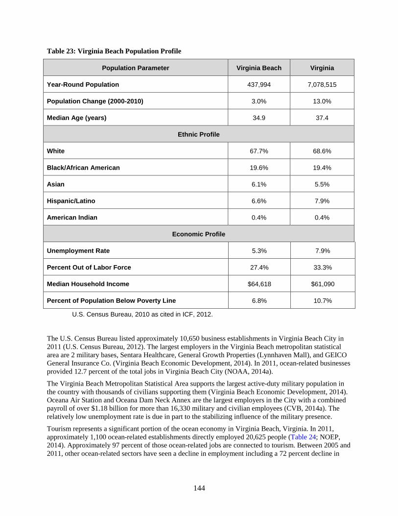
144
Table 23: Virginia Beach Population Profile
Population Parameter Virginia Beach Virginia
Year-Round Population 437,994 7,078,515
Population Change (2000-2010) 3.0% 13.0%
Median Age (years) 34.9 37.4
Ethnic Profile
White 67.7% 68.6%
Black/African American 19.6% 19.4%
Asian 6.1% 5.5%
Hispanic/Latino 6.6% 7.9%
American Indian 0.4% 0.4%
Economic Profile
Unemployment Rate 5.3% 7.9%
Percent Out of Labor Force 27.4% 33.3%
Median Household Income $64,618 $61,090
Percent of Population Below Poverty Line 6.8% 10.7%
U.S. Census Bureau, 2010 as cited in ICF, 2012.
The U.S. Census Bureau listed approximately 10,650 business establishments in Virginia Beach City in 2011 (U.S. Census Bureau, 2012). The largest employers in the Virginia Beach metropolitan statistical area are 2 military bases, Sentara Healthcare, General Growth Properties (Lynnhaven Mall), and GEICO General Insurance Co. (Virginia Beach Economic Development, 2014). In 2011, ocean-related businesses provided 12.7 percent of the total jobs in Virginia Beach City (NOAA, 2014a).
The Virginia Beach Metropolitan Statistical Area supports the largest active-duty military population in the country with thousands of civilians supporting them (Virginia Beach Economic Development, 2014). Oceana Air Station and Oceana Dam Neck Annex are the largest employers in the City with a combined payroll of over $1.18 billion for more than 16,330 military and civilian employees (CVB, 2014a). The relatively low unemployment rate is due in part to the stabilizing influence of the military presence.
Tourism represents a significant portion of the ocean economy in Virginia Beach, Virginia. In 2011, approximately 1,100 ocean-related establishments directly employed 20,625 people (Table 24; NOEP, 2014). Approximately 97 percent of those ocean-related jobs are connected to tourism. Between 2005 and 2011, other ocean-related sectors have seen a decline in employment including a 72 percent decline in

145
living resources (e.g., fishing, seafood processing), (52 percent in marine transportation, and 70 percent in marine constructions (NOAA, 2014a).
Table 24: Ocean-Related Employment Data for Virginia Beach
Sector Establishments Employment Wages Gross Domestic Product
All Ocean Sectors 1,104 20,625 $340,684,000 $704,867,000
Tourism and Recreation 1,050 20,092 $319,386,000 $671,904,000
NOEP, 2014
3.3.3.2 Impact Analysis of Alternative A (Preferred Alternative)
Impacts of Routine Activities and Events
As detailed in the sections below, for each phase of OCS wind energy development, impacts to socioeconomic resources are expected to be minor. As described in the programmatic environmental impact statement (MMS, 2007), activities associated with the construction phase of OCS wind energy technologies would include the onshore manufacturing of components and their transportation to offshore sites, the preparation of port facilities, and the installation of components, transformers, and cables. Activities required for operation would include monitoring and maintenance of offshore facilities with the use of small boats and cranes. During the eventual decommissioning, the dismantling and removal of offshore facilities, devices, and cables would occur as would their transportation back to shore with the use of special vessels (MMS, 2007).
The proposed project of 12 MW would employ a small number of workers with jobs that are temporary in nature, and it would generate a low impact on local and regional income and the population. Tetra Tech predicts the project could directly create 360 cumulative jobs in the six-year period, mostly in the construction trades (RAP, 2015, Section 4.11.2). An additional 77 cumulative indirect jobs could be created in firms supporting construction. Dominion has indicated that they would hire local workers where possible (RAP, 2015, Section 4.11.2).
Given the marine-industrial nature of the area’s workforce (Rondorf et al., 2009), it is expected that the project would be able to acquire local workers during the construction stage. Indirect job creation would also occur within the local area, but it is assumed that most of these jobs would be associated with current residents (MMS, 2007). Because it is expected that offshore wind developments in the planning period would be developed near existing urban areas, the additional demand for housing and infrastructure to support the construction crews and their dependents is expected to be negligible.
Additional discussion about employment, tax implications, and other negligible socioeconomic impacts is described in (RAP, 2015; Section 4.11).
Impacts of Non-routine Activities and Events
Collisions are considered unlikely because vessel traffic is controlled by multiple routing measures such as safety fairways, traffic separation schemes, and anchorages and these higher traffic areas do not overlap the project area. Risk of allisions with WTGs would be further reduced by USCG-required

146
marking and lighting. Even if an accidental event occurs or even in the event of hurricane damage, the results would likely have minor effects on the demographic and employment characteristics of Virginia Beach. This is because non-routine events typically cause only short-term population movements (e.g., individuals seek employment to help with a clean-up) or have their existing employment displaced during the event on par with the rest of the area (e.g., severe storms would impact offshore activities). Given the small size of the project, recovery is anticipated to be quick.
Conclusion
BOEM has determined that minor population and employment impacts would occur given the small size of the project compared to the rest of the Virginia Beach economy. Negligible impact on housing is expected from employment generated by the project given the limited number of employees.
3.3.3.3 Alternative B – Alternate Turbine Location (adjacent to the Virginia WEA
All the socioeconomic impacts associated with selecting Alternative B are the same as those associated with Alternative A.
Conclusion
From a demographic and economic standpoint, there is no difference in the impacts from construction, operating and eventual decommission of VOWTAP in any of the alternatives.
3.3.3.4 Alternative C – Alternate Turbine Location (within Virginia WEA)
All the socioeconomic impacts associated with selecting Alternative C are the same as those associated with Alternative A.
Conclusion
From a demographic and economic standpoint, there is no difference in the impacts from construction, operating and eventual decommission of VOWTAP in any of the alternatives.
3.3.3.5 Alternative D – Alternate Export Cable Landfall (Croatan Beach)
All the socioeconomic impacts associated with selecting Alternative D are the same as those associated with Alternative A.
Conclusion
From a demographic and economic standpoint, there is no difference in the impacts from construction, operating and eventual decommission of VOWTAP in any of the alternatives.
3.3.3.6 Alternative E – No Action
Under Alternative E any potential impacts described in Section 3.3.3.1 would not occur or would be postponed.
3.3.3.7 Cumulative Impacts Analysis
The cumulative activities are discussed in detail in Section 2.6 and includes nine reasonably foreseeable activities: (1) site assessment activities; (2) wind energy development; (3) geological and geophysical activities; (4) transmission line installation; (5) marine minerals use; (6) dredged material disposal; (7) LNG terminal operations; (8) military range complexes and civilian space program use; and (9) shipping and marine transportation. The activities that would most affect demographics and employment are

147
activities in Virginia state waters related to site assessments, marine minerals use, dredged material disposal, transportation at Virginia ports, and renewable energy development because they use similar types of marine crews.
As discussed earlier, the military influence on employment rates is sizable. The area has a trained workforce (e.g., maritime managers, engineers with shipboard experience, experience working at sea) that is frequently seeking new careers after military service (Rondorf et al., 2009).
The cumulative activities are projected to minimally affect the analysis area’s demography because they would involve limited duration influx of employees or would be able to utilize existing capacity in the local workforce (Rondorf et al., 2009). Potential employment activities would have a negligible impact compared to other factors such as population growth or the status of the overall economy.
Conclusion
The cumulative level of impact to employment, population growth, age, and racial distributions is negligible compared to other factors such as the status of unforeseen national economic health or changes in military spending.
3.3.4 Environmental Justice
3.3.4.1 Description of the Affected Environment
Executive Order 12898 (EO 12898, Subsection 1-101) requires that “each federal agency shall make achieving environmental justice part of its mission by identifying and addressing, as appropriate, disproportionately high and adverse human health or environmental effects of its programs, policies, and activities on minority populations and low-income populations…”. If such effects are identified, appropriate mitigation measures must be implemented. The Programmatic EIS (MMS, 2007) contains a complete description of the method used for analyzing impacts to low-income and minority populations. Median household income and demographics data for the study area counties were reviewed to better understand the income levels of residents within the counties surrounding the proposed port locations in Norfolk and Newport News.
Table 25 shows that both the cities of Newport News, Virginia and Norfolk, Virginia have a higher percentage of minority population than the state of Virginia. In addition, median household income data shows that incomes from Newport News and Norfolk were below the state median household income. Finally, the percentage of persons below the poverty line in Newport News and Norfolk were well above the state average.

148
Table 25: Proposed Action Area Demographics and Income Data
Demographic Virginia Beach Newport News Norfolk Virginia
Median Household Incomea $65,980 $50,744 $44,164 $63,636
Persons below poverty levelb 7.4% 14.5% 18.2% 11.1%
Ethnic Profile
White (not Hispanic or Latino) 64.5% 46% 44.3% 64.8%
Black or African American 19.6% 40.7% 43.1% 19.4%
Hispanic or Latino 6.6% 7.5% 6.6% 7.9%
Asian 6.1% 2.7% 3.3% 5.5%
American Indian and Alaska Native 0.4% 0.5% 0.5% 0.4% a 2012 data from U.S. Census Bureau, 2014 b 2008-2012 data from U.S. Census Bureau, 2014
3.3.4.2 Impact Analysis of Alternative A (Preferred Alternative)
Impacts of Routine Activities and Events
Because VOWTAP wind testing facility would be located 24 nautical miles (44.5 km) offshore (RAP, 2015, Section 1.1), construction, operations, and maintenance activities are not anticipated to have disproportionately high or adverse environmental or health effects on minority or low-income populations. Onshore activities in support of VOWTAP include a construction port, an operation and maintenance facility, and a base port (RAP, 2015, Section 3.2.6). The construction port facility would either be located in Norfolk, Virginia or Newport News, Virginia. It is not anticipated that improvements or land-disturbing activities would be necessary to support project construction and staging. The operation and maintenances facility would be located at an existing Dominion facility or an existing industrial/commercial waterfront parcel in the cities of Norfolk or Virginia Beach. Finally, the base port would be located in the Virginia Beach area at an existing marina. No expansion of the marina would be necessary.
The export cable landfall site would be located at Camp Pendleton Beach where cables would connect to a new switch cabinet that would be constructed in a parking lot adjacent to Camp Pendleton Beach. In addition, an interconnection station would be constructed at Camp Pendleton Beach. Visual impacts from the interconnection station would be mitigated by an 8-ft-high fence and vegetation screening. Additional information on visual impacts can be found in Section 3.3.1.2 of this revised EA.
A minor increase in traffic and noise is likely during periods of onshore staging and construction. However, the majority of traffic and noise would be confined to existing commercial and industrial facilities and a military installation (Camp Pendleton). All impacts from increased traffic and noise would only occur during periods of onshore staging and construction; and therefore, would be temporary in nature.

149
Decommissioning activities are similar to the proposed construction activities, although they would occur in reverse order. No expansion or improvements of existing facilities is anticipated for decommissioning activities. A minor but transient increase in traffic and noise is likely during staging periods for decommissioning activities.
Impacts of Non-routine Activities and Events
Non-routine events such as oil spills have the potential to impact local beaches. More information on oil spills can be found in Section 3.1.2 of this revised EA. If a spill were to occur, it is expected to dissipate very rapidly and biodegrade within a few days and is unlikely to reach the shore given that the project is located 24 nautical miles offshore.
Conclusion
Although the cities of Newport News, Virginia and Norfolk, Virginia have a higher percentage of low-income and minority persons than the state average, BOEM does not anticipate disproportionately high or adverse environmental or health effects on low income- or minority populations based on the distance of the project from shore, the temporary nature of onshore construction, staging, and decommissioning activities, and the use of existing commercial and industrial facilities.
3.3.4.3 Alternative B – Alternate Turbine Location (adjacent to the Virginia WEA)
Under Alternative B, research activities including the construction, operation, maintenance, and eventual decommission of 2 turbines would occur in the three northern aliquots of the proposed research lease area (aliquots H, L, P of OCS block 6061), directly north of the area identified under the Proposed Action. Like the Proposed Action, this alternative also includes the construction, operation, maintenance, and eventual decommission of the export cable to shore; however, the export cable would be approximately 1.5 nautical miles longer (total of approximately 25.5 nautical miles).
All the environmental consequences associated with selecting Alternative B would be the same as those associated with Alternative A, except for the specific local impacts associated with the placement of turbines.
Section 3.3.4.2, which describes the project impacts on low-income or minority populations, concluded that BOEM does not anticipate disproportionately high or adverse environmental or health effects on minority or low-income populations based on the distance of the project from shore, the temporary nature of onshore construction, staging, and decommissioning activities, and the use of existing commercial and industrial facilities.
Alternative B would not result in any change in the type or quantity of impacts on low-income or minority populations when compared with Alternative A. Impacts to low-income or minority populations are not a discriminating factor among these alternatives due to the fact that impact levels do not change as a result of the alternatives.
3.3.4.4 Alternative C – Alternate Turbine Location (within the Virginia WEA)
Like the Proposed Action, Alternative C also includes the export cable to shore in its analysis. All the environmental consequences associated with selecting Alternative C would be the same as those associated with Alternative A, except for the specific local impacts associated with the placement of two turbines, a longer cable route to shore, impacts to navigation, and additional site characterization surveys.
Section 3.3.4.2, which describes the project impacts on low-income or minority populations, concluded that BOEM does not anticipate disproportionately high or adverse environmental or health effects on minority or low-income populations based on the distance of the project from shore, the temporary nature of onshore construction, staging, and decommissioning activities, and the use of existing commercial and

150
industrial facilities. Alternative C would not result in disproportionately high or adverse environmental or health effects on low-income or minority populations and thus would be the same as Alternative A.
Alternative C would not result in any change in the type or quantity of impacts on low-income or minority populations when compared with Alternative A. Impacts to low-income or minority populations are not a discriminating factor among these alternatives due to the fact that impact levels do not change as a result of the alternatives.
3.3.4.5 Alternative D – Alternate Export Cable Landfall (Croatan Beach)
Under Alternative D, the Croatan Beach public parking lot would be used as the export cable landfall location. In the RAP, VOWTAP considered several criteria when examining potential export cable landfall locations (RAP, 2015, Section 2.3.1). This location is slightly north of the landfall location identified in the Proposed Action (Camp Pendleton Beach). Landfall to the interconnection point would be 0.91 mile (1.7 km) from landfall to the interconnection point, slightly longer than the length under the Proposed Action (0.68 mile [1.3 km]).
The cable landfall location under Alternative D would be in a more publicly accessible location then the landfall location identified in Alternative A. In addition, the onshore cable route under Alternative D would be longer then the cable route in Alternative A. While the public parking area would be impacted by Alternative D, the natural and recreational resources of Croatan Beach would still be accessible to the public. Any impacts associated with the cable landfall location and onshore route, including visual impacts or increased traffic during construction would occur within the city of Virginia Beach, Virginia and would not restrict public access to recreation and natural areas, therefore, they would not have a disproportionate impact on low-income or minority populations.
Alternative D would not result in disproportionately high or adverse environmental or health effects on low-income or minority populations and thus would be the same as Alternative A.
3.3.4.6 Alternative E – No Action
Under the No Action Alternative, no research activities, including the construction, operation, maintenance and eventual decommission of two turbines and export cable to shore, would be approved on the OCS offshore Virginia at this time. All minor impacts from increased traffic, noise, and visual impacts as a result of the Proposed Action would not occur in Alternative E.
Alternative E would not result in any impacts on low-income or minority populations as this Alternative would not result in any development or impacts to communities in Virginia.
3.3.4.7 Cumulative Impacts Analysis
Cumulative activities are discussed in detail in Section 2.6 and include nine reasonably foreseeable activities: (1) site assessment activities; (2) wind energy development; (3) geological and geophysical activities; (4) transmission line installation; (5) marine minerals use; (6) dredged material disposal; (7) LNG terminal operations; (8) military range complexes and civilian space program use; and (9) shipping and marine transportation. The activities most impactful to low income and minority populations are activities in Virginia state waters related to site assessments, marine minerals use and dredged material disposal, transportation at Virginia ports, and renewable energy development because these activities are closer to onshore communities and impact local employment (see Section 3.3.3.2 for more information on impacts to demographics and employment).
The majority of past, present, and future activities analyzed under the cumulative activities would occur offshore. Offshore activities have only minor indirect impacts on the population in the study area. The

151
cumulative activities are projected to result in minor impacts due to distance from shore and the temporary nature of the onshore activities.
Conclusion
The minor impacts associated with the past, present, and future activities would not have a disproportionally high impact on low income or minority populations due to distance from shore and the temporary nature of the onshore activities.
3.3.5 Land Use and Coastal Infrastructure
3.3.5.1 Description of the Affected Environment
The onshore switch cabinet, an underground fiber optic cable, and a new interconnection station are proposed to be located entirely within the boundaries of Camp Pendleton Beach, which is owned by the state of Virginia and primarily used for onsite training of Virginia National Guard personnel (Proposed Action area). Camp Pendleton is listed in the NRHP for its association with the military training and build-up associated with both world wars and for its collection of exemplary military architecture (RAP, 2015). Additional aspects of the project are located in a heavy industrial district within an existing Dominion right-of-way (RAP, 2015).
Dominion indicated that onshore support facilities would be located at existing waterfront industrial and commercial properties in Virginia Beach, Norfolk, and Newport News (RAP, 2015). The harbor capacity is among the highest quality on the U.S. East Coast and with extensive tug, barge, and marine transportation options along with multiple options that offer sufficient capacity for large component transportation to offshore locations (Rondorf et al., 2009).
3.3.5.2 Impact Analysis of Alternative A (Preferred Alternative)
Impacts of Routine Activities and Events
Dominion has indicated use of existing facilities in the cities of Virginia Beach, Virginia, Norfolk, Virginia and Newport News, Virginia to serve as a potential construction port, operations and maintenance facility, and base port (RAP, 2015, Section 1.3). These facilities are not expected to require modifications to support construction, operation and maintenance, or decommissioning of the wind energy facility (RAP, 2015, Section 3.2.6). This conclusion is supported by a 2009 study, which found that Virginia ports have appropriate characteristics to support offshore wind energy construction (Rondorf et al., 2009). Onshore construction to tie electrical production from the offshore wind facility to the local grid would have negligible impact on the area, which is located solely on military lands. Activities associated with decommissioning of a facility would likely be the reverse of the 12 week construction process, though likely somewhat shorter in duration (MMS, 2007).
Impacts of Non-routine Activities and Events
Accidental events, such as vessel collisions, would have no effects on land use. Storm-related events may have an impact but unrelated to the wind energy facility.
Conclusion
BOEM has determined negligible impacts given that construction, operation and maintenance, and decommissioning of the wind energy facility would not require changes in land use or existing infrastructure.

152
3.3.5.3 Alternative B – Alternate Turbine Location (adjacent to the Virginia WEA)
From a land use and infrastructure standpoint, there is little difference in the potential disruptions from construction, operation and maintenance, and eventual decommission of VOWTAP. All the impacts associated with selecting Alternative B would be the same as those associated with Alternative A.
3.3.5.4 Alternative C – Alternate Turbine Location (within the Virginia WEA)
From a land use and infrastructure standpoint, there is little difference in the potential disruptions from construction, operation and maintenance and eventual decommission of VOWTAP. All the impacts associated with selecting Alternative C would be the same as those associated with Alternative A.
3.3.5.5 Alternative D – Alternate Export Cable Landfall (Croatan Beach)
Landfall site at the Croatan Beach public parking lot would also impact a public area, but would generally result in the same impacts that would occur under Alternative A.
3.3.5.6 Alternative E – No Action
Under Alternative E any potential impacts described in Section 3.3.5.2 would not occur or would be postponed.
3.3.5.7 Cumulative Impacts Analysis
The cumulative activities are discussed in detail in Section 2.6 and includes nine reasonably foreseeable activities: (1) site assessment activities; (2) wind energy development; (3) geological and geophysical activities; (4) transmission line installation; (5) marine minerals use; (6) dredged material disposal; (7) LNG terminal operation; (8) military range complexes and civilian space program use; and (9) shipping and marine transportation. The activities most impacting land use and infrastructure are activities in Virginia state waters related to site assessments, marine minerals use and dredged material disposal, transportation at Virginia ports, and renewable energy development because they use similar types of marine infrastructure.
The use of existing ports and their associated land bases is expected to have no or negligible land use conflicts with existing land uses and land use plans because of existing capacity (Rondorf et al., 2009), and they can be seen as positive for utilizing areas already developed for marine activities. A cumulative increase in port traffic is expected, particularly related to shipping and marine transport in East Coast ports that can accommodate the larger Panama ships (see Section 2.6.9). However, the impact from accidental fuel spills arising from vessel collision under the cumulative activities is expected to be negligible due to safety and navigation mitigation measures related to construction of the WTGs, along with the cumulative projects being located outside popular shipping lanes.
Conclusion
The incremental contribution of VOWTAP with other past, present, and reasonably foreseeable uses of land and coastal infrastructure is likely to be positive through the use of underused capacity in port areas.

153
3.3.6 Commercial and Recreational Fishing Activities
3.3.6.1 Description of the Affected Environment
A description of recreational and commercial fishing offshore Virginia can be found in Section 4.1.3.6 of the Mid Atlantic EA (BOEM, 2012a) and in Chapter 4 (4.2.7 and 4.2.8) of the Atlantic G&G FPEIS (BOEM, 2014a). Section 3.2.5 of this revised EA discusses the specific fish species and their habitat found in the project area. Unless otherwise cited, the information provided in the following sections is based on analysis conducted by NMFS Northeast Fisheries Science Center (NEFSC) (Kirkpatrick et al., 2014). NEFSC primarily used vessel trip reports (e.g., federally reported landing data) and vessel monitoring data to identify fishermen locations. Given VOWTAP’s location adjacent to the Virginia WEA, BOEM is using NEFSC’s results as a proxy of potentially impacted activities.
Recreational Fishing
Virginia has an active recreational fishing sector in its coastal waters, with the top recreational species from federal waters identified as black sea bass, tautog, summer flounder, bluefish, mahi-mahi, tuna, and mackerels (NOAA OST, 2014). The number of anglers has been decreasing since 2006 with the largest decrease occurring in out-of-state visitors (NOAA OST, 2014). NEFSC identified 2 principal Virginia ports (Virginia Beach and Wachapreague) from which recreational anglers fishing in or near the Virginia WEA departed. During 2007 through 2012, approximately 2,620,730 recreational fishing trips left these ports. Slightly less than 2.2 percent of those departing were from Virginia Beach and traveled near or in the Virginia WEA, and only 0.01 percent was from Wachapreague. Figure 17 illustrates that the more heavily used areas for recreational fishing tend to be closer to shore.
Commercial Fishing
Table 26 shows the four-year trend for commercial landings for the state. The data indicate that landings increased from the early 2000s but remained relatively stable from 2009-2012. In each of the latter four years, over two-thirds of the commercial value for the Virginia marine fishery was derived from shellfish, primarily sea scallop, blue crab, and northern quahog clam. Among finfish the value of menhaden, Atlantic croaker, summer flounder, and striped bass dominated commercial landings. These four finfish species comprised approximately 25.1 percent of the commercial value of the fishery, with menhaden alone representing 16.9 percent.

154
Figure 17: Recreational Fishing Offshore, 2007-2012
Primary Data Source: TNC, 2014
Table 26: Virginia Commercial Fishery Landed Weight and Value 2009-2012
Year Pounds Cost
2009 426,797,509 $152,017
2010 510,473,685 $183,181
2011 494,050,244 $191,025
2012 461,943,838 $175,640
Four-year Average 473,316,319 $175,466
NOAA OST, 2014
Table 27 lists NEFSC’s assessment of the top ports where commercial fishing vessels that utilize waters in or near the Virginia WEA depart from. NEFSC’s research found that only commercial fishermen from Virginia Beach have more than 0.10 percent of their total landing revenue generated from in or around the Virginia WEA. The value of “exposure” for these fishing vessels was roughly $40,000 per year. This reported value should not be interpreted as potential loss, but is a reflection of the level of economic

155
activity that existed during the study period in the WEA. There are likely substitutable fishing locations, which could mean no economic impact.
Table 27: Top Ports with Commercial Fishermen Using Waters in or near Virginia WEA
Port
Average Annual Federally Reported Landed Value (2007-2012)a
Virginia WEAb Total Percent of Revenue from Virginia WEA
Massachusetts
New Bedford $926 $292,229,242 Less than 0.01%
North Carolina
Oriental $1,087 $1,272,725 0.10%
Engelhard $2,109 $2,307,195 0.10%
New Jersey
Cape May $1,437 $75,665,163 Less than 0.01%
Rhode Island
North Kingstown $9,530 $9,555,145 0.10%
Virginia
Chincoteague $808 $3,130,890 Less than 0.01%
Hampton $1,176 $15,344,027 Less than 0.01%
Newport News $5,633 $38,319,620 Less than 0.01%
Norfolk Not disclosedc
Virginia Beach $40,251 $1,122,195 3.60%
a Kirkpatrick et al., 2014. b Given VOWTAP’s location adjacent to the Virginia WEA, BOEM is using NEFSC’s results as a proxy of potentially impacted activities. The VOWTAP footprint is much smaller. c Suppressed for confidentiality, which indicates less than 3 vessels reporting data

156
3.3.6.2 Impact Analysis of Alternative A (Preferred Alternative)
Impacts of Routine Activities and Events Impacts to fisheries that may result from development of OCS wind energy facilities include:
• Changes in the distribution or abundance of fishery resources • Reduction in the catchability of fish or shellfish • Limitations to accessing fishing areas • Losses or damage to equipment or vessels
More details on the impacts to fish are provided in Section 3.3.2.1.
Construction
Construction activities of two WTGs and placement of transmission lines on the seafloor could harm or temporarily displace target fish species from localized areas. However, population-level changes in fishery abundance or distribution are not anticipated. Impacts to seafloor habitats are expected to be localized with negligible effects on populations of seafloor biota (MMS, 2007, Section 5.2.14 and Section 5.2.15). Dominion has indicated pile driving would require one week for each foundation occurring in a three week period in May during daylight hours only (RAP, 2015, Section 3.4). Noise associated with the turbine foundations and site characterization activity could reduce the catchability of some fish species during the duration of the noise-producing activity (Normandeau et al., 2012). Fishing would likely return to normal immediately after construction.
Some construction activities have the potential to result in space-use conflicts. Dominion expects offshore construction to take place over a 12-week period, during which there would be temporarily restricted access to the work areas (RAP, 2015, Section 4.11.2.5). To ensure the safety of the local mariners, Dominion would establish a work area around each WTG location and a 200-ft-wide construction right-of-way along the routes of the export cable and inter-array Cable. As a consequence, fishing activities could be temporarily excluded to avoid gear loss or vessel accidents. Dominion intends to minimize closures and the entire area identified would not be closed for the entire duration of construction (i.e., May to July). The temporary construction area would be closed off around the area where activity is occurring at that time.
The export cable crosses an area used by the military, which is designated as a danger zone on nautical charts (C&H Global Security, 2013). Recreational and commercial fishermen are asked to remain not remain in the area longer than necessary for purpose of transit (33 CFR § 334.380; 33 CFR § 334.390).
The small increase in vessel activity that would occur during the construction phase would not measurably affect fishing opportunities, navigation, or port congestion. Fuel spills that occur as a result of vessel accidents or leaks could temporarily close affected areas to fishing. However, the likelihood of such spills is relatively low because of the small number of trips that would be required during the construction phase. If vessel fuel spills occurred, the volume of fuel that potentially could be spilled would be less than a few thousand gallons and would be limited spatially and temporally to the vicinity of the point of release. Impacts to fish resources or commercial or recreational fisheries would therefore be negligible.
Operation
The foundations for the WTG would likely act as an artificial reef, which could increase the diversity of fish and abundance of some fish species within 1 to 5 meters, the foundations (Bergstrom et al., 2014 and Wilhelmsson et al., 2006). See further details in Fish Habitat Section 3.2.5. The project area might therefore become a desirable recreational fishing area (MMS, 2007, Section 5.2.11.4 and Section 5.2.14.4).

157
The WTGs would represent an obstruction to navigation, but the height of the towers above the ocean surface would make them visually detectable at a considerable distance during the day and easily detected by vessels equipped with radar. An allision between a vessel and a WTG is possible but highly unlikely given implemental of USCG approved lighting and marking requirements (C&H Global Security, 2013). Given the small size of the project, the WTGs would likely not impede the ability of vessels’ marine radar from identifying other vessels either within or on the opposite side of VOWTAP (C&H Global Security, 2013). Furthermore, the project is required to submit a navigational risk assessment to the USCG according to Navigation and Vessel Inspection Circular 02-07 (USCG, 2007).
With the exception of a hydraulic dredge, the 2-m (ft) burial depth of the export cable is of sufficient depth to not present a gear entanglement hazard to commercial and recreational fishing gear. The surfclam and ocean quahog fishery, which is the only fishery to utilize a hydraulic dredge in the northeast, is not currently operating offshore Virginia (Table 28). There is a risk that over time cables could become unburied as a result of normal physical oceanographic processes, including storm events. VOWTAP would be inspecting cables at regular intervals to help identify if cables become unburied. Any maritime activities that involve bottom contact or loitering are prohibited along the segment of the export cable that crosses the active military practice areas (RAP, 2015, Section 4.12).
The small increase in vessel activity would not be expected to measurably affect fishing opportunities, catchability of fish and shellfish resources, or navigation. Fuel spills that occurred as a result of vessel accidents or leaks could temporarily affect fishing opportunity. However, the likelihood of such spills is relatively low because of the small number of trips that would be required for maintenance activities. If spills occurred, the volume of fuel that potentially could be less than a few thousand gallons and would be limited spatially and temporally to the vicinity of the point of release. Impacts to fish resources or commercial or recreational fisheries would be negligible.
Table 28: Top Gear and Fishery Management Plans Performed Offshore Virginia
Gear Permits
(Estimated)a Fishery Management Plan(s)
Trawl bottom 109 Mackerel Squid Butterfish; Summer Flounder, Scup, and Black Sea Bass;
other, including highly migratory species
Pot 19 Summer Flounder, Scup, and Black Sea Bass; Deep Sea Red Crab; Northeast large multi species; other
Gillnet 12 None; Monkfish; Northeastern Skate; Bluefish; other
Hand 9 Summer Flounder, Scup, and Black Sea Bass; Bluefish; other
Pot lobster 4 Deep Sea Red Crab; other
Longline 2 Other and highly migratory species;

158
Gear Permits
(Estimated)a Fishery Management Plan(s)
Dredge 2 Atlantic Sea Scallop; Summer Flounder, Scup, and Black Sea Bass mid-Atlantic; Monkfish; Other
Midwater Trawl 1 Other
aThis is the estimated maximum number of permits that fished in the Virginia WEA (Kirkpatrick et al., 2014).
Decommissioning
Removal of structures that act as artificial reefs would result in loss of recreational fishing opportunities that would have developed during the operational phase. There is also a small potential for accidental releases of hazardous materials and fuel during decommissioning activities. Fishing activities could be temporarily excluded from areas that might be normal fishing grounds during removal activities to avoid the potential for gear loss or vessel accidents. Anglers could also feel compelled to avoid areas with decommissioning activity because of perceived disturbances.
The small increase in vessel activity that would occur during the decommissioning phase would not be expected to measurably affect commercial or recreational fishing opportunities, catchability of fish and shellfish resources, or navigation. Fuel spills that occurred as a result of vessel accidents or leaks could temporarily affect fishing opportunities in the affected area. However, the likelihood of such spills is relatively low because of the small number of trips that would be required. If spills occurred, the volume of fuel that potentially could be spilled would be lease than a few thousand gallons and would be limited spatially and temporally to the vicinity of the point of release. Impacts to fish resources or commercial or recreational fisheries would be negligible.
Assuming that all infrastructures are removed and that all pilings and entanglement hazards associated with development of the project are below the level of the seabed or buried, fishing conditions within the project area should return to those that existed prior to construction.
Impacts of Non-routine Activities and Events
The coastal region of Virginia is subject to potential year-round weather hazards such as hurricanes. Dominion has selected WTGs based on their suitability for an offshore location (RAP, 2015, Section 4.1.1.2). After storm-related events, Dominion would conduct surveys of the export cables to ensure they are still buried to avoid entanglement with fishing gear.
Conclusion
BOEM has determined negligible impacts to commercial and recreational fishing would occur from the construction, operation and maintenance, and decommissioning of the wind energy facility given its localized footprint. Reasonably foreseeable impacts on commercial and recreational fishing include, increased vessel traffic and temporary exclusion of vessels during construction and decommissioning phases. Depending on the type of gear used, commercial fishermen may choose not to fish near (within 5 m to 10 m) the two foundations. The actual foundation footprint and a 5 m to 10 m-area around the foundation that may be lost to bottom-tending mobile gear is an extremely limited area compared to available fishing grounds in the area.

159
3.3.6.3 Alternative B – Alternate Turbine Location (adjacent to the Virginia WEA)
All the impacts associated with selecting Alternative B would be approximately the same as those associated with Alternative A.
For recreational and commercial fishing there is little difference in the potential disruptions from construction, operation and maintenance and decommissioning of VOWTAP in any of the alternatives (A to D) given the limited size of the project.
3.3.6.4 Alternative C – Alternate Turbine Location (within the Virginia WEA)
All the impacts associated with selecting Alternative C and would be approximately the same as those associated with Alternative A.
For recreational and commercial fishing there is little difference in the potential disruptions from construction, operation and maintenance and decommissioning of VOWTAP in any of the alternatives (A to D) given the limited size of the project.
3.3.6.5 Alternative D – Alternate Export Cable Landfall (Croatan Beach)
All the impacts associated with selecting Alternative D and would be approximately the same as those associated with Alternative A.
For recreational and commercial fishing there is little difference in the potential disruptions from construction, operation and maintenance and decommissioning of VOWTAP in any of the alternatives (A to D) given the limited size of the project.
3.3.6.6 Alternative E – No Action
Under Alternative E, any potential impacts described in Section 2.5 would not occur or would be postponed.
3.3.6.7 Cumulative Impacts Analysis
The cumulative activities are discussed in detail in Section 2.6 and includes nine reasonably foreseeable activities: (1) site assessment activities; (2) wind energy development; (3) geological and geophysical activities; (4) transmission line installation; (5) marine minerals use; (6) dredged material disposal; (7) LNG terminal operation; (8) military range complexes and civilian space program use; and (9) shipping and marine transportation. The impact-producing factors for these cumulative activities that have the potential to affect commercial and recreational fisheries include (1) increased anthropogenic noise in the ocean, including underwater noise from sonars, explosives, and other active sound sources; (2) vessel traffic and vessel exclusion zones; (3) seafloor disturbances; and (4) a risk of accidental releases of fuel or other hazardous materials from accidents (smaller accidental events or low-probability large scale catastrophic events).
Underwater Noise
Impact analyses presented in Fish and Essential Fish Habitat (Section 3.2.5) determined that activities projected to occur under Alternative A would result in negligible to minor impacts related to fish and essential fish habitat. The cumulative impact to fishing from underwater noise concerns the availability and catchability of fish as a result of underwater noise exposure. The approximately two-week period of intermittent pile-driving activity is not expected to measurably decrease the availability and catchability of targeted fish offshore Virginia. Because there are no significant noise impacts evident from the

160
cumulative activities and because there is no evidence of ambient noise levels approaching a threshold level where fisheries might be significantly affected, it is expected that there would be an extremely minor incremental decrease in the availability and catchability of fish resulting from active acoustic sound disturbances under Alternative A under the cumulative activities.
Vessel Traffic, Vessel Exclusion Zones and Fixed Structures
Vessel traffic would increase under the cumulative activities to support most of the activities. Generally, most commercial fishing operators set their gear according to specific habitats (e.g., bottom profile) or water conditions. Thus, if there are numerous vessels transiting through the fishing grounds, they may prevent fishermen from setting their gear in a manner that maximizes fishing effort. However, the additional vessel traffic from the cumulative activities would not be a significant increase to existing vessel traffic. Small vessels would be able to avoid commercial fishing vessels with gear in the water as they transit to offshore locations, and larger vessels typically adhere to traffic separation schemes (TSS) and safety fairways establish by the USCG. TSSs are generally avoided by fishermen under existing conditions; therefore impacts to commercial fisheries from vessel traffic associated with the cumulative activities are expected to be negligible.
Military range complexes and civilian space program-use areas already restrict commercial fishing activities, and during the construction and decommissioning of VOWTAP there would be additional vessel exclusion zones. However these exclusion zones would be intermittent, temporary, and short-term during construction and decommissioning. The total footprint of each IBGS foundation is approximately 0.09 acre (0.04 hectare) on the seafloor. Thus impacts to commercial fisheries arising from vessel exclusion zones are expected to be negligible.
It is possible that traffic associated with the Dam Neck Coastal Restoration project could overlap in time with VOWTAP construction, causing vessel traffic congestion. However, the Dam Neck-associated traffic would likely use routes located to the south of Camp Pendleton, and interaction effects would be unlikely. The onshore Proposed Project activity would not overlap spatially or temporally with development of any of the other identified reasonably foreseeable future actions. Offshore, there could be short-term increases in vessel traffic associated with construction or decommissioning of VOWTAP that could overlap in time with similar actions associated with the commercial WEA and the Dam Neck Restoration Project. To the extent that such changes occurred in combination, the effects for all of the projects would be limited in duration and minor in relation to the baseline level of vessel activity in the area. Based on the intensity and duration of the effects, the potential for meaningful cumulative impacts on marine transportation is very low.
Cumulative activities including the installation of meteorological/oceanographic buoys and meteorological towers in support of various energy development projects would likely introduce more structure and navigational obstructions offshore Virginia. However, the number of buoys and towers that could be installed is not expected to cause any more hazards to fishing than do existing shipwrecks, navigational buoys, and the Chesapeake Light Tower current pose to commercial and recreational fishing. Incremental impacts to commercial fisheries arising from the presence of structures are expected to be negligible.
Accidental Fuel Spills
The potential for a fuel spill from vessels involved in the cumulative activities is expected to be minor and have negligible impact. Section 3.2.5 of this assessment discusses accidental petrochemical spills to fish and essential fish habitat. Consequently, it may be possible that commercially important fishes could be exposed to petrochemicals. Spill effects on commercial fishes, as well as spill response vessel operations, could have a direct effect on commercial fishing operations. However, given the size of the potential spill, a large-scale spill response involving multiple vessels is not expected. Small diesel spills (50 to 5,000 gallons) usually evaporate and disperse within a day or less, even in cold water (NOAA, 2014c); thus,

161
there is seldom any oil on the surface for responders to recover. Therefore, the incremental impacts to commercial fisheries activities associated with a fuel spill from vessels under the cumulative activities would be negligible.
Conclusion
Overall, BOEM has determined negligible impacts to commercial and recreational fishing would occur from the construction, operation and maintenance, and decommissioning.
3.3.7 Other Uses of the OCS
3.3.7.1 Description of the Affected Environment
A detailed description of other uses of the OCS offshore Virginia can be found in Section 4.1.3.7 of the Mid Atlantic EA (BOEM, 2012a). The following information is a summary of the resource description incorporated from the Mid Atlantic EA, and relevant new information for the Proposed Action area that has become available since the document was prepared, including information from the RAP.
Vessel traffic, structures, and submarine cables associated with the proposed project could pose a conflict with other existing and future uses of the OCS, including military activities, marine transportation, marine minerals program; ocean dredged material disposal sites, and other renewable energy activities. These activities are discussed below. Commercial and recreational fishing and recreational boating are discussed in Sections 3.3.6 and 3.3.2 of this revised EA.
Military Activities
Section 4.1.3.7 of the Mid Atlantic EA discusses the military use areas and activities offshore Virginia and the surrounding areas (BOEM, 2012a). The proposed project is partially located in the Virginia Capes Naval Operating Area (VACAPES OPAREA) where frequent surface and subsurface training and exercise operations are carried out.
The VACAPES Range Complex includes special use airspace with associated warnings and restricted areas and surface and subsurface sea space of the VACAPES OPAREA. The VACAPES Range Complex also includes established mine warfare training areas located within the lower Chesapeake Bay and off the coast of Virginia (Navy, 2013a). The project area and vicinity has a long history of military training and combat activity. As a result there is the potential existence of unexploded ordnance (UXO) at the WTG locations and along the cable route. An evaluation and quantification of the probability of encountering UXO in the project area has been described in the supplemental Munitions and Explosives of Concern Desktop Study prepared in March 2015 as part of the RAP (2015). A portion of the proposed export cable would be located within the boundaries of Warning Area 50 (W-50-A and W-50-B), a special-use airspace warning area (VACAPES OPAREA, 2014). The proposed export cable also passes through special-use airspace restricted area R-6606 near Camp Pendleton, Virginia. The proposed export cable would also cross 2 live-fire danger zones operated by the Dam Neck Fleet Combat Center (33 CFR § 334.380; 33 CFR § 334.390).

162
Figure 18: Military Use Areas
Marine Transportation
A general description of vessel traffic along the Atlantic coast can be found in Chapter 4.2.1 of the Programmatic EIS (MMS, 2007). A description of marine transportation, vessel traffic, and the TSS in the vicinity of the proposed project area can be found in Section 4.1.3.7 of the Mid Atlantic EA (BOEM, 2012a). Commercial vessel traffic is high at the entrance of the Chesapeake Bay and the Hampton Roads ports. Traffic density is particularly concentrated in the Chesapeake Approaches of the TSS and quickly disperses once out of the TSS area.
At this time, the Ports of Virginia and Baltimore are the only deep-water ports on the East Coast that can accommodate the supersized ships that would navigate the Panama Canal once its expansion is complete (RAP, 2015). The proposed turbine locations are located approximately 13-nautical miles seaward of the Chesapeake Approaches TSS. The proposed export cable location travels from the proposed WTG locations and makes landfall at Camp Pendleton, Virginia. The proposed export cable runs roughly perpendicular to the Chesapeake Bay TSS Southern Approach, where a portion of the cable is located less than 1.0 nautical mile from the TSS. Ships frequently anchor in the vicinity of TSSs, in unofficial anchorage areas, while waiting to go to port (USCG, 2008, personal communication originally cited in BOEM 2012a).

163
The USCG is currently performing an Atlantic Coast Port Access Route Study. The results of the ACPARS may establish new vessel routing measures through an analysis of navigational risk. On July 13, 2012, the USCG issued an Atlantic Coast Port Access Route Study interim report, indicating that all lease blocks within the Virginia WEA conflict with existing shipping routes and would require new or multiple routing measures to be created or would be unsuitable for development. The proposed WTGs are located in OCS block 6111, which was assessed as being not suitable for development under any of the foreseeable options for creating routing measures (USCG, 2012). Although initially determined unsuitable for development, due to the relatively small footprint, navigational safety markings (lights), and charted positions, the placement of two WTG structures would not pose a significant risk to navigation for vessels transiting the area.
Marine Minerals Program
Submerged shoals located offshore Virginia between the proposed project area and the shore have been identified as long-term sources of sand (sand borrow sites) for coastal erosion management (MMS, 2007). The boundaries of the proposed project are not located within the identified submerged shoal; however, the proposed export cable is located approximately 1.6 nautical miles north of the shoal area.
Ocean Dredged Material Disposal Site
The Dam Neck Ocean Disposal Site is a designated Ocean Dredged Material Disposal Site (ODMDS) managed and permitted by the USACE with the U.S. Environmental Protection Agency’s (USEPA’s) approval (EPA and USACE, 2009). The export cable is proposed to be routed through Zone 2 and 5 of Dam Neck Ocean Disposal Site. These zones are designated for the disposal of fine material such as silts and clays. The RAP submitted to BOEM by DMME in December 2013 (revised February 2014), indicates that the siting location of the export cable is based upon recommendations made by the USACE to Dominion (RAP, 2015). The Norfolk Ocean Disposal Site is also in the vicinity of the proposed project area, however it is located approximately 5 nautical miles to the northwest of the project area and project related vessels are not expected to transit through the site.
High Frequency (HF) Radar
NOAA and its academic partners maintain a network of HF radar sensors along the U.S. Atlantic coast for the measurement of ocean surface current speed and direction. The U.S. Coast Guard and NOAA use HF radar operationally for search and rescue and for oil spill response, respectively. The marine shipping industry uses oceanographic data from HF radar systems for navigational purposes. The proposed WTGs are located within the currently operational HF radar network coverage area, which extends from a few kilometers offshore to a maximum of approximately 250 km off the U.S. coast.
Other Renewable Energy Projects
There are other reasonably foreseeable renewable energy activities in the vicinity of the proposed project area that could occur in the same timeframe as the proposed project. A commercial lease has been issued offshore Virginia directly adjacent to the proposed project area. On November 1, 2013, BOEM executed a commercial wind energy lease with Dominion. As a result of that commercial lease, increased vessel traffic associated with site characterization surveys could occur simultaneously with the proposed activities.
3.3.7.2 Impact Analysis of Alternative A (Preferred Alternative)
The following Section discusses the reasonably foreseeable impacts associated with Alternative A on other uses of the OCS. The two primary activities that could impact other uses of the OCS are vessel traffic associated with the project and the permanent placement of structures on the OCS.

164
Impacts of Routine Activities and Events
The proposed activities are located onshore at the location where the export cable makes landfall and continues along the export cable route out to approximately two nautical miles offshore where the turbines are located. As a result, military activities, marine transportation, the Marine Minerals Program, the Ocean Dredged Material Disposal Site (ODMDS), HF Radar, and other renewable energy projects could be affected during all phases of the project life cycle in Alternative A. The project life cycle is expected to be 20 years and includes deployment and construction, operation and maintenance, and decommissioning activities. Vessel traffic would be present at the project landfall location, along the export cable route, and at the turbine construction location. Impacts from vessel traffic associated with the project construction, operations, and decommissioning and the permanent placement of structures associated with other uses of the OCS are discussed below.
Military Activities
Impacts related to military marine uses could include the disruption of military testing and training exercises and an increased risk of vessel collision due to support vessel movement during the project construction, maintenance, and decommissioning. The DOD would reserve the right to suspend operations or require evacuation of the project area in the interest of national security (RAP, 2015).
Activities related to project construction, operation and maintenance, and decommissioning activities would be coordinated with the Fleet Area Control and Surveillance Facility, Virginia Capes and the Fleet Forces Atlantic Exercise Coordination Center at Naval Air Station Oceana. Onshore activities at Camp Pendleton during deployment and construction would be staged in a manner that would minimize impacts to training and daily activities (RAP, 2015).
The potential to encounter UXO along the export cable route poses a potential risk to installation operations. There is a relatively high likelihood of encountering UXO along the cable route due to its history as a practice range; however UXO-specific surveys prior to cable installation can minimize potential risks. Measures to lower the potential risk of UXO encounters include development of munitions and explosives of concern mobility modeling, site-specific surveys, and intrusive investigation to include diving on specific locations. DMME and/or Dominion is also required to prepare and submit an Explosive Safety Submission to the DoD Explosive Safety Board for review and approval when there is the potential for human contact with munitions and explosives of concern during intrusive work on DoD sites (RAP, 2015).
Impacts from routine activities may be expected to affect military maritime uses. Testing and training activities occurring during all phases of the project life cycle could be affected by increased vessel traffic and the permanent placement of structures. During project construction, maintenance, and decommissioning, support vessels could potentially transit through the live-fire danger zones. Cable-laying vessels involved in placement of the export cable would be operating in the live-fire danger zones. Disruption can be minimized or avoided by coordination with Dam Neck Fleet Combat Center and adherence to navigation regulations.
Marine Transportation
Direct impacts from routine activities may occur as a result of increased vessel traffic in support of Alternative A. All phases of the project life cycle require vessels to be present in the project area, in harbor, and coastal areas. Offshore construction activities would see the largest increase of vessel traffic as vessels transit from ports in the vicinity of Hampton Roads to the turbine location. During deployment and construction the transportation and installation of foundations, and WTG components, requires the use of transport vessels. Offshore construction would take place during an approximately 12-week period.
A number of mitigation measures have been established by DMME to decrease impacts to marine transportation associated with Alternative A. These include: (1) establishment of a project-specific

165
website to share information about construction progress; (2) issuance of specific local notices to mariners in coordination with the USCG throughout the construction period; (3) establish and temporarily restrict vessel access within temporary WTG work areas, an offshore HDD work area and along the export and inter-array cable right-of-way during construction, (4) deployment of lighted buoys to indicate the location of the cable as it is being installed, (5) placement of a RACON at the WTG site; (6) notification to agencies and military authorities for notification of project construction in order to make necessary charting revisions, (7) WTGs would be marked and lit with USCG and FAA approved navigational aids (RAP, 2015).On December 22, 2014, the American Waterways Operators commented that the proposed project is located in an area where navigational hazards are unlikely to occur (see Section 4.1.3 of this revised EA).
Marine Minerals Program
Sand resources are located approximately 1.6 nautical miles south of the export cable location in Alternative A. While there would be no impact to sand resources from the cable location, it is possible that vessels used to characterize or extract the sand resource could be transiting in the vicinity of construction activities when the export cable is being laid. The likelihood of a collision or allision with work vessels is minor because of the low volume of vessels partaking in the activities.
Ocean Dredged Material Disposal Site
Under Alternative A the export cable is proposed to pass through Dam Neck Ocean Dredged Material Disposal Site (ODMDS). The cable would be laid during the deployment and construction phase of the project and may require additional surveys designed for evaluation of the material to ensure safe installation. As a result, DMME and/or Dominion could elect to increase the cable burial depth to 13 ft (3m) to ensure protection of the cable throughout operations (RAP, 2015). Activities related to the laying and burying of the export cable would not have a measurable impact to the monitoring, management, and placement of material in the ODMDS. Vessel traffic due to the Proposed Action would therefore be minor in comparison to existing traffic levels that would pass through, or near, the ODMDS.
HF Radar
HF radar sensors must look through any obstructions between the coastline and the ocean by propagating a vertically polarized electromagnetic wave along the ocean surface, and the potential exists for interference to HF radar operations from offshore wind turbines. The rotation rate of the turbine blades is comparable to the Doppler shift from ocean wave motion that is sensed by the radar for measurement of surface current vectors, and the physical size of the turbine rotating blades is comparable to the wavelength used by HF radars (Teague and Barrick, 2012). Preliminary data from Europe indicate that offshore wind turbines may interfere with HF radar measurements; however, no in situ data are presently available for offshore wind turbine effects on the U.S. HF radar network. The DOE report, “Assessment of Offshore Wind Farm Effects on Sea Surface, Subsurface, and Airborne Electronic Systems” (Ling et al., 2013), concludes from modeling results that HF radars may experience interference under certain proximity and operating conditions as a result of typical wind farm configurations, and field measurements are needed to corroborate modeling results. Possible mitigation methods that may be employed by wind turbine operators include using terrain screening to mask wind turbines from radar, constructing wind turbines with non-conducting turbine materials, and properly designing wind turbine layouts to minimize clutter seen by the radar. Mitigation approaches for HF radar operators include optimizing radar parameters to minimize wind turbine interference and using advanced processing and filtering techniques on radar data.
Other Renewable Energy Projects
The vessel traffic and structures associated with Alternative A could pose a conflict with other potential offshore renewable energy projects. A commercial lease has been issued directly adjacent to the proposed

166
project area, although development plans have not been received by BOEM, and there is currently no anticipated timeframe to receive plans. If commercial scale development were to occur in the Virginia commercial lease area, there would be potential for additional vessel traffic in the vicinity of activities proposed in Alternative A. Vessels used for site characterization, deployment, construction, and maintenance of a wind facility located in the commercial lease area, directly adjacent to the Alternative A project area, would have to safely navigate the two WTG structures.
It is not likely that the construction of a commercial wind facility adjacent to the Alternative A project area would have measurable impacts to vessel traffic. BOEM assumes that the placement of two WTG structures would not pose a risk to navigation for vessels transiting between port and the commercial lease area because of their relatively small footprint, navigational safety markings (lights), and charted positions.
Impacts of Non-routine Activities and Events
Vessel collisions could occur between vessels transiting between the Alternative A project area and ports. BOEM assumes that vessels associated with the Proposed Action would follow safe navigational practices. Commercial vessel traffic in the vicinity of the proposed cable route and turbine locations is highest at the portion of the proposed cable route near the Chesapeake Bay TSS Southern Approach (Figure 19). Vessel density dissipates in the vicinity of the proposed turbine locations as vessels either approach or exit the TSS. Approximately 14 vessel types are anticipated to be mobilized in support of the project over a six-month period.
Spills of oil or diesel could occur as a result of collisions, allisions, accidents, or natural events, such as refueling of equipment on the electrical service platform or WTG. Vessels would be expected to comply with USCG requirements relating to the prevention and control of diesel fuel and oil spills (BOEM, 2012a).

167
Figure 19: Commercial Vessel Traffic, Automatic Identification Systems (2011)
Conclusion
Minor impacts to other uses of the OCS from routine activities may occur as a result of the presence of structures and increased vessel traffic in support of Alternative A. The increase in vessel traffic, and activities associated with the construction and operation of WTGs would not measurably impact current or projected future shipping or navigation due to the short duration of construction, maintenance, and decommissioning activities, and the relatively low volume of vessel traffic associated with construction and operation. Although the project life cycle has an expected term of approximately 20 years, the impacts due to increased vessel traffic can be expected to be short-term in duration (hours to months) and cause limited conflict with existing marine transportation. It is unlikely that vessels would allide with the two WTGs due to USCG navigational lighting requirements and the charting of the structures on National Oceanic and Atmospheric Administration nautical charts. An oil spill resulting from an allision between a vessel and a WTG is not reasonably foreseeable because of the limited footprint of the two proposed structures. Preliminary data from Europe and modeling results indicate that wind turbines may negatively interfere with HF radar operations. As a DOE Advanced Technology Demonstration project, VOWTAP may provide an appropriate testing ground to collect HF radar data before and after wind turbine installation to explore mitigation approaches possible for sustainable operations of HF radars and offshore wind facilities.
Negligible impacts from routine activities would occur to the Marine Minerals Program because the resource areas are outside of the proposed project area. Minor impacts from routine activities may occur in the Dam Neck Ocean Disposal Site as a result of cable installation as the cable is buried in the site. Minor impacts to military areas are most likely to occur during construction when vessels are transiting or

168
working in live-fire danger zones or warning areas where the export cable traverses the military use areas. Through coordination with the appropriate command, impacts can reasonably be mitigated or avoided.
3.3.7.3 Alternative B – Alternate Turbine Location (adjacent to the Virginia WEA)
Alternative B analyzes the approval of research activities including the construction, operation, maintenance, and eventual decommission of two turbines that would occur in the three northern aliquots of the proposed research lease area (aliquots H, L, P of OCS block 6061), directly north of the area identified under the Proposed Action. Like the Proposed Action, this alternative also includes the construction, operation, maintenance, and eventual decommission of the export cable to shore: however, the export cable would be approximately 10 nautical miles longer (approximately 25 nautical miles) in its analysis.
Section 3.3.7.2 describes the reasonably foreseeable impacts of Alternative A on other uses of the OCS and concluded that minor impacts to routine activities could occur as a result of increased vessel traffic due to project construction and operation. Under Alternative B, the volume of vessel traffic engaged in the construction, operation, maintenance and eventual decommission of the two turbines is expected to be the same. Due to the close proximity of the alternate site, the impacts from construction- and maintenance-related vessel traffic remains the same as Alternative A.
3.3.7.4 Alternative C – Alternate Turbine Location (within the Virginia WEA)
Alternative C analyzes the approval of research activities including the construction, operation, maintenance and eventual decommission of two turbines within the Virginia WEA. Like the Proposed Action, this alternative also includes the export cable to shore in its analysis.
The environmental consequences associated with selecting Alternative C would be the same as those associated with Alternative A, except for the specific local impacts associated with the placement of 2 turbines, a longer cable route to shore, impacts to navigation, and additional site characterization surveys.
Section 3.3.7.2 describes the reasonably foreseeable impacts of Alternative A on other uses of the OCS and concluded that minor impacts to routine activities could occur as a result of increased vessel traffic due to project construction and operation. Under Alternative C, the volume of vessel traffic engaged in the construction, operation, maintenance and eventual decommission of the two turbines is expected to be the same, however it is reasonably foreseeable that surveying, construction, operation and maintenance and eventual decommission vessels engaged in developing offshore commercial wind facilities in the Virginia WEA would be occupying the same ocean space and come into contact more frequently requiring increased coordination of activities. As a result, Alternative C could slightly increase the risk of collisions and allisions more than Alternative A.
3.3.7.5 Alternative D – Alternate Export Cable Landfall (Croatan Beach)
Under Alternative D, Croatan Beach public parking lot would be used as the export cable landfall location. In the RAP, VOWTAP considered several criteria when examining potential export cable landfall locations (RAP, 2015, Section 2.3.1). This location is slightly north of the landfall location identified in the Proposed Action (Camp Pendleton Beach). Landfall to interconnection point would be 0.9 mile (1.4 km) from landfall to the interconnection point, slightly longer than the length under the Proposed Action (0.6 mile [1 km]).
Section 3.3.7.2 describes the reasonably foreseeable impacts of Alternative A on other uses of the OCS and concluded that minor impacts to routine activities could occur as a result of increased vessel traffic due to project construction and operation. Under Alternative D, the volume of vessel traffic engaged in the construction, operation, maintenance and eventual decommission of the two turbines is expected to be
169
the same. At its maximum the alternate offshore cable route required to make landfall at Croatan Beach differs from the Alternative A route by less than 300 m. Due to the close proximity of the alternate landfall location at Croatan Beach to the Camp Pendleton Beach, the impacts from construction and maintenance related vessel traffic remain the same as Alternative A.
3.3.7.6 Alternative E – No Action
Under the No Action Alternative, no research activities, including the construction, operation, maintenance and eventual decommission of two turbines and export cable to shore, would be approved on the OCS offshore Virginia at this time. The impacts associated with these activities would not occur or would be postponed.
3.3.7.7 Cumulative Impacts Analysis
The cumulative activities are discussed in detail in Section 2.6 and includes nine reasonably foreseeable activities: (1) site assessment activities; (2) wind energy development; (3) geological and geophysical activities; (4) transmission line installation; (5) marine minerals use; (6) dredged material disposal; (7) LNG terminal operation; (8) military range complexes and civilian space program use; and (9) shipping and marine transportation. The impact-producing factors for these cumulative activities that have the potential to affect other uses of the OCS are increased vessel traffic and marine transportation.
Impact analyses presented in Section 3.7.2 determined that activities projected to occur under Alternative A would result in minor impacts to other uses of the OCS. The following analysis considers whether those incremental impacts, when added to or acting synergistically with other impact sources from the cumulative activities, may result in a significant impact.
Vessel Traffic
Chapter 5.2.17 of the PEIS estimates the volume of vessel traffic during the construction, operation and maintenance phases to be several vessels, to include a large jack-up barge that would be operating at the wind facility location for about two days per WTG installed. The absolute number of vessels required and the duration would be variable and finalized following receipt of project permits. The total duration of the construction activities is expected to be 12 weeks (RAP, 2015). The impact would be temporary and increased vessel traffic is limited in duration to the construction and decommissioning phases.
DMME indicated that approximately 14 vessel types and a ROV jet trencher would be used during all phases of the project (RAP, 2015, Section 3.3.4.1). The following is a description of the approximate effort of vessel mobilization and material transportation required during construction, maintenance, and decommissioning of the project:
Construction
• Large components are transported from the Gulf of Mexico or Europe, potentially by ocean faring vessel to the staging port.
• Approximately 7 days are required to complete pile driving per IBGS foundation. The total duration is 3 weeks.
• Approximately 3 weeks are required for installation of the two WTGs. • Route clearance, pre-lay grapnel, and obstruction removal would be performed prior to laying
cable. • Approximately 2 weeks are required to install the inter-array cable.

170
• Approximately 4 weeks are required to install the export cable to shore. • Post-lay cable surveys would be performed as required. • Approximately 5 weeks of commissioning activities would occur post-construction requiring
technicians to travel to the WTGs weekly.
Maintenance
• A small vessel would be deployed, utilizing approximately 240 man-hours per year, per WTG. • A survey of the cable would be performed 6 months to 1 year after installation, then every 2 years
or after major storm events.
Decommissioning
• Bathymetry surveys would be performed in preparation for decommissioning activities. • The remainder of the effort is considered similar to the installation performed in reverse order.
The increase in vessel traffic would be most predominant during the construction and decommissioning phases. Vessel traffic associated with the maintenance phase of the project would be sparse. Over the expected project life of 20 years, the contribution of vessel traffic associated with the proposed project compared to the total volume of vessel traffic in the vicinity of the project area is minor.
Other uses of the OCS include military activities, marine transportation, the marine minerals program, an ocean dredged material disposal site, and other renewable energy activities. When considered with all other activities described in Section 4.1.3.7 and other uses of the OCS, the increased vessel traffic as a result of project activities is small compared to existing vessel traffic volume and is not expected to adversely affect other uses of the OCS.
Conclusion
The incremental contribution of the action alternatives to other past, present, and reasonably foreseeable actions that may impact other uses of the OCS is minor. The impacts resulting from increased vessel traffic related to the proposed project are expected to be temporary and isolated to the project site and vicinity. Adherence to navigation regulations would minimize navigational risk related to the additional vessel traffic associated with the project.

171
4 CONSULTATION AND COORDINATION BOEM conducted early consultation with appropriate Federal and State agencies, Tribal governments, and other concerned parties to discuss and coordinate the development of this revised EA. Formal consultations and cooperating agency exchanges are detailed below. In addition, BOEM consulted informally, through dialogue, teleconference, and/or in-person meetings, with the following Federal and State agencies, USFWS, NMFS, DOD, USACE, USCG, USEPA, VADEQ, the State Historic Perseveration Office (SHPO) of Virginia, and the Advisory Council on Historic Preservation (ACHP).
4.1 Public Involvement
4.1.1 Notice of Intent
On March 14, 2014, BOEM published a NOI to prepare an EA (79 FR 14534). Comments received in response to the NOI can be viewed at http://www.regulations.gov by searching Docket ID BOEM-2014-0009. A public scoping meeting was held April 3, 2014 in Virginia Beach, Virginia.
4.1.2 Notice of Availability
On December 2, 2014, BOEM published the NOA of the EA in the Federal Register (79 FR 71446). The public comment period on the EA was extended to January 16, 2015 (80 FR 53). Comments received were considered in the preparation of this revised EA and in determining to issue a FONSI. Comments received in response to the NOA can be view at http://www.regulations.gov by searching Docket ID BOEM-2014-0077.
4.1.3 Summary of Public Comments Received on the EA
BOEM received a total of 68 verbal and written comments from: federal agencies (National Oceanic and Atmospheric Administration); state agencies (Virginia Department of Environmental Quality, Virginia Department of Health, Virginia Institute of Marine Science , and Virginia Offshore Wind Development Authority); non-governmental organizations (Chesapeake Climate Action Network, Oceana, Sierra Club, Southern Environmental Law Center, Virginia Aquarium and Marine Science Center Foundation, and Virginia Conservation Network); industry representatives (the American Waterways Operators, Dominion Resource Services, Inc., and Williams Offshore Wind); and private citizens and students. BOEM identified 36 discrete comments or issues within the 68 submittals which can be view at http://www.regulations.gov by searching Docket ID BOEM-2014-0077. Below is a summary of the 36 discrete comments or issues, which are categorized under “Responses to Comments not Requiring Revision to the EA,” and “Responses to Comments Requiring Revision to the EA.”
Responses to Comments not Requiring Revision to EA:
Adaptive Management Plan
A commenter recommended that BOEM implement an inter-organization, ecosystem based adaptive management plan to guide the regulatory process associated with offshore wind development in the mid-Atlantic region, and suggested that a long-term species monitoring program be the cornerstone of this plan. (Virginia Aquarium and Marine Science Center Foundation)

172
BOEM’s response to Comment
BOEM’s regulations support an adaptive management approach to renewable energy development as indicated in 30 CFR § 585.800. In addition, BOEM’s Environmental Studies Program currently supports many environmental studies to inform the development of the offshore renewable energy industry in an environmentally responsible way. For example, the Atlantic Marine Assessment Program for Protected Species (AMAPPS) project is a collaborative effort between BOEM, NMFS, U.S. Navy and USFWS, and is the first multi-agency board scale effort to collect ecosystem data across the U.S. Atlantic that is anticipated to address current data gaps and provide a basis for a long-term species monitoring program. Since this comment was not specific to the EA or VOWTAP, no changes were made to the EA.
Offshore Development – Opposed
Some private citizens and students oppose the approval of VOWTAP due to potential impacts to the U.S. Navy’s ongoing vessel traffic, potential harm to ocean wildlife, and expense of wind technology. (11 private citizens and students)
BOEM’s response to Comments
As originally presented in the EA, vessel traffic was considered under Section 3.3.7. Also, in Section 3 of the EA, BOEM considered the reasonably foreseeable environmental consequences associated with VOWTAP for ocean wildlife such as marine mammals and sea turtles. Furthermore, in Section 2.1 of the EA, DOE acknowledges there is a need to reduce the cost of energy through technology development to ensure competitiveness with other electrical generation sources. These comments have been noted and will be considered in the decision-making process.
Offshore Development – Support
Many private citizens and students, along with NGOs, submitted comments in support of wind energy development offshore Virginia. Numerous private citizens expressed the need to improve our knowledge of offshore wind technology and environmental impacts and that VOWTAP be approved in an environmentally safe matter. (43 private citizens and students; 2 NGOs)
BOEM’s response to Comments
These comments have been noted and will be considered in the decision-making process.
Onshore Impact Analysis
Clarification was requested regarding the description of the onshore area that would be impacted by the proposed onshore construction activities outlined in the EA and the description of the onshore area depicted in an aerial photo on Dominion’s website. (Catherine Ledec)
BOEM’s Response to Comments
BOEM believes there is no contradiction between the EA and what is seen in the aerial photo on Dominion’s website. The preferred cable route runs along a right-of-way next to Rifle Range Road. The

173
trees in the photo obscure the view of the paved road. For a ground view, see the “Appendix H, Jurisdictional Wetland Delineation Report” of the RAP. Therefore, no change was made to the EA.
Support of Alternative A – Preferred Alternative
Two commenters support Alternative A – Preferred Alternative, because it would minimize environmental effects during construction and allow the development of VOWTAP to proceed under the SOCs outlined in Appendix A of the EA. (Oceana; Virginia Offshore Wind Development Authority)
BOEM’s response to Comment
These comments have been noted and will be considered in the decision-making process.
Responses to Comments Requiring Revision to EA:
Air Quality Analysis
BOEM received a comment regarding the accuracy of the air quality analysis associated with the proposed activities for VOWTAP: BOEM’s calculation for the total emissions from VOWTAP for the entire Hampton Roads area is inaccurate. BOEM incorrectly implied that VOWTAP is subject to Federal Nonattainment New Source Review (NSR) and that the Hampton Road area is considered an ozone maintenance area. However, conformity determination would be required if VOC emission exceed 100 TPY and 50 TPY. Another commenter requested clarification on what data was used to determine that the air quality in the project area would not be impacted by the project’s emissions. (Dominion; Scott Collins)
BOEM’s Response to Comments
Dividing the entirety of the Hampton Roads area emissions by project related emissions would not equal less than 0.1% of total project emissions. However, if the entirety of VOWTAP-related emissions were to be divided by the Hampton Roads area emissions, regardless of pollutant type, the total would be approximately 0.1%. Because the potential to emit is less than 250 tons per year, but still above 100 tons per year, VOWTAP is subject to a minor New Source Review permit. Virginia Department of Environmental Quality was granted authority by the USEPA to issue this permit. It is correct that the Hampton Roads area is an ozone maintenance area and not an ozone transport region. For that reason, a conformity determination would only be required if VOC emissions exceed 100 tons per year.
In Section 3.1.1.2 of this revised EA, edits were made to clarify that “[t]he total emissions from the proposed action, regardless of pollutant type, would be approximately 0.1 percent of the total emissions for the entire Hampton Roads area.” In Section 3.1.1.1 of this revised EA, edits were also made to clarify that VOWTAP would require a New Source Review (NSR) permit from Virginia Department of Environmental Quality if projected emissions are estimated to be more than 100 tons per year of any criteria pollutant (Table 5 of this revised EA). Also within Section 3.1.1.1 of this revised EA, edits were made to clarify that activities occurring during travel through state waters would require a conformity determination if VOC emissions exceed 100 tons per year and/or NOx emissions exceed 100 tons per year (EPA, 2014).

174
As originally presented in the EA, the majority of pollutant emissions would occur during the construction and the decommissioning periods. These emissions would be short in duration, with construction occurring during the months of February – July, with the majority of offshore construction occurring May - July. The additional pollutant emissions will temporarily degrade air quality, but the minor amount of additional pollutants would be practically undetectable in light of all existing activity in the area. During the operational phase of the project, there would be very few emissions except for during servicing and maintenance activities. Overall, regional air quality would not improve considerably due to this demonstration project because it is not intended to replace a significant amount of traditional electricity generation (e.g., coal-fired power plants).
Archaeological Resources
In 2013, DMME conducted surveys within the offshore and near-shore submerged lands comprising the research lease area and the inter-array and export cable corridors. As a result of these surveys, three remote sensing targets were identified that were interpreted from their geophysical signatures to be possible shipwrecks. (Dominion)
BOEM’s Response to Comments
BOEM has conducted diver investigations on these three identified targets and concluded that one is a large concrete buoy mooring anchor of no significance. Based on review under Section 106 of the National Historic Preservation Act of the archaeological reports and data submitted by DMME, as well as BOEM’s additional investigations, BOEM determined in consultation that the remaining two targets have the potential to be historic properties. BOEM has determined that these targets are potentially eligible for inclusion on the National Register of Historic Places under Criteria D (36 CFR § 60.4(d), sites that have yielded, or may be likely to yield, information important in prehistory or history), and will require DMME and/or Dominion to avoid them. BOEM codified this determination in a Finding of No Adverse Effect (36 CFR § 800.5(b)), with which the Section 106 consulting parties concurred. Additionally, revisions were made in Section 3.3.1.1 of this revised EA denoting that the targets are “potential historic properties.”
Avian Resources
There were concerns regarding the use of the avian collision model parameter for North American population of Northern Gannet species outlined in the EA. In addition, a request was made for more specific details on whether the aviation safety lights to be used for VOWTAP are bird-friendly. A commenter also requested that DMME and/or Dominion implement a post construction monitoring plan during operations to evaluate actual impacts from the wind turbines on birds. (Dominion; Catherine Ledec)
BOEM’s Response to Comments
As originally stated in the EA, relatively few birds occur near the proposed project site due to its distance from shore. Using a collision risk model, the estimated mortality rate for the most common bird, the Northern Gannet, near the proposed site is very low (one per year) and would likely be even lower if down time due to routine maintenance, unscheduled repairs, or other reasons were accounted for in the model inputs. Thus, the annual mortality rate for other birds due to collision with VOWTAP’s operating

175
wind turbines is also expected to extremely low, particularly among very rare species. In Section 3.2.3.2 of this revised EA, text was added stating that to minimize attracting birds (including passerines) to the wind turbines, flashing red aviation safety lights (i.e., L-864 medium intensity aeronautical light with a flash rate of 20 flashes per minute) would be used on wind turbine nacelles to decrease the collision risk. In addition, when possible, work lights would be down-shielded during the construction phase of the project.
Upon completion of ESA consultation with USFWS, revisions were made in Section 3.2.3.2 (under Standard Operating Conditions) of this revised EA, stating that DMME and/or Dominion would be required to submit to BOEM and USFWS a plan to monitor the potential impacts of operating wind turbines on birds and bats. DMME and/or Dominion would be required to provide the results of all avian and bat monitoring efforts in an annual report to BOEM and USFWS. BOEM would make these final reports available to the public. These SOCs would be enforceable within the terms and conditions of RAP approval.
Protected Species
BOEM received comments requesting that the seasonal prohibition on pile driving (November 1 through April 30) considered in the EA be extended to decommissioning activities, that pile driving operations should be limited to daylight hours, and that Appendix A clarify specific requirements for establishing or monitoring the monitoring zone during pile driving operations. Clarification was also requested on how compliance with the SOCs outlined in Appendix A of the EA will be monitored, enforced, and reported. Another comment sought clarification regarding vessel speed restrictions and requested that they be included in Appendix A of the EA. Another comment questioned the validity of the conclusion that dynamic positioning is unlikely to pose risk to marine mammals and asserted that the analysis of entanglement risk was ambiguous. (Dominion; Virginia Department of Environmental Quality; Catherine Ledec; Southern Environmental Law Center; and Oceana)
BOEM’s Response to Comments
Revisions were made in Section 3.2.6.2 of this revised EA that describe a prohibition of decommissioning activities during the mid-Atlantic U.S. Seasonal Management Area periods (November 1 through April 30) for North Atlantic right whales, which would also benefit other marine mammals in the Proposed Action Area. This prohibition will be included as a term and condition of RAP approval.
In Section 3.2.6.2 of this revised EA, BOEM provides clarification on the establishment of monitoring zones for DP thruster use and exclusion zones for pile driving and HRG operations.
As originally stated in the EA, the 1,700 meter default exclusion zone is a conservative estimate based on previous reports to BOEM on modeled areas of ensonification from pile driving activities, intended to reduce any risk of injury to protected species during pile driving operations. In order to ensure that this zone is effective, BOEM requires field-based sound source verification during the installation of each IBGS foundation and the provision and review of the results of the installation of the first foundation before the second is installed. If BOEM determines that the required mitigation measures do not cover Level A harassment, BOEM will confer with NMFS and may impose additional, relevant requirements on DMME and/or Dominion, including but not limited to, required expansion of this exclusion zone (30 CFR

176
§ 585.801). BOEM therefore does not specify monitoring requirements beyond the 1,700 m exclusion zone.
As stated in the EA, pile driving operations are currently limited to daylight hours only (Section 3.2.6.2 of this revised EA); however, BOEM allows for consideration, in consultation with NMFS, of an alternative monitoring plan submitted by DMME and/or Dominion. BOEM includes this requirement in order to accommodate the development of future mitigation technologies.
Appendix A was revised to include requirements for vessel speed restrictions. Per USCG regulations (CFR Part 164.46b), all vessels 65 foot or longer and in commercial use, are required to have Automated Identification systems which enable the USCG to enforce vessel speed restrictions in U.S. waters. BOEM will ensure compliance with all SOCs and reporting requirements outlined in Appendix A of the revised EA through its terms and conditions for RAP approval.
Revisions were also made in Section 3.2.6.2 of this revised EA to clarify that there have been no reported incidents to date of cetaceans becoming entrained in ducted propellers. BOEM believes monitoring and reporting mitigation requirements, as presented in the original EA, are adequate to reduce any potential impacts to protected species.
Radar Operations
The National Oceanic and Atmospheric Administration Integrated Ocean Observing System (NOAA IOOS) submitted a comment stating that BOEM’s analysis for radar operations contradicts two technical simulations recently performed for offshore wind turbine interaction with HF coastal radar operation. (National Oceanic and Atmospheric Administration, Integrated Ocean Observing System)
BOEM’s response to Comment
The two referenced studies are recent, but are based only on simulations and expert interviews. BOEM coordinated with NOAA IOOS and made revisions in Sections 2.6.3 and 3.3.7 of this revised EA to more accurately characterize HF radar interference risks. NOAA IOOS indicated that there is a potential negative impact to existing HF radar systems; the extent of the impact is unknown, however, until real world measurements can be taken. At present, only modeling studies indicate the potential for negative impacts to HF radar systems.
Marine Transportation
BOEM received comments from the tugboat, towboat and barge industry urging BOEM to replicate its process for consulting with them during the early stages of VOWTAP for future wind energy projects. BOEM was commended for choosing a location for VOWTAP where navigational hazards are unlikely, though AWO would prefer that the turbines be located with the Virginia WEA (Alternative C). (American Waterways Operators)
BOEM’s Response to Comment
AWO’s statement that navigational hazards are unlikely in the proposed location was included in Section 3.3.7.2 of this revised EA. BOEM will continue to consult with the tugboat, towboat and barge industry early in the planning process and will consider AWO’s comments during the decision-making process.
177
4.2 Cooperating Agencies Under NEPA, a cooperating agency is another federal, state, local, or tribal government agency having jurisdiction by law and/or special expertise regarding the Proposed Action or its potential environmental effects. In accordance with the CEQ regulations at 40 CFR 1501.6, BOEM invited the agencies listed below to become cooperating agencies on this revised EA. The purpose of bringing these agencies into the process is to assist in the review and development of information and matters related to project design, characterization of resources, assessment of environmental impacts, and mitigation. BOEM is the lead federal agency for the required consultations discussed in Section 4.3 of this revised EA and conducted all required consultations.
• Narragansett Indian Tribe; • Shinnecock Indian Nation; • U.S. Army Corps of Engineering (USACE); • U.S. Coast Guard (USCG); • U.S. Department of Energy (DOE); • U.S. Department of Commerce, National Oceanic and Atmospheric Administration (NOAA); and • U.S. Department of Interior, Bureau of Safety and Environmental Enforcement (BSEE).
The USACE, USCG, DOE, NOAA, and BSEE accepted BOEM’s invitation to become cooperating agencies on this revised EA.
4.3 Consultations
4.3.1 Endangered Species Act
BOEM initiated consultation for site characterization activities (e.g., geophysical surveys) for all of BOEM’s program areas (oil and gas, marine minerals, and renewable energy) in the Mid- and South Atlantic OCS Planning Areas on May 24, 2012. The proposed location for VOWTAP is in the Mid Atlantic OCS Planning Area. The consultation ended informally with USFWS concurrence on August 7, 2012, and formally on July 19, 2013, with a biological opinion from NMFS.
National Marine Fisheries Service
In the July 19, 2013 biological opinion, NMFS concluded that site characterization activities (e.g., geophysical surveys) would not jeopardize the continued existence of any ESA-listed species. NMFS nonetheless required several reasonable and prudent measures (RPMs) and included an incidental take statement for ESA-listed marine mammals and sea turtles. The Proposed Action does not include any large-scale geophysical surveys to which these RPMs directly apply. However, if additional geophysical site characterization surveys are necessary, these activities would be covered under the July 19, 2013 biological opinion and BOEM will require adherence to the RPMs as applicable.
For activities not previously consulted upon (i.e., primarily the construction and operation of two offshore wind turbines and associated electrical power cables), BOEM initiated a formal consultation with NMFS concurrent with the release of the EA in December 2014. BOEM concluded that the impacts from the Proposed Action are expected to be discountable and insignificant, and thus, not likely to adversely affect ESA-listed fish. BOEM anticipates that temporary adverse impacts equivalent to Level B harassment from noise would affect ESA-listed marine mammals and sea turtles during pile-driving activity. Potential adverse impacts are greatly reduced when activities are implemented according to the SOCs outlined in the EA.
In the biological opinion dated July 9, 2015, NMFS concluded that the proposed action “may adversely affect, but is not likely to jeopardize the continued existence of Kemp’s ridley, green, leatherback or the Northeast Atlantic DPS of loggerhead sea turtles, North Atlantic right, humpback, or fin whales, or the

178
GOM, NYB, CB, Carolina, or SA DPSs of Atlantic sturgeon.” The biological opinion included an incidental take statement for ESA-listed Atlantic sturgeon, sea turtles, an estimate of the number of whales that are likely to be harassed, and required several RPMs (NMFS, 2015). The SOCs outlined in this revised EA have incorporated these RPMs, which will be included as conditions of RAP approval (Appendix A of this revised EA).
In order for VOWTAP to be decommissioned, BOEM requires DMME and/or Dominion to comply with the provisions for decommissioning outlined in 30 CFR § 585.900-913, including the obligation to submit a decommissioning application for BOEM’s approval. BOEM will provide this information to NMFS for review in order for NMFS to determine whether re-initiation of the existing Section 7 ESA consultation is necessary.
U.S. Fish and Wildlife Service
For activities not previously consulted upon (i.e., primarily the construction and operation of two offshore wind turbines and associated electrical power cables)), BOEM initiated informal consultation with the USFWS concurrent with the release of the EA. In its December 2014 biological assessment, BOEM concluded that the impacts from the Proposed Action are expected to be discountable and insignificant and, thus, not likely to adversely affect ESA-listed birds. In addition, BOEM concluded that the impacts from the Proposed Action onshore are expected to be discountable and insignificant and, thus, not likely to adversely affect ESA-listed sea turtles. On January 29, 2015, USFWS concurred with BOEM’s conclusion that the proposed action: 1) was not likely to adversely affect the piping plover, roseate tern, red knot, Bermuda petrel, black-capped petrel, green sea turtle, Kemp’s Ridley sea turtle, and logger head turtle; 2) would have no effect on the hawksbill sea turtle and leatherback turtle; and 3) would have no effect on critical habitat.
4.3.2 Magnuson Fishery Conservation and Management Act
Pursuant to Section 305(b) of the Magnuson-Stevens Fishery Conservation and Management Act (Magnuson-Stevens Act; 50 CFR 600), Federal agencies are required to consult with NMFS on any action that may result in adverse effects on EFH. Certain OCS activities authorized by BOEM may result in adverse effects on EFH and, therefore, require consultation with NMFS. BOEM initiated consultation with NMFS in December 2014 with BOEM transmitting a final EFH assessment to NMFS on May 4, 2015. BOEM has determined that the Proposed Action would temporarily adversely affect the quality of EFH offshore Virginia but not substantially affect the quality and quantity of EFH in the inner-shelf zone offshore Virginia over the life of the project. There are no EFH habitat areas of particular concern in the proposed lease area. In a letter dated June 15, 2015, NMFS examined impacts from noise, physical disturbance, and water quality to EFH and federally managed species. NMFS largely concurred with BOEM’s determinations stating that direct impacts to juvenile and adult life stages of EFH species are expected to be moderate and largely temporary. Larvae and egg life stages of EFH species may also be impacted, but are expected to be negligible. NMFS provided four conservation recommendations regarding the pile-driving soft start procedure, cable protection, acoustic monitoring, and results of environmental monitoring. BOEM has accepted these conservation measures and adopted them into the SOCs in Appendix A of this revised EA.
4.3.3 Coastal Zone Management Act
The Coastal Zone Management Act requires that “all applicants for required federal licenses or permits subject to State agency review shall provide in the application to the federal licensing or permitting agency a certification that the proposed activity complies with and would be conducted in a manner consistent with the management program". At the same time, the applicant shall furnish to the State agency a copy of the certification and necessary data and information” (15 CFR 930 Subpart D).

179
On May 14, 2014 Dominion submitted a consistency certification (CC) to BOEM and the Virginia Coastal Program within the VADEQ (RAP, 2015). In the CC, Dominion concluded that “the proposed activity complies with the enforceable policies of Virginia’s Coastal Zone Management Program (VCP) and would be conducted in a manner consistent with the VCP.” The RAP, 2015 and technical appendices were provided to serve as the comprehensive data and information required to support the CC under 15 CFR 930.58. On August 7, 2014, VADEQ stated: “Based on our review of the consistency certification and the comments submitted by agencies administering the enforceable policies of the VCP, DEQ concurs that the proposal is consistent with the VCP provided all applicable permits and approvals are obtained[.]”
4.3.4 National Historic Preservation Act
On March 14, 2014, BOEM formally notified the public through the Federal Register (FR 79 14534) of its intent to prepare an EA to consider the reasonably foreseeable environmental consequences associated with the project and to use responses to the notice and the EA and to obtain public input for its Section 106 review (36 CFR 800.2(d)(3)). BOEM held a public meeting in Virginia Beach, VA on April 3, 2014, in part to solicit comments and information on historic properties. None of the comments received concerned historic properties, the scope of historic properties identification efforts, or any other topic relevant to Section 106 review. BOEM, with the consulting parties, would continue to involve the public through outreach, notifications, and request for comment throughout the Section 106 consultation and development of the EA. This includes publications in the Federal Register and on its website requesting information on historic properties and concerns regarding the undertakings.
BOEM initiated Section 106 consultation on April 3, 2014 through letters of invitation, telephone calls, and emails. Subsequently, BOEM held webinars and meetings, to circulate and discuss the project survey reports and its Finding, in draft format. This outreach and notification included contacting over 50 individuals and entities from 27 organizations, including federally recognized tribes, local governments, SHPOs, state-recognized tribes, and the public (Table 29). BOEM has conducted formal government-to-government consultation with the Narragansett Indian Tribe and the Shinnecock Indian Nation. Furthermore, BOEM has identified and contacted 16 state-recognized tribes, one of which, the Lenape Indian Tribe of Delaware, chose to consult with BOEM on this undertaking.
As documented in BOEM’s Finding of No Adverse Effect, insofar as all areas of potential effect for these proposed activities have been surveyed for historic properties (RAP, 2015, Appendix P; RAP, 2015, Appendix Q; Schmidt et al., 2013; and Sexton, 2013), and provided that the two potential historic period archaeological resources identified that are interpreted from their geophysical signatures to be shipwrecks are avoided by a buffer of 50 meters around the discernable perimeter of the shipwreck to ensure their protection, (Schmidt et al., 2013), adverse effects to these potential historic properties will be avoided. Consultation with the Virginia Army National Guard (VAARNG) indicated that the proposed general location for the switch cabinet is in the vicinity of three resources that contribute to the National Register of Historic Places-listed Camp Pendleton/State Military Reservation Historic District (DHR Resource No. 134-0413): the Beachfront Rifle Range (DHR Resource No. 134-0413-0160), the Beachfront cultural landscape (DHR Resource No. 134-0413-0170), and the Observation Deck (DHR Resource No. 134-0413-0168). However, the use of additional vegetative screening and appropriate paint scheme will significantly reduce the visibility of the switch cabinet and avoid any possible adverse effects.
Although effects to historic properties may occur from an unanticipated post-review discovery during construction, implementation of the unanticipated discoveries clause at 30 CFR § 585.802 ensures that any discoveries are reported and reviewed under the National Historic Preservation Act.
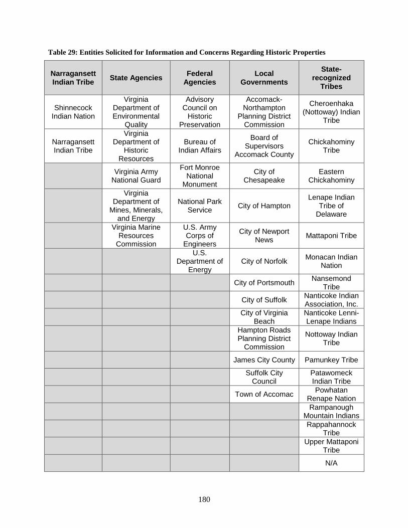
180
Table 29: Entities Solicited for Information and Concerns Regarding Historic Properties
Narragansett Indian Tribe State Agencies Federal
Agencies Local
Governments
State-recognized
Tribes
Shinnecock Indian Nation
Virginia Department of Environmental
Quality
Advisory Council on
Historic Preservation
Accomack-Northampton
Planning District Commission
Cheroenhaka (Nottoway) Indian
Tribe
Narragansett Indian Tribe
Virginia Department of
Historic Resources
Bureau of Indian Affairs
Board of Supervisors
Accomack County
Chickahominy Tribe
Virginia Army National Guard
Fort Monroe National
Monument
City of Chesapeake
Eastern Chickahominy
Virginia Department of
Mines, Minerals, and Energy
National Park Service City of Hampton
Lenape Indian Tribe of
Delaware
Virginia Marine
Resources Commission
U.S. Army Corps of
Engineers
City of Newport News Mattaponi Tribe
U.S.
Department of Energy
City of Norfolk Monacan Indian Nation
City of Portsmouth Nansemond Tribe
City of Suffolk Nanticoke Indian Association, Inc.
City of Virginia Beach
Nanticoke Lenni-Lenape Indians
Hampton Roads Planning District
Commission
Nottoway Indian Tribe
James City County Pamunkey Tribe
Suffolk City Council
Patawomeck Indian Tribe
Town of Accomac Powhatan Renape Nation
Rampanough Mountain Indians
Rappahannock Tribe
Upper Mattaponi Tribe
N/A

181
5 REFERENCES
Adams, T., R. Miller, D. Aleynik, et al. 2014. Offshore Marine Renewable Energy Devices as Stepping Stones Across Biogeographical Boundaries. J Appl Ecol 51(2):330-338.
Ahlén, I, B. Hans, and B. Lothar. 2009. Behavior of Scandinavian Bats during Migration and Foraging at Sea. Journal of Mammalogy 90(6):1318-1323.
ASSRT (Atlantic Sturgeon Status Review Team). 2007. Status review of Atlantic sturgeon (Acipenser oxyrinchus oxyrinchus). Report to National Marine Fisheries Service, Northeast Regional Office (NOAA), 174 pp. Updated with corrections July 27, 2007; http://www.nmfs.noaa.gov/pr/pdfs/statusreviews/atlanticsturgeon2007.pdf (Accessed August 23, 2011)
AFMC (Atlantic Fishery Management Council). 2014. Internet Resource. http://www.mafmc.org/ (Accessed October 9, 2014).
Band, B. 2012. Using a collision risk model to assess bird collision risks for offshore wind farms (with extended method) Report to Strategic Ornithological Support Services; http://www.bto.org/sites/default/files/u28/downloads/Projects/Final_Report_SOSS02_Band1ModelGuidance.pdf (Accessed September 28, 2014).
Bartol, S. and D.R. Ketten. 2006. Turtle and tuna hearing. In: Swimmer Y, Brill R (eds.) Sea turtle and pelagic fish sensory biology: Developing techniques to reduce sea turtle bycatch in longline fisheries. NOAA (National Oceanic and Atmospheric Administration) Technical Memorandum, NMFS-PIFSC-7, pages 98–105; http://www.pifsc.noaa.gov/tech/NOAA_Tech_Memo_PIFSC_7.pdf (Accessed October 8, 2014).
Bartol, S., J.A. Musick, and M.L. Lenhardt. 1999. Auditory evoked potentials of the loggerhead sea turtle (Caretta caretta). Copeia 1999(3):836–840.
Bejarano, A.C., J. Michel, J. Rowe, et al. 2013. Environmental Risks, Fate and Effects of Chemicals Associated with Wind Turbines on the Atlantic Outer Continental Shelf. U.S. Department of the Interior, Bureau of Ocean Energy Management, Office of Renewable Energy Programs, Herndon, VA. OCS Study BOEM 2013-213; http://www.data.boem.gov/PI/PDFImages/ESPIS/5/5330.pdf (Accessed September 26, 2013).
Bergstrom, L., L. Kautsky, T. Malm, et al. 2014. Effects of Offshore Wind Farms on Marine Wildlife – A Generalized Impact Assessment. Environ Res Lett 9(3):1-12.
Betke, K., M. Schultz-von Glahn, and R. Matuschek. 2004. Underwater noise emissions from offshore wind turbines. Proc CFA/DAGA 2004, Strasbourg. http://www.itap.de/daga04owea.pdf (Accessed October 16, 2014).
Bexton, S., D. Thompson, A. Brownlow, et al. 2012. Unusual Mortality of Pinnipeds in the United Kingdom Associated with Helical (Corkscrew) Injuries of Anthropogenic Origin. Aquat. Mamm. 38(3): 229-240.
Blackwell, S.B., J.W. Lawson, and J.T. Williams. 2004. Tolerance by ringed seals (Phoca hispida) to impact pipe-driving and construction sounds at an oil production island. J Acoust Soc Amer 115(5 pt 1)2346–2357.
Blanton, D.B. and S.G. Margolin. 1994. An Assessment of Virginia’s Underwater Cultural Resources. Issue 3 of Survey and Planning Report Series. William and Mary Center for Archaeological Research. Virginia Department of Historic Resources. 111 pages.

182
Blaylock, R. A., J.W. Hain, L.J. Hansen, D.L. Palka, and G.T. Waring. 1995. U.S. Atlantic and Gulf of Mexico Marine Mammal Stock Assessments. NOAA Technical Memorandum No. NMFS-SEFSC-363; http://www.nmfs.noaa.gov/pr/pdfs/sars/ao1995.pdf (Accessed October 8, 2014).
Boehlert, G.W., G.R. McMurray, and C.E. Tortorici. 2007. Ecological Effects of Wave Energy in the Pacific Northwest. U.S. Department of Commerce. NOAA Technical Memorandum. NMFS-F/SPO-92; http://spo.nwr.noaa.gov/tm/Wave%20Energy%20NOAATM92%20for%20web.pdf (Accessed October 10, 2014).
BOEM (Bureau of Ocean Energy Management). 2012a. Commercial Wind Lease Issuance and Site Assessment Activities on the Atlantic Outer Continental Shelf Offshore New Jersey, Delaware, Maryland, and Virginia, Final Environmental Assessment. OCS EIS/EA BOEMRE 2012-003; http://www.boem.gov/uploadedFiles/BOEM/Renewable_Energy_Program/Smart_from_the_Start/Mid-Atlantic_Final_EA_012012.pdf (Accessed October 27, 2014).
BOEM (Bureau of Ocean Energy Management). 2012b. Atlantic Region Wind Energy Development: Recreation and Tourism Economic Baseline Development; Appendix E: Socioeconomic and Coastal Tourism Profiles: Technical Assistance for Users and Community Profiles, BOEM 2012-085; http://coast.noaa.gov/digitalcoast/sites/default/files/uploaded/AtlanticRegionWindEnergyDevelopment.pdf (Accessed October 10, 2014).
BOEM (Bureau of Ocean Energy Management). 2012c. Update of Occurrence Rates for Offshore Oil Spills. OCS Report BOEM 2012-069. June 2012; http://www.boem.gov/uploadedFiles/BOEM/Environmental_Stewardship/Environmental_Assessment/Oil_Spill_Modeling/AndersonMayesLabelle2012.pdf.
BOEM (Bureau of Ocean Energy Management). 2014a. Atlantic OCS Proposed Geological and Geophysical Activities, Mid-Atlantic and South Atlantic Planning Areas, Final Programmatic Environmental Impact Statement. Volumes I, II, and III; http://www.boem.gov/Atlantic-G-G-PEIS/#Final PEIS (Accessed September 28, 2014).
BOEM (Bureau of Ocean Energy Management). 2014b. Atlantic Shipwreck Database; http://www.data.boem.gov/PI/PDFImages/ESPIS/5/5196.pdf (Accessed May 16, 2014).
BOEM (Bureau of Ocean Energy Management). 2014c. Personal Communication from BOEM Scientific Diving Program. August 15, 2014.
BOEM (Bureau of Ocean Energy Management). 2014d. Finding of No Significant Impact: Block Island Wind Farm and Block Island Transmission System. http://www.boem.gov/BITS_FONSI/; October 27, 2014.
BOEM (Bureau of Ocean Energy Management). 2015a. Block Island Transmission System. http://www.boem.gov/Renewable-Energy-Program/State-Activities/RI/Block-Island-Transmission-System.aspx (Accessed June 24, 2015).
BOEM (Bureau of Ocean Energy Management). 2015b. Marine Minerals Program. http://www.boem.gov/Marine-Minerals-Program/ (Accessed July 7, 2015).
Boesch, D.F. 1979. Benthic Ecological Studies. In. Middle Atlantic Outer Continental Shelf environmental studies, Vol IIB. Chemical and Biological Benchmark studies. Chapter 6. Contract No. BLM AA550-CT6-62, Accession No. PB81-174740. Prepared by the Virginia Institute of Marine Science for the Bureau of Land Management; http://invertebrates.si.edu/boem/reports/CABP_final_exec.pdf (Accessed October 14, 2014).
Boettcher, R. 2014. 1970-2013 Summary of Sea Turtle Nests in Virginia. Unpublished document at VA Dept. of Game & Inland Fisheries, Charles City, VA.

183
Brooks, R.A, C.N. Purdy, S.S. Bell, and K.J. Sulak. 2006. The benthic community of the eastern US continental shelf: A literature synopsis of benthic faunal resources. Continental Shelf Res 26(6):804–818.
Burger, J., C. Gordon, L. Niles, and J.E. 2011. Risk Evaluation for Federally Listed (Roseate Tern, Piping Plover) or Candidate (Red Knot) Bird Species in Offshore Waters: A First Step for Managing the Potential Impacts of Wind Facility Development on the Atlantic Outer Continental Shelf. Renew Energ 36(1):338-351.
Burger, J., L. J. Niles, R. R. Porter, A. D. Dey, S. Koch, and C. Gordon. 2012a. Migration and Overwintering of Red Knots (Calidris canutus rufa) along the Atlantic Coast of the United States. Condor 114(2):1-12.
Burger, J., L. J. Niles, R. R. Porter, A. D. Dey, S. Koch, and C. Gordon. 2012b. Using a Shore Bird (Red Knot) Fitted with Geolocators to Evaluate a Conceptual Risk Model Focusing on Offshore Wind. Renewable Energy 43:370-377.
C&H Global Security. 2014. Internet Resource. Virginia Offshore Wind Technology Advancement Project (VOWTAP): Navigational Risk Assessment. Prepared for Tetra Tech, Inc. by C&H Global Security, 2013 (in RAP, 2015); http://www.nao.usace.army.mil/Portals/31/docs/regulatory/publicnotices/2014/July/NAO-2013-0418_Appendix_R_NRA.pdf (Accessed September 28, 2014).
Caltrans (California Department of Transportation). 2001. San-Francisco-Oakland Bay Bridge east span seismic safety project. Pile installation demonstration project. Marine mammal impact assessment. PIDP EA 012081. Caltrans Contract 04A0148. Task Order 205.10.90. PIDP 04-ALA-80-0.0/0.5. 49 pp; http://www.dot.ca.gov/dist4/documents/mmfinal_report_80901.pdf (Accessed November 5, 2014).
Caltrans (California Department of Transportation). 2009 (with 2012 update). Technical Guidance for Assessment and Mitigation of the Hydroacoustic Effects of Pile Driving on Fish, Appendix 1; Compendium of Pile Driving Sound Data. ICF Jones & Stokes and Illingworth & Rodkin, Inc; http://www.dot.ca.gov/hq/env/bio/files/Guidance_Manual_2_09.pdf (Accessed October 8, 2014).
Casper, B.M. and D.A. Mann. 2006. Evoked potential audiograms of the nurse shark (Ginglymostoma cirratum) and the yellow stingray (Urobatis jamaicensis). Environ Biol Fish 76(1):101-108.
Casper, B.M., P.S. Lobel, and H.Y. Yan. 2003. The hearing sensitivity of the little skate, Raja erinacea: A comparison of two methods. Environ Biol Fish 68:371-379.
CCC (California Coastal Commission). 2014. Internet Resource. The Problem with Marine Debris; http://www.coastal.ca.gov/publiced/marinedebris.html (Accessed August 25, 2014).
CEQ (Council on Environmental Quality). 1997. Considering cumulative effects under the National Environmental Policy Act; http://energy.gov/sites/prod/files/nepapub/nepa_documents/RedDont/G-CEQ-ConsidCumulEffects.pdf (Accessed August 14, 2014).
CETAP. 1981. A characterization of marine mammals and turtles in the mid- and north Atlantic areas of the U.S. outer continental shelf. Cetacean and Turtle Assessment Program, University of Rhode Island. Final Report #AA551-CT8-48 to the Bureau of Land Management, Washington, DC: http://tethys.pnnl.gov/sites/default/files/publications/A_Characterization_of_Marine_Mammals_and_Turtles.pdf (Accessed October 8, 2014).
Chapman, C.J. and A.D. Hawkins. 1973. A field study of hearing in the cod, Gadus morhua. J Comp Physiol 85:147-167.

184
Clapham, P.J., L.S. Baraff, C.A. Carlson, et al. 1993. Seasonal occurrence and annual return of humpback whales, Megaptera novaeangliae, in the southern Gulf of Maine. Can J of Zool 71(2):440-443.
Collar, N.J., L.P. Gonzaga, N. Krabbe, et al. 1992. Threatened Birds of the Americas. The ICBP/IUCN Red Data Book. 3rd edition, Part 2. International Council for Bird Preservation, Cambridge, UK.
Colvocoresses, J.A. and J.A. Musick. 1984. Species associations and community composition of Middle Atlantic Bight continental shelf demersal fishes. U.S. National Marine Fisheries Service Fishery Bulletin 82:295-314.
Conn, P.B. and G.K. Silber. 2013. Vessel speed restrictions reduce risk of collision-related mortality for North Atlantic right whales. Ecosphere 4(4):43; http://www.esajournals.org/doi/pdf/10.1890/ES13-00004.1 (Accessed October 14, 2014).
Cook, S.L. and T.G. Forrest. 2005. Sounds produced by nesting leatherback sea turtles (Dermochelys coriacea). Herp Rev 36:387-390.
Crawford, R.L. and W.W. Baker. 1981. Bats killed at a north Florida television tower: a 25 year record. J Mammal. 62: 651– 652.
Crothers, A.G. 2004. Commercial risk and capital formation in early America: Virginia merchants and the rise of marine insurance, 1750–1815. Bus Hist Rev 78:607-633.
Cryan, P.M. 2003. Seasonal Distribution of Migratory Tree Bats (Lasiurus And Lasionycteris) In North America. J. Mamm 84(2):579–593.
Cryan, P.M. and A.C. Brown. 2007. Migration of Bats past a Remote island offers clues toward problem of bat fatalities at wind turbines. Biol Conserv. 139(1-2):1-11.
CVB (City of Virginia Beach). 2014a. Internet Resource. Maps; http://www.vbgov.com/map (Accessed May 19, 2014).
CVB (City of Virginia Beach). 2014b. 2013 Sandbridge Beach Replenishment; http://www.vbgov.com/government/departments/public-works/coastal/Pages/sb-bch-replenish.aspx (Accessed August 28, 2014).
Dalyander, P.S., B. Butman, C.R. Sherwood, et al. 2012. Documentation of the U.S. Geological Survey Sea Floor Stress and Sediment Mobility Database. U.S. Geological Survey Open-File Report 2012-1137; http://pubs.usgs.gov/of/2012/1137/pdf/ofr2012-1137.pdf (Accessed September 26, 2014).
Deepwater Wind Block Island Transmission (DWBITS), LLC. 2012. Environmental Report for the Block Island Transmission System General Activities Plan (prepared by Tetra Tech EC, Inc.). September 14, 2012.
de Neef, L., P. Middendorp, and J. Bakker. 2013. Installation of monopoles by vibrohammers for the Riffgat Proposed Alternative. Pfahlsymposium, Braunschweig, The Netherlands. 14 pages; http://www.allnamics.eu/wp-content/uploads/Riffgat_Pfahlsymposium_2013_de_Neef.pdf (Accessed October 10, 2014).
Degn, U. 2000. Offshore wind turbines—VVM, underwater noise measurements, analysis, and predictions. Ødegaard & Danneskiold-Samsøe A/S, Rep No 00.792 rev. 1. p 1–230; http://tethys.pnnl.gov/sites/default/files/publications/ODS_Underwater_Noise_2000.pdf (Accessed October 9, 2014).
DeGroot, K.A. and J.H. Shaw. 1993. Nesting Activities by the Loggerhead (Caretta caretta) at Back Bay National Wildlife Refuge, Virginia. Proceedings of the Oklahoma Academy of Science. 73:15-17; http://digital.library.okstate.edu/oas/oas_pdf/v73/p15_17.pdf (Accessed October 9, 2014).

185
Deng, X., H.J. Wagner, and A.N. Popper. 2011. The inner ear and its coupling to the swim bladder in the deep-sea fish Antimora rostrata (Teleostei: Moridae). Deep Sea Res, Part I, 58(1):27-37.
Desholm, M. and J. Kahlert. 2005. Avian Collision Risk at an Offshore Wind Farm. Biol Lett 1:296-298.
DEWI (Deutsches Windenergie-Institut). 2004. Standardverfahren zur Ermittlung und Bewertung der Belastung der Meeresumwelt durch die Schallimmission von Offshore-Windenergieanlagen. Forschungsvorhaben 0327528A. Deutsches Windenergie-Institut, Wilhelmshaven.
Diederichs, A., G. Nehls, M. Dähne, et al. 2008. Methodologies for measuring and assessing potential changes in marine mammal behaviour, abundance or distribution arising from the construction, operation and decommissioning of offshore windfarms. Commissioned by COWRIE Ltd; http://bioconsult-sh.de/pdf/Diederichs%20et%20al.%202008_%20Methodologies%20for%20measuring%20and%20assessing%20potential%20changes%20in%20marine%20mammal%20behaviour,%20abundance%20or.pdf (Accessed October 10, 2014).
Dobson, A. F. and J. Madeiros 2008. Threats Facing Bermuda’s Breeding Seabirds: Measures to Assist Future Breeding Success. Proceedings of the fourth International Partners in Flight conference: Tundra to Tropics. 223-226; http://www.partnersinflight.org/pubs/mcallenproc/articles/PIF09_Anthropogenic%20Impacts/Dobson_PIF09.pdf (Accessed September 26, 2014)
Douglas, S.G., J.L. Haney, and A.B. Hudischewskyj. 2014. Synthesis, analysis, and integration of meteorological and air quality data for the Atlantic coast region. Volume III: Data analysis BOEM (Bureau of Ocean Energy Management) AR Study BOEM 2014-008; http://www.data.boem.gov/PI/PDFImages/ESPIS/5/5371.pdf (Accessed September 20, 2014).
Dow Piniak W. E., S.A. Eckert, C.A. Harm, et al. 2012. Underwater hearing sensitivity of the leatherback sea turtle (Dermochelys coriacea): Assessing the potential effect of anthropogenic noise. U.S. Dept. of the Interior, Bureau of Ocean Energy Management, Headquarters, Herndon, VA. OCS Study BOEM 2012-01156; http://www.data.boem.gov/PI/PDFImages/ESPIS/5/5279.pdf (Accessed October 10, 2014).
Dow, W.E., D.A. Mann, T.T. Jones, S.A. Eckert, and C.A. Harms. 2008. In-water and in-air hearing sensitivity of the green sea turtle (Chelonia mydas). Abstract, Acoustic Communication by Animals, 2nd International Conference, 12-15 August 2008, Corvallis, OR; http://www.seaturtle.org/PDF/DowWE_2008_InAcousticCommunicationbyAnimalsSecon_p60.pdf (Accessed October 8, 2014).
DWW (DeepWater Wind, LLC). 2015. http://dwwind.com/press/block-island-wind-farm-now-fully-financed/. (Accessed June 24, 2015).
eBird. 2014. eBird: An online database of bird distribution and abundance. Internet Resource. Cornell Laboratory of Ornithology, Ithaca, New York; http://www.ebird.org (Accessed May 27, 2014).
Elliott-Smith, E., and S.M. Haig. 2004. Piping Plover (Charadrius melodus). The Birds of North America Online (A. Poole, ed.). Ithaca: Cornell Lab of Ornithology, Ithaca, New York; http://bna.birds.cornell.edu/bna/species/002 (Accessed September 26, 2014).
EO 12898 (Executive Order). 1994. Federal Actions to Address Environmental Justice in Minority Populations and Low-Income Populations; http://epa.gov/compliance/environmentaljustice/resources/policy/exec_order_12898.pdf (Accessed September 16, 2014).

186
EPA (U.S. Environmental Protection Agency). 2009. U.S. Climate Change Science Program; Final Report, Synthesis and Assessment Product 4.1. Coastal Sensitivity to Sea Level Rise: A Focus on the Mid-Atlantic Region. A report by the U.S. Climate Change Science Program and the Subcommittee on Global Change Research (Synthesis and Assessment Product 4.1); http://downloads.globalchange.gov/sap/sap4-1/sap4-1-final-report-all.pdf (Accessed October 10, 2014).
EPA (Environmental Protection Agency). 2012. National Coastal Condition Report IV. EPA Office of Research and Development/Office of Water. Washington, DC; http://water.epa.gov/type/oceb/assessmonitor/nccr/upload/0_NCCR_4_Report_508_bookmarks.pdf (Accessed September 20, 2014).
EPA (Environmental Protection Agency). 2014. Internet Resource. General Conformity. De Minimis Levels; http://www.epa.gov/oaqps001/genconform/deminimis.html (August 14, 2014).
EPA and USACE (U.S. Environmental Protection Agency and U.S. Army Corps of Engineers). 2009. Site Management and Monitoring Plan for the Dam Neck Ocean Disposal Site (DNODS). (Dam Neck Ocean Disposal Site, SMMP); http://epa.gov/reg3esd1/coast/pdf/damnecksmmp.pdf (Accessed October 8, 2009).
Epperly, S. P., J. Braun, A.J. Chester, F.A. Cross, J.V. Merriner, and P.A. Tester. 1995. Winter distribution of sea turtles in the vicinity of Cape Hatteras and their interactions with the summer flounder trawl fishery. Bulletin of Marine Science 56(2): 547-568.
Erickson, W.P., M. Wolfe, K.J. Bay, et al., 2014. A Comprehensive Analysis of Small-Passerine Fatalities from Collision with Turbines at Wind Energy Facilities. PLoS ONE 9:e107491; http://www.plosone.org/article/info%3Adoi%2F10.1371%2Fjournal.pone.0107491 (Accessed October 9, 2014).
ESPreSSO (Rutgers Ocean Modeling Group). 2014. Internet Resource; Regional Ocean Modeling System Experimental System for Predicting Shelf and Slope Optics (distributed software); http://www.myroms.org/espresso/ (Accessed August 28, 2014).
Fay, R.R. 1988. Hearing in Vertebrates: A Psychophysics Databook. Winnetka, IL: Hill-Fay Associates. 621 pages.
Fay, R.R. and A.N. Popper. 2000. Evolution of hearing in vertebrates: The inner ears and processing. Hearing Res 149(1-2):1-10
Feng, Y., P.J. Tavner and H. Long. 2010. Early expericences with UK Round 1 offshore wind farms. Proceedings of the Institution of Civil Engineers: energy., 163(4):167-181.
Firestone, J., S. B. Lyons, C. Wang, et al. 2008. Statistical modeling of North Atlantic right whale migration along the mid-Atlantic region of the eastern seaboard of the United States. Biol Conserv 141(1):221–232.
Fish, J. F. and Offutt, C. 1972. Hearing thresholds from toadfish, Opsanus tau, measured in the laboratory and field. J. Acoust. Soc. Am. 51(4):1318-1321.
Fishermen, 2014. Fishermen’s Energy Atlantic City Wind Farm (FACW). Internet Resource; http://www.fishermensenergy.com/atlantic-city-windfarm.php (Accessed on September 10, 2014)
French, C.J. 1987. Productivity in the Atlantic shipping industry: A quantitative study. J Interdisciplin Hist 17(3):613-638.
Fristedt T, P., P. Morén, and P. Söderberg P. 2001. Acoustic and electromagnetic noise induced by windmills—implications for underwater surveillance systems: pilot study. FOI-R-0233-SE, Swedish

187
Defence Research Agency, Stockholm; http://foi.se/ReportFiles/foir_0233.pdf (Accessed October 8, 2014).
Gallegos, J.B. 2014. Personal Communication between John Gallegos (FWS) and David Bigger (BOEM), October 2014.
Gibb, A.B. 2005. Offshore renewable energy: ecological implications of generating electricity in the coastal zone. J. Appl Ecol 42(4): 605; http://onlinelibrary.wiley.com/doi/10.1111/j.1365-2664.2005.01060.x/pdf (Accessed September 26, 2014).
Glass, A.H., T.V.N Cole, M. Garron, R.L. Merrick, et al. 2008. Mortality and serious injury determinations for baleen whale stocks along the United States eastern seaboard and adjacent Canadian Maritimes, 2002-2006. Northeast Fisheries Science Center Reference Document 08-04; http://nefsc.noaa.gov/publications/crd/crd0804/crd0804.pdf (Accessed October 8, 2014).
Gochfeld, M., J. Burger, and I.C. Nisbet. 1998. Roseate Tern (Sterna dougallii). In The Birds of North America Online (A. Poole, ed.). Ithaca: Cornell Lab of Ornithology. No. 370. http://bna.birds.cornell.edu/bna/species/370 (Accessed September 26, 2014).
Goetz, J. E., J. H. Norris, and J. A. Wheeler. 2012. Conservation Action Plan for the Black-Capped Petrel (Pterodroma hasitata). International Black-Capped Petrel Conservation Group;http://www.fws.gov/birds/waterbirds/petrel/pdfs/PlanFinal.pdf (Accessed September 26, 2014).
Greene, K.E., J.L. Zimmerman, R.W. Laney, et al. 2009. Atlantic coast diadromous fish habitat: A review of utilization, threats, recommendations for conservation, and research needs. Atlantic States Marine Fisheries Commission Habitat Management Series No. 9, Washington D.C.; http://www.epa.gov/region1/npdes/merrimackstation/pdfs/ar/AR-56.pdf (Accessed October 9, 2014).
Hain, J.H.W., M.J. Ratnaswamy, R.D. Kenney, and H.E. Winn. 1992. The fin whale, Balaenoptera physalus, in waters of the northeastern United States continental shelf. Reports to the International Whaling Commission. 42:653-669.
Hatch, S.K., E.E. Connelly, T.J. Divoll, et al. 2013. Offshore Observations of Eastern Red Bats (Lasiurus borealis) in the Mid-Atlantic United States Using Multiple Survey Methods. PLoS ONE 8:e83803; http://www.plosone.org/article/info%3Adoi%2F10.1371%2Fjournal.pone.0083803 (Accessed September 26, 2014).
Hawkins, A.D. and A.A. Myrberg, Jr. 1983. Hearing and sound communication under water. In: Lewis, B., ed. Bioacoustics: A comparative approach. London: Academic Press. pages 347-405.
Hawkins, A.D., A.E. Pembroke, and A.N. Popper. 2014. Information gaps in understanding the effects of noise on fishes and invertebrates. Rev. Fish Biol Fisheries doi 10.007/s11160-014-9369-3.
Helfman, G.S., B.B. Collette, and D.E. Facey. 1997. Diversity of Fishes. Madden, MA: Blackwell Science. 528 pages.
Hildebrand, J.A. 2009. Anthropogenic and natural sources of ambient noise in the ocean. Marine Ecology Progress Ser 395:5-20; http://www.int-res.com/articles/theme/m395p005.pdf (Accessed October 14, 2014).
Hobbs, C.H., Krantz, D.E., and G.L. Wikel. 2008. Coastal Processes and Offshore Geology. The Geology of Virginia. ed. C. Bailey. College of William and Mary. pp 1-44.
Huppop, O., J. Dierschke, K. M. Exo, E. Fredrich, and R. Hill. 2006. Bird Migration Studies and Potential Collision Risk with Offshore Turbines. Ibis 148:90-109.

188
ICF (ICF Incorporated, L.L.C. 2012. Appendix E: Socioeconomic and Coastal Tourism Profiles,” Atlantic Region Wind Energy Development: Recreation and Tourism Economic Baseline Development. U.S. Dept. of the Interior, Bureau of Ocean Energy Management, Office of Renewable Energy Programs, Herndon, VA. OCS Study BOEM 2012-085; http://www.data.boem.gov/PI/PDFImages/ESPIS/5/5228.pdf (Accessed October 8, 2014).
Ingemansson Technology AB. 2003. Utgrunden offshore wind farm—measurements of underwater noise. Report 11-00329-03012700. Ingemansson Technology A/S, Gothenburg; http://tethys.pnnl.gov/sites/default/files/publications/Utgrunden_Underwater_Noise_2003.pdf (Accessed October 8, 2014).
IPCC (Intergovernmental Panel on Climate Change), 2007 Climate Change Synthesis Report; http://www.ipcc.ch/pdf/assessment-report/ar4/syr/ar4_syr.pdf (Accessed October 9, 2014).
IPCC (Intergovernmental Panel on Climate Change). 2014. Technical Summary: Climate Change 2014: Impacts, Adaptation, and Vulnerability; http://www.ipcc.ch/report/ar5/wg2 (Accessed September 30, 2014).
Iversen, R.T.B. 1967. Response of the yellowfin tuna (Thunnus albacares) to underwater sound. ed. Tavolga, W.N., In Marine Bio-Acoustics II. New York, NY: Pergamon Press. Pages 105-121.
Iversen, R.T.B. 1969. Auditory thresholds of the scombrid fish Euthynnus affinis, with comments on the use of sound in tuna fishing. Proceedings of the FAO Conference on Fish Behaviour in Relation to Fishing Techniques and Tactics, October 1967. FAO Fisheries Reports No. 62 Vol. 3. FRm/R62.3.
Jensen, A.S. and G.K. Silber. 2004. Large Whale Ship Strike Database. U.S. Department of Commerce. NOAA Technical Memorandum. NMFS-OPR-25: http://www.nmfs.noaa.gov/pr/pdfs/shipstrike/lwssdata.pdf (Accessed October 9, 2014).
Jerkø, H., I. Turunen-Rise, P.S. Enger, and O. Sand. 1989. Hearing in the eel (Anguilla anguilla). J Comp Physiol 165(4):455-459.
Johnson, J.B., J.E. Gates, and N.P. Zegre. 2011. Monitoring seasonal bat activity on a coastal barrier island in Maryland, USA Environ Monitor Assess 173(1-4):685-699.
Johnson, K.A. 2004. Characterization of the fishing practices and marine benthic ecosystems of the northeast U.S. shelf and an evaluation of the potential effects of fishing on essential fish habitat. NOAA Technical memo NMFS-NE-181, 2004 (posted online 2006); http://www.nefsc.noaa.gov/publications/tm/tm181/tm181.pdf (Accessed September 26, 2014).
Johnston, N.N., J.E. Bradley, and K.A. Otter. 2014. Increased Flight Altitudes among Migrating Golden Eagles Suggest Turbine Avoidance at a Rocky Mountain Wind Installation. PLoS One 9(3):e93030; http://www.plosone.org/article/info%3Adoi%2F10.1371%2Fjournal.pone.0093030 (Accessed September 26, 2014).
Kenney, R.D. 2002. North Atlantic, North Pacific and southern Right Whales., eds. W.F. Perrin, B. Würsig, and J.G.M. Thewissen In: Encyclopedia of Marine Mammals. Academic Press, San Diego, CA, pp. 806-813.
Kenney, R.D. and K.J. Vigness-Raposa. 2010. Marine Mammals and Sea Turtles of Narragansett Bay, Block Island Sound, Rhode Island Sound, and Nearby Waters: An Analysis of Existing Data for the Rhode Island Ocean Special Area Management Plan. Final Technical Report to the Rhode Island Office of Energy Resources and Rhode Island Coastal Resources Management Council. University of Rhode Island, Graduate School of Oceanography, Narragansett, RI; http://seagrant.gso.uri.edu/oceansamp/pdf/appendix/10-Kenney-MM&T_reduced.pdf (Accessed October 8, 2014).

189
Kerlinger, P., J. L. Gehring, W. P. Erickson, R. Curry, A. Jain, and J. Guarnaccia. 2010. “Night Migrant Fatalities and Obstruction Lighting at Wind Turbines in North America.” The Wilson Journal of Ornithology 122 (4): 744-754.
Kinlan, B.P., R. Rankin, A. Winship, et al. in preparation. Modeling At-Sea Occurrence and Abundance Marine Birds to Support Mid-Atlantic Marine Renewable Energy Planning. BOEM OCS Study. NOAA Technical Memorandum NOS NCCOS (Accessed November 16, 2014).
Kirkpatrick, A. J., S. Benjamin, and G. DePiper 2014. “VA WEA Data.” NOAA Northeast Fisheries Science Center. Prepared for BOEM under interagency agreement M12PG00028.
Klein, J. I., W. M. Tankersley, R. Meyer. et al., 2012. Evaluation of Visual Impacts on Cultural Resources/Historic Properties North Atlantic, Mid-Atlantic, South Atlantic & Florida Straits, Volume I: Technical Report; http://www.data.boem.gov/PI/PDFImages/ESPIS/5/5249.pdf (Accessed September 26, 2014); Appendices (Volume II); http://www.data.boem.gov/PI/PDFImages/ESPIS/5/5250.pdf (Accessed September 26, 2014).
Knowlton, A., J. Ring, and B. Russell. 2002. Right whale sightings and survey effort in the mid-atlantic region: migratory corridor, time frame, and proximity to port entrances. Oak Foundation, International Fund for Animal Welfare, and National Marine Fisheries Service; http://www.greateratlantic.fisheries.noaa.gov/shipstrike/ssr/midatanticreportrFINAL.pdf (Accessed October 8, 2014).
Knust, R., P. Dalhoff, J. Gabriel, et al. 2004. Untersuchungen zur Vermeidung und Verminderung von Belastungen der Meeresumwelt durch Offshore-Windenergieanlagen in küstenfernen Bereich der Nord- und Ostsee. 62/03. Umweltbundesamt, Büsum (10013/epic.17077).
Koski-Karell, D. 1995. Historic Archaeological Context on the Maritime Theme with the Sub-Theme Shipwrecks, Coastal Zone (1495-1940 +/-), Volume I- Historic Context, Karell Archaeological Services, Washington, D.C. Report No. NABD 43231.
Ladich, F. and A.N. Popper. 2004. Parallel evolution in fish hearing organs. In Evolution of the Vertebrate Auditory System, eds. Manly G.A, A.N Popper, and R.R. Fay. Springer Handbook of Auditory Research. New York, NY: Springer-Verlag. pages 95-127.
Laist, D.W., A.R. Knowlton, J.G. Mead, et al. 2001. Collisions between ships and whales. Marine Mammal Science 17(1):35–75; http://www.greateratlantic.fisheries.noaa.gov/shipstrike/whatsnew/Laist%20et%20al_2001.pdf (Accessed October 9, 2014)
Laney, R.W., J.E. Hightower, B.R. Versak, et al. 2007. Distribution, habitat use, and size of Atlantic sturgeon captured during cooperative winter tagging cruises, 1988-2006. American Fisheries Society Symposium 56(000-000):167-182; http://etd.lib.ncsu.edu/publications/bitstream/1840.2/1959/1/Laney_etal_2007.pdf (Accessed August 12, 2014).
Lee, D.S. 1987. December records of seabirds off North Carolina. The Wilson Bulletin (now The Wilson Journal of Ornithology; The Wilson Ornithological Society) 99(1):116-121.
Lenhardt, M.L. 1994. Seismic and very low frequency sound induced behaviors in captive loggerhead marine turtles (Caretta caretta). K.A. Bjorndal, A.B. Bolten, D.A. Johnson, and P.J. Eliazar, compilers. Proceedings of the Fourteenth Annual Symposium on Sea Turtle Biology and Conservation. NOAA Technical Memorandum NMFS-SEFSC-351. pages 238-241. NMFS, Southeast Fisheries Science Center, Miami, FL.

190
Ling. H., et al. 2013. Final Report DE-EE0005380: Assessment of Offshore Wind Farm Effects on Sea Surface, Subsurface and Airborne Electronic Systems. Prepared for the U.S. Department of Energy (DOE). http://www.ioos.noaa.gov/hfradar/assessment_offshore_wt_effects.pdf.
Loss, S. R., T. Will, and P. P. Marra. 2013. Estimates of Bird Collision Mortality at Wind Facilities in the Contiguous United States. Biol Conserv 168: 201-09. doi:10.1016/j.biocon.2013.10.007.
Lovell, J.M., M.M. Findlay, R.M. Moate, et al. 2005. The inner ear morphology and hearing abilities of the Paddlefish (Polyodon spathula) and the Lake Sturgeon (Acipenser fulvescens). Comp Biochem Physiol A Mol Integr Physiol. 142(3):286-289.
Lu, Z. and Z. Xu. 2009. Effects of saccular otolith removal on hearing sensitivity of the sleeper goby (Dormitator latifrons). J Compar Physiol 188(8):595-602.
Madeiros, J. 2012. 2011/2012 Cahow Recovery Program, Breeding Season Report. Bermuda Government; http://www.conservation.bm/publications/projects-reports/2012%20CAHOW%20RECOVERY%20PROGRAM%20REPORT%20WEBSITE.pdf (Accessed November 7, 2014).
Madsen, P.T., M. Wahlberg, J. Tougaard, K. Lucke, and P. Tyack. 2006. Wind turbine underwater noise and marine mammals: implications of current knowledge and data needs. Mar. Ecol. Prog. Ser. 309:279–295.
Mann, D.A., D.M. Higgs, W.N. Tavolga, et al. 2001. Ultrasound detection by clupeiform fishes. J Acoust Soc Am 109:3048-3054.
Mann, D.A., Z. Lu, and A.N. Popper. 1997. A clupeid fish can detect ultrasound. Nature 389:341.
MARAD (Marine Administration). 2013. Phase I Report: Panama Expansion Study. November. U.S. Department of Transportation, U.S. Department of Transportation Maritime Administration, Developments in Tratde and National and Global Economies; http://www.marad.dot.gov/documents/Panama_Canal_Phase_I_Report_-_20Nov2013.pdf (Accessed September 30, 2014).
Marine Mammal Commission. 2003. Annual Report to Congress; http://www.mmc.gov/reports/annual/pdf/2003annualreport.pdf (Accessed October 2, 2014).
MARPOL. 1997. International Convention for the Prevention of Pollution from Ships) (original treaty) (Accessed October 1, 2014).
Martin, K.J., S.C. Alessi, J.C. Gaspard, A.D. Tucker, G.B. Bauer, and D.A. Mann. 2012. Underwater hearing in the loggerhead turtle (Caretta caretta): a comparison of behavioral and auditory evoked potential audiograms. J. Exp. Biol. 215(Pt 17):3001–3005 (Accessed November 5, 2014).
Matson, C. 1998. Merchants and empire: Trading in colonial New York. Baltimore: The Johns Hopkins University Press. 472 pages.
McCauley, R.D., J. Fewtrell, A.J. Duncan, C. Jenner, M.N. Jenner, J.D. Penrose, R.I.T. Prince, A. Adhitya, J. Murdoch, and K. McCabe. 2000. Marine seismic surveys: Analysis of airgun signals and effects of air gun exposure on humpback whales, sea turtles, fishes and squid. Report from Centre for Marine Science and Technology, Curtin University, Perth, Western Australia, for Australian Petroleum Production Association, Sydney, NSW; http://www.anp.gov.br/meio/guias/sismica/biblio/McCauleye2000.PDF (Accessed October 10, 2014).
McNeilan, T.W., K.R. Smith, and J.R. Fisher. 2013. Regional Geophysical Survey and Interpretive Report: Virginia Wind Energy Area Offshore Southeastern Virginia. BOEM 2012-220; http://www.boem.gov/Virginia-WEA-Survey/ (Accessed September 26, 2014).

191
Meyer, M., R.R. Fay, and A.N. Popper. 2010. Frequency tuning and intensity coding of sound in the auditory periphery of the lake sturgeon, Acipenser fulvescens. J Exper Biol 213:1567-1578.
Michel, J., H. Dunagan, C. Boring, E. Healy, W. Evans, J.M. Dean, A. McGillis, and J. Hain. 2007. Worldwide Synthesis and Analysis of Existing Information Regarding Environmental Effects of Alternative Energy Uses on the Outer Continental Shelf. MMS OCS Report 2007 038. Mineral Management Service; http://www.safmc.net/Portals/6/Meetings/Council/BriefingBook/September%202007/Ecosystem/Attach8_MMSAltEnergysynthrptfinal.pdf (Accessed September 30, 2014).
Middendorp, P. and G.E.H. Verbeek. 2012. “At the Cutting Edge of Pile Driving and Pile Testing.” The 9th International Conference on Testing and Design Methods for Deep Foundations, Kanazawa. http://www.allnamics.eu/wp-content/uploads/At-the-cutting-edge-of-pile-driving-and-pile-testing-Middendorp-Verbeek-IS-Kanasaw-2012.pdf (Accessed October 6, 2014).
MMPA (Marine Mammal Protection Act, NOAA Fisheries). 1972 (as amended in 2007); http://www.nmfs.noaa.gov/pr/pdfs/laws/mmpa.pdf (Accessed October, 2014).
MMS (Minerals Management Service). 2005. Structure-removal operations on the Outer Continental Shelf of the Gulf of Mexico—Programmatic environmental assessment. MMS, Gulf of Mexico OCS Region, New Orleans, LA. OCS EIS/EA MMS 2005-013; http://www.boem.gov/BOEM-Newsroom/Library/Publications/2005/2005-013.aspx (Accessed October 8, 2014).
MMS (Minerals Management Service). 2007. Programmatic Environmental Impact Statement for Alternative Energy Development and Production and Alternative Use Facilities on the Outer Continental Shelf. OCS Report MMS 2007-0246 (Chapters I, II, III, and IV); http://www.boem.gov/Renewable-Energy-Program/Regulatory-Information/Alt_Energy_FPEIS_VolIIFrontMatter.aspx (Accessed September 26, 2014).
Morgan, K. 1989. Shipping patterns and the Atlantic trade of Bristol, 1749–1770. The William and Mary Quarterly. Third Series, 46:506–538.
MOU (Memorandum of Understanding Between the U.S. Department of the Interior, Minerals Management Service [now BOEM] and the U.S. Department of the Interior U.S. Fish and Wildlife Service Regarding Implementation of Executive Order 13186, Responsibilities of Federal Agencies to Protect Migratory Birds. 2009; https://www.fws.gov/migratorybirds/Partnerships/DOEMOUfinalsignature.pdf (Accessed September 26, 2014).
Mowbray, T.B. 2002. Northern Gannet (Morus bassanus), The Birds of North America Online (A. Poole, Ed.). Ithaca: Cornell Lab of Ornithology; Birds of North America Online; http://bna.birds.cornell.edu/bna/species/693 (Accessed: September 4, 2014).
Mrosovsky, N. 1972. Spectographs of the sounds of leatherback turtles. Herpetologica 29(3):256-258.
Musial, W. and B. Ram. 2010. Large-Scale Offshore Wind Power in the United States: Assessment of Opportunities and Barriers. September 2010. NREL/TP-500-40745. http://www.nrel.gov/wind/pdfs/40745.pdf (Accessed September 29, 2041).
Myrberg, A.A. 2001. The acoustical biology of elasmobranchs. Environ Biol Fishes 60:31-46.
Myrberg, A.A., Jr. and J.Y. Spires. 1980. Hearing in damselfishes: An analysis of signal detection among closely related species. J Comp Physiol 140:135-144.

192
Myrberg, A.A., Jr., C.R. Gordon, and A.P. Klimley. 1976. Attraction of free ranging sharks by low frequency sound, with comments on its biological significance. In: Schuijf, A. and A.D. Hawkins, eds. Sound reception in fish. Amsterdam: Elsevier. Pp. 205-228.
Navy (U.S. Department of the Navy). 2007. Navy OPAREA Density Estimates (NODE) for the Southeast OPAREAs: VACAPES, CHPT, JAX/CHASN, and Southeastern Florida & AUTEC-Andros. Naval Facilities Engineering Command, Atlantic; Norfolk Virginia. Contract number N62470-02-D-9997, CTO 0060; http://seamap.env.duke.edu/downloads/resources/serdp/Southeast%20NODE%20Final%20Report.pdf (Accessed October 8, 2014).
Navy (U.S. Department of the Navy [Naval Facilities Engineering Command Southeast and Atlantic]). 2013a. Request for an Incidental Harassment Authorization under the Marine Mammal Protection Act for the Wharf C-2 Recapitalization Proposed Alternative at Naval Station Mayport, Florida. Navy Region Southeast. Submitted to Office of Protected Resources, National Marine Fisheries Service, NOAA; http://www.nmfs.noaa.gov/pr/pdfs/permits/navy_wharf_mayport_iha_application2013.pdf (Accessed October 8, 2014).
Navy (U.S. Department of the Navy). 2013b. Final Environmental Impact Statement / Overseas Environmental Impact Statement. Department of the Navy Atlantic Fleet Training and Testing, Naval Facilities Engineering Command Atlantic, Norfolk, Virginia (AFTT EIS/OEIS); http://aftteis.com/DocumentsandReferences/AFTTDocuments/FinalEISOEIS.aspx (Accessed October 8, 2014).
Nedwell, J. and D. Howell. 2004. A Review of Offshore Windfarm Related Underwater Noise Sources. Report No. 544 R 0308. Commissioned by COWRIE; http://www.subacoustech.com/wp-content/uploads/544R0308.pdf (Accessed October 8, 2014).
Nedwell, J., J. Langworthy, and D. Howell. 2003. Assessment of sub-sea acoustic noise and vibration from offshore wind turbines and its impact on marine wildlife; initial measurements of underwater noise during construction of offshore windfarms, and comparison with background noise. Report No. 544 R 0424. May 2003. Commissioned by COWRIE; http://www.subacoustech.com/wp-content/uploads/544R0424.pdf (Accessed October 8, 2014).
Nedwell, J.R., B. Edwards, A.W.H. Turnpenny, and J. Gordon. 2004. Fish and marine mammal audiograms: A summary of available information. Prepared by Subacoustech Ltd., Hamphire, UK. Report 534 R 0214; http://www.subacoustech.com/wp-content/uploads/534r0214.pdf (Accessed September 28, 2014).
Nelson, M., M. Garron, R.L. Merrick, R.M. Pace and T.V.N. Cole. 2007. Mortality and serious injury determinations for baleen whale stocks along the United States Eastern Seaboard and Adjacent Canadian Maritimes, 2001-2005. U.S. Department of Commerce, Northeast Fish. Sci. Cent. Ref. Doc. 07-05; http://www.nefsc.noaa.gov/publications/crd/crd0705/crd0705.pdf (Accessed October 8, 2014).
Niles, L.J., J. Burger, R.R. Porter, A.D. Dey, C.D.T. Minton, P.M. Gonzalez, A.J. Baker, J.W. Fox, and C. Gordon. 2010. First Results Using Light Level Geolocators to Track Red Knots in the Western Hemisphere Show Rapid and Long Intercontinental Flights and New Details of Migration Pathways. Wader Study Group Bulletin 117:123-130; http://report.bandedbirds.org/content/WYSIWYG/red_knot_geolocator_paper.pdf (Accessed September 26, 2014).
Niles, L.J., H.P. Sitters, A.D. Dey, et al., 2008. Status of the Red Knot, Calidris canutus rufa, in the Western Hemisphere. Studies Avian Biol. 36:1-185; https://sora.unm.edu/sites/default/files/journals/sab/sab_036.pdf.

193
Niles, L.J., B.J. Bart, P. Humphrey, et al. 2009. Effects of Horseshoe Crab Harvest in Delaware Bay on Red Knots: Are Harvest Restrictions Working? Biosci 59:153-64.
Nisbet, I.C.T. 1984. Migration and Winter Quarters of North American Roseate Terns as Shown by Banding Recoveries. J of Field Ornithol 55:1-17; https://sora.unm.edu/sites/default/files/journals/jfo/v055n01/p0001-p0017.pdf (Accessed September 26, 2014).
NJDEP (New Jersey Department of Environmental Protection). 2010. Ocean/Wind Power Ecological Baseline Studies Final Report: Volume II, January 2008 – December 2009. Prepared by Geo-Marine, Inc. http://mhk.pnl.gov/sites/default/files/publications/New%20Jersey%20Baseline%20Environmental%20Study%20Volume%202.pdf (Accessed October 9, 2014).
NMFS (National Marine Fisheries Service). 1991. Final recovery plan for the humpback whale (Megaptera novaeangliae). Prepared by the Humpback Whale Recovery Team for the national Marine Fisheries Service, Silver Spring, Maryland; http://www.nmfs.noaa.gov/pr/pdfs/recovery/whale_humpback.pdf (Accessed October 8, 2014).
NMFS (National Marine Fisheries Service). 2006. Review of the status of the right whales in the North Atlantic and North Pacific Oceans. 68 pp. https://alaskafisheries.noaa.gov/protectedresources/whales/nright/statusreview1206.pdf (Accessed November 5, 2014).
NMFS (National Marine Fisheries Service). 2008. Reducing Ship Strikes to North Atlantic Right Whales. http://www.nmfs.noaa.gov/pr/shipstrike/ (Accessed January 21, 2015).
NMFS (National Marine Fisheries Service). 2013. Draft Environmental Impact Statement for Amending the Atlantic Large Whale Take Reduction Plan: Vertical Line Rule, Report No. NOAA-20130202, Appendices. Prepared by Industrial Economics, Incorporated, and NOAA’s National Marine Fisheries Service; http://www.greateratlantic.fisheries.noaa.gov/protected/whaletrp/eis2013/deis/table_of_contents.pdf (Accessed October 9, 2014).
NMFS (National Marine Fisheries Service). 2014a. Internet Resource. Green turtle (Chelonia mydas); http://www.nmfs.noaa.gov/pr/species/turtles/green.htm. Last updated May 15, 2014 (Accessed June 2, 2014).
NMFS (National Marine Fisheries Service). 2014b. Loggerhead turtle (Caretta caretta); http://www.nmfs.noaa.gov/pr/species/turtles/loggerhead.htm. Last updated May 15, 2014 (Accessed June 2, 2014).
NMFS (National Marine Fisheries Service). 2014c. Internet Resource. Marine Recreational Information Program: Query MRIP Catch Snapshot, All for hire-modes combined, number of fish. 2010-2013; http://www.st.nmfs.noaa.gov/st1/index.html (Accessed August 4, 2014).
NMFS (National Marine Fisheries Service). 2015. Endangered Species Act Section 7 Consultation Biological Opinion for the Virginia Offshore Wind Technology Advancement Project. NER-2015-12128. Date Issued July 9, 2015.
NMFS and USFWS (National Marine Fisheries Service and U.S. Fish and Wildlife Service). 1992. Recovery Plan for leatherback turtles in the U.S. Caribbean, Atlantic and Gulf of Mexico. NMFS, Washington, D.C. http://www.fws.gov/ecos/ajax/docs/recovery_plan/920406.pdf (Accessed October 8, 2014).

194
NMFS and USFWS (National Marine Fisheries Service and U.S. Fish and Wildlife Service). 2007a. Loggerhead sea turtle (Caretta caretta) 5 year review: summary and evaluation. National Marine Fisheries Service, Silver Spring, Maryland; http://www.nmfs.noaa.gov/pr/pdfs/species/loggerhead_5yearreview.pdf (Accessed October 8, 2014).
NMFS and USFWS (National Marine Fisheries Service and U.S. Fish and Wildlife Service). 2007b. Leatherback sea turtle (Dermochelys coriacea) 5 year review: summary and evaluation. National Marine Fisheries Service, Silver Spring, Maryland; http://www.nmfs.noaa.gov/pr/pdfs/species/leatherback_5yearreview.pdf (Accessed October 8, 2014).
NMFS and USFWS (National Marine Fisheries Service and U.S. Fish and Wildlife Service). 2007c. Kemp’s ridley sea turtle (Lepidochelys kempii) 5 year review: summary and evaluation. National Marine Fisheries Service, Silver Spring, Maryland; http://www.nmfs.noaa.gov/pr/pdfs/species/oliveridley_5yearreview.pdf (Accessed October 8, 2014).
NMFS and USFWS (National Marine Fisheries Service and U.S. Fish and Wildlife Service). 2007d. Green sea turtle (Chelonia mydas) 5 year review: summary and evaluation. National Marine Fisheries Service, Silver Spring, Maryland; http://www.nmfs.noaa.gov/pr/pdfs/species/greenturtle_5yearreview.pdf (Accessed October 8, 2014).
NOAA (National Oceanic and Atmospheric Administration). 2001. Stock assessments of loggerhead and leatherback sea turtles and an assessment of the impact of the pelagic longline fishery on the loggerhead and leatherback sea turtles of the Western North Atlantic. U.S. Department of Commerce NOAA Technical Memorandum NMFS-SEFSC, 455, 343; http://www.sefsc.noaa.gov/turtles/TM_455_NMFS.pdf (Accessed October 8, 2014).
NOAA (National Oceanic and Atmospheric Administration). 2014a. Internet Resource. Ocean and Great Lakes Jobs Snapshot: Virginia Beach; http://www.csc.noaa.gov/snapshots/#ocean%2651810. Accessed May 7, 2014.
NOAA (National Oceanic and Atmospheric Administration). 2014b. Internet Resource. “Small Diesel Spills (500-5,000 gallons);” Available at http://response.restoration.noaa.gov/oil-and-chemical-spills/oil-spills/resources/small-diesel-spills.html (Accessed August 25, 2014).
NOAA (National Oceanic and Atmospheric Administration). 2014c. Programmatic Environmental Assessment: NOAA U.S. Integrated Ocean Observing System. Draft. March; http://www.ioos.noaa.gov/about/governance/ioos_draft_pea_january_2014.pdf (Accessed September 30, 2014).
NOAA NEFSC (Northeast Fisheries Science Center). 2014. Internet Resource (modified 2013). Interactive North Atlantic Right Whale Sightings Map; http://www.nefsc.noaa.gov/psb/surveys/ (Accessed October 8, 2014).
NOAA OST (Office of Science and Technology). 2012. Mid-Atlantic Fisheries Economics of the U.S. 2012; http://www.st.nmfs.noaa.gov/economics/publications/feus/fisheries_economics_2012 (Accessed November 6, 2014).
NOAA OST (Office of Science and Technology). 2014. Internet Resource. Recreational Fisheries Statistics Queries; http://www.st.nmfs.noaa.gov/st1/recreational/querieshttp://www.st.nmfs.noaa.gov/commercial-fisheries/ (Accessed October 9, 2014).
NOEP (National Ocean Economics Program. Internet Resource. Ocean Economy Data. 2014. Internet resource; http://www.oceaneconomics.org/Market/ocean/oceanEcon.asp (Accessed May 7, 2014).

195
Normandeau Associates, Inc. 2011. New Insights and New Tools Regarding Risk to Roseate Terns, Piping Plovers, and Red Knots from Wind Facility Operations on the Atlantic Outer Continental Shelf. A Final Report for the U.S. Department of the Interior, Bureau of Ocean Energy Management, Regulation and Enforcement, Report No. BOEMRE 048-2011. Contract No. M08PC20060; http://www.data.boem.gov/PI/PDFImages/ESPIS/4/5119.pdf (Accessed September 26, 2014).
Normandeau Associates, Inc. 2012. Effects of noise on fish, fisheries, and invertebrates in the U.S. Atlantic and Arctic from energy industry sound-generating activities. A literature synthesis for the U.S. Dept. of the Interior, Bureau of Ocean Energy Management. Contract No. M11PC00031. 135 pp; http://www.cbd.int/doc/meetings/mar/mcbem-2014-01/other/mcbem-2014-01-submission-boem-04-en.pdf (Accessed November 5, 2014).
Normandeau Associates, Inc. 2014. Understanding the Habitat Value and Function of Shoal/Ridge/Trough Complexes to Fish and Fisheries on the Atlantic and Gulf of Mexico Outer Continental Shelf. Draft Literature Synthesis for the U.S. Dept. of the Interior, Bureau of Ocean Energy Management. Contract M12PS00031: http://www.boem.gov/final-draft-report/; (Accessed October, 2014).
Nowacek, D.P., M.P. Johnson, and P.L. Tyack. 2004. North Atlantic right whales (Eubalaena glacialis) ignore ships but respond to alerting stimuli. Proc of the Royal Soc of London, Part B., 271(1538):227-231.
NSF and USGS (National Science Foundation and United States Geological Survey). 2011. Final Programmatic Environmental Impact Statement/Overseas Environmental Impact Statement for Marine Seismic Research funded by the National Science Foundation or conducted by the U.S. Geological Survey; http://permanent.access.gpo.gov/gpo13140/nsf-usgs-final-eis-oeis-with-appendices.pdf (Accessed October 2, 2014).
O’Hara, J. and J.R. Wilcox. 1990. Avoidance responses of loggerhead turtles, Caretta caretta, to low frequency sound. Copeia 1990:564-567. doi 10.2307/1446362.
O’Connell, A.F., B. Gardner, A.T. Gilbert, et al. 2009. Compendium of Avian Occurrence Information for the Continental Shelf Waters along the Atlantic Coast of the United States, Final Report (Database Section - Seabirds). Prepared by the USGS Patuxent Wildlife Research Center, Beltsville, MD. U.S. Department of the Interior, Geological Survey, and Bureau of Ocean Energy Management Headquarters, OCS Study BOEM 2012-076; http://www.data.boem.gov/PI/PDFImages/ESPIS/5/5209.pdf (Accessed September 28, 2014).
OEERE (Office of Energy Efficiency and Renewable Energy). 2013. Supplement Assessment/Finding of No Significance of Impact for the University of Maine’s Deepwater Offshore Floating Wind Turbine Testing and Demonstration Project. DOE/EA-1792-S1. U.S. Department of Energy. http://www.go.doe.gov/ReadingRoom/NEPA/Final/1792S1/Final%20Castine%20Supplement%20Analysis.pdf (Accessed September 30, 2014).
Oertel, G.F. and A.M. Foyle. 1995. Drainage Displacement by Sea-Level Fluctuation at the Outer Margin of the Chesapeake Seaway. Journal of Coastal Research 11(3): 583-604; http://journals.fcla.edu/jcr/article/download/79825/77092 (Accessed October 14, 2014).
Orr, T., S. Herz, and D. Oakley. 2013. Evaluation of Lighting Schemes for Offshore Wind Facilities and Impacts to Local Environments. Bureau of Ocean Energy Management (BOEM), Office of Renewable Energy Programs, Herndon, VA. OCS Study BOEM 2013-0116; www.data.boem.gov/PI/PDFImages/ESPIS/5/5298.pdf (Accessed September 12, 2014).

196
Parks, S. E., M. Johnson, D. Nowacek, and P. L. Tyack. 2010. Individual right whales call louder in increased environmental noise. Biol Lett 7:33-35.
Paton, P., K. Winiarski, C. Trocki, and S. McWilliams. 2010. Spatial distribution, abundance, and flight ecology of birds in nearshore and offshore waters of Rhode Island. Interim technical report for the Rhode Island Ocean Special Area Management Plan 2010. University of Rhode Island, technical report #11; http://seagrant.gso.uri.edu/oceansamp/pdf/appendix/11a-PatonAvianRept.pdf (Accessed September 28, 2011).
Pelletier, S.K., K. Omland, K.S. Watrous, et al. 2013. Information Synthesis on the Potential for Bat Interactions with Offshore Wind Facilities – Final Report. BOEM (Bureau of Ocean Energy Management) Study BOEM 2013-01163. 119 pages; http://www.data.boem.gov/PI/PDFImages/ESPIS/5/5289.pdf (Accessed September 28, 2013).
Petersen, I.K., T.K. Christensen, J. Kahlert, et al. 2006. Final results of bird studies at the offshore wind farms at Nysted and Horns Reef, Denmark. Commissioned report to Elsam Engineering and Energy E2 (DONG Energy); http://www.folkecenter.net/mediafiles/folkecenter/pdf/Final_results_of_bird_studies_at_the_offshore_wind_farms_at_Nysted_and_Horns_Rev_Denmark.pdf (Accessed September 28, 2014).
Plissner, J. H. and S. M. Haig. 2000. Viability of Piping Plover, Charadrius melodus, Metapopulations. Biological Conservation 92:163-173; http://digitalcommons.unl.edu/cgi/viewcontent.cgi?article=1569&context=usgsstaffpub (Accessed September 2014).
Plonczkier, P., I.C. Simms, and D. Thompson. 2012. Radar Monitoring of Migrating Pink-Footed Geese: Behavioural Responses to Offshore Wind Farm Development. J Appl Ecol 49:1187-94.
Popper, A.N. 1980. Scanning electron microscopic studies of the sacculus and lagena in several deep-sea fishes. Am J Anat 157:115-136.
Popper A.N., A.D. Hawkins, R.R. Fay, D.A. Mann, S. Bartol, T.J. Carlson, S. Coombs, W.T. Ellison, R.L. Gentry, M.B. Halvorsen, S. Løkkeborg, P.H. Rogers, B.L. Southall, D.G. Zeddies, and W.N. Tavolga. 2014. Sound exposure guidelines for fishes and sea turtles: a technical report prepared by ANSI-Accredited Standards Committee S3/SC1 and registered with ANSI. ASA S3/SC1.4 TR-2014. Springer and ASA Press, Cham, Switzerland.
Popper, A.N. and C.R. Schilt. 2008. Hearing and acoustic behavior (basic and applied). eds. Webb, J.F., R.R. Fay, and A.N. Popper, In Fish bioacoustics. New York, NY: Springer Science + Business Media, LLC.
Popper, A.N., R.R. Fay, C. Platt, and O. Sand. 2003. Sound detection mechanisms and capabilities of teleost fishes. eds. Collin, S.P. and N.J. Marshall In Sensory processing in aquatic environments. New York, NY: Springer-Verlag. Pages 3-38.
Popper, Arthur N., Michele B. Halvorsen, Brandon M. Casper. et al. 2013. Effects of Pile Sounds on Non-Auditory Tissues of Fish (Final Report). OCS Study BOEM 2012-105; http://www.data.boem.gov/PI/PDFImages/ESPIS/5/5234.pdf (Accessed September 28, 2014).
Pratt, S.D. 1973. Benthic fauna coastal and offshore environmental inventory Cape Hatteras to Nantucket shoals. Marine Publication Series No. 2. University of Rhode Island. Kingston, RI.
PVA (The Port of Virginia). 2014. Congress Clears Path for Craney Island Land Transfer; http://blog.portofvirginia.com/my-blog/2014/05/congress-clears-path-for-craney-island-land-transfer.html (Accessed October 9, 2014).
197
Ramcharitar, J., D. Gannon, and A. Popper. 2006. Bioacoustics of fishes of the family Sciaenidae (croakers and drums). Transac Am Fish Soc 135:1409-1431.
Ramcharitar, J.U., X., Deng, D. Ketten, and A.N. Popper. 2004. Form and function in the unique inner ear of a teleost fish: The silver perch (Bairdiella chrysoura). J Comp Neurol 475:531-539.
RAP (Research Activities Plan). 2015. Virginia Offshore Wind Technology Advancement Project (VOWTAP); prepared by Tetra Tech, submitted December 2013,revised February and October 2014; and April 2015. http://www.boem.gov/Research-Activities-Plan/ (Accessed May 26, 2015).
Richardson W.J., B. Wursig, C.R. Greene, Jr. 1986. Reactions of bowhead whales, Balaena mysticetus, to seismic exploration in the Canadian Beaufort Sea. J Acoust Soc Am 79:1117–1128.
Richardson, W. J., C.R. Greene, Jr., C.I. Malme, and D.H. Thomson. 1995. "Marine Mammals and Noise." Academic Press, New York.
Richardson, W.J, C.R. Greene, Jr., C.I. Malme, et al. 1991. Effects of noise on marine mammals. OCS Study MMS 90 0093. Report from LGL Ecol. Resl. Assoc. Inc., Bryan, TX for U.S. Minerals Management Service, Atlantic OCS Region, NTIS PB91 168914.
Robinson Willmott, J. C., G. Forcey, and A. Kent. 2013. The Relative Vulnerability of Migratory Bird Species to Offshore Wind Energy Projects on the Atlantic Outer Continental Shelf: An Assessment Method and Database. Final Report to the U.S. Department of the Interior, BOEM Study BOEM 2013-207; http://www.data.boem.gov/PI/PDFImages/ESPIS/5/5319.pdf (Accessed September 26, 2014).
Rondorf, N., T. Wilkins, and J. Turner. 2009. Hampton Roads Maritime and Ports Capacity Report. Prepared by SAIC and Virginia Coastal Energy Research Consortium (VCERC). July 2009; http://www.vcerc.org/FINAL%20HRMARITIME.pdf (Accessed October, 7, 2014).
RWE Innogy. 2014. New Proposed Alternative underway using vibration to install monopoles to reduce costs of offshore wind energy. (c/o RWE Innogy; https://www.rwe.com/web/cms/en/86134/rwe-innogy/) Accessed October 10, 2014).
Salisbury, D.P., C.W. Clark and A.N. Rice. 2015. In Review. Right Whale Occurrence in Virginia Coastal Waters: Implications of Endangered Species Presence in a Rapidly Developing Energy Market.
Samuel, Y., S.J. Morreale, C.W. Clark, C.H. Greene, et al. 2005. Underwater, low frequency noise in a coastal sea turtle habitat. J. Acoust. Soc. Amer. 17:1465-1472.
Sand, O. and H.E. Karlsen. 1986. Detection of Infrasound by the Atlantic Cod. J. Exper. Biol. 125:197-204.
Scheidat, M., J. Tougaard, S. Brasseur, et al. 2011. Harbour porpoises (Phocoena phocoena) and wind farms: a case study in the Dutch North Sea. Environ. Res. Lett. 6:1-10.
Schmidt, J.S., K.A. Ryberg, D.A. McCullough, et al. 2013. Marine Archaeological Resources Assessment. Virginia Offshore Wind Technology Advancement Project. Prepared for Dominion Resources, Inc. under Contract to Tetra Tech, Inc. by R. Christopher Goodwin & Associates, Inc. Appendix N of Research Activities Plan.
Sivle, L.D., P.H. Kvadsheim and M.A. Ainslie. 2014. Potential for population-level disturbance by active sonar in herring. ICES Journal of Marine Science. DOI:10.1093/icesjms/fsu154. 10 pp.
Sergeant, D.E. 1977. Stocks of fin whales Balaenoptera physalus L. in the North Atlantic Ocean. Reports to the international. Whaling Commission. 27:460-473.

198
Sexton, J. 2013. Historic Properties Survey Report; VDHR File No. 2013-0452 ( Prepared for Dominion Resources, Inc. by Tetra Tech, Inc. Appendix P of Research Activities Plan) 54 pages; http://www.boem.gov/Renewable-Energy-Program/State-Activities/VA/2013-12-06_Appendix-P_VOWTAP_Final-Historic-Structures-Survey-Report_FINAL.aspx (Accessed September 12, 2014).
Simons, T. R., D.S. Lee, and J.C. Haney. 2013. Diablotin Pterodroma hasitata: A Biography of the Endangered Black-Capped Petrel. Marine Ornitho. 41 (Special Issue): S 3–S 43.
Sjollema, A.L., J. Edward Gates, R.H. Hilderbrand, et al. 2014. Offshore Activity of Bats Along the Mid-Atlantic Coast. Northeastern Naturalist 21:154-63.
Smith, S.D. 2003. Review: Reckoning with the Atlantic economy. The Historical Journal 46:749–764.
Snedden, J.W. and R.W. Dalrymple. 1999. Shelf sand bodies: from historical perspective to a unified hydrodynamic and evolutionary model: eds. Bergman, K., and J. W. Snedden, In Isolated Shallow Marine Sand Bodies, SEPM Special Concepts in Sedimentology and Paleontology volume, pages 13-28.
Song, J., A. Mathieu, R.F. Soper, et al. 2006. Structure of the inner ear of bluefin tuna Thunnus thynnus. J. Fish. Biol. 68:1767-1781.
Southall, B.L., A.E. Bowles, W.T. Ellison, et al. 2007. Marine mammals noise exposure criteria: Initial scientific recommendations. Aquatic Mammals. 33:1-521.
Southall, B.L., T. Rowles, F. Gulland, R.W. Baird, and P.D. Jepson. 2008. Final report of the Independent Scientific Review Panel investigating potential contributing factors to a 2008 mass stranding of melon-headed whales (Peponocephala electra) in Antsohihy, Madagascar; http://iwc.int/private/downloads/dec7jrij06gosggkgw848ogc8/Madagascar%20ISRP%20FINAL%20REPORT%20SUMMARY_English.pdf (Accessed October 10, 2014).
Steimle, F.W and W. Figley. 1996. The Importance of Artificial Reef Epifauna to Black Sea Bass Diets in the Middle Atlantic Bight. North Amer. J. Fish. Management. 16:433:439; http://www.tandfonline.com/doi/abs/10.1577/1548-8675%281996%29016%3C0433%3ATIOARE%3E2.3.CO%3B2?journalCode=ujfm20#preview (Accessed October 14, 2014).
Steimle, F.W. and C. Zetlin. 2000. Reef habitats in the Middle Atlantic Bight: abundance, distribution, associated biological communities, and fishery resource use. Mar. Fish. Rev. 62:24-42.
Stevick, P.T., L. Pacheco de Godoy. et al. 2006. A note on the movement of a humpback whale from Abrolhos Bank, Brazil to South Georgia. J. Cetacean. Res. Management 8:297-300.
Sullivan, Robert G. L.B. Kirchlera, J. Cothren et al. 2013. Offshore Wind Turbine Visibility and Visual Impact Threshold Distances. Envt Practice15: 33-49.
Sutcliffe M.H., and P.F. Brodie. 1977. Whale distributions in Nova Scotia waters. Fish. Mar. ServTech Rep. 722:1-89.
Swingle, W.M., S.G. Barco, T.D. Pitchford et al.1993. Appearance of juvenile humpback whales feeding in the nearshore waters of Virginia. Marine Mamm. Sci. 9:309-315.
Tavolga, W.N. and J. Wodinsky. 1963. Auditory capacities in fishes: Pure tone thresholds in nine species of marine teleosts. Bull. Am. Museum. Nat. His. 126:177-240.
Teague, C.C. and D.E. Barrick. 2012. Estimation of Wind Turbine Radar Signature at 13.5 MHz. http://users.ece.utexas.edu/~ling/US1%20CODAR%20oceans12.pdf (Accessed April 1, 2015).

199
Teilmann, J. and J. Carstensen. 2012. Negative long-term effects on harbour porpoises from a large-scale offshore wind farm in the Baltic - evidence of slow recovery. Environ. Res. Lett. 7:1-10.
Tetra Tech. 2014. Support Document for Clean Air Act General Conformity Virginia Offshore Wind Technology Advancement Project (VOWTAP). Prepared by Tetra Tech, Inc. for Dominion, submitted November 24, 2014.
TEWG (Turtle Expert Working Group). 2000. Assessment Update for the Kemp’s Ridley and Loggerhead Sea Turtle Populations in the Western North Atlantic. NOAA Tech. Mem. NMFS-SEFSC-444, 115 pp; http://www.nmfs.noaa.gov/pr/pdfs/species/tewg2000.pdf (Accessed October 9, 2014).
TEWG (Turtle Expert Working Group). 2007. An Assessment of the Leatherback Turtle Population in the Atlantic Ocean. NOAA Tech Mem NMFS-SEFSC-555; http://www.sefsc.noaa.gov/turtles/TM_555_DcTEWG.pdf (Accessed October 9, 2014).
Thompson, D., R. Culloch and R. Milne. 2013. Current state of knowledge of the extent, causes and population of effects of unusual mortality events in Scottish seals. Tasks USD1 & USD6. Marine Mammal Scientific Supagesort Research Programme MMSS/001/11. Report to Scottish Government, 26 pages; http://www.smru.st-and.ac.uk/documents/1282.pdf (Accessed October 10, 2014).
Thompson, D., S. Bexton, A. Brownlow et al., 2010. Report on recent seal mortalities in UK waters caused by extensive lacerations October 2010. Report to Scottish Government, Scottish Oceans Institute; http://www.smru.st-and.ac.uk/documents/366.pdf (Accessed October 10, 2014).
Thompson, N. B. 1988. The status of loggerhead, Caretta caretia; Kemp's ridley, Lepidochelys kempi; and green, Chelonia mydas, sea turtles in U.S. waters. Mar. Fish. Rev. 50(3):16-23.
Thomsen, F., K. Lüdemann, R. Kafemann, and W. Piper. 2006. Effects of Offshore Wind Farm Noise on Marine Mammals and Fish, biola, Hamburg, Germany on behalf of COWRIE Ltd; http://iwc.int/private/downloads/7rt8qdt9k3wocsgokcwwcgw48/Thomsen_et_al._2006%20Effects%20OWF%20noise%20on%20marine%20mammals%20and%20fish.pdf (Accessed October 10, 2014)
Turbeville, D.B., and G.A., Marsh. 1982. Benthic Fauna of an Offshore Borrow Area in Broward County, Florida. Prepared for U.S. Army, Corps of Engineers Coastal Engineering Research Center, Miscellaneous Report No. 82-1.
Tougaard, J., B. Wilson, S. Benjamins et al., 2012. Assessment of the marine renewables industry in relation to marine mammals: Synthesis of work undertaken by the ICES Working Group on Marine Mammal Ecology (WGMME). S. Murphy (Ed.). Report to the International Whaling Commission, IWC/64/SC MRED1; http://mhk.pnl.gov/publications/assessment-marine-renewables-industry-relation-marine-mammals-synthesis-work-undertaken (Accessed October 10, 2014).
Tougaard, J., O.D. Henriksenand, and L.A. Miller. 2009. Underwater noise from three types of offshore wind turbines: estimation of impact zones for harbor porpoises and harbor seals. J Acoust Soc Amer. 125:3766–3773.
Tougaard, J., J. Carstensen, J. Teilmann et al., 2005. Effects on the Nysted Offshore wind farm on harbour porpoises. Technical Report to Energi E2 A/S. NERI, Roskilde;
Tougaard, J., J. Carstensen, O.D. Henriksen et al., 2003. Short-term effects of the construction of wind turbines on harbour porpoises at Horns Reef. Technical report to Techwise A/S, HME/362–02662. Hedeselskabet, Roskilde; http://www.risoe.dk/rispubl/NEI/nei-dk-4690.pdf (Accessed October 10, 2014).

200
TRC Environmental Corporation. 2012. Inventory and analysis of archaeological site occurrence on the Atlantic outer continental shelf. U.S. Dept. of the Interior, Bureau of Ocean Energy, Gulf of Mexico OCS Region, New Orleans, LA. OCS Study BOEM 2012-008; http://permanent.access.gpo.gov/gpo27950/5196.pdf (Accessed October 10, 2014).
U.S. Census Bureau (U.S. Department of Commerce). 2012. 2011 County Business Patterns. Internet Resource; http://www.census.gov/econ/cbp/index.html.
U.S. Census Bureau (U.S. Department of Commerce). 2014. Internet Resource; http://www.census.gov/data.html (Accessed, October 7, 2014).
USACE (U.S. Army Corps of Engineers). 2002. Coastal Engineering Manual 1110-2-1100, U.S. Army Corps of Engineers, Washington, D.C.
USACE (U.S. Army Corps of Engineers). 2012. Institute for Water Resources. U.S. Port and Inland Waterways Modernization: Preparing for Post-Panamax Vessels; http://www.iwr.usace.army.mil/Portals/70/docs/portswaterways/rpt/June_20_U.S._Port_and_Inland_Waterways_Preparing_for_Post_Panamax_Vessels.pdf (Accessed September 30, 2014).
USACE (U.S. Army Corps of Engineers). 2014. Environmental Assessment and Statement of Findings. Application number: NAE-2009-789 and NAE-2012-2724; http://www.nae.usace.army.mil/Portals/74/docs/Topics/DeepwaterWind/EA17Sep2014.pdf (Accessed September 18, 2014).
USCG (U.S. Coast Guard). 2007. Navigation and Vessel Inspection Circular No. 02-07 (Reference No. COMDTPUB P16700.4, NVIC 02-07); https://www.uscg.mil/d17/d17%20divisions/dpw/docs/NVIC02-07.pdf (Accessed October 9, 2014).
USCG (U.S. Coast Guard). 2008. Personal communication. Comments made at the MMS Regulator/Stakeholder Workshop. Rehoboth, DE. November 5, 2008, originally cited in BOEM, 2012a.
USCG (U.S. Coast Guard). 2012. Atlantic Coast Port Access Route Study Interim Report. Docket Number USCG-2011-0351; http://www.uscg.mil/LANTAREA/ACPARS/docs/ACPARS_Interim_Report-Final_09AUG.pdf (Accessed October 9, 2014).
USCG (U.S. Coast Guard). 2014. Light List: Volume II, Atlantic Coast. COMDTPUB P16502.2. Department of Homeland Security; http://www.navcen.uscg.gov/pdf/lightLists/LightList%20V2.pdf (Accessed October 9, 2014).
USFWS (U.S. Fish and Wildlife Service). 2008. West Indian Manatee Fact Sheet; http://www.fws.gov/endangered/esa-library/pdf/manatee.pdf (Accessed June 4, 2014).
USFWS (U.S. Fish and Wildlife Service). 2009. Piping Plover (Charadrius melodus) 5-Year Review: Summary and Evaluation. U.S. Fish and Wildlife Service Northeast Region, Hadley, Massachusetts and Midwest Region, East Lansing, Michigan; http://ecos.fws.gov/docs/five_year_review/doc3009.pdf (Accessed September 26, 2014).
USFWS (U.S. Fish and Wildlife Service). 2010. Caribbean Roseate Tern and North Atlantic Roseate Tern (Sterna dougallii dougallii) 5-Year Review: Summary and Evaluation. U.S. Fish and Wildlife Service. Southeast Region, Caribbean Ecological Services Field Office Boquerón, Puerto Rico and Northeast Region, New England Field Office, Concord, New Hampshire; http://www.fws.gov/northeast/EcologicalServices/pdf/endangered/ROST%205-year%20final.pdf (Accessed October 8, 2014).

201
USFWS (U.S. Fish and Wildlife Service). 2011. 2010 Update (Abundance and productivity estimates –2010 update: Atlantic Coast Piping Plover population). Sudbury, Massachusetts; http://www.fws.gov/northeast/pipingplover/pdf/Abundance&Productivity2010Update.pdf (accessed September 28, 2014).
USFWS (U.S. Fish and Wildlife Service). 2013. Preliminary 2012 Atlantic Coast Piping Plover Abundance and Productivity Estimates. April 18, 2013;http://www.fws.gov/northeast/pipingplover/pdf/preliminary2012_18April2013.pdf (Accessed September 26, 2014).
USGCRP (U.S. Global Change Research Program). 2014. eds. Melillo, Jerry M., Terese Richmond, and Gary W. Yohe, In Highlights of Climate Change Impacts in the United States: The Third National Climate Assessment. U.S. Global Change Research Program (USGRP); http://nca2014.globalchange.gov (Accessed September 30, 2014).
USGS (U.S. Geological Survey). 2009. Re: Complaint About Information Quality in response to Memorandum: USGS Director Mark D. Myers memorandum to the Director of the U.S. Fish and Wildlife Service (FWS) and the Solicitor of the Department of the Interior dated May 14, 2008 regarding, “The Challenges of Linking Carbon Emissions, Atmospheric Greenhouse Gas Concentrations, Global Warming, and Consequential Impacts” (“USGS memorandum”). http://www.usgs.gov/climate_landuse/info_quality_docs/director_memo_14may08.pdf (Accessed October 14, 2014).
VACAPES OPEREA (Virginia Capes Operating Area). 2014. Internet Resource; http://www.globalsecurity.org/military/facility/vacapes.htm (Accessed May 1, 2014).
VADCR (Virginia Department of Conservation and Recreation). 2014a. Internet Resource. First Landing State Park (2500 Shore Dr., Virginia Beach, VA 23451); http://www.dcr.virginia.gov/state-parks/first-landing.shtml (Accessed May 7, 2014).
VADCR (Virginia Department of Conservation and Resources). 2014b. Internet Resource. Karst Program: Cave and Karst Protection; http://www.dcr.virginia.gov/natural_heritage/karst_bats.shtml (Accessed July 17, 2014).
VADEQ (Virginia Department of Environmental Quality). 2014a. Ozone and PM2.5 Regional Planning Activities. Internet website: http://www.deq.virginia.gov/Programs/Air/AirQualityPlans/OzoneandPM25RegionalPlanningActivities.aspx (Accessed: August 15, 2014).
VADEQ (Virginia Department of Environmental Quality). 2014b. Final 2012 305(b)/303(d) Water Quality Assessment Integrated Report; http://www.deq.virginia.gov/Portals/0/DEQ/Water/WaterQualityAssessments/IntegratedReport/2012/ir12_Integrated_Report_All_Final.pdf (Accessed October 9, 2014).
VADGIF (Virginia Department of Game and Inland Fisheries). 2013. Updated May 2013. Time of year restrictions 2013. Available at: http://www.dgif.virginia.gov/environmental-programs/files/VDGIF-Time-of-Year-Restrictions-Table.pdf (Accessed October 13, 2014).
VADGIF (Virginia Department of Game and Inland Fisheries). 2014. Internet Resource. Sea Turtles in Virginia; http://www.dgif.virginia.gov/habitat/landowners/infosheets/sea_turtles.pdf (Accessed October 13, 2014).
VADHR (Virginia Department of Historic Resources). 2010. Assessing Visual Effects on Historic Properties. http://www.dhr.virginia.gov/pdf_files/Assessing_Visual_Effects_JUN10.pdf. Accessed May 16, 2014 (Accessed September 30, 2014).
http://www.deq.virginia.gov/Programs/Air/AirQualityPlans/OzoneandPM25RegionalPlanningActivities.aspx

202
Vanderlaan, A.S.M, A.E. Hay, C.T. Taggart. 2003. Characterization of North Atlantic right-whale (Eubalaena glacialis) sounds in the Bay of Fundy. IEEE J Ocean Eng 28:164–173.
Vanderlaan, A.S.M. and C.T. Taggart. 2006. Vessel collisions with whales: the probability of lethal injury based on vessel speed. Marine Mammal Science. 23:144-156.
Vasconcelos, R.O. and F. Ladich. 2008. Development of vocalization, auditory sensitivitiy and acoustic communication in the Lusitanian toadfish Halobatrachus didactyllus. J Exp Biol 211:502-509.
VIMS (Virginia Institute of Marine Science). 2014. Internet Resource. Virginia’s Sea Turtles; http://www.vims.edu/research/units/programs/sea_turtle/va_sea_turtles/index.php (Accessed October 9, 2014).
VIMS (Virginia Institute of Marine Science). 2015. Internet Resource. http://www.vims.edu/research/units/programs/sea_turtle/ (Accessed March 17, 2015).
Virginia Beach Economic Development. 2014. Internet Resource. Virginia Beach 2014 Community Profile; http://www.yesvirginiabeach.com (Accessed May 7, 2014).
Vlietstra, L. 2008. Common and Roseate Tern Exposure to the Massachusetts Maritime Academy Wind Turbine: 2006 and 2007. Report to the Massachusetts Division of Fisheries and wildlife, Natural Heritage Program, Westborough, MA. 73 pp.
Vuyk Engineering Rotterdam B.V. 2015. Internet Resource. http://www.vuykrotterdam.com/uploads/FinalPDF/VER_Cable_Installation_Vessel.pdf (Accessed March 17, 2015).
Wahlberg, M. 2008. Contribution of biological sound sources to underwater ambient noise levels. Bioacoustics. 17(1-3):30-32.
Wahlberg, M. and H. Westerberg, 2005. Hearing in fish and their reaction to sounds from offshore wind farms. Mar Ecol Prog Ser 288:295-309; http://www.int-res.com/articles/meps2005/288/m288p295.pdf (Accessed October 14, 2014).
Warham, J. 1990. Petrels: Their Ecology and Breeding Systems. London: Academic Press.
Waring, G.T., E. Josephson E, K. Maze-Foley and P.E. Rosel. Editors. 2010. U.S. Atlantic and Gulf of Mexico Marine Mammal Stock Assessments - 2009. NOAA Tech Memo NOAA Fisheries NE 213; http://www.nefsc.noaa.gov/publications/tm/tm213/ (Accessed October 8, 2013).
Waring, G.T., E. Josephson, C.P. Fairfield-Walsh, and K. Maze Foley. Editors. 2007. US Atlantic and Gulf of Mexico Marine Mammal Stock Assessments – 2007. NOAA Technical Memorandum NMFS-NE-205. http://www.nefsc.noaa.gov/publications/tm/tm205/ (Accessed October 8, 2013).
Waring, G.T., E. Josephson, K. Maze-Foley, and P.E. Rosel. Editors. 2013. U.S. Atlantic and Gulf of Mexico Marine Mammal Stock Assessments -- 2012. NOAA Tech Memo NMFS NE 223; http://www.nefsc.noaa.gov/publications/tm/tm223/ (Accessed October 8, 2014).
Waring, G.T., E. Josephson, K. Maze-Foley, and P.E. Rosel. Editors. 2011. U.S. Atlantic and Gulf of Mexico Marine Mammal Stock Assessments – 2010. NOAA Tech Memo NMFS NE 219; http://www.nefsc.noaa.gov/publications/tm/tm219/ (Accessed October 8, 2014)
Waring, G.T., S. A. Wood, and E. Josephson. 2012. Literature search and data synthesis for marine mammals and sea turtles in the U.S. Atlantic from Maine to the Florida Keys. BOEM, Gulf of Mexico OCS Region, OCS Study BOEM 2012-109; http://www.boem.gov/Tech-2012-109/ (Accessed October 8, 2014).

203
Watts, B.D. 2010. Wind and waterbirds: establishing sustainable mortality limits within the Atlantic Flyway. Center for Conservation Biology Technical Report Series, CCBTR-10-05. College of William and Mary/Virginia Commonwealth University, Williamsburg, VA. 43 pp; http://www.deq.state.va.us/Portals/0/DEQ/CoastalZoneManagement/task2-03-07.pdf (Accessed September 26, 2013).
Westerberg, H. 1994. Fiskeriundersökningar vid havsbaserat vindkraftverk 1990–1993. Rapages 5—1994. Fiskeriverket,Utredningskontoret Jönköping.
Whitehouse, R., J. Harris, J. Sutherland, and J. Rees. 2008. An assessment of field data for scour at offshore wind turbine foundations. 4th International Conference on Scour and Erosion. Tokyo, Japan. Nov. 5 – 7, 2008.
WildEarth Guardians. 2010. Petition to designate critical habitat for the Kemp’s ridley sea turtle (Lepidochelys kempii). Petition submitted to the U.S. Secretary of Interior, acting through the U.S. Fish and Wildlife Service and the U.S. Secretary of Commerce, acting through the National Oceanic and Atmospheric Administration Fisheries Service. Santa Fe, NM; http://www.nmfs.noaa.gov/pr/pdfs/petitions/kempsridley_criticalhabitat_feb2010.pdf (Accessed October 8, 2014).
Wiley, D.N., R.A. Asmutis, T.D. Pitchford, and D.P. Gannon. 1995. Stranding and mortality of humpback whales, Megaptera novaeangliae, in the mid-Atlantic and southeast United States, 1985-1992. Fishery Bulletin. 93:196-205.
Wilhelmsson, D., Malm, T., and M.C. Ohman. 2006. The influence of offshore windpower on demersal fish. ICES J Marine Sci, 63:775-784; http://icesjms.oxfordjournals.org/content/63/5/775.abstract (Accessed September 30, 2014).
WEG (Williamsburg Environmental Group, Inc.). 2004. Integrated Natural Resources Management Plan: State Military Reservation Camp Pendleton. Virginia Department of Military Affairs. Blackstone, Virginia.
Wilson, B., R.S. Batty, F. Daunt et al., 2007. Collision risks between marine renewable energy devices and mammals, fish and diving birds. Report to the Scottish Executive. Appendix C.7.B of the Scottish Marine Renewables Strategic Environmental Assessment (SEA): 110 pages.
Wolf, E. D., M. Fields, and R. Schneider. 2013. Camp Pendleton All Taxa Survey December 2013. Prepared for: Virginia Army National Guard and Virginia Department of Military Affairs Facilities Management – Environmental Division Blackstone, Virginia. 74 pp (Accessed November 3, 2014).
Woodruff, D.L., V.I. Cullinan, A.E. Copping, K.E. Marshall. 2013. Effects of Electromagnetic Fields on Fish and Invertebrates Task 2.1.3: Effects on Aquatic Organisms Fiscal Year 2012 Progress Report Environmental Effects of Marine and Hydrokinetic Energy. Pacific Northwest National Labs. May 2013.
WWT (Wildfowl and Wetlands Trust). 2012. SOSS-04 Gannet population viability analysis: Demographic data, population model and outputs. The Crown Estate SOSS. 61 pp; http://www.bto.org/sites/default/files/u28/downloads/Projects/Final_Report_SOSS04_GannetPVA.pdf (Accessed September 26, 2014).
Zelick, R., D. Mann, and A.N. Popper. 1999. Acoustic communication in fishes and frogs. eds. Fay, R.R. and A.N. Popper, In Comparative hearing: Fish and amphibians. New York, NY: Springer-Verlag NY Inc. 416 pages.

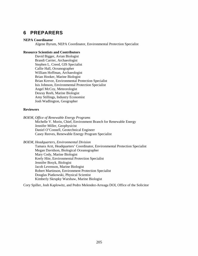
205
6 PREPARERS NEPA Coordinator
Algene Byrum, NEPA Coordinator, Environmental Protection Specialist
Resource Scientists and Contributors David Bigger, Avian Biologist Brandi Carrier, Archaeologist Stephen L. Creed, GIS Specialist Callie Hall, Oceanographer William Hoffman, Archaeologist Brian Hooker, Marine Biologist Brian Krevor, Environmental Protection Specialist Isis Johnson, Environmental Protection Specialist Angel McCoy, Meteorologist Desray Reeb, Marine Biologist Amy Stillings, Industry Economist Josh Wadlington, Geographer
Reviewers BOEM, Office of Renewable Energy Programs
Michelle V. Morin, Chief, Environment Branch for Renewable Energy Jennifer Miller, Geophysicist Daniel O’Connell, Geotechnical Engineer Casey Reeves, Renewable Energy Program Specialist
BOEM, Headquarters, Environmental Division
Tamara Arzt, Headquarters’ Coordinator, Environmental Protection Specialist Megan Davidson, Biological Oceanographer Mary Cody, Marine Biologist Keely Hite, Environmental Protection Specialist Jennifer Bosyk, Biologist Jacob Levenson, Marine Biologist Robert Martinson, Environment Protection Specialist Douglas Piatkowski, Physical Scientist Kimberly Skrupky Warshaw, Marine Biologist
Cory Spiller, Josh Kaplowitz, and Pedro Melendez-Arreaga DOI, Office of the Solicitor


207
APPENDIX A – STANDARD OPERATING CONDITIONS FOR
MARINE PROTECTED SPECIES AND ESSENTIAL FISH
HABITAT This section sets forth the standard operating conditions (SOCs) that are part of the Proposed Action and minimize or eliminate potential impacts to protected species. These SOCs supersede Addendum “C” of the lease (OCS-A 0497) and are divided into six sections: (A) those required during all project activities pursuant to the RAP; (B) those required during HRG surveys; (C) those required during pile driving of the WTG foundations; (D) those required during DP thruster use; (E) reporting requirements; and (F) EFH reporting and conservation measures. BOEM has revised the SOCs since publication of the EA in December 2, 2014. Sections A-E of the SOCs in this appendix constitute reasonable and prudent measures to protect endangered species as required by NMFS through its July 9, 2015, Biological Opinion (NMFS, 2015) of BOEM’s assessment of the proposed action (see Section 4.3.1, “Endangered Species Act”). The last section was added as a result of consultation with NMFS under the Magnuson-Stevens Act (see Sections 3.2.2 and 4.3.2 of this revised EA). These SOCs will be included as conditions of BOEM’s approval of the RAP.
A.1. GENERAL REQUIREMENTS
1) DMME and/or Dominion must ensure that vessel operators and crew members receive training on protected species sighting and reporting that would stress individual responsibility for cetacean, pinniped, and sea turtle awareness and protection.
2) Prior to the start of operations, DMME and/or Dominion must hold a briefing to establish responsibilities of each involved party, define the chains of command, discuss communication procedures, provide an overview of monitoring procedures, and review operational procedures. This briefing must include all relevant personnel, crew members and protected species observers. New personnel must be briefed as they join the work in progress.
3) DMME and/or Dominion must ensure that all vessel operators and crew members, including protected species observers, are familiar with, and understand, the requirements specified in Appendix A.
4) DMME and/or Dominion must ensure that a copy of the standard operating conditions (Appendix A) is made available on every project-related vessel.
A.1.1 Requirements for Vessel Strike Avoidance
DMME and/or Dominion must ensure that all vessels conducting activities pursuant to the RAP comply with the vessel-strike avoidance measures specified below except when the safety of the vessel or crew is in doubt or the safety of life at sea is in question.
1) DMME and/or Dominion must ensure that vessel operators and crews maintain a vigilant watch for cetaceans, pinnipeds, and sea turtles and take the appropriate measures to avoid striking these protected species.
2) DMME and/or Dominion must ensure that all vessel operators comply with 10 knot (18.5 km/hr) speed restrictions in any Dynamic Management Area (DMA).
3) DMME and/or Dominion must ensure that all vessels operating in the mid-Atlantic Seasonal Management Areas from November 1 through April 30 operate at speeds of 10 knots (18.5 km/hr) or less.

208
4) DMME and/or Dominion must ensure that all vessel operators reduce vessel speed to 10 knots or less when mother/calf pairs, pods, or large assemblages of non-delphinoid cetaceans are observed near an underway vessel.
5) North Atlantic right whales.
a) DMME and/or Dominion must ensure all vessels maintain a separation distance of 500 meters (1,640 ft) or greater from any sighted North Atlantic right whale.
b) DMME and/or Dominion must ensure that the following avoidance measures are taken if a vessel comes within 500 meters (1,640 ft) of any North Atlantic right whale:
i) If underway, any vessel must steer a course away from the North Atlantic right whale at 10 knots (18.5 km/h) or less until the 500 meters (1,640 ft) minimum separation distance has been established (unless (ii) below applies).
ii) If a North Atlantic right whale is sighted within 100 meters (328 ft) to an underway vessel, the vessel operator must immediately reduce speed and promptly shift the engine to neutral. The vessel operator must not engage the engines until the North Atlantic right whale has moved beyond 100 meters (328 ft), at which point DMME and/or Dominion must comply with 5(b)(i) above.
iii) If a vessel is stationary, the vessel operator must not engage engines until the North Atlantic right whale has moved beyond 100 meters (328 ft), at which point DMME and/or Dominion must comply with 5(b)(i) above.
6) Non-delphinoid cetaceans other than the North Atlantic right whale.
a) DMME and/or Dominion must ensure all vessels maintain a separation distance of 100 meters (328 ft) or greater from any sighted non-delphinoid cetacean.
b) DMME and/or Dominion must ensure that the following avoidance measures are taken if a vessel comes within 100 meters (328 ft) of any non-delphinoid cetacean:
i) If any non-delphinoid cetacean is sighted, the vessel underway must reduce speed and shift the engine to neutral, and must not engage the engines until the non-delphinoid cetacean has moved beyond 100 meters (328 ft).
ii) If a vessel is stationary, the vessel must not engage engines until the non-delphinoid cetacean has moved beyond 100 meters (328 ft).
7) Delphinoid cetaceans and Pinnipeds.
a) DMME and/or Dominion must ensure that vessels underway do not divert to approach any delphinoid cetacean and/or pinniped.
b) DMME and/or Dominion must ensure that if a delphinoid cetacean and/or pinniped approaches any vessel underway, the vessel underway must avoid excessive speed or abrupt changes in direction to avoid injury to the delphinoid cetacean and/or pinniped.
8) Sea Turtles.
a) DMME and/or Dominion must ensure all vessels maintain a separation distance of 50 meters (164 ft) or greater from any sighted sea turtle.

209
A.2. Marine Debris Awareness
Marine debris awareness measures are intended to reduce the risk marine debris poses to protected species from ingestion and entanglement. These simple measures will reduce the potential for debris ending up in the marine environment.
In addition to the training described in Section 3.2.6.2 (Accidental Releases of Hazardous Materials or Fuels), DMME and/or Dominion must ensure that vessel operators, employees, and contractors engaged in activities pursuant to the RAP are briefed on marine trash and debris awareness elimination as described in the BSEE NTL No. 2012-G01 (“Marine Trash and Debris Awareness and Elimination”). DMME and/or Dominion must ensure that its employees and contractors are made aware of the environmental and socioeconomic impacts associated with marine trash and debris and their responsibilities for ensuring that trash and debris are not intentionally or accidentally discharged into the marine environment. The above referenced NTL provides information DMME and/or Dominion may use for this awareness training.
B. REQUIREMENTS FOR HIGH RESOLUTION GEOPHYSICAL SURVEYS
DMME and/or Dominion must ensure that all vessels conducting activity pursuant to the RAP comply with the HRG survey requirements specified here, except under extraordinary circumstances when the safety of the vessel or crew are in doubt or the safety of life at sea is in question. The following requirements will apply to all HRG survey work actively using electromechanical survey equipment where one or more acoustic sound source is operating at frequencies below 200 kHz.
1) Visibility. DMME and/or Dominion must not conduct HRG surveys at any time when lighting or weather conditions (e.g., darkness, rain, fog, sea state) prevents visual monitoring of the HRG survey exclusion zone.
2) Modification of Visibility Requirement. If DMME and/or Dominion intend to conduct HRG survey operations at night or when visual observation is otherwise impaired, DMME and/or Dominion must submit to BOEM an alternative monitoring plan detailing the alternative monitoring methodology (e.g., active or passive monitoring technologies). The alternative monitoring plan must demonstrate the effectiveness of the methodology proposed to BOEM's satisfaction. BOEM may, in consultation with NMFS, decide to allow DMME and/or Dominion to conduct HRG surveys at night or when visual observation is otherwise impaired using the proposed alternative monitoring methodology.
3) Protected Species Observer (PSO). DMME and/or Dominion must ensure that the exclusion zone for all HRG surveys is monitored by NMFS‐approved PSOs around the sound source. The number of PSOs must be sufficient to effectively monitor the exclusion zone at all times. In order to ensure effective monitoring, observers must not be on watch for more than 4 consecutive hours, with at least a 2-hour break after a 4-hour watch, unless otherwise accepted by BOEM. Observers must not work for more than 12 hours in a 24-hour period. DMME and/or Dominion must provide to BOEM a list of observers and their résumés no later than 45 calendar days prior to the scheduled start of surveys. DMME and/or Dominion must provide the résumés of additional observers at least 15 calendar days prior to each observer’s start date. BOEM will send the observer information to NMFS for approval.
4) Optical Device Availability. DMME and/or Dominion must ensure that monitoring occurs from the highest available vantage point on the associated operational platform, allowing for 360-degree scanning. DMME and/or Dominion must ensure that reticle binoculars and other suitable equipment are available to each observer to adequately perceive and monitor protected marine species within the exclusion zone during surveys.

210
5) Establishment of Default Exclusion Zone. DMME and/or Dominion must ensure a 200‐meter radius exclusion zone for marine mammals and sea turtles. DMME and/or Dominion may not use HRG survey devices that emit sound levels that exceed the 180 dB Level A harassment radius (200 meter) boundary without approval from BOEM. If BOEM determines that the exclusion zone does not encompass the 180 dB Level A harassment radius, BOEM may impose additional, relevant requirements on DMME and/or Dominion, including but not limited to, required expansion of this exclusion zone.
6) Field Verification of Exclusion Zone. DMME and/or Dominion must conduct field verification of the exclusion zone for the HRG survey equipment operating below 200 kHz. DMME and/or Dominion must take acoustic measurements at a minimum of two reference locations and in a manner that is sufficient to establish the following: source level (peak at 1 meter) and distance to the 180, 160, and 150 dBrms re 1μPa sound pressure level (SPL) isopleths as well as the 187 dB re 1μPa cumulative sound exposure level (cSEL). DMME and/or Dominion must take such sound measurements at the reference locations at two depths (i.e., a depth at mid-water and a depth at approximately 1 meter (3.28 ft) above the seafloor).
7) HRG Survey Chesapeake Bay Seasonal Management Area (SMA) Right Whale Monitoring. DMME and/or Dominion must ensure that between November 1 and April 30 vessel operators monitor National Marine Fisheries Service North Atlantic Right Whale reporting systems (e.g., the Early Warning System, Sighting Advisory System, and Mandatory Ship Reporting System) for the presence of North Atlantic right whales during HRG survey operations.
8) Dynamic Management Area Shutdown Requirement. DMME and/or Dominion must ensure that vessels cease HRG survey activities within 24 hours of NMFS establishing a DMA in DMME’s HRG survey area. HRG surveys may resume in the affected area after the DMA has expired.
9) Clearance of Exclusion Zone. DMME and/or Dominion must ensure that active acoustic sound sources will not be activated until the protected species observer has reported the exclusion zone clear of all marine mammals and sea turtles for 60 minutes.
10) Electromechanical Survey Equipment Ramp Up. DMME and/or Dominion must ensure that, when technically feasible, a “ramp up” of the electromechanical survey equipment occurs at the start or re‐start of HRG survey activities. A ramp‐up must begin with the power of the smallest acoustic equipment for the HRG survey at its lowest power output. The power output must be gradually turned up and other acoustic sources added in a way such that the source level increases in steps not exceeding 6 dB per 5‐minute period.
11) Shutdown for Non‐Delphinoid Cetaceans and Sea Turtles. If a non‐delphinoid cetacean or sea turtle is sighted at or within the exclusion zone, an immediate shutdown of the electromechanical survey equipment is required. The vessel operator must comply immediately with such a call by the observer. Any disagreement or discussion must occur only after shutdown. Subsequent restart of the electromechanical survey equipment may only occur following clearance of the exclusion zone (see #9 above) and implementation of ramp‐up procedures (see #10 above).
12) Power Down for Delphinoid Cetaceans and Pinnipeds. If a delphinoid cetacean or pinniped is sighted at or within the exclusion zone, the electromechanical survey equipment must be powered down to the lowest power output that is technically feasible. The vessel operator must comply immediately with such a call by the observer. Any disagreement or discussion must occur only after power‐down. Subsequent power up of the electromechanical survey equipment must use the ramp‐up provisions described in #10 and may occur after (1) the exclusion zone is clear of delphinoid cetaceans and pinnipeds or (2) a determination by the observer after a minimum of 10 minutes of observation that the delphinoid cetacean or pinniped is approaching the vessel or towed equipment at a speed and vector that indicates voluntary approach to bow‐ride or chase

211
towed equipment. An incursion into the exclusion zone by a non‐delphinoid cetacean or sea turtle during a power‐down requires implementation of the shutdown procedures described in #11.
13) Pauses in Electromechanical Survey Sound Source. DMME and/or Dominion must ensure that, if the electromechanical sound source shuts down for reasons other than encroachment into the exclusion zone by a non‐delphinoid cetacean or sea turtle, including reasons such as, but not limited to, mechanical or electronic failure, resulting in the cessation of the sound source for a period greater than 20 minutes, restart of the electromechanical survey equipment commences only after clearance of the exclusion zone (see #9 above) and implementation of ramp‐up procedures (see #10 above). If the pause is less than 20 minutes the equipment may be restarted as soon as practicable at its operational level as long as visual surveys were continued diligently throughout the silent period and the exclusion zone remained clear of marine mammals and sea turtles. If visual surveys were not continued diligently during the pause of 20‐minutes or less, DMME and/or Dominion must restart the electromechanical survey equipment following clearance of the exclusion zone (see #9 above) and implementation of ramp‐up procedures (#10 above).
C. REQUIREMENTS FOR PILE DRIVING OF A WIND TURBINE GENERATOR (WTG) INWARD BATTERED GUIDE STRUCTURE (IBGS) FOUNDATION
DMME and/or Dominion must ensure that all vessels conducting activity pursuant to the RAP comply with the pile driving requirements specified here, except when the safety of the vessel or crew are in doubt or the safety of life at sea is in question. The 1,000 m (3,281 ft) and 1,700 m (5,577 ft) default exclusion zones are based upon the largest field of ensonification to the 180 dB (RMS) isopleths for the 600 kJ and 1000 kJ impact hammers, respectively, as reported in the RAP (RAP, 2015 Appendix M-2). Because of the greater risk of injury to cetaceans, pinnipeds, and sea turtles from pile driving, BOEM has adopted a conservative shutdown requirement that would apply to all incursions into the exclusion zones during pile driving.
1) Visibility. DMME and/or Dominion must not conduct pile driving for IBGS foundations at any time when lighting or weather conditions (e.g., darkness, rain, fog, sea state) prevent visual monitoring of the exclusion zones for IBGS foundation pile driving as specified below. This requirement may be modified, pursuant to (2) below.
a. If the driving of a pile commenced during daylight hours, then DMME and/or Dominion may complete driving that pile after daylight hours. However, DMME and/or Dominion may not start driving a new pile after daylight hours, unless allowed to pursuant to an alternative monitoring plan as described in (2) below.
2) Modification of Visibility Requirement. If DMME and/or Dominion intend to conduct pile driving for an IBGS foundation at night or when visual observation is otherwise impaired, DMME and/or Dominion must submit to BOEM an alternative monitoring plan detailing the alternative monitoring methodology (e.g., active or passive monitoring technologies). The alternative monitoring plan must demonstrate, to BOEM’s satisfaction, the effectiveness of the methodology proposed. BOEM may, in consultation with NMFS, decide to allow DMME and/or Dominion to conduct pile driving for an IBGS foundation using the proposed alternative monitoring methodology at night or when visual observation is otherwise impaired.
3) Protected-Species Observer (PSO). DMME and/or Dominion must ensure that the exclusion zone for all pile driving for an IBGS foundation is monitored by NMFS-approved PSOs around the sound source. The number of protected species observers must be sufficient to effectively monitor the exclusion zone at all times. In order to ensure effective monitoring, observers must not be on watch for more than 4 consecutive hours, with at least a 2-hour break after a 4-hour watch, unless

212
otherwise accepted by BOEM. Observers must not work for more than 12 hours in a 24-hour period. DMME and/or Dominion must provide to BOEM a list of observers and their résumés no later than forty-five (45) calendar days prior to the scheduled start of IBGS foundation construction activity. The résumés of any additional observers must be provided fifteen (15) calendar days prior to each observer’s start date. BOEM will send the observer information to NMFS for approval.
4) Optical Device Availability. DMME and/or Dominion must ensure that monitoring occurs from the highest available vantage point on the associated operational platform, allowing for 360-degree scanning. DMME and/or Dominion must ensure that reticle binoculars and other suitable equipment are available to each observer to adequately perceive and monitor protected species within the exclusion zone during construction activities.
5) Prohibition on Pile Driving. DMME and/or Dominion must ensure that no pile-driving activities (e.g., pneumatic, hydraulic, or vibratory installation of foundation piles) occur from November 1 – April 30 or within an active Dynamic Management Area (DMA) as established by NMFS. Any surveys outside of the DMA are required to remain at a distance such that received levels at these boundaries are no more than Level B harassment as determined by field verification or modeling.
6) Establishment of Exclusion Zones. DMME and/or Dominion must ensure the establishment of default exclusion zones for cetaceans, sea turtles, and pinnipeds around each pile driving site based on the 180 dB isopleth.
a. For the 1000 kJ impact hammer, the default exclusion zone will be 1,700 m (5,577ft). The 1,700 m (5,577 ft) exclusion zone must be monitored from two locations. At least two observers on simultaneous watch must be based at or near the sound source and will be responsible for monitoring out to 1,000 m (3,281 ft) from the sound source. At least two additional observers on simultaneous watch must be located on a separate vessel navigating approximately 1,700 m (5,577 ft) around the pile hammer and will be responsible for monitoring the area between 1,000 m (3,281 ft) to 1,700 m (5,577 ft) from the sound source.
b. For the 600 kJ impact hammer, the default exclusion zone will be 1,000 m (3,281 ft). The 1,000 m (3,281 ft) exclusion zone must be monitored from two locations. At least two observers on simultaneous watch must be based at or near the sound source and will be responsible for monitoring out to 500 m (1,641 ft) from the sound source. At least two additional observers on simultaneous watch must be located on a separate vessel navigating approximately 1,000 m (3,281 ft) around the pile hammer and will be responsible for monitoring the area between 500 m (1,641 ft) to 1,000 m (3,281 ft) from the sound source.
7) Field Verification of Exclusion Zones. DMME and/or Dominion must conduct acoustic monitoring of pile driving activities during the installation of each IBGS foundation requiring pile driving and will include the driving of the last half (deepest pile segment) for any given open-water pile. DMME and/or Dominion must take acoustic measurements at a minimum of two reference locations and be sufficient to establish the following: source level (peak at 1 m) and distance to the 207, 180, 166, 160, and 150 dB re 1μPa (RMS) SPL isopleths as well as the 187 dB re 1μPa cSEL and 206 dBpeak. Such sound measurements must be taken at the reference locations at two depths (i.e., a depth at midwater and a depth at approximately 1m above the seafloor). Sound pressure levels must be measured in the field in dB re 1 μPa (RMS) and reported. DMME and/or Dominion must report the azimuthal bearing from the central pile to the receivers. Additionally, DMME and/ or Dominion must record the bearings from the central caisson to the strike surfaces of each IBGS pile, as well as the bearing from the central caisson to where each IBGS pile enters the ocean floor.

213
8) Modification of Exclusion Zones. DMME and/or Dominion may use the field verification method described above to modify the default exclusion zones provided above for pile driving activities. Results of the field verification must be submitted to BOEM after the pile driving of the first IBGS foundation. The results of the measurements must be used to establish a new exclusion zone which may be greater than or less than the default exclusion zones, depending on the results of the field tests. Any new exclusion zone radius must be based on the most conservative measurement (i.e., the largest safety zone configuration) of the target (i.e. 180 dB or 160 dB) zone. DMME and/or Dominion must obtain BOEM’s approval for any new exclusion zone before it may be implemented.
9) Clearance of Exclusion Zones. DMME and/or Dominion must ensure that visual monitoring of the exclusion zone begins no less than 60 minutes prior to the start of any pile driving operations and continues for at least 60 minutes after pile driving operations cease, unless sighting conditions do not allow observation of the sea surface (e.g., fog, rain, darkness) (refer to #1 above). If a cetacean, pinniped, or sea turtle is observed, the observer must note and monitor the position, relative bearing and estimated distance to the animal until the animal dives or moves out of visual range of the observer. The observer must continue to watch for additional animals that may surface in the area. DMME and/or Dominion must ensure that pile driving operations do not begin until the protected species observer has reported the exclusion zone clear of all marine mammals and sea turtles for at least 60 minutes.
10) Implementation of Soft Start. DMME and/or Dominion must ensure that a “soft start” be implemented at the beginning of each pile installation in order to provide additional protection to cetaceans, pinnipeds, and sea turtles near the project area by allowing them to vacate the area prior to the commencement of pile driving activities. DMME and/or Dominion must ensure the following at the beginning of each day's in-water pile driving activities or when pile driving has ceased for more than one hour: The impact hammer soft start requires 3 strike sets, with a minimum of 3 strikes per set. A 1-minute wait period must occur between each strike set. The initial strike set will be at approximately 10 percent energy, the second strike set at approximately 25 percent energy and the third strike set at approximately 40 percent energy. The soft start procedure should not be less than 20 minutes. Strikes may continue at full operational power following the soft start period. For vibratory hammers, the soft start requires initiation of noise from the hammers for 15 seconds at reduced energy, followed by a one-minute waiting period. This procedure must be repeated two additional times, after which the vibratory hammer can be operated at full operational power.
11) Shut Down for Cetaceans, Pinnipeds, and Sea Turtles. DMME and/or Dominion must ensure that any time a cetacean, pinniped, and/or sea turtle is observed within the exclusion zone, the observer must notify the Dominion Construction Compliance Manager, Resident Engineer (or other authorized individual) and call for a shutdown of pile driving activity. Any disagreement or discussion should occur only after shut-down, unless such discussion relates to the safety of the timing of the cessation of the pile driving activity. Subsequent restart of the pile driving equipment may only occur following clearance of the exclusion zone of any cetacean, pinniped, and/or sea turtle for at least 60 minutes.
12) Pauses in Pile Driving Activity. DMME and/or Dominion must ensure that if pile driving ceases for 30 minutes or more and a cetacean, pinniped, and/or sea turtle is sighted within the exclusion zone prior to re-start of pile driving, the observer(s) must notify the Dominion Construction Compliance Manager, Resident Engineer (or other authorized individual) that an additional 60 minute visual and acoustic observation period must be completed, as described above, before restarting pile driving activities. A pause in pile driving for less than 30 minutes must still begin with a soft start, but will not require the 60 minute clearance period as long as visual surveys were continued diligently throughout the silent period and the exclusion zone remained clear of

214
cetaceans, pinnipeds, and sea turtles. If visual surveys were not continued diligently during the pause of 30-minutes or less, DMME and/or Dominion must ensure the exclusion zone is clear of all cetaceans, pinnipeds, and sea turtles for at least 60 minutes prior to the commencement of a soft start and subsequent pile driving.
D. REQUIREMENTS FOR DYNAMIC POSITIONING (DP) THRUSTER USE
1) Visibility. In order for DMME and/or Dominion to conduct DP thruster operations at night or when visual observation is otherwise impaired, an alternative monitoring plan detailing the alternative monitoring technologies (e.g., night vision optics and at-sea calibration exercises) must be submitted to and approved by BOEM. The alternative monitoring plan must demonstrate the effectiveness of the methodology proposed. BOEM may, after consultation with NMFS, decide to approve or disapprove the alternative monitoring plan.
2) Establishment of Default Monitoring Zone. In order to minimize potential entrainment and/or acoustic impacts, DMME and/or Dominion must ensure the establishment of a 50‐meter radius monitoring zone for marine mammals and sea turtles. DMME and/or Dominion must ensure that the monitoring zone is established when the vessel initially leaves the dock and throughout the construction activity, ending when the DP vessel returns to dock. If BOEM determines that the monitoring zone does not encompass the 160 dB isopleth, BOEM may impose additional, relevant requirements on DMME and/or Dominion, including but not limited to, required expansion of this monitoring zone.
3) Field Verification of Monitoring Zone. DMME and/or Dominion must conduct acoustic monitoring of DP thrusters during cable laying operations. DMME and/or Dominion must take acoustic measurements sufficient to establish the following: source level (peak at 1 m) and distance to the 207, 180, 166, 160, 150 and 120 dB re 1μPa (RMS) SPL isopleths as well as the 187 dB re 1μPa cSEL and 206 dBpeak.
4) Protected Species Observer (PSO). DMME and/or Dominion must ensure that the monitoring zone during DP thruster use is monitored by NMFS‐approved PSOs around the sound source. The number of PSOs must be sufficient to effectively monitor the monitoring zone at all times. At least two PSOs trained on using night vision optics must be on simultaneous watch during night time operations, if such operations are allowed by BOEM. In order to ensure effective monitoring, observers must not be on watch for more than 4 consecutive hours, with at least a 2-hour break after a 4-hour watch, unless otherwise accepted by BOEM. Observers must not work for more than 12 hours in a 24-hour period. DMME and/or Dominion must provide BOEM with a list of observers and their résumés no later than 45 calendar days prior to the scheduled start of surveys. The résumés of any additional observers must be provided at least 15 calendar days prior to each observer’s start date. BOEM will send the observer information to NMFS for approval.
5) Optical Device Availability. DMME and/or Dominion must ensure that monitoring occurs from the highest available vantage point on the associated operational platform, allowing for 360-degree scanning. DMME and/or Dominion must ensure that reticle binoculars and other suitable equipment are available to each observer to adequately perceive and monitor protected marine species within the monitoring zone during DP thruster use.
6) Chesapeake Bay Seasonal Management Area (SMA) Right Whale Monitoring. DMME and/or Dominion must ensure that during DP thruster use that takes place between November 1 and April 30 vessel operators monitor National Marine Fisheries Service North Atlantic Right Whale reporting systems (e.g., the Early Warning System, Sighting Advisory System, and Mandatory Ship Reporting System) for the presence of North Atlantic right whales.
7) DP Thruster Ramp Up. DMME and/or Dominion must ensure that, when technically feasible, a “ramp up” of the DP thrusters occurs at the start or re‐start of DP thruster use. A ramp up would
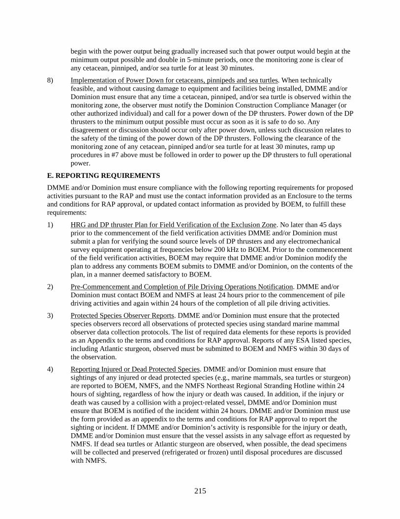
215
begin with the power output being gradually increased such that power output would begin at the minimum output possible and double in 5‐minute periods, once the monitoring zone is clear of any cetacean, pinniped, and/or sea turtle for at least 30 minutes.
8) Implementation of Power Down for cetaceans, pinnipeds and sea turtles. When technically feasible, and without causing damage to equipment and facilities being installed, DMME and/or Dominion must ensure that any time a cetacean, pinniped, and/or sea turtle is observed within the monitoring zone, the observer must notify the Dominion Construction Compliance Manager (or other authorized individual) and call for a power down of the DP thrusters. Power down of the DP thrusters to the minimum output possible must occur as soon as it is safe to do so. Any disagreement or discussion should occur only after power down, unless such discussion relates to the safety of the timing of the power down of the DP thrusters. Following the clearance of the monitoring zone of any cetacean, pinniped and/or sea turtle for at least 30 minutes, ramp up procedures in #7 above must be followed in order to power up the DP thrusters to full operational power.
E. REPORTING REQUIREMENTS
DMME and/or Dominion must ensure compliance with the following reporting requirements for proposed activities pursuant to the RAP and must use the contact information provided as an Enclosure to the terms and conditions for RAP approval, or updated contact information as provided by BOEM, to fulfill these requirements:
1) HRG and DP thruster Plan for Field Verification of the Exclusion Zone. No later than 45 days prior to the commencement of the field verification activities DMME and/or Dominion must submit a plan for verifying the sound source levels of DP thrusters and any electromechanical survey equipment operating at frequencies below 200 kHz to BOEM. Prior to the commencement of the field verification activities, BOEM may require that DMME and/or Dominion modify the plan to address any comments BOEM submits to DMME and/or Dominion, on the contents of the plan, in a manner deemed satisfactory to BOEM.
2) Pre-Commencement and Completion of Pile Driving Operations Notification. DMME and/or Dominion must contact BOEM and NMFS at least 24 hours prior to the commencement of pile driving activities and again within 24 hours of the completion of all pile driving activities.
3) Protected Species Observer Reports. DMME and/or Dominion must ensure that the protected species observers record all observations of protected species using standard marine mammal observer data collection protocols. The list of required data elements for these reports is provided as an Appendix to the terms and conditions for RAP approval. Reports of any ESA listed species, including Atlantic sturgeon, observed must be submitted to BOEM and NMFS within 30 days of the observation.
4) Reporting Injured or Dead Protected Species. DMME and/or Dominion must ensure that sightings of any injured or dead protected species (e.g., marine mammals, sea turtles or sturgeon) are reported to BOEM, NMFS, and the NMFS Northeast Regional Stranding Hotline within 24 hours of sighting, regardless of how the injury or death was caused. In addition, if the injury or death was caused by a collision with a project‐related vessel, DMME and/or Dominion must ensure that BOEM is notified of the incident within 24 hours. DMME and/or Dominion must use the form provided as an appendix to the terms and conditions for RAP approval to report the sighting or incident. If DMME and/or Dominion’s activity is responsible for the injury or death, DMME and/or Dominion must ensure that the vessel assists in any salvage effort as requested by NMFS. If dead sea turtles or Atlantic sturgeon are observed, when possible, the dead specimens will be collected and preserved (refrigerated or frozen) until disposal procedures are discussed with NMFS.

216
5) Reporting Observed Impacts to Protected Species.
i) DMME and/or Dominion must report any observed takes of listed marine mammals, sea turtles or sturgeon resulting in injury or mortality within 24 hours to BOEM and NMFS.
ii) DMME and/or Dominion must report any observations concerning any impacts on Endangered Species Act listed marine mammals, sea turtles or sturgeon to BOEM and NMFS Northeast Region’s Stranding Hotline within 48 hours.
iii) DMME and/or Dominion must record injuries or mortalities using the form provided as an Appendix of the terms and conditions for RAP approval.
6) Field Verification of Exclusion Zone Reports for HRG and DP thruster use. DMME and/or Dominion must ensure that the results of the field verification are reported to BOEM and NMFS prior to this equipment being used for project related activities and within 7 days of the commencement of field verification activities. A preliminary interpretation of the results for all sound sources, which will include details of the operating frequencies, sound pressure levels (RMS), received cSELs , and frequency bands covered, as well as associated latitude/longitude positions, ranges, depths and bearings between sound sources and receivers, must be included in the reports. DMME and/or Dominion may commence HRG and DP thruster use unless BOEM determines that the results are not within the scope of existing consultations. Acoustic monitoring results collected during DP thruster use related to cable-laying must be submitted every 24 hours to BOEM and NMFS.
7) Field Verification of Exclusion Zone Reports for Pile Driving. DMME and/or Dominion must ensure that the results of acoustic monitoring of each pile are submitted to BOEM and NMFS within 24 hours of installation. Results of the field sound source verification collected during the installation of the first IBGS foundation must be reported to BOEM and NMFS within 7 days of the commencement of field verification activities, and before the installation of the second IBGS foundation. A preliminary interpretation of the results for each pile installation, which for all sound sources will include details of the operating frequencies, sound pressure levels (RMS), received cSELs and frequency bands covered, as well as associated latitude/longitude positions, ranges, depths and bearings between sound sources and receivers, must be included in the reports. Pile driving of the second IBGS foundation may commence unless BOEM determines that the results are not within the scope of existing consultations.
8) Required Modification of Exclusion or Monitoring Zone Notification: DMME and/or Dominion must notify BOEM and NMFS within 24 hours of receiving any acoustic monitoring results which indicate that the exclusion or monitoring zones do not cover the Level A harassment threshold. The exclusion or monitoring zone cannot be modified without written (e-mail) approval from BOEM and NMFS.
9) Final Technical Report for DP thruster use and Observations. DMME and/or Dominion must provide to BOEM and NMFS a final report of the observation data recorded during DP thruster use monitoring within 120 days of final DP thruster use. The report must include full documentation of methods and monitoring protocols, summarize the data collected during monitoring, estimate the number of listed marine mammals and sea turtles that may have been taken during DP thruster use, and provide an interpretation of the results and effectiveness of all monitoring tasks. The report must also include the results and analysis of the data collected during the sound source field verification of the DP thrusters.
10) Final Technical Report for WTG Construction and Observations. DMME and/or Dominion must provide BOEM and NMFS a report within 120 days of completion of the pile driving and construction activities. The report must include full documentation of methods and monitoring protocols, summarize the data recorded during monitoring, estimate the number of listed marine

217
mammals and sea turtles that may have been taken during construction activities, and provide an interpretation of the results and effectiveness of all monitoring tasks. The report must also include the results and analysis of the sound source field verification data collected during pile driving activity.
11) Marine Mammal Protection Act Authorization(s). If DMME and/or Dominion is required to obtain an authorization pursuant to section 101(a)(5) of the Marine Mammal Protection Act prior to conducting activities pursuant to the RAP, then DMME and/or Dominion must provide to BOEM a copy of the authorization prior to commencing these activities, pursuant to CFR 585.801(b).
F. Essential Fish Habitat Reporting and Conservation Measures
1) Foundation Monitoring Reports. DMME and/or Dominion must provide BOEM with a visual inspection report within 45 calendar days of each foundation inspection. The visual inspections will be carried out at 6 month intervals for the first year of commissioning and at 12 month intervals thereafter, as described in Section 3.6.1 of the BOEM-approved Research Activities Plan. The visual inspection reports must include the type and thickness of marine growth on each foundation and on the seabed within 5 meters of each pile and central caisson, identified to the lowest taxonomic group possible.
2) Foundation Scour Monitoring Reports. DMME and/or Dominion must provide BOEM with a foundation scour monitoring report within 45 calendar days following each scour inspection. As described in Section 3.6.1 of The BOEM-approved RAP, the initial scour inspection will be carried out within 6 months of commissioning, and subsequent inspections will be carried out at intervals of 1, 2, 5 and 10 years after commissioning, or after a major storm event.
3) Inter-array and Export Cable Monitoring Reports. DMME and/or Dominion must provide BOEM with an inter-array and export cable monitoring report within 45 calendar days following each inter-array and export cable inspection, which will be carried out according to the schedule described in Section 3.6.3 of the BOEM-approved RAP. The initial inter-array and export cable inspection will be carried out at intervals of 6 months and 1 year after installation. Survey frequency thereafter will be reduced to every 2 years or after a major storm event.
4) If DMME and/or Dominion determine that cable protection measures are necessary DMME and/or Dominion must consider utilizing measures that minimize impacts to essential fish habitat (e.g., cable protection measures with the smallest footprint practicable). Should DMME and/or Dominion determine that it is necessary to implement cable protection measure, DMME and/or Dominion must provide to the BOEM a written description of the cable protection measures implemented, including an explanation of the EFH impact minimization measures considered and/or utilized.

www.boem.gov
The Department of the Interior Mission
As the Nation’s principal conservation agency, the Department of the Interior has responsibility for most of our nationally owned public lands and natural resources. This includes fostering the sound use of our land and water resources, protecting our fish, wildlife and biological diversity; preserving the environmental and cultural values of our national parks and historical places; and providing for the enjoyment of life through outdoor recreation. The Department assesses our energy and mineral resources and works to ensure that their development is in the best interests of all our people by encouraging stewardship and citizen participation in their care. The Department also has a major responsibility for American Indian reservation communities and for people who live in island communities.
The Bureau of Ocean Energy Management
The Bureau of Ocean Energy Management (BOEM) works to manage the exploration and development of the nation's offshore resources in a way that appropriately balances economic development, energy independence, and environmental protection through oil and gas leases, renewable energy development and environmental reviews and studies.