VIIRS Sensor Performance - SSEC, UW-Madison VIIRS Sensor... · Copyright © 2003 Raytheon Company...
19
Copyright © 2003 Raytheon Company An unpublished work. All rights reserved. NPOESS Visible Infrared Imaging Radiometer Suite (VIIRS) Sensor Design and Performance J. Puschell 1 , C. Schueler 1 , J. Ed Clement 1 , R. Ravella 1 , L. Darnton 2 F. DeLuccia 3 , Captain T. Scalione USAF 4 , H. Bloom 4 , H. Swenson 3 1 Raytheon Santa Barbara Remote Sensing 2 Northrop Grumman Space Technology 3 The Aerospace Corporation 4 NPOESS Integrated Program Office (IPO)
Transcript of VIIRS Sensor Performance - SSEC, UW-Madison VIIRS Sensor... · Copyright © 2003 Raytheon Company...

Copyright © 2003 Raytheon CompanyAn unpublished work. All rights reserved.
NPOESS Visible Infrared Imaging Radiometer Suite (VIIRS) Sensor Design and Performance
J. Puschell1, C. Schueler1, J. Ed Clement1, R. Ravella1, L. Darnton2
F. DeLuccia3, Captain T. Scalione USAF4, H. Bloom4, H. Swenson3
1Raytheon Santa Barbara Remote Sensing2Northrop Grumman Space Technology
3The Aerospace Corporation4NPOESS Integrated Program Office (IPO)

Copyright © 2003 Raytheon CompanyAn unpublished work. All rights reserved.
VIIRS System to Provide Excellent Environmental Data Records (EDRs)
• VIIRS System Design based on integrated Sensor and Algorithms• Engineering Development Unit (EDU) approaching integration• EDR Science Algorithms developed, documented, and publicly released by Raytheon Technical Services Company (RTSC) Information Technology and Scientific Services (ITSS)
Imagery (with four ARRs)Sea Surface Temp
Aerosol Optical ThicknessAerosol Particle Size
Suspended MatterCloud Cover/Layers
Cloud Effective Particle SizeCloud Optical Thickness
Cloud Top HeightCloud Top Pressure
Cloud Top TemperatureAlbedo
Land Surface TemperatureVegetation Index
Snow Cover/DepthSurface Type (ST)l
Fresh Water Ice(Sea Ice ARR)Ice Surface Temperature
Ocean Color/Chlorophyll Sea Ice Characterization
Active Fires (ST ARR)Precipitable WaterCloud Base Height
Net Heat FluxSoil Moisture
IA
IIA
IIB
IIIB
IORD/TRD Threshold IORD/TRD Objective

Copyright © 2003 Raytheon CompanyAn unpublished work. All rights reserved.
VIIRS PerformanceVerified by Hardware & Testbed
Snow/Ice
Snow/Ice
SurfaceTemp.
SurfaceTemp.
OceanOcean
TOA*Scene
Radiance
TOA*Scene
Radiance
Algorithms: (VIIRS Subsystem)Sensor: (VIIRS Subsystem)
VIIRS System
CoolerCooler
CloudsClouds
LandLand
AerosolsAerosols
RotatingTelescopeRotatingTelescope
Aft Optics/FPAs
Aft Optics/FPAs
SDRProcessing
SDRProcessing
RDRProc-essor
RDRProc-essor
ImageryImageryOn-BoardCalibratorsOn-Board
Calibrators
Auxiliary & Ancillary
data
Auxiliary & Ancillary
data
ClosedClosedthethe
Loop!Loop!
*Top ofAtmosphere
• EDRs drive algorithm and raw sensor data requirements• Sensor specification derived from EDRs with testbed• Sensor performance verified by hardware risk-reduction demonstrations and analyses
• EDR performance verified by testbed with sensor models

Copyright © 2003 Raytheon CompanyAn unpublished work. All rights reserved.
VIIRS Sensor Performance Defined by Sensor Specification
Sensor Performance Requirements
Scan
56.26o
40 rpm
Radiometric
Typical Radiance (Ltyp)
Dynamic range
SNRAlignment
Pointing
Registration
Spatial
GIFOV
HSI
MTF
Calibration
Pre-launch
On-orbit
Stability
Other
Uniformity
Linearity
Stray light
Crosstalk
Spectral
Tolerances
Band center
Bandwidth
Out-of-band
response
In this presentation
In VIIRS specification
• Northrop-Grumman Space Technology (NGST) contract to Raytheon Santa Barbara Remote Sensing (SBRS) based on sensor specification
• NPOESS Integrated Program Office (IPO) contract to NGST based onsystem specification including EDR performance

Copyright © 2003 Raytheon CompanyAn unpublished work. All rights reserved.
Radiative Cooler/Earth Shield
Photons to Digital Data: VIIRS Architecture Stable Since PDR
SolarDiffuser
Blackbody
Sun
SpaceView
Earth
RotatingTelescopeAssembly
FPADewar
Focal PlaneElectronicsReadout &
A/DConversion
FormatterBuffer
Compression
Data
Power, Command,Control, Telemetry
LWIR (4)
SWIR/MWIR (8)
Beam-splitter
SDSM
Beam-splitterBeam-splitter
Imager DNB/VNIR(10 bands)
GroundSupport
andSystem TestEquipment
Dimensions: 134 x 141 x 85 cmMass: 275 kgPower: 240 WData Rate: 10.5 peak/8 avg Mbps
DNB - Day/Night “Band”VisNIR - Visible/Near IRSWIR - Short Wave IRMWIR - Mid Wave IRLWIR - Long Wave IRHAM - Half Angle Mirror SDSM - Solar Diffuser Stability Monitor
HAM
Moon
SpaceView

Copyright © 2003 Raytheon CompanyAn unpublished work. All rights reserved.
VIIRS Post-CDR RefinementsBeing Verified in EDU*
• Constant-speed rotating telescope• Simple all-reflective diamond point
turned bolt-together optics• Proven emissive/reflective calibration
Passive Cryoradiator
4-mirror anastigmatAll-reflective
Aft optics imager
3-Mirror AnastigmatRotating telescope refined to eliminate modulated instrument background (MIB)
MODIS-heritage blackbodyrelocated to minimize Earth shine
MODIS-heritage Solar Diffuser screen redesigned to minimize solar modulation
Electronics module (EM) & cables refined to minimize EMI
Cold FPADewar Assembly
MODIS-heritageSolar DiffuserStability Monitor refined to improve performance

Copyright © 2003 Raytheon CompanyAn unpublished work. All rights reserved.
VIIRS Compact, All ReflectiveNon-Image Rotating Optical Design
Rotating Telescope Assembly (RTA)
Half Angle Mirror (HAM)
FMA Imager
SWIR/MWIR& LWIR Dewar
VNIR/DNB FPA
Key post-CDR redesign:Moved aperture stop from primary mirror to just aft of HAM to keep source of detected rays within primary mirror, mitigating MIB
HAM rotates at half RTA speed in same direction to eliminate image rotation

Copyright © 2003 Raytheon CompanyAn unpublished work. All rights reserved.
Follow the Photon!

Copyright © 2003 Raytheon CompanyAn unpublished work. All rights reserved.
Sensor Models Being Verified byEngineering Development Unit (EDU) Tests
Mainframe: G, H
Rotating Telescope: A, B
Aft Optics: A, B
ElectronicsModule (EM): G
Half-Angle Mirror: I
All Optics:
C,D,E,F,H
FPAs & EM:
A,B, H, IFocal Planes
(FPAs): J
IHGFEDCBA163231 153029 142827 132625 122423 112221 102019 91817 81615 71413 61211 5109487365243121
SCAN
TRAC
K
CAB
LE S
IDE
Mux
3a
Mux
2a M
ux 2
bM
ux 3
b
Mux
1a
Mux
1b
Stag
e 1a
Stag
e 1b
Mux
1b
Mux
1a
A B C D E F G H
16 3231
15 3029
14 2827
13 2625
12 2423
11 2221
10 2019
9 1817
8 1615
7 1413
6 1211
5 109
4 87
3 65
2 43
1 21
CABLE SIDE
SCAN
TR
AC
K
A B C D E
32 163130 152928 142726 132524 122322 112120 101918 91716 81514 71312 61110 598 476 354 232 11
CABLE SIDE
SCAN
TRA
CK
Solar Diffuser Solar DiffuserStability Monitor
BlackbodyReference
On-Board Calibration Mechanisms: A
Legend Model Description
A Signal to Noise Ratio (SNR)
B Modulation Transfer Function (MTF)
C Polarization Performance
D Sequential Ray Trace
E Non-sequential Ray Trace
F Thin Films Design and Performance
G Structural Design and Performance
H Thermal Design and Performance
I Electronics Simulation
J Focal Plane Array (FPA) Performance

Copyright © 2003 Raytheon CompanyAn unpublished work. All rights reserved.
Spectral, Spatial & Radiometric Attributes of 22 VIIRS Bands
Nadir End of Scan Required Predicted MarginM1 0.412 0.742 x 0.259 1.60 x 1.58 Ocean Color Low 44.9 352 441 25%
Aerosols High 155 316 807 155%M2 0.445 0.742 x 0.259 1.60 x 1.58 Ocean Color Low 40 380 524 38%
Aerosols High 146 409 926 126%M3 0.488 0.742 x 0.259 1.60 x 1.58 Ocean Color Low 32 416 542 30%
Aerosols High 123 414 730 76%M4 0.555 0.742 x 0.259 1.60 x 1.58 Ocean Color Low 21 362 455 26%
Aerosols High 90 315 638 102%I1 0.640 0.371 x 0.387 0.80 x 0.789 Imagery Single 22 119 146 23%M5 0.672 0.742 x 0.259 1.60 x 1.58 Ocean Color Low 10 242 298 23%
Aerosols High 68 360 522 45%M6 0.746 0.742 x 0.776 1.60 x 1.58 Atmospheric Corr'n Single 9.6 199 239 20%I2 0.865 0.371 x 0.387 0.80 x 0.789 NDVI Single 25 150 225 50%M7 0.865 0.742 x 0.259 1.60 x 1.58 Ocean Color Low 6.4 215 388 81%
Aerosols High 33.4 340 494 45%DNB 0.7 0.742 x 0.742 0.742 x 0.742 Imagery Var. 6.70E-05 6 5.7 -5%
M8 1.24 0.742 x 0.776 1.60 x 1.58 Cloud Particle Size Single 5.4 74 98 32%M9 1.378 0.742 x 0.776 1.60 x 1.58 Cirrus/Cloud Cover Single 6 83 155 88%I3 1.61 0.371 x 0.387 0.80 x 0.789 Binary Snow Map Single 7.3 6.0 97 1523%
M10 1.61 0.742 x 0.776 1.60 x 1.58 Snow Fraction Single 7.3 342 439 28%M11 2.25 0.742 x 0.776 1.60 x 1.58 Clouds Single 0.12 10 17 66%I4 3.74 0.371 x 0.387 0.80 x 0.789 Imagery Clouds Single 270 K 2.500 0.486 415%
M12 3.70 0.742 x 0.776 1.60 x 1.58 SST Single 270 K 0.396 0.218 82%M13 4.05 0.742 x 0.259 1.60 x 1.58 SST Low 300 K 0.107 0.063 69%
Fires High 380 K 0.423 0.334 27%
M14 8.55 0.742 x 0.776 1.60 x 1.58 Cloud Top Properties Single 270 K 0.091 0.075 22%M15 10.763 0.742 x 0.776 1.60 x 1.58 SST Single 300 K 0.070 0.038 85%I5 11.450 0.371 x 0.387 0.80 x 0.789 Cloud Imagery Single 210 K 1.500 0.789 90%
M16 12.013 0.742 x 0.776 1.60 x 1.58 SST Single 300 K 0.072 0.051 42%
Driving EDRsRadi-ance
Range
Ltyp or Ttyp
Signal to Noise Ratio(dimensionless)
or NE∆T (Kelvins)
CCD
Horiz Sample Interval(km Downtrack x Crosstrack)Band
No.Wave-length (µm)
VIS
/NIR
FP
AS
ilicon
PIN
Dio
des
S/M
WIR
PV
HgC
dTe
(HC
T)PV
HC
TLW
IR

Copyright © 2003 Raytheon CompanyAn unpublished work. All rights reserved.
Finer Sampling, Spatial Resolution & Better Sensitivity
1.2km
1.1k
m
1.6km
1.6k
m
0.75km
0.75
km
Fine-Resolution Imaging ‘I’ Bands
Moderate-Resolution (“Radiometric”) ‘M’ Bands
Day-Night Band ‘DNB’
0.74
km
0.74km
0.74
km
0.74km
0.74
km
0.74km
M M M
I DNBDNBDNB II
SNR predicted and specified at worst-case edge of scan: ~60% better nadir SNR and finer spatial resolution

Copyright © 2003 Raytheon CompanyAn unpublished work. All rights reserved.
VIIRS Provides Operational Data Continuity in Many Areas,
Including Ocean Color*
• 5 year mission –aproaching 6 years
• Verified ocean color benefits
• Eight bands
• 5 year life• Nine ocean color
bands• Ocean color one of
many applications
• 7 year life• Seven ocean color
bands• Ocean color supports
other VIIRS EDRs
NASA EOS MODIS(1999)
NPOESS VIIRS(2006 NPP)
Commercial &Research Research OperationalSeaWiFS
(1997)
*With VIIRS improvements: e.g., dual-gain, finer spatial resolution, better sensitivity, etc.

Copyright © 2003 Raytheon CompanyAn unpublished work. All rights reserved.
VIIRS Model Predicts Excellent Polarization Sensitivity Margin
VIIRS Band
Bandcenter(nm)
Polarization Specification
(%)
-45 degrees
Zero degrees
+45 degrees
M1 412 3.0 1.30 2.00 2.90
M4 555 2.5 0.50 0.30 0.60
I2 & M7 865 3.0 0.70 0.04 0.02
Image courtesy the SeaWiFS Project, NASA/Goddard Space Flight Center and ORBIMAGE

Copyright © 2003 Raytheon CompanyAn unpublished work. All rights reserved.
Detailed Thermal Modeling Predicts On-orbit Temperature Variations
HAM cavity (1041)HAM cavity (1042)HAM cavity (1048)
HAM cavity (1092)HAMAft optics
Time, minutes
Tem
pera
ture
, K
Thermal model 1730 orbit, hot
0 20 40 60 80 100 120 140 160 180 200 220
277
278
279
280
281
282
276
HAM cavity (1041)HAM cavity (1042)HAM cavity (1048)
HAM cavity (1092)HAMAft optics
HAM cavity (1041)HAM cavity (1042)HAM cavity (1048)
HAM cavity (1092)HAMAft optics
Time, minutes
Tem
pera
ture
, K
Thermal model 1730 orbit, hot
0 20 40 60 80 100 120 140 160 180 200 220
277
278
279
280
281
282
276
• Detailed VIIRS thermal model predicts sensor structure and optics element temperatures vs. orbit and time: Greatest variations in 1730 (terminator) orbit
• Detailed calibration model uses results to predict emissive band radiometric accuracy: Model predicts specification margin in all bands
Copyright © 2003 Raytheon CompanyAn unpublished work. All rights reserved.
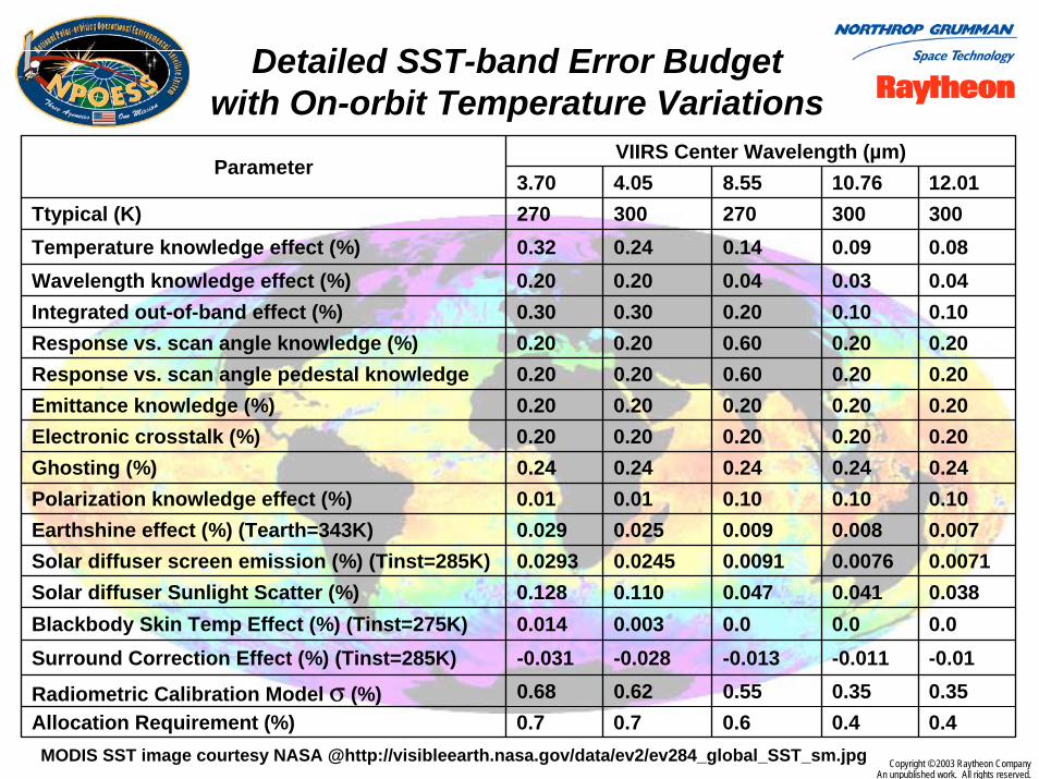
Detailed SST-band Error Budget with On-orbit Temperature Variations
VIIRS Center Wavelength (µm)Parameter
3.70 4.05 8.55 10.76 12.01Ttypical (K) 270 300 270 300 300Temperature knowledge effect (%) 0.32 0.24 0.14 0.09 0.08Wavelength knowledge effect (%) 0.20 0.20 0.04 0.03 0.04Integrated out-of-band effect (%) 0.30 0.30 0.20 0.10 0.10Response vs. scan angle knowledge (%) 0.20 0.20 0.60 0.20 0.20Response vs. scan angle pedestal knowledge 0.20 0.20 0.60 0.20 0.20Emittance knowledge (%) 0.20 0.20 0.20 0.20 0.20Electronic crosstalk (%) 0.20 0.20 0.20 0.20 0.20Ghosting (%) 0.24 0.24 0.24 0.24 0.24Polarization knowledge effect (%) 0.01 0.01 0.10 0.10 0.10Earthshine effect (%) (Tearth=343K) 0.029 0.025 0.009 0.008 0.007Solar diffuser screen emission (%) (Tinst=285K) 0.0293 0.0245 0.0091 0.0076 0.0071Solar diffuser Sunlight Scatter (%) 0.128 0.110 0.047 0.041 0.038Blackbody Skin Temp Effect (%) (Tinst=275K) 0.014 0.003 0.0 0.0 0.0Surround Correction Effect (%) (Tinst=285K) -0.031 -0.028 -0.013 -0.011 -0.01
Radiometric Calibration Model σ (%) 0.68 0.62 0.55 0.35 0.35Allocation Requirement (%) 0.7 0.7 0.6 0.4 0.4MODIS SST image courtesy NASA @http://visibleearth.nasa.gov/data/ev2/ev284_global_SST_sm.jpg
Copyright © 2003 Raytheon CompanyAn unpublished work. All rights reserved.
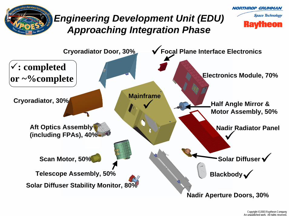
Engineering Development Unit (EDU) Approaching Integration Phase
Cryoradiator, 30%
Aft Optics Assembly (including FPAs), 40%
Scan Motor, 50%
Telescope Assembly, 50%
Solar Diffuser Stability Monitor, 80%
Cryoradiator Door, 30% Focal Plane Interface Electronics
Electronics Module, 70%
Half Angle Mirror & Motor Assembly, 50%
Nadir Radiator Panel
Solar Diffuser
Blackbody
Mainframe
: completedor ~%complete
Nadir Aperture Doors, 30%

Copyright © 2003 Raytheon CompanyAn unpublished work. All rights reserved.
EDU Focal PlanesVerified Design
•All EDU FPAs assembled and tested, including detectors & read-out integrated circuits (ROICs)
•S/MWIR & LWIR FPAs: Photovoltaic (PV) HgCdTewith integrated “Microlens” technology to reduce background noise
•All PV HgCdTe allows LWIR time-delay and integration (TDI) and lowers crosstalk
•Optical alignment of all FPAs provides optimum band-band registration
IHGFEDCBA1632
31 153029
1428271326
251224
231122
21 102019
91817
81615
71413612
11510
948
7 365
24312
1
SCAN
TRAC
K
CAB
LE S
IDE VNIR
A B C D E F G H
16 3231
15 3029
14 2827
13 2625
12 2423
11 2221
10 2019
9 1817
8 1615
7 1413
6 1211
5 109
4 87
3 65
2 43
1 21
CABLE SIDE
SCAN
TR
AC
K
SW/MWIRA B C D E
32 163130 152928 142726 132524 122322 112120 101918 91716 81514 71312 61110 598 476 354 232 11
CABLE SIDE
SCAN
TR
AC
K
LWIR
Mux
3a
Mux
2a
Mux
2b
Mux
3b
Mux
1a
Mux
1b
Stag
e 1a
Stag
e 1b
Mux
1b
Mux
1a
DNB
Band I5 Noise Equivalent Irradiance
1.00E+122.00E+123.00E+124.00E+125.00E+126.00E+127.00E+12
1 3 5 7 9 11 13 15 17 19 21 23 25 27 29 31
Pixel Number
NEI
, ph/
cm^2
-s
Band I5 DC Uniformity @ Qtyp
-3.500
-3.300
-3.100
-2.900
-2.700
-2.500
1 3 5 7 9 11 13 15 17 19 21 23 25 27 29 31
Pixel Number
Sign
al V
olta
ge, V

Copyright © 2003 Raytheon CompanyAn unpublished work. All rights reserved.
EDU Testing Lowers Risk for Flight Unit Integration & Test
96-0
2-08
5
Software, Documentation,and Engineering Analysis Engineering Development Unit
Ground Support Equipment Shipping/Storage
FlightInstruments NPP model (2005)
C1 model (2006)
First Flight Unit
• Calibration and Test• Performance Assessments
EDU Lessons Learned
• Integration• Calibration and Test• Performance Assessments
Copyright © 2003 Raytheon CompanyAn unpublished work. All rights reserved.
VIIRS on-track to EDU Integration & NPP Flight Unit Development
• National Polar-orbiting Operational Environmental Satellite (NPOESS) Visible Infrared Imaging Radiometer Suite (VIIRS) approaching Engineering Development Unit (EDU) integration
– Several design refinements lowered EDU and flight unit development and test risks
– Principal post-CDR optics design change to correct modulated instrument background (MIB) approved
– Sensor specified for excellent EDR performance: Refined design offers margin to sensor specification
– Detailed quantitative sensor performance modeling completed and partially verified by EDU hardware tests
– Remaining EDU fabrication and testing will verify models or identify corrective action
• First flight unit for NPOESS Preparatory Project (NPP) scheduledfor completion in 2005 for 2006 launch
• Second flight unit for NPOESS initial operational launch in 2130orbit scheduled for completion in 2006 for 2009 launch