· Web viewEven while Caesar was in Luca meeting with Pompey and Crassus, word began to arrive...
85
Page 1 of 85 May25-June9 Vienna-Amsterdam
Transcript of · Web viewEven while Caesar was in Luca meeting with Pompey and Crassus, word began to arrive...

Page 1 of 67
May25-June9Vienna-Amsterdam

Page 2 of 67
DAY DESTINATION ARRIVE DEPART DAY HIGHLIGHTS
1 - May 25 Fly U.S.Vienna, Austria
2 - May 26 ViennaEmbark ship 12:30pm
3 - May 27 Vienna Included: Vienna
4 - May 28 ViennaMelk 12:30pm
3am6:30pm
Optional Tour: Melk Abbey
5 - May 29 Passau, Germany
10:30am 5pm Included: Passau
6 - May 30 Regensburg 9am Included: Regensburg, Included dinner off ship in Regensburg
7 - May 31 RegensburgKelheimRiedenburg
8:45am11:15am
4:15am9am6:45pm
Optional Tour: Bavaria: Baroque & Beer
8 - June 1
Nuremberg 6:15am 6:30pm Included: Nuremberg, Room 600
9 - June 2
Bamberg 4:30am 3pm Included: Bamberg
10- June 3
GerlachshausenWurzburg
12:30am3:30pm
8:30am11:30pm
Included: WurzburgOptional Tour: Rothenburg
11- June 4
Wertheim 10:30am 9pm Included: Wertheim
12- June 5
Offenbach (for Heidelberg)Rudesheim
8:30am5pm
9am Included: Heidelberg
13- June 6
RudesheimKoblenz 12:30pm
7:30am7:30pm
Included: Koblenz
14- June 7
Cologne 1:30am 5pm Included: Cologne
15- June 8
Amsterdam, the Netherlands
8am Included: Amsterdam Canal Cruise
16- June 9
AmsterdamDisembark shipFly AmsterdamReturn to U.S.

Page 3 of 67
Danube River - DANU´BIUSFrom the Dictionary of Greek and Roman Geography, William Smith, LLD, Ed.
DANU´BIUS (Δανούβιος: the Danube), on coins and inscriptions frequently called DANUVIUS, the greatest river in south-eastern Europe. Its sources are at Donaueschingen, on the Mons Abnoba, and, after a long course through Vindelicia, Noricum, Pannonia, and Dacia, it divides itself near Noviodunum into three main branches, so as to form a delta, and empties its waters into the Euxine.
The Danube at first forms the southern frontier of Germania Magna; further east it is the boundary between Pannonia and Dacia, and between Dacia and Moesia. Among its many tributaries, we may mention the Dravus, Savus, Pathissus, and Margus, as the principal ones.
This river was known even to the earliest Greeks, under the name of ISTER (Ἴστρος), though they knew only the part near its mouth, and entertained very erroneous notions respecting its course (Hesiod, Hes. Th. 338; Pind. O. 3.25; Aeschyl. ap. Schol. ad Apollon. Rhod. 4.284), which did not become fully known until the time of the Roman empire. The Romans, and especially their poets, sometimes adopted the Greek name ISTRUS or HISTER (Tib. 4.1. 146), until in later, times the two names Ister and Danubius were used indiscriminately; though it was still very common to apply the former to the lower part of the river, and the latter to the upper part, from its sources to Vindobona [Vienna] or Sirmium. Stephanus B., who himself calls the river Danubis or Danusis, states that its ancient name was Matoas.
It is said, moreover, that Danubius was its Thracian, and Ister its Celtic name (Lydus, De Mag. 3.32; Jornand. De Reb. Get. 12); but there can be no doubt that DAN is the same word which is found in Rhodanus, Eridanus, Tanais, Don, and others, and signifies [1.751] “water.” According to Adelung, Dan-ubius means “the upper water,” and (Dan)-ister “the lower water.”
The earlier writers entertained very vague and contradictory notions about the sources of this mighty river; thus Pindar makes it flow from the country of the Hyperboreans, Aeschylus from the Rhipaean mountains, Herodotus (2.33) from the country of the Celts in the extreme west (somewhere about the Pyrenees), and Scymnus of Chios (Fragm. 31) likewise from the country of the Celts. Afterwards a notion arose that one branch of the Danube flowed into the Adriatic. But these and similar ideas, which were combated by some of the ancients themselves, were rectified during the conquests of the Romans in the north and east of Europe.
We have already stated that there are three main branches by which the Danube empties itself into the sea; though Strabo appears to assume four, for out of the seven he mentions, he calls three the lesser ones. Other writers, however, mention only six, five, four, three, or even two mouths. The names of these mouths, so far as they are known to us, are:--(1) the southernmost, called Peuce or the sacrum ostium (τὸ ἱερὸν στόμα, Strab. vii. p.305; Ptol. 3.10.2); (2) Naracustoma (Ναράκιον or τὸ Νάρακον, Ptol. 3.10.5; Arrian, Peripl. p. 23); (3) Calonstoma (τὸ καλὸν στόμα); (4) Pseudostoma (Ψευδόστομον, Ptol. 3.10.6); (5) Boreonstoma (Βόρειον στόμα, Ptol. l.c.); (6) Thiagola (Θιαγόλα, Ptol. 3.10.4, or τὸ ψιλὸν στόμα). Respecting these mouths, three of which were navigable in antiquity (P.

Page 4 of 67
Mela, 2.1, 8), see Kruse, De Istri Ostiis, Vratislav. 1820. At present it is impossible accurately to identify the statements of the ancients about them, as the Danube has undergone very great changes at its mouth. See Katancsich, De Istro, Budae, 1798, 4to.; Rennell, Comparative Geogr. of West. Asia, vol. ii. p. 374
Limes GermanicusFrom http://en.wikipedia.org/wiki/Limes_GermanicusThe Limes Germanicus (Latin for Germanic frontier) was a line of frontier (limes) fortifications that bounded the ancient Roman provinces of Germania Inferior, Germania Superior and Raetia, dividing the Roman Empire and the unsubdued Germanic tribes from the years 83 to about 260 AD. At its height, the limes stretched from the North Sea outlet of the Rhine to near Regensburg on the Danube. Those two major rivers afforded natural protection from mass incursions into imperial territory, with the exception of a gap stretching roughly from Mogontiacum (Mainz) on the Rhine to Castra Regina (Regensburg) on the Danube.The Limes Germanicus was divided into:• The Lower Germanic Limes, which extended from the North Sea at Katwijk in the
Netherlands along the then main Lower Rhine branches (modern Oude Rijn, Leidse Rijn, Kromme Rijn, Nederrijn)
• The Upper Germanic Limes started from the Rhine at Rheinbrohl (Neuwied (district)) across the Taunus mountains to the river Main (East of Hanau), then along the Main to Miltenberg, and from Osterburken (Neckar-Odenwald-Kreis) south to Lorch (Ostalbkreis) in a nearly perfect straight line of more than 70 km;
• The proper Rhaetian Limes extended east from Lorch to Eining (close to Kelheim) on the Danube.
The total length was 568 km (353 mi). It included at least 60 forts and 900 watchtowers. The potentially weakest, hence most heavily guarded part of the Limes was the aforementioned gap between the westward bend of the Rhine at modern-day Mainz and the main flow of the Danube at Regensburg. This 300-km wide land corridor between the two great rivers permitted movement of large groups of people without the need for water transport, hence the heavy concentration of forts and towers there, arranged in depth and in multiple layers along waterways, fords, roads, and hilltops.

Page 5 of 67
Reconstructed Limes near Saalburg, Germany.
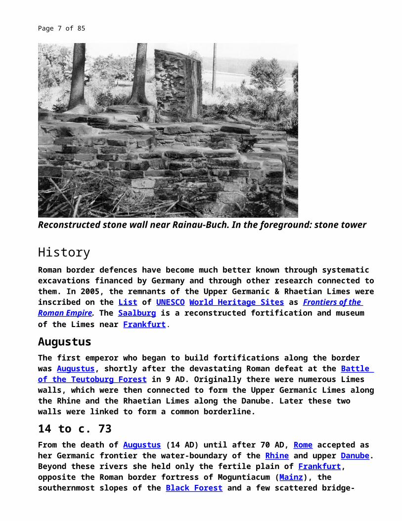
Reconstructed stone wall near Rainau-Buch. In the foreground: stone tower
HistoryRoman border defences have become much better known through systematic excavations financed by Germany and through other research connected to them. In 2005, the remnants of the Upper Germanic & Rhaetian Limes were inscribed on the List of UNESCO World Heritage Sites as Frontiers of the Roman Empire. The Saalburg is a reconstructed fortification and museum of the Limes near Frankfurt.
Augustus The first emperor who began to build fortifications along the border was Augustus, shortly after the devastating Roman defeat at the Battle of the Teutoburg Forest in 9 AD. Originally there were numerous Limes walls, which were then connected to form the Upper Germanic Limes along the Rhine and the Rhaetian Limes along the Danube. Later these two walls were linked to form a common borderline.

Page 6 of 67
14 to c. 73 From the death of Augustus (14 AD) until after 70 AD, Rome accepted as her Germanic frontier the water-boundary of the Rhine and upper Danube. Beyond these rivers she held only the fertile plain of Frankfurt, opposite the Roman border fortress of Moguntiacum (Mainz), the southernmost slopes of the Black Forest and a few scattered bridge-heads. The northern section of this frontier, where the Rhine is deep and broad, remained the Roman boundary until the empire fell. The southern part was different. The upper Rhine and upper Danube are easily crossed. The frontier which they form is inconveniently long, enclosing an acute-angled wedge of foreign territory between the modern Baden and Württemberg. The Germanic populations of these lands seem in Roman times to have been scanty, and Roman subjects from the modern Alsace-Lorraine had drifted across the river eastwards. The motives alike of geographical convenience and of the advantages to be gained by recognising these movements of Roman subjects combined to urge a forward policy at Rome, and when the vigorous Vespasian had succeeded Nero, a series of advances began which gradually closed up the acute angle, or at least rendered it obtuse.
Remains of the Limes.
Flavian dynasty The first advance came about 74 AD, when what is now Baden was invaded and in
Page 7 of 67
part annexed and a road carried from the Roman base on the upper Rhine, Straßburg, to the Danube just above Ulm. The point of the angle was broken off.The second advance was made by Domitian about 83 AD. He pushed out from Moguntiacum, extended the Roman territory east of it and enclosed the whole within a systematically delimited and defended frontier with numerous blockhouses along it and larger forts in the rear. Among the blockhouses was one which by various enlargements and refoundations grew into the well-known Saalburg fort on the Taunus near Bad Homburg. This advance necessitated a third movement, the construction of a frontier connecting the annexations of AD 74 and AD 83 . We know the line of this frontier which ran from the Main across the upland Odenwald to the upper waters of the Neckar and was defended by a chain of forts. We do not, however, know its date, save that, if not Domitian's work, it was carried out soon after his death, and the whole frontier thus constituted was reorganised, probably by Hadrian, with a continuous wooden palisade reaching from Rhine to Danube.
Hadrian and the Antonines The angle between the rivers was now almost full. But there remained further advance and further fortification. Either Hadrian or, more probably, his successor Antoninus Pius pushed out from the Odenwald and the Danube, and marked out a new frontier roughly parallel to, but in advance of these two lines, though sometimes, as on the Taunus, coinciding with the older line. This is the frontier which is now visible and visited by the curious. It consists, as we see it today, of two distinct frontier works, one, known as the Pfahlgraben, is a palisade of stakes with a ditch and earthen mound behind it, best seen in the neighbourhood of the Saalburg but once extending from the Rhine southwards into southern Germany. The other, which begins where the earthwork stops, is a wall, though not a very formidable wall, of stone, the Teufelsmauer; it runs roughly east and west parallel to the Danube, which it finally joins at Heinheim near Regensburg. The southern part of the Pfahlgraben is remarkably straight; for over 50 km it points almost absolutely true for Polaris.This frontier remained for about 100 years, and no doubt in that long period much was done to it to which precise dates are difficult to fix. It cannot even be absolutely certain when the frontier laid out by Pius was equipped with the manpitts and other special fortifications. But we know that the pressure of the barbarians began to be felt seriously in the later part of the 2nd century, and after long struggles the whole or almost the whole district east of the Rhine and north of the Danube was lost, seemingly all within one short period, about 250.

Page 8 of 67
Late Roman Empire Germanic invasions in the late 3rd century led to the abandonment of the so-called "Upper Raetian Limes" in favour of a Roman defence line along the rivers Rhine, Iller and Danube (Donau-Iller-Rhine-Limes). Support was provided
to some degree by fast river boats, the navis lusoria being the standard type, that could reach outposts or points of crisis quickly. Watch towers were in sight contact and heavily fortified castra placed at important passes (e.g. Castrum Rauracense instead of the previously unwalled Augusta Raurica near to Basel) and in the hinterland of the frontier (e.g. Vindonissa in today's Switzerland).
Description and functionality of the limes
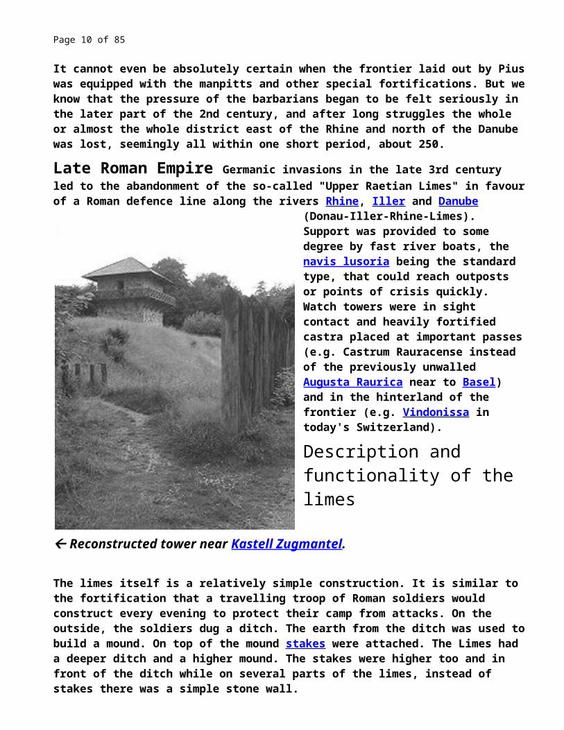
Reconstructed tower near Kastell Zugmantel.
The limes itself is a relatively simple construction. It is similar to the fortification that a travelling troop of Roman soldiers would construct every evening to protect their camp from attacks. On the outside, the soldiers dug a ditch. The earth from the ditch was used
to build a mound. On top of the mound stakes were attached. The Limes had a deeper ditch and a higher mound. The stakes were higher too and in front of the ditch while on several parts of the limes, instead of stakes there was a simple stone wall.
Behind the wall/mound a system of control towers, built of wood or stone, was installed, each within sight of the next one, and usually able also to signal to the forts several kilometers to the rear.
The Saalburg, a reconstruction of a Roman fort.
The limes was never able to prevent whole Germanic tribes from entering the territory of the Roman Empire. This was not the intention of the builders. Near the watch towers, the limes was open to passage,
especially by traders or persons coming to live or work within the Empire. The purpose of

Page 9 of 67
the limes was control of this traffic. To cross the limes it was necessary to pass the towers, and so come to the notice of the garrison, or to climb or destroy the wall or the stakes. Only individuals or small groups could climb the obstacles without being noticed, and they could not drive much stolen livestock with them. Large groups would be noticed, they could destroy one or several towers, but this also would come to the attention of the Romans. This knowledge of all traffic crossing the border was crucial to the Roman military. For a territory as large as the Roman Empire, there were amazingly few soldiers, almost all of the legions were based close to the frontiers. Any hostile group who managed to pass this area of defense could travel within the Empire without much significant resistance. The purpose of the limes was as an early warning system, deterrence of casual small-scale raiding, and the ability to counteract while the enemy was near the border fortresses and garrisons.
Page 10 of 67
Roman forts along the limes
Lower (i.e., downriver) Germanic Limes (RhineRiver)Lower Germanic Limes The Netherlands:• Katwijk (Lugdunum Batavorum)• Valkenburg (Praetorium Agrippinae)• Leiden-Roomburg (Matilo)• Alphen aan den Rijn (Albaniana)• Zwammerdam (Nigrum Pullum)• Bodegraven • Woerden (Laurium)• Vleuten (Fletio)• Utrecht (Traiectum)• Vechten (Fectio)• Rijswijk (Levefanum)• Maurik (Mannaricium)• Kesteren (Carvo)• Arnhem-Meinerswijk (believed to be Castra Herculis)• Duiven • Herwen-De Bijland (Carvium)

Page 11 of 67
Germany:• Kleve -Rinderen (Harenatium)[2]• Bedburg-Hau -Qualburg (Quadriburgium)• Till-Moyland (now known as Kastell Steincheshof)• Kalkar -Altkalkar (Burginatium)• Xanten (Castra Vetera)• Wesel-Büderich (Kastell Wesel-Büderich)• Halen (Calo)[3]• Duisburg-Baerl • Moers -Asberg (Asciburgium)• Rheinhausen-Werthausen (Kleinkastell Werthausen)• Krefeld -Gellep-Stratum (Gelduba)• Neuss -Gnadental (Novaesium)• Neuss-Grimlinghausen• Monheim am Rhein (Burungum)• Dormagen (Durnomagus)• Köln (Colonia Claudia Ara Agrippinensium)• Bonn (Bonnensia)• Remagen (Rigomagus)

Page 12 of 67
Upper (i.e., upriver) Germanic & Raetian Limes
Upper Germanic Limes • Rheinbrohl (now known by the name:
Kleinkastell Rheinbrohl)• Bad Ems (now known as: Kastell Ems)• Adolfseck (Kleinkastell Adolfseck)• Bad Homburg (Saalburg)• Wetterau (Civitas Taunensium)• Marköbel • Großkotzenburg am Main • Hainstadt • Miltenberg

Page 13 of 67
• Rehberg • Walldüm • Buchen • Osterburken • Jagsthausen • Welzheim (Kastelle von Welzheim)• Haghof • Lorch (probably Lauriacum)[4]
Rhaetian Limes • Aalen (Alae)• Ruffenhofen • Gunzenhausen (Kastell
Gunzenhausen)• Weißenburg (Biriciana)• Kipfenberg (Kastell Böhming)• Eining (Abusina)
Caesar Crosses the Rhine In 55 BC Caesar was busy preparing for his invasion of Britain. Whether his reasoning was retribution against those tribes that supported the Veneti and other opposing Gallic tribes as he himself claimed, the search to secure more metal sources such as tin and iron, or simply increasing his fame by being the first to cross, Caesar was prepared to make the crossing when events along the Rhine intervened. Even while Caesar was in Luca meeting with Pompey and Crassus, word began to arrive of Germanic crossings of the Rhine. The Usipetes and Tenchteri tribes, both in a state of perpetual war with the powerful Suevi, began looking for safer land across the river.
Since the winter of 56/55 BC, the Germanics had displaced the Menapii tribe of Gauls, and Caesar was concerned that the incursions would lead to renewal of war in the region. According to him, he set out for the Rhine 'earlier than he was accustomed to do' with his legions, likely in the early spring of 55 BC. News arrived of further Germanic advances into the territory of the Eburones and the Condrusi, and Caesar was resolved for a fight. Caesar marched quickly and when he was within a few days march, the Germanics sent ambassadors to discuss the situation.
The general tone of the discussion was one of conciliation. The Germans claimed to only want peace and their own land away from the Suevi. Caesar refused their request to stay in Gaul but said he could arrange for settlement in the lands of the Ubii, who would be

Page 14 of 67
grateful for assistance against their mutual enemies, the Suevi. The invaders asked for 3 days to deliberate with their tribesmen, but Caesar refused, believing that they were only delaying long enough for their own cavalry to return from raids against the Ambivariti tribe. Caesar continued to march and when he arrived within 12 miles of the enemy camp, another embassy arrived to beg for more time. This time Caesar partially relented, ordering his cavalry which was scouting ahead of the main body, to resist committing aggression against the Germans.
Caesar's cavalry which numbered 5,000 soon found itself under attack, however. Apparently hoping to lure the Romans into complacency through negotiation, a much smaller force of Germanic cavalry launched a surprise attack on the Romans. With 800 men, the Germans caused considerable mayhem, killing 74 Romans before driving them all the way back to Caesar's main lines. While Caesar was preparing to launch a counter attack, he had an incredible stroke of luck. A large Germanic contingent of tribal elders and leading men arrived to beg forgiveness for the treachery and to set matter right. Caesar, however, would have nothing to do with it and ordered the Germans seized and held. A full scale assault was then launched on the German camp and according to Caesar, 430,000 leaderless German men, women and children were assembled. The Romans butchered indiscriminately, sending the mass of people fleeing to the Rhine, where many more succumbed to the river. In the end, there is no account of how many were killed, but Caesar also claims to have not lost a single man. Of those that survived, many stayed with the Romans in service rather than face the angry Gauls or the Suevi in their depleted state.
With the situation secure on the Gallic side of the river, Caesar decided it was time to settle the matter with the aggressive Germans, lest they invade again. The Ubii alone, still seeking help against the Suevi, welcomed Roman intervention. It was decided, in order to impress the Germans and the Roman people that bridging the Rhine would have the most significant effect. By June of 56 BC, Caesar became the first Roman to cross the Rhine into Germanic territory. In so doing, a monstrous wooden bridge was built in only 10 days, stretching over 300 feet across the great river. This alone assuredly, impressed the Germans and Gauls, who had little comparative capability in bridge building. Within a short time of his crossing, nearly all tribes within the region sent hostages along with messages of peace. Only the Sigambri resisted, fleeing their towns rather than submit to Caesar. The Romans made an example of them by burning their stores and their villages before receiving word that the Suevi were beginning to assemble in opposition. Caesar, rather than risk this glorious achievement in a pitched battle with a fierce foe, decided that discretion was the better part of valor. After spending only 18 days in Germanic territory, the Romans returned across the Rhine, burning their bridge in the process. With that short diversion, Caesar secured peace among the Germanics, as the Suevi remained relatively peaceful for some time after, and secured a crucial alliance with the Ubii. His rear secured, Caesar looked for another glorious Roman 'first' and moved his body north to prepare for the invasion of Britain.
http://www.lane-weinberg.com/2012/01/29/caesars-rhine-bridge-rome-showcases-its-technical-prowess/

Page 15 of 67
MIKEANDERSON | JANUARY 29, 2012 · 4:27 AM
Caesar’s Rhine Bridge – Rome Showcases its Technical ProwessObviously, there are gaps in our knowledge of Roman construction techniques and tools because we lack either written or physical evidence of these. Non-permanent materials have eroded away over two millennia and their characteristics elude us. Great structures like Hadrian’s Wall survivebecause of the use of stone or concrete.
There is, however, one clear example of a non-permanent structure which we know a lot about – Caesar’s first bridge over the Rhine. We know the story because Caesar tells us in volume four of The Conquest of Gaul. But construction techniques are only part of the story. Caesar built this bridge to show the Germans they were never safe from him because he had the skills to cross the river and attack them. In 55 B.C, the German tribes Usipetes and Tenctheri crossed the Rhine to the Roman occupied west bank and plundered corn they found there. Crossing back over they joined forces with the Sugambri tribe. When Caesar sent an embassy to the Sugambri and asked that the culprits be returned to him, the response was that the Rhine was the limit of Roman authority. Simultaneously, the Ubii tribe, an ally of Rome, asked for help against the Suebi tribe who were harassing them. Caesar, deciding he had enough reasons to cross the Rhine, planned an expedition to attack the Sugambri.
Downstream from Koblenz, there are two small towns named Andernach and Neuwied.

Page 16 of 67
Historical scholarship suggests Caesar planned to cross the Rhine in between these two locations. The distance between the shorelines in this area is 800 to 1000 feet. The average depth of the river is 16 feet.
Before we talk about the construction of the bridge, it will be useful to show a photograph of the model that sits in The Museo Della Civilta Romana in Rome.
Before starting construction, the Romans built a crane on a raft and floated it out into the river. You can see the framework of this apparatus on the left of the picture. The piers supporting the bridge were constructed of one and a half foot thick logs. These tigna bina were tied together in pairs with a two foot gap between them. They were then driven into the river bed at an oblique angle using a pile driver. This was apparently a large stone, attached to block and tackle on poles, that could be swung at the posts once they were tied into position. Once two sets of these posts were secure a large log (fibulae) was placed between them in the slot formed by the two foot gap. Angled supporting posts were tied to the tigna bina to provide additional support.
Caesar says the piles were positioned forty feet apart before they were driven into the riverbed.
Once the support structure was in place, logs were laid across the piers and then boards were used to form the roadway.

Page 17 of 67
I estimate that the piers were about twenty feet apart so a thousand foot river span would have required 50 piers. The bridge was built in ten days which meant workers would have placed five piers per day assuming the roadway was built as a parallel process over piers already completed.
The Romans had a variety of familiar tools at their disposal, including adzes, hammers, saws for cutting boards, and block and tackle. They used 9 inch nails to fasten boards together.
Once the bridge was complete, the army crossed over the Rhine. They spent 18 days in the land of the Sugambri, burning abandoned villages because the enemy had fled their homeland in fear of the Roman juggernaut. After treating with the Ubii, Caesar crossed back over the Rhine and destroyed the bridge behind him. Ten days in the making, Caesar’s Rhine bridge lived for eighteen days.
A footnote to the story. There have been endless arguments about this event among scholars. Some reinterpret Caesar’s Latin and challenge the construction methods described. Others question the engineering saying that the bridge would not have held. As an engineer, I am comfortable with the construction methods described and think these debates are a waste of time. Scholars will be scholars, however, and they’ll debate any issue until each has had his say. How many engineer historians are there, anyway?
TKW Note – The story of Trajan’s masonry, cement, and wood bridge across the Danube River East of the Iron Gates near the cities of Drobeta-Turnu Severin (Romania) and Kladovo (Serbia), is on the internet at http://en.wikipedia.org/wiki/Trajan's_Bridge. The bridge was constructed in 105 AD by the Greek architect Apollodorus of Damascus for the deployment of Roman troops in the war against Dacia. It was 1,135 m (3,724 ft) long (the Danube is 800 m (2,600 ft) wide in that area), 15 m (49 ft) wide, and 19 m (62 ft) high (measured from the river's surface). At each end was a Roman castrum, each built around an entrance (crossing was possible only by walking through the camp). Though it was only functional for a few decades, for more than 1,000 years it was the longest arch bridge in both total and span length.
Vindobona (Vienna)From Wikipedia, the free encyclopedia --

Page 18 of 67
http://en.wikipedia.org/wiki/Vindobona
Map of Vindobona around 250 A.D.
Vindobona (Celtic/Gaulish windo- "fair/white/blessed", bona "base/bottom", presumably so-named from its geological/topological position) was originally a Celtic settlement, and later a Roman military camp on the site of the modern city of Vienna in Austria. Around 15 BC, the kingdom of Noricum was included in the Roman Empire. Henceforth, the Danube marked the border of the empire, and the Romans built fortifications and settlements on the banks of the Danube, including Vindobona.

Page 19 of 67
Head of a genius found during excavations of Vindobona
Silver plate, part of a larger find found around Kärntner Straße in 1945
Early references to Vindobona are made by the geographer Ptolemy in his Geographica and the historian Aurelius Victor, who recounts that emperor Marcus Aurelius died in Vindobona on the 17 March 180. Today, there is a Marc-Aurelstraße (English: Marcus Aurelius street) near the Hoher Markt in Vienna.From a military base to a townVindobona was part of the Roman province Pannonia, of which the regional administrative centre was Carnuntum. The local inhabitants were probably of Celtic and Illyrian origin.Vindobona was a military camp with an attached civilian city (Canabae). The

Page 20 of 67
military complex covered an area of some 20 hectares, housing about 6000 men where Vienna’s first district now stands. The Danube marked the border of the Roman Empire, and Vindobona was part of a defensive network including the camps of Carnuntum, Brigetio and Aquincum. Under Emperor Trajan, four legions were stationed in Pannonia[citation needed].Vindobona was provisioned by the surrounding Roman country estates (Villae rusticae).A centre of trade with a developed infrastructure as well as agriculture and forestry developed around Vindobona. Civic communities developed outside the fortifications (canabae legionis), as well another community that was independent of the military authorities in today's third district[citation needed]. It has also been proven that a Germanic settlement with a large marketplace existed on the far side of the Danube from the second century onwards[citation needed].The asymmetrical layout of the military camp, which was unusual for the otherwise standardised Roman encampments, is still recognisable in Vienna’s street plan: Graben, Naglergasse, Tiefer Graben, Salzgries, Rabensteig, Rotenturmstraße. The oblique camp border along today's street Salzgries was probably caused by a tremendous flood of the river Danube that occurred during the 3rd century and eroded a considerable part of the camp.[1] The name “Graben” (English: ditch) is believed to hark back to the defensive ditches of the military camp. It is thought that at least parts of the walls still stood in the Middle Ages, when these streets were laid out, and thus determined their routes. The Berghof was later erected in one corner of the camp.Wars, administrative and military reforms in the 3rd and 4th century as well as devastating floods led the population to retreat more and more into the military camp[citation needed]. The area lost its importance as a border in the 5th century, and the local population lived within the former fortification.
Evidence for the Roman presence in Vindobona:
Remains of the Roman military camp have been found at many sites in the centre of Vienna. The centre of the Michaelerplatz has been widely investigated by archaeologists. Here, traces of a Roman legionary outpost (canabae legionis) and of a crossroad have been found.[2] The centrepiece of the current design of the square is a rectangular opening that evokes the archaeological excavations at the site and shows wall remains that have been preserved from different epochs.Part of a Roman canal system is underneath the fire station am Hof.[3]

Page 21 of 67
Directly under the Hoher Markt are the remains of two buildings unearthed during the canalisation works of 1948/49 and made accessible to the public. After further excavation, a showroom was opened in 1961. For this purpose some of the original walls had to be removed; white marks on the floor show the spots where[citation needed]. The buildings, which are separated from one another by a road, housed an officer and his family[citation needed]. In 2008 this Roman ruins exhibit was expanded into the Museum of the Romans.[4] Only a small portion can today be seen, for the majority of the remains are still located underneath the square and south of it.The remains of the walls date from different phases from the 1st to the 5th century AD. The houses were typical Roman villas, with living quarters and space for working set around a middle courtyard with columned halls.[5]Evidence for the Roman military presenceOver 3000 stamped bricks, several stone monuments and written sources prove that several legions, cavalry units and marines were stationed in Vindobona. Around 97. AD, Legio XIII Gemina was responsible for construction of the legionary camps. Because of the wars in Dacia, they were pulled out and redeployed in 101 AD. A decade later, Legio XIIII Gemina Martia Victrix followed. Legio X Gemina from Aquincum arrived in 114 AD and remained in Vindobona until the 5th century[citation needed].About 6000 soldiers were stationed in the Roman camp[citation needed]. Many of them were free from active duty during peaceful times and had other jobs[citation needed]. These so-called immunes were needed for the supply of goods and for the production and maintenance of weapons and commodities. They also extracted stone from quarries and wood from forests, produced bricks, and maintained the streets, bridges and the water system. Administrating the camp and ensuring its security required additional manpower.Roman canalsThe Romans provided their cities, including Vindobona, with clean potable water through an elaborate systems of Roman aqueducts, canals, and large subterranean pipes. Excavations have revealed that Vindobona received its supply through a 17 km long water pipeline[citation needed]. The source is in the Vienna Woods around today's Kalksburg. Wells, latrines and the thermae were supplied with water. Central buildings such as the commander's office and the hospital had their own supplies, as did the settlement outside the camp, where households had their own groundwater wells[citation needed].Archaeological excavations done over the last 100 years have discovered many Roman water supply fragment locations:Waste from the Roman camp was transported through an elaborate

Page 22 of 67
subterranean sewerage system that was planned from the beginning. The sewers were lined with brick walls and plates and ran beneath the main roads. Gradients were used in such a way that the waste water descended through the canals into the Danube River. Since the canals were up to two meters deep, they could be cleaned out regularly. Large waste was probably deposed at the slope of the river. In the civilian settlement, waste was deposed in former water wells and dumps[citation needed].Legacies in today's streetsThe layout of a Roman camp (castra) was normally standardised. This has helped archaeologists to reconstruct what the camp must have looked like, despite the heavy rebuilding that has taken place in Vienna throughout the centuries. The basic contours of the camp, which was surrounded by a mighty wall with towers and three moats (today the Tiefer Graben, Naglergasse, Graben, and Rotenturmstraße) are identifiable. Along these axes, main roads connected the gates with one other. The main buildings were the commander's headquarters, the Palace of the Legate, the houses of the staff officers, and the thermae. At right angles to these, the soldiers' accommodation, a hospital, workshops, and mews (stables) were constructed.[citation needed]
Popular culture
← Two lines in the film Gladiator make reference to Vindobona:In one, the lead character's servant, Cicero, trying to get the attention of Lucilla, states, "I served with your father at Vindobona!"In the other, the lead character asks if anyone in his group of gladiators has served in the army, to which an anonymous fighter responds, "I served with you at Vindobona."• The historical novel Votan by Welsh writer John James begins in
"Vindabonum" and imagines 2nd century C.E. life there.
References
• ^ Reconstruction of the ancient relief of downtown Vienna (German)• ^ Wien Museum | Archäologisches Grabungsfeld Michaelerplatz(German)• ^ Wien Museum | Römische Baureste Am Hof, Vienna Museum (German)• ^ "Die Römer kommen nach Wien", ORF 10 May 2008 (German)• ^ Wien Museum | Römische Ruinen Hoher Markt(German)
Further reading
• Michaela Kronberger: Siedlungschronologische Forschungen zu den

Page 23 of 67
canabae legionis von Vindobona. Die Gräberfelder (Monographien der Stadtarchäologie Wien Band 1). Phoibos Verlag, Wien 2005. (German)
• Christine Ranseder e.a., Michaelerplatz. Die archäologischen Ausgrabungen. Wien Archäologisch 1, Wien 2006. ISBN 3-901232-72-9. (German)
• Vindobona. Die Reise in das antike Wien. DVD-Rom, 2004. (German)• Vindobona II. Wassertechnik des antiken Wiens. DVD-Rom, 2005. (German)
External links
Media related to Vindobona at Wikimedia Commons• Wien Museum | Ausgrabungsstätten (German)• Forschungsgesellschaft Wiener Stadtarchäologie | Legionslager
Vindobona (German)• Animationsfilme zu vindobona (German)• Seite mit sehenswerter Rekonstruktion des Lagertores (German)• Livius.org: Vindobona (Vienna) • Austrian Mint Coin Features Vindobona • Bursche, A., L. Pitts, P. Kaczanowski, E. Krekovič, R. Madyda-Legutko, R.
Talbert, T. Elliott, S. Gillies. "Places: 128537 (Vindobona)". Pleiades. Retrieved March 8, 2012 3:55 pm.
Coordinates: 48°12′39″N 16°22′13″E
Melk At the point where the Danube enters the region of the Wachau lies the little town of Melk, dominated by the massive bulk of the Benedictine abbey, one of the best known and most splendid monastic houses in Austria. Visible from miles away, the abbey is perched on a hill which slopes steeply down to the Danube and is accessible only from the east. Originally a Roman fortified post (Namare Castellum), Melk was later occupied by a Babenberg castle to defend the border against the Hungarians. In 1089 the castle and church were made over to the Benedictines by the Margrave Leopold II; in 1113 the bones of St Koloman were moved there. In the 13th C. Melk became a market town. After the abbey had been damaged by fire several times the present magnificent Baroque abbey was built by Jakob Prandtauer and Joseph Munggenast between 1702 and 1738.

Page 24 of 67
Melk AbbeyFrom Wikipedia, the free encyclopedia
Melk Abbey (German: Stift Melk) is a Benedictine abbey in Austria, and among the world's most famous monastic sites. It is located above the town of Melk on a rocky outcrop overlooking the Danube river in Lower Austria, adjoining the Wachau valley.[1] The abbey contains the tomb of Saint Coloman of Stockerau and the remains of several members of the House of Babenberg, Austria's first ruling dynasty.[2]
History The abbey was founded in 1089 when Leopold II, Margrave of Austria gave one of his castles to Benedictine monks from Lambach Abbey. A monastic school, the Stiftsgymnasium Melk, was founded in the 12th century, and the monastic library soon became renowned for its extensive manuscript collection. The monastery's scriptorium was also a major site for the production of manuscripts. In the 15th century the abbey became the centre of the Melk Reform movement which reinvigorated the monastic life of Austria and Southern Germany.[3]Today's impressive Baroque abbey was built between 1702 and 1736 to designs by Jakob Prandtauer. Particularly noteworthy is the abbey church with frescos by Johann Michael Rottmayr and the impressive library with countless medieval manuscripts, including a famed collection of musical manuscripts and frescos by Paul Troger.Due to its fame and academic stature, Melk managed to escape dissolution under Emperor Joseph II when many other Austrian abbeys were seized and dissolved between 1780 and 1790. The abbey managed to survive other threats to its existence during the

Page 25 of 67
Napoleonic Wars, and also in the period following the Nazi Anschluss that took control of Austria in 1938, when the school and a large part of the abbey were confiscated by the state.The school was returned to the abbey after the Second World War and now caters for nearly 900 pupils of both sexes.Since 1625 the abbey has been a member of the Austrian Congregation, now within the Benedictine Confederation.In his well-known novel The Name of the Rose, Umberto Eco named one of the protagonists "Adson von Melk" as a tribute to the abbey and its famous library.Melk Abbey is also the metaphorical climax ("a peak in a mountain range of discovery") of Patrick Leigh Fermor's autobiographical account of his walking tour across pre-WW II Europe in "A Time of Gifts", which provides a lyrical, impressionistic description of the Abbey at that time. [4]
Euro commemorative coin Melk Abbey was recently selected as the main motif of a very high value collectors' coin: the Austrian Melk Abbey commemorative coin, minted on April 18, 2007. The obverse shows a view up to the façade of the abbey church and its two side wings from a low level. The twin baroque towers and the great dome of the church behind them can be seen. In the lower right corner the coat-of-arms of the Abbey of Melk (the crossed keys of St. Peter) can be seen.
References ←^ "Melk, Niederösterreich". Encyclopedia of Austria. Retrieved 8 January 2013.←^ Ellegast, Dr. Burkhard (1998). Melk Abbey. Melk: Stift Melk. p. 51. ASIN B000N48KHS.←^ Toke, L. (1911). "Abbey and Congregation of Melk". The Catholic Encyclopedia. New
York: Robert Appleton Company. Retrieved 8 January 2013.←^ Fermor, Patrick Leigh (2005). A Time of Gifts: On Foot to Constantinople. New York,
pp. 172–77.
Located on the bank of the Danube River between Salzburg and Vienna, Melk Abbey stands crowned by towers and resplendent in a golden hue. The impressive Baroque ensemble at Melk was built in 1702-1736 by architect Jakob Prandtauer. Especially noteworthy is the church with magnificent frescoes by Johann Michael Rottmayr and the library containing countless medieval manuscripts. The monastic community of Melk is over 900 years old and black-robed Benedictine monks still stroll amidst the marble sculptures and frescoed walls. It is now also a prestigious coed monastery school with more than 700 students.

Page 26 of 67
History
Melk has played an important role in the Danube region since Roman times, when a fortress was built on the promontory overlooking a tiny "arm" of the Danube. Melk also appears in the German epic poem Nibelungenlied, in which it is called "Medelike". The rock-strewn bluff where the abbey now stands was the seat of the Babenbergs, who ruled Austria from 976 until the Hapsburgs took over.
In the 11th century, Leopold II of Babenberg presented the palace at Melk to Benedictine monks, who turned it into a fortified abbey. Its influence and reputation as a center of learning and culture spread throughout Austria, as reflected in Umberto Eco's popular novel The Name of the Rose. Eco researched his novel in the abbey's library.
Melk Abbey suffered damaged during the Reformation and the 1683 Turkish invasion, but it was spared direct attack when the Otoman armies were halted outside Vienna. Reconstruction of the abbey began in 1702 in full Baroque style and was completed in 1736. The abbey church was damaged by fire in 1947, but is now almost completely restored.
What to See
The design of the present abbey ensemble (1702-36) is primarily the work of architect Jakob Prandtauer. The Marmorsaal (Marble Hall) contains pilasters coated in red marble and an allegorical painted ceiling by Paul Troger.
The library rises two floors and also has a Troger ceiling, along with around 80,000 volumes of priceless works. The Kaisergang (Emperors' Gallery) stretches for 198m (650 ft.), decorated with portraits of Austrian royalty.
The highlight of the abbey, though, is certainly the Stiftskirche (Abbey Church). The church has an astonishing number of windows and is richly embellished with marble and frescoes by Johann Michael Rottmayr with help from Troger.
There are fine views of the river from the abbey's terrace, which Napoleon probably used as a lookout when he used Melk as his headquarters for his campaign against Austria.
The abbey restaurant (Stiftsrestaurant Melk) located near the entrance serves hot meals and monastery wine in beautiful Baroque and outdoor surroundings

Page 27 of 67
Quick Facts on Melk Abbey
Site InformationNames: Melk AbbeyCountry: Austriacat: Monasteriesfaith: Christianity; Catholic; Benedictinestyle: BaroqueDates: 1702-36Status: activeVisitor and Contact InformationAddress: Abt Berthold Dietmayrstraße, 1 A, AustriaCoordinates:
48.228790° N, 15.331163° E )
Opening Hours:
May-Sep: 9am-5:30pm (last admission 5pm)Apr, Oct: 9am-4:30pm (last admission 4pm)Nov-Mar: only open on guided tours
Phone: +43 (0) 2752 555225Email: [email protected]: www.stiftmelk.at

Page 28 of 67

Page 29 of 67
Passau De
On the south bank of the River Inn in Passau is the Römermuseum. It occupies the site of a former Roman fort excavated here. Inside the museum you will see many Roman artefacts and archaeological items excavated on the site and in the area. Outside, you are free to wander the remains of the fort and learn about its history and purpose, and the Roman history of the Passau

Page 30 of 67
region. The museum is open for most of the year, on most days of the week for a small entrance fee.
Regensburg (Germany)
The first settlements in Regensburg date to the Stone Age. The Celtic name Radasbona was the oldest name given to a settlement near the present city. Around AD 90, the Romans built a fort there.In 179, the Roman fort Castra Regina ("fortress by the river Regen") was built for Legio III Italica during the reign of Emperor Marcus Aurelius. It was an important camp on the most northern point of the Danube: it corresponds to what is today the core of Regensburg's Altstadt ("Old City") east of the Obere and Untere Bachgasse and West of the Schwanenplatz. It is believed that even in late Roman times the city was the seat of a bishop, and St Boniface re-established the Bishopric of Regensburg in 739.
Roman RegensburgRegensburg is one of the few cities in Germany whose history goes right back to the Romans. The Emperor Marcus Aurelius had a huge military fort built here, garrisoned by a legion - six thousand soldiers. Castra Regina defended the border of the empire, the Danube, against the Germanic tribes north of the river. The Romans held the fort for three hundred years, until they were forced to abandon it at the time of the barbarian migrations. We can still see impressive remnants of Castra Regina in the city – parts of the city wall, for example, or the Porta Praetoria, which, apart from the Porta Nigra in Trier, is the only Roman city gate still standing in Germany. And an entire section of the Historical Museum is devoted to artefacts and exhibits from the time of the Romans.

Page 31 of 67
Regensberg Museum
In the Historical Museum at the Dachauplatz, there are exhibitions from the Stone Age to the Middle Ages, covering mainly the Roman period when Regensburg was flourishing.Dachauplatz 2-4 93047 Regensburg Tel. 0941 / 507-2448 Open Tuesday / Wednesday, Friday to Sunday from 10.00 a.m to 4.00 p.m., Thursday 10.00 a.m. to 8.00 pm
Regensburg The first settlements in Regensburg date to the Stone Age. The Celtic name Radasbona was the oldest name given to a settlement near the present city. Around AD 90, the Romans built a fort there.In 179, the Roman fort Castra Regina ("fortress by the river Regen") was built for Legio III Italica during the reign of Emperor Marcus Aurelius.[2] It was an important camp on the most northern point of the Danube: it corresponds to what is today the core of Regensburg's Altstadt ("Old City") east of the Obere and Untere Bachgasse and West of the Schwanenplatz. It is believed that even in late Roman times the city was the seat of a bishop, and St Boniface re-established the Bishopric of Regensburg in 739.From the early 6th century, Regensburg was the seat of the Agilolfing ruling family. From about 530 to the first half of the 13th century, it was the capital of Bavaria. Regensburg remained an important city during the reign of Charlemagne. In 792, Regensburg hosted the ecclesiastical section of Charlemagne's General Assembly. The bishops in council condemned the heresy of Adoptionism taught by the Spanish bishops, Elipandus of Toledo and Felix of Urgel. After the partition of the Carolingian Empire, the city became the seat of the Eastern Frankish ruler, Louis II the German in 843. Two years later, fourteen Bohemian princes came to Regensburg to receive baptism there. This was the starting point of Christianization of the Czech people, and the diocese of Regensburg became the mother diocese of Prague. These events had a wide impact on the cultural history of Czech lands, as they were consequently incorporated into the Roman Catholic and not into the Slavic-Orthodox world. The fact is well remembered, and a memorial plate at St John's Church (the alleged place of the baptism) was unveiled a few years ago, commemorating the incident in the Czech and German languages.On 8 December 899 Arnulf of Carinthia, descendant of Charlemagne, died at

Page 32 of 67
Regensburg (known as Ratisbon at the time), Bavaria, Germany.[3]In 1096, on the way to the First Crusade, Peter the Hermit led a mob of Crusaders that attempted to force the mass conversion of the Jews of Regensburg and killed all those who resisted.[4]Between 1135 and 1146, the Stone Bridge across the Danube was built at Regensburg. This bridge opened major international trade routes between northern Europe and Venice, and this began Regensburg's golden age as a residence of wealthy trading families. Regensburg became the cultural centre of southern Germany and was celebrated for its gold work and fabrics.
The remains of the East Tower of Porta Praetoria from Ancient Roman times
In 1245 Regensburg became a Free Imperial City and was a trade centre before the shifting of trade routes in the late Middle Ages. At the end of the 15th century in 1486, Regensburg became part of the Duchy of Bavaria, but its independence was restored by the Holy Roman Emperor ten years later. The city adopted the Protestant Reformation in 1542 and its Town Council remained entirely Lutheran. From 1663 to 1806, the city was the permanent seat of the Imperial Diet of the Holy Roman Empire, which became known as the Perpetual Diet of Regensburg. Thus, Regensburg was one of the central towns of the Empire, attracting visitors in large numbers
Classic Regensburg thaler showing a remarkably detailed view of the city
A minority of the population remained Roman Catholic, and Roman Catholics were denied civil rights ("Bürgerrecht"). But the town of Regensburg must not be confused with the Bishopric of Regensburg. Although the Imperial city had adopted the Reformation, the town remained the seat of a Roman Catholic bishop and several abbeys. Three of the latter, St. Emmeram, Niedermünster and Obermünster, were estates of their own within the Holy Roman Empire, meaning that they were granted a seat and a vote at the Imperial Diet (Reichstag). So there was the unique situation that the town of Regensburg comprised five independent "states" (in terms of the Holy Roman Empire): the Protestant city itself, the Roman Catholic bishopric, and

Page 33 of 67
the three monasteries (mentioned previously).In 1803 the city lost its status as a free city, following its incorporation into the Principality of Regensburg. It was handed over to the Archbishop of Mainz and Archchancellor of the Holy Roman Empire Carl von Dalberg in compensation for Mainz, which had become French under the terms of the Treaty of Lunéville in 1801. The archbishopric of Mainz was formally transferred to Regensburg. Dalberg united the bishopric, the monasteries, and the town itself, making up the Principality of Regensburg (Fürstentum Regensburg). Dalberg strictly modernized public life. Most importantly, he awarded equal rights to Protestants and Roman Catholics alike. In 1810 Dalberg ceded Regensburg to the Kingdom of Bavaria, he himself being compensated by the award of Fulda and Hanau to him under the title of "Grand Duke of Frankfurt".Between April 19 and April 23, 1809, Regensburg was the scene of the Battle of Ratisbon between forces commanded by Baron de Coutaud (the 65th Ligne) and retreating Austrian forces. The city was eventually overrun, after supplies and ammunition ran out. The city suffered severe damage during the fight, with about 150 houses being burnt and others being looted.

Page 34 of 67
Kelheim (probably = Kelt Home)
Kelheim is a municipality in Bavaria, capital of the district Kelheim. It is situated at the confluence of Altmühl and Danube. As of June 30, 2005, the town had a population of 15,667.

Page 35 of 67
In and around Kelheim are an unusual number of archaeological sites from the Palaeolithic to the modern day. Particularly important remains date from the Late Bronze Age (a large cemetery of cremation burials) and the Late Iron Age. From about the middle of the second century until the middle of the first century B.C., Kelheim was the site of an oppidum, a large, walled settlement of the final period of the prehistoric Iron Age, before the Roman conquest of much of temperate Europe. Just west of the medieval and modern town center is the site of the Late Iron Age complex, set on a triangular piece of land bounded by the Altmühl River on the north, the Danube in the southeast, and a wall 3.28 kilometers long along its western edge, cutting the promontory off from the land to the west. The area enclosed by this wall and the two rivers is about 600 hectares, 90 percent of which is on top of the limestone plateau known as the Michelsberg and 10 percent of which lies in the valley of the Altmühl, between the steep slope of the Michelsberg and the southern bank of the river. Some investigators believe that the settlement that occupied this site was one referred to as “Alkimoennis” by the Greek geographer Ptolemy.
Numerous archaeological excavations have been carried out on sections of the walls, on iron mining pits on the Michelsberg, and on limited portions of the enclosed land. The western wall, an inner wall 930 meters in length, and a wall along the south bank of the Danube that is 3.3 kilometers in length were constructed in similar ways. Tree trunks

Page 36 of 67
about 60 centimeters in diameter were sunk into the ground at intervals of 2 meters or less, and between the trunks the wall front was constructed of limestone slabs to a height of 5 to 6 meters. An earth ramp behind the wall held the stone facing in place and provided access to the top for defenders. Estimates suggest that more than eight thousand trees were felled, some twenty-five thousand cubic meters of limestone were quarried and cut for the wall front, and four hundred thousand cubic meters of earth were piled up for the embankment, representing a substantial amount of labor as well as a significant environmental impact on the surrounding forest.
On the Michelsberg plateau, both within the enclosed area and beyond the western wall, some six thousand pits have been identified from their partially filled remains visible on the surface. Excavations of a few reveal that they are mining pits, cut into the limestone to reach layers of limonite iron ore. Some are of Late Iron Age date and are associated with the oppidum occupation; others are medieval. Remains of smelting furnaces near some of the pits have been studied. The principal evidence for the settlement has been found below the Michelsberg plateau, between it and the Altmühl on a part of the site known as the Mitterfeld. Limited excavations on top of the Michelsberg have failed to uncover any extensive settlement remains, but on the Mitterfeld are abundant materials from the Late Iron Age occupation. They are densest in the eastern part of the Mitterfeld and thin out toward the west. Postholes, storage pits, wells, and chunks of wall plaster indicate a typical settlement of the Late La Tène culture, comparable to the site of Manching 36 kilometers up the Danube.
Pieces of ore, slag, and furnace bottoms occur over much of the settlement, attesting to the importance of iron production. Iron tools and ornaments were manufactured on the site, bronze was cast, and glass ornaments made. Tools recovered include axes, anvils, chisels, awls, nails, clamps, hooks, needles, pins, and keys. Vessels, brooches, and spearheads also were made of iron. Bronze ornaments include brooches, rings, pendants, pins, and several figural ornaments, including a small, finely crafted head of a vulture.
The pottery assemblage is typical of the major oppidum settlements. Most of the pots were made on a potter’s wheel, and they include fine painted wares, well-made tableware, thick-walled cooking pots of a graphite-clay mix, and large, coarse-walled storage vessels. Spindle whorls attest to textile production by the community. Lumps of unshaped glass indicate local manufacture of beads and bracelets. A number of bronze and silver coins have been recovered, along with a mold in which blanks were cast. All of this production of iron and manufacture of goods was based on a solid subsistence economy of agriculture and livestock husbandry. Barley, spelt wheat, millet, and peas were among the principal crops, and pigs and cattle were the main livestock.
Like all of the major oppida, the community at Kelheim was actively involved in the commercial systems of Late Iron Age Europe. The quantities of iron produced by the mines and the abundant smelting and forging debris indicate specialized production for trade. The site’s situation at the confluence of two major rivers was ideal for commerce. The copper and tin that composed bronze had to be brought in, as did the raw glass and the graphite clay used for cooking pots. Imports from the Roman world include a bronze wine jug, a fragmentary sieve, and an attachment in the form of a dolphin.
As at most of the oppida in Late Iron Age Europe, few graves have been found at Kelheim.

Page 37 of 67
Without burial evidence, population estimates are difficult to make, but an educated guess might put the size of Late Iron Age Kelheim at between five hundred and two thousand people. Landscape survey shows that when the oppidum at Kelheim was established during the second century B.C., people living on farms and in small villages in the vicinity abandoned their settlements and moved into the growing center, perhaps to take advantage of the defense system and for mutual protection. Around the middle of the first century B.C., the oppidum was abandoned, like many others east of the Rhine, for reasons and under conditions that are not yet well understood but are subjects of intensive ongoing research.
Kelheim is also the site of a large Iron Age oppidum from the La Tène period, which has been tentatively identified as the Celtic city of Alcimoennis. The ramparts of the fort cross the promontory between the rivers Altmühl and Danube. There is an inner defensive line enclosing 60 ha near the confluence, then a long outer rampart enclosing an enormous area of 630 ha. A small promontory fort on the other bank of the Danube has a series of short linear ramparts protecting a settlement in the bend of a meander. This is aligned with the end of the outer rampart on the far bank, dominating traffic on the river. Kelheim has given its name to the pfostenschlitzmauer style of rampart construction characterized by vertical wooden posts set into the stone facing.
The landscape and bountiful resouces in Kelheim attracted people as long ago as 50,000 years, but the possibilities escalated
In the early centuries B.C. The iron production of this area began to increase and some scholars point to one of two causes:1. Capability increased and when the Romans arrived, trade began.2. Production was high enough to encourage trade with the Romans, and trade allowed for better technology.
Either way, massive amounts of iron and bronze were produced, and the Romans invaded central and western Europe, thus ending the independence of the area for hundreds of years.
Artifacts such as metal plows mounted with sharp iron disks for cutting into the deep, heavy clay. Iron hammers, axes, and drills improved building capabilities. What made this all possible was the large limestone plateaus filled with iron ore. More than 6,000 pits have been discovered where locals mined the iron.
Trade with the Romans was obvious, but trade to other areas was also evident with four coins from outside areas was found along with Kelheim minted coins.
The iron production may not have been very effective, though, because twice as much slag as iron was present at Kelheim. However, it is possible that more trade than is represented occurred.
With the coming of the Romans, the regional chieftans were defeated because of their lack of organization, leading to the massive Roman empire that has coined endless phrases such as "All roads lead to Rome" and "Rome wasn't built in a day." While western society's roots are in Prehistoric Europe, we are heavily influenced by the ways and means of the Roman society.

Page 38 of 67
The Rhine–Main–Danube Canal also called Main-Danube Canal, RMD Canal or Europa Canal, located in Bavaria, Germany, connects the Main and the Danube rivers across the European Watershed, running from Kelheim via Nuremberg to Bamberg. The canal connects the Black Sea to the North Sea and Atlantic Ocean, providing a navigable artery between the Danube Delta (or Constanţa, through the Danube – Black Sea Canal) in eastern Romania and the Rhine delta (at Rotterdam in the Netherlands). The present canal was completed in 1992 and is 171 km (106 mi) long.
Projects for connecting the Danube and Rhine basins by canal have a long history. In 793, the Emperor Charlemagne ordered the construction of a canal — the Fossa Carolina, or Karlsgraben — connecting the Schwäbische Rezat, a tributary of the Rednitz, to the Altmühl near Treuchtlingen. Between 1836 and 1846 the Ludwig Canal, or Ludwigskanal, named for King Ludwig I of Bavaria, was built between Bamberg and Kelheim. This canal had a narrow channel, with many locks, and a shortage of water in the peak section, so the operation of the waterway soon became uneconomic — especially given the rapidly advancing construction of the railway network in the southern German countryside. The canal finally was abandoned in 1950, after a decision was made to not repair damage it had suffered during World War II.
In 1917, the Landtag of Bavaria passed a law calling for the development of a major shipping route "between Aschaffenburg and Passau", with the capacity to carry the 1,200-ton ships used on the Rhine. On 13 June 1921, Bavaria and the German Reich concluded an agreement to build the „Main-Donau-Wasserstraße".[1] Under this plan, in addition to the expansion of the Main and Danube, a completely new channel linking the rivers was to be created. The Rhein-Main-Donau AG (RMD-AG) was founded on 30 December 1921 to undertake the project. To finance the waterway, the RMD was given control of the water resources of the Main, Danube, Lech, and Altmühl, and Regnitz.

Page 39 of 67
Several attempts were made to connect the Danube and the RhineRhine-Main-Danube RMD Canal

Page 40 of 67

Page 41 of 67
ancient Rome : Germania Inferior : article by Jona Lendering ©
Rhine (Rhenus)
The river god Rhenus (Römisch-Germanisches
Museum, Köln)
Rhine (Latin Rhenus): the largest river in northwestern Europe. As the frontier of the Roman empire and (with the Rhône) main transport corridor between the Mediterranean and the North Sea, it played an important role in shaping the history of the old world. With a length of 1326 kilometer, the Rhine is one of the longest rivers in Europe. Its sources are in the Swiss Alps, in an area that is connected by the Splügen Pass with Lake Como and Italy. The two mountain streams unite at Reichenau near Chur (ancient Curia). From this confluence, the river flows to the Bodensee, a big lake, 150 kilometers to the north and almost 2 kilometers lower. From this lake, once known as Lacus Brigantinus, the river turns to the west and thunders over the splendid Schaffhausen cataract. Every second, more than 600 m³ falls down 23 meters. At Windisch (Vindonissa), the Rhine is joined by the river Aare (Arurius), and becomes navigable.
Schaffhausen
After reaching Augst (Colonia Augusta Rauracorum) and Basel, it takes a generally northern course between the Vogeses and the city of Strasbourg (Argentorate) in the west, and the Black Forest in the east.
In Basel, the river's capacity is more than 1040 m³ per second, and this rapidly increases. Among the first contribuaries is the Neckar (Nicer). Near Mainz (Mogontiacum), the river is joined by the Main (Moenus). There was a bridge. After Mainz, the Rhine breaks through the Taunus mountains, and the next big city, Koblenz (Confluentes), is called after the confluence with the Moselle (Mosella), which is the corridor to the Saône, Rhône, and Mediterranean Sea.

Page 42 of 67
Until Koblenz, the Rhine was streaming through the Roman province of Germania Superior, which had once been a Celtic-speaking country. (In fact, the word "Rhine" or Rên is Celtic and means "stream".) At the Vinxtbach near Remagen (Rigomagus), the river enters Germania Inferior and reaches the northern plains, where new, eastern rivers contribute to the width of the stream: the Sieg, Wupper, Ruhr, and the lovely Lippe (Lipua).
On the west bank, people had once been speaking Germanic languages, and on the east bank, they still did, because the Rhine became in the first century CE the frontier (limes) between the Roman empire and "free" Germania. At regular intervals, there were forts for the auxiliary troops, and on some places the legions had their fortresses. Their commander resided in Cologne (Colonia Claudia Ara Agrippinensium).
The Rhine near Koblenz
After the Lippe and the Roman city of Xanten (Colonia Ulpia Vetera), the mighty Rhine, which at this point has a capacity of 2200 m³, turns to the west, and divides into two branches: the large Waal (1540 m³) passes along Nijmegen (Noviomagus) and goes straight to the west, whereas the comparatively small Lower Rhine (660 m³) continues to the northwest. (The land between these branches was, in Antiquity, called "the island of the Batavians" and is now called Betuwe.) The two branches were well known: the Roman poet Virgil calls the Rhine bicornis, "with two horns" (Aeneid, 8.727).
After the bifurcation, the Rhine slows down. If the water is high in Mainz, it takes three days to reach the point where the river divides into Waal and Lower Rhine. From here to the sea is another three days, although it is less than half the distance to Mainz.
In Antiquity, the Lower Rhine was larger than today. In the second decade BCE, the Roman commander Drusus built a dam (moles Drusiana, near modern Herwen) that pushed more water to the Waal; and he ordered the digging of a canal, the Fossa Drusiana, to connect the river to Lake Flevo. Other branches of the Lower Rhine are the Lek (to the west) and the Vecht (to the north). When the Rhine ultimately reaches the North Sea near Katwijk (ancient Lugdunum), it is not a very big river anymore.

Page 43 of 67
The Rhine near Katwijk
Model of Caesar's bridge across the Rhine (Museo
nazionale della civiltà romana, Roma; ©**)
The Greeks and Romans hardly knew about the existence of this river until Julius Caesar reached it in 58 BCE and declared that it was the boundary between the Gallic (or Celtic) nations in the west and the Germanic tribes in the east. This is simply untrue: along the Upper Rhine, the Celtic culture continued along the Danube to Bohemia, and further to the north, the Germanic language had already advanced west of the Rhine into what is now Belgium. Yet, Caesar needed a clear demarcation of the war zone, and this is why people still think that the Rhine divided two races.
To the Romans, the Germanic tribes were awe-inspiring, and the senators must have been shaken with excitement when Caesar crossed the Rhine in 55 and 53 BCE (more...). His expeditions had no military results whatsoever, but they impressed his contemporaries.
Corbulo (Louvre)
Later generals also crossed the river. Marcus Vipsanius Agrippa attacked the inhabitants of the east bank and seems to have resettled people from the Taunus area in the Rhine delta: the Batavians. The Ubians received a similar treatment and were the first inhabitants of Cologne. Later, prince Drusus conquered the Lippe area, where towns like Haltern and Anreppen were founded. However, after the Roman commander Quinctilius Varus had been defeated in the Teutoburg Forest, in 9 CE, the Romans gave up their attempt to conquer the east.
The Rhine started to become a real frontier when Drusus' grandson, the emperor Caligula, visited the Rhineland in 40, and ordered the construction of fortifications in Germania Inferior. In 41, he was succeeded by Claudius, who appears to have ordered more constructions, and made the strategic decision to make this frontier permanent. When general

Page 44 of 67
Domitius Corbulo in 47 crossed the river, he was recalled. Corbulo who is also responsible for the Canal of Corbulo (Fossa Corbulonis), which still connects the two branches of the Rhine. After this, the Lower Rhine remained the fixed northern frontier of the Roman empire until the early fifth century, although it was sometimes threatened (e.g., during the Batavian revolt in 69-70).
Reconstruction of a Roman war ship, used on the
Rhine (Museum für antike Schifffahrt, Mainz)
After 70, during the reign of Vespasian, the Romans started to occupy the east bank of the Middle Rhine south of Mainz. Soldiers of the Eight legion Augusta built a road from Strasbourg through the valley of the Upper Neckar to the sources of the Danube. This was the beginning of the occupation of the Black Forest (often called Agri decumates). It is almost certain that the same legion was part of the forces that the emperor Domitian employed (in 83/85 and 88/89) against the Chatti, who threatened the newly conquered Roman possessions on the east bank of the Rhine. He built a large palisade through the Taunus, to protect the conquered area; later, Hadrian expanded this palisade to the Neckar area; and still later, Antoninus Pius and Caracalla improved these fortifications.
In 260, the Agri decumates were lost to a new tribal federation, the Alamanni. Yet, the Rhine frontier itself remained intact and was to last for another century and a half, although the original wooden fortresses and forts on the west bank were gradually replaced by stronger buildings of natural stone. On the east bank, there were impressive castles that guarded the bridgeheads; an example is the immense bulwark at Divitia (Köln-Deutz), which protected the bridge at Cologne against another federation of Germanic tribes, the Franks. It was only in the first decade of the fifth century that the Rhine frontier was given up.
Model of the castle at Divitia/Deutz (Museo nazionale della

Page 45 of 67
civiltà romana, Roma)
The fact that the Rhine was a boundary had important consequences, because there were thousands of soldiers who needed food. As an indication: in the second century, we find four legions of 5,300 men each along the Rhine: XXX Ulpia Victrix at Xanten, I Minervia at Bonn, XXII Primigenia at Mainz, and VIII Augusta at Strasburg. There were as many auxiliary soldiers - taken together, more than 40,000 soldiers. (At the end of the reign of Augustus, the Roman forces had been twice as strong.) These men needed more grain than the Rhineland could produce, and when the annexation of the valley of the Lippe failed, it had to be imported from the area of the Meuse and Moselle. The demand for food was an enormous economic incentive.
Roman ship on a relief from Ganuenta (Rijksmuseum van Oudheden, Leiden)
At the same time, the soldiers spent their money in the towns along the river, which rapidly became important cities and started to import all kinds of other products. In return, the cities produced metal, pelts, and hair (for wigs and catapults), and traded amber, horses, slaves, and silver. The Rhineland, which was connected with the Mediterranean by the Moselle, Saône, and Rhône, urbanized and became an important economic zone. Although the area was taken over by Franks and Alamanni in the early fifth century, the urban infrastructure more or less survived. In the Middle Ages, the corridor of Rhône, Saône, Moselle, and Rhine was again the economic axis of Europe.

Page 46 of 67
Nuremberg
Old fortifications of Nuremberg
Nuremberg was probably founded around the turn of the 11th century, according to the first documentary mention of the city in 1050, as the location of an Imperial castle between the East Franks and the Bavarian March of the Nordgau.[3] From 1050 to 1571, the city expanded and rose dramatically in importance due to its location on key trade routes. King Conrad III established a burgraviate, with the first burgraves coming from the Austrian House of Raab but, with the extinction of their male line around 1190, the burgraviate was inherited by the last count's son-in-law, of the House of Hohenzollern. From the late 12th century to the Interregnum (1254–73), however, the power of the burgraves diminished as the Hohenstaufen emperors transferred most non-military powers to a castellan, with the city administration and the municipal courts handed over to an Imperial mayor (German: Reichsschultheiß) from 1173/74.[3][4] The strained relations between the burgraves and the castellan, with gradual transferral of powers to the latter in the late 14th and early 15th centuries, finally broke out into open enmity, which greatly influenced the history of the city.

Page 47 of 67
The Imperial Castle
Nuremberg is often referred to as having been the 'unofficial capital' of the Holy Roman Empire, particularly because Imperial Diet (Reichstag) and courts met at Nuremberg Castle. The Diets of Nuremberg were an important part of the administrative structure of the empire. The increasing demand of the royal court and the increasing importance of the city attracted increased trade and commerce to Nuremberg. In 1219, Frederick II granted the Großen Freiheitsbrief (Great Letter of Freedom), including town rights, Imperial immediacy (Reichsfreiheit), the privilege to mint coins, and an independent customs policy, almost wholly removing the city from the purview of the burgraves.[3][4] Nuremberg soon became, with Augsburg, one of the two great trade centers on the route from Italy to Northern Europe.In 1298, the Jews of the town were accused of having desecrated the host, and 698 of them were killed in one of the many Rintfleisch Massacres. Behind the massacre of 1298 was also the desire to combine the northern and southern parts of the city, which were divided by the Pegnitz river. The Jews of the German lands suffered many massacres during the plague years. In 1349, Nuremberg's Jews were subjected to a pogrom.[5] They were burned at the stake or expelled, and a marketplace was built over the former Jewish quarter.The plague returned to the city in 1405, 1435, 1437, 1482, 1494, 1520 and 1534.The largest gains for Nuremberg were in the 14th century; including Charles IV's Golden Bull of 1356, naming Nuremberg as the city where newly-elected kings of Germany must hold their first Imperial Diet, making Nuremberg one of the three most important cities of the Empire.[3] Charles was the patron of the Frauenkirche, built between 1352 and 1362 (the architect was likely Peter Parler), where the Imperial court worshipped during its stays in Nuremberg. The royal and Imperial connection was strengthened when Sigismund of Luxembourg granted the Imperial regalia to be kept permanently in Nuremberg in 1423, where they remained until 1796, when the advancing French troops required their removal to Regensburg and thence to Vienna.In 1349 the members of the guilds unsuccessfully rebelled against the patricians in the

Page 48 of 67
Handwerkeraufstand (Craftsmen's Uprising), supported by merchants and some councillors, leading to a ban on any self-organisation of the artisans in the city, abolishing the guilds that were customary elsewhere in Europe; the unions were then dissolved, and the oligarchs remained in power while Nuremberg was a free city.[3][4] Charles IV conferred upon the city the right to conclude alliances independently, thereby placing it upon a politically equal footing with the princes of the empire.[4] Frequent fights took place with the burgraves without, however, inflicting lasting damage upon the city. After the castle had been destroyed by fire in 1420 during a feud between Frederick IV (since 1417 margrave of Brandenburg) and the duke of Bavaria-Ingolstadt, the ruins and the forest belonging to the castle were purchased by the city (1427), resulting in the city's total sovereignty within its borders. Through these and other acquisitions the city accumulated considerable territory.[4] The Hussite Wars, recurrence of the Black Death in 1437, and the First Margrave War led to a severe fall in population in the mid-15th century.[4] At the beginning of the 16th century, siding with Albert IV, Duke of Bavaria-Munich, in the Landshut War of Succession led the city to gain substantial territory, resulting in lands of 25 sq mi (64.7 km2), becoming one of the largest Imperial cities.
Early modern age The cultural flowering of Nuremberg, in the 15th and 16th centuries, made it the centre of the German Renaissance. In 1525, Nuremberg accepted the Protestant Reformation, and
in 1532, the religious Peace of Nuremberg, by which the Lutherans gained important concessions, was signed there.[4] During the 1552 revolution against Charles V, Nuremberg tried to purchase its neutrality, but the city was attacked without a declaration of war and was forced into a disadvantageous peace.[4] At the Peace of Augsburg, the possessions of the Protestants were confirmed by the Emperor, their religious privileges extended and their independence from the Bishop of Bamberg affirmed, while the 1520s' secularisation of the monasteries was also approved Wolffscher Bau of the old city hall
The state of affairs in the early 16th century, increased trade routes elsewhere and the ossification of the social hierarchy and legal structures contributed to the decline in trade.[4] Frequent quartering of Imperial, Swedish and League soldiers, the financial costs of the war and the cessation of trade caused irreparable damage to the city and a near-halving of the population.[4]
In 1632, the city, occupied by the forces of Gustavus Adolphus of Sweden, was besieged by the army of Imperial general Albrecht von Wallenstein. The city declined after the war and recovered its importance only in the 19th century, when it grew as an industrial centre. Even after the Thirty Years' War, however, there was a late flowering of architecture and culture – secular Baroque architecture is exemplified in the layout of the civic gardens built outside the city walls, and in the Protestant city's rebuilding of the

Page 49 of 67
Egidienkirche, destroyed by fire at the beginning of the 18th century, considered a significant contribution to the baroque church architecture of Middle Franconia.After the Thirty Years' War, Nuremberg attempted to remain detached from external affairs, but contributions were demanded for the War of the Austrian Succession and the Seven Years' War and restrictions of imports and exports deprived the city of many markets for its manufactures.[4] The Bavarian elector, Charles Theodore, appropriated part of the land obtained by the city during the Landshut War of Succession, to which Bavaria had maintained its claim; Prussia also claimed part of the territory. Realising its weakness, the city asked to be incorporated into Prussia but Frederick William II refused, fearing to offend Austria, Russia and France.[4] At the Imperial diet in 1803, the independence of Nuremberg was affirmed, but on the signing of the Confederation of the Rhine on 12 July 1806, it was agreed to hand the city over to Bavaria from 8 September, with Bavaria guaranteeing the amortisation of the city's 12.5 million guilder public debt.
After the Great French War After the fall of Napoleon, the city's trade and commerce revived; the skill of its inhabitants together with its favourable situation soon made the city prosperous, particularly after its public debt had been acknowledged as a part of the Bavarian national debt. Having been incorporated into a Catholic country, the city was compelled to refrain from further discrimination against Catholics, who had been excluded from the rights of citizenship. Catholic services had been celebrated in the city by the priests of the Teutonic Order, often under great difficulties. After their possessions had been confiscated by the Bavarian government in 1806, they were given the Frauenkirche on the Market in 1809; in 1810 the first Catholic parish was established, which in 1818 numbered 1010 souls.In 1817, the city was incorporated into the district of Rezatkreis (named for the Franconian Rezat river), which was renamed to Middle Franconia (German: Mittelfranken) on 1 January 1838. The first German railway, the Bavarian Ludwigsbahn, from Nuremberg to nearby Fürth, was opened in 1835. The establishment of railways and the incorporation of Bavaria into Zollverein (the 19th-century German Customs Union), commerce and industry opened the way to greater prosperity. In 1852, there were 53,638 inhabitants: 46,441 Protestants and 6616 Catholics. It subsequently grew to become the most important industrial city of Bavaria and one of the most prosperous towns of southern Germany. In 1905, its population, including several incorporated suburbs, was 291,351: 86,943 Catholics, 196,913 Protestants, 3738 Jews and 3766 members of other creeds.
Nazi eraNuremberg held great significance during the Nazi Germany era. Because of the city's relevance to the Holy Roman Empire and its position in the centre of Germany, the Nazi Party chose the city to be the site of huge Nazi Party conventions – the Nuremberg rallies. The rallies were held 1927, 1929 and annually 1933-1938 in Nuremberg. After Adolf Hitler's rise to power in 1933 the Nuremberg rallies became huge Nazi propaganda events, a centre of Nazi ideals. The 1934 rally was filmed by Leni Riefenstahl, and made into a propaganda film called Triumph des Willens (Triumph of the Will). At the 1935 rally, Hitler specifically ordered the Reichstag to convene at Nuremberg to pass the anti-Semitic Nuremberg Laws which revoked German citizenship for all Jews. A number of premises were constructed solely for these assemblies, some of which were not finished. Today many examples of Nazi architecture can still be seen in the city. The city was also the

Page 50 of 67
home of the Nazi propagandist Julius Streicher, the publisher of Der Stürmer.During World War II, Nuremberg was the headquarters of Wehrkreis (military district) XIII, and an important site for military production, including aircraft, submarines, and tank engines. A subcamp of Flossenbürg concentration camp was located here. Extensive use was made of slave labour.[8] The city was severely damaged in Allied strategic bombing from 1943–45. On 2 January 1945, the medieval city centre was systematically bombed by the Royal Air Force and the U.S. Army Air Forces and about ninety percent of it was destroyed in only one hour, with 1,800 residents killed and roughly 100,000 displaced. In February 1945, additional attacks followed. In total, about 6,000 Nuremberg residents are estimated to have been killed in air raids.Nuremberg was a heavily fortified city that was captured in a fierce battle lasting from 17 to 21 April 1945 by the US 3rd Infantry Division, 42nd Infantry Division, and 45th Infantry Division, which fought house-to-house and block-by-block against determined German resistance, causing further urban devastation to the already bombed and shelled buildings.[9] Despite this intense degree of destruction, the city was rebuilt after the war and was to some extent, restored to its pre-war appearance including the reconstruction of some of its medieval buildings.[10] However, the biggest part of the historic structural condition of the old Imperial Free City was lost forever.
Nuremberg Trials Defendants in the dock at Nuremberg Trials
Between 1945 and 1946, German officials involved in the Holocaust and other war crimes were brought before an international tribunal in the Nuremberg Trials. The Soviet Union had wanted these trials to take place in Berlin. However, Nuremberg was chosen as the site for the trials for specific reasons:
• The city had been the location of the Nazi Party's Nuremberg rallies and the laws stripping Jews of their citizenship were passed there. There was symbolic value in making it the place of Nazi demise.
• The Palace of Justice was spacious and largely undamaged (one of the few that had remained largely intact despite extensive Allied bombing of Germany). The already large courtroom was reasonably easily expanded by the removal of the wall at the end opposite the bench, thereby incorporating the adjoining room. A large prison was also part of the complex.
• As a compromise, it was agreed that Berlin would become the permanent seat of the

Page 51 of 67
International Military Tribunal and that the first trial (several were planned) would take place in Nuremberg. Due to the Cold War, subsequent trials never took place.
The same courtroom in Nuremberg was the venue of the Nuremberg Military Tribunals, organised by the United States as occupying power in the area.
Nuremberg -- German National MuseumFeed inner German history buff at expansive museumBy Michael AbramsPublished: December 23, 2008
14th-century “Hansel” -- once part of a fountain in the courtyard of a Nuremberg hospital.
In the old imperial city of Nuremberg, there is a big, sprawling museum dedicated to all things German.
With a collection that reaches from Stone Age tools to 20th-century art and design, the Germanisches Nationalmuseum gives the visitor insight into the cultural history of the German-speaking regions of central Europe.
Housed in a variety of connected buildings that date from the 14th century to the present, the GNM, as it is known for short, has exhibits devoted to painting, sculpture, religion, applied arts, musical instruments, weapons, armor, clothing, farmhouse interiors and household furnishings. And if that weren’t enough, a couple of doors down in a separate building is the museum’s toy and doll house collection.
While the exhibits follow a prehistory-to-modern-times chronology, the way they are presented do not, sometimes leaving visitors confused in the maze of buildings. Luckily,

Page 52 of 67
directions are posted throughout the museum to guide them through.
One of the most fabulous items on display is also one of its oldest: the 3,000-year-old golden headdress of a Bronze Age sun priest. A worker clearing tree stumps found the tall, conical headdress near Nuremberg in 1953.
Another ancient item worth checking out is a bronze, second-century Roman parade helmet.
The art through the ages on display here is from such notable Germans as Albrecht Dürer, Tilman Riemenschneider, Carl Spitzweg, Ernst Ludwig Kirchner, Egon Schiele and Joseph Beuys.
Nuremberg was also a major music instrument-manufacturing city, and the museum’s collection is extensive. Included are the earliest-known trombone and many forerunners of today’s guitar.
One room in the museum features the history of clothing from the 18th to the 20th century. Not only can you see how dress clothes have changed over the years, but also the evolution of underwear and swimwear.
Another room is dedicated to bourgeois art and culture in 19th-century Germany. Besides sculpture and paintings — check out Anselm Feuerbach’s "Battle of the Amazons" — there is also an early bicycle and a guillotine on display. A French tribunal in the German town of Dillenburg used the latter until 1813.
The museum’s collection of armor and weapons is perhaps not as extensive as one would expect from a country filled with castles — although one piece, a knight in shining armor atop his steed, is pretty impressive.
However, the GNM’s collection of medieval religious sculptures is outstanding. Check out the 13th-century John the Baptist or the 14th-century Madonna shrine.
Another example of fine medieval art is the "Spieleteppich," a tapestry from about 1400 depicting the Minnespiel, the courtly game of love. After a major restoration, it was recently unveiled for the first time in 30 years, and is the centerpiece of an exhibition that lasts until April 13, 2009.
Directions: The Germanisches National Museum is in downtown Nuremberg at Kartäusergasse. By foot, it is about 10 minutes from the main train station. The nearest public parking are the Opernhaus, Sterntor and City-Point garages.
Times: The museum is open 10 a.m. to 6 p.m. Tuesday through Sunday, and until 9 p.m. on Wednesdays.
Costs: Admission is 6 euros for adults and 4 euros for children. A family ticket is available for 9 euros for up to two adults and four children. Admission is free from 6-9 p.m. on Wednesdays.
Food: The cafe in the museum’s basement offers a lunch menu that changes daily as well as cake and coffee specialties at decent prices. There are also plenty of restaurants in the neighborhood.
Information: The museum’s Web site is www.gnm.de, where there is an English language link. The phone number is (+49 911 13310.

Page 53 of 67

Page 54 of 67
January 03, 2007 – from http://graymonk.mu.nu/archives/2007/01/roman_navy_on_t.html
Roman River NavyIn the 1980's a most interesting find was made while a site near the modern bank of the Rhine was being excavated for a new building project in Mainz. Six wooden ships were uncovered buried under centuries of mud. These were in a remarkable state of preservation and archeologists were very excited by their discovery because they were among the best examples of Roman ships yet discovered. Even better was the fact that two turned out to be military vessels, providing a wonderful insight into a type, until then, known only from friezes and funeral ornamentation. These have been reconstructed in full size and now form the centre piece of a museum built near the site on which they were originally discovered. One is a small, lean and very businesslike galley, the other apparently a patrol ship, is slightly broader in the beam, decked and carries the Roman equivalent of a machine gun on her foredeck.
The reconstructed Roman war galley at the museum of Antique Ship Travel in Mainz. Note the slim lines and businesslike bow ram - the Roman equivalent of a modern Fast
Attack Craft.

Page 55 of 67
Among the other vessels that were uncovered, several were obviously for trade and commerce, but the construction is the most interesting feature. These ships are all of them 'carvel' built over stong ribs. That is to say, they are built of planks laid edge to edge and not overlapping as the later Nordic ship's were built. The planks are broad and fastened to the frames with 'clenched' iron nails, making the whole structure very strong. The seams were paid with rope yarn (something which was still being done right up to the time Brunel started the system of building in iron or steel in the 1840's!) and then the hull painted over with a bituminous mix to seal them. The hulls all have a flattened bottom in the waist (the broadest part of the hull) with the bow and stern shaped to provide a clean 'entry' and 'exit' from the water. The two military examples both carry a 'ram' bow, clearly capable of doing considerable damage. Even more interesting is the manner in which they dealt with the very difficult design problem of creating the "turn of the bilge", since a seam along the junction between the ship's bottom and the first strake or plank on the side would invariable 'work' and leak badly. The Roman designers solved it by cutting a plank with a 90 degree bend built in from a single tree trunk. To do this they needed to saw it from the heart of an oak tree trunk that would have been at least 150 yeras old. Tool marks show that they used saws, chisels and adzes to cut the timbers and shape them and some of the joints between planks, particularly where there is a need for strength, are 'chamferred' so that the joint is a long diagonal rather than a vertical seam. Analysis of the galley's hull shape and tests carried out with it, have shown that it could reach speeds of around 28 km/h - a speed quite capable of impaling it into any enemy craft attempting to cross the river!
Broader and heavier than her counter-part, this ship is thought to have been a 'patrol vessel'. The outrigger arrangements for the oars clear the central part of the hull,

Page 56 of 67
allowing it to be decked over and giving the crew a sheltered space when not rowing or standing guard watches.
The Roman Naval organisation was impressive, even for a 'Fleet' based entirely on the river. It followed the same pattern as any of the seagoing fleets maintained by the Roman Empire and the command cascade included structures and command ranks we would have no trouble recognising today. An 'Admiralty' sat at the top of the tree, probably in Rome itself, and command then devolved to Fleet Commanders, Squadron Commanders and the commanders of individual ships. Fleets were based in the Black Sea, the Adriatic, the Levantine shore, Alexandria, Tripoli and Southern Gaul. There was one based on the Cinque Ports in the British Isles and the Rhine, with its Commander based at Köln. Each ship had two commander's, the one responsible for the management of the ship itself, the other for the fighting men aboard it and the actual fighting. A Division of Command that again had echoes right into the Middle Ages, being reflected even in Nelson's Navy by the fact that ship's carried a Captain and a "Sailing Master" - the man responsible for the navigation and sail handling originally, but, by Nelson's time, a Warrant Officer whose position was as an assistant to the officers with responsibility for the maintenance of the ship's charts and other navigational equipment as well as to ensure that the navigation was carried out correctly.
It seems these ships survived because they were abandoned, probably deliberately damaged, after the 'Catastrophe on the Rhine' in 406AD when Germanic tribes swept across the frozen Rhine and stormed several Colonia, over running them. At that time the Rhine was the border to the Empire, and once it had been penetrated it rapidly crumbled, the Roman's withdrawing progressively south from there on in. The soon forgotten ships sinking into their mud berths to be preserved and rediscovered some 1,600 years later. I suppose that, in some ways, the 'Catastrophe' has provided us with some truly remarkable examples of Roman ships, beautifully adapted and built for the protection of the river and an even more remarkable insight into how they were built.

Page 57 of 67
Frankfurt
Frankonovurd (in old high German) or Vadum Francorum (in Latin) were the first names mentioned in written records from 794. It transformed to Frankenfort during the Middle Ages and then to Franckfort and Franckfurth in the modern era. At the beginning of the 19th century the spelling of Frankfurt was widely established. The affix "am Main" has been used regularly since the 14th century.In English, the city's full name of Frankfurt am Main translates to "Frankfurt on the Main" (pronounced like English mine or German mein). Frankfurt is located on an ancient ford (German: Furt) on In the area of the Römer, Roman settlements were established, probably in the 1st century; some artifacts from that era are found even to this day. The city district Bonames has a name probably dating back to Roman times—it is thought to be derived from bona me(n)sa. Nida (Heddernheim) was also a Roman civitas capital.The name of Frankfurt on Main is derived from the Franconofurd of the Germanic tribe of the Franks; Furt (cf. English ford) where the river was shallow enough to be crossed by wading. Alemanni and Franks lived there and by 794 Charlemagne presided over an imperial assembly and church synod, at which Franconofurd (-furt -vurd) was first mentioned.Frankfurt was one of the most important cities in the following Holy Roman Empire. From 855 the German kings and emperors were elected in Frankfurt and crowned in Aachen. From 1562 the kings/emperors were also crowned in Frankfurt, Maximilian II being the first. This tradition ended in 1792, when Franz II was elected. His coronation was deliberately held on Bastille Day, 14 July, the anniversary of the storming of the Bastille. The elections and coronations took place in St. Bartholomäus cathedral, known as the Kaiserdom (en: Emperor's Cathedral), or in its predecessors.
History In the area of the Römer, Roman settlements were established, probably in the 1st century; some artifacts from that era are found even to this day. The city district Bonames has a name probably dating back to Roman times—it is thought to be derived from bona me(n)sa. Nida (Heddernheim) was also a Roman civitas capital.The name of Frankfurt on Main is derived from the Franconofurd of the Germanic tribe of the Franks; Furt (cf. English ford) where the river was shallow enough to be crossed by wading. Alemanni and Franks lived there and by 794 Charlemagne presided over an imperial assembly and church synod, at which Franconofurd (-furt -vurd) was first mentioned.Frankfurt was one of the most important cities in the following Holy Roman Empire. From 855 the German kings and emperors were elected in Frankfurt and crowned in Aachen. From 1562 the kings/emperors were also crowned in Frankfurt, Maximilian II being the first. This tradition ended in 1792, when Franz II was elected. His coronation was deliberately held on Bastille Day, 14 July, the anniversary of the storming of the Bastille. The elections and coronations took place in St. Bartholomäus cathedral, known as the

Page 58 of 67
Kaiserdom (en: Emperor's Cathedral), or in its predecessors.The Frankfurter Messe (Frankfurt Trade Fair) was first mentioned in 1150. In 1240, Emperor Friedrich II granted an Imperial privilege to its visitors, meaning they would be protected by the Empire. The fair became particularly important when similar fairs in French Beaucaire lost attraction around 1380. Book trade fairs have been held in Frankfurt since 1478.In 1372 Frankfurt became a Reichsstadt (en: Imperial city), i.e. directly subordinate to the Holy Roman Emperor and not to a regional ruler or a local nobleman.Frankfurt managed to remain neutral during the Thirty Years' War, but suffered from the bubonic plague that was brought to the city by refugees. After the end of the war, Frankfurt regained its wealth.In the Napoleonic Wars Frankfurt was occupied or bombarded several times by French troops. It nevertheless still remained a free city until the total collapse of the Holy Roman Empire in 1805/6. In 1806 it become part of the principality of Aschaffenburg under the Fürstprimas (Prince-Primate), Karl Theodor Anton Maria von Dalberg. This also meant that Frankfurt was incorporated into the confederation of the Rhine. In 1810 Dalberg adopted the title of a Grand Duke of Frankfurt. Napoleon intended to make his adopted son Eugène de Beauharnais, already Prince de Venise ("prince of Venice", a newly established primogeniture in Italy), Grand Duke of Frankfurt after Dalberg's death (since the latter as a Catholic bishop had no legitimate heirs). The Grand Duchy remained a short episode lasting from 1810 to 1813, when the military tide turned in favour of the Anglo-Prussian lead allies, which overturned the Napoleonic order of central Europe. Dalberg abdicated in favour of Eugène de Beauharnais, which of course was only a symbolic action, as the latter effectively never did rule after the ruin of the French armies and Frankfurt being taken by the allies.After Napoleon's final defeat and abdication, the Congress of Vienna (1814–1815, redrawing the map of Europe) dissolved the grand-duchy, and Frankfurt entered the newly founded German Confederation (till 1866) as a free city, becoming the seat of its Bundestag, the confederal parliament where the nominally presiding Habsburg Emperor of Austria was represented by an Austrian "presidential envoy".After the ill-fated revolution of 1848, Frankfurt was the seat of the first democratically elected German parliament, the Frankfurt Parliament, which met in the Frankfurter Paulskirche (St. Paul's Church) and was opened on 18 May 1848. The institution failed in 1849 when the Prussian king declared that he would not accept "a crown from the gutter". In the year of its existence, the assembly developed a common constitution for a unified Germany, with the Prussian king as its monarch.Frankfurt lost its independence after the Austro-Prussian War as Prussia in 1866 annexed several smaller states, among them the Free City of Frankfurt. The Prussian administration incorporated Frankfurt into its province of Hesse-Nassau. The formerly independent towns of Bornheim and Bockenheim were incorporated in 1890.In 1914 the citizens of Frankfurt founded the University of Frankfurt, later called Johann Wolfgang Goethe University. This is the only civic foundation of a university in Germany; today it is one of Germany's largest universities.From 6 April to 17 May 1920, following military intervention to put down the Ruhr Uprising, Frankfurt was occupied by French troops. The French claimed that Articles 42 to 44 of the peace treaty of Versailles concerning the demilitarisation of the Rhineland
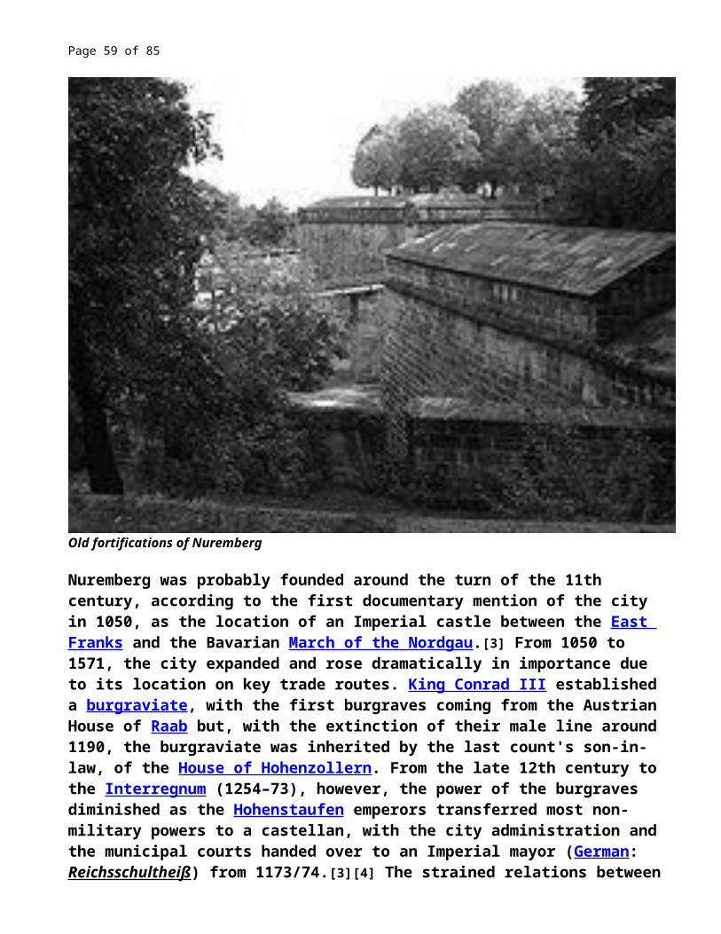
Page 59 of 67
had been broken. In 1924 Ludwig Landmann became the first Jewish Mayor of the city, and led a significant expansion during the following years. However, during the Nazi era, the synagogues of Frankfurt were destroyed.The city of Frankfurt was severely bombed in World War II (1939–1945). About 5,500 residents were killed during the raids, and the once famous medieval city centre, by that time the largest in Germany, was destroyed. Post-war reconstruction took place in a sometimes simple modern style, thus irrevocably changing the architectural face of Frankfurt. Only very few landmark buildings have been reconstructed historically, albeit in a simplified manner. The collection of historically significant Cairo Genizah documents of the Municipal Library was destroyed when the city was bombed. According to Arabist and Genizah scholar S.D. Goitein, "not even handlists indicating its contents have survived."Frankfurt became a ground battlefield commencing 26 March 1945, when the Allied advance into Germany was forced to take the city in contested urban combat that included a river assault. The US 5th Infantry Division and US 6th Armored Division captured Frankfurt after several days of intense fighting, and it was declared largely secure on 29 March 1945. More details of this battle are provided at History of Frankfurt am Main.After the end of the war, Frankfurt became a part of the newly founded state of Hesse, consisting of the old Hesse-(Darmstadt) and the Prussian Hesse provinces. The city was part of the American Zone of Occupation of Germany. The Military Governor for the United States Zone (1945–1949) and the United States High Commissioner for Germany (HICOG) (1949–1952) had their headquarters in the IG Farben Building, intentionally left undamaged by the Allies' wartime bombardment. Frankfurt was the original choice for the provisional capital of West Germany—they even went as far as constructing a new parliament building that has never been used for its intended purpose. Since 1949 it is used to house the radio studios of Hessischer Rundfunk. In the end, Konrad Adenauer (the first post-war Chancellor) preferred the tiny city of Bonn, for the most part because it was close to his hometown, but also for another reason; many other prominent politicians opposed the choice of Frankfurt out of concern that Frankfurt, one of the largest German cities and a former centre of the old German-dominated Holy Roman Empire, would be accepted as a "permanent" capital of Germany, thereby weakening the West German population's support for reunification and the eventual return of the Government to Berlin.During the 1970s, the city created one of Europe's most efficient underground transportation systems. That system includes a suburban rail system (S-Bahn) capable of reaching outlying communities as well as the city centre, and a deep underground light rail system with smaller coaches (U-Bahn) also capable of travelling above ground on street rails.Since the postwar period Frankfurt has emerged once again as the financial and transportation centre of Germany.
Romans in the NetherlandsFrom Wikipedia, the free encyclopediahttp://en.wikipedia.org/wiki/Romans_in_the_Netherlands

Page 60 of 67
Reconstruction of a Roman watch tower near Fectio in the Netherlands
For around 450 years, from around 55 BC to around 410 AD, the southern part of the Netherlands was integrated into the Roman Empire. During this time the Romans in the Netherlands had an enormous influence on the lives and culture of the people who lived in the Netherlands at the time and (indirectly) on the generations that followed.[1]
Early History

Page 61 of 67
Limes Romanus in the Netherlands
During the Gallic Wars, the area south and west of the Rhine was conquered by Roman forces under Julius Caesar in a series of campaigns from 57 BC to 53 BC.[2] The approximately 450 years of Roman rule that followed would profoundly change the Netherlands.Starting about 15 BC, the Rhine in the Netherlands came to be defended by the Lower Limes Germanicus. After a series of military actions, the Rhine became fixed around 12 AD as Rome's northern frontier on the European mainland. A number of towns and developments would arise along this line.The area to the south would be integrated into the Roman Empire. At first part of Gallia Belgica, this area became part of the province of Germania Inferior. The tribes already within, or relocated to, this area became part of the Roman Empire.The area to the north of the Rhine, inhabited by the Frisii and the Chauci, remained outside Roman rule but not its presence and control. The Frisii were initially "won over" by Drusus, suggesting a Roman suzerainty was imposed by Augustus on the coastal areas nort of the Rhine river.[3] Over the course of time the Frisii would provide Roman auxiliaries through treaty obligations, but the tribe would also fight the Romans in concert with other Germanic tribes (finally, in 296 the Frisii were relocated in Flanders and disappeared from recorded history).
Batavians

Page 62 of 67
About 38 BC, a pro-Roman faction of the Chatti (a Germanic tribe located east of the Rhine) was settled by Agrippa in an area south of the Rhine, now thought to be the Betuwe area. They took on the name of the people already living there—the Batavians.[2]
The Conspiracy of Julius Civilis, completed in 1661 by Rembrandt, the best-known painter of the Dutch Golden Age. It depicts a Batavian oath to Gaius Julius
Civilis, the head of the Batavian rebellion against the Romans in 69
The relationship with the original inhabitants was on the whole quite good; many Batavians even served in the Roman cavalry. Batavian culture was influenced by the Roman one, resulting among other things in Roman-style temples such as the one in Elst, dedicated to local gods. Also the trade flourished: the salt used in the Roman empire was won from the North Sea and remains are found across the whole Roman empire.However, this did not prevent the Batavian rebellion of 69, a very successful revolt under the leadership of Batavian Gaius Julius Civilis. Forty castella were burnt down because the Romans violated the rights of the Batavian leaders by taking young Batavians as their slaves.[4]Other Roman soldiers (like those in Xanten and the auxiliary troops of Batavians and Caninefatae from the legions of Vitellius) joined the revolt, which split the northern part of the Roman army. April 70, Vespasianus sent a few legions to stop the revolt. Their commander, Petilius Cerialis, eventually defeated the Batavians and started negotiations with Julius Civilis on his home ground, somewhere between the Waal and the Maas near Noviomagus (Nijmegen) or—as the Batavians probably called it—Batavodurum.[5]
FranksIn the 3rd century started to appear in Roman Netherlands the Franks, a warrior Germanic tribe. Their attacks happened in a time period with a catastrofic sea

Page 63 of 67
invasion of the area.
Netherlands in 50. Darkest areas are under sea level
Another change was irreversible. During transgression phases, the sea is more aggressive than under normal circumstances. The third century saw the beginning of an era of increased violence from the sea. The canal between Lake Flevo and the Wadden Sea widened and the mud-flats of the north become wetlands. The Frisians and Chauci increased the height of the terps (the mounds on the alluvial plain on which they lived) but in vain. It seems that their country was largely depopulated, and the Frisians disappear from our sources. (It is unlikely that the inhabitants of modern Friesland are related to the ancient Frisians.).....The cause of this devastation (in Frisian lands) is easy

Page 64 of 67
to find: raids of a new Germanic tribe, the Franks.[6]
Frankish identity emerged at the first half of the 3rd century out of various earlier, smaller Germanic groups, including the Salii, Sicambri, Chamavi, Bructeri, Chatti, Chattuarii, Ampsivarii, Tencteri, Ubii, Batavi and the Tungri, who inhabited the lower and middle Rhine valley between the Zuyderzee and the river Lahn and extended eastwards as far as the Weser, but were the most densely settled around the IJssel and between the Lippe and the Sieg. The Frankish confederation probably began to coalesce in the 210s.[7]Franks appear in Roman texts as both allies and enemies (laeti or dediticii). Around 310, the Franks had the region of the Scheldt river (present day west Flanders and southwest Netherlands) under control, and were raiding the Channel, disrupting transportation to Britain. Roman forces pacified the region, but did not expel the Franks, who continued to be feared as pirates along the shores at least until the time of Julian the Apostate (358), when Salian Franks were granted to settle as foederati in Toxandria, according to Ammianus Marcellinus.[8]At the beginning of the 5th century, the Franks became the most important ethnic group in the region, just before the end of the Western Roman Empire.
Roman settlements in the Netherlands: During their stay in Germania Inferior, the Romans established a number of towns and smaller settlements in the Netherlands and reinforced the Limes Germanicus with military forts. More notable towns include Ulpia Noviomagus Batavorum (modern Nijmegen) and Forum Hadriani (Voorburg).
Roman forts in the Netherlands (squares on the map next page)
1. Flevum (at modern Velsen) A harbour has been found here as well.2. Lugdunum Batavorum (Brittenburg at modern Katwijk aan Zee)3. Praetorium Agrippinae (at modern Valkenburg)4. Matilo (in the modern Roomburg area of Leiden)5. Albaniana (at modern Alphen aan den Rijn)6. Fort of an unknown name (near Bodegraven)7. Laurium (at modern Woerden)8. A fort perhaps called Fletio (at modern Vleuten)9. Traiectum (in modern Utrecht)10.Fectio (Vechten)11.Levefanum (at modern Wijk bij Duurstede)12.Carvo (at modern Kesteren in Neder-Betuwe)13.Fort of an unknown name at (Meinerswijk)14.Noviomagus (in modern (Nijmegen)
Towns in the Netherlands (triangles on the map)A) Forum Hadriani, a.k.a. Aellium Cananefatum (modern Voorburg)B) Ulpia Noviomagus Batavorum, a.k.a. Colonia Ulpia Noviomagus, (modern Nijmegen)C) Batavorum (in modern Nijmegen)

Page 65 of 67
D) Colonia Ulpia Trajana (in modern Xanten, Germany)E) Coriovallum (in modern Heerlen)
Settlements or posts (circles on the map)F) Nigrum Pullum (modern Zwammerdam)G) settlement of an unknown name on the Leidsche RijnH) Haltna (modern Houten)I) settlement of an unknown name (modern Ermelo)J) settlement of an unknown name (modern Tiel)K) Roman temples (modern Elst, Overbetuwe)L) Temple possibly devoted to Hercules Magusannus (modern Kessel, North Brabant)M) Temple (at an area called ‘’De lithse Ham’’ near Maren-Kessel, now part of Oss)[9]N) Ceuclum (modern Cuijk)O) unknown (modern Esch)P) Trajectum ad Mosam, also known as Mosae Trajectum, (modern Maastricht)Not marked on the map: a possible fort in modern

Page 66 of 67

Page 67 of 67
Map showing Roman settlements in the Netherlands.