· Web viewData received from NAVY for Porbandar station and disseminated for FDP (CTCZ)....
125
Country Report of India 5.1 Meteorology A brief description of the observational network of IMD and types of observations collected from the network are given below: a. Surface Observatories The network of surface meteorological observatories consists of total 709 Stations. The break-up of various categories is as follows: CATEGORY OF DEPARTMENTAL OBSERVATORIES CLASS RMC Delhi RMC Chennai RMC Kolkat a RMC Mumbai RMC Nagpur RMC Guwahati Tot al I , II (a), IV, VI & SMO (Deptt.) 57 53 32 29 17 16 204 II (b), II (c), II (d), III & IV, V, VI Io & EMO (Non Deptt.) 106 71 47 30 47 25 326 V (Non Deptt. HMO) 64 17 54 21 12 11 179 TOTAL 227 141 133 80 76 52 709 High Wind Speed Recorders (HWSRs) 1
-
Upload
trinhkhuong -
Category
Documents
-
view
286 -
download
15
Transcript of · Web viewData received from NAVY for Porbandar station and disseminated for FDP (CTCZ)....

Country Report of India5.1 MeteorologyA brief description of the observational network of IMD and types of observations
collected from the network are given below:a. Surface ObservatoriesThe network of surface meteorological observatories consists of total 709 Stations.
The break-up of various categories is as follows:
CATEGORY OF DEPARTMENTAL OBSERVATORIES
CLASS RMC Delhi
RMC Chennai
RMC Kolkata
RMC Mumbai
RMC Nagpur
RMC Guwahati
Total
I , II (a), IV, VI & SMO (Deptt.)
57 53 32 29 17 16 204
II (b), II(c), II (d),III & IV, V, VI Io & EMO (Non Deptt.)
106 71 47 30 47 25 326
V (Non Deptt. HMO)
64 17 54 21 12 11 179
TOTAL 227 141 133 80 76 52 709
High Wind Speed Recorders (HWSRs)(a) Real time HWSR data through GPRS modules is available on www.imdaws.com site for the stations: Goa, Pune, Bhuj, Naliya Dwarka, Veraval, Karaikal, Kakinada, Gopalpur, Visakhapatnam, Machilipatnam, Chennai , Digha, Haldia, Sagar Island, Kalingapatanam, Balasore,Paradip, Puri and NelloreThe on-line data will be made available on www.imdaws.com site shortly for above four stations.
b. Upper Air observatories
i. 06 Nos. of GPS based systems (make M/s GRAW Germany) installed/ commissioned at RMCs to up-grade these RS/RW stations as per WMO GCOS Network (GUAN) stan-dard. Action being taken for induction of these stations into GUAN network.
1
ii. Pilot Balloon (PB) observatories of Sundernagar and Dehradun up-graded to RS/RW.iii. 13 Nos. of GPS based systems (make M/s Jinyang Korea) installed/ commissioned at
RS/RW Agaratala, Siliguri, Gorakhpur, Lucknow, Ranchi, Karaikal, Machhilipatnam, Mangalore, Kochi, Jodhpur, Jammu, Sundernagar & Dehradun.
iv. 7 Nos. of GPS based systems (make M/s Changfeng China) installed/ commissioned at Patiala, Gwalior, Jagdalpur, Raipur, Jaipur, Aurangabad & Bangalore to up-grade these RS/RW stations
v. Total network of upper air radiosounding (RS/RW) of 39 stations has been upgraded with GPS based radiosounding, and all the stations are working at present.
vi. Indigenous GPS based radiosonde is in final stage of production. Procurement of differ-ent components in different stages-production to start on receipt of material.
(c) Meteorological Satellite At present IMD is receiving and processing meteorological data from three Indian
satellites namely Kalpana-1, INSAT-3A & INSAT-3D. Kalpana-1 was launched on 12 th
September, 2002 and is located at 74.0°E. INSAT-3A was launched on 10 April, 2003 and is located at 93.5°E. INSAT-3D was launched on 26 July 2013. Kalpana-1 and INSAT-3A both have payload of Very High Resolution Radiometer (VHRR) for imaging the earth in three channels viz. Visible (0.55-0.75 µm), Infra-Red (10.5-12.5µm) and Water vapour (5.7-7.1µm) having resolution of 2X2 km in visible and 8X8 km in Water vapour (WV) and Infra-red (IR) channels. In addition, the INSAT-3A has a three channel Charge Coupled Device (CCD) payload for imaging the earth in Visible (0.62- 0.69um), Near IR (0.77-0.86µm) and Short Wave IR (1.55-1.77µm) bands of Spectrum.The Resolution of CCD payload in all the three short wave (SW) channels is 1KmX 1 Km. INSAT-3D has an advanced imager with six imagery channels {Visible (0.55-0.75 µm), Short wave Infra-Red (SWIR) (1.55-1.70 µm), Medium Infra-Red (MIR) (3.80-4.00 µm), Thermal Infra-Red-1(TIR-1) (10.2-11.3 µm), TIR-2 (11.5-12.5 µm), & WV (6.50-7.10 µm)} and a nineteen channel sounder (18 IR & 1 Visible) for derivation of atmospheric temperature and moisture profiles. It provides 1 km. resolution imagery in visible band, 4 km resolution in IR band and 8 km in WV channel.
At Present about 48 nos. of satellite images are taken daily from Kalpana-1, approximately 20 images are taken from INSAT-3A. Imaging from CCD is done 5 times during daytime only. Half hourly satellite imageries are also obtained from all the six imager channels and hourly images from the sounder channels of INSAT-3D satellite. All the received data from the satellite are processed and archived in National Satellite Data Center (NSDC), New Delhi. INSAT-3D Meteorological Data Processing System (IMDPS) is processing meteorological data from INSAT VHRR and CCD data and supports all operational activities of the Satellite Meteorology Division on round the clock basis. Cloud Imagery Data are processed and transmitted to forecasting offices of the IMD as well as to the other users in India and foreign countries. The following products derived from the satellite are useful for monitoring of tropical cyclones
1. Outgoing Long wave Radiation (OLR) at 0.250X0.250 resolution2. Quantitative Precipitation Estimation (QPE) at 10 /10 resolution3. Sea Surface Temperature (SST) at 10 /10 resolution4. Cloud Motion Vector (CMV)5. Water Vapour Wind (WVW)
2

6. Upper Tropospheric Humidity (UTH)7. Temperature, Humidity profile8. Value added parameters from sounder products
a. Geo-potential Heightb. Layer Precipitable Waterc. Total Precipitable Waterd. Lifted Indexe. Dry Microburst Indexf. Maximum Vertical Theta-E Differentialg. Wind Index
At present Dvorak technique is used but manually applied. Recently efforts have been made for automation of this technique. Automated Dvorak technique version (8.2.1) is running in experimental mode at Satellite Application Unit, Satellite Meteorology Division. Satellite Application Unit is also using Microwave imageries operationally from NOAA, Metop’s DMSP satellites for locating the tropical systems. Satellite Application Unit issues three hourly bulletins in general and hourly and half hourly bulletins in case of tropical cyclones and other severe weather events.
With the Web Archival System developed at IMD, KALPANA-1/INSAT-3A/INSAT-3D products & imageries are archived. The automatic script is being used to keep and update the images/products on the website for 6 months. These are available to all users.
(d) Performance of operational NWP models for cyclone forecasting during 2015
NWP Division of India Meteorological Department (IMD) operationally runs three
NWP models WRF (ARW), HWRF and Global model (GFS T574/L64) for short and
medium range predictions (3-7 days). As a part of effort to translate research to operation,
and to meet the need of the operational forecaster, IMD developed and implemented an
objective NWP based Cyclone Prediction System for the operational cyclone forecasting
work. The method comprises of five forecast components, namely (a) Cyclone Genesis
Potential Parameter (GPP), (b) Multi-Model Ensemble (MME) technique for cyclone track
prediction, (c) Cyclone intensity prediction, (d) Rapid intensification and (e) Predicting
decaying intensity after the landfall.
Under NOAA-MoES collaboration program the basic version of the model
HWRFV (3.7+) which was operational at EMC, NCEP, USA was ported on IITM ADITYA
HPCS machine with nested domain of 27 km, 9 km and 3 km horizontal resolution and 61
vertical levels with outer domain covering the area of 216X432, 106X204 and innermost
domain 198X354 with Center of the system adjusted to the Center of the observed cyclonic
storm. The model is run on real time six hourly basis (started from cyclone season 2015)
based on 00, 06, 12 and 18 UTC initial conditions to provide 6 hourly track and intensity
3

forecasts along with surface wind and rain swaths valid up to 126 hours. The model uses
IMD GFS-T574L64 analysis/forecast as first guess.
As part of WMO Program to provide a guidance of tropical cyclone (TC) forecasts in
near real-time for the ESCAP/WMO Member Countries based on the TIGGE Cyclone XML
(CXML) data, IMD implemented JMA supported software for real-time TC forecast over
North Indian Ocean (NIO) during 2011. The Ensemble and deterministic forecast products
from UKMO (50+1 Members), NCEP (20+1 Members), UKMO (23+1 Members) and MSC
(20+1 Members) are available near real-time for NIO region for named TCs. These
Products includes: Deterministic and Ensemble TC track forecasts, Strike Probability Maps,
Strike probability of cities within the range of 120 kms 4 days in advance. The JMA provided
software to prepare Web page to provide guidance of tropical cyclone forecasts in near
real-time for the ESCAP/WMO committee Members.
(d) Telecommunication Network in IMD
(e) Telecommunication Network in IMD
Present Status of Circuits in the GTS connected with RTH, New Delhi1. India Meteorological Department has its National Meteorological
Telecommunication Centre (NMTC) with an Automatic Message Switching computer System (AMSS) which is connected to WMO Centers on the GTS. The existing RTH switching system “TRANSMET” is the state-of-the-art technology system. It consists of two Separate Automatic Message Switching System (AMSS) for National and International data exchange. Each AMSS works in hot standby mode for 100% redundancy in case of any failure.
During the period 2013-2014 following new data sets were received from different circuit and submitted on GTS
a. BUFR data from Pakistan b. Storm Information, Forecast and Advisories messages from RSMC NEW Delhi in
Text and Graphical form.c. ASCII & BUFR AWS/ARG data are shared on GTS.d. Sixteen(16) operational RADAR data are received in NETCDF and BUFR format
and routed to users as per their requirement.e. Forecast via SMS during AMARNATH Yatra gets disseminated through RTH to
the users concerned.f. Warning messages such as Tsunami and Cyclone messages received from
INCOIS and RSMC are disseminated via SMS as per the user requirement.g. INSAT-3D wind data is being shared on GTS.h. Data received from NAVY for Porbandar station and disseminated for FDP
(CTCZ).i. RMDCN link has been upgraded to 4 Mbps RMDCN-NG(Next Gen) which
handles 6 circuits viz. Tokyo, Moscow, Beijing , Germany, Exeter and Toulouse. This has improved the data exchange between these GTS centres.
4

j. New Delhi- Bhutan link established for Meteorological data exchange on GTS.k. MPLS VPN link at HQ New Delhi has been upgraded to 8 Mbps for smooth
catering of data requirements to the national users. This will help in faster data reception at Head Quarter from DWR stations & NWP Centres to various users.
2. VPN CircuitsFifty four, IMD stations are connected with IPVPN connectivity speeds ranging from
256 Kbps to 8 Mbps. These VPN circuits are connected with Synergie Systems at various out stations, Doppler Weather Radar Stations, AMSS Centres and Regional Centres.
3. IVRSPopularly known as “Weather on telephone”, the Interactive Voice Response System
(IVRS) is functioning with effect from July, 2000. One can access current weather and forecast for major Indian cities and air quality of some selected cities by dialing Toll free number 1800 180 1717 (List of IVRS stations enclosed as Annexure III).
4. Internet ServicesAt present IMD has two independent Internet leased links of 100 Mbps and 60
Mbps from different Internet service providers. IMD is also connected to 1 Gbps NKN (National Knowledge Network) link of NIC for internet, data exchange within Close User Group (CUG), Video conferencing & Telepresence services.
5. GMDSSIndia has been designated as an issuing authority under the GMDSS programme for
Meteorological Area VIII (N). This covers the area of the Indian Ocean enclosed by the lines from Indo-Pakistan frontier in 23°45’N 68°E; 12°N 63°E, thence to Cape Gardafui; the east African coast south to equator, thence to 95°E to 6°N, thence to the Myanmar / Thailand frontier in 10° N 98° 30’ E.
India Meteorological Department is transmitting daily two GMDSS bulletins for Met. Area VIII(N), one at 0900 UTC and other at 1800 UTC. During Cyclone Season additional bulletins (4) are also being issued for GMDSS broadcast depending on the requirement. GMDSS bulletins are transferred to Earth Station of Tata Communication Ltd. at Pune through email as well as uploaded on IMD Website at URL http://www.imd.gov.in. Pune Earth Station uplinks this information to INMARSAT satellite for broadcast to all ships in Met Area VIII(N).
6. Regional Telecommunication Hub (RTH)Regional Telecommunication Hub (RTH), New Delhi came into existence in the year 1971. It was automated and first DS- 714 Philips Computer System became operational in the year 1974. This RTH Computer was replaced by VAX- 11/ 750 Computer in 1988. In July, 2000 RTH New Delhi has installed a SUN E- 250 Computer. Now the latest system has been installed in the year 2009 by Meteo France International (MFI). This is connected to WMO Centres on the GTS. The existing RTH computer system is driven primarily by dual HP server working on the state-of-the-art distributed networking technology. The whole system has been designed to handle high speed data circuits, message exchange through web interface, SMS & Email. It has also fax interface and audio alarm. NMTC New Delhi is connected to HPCS of NCMRWF Noida, IITM Pune through NKN and the HPCS computer at Regional Specialised Meteorological Centre (RSMC) New Delhi for instantaneous transmission of global observational data and processed information received via GTS.
5

Moreover, NWP division of IMD is utilizing the resources of IITM HPCS to run their various models for product generations through CUG link of NKN. As regards the Meteorological Telecommunication Networks within the GTS, New Delhi telecommunication center is a designated RTH located on the Main Trunk Network (MTN). The MTN is the core network of GTS. It links together three World Meteorological Centers (WMCs) and 14 other RTHs on the MTN. The Centre is also a National Meteorological Centre (NMC) for telecommunication purposes within the framework of GTS. RTH New Delhi is directly connected with Tokyo, Exeter, Offenbach, Cairo, Jeddah, Beijing, Dhaka, Bangkok, Karachi, Male, Moscow, Oman, Colombo, Melbourne, Toulouse, Katmandu and Yangoon with different protocol and speed.Automatic Message Switching Systems (AMSS) are also operational at the major International airports of India viz. Mumbai, Delhi, Kolkata, Chennai, Nagpur and Guwahati. The circuits linking New Delhi (Palam), Mumbai, Kolkata, Chennai, Nagpur and Guwahati Airport computers with the NMTC New Delhi are working at 512 kbps speed.
On line Briefing System at Chennai & Delhi (Palam) has been commissioned and functional.
Under the Modernization programme of India Meteorological Department, following systems have been installed at RTH New Delhi:-
a. Central Information Processing System (CIPS): High end database management system having task centre to develop, test and operationalize meteorological tasks for real time generation of meteorological products.
b. Transmet: Automatic Message Switching System (AMSS) to receive, check and route the meteorological data and products according to WMO standards/requirements.
c. Public Weather System (PWS): To deliver High quality weather products and alerts to end users like print media and Television.
d. Clisys: Climatological data storage system with scalable management tool for effective utilization of these data.
e. Synergie: Decision support system for forecasters to gather, visuslize, interact and value add meteorological forecasts and products.The Mirror RTH at Pune is functional to act as Disaster Recovery Centre (DRC)
which would be able to take over all the responsibilities of RTH New Delhi in case of any catastrophe at RTH New Delhi. This will also function as WMO WIS GISC for South East Asia and cater to all data needs for Indian users and all other WMO GISC centres in real time with 24 hours cache for all data. 7. Website of IMD
Website of IMD is operational since 1st June, 2000. It contains static & dynamically updated information on all India Weather and forecasts, special monsoon report, local weather forecasts for 300 cities, satellite cloud pictures (updated every half an hour), animated satellite cloud pictures, NWP models like GFS, WRF etc. and prognostic charts, special weather warnings, tropical cyclone information and warnings, daily, weekly and monthly rainfall distribution maps, earthquake reports, etc. This also contains a lot of static information including temperature and rainfall normals over the country and a brief overview of the activities and services rendered by India Meteorological Department. This site can be accessed round the clock with the URL: http://www.imd.gov.in . The Regional Meteorological Centres have also their own websites. IMD is also providing 100 Indian city forecast on the WMO Website daily at http://worldweather.wmo.int/066/m066.htm .
6

IMD has also launched a new user-friendly website for the public with URL: http://www.indiaweather.gov.in
India Meteorological Department developed its own intranet website with the address http://metnet.imd.gov.in exclusively for the use of IMD officials. All employees can access this site using their login ID. This is a very useful site and all IMD officials are accessing this site all over the country for numerous applications on official matters. The list of email addresses of senior officers are available at IMD website.
8. Information Technology CellConsidering the ever growing influence of Information Technology in day–to-day
affairs of the department, IT cell carries out the following activities:- a) Coordination of IT initiatives of the department.b) Supervise various IT projects to be implemented.c) Asserting the IT literacy and imparting suitable mechanisms for its improvement.d) Development of various in-house softwares for routine activities. Conforming to these objectives, IT Division has developed an intra - IMD Portal,
which is considered as the first step towards e-governance implementation in the department.
9. Global Data MonitoringSpecial Antarctica Monitoring during the period 1-15th January, 2015 and the result
was uploaded to WMO. The reception of SYNOP was 97%.
10. Ongoing projects:Provision of adequate communication system for data and product transmission:a. Mirror RTH and Global Information System Centre (GISC) has been installed at Pune
as a part of the WMO Information System (WIS) implementation, which includes design, development, integration with existing systems like CIPS, Clisys, AMSS, HPCs. These systems act as GISC and Data Collection and Processing Centre(DCPC) with disaster recovery centre (DRC) Pune for RTH New Delhi. As per guideline of WMO, RTH New Delhi applied for GISC as well as DCPC for
South Asia. Upgradation of RTH New Delhi as GISC is under process After installation Mirror RTH Pune, Audit team from WMO visited RTH/GISC New
Delhi at Pune and submitted their report to WMO. After acceptance of the report by WMO, the centre shall become an operational GISC.
Mirror GISC is also under process. All the national VPNs are under process for upgradation from 512 Kbps to 10 Mbps.
b. Up Gradation of AMSS (Automatic Message Switching Systems) at Delhi-Palam, Kolkata, Mumbai and Chennai.
c. Development of Centralized GIS Based content managed Website of IMD under process.
d. Development of Met GIS – Web based GIS Portal under process.
5.2 Hydrological Component Flood is one of the natural calamity which causes huge loses of life and property in
each year . In India Flood Forecast is the joint responsibility of India Meteorological
7

Department (IMD) and Central Water commission (CWC). IMD is the nodal agency for issuing Quantitative precipitation Forecast (QPF) for river basins/ sub-basins where as CWC is the nodal agency for issuing Flood Forecast. The QPF is used as the input in the Flood Forecasting model of CWC .
There are 10 Flood Meteorological Offices(FMOs) at different parts of flood prone areas of the country which are located at Agra, Ahmedabad, Asansol, Bhubaneswar, Guwahati, Hyderabad, Jalpaiguri, Lucknow, New Delhi and Patna in the flood prone areas namely the river catchments Yamuna, Narmada, Tapi, Ajoy, Mayuraksi and Kangasbati, Mahanandi, Brahmani and Subernarekha, Brahmaputra, Dhansiri and Barak, Godavari and Krishna, Teesta, Ganga and Sharada, and Sahibi, Kosi, Baghmati, Gandak etc. IMD also provides similar support to Damodar Valley Corporation (DVC) for the river basins Barakar and Damodar. Flood Meteorological Service is provided daily, consisting of following inputs to Central Water Commission (CWC) issuing Hydromet Bulletins which contains the following information:
i. Sub-basin wise QPF, ii. Synoptic situations, iii. Spatial and temporal distribution of rainfall, iv. Heavy rainfall warnings, v. Sub-basin wise past 24 hr realized rainfall.
QPF bulletin is issued at 0930 hrs IST and Hydromet Bulletin at 1230 hrs IST by FMOs. Forecast for a lead time of 5-days (forecast for 3 days and outlook for subsequent 4 days) are issued daily during flood season which may be modified in the evening when situation warrants. In the flood season, year 2015, 22679 no of QPF have been issued out of which 13660 are correct over the river catchment and in annual consolidated forecast report “Correct Forecast” has been found about 60%. QPF Bulletins including heavy rainfall warning are also issued by concerned FMOs during cyclonic period or when there is a chance of heavy rainfall leading to flood. The are operational run of sub-basin-wise WRF (00UTC & 12UTC ) and MME (00UTC) models’ output (1-day, 2-day and 3-day) for rainfall are generated and uploaded on IMD website for 122 sub-basins under FMO which is an additional guidance to forecaster for issuing QPF. In the flood season 2015, IMD GFS model rainfall products became operational for basin/sub basin level for 7 days which was very useful for water management.
Major New Initiatives(I) A project entitled “Modeling of changing Water Cycle and Climate” (Rs. 89.90
Crores) approved for implementation jointly with NCMRWF during XII FYP.The main objectives of the program are as follows:
i. To augment the present hydro-meteorological observing systems especially in the Himalayan glacier region. Two river basins Narmada and Satluj has been chosen for this pilot study.
ii. To develop basin scale high-resolution modelling system to enhance predictions of hydro-meteorological variables
iii. To develop integrated basin-scale hydrological modelling system by incorporation of conventional and satellite data and to generate a quantified estimate of water balance in the river catchment basins of Narmada and Satluj
8

iv. Creation of hydro-meteorological information system at basin scalev. To investigate the impact of climate variability and change scenarios on
hydrological response at basin level(II) GIS based customized rainfall information system (CRIS) made operational for
processing real time rainfall data to generate state, sub-division, district and river basin wise products for operational use.
5.2.1 NWP NWP Division using Quality Controled DWR data in WDSS-II Nowcasting system and
ARPS model 3D Var for very short-range forecasting. In addition, NWP Division also using these data sets in WRF model experimentaly. The same will be made operational after validation. Presently IMD operates two Nowcast Systems based on DWR data input (1) Warning Decision Support System Integrated Information (WDSSII) (updated every 10 minutes) for Metropolitan City Forecast and Aviation forecast (Single Radar Products) at Delhi, Chennai, Hyderabad and Kolkata forecast for next 2 hours (2) Advanced Regional Prediction System (ARPS) (thirty minutes updates) for NW, South, NE regions for forecast for next 9 hours.
INSAT 3D AMV data assimilation in GFS model and MEGHA-TROPIQUES satellite SAPHIR Radiance (6 channel) INSAT 3D Sounder Radiance (5 Channels) in WRF model initiated. DWR data assimilation in WRF model started in experimental mode.
GFS model (T574/L64) and WRF model (27/9 km) installation completed at IITM HPC from analysis to 7-days/3-days forecast and product generation. A parallel sys-tem to the existing NWP system at IMD, New Delhi to be established at IITM, Pune by the end of February 2015 to optimize resources utilization to provide uninterrupted NWP product delivery for real-time utilization of NWP guidance.
Experimental dynamical extended range forecast based on multi model ensemble (MME) for 4 weeks rainfall using model outputs from IITM CFS V2 and other global centres prepared every week and made available through IMD website.
Experimental Monthly and seasonal global forecasts for temperature and rainfall was prepared every month and made available through IMD website.
Establish a state-of the-art climate data centre with advanced climate data manage-ment system with observation Quality Control as per WMO standard.
Increased city Forecast to 310 cites, Tourist city Forecast from 87 to 107 destinations and validity of local forecast increased from 5 to 7 days. (May be obtain from NOWP Section)
5.3. Disaster prevention and preparedness
5.3.1 Cyclone Warning ServicesThe extensive coastal belts of India are exposed to cyclonic storms, which originate
in the Bay of Bengal and the Arabian Sea every year. These cyclones, which are accompanied with very heavy to extremely heavy rain, gales and storm surges cause heavy loss of human lives and cattle. They also cause extensive damage to standing crops and properties.
It is the endeavour of India Meteorological Department (IMD) to minimise the loss of human lives and damage to properties due to tropical cyclones by providing early warnings against the tropical cyclones. Cyclone warning is one of the most important function of the
9

IMD and it was the first service undertaken by the department in1865. The cyclone warnings are provided by the IMD from the Area Cyclone Warning Centres (ACWCs) at Kolkata, Chennai & Mumbai and Cyclone Warning Centres (CWCs) at Vishakhapatnam, Bhubaneswar and Ahmedabad.
The complete Cyclone Warning Programme in the country is supervised by the Cyclone Warning Division (CWD) at Head Quarter Office of the Director General of Meteorology at New Delhi. The CWD monitors the cyclonic disturbance both in the Bay of Bengal and Arabian Sea and advises the Government of India at the Apex level. Information on cyclone warnings is furnished on a real time basis to the Control Room in the Ministry of Home Affairs, Government of India, besides other Ministries & Departments of the Central Government. This Division provides cyclone warning bulletins to Doordarshan and All India Radio (AIR) station at New Delhi for inclusion in the National broadcast/telecast. Bulletins are also provided to other electronic and print media and concerned state govts. The Deputy Director General of Meteorology (Cyclone Warning) and Deputy Director General of Meteorology (Weather Forecasting) Pune monitor technical aspects and review the standard practices in the area of cyclone forecasting.
5.3.2 Cyclone warning bulletinsThe following is the list of bulletins and warnings issued by ACWCs/CWCs for their
respective areas of responsibility:1. Sea area bulletins for ships plying in High Seas. 2. Coastal weather bulletins for ships plying in coastal waters.3. Bulletins for Global Maritime Distress and Safety System (GMDSS). Broadcast
through Indian Coastal Earth Stations. 4. Bulletins for Indian Navy.5. Port Warnings.6. Fisheries Warnings.7. Four stage warnings for Central and State Govt. Officials.8. Bulletins for broadcast through AIRs for general public.9. Warning for registered users.10. Bulletins for press.11. Warnings for Aviation (issued by concerned Aviation Meteorological Offices).12. Bulletins for ships in the high seas through Navtex Coastal Radio Stations.
The cyclone warnings are issued to state government officials in four stages. The First Stage warning known as "PRE CYCLONE WATCH" issued 72 hours in advance contains early warning about the development of a cyclonic disturbance in the north Indian Ocean, its likely intensification into a tropical cyclone and the coastal belt likely to experience adverse weather. This early warning bulletin is issued by the Director General of Meteorology himself and is addressed to the Cabinet Secretary and other senior officers of the Government of India including the Chief Secretaries of concerned maritime states.
The Second Stage warning known as "CYCLONE ALERT" is issued at least 48 hrs in advance of the expected commencement of adverse weather over the coastal areas. It contains information on the location and intensity of the storm likely direction of its movement, intensification, coastal districts likely to experience adverse weather and advice to fishermen, general public, media and disaster managers. This is issued by the concerned ACWCs/CWCs and CWD at HQ.
10

The Third Stage warning known as "CYCLONE WARNING" issued at least 24 hours in advance of the expected commencement of adverse weather over the coastal areas. Landfall point is forecast at this stage. These warnings are issued by ACWCs/CWCs/and CWD at HQ at 3 hourly interval giving the latest position of cyclone and its intensity, likely point and time of landfall, associated heavy rainfall, strong wind and storm surge alongwith their impact and advice to general public, media, fishermen and disaster managers.
The Fourth Stage of warning known as "POST LANDFALL OUTLOOK" is issued by the concerned ACWCs/CWCs/and CWD at HQ at least 12 hours in advance of expected time of landfall. It gives likely direction of movement of the cyclone after its landfall and adverse weather likely to be experienced in the interior areas.
Different colour codes as mentioned below are being used in since post monsoon season of 2006 the different stages of the cyclone warning bulletins as desired by the National Disaster Management.
Stage of warning Colour code
Cyclone Alert Yellow
Cyclone Warning Orange
Post landfall out look Red
During disturbed weather over the Bay of Bengal and Arabian Sea, the ports likely to be affected are warned by concerned ACWCs/CWCs by advising the port authorities through port warnings to hoist appropriate Storm Warning Signals. The Department also issues "Fleet Forecast" for Indian Navy, Coastal Bulletins for Indian coastal areas covering up to 75 km from the coast line and sea area bulletins for the sea areas beyond 75 km. The special warnings are issued for fishermen four times a day in normal weather and every three hourly in accordance with the four stage warning in case of disturbed weather.
The general public, the coastal residents and fishermen are warned through State Government officials and broadcast of warnings through All India Radio and Doordarshan telecast programmes in national and regional hook-up. A system of warning dissemination for fishermen through World Space Digital Based radio receivers is being planned.
Specific objectivesIt is proposed to modify the format of Cyclone Warning bulletins to make it more
comprehensive for the use of Disaster Managers in view of the recent introduction of graphical warning products. The possibility of automation in generating the bulletins through a suitable software whereby several different bulletins which are focused towards the needs of specific groups such as fishermen, shipping, AIR, press, port etc. is being pursued by Cyclone Warning Division at New Delhi.
5.3.3 Cyclone Warning Dissemination
11

Cyclone warnings are disseminated through a variety of communication media, such as, radio, television, print media, telephones, fax, telex, telegrams, police, wireless network. A specially designed Cyclone Warning Dissemination System (CWDS) which works via the INSAT Satellite provides area-specific service even when there is a failure of conventional communication channels. A set of 250 analog and 100 digital CWDS receivers have been employed in vulnerable coastal areas in the east and west coast. Steps are being taken for introduction of shortly for 500 new CWDS (Cyclone Warning Dissemination Systems), which are based on DTH concept through cable network.
5.3.4 Disaster Management
5.3.4.1 Institutional and Policy Framework
5.3.4.1.1 The institutional and policy mechanisms for carrying out response, relief and rehabilitation have been well-established since Independence. These mechanisms have proved to be robust and effective in so far as response, relief and rehabilitation are concerned.
5.3.4.1.2 At the national level, the Ministry of Home Affairs is the nodal Ministry for all matters concerning disaster management. The Central Relief Commissioner (CRC) in the Ministry of Home Affairs is the nodal officer to coordinate relief operations for natural disasters. The CRC receives information relating to forecasting/warning of a natural calamity from India Meteorological Department (IMD) or from Central Water Commission of Ministry of Water Resources on a continuing basis. The Ministries/ Departments/Organizations concerned with the primary and secondary functions relating to the management of disasters include:
India Meteorological Department, Central Water Commission, Ministry of Home Affairs, Ministry of Defence, Ministry of Finance, Ministry of Rural Development, Ministry of Urban Development, Department of Communications, Ministry of Health, Ministry of Water Resources, Ministry of Petroleum, Department of Agriculture & Cooperation. Ministry of Power, Department of Civil Supplies, Ministry of Railways, Ministry of Information and Broadcasting, Planning Commission, Cabinet Secretariat, Department of Surface Transport, Ministry of Social Justice, Department of Women and Child Development, Ministry of Environment and Forest, Department of Food. Each Ministry/Department/Organization nominate their nodal officer to the Crisis Management Group chaired by Central Relief Commissioner. The nodal officer is responsible for preparing sectoral Action Plan/Emergency Support Function Plan for managing disasters.
5.3.4.1.3 National Crisis Management Committee (NCMC):Cabinet Secretary, who is the highest executive officer, heads the NCMC.
Secretaries of all the concerned Ministries /Departments as well as organizations are the members of the Committee The NCMC gives direction to the Crisis Management Group as deemed necessary. The Secretary, Ministry of Home Affairs is responsible for ensuring that all developments are brought to the notice of the NCMC promptly. The NCMC can give directions to any Ministry/Department/Organization for specific action needed for meeting the crisis situation.
5.3.4.1.4. Crisis Management Group:
12
The Central Relief Commissioner in the Ministry of Home Affairs is the Chairman of the CMG, consisting of senior officers (called nodal officers) from various concerned Ministries. The CMG’s functions are to review every year contingency plans formulated by various Ministries/Departments/Organizations in their respective sectors, measures required for dealing with a natural disasters, coordinate the activities of the Central Ministries and the State Governments in relation to disaster preparedness and relief and to obtain information from the nodal officers on measures relating to above. The CMG, in the event of a natural disaster, meets frequently to review the relief operations and extend all possible assistance required by the affected States to overcome the situation effectively. The Resident Commissioner of the affected State is also associated with such meetings.
5.3.4.1.5 Control Room (Emergency Operation Room): An Emergency Operations Centre (Control Room) exists in the nodal Ministry of
Home Affairs, which functions round the clock, to assist the Central Relief Commissioner in the discharge of his duties. The activities of the Control Room include collection and transmission of information concerning natural calamity and relief, keeping close contact with governments of the affected States, interaction with other Central Ministries/Departments/Organizations in connection with relief, maintaining records containing all relevant information relating to action points and contact points in Central Ministries etc., keeping up-to-date details of all concerned officers at the Central and State levels.
5.3.4.2 National Disaster Management Authority (NDMA )About 8% of the area in the country is prone to cyclone-related disasters. Recurring
cyclones account for large number of deaths, loss of livelihood opportunities, loss of public and private property and severe damage to infrastructure, thus seriously reversing developmental gains at regular intervals.
Broad-scale assessment of the population at risk suggests that an estimated 32 crore people, which accounts for almost a third of the country’s total population, are vulnerable to cyclone related hazards. Climate change and its resultant sea-level rise can significantly increase the vulnerability of the coastal population.
As mandated by Disaster Management Act, 2005, the Government of India (GoI) created a multi-tiered institutional system consisting of the National Disaster Management Authority (NDMA) headed by the Prime Minister, the State Disaster Management Authorities (SDMAs) by the respective Chief Ministers and the District Disaster Management Authorities (DDMAs) by the District Collectors and co-chaired by Chairpersons of the local bodies. These bodies have been set up to facilitate a paradigm shift from the hitherto relief centric approach to a more proactive, holistic and integrated approach of strengthening disaster preparedness, mitigation and emergency response.
5.3.4.2.1 Guidelines for the Management of Cyclones The NDMA has prepared Guidelines for the Management of Cyclones to assist ministries and departments of GoI and state governments to prepare their DM plans. The guidelines are presented in nine chapters as detailed below:
I. Chapter 1 provides an introductory overview that reflects the risk and vulnerability of the country to cyclones, including the dimensions and magnitude of the problem.
II. Chapter 2 discusses the Early Warning Systems (EWS) for cyclones. In this chapter, the present status of EWSs has been discussed and the gaps have been identified.
13
Requirement to bring them up to international standards and making them state-of-the-art systems has been recommended.
III. Chapter 3 deals with the present status of Warning Communication and Dissemination, its gaps and future improvements required towards making it fail-proof and modern.
IV. Chapter 4 covers structural measures for preparedness and mitigation, covering cyclone shelters, buildings, road links, culverts and bridges, canals, drains, saline embankments surface water tanks, cattle mounds and communication/power transmission networks.
V. In Chapter 5, important aspects of the management of coastal zones and its relevance to CDM, including some other non-structural mitigation options have been presented. This chapter discusses issues related to coastal zone management, sustainability of coastal resources, bioshields, coastal flood plain management, coastal erosion, natural resources management, etc.
VI. Chapter 6 deals with various aspects of awareness generation related to CDM as an important preparedness measure.
VII. Chapter 7 covers Disaster Risk Management (DRM) issues, risk assessment and vulnerability analysis, hazard zoning and mapping, data generation, including the use of GIS tools, and capacity development.
VIII. Chapter 8 deals with CDM-related response and relief strategies. A detailed account of several issues related to effective response such as response platforms, linking risk knowledge with response planning, evolving disaster response capabilities, etc., is brought out in this chapter.
IX. In Chapter 9, guidelines and implementation strategies have been discussed. X. Salient initiatives recommended for implementation as part of the National Guidelines
for Management of Cyclones are listed for undertaking action by various relevant Departments.
XI. The detail Guideline is hoisted in the NDMA website.
5.3.4.2.2 Current Status1. Meetings related to cyclone preparedness and disaster management
conducted by the State Govt. departments are regularly attended by IMD officers to provide necessary briefings and inputs.
2. Frequent lectures on Disaster Preparedness and Mitigation are delivered to educate the State Govt. officials and NGOs.
3. Exhibits on Statistics on frequencies of landfalling Tropical Cyclones over the coastal belts of North Indian Ocean, Cyclone Warning procedures employed by IMD, Damages caused due to landfalling cyclones etc. are prepared every year with updated data and displayed in the meteorological exhibition conducted during the WMO Day, National Science Day and Indian Science Congress.
4. Exhibits are also supplied to schools and other academic/ govt. institutions for display during scientific programmes. IMD officials also participate in such exhibitions.
5.3.4.3 National Disaster Response Force (NDRF)
14

Two national calamities in quick succession in the form of Orissa Super Cyclone (1999) and Gujarat Earthquake (2001) brought about the realization of the need of having a specialist response mechanism at National Level to effectively respond to disasters. This realization led to the enactment of the DM Act on 26 Dec 2005. The NDMA was constituted to lay down the policies, plans and guidelines for disaster management.
The DM Act has made the statutory provisions for constitution of National Disaster Response Force (NDRF) for the purpose of specialized response to natural and man-made disasters. Accordingly, in 2006 NDRF was constituted with 08 Bns (02 Bn each from BSF, CRPF, ITBP and CISF). As on date NDRF is having strength of 10 Bns. Each NDRF Bn consists of 1149 personnel. Union cabinet has also approved the conversion/up-gradation of 02 Bns from SSB.
The force is gradually emerging as the most visible and vibrant multi–disciplinary, multi-skilled, high-tech, stand alone force capable of dealing with all types of natural and man-made disasters.
The DM Act, 2005 envisages a paradigm shift from the erstwhile response centric syndrome to a proactive, holistic and integrated management of disasters with emphasis on prevention, mitigation and preparedness. This national vision inter alia, aims at inculcating a culture of preparedness among all stakeholders.
NDRF has proved its importance in achieving this vision by highly skilled rescue and relief operations, regular and intensive training and re-training, capacity building & familiarization exercises within the area of responsibility of respective NDRF Bns, carrying out mock drills and joint exercises with the various stakeholders.
Vision of NDRF is to emerge as the most visible and vibrant multi-disciplinary, multi-skilled, high-tech force capable to deal with all types of natural as well as manmade disasters and to mitigate the effects of disasters.
5.3.4.3.1 Role and Mandate of NDRF Specialized response during disasters Proactive deployment during impending disaster situations Acquire and continually upgrade its own training and skills Liaison, Reconnaissance, Rehearsals and Mock Drills Impart basic and operational level training to State Response Forces (Police, Civil
Defence and Home Guards) Vis-à-vis Community- All NDRF Bns are actively engaged in various: Community Capacity Building Programme Public Awareness Campaign Exhibitions : Posters, Pamphlets, literatures
5.3.4.3.2 Unique Force The only dedicated disaster response force of the world. The only agency with comprehensive response capabilities having multi-disciplinary
and multi-skilled, high-tech, stand alone nature. Experienced paramilitary personnel specially trained and equipped for disaster
response. Capabilities for undertaking disaster response, prevention, mitigation and capacity
building
15

5.3.4.4 National Institute of Disaster Management (NIDM) The National Institute of Disaster Management (NIDM) was constituted under an Act
of Parliament with a vision to play the role of a premier institute for capacity development in India and the region. The efforts in this direction that began with the formation of the National Centre for Disaster Management (NCDM) in 1995 gained impetus with its redesignation as the National Institute of Disaster Management (NIDM) for training and capacity development. Under the Disaster Management Act 2005, NIDM has been assigned nodal responsibilities for human resource development, capacity building, training, research, documentation and policy advocacy in the field of disaster management.
Both as a national Centre and then as the national Institute, NIDM has performed a crucial role in bringing disaster risk reduction to the forefront of the national agenda. It is our belief that disaster risk reduction is possible only through promotion of a "Culture of Prevention" involving all stakeholders. We work through strategic partnerships with various ministries and departments of the central, state and local governments, academic, research and technical organizations in India and abroad and other bi-lateral and multi-lateral international agencies.
NIDM is proud to have a multi-disciplinary core team of professionals working in various aspects of disaster management. In its endeavour to facilitate training and capacity development, the Institute has state-of-the-art facilities like class rooms, seminar hall, a GIS laboratory and video-conferencing facilities etc. The Institute has a well-stocked library exclusively on the theme of disaster management and mitigation. The Institute provides training in face-to-face, on-line and self-learning mode as well as satellites based training. In-house and off-campus face-to-face training to the officials of the state governments is provided free of charge including modest boarding and lodging facilities.
NIDM provides technical support to the state governments through the Disaster Management Centres (DMCs) in the Administrative Training Institutes (ATIs) of the States and Union Territories. Presently NIDM is supporting thirty such centres. Six of these centres are being developed as Centres of Excellence in the specialised areas of flood risk management, earthquake risk management, cyclone risk management, drought risk management, landslides risk management and management of industrial disasters. Eleven larger states (Andhra Pradesh, Bihar, Gujarat, Karnataka, Madhya Pradesh, Maharashtra, Rajasthan, Tamil Nadu, Uttar Pradesh, West Bengal and Odisha) have been provided with additional centres to cater their needs in this area.
NIDM hosts the SAARC Disaster Management Centre (SDMC) and works as its national focal point.
The vision is to create a Disaster Resilient India by building the capacity at all levels for disaster prevention and preparedness.
5.3.4.5 Common Alert Protocol (CAP)
Guidelines of implementation of Common Alert Protocol (CAP) have been received from WMO and India Meteorological Department (IMD) already has taken action for implementation of CAP with respect to cyclone, thunderstorm & earthquake.
16

Current Status1. SOP for Post De-Warning Procedures after the landfall of cyclone is prepared.2. Cyclone Hazard Maps for coastal zones is made available on IMD Website.3. Efforts are on to increase the number of SMS users to whom messages are sent
during cyclone.4. Meetings related to cyclone preparedness and disaster management conducted by
the State Govt. departments are regularly attended by IMD officers to provide necessary briefings and inputs.
5. Frequent lectures on Disaster Preparedness and Mitigation are delivered to educate the State Govt. officials and NGOs.
6. Dr. S. Balachandran, Scientist-E has been included as a core group member for the preparation of Tamil Nadu State Disaster Management Plan. Necessary input material for the same is being prepared.
7. Exhibits on Statistics on frequencies of landfalling Tropical Cyclones over the coastal belts of North Indian Ocean, Cyclone Warning procedures employed by IMD, Damages caused due to landfalling cyclones etc. are prepared every year with updated data and displayed in the meteorological exhibition conducted during the WM Day and National Science Day.
8. 45 exhibits (15 permanent) were prepared and put up for display at the exhibition hall of the newly constructed building for FMC Kanyakumari for the benefit of students and other visitors.
9. Exhibits are also supplied to schools and other academic/ govt. institutions for display during scientific programmes.
10. . IMD officials also participate in exhibitions conducted during National Science Congress and Science festivals organised by State Govt. and scientific institutions.
11. The names, addresses and telephone Nos. of the Officers were sent to all concerned offices as a Pre-cyclone exercise.
5.3.4.6 On-going Projects
5.3.4.6.1 FDP on landfalling cyclones over the Bay of BengalCyclone Warning Research Centre (CWRC, Regional Meteorological Centre,
Chennai is functioning as the Field Operational Centre (FOC) for the FDP(Cyclones) 2013 campaign w.e.f 15th October. FOC’s report on the status of observational data received was sent to the National Operations Centre (NOC), IMD New Delhi daily. Daily observational data are archived as per the FDP implementation plan.
5.3.4.6.2 A project on development of a Tropical Cyclone Data Portal (TCDaP) for the North Indian Ocean is being initiated at CWRC, RMC Chennai.
5.3.4.6.3 A project on development and execution of a software tool TCWIND - for depicting winds associated with 43 Tropical Cyclones over North Indian Ocean during 2000-2010 (time series of maximum sustained wind speed, vertical wind shear, tangential and radial velocities) based on IMD’s best track data and 6-hrly NCEP FNL data is in progress.
17

5.3.4.6.4 Research on diabatic heat source and moisture sink associated with rapid intensification of north Indian ocean cyclones is being carried out.
5.3.4.6.2 Cyclone eAtlas-IMD
Cyclone eAtlas – IMD, a software for generation of tracks and statistics of cyclones and depressions over the North Indian Ocean was brought out in CD form by IMD during 2008 and subsequently hosted in the web at the URL: www.rmcchennaieatlas.tn.nic.in. The database for the software for 2015 updated and uploaded in the web. It is also sent to all buyers of the CD every year. As on date ,there are 6464 registered users with 21999 login in e-Atlas.
3. Statistical prediction of seasonal cyclonic activity over the North Indian Ocean
An experimental outlook on the seasonal cyclonic activity over the North Indian Ocean for the period October-December 2015 was prepared on real-time basis (during September 2015) and communicated to Cyclone warning Division, NewDelhi, and the Area Cyclone Warning Centre, Chennai . The prediction was validated at the end of the season. Efforts are on for improving the prediction model.
5.3.4.6.4 Experimental efforts are on for Cyclone Intensity and Track prediction based on WRF model. Track and Intensity predictions were generated on real time basis (experimental) and validated during October-December 2014, the chief cyclone period for the North Indian Ocean.
5.4 Training Component
The Human Resource Development has been one of the prime thrust areas of capacity building in IMD to keep pace with the latest trends in weather monitoring and forecasting. Meteorological Training Institute (MTI) at IMD Pune acts as a WMO recognised regional training centre. Like previous years, MTI Pune conducted various training programmes in 2015. The course curricula of various training courses have been modified keeping in view the latest developments. The institute imparted training for participants from 53 countries on various aspects. In addition, RSMC New Delhi conducted its regular cyclone training programme. Various other divisions of IMD such as Satellite Meteorological Division, Radar Division and NWP Division conducted training programmes in their respective areas for national and international participants. E-learning in training programme has been introduced for some courses of IMD. Initiative is being taken up to introduce distance learning through virtual classroom facilities in IMD’s training programme. Two refresher courses viz. on tropical cyclones and climate science have been organized in 2015. Five Advanced Refresher Courses viz. Aviation Meteorology, Radar Meteorology, Radar Technology, Communication and IS and NWP have been planned to be conducted during 2016-17.
18

5.5 Research
CURRENT STATUS
Research works pertaining to statistical, climatological and dynamical aspects of Tropical Cyclones of North Indian Ocean are undertaken regularly. Some recent efforts are listed below:
Project TCRAIN
A Tropical Cyclone Rainfall Analytical tool for the North Indian Ocean – TCRAIN that depicts rainfall characteristics of 59 Tropical Cyclones over North Indian Ocean during the period 2000-2015 was developed based on TRMM data by CWRC, RMC Chennai and the application is hosted in the web at the URL: www.cwrcimdchennaitcrain.in. The necessary software for generation of percentage frequency distribution of rain rates, azimuthally averaged radial profiles of rain rates and quadrant-wise mean rain rates around a cyclone centre and with respect to the direction of movement of the cyclone using 3hrly TRMM data was developed in-house. The products are generated for different stages of intensity of the system viz., (i) Depression, (ii) Cyclonic Storm and (iii) Severe Cyclonic Storm and above during its growth as well as decay for all the 59 cyclones would serve as valuable inputs for research on rainfall associated with Tropical Cyclones of the North Indian Ocean. As on date there were 811 registered users.
4. Research Papers
(a) The following research papers have been publisied :
1. Tropical cyclones and climate change. Walsh, K.J.E., J.L. McBride, P.J. Klotzbach, Balachandran, S.J. Camargo, G. Holland, T.R. Knutson, J. Kossin, T.-C. Lee, A. Sobel, and M. Sugi, 2015: WIRES Climate Change 65–89. doi: 10.1002/wcc.371.
2. TCRAIN – A Database of Tropical Cyclone Raifall Products for North Indian Ocean S. Balachandran, B. Geetha, K. Ramesh, N. Selvam , Tropical Cyclone Research and Review. 2014, 3 (2): 122; doi: 10.6057/2014TCRR02.05
3. Eddy Angular Momentum Fluxes in Relation with Intensity Changes of Tropical Cyclones Jal (2010) and Thane (2011) in North Indian Ocean . Balachandaran S. and Geetha B. (2013), ‘High Impact Weather Events over the SAARC Region’ , pp164-176, Capital Publishing Company, New Delhi.
5. Participation in Seminar / Symposium / Conference
Dr.S.Balachandran, Scientist-E, participated in International Training Workshop of seven countries, on Tropical Cyclone Forecasting (ITWTCF-2015) during 3-14, August, 2015 at New Delhi and elivered talk on North Indian Ocean Tropical cyclone – Climatology and variability.
19

5.6 Publication Annual RSMC Report on Cyclonic Disturbances
Annual Cyclone Review Report of WMO/ESCAP Panel countries
Annual Tropical Cyclone Operation Plan (TCP-21)
WMO/ESCAP Panel News
Annual Report of Cyclone Warning Division, IMD and MoES
News Letters : IMD, MoES, SMRC
Preliminary reports of cyclonic disturbances
20

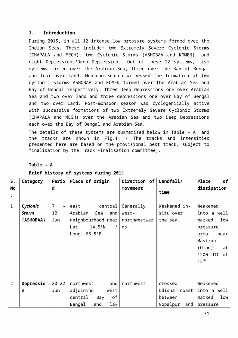
1. Introduction During 2015, in all 12 intense low pressure systems formed over the Indian Seas. These include; two Extremely Severe Cyclonic Storms (CHAPALA and MEGH), two Cyclonic Storms (ASHOBAA and KOMEN), and eight Depressions/Deep Depressions. Out of these 12 systems, five systems formed over the Arabian Sea, three over the Bay of Bengal and four over Land. Monsoon Season witnessed the formation of two cyclonic storms ASHOBAA and KOMEN formed over the Arabian Sea and Bay of Bengal respectively; three Deep depressions one over Arabian Sea and two over land and three depressions one over Bay of Bengal and two over Land. Post-monsoon season was cyclogenically active with successive formations of two Extremely Severe Cyclonic Storms (CHAPALA and MEGH) over the Arabian Sea and two Deep Depressions each over the Bay of Bengal and Arabian Sea. The details of these systems are summarised below in Table – A and the tracks are shown in Fig.1: ( The tracks and intensities presented here are based on the provisional best track, subject to finalisation by the Track Finalisation committee).
Table – ABrief history of systems during 2015
S. No.
Category Period Place of Origin Direction of movement
Landfall/
time
Place of dissipation
1 Cyclonic Storm (ASHOBAA)
7 – 12 Jun.
east central Arabian Sea and neighbourhood near Lat. 14.5°N / Long. 68.5°E
Generally west-northwestwards
Weakened in-situ over the sea.
Weakened into a well marked low pressure area near Masirah (Oman) at 1200 UTC of 12th
2 Depression 20–22 Jun
northwest and adjoining west central Bay of Bengal and lay centred near Lat. 18.0°N / Long. 86.0°E
northwest crossed Odisha coast between Gopalpur and Puri around 0100 UTC of 21st
(to be checked with hourly observation from CWC BWN)
Weakened into a well marked low pressure area and lay over Odisha and adjoining areas of Jharkhand & Chhattisgarh on 22nd
morning.
3 Deep Depression
22– 25 Jun
northeast and adjoining eastcentral Arabian Sea near Lat. 20.0°N / Long. 67.0°E
East-northeast, northeast and then again East-northeast
south Gujarat coast near Diu between 0900 and 1000 UTC of
Weakened into a well marked low pressure area over
21

23rd northwest Madhya Pradesh and neighbourhood on 25th
morning.
4 Land Depression
10– 12 July
Jharkhand and neighbourhood centered near Lat. 23.1°N / Long. 85.1°E
West-northwest, northwest
-
weakened into a well marked low pressure area over northwest Uttar Pradesh and adjoining areas of Haryana on 12th evening.
5 Land Deep depression
27 - 30 Jul.
southwest Rajasthan and neighbourhood near at.26.2°N/Long.71.8°E
North-northeast
-
Weakened into a well marked low pressure area over west Rajastan and neighbourhood.
6 Cyclonic Storm (KOMEN)
26 July – 2 Aug.
northeast Bay of Bengal and adjoining coastal areas of Bangla Desh & West Bengal and lay centred near Lat.22.0°N/Long.90.8°E
West crossed Bangla Desh coast between Hatia and Sandwip during 1400 to 1500 UTC on 30th.
weakened into a well marked low pressure area over Jharkhand and adjoining areas of north Odisha and north Chhattisgarh on 2nd Aug.
7 Land Depression
4-5 Aug.
east Madhya Pradesh and adjoining Chhattisgarh centred near Lat. 22.7°N and Long. 80.5°E
west
-
Weakened into a well marked low pressure area over southwest Madhya Pradesh and neighbourhood on 00UTC of 5th.
8 Land Deep depression
16 - 19 Sept.
south Odisha and neighbourhood near Lat.20.3°N/Long.83.3°E
West-northwest and west
- weakened into a well marked low pressure
22

area over north Madhya Maharashtra & adjoining areas of southwest Madhya Pradesh and Gujarat region.
9 Deep Depression
9 – 12 Oct.
eastcentral Arabian Sea centred near Lat. 14.0°N / Long. 70.3°E
northwest Weakened in-situ over the sea.
east central and adjoining west central Arabian Sea.
10 Extremely Severe Cyclonic Storm 'CHAPALA'
28 oct. – 4 Nov.
southeast Arabian Sea and adjoining area of southwest and central Arabian Sea, centred near Lat. 11.5°N / Long. 65.0°E,
Northwest and then west
Yemen coast to the southwest of Riyan (14.1/48.65) during 0100-0200 UTC on 3rd Nov.
Yemen
11 Extremely severe cyclonic storm ‘MEGH’
5 – 10 Nov.
eastcentral Arabian Sea, centred near Lat.14.1° N / Long. 66.0° E
Northwest and then west
Yemen coast near latitude 13.4°N/46.1°E around 0900 UTC on 10th.
Yemen and neighbourhood.
12 Deep Depression
8-10 Nov.
Southwest Bay of Bengal Lat.10.7°N/ Long. 83.7°E.
northwest north Tamil Nadu coast close to Marakanam (north of Puducherry) near latitude 12.2°N/80.0°E around 1400 UTC on 9th.
north Tamilnadu and neighbourhood
2. Details of the systems2.1 Cyclonic Storm (ASHOBAA) over the Arabian Sea (7th – 12th June 2015)
2.1.1 A trough of low at mean sea level lay over Lakshadweep area and neighbourhood on 3rd and over southeast Arabian sea and adjoining Lakshadweep area on 4th and 5th with a cyclonic circulation aloft. It organised into a low pressure area over southeast and adjoining east central Arabian Sea with associated cyclonic circulation extending upto 3.1 kms a.s.l. on 6th and became a well marked low pressure area over the same region on 7th, early morning. It then concentrated into a Depression over east central Arabian Sea and neighbourhood and lay centred near Lat. 14.5°N / Long. 68.5°E,
23

about 690 km southwest of Mumbai and 740 km south southwest of Veraval at 0300 UTC on 7th. Moving north northwestwards it lay centred near Lat. 16.0°N / Long. 68.0°E, about 580 km southwest of Mumbai and 560 km south southwest of Veraval at 1200 UTC of 7th. It moved north northwestwards and intensified into a Deep Depression and lay centred near Lat. 17.5°N / Long. 67.5°E, about 590 km west southwest of Mumbai & 480 km south southwest of Veraval at 0000 UTC on 8th. It continued to move north northwestwards and intensified into a Cyclonic Storm (ASHOBAA) and lay centred near Lat. 17.9°N / Long. 67.2°E, about 590 km west southwest of Mumbai & 470 km southwest of Veraval at 0300 UTC on 8th. It moved northwestwards and lay centred near Lat. 18.6°N / Long. 66.5°E, about 480 kms southwest of Veraval at 1200 UTC on 8th. It continued to move northwestwards and lay over east central and adjoining northwest and west central Arabian Sea, centred near Lat. 20.0°N / Long. 65.0°E about 570 kms west southwest of Veraval and 640 kms east-southeast of Sur (Oman) at 0300 UTC on 9 th. It moved west-northwestwards and lay centred near Lat. 21.0°N / Long. 63.0°E, about 860 kms west of Veraval and 400 kms east-southeast of Sur (Oman) at 1200 UTC on 9th. It moved westwards and lay centred over northwest and adjoining west central Arabian Sea, near Lat. 21.3°N / Long. 61.8°E about, 270 kms southeast of Sur (Oman) and 310 kms eastnortheast of Masirah (Oman) at 0300 UTC on 10th. Subsequently moving west southwestwards, it lay over northwest Arabian Sea, near Lat. 21.2°N / Long. 61.1°E, about 235 km, east northeast of Masirah (Oman) at 1200 UTC of 10 th. It moved west-southwestwards and lay centred near Lat. 20.8°N / Long. 60.8°E about 200 kms east-northeast of Masirah (Oman) at 0300 UTC on 11th. It moved westwards lay centred near Lat. 20.8°N / Long. 60.0°E about 120 kms east-northeast of Masirah (Oman) at 1200 UTC of 11th. It continued to move westwards and weakened into a Deep Depression, near Lat. 20.8°N / Long. 59.7°E at 1800 UTC of 11th and further weakened into a Depression near Lat. 20.8°N / Long. 59.5°E at 0000 UTC of 12th. It remained practically stationary and lay centred near Lat. 20.8°N / Long. 59.5°E, about 60 kms east-northeast of Masirah (Oman) at 0300 UTC of 12th. It moved slightly west southwestwards and weakened into a well marked low pressure area over the same region on the same evening.
The observational details are given in Table–1.
Table–1
Date / Time (UTC)
Intensity Position near
Lat. o N / Long. o E(Best Track)
Based on
Revised Estimates on Satellite Imagery /RADAR Obsn.
Supporting synoptic / asynoptic observations
07 Jun/ 0300
Depression 14.5 / 68.5 C.I. No. 1.5 Ship TBWUK35(10.3/65.0): 1005.9hPa, 320/16ktsBuoy 23451(15.0/68.8):- 1003.1 hPaBuoy 23675(14.2/67.7):
24

1002.6 hPa Amini Divi: 1005.4 hPa 180/4kts
07 Jun/ 1200
Depression 16.0/68.0 C.I. No. 1.5 Buoy 23675 (14.2/67.8): 1001.4 hPaBuoy 23451(15.0/68.8): 1002.3 hPaBuoy 23976(18.3/68.3): 1000.1 hPaBuoy 23690(18.6/66.6): 1001.7 hPa
08 Jun/ 0000
Deep Depression
17.5/67.5 C.I. No. 2.0 Buoy 23690(18.6/66.6): 995.2 hPaBuoy 23976(18.3/68.1): 992.3 hPaBuoy 23451(15.0/68.8): 1000.6 hPaBuoy 23675(14.2/67.8): 1001.9 hPa
08 Jun/ 0300
Cyclonic Storm ASHOBAA
17.9/67.2 C.I. No. 2.5 Buoy 23976(18.2/68.1): 995.9 hPaBuoy 23690(18.6/66.6): 992.7 hPaBuoy 23690(14.2/67.8): 1001.9 hPaBuoy 23910(17.8/59.2): 1002.2 hPa
08 Jun/ 1200
Cyclonic Storm ASHOBAA
18.6/66.5 C.I. No. 2.5 Buoy 23690(18.5/66.4): 986.2 hPaBuoy 23976(18.5/68.1): 999.0 hPaShip ZCBU3 (15.4/68.8): 1003.4 hPa 190/23ktsShip A8UB3 (12.8/57.6): 1004.0 hPa 250/25ktsShip A8CB7 (13.4/55.3): 1003.0 hPa 250/20ktsMashirah:- 999.4 hPaRas Al Hadd:- 999.5
25
hPa
09 Jun/ 0300
Cyclonic Storm ASHOBAA
20.0/65.0 C.I. No. 2.5 Buoy 23910(18.1/59.1): 1002.0 hPaBuoy 23693(16.1/60.3): 1003.4 hPaBuoy 23910(18.4/68.3): 1004.3 hPaRajkot:- 1005.6 hPa, 200/8kts
09 Jun/ 1200
Cyclonic Storm ASHOBAA
21.0/63.0 C.I. No. 3.0 Ship VRMX7 (16.7/65.8): 999.0 hPa, 230/20ktsShip WKAB (15.4/57.9): 1000.7 hPa 240/15ktsShip A8CH2 (12.8/56.2): 1003.0 hPa 220/33ktsShip WKPM (12.6/64.4): 1001.3 hPa 250/33ktsBuoy 23910(18.1/59.1): 999.5 hPa Mashirah: 999.4 hPa Ras Al Hadd: 999.4 hPa, 30/10kts,
10 Jun/ 0300
Cyclonic Storm ASHOBAA
21.3/61.8 C.I. No. 3.0 Buoy 23910(18.2/59.1): 999.7 hPaBuoy 23693(16.0/60.4): 1002.2 hPaShip BATFR28 (18.8/63.3): 250/14ktsJiwani: 1000.8hPa, 90/10kts Mashirah: 1000.3 hPa 260/5kts Ras Al Hadd: 1000.6hPa
10 Jun/ 1200
Cyclonic Storm ASHOBAA
21.2/61.1 C.I. No. 3.0 Ship CQII (20.4/65.4): 1000.5 hPa, 190/22ktsShip BATFR28 (18.5/65.5): 180/23ktsBuoy 23910(18.3/59.1):
26

998.2 hPaShip WKPM (15.1/58.4): 995.1 hPa, 230/30kts Mashirah: 998.0 hPa,Ras Al Hadd: 997.9 hPa
11 Jun/ 0300
Cyclonic Storm ASHOBAA
20.8/60.8 C.I. No. 2.5 Mashirah: 999.1 hPa, 300/11kts Ras Al Hadd: 999.2 hPaShip TBWUK50 (23.2/62.8): 1002.9 hPa, 170/15kts Buoy 23910(18.4/59.2): 998.2 hPa Buoy 23693(15.8/60.5): 1001.7 hPa
11 Jun/ 1200
Cyclonic Storm ASHOBAA
20.8/60.0 C.I. No. 2.5 Ship CQII (18.1/59.2):-240/31kts, 997.0 hPa Marmul:-993.6hPaSohar Majis: 1000.4hPa, 060/12ktsYaaloni:- 996.1hPa, Buoy 23693(15.8/60.5): 1000.7 hPa
11 Jun/ 1800
Deep Depression
20.8/59.7 C.I. No. 2.0 Mashirah:- 998.6hPa, 350/22kts Ras Al Had:- 998.6hPa, 030/12ktsIbra:- 999.7hPa, 020/11kts Pasni: 090/4 ktsShip A8CB7 (19.1/59.2): 999.0 hPa, 270/25kts Ship CQII (17.6/57.5):-220/28kts
12 Jun/ 0000
Depression 20.8/59.5 C.I. No. 1.5 Mashirah: 996.7hPa, 320/22kts Ras Al Had: 998.0hPa, 060/17kts
27

Ibra: 997.3hPa, 010/12kts Ship DIXJ2(24.0/59.6): 1001.5 hPa, 240/25kts Buoy 23910(18.5/59.3): 997.2 hPa
12 Jun/ 0300
Depression 20.8/59.5 C.I. No. 1.5 Mashirah: 997.6hPa, 330/31kts Ras Al Had: 999.9hPa, 070/18kts Yaaloni: 999.9hPa, 260/4kts Ship DIXJ2(23.7/60.5): 1001.4 hPa, 070/28kts Buoy 23910(18.5/59.3): 999.2 hPa
12 Jun/ 0600
Depression 20.8/59.5 C.I. No. 1.5 Mashirah: 997.7hPa, 320/37kts Ras Al Had: 1000.9hPa, 070/17kts Ibra: 1008.0hPa, 010/11kts Ship DIGY2(18.2/57.3): 1003.2 hPa, 230/17kts Buoy 23910(18.5/59.3): 1000.4 hPa
12 Jun/ 1200
It moved slightly west southwestwards and weakened into a well marked low pressure area over northwest Arabian Sea and adjoining Oman region on 12th evening.
2.1.2 Other features observedThe lowest ECP was 990 hPa from 0600 UTC of 9th to 1500 UTC of 10th. The
maximum estimated mean wind speed was 45 kts from 1800 UTC of 9 th to 2100 UTC of 10th. The lowest observed pressure of 986.2 hPa was reported by Buoy 23690(18.5/66.4) at 1200 UTC of 8th, when the system was to the west of the Buoy 23690. The maximum observed mean wind speed of 33 kts was reported by Ship WKPM (12.6/64.4) at 1200 UTC of 9th. The system moved initially northwest, westward and then westsouthwest and again westward direction.
2.1.3 Weather and damage caused
28

Heavy to very heavy rainfall occurred at isolated places over Gujarat State. Scattered to widespread rainfall with heavy rainfall occurred at isolated places over the sub-divisions along the west coast.No damage has been reported due to this system.Chief amounts of 24 hrs rainfall (more than 2 cm ) ending at 0300 UTC of 7th -12th Jun, 2015 are given below.
7.6.2015
Saurashtra & Kutch: 4 – Bhanvad
Konkan & Goa: 9 - Kankavli; 3 - Lanja, Guhagarh and Devgarh each; 2 - Mangaon and Rajapur each
Lakshadweep: 2 - Amini Divi
8.6.2015
Gujarat Region: 9 - Kaprada; 7 - Silvassa and Valsad each; 6 - Vapi; 5 - Pardi; 4 - Madhbun and Nanipalson each.
Konkan & Goa: 4 - Panjim (Goa); 3 - Malvan, Bhira, Marmugoa and Shahapur each
Coastal Karnataka: 5 - Karwar and Mangaluru each; 4 - Mulki; 3 - Udupi, Kota, Mudubidre and Gokarna each.
Kerala: 8 - Cherthala and Kayamkulam Agri each; 7 - Kunnamkulam, Kayamkulam and Kannur each; 6 - Chengannur, Ponnani, Vaikom and Thiruvananthapuram AP each; 5 - Thiruvananthapuram, Alappuzha and Haripad each.
Lakshadweep: 3 - Agathi and Kavaratti each; 2 - Amini Divi.
9.6.2015
Gujarat Region: 13 - Kaprada; 8 - Nanipalson; 7 - Dharampur; 4 - Vansda and Chikhli each.
Saurashtra & Kutch: 5 - Okha; 4 - Khambhalia and Jodia each; 3 - Tankara and Dhrol ARG each.
Konkan & Goa: 5 - Malvan; 4 - Sawantwadi and Canacona each; 3 - Kankavli, Vengurla, Mulde - AWS, Quepem and Devgarh each.
Coastal Karnataka: 8 - Mangaluru AP and Mangaluru AP each; 6 - Mulki and Gokarna each; 5 - Karwar, Udupi, Mudubidre, Karkala, Bantwal and Mangaluru each; 4 - Kollur, Honavar, Ankola and Kumta each.
Kerala: 6 - Kumarakom, Kannur and Mavelikara each; 5 - Alappuzha, Piravam, Karipur and Cherthala each; 4 - Kollam Rly, Taliparamba, Vaikom and Thalasserry each; 3 - Perinthalamanna, Enamakkal, Konni and Vadakara each.
29

Lakshadweep: 3 - Kavaratti.
10.6.2015
Gujarat Region: 7 - Dangs (Ahwa); 5 - Sanand; 4 - Arnej AWS; 3 - Dhandhuka.
Saurashtra & Kutch: 3 – Chotila
Konkan & Goa: 6 - Canacona; 4 - Marmugoa, Sanguem, Dahanu and Quepem each; 3 - Kudal, Dabholim (Goa), Panjim (Goa), Ratnagiri, Devgarh, Mulde - AWS, Mulde Agri, Valpoi, Margao, Dodamarg and Mapusa each.
Coastal Karnataka: 9 - Mangaluru AP, Mangaluru AP and Panambur each; 8 - Karwar; 6 - Mangaluru, Subramanya, Mulki and Kota each; 5 - Manki, Siddapura and Shirali PTO each.
Kerala: 6 - Kannur; 5 - Kudulu and Cheruthazham each; 4 - Enamakkal, Hosdurg and Ponnani each; 3 - Taliparamba, CIAL Kochi, Kunnamkulam and Irinjalakuda each.
Lakshadweep: 2 – Agathi.
11.6.2015
Gujarat Region: 6 - Waghai ARG; 2 - Dhandhuka and Bodeli each.
Saurashtra & Kutch: 4 - Dhrol ARG; 3 - Rajkot and Dhrol.
Konkan & Goa: 4 - Panjim (Goa) and Dahanu each; 2 - Mapusa and Vengurla each.
Coastal Karnataka: 3 - Mulki; 2 - Karwar.
Kerala: 9 - Kunnamkulam; 5 - Thalasserry, Kannur and Vellanikkara each; 4 – Mattanur
Lakshadweep: 2 - Amini Divi and Kavaratti each.
12.6.2015
Gujarat Region: 7 - Bodeli; 6 - Sankheda; 5 - Khedbrahma; 4 – Surat.
Saurashtra & Kutch: 9 - Dhari; 5 - Bhesan; 3 - Jafrabad, Lathi and Kalavad each.
Konkan & Goa: 8 - Canacona, Mumbai (SCZ), Dodamarg and Mapusa each; 7 - PalgharAgri, Talasari and Mulde - AWS each; 6 - Sawantwadi, Mhasla, Harnai and Dabholim (Goa) each; 5 - Mulde Agri, Alibag and Devgarh each; 4 - Kankavli, Panjim (Goa), Chiplun, Ratnagiri, Khed, Shriwardhan and Marmugoa each.
Coastal Karnataka: 19 - Karwar; 13 - Bantwal; 12 - Ankola; 10 - Manki; 9 - Mudubidre; 8 - Mani and Dharmasthala each; 7 - Shirali and Shirali PTO each; 6 - Honavar, Kadra, Panambur, Puttur HMS and Uppinangadi each; 5 - Karkala, Haliyal, Mangalooru AP and Mangaluru AP each; 4 – Gersoppa.
30
Kerala: 9 - Kochi AP; 8 - Ernakulam South; 7 - Aluva PWD, Kannur and Thodupuzha each; 6 - Piravam; 5 - Kozhikode, Quilandi, Kurudamannil, Kanjirappally, CIAL Kochi, Ottapalam and Kodungallur each; 4 - Enamakkal, Taliparamba and Ponnani each.
Lakshadweep: 12 - Amini Divi; 4 - Kavaratti; 3 - Minicoy.
2.2 Depression over northwest and adjoining west central Bay of Bengal (20th– 22nd
Jun 2015)
2.2.1 A cyclonic circulation extending between 4.5 & 5.8 kms a.s.l. lay over west central Bay of Bengal off south Odisha - north Andhra Pradesh coasts on 16 th. Under its influence, a low pressure area formed over the same region on 17th. It persisted there on 18th. It lay as a well marked low pressure area over west central and adjoining northwest Bay of Bengal off south Odisha - north Andhra Pradesh coasts with associated cyclonic circulation extending upto 7.6 kms a.s.l. tilting southwestwards with height on 19th. It concentrated into a Depression over northwest and adjoining west central Bay of Bengal and lay centred near Lat. 18.0°N / Long. 86.0°E, about 200 kms south of Puri at 0300 UTC of 20 th. It moved northwestwards and lay centred near Lat. 19.0°N / Long. 85.5°E, about 150 kms south-southwest of Puri at 1200 UTC of 20th. It continued to move northwestwards and crossed Odisha coast between Gopalpur and Puri around 0100 UTC (to be ascertained from hourly observation from CWC Bhubaneshwar) of 21st and lay over coastal Odisha, centred near Lat. 20.0°N / Long. 85.0°E, about 90 kms southeast of Phulbani at 0300 UTC of 21st. It moved slightly northwestwards and lay centered over interior Odisha, near Lat. 20.5°N / Long. 84.5°E, about 110 kms southeast of Sambalpur at 1200 UTC of 21st. Further moving northwestwards, it weakened into a well marked low pressure area in the morning hours of 22nd and lay over Odisha and adjoining areas of Jharkhand & Chhattisgarh. It lay as a low pressure area over Gangetic West Bengal and adjoining Jharkhand on 23rd and over Bangla Desh and adjoining Gangetic West Bengal on 24th. It lay over Bangla Desh and neighbourhood on 25th, over southeastern parts of Bangla Desh and neighbourhood on 26 th, over Bangla Desh and adjoining Gangetic West Bengal on 27th, over Bihar and adjoining Jharkhand on 28th and over east Uttar Pradesh and adjoining north Madhya Pradesh on 29 th
& 30th. It became less marked on 1st July. The associated cyclonic circulation extended upto mid tropospheric levels during 22nd -30th June.
The observational details are given in Table–2.
Table–2
Date / Time (UTC)
Intensity Position near Lat. o N / Long. o E(Best Track)
Based on
Revised Estimates on Satellite Imagery /RADAR Obsn.
Supporting synoptic / asynoptic observations
20 Jun/ 0300
Depression 18.0/86.0 T 1.5 Buoy 23092(17.7/89.6):
31

1001.1 hPa, 190/25kts. Buoy 23093(16.4/87.9): 1005.7 hPa, 230/23kts.. 1007.1 hPaGopalpur: 994.8 hPa, 360/6 ktsBWN: 995.3 hPa, 050/2 ktsVSK: 996.5 hPa, 230/5 ktsTeknaf: 1002.3 hPa, 140/14 kts
20 Jun/ 1200
Depression 19.0/85.5 T 1.5 Buoy 23092(17.7/85.5): 1003.6 hPa, 210/27kts. Ship PEND(17.0/85.0): 992.7 hPa, 250/39kts.. VSK: 994.0 hPa, 230/3 ktsGopalpur: 990.5 hPa, 360/8 ktsBWN: 991.7 hPa, 050/8 ktsTeknaf: 1002.3 hPa, 140/14 kts
20 Jun The system crossed Odisha coast between Gopalpur and puri during 2000-2100UTC.
21 Jun/ 0300
Depression 20.0/85.0 - Buoy 23093(16.4/87.9): 1002.0 hPa, 220/27kts. Gopalpur: 993.4 hPa, 250/4 ktsBWN: 993.7 hPa, 090/8 ktsJharsuguda: 995.3 hPa, 050/1 kts KNJ: 995.5 hPa, 050/3 kts
21 Jun/ 1200
Depression 20.5/84.5 - Gopalpur: 993.4 hPa, 200/12 ktsBWN: 992.6 hPa, 200/10 kts
32

Jharsuguda: 991.7 hPa, 050/2kts KLN: 994.9 hPa, 230/12 ktsJSD: 992.9 hPa, 090/4 kts
22Jun/0000
The system weakened into a well marked low pressure area over interior Odisha and adjoining areas of Jharkhand & Chhattisgarh at 0000 UTC.
2.2.2 Other features observedThe lowest observed pressure of 990.5 hPa was reported by Gopalpur at 1200 UTC
of 20th, when the system was to its east. The maximum mean wind speed of 39 kts was reported by Ship PEND(17.0/85.0) at 1200 UTC of 20th. The system moved in a northwest and then weakened into a well marked low pressure area and lay over Odisha and adjoining areas of Jharkhand & Chhattisgarh.
2.2.3 Weather and damage causedActive to vigourous monsoon activity was observed over Odisha, north coastal Andhra Pradesh and Telangana. No damage has been reported due to this depression.
Chief amounts of 24 hrs. Rainfall (more than 5 cm ) ending at 0300 UTC from 20 th to 21st June 2015 are given below:
20.6.2015
Odisha: 18 - Malkangiri; 7 - Pottangi and Athgarh each; 6 - Soro; 5 - Banki ARG, Bonth, Rajghat and Dhenkanal each.
Telangana: 16 - Koida; 14 - Kunavaram; 13 - Dummugudem and Mulakalapalle each; 11 - Aswaraopeta and Aswapuram each; 10 - Manuguru; 9 - Sathupalle and Burgampadu each; 8 - Palawancha; 7 - Venkatapuram, Kothagudem, Pinapaka and Julurpad each; 6 - Perur and Chandrugonda each; 5 - Kaleswaram, Eturnagaram and Tekulapalle each.
Coastal Andhra Pradesh: 17 - Kakinada, Amalapuram and Visakhapatnam AP each; 16 - Rajahmundry; 15 - Polavaram; 14 - Peddapuram and Dowleshwaram each; 13 - Tanuku; 11 - Palakoderu; 10 - Prathipadu, Narsapur and Visakhapatnam each; 9 - Koyyalagudem, Tuni and Tadepalligudem each; 8 - Gantyada; 7 - Bheemavaram, Bheemunipatnam, Gajapathinagaram, Chintalapudi, Chodavaram, Tiruvuru, Yelamanchili, Bondapalle and Chintapalle each.
21.6.2015
33

Odisha: 33 - Jhorigam ARG; 21 - Umarkote and Malkangiri each; 16 - R.Udaigiri; 14 - Chandahandi ARG; 13 - Junagarh, Jeypore, Dharmagarh ARG, Mahendragarh, Gudari and Raighar ARG each; 12 - Tentulikhunti ARG; 11 - Gopalpur, Dabugan ARG and Jaipatna each; 10 - Nawarangpur, Mohana, Digapahandi ARG, Bissem -Cuttack and Madhabarida each; 9 - Nuagada ARG, Chhatrapur, Banki ARG and Berhampur each; 8 - Purushottampur, Aska, Koraput and Kashipur each; 7 - Similiguda AWS; 6 - Kaptipada ARG, Rayagada, Gunupur, Jaipur, Udala and Nawana each; 5 - Pottangi, Bhanjnagar, Kotraguda, Kesinga ARG, Sorada, Jagannath Prasad ARG, Balimundali and Khairamal each
Telangana: 18 - Eturnagaram and Shayampet each; 17 - Khanapur, Parkal, Gundala and Gudur each; 16 - Venkatapuram and Venkatapur each; 15 - Chennaraopet, Govindaraopet, Kaleswaram, Mulakalapalle, Mulugu (Arg), Atmakur, Yellandu, Kothagudem and Narsampet each; 14 - Mogullapalle and Palawancha each; 13 - Pinapaka, Bhupalpalle and Mahbubabad each; 12 - Manuguru and Nallabelly each; 11 - Adilabad, Bayyaram, Tekulapalle, Dummugudem and Chennur each; 10 - Kothagudem, Hasanparthy, Julurpad, Huzurabad, Sultanabad and Chandrugonda each; 9 - Hanamkonda, Manthani, Aswapuram, Enkuru, Dornakal and Garla each; 8 - Karimnagar, Koida, Parvathagiri, Dharmasagar, Julapalle, Sirpur T, Ramagundam, Bheemadevarpalle and Pegadapalle each; 7 - Burgampadu, Boath, Dharmapuri, Utnur, Thollada and Asifabad each; 6 - Ibrahimpatnam, Kunavaram, Luxettipet, Mallial, Sarangapur, Zaffergadh, Jagtial, Thimmapur, Nirmal and Sathupalle each; 5 - Khanpur, Aswaraopeta, Metpalle, Konijerla and Shriramsag.Pocha each.
Coastal Andhra Pradesh: 20 - Ichchapuram; 12 - Sompeta; 11 - Kalingapatnam; 9 - Mandasa, Cheepurupalle, Garividi and Ranastalam each; 8 - Palasa.
2.3 Deep Depression over northeast and adjoining eastcentral Arabian Sea (22nd – 25th June 2015)2.3.1 A cyclonic circulation lay over northeast Arabian sea off Gujarat coast and extended between 1.5 & 4.5 kms a.s.l. during 18th- 20th. Under its influence, a low pressure area formed over northeast Arabian Sea off Gujarat coast on 21st. It lay as a well marked low pressure area over northeast and adjoining eastcentral Arabian Sea on the same evening. It subsequently concentrated into a Depression over the same area and lay centred near Lat. 20.0°N / Long. 67.0°E, about 320 kms southwest of Porbandar at 0300 UTC of 22nd. It remained practically stationary and lay centred near Lat. 20.0°N / Long. 67.0°E, at 1200 UTC of 22nd. Then it moved eastnortheastwards, intensified into a Deep Depression over northeast Arabian Sea off south Gujarat coast and lay centred near Lat. 20.5°N / Long. 70.5°E, about 50 kms west-southwest of Diu at 0300 UTC of 23rd. It moved east-northeastwards and crossed south Gujarat coast near Diu between 0900 and 1000 UTC of 23rd and lay over Saurashtra centred near Lat. 21.0°N / Long. 71.3°E, about 65 kms south-southeast of Amreli at 1200 UTC of 23rd. It moved northeastwards and lay over Saurashtra & adjoining Gujarat Region centered near Lat. 22.4°N / Long. 72.0°E, about 85 kms southwest of Ahmedabad at 0300 UTC of 24th. It then moved east northeastwards and lay over Gujarat region and neighbourhood near Lat. 22.8°N / Long. 72.7°E, about 80 km southeast of Ahmedabad and 40 km north of Vadodara at 0600 UTC of 24th. Further moving east northeastwards, and weakened into a Depression at 1200 UTC of 24th near Lat. 23.5°N / Long. 74.0°E, over Gujarat region and adjoining areas of west Madhya Pradesh and south Rajasthan, about 50 km northwest of Dohad (Gujarat) and 130 km west southwest of Ratlam (west Madhya Pradesh). It weakened into a well marked low pressure area over northwest Madhya Pradesh and neighbourhood in the morning hours of 25th and lay as a low pressure area over northwest Madhya Pradesh and adjoining south Uttar Pradesh at 0300 UTC on
34

25th and over central parts of north Uttar Pradesh and neighbourhood on 26th. It became less marked on 27th. The associated cyclonic circulation extended upto mid tropospheric levels during 25th - 26th. It also became less marked on 27th.
The observational details are given in Table–3.
Table–3
Date / Time (UTC)
Intensity Position near Lat. o N / Long. o E(Best Track)
Based on
Revised Estimates on Satellite Imagery /RADAR Obsn.
Supporting synoptic / asynoptic observations
22 June/ 0300
Depression 20.0/67.0 T 1.5 Buoy 23976(17.1/69.4): 997.9 hPa Buoy 23451(15.0/68.9): 1002.0 hPa, 240/17ktsDwarka: 994.3 hPa, 090/6 ktsVeraval: 996.1 hPa, 180/5 ktsPorbandar: 996.1 hPa, 180/5 ktsPasni: 994.8 hPa, 050/2 kts Karachi AP: 994.0hPa, 110/10 kts
22 June/ 1200
Depression 20.0/67.0 T 1.5 Buoy 23976(17.1/69.5): 996.3 hPa Buoy 23451(14.9/68.8): 1000.5 hPa, 220/29ktsShip 56LTS(12.7/60.7): 1005.0 hPa, 230/40kts Ship WKAB(12.3/65.9): 1002.8 hPa, 250/25kts Kandla: 991.4 hPa, 110/17kts
35

Naliya: 991.0 hPa, 020/4 ktsporbandar: 992.7 hPa, 180/4 kts
23 June/ 0300
Deep Depression
20.5/70.5 T 2.0 Buoy 23976(17.2/69.8): 998.9 hPa Buoy 23451(15.0/68.8): 1002.5 hPa, 220/21ktsDiu: 989.6 hPa, 110/12kts Porbandar: 993.5 hPa, 360/8kts Rajkot: 994.3 hPa, 110/9ktsBaroda: 996.7 hPa, 140/10 kts
23 June The system crossed South Gujarat coast near Diu between 0900 & 1000 UTC
23 June/ 1200
Deep Depression
21.0/71.3 - Buoy 23976(17.1/70.0): 998.6 hPa Mahuva: 990.1 hPa, 180/16ktsDiu: 988.4 hPa, 290/11kts Amreli: 988.7 hPa, 050/2kts Bhavnagar: 992.7hPa, 180/25ktsVeraval: 989.5 hPa, 340/10 kts
24 June/ 0300
Deep Depression
22.4/72.0 - Diu: 997.7 hPa, 250/24kts Porbandar: 998.2 hPa, 340/16kts Rajkot: 995.0 hPa, 340/16ktsMahuva: 995.7 hPa, 230/13 ktsBhavnagar: 988.4 hPa, 230/22ktsSurat: 995.4 hPa, 200/25 kts
24 June/ 0600
Deep Depression
22.8/72.7 - Baroda: 990.1 hPa, 270/21kts Veraval: 999.3 hPa, 250/17kts Rajkot: 997.0 hPa, 290/9ktsMahuva: 995.7 hPa, 230/13 kts
36

Bhavnagar: 996.4 hPa, 270/19kts
24 June/ 1200
Depression 23.5/74.0 - Bhuj: 994.5 hPa, 270/5kts Porbandar: 997.5 hPa, 250/13kts Rajkot: 996.1 hPa, 250/12ktsMahuva: 998.3 hPa, 230/15 ktsBhavnagar: 987.0 hPa, 230/10ktsSurat: 998.2 hPa, 230/18 ktsJodhpur: 990.8 hPa, 140/4 kts
25 Jun/0000
The systen weakened into a well marked low pressure area over northwest Madhya Pradesh and adjoining south Uttar Pradesh.
2.3.2 Other features observedThe lowest observed pressure of 988.4 hPa was reported by Diu at 1200 UTC of
23rd, when the system was to its north. The maximum mean wind speed of 40 kts was reported by Ship 56LTS (12.7/60.7) at 1200 UTC of 22nd.
2.3.3 Weather and damage causedHeavy to very heavy rainfall rainfall occurred over Gujarat state, Rajasthan and west
Madhya Pradesh with extremely heavy rainfall over Saurashtra and Kutch.This system caused damage to life and property in Gujarat. Death toll crossed 81.Chief amounts of 24 hrs. Rainfall (5 cm or more) ending at 0300 UTC from 22nd to 24th June 2015 are given below:
22.06.2014Gujarat region: 9 - Khedbrahma and Umergam each; 7 - Nanipalson; 6 - Vijaynagar; 5 - Dharoi Colony.
Saurashtra & Kutch: 6 - Rajula; 5 - Mangrol (J).
West Rajastan: 6 - Erinpura Rd
East Rajastan: 12 - Devel; 11 - Dungarpur Tehsil; 7 - Bhungra; 6 - Dhambola, Sagwara and Veja each; 5 – Garhi.
West Madhya Pradesh: 7 - Indore, Multai, Indore - AWS and Shegaon each; 6 - Sendhwa (Med) and Kannod -Arg each; 5 - Thikri, Thandla, Pandhana, Jhabua - AWS, Sonkatch and Manasa each.
East Madhya Pradesh: 7 - Bichhia; 5 – Sausar.
37

23.06.2015Gujarat region: 17 - Choryasi; 16 - Olpad; 14 - Kamrej; 10 - Valod, Surat and Jalalpor each; 9 - Valsad and Nanipalson each; 8 - Umergam and Vyara each; 7 - Navsari and Umerpada each; 6 - Vapi, Mangrol and Bodeli each; 5 - Chikhli, Ukai, Gandevi and Madhbun each.
Saurashtra & Kutch: 12 - Diu; 11 - Ghogha; 10 - Jafrabad; 9 - Talaja and Una each; 7 - Mangrol (J), Dwarka and Rajula each; 6 - Kodinar, Shihor and Malia each; 5 - Mahuva and Talala each.
East Rajastan: 9 - Rajsamand; 8 - Chabra; 6 - Chhotisadri; 5 - Arnod, Pachpahar and Manohar Thana each.
West Madhya Pradesh: 15 - Sehore - AWS; 12 - Susner; 9 - Budhni, Depalpur, Tarana, Narsingarh, Badnagar and Khilchipur each; 8 - Agar; 7 - Sonkatch, Nalkheda, Hoshangabad and Khategaon each; 6 - Suvasara and Udaipura each; 5 - Shajapur, Shajapur - AWS, Rajgarh, Tonkhurd, Atner, Sarangpur, Ichhawar, Ashta -Arg and Vidisha - AWS each.
East Madhya Pradesh: 22 - Dindori - AWS; 9 - Lanji.
24.06.2015East Rajastan: 10 - Shahabad; 5 – Jagpura.
Gujarat Region: 8 - Dhandhuka ARG, Dhandhuka and Ranpur each; 7 - Madhbun and Nanipalson each; 6 - Kaprada and Khambhat each; 5 - Surat, Silvassa, Songadh and Tarapur each.
Saurashtra & Kutch: 32 - Una; 27 - Malia; 23 - Kodinar; 22 - Talala; 19 - Rajula and Diu each; 17 - Rajkot; 13 - Jafrabad; 12 - Mangrol (J), Khambha and Tankara each; 11 - Keshod, Savarkundla, Veraval and Ranavav each; 10 - Mahuva, Gondal and Sutrapada each; 9 - Botad, Palitana, Chotila and Vanthali each; 7 - Khambhalia, Junagadh, Kotdasangani, Mendarda and Porbandar AP each; 6 - Bhaunagar, Amreli and Jetpur each; 5 - Dhari, Dhoraji, Chuda, Jamkandorna, Lodhika, Okha, Manavadar, Upleta, Bhesan and Paddhari each.
East Rajastan: 10 - Shahabad; 5 - Jagpura.
East Madhya Pradesh: 12 - Chahtarpur - AWS; 8 - Rajnagar; 6 - Khajurao; 5 - Nagode and Nagaon each.
2.4 Land Depression over Jharkhand and nighbourhood (10th -12th July 2015)
2.4.1 A cyclonic circulation extending upto mid-tropospheric levels lay over north Bay of Bengal and neighbourhood on 5th, over coastal areas of west Bengal and neighbourhood on 6th and over north Bay of Bengal and neighbourhood on 7th. Under its influence, a low pressure area formed over north Bay of Bengal and adjoining coastal areas of Bangla Desh and West Bengal with associated cyclonic circulation extending upto 5.8 kms a.s.l. on 8 th. It lay over northern parts of Gangetic West Bengal and adjoining areas of Bihar and Jharkhand with the associated cyclonic circulation extending upto 5.8 kms a.s.l. on 9th. It lay over
38
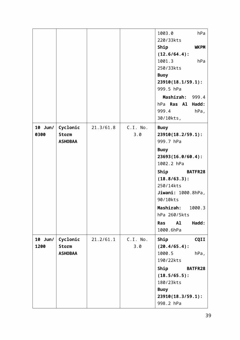
Jharkhand and adjoining areas of Gangetic West Bengal & Bihar on the same evening. It rapidly concentrated into a Depression and lay over Jharkhand and neighbourhood centered near Lat. 23.1°N / Long. 85.1°E, about 30 kms southwest of Ranchi at 0300 UTC on 10th. It moved west-northwestwards and lay over north Chhattisgarh and adjoining areas of Jharkhand centered near Lat. 23.5°N / Long. 83.5°E, about 60 Kms northeast of Ambikapur at 1200 UTC of 10th. It continued to move west-northwestwards and lay over northeast Madhya Pradesh and adjoining southeast Uttar Pradesh centered near Lat. 24.0°N / Long. 80.5°E, about 55 kms south-southwest of Satna at 0300 UTC of 11 th. It moved northwestwards and lay centred over central parts of south Uttar Pradesh and adjoining north Madhya Pradesh near Lat. 25.5°N / Long. 80.5°E about 80 kms northeast of Khajuraho and 125 kms southwest of Fursatganj at 1200 UTC of 11th. It further moved northwestwards and lay over west Uttar Pradesh and adjoining areas of Haryana centred near Lat. 28.5°N / Long. 78.0°E, about 55 kms east of Delhi at 0300 UTC of 12 th and over Haryana and neighbourhood, near Lat. 28.5°N / Long. 77.3°E, close to Delhi at 0900 UTC of 12th. It moved northwestwards and weakened into a well marked low pressure area over northwest Uttar Pradesh and adjoining areas of Haryana on the same evening. It further moved northwestwards and lay as a low pressure area over Punjab and adjoining Haryana with associated cyclonic circulation extending upto 3.1 kms a.s.l. on 13 th and became less marked on 13th evening. The associated cyclonic circulation persisted over the same region on 13th and over Haryana and neighbourhood between 1.5 & 5.8 kms a.s.l. on 14th and became less marked on 15th.
The observational details are given in Table–4.Table–4
Date / Time (UTC)
Intensity Position near Lat. o N / Long. o E(Best Track)
Based on
Revised Estimates on Satellite Imagery /RADAR Obsn.
Supporting synoptic / asynoptic observations
10 July/ 0300
Depression 23.1/85.1 - Jamshedpur: 995.0 hPaShantiniketan 998.5 hPa, 140/5ktsDaltonganj: 994.6 hPa, 090/2kts Gaya: 995.5 hPa, 050/9kts Bhubaneshwar: 998.2 hPa, 200/12ktsMidnapur: 997.7 hPa, 230/1 kts
10 July/ 1200
Depression 23.5/83.5 - Ambikapur: 991.0 hPa, 360/3ktsRanchi: 994.2 hPa, 180/10ktsDaltonganj: 991.1 hPa,
39

090/3kts Gaya: 993.9 hPa, 090/12kts Varanasi: 993.4 hPa, 070/13ktsJamshedpur: 992.9 hPa, 140/4 kts
11 July/ 0300
Depression 24.0/80.5 - Ambikapur: 998.9 hPa, Satna: 995.0 hPa, 050/10ktsMandla: 998.4 hPa, 160/1kts Pendra Road: 997.4 hPa, Sidhi: 995.1 hPaNowgong: 996.9 hPaSagar: 997.5 hPa, 270/2kts
11 July/ 1200
Depression 25.5/80.5 - Ambikapur: 999.6 hPa, 180/2kts Satna: 994.8 hPa, 230/10ktsVaranasi: 997.6 hPa, 080/8kts Pendra Road: 998.6 hPa, 180/4ktsSidhi: 994.6 hPaNowgong: 995.1hPa
12 July/ 0300
Depression 28.5/78.0 - Agra: 997.9 hPa, 200/7kts Hardoi: 999.5 hPa, 090/1ktsBareli: 999.5 hPa, 180/2kts Shahajanpur: 998.6 hPa, 140/4ktsMeerut: 996.9 hPa, 050/3kts
12July0900
Depression 28.5/77.3 - New Delhi: 997.7 hPa, 270/5kts Meerut: 998.4 hPa, 110/3ktsBareli: 1000.6 hPa, 140/2kts Bikaner: 998.3 hPa, 320/2ktsChuru: 999.1 hPa
12 July Weakened into a well marked low pressure area over northwest Uttar Pradesh and adjoining areas of Haryana in the evening.
40

2.4.2 Other features observedThe lowest observed Pressure of 991.0 hPa was recorded by Ambikapur at 1200
UTC of 10th July, when the centre of system was very close to it. Gaya reported wind speed of 12 kts on 1200 UTC of 10th July.
2.4.3 Weather and damage causedActive to vigorous monsoon condition prevailed over Gangetic West Bengal, Odisha,
Jharkhand, Uttar Pradesh, Madhya Pradesh and Chhattisgarh with extremely heavy rainfall at isolated places over Gangetic West Bengal, Odisha and Jharkhand.
Chief amounts of 24 hrs rainfall (5 cm or more) ending at 0300 UTC from 10th -12th July are given below:
10.7.2014 Gangetic West Bengal : 26 - Deganga; 25 - Bongaon; 23 - Katwa and Durgachak each; 20 - Sonamukhi ARG and Baruipur each; 17 - Tilpara Barrage; 16 - Salar, Kolkata AP and Bolpur each; 15 - Suri CWC and Diamond Harbour each; 14 - Bashirhat, Kolkata and Chinsura each; 13 - Purihansa, Basirhat, Nandigram, Kandi and Harinkhola each; 12 - Sriniketan; 11 - Burdwan, Shekhampore ARG, Kalna, Tusuma, Kandi and Dhaniakhali ARG each; 10 - Contai, Amtala, Ranaghat, Dhaniakhali, Contai and Bagati (Magra) each; 9 - Rajnagar, Labpur, Kharidwar, Kalyani Smo, Mangalkote and Bankura CWC each; 8 - Krishnanagar, Berhampore, Barrackpur IAF, Manteswar, Digha, Phulberia and Purulia each; 7 - Narayanpur, Simula, Burdawan, Sagardighi, Manmothnagar, Hatwara, Bankura and Jiaganj each; 6 - Hetampur, Krishnanagar, Balagarh, Jangipur and Canning Town each; 5 - Mankar, Uluberia, Nakshipara, Tamluk AWS, Uluberia, Gheropara, Indus, Joypur, Rampurhat (DRMS) and Sagar each.
Odisha: 15 - Tensa; 13 - Lahunipara; 12 - Gurundia ARG; 11 - Jamankira and Banaigarh AWS each; 9 - Kuchinda, Barkote, Laikera and Deogarh each; 8 - Nawapara, Rairakhol, Kirmira ARG, Soro and Keiri AWS each; 7 - Khariar, Pallahara, Atabira ARG, Bonth, Patnagarh, Bijepur, Joda ARG, Komna, Lakhanpur ARG and Birmaharajpur ARG each; 6 - Boudhgarh, Ambabhona, Tarva ARG, Jujumura ARG, Deogaon, Athmalik, Gaisilet ARG, Sonepur, Danagadi ARG, Khairamal and Naktideul each; 5 - Batagaon, Champua, Saintala ARG, Panposh, Reamal, Sambalpur, Jharsuguda AP, Kantamal, Bolangir, Joshipur, Altuma CWC, Loisingha ARG, Daitari, Basudevpur AWS, Salebhatta ARG, Kankadahad ARG, Chandanpur, Bhadrak AWS, Rajkishorenagar and Burla ARG each.
Jharkhand: 13 - Palkot; 12 - Mandar; 11 - Ranchi AP; 10 - Messenjore; 9 - Moharo, Dumka and Deoghar each; 8 - Torpa and Simdega each; 7 - Nimdih, Kolebira, Dumri, Jarmindi and Amrapara each; 6 - Bishrampur and Madhupur each; 5 - Mohanpur, Koner, Raidih, Bokaro, Maheshpur and Giridih each.
West Uttar Pradesh: 11 - Bijnor; 10 - Baheri; 9 - Sahaswan; 8 - Garotha and Jalaun each; 6 - Bareilly, Bareilly Tehsil and Dataganj each; 5 - Orai and Rath each.
West Madhya Pradesh: 14 - Chachoda; 9 - Seodha (Seondha) and Udaipura each; 8 - Pachmarhi and Mungaoli each; 7 - Salwani / Silvani; 5 - Gohad, Morena - AWS and Begumganj each.
41
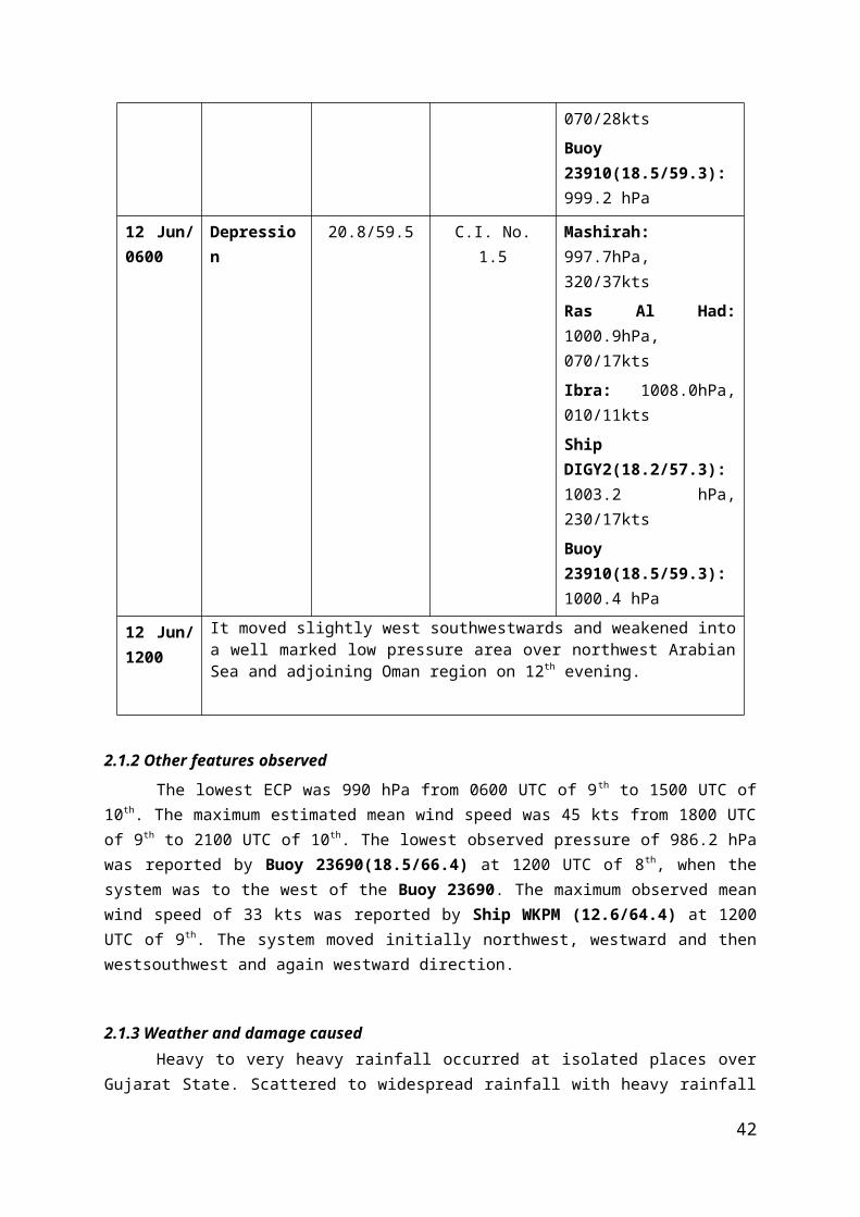
East Madhya Pradesh: 15 - Kareli; 11 - Malanjkhand; 9 - Gadarwara; 7 - Chindwara - AWS; 6 - Narsingpur, Bichhia, Jabalpur, Ghansore, Tendukheda and Sohagpur - AWS each; 5 - Lakhnadon, Khurai, Nainpur, Dindori - AWS and Maihar each.
Chhattisgarh: 8 - Ambikapur; 7 - Gandai and Gharghoda each; 6 - Mahasamund; 5 - Bemetara, Janakpur, Gariabund, Mana AP, Korba and Dhamtari each.
11.7.2014 Gangetic West Bengal : 16 - Bolpur and Pingla each; 14 - Sriniketan and Mangalkote each; 13 - Burdawan; 11 - Khirpai and Shekhampore ARG each; 9 - Burdwan; 8 - Manteswar; 7 - Dhaniakhali ARG and Amta each; 6 - Sabong, Dhaniakhali, Kanksa BSF and Kalaikunda each; 5 - Katwa, Joypur, Indus, Krishnanagar, Panagarh AP and Arambagh each.
Odisha: 26 - Sundargarh; 25 - Balisankara ARG; 22 - Hemgiri; 16 - Bargaon; 15 - Bamra ARG; 13 - Lakhanpur ARG and Laikera each; 12 - Jharsuguda AP; 11 - Kirmira ARG, Deogaon and Kolabira ARG each; 9 - Kuchinda; 8 - Salepur ARG, Burla ARG and Akhuapada each; 7 - Rajgangpur; 6 - Jamankira, Ambabhona, Junagarh, Sambalpur, Hirakud, Atabira ARG and Jajpur each; 5 - Kesinga ARG, Gaisilet ARG, Madanpur Rampur, Bargarh, Bijepur, Mandira Dam, Komna, Rairakhol, Bhavani P. and Balasore each.
Jharkhand: 39 - Kolebira; 13 - Mohanpur; 12 - Raidih; 9 - Simdega; 7 - Pakuria; 6 - Daltonganj and Palkot each; 5 – Mandar.
East Uttar Pradesh: 10 - Ankinghat; 7 - Rasoolabad, Chhibramau, Kannauj and Hasanganj each; 6 - Sultanpur; 5 - Safipur and Lucknow AP each.
West Uttar Pradesh: 14 - Narora and Mathura CWC each; 12 - Nakur; 9 - Maudaha; 8 - Gunnaur; 7 - Bisauli; 6 - Anupshahr, Jalesar, Budaun, Bareilly CWC and Saharanpur each; 5 - Gautam Buddha Nagar, Bharthana, Bidhuna, Thakurdwara, Chhata and Sahaswan each.
West Madhya Pradesh: 18 - Biaora; 15 - Rajgarh; 9 - Narsingarh, Kolaras, Morena - AWS and Sabalgarh each; 8 - Udaipura; 7 - Isagarh; 5 - Bhainder, Seodha (Seondha) and Chanderi each.
East Madhya Pradesh: 10 - Gadarwara and Maihar each; 7 - Ajaigarh, Nagode and Kotma each; 6 - Satna - AWS, Satna, Khajurao, Malanjkhand, Panna - AWS and Jaithari each; 5 - Damoh, Damoh - AWS, Anuppur - AWS, Rajnagar, Amarwara, Seoni, Seoni - AWS, Umaria and Umaria - AWS each.
Chhattisgarh: 17 - Raigarh; 12 - Janakpur; 9 - Janjgir and Pathalgaon each; 8 - Manendragarh, Korba and Jashpurnagar each; 7 - Baikunthpur, Gharghoda and Bilaspur each; 6 - Surajpur, Pali, Kanker and Ambikapur each; 5 - Champa, Narayanpur, Kawardha and Ramanujganj each.
12.7.2014 Gangetic West Bengal: 6 - Mangalkote; 5 – Hetampur.
42

Odisha:
Jharkhand: 9 – Dumka.
East Uttar Pradesh: 17 - Hardoi; 16 - Shahabad; 15 - Muhammadi and Sandila each; 12 - Neemsar; 11 - Jaunpur Tehsil and Nawabganj Tehsil each; 10 - Bara Banki and Malihabad each; 9 - Bhatpurwaghat and Sidhauli each; 8 - Sultanpur CWC, Sultanpur, Biswan, Sawayajpur, Lucknow AP and Hasanganj each; 7 - Sitapur, Misrikh, Varanasi city, Shahganj, Kannauj, Handia, Elgin Bridge and Hardoi Teh each; 6 - Rajghat (Vns CWC), Deogaon Lalganj, Musafir Khana, Sirauli Gauspur Tehsil, Allahabad AP, Muhammadbad (G), Lucknow (Hs) and Purwa each; 5 - Varanasi AP, Ankinghat, Lucknow (Cr), Gyanpur, Bani, Kaiserganj, Phoolpur Alb, Chhatnag, Fatehpur Tehsil, Karchhana, Meja, Ram Sanehi Ghat Tehsil, Tarabganj, Nighasan and Pratapgarh T each.
West Uttar Pradesh: 15 - Moradabad; 14 - Shajanpur and Shahjahapur each; 13 - Sahaswan and Amroha each; 12 - Pawayan, Bareilly and Bareilly Tehsil each; 11 - Bareilly CWC; 10 - Bilari; 8 - Kasganj; 7 - Narora, Harpur, Bisalpur, Gunnaur, Shahjahanpur T and Garotha each; 6 - Budaun; 5 - Rampur, Aonla, Sambhal, Bijnor, Mawana, Jalalabad, Anupshahr, Chhata and Nakur each.
West Madhya Pradesh: 19 - Gwalior and Dabra each; 9 - Biaora; 8 - Gohad, Khilchipur and Rajgarh each; 7 - Narsingarh and Isagarh each; 5 - Salwani / Silvani, Udaipura and Ambah each.
2.5 Land Deep depression over southwest Rajasthan and neighbourhood (27th -30th Jul. 2015)2.5.1 A low pressure area formed over northwest Madhya Pradesh and adjoining east Rajasthan on 24th and persisted there on 25th. It lay as a well marked low pressure area over east Rajasthan and neighbourhood on 26th and over central parts of Rajasthan and neighbourhood on the same evening. It lay over southwest Rajasthan and neighbourhood on 27th. Associated cyclonic circulation extending upto 5.8 kms a.s.l. persisted during 24 th - 27th. The well marked low pressure area concentrated into a Depression and lay over southwest Rajasthan & neighbourhood centred near Lat.26.2°N/Long.71.8°E, about 100 kms east-southeast of Jaisalmer (Rajasthan) at 1200 UTC on 27th evening. It then intensified into a Deep Depression and lay over southwest Rajasthan and adjoining Gujarat centred near Lat.24.8°N/Long.71.8°E, about 110 kms east-southeast of Barmer (Rajasthan) at 0300 UTC on 28th. It remained over the same region and lay centred near Lat.25.5°N/Long.72.0°E, about 70 kms south-southeast of Barmer (Rajasthan) at 1200 UTC on 28th. It moved north-northeastwards and weakened into a Depression and lay over west Rajasthan, centered near Lat.27.2°N/Long.73.0°E, about 40 kms south-southwest of Bikaner (Rajasthan) at 0300 UTC on 29th. It moved northeastwards and lay over the same region centred near Lat. 27.7°N/Long.73.0°E about 30 kms south-southeast of Bikaner (Rajasthan ) at 1200 UTC of 29th July. It moved northwards and lay over west Rajasthan and neighbourhood centered near Lat. 28.7°N / Long. 73.4°E, about 80 kms north-northeast of Bikaner (Rajasthan) at 0000 UTC on 30th. It further moved north-northeastwards and weakened into a well marked low pressure area over the same region on 30th. It lay as a low pressure area over northwest Rajasthan and neighbourhood on 30th evening. It persisted over the same region on 31st
July. over central Pakistan and adjoining west Rajasthan on 1st & 2nd Aug. and over central Pakistan and adjoining northwest Rajasthan on 3rd. It became less marked on 4th. Associated
43

cyclonic circulation extending upto mid tropospheric levels persisted during 30th July -3rd
August. It became less marked 4th.
The details of the system are given in Table 5.
Table–5
Date / Time (UTC)
Intensity Position near Lat. o N / Long. o E(Real time)
Based on
Revised Estimates on Satellite Imagery /RADAR Obsn.
Supporting synoptic / asynoptic observations
27 Jul./ 1200
Depression 26.2/ 71.8 - Jaisalmer: 991.9 hPa, 360/6 kts Khanpur (41718) :994.3 hPa, 050/6 ktsBarmer: 992.5 hPa.Bikaner: 993.4 hPa, 090/3 kts.Jodhpur: 992.5 hPa, 140/6 kts.Kota: 998.6 hPa, 180/10ktNawabshah (41749) : 994.6 hPa, 270/10kt
28 Jul./ 0300
Deep Depression
24.8/71.8 - Jaisalmer: 994.9 hPa, 050/4 kts Erinpura: 990.8, 270/3kts994.3 hPa, 050/6 ktsBarmer: 991.7 hPa, 050/6 ktsBhuj: 997.1 hPa, 270/18 kts.Jodhpur: 993.3 hPa, 090/4 kts.New Kandla: 997.6 hPa, 250/25ktsKarachi: 999.2 hPa, 270/18kt
28 Jul./ 1200
Deep Depression
25.5/72.0 - Jaisalmer: 991.6 hPa, 050/6 kts Bikaner: 993.0, 140/6kts994.3 hPa, 050/6 ktsBarmer: 991.7 hPa, 320/4 ktsBhuj: 997.8 hPa, 320/18 kts.Udaipur: 994.7 hPa, 230/16
44

kts.Chhor (41768): 995.4 hPa, 360/7ktsNawabshah (41749) : 995.4 hPa, 360/7kt
29 Jul./ 0300
Depression 27.2/73.0 - Jaisalmer: 995.9 hPa, 320/4 kts Bikaner: 993.5 hPaBarmer: 997.4 hPa, 270/4 ktsBhuj: 1001.1 hPa, 320/12 ktsPhalodi: 994.2 hPa,360/2ktsChuru: 995.7 hPa, 090/4 ktsJodhpur: 994.1 hPa, 270/3kts
29 Jul./ 1200
Depression 27.7/73.4 - Bikaner: 991.1 hPa, 050/2 ktsJodhpur: 994.3 hPa, 230/6ktsChuru: 994.0 hPa, 140/2 ktsGanganagar: 994.4 hPa, 090/2ktsJaisalmer: 995.9 hPa, 320/4 kts Hissar: 994.9 hPa, 070/3 kts
30 Jul./ 0000
Depression 28.7/73.4 - Bikaner: 993.2 hPaSymp(BKR)(27.9/73.5): 994.3 hPa, 330/21ktsChuru: 996.7 hPa, 180/3 ktsSymp(NGR)(27.1/73.6): 995.8 hPa, 240/11ktsJodhpur: 997.8hPa, 230/6 kts Ganganagar: 996.3 hPa, 070/3 kts
30 Jul. It further moved north-northeastwards and weakened into a well marked low pressure area over west Rajasthan on 30th.
2.5.2 Other features observedThe lowest observed pressure of 990.8 hPa was reported by Erinpura at 0300 UTC of 28th, when the centre of system was very close to it. The maximum sustained wind speed of 25
45

kts was reported by New Kandla at 0300 UTC of 28th. The system moved in a northnortheasterly direction weakened into a well marked low pressure area west Rajasthan.
2.5.3 Weather and damage causedActive to vigorous monsoon conditions prevailed over Rajastan, Gujarat State and
west Madhya Pradesh. This deep depression caused heavy to very heavy with extremely heavy rainfall at isolated places of Rajastan, Gujarat State and west Madhya Pradesh.
Chief amounts of 24 hrs. rainfall (7 cm or more) ending at 0300 UTC from 27 th to 30th are given below:
27.7.2015
West Rajastan: 33 - Gudamalani; 32 - Raniwada; 29 - Jaswantpura; 22 - Bhinmal; 18 - Bagoda; 17 - Bali and Chotan each; 15 - Sinderi and Sanchore each; 13 - Dorimanna and Desuri each; 12 - Erinpura Rd. and Sumerpur each; 11 - Sayla; 9 - Bilara; 7 - Pachpadra, Sedwa and Ramsar each.
East Rajastan: 45 - Mount Abu; 24 - Abu Road; 21 - Reodar; 19 - Arthuna; 15 - Sirohi; 12 - Galiakot; 11 - Danpur, Bijoliya, Nayanagar / Beawar, Veja and Bhainsroadgarh each; 10 - Chikali, Sheoganj and Kesarpura each; 9 - Pindwara, Kanva, Bagidora, Shergarh, Kumbhalgarh, Sallopat, Dungarpur Tehsil and Aspur each; 8 - Dhambola, Garhi, Sabla, Sagwara, Sajjangarh, Chambal / R.B.Dam and Nimbahera each; 7 - Gangrar, Khushalgarh, Kotda, Ladpura, Bari -Sadri, Kota AP, Loharia and Chittorgarh each.
West Madhya Pradesh: 11 - Jawad; 8 - Alirajpur - AWS and Sailana each; 7 - Nimach, Manasa, Ratlam, Ratlam - AWS and Jabot each.
Gujarat region: 19 - Dadiapada ARG and Dhanera each; 18 - Vapi; 17 - Mansa; 16 - Dahegam, Vijapur and Kankrej each; 15 - Valia, Siddhpur and Silvassa each; 14 - Dantiwada, Danta and Mangrol each; 13 - Vadgam, Himatanagar, Patan, Unjha, Amirgadh, Dharampur, Godhra and Palanpur each; 12 - Kaprada, Mahesana, Dangs (Ahwa), Kamrej and Deodar each; 11 - Dharoi Colony, Bhiloda, Tharad, Umerpada, Anand and Pardi each; 10 - Kalol (G), Jambughoda, Kadana, Daman, Wanakbori, Malpur, Umergam, Khedbrahma, Balasinor, Valsad, Deesa, Olpad, Madhubun and Kapadvanj each; 9 - Quant, Tilakwada ARG, Viramgam, Sagbara, Wav, Dhansura, Gandhinagar and Kadi each; 8 - Radhanpur, Talod, Karjan, Lunawada, Bavla, Khanpur, Bhabhar, Chhota Udepur, Gandevi ARG, Kamrej ARG, Kathalal and Dediapada each; 7 - Chhota ARG, Santrampur, Ahmedabad, Detroj, Vansda, Becharaji, Morva Hadaf, Shahera, Tilakwada, Bodeli, Fatepura, Sinor, Rajpipala, Meghraj, Nanipalson, Bardoli and Umreth each.
Saurashtra & Kutch: 19 - Junagadh; 17 - Jodia; 15 - Dasada; 14 - Bhesan; 13 - Junagarh AWS; 12 - Morbi, Vanthali and Visavadar each; 11 - Manavadar; 10 - Kotdasangani; 9 - Tankara; 8 - Amreli; 7 - Bhuj AP and Kharaghoda each.
28.7.015
46

West Rajastan: 24 - Sanchore; 19 - Raniwada; 18 - Jalore and Bagoda each; 16 - Jaswantpura; 9 - Gudamalani and Sedwa each; 7 – Bhinmal.
East Rajastan: 33 - Mount Abu; 13 - Abu Road; 12 - Reodar; 11 - Kotda; 10 - Veja; 8 - Galiakot and Dungarpur Tehsil each; 7 - Gogunda, Ganeshpur and Bari -Sadri each.
West Madhya Pradesh: 10 - Thandla and Petlawad each; 9 - Bhabhra; 8 - Sailana, Jhabua - AWS and Khachrod each; 7 – Ratlam.
Gujarat region: 43 - Dhanera; 42 - Wav; 40 - Deesa; 35 - Bhabhar; 34 - Kankrej; 33 - Tharad and Dantiwada each; 32 - Radhanpur; 25 - Deodar; 22 - Palanpur; 21 - Umerpada and Patan each; 20 - Santalpur; 19 - Dharoi Colony; 18 - Siddhpur, Unjha and Vadgam each; 16 - Mahesana and Becharaji each; 15 - Amirgadh and Vapi each; 14 - Dangs (Ahwa), Idar, Gandhinagar, Chanasma, Quant and Vansda each; 13 - Danta and Talod each; 12 - Silvassa, Ghandinagar AWS, Detroj, Himatanagar, Petlad and Satlasana each; 11 - Vadali, Kadi, Dadiapada ARG, Anand, Khedbrahma, Bodeli, Dharampur, Kaprada and Vijapur each; 10 - Kheralu, Mansa, Mangrol and Prantij each; 9 - Visnagar, Nandod, Sanand, Chikhli, Jetpur Pavi, Kalol (G), Mandal, Umergam, Mc Ahmedabad ARG, Dahegam, Khambhat, Ahmedabad, Rajpipala, Sami and Pardi each; 8 - Harij, Dohad, Chhota Udepur and Dhansura each; 7 - Naswadi, Vadnagar, Shahera, Gandevi ARG, Tilakwada, Sankheda, Borsad, Daman, Sagbara, Kamrej, Jambughoda, Godhra and Madhbun each.
Saurashtra & Kutch: 31 - Nakhatrana; 25 - Bhuj AP; 23 - Anjar and Rapar each; 19 - Morbi and Kandla Airport each; 18 - Tankara; 17 - New Kandla; 15 - Bhachau; 14 - Gandhidham; 13 - Jodia and MaliaMiana each; 12 - Lakhpat, Lalpur and Mundra each; 11 - Dasada, Halvad and Dhrangadhra each; 7 - Jamnagar IAF, Dhrol ARG, Lakhtar, Chotila, Targhadia AWS and Surendranagar each.
29.7.2015
West Rajastan: 15 - Sanchore and Sedwa each; 9 - Marwar Junction; 7 - Erinpura Rd., Bali, Sumerpur and Pali each.
East Rajastan: 41 - Abu Road; 32 - Mount Abu; 30 - Kotda; 19 - Jhadol; 18 - Devel; 12 - Girva, Udaipur AP and Gogunda each; 10 - Mavli and Veja each; 9 - Kherwara and Galiakot each; 8 - Udaipur, Dungarpur Tehsil, Bhungra, Chikali, Dhambola, Kanva and Arthuna each; 7 - Tatgarh, Sarara, Pindwara, Sheoganj, Shergarh and Salumber each.
Gujarat region: 49 - Vadgam; 36 - Deesa; 32 - Palanpur; 31 - Amirgadh; 30 - Dhanera; 28 - Siddhpur; 27 - Mahesana, Patan and Dharoi Colony each; 25 - Danta and Unjha each; 23 - Kadi; 21 - Idar; 20 - Radhanpur and Vijaynagar each; 19 - Prantij; 18 - Mansa and Bhabhar each; 17 - Vijapur, Deodar and Khedbrahma each; 16 - Kalol (G) and Vadali each; 15 - Sanand, Himatanagar, Mandal and Harij each; 14 - Kheralu; 13 - Dahegam, Chanasma, Talod and Viramgam each; 12 - Dhansura, Detroj and Umerpada each; 11 - Vadnagar, Gandhinagar and Visnagar each; 10 - Sami, Kathalal, Mahemdavad, Ghandinagar AWS, Modasa and Mc Ahmedabad ARG each; 9 - Satlasana, Ahmedabad and Meghraj each; 8 -
47
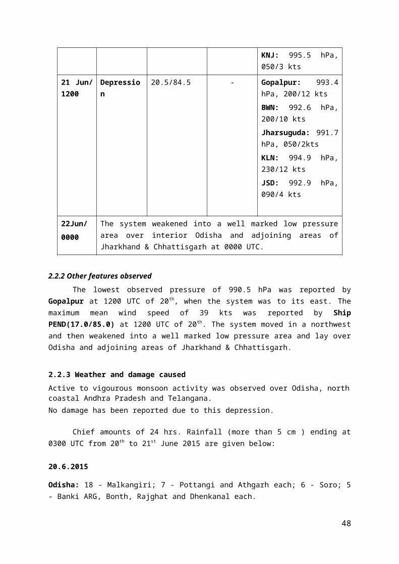
Dascroi; 7 - Dholka, Lunawada, Kapadvanj, Wanakbori, Dholka ARG, Mahuva, Bayad, Chhota Udepur and Matar each.
Saurashtra & Kutch: 33 - Bhachau; 23 - Morbi; 21 - MaliaMiana and Rapar each; 19 - Dasada; 17 - Nakhatrana; 14 - Anjar; 13 - Dhrangadhra and Bhuj AP each; 11 - Halvad and Kharaghoda each; 9 - Gandhidham and Vanthali each; 8 - Mundra, Lakhpat, Lalpur, New Kandla and Tankara each; 7 - Kandla Airport and Mangrol (J) each.
30.7.2015
West Rajastan: 10 - Marwar Junction and Pali each; 9 - Bhinmal, Nokh, Dorimanna and Jaswantpura each; 8 - Sojat; 7 - Bagoda, Phalodi Tehsil, Bhopalgarh and Ramgarh each.
East Rajastan: 12 - Mount Abu; 10 - Sirohi; 9 - Bhim, Dungarpur Tehsil and Tatgarh each; 8 - Pindwara; 7 - Abu Road, Deogarh, Asind and Hurda each.
Gujarat region: 14 - Deodar; 10 - Vadali; 9 - Amirgadh, Idar and Bhiloda each; 8 - Santalpur, Siddhpur, Khedbrahma, Palanpur and Harij each; 7 - Vijaynagar and Unjha each.
2.6 Cyclonic storm (KOMEN) over the Bay of Bengal (26th July – 2nd Aug. 2015)
2.6.1 A cyclonic circulation extending upto 5.8 kms a. s. l. lay over northeast Bay of Bengal and neighbourhood on 25th. Under its influence, a low pressure area formed over northeast Bay of Bengal and adjoining areas of Bangla Desh & Gangetic West Bengal on the same evening. It rapidly concentrated into a Depression over northeast Bay of Bengal and adjoining coastal areas of Bangla Desh & West Bengal and lay centred near Lat.22.0°N/Long.90.8°E, about 60 kms southeast of Patuakhali (Bangla Desh) at 0000 UTC and remained practically stationary ay 0300 UTC of 26th. It moved slightly westwards and lay centered near Lat.22.0°N/Long. 90.5°E, close to Khepupara (Bangla Desh) at 1200 UTC on 26th. It remained practically stationary over the same area upto 28th evening. It moved southeastwards and intensified into a Deep Depression and lay over northeast Bay of Bengal and adjoining areas of Bangla Desh, centered near Lat.21.0°N/Long.91.0°E, about 160 kms south-southwest of Chittagong (Bangla Desh) at 0000 UTC on 29th. It remained practically stationary over the same region at 0300 UTC on 29th. It remained practically stationary and lay over the same region centred near Lat.21.5°N/Long.91.4°E about 100 kms south-southwest of Chittagong (Bangla Desh) at 1200 UTC on 29th July. It moved northwestwards and intensified into a Cyclonic Storm 'KOMEN' and lay over the same region centered near Lat. 21.6°N / Long. 91.4°E about 95 kms south-southwest of Chittagong (Bangla Desh) and about 300 kms east-southeast of Kolkata at 1800 UTC on 29th. Moving northwards, it lay over the same region centered near Lat. 22.0°N / Long. 91.4°E about 80 kms southwest of Chittagong (Bangla Desh) and about 300 kms east-southeast of Kolkata at 0300 UTC on 30th. It moved northwestwards and lay centred close to Bangla Desh coast near Lat. 22.4°N / Long. 91.4°E about 20 kms east of Hatia (Bangla Desh) at 1200 UTC on 30th. It moved northwards and crossed Bangla Desh coast between Hatia and Sandwip during 1400 to 1500 UTC on 30th. It then moved nearly northwards, weakened into a Deep Depression and lay over Bangla Desh centred near Lat. 23.0°N / Long. 91.0°E at 2100 UTC on 30th. Subsequently, it moved west-northwestwards and centred near Lat. 23.1°N / Long. 90.0°E, about 85 kms east-southeast of Jessore (Bangla Desh) at 0000 UTC on 31st. It remained practically stationary over the same region at 0300 UTC on 31st July. It then moved west
48

northwestwards, weakened into a Depression and lay over Bangla Desh centered near Lat. 23.1°N / Long. 89.5°E about 35 kms east of Jessore (Bangla Desh) at 1200 UTC on 31st. It continued to moved westwards and lay over Bangla Desh centered near Lat. 23.2°N / Long. 89.2°E, close to Jessore at 0300 UTC on 1st Aug. It moved west northwestwards and lay over Gangetic West Bengal and adjoining Bangla Desh centred near Lat. 23.8°N / Long. 88.4°E about 30 kms south-southeast of Behrampore (West Bengal) at 1200 on 1st Aug. It moved westwards and lay over Jharkhand and adjoining Gangetic West Bengal centred near Lat. 23.8°N and Long. 86.7°E, about 70 km northwest of Bankura at 0000 UTC on 2nd. It moved west-southwestwards and lay over Gangetic West Bengal and adjoining Jharkhand centred near Lat. 23.5°N / Long. 86.0°E, about 70 kms east-northeast of Ranchi at 0300 UTC on 2nd. It moved south-southwestwards and weakened into a well marked low pressure area over Jharkhand and adjoining areas of north Odisha and north Chhattisgarh on same evening.
The details of the system are given in Table 6.
Table–6
Date / Time (UTC)
Intensity Position near Lat. o N / Long. o E(Best Track)
Based on
Real time Estimates on Satellite Imagery /RADAR Obsn.
Supporting synoptic / asynoptic observations
26 Jul./ 0000
Depression 22.0/90.8 C.I. No. 1.5 -
26 Jul./ 0300
Depression 22.0/90.8 C.I. No. 1.5 Cox Bazar: 998.6 hPa, 150/8 kts.Chittagong: 997.7 hPa, 120/6 kts.Hatia: 995.1 hPa, 180/2 kts.Khempura: 996.3 hPa Kolkata: 999.4 hPa, 020/3 kts
26 Jul./ 1200
Depression 22.0/90.5 C.I. No. 1.5 Mongla: 994.5 hPa, 030/8 kts.Bhola: 994.6 hPa, 120/6 kts.Agartala: 998.7 hPa, 090/1 kts.Khempura: 993.4 hPa, 230/2 ktsKolkata: 996.4 hPa,
49

360/6 kts
27 Jul./ 0300
Depression 22.0/90.5 C.I. No. 1.5 Khempura: 994.0 hPaMongla: 996.6 hPa, 030/8 ktsBarisal: 996.3 hPa, 050/4 kts.Hatia: 995.6 hPa, 130/3 ktsCox Bazar: 997.8, 170/6ktsKolkata: 999.1 hPa360/5 kts
27 Aug./ 1200
Depression 22.0/90.2 C.I. No. 1.5 Khempura: 993.9 hPaMongla: 994.0 hPa, 030/3 ktsJesoore: 995.9 hPa, 050/4 kts.Kolkata: 996.6 hPa340/3 ktsShip AUYQ(20.8/88.1):999.6hPa, 320/24kts
28 Jul./ 0300
Depression 22.0/90.8 C.I. No. 1.5 Khempura: 994.1 hPaMongla: 997.6 hPa, 030/4 ktsJesoore: 1000.1 hPa, 030/10 kts.Kolkata: 999.8 hPa340/6ktsPatuakhali: 997.8hPa, 050/3kts
28 Aug./ 1200
Depression 21.5/90.2 C.I. No. 1.5 Khempura: 994.5 hPa, 050/4 ktsMongla: 995.5 hPa, 030/2 ktsHatia: 995.9 hPa,180/3ktsFeni: 996.1 hPa,
50
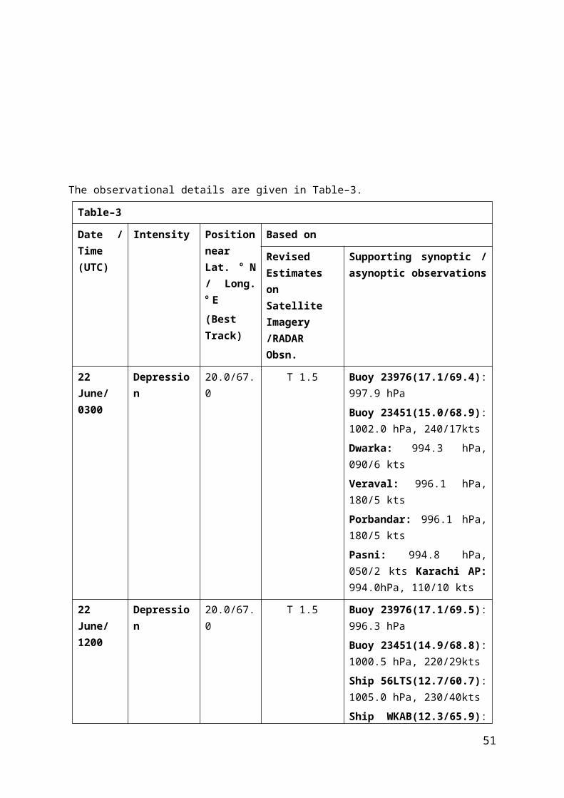
160/4ktsCox Bazar: 994.8 hPa, 170/5 ktsTeknaf: 1000.4 hPa, 180/12 kts
29 Jul./ 0000
Deep Depression
21.0/91.0 C.I. No. 2.0 Cox Bazar: 993.6 hPaTeknaf: 994.4 hPa, 180/21 ktsChittagong: 994.8hPa, 090/6 ktsHatia: 994.7 hPa, 070/5ktsSittwe: 997.2 hPa, 230/15kts
29 Jul./ 0300
Deep Depression
21.0/91.0 C.I. No. 2.0 Khempura: 994.3 hPa, 140/7 ktsCox Bazar: 993.3 hPa,120/15ktsTeknaf: 994.3 hPa, 180/24 ktsHatia: 995.4 hPa, 130/14ktsSittwe: 998.5 hPa, 230/15kts
29 Jul/ 1200
Deep Depression
21.5/91.4 C.I. No. 2.0 Cox Bazar: 990.3 hPa,180/8 ktsTeknaf: 991.4 hPa, 180/11 ktsChittagong: 991.5hPa, 080/12 ktsHatia: 991.3 hPa, 050/10ktsKhempura: 991.0hPa, 140/7 kts
29 Jul/ 1800
Cyclonic Storm KOMEN
21.6/91.4 C.I. No. 2.0 Cox Bazar: 991.4 hPa,090/3 ktsTeknaf: 992.1 hPa, 230/29 ktsChittagong: 993.8hPa, 090/8 ktsHatia: 994.4 hPa,
51

130/3ktsKhempura: 993.4hPa, 050/10 kts
30 Jul/ 0000
Cyclonic Storm KOMEN
21.7/91.4 C.I. No. 2.0 SypM(SAK) 22.5/93.0: 090/21 ktsSypM(GKL) 23.4/91.4: 991.8hPa, 010/4 ktsMongla: 994.9 hPa, 050/4 ktsKailashshahar: 996.3hPa, 140/10 ktsAgartala: 995.8hPa
30 Jul/ 0300
Cyclonic Storm KOMEN
22.0/91.4 C.I. No. 2.5 Hatia: 991.1 hPa, 030/4 ktsFeni: 992.9 hPa, 130/3 ktsChittagong: 989.3 hPa, 070/15 ktsCox Bazar: 986.9 hPa, 180/12ktsTeknaf: 989.9 hPa, 230/9kts
30 Jul/ 1200
Cyclonic Storm KOMEN
22.4/91.4 C.I. No. 2.5 Hatia: 989.7 hPa, 050/6 ktsSandwip: 989.6 hPa, 180/7 ktsChittagong: 988.9 hPa, 080/10 ktsCox Bazar: 989.0 hPa, 180/8ktsTeknaf: 992.4 hPa, 230/16kts
Crossed Bangala Desh coast near Longitude 91.4° E during 1400-1500UTC.
30 Jul 2100
Deep Depression
23.0/91.0 - Hatia: 992.8 hPa, 270/1 ktsFeni: 990.2 hPa, 90/3 ktsChittagong: 992.5 hPa, 210/12ktsAgartala: 993.2 hPa, 090/5kts
52

Teknaf: 995.5 hPa, 230/15kts
31 Jul./ 0000
Deep Depression
23.1/90.0 - Hatia: 992.9 hPa, 300/1 ktsFeni: 992.0 hPa, 160/5 ktsChittagong: 993.1 hPa, 130/5ktsAgartala: 993.6 hPa, 050/7ktsTeknaf: 996.4 hPa, 230/22kts
31 Jul./ 0300
Deep Depression
23.1/90.0 - Hatia: 994.8 hPa, 180/2 ktsFeni: 994.2 hPa, 130/4 ktsChittagong: 995.5 hPa, 180/3ktsFaridpur: 994.5 hPa, 360/4ktsJessore: 995.9 hPa, 350/8kts
31 Jul./ 1200
Depression 23.1/89.5 - Barisal: 994.0 hPa, 180/6 ktsMadaripur: 993.4 hPa, 170/2 ktsChandpur: 993.7 hPa, 180/2ktsFaridpur: 993.6 hPa, 110/3ktsJessore: 993.6 hPa, 350/4kts
1 Aug./0300
Depression 23.2/89.2 - Barisal: 998.9 hPa, 180/10 ktsTargail: 997.4 hPa, 140/2 ktsBagatir: 997.3 hPa, 320/1ktsFaridpur: 997.3 hPa, 140/2ktsJessore: 996.2 hPaBalasur: 995.9hPa
53

1 Aug./1200
Depression 23.8/88.4 - Balasur:999.6hPaJamshedpur:999.2hPaCanningTown:999.8hPa
2 Aug./0000
Depression 23.8/86.7 - -
2 Aug./0300
Depression 23.5/86.0 - Jamshedpur:999hPaSundergarh:1001hPaBalasur:1002hPa
2 Aug. evening
Weakened into a well marked low pressure area over Jharkhand and adjoining areas of north Odisha and north Chhattisgarh.
2.6.2 Other features observedThe highest maximum wind speed has been estimated as 40 knots. However, Teknaf
(Bangladesh) reported 55 knots (in the southeastern sector of the CS, Komen) in the early hours of 30th July for a short period. It reported 76 kmph (40 kts) at 0600 UTC of 30 th July. Maungdaw (48061) and Sittwe (47062) which lay to the southeast of the centre of the cyclonic storm reported maximum wind of 67 kt at 2300 UTC and 58 kt at 0400 UTC of 30 th
July respectively which may be due to the squall in association with the cyclonic storm. The lowest estimated central pressure has been 986 hPa. The MSLP of about 986.9 hPa was reported at Cox Bazar on 30th at 0300 UTC. The MSLP of about 986.5 hPa has been reported from southeastern coast of Bangladesh, when the CS was moving northward close to that coast.
2.6.3 Weather and damage caused Active to vigourous monsoon conditions with heavy to very heavy rainfall at isolated places prevailed over Nagaland-Manipur-Mizoram-Tripura, Gangetic West Bengal and Odisha with extremely heavy rain over Jharkhand. This condition triggered floods which claimed 69 lives in Gangetic west Bengal and 5 in Odisha. It affected five lakh people. Landslides claimed 20 lives in Manipur.
Chief amounts of 24 hrs. rainfall (4 cm or more) ending at 0300 UTC from 26 th July to 2nd
August 2015 are given below:
26.7.2015
Nagaland-Manipur-Mizoram-Tripura: 6 – Sabroom.
Gangetic West Bengal: 10 - Dhaniakhali ARG; 9 - Nandigram, Manmothnagar and Canning Town. each; 8 - Kharagpur (I.I.T), Dhaniakhali, Uluberia, Kansabati Dam, Uluberia and
54

Harinkhola each; 7 - Bagati (Magra); 6 - Sagar, Mangalkote, Ranibandh, Amta and Kolkata AP each; 5 - Joypur, Kharidwar, Chinsura, Burdwan, Diamond Harbour, Phulberia and Tusuma each; 4 - Baruipur, Tamluk AWS, Barrackpur IAF, Kalyani Smo and Digha each.
Odisha: 9 - Mandira Dam and Khandapara each; 8 - Kuchinda; 7 - Danagadi ARG, Derabis ARG and Panposh each; 6 - Banki ARG, Keiri AWS, Kantapada ARG, Jamsolaghat, Pipili, Gunupur and Chendipada each; 5 - Alipingal, Kendrapara, Garadapur ARG, Satyabadi ARG, Daspalla, Paradip, Keongjhargarh, Jagatsinghpur AWS, Laikera, Thakurmunda, Kaniha ARG, Khairamal, Paralakhemundi and Tangi each; 4 - Swam -Patna, Bhubaneshwar AP, Cuttack, Balipatna ARG, Bhograi, Raghunathpur ARG, Tigiria ARG, Chandbali, Puri, Joda ARG, Batagaon, Kirmira ARG, Digapahandi ARG, Nimpara, Rajgangpur, Naktideul, Pattamundai, Nuagada ARG, Akhuapada, Jharsuguda AP, Naraj and Rairakhol each.
Jharkhand: 4 - Barkisuriya and Maithon each.
27.7.2015
Nagaland-Manipur-Mizoram-Tripura: 9 - Sabroom; 5 - Belonia.
Gangetic West Bengal: 14 - Bankura CWC; 10 - Kansabati Dam, Phulberia and Bankura each; 9 - Kharidwar; 6 - Narayanpur and Ranibandh each; 5 - Kolkata AP, Burdawan, Kanksa BSF and Panagarh AP each; 4 - Diamond Harbour, Manmothnagar, Tusuma, Mangalkote, Manteswar, Indus, Kolkata, Simula and Labpur each.
Odisha: 17 - Lahunipara; 15 - Jamankira; 12 - Deogarh; 11 - Banaigarh AWS and Keiri AWS each; 10 - Tensa and Rengali each; 9 - Naktideul, Reamal, Chendipada, Barkote and Chandanpur each; 8 - Batagaon, Karanjia, Kujanga ARG and Kaniha ARG each; 7 - Marsaghai ARG, Swam -Patna, Joda ARG, Ghatagaon, Chandbali, Pallahara and Rairakhol each; 6 - Angul, Jaipatna, Korei ARG, Tihidi ARG, Bangiriposi and Gurundia ARG each; 5 - Boudhgarh, Rajkanika, Rajgangpur, Jajpur, Akhuapada, Bari ARG, Kuchinda, Hindol, Daitari, Anandpur and Basudevpur AWS each; 4 - Derabis ARG, Keongjhargarh, Thakurmunda, Bamra ARG, Bhograi, Kankadahad ARG, Mahanga ARG, Joshipur, Balasore, Champua, Banarpal ARG, Bhadrak AWS, Kolabira ARG, Garadapur ARG and Kirmira ARG each.
Jharkhand: 8 - Nimdih and Chandil each; 7 - Jamshedpur; 5 - Jamshedpur AP; 4 - Mohanpur.
28.7.2015
Nagaland-Manipur-Mizoram-Tripura: 7 - Amarpur.
Gangetic West Bengal: 24 - Purihansa; 13 - Tusuma; 12 - Hatwara and Purulia each; 11 - Simula; 9 - Kharidwar and Contai each; 7 - Phulberia and Kashipur each; 5 - Tamluk AWS and Asansol CWC each; 4 - Sagar, Kansabati Dam, Ranibandh, Manmothnagar and Digha each.
55

Odisha: 23 - Tiring; 21 - Rairangpur; 19 - Balikuda ARG; 18 - Tirtol ARG; 17 - Dhamnagar ARG, Paradip, Binjharpur ARG and Salepur ARG each; 16 - Kujanga ARG, Korei ARG and Marsaghai ARG each; 15 - Kendrapara, Raghunathpur ARG, Garadapur ARG, Jagatsinghpur AWS, Banki ARG, Swam -Patna, Jajpur, Pattamundai and Jenapur each; 14 - Akhuapada, Joshipur and Karanjia each; 13 - Nawana, Bonth, Derabis ARG and Chandanpur each; 12 - Bari ARG, Mahanga ARG, Danagadi ARG and Daitari each; 11 - Bhuban ARG and Anandpur each; 10 - Thakurmunda; 9 - Alipingal, Tihidi ARG, Hindol, Kantapada ARG and Ghatagaon each; 8 - Mandira Dam, Betanati ARG, Sukinda and Kakatpur each; 7 - Kaniha ARG, Rajkanika and Bangiriposi each; 6 - Keongjhargarh, Kankadahad ARG, Astaranga ARG, Champua, Rengali and Nilgiri each; 5 - Bhadrak AWS, Nischintakoili ARG, Udala, Angul, Basudevpur AWS, Niali ARG, Talcher, Jamsolaghat, Cuttack, Balipatna ARG and Jaipur each; 4 - Jhumpura, Baripada, Balimundali, Rajgangpur, Banarpal ARG, Tigiria ARG, Kaptipada ARG, Soro, Batagaon, Altuma CWC, Naktideul and Chandbali each.
Jharkhand: 25 - Jamshedpur; 20 - Jamshedpur AP; 10 - Ghatsila; 9 - Putki and Topchanchi each; 8 - Nimdih and Nandadih each; 7 - Chandil, Dumka and Dumri each; 6 - Kharsema; 5 - Bokaro; 4 - Gobindpur, Dhanbad, Madhupur, Maithon and Rajdhanwar each.
29.7.2015
Gangetic West Bengal: 21 - Uluberia; 19 - Tamluk AWS; 14 - Contai; 12 - Nandigram; 11 - Amta, Dhaniakhali ARG and Contai each; 10 - Harinkhola; 9 - Labpur and Dhaniakhali each; 8 - Narayanpur and Sriniketan each; 7 - Sagar and Bolpur each; 6 - Bagati (Magra), Manteswar, Kalna, Nakshipara and Digha each; 5 - Durgachak, Krishnanagar and Kharagpur (I.I.T) each; 4 - Balagarh, Sabong, Pingla, Diamond Harbour, Arambagh, Midnapore CWC, Midnapore and Joypur each.
Odisha: 16 - Chandanpur; 13 - Rairangpur and Bhograi each; 12 - Bangiriposi; 10 - Nawana; 7 - Jaleswar; 6 - Jamsolaghat; 5 - Samakhunta AWS, Balikuda ARG and Rajghat each; 4 - Astaranga ARG and Bhuban ARG each.
Jharkhand: 15 - Ghatsila; 10 - Dhanbad; 8 - Sarath; 7 - Dumka; 6 - Moharo; 5 - Gobindpur; 4 - Maithon, Papunki and Putki each.
30.7.2015
Gangetic West Bengal: 20 - Manteswar; 19 - Harinkhola; 17 - Amta; 12 - Arambagh and Sagar each; 11 - Salar; 9 - Sagardighi, Amtala, Nandigram, Dhaniakhali ARG and Burdwan each; 8 - Murarai, Contai, Narayanpur and Mangalkote each; 7 - Nalhati, Contai, Durgachak, Burdawan and Indus each; 6 - Labpur, Khirpai and Pingla each; 5 - Kandi, Balagarh, Uluberia, Digha, Uluberia, Rampurhat (Drms), Jangipur, Debagram, Kalna, Sonamukhi ARG, Dhaniakhali and Ranaghat each; 4 - Kandi, Katwa, Bolpur, Sriniketan, Nakshipara and Gheropara each.
Odisha: 2 - Jaleswar and Rajghat each; 1 - Balasore, Betanati ARG and Nh5 Gobindpur each.
56
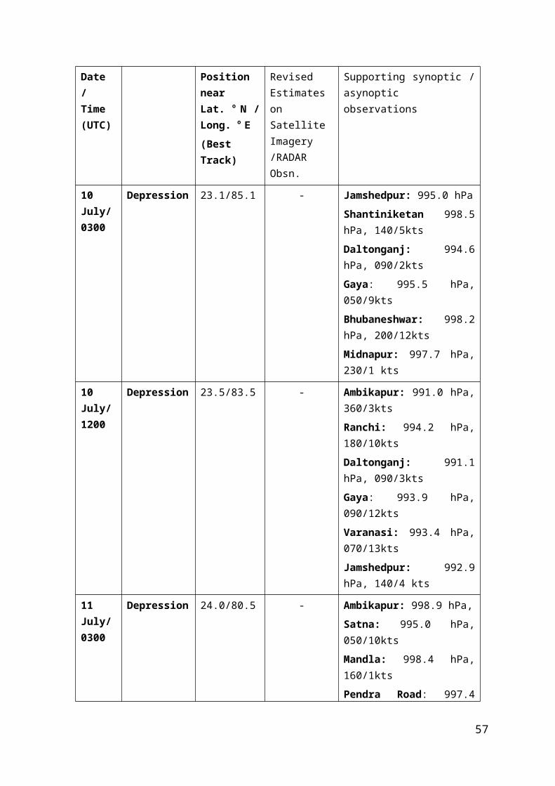
Jharkhand: 3 - Maheshpur and Pakuria each; 2 - Pakur; 1 - Rajmahal and Hiranpur each.
31.7.2015
Nagaland-Manipur-Mizoram-Tripura: 6 – Sabroom.
Gangetic West Bengal: 8 - Digha and Hetampur each; 6 - Murarai, Tantloi and Asansol CWC each; 4 - Kandi, Dhaniakhali ARG and Suri CWC each.
Odisha: 8 - Bhograi; 4 - Rajghat.
Jharkhand: 17 - Maheshpur; 15 - Dumka and Jarmindi each; 9 - Moharo and Sarath each; 7 - Giridih, Topchanchi, Jamtara and Messenjore each; 5 - Papunki, Madhupur, Balumath, Tilaiya and Nandadih each; 4 - Koderma, Maithon, Pathalgada, Tundi, Putki, Pakuria and Barkisuriya each.
1.8.2015
Nagaland-Manipur-Mizoram-Tripura: 9 - Thoubal AWS and Imphal each; 5 - Kamalpur, Serchip (Hydro) and Belonia each.
Gangetic West Bengal: 21 - Deganga; 16 - Contai; 15 - Bashirhat; 14 - Basirhat and Khirpai each; 13 - Kolkata, Indus, Kolkata AP and Joypur each; 11 - Contai; 10 - Barrackpur IAF, Mohanpur and Chinsura each; 9 - Pingla, Burdwan, Midnapore CWC, Midnapore, Canning Town. and Baruipur each; 8 - Arambagh, Durgapur, Burdawan, Bongaon, Phulberia and Amta each; 7 - Hetampur, Uluberia, Dhaniakhali ARG, Asansol CWC, Kanksa BSF, Kalyani Smo, Suri CWC, Panagarh AP, Tusuma, Tilpara Barrage, Mangalkote, Mankar and Bankura CWC each; 6 - Diamond Harbour, Purihansa, Balagarh, Bagati (Magra), Nandigram, Kharagpur (I.I.T), Kansabati Dam, Manteswar and Bankura each; 5 - Ranibandh, Dhaniakhali, Rampurhat (Drms), Kashipur, Sabong, Tamluk AWS, Shekhampore ARG, Sagar, D.P.Ghat, Rajnagar, Jhargram, Narayanpur, Kalaikunda and Kharidwar each; 4 - Labpur, Nalhati, Bolpur, Durgachak, Salar, Sagardighi, Sriniketan, Ranaghat, Katwa, Amtala and Kandi each.
Odisha: 6 - Salepur ARG; 5 - Barkote, Altuma CWC and Naktideul each; 4 - Deogarh, Kamakhyanagar, Boudhgarh, Jamankira and Banaigarh AWS each.
Jharkhand: 13 - Dumri; 9 - Hazaribagh; 8 - Panki, Kuru and Messenjore each; 7 - Daltonganj and Sarath each; 6 - Bagodar I, Satgaon, Bishrampur and Ghatsila each; 5 - Manatu, Barkisuriya, Maithon, Koner, Koderma, Tilaiya, Jamtara, Mandar, Lohar -Daga, Panchet and Maheshpur each; 4 - Ranchi AP, Ramgarh, Jaridih, Rajdhanwar, Hindgir and Jarmindi each.
2.8.2015
57

Gangetic West Bengal: 11 - Mangalkote; 9 - Burdawan, Arambagh, Narayanpur and Burdwan each; 8 - Mankar and Kashipur each; 7 - Joypur, Sriniketan, Murarai, Harinkhola and Bankura CWC each; 6 - Bankura, Rampurhat (Drms), D.P.Ghat and Gheropara each; 5 - Jhalda, Canning Town., Purihansa, Hatwara, Kanksa BSF, Kalaikunda, Bolpur, Durgapur and Kharidwar each; 4 - Phulberia, Jhargram, Uluberia, Katwa, Dhaniakhali ARG, Sonamukhi ARG, Labpur, Nalhati, Kalyani Smo, Tusuma, Indus, Suri CWC, Midnapore CWC, Salar, Khirpai, Midnapore and Kalna each.
Odisha: 10 - Khairamal; 8 - Jujumura ARG and Tirtol ARG each; 7 - Kantapada ARG; 6 - Phulbani, Harabhanga and Angul each; 5 - Rajkishorenagar, Boudhgarh, Tikabali, Alipingal, Paradip, Kalinga, Salepur ARG, Naktideul and Birmaharajpur ARG each; 4 - Sambalpur, Athgarh, Athmalik, Tikarpara, Bhubaneshwar AP, Barmul and Rairangpur each.
Jharkhand: 11 - Deoghar, Putki and Koner each; 10 - Ramgarh, Mohanpur, Barkisuriya and Barhi each; 9 - Mandar; 8 - Rajdhanwar, Jarmindi, Pathalgada, Dhanbad, Hindgir and Tenughat each; 7 - Lohar -Daga, Moharo, Chatra, Bokaro, Papunki, Giridih, Hazaribagh, Dumri, Jamtara, Sarath, Jaridih and Koderma each; 6 - Messenjore, Palkot, Balumath, Maheshpur and Dumka each; 5 - Tilaiya, Ranchi AP, Ormangi, Pakuria, Nandadih, Panchet, Tundi, Kuru, Kolebira and Maithon each; 4 – Chakradharpur.
2.7 Land Depression over east Madhya Pradesh and adjoining Chhattisgarh (4th-5th Aug.)2.7.1 After dissipation of cyclone ‘KOMEN’, a well marked low pressure area formed over Jharkhand and adjoining areas of north Odisha and north Chhattisgarh on 2nd. It moved southwestwards and lay over north Chhattisgarh and adjoining north Odisha and Jharkhand with an associated cyclonic circulation extending upto mid tropospheric levels upto 3 rd and over north Chhattisgarh and adjoining southwest Bihar, southeast Uttar Pradesh and east Madhya Pradesh on 4th evening. It concentrated into a Depression and lay over east Madhya Pradesh and adjoining Chhattisgarh centred near Lat. 22.7°N and Long. 80.5°E, about 75 kms southeast of Jabalpur at 0300 UTC on 4th. It moved westwards and lay over central parts of Madhya Pradesh centred near Lat. 22.7°N and Long. 77.8°E, close to Hoshangabad at 1200 UTC on 4 th. It weakened into a well marked low pressure area and lay over southwest Madhya Pradesh and neighbourhood at 0000 UTC on 5th. It lay over central parts of Madhya Pradesh with an associated cyclonic circulation extending upto mid tropospheric levels on 5th. It weakened into a low pressure area over the same region until the afternoon of 5th and persisted there till the evening. It became less marked on 6th. However the associated cyclonic circulation lay over east Madhya Pradesh and neighbourhood and extending between 1.5 & 5.8 kms a.s.l. on 6 th and over north Chhattisgarh and neighbourhood and extending upto 3.1 kms a.s.l. during 7 th - 10th. It became less marked on 11th.
The details of the system are given in Table 7.
Table–7
Intensity Based on
58

Date / Time (UTC)
Position near Lat. o N / Long. o E(Best Track)
Real time Estimates on Satellite Imagery /RADAR Obsn.
Supporting synoptic / asynoptic observations
4 Aug./ 0300
Depression 22.7/80.5 - Seoni: 997.8 hPa, 360/1 ktsJabalpur: 997.7 hPa, 050/8 ktsPendra Road: 1000.6 hPa, 140/2ktsAmbikapur: 1001.8 hPa, 140/3ktsBhopal: 1000.9 hPa, 320/12kts
4 Aug./ 1200
Depression 22.7/77.8 - Seoni: 996.4 hPa, 230/1 ktsJabalpur: 996.8 hPa, 140/4 ktsIndore: 997.8 hPa, 290/16ktsNagpur: 998.3 hPa, 250/3ktsBhopal: 996.0 hPa, 320/10ktsHoshangabad: 994.9, hPa, 050/6ktsDamoh: 994.9 hPa, 090/2kts
4 Aug./ 1800
Depression 22.7/77.8 - -
5 Aug./ 0000
Weakened into a well marked low pressure area and lay over southwest Madhya Pradesh and neighbourhood at 0000 UTC on 5th.
2.7.2 Other features observedThe lowest observed pressure of 994.9 hPa, was reported by Hoshangabad and Damoh at 1200 UTC of 4th. The maximum sustained wind speed of 16 kts was reported by Indore at 1200 UTC of 4th.
2.7.3 Weather and damage caused
59

Active monsoon conditions with heavy to very heavy rainfall at isolated places prevailed over Madhya Pradesh, Vidarbha and Chhattisgarh.
Chief amounts of 24 hrs. rainfall (5 cm or more) ending at 0300 UTC from 4 th August are given below:4.8.2015
Madhya Pradesh: 21 - Pachmarhi; 10 - Betul, Betul - AWS, Udaipura and Sardarpur each; 9 - Bhainsdehi; 8 - Chanderi, Chicholi and Kolaras each; 7 - Pichhore and Multai each; 6 - Nusrulgunj -Arg; 5 - Narsingarh, Shajapur, Shajapur - AWS, Begumganj, Atner, Ichhawar, Ganjbasoda and Ashoknagar - AWS each.
East Madhya Pradesh: 15 - Amarwara and Balaghat - AWS each; 13 - Narsingpur; 12 - Seoni, Seoni - AWS, Gotegaon and Chindwara - AWS each; 11 - Keolari and Katangi each; 10 - Lakhnadon, Mandla - AWS and Bichhia each; 9 - Jabalpur, Gadarwara and Kareli each; 8 - Malanjkhand, Deori, Nainpur and Patan each; 7 - Dindori - AWS; 6 - Garhakota, Umaria, Umaria - AWS, Ghansore, Rehli, Tikamgarh, Waraseoni and Tikamgarh - AWS each; 5 - Amarkantak, Sagar, Sagar - AWS and Pushparajgarh each.
Vidarbha: 6 - Tumsar, Wardha and Gondia each; 5 - Saoner, Tirora, Tiroda (Arg), Ashti, Dhamangaon Rlwy, Nagpur AP and Salekasa each.
Chhattisgarh: 12 - Bemetara; 10 - Korba; 9 - Katghora; 8 - Pali; 7 - Raigarh; 6 - Sarangarh, Mungeli, Pallari / Palari and Saraipali each; 5 - Simga, Pendra, Bhopalpatnam, Janjgir and Gandai each.
2.8 Land Deep depression over south Odisha and neighbourhood (16th- 19th Sept,)2.8.1 A cyclonic circulation extending upto mid tropospheric level lay over west-central Bay of Bengal & neighbourhood during 7th -11th. Under its influence, a low pressure area formed over west-central & adjoining northwest Bay of Bengal on12th and persistsed over the same area on 13th & 14th. It lay as a well marked low pressure area over west-central & adjoining northwest Bay of Bengal off north Andhra Pradesh - south Odisha coasts on 15th and over south Odisha & neighbourhood on 16th. Associated cyclonic circulation extended upto 7.6 kms a. s. l. during 12th
- 16th. The well marked low pressure area over south Odisha & neighbourhood concentrated into a Depression and lay centered at 0300 UTC of 16th Sept. over south Odisha and neighbourhood near Lat.19.6°N/ Long.83.5°E. It moved west-northwestwards and lay centered at 1200 UTC of 16th Sept. 2015 over south Odisha and adjoining Chattisgarh near Lat.20.5°N/Long.82.5°E about 70 kms northwest of Titlagarh and 130 kms southeast of Raipur. It continued to move west-northwestwards and intensified into a Deep Depression and lay centered over Vidarbha and adjoining areas of south Chhattisgarh near Lat.21.0°N/ Long.79.5°E about 50 kms east-southeast of Nagpur at 0300 UTC on 17th. It moved nearly westwards and lay centred over Vidarbha & neighbourhood near Lat.20.5°N/ Long.79.0°E about 50 kms east of Wardha at 1200 UTC on 17th. It further moved nearly westwards and weakened into a Depression and lay centred over Vidarbha & neighbourhood near Lat.20.7°N/ Long.77.0°E close to Akola at 0300 UTC on 18th. It moved nearly westwards and lay centred over west Vidarbha & neighbourhood near Lat.20.5° N/ Long.76.0° E close to Buldhana at 1200 UTC on 18th. It nearly moved west-northwestwards and lay centred over north Madhya Maharashtra & neighbourhood near Lat.21.0° N/ Long.74.5° E about 50 kms north of Malegaon and 160 kms
60

southeast of Vadodara, at 0000 UTC of 19th. It further moved westwards and weakened into a well marked low pressure area over north Madhya Maharashtra & adjoining areas of southwest Madhya Pradesh and Gujarat region at 0300 UTC on 19 th. It lay over south Gujarat and neighbourhood on 19th evening. It lay lay as a low pressure area over Saurashtra & neighbourhood on 20th, over Saurashtra & Kutch and neighbourhood on 21st, over northwest Rajasthan and neighbourhood on 22nd and became less marked in the same evening. However, associated cyclonic circulation lay over Haryana and adjoining Punjab extending between 1.5 & 2.1 kms a.s.l. on 23rd Sept.
The details of the system are given in Table 8.
Table–8
Date / Time (UTC)
Intensity Position near Lat. o N / Long. o E(Real time)
Based on
Revised Estimates on Satellite Imagery /RADAR Obsn.
Supporting synoptic / asynoptic observations
16 Sept./ 0300
Depression 19.6/83.5 - KLN: 999.3hPa, 270/3kts BWN: 1000.9hPa, 110/6kts
16 Sept./ 0600
Depression 20.3/83.0 - Ship KAOU(17.5/89.3): 1004.3 hPa, 200/14kts Buoy 23459(13.9/87.0): 1004.5 hPa, 220/16kts KLN: 998.6hPa, 250/10kts BWN: 1000.2hPa, 110/8kts Jharsuguda: 999.9hPa, 050/ 2kts
16 Sept./ 1200
Depression 20.5/82.5 - Bhawanipatna: 995.7hPa, Jagdalpur: 997.8hPa, 270/ 2kts BWN: 999.0hPa, 140/8ktsKLN: 997.2hPa, 200/6kts BWN: 999.0hPa, 140/8kts Jharsuguda: 997.5hPaNagpur:996.9hPa, 360/6kts
17 Sept./ 0300
Deep Depression
21.0/79.5 - Brahmapuri: 995.7hPa Gondia: 050/ 10kts
61

Nagpur: 998.5hPa, 340/8ktsAkola: 1001.9hPa, 290/2kts Ramgundam: 999.6hPa, 180/2kts Chandrapur: 997.9hPa, 230/3kts
17 Sept./ 1200
Deep Depression
20.5/79.0 - Chandrapur: 995.1hPa, 230/3kts Brahmapuri: 996.1hPa Nagpur: 995.7hPa, 020/5ktsBetul: 997.6hPa, 320/1kts Ramgundam: 997.6hPa, 230/3kts Wardha: 995.6hPa, 070/7kts
18 Sept./ 0300
Depression 20.7/77.0 - Akola: 997.6hPa, 320/1kts Gondia: 140/15ktsBetul: 997.7hPa, 140/1kts Buldhana: 998.6hPa, 320/6ktsAurangabad: 999.5hPa, 230/13kts Nagpur: 1001.5hPa, 180/8kts
18 Sept./ 1200
Depression 20.5/76.0 - Aurangabad: 998.4hPa, 250/12kts Buldhana: 998.2hPa, 140/4ktsWashim: 982.6hPa, 190/3kts Akola: 998.0hPa, 160/2ktsNagpur: 1001.0hPa, 090/4ktsJalna: 999.5hPa, 230/12kts
19 Sept./ 00
Depression 21.0/74.5 - Aurangabad: 993.7hPa, Ahmednagar: 999.4hPa, 320/4kts Indore: 999.7hPa, 090/12kts
62

Bhopal: 1001.9hPa, 160/14ktsSurat: 999.5hPa, 290/3kts Dahanu: 1001.5hPa, 270/16kts Baroda: 998.5hPa
19 Sept./ 0300
The system weakened into a well marked low pressure area over north Madhya Maharashtra & adjoining areas of southwest Madhya Pradesh and Gujarat region.
2.8.2 Other features observedThe system moved initially westnorthwestwards and then westward direction and weakened into a well marked low pressure area. The lowest observed pressure of 982.6hPa, was reported by Washim at 1200 UTC of 18th when the centre of system was close to the Washim. The maximum sustained wind speed of 10 kts was reported by Kalingapattanam at 0600 UTC of 16th when the system was northwest of Kalingapattanam.
2.8.3 Weather and damage causedActive to vigorous monsoon conditions prevailed over Odisha, south Gujarat Region,
Maharashtra state and Chhattisgarh. This deep depression caused heavy to very heavy rainfall over Odisha, Maharashtra State and Chhattisgarh with extremely heavy rainfall at isolated places over Odisha and south Gujarat Region.
This system caused flood in Odisha which claimed 2 death and 25,000 affected by rain, landslides and road & rail traffic.
Chief amounts of 24 hrs. rainfall (5 cm or more) ending at 0300 UTC from 16 th to 18th are given below:16.9.2015Odisha: 28 - Tentulikhunti ARG; 26 - Muniguda ARG; 23 - Jaipatna; 22 - Bhavani P. and Narla ARG each; 21 - Jhorigam ARG, Ambadola and Koraput each; 19 - Chandahandi ARG and Nawarangpur each; 18 - Lanjigarh; 17 - Madanpur Rampur, Kotagarh and Sorada each; 15 - Junagarh, Similiguda AWS, Daringibadi, Madhabarida and Bissem -Cuttack each; 14 - Jeypore and Kashipur each; 13 - Kotraguda and Nuagada ARG each; 12 - Gudari, Kesinga ARG, Pottangi and Dabugan ARG each; 11 - Raikia ARG, Belaguntha ARG, Bhanjnagar and Tikabali each; 10 - Kalinga; 9 - Mohana, Belgaon, Titlagarh, Dharmagarh ARG, Khariar, Kaptipada ARG, Umarkote, Tikarpara, Kosagumda and Rayagada each; 8 - R.Udaigiri, Raighar ARG, G Udayagiri AWS, K Nuagaon ARG, Phiringia ARG, Gunupur, Komna and Sinapali ARG each; 7 - Balimundali, Boden ARG, Aska, Baliguda, Jagannath Prasad ARG, Barmul, Nayagarh, Ranpur, Bolangir, Daspalla and Udala each; 6 - Mahendragarh, Odagaon ARG, Saintala ARG, Turekela, Betanati ARG, Nawana, Patnagarh, Digapahandi ARG, Tarva ARG and Purushottampur each; 5 - Belpada ARG, Gania ARG, Tangi, Cuttack, Bari ARG, Nimpara, Nilgiri, Khandapara, Nawapara, Bolagarh ARG, Paralakhemundi, Puri and Bangiriposi each.
63

Konkan & Goa : 11 - Ratnagiri; 10 - Canacona; 9 - Panjim (Goa) and Mapusa each; 8 - Ponda; 7 - Sanguem and Malvan each; 6 - Kudal, Quepem and Lanja each; 5 - Kankavli, Marmugoa, Mormugao and Sangameshwar Devrukh each.
Madhya Maharashtra: 6 - Mahabaleshwar; 5 - Gaganbawada
Vidarbha: 9 - Balapur; 7 - Chamorshi; 6 - Sadakarjuni; 5 - Chimur, Mul, Saoli, Akola (AWS) and Mulchera each; 4 - Sindkhed Raja, Chikhli, Motala, Babulgaon, Kalmeshwar, Bhamragad, Risod and Akola each; 3 - Sangrampur, Buldhana, Warora, Narkhed ARG, Etapalli, Ahiri, Korpana, Malkapur, Nandura, Wani, Gadchiroli, Buldhana (AWS), Deoli, Dhanora and Patur each; 2 - Sakoli, Shegaon, Ashti, Katol, Saoner, Jalgaon Jamod, Yeotmal, Malegaon, Gondpipri, Sindewahi, Daryapur, Bhadravati, Bhiwapur, Digras, Maregaon, Narkheda and Bramhapuri each; 1 - Pandherikawara, Pauni, Tiwsa, Darwha, Manora, Amgaon, Samudrapur, Khamgaon, Deolgaon Raja, Kamptee, Lonar, Kurkheda, Ballarpur, Deori, Zarizamni, Lakhani, Korchi, Nagbhir, Arvi, Mehkar, Tirora, Salekasa, Chandur Rlwy, Wardha, Kuhi, Arni, Ner and Tiroda (Arg) each.
Chhattisgarh: 16 - Deobhog; 11 - Balod; 9 - Bhanupratappur; 7 - Dhamtari, Jagdalpur and Kanker each; 6 - Mana AP, Raipur and Mahasamund each; 5 - Gariabund.
17.9.2015Odisha: 13 - Jhorigam ARG; 12 - Umarkote and Raighar ARG each; 10 - Junagarh; 8 - Boden ARG and Patnagarh each; 7 - Belaguntha ARG, Khariar, Malkangiri and Kalinga each; 6 - Rayagada, Belpada ARG, Paikmal, Sinapali ARG, Chandahandi ARG and Dabugan ARG each; 5 - Bhavani P., Tikabali and Tentulikhunti ARG each.Konkan & Goa : 7 - KarjatAgri and Chiplun each; 6 - Matheran, Ratnagiri and Bhira each; 5 - Mormugao, Alibag, Shriwardhan, Guhagar and Murud each.
Vidarbha: 14 - Sadakarjuni; 12 - Korpana, Amgaon, Goregaon and Mul each; 11 - Deori, Kurkheda, Lakhani, Korchi, Bhadravati and Salekasa each; 10 - Bramhapuri, Saoli, Rajura and Desaiganj each; 9 - Ahiri, Sakoli and Gondpipri each; 8 - Lakhandur, Chamorshi, Gondia AP, Gondia, Chandrapur, Armori and Arjuni Morgaon each; 7 - Pauni, Nagbhir and Dhanora each; 6 - Sindewahi and Sironcha each; 5 - Bhandara, Gadchiroli, Tirora, Wani, Warora, Chimur, Mohadi and Buldhana each.
Chhattisgarh: 21 - Sukma; 17 - Kanker; 14 - Mahasamund; 11 - Dongargarh and Balod each; 9 - Ambagarh Chowki, Narayanpur and Bhanupratappur each; 8 - Raipur and Kondagaon each; 7 - Mana AP, Rajnandgaon, Durg, Deobhog, Pendra and Dondilohara each; 6 - Dongargaon and Gariabund each; 5 - Arang, Bilaspur, Dhamtari, Bemetara and Katghora each.
18.9.2015 Marathawada: 16 - Sillod; 11 - Mahur; 10 - Himayatnagar; 9 - Bhokardan, Jalna, Hingoli - Hyd, Kallamnuri, Phulambri, Sengaon, Hadgaon and Aurangabad AP each; 8 - Partur, Kinwat, Parbhani and Dhalegaon - FMO each; 7 - Soegaon, Kannad, Ambad and Selu each; 6 - Khultabad, Jintur and Jafrabad each; 5 - Vasmat, Ghansawangi, Paithan and Gangapur each.
64

Konkan & Goa: 10 - Sanguem; 7 - Quepem, Margao, Mulde Agri and Mulde - AWS each; 6 - Marmugoa, Mormugao, Dabholim (Goa), Kankavli and Sawantwadi each; 5 - Kudal, Ponda, Vengurla, Devgarh and Canacona each.
Madhya Maharashtra: 18 - Sindkheda; 15 - Gidhade - FMO; 13 - Shahada; 12 - Jalgaon, Jamner and Dahigaon - FMO each; 11 - Shirpur; 9 - Malegaon and Sinnar each; 8 - Pachora and Kalvan each; 7 - Nandurbar, Yaval, Erandol and Sakri each; 6 - Girnadam - FMO, Dhule, Igatpuri, Niphad and Chopda each; 5 - Nandgaon, Raver, Navapur, Chalisgaon, Bodwad, Amalner, Muktainagar / Edalabad and Dindori each
Marathwada: 16 - Sillod; 11 - Mahur; 10 - Himayatnagar; 9 - Bhokardan, Jalna, Hingoli - Hyd, Kallamnuri, Phulambri, Sengaon, Hadgaon and Aurangabad AP each; 8 - Partur, Kinwat, Parbhani and Dhalegaon - FMO each; 7 - Soegaon, Kannad, Ambad and Selu each; 6 - Khultabad, Jintur and Jafrabad each; 5 - Vasmat, Ghansawangi, Paithan and Gangapur each.
Vidarbha: 16 - Pandherikawara and Korpana each; 15 - Deolgaon Raja and Wani each; 14 - Zarizamni; 13 - Maregaon, Sindkhed Raja, Buldhana, Nandgaonkazi and Bhadravati each; 12 - Akot, Darwha, Lonar, Umerkhed, Digras, Joiti, Ner, Mahagaon and Ghatanji each; 11 - Buldhana (AWS), Mehkar, Washim and Manora each; 10 - Arni, Hinganghat, Yeotmal, Ballarpur, Warora, Washim (AWS) and Wardha each; 9 - Kuhi, Ralegaon, Risod, Motala, Chandur Rlwy and Kalamb each; 8 - Shegaon, Bhandara (AWS), Amraoti, Mauda, Mangrulpir and Chikhli each; 7 - Tiwsa, Akola (AWS), Khamgaon, Malegaon, Chikhalda, Karanjalad, Sangrampur, Samudrapur, Telhara, Chandrapur, Jalgaon Jamod and Selu each; 6 - Daryapur, Patur, Batkuli, Balapur, Akola, Deoli, Bhandara and Dhamangaon Rlwy each; 5 - Mohadi, Anjangaon, Arvi, Babulgaon, Rajura, Barshitakli, Deori, Saoner, Chandur Bazar, Hingna, Malkapur, Dharni, Kalmeshwar, Kharangha, Nandura, Sindewahi and Nagpur AP each.
2.9 Deep Depression over eastcentral Arabian Sea (9th – 12th Oct. 2015)2.9.1 A cyclonic circulation extending upto 0.9 km a.s.l. lay over Lakshadweep area and neighbourhood on 5th and over southeast Arabian Sea and adjoining east central Arabian Sea extending upto mid tropospheric levels on 6th - 7th. Under its influence, a low pressure area formed over east central and adjoining southeast Arabian Sea in the early morning of 8th. It lay as a well marked low pressure area over the same region with the associated cyclonic circulation extending upto mid tropospheric levels on 8th. It concentrated into a Depression and lay over east central Arabian Sea centred near Lat. 14.0°N / Long. 70.3°E about 410 kms west-southwest of Goa and 630 kms south-southwest of Mumbai at 0000 UTC on 9th. It remained practically stationary over the same region and lay centred near Lat. 14.0°N / Long. 70.3°E at 0300 UTC on 9th. It moved northwards and lay over east central Arabian Sea centred near Lat. 14.3°N / Long. 70.2°E about 400 kms west-southwest of Goa and 600 kms of south-southwest of Mumbai at 1200 UTC on 9th. It moved northwestwards, intensified into a Deep Depression and lay over east central Arabian Sea centred near Lat. 14.7°N / Long. 69.9°E, at 1800 UTC on 9th. It moved northwestwards and lay over east central Arabian Sea centred near Lat. 15.1°N / Long. 69.5°E, about 460 kms west-
65

southwest of Goa and 550 kms of south-southwest of Mumbai at 0300 UTC on 10 th. It moved slightly northwestwards and lay over east central Arabian Sea centred near Lat. 15.2°N / Long. 69.3°E, about 490 kms west-southwest of Goa and 560 kms of south-southwest of Mumbai at 1200 UTC on 10th. It continued to move northwards, weakened into a Depression and lay over east central Arabian Sea centred near Lat. 15.6°N / Long. 69.2°E, about 490 kms west of Goa and 520 kms of south-southwest of Mumbai at 0300 UTC of on 11th. It moved northwards and lay centred near Lat. 15.9°N / Long. 69.2°E, about 500 kms west-northwest of Goa and 520 kms southwest of Mumbai at 1200 UTC on 11 th. Then it moved west-northwestwards and lay centred near Lat. 16.1°N / Long. 69.0°E, about 520 kms west-northwest of Goa and 510 kms southwest of Mumbai at 0000 UTC on 12 th. Further moved slightly west-northwestwards it weakened into a well marked low pressure area over the same region in the morning hours on 12 th. It weakened into a low pressure area and lay over east central and adjoining west central Arabian Sea on 13 th. It became less marked on 14th. However, associated cyclonic circulation extending upto 3.1 kms a.s.l. lay over west central Arabian Sea and neighbourhood on 14th Oct.
The details of the system are given in Table 9.
Table–9
Date / Time (UTC)
Intensity Position near Lat. o N / Long. o E(Real time)
Based on
Revised Estimates on Satellite Imagery /RADAR Obsn.
Supporting synoptic / asynoptic observations
9 Oct./ 00
Depression 14.0 / 70.3
T 1.5 Ship DFCW2(10.2/72.9): 1006.8 hPa, 270/16kts Buoy 23097(14.8/68.9): 1005.5 hPa, 250/14kts Buoy 23451(15.0/68.8): 1005.7 hPa, 350/14kts Bajpe: 998.6hPa, 110/12kts Panjim: 1007.1hPa, 090/2kts
9 Oct./ 0300
Depression 14.0 / 70.3
T 1.5 Buoy 23097(14.9/68.9): 1007.7 hPa, 220/16kts Buoy 23451(15.0/68.8): 1008.0 hPa Amini: 1008.9hPa, 270/4kts Panjim: 1009.6hPaBajpe: 1010.6hPa, 090/6kts
66
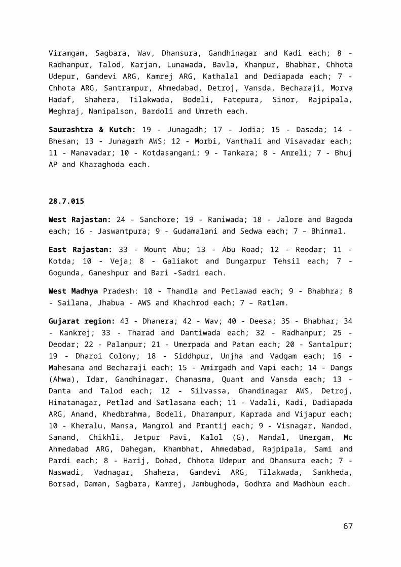
Agathi: 1008.9hPa, 270/4kts
9 Oct./ 1200
Depression 14.3 / 70.2
T 1.5 Buoy 23454(10.3/72.7): 1008.0 hPa, 020/14kts Buoy 23910(13.3/68.5): 1005.5 hPa Amini: 1006.7hPa, 270/5kts Minicoy: 1008.9hPa, 250/8ktsHonavar: 1008.0hPa, 180/4kts
9 Oct./ 1800
Deep Depression
14.7 / 69.9
T 2.0 -
10 Oct./ 0300
Deep Depression
15.1 / 69.5
T 2.0 Buoy 23097(15.0/69.0): 1005.2 hPa, 300/15kts Buoy 23497(10.5/72.2): 1010.9 hPa, 040/14ktsShip TBWUK77(10.8/65.6): 1011.8 hPa, 350/12kts Amini: 1010.6hPa, 270/4kts Panjim: 1010.8hPa, 180/3ktsKarwar: 1011.2hPa, 140/3kts
10 Oct./ 1200
Deep Depression
15.2/69.3 T 2.0 Buoy 23097(14.0/68.0): 1006.8 hPa, 270/20kts Ship TBWVK54(12.5/69.5): 1008.5 hPa, 320/5kts Amini Divi: 1007.6hPa, 270/5kts Minicoy: 1010.2hPa, 220/5ktsPanjim: 1007.8hPa, 180/5kts
11 Oct./ 0300
Depression 15.6/69.2 T 1.5 Buoy 23097(14.8/68.9): 1008.8 hPaBuoy 23492(10.8/72.2): 1011.9 hPa, 090/4ktsBuoy 23451(15.1/68.9): 1008.6 hPaShip C6BQ5(12.7/71.7): 1012.0 hPa, 230/16kts
67

Minicoy: 1012.8hPa, 270/3kts Ratnagiri: 1011.8hPa, 140/3kts
11 Oct./ 1200
Depression 15.9/69.2 T 1.5 Buoy 23451(15.0/68.9): 1008.6 hPa, 280/18ktsBuoy 23097(14.8/69.0): 1008.8 hPa, 290/10ktsBuoy 23910(13.2/68.5): 1010.0 hPaShip C6BQ5(12.4/71.7): 1012.0 hPa, 230/16kts Amini Divi: 1011.4hPa, 270/4kts Ratnagiri: 1011.0hPa, 140/3kts
12 Oct./ 0000
Depression 16.1/69.2 T 1.5 Buoy 23497(10.5/72.3): 1011.4 hPaBuoy 23097(14.8/69.0): 1009.0 hPa, 240/14ktsShip A8KM8(16.2/70.0): 1012.0 hPa, 230/16kts Amini Divi: 1010.0hPaRatnagiri: 1011.0hPa, 110/3kts
12 Oct. /0300
The system weakened into a well marked low pressure area over the east central Arabian Sea.
2.9.2 Other features observedThe lowest observed pressure of 998.6 hPa was reported by Bajpe at 0000 UTC of 9th Oct., when the system was north to the Bajpe. The maximum observed mean wind speed was 20 kts reported by Buoy 23097(14.0/68.0), when the system was to the northwest of Buoy 23097 at 1200 UTC of 12th Oct. The system moved in northwest direction.
2.9.3 Weather and damage caused No damage was reported by this system.Isolated to scattered rainfall occurred over parts of Konkan & Goa and coastal Karnataka.
Chief amounts of 24 hrs. rainfall (1 cm or more) ending at 0300 UTC from 9 th to 12th Oct. 2015 are given below:9.10.2015
68

Konkan & Goa: 5-Dodamarg, 1-Pernem
Coastal Karnataka: 1- Mangaluru
10.10.2015
Coastal Karnataka: 3- Manchikere; 2- Mani; 1- Siddapura, Dharmasthala, Kumta, Shirali PTO
11.10.2015
Coastal Karnataka: 2- Puttur Hms, 1-Uppinangadi, Mani.
Konkan & Goa: 1- Mokhada – FMO, Ambernath.
12.10.2015Konkan & Goa: 4- Matheran, Karjatagri, Bhiwandi; 3- Sudhagad Pali, Wada, Shahapur,
Pen; 2- Jawhar, Kalyan, Murbad; 1- Poladpur, Mokhada – FMO, Vikramgad, Khalapur, Sangameshwar.
2.10 Extremely Severe Cyclonic Storm 'CHAPALA' over Arabian Sea (28th Oct. –4th Nov. 2015)2.10.1 A trough of low at mean sea level lay over southeast Arabian Sea and adjoining Laskhadweep area on 22nd, over southeast Arabian Sea and neighbourhood with a cyclonic circulation aloft extending upto 0.9 km a.s.l. on 23rd and over southeast and adjoining southwest Arabian Sea with the cyclonic circulation aloft extending upto 0.9 km a.s.l. on 24 th
& 25th. It organised into a low pressure area over the same region with an associated cyclonic circulation extending upto mid tropospheric levels on 26 th. It lay as a well marked low pressure area over the same region with associated cyclonic circulation extending upto mid tropospheric levels on 27th. Then it concentrated into a Depression and lay over southeast Arabian Sea and adjoining areas of southwest & central Arabian Sea, centred near Lat. 11.5°N / Long. 65.0°E about 1200 kms southwest of Mumbai and 1320 kms southeast of Salalah (Oman) at 0300 UTC on 28th Oct. Moving north northwestwards, it intensified into a Deep Depression over east central and adjoining west central and south Arabian Sea and lay centred at 1200 UTC of 28th, near Lat. 12.5°N / Long. 64.7°E. It continued to move north-northwestwards and further intensified into a Cyclonic Storm, 'CHAPALA' and lay over eastcentral and adjoining westcentral and south Arabian Sea centered near Lat. 13.7°N / Long. 64.3°E, about 1080 kms southwest of Mumbai and about 1150 kms east-southeast of Salalah (Oman) at 0000 UTC on 29th. It then moved northwestwards and lay over eastcentral and adjoining westcentral and south Arabian Sea, centred near Lat. 13.8°N / Long. 64.2°E, about 1090 kms southwest of Mumbai and about 1140 kms east-southeast of Salalah (Oman) at 0300 UTC of 29th. It moved west-
69

northwestwards and intensified into a Severe Cyclonic Storm and lay over west central and adjoining eastcentral Arabian sea at 0900 UTC on 29th October 2015 centered near Lat. 14.0°N / Long. 63.5°E. It further moved west-northwestwards and lay over west central and adjoining eastcentral Arabian sea at 1200 UTC on 29th October 2015 centered near Lat. 14.1°N / Long. 63.3°E, about 1150 kms west-southwest of Mumbai and about 1040 kms east-southeast of Salalah (Oman). It further intensified into a Very Severe Cyclonic Storm and lay over westcentral Arabian Sea centred near Lat. 14.3°N / Long. 62.5°E at 1800 UTC of 29th. Then it moved westwards and further intensified into an Extremely Severe Cyclonic Storm and lay over westcentral Arabian Sea, centred near Lat. 14.3°N / Long. 61.8°E at 0000 UTC on 30th. It further moved westwards and lay over westcentral Arabian Sea, centred near Lat. 14.3°N / Long. 61.5°E, about 1320 kms west-southwest of Mumbai and 850 kms east-southeast of Salalah (Oman) at 0300 UTC on 30th. It moved west-southwestwards and lay centred near Lat. 14.1°N / Long. 60.6°E about 1410 kms west-southwest of Mumbai and 770 kms east-southeast of Salalah (Oman) at 1200 UTC on 30th. It further moved west-southwestwards and lay centred near Lat. 13.8°N / Long. 59.2°E, about 1560 kms west-southwest of Mumbai and 650 kms southeast of Salalah (Oman) at 0300 UTC on 31st. It moved westwards and lay centered near Lat. 13.8°N / Long. 57.9°E, about 1690 kms west-southwest of Mumbai and 540 kms southeast of Salalah (Oman) at 1200 UTC on 31st Oct. It moved west-southwestwards and lays centered near Lat. 13.6°N / Long. 56.1°E, about 430 kms south-southeast of Salalah (Oman) , 740 kms east-southeast of Riyan (Yemen) and 260 kms east-northeast of Socotra Island (Yemen) at 0300 UTC on 1st
Nov. It moved westwards and lay centered near Lat. 13.6°N / Long. 54.6°E, about 380 kms south- southeast of Salalah (Oman) , 590 kms east-southeast of Riyan (Yemen) and 130 kms north-northeast of Socotra Island (Yemen) at 1200 UTC on 1st. It moved west-southwestwards and lay centered near Lat. 13.2°N / Long. 52.2°E, about 470 kms south-southeast of Salalah (Oman) , 350 kms southeast of Riyan (Yemen) and 190 kms west-northwest of Socotra Island (Yemen) at 0300 UTC on 2nd. It moved west-northwestwards, weakened into a Very Severe Cyclonic Storm and lay over Gulf of Aden and adjoining westcentral Arabian Sea centered near Lat. 13.4°N / Long. 50.5°E, about 180 km southeast of Riyan (Yemen) and about 550 km southwest of Salalah (Oman) at 1200 UTC of 2nd. It furher moved west-northwestwards, crossed Yemen coast to the southwest of Riyan, near Lat. 14.1°N / Long. 48.6°E, during 0100-0200 UTC on 3rd November as a Very Severe Cyclonic Storm. It then continued to move west-northwestwards, weakened into a Severe Cyclonic Storm and lay over Yemen centred near Lat. 14.2°N / Long. 48.4°E about 100 km southwest of Riyan (Yemen) at 0300 UTC on 3rd. It moved west-northwestwards and weakened into a Cyclonic Storm and lay centered near Lat. 14.2°N / Long. 47.8°E about 100 kms east-southeast of Ataq (Yemen) at 0600 UTC on 3rd. It further moved westwards and lay centered near Lat. 14.2°N / Long. 47.3°E about 60 kms south-southeast of Ataq (Yemen) at 1200 UTC of 3rd. It then moved west-northwestwards, weakened into a Deep Depression and lay centred near Lat. 14.3°N / Long. 47.0°E, about 25 kms south-southeast of Ataq (Yemen) at 1800 UTC of 3rd. It further moved nortwestwards and weakened into a Depression and lay centred near Lat. 14.8°N / Long. 46.5°E about 50 kms northwest of Ataq (Yemen) at 0000 UTC on 4th Nov. It further weakened and lay as a well marked low pressure area over Yemen on 4th Nov.
The details of the system are given in Table 10.
70

Table–10
Date / Time (UTC)
Intensity Position near Lat. o N / Long. o E(Real time)
Based on
Revised Estimates on Satellite Imagery /RADAR Obsn.
Supporting synoptic / asynoptic observations
28 Oct./ 03
Depression 11.5 / 65.0
T 1.5 Buoy 23910(12.2/69.2): 1010.0 hPa Buoy 23668(13.9/61.8): 1010.6 hPa Buoy 23451(15.0/68.9): 1012.3 hPa Minicoy: 1011.9 hPa, 230/3kts Amini Divi: 1011.4 hPa, VRB/1kts
28 Oct./ 1200
Deep Depression
12.5 / 64.7
T 2.0 Buoy 23668(13.5/61.5): 1007.9 hPa Buoy 23451(15.0/68.5): 1010.0 hPa, 080/10ktsBuoy 23910(12.2/69.1): 1007.7 hPaShip DCCP2(7.3/54.3): 1009.0 hPa, 020/4kts Ratnagiri: 1009.5 hPa, 270/2ktsAmini Divi: 1008.7 hPa
29 Oct./ 0000
Cyclonic storm
13.7 / 64.3
T 2.5 Buoy 23097(14.5/68.5): 1009.2 hPa, 140/12kts Buoy 23910(12.2/69.1): 1008.7 hPa Ship A8CB7(19.0/59.4): 1011.0 hPa, 080/19kts Ship BATFR45(10.3/55.4): 1009.2 hPa, 120/20kts Amini Divi: 1008.7 hPa
29 Oct./ 0300
Cyclonic storm
13.8 / 64.2
T 2.5 Buoy 23668(13.5/61.4): 1008.8 hPa Buoy 23451(15.0/68.5): 1011.8 hPa, 110/8ktsBuoy 23097(14.5/68.5):
71

1011.5 hPa, 120/10ktsShip BATFR45(10.6/56.1): 1010.3 hPa, 060/11kts Syp Masirah: 1014.8hPa, 100/14kts Hanimaadhoo: 1012.2hPa, VRB/1kts
29 Oct./ 0900
Severe Cyclonic storm
14.0 / 63.5
T 3.0-
29 Oct./ 1200
Severe Cyclonic storm
14.1 / 63.3
T 3.5 Buoy 23668(13.7/61.6): 1004.9 hPa Ship BATFR45(11.5/58.2): 1007.5 hPa, 350/10kts Ship WDE8265(16.8/70.2): 1009.8 hPa, 180/2kts Mashirah: 1012.9 hPa, 070/17ktsRas Al Hadd: 1013.3 hPa, 060/8 kts
29 Oct./ 1800
Very Severe Cyclonic storm
14.3 / 62.5
T 4.0 Buoy 23097(14.8/68.8): 1011.6 hPa, 130/8ktsShip BATFR45(12.0/59.4): 1008.9 hPa, 330/13kts Ship TWWUK75(18.0/67.2): 1011.7 hPa, 070/22kts Ship DIGW(18.7/71.9): 1011.0 hPa, 020/21kts Mashirah: 1015.0 hPa, 070/14kts
30 Oct./ 0000
Extremely Severe Cyclonic storm
14.3 / 61.8
T 5.0 Buoy 23097(14.8/69.0): 1009.7 hPa, 120/4ktsShip BATFR45(12.0/61.0): 1005.8 hPa, 270/16kts Buoy 23910(12.0/69.3): 1008.7 hPaAmini Divi: 1008.4 hPa, VRB/1kts Mashirah: 1013.6 hPa, 070/16kts
30 Oct./ Extremely 14.3 / T 5.5 Buoy 23668(13.5/61.6):
72

0300 Severe Cyclonic storm
61.5 1000.4 hPaShip BATFR45(12.0/61.7): 1007.5 hPa, 240/19kts Ship ATSS(21.0/66.2): 1009.8 hPa, 180/2kts Ship DIGW(18.7/71.9): 1001.3 hPa, 150/58kts Mashirah: 1014.9 hPa, 080/19kts
30 Oct./ 1200
Extremely Severe Cyclonic storm
14.1 / 60.6
T 6.0 Buoy 23910(12.3/69.4): 1009.0 hPaShip BATFR45(12.5/63.9): 1008.2 hPa, 190/16kts Ship CQCZ(15.3/54.3): 1010.3 hPa, 090/20kts Mashirah: 1013.5 hPa, 080/20ktsRas Al Hadd: 1014.3 hPa, 040/10kts
31 Oct./ 0300
Extremely Severe Cyclonic storm
13.8 / 59.2
T 5.5 Buoy 23910(12.3/69.4): 1011.0 hPaShip BATFR45(15.4/65.3): 1011.2 hPa, 110/13kts Ship D5BU7(19.6/64.6): 1013.0 hPa, 060/14kts Mashirah: 1014.6 hPa, 080/16ktsRas Al Hadd: 1015.0 hPa, 060/11kts
31 Oct./ 1200
Extremely Severe Cyclonic storm
13.8 / 57.9
T 5.5 Ship BATFR45(17.4/65.6): 1009.7 hPa, 070/12kts Buoy 23910(12.3/69.4): 1008.2 hPaMashirah: 1012.6 hPa, 080/16ktsSalalah: 1009.7 hPa, 070/12ktsMarmul: 1008.7 hPa, 070/15kts
1 Nov./ 0300
Extremely Severe Cyclonic
13.6/56.1 T 5.5 Ship BATFR45(19.8/60.0): 1010.6 hPa, 070/17kts Buoy 23097(14.8/68.9):
73

storm 1009.0 hPa, 090/8ktsMashirah: 1013.2 hPa, 090/13ktsSalalah: 1010.1 hPa, 360/18ktsMarmul: 1011.0 hPa, 050/13kts
1 Nov./ 1200
Extremely Severe Cyclonic storm
13.6/54.6 T 5.5 Salalah: 1009.0 hPa, 170/8ktsMarmul: 1009.4 hPa, 100/15ktsYalni: 1011.1 hPa, 090/13ktsBuoy 23451(15.0/68.9): 1009.3 hPa, 040/4kts
2 Nov./ 0300
Extremely Severe Cyclonic storm
13.2/52.2 T 5.0 Ship BATFR45(12.0/49.4): 1008.5 hPa, 310/12kts Buoy 23451(15.0/68.9): 1012.2 hPa, 020/10ktsSalalah: 1012.6 hPa, 010/3ktsMarmul: 1013.2 hPa, 050/8kts
2 Nov./ 1200
Very Severe Cyclonic storm
13.4/50.5 T 4.5 Ship WMPP(12.2/50.2): 1002.5 hPa, 250/30kts Ship BATFR45(12.0/51.0): 1003.5 hPa, 270/27kts Mashirah: 1013.7 hPa, 090/13ktsSalalah: 1011.5 hPa, 140/12ktsMarmul: 1010.7 hPa, 120/14kts
3 Nov./ 0100-0200 UTC
It moved west-northwestwards, crossed Yemen coast to the southwest of Riyan, near Lat. 14.1°N / Long. 48.6°E, during 0100-0200 UTC on 3rd
November as a Very Severe Cyclonic Storm.
3 Nov./ 0300
Severe Cyclonic storm
14.2/48.4 - Ship SHIP(12.5/43.2): 1006.3 hPa, 270/15kts Ship BATFR45(12.0/53.0): 1011.5 hPa, 170/13kts Salalah: 1014.5 hPa,
74

010/4kts
3 Nov./ 0600
Cyclonic storm
14.2/47.8 - Ship SHIP(12.2/44.6): 1008.9 hPa, 350/7kts Ship BATFR19(11.0/53.6): 1013.4 hPa, 130/11kts Ship WMPP(14.7/53.2): 1015.0 hPa, 100/15kts Ship 9U8797(13.5/42.4): 1010.9 hPa, 280/10kts Salalah: 1016.0 hPa, VRB/7kts
3 Nov./ 1200
Cyclonic storm
14.2/47.3 - Ship DIXJ2(12.2/61.2): 1010.3 hPa, 040/12kts Ship BATFR19(10.2/54.3): 1009.9 hPa, 110/14kts Ship WMPP(15.6/53.5): 1012.7 hPa, 110/3kts Marmul: 1010.9 hPa, 090/10kts Gizan: 1005.2 hPa, 270/12kts
3 Nov./ 1800
Deep Depression
14.3/47.0 - Ship A8PX5(12.1/45.0): 1011.2 hPa, 060/15kts Ship BATFR19(9.4/55.0): 1013.2 hPa, 090/16kts Ship VRGM8(17.2/56.5): 1016.1 hPa, 080/12kts Salalah: 1015.7 hPa, 120/6kts Gizan: 1009.2 hPa, 360/4kts
4 Nov./ 0000
Depression 14.8/46.5 - Ship ONAR(20.5/38.6): 1008.0 hPa, 350/9kts Ship BATFR19(8.2/53.2): 1011.2 hPa, 080/11kts Marmul: 1013.6 hPa, 150/3kts Salalah: 1013.8 hPa, 350/2kts Gizan: 1007.2 hPa
4 Nov. The system weakened and lay as a well marked low pressure area over Yemen on 4th Nov.
75

2.10.2 Other features observedThe lowest estimated central pressure has been 940 hPa. The estimated maximum sustained surface winds (MSW) were 115 knots during 0900 - 2100 UTC of 30th Oct. However, at the time of landfall, the ECP was 984 hPa and MSW was 65 knots (very severe cyclonic storm) due to weakening of the system over Gulf of Aden.The lowest observed pressure of 1000.4 hPa was reported by Buoy 23668(13.5/61.6) at 0300 UTC of 30th Oct., when the centre of system was close to the Buoy 23668. The maximum observed mean wind speed was 58 kts reported by Ship DIGW (18.7/71.9), when the system was at southeast of Ship DIGW (18.7/71.9) at 0300 UTC of 30th Oct. The system moved initially northwest then westward direction.
2.10.3 Weather and damage causedDuring the initial stage of formation of the system, on 28 th, rainfall belt was oriented
along NE-SW and the rainfall maximum was observed to the northeast of the system centre. Subsequently, with the organisation of the system, convection became more and more organised and rainfall was symmetric about the centre on 31st. Rainfall of the order of 25-30 cm was realised near the core of the system on 28 th and about 30-45 cm was realised in the wall cloud region during 29th October to 03rd November.
Rainfall activity increased along the west coast.
As per media and press report, ESCS Chapala claimed at least five lives and caused widespread damage as it brushed past Socotra Island of Yemen. More than 50,000 people in Yemen, including about 18,000 on Socotra, were displaced because of Cyclone Chapala.
Chief amounts of 24 hrs. rainfall ( more than 1 cm ) ending at 0300 UTC of 28th Oct. –4th
Nov. 2015 are given below.
28.10.2015 :
Kerala : 5 - Vadakara; 3 - Chittur; 2 - Kozhikode; 1 - Ambalavayal, Kannur and Manjeri each.
29.10.2015 :
Kerala 8 - Thodupuzha; 5 - Peermade To; 4 - Kozha and Ottapalam each; 3 - Piravam, Ambalavayal, Neyyattinkara and Kuppady each; 2 - Nedumangad, Vythiri, Kollamkode, Thiruvananthapuram, Vadakkancherry, Pattambi and Kunnamkulam each; 1 - Aryankavu, Kozhikode, Kudulu, Myladumpara Agri, Irikkur, Mananthavady, Kollam Rly, Thrithala, Kanjirappally, Kottayam, Mannarkad and Kodungallur each.
76

2.11 Extremely Severe Cyclonic Storm 'MEGH' over Arabian Sea (5th Nov. -10th Nov.)2.11.1 A cyclonic circulation lay over Sri Lanka and adjoining areas of southwest Bay of Bengal extending upto 4.5 kms a.s.l. on 29th, over Sri Lanka and adjoining Comorin area on 30th, over Comorin area and neighbourhood extending upto 5.8 kms a.s.l. on 31st Oct., over Lakshadweep and neighbourhood extending upto 4.5 kms a.s.l. on 1st Nov. and over east-central Arabian Sea off Karnataka coast extending upto 3.1 kms a.s.l. on 2nd - 3rd. Under its influence, a low pressure area formed over east-central and adjoining southeast Arabian Sea on the 3rd evening. It lay as a well marked low pressure area over east-central Arabian sea and neighbourhood with an associated cyclonic circulation extending upto 5.8 kms a.s.l. on 4th. It concentrated into a Depression and lay over eastcentral Arabian Sea centered near Lat. 14.1°N / Long.66.0°E, about 920 km southwest of Mumbai and 1310 km east southeast of Salalah (Oman) at 0000 UTC of 5th. It moved westwards and lay over eastcentral Arabian Sea centred near Lat. 14.1°N / Long.65.6°E, about 950 km southwest of Mumbai and 1280 km east southeast of Salalah(Oman) at 0300 UTC of 5 th. It moved westwards and intensified into a Deep Depression over eastcentral Arabian Sea centred near Lat. 14.1° N / Long. 64.8° E, about 1020 kms southwest of Mumbai and 1200 kms east-southeast of Salalah (Oman) at 0600 UTC of 5th. Continuing to move westwards, it intensified into a Cyclonic Storm 'MEGH' and lay over central Arabian Sea centred near Lat. 14.0° N / Long. 64.0° E, about 1090 kms southwest of Mumbai and 1120 kms east-southeast of Salalah (Oman) at 1200 UTC of 5th. It moved west-southwestwards and lay over westcentral Arabian Sea centred near Lat. 13.5° N / Long. 62.2° E, about 920 kms east-northeast of Socotra Island (Yemen) and 1270 kms southwest of Mumbai at 0300 UTC of the 6th. It moved westsouthwestwards and lay over westcentral Arabian sea centred near Lat.13.0°N / Long.61.0°E, about 770 km eastnortheast of Socotra Island (Yemen), 1430km westsouthwest of Mumbai and 860 km eastsoutheast of Salalah (Oman) at 1200 UTC of 6th. It further moved westwards and lay over westcentral Arabian Sea centred near Lat. 12.8° N / Long. 59.6° E, about 620 kms east-southeast of Socotra Island (Yemen) and 1580 kms southwest of Mumbai and 750 kms east-southeast of Salalah (Oman) at 0300 UTC of 7 th. Further moving westsouthwestwards it intensified into a Severe Cyclonic Storm and lay over westcentral and adjoining southwest Arabian Sea, centred near Lat.12.7 N/ Long.59.2° E at 0600 UTC of 7th. It then moved west-southwestwards and lay over westcentral and adjoining southwest Arabian Sea centred near Lat. 12.7° N / Long. 58.4° E, about 470 kms east of Socotra Island (Yemen) and 1710 kms west-southwest of Mumbai and 660 kms east-southeast of Salalah (Oman)at 1200 UTC of 7th. It further moved westwards and intensified into a Very Severe Cyclonic Storm and lay over westcentral and adjoining southwest Arabian Sea, centred near Lat.12.6° N/ Long.57.9° E, about 430 kms east of Socotra Island (Yemen), 1750 kms west-southwest of Mumbai and 640 kms southeast of Salalah (Oman)at 1500 UTC of 7th. It moved westwards and further intensified into an Extremely Severe Cyclonic Storm and lay over westcentral and adjoining southwest Arabian Sea, centred near Lat.12.7° N / Long.55.5° E, about 180 kms east of Socotra Island (Yemen) and 510 kms south-southeast of Salalah (Oman) at 0300 UTC of 8th. It moved westwards and lay over westcentral and adjoining southwest Arabian Sea centred near Lat. 12.7° N / Long. 53.5° E at 1200 UTC of 8th. It moved west-southwestwards and weakened into a Very Severe Cyclonic Storm and lay over westcentral and adjoining southwest Arabian Sea,centred near Lat. 12.3° N / Long. 51.0° E, about 320 kms west of Socotra Island (Yemen) and 620 kms south-southwest of Salalah (Oman) at 0000 UTC of 9 th. It moved
77

westwards and lay over westcentral and adjoining southwest Arabian Sea,centred near Lat. 12.3° N / Long. 50.3° E, about 380 kms west-southwest of Socotra Island (Yemen) and 650 kms south-southwest of Salalah (Oman) at 0300 UTC of 9th. Moving further westwards it weakened into Severe Cyclonic Storm and lay over Gulf of Aden centred near Lat. 12.7° N / Long. 46.8° E at 2100 UTC of 9 th. Further moving west northewestwards it weakened into Cyclonic Storm centred near Lat. 13.1° N / Long. 46.2° E at 0300 UTC and as a Deep Depression over Gulf of Aden centred near Lat. 13.3° N / Long. 46.1° E at 0600 UTC of 10th. It then recurved northeastwards and crossed Yemen coast near Lat. 13.4° N / Long. 46.1° E around 0900 UTC of 10th. After landfall the Deep Depression moved eastnortheastwards and weakened into a Depression and lay over coastal Yemen centred near Lat. 13.6° N / Long. 46.5° E at 1200 UTC of 10th and thereafter it weakened into a well marked low pressure area over Yemen and neighbourhood.
The details of the system are given in Table 11.
Table–11
Date / Time (UTC)
Intensity Position near Lat. o N / Long. o E(Real time)
Based on
Revised Estimates on Satellite Imagery /RADAR Obsn.
Supporting synoptic / asynoptic observations
5 Nov./ 0000
Depression 14.1 / 66.0
T 1.5
-
5 Nov./ 0300
Depression 14.1 / 65.6
T 1.5 Ship AUCE(6.0/70.0): 1009.6 hPa, 290/4kts Buoy 23451(15.0/68.8): 1012.4 hPa, 110/12ktsBuoy 23910(12.3/69.5): 1012.2 hPaSalalah: 1014.7hPa, 030/2kts Mashirah: 1015.9hPa, 320/3kts
5 Nov./ 0600
Deep Depression
14.1 / 64.8
T 2.0 Ship 9HA3488(16.3/60.7): 1014.0 hPa, 030/13kts Ship CQIT(17.3/58.7): 1016.0 hPa, 050/10kts Buoy 23451(15.0/68.8): 1012.3 hPa, 130/8ktsBuoy 23910(12.3/69.5):
78

1012.0 hPaAmini: 1012.6hPa
5 Nov./ 1200
Cyclonic Storm 'MEGH'
14.0 / 64.0
T 2.5 Ship A8507(10.1/65.9): 1009.2 hPa, 280/10kts Buoy 23451(15.0/68.8): 1009.7 hPaBuoy 23910(12.2/69.5): 1008.7 hPaMashirah: 1013.0hPa, 050/5ktsSalalah: 1012.7hPa, VRB/7kts
6 Nov./ 0300
Cyclonic Storm
13.5 / 62.2
T 3.0 Ship SHIP(17.8/59.9): 1009.9 hPa, 130/27kts Buoy 23451(15.0/68.8): 1011.7 hPaBuoy 23910(12.3/69.5): 1011.7 hPaMashirah: 1014.9hPa, 080/8ktsSalalah: 1014.4hPa, 360/4kts
6 Nov./ 1200
Cyclonic Storm
13.0 / 61.0
T 3.0 Ship A8307(13.5/61.7): 1005.0 hPa, 150/38kts Ship ONAR(12.2/44.0): 1010.0 hPa, 24kts Ship DJCE2(12.4/63.9): 1008.1 hPa, 200/14kts Mashirah: 1012.5hPa, 080/13ktsSalalah: 1011.2hPa, 180/6kts
7 Nov./ 0300
Cyclonic Storm
12.8 / 59.6
T 3.0 Buoy 23451(15.0/68.9): 1012.2 hPa, 340/4ktsShip DGHX(13.2/49.7): 1013.5 hPa, 030/12kts Mashirah: 1014.9hPa, 110/8ktsSalalah: 1014.0hPa, 010/3kts Amini: 1011.0hPa, 360/2kts
7 Nov./ Severe 12.7 / T 3.0 Ship 9V9403(14.1/16.0):
79
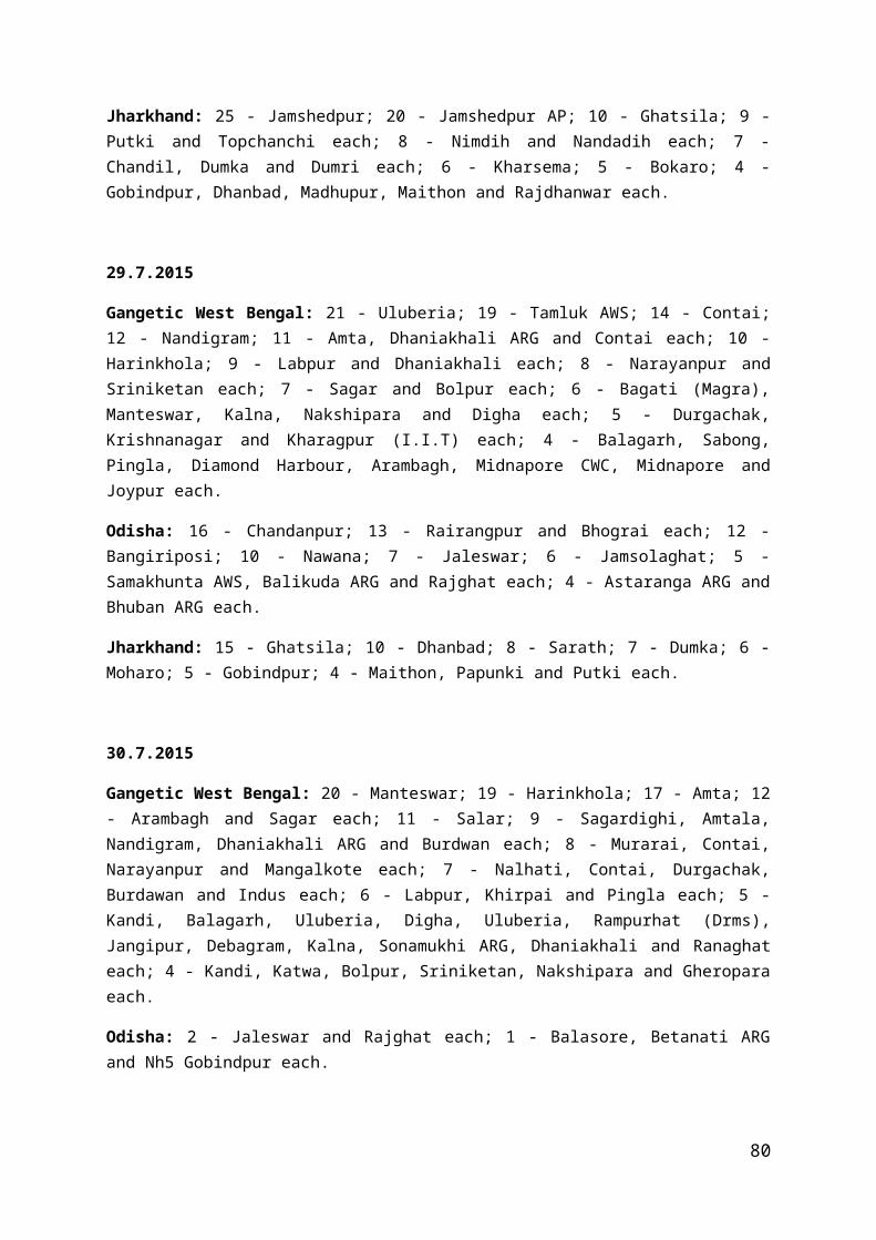
0600 Cyclonic Storm
59.2 1014.0 hPa, 100/23kts Ship 9V8797(15.0/58.3): 1012.7 hPa, 030/20kts Ship D5BA9(15.7/54.5): 1014.2 hPa, 070/10kts Ship DIHC(13.6/50.5): 1015.3 hPa, 360/6kts
7 Nov./ 1200
Severe Cyclonic Storm
12.7 / 58.4
T 3.5 Ship A8507(14.7/56.3): 1009.3 hPa, 050/12kts Ship 9V9403(14.4/58.1): 1011.0 hPa, 060/19kts Ship D5BA9(16.8/56.0): 1010.3 hPa, 070/13kts Salalah: 1011.2hPa, 150/8kts Mashirah: 1012.7hPa, 090/11kts
7 Nov./ 1500
Very Severe Cyclonic Storm
12.6 / 57.9
T 4.0 Buoy 23451(15.0/68.9): 1012.1 hPa, 010/4ktsBuoy 23910(12.2/69.6): 1011.2 hPaSalalah: 1012.7hPa, 360/1kts Mashirah: 1014.7hPa, 090/10ktsMarmul: 1011.9hPa, 140/11kts
8 Nov./ 0300
Extremely Severe Cyclonic Storm
12.7 / 55.5
T 5.0 Ship AMOHK01(12.5/45.6): 1013.0 hPa Buoy 23451(15.0/68.9): 1013.3 hPa, 010/10ktsBuoy 23910(12.2/69.6): 1012.7 hPaSalalah: 1014.5hPa, 350/4kts Mashirah: 1016.4hPa, 120/4ktsAgathi: 1012.1hPa, 360/10kts
8 Nov./ 1200
Extremely Severe Cyclonic
12.7 / 53.5
T 5.0 Ship AMOHK01(13.3/48.0): 1011.3 hPa Ship A8S07(13.6/50.7):
80
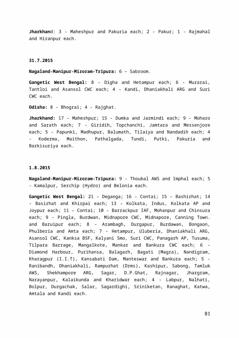
Storm 1011.2 hPa , 050/10ktsShip 9U8797 (11.4/66.4): 1011.1 hPa, 030/12ktsSalalah(AWS): 1012.2hPa, 110/8kts
9 Nov./ 0000
Very Severe Cyclonic Storm
12.3 / 51.0
T 4.5 Ship ONAR(14.2/54.1): 1012.0 hPa, 050/19ktsShip AMOHK01(13.9/51.6): 1010.8 hPa , 050/10ktsShip A8507 (12.8/48.2): 1012.0 hPa, 010/8ktsSalalah:1014.5hPa, 330/3kts
9 Nov./ 0300
Very Severe Cyclonic Storm
12.3 / 50.3
T 4.5 Ship TBWUK52(16.4/67.6): 1014.1 hPa, 010/8ktsShip AMOHK01(14.0/52.5): 1013.1 hPa Marmul: 1015.2 hPa, 080/5ktsSalalah:1015.9hPa, 350/3kts
9 Nov./ 1200
Very Severe Cyclonic Storm
12.5 / 48.0
T 4.0 Ship ONAR(14.2/56.0): 1012.0 hPa, 13 ktsMarmul: 1010.7 hPa , 150/13ktsDijbouti: 1011.0 hPa, 070/10ktsSalalah:1012.8hPa, 180/8ktsGizan:1009.2hPa, 230/10kts
9 Nov./ 2100
Severe Cyclonic Storm
12.7/46.8 T 3.5 Ship A8OU4(13.2/49.7): 1013.0 hPa, 250/15ktsShip ONAR(13.9/57.5): 1013.0 hPa, 040/9kts Gizan: 1010.2 hPa, 010/4ktsSalalah:1013.9hPa, VRB/2kts
10 Nov./ 0300
Cyclonic Storm
13.1 / 46.2
T 3.0 Ship C6YAS(17.1/39.7): 1010.0 hPa, 330/7ktsShip AMOHK01(12.5/59.6):
81

1012.8 hPa Gizan: 1010.2 hPaSalalah:1014.3hPa, 010/2kts
10 Nov./ 0600
Deep Depression
13.3 / 46.1
T 2.0 Ship CQII(12.0/45.9): 1015.7 hPa, 040/16ktsShip ONAR(13.7/58.8): 1014.0 hPa, 330/9ktsDjibouti: 1013.8 hPa, 140/6ktsSalalah:1015.4hPa, VRB/2kts
10 Nov./ 0900
System crossed Yemen coast near Lat. 13.4° N/Long. 46.1° E around 0900UTC.
10 Nov./ 1200
Depression
13.6 / 46.5
T 1.5 Ship ONAR(13.6/59.6): 1011.0 hPa, 330/13ktsShip C6YAS (13.6/59.6): 1008.0 hPa, 180/5ktsMina Salalah: 1010.9 hPa, 180/7ktsGizan:1008.2hPa, 240/14kts
The system weakened into a well marked low pressure area over Yemen and neighbourhood.
2.11.2 Other features observedThe lowest ECP was 964 hPa from 0600 UTC to 0900 UTC of 8th. The maximum estimated mean wind speed was 95 kts from 0600 UTC to 0900 UTC of 8th. The lowest observed pressure of 1005.0 hPa and maximum observed mean wind speed of 38kts was reported by Ship A8307(13.5/61.7) at 1200 UTC of 6th, when the centre of system was very close to Ship A8307. The system moved initially northwest and then westward direction.
2.11.3 Weather and damage causedNo damage has been reported due to this system.
2.12 Deep Depression over southwest Bay of Bengal( 8th -10th Nov. 2015)
2.12.1 A cyclonic circulation lay over Equatorial Indian Ocean and adjoining southwest Bay of Bengal extending upto 3.1 kms a.s.l. on 4th and over southwest Bay of Bengal and neighbourhood on 5th and 6th. It lay as a low pressure area over southwest and adjoining
82

southeast Bay of Bengal with associated cyclonic circulation extending upto 4.5 kms a.s.l. on 7th and as a well marked low pressure area over southwest Bay of Bengal and neighbourhood in the evening of 7th. It concentrated into a Depression and lay over southwest Bay of Bengal, centred near Lat. 10.7° N/Long. 83.7° E, about 400 kms southeast of Chennai, 440 kms east-southeast of Puducherry, 420 kms east of Karaikal and 480 kms east-northeast of Jafna (Sri Lanka) at 0300 UTC of 8th. It moved west-northwestwards and intensified into a Deep Depression and lay over southwest Bay of Bengal, centred near Lat. 11.2° N / Long. 81.4° E, at 1800 UTC of 8th. It further moved west-northwestwards and lay over southwest Bay of Bengal,centred near Lat. 11.6° N / Long. 80.3° E, about, 60 kms east-southeast of Puducherry, 150 kms southeast of Chennai at 0300 UTC of the 9th. Then it moved northwards and lay over southwest Bay of Bengal centred near Lat. 12.1° N / Long. 80.0° E very close to north Tamil Nadu coast near north Puducherry at 1200 UTC of 9th. Moving westwards, it crossed north Tamil Nadu coast close to Marakanam (north of Puducherry) near Lat. 12.2° N / Long. 80.0° E around 1400 UTC of 9th and lay centred near Lat. 12.4° N / Long. 79.6° E at 0000 UTC of 10th. It then moved westwards and weakened into a Depression and lay over north Tamil Nadu centred near Lat. 12.4° N / Long. 79.3° E, about 80 kms east of Tirupattur and 60 kms south-southeast of Vellore at 0300 UTC of 10th. It moved slowly westwards and weakened into a well marked low pressure area at 0600 UTC and lay over north Tamil Nadu and neighbourhood on 10th afternoon. It weakened into a low pressure area and lay over north Tamil Nadu and adjoining south interior Karnataka in the evening of 10th & became less marked on 11th. However, the associated cyclonic circulation extending upto 5.8 kms a.s.l. lay over Kerala and neighbourhood on 12th.
The details of the system are given in Table 12.
Table–12
Date / Time (UTC)
Intensity Position near Lat. o N / Long. o E(Real time)
Based on
Revised Estimates on Satellite Imagery /RADAR Obsn.
Supporting synoptic / asynoptic observations
8 Nov./ 0300
Depression 10.7 / 83.7
T 1.5 Buoy 23094(13.3/84.0): 1011.2 hPa, 050/16kts Buoy 23459(14.0/87.0): 1012.7 hPa, 100/17kts Buoy 23092(17.8/89.7): 1015.3 hPa, 040/14kts Buoy 23460(6.9/88.0): 1013.1 hPa, 070/10kts VSK: 1014.7hPa, 020/9kts
8 Nov./ 1200
Depression 11.0 / 82.5
T 1.5 Buoy 23094(13.4/83.1): 1009.8 hPa, 090/23kts Buoy 23459(14.0/87.0):
83

1010.6 hPa, 090/12kts MPT: 1010.4 hPa, 070/8kts NPT: 1006.3 hPa, 320/10kts Pamban: 1008.0 hPa, 360/22kts
8 Nov./ 1800
Deep Depression
11.2 / 81.4
T 2.0 Buoy 23094(13.5/84.0): 1010.6 hPa, 110/23kts Buoy 23459(14.0/87.0): 1012.5 hPa, 090/10kts MPT: 1011.9 hPa, 050/5kts CDL: 1007.1 hPa, 340/5kts NPT: 1007.1 hPa, 270/15kts
9 Nov./ 0000
Deep Depression
11.4 / 80.7
T 2.0 Buoy 23094(13.5/84.0): 1008.9 hPa, 100/19kts Buoy 23459(14.0/87.0): 1010.8 hPa, 110/14kts Buoy 23099(13.1/80.3): 1004.5 hPa, 100/19kts Cuddalore: 1000.8 hPa, 340/8ktsNPT: 1002.6 hPa, 270/18kts Pamban: 1006.9 hPa, 230/11kts
9 Nov./ 0300
Deep Depression
11.6 / 80.3
T 2.0 Buoy 23094(13.5/84.0): 1011.2 hPa, 090/17kts Buoy 23099(13.1/80.3): 1005.4 hPa, 110/25kts Cuddalore: 1001.1 hPa, 320/20ktsChennai: 1006.6 hPa, 020/18kts TTC: 1008.8 hPa, 230/19kts
9 Nov./ 1200
Deep Depression
12.1 / 80.0
T 2.0 Buoy 23094(13.5/84.0): 1008.4 hPa, 120/14kts Ship 2GYL6(8.3/83.4): 1006.4 hPa, 160/17kts Cuddalore: 999.0 hPa, 270/21ktsTirupati: 1004.3 hPa,
84

050/16kts Puducherry: 996.0 hPa, 340/4kts
Crossed north Tamil Nadu coast close to Marakanam, north of Puducherry near latitude 12.2°N/80.0°E around 1400 UTC.
10 Nov./ 0300
Depression 12.4/ 79.3 T 1.5 Vellore: 1005.4 hPa, 050/3kts Chennai: 1007.1 hPa, 110/3kts Cuddalore: 1006.0 hPa, 230/6ktsKaraikal: 1007.3 hPa, 230/11kts Puducherry: 1005.7 hPa, 200/5kts
10 Nov. It moved slowly westwards and weakened into a well marked low pressure area at 0600 UTC and lay over north Tamil Nadu and neighbourhood at 0900 UTC of 10th.
2.12.2 Other features observedThe lowest ECP was 996 hPa from 0600 UTC to 1200 UTC of 9th. The maximum estimated mean wind speed was 30 kts from 1800 UTC of 8th to 0000 UTC of 10th. At 0600 UTC of 9th, the system centre was located about 40-50 km southsoutheast of Puducherry. The lowest MSLP of 997.5 hPa was recorded at Puducherry and the ECP was 996 hPa. At 1200 UTC of 09th, the system was located about 30 km east-northeast of Puducherry with 996 hPa MSLP over Puducherry and ECP also about 996 hPa. However, Puducherry recorded the lowest MSLP of 991.7 hPa at 0900 UTC (1430 IST) of 9th.
As the system was located very close to the coast when the system maintained the intensity of a deep depression, wind speeds recorded by hourly coastal observations 8 provided the crucial input for determination of MSW during the time of landfall. Highest wind speed of 25 knots has been recorded by Puducherry observatory at 0000 and 0500 UTC of 09th. The maximum observed mean wind speed of 25 kts was also reported by Buoy 23099 (13.1/80.3) at 0300 UTC of 9th. The system moved initially west-northwest, northwards and then westward direction.
2.12.3 Weather and damage causedHeavy rain at a few places with very heavy rain at isolated places occurred over
south interior Karnataka and coastal Andhra Pradesh. Heavy to very heavy rain at a few places with extremely havy rain occurred at isolated places over Rayalseema and Tamil Nadu.
As the system caused extremely heavy rainfall, it caused extensive inland flooding over coastal districts of north coastal Tamil Nadu. About 31 deaths were reported in Tamil
85

Nadu and Puducherry in association with the damages caused by the system (flood related casualities and due to wall collapses in kutcha houses).
Chief amounts of 24 hrs. rainfall ( more than 5 cm ) ending at 0300 UTC of 8 th -10th Nov. 2015 are given below.8.11.2015
Coastal Andhra Pradesh: 7-Gudur
Rayalseema: 5- Tirumalla AP
Tamil Nadu: 9- Manimutharu; 8- Nagapattinam, Ambasamudram each; 7- Maniyachi, Lower Kothaiyar ARG each; 6-Cheranmahadevi, Nanguneri, Radhapuram, Rameswaram each; 5- Coonoor PTO, Coonoor, Karaikal, Thenkasi, Ramnad Nicra, Palayamkottai each.
9.11.2015
Coastal Andhra Pradesh: 6- Udayagiri, Tada, Sullurpeta, Shar each.
Rayalseema:12- Tirumalla AP; 8-Satyavedu; 7-puttur, kodur, Srikalahasti each; 6- Nagari Pakala Thottambedu each; 5-Tirupati AP, Palasamudram each.
Tamil Nadu: 17- Karaikal, Chennai each; 14- Nagapattinam, Cuddalore each; 13- Puducherry; 5- Tiruttani.
10.11.2015
Coastal Andhra Pradesh: 24- Venkatagiri; 20- Gudur; 19- Rapur; 17- Atmakur; 12- Podalakur (Arg); 10-Nellore, Vinjamur each; 8- Tada; 7- Kaveli, Shar, Udayagiri, Sullurpeta each.
Rayalseema: 30- Tirumalla Ap; 22- Kodur; 20- Ananthrajpeta ARG; 15- Pullampeta, Kalakada each; 14- Chittoor; 13- Palamaner, Pakala, Mandapalle each; 12- Rajampet, Arogyavaram each; 11- Gurramkonda, Thottambedu, Santhipuram, trupati AP, Penagaluru, Palasamudram each; 10-Srikalahasti, Satyavedu, Punganur, Kuppam, Nagari each; 9- Royachoti, Venkatagiri Kota, Chinnamandem each; 6- Puttur, Thambalapalle each; 5- Utukuru AP, Lakkireddipalle, Kadiri, Nambulipulikunta, Tanakal each.
Tamil Nadu & Puducherry: 48-Neyveli AWS; 35-Panruti; 34-Sethiarthopu, Chidambaram each; 33-Parangipettai; 25-Yercaud; 24- Chidambaram AWS; 21- Thirukoyilur; 19- Virudhachalam, Uthangarai, Ambur, Sathanur Dam each; 18- Vilupuram, Alangayam, Vaniaymbadi, Alangayam, Vilupuram; 17- Pappireddipatti; 16- Uthiramerur; 15- Kallakkurichchi, Pennagaram, Barur, Sankarapuram, Anaikaranchatram (Kollid) each; 14- Penucondapuram , Shoolagiri, Palacode each; 13- Pallipattu, Krishnagiri, Kancheepuram, Omalur, Pochampalli each; 12-Gingee, Salem each; 11- Marandahalli, Ulundurpet, Hosur,
86

Hogenekal, Cuddalore, Ponneri, Chengalpattu, Vellore each; 10- Tindivanam Trangambadi (or) Tranqueb, Vazhapadi, Rasipuram, Anjatti, Gudiyatham, Melalathur, Kaveripakkam each;
9- Puzhal ARG, Kalavai AWS, Thiruvalangadu, R.K.Pet, Denkanikottai, Chembarabakkam, Tiruvallur, Rayakottah, Thali, Red Hills each; 8- Mettur, Thamaraipakkam, Attur, Mangalapuram, Cholavaram, Sriperumbudur each; 7- Poonamallee, Sirkali, Poonamalle ARG, Chennai city, Ennore AWS, Tambaram, Thammampatty, Tozhudur, Madavaram AWS, Arakonam, Perambalur each; 6- Vanur, Sholingur, K.M.Koil, Venbavur, Chettikulam, Srimushnam, Thuraiyur, Kelambakkam, Puducherry, Tiruttani each; 5- Wallajah, Jayamkondam, Chembarambakkam ARG, Sankaridurg, Chennai AP, Padalur, Ariyalur, Thalavadi, Sendurai each.
South interior Karnataka: 18- Chamarajanagar PTO; 7- Yelandur, Kolar Gold Field, M M Hills each; 6- Chamarajanagar, Chintamani PTO each; 5- Hoskote, Bengaluru City, Gudibande each.
Fig. 1 : Tracks of storms and depressions over during the year 2015
87

88


![[XLS] · Web viewRohtak Pashchim Singhbhum Hassan Guna Mumbai City Kendrapara Patiala Jaisalmer Ramanathapuram Bijnor South 24 Parganas BAHRAIN Rangareddi Nagaon Lakhisarai Porbandar](https://static.fdocuments.us/doc/165x107/5ad688307f8b9a5c638e7a33/xls-viewrohtak-pashchim-singhbhum-hassan-guna-mumbai-city-kendrapara-patiala-jaisalmer.jpg)