USAID SUSTAINABLE ECOSYSTEMS ADVANCED (SEA) … · For the tunas (big and small) the fishermen use...
11
DISCLAIMER This activity report is made possible by the generous support of the American People through the United States Agency for International Development (USAID) with the close collaboration of the Government of Indonesia (GOI). The contents of this report are the sole responsibility of WWF-Indonesia and do not necessarily reflect the views of USAID or the United States Government. e ACTIVITY REPORT: SCOPING STUDY, BUANO ISLAND [February 7 – 12, 2017] Prepared by: M. Maskur Tamanyira/ WWF-Indonesia USAID SUSTAINABLE ECOSYSTEMS ADVANCED (SEA) PROJECT
-
Upload
nguyenliem -
Category
Documents
-
view
215 -
download
0
Transcript of USAID SUSTAINABLE ECOSYSTEMS ADVANCED (SEA) … · For the tunas (big and small) the fishermen use...

Activity Report: Scoping Study, Buano Island, February 7 – 12, 2017 P a g e | 1
DISCLAIMER
This activity report is made possible by the generous support of the American People through the United States Agency for
International Development (USAID) with the close collaboration of the Government of Indonesia (GOI). The contents of this report
are the sole responsibility of WWF-Indonesia and do not necessarily reflect the views of USAID or the United States Government.
e
ACTIVITY REPORT: SCOPING STUDY, BUANO ISLAND
[February 7 – 12, 2017] Prepared by: M. Maskur Tamanyira/ WWF-Indonesia
USAID SUSTAINABLE ECOSYSTEMS ADVANCED (SEA) PROJECT

Activity Report: Scoping Study, Buano Island, February 7 – 12, 2017 P a g e | 2
TABLE OF CONTENTS
INTRODUCTION ................................................................................................................................................. 4
OBJECTIVES OF ACTIVITY ............................................................................................................................... 4
SUMMARY OF PARTICIPANTS ...................................................................................................................... 4
RESULTS ................................................................................................................................................................ 4
KEY OUTPUTS, OUTCOMES, AND ACHIEVEMENTS ............................................................................. 5
RECOMMENDATIONS ..................................................................................................................................... 7
LESSON LEARNED ............................................................................................................................................. 7
PHOTOS AND CAPTION ................................................................................................................................. 8
ANNEX ................................................................................................................................................................ 11

Activity Report: Scoping Study, Buano Island, February 7 – 12, 2017 P a g e | 3
ACRONYMS AND ABBREVIATIONS
CTC Coral Triangle Center
DKP
FADs
KP3K
Dinas Kelautan dan Perikanan (Marine Affairs and Fisheries Office)
Fishing Aggregation Devices
Kelautan, Pesisir, dan Pulau-Pulau Kecil (Marine, Coastal, and Small Islands)
MPA Marine Protected Area
SEA Sustainable Ecosystems Advanced
WWF World Wildlife Fund-Indonesia
Activity Report: Scoping Study, Buano Island, February 7 – 12, 2017 P a g e | 4
INTRODUCTION
The USAID Sustainable Ecosystems Advanced (USAID SEA) Project is a five-year project that
supports the Government of Indonesia (GOI) to conserve biological diversity and
improve the governance of marine resources at local, district, provincial, and national levels.
The overall 5-year goal of USAID SEA Project is that USAID assistance will have
improved the conservation and management of Indonesia’s marine biodiversity through
improved capacity and practical application of marine conservation and sustainable
fisheries management.
Together with the Coral Triangle Center (CTC) to supports Strategic Approach 2B: to improve
the ecosystem management, WWF-Indonesia supports the establishment of a new MPA in
Buano Island, West Seram in Maluku Province. One important step to initiate the
establishment of MPA and its network design is data. As per USAID SEA Project requirement,
data collected from this survey will use a consistent methodology that is valid and
scientifically defendable. In addition, to achieve the survey objective, an efficient survey
design is important. For the data collection survey in Buano Island, a scoping study was
conducted to determine types of data and important to design the survey. This report
describes the process of scoping survey for the development of MPA in Buano Island by
WWF Indonesia. In this survey, WWF gathered data specific to fisheries activities.
OBJECTIVES OF ACTIVITY
1. To collect any data/report/information from organizations working in Buano Island,
West Seram District, Maluku.
2. To assess transportations and accommodation options as well as logistic support for
the survey.
3. To identify local potential partners to conduct the data collection survey in Buano
Island.
SUMMARY OF PARTICIPANTS
This activity was organized by CTC, with the involvement of WWF-Indonesia, the USAID SEA
Core Team - Ambon Office, and Marine Affairs and Fisheries Office (DKP) of Maluku Province.
The participants from each organization were:
- CTC: Marthen Welly, Sanjaya, Mad Korebima, Reinhart Paat, Elisnawaty, Yoga Putra
and Ardan;
- WWF-ID: Maskur Tamanyira;
- DKP Maluku Province: Robert (Division of Coastal and Small Island) Staff from
Directorate General of Marine, Coastal, and Small Islands/KP3K);
- USAID SEA Core Team – Ambon Office: Asril Djunaidi.
RESULTS
Buano is an island and is part of the Huamual Belakang Sub-district, West Seram District,
Maluku Province. The island has a king as the local leader and the new one already reigned
the island for one year. The King of Buano has the authority to issue a decree with all the

Activity Report: Scoping Study, Buano Island, February 7 – 12, 2017 P a g e | 5
terms and conditions required by the tradition in which the local communities should obey
and implement it. Based on conversation with Kamal, the Negeri Buano’s King, Buano has a
population around 2,300 households. However, the information still needs to be further
confirmed by looking at the population data in Sub-district office in Waesala, Huamual
Belakang. According to the king, 60% of the island population are fishermen.
Available information on the local government (both at sub-district and district level) to
support the site visit is limited and did not meet the needs of this scoping study. Hard-
copied materials and scoping time that coincided with the regency election campaign period
for West Seram, made it difficult to collect best data/information available for data collection
survey, particularly in Piru, the capital of West Seram Regency, and Waesala, the capital of
Huamual Belakang.
Buano Island can be reached with a half day boat trip from Ambon. The Island has about 12
villages inhabited primarily by native Buanos residents. Some specific areas on the Island,
such as Kasuari Island and Coconut Island, are dominated by Buton people.
The fisheries activities are dominated by the elders, while big numbers of local population
(18-35 years old) are working outside the village to generate income from woodwork activity
in the surrounding islands. Along with farming, fishing is the largest source of livelihood in
Buano. The majority of the fishermen use hand-lines and fishnets as fishing gear. Fish
landing is dominated by small-pelagic fish (scad, fusiliers, kawa-kawa, and skipjack) for local
consumption. During the season, the fishermen target big tuna (yellowfin), and a prolific mix
of bottom-fish such as emperors, red grouper, groupers, and deep-water snappers.
Fish such as big tuna and the mixed bottom fish which have higher price are sold to the
collectors located in the Kasuari Island, Osi Island, Pelita Jaya, and Kawa (administratively, the
last three are not part of Buano). Collectors mostly use collecting boats stationed in those
areas and buy the fish. Based on the earlier scoping study, all of the collecting boats come
from outside West Seram District. There is a presumption that these collectors are also the
ones responsible for the deployment of Fish Aggregation Devices (FADs) in the fishing
hotspot area such as Tanjung Pamali.
KEY OUTPUTS, OUTCOMES, AND ACHIEVEMENTS
Geographic & Administration:
- Buano Island consists of two villages:
1. Buano Utara, and;
2. Buano Selatan
Fisheries situation and issues
Local villagers fish every day for local consumption and land the fish everywhere in the beach
alongside the island where villages are located. For commercial fishing activities:

Activity Report: Scoping Study, Buano Island, February 7 – 12, 2017 P a g e | 6
The fishing season for mixed bottom-fish is April, May, October, November, and
December
The fishing season for tuna is January, February, March, and to a lesser extent in June,
July, August and September because of large waves during those months.
The hotspot for the fishing activity is Tanjung Pamali. Dolphins, whales, and sharks
are frequently seen in this area.
FADs are common in Tanjung Pamali’s waters and widely spread. Each FAD is marked
by numbers as a unique code.
The market quality of fish caught by Buano’s fishermen is generally low, because
there is no ice factory available in the island and/or in a nearby area.
The collecting boats also do not help much to maintain the quality of fish caught. The
fishermen don’t provide a standard quality of ice. They generally collect the fish and
store them in the icebox inside the vessel.
From the initial discussion with several fishermen in Buano Utara, the collecting boats
come from areas such as Ambon, Makassar, and Bitung.
For the tunas (big and small) the fishermen use a hand-line method and its variation
such as kite fishing, deep setting hand-line, etc.
The mixed bottom-fish is caught by hand-line.
Small pelagic fish is usually caught by fishnet or jaring paying.
The fishermen in Buano are not informed nor aware of local, and or national
regulations
There is no management applied in the fishing activity in the area.
Based on the observation, vessels seen in Buano Island are around 1 – 7 GT and
classified as an artisanal fishermen by the new law on fishermen (Undang
Kenelayanan, UU 7/2016)
Based on conversation with Ademin Nurlette, a fisherman, some of fishermen have
fishermen IDs.
Logistic issues:
o Rent car from Ambon are vary in price, from Rp.750,000 – 1,500,000/day
o To reach Seram from Ambon, one needs to go to Pelabuhan Hunimua, Liang to cross
the sea with, Terubuk Motorboat, which is hourly available.
o Sail duration with Terubuk Motorboat from Liang, Ambon to Waipirit, Seram is
around 90 – 120 minutes.
o Ticket price : Rp. 16,500/ person
: Rp. 85, 500/ car (driver included)
o From Waipirit to Pelita Jaya (-3.003827, 128.119232) the crossing point will take
around 60-90 minutes.
o To get to Buano from Pelita Jaya, one can hire small boat (longjohn/ketinting) the
price is around Rp. 1,000,000 – 1,500,000
o In the Buano Utara (possibly as the center of Buano Island administration) the
electricity is available for 12 hours, between 6 PM – 6 AM
o There are no hotels or guesthouse, but local’s house can be used as
accommodations.
o Fresh water available from the springs, but sometimes the residents of Buano also
harvest the rainwater to fulfil the villagers need.

Activity Report: Scoping Study, Buano Island, February 7 – 12, 2017 P a g e | 7
RECOMMENDATIONS
- A wide area survey is needed in Buano and surroundings to get the full picture of
Buano Island resources management issues and needs.
- To initiate and conduct a small workshop on the dissemination of regulations with
the local government/fisheries and marine affairs offices at provincial, district and
local community levels.
- To identify preparations needed to initiate a joint action with CTC in order to conduct
a more comprehensive survey.
- To conduct fish landing enumeration, with market analysis to collect data on fish
caught and to improve the handling of fish caught for marketing.
LESSONS LEARNED
- Several islands and villages in Maluku, has kings as rulers/managers. In local
government system, the kings have the capacity to develop a local
regulation/management system to maintain the greater good of their
islands/villages. This system can be used as a vehicle to insert a management
intervention for sustainable utilization of marine and fisheries resources that builds
on the traditional values and rules that are acceptable in these communities.
- Structured capacity building and formal – informal approach to the king are key to
have a better future engagement with local stakeholders in Buano Island and nearby
potential sites for fisheries data collection.

Activity Report: Scoping Study, Buano Island, February 7 – 12, 2017 P a g e | 8
PHOTOS AND CAPTIONS
The King, known also as Raja Buano (in white shirt) happily accepted the team in his house.
The King shared a lot of information about his previous activities as a policeman in Tual, Kei
Island and the traditional procession and steps for him to take up the role as a King in Buano
Island. (Maskur Tamanyira/ WWF-ID).
Activity Report: Scoping Study, Buano Island, February 7 – 12, 2017 P a g e | 9
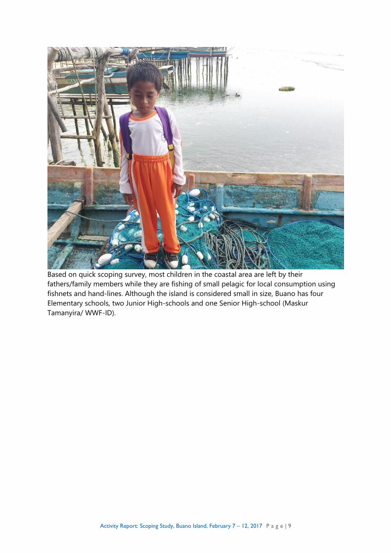
Based on quick scoping survey, most children in the coastal area are left by their
fathers/family members while they are fishing of small pelagic for local consumption using
fishnets and hand-lines. Although the island is considered small in size, Buano has four
Elementary schools, two Junior High-schools and one Senior High-school (Maskur
Tamanyira/ WWF-ID).

Activity Report: Scoping Study, Buano Island, February 7 – 12, 2017 P a g e | 10
“Jibu-jibu” is waiting for the fish to be landed. Jibu-jibu, is a value chain system where
women have a significant role to determine fish price, sell it to a widespread consumers
inside the island and process the fish into smoked or salted fish.
(Maskur Tamanyira/ WWF-ID)
Activity Report: Scoping Study, Buano Island, February 7 – 12, 2017 P a g e | 11
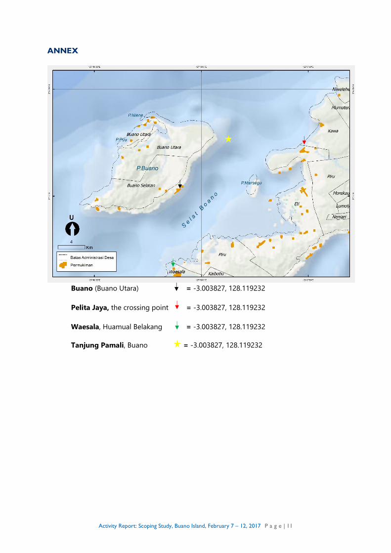
ANNEX
Buano (Buano Utara) = -3.003827, 128.119232
Pelita Jaya, the crossing point = -3.003827, 128.119232
Waesala, Huamual Belakang = -3.003827, 128.119232
Tanjung Pamali, Buano = -3.003827, 128.119232