Urban Transformation in the Context of Rail Transport ...
16
Research Article Urban Transformation in the Context of Rail Transport Development: The Case of a Newly Built Railway Line in GdaNsk (Poland) Marcin PoBom , Maciej Tarkowski , and Krystian Puzdrakiewicz Department of Regional Development Geography, Institute of Geography, University of Gda´ nsk, Poland Correspondence should be addressed to Marcin Połom; [email protected] Received 2 June 2018; Revised 20 September 2018; Accepted 1 October 2018; Published 29 October 2018 Guest Editor: Borna Abramovi´ c Copyright © 2018 Marcin Połom et al. is is an open access article distributed under the Creative Commons Attribution License, which permits unrestricted use, distribution, and reproduction in any medium, provided the original work is properly cited. Development of railway transport systems is perceived as one of the most effective ways of shaping sustainable urban transportation. However, railway transportation systems can only compete with individual means of transportation when having properly developed infrastructure, especially in terms of the train stops accessibility. e main objective of this article is to discuss mutual relations between operation of a newly built railway line and spatial changes taking place in its closest vicinity which determine the accessibility to it. e research methods included the GIS tools, direct measurements of passenger exchange, and public opinion poll among the passengers taking the new line. e research area was the city of Gda´ nsk, one of the largest cities in Poland, where transportation problems are cumulating as a result of the urban sprawl. e new railway was opened in order to mitigate these problems. e research results have proved this strategy was only partially successful as the course of the line and location of the stops do not provide a large number of potential passengers. at is why it was necessary to connect the line to the already existing urban transportation system, yet this solution has not resolved the problem completely. However, the urban development plan assumes introduction of large housing projects in the areas surrounding the existing train stops what will allow using the new line more efficiently in the future. 1. Introduction Transport is regarded as a basic factor fostering develop- ment of urban regions [1–3]. e “triumph of the city” [4] will not be possible without an efficient transportation system, urbanisation, although in some regions it is not as dynamic as it used to be in the demographic aspect, it is still progressing in the economic, social, and spatial dimension. e structure of urban transportation systems is subject to ongoing changes. Pedestrian traffic and public transport are considered to no longer have a dominant position in the system; motorised individual transport is now the most important part of it. e external costs of such a model (including costs of accidents, air pollution, climate change, noise, and congestion) [5] have forced search and implementation of solutions aimed at supporting pedes- trian traffic, improving public transportation systems and promoting alternative ways of individual transport (private bicycles, urban bicycles, car-sharing systems, and all kinds of electric individual means of transport). Although, obviously, technological progress was the main force driving the above- mentioned changes [6], yet some social phenomena were also fostering them, such as emergence of the automobility culture [7] and the concept of sustainable mobility, aimed at overthrowing the car culture. In order to introduce the idea of sustainable mobility, actions in four basic dimensions have to be taken: implementing the latest technology to increase the efficiency, developing a pricing policy which internalises the external costs generated by each and every mode of transport, introducing spatial management tools aimed at decreasing in demand for transport and bringing about a change in the modal split, and providing a precisely addressed information system for citizens [8]. One way of bringing the idea of urban sustainable mobility into life is to develop rail-based public trans- portation systems, including urban railways. Such systems allow increasing efficiency of transport in two ways: through technical improvement of infrastructure and vehicles and, Hindawi Journal of Advanced Transportation Volume 2018, Article ID 1218041, 15 pages https://doi.org/10.1155/2018/1218041
Transcript of Urban Transformation in the Context of Rail Transport ...

Research ArticleUrban Transformation in the Context of Rail TransportDevelopment: The Case of a Newly Built Railway Line inGdaNsk (Poland)
Marcin PoBom , Maciej Tarkowski , and Krystian Puzdrakiewicz
Department of Regional Development Geography, Institute of Geography, University of Gdansk, Poland
Correspondence should be addressed to Marcin Połom; [email protected]
Received 2 June 2018; Revised 20 September 2018; Accepted 1 October 2018; Published 29 October 2018
Guest Editor: Borna Abramovic
Copyright © 2018 Marcin Połom et al. This is an open access article distributed under the Creative Commons Attribution License,which permits unrestricted use, distribution, and reproduction in any medium, provided the original work is properly cited.
Development of railway transport systems is perceived as one of themost effectiveways of shaping sustainable urban transportation.However, railway transportation systems can only compete with individual means of transportation when having properlydeveloped infrastructure, especially in terms of the train stops accessibility. The main objective of this article is to discuss mutualrelations between operation of a newly built railway line and spatial changes taking place in its closest vicinity which determine theaccessibility to it. The research methods included the GIS tools, direct measurements of passenger exchange, and public opinionpoll among the passengers taking the new line. The research area was the city of Gdansk, one of the largest cities in Poland, wheretransportation problems are cumulating as a result of the urban sprawl. The new railway was opened in order to mitigate theseproblems. The research results have proved this strategy was only partially successful as the course of the line and location of thestops do not provide a large number of potential passengers. That is why it was necessary to connect the line to the already existingurban transportation system, yet this solution has not resolved the problem completely. However, the urban development planassumes introduction of large housing projects in the areas surrounding the existing train stops what will allow using the new linemore efficiently in the future.
1. Introduction
Transport is regarded as a basic factor fostering develop-ment of urban regions [1–3]. The “triumph of the city”[4] will not be possible without an efficient transportationsystem, urbanisation, although in some regions it is notas dynamic as it used to be in the demographic aspect,it is still progressing in the economic, social, and spatialdimension. The structure of urban transportation systemsis subject to ongoing changes. Pedestrian traffic and publictransport are considered to no longer have a dominantposition in the system; motorised individual transport isnow the most important part of it. The external costs ofsuch a model (including costs of accidents, air pollution,climate change, noise, and congestion) [5] have forced searchand implementation of solutions aimed at supporting pedes-trian traffic, improving public transportation systems andpromoting alternative ways of individual transport (privatebicycles, urban bicycles, car-sharing systems, and all kinds of
electric individual means of transport). Although, obviously,technological progress was the main force driving the above-mentioned changes [6], yet some social phenomena werealso fostering them, such as emergence of the automobilityculture [7] and the concept of sustainable mobility, aimed atoverthrowing the car culture. In order to introduce the idea ofsustainable mobility, actions in four basic dimensions have tobe taken: implementing the latest technology to increase theefficiency, developing a pricing policy which internalises theexternal costs generated by each and everymode of transport,introducing spatial management tools aimed at decreasingin demand for transport and bringing about a change in themodal split, and providing a precisely addressed informationsystem for citizens [8].
One way of bringing the idea of urban sustainablemobility into life is to develop rail-based public trans-portation systems, including urban railways. Such systemsallow increasing efficiency of transport in two ways: throughtechnical improvement of infrastructure and vehicles and,
HindawiJournal of Advanced TransportationVolume 2018, Article ID 1218041, 15 pageshttps://doi.org/10.1155/2018/1218041
2 Journal of Advanced Transportation
PMR line, stationsRailways
Tram lineMain roads
District boundariesCity boundary of GdaHsk
2 0 2 4 km
Figure 1: The Pomeranian Metropolitan Railway line within the city of Gdansk boundaries.
above all, through introducing a change in the modal splitwhich limits use of private cars and reduces congestionand its all negative consequences, including the social ones[9]. This change is also vital in the context of reducinggreenhouse gas emissions [10]. Everyday functioning of citiesand transportation systems is extremely energy-consuming;that is why the potential of reducing the emissions is sohigh in this case. However, these benefits can only beachieved when development of public rail-based transportsystems is coupled with proper spatial planning. Hence, rail-based transport plays a valuable role in shaping the spatial-functional structure of cities [11, 12].
In the postsocial countries, including Poland, the pre-sented above sequence of transformations took place muchlater. The system transformation towards the free-marketcapitalism (after 1989) covered both transportation and citymanagement, to some extent. Not sufficient, in relationto actual demand, expenditures on the public transportinfrastructure led to its degradation. Only some componentsof the system have been privatised, often with foreign capitalparticipation, yet it has not improved the transport offer on anational level [13]. The rest of it, especially local commuterbus and train lines, have been gradually dismantled. Thisregression in the number of local lines was one of the mainreasons for the decrease in the rail passenger traffic [14].According to the data published by the Central StatisticalOffice, in 2000 the number of rail passengers in Polandconstituted only 48% of the number recorded in 1990 and thenumber of bus passengers, 60%. At the same time, the num-ber of private cars constituted 189% of the number recordedat the beginning of the analysed decade [15]. A significant
increase in the level of motorisation was not only a result ofthe regression in the public transportation services. Owning acar was a factor shaping the way of life and it served as a statussymbol [16]. During the next decade after the beginningof the transformation (2000-2010) there were no significantchanges in the structure of the above-mentioned modes.Accession to the European Union in 2004 allowed usingthe Structural Funds for development and modernisationof the transport infrastructure. Some of the money was setaside for development of urban road networks, what made itpossible to reduce the traffic congestion in large cities, at leasttemporarily [17]. There were also some funds allocated fordevelopment of railways, including urban ones, but the scaleof investmentwas less significant. Railway systems ofWarsaw,Gdansk-Gdynia-Sopot, Lodz, and Cracow were modernisedat that time [18].
Themain objective of this article is to answer a question towhat extent launching the Pomeranian Metropolitan Railwayhas contributed to changes in the spatial and functionalstructure of Gdansk, one of the largest cities in Poland(see Figure 1). E. Babalik [19] arguments the urban formof cities can influence the success of urban rail systems. Itwas observed that the economic vitality of central businessdistricts, the location of employment and retail outlets, thepopulation and residential density, and the dominant urbanpattern were particularly important. Taking the strategicvalue of this investment under consideration, the authorswill also make an attempt to indicate possible directionsof spatial development of the city during the next decade.Transportation systems affect the process of spatial andfunctional urban structure shaping.That is why, in this article,
Journal of Advanced Transportation 3
a case of the Pomeranian Metropolitan Railway and the wayit influences the urban structure of Gdansk will be described,along with the mobility patterns of its citizens.
Despite the fact that the Pomeranian Metropolitan Rail-way serves other towns in the region, the spatial scopeof this article is limited to the city of Gdansk, where themain investment efforts were concentrated. Special attentionwas paid to the areas located in the closest vicinity of thePMR stations as the most notable changes in the spatial andfunctional urban structure can be observed there. The areasare planned to undergo some far-reaching changes in terms ofspatial development. The time scope of the analysis was threeyears of the PMR operation, that is, from mid-2015 to mid-2018. However, the future plans for further development ofthe Pomeranian Metropolitan Railway as well as provisionsof the spatial development plan for Gdansk have also beenanalysed [20].
The article consists of four parts. The first one comprisesgeneral background information on the case study, includinginformation on the investment circumstances, the course ofthe route, location of the stations, and the size of passengerflows. In the second part the authors indicate the researchmethods and sources of the data used for analysis. The resultshave been presented with attention paid to four major issues:the existing land use patterns, population density, the degreeof linkage between the PMR and the bus and tram systems,and expected changes in the land use.The article is completedwith conclusions and recommendation concerning furtherresearch tasks.
2. Case Study
2.1. Unsustainable Mobility: Gdansk as Typical Case of PolishLarge City. Gdansk is the sixth largest city in Poland witha population of approximately 464 thousand people (2016).Along with Gdynia and Sopot the three cities comprise aband-shaped spatial layout of a polycentric structure, whichemerged as a result of many interrelated environmental,social, economic, and political conditions. It is a centre ofa large urban region with a population of approximately1 million people. According to the typology of functionalurban areas created on the basis of their size, competitiveness,knowledge sources, and their accessibility [22], this regionbelongs to Type 4 European metropolitan areas as well asSzczecin, Poznan, Wroclaw, Lodz, Cracow, and Katowice(in Poland) and Cork in Ireland, Southampton (along withBournemouth and Portsmouth) in Great Britain, Porto inPortugal, Seville in Spain, Havre and Bordeaux in France,Genoa in Italy, Valletta in Malta, Turku in Finland, Tallinnin Estonia, Riga in Latvia, Vilnius in Lithuania, Bucharestand Timisoara in Romania, Sofia in Bulgaria, and Ljubljanain Slovenia. Gdansk, as well as other large Polish cities, facesthe problem of unsustainable mobility. According to GdanskTraffic Research [23], the share of individual transport is41% and it significantly exceeds shares of other forms ofmobility. However, such a structure of urban traffic is notsomething unusual; it is commonly observed in other Polishand European cities. There are also cities with a higher shareof individual transport yet it does not change the fact that
the modal split of transport based on individual means oftransportation causes a number of essential problems interms of functioning of cities and everyday life of theircitizens. One of the most recognisable one is traffic conges-tion. As it has already been mentioned, this phenomenonhas been developing in Poland since the beginning of thepolitical transformation and nowadays it has reached thelevel observed in the highly developed countries. Not onlywas it a result of a general improvement of the citizens’wealth, but also it is connected with chaotic development ofsuburbanisation.
2.2. Local Context of Urban Mobility in Gdansk. All theabove-mentioned general problems affect Gdansk, yet thereare some local factors influencing the situation, too. Theenvironmental conditions were the main reason why thecity has band-shaped infrastructural systems serving tworelatively separated parts of the city: the lower terrace, locatedmostly on an alluvial plain (northern and eastern parts ofGdansk) and the upper terrace, located at 100-150 m abovesea level, on a postglacial upland (southwestern and westernparts of Gdansk). On the lower terrace there is a historicalcity centre, band-shaped central service district, port andindustrial areas, and residential districts with high populationdensities. On the upper terrace there are mainly scatteredresidential areas of lower population densities. They generateproblems for public transportation system and are not as wellcommunicated as the central ones. On the upper terrace thereare also several other objects generating traffic: the airportwith an industrial district nearby and some large shoppingcentres. A steep edge of the upland is a natural boundaryseparating the two parts of the city. It is covered with forestand it is legally protected. As seen from the perspective ofurban development, this barrier was overcome in the 1970sand 1980s when large-panel prefabricated housing estateswere built. The process of inhabiting the upper terrace wascontinued during the period of transformation. It showedsigns of chaotic internal suburbanisation [24]; there wereboth detached houses built by the owners themselves andlarge residential areas constructed by developers. Such asuburbanisation model makes it difficult to make urbanmobility sustainable. Modernisation and development of theroad system on the upper terrace began too late and its pacewas not sufficient. As for the public transport infrastructure,the situation was even worse and it did not contribute to adecrease in the share of citizens using private cars. On thecontrary, the role of this means of transport increased by 2%when compared with 2009; the city has not been movingtowards the sustainable mobility model [23]. However, someadverse trends had been noticed before that and they trig-gered an intense public debate regarding further transportinvestments in the city. The conclusions of this debate wereincluded in the Gdansk 2030 PlusDevelopment Strategy [25].As for transport and mobility it was stated that the modalsplit of transport in the city has to be changed in order tomeet the criteria of sustainable mobility. The PomeranianMetropolitan Railway had already been under constructionat that time and it was considered a logical component of thisplan.
4 Journal of Advanced Transportation
2.3. Towards More Sustainable Mobility: Pomeranian Metro-politan Railway. Construction of an agglomeration railwayline in the urban area of Gdansk-Gdynia-Sopot has beenplanned for several decades. It was assumed that the railwayline would connect the city centres of Gdansk and Gdyniawith the existing airport in Gdansk and the planned one inGdynia-Kosakowo. It was planned to extend the offer of theFast Urban Railway running along the central service district.Initially, it was assumed that the PMR would start operationbefore the 2012 UEFA European Championship, but it wasnot possible to meet the deadline. It took three more yearsto complete the construction. The Pomeranian MetropolitanRailway is a name for the line itself and for a special purposecompany established to construct and then manage therailway line.The line was constructed between 2013 and 2015,financed mainly from the structural EU funds. Although itwas built along an old railway line, which was there in thepast, the whole infrastructure had to be reconstructed. Thatis why this investment is of special meaning as there wasno other urban region where the scale of construction andmodernisation of a railway line was that large.
As part of the investment, a railway line (19,5 km),including 18 km of a double track section towards Gdansk-Osowa station and a connector (1,5 km), was constructed.Additionally, eight new stations were built and two morealready existing ones were modernised to connect the PMRwith the Fast Urban Railway. The maximum permissiblespeed on this route is 120 km/h.
Right after launching the PMR the line Gdansk Głowny–Gdansk Airport–Gdynia Głowna started to operate as well astwo shorter lines to Gdansk Osowa and Gdansk Wrzeszcz.Then, in the period of 2015-2016 other two lines were openedconnecting Gdansk with two smaller towns located outsidethe urban area. However, in this article, themain focuswill beput on the lines located within the city of Gdansk boundaries.
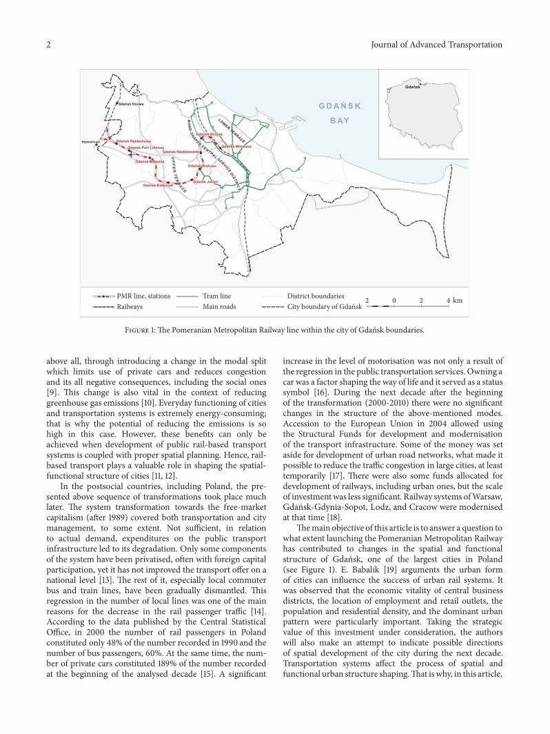
A relatively short, three-year period of the PMR oper-ation, during which there were numerous changes in thetimetable aswell as a temporary cessation of operations due toextremely heavy rain in July and August 2016, does not allowunambiguously evaluating the investment. An actual impactof the Pomeranian Metropolitan Railway on the urban trafficmay be assessed by analysing the number of its passengers(Figure 2). In the period of October 2015–March 2018 avisible positive trend is observed when analysing the totalnumber of passengers. However, when analysing the numberof passengers using not only the innercity lines, but alsothe ones connecting Tricity with Kartuzy and Koscierzyna,some interesting patterns can be observed. According tothe PKM S.A. (PMR limited company) data, the number ofpassengers taking part in the metropolitan traffic (Gdanskand Gdynia) actually decreased from 151,6 thousand in June2016 to 141,1 thousand in June 2017. Most probably, thanks tomodifications in the timetable it was possible to reverse thisnegative trend and in March 2018 the number of passengersreached approximately 190 thousands.
The results of a direct measurement carried out in theperiod of October-November 2017 [21] have shown that themost popular stations in Gdansk are Wrzeszcz, Strzyza, andJasien. Airport and Kiełpinek are also among the stations of
0100200300400500600700800900
Passengers getting onPassengers getting off
Num
ber o
f pas
seng
ers
Strz
y
Ta
Nie
d
Tw
iedn
ik
Bręt
owo
Jasie
H
Mat
arni
a
Port
lotn
icy
Rębi
echo
wo
Kieł
pine
k
Figure 2: Average daily number of getting on and getting offpassengers by the PMR line stations in the period of 17.10-16.11.2017.Source: own elaboration based on [21].
significant importance. The least popular among the PKRpassengers is Niedzwiednik station. It is situated relativelyclose to the central service district and it is more convenientfor the citizens to reach it by bus.
3. Methods and Data
In order to achieve the objective of this article the authorsused a whole range of GIS tools; they carried out directmeasurements of the passengers flow and they interviewedthe passengers using the PMR service.
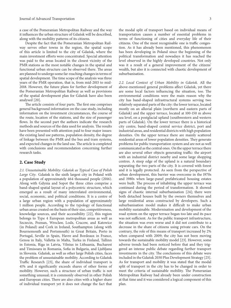
3.1. GIS Tools. The GIS tools (QGIS software) were usedwhile determining spatial conditions along the railway line,location of the stations, and how they are connected by busand tram. The GIS tools were also useful when describingthe foreseen changes in the land use. The base for theirimplementation was a map of topographic objects at 1:10000 scale obtained from a publicly accessible cartographicresource base.
In order to assess the land use character and intensityof development in the closest vicinity of the stations, a toolnamed “fixed width buffer” was used. It allowed delimitinga 660 m equidistant for a 10 minutes’ walking distance anda 1320 m equidistant for a 20 minutes’ walking distanceto the stations being central points of the delimited zones(Figure 3). The 660 m equidistant was also used to delimitthe zones of 10 minutes’ walking distance to the bus or tramstops which allow reaching a given PMR station within 5minutes. In the literature normal walking speed varies from3,2 km/h to 5,4 km/h and 4,5 h/km on average [26]. In orderto calculate the distance to the PMR station, which passengershave to cover in the 10- and 20-minute zones, the averagenormal walking speed of 4km/h was adopted [27–29], takingthe space resistance resulting from implementation of thestraight-line mechanism under consideration.
Time distances between the stations were calculated onthe basis of public transport schemes and timetables for busesand trams published by the urban transport operator. This

Journal of Advanced Transportation 5
City boundary of GdaHsk
Tricity Fast Urban Railway
Pomeranian Metropolitan Railway (PMR)
Pomeranian Metropolitan Railway stationsIsochrone 10 minutes pedestrian trafficfrom/to PMR stationsIsochrone 20minutes pedestrian trafficfrom/to PMR stations
1 0 1 2 3 km
Figure 3: Zones of 10-minute and 20-minute walking accessibility to the PMR line in the context of the contemporary land use forms.
procedure allowed delimiting an indicative intermodal whichis served by the PMR, buses, and trams (Figure 6). Intensityof communication linkages between the railway stations andbus/tram stops was depicted with the use of a ribbon-likecartogram. Itwas created on the basis of the timetables, takingthe average number of all 5-minute daytime bus and tramcourses to/from the railway stations on weekdays during aschool year (both directions) (Figure 6). In order to assess thecharacter and intensity of land use in the whole area served bythe PMR, the authors analysed population density grids (100m/1ha).Themost recent data on number of people registeredin the city of Gdansk at the end of 2016 was obtained fromGdansk Development Office, local authority responsible forthe spatial policy. In Poland it is obligatory for all citizensto register. However, there are no sanctions forcing peopleto do so. The majority of population actually lives in placeswhere they are registered yet the number of people who donot is still growing. In 2009 the data regarding the numberof registered people was officially published for the last time;
in Gdansk it was lower by 1,1% than the number assessedusing the balance sheet method. Using the above-mentioneddata, the number of people having access to each railwaystation, the number of people living in common areas ofthe 1320 equidistant zones, and the total sum for all thestations were calculated. When calculating, rectangles havingtheir geometrical centres within a zone set by a particularequidistant delimited for each of the station (Figure 5)were taken under consideration. Additionally, in order toassess the current land use structure as well as the plannedchanges in it, cartographic data included in the general localdevelopment plan for Gdansk was used [8]. On the maps,being attachments to the plan, dominating land use forms,housing and housing-service areas as well as the foreseenchanges in the land use are presented (Figure 7).
3.2. Passenger Traffic Measurement and Questionnaire Sur-vey. In order to assess the volume of passenger traffic atevery PMR station and the impact that the PMR exerts

6 Journal of Advanced Transportation
Table 1: Land use forms in the closest vicinity of (660 m radius) the PMR stations in Gdansk (at the end of July 2017.
Station Dominating housingdevelopment type
Dominating land-use forms– housing and
housing-services (ha)
Dominating supra-localservice or industrial
functions
Elements integrating thestation with other modes of
transport
Strzyza mixed with a domination ofsingle-house 39
university campus, tramdepot, shopping centre,
sports centre, carshowrooms,
tram stop at the depot anda regular tram stop
Niedzwiednik multi-house 28 asylum, cemetery,non-public schools bus stop
Brętowo mixed 40 terminal tram stop and abus stop
Jasien multi-house 14 terminal bus stop, car park
Kiełpinek mixed with a domination ofmulti-house 17 shopping centre terminal bus stop, car park
Matarnia multi-house 11 service and industrialcompanies bus stop, car park
Port Lotniczy scattered single-house 3 office buildings, hotel airport, terminal bus stopRębiechowo scattered single-house 3 arable landsSource: own elaboration based on the GIS analysis and fieldwork.
on mobility patterns, data on the volume of the passengertraffic was used [21]. The data was obtained during the17.10.2017-16.11.2017 measurements carried out on typicalweekdays in two sessions (6:00-9:00 and 14:00-19:00). Forthree selected stations 16-hour measurement was carriedout.Themeasuring staff encompassed well-trained observersequipped with measuring cards, documents with a detaileddescription of the measurement, visibility vests, and namebadges. Moreover, the passengers were being interviewedwith the use of a standardised questionnaire. They were askedabout motives behind and frequency of their journeys, whythey choose the PMR, how they get to a starting station,and how they continue their journey after getting off thetrain. Usually, there were from 1 to 3 interviewers on eachstation, depending on where a given station is situated andthe estimated number of passengers using it. The reportsummarising this measurement is publicly accessible and itwas obtained from the Pomeranian Regional Planning Officewhich had commissioned the research. The office is regionalauthority responsible for the spatial policy.
4. Results and Discussion
4.1. Land Use Zones in the Areas Surrounding the PMR Line.The main problem connected with reconstructing an oldrailway line is the fact that the areas it used to cover havebeen built-up and now they are potential sources of passen-ger traffic. This is also the issue affecting the PomeranianMetropolitan Railway line. Only two stations, Wrzeszcz andStrzyza, located on the lower terracewithin the central servicedistrict are situated in a highly urbanised area with well-developed housing, service, and communication functions(Table 1). Other two stations, Niedzwiednik and Brętowo, arelocated in the upland edge; thus there are not many housingor service areas in their closest vicinity, yet still within therange of the 660 m zone. In most cases, in order to reach the
station people have to walk up/down a steep hill what maydiscourage them from using the PMR trains.
There are five stations located in the upper terrace. Theclosest vicinity of three of them, Jasien, Kiełpinek, andRębiechowo, is not densely built-up. In the areas aroundJasien and Kiełpinek new housing estates are being con-structed; some of them have already been finished. The areasaround Kiełpinek station are the most densely built-up.Thereis a large housing estate there and a large shopping centre.However, the station is not located in the centre of this area soit is not attractive for all its residents. The least densely built-up areas surround Rębiechowo station (Table 1, Figure 3);they are mainly arable lands and areas with highly dispersedsingle-housing development; additionally, most of it is notlocated within the city boundary. The station is located nearthe city boundary in Banino, a village being now under asevere suburbanisation pressure.
The areas surrounding Matarnia and Port Lotniczy sta-tions are more densely built-up than the closest vicinityof the three previously described stations. Matarnia stationis located on the edge of a large industrial district and ahousing estate. Such a peripheral location of this stationmarginalises its role in transport services. The second station(Port Lotniczy) is located near the airport which is a keyobject for this railway line. Improving accessibility of theairport was one of the motives behind the construction ofthe PMR line. What is more, in this area there are airportcar parks, a hotel, and some objects situated on the edgeof an office district, which core, in a form of the “Intel”headquarters, is not in the zone of convenient accessibility tothe station.
The analysis of the land use of areas surrounding the PMRstations has confirmed a strategic character of this invest-ment. It may be stated that it partially exceeds the foreseendemand what is a rare situation in Poland. However, the truefuture role of the PMR will depend on the housing estates

Journal of Advanced Transportation 7
47753406 3596
6512461
124861 18
21498
1643917561
8815
4901 4277
727 760
5000
10000
15000
20000
25000
Num
ber o
f peo
ple
10 min buffer of the pedestrianaccess to the PMR line stations20 min buffer of the pedestrianaccess to the PMR line stations
Strz
y
Ta
Nie
d
Tw
iedn
ik
Bręt
owo
Jasie
H
Mat
arni
a
Kieł
pien
ek
Port
lotn
iczy
Rębi
echo
wo
Figure 4: Population density in the zones of 10-minute and 20-minute walking accessibility to the PMR stations.
development, organisation of bus and tram transportationsystems, and their coordination as well as on development ofthe park and ride system in the vicinity of the line.
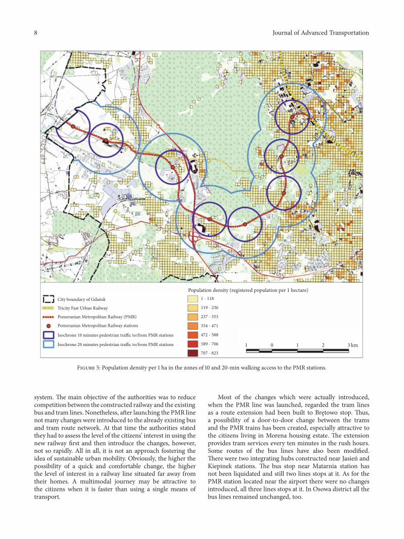
4.2. Population Density in the PMR Line Impact Zone. Spatialdistribution of population is a consequence of the above-described course of the PMR line and the intensity of landuse. Population density is a vital factor affecting the level ofits success, the success understood as a volume of passengertraffic [30]. For the purposes of this study, populationdensities for the 10-minute (660 m) and 20-minute (1320 m)walking accessibility zones have been calculated using theregistration data. Areas located nearer to the PomeranianMetropolitan Railway stations have low population densitiesreaching 15 people per 1 ha on average. The populationdensities vary from 0,16 ppl/ha for Rębiechowo station to34 ppl/ha for Strzyza station. The highest number of peopleliving within the 10-minute (660 m) and 20-minute (1320 m)walking accessibility zones was recorded for Strzyza station,4,8 thousands and 21,5 thousands, respectively. The lowestnumber for Rębiechowo station was only 18 and 76 people,respectively (see Figures 4 and 5).
Population density in the Pomeranian Metropolitan Rail-way impact zone is relatively low.The line has been located onthe edge between some green areas (the landscape park) andnew housing estates where developers started constructingbuildings during the last decade. As an effect, the largestimpact on effectiveness of the PMR line should be exerted byredirecting the vehicles of public urban transport to serve therailway stations in a formula of the multimodal transport (Inthe article the term “multimodal transport system” refers to apartially integrated transport system as the system in the cityof Gdansk is not fully integrated. There is no one official bodymanaging all different transport subsystems. There is only apartially integrated fee system. Among the main tasks relatedto exploitation of the PMR line is integrating the public urbantransportation system in Gdansk and the PMR stations. Suchactions refer to the idea of multimodal transport. In the
literature, the issues ofmultimodality in everyday commutinghave not been frequently addressed so far [31]. In a reviewarticle entitled Rail and Multimodal Transport[32] there areeighteen definitions, but only two of them refer to passengertransport. In both cases, byW. Jones et al. [33], it is defined asusing two or more means of transport during one integratedjourney. In passenger transport, the level of multimodalitydepends less on accessibility of alternative transport links,yet more on the quality of them, including presence ofinterchanges. In the literature, this quality is known asinterconnectivity [[31] after: [34–36]]. Strategic documentsissued by the European Union similarly define the way oforganising urban transportation systems. In the White Paper“Roadmap to a Single European Transport Area–Towardsa Competitive and Resource Efficient Transport System”[37] a vision of development of the European transportsystem by 2050 and a strategy of achieving the objectiveswere presented [38]. According to this document, one ofthe most important problems of European cities is trafficcongestion, bad air condition, and the noise. Reorganisingthe transportation system in a way which will allow usingthe multimodality more effectively may diminish negativelyits impact on the living environment [35, 39]). Developmentof proper infrastructure (park&ride, kiss&ride, and urbanbike systems) serving individual means of transport (cars,mopeds, and bicycles) in the closest vicinity of the PMRstation is also of great importance.
4.3. The PMR Line as a Part of a Multimodal TransportSystem. Effective organisation of urban public transport,especially in metropolitan areas, relates to its full integrationand high-quality services. Transportation systems in largecities usually comprise several different modes of transport.Gdansk is an example of such a situation having bus andtram lines, Tricity Fast Urban Railway and the PomeranianMetropolitan Railway line, which is the main subject ofthis article. Full integration of all these modes is difficultas particular modes are owned and managed by differentbodies and financed under different regulations. However,when taking the objectives behind constructing the PMRline and high costs of its construction under consideration,cooperation of the bodies responsible for managing andorganising the public transportation system shall be thenumber one priority.
During the period of preparations before launchingthe Pomeranian Metropolitan Railway the body responsiblefor managing the urban transportation system in Gdansk,Zarząd Transportu Miejskiego (Public Transport Council),prepared a plan of necessary changes which should havebeen introduced to the already existing bus and tram routenetwork.Themain assumption of this planwas to reconfigurethe routes so they complement each other. It was planned toliquidate the bus lines connecting areas surrounding the PMRstations with the city centre, reorganise ten lines in order toconnect them with these stations, and turn them into feederlines as well as creating a new feeder line. Thanks to thesesolutions people living in areas remote from the PMR linecould access the stations more easily which may result in alarger number of passengers using the public transportation
8 Journal of Advanced Transportation
City boundary of GdaHsk
Tricity Fast Urban Railway
Pomeranian Metropolitan Railway (PMR)
Pomeranian Metropolitan Railway stations
Isochrone 10 minutes pedestrian traffic to/from PMR stations
Isochrone 20minutes pedestrian traffic to/from PMR stations 1 0 1 2 3 km
Population density (registered population per 1 hectare)1 - 118
119 - 236
237 - 353
354 - 471
472 - 588
589 - 706
707 - 823
Figure 5: Population density per 1 ha in the zones of 10 and 20-min walking access to the PMR stations.
system. The main objective of the authorities was to reducecompetition between the constructed railway and the existingbus and tram lines. Nonetheless, after launching the PMR linenotmany changes were introduced to the already existing busand tram route network. At that time the authorities statedthey had to assess the level of the citizens’ interest in using thenew railway first and then introduce the changes, however,not so rapidly. All in all, it is not an approach fostering theidea of sustainable urban mobility. Obviously, the higher thepossibility of a quick and comfortable change, the higherthe level of interest in a railway line situated far away fromtheir homes. A multimodal journey may be attractive tothe citizens when it is faster than using a single means oftransport.
Most of the changes which were actually introduced,when the PMR line was launched, regarded the tram linesas a route extension had been built to Brętowo stop. Thus,a possibility of a door-to-door change between the tramsand the PMR trains has been created, especially attractive tothe citizens living in Morena housing estate. The extensionprovides tram services every ten minutes in the rush hours.Some routes of the bus lines have also been modified.There were two integrating hubs constructed near Jasien andKiepinek stations. The bus stop near Matarnia station hasnot been liquidated and still two lines stops at it. As for thePMR station located near the airport there were no changesintroduced, all three lines stops at it. In Osowa district all thebus lines remained unchanged, too.

Journal of Advanced Transportation 9
City boundary of GdaHsk
Pomeranian Metropolitan Railway (PMR)
Pomeranian Metropolitan Railway stationsIsochrone 10 minutes pedestrian trafficfrom/to bus and tram stops
Intensity of public transport from/to PMR line per day1 0 1 2 3 km
Population density(registered population per 1 hectare)
1 - 118
119 - 236
237 - 353
1-100 101-200 201-300 301-400 401-500 501-600 601-700 701-800
354 - 471
472 - 588
589 - 706
707 - 823
Figure 6: Supply of the bus and tram transport services in a multimodal connections model (the number of operations per day).
Launching the Pomeranian Metropolitan Railway linehas forced the authorities to reorganise that part of theurban transport system which served the areas surroundingthe line. Two integrating hubs (near Kiełpino and Jasienstations) and a tram line extension to Brętowo station werebuilt; all the projects were cofinanced by the EuropeanUnion. Although these new infrastructural investments werevery important for the transportation system of Gdansk,they did not liquidate the problem of competition betweendifferent means of transport. However, the most significantdisadvantage of the new transportation system is lack of tariffintegration due to different bodies managing the systems.The one and only common metropolitan ticket is distributedby the Metropolitan Public Transport Association of Gdansk
Bay yet this solution is quite expensive and not popularamong the citizens [40].
For the purposes of this study the authors analysed thesupply of bus and tram transport services which may beincorporated intomultimodal lines to/from the PMR stations(see Figure 6).
Approximately 84 thousand people live within the zoneof 10-minute walking accessibility to the nearest bus ortram stop allowing to reach the nearest PMR station in 5minutes. Figure 6 presents possibilities of change betweenthe PMR stations and the bus/tram stations. Strzyza stationhas the best accessibility of all as there is a tram line nearby.Because the trams are faster than the buses more citizenscan change at this station. Brętowo is another station where
10 Journal of Advanced Transportation
City boundary of GdaHsk
Tricity Fast Urban Railway
Pomeranian Metropolitan Railway (PMR)
Pomeranian Metropolitan Railway stations
Existing areas of residential and residential-service development
Planned areas of residential and residential-service development
Isochrone 10 minutes pedestrian traffic to/from PMR stations
Isochrone 20minutes pedestrian traffic to/from PMR stations
1 0 1 2 3 km
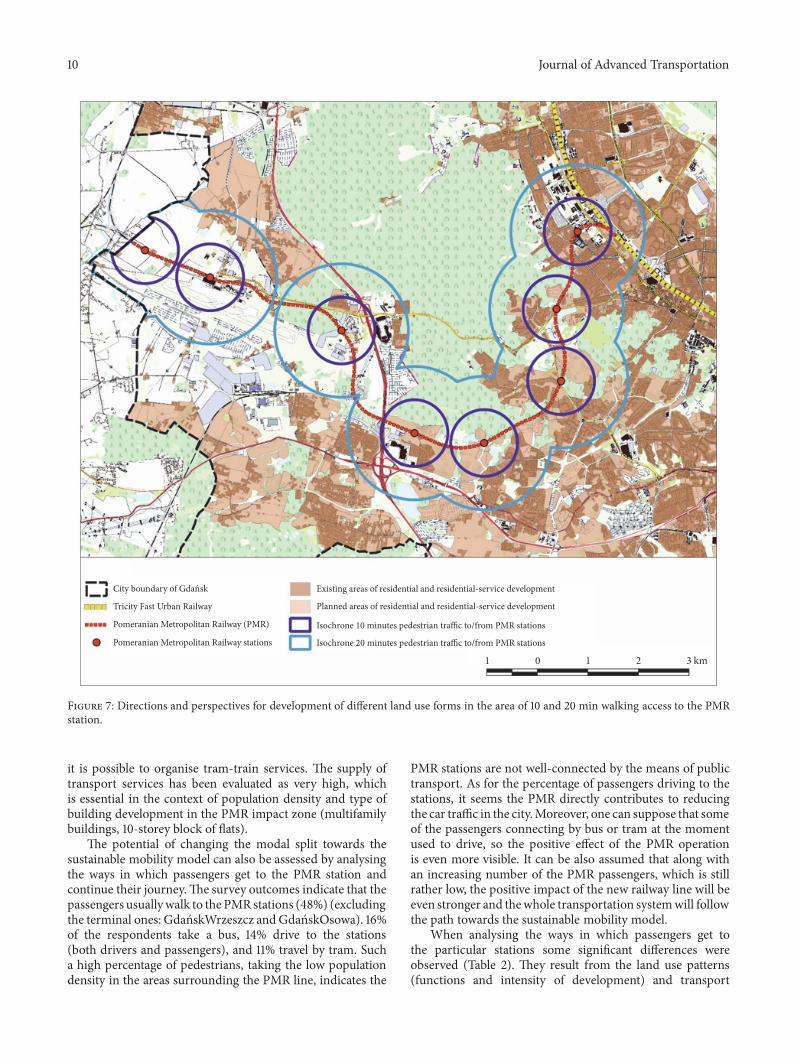
Figure 7: Directions and perspectives for development of different land use forms in the area of 10 and 20 min walking access to the PMRstation.
it is possible to organise tram-train services. The supply oftransport services has been evaluated as very high, whichis essential in the context of population density and type ofbuilding development in the PMR impact zone (multifamilybuildings, 10-storey block of flats).
The potential of changing the modal split towards thesustainable mobility model can also be assessed by analysingthe ways in which passengers get to the PMR station andcontinue their journey.The survey outcomes indicate that thepassengers usuallywalk to the PMR stations (48%) (excludingthe terminal ones: GdanskWrzeszcz andGdanskOsowa). 16%of the respondents take a bus, 14% drive to the stations(both drivers and passengers), and 11% travel by tram. Sucha high percentage of pedestrians, taking the low populationdensity in the areas surrounding the PMR line, indicates the
PMR stations are not well-connected by the means of publictransport. As for the percentage of passengers driving to thestations, it seems the PMR directly contributes to reducingthe car traffic in the city.Moreover, one can suppose that someof the passengers connecting by bus or tram at the momentused to drive, so the positive effect of the PMR operationis even more visible. It can be also assumed that along withan increasing number of the PMR passengers, which is stillrather low, the positive impact of the new railway line will beeven stronger and thewhole transportation systemwill followthe path towards the sustainable mobility model.
When analysing the ways in which passengers get tothe particular stations some significant differences wereobserved (Table 2). They result from the land use patterns(functions and intensity of development) and transport
Journal of Advanced Transportation 11
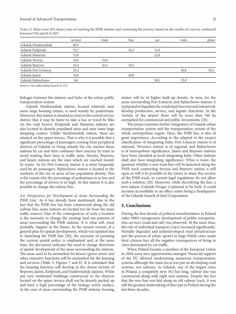
Table 2: Main (over 10% share) ways of reaching the PMR stations and continuing the journey, based on the results of a survey conductedbetween 17.10 and 16.11.2017.
on foot tram bus car train planeGdansk Niedzwiednik 80,5Gdansk Kiełpinek 72,7 10,3 13,9Gdansk Matarnia 57,8 22,9Gdansk Strzyza 52,0 33,0Gdansk Brętowo 45,4 26,2 19,2Gdansk Port Lotniczy 43,2 10,8 30,5Gdansk Jasien 31,8 49,8Gdansk Rębiechowo 9,6 58,5 25,9Source: own elaboration based on [21].
linkages between the stations and hubs of the urban publictransportation system.
Gdansk Niedzwiednik station, located relatively nearsome large housing estates, is used mainly by pedestrians.Moreover, this station is situated so close to the central servicedistrict that it may be faster to take a bus or travel by bike(in the rush hours). Kiełpinek and Matarnia stations arealso located in densely populated areas and near some largeshopping centres. Unlike Niedzwiednik station, these aresituated on the upper terrace. That is why it is possible that asignificant percentage of passengers coming from peripheraldistricts of Gdansk or living outside the city reaches thosestations by car and then continues their journey by tram toavoid wasting their time in traffic jams. Strzyza, Brętowo,and Jasien stations are the ones which are reached mainlyby trams. As for Port Lotniczy station it is most frequentlyused by air passengers. Rębiechowo station is located in theoutskirts of the city in areas of low population density. Thisis the reason why the percentage of pedestrians is so low andthe percentage of drivers is so high. At this station it is alsopossible to change the railway line.
4.4. Perspectives for Development of Areas Surrounding thePMR Line. As it has already been mentioned, due to thefact that the PMR line has been constructed along the oldrailway line, some stations are located too far from the maintraffic sources. One of the consequences of such a locationis the necessity to change the existing land use patterns ofareas surrounding the PMR stations. It is what will, mostprobably, happen in the future. In the newest version of ageneral plan for spatial development, which was updated dueto launching the PMR line [20], the necessity of pursuingthe current spatial policy is emphasized and, at the sametime, the document indicates the need to change directionsof spatial development of the areas surrounding the stations.The areas used to be earmarked for leisure (green areas) andother extensive functions will be earmarked for the housingand services (Table 3, Figures 7 and 8). It is estimated thatthe housing function will develop in the closest vicinity ofBrętowo, Jasien, Kiełpinek, andNiedzwiednik stations. Whileany new residential buildings constructed in the districtslocated on the upper terrace shall not be densely packed upand have a high percentage of the biology active surface,in the case of areas surrounding the PMR stations housing
estates will be of higher built-up density. In turn, for theareas surrounding Port Lotniczy and Rębiechowo stations itis planned to liquidate the residential function and intensivelydevelop production, service, and logistic functions. In thevicinity of the airport there will be more than 140 haearmarked for commercial and public investments [20].
The project assumes further integration of Gdansk urbantransportation system and the transportation system of thewhole metropolitan region. Here, the PMR line is also ofgreat importance. According to the adapted in the projectclassification of integrating hubs, Port Lotniczy station is ofnational, Wrzeszcz station is of regional, and Rębiechowois of metropolitan significance. Jasien and Brętowo stationshave been classified as local integrating hubs. Other stationsshall also have integrating significance. What is more, thequestion whether a new tram line will be launched along thePMR track connecting Strzyza and Brętowo station is stillopen or will it be possible in the future to share this sectionof the PMR track, as current legal regulations do not allowsuch a solution [20]. Moreover, while electrifying the line, anew station (Gdansk Firoga) is planned to be built. It couldincrease accessibility to an office centre being a headquarterof the Gdansk branch of Intel Corporation.
5. Conclusions
During the first decade of political transformation in Poland(after 1989) retrogressive development of public transporta-tion services (road and rail) was observed. At the same time,the role of individual transport (cars) increased significantly.Partially degraded and underdeveloped road infrastructureand the process of urban sprawl in large Polish cities madetheir citizens face all the negative consequences of living incities dominated by car traffic.
When Poland became a member of the European Unionin 2004 some new opportunities emerged. Financial supportof the EU allowed modernising numerous transportationsystems although the main focus was put on developing roadsystems, not railways. In Gdansk, one of the largest citiesin Poland, a completely new, 19,5 km long, railway line wasconstructed along with eight new stations. Despite the factthat the new line was laid along an old railway track, it wasstill the greatest undertaking of this type in Poland during thelast three decades.

12 Journal of Advanced Transportation
Table 3: Currently dominating and future land-use forms [ha]; changes in the area of residential and service developments within an area of660 m radius from the PMR stations in Gdansk.
Currently dominating land-use forms –residential,residential and service development
Future dominating land-use forms –residentialdevelopment with basic services, residential
and service developmentGdansk Brętowo 40,1 92,5Gdansk Jasien 14,4 55,1Gdansk Kiełpienek 16,6 49,6Gdansk Niedzwiednik 27,9 56,9Gdansk Strzyza 38,6 55,2Gdansk Matarnia 10,9 10,7Gdansk Port lotniczy 2,6 0,0Gdansk Rębiechowo 3,3 0,0Source: own elaboration based on [20].
City boundary of GdaHsk
Tricity Fast Urban Railway
Pomeranian Metropolitan Railway (PMR)
Pomeranian Metropolitan Railway stationsExisting areas of residential and residential-servicedevelopment
developmentPlanned areas of residential and residential-service
Bus line and tramway lines
Bus and tram stopsIsochrone 10 minutes pedestrian trafficfrom/to bus and tram stops
1 0 1 2 3 km
Figure 8: Directions and perspectives for development of areas around the PMR line (in the area of bus and tram transport servicesmultimodal connections model).

Journal of Advanced Transportation 13
The course of the line as well as the stations’ location werelargely affected by the landscape conditions and already exist-ing infrastructure so there are not many potential passengersin the areas surrounding the PMR line. In 2016 in the zoneof 10-minute walking distance to the new stations only 16,2thousand people lived (population density was 15ppl/ha). Inthe zone of 20-minute walking distance a total number of res-idents was 62,8 thousand. However, the number of potentialpassengers could be higher as there are some public utilitieslocated in close vicinity of the stations: the university campus(Gdansk Strzyza), large shopping centre (Gdansk Kiełpinek),industrial and service companies (GdanskMatarnia), and theairport and office centre (Gdansk Port Lotniczy).
As the potential sources of passenger traffic are locatedfar from the line, it was necessary to connect it by the meansof public transportation system. Approximately 84 thousandpeople live within the zone of 10-minute walking accessibilityto the nearest bus or tram stop allowing reaching the nearestPMR station in 5 minutes. However, the plan to connect thePMR line has not been fully implemented. In fact, only 27%of passengers were getting to the PMR station by bus or tramwhile 48% on foot. Thus, it can be stated that in order toincrease the passenger traffic on this line, it is necessary toproceed with the integrating actions. The integration shallalso comprise the tariff system. Lack of a common ticket tariffhampers introduction of the multimodal model.
Despite the above-mentioned unfavourable conditions,the number of passengers increased from 151,6 thousandin June 2016 to 190,0 thousand in March 2018. Wrzeszcz,Strzyza, and Jasien are the most popular stations amongthe passengers. Relatively large passenger traffic was alsoobserved at Port Lotniczy and Kiełpinek stations. The leastpopular station is Niedzwiednik as it is located relatively nearthe central service district and well-connected by bus.
The PMR line in Gdansk was planned to serve the airportas well as lower the traffic congestion on roads connecting theupper and lower terraces. In order to increase the number ofpeople travelling by the PMR trains it is not enough to preparea proper timetable and develop a network of multimodallinkages. Development of the residential function around thePMR stations is also of great importance. In order to do so, itwas necessary to introduce some amendments to the generalplan of spatial development. The document was adopted inApril 2018 and according to its provisions it will be possible todevelop an intense residential function in the closest vicinityof the PMR stations. There are three stations around whichproduction, service, and logistic functions will be developed.When observing the ongoing changes on the housing marketand some initial projects aimed at developing services andindustry sectors around the PMR line, it may be stated thatthe plan to intensify the residential development in this areahas sufficient prospect of success. Hence, the PMR line seemsto have a significant impact on the process of urban formtransformation.
Taking the main objective of the article into consid-eration, it has to be stated that launching the PMR hascontributed to the changes in the functional and spatialstructure of the city, yet to a limited extent. It is mainlybecause of a relatively short term of its functioning and
limited accessibility to the train stops resulting from theirperipheral location and the underdeveloped connecting linessystem.
Most probably, some passengers do not use the linebecause the schedule does not match their needs; there is nointegrated fee system and the passenger information systemis not sufficient. Nonetheless, those issues have not beenfully studied in this article so some further research on thepassenger exchange and the passengers’ motivation behindtravelling by train shall be carried in the future.
A relatively short period of the new line operationmakes it difficult to formulate any plausible conclusions ontime variability. It is especially interesting to what extentthe railway line contributes to reducing the car traffic. Theanalysis of data on the way in which passengers get to thePMR stations provided only superficial conclusions. Anychanges introduced to the level of connectivity between thePMR line and the tram/bus system may help to identify thesolutions which affect behaviour patterns of the passengersthe most. Another interesting issue is the process of adoptingnew local development plans for areas surrounding thePMR stations as they will set the limits for their spatialdevelopment. Analysing strategies adopted by developerswho are interested in investing in the areas surrounding thePMR line may also deliver interesting results.
Data Availability
The data used to support the findings of this study areavailable from the corresponding author upon request.
Conflicts of Interest
The authors declare that they have no conflicts of interest.
Acknowledgments
The authors wish to thank Edyta Damszel-Turek, MarcinTurzynski, and Mateusz Zuk representing the Gdansk Devel-opment Office for sharing cartographic materials usedin developing maps presented in this article and JakubPietruszewski fromPomeranian Regional Planning Office forsharing results of the research on the Passenger Traffic andTransportation Preferences of the Pomeranian Metropoli-tan Railway Passengers. The research was partially fundedby a grant from the Polish National Science Centre (no.2016/23/D/HS4/03085).
References
[1] D. Banister, Ed., Transport and Urban Development, E & FNSPON. An Imprint of Chapman & Hall, 2005.
[2] C. Divall and W. Bond, Eds., Suburbanizing the masses: publictransport and urban development in historical perspective, Rout-ledge, Routledge, 2003.
[3] P. Rode, G. Floater, N. Thomopoulos et al., “Accessibility inCities: Transport and Urban Form,” in Disrupting Mobility,Lecture Notes in Mobility, pp. 239–273, Springer InternationalPublishing, Cham, 2017.
14 Journal of Advanced Transportation
[4] E. Glaeser, Triumph of the City: How Our Greatest InventionMakes Us Richer, Smarter, Greener, Healthier, and Happier,Penguin Press, 2011.
[5] P. Jochem, C. Doll, and W. Fichtner, “External costs of electricvehicles,” Transportation Research Part D: Transport and Envi-ronment, vol. 42, pp. 60–76, 2016.
[6] A. Gonzalez-Gil, R. Palacin, P. Batty, and J. P. Powell, “A systemsapproach to reduce urban rail energy consumption,” EnergyConversion and Management, vol. 80, pp. 509–524, 2014.
[7] J. Urry, “The ‘System’ of Automobility,” Theory, Culture &Society, vol. 21, no. 5, pp. 25–39, 2004.
[8] D. Banister, “The sustainable mobility paradigm,” TransportPolicy, vol. 15, no. 2, pp. 73–80, 2008.
[9] B. Brown and C.Werner, “Before and after a new light rail stop,”Journal of the American Planning Association, vol. 75, no. 1, pp.5–12, 2009.
[10] P. Poudenx, “The effect of transportation policies on energyconsumption and greenhouse gas emission from urban passen-ger transportation,” Transportation Research Part A: Policy andPractice, vol. 42, no. 6, pp. 901–909, 2008.
[11] Q. Pan, “The impacts of an urban light rail system on residentialproperty values: A case study of the Houston METRORailtransit line,” Transportation Planning and Technology, vol. 36,no. 2, pp. 145–169, 2013.
[12] A. D. May, “Integrated transport strategies: a new approachto urban transport policy formulation in the u.k.: foreignsummaries,” Transport Reviews, vol. 11, no. 3, pp. 223–247, 1991.
[13] Z. Taylor and A. Ciechanski, Foreign Direct Investment in thePolish Transport Sector, Institute of Geography and SpatialOrganization. Polish Academy of Sciences, 2013.
[14] Z. Taylor,TheGrowth andContraction of the RailwayNetwork inPoland, Institute of Geography and Spatial Organization. PolishAcademy of Sciences, 2007.
[15] Transport. Activity results in 2006, Central Statistical Office,2007.
[16] K. Kajdanek, Społeczno-kulturowe wzory korzystania z systemutransportu w kontekscie systemu transport zrownowazonego –przykład Wrocławia (Socio-cultural patterns of using the trans-port system in the context of the sustainable transport system- an example of Wrocław), Wolaniuk, Wspołczesne czynnikii bariery rozwoju miast: XXVIII Konserwatorium Wiedzy OMiescie (Contemporary factors and barriers to urban develop-ment: XXVIII Conservatory of Knowledge about the City),Wydawnictwo Uniwersytetu Łodzkiego, 2016.
[17] T. Komornicki et al., Impact of the construction of motorwaysand expressways on socio-economic and territorial developmentof Poland, Ministry of Regional Development, 2013.
[18] E. Raczynska-Buława, “Agglomeration railway systems inPoland,” TTS Technika Transportu Szynowego, vol. 24, pp. 15–20, 2017.
[19] E. Babalik, Urban rail systems: a planning framework to increasetheir success [Ph.D. thesis], Centre for Transport Studies, Uni-versity of London, 2000.
[20] Study of conditions and directions for the spatial development ofthe city of Gdansk, Gdansk Development Office, 2018.
[21] K. Jamroz and J. Jamroz, “Raport z przeprowadzania pomia-row natęzenia ruchu pasazerskiego na liniach kolejowychobsługiwanych przez PKP Szybką Kolej Miejską w Trojmiesciesp. z o.o. wraz z badaniem preferencji i zachowan komunika-cyjnych podroznych (Report on the measurement of passen-gertraffic on railway lines served by PKP Szybka Kolej Miejska
w Trojmiescie sp. Z o.o. together with the study of travelers’preferences and travel behawior),” Fundacja Rozwoju InzynieriiLądowej, 2017.
[22] ESPON 1.1.1. Potentials for polycentric development in Europe,ESPON Coordination Unit, 2004.
[23] Gdanskie Badania Ruchu 2016 wraz z opracowaniem trans-portowego modelu symulacyjnego Gdanska, Raport III. Raportz przeprowadzenia badani pomiarow (Gdansk Traffic Research2016 together with the development of Gdansk’s transport simu-lation model. Report III. Report on testing and measurements),Urząd Miejski w Gdansku, 2016.
[24] P. Lorens, “Scenariusze rozwoju przestrzennego obszaru met-ropolitalnego Trojmiasta,” Rozwoj Regionalny i Polityka Region-alna, no. 29, p. 71, 2016.
[25] Gdansk 2030 Plus Strategia Rozwoju Miasta (Gdansk 2030 PlusCity Development Strategy), Urząd Miejski w Gdansku, 2014.
[26] M. Stępniak and S. Goliszek, “Spatio-Temporal Variation ofAccessibility by Public Transport—The Equity Perspective,” inThe Rise of Big Spatial Data, Lecture Notes in Geoinformationand Cartography, pp. 241–261, Springer International Publish-ing, Cham, 2017.
[27] K. Fransen, T. Neutens, S. Farber, P. De Maeyer, G. Deruyter,and F. Witlox, “Identifying public transport gaps using time-dependent accessibility levels,” Journal of Transport Geography,vol. 48, pp. 176–187, 2015.
[28] J. Ritsema van Eck, G. Burghouwt, and M. Dijst, “Lifestyles,spatial configurations and quality of life in daily travel: Anexplorative simulation study,” Journal of Transport Geography,vol. 13, no. 2, pp. 123–134, 2005.
[29] Y. Hadas, “Assessing public transport systems connectivitybased on Google Transit data,” Journal of Transport Geography,vol. 33, pp. 105–116, 2013.
[30] E. Babalik-Sutcliffe, “Urban rail systems: Analysis of the factorsbehind success,” Transport Reviews, vol. 22, no. 4, pp. 415–447,2002.
[31] K. Kowalczyk, Pasazerski transport kolejowy na obszarachaglomeracyjnych w Polsce a rozwiązania multimodalne w codzi-ennych dojazdach do pracy (Passenger railway transport inagglomeration areas in Poland and multimodal solutions ineveryday commuting) [Ph.D. thesis], Maria Curie-SkłodowskaUniversity, Lublin, Poland, 2017.
[32] V. Reis, J. FabianMeier, G. Pace, and R. Palacin, “Rail andmulti-modal transport,”Research in Transportation Economics, vol. 41,no. 1, pp. 17–30, 2013.
[33] W. B. Jones, C. R. Cassady, and R. O. Bowden, Developing astandard definition of intermodal transportation, Department ofIndustrial Engineering, Mississippi State University, 2000.
[34] J. Schonharting, A. Schmidt, A. Frank, and S. Bremer, “Towardsthemultimodal transport of people and freight: Interconnectivenetworks in the RheinRuhr Metropolis,” Journal of TransportGeography, vol. 11, no. 3, pp. 193–203, 2003.
[35] S. Krygsman, M. Dijst, and T. Arentze, “Multimodal publictransport: An analysis of travel time elements and the intercon-nectivity ratio,”Transport Policy, vol. 11, no. 3, pp. 265–275, 2004.
[36] M. Bąk and J. Burnewicz, Challenges for multimodal pas-senger transport, Szyliowicz. Multimodal Transport SecurityFrameworks and Policy Applications in Freight and PassengerTransport, Comparitive Perspectives on Transportation Security,Edward Elgar Publishing, 2016.
[37] White paper, Roadmap to a Single European Transport Area –Towards a competitive and resource efficient trandsport system,European Commission, 2011.

Journal of Advanced Transportation 15
[38] T. Dyr, “Europejska polityka transportowa na pierwszą połowęXXI wieku (European transport policy for the first half ofthe 21st century),” Autobusy-Technika, Eksploatacja, SystemyTransportowe, vol. 12, no. 10, pp. 20–29, 2011.
[39] L. Bertolini and F. le Clercq, “Urban development without moremobility by car? Lessons fromAmsterdam, amultimodal urbanregion,” Environment and PlanningA, vol. 35, no. 4, pp. 575–589,2003.
[40] M. Połom, “Disintegration of the public transport services inthe Gdansk agglomeration,” Metropolitan. Przegląd Naukowy,vol. 8, no. 2, pp. 70–81.

International Journal of
AerospaceEngineeringHindawiwww.hindawi.com Volume 2018
RoboticsJournal of
Hindawiwww.hindawi.com Volume 2018
Hindawiwww.hindawi.com Volume 2018
Active and Passive Electronic Components
VLSI Design
Hindawiwww.hindawi.com Volume 2018
Hindawiwww.hindawi.com Volume 2018
Shock and Vibration
Hindawiwww.hindawi.com Volume 2018
Civil EngineeringAdvances in
Acoustics and VibrationAdvances in
Hindawiwww.hindawi.com Volume 2018
Hindawiwww.hindawi.com Volume 2018
Electrical and Computer Engineering
Journal of
Advances inOptoElectronics
Hindawiwww.hindawi.com
Volume 2018
Hindawi Publishing Corporation http://www.hindawi.com Volume 2013Hindawiwww.hindawi.com
The Scientific World Journal
Volume 2018
Control Scienceand Engineering
Journal of
Hindawiwww.hindawi.com Volume 2018
Hindawiwww.hindawi.com
Journal ofEngineeringVolume 2018
SensorsJournal of
Hindawiwww.hindawi.com Volume 2018
International Journal of
RotatingMachinery
Hindawiwww.hindawi.com Volume 2018
Modelling &Simulationin EngineeringHindawiwww.hindawi.com Volume 2018
Hindawiwww.hindawi.com Volume 2018
Chemical EngineeringInternational Journal of Antennas and
Propagation
International Journal of
Hindawiwww.hindawi.com Volume 2018
Hindawiwww.hindawi.com Volume 2018
Navigation and Observation
International Journal of
Hindawi
www.hindawi.com Volume 2018
Advances in
Multimedia
Submit your manuscripts atwww.hindawi.com