Upstream Offshore Environment Plan Summary - BassGas · Upstream Offshore Environment Plan Summary...
32
THE THREE WHATS What can go wrong? What could cause it to go wrong? What can I do to prevent it? For internal Origin use and distribution only. Subject to employee confidentiality obligations. Once printed, this is an uncontrolled document unless issued and stamped Controlled Copy or issued under a transmittal. Upstream Offshore Environment Plan Summary - BassGas Review record Rev Date Reason for issue Prepared Checked Approved A 13/10/2014 Issued for internal approval THA SC 0 17/10/2014 Issued for use THA SC SC 1 14/01/2015 Update with NOPSEMA comments JB TH MQ
Transcript of Upstream Offshore Environment Plan Summary - BassGas · Upstream Offshore Environment Plan Summary...
THE THREE WHATS What can go wrong? What could cause it to go wrong? What can I do to prevent it?
For internal Origin use and distribution only. Subject to employee confidentiality obligations.
Once printed, this is an uncontrolled document unless issued and stamped Controlled Copy or issued under a transmittal.
Upstream
Offshore Environment Plan Summary - BassGas
Review record
Rev Date Reason for issue Prepared Checked Approved
A 13/10/2014 Issued for internal approval THA SC
0 17/10/2014 Issued for use THA SC SC
1 14/01/2015 Update with NOPSEMA comments JB TH MQ

Offshore Environmental Plan Summary BassGas
Released on 14/01/2015 – Revision number 1 – Final Process Owner is Otway Operations Manager
Origin Energy Resources Limited: ABN 66 007 845 338 Once printed, this is an uncontrolled document unless issued and stamped Controlled Copy or issued under a transmittal. Template: Upstream Information Management & Engineering Systems Manager_Revision 4_26/09/2013_OEUP-1000-TMP-BUS-001
Table of contents
1. Introduction 3
2. Description of the activity 5
2.1.1 Operation, maintenance and inspection 5 2.1.2 Logistics 6 2.1.3 Process description 6 2.1.4 Yolla-5 and Yolla-6 Drilling 7
3. Description of the environment 9
3.1 Physical environment 9 3.2 Biological environment 9
3.2.1 Threatened species 9 3.2.2 Birds 11 3.2.3 Mammals 11 3.2.4 Reptiles 11 3.2.5 Sharks and ray finned fish 12 3.2.6 Fish 12 3.2.7 Invertebrates and plankton 12
3.3 Cultural and Socio-Economic Environment 13 3.3.1 Marine protected areas and reserves 13 3.3.2 Heritage Values 13 3.3.3 Commercial fisheries 14 3.3.4 Shipping 14
4. Environmental Risks, Impacts and Controls 15
5. Management and monitoring 19
6. Consultation 20
7. Contact details 21
Table of figures
Figure 1-1: Location of the activity 4
Figure 3-1 Commonwealth Marine Reserves (CMRs) in relation to the Yolla Project 13
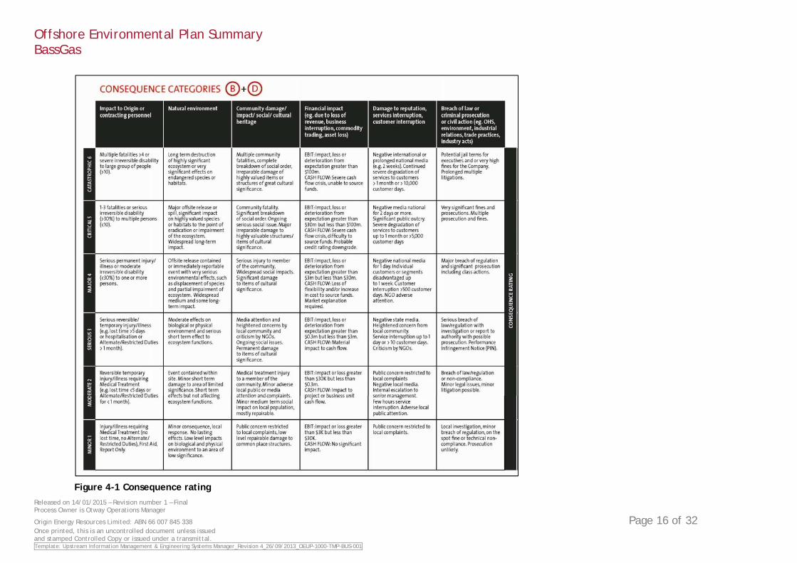
Figure 4-1 Consequence rating 16
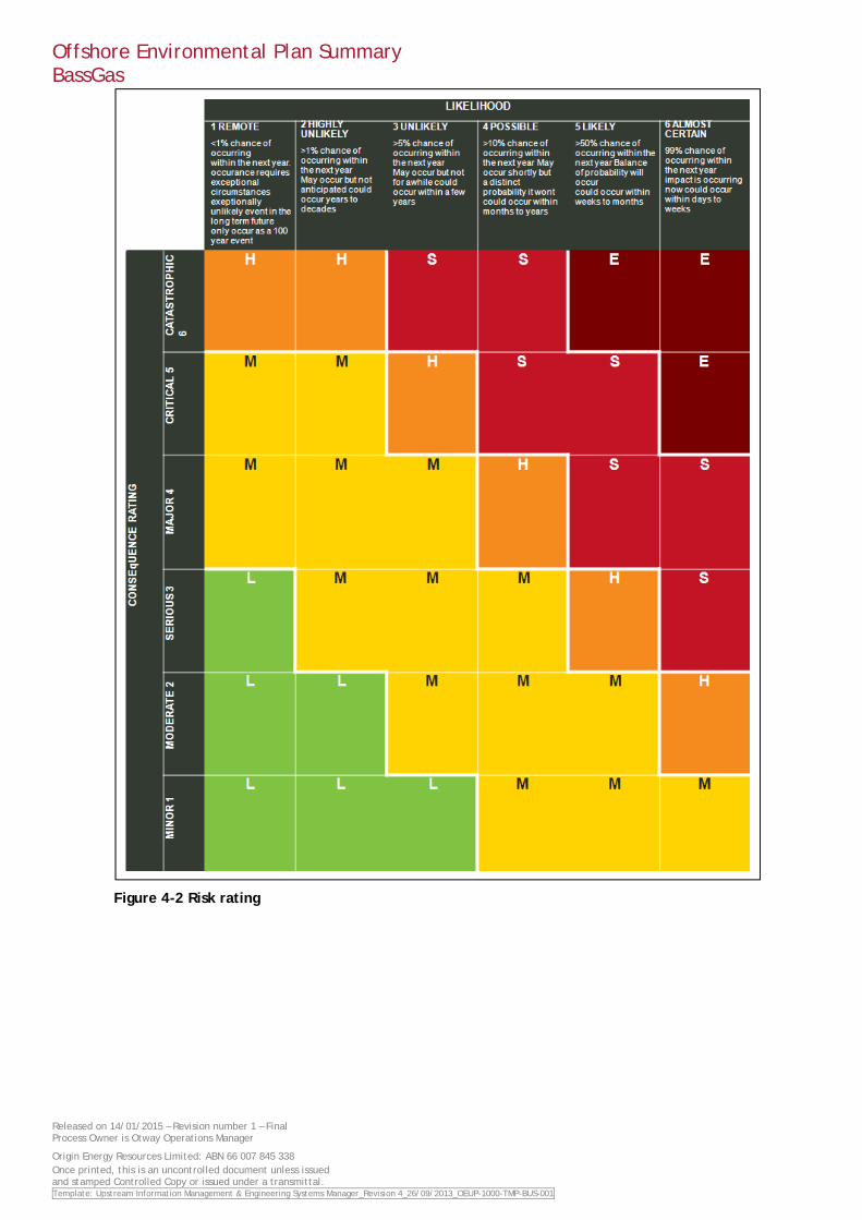
Figure 4-2 Risk rating 17
List of tables
Table 3-1 EPBC listed species identified in the protected matters search 10
Table 3-2: Commercial Fisheries in Bass Strait 14
Table 4-1 Consequence and risk rating for identified routine and non-routine impacts 18
Appendices
Appendix A - Oil Pollution Emergency Plan
Appendix B - Risk assessment tables
Offshore Environmental Plan Summary BassGas
Released on 14/01/2015 – Revision number 1 – Final Process Owner is Otway Operations Manager
Origin Energy Resources Limited: ABN 66 007 845 338 Once printed, this is an uncontrolled document unless issued and stamped Controlled Copy or issued under a transmittal. Template: Upstream Information Management & Engineering Systems Manager_Revision 4_26/09/2013_OEUP-1000-TMP-BUS-001
1. Introduction
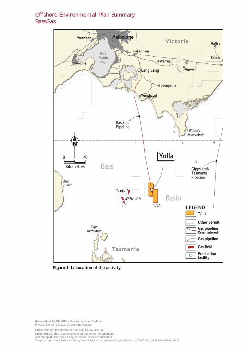
Origin Energy Resources Limited (Origin) is the operator of the BassGas Project, which produces gas and liquids from the Yolla gas field, located 147 km south of Kilcunda in Bass Strait (Figure 1-1). The Yolla gas field lies in 80 m of water and is serviced by the Yolla A Offshore Platform. An undersea pipeline transports the gas and liquids from the platform to the Victorian mainland via a coastline crossing near Kilcunda. The pipeline terminates at the Lang Lang Gas Plan (LLGP) where gas is processed prior to distribution to the Victorian gas network. Commercial production of gas started in June 2006.
Origin is the operator for the Yolla field, the BassGas Pipeline and LLGP on behalf of joint venture partners:
• Origin Energy Resources Limited – 37.50%;
• Origin Energy Northwest Limited – 5.00%;
• AWE Limited – 33.75%;
• Arc Energy Pty Ltd – 12.50%; and
• Toyota Tsusho Gas E&P Trefoil Pty Ltd – 11.25%.
The Environment plan (EP) for the BassGas offshore facilities was prepared in accordance with the Offshore Petroleum and Greenhouse Gas Storage (Environment) Regulations 2009 (Environment Regulations) and accepted by the National Offshore Petroleum Safety and Environmental Management Authority (NOPSEMA) on 7th October 2014.
This EP summary document has been prepared as per the requirements of the Environment Regulations 11(7) and 11(8). It summarises the findings and conclusions of the environmental risk assessment undertaken for ongoing operation of the BassGas offshore facilities, and the relevant control measures developed and implemented to reduce risks and impacts to as low as reasonably practicable (ALARP).
Offshore Environmental Plan Summary BassGas
Released on 14/01/2015 – Revision number 1 – Final Process Owner is Otway Operations Manager
Origin Energy Resources Limited: ABN 66 007 845 338 Once printed, this is an uncontrolled document unless issued and stamped Controlled Copy or issued under a transmittal. Template: Upstream Information Management & Engineering Systems Manager_Revision 4_26/09/2013_OEUP-1000-TMP-BUS-001
Figure 1-1: Location of the activity
Offshore Environmental Plan Summary BassGas
Released on 14/01/2015 – Revision number 1 – Final Process Owner is Otway Operations Manager
Origin Energy Resources Limited: ABN 66 007 845 338 Once printed, this is an uncontrolled document unless issued and stamped Controlled Copy or issued under a transmittal. Template: Upstream Information Management & Engineering Systems Manager_Revision 4_26/09/2013_OEUP-1000-TMP-BUS-001
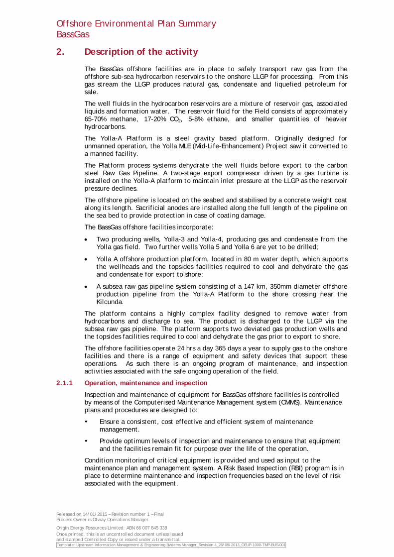
2. Description of the activity
The BassGas offshore facilities are in place to safely transport raw gas from the offshore sub-sea hydrocarbon reservoirs to the onshore LLGP for processing. From this gas stream the LLGP produces natural gas, condensate and liquefied petroleum for sale.
The well fluids in the hydrocarbon reservoirs are a mixture of reservoir gas, associated liquids and formation water. The reservoir fluid for the Field consists of approximately 65-70% methane, 17-20% CO2, 5-8% ethane, and smaller quantities of heavier hydrocarbons.
The Yolla-A Platform is a steel gravity based platform. Originally designed for unmanned operation, the Yolla MLE (Mid-Life-Enhancement) Project saw it converted to a manned facility.
The Platform process systems dehydrate the well fluids before export to the carbon steel Raw Gas Pipeline. A two-stage export compressor driven by a gas turbine is installed on the Yolla-A platform to maintain inlet pressure at the LLGP as the reservoir pressure declines.
The offshore pipeline is located on the seabed and stabilised by a concrete weight coat along its length. Sacrificial anodes are installed along the full length of the pipeline on the sea bed to provide protection in case of coating damage.
The BassGas offshore facilities incorporate:
• Two producing wells, Yolla-3 and Yolla-4, producing gas and condensate from the Yolla gas field. Two further wells Yolla 5 and Yolla 6 are yet to be drilled;
• Yolla A offshore production platform, located in 80 m water depth, which supports the wellheads and the topsides facilities required to cool and dehydrate the gas and condensate for export to shore;
• A subsea raw gas pipeline system consisting of a 147 km, 350mm diameter offshore production pipeline from the Yolla-A Platform to the shore crossing near the Kilcunda.
The platform contains a highly complex facility designed to remove water from hydrocarbons and discharge to sea. The product is discharged to the LLGP via the subsea raw gas pipeline. The platform supports two deviated gas production wells and the topsides facilities required to cool and dehydrate the gas prior to export to shore.
The offshore facilities operate 24 hrs a day 365 days a year to supply gas to the onshore facilities and there is a range of equipment and safety devices that support these operations. As such there is an ongoing program of maintenance, and inspection activities associated with the safe ongoing operation of the field.
2.1.1 Operation, maintenance and inspection
Inspection and maintenance of equipment for BassGas offshore facilities is controlled by means of the Computerised Maintenance Management system (CMMS). Maintenance plans and procedures are designed to:
Ensure a consistent, cost effective and efficient system of maintenance management.
Provide optimum levels of inspection and maintenance to ensure that equipment and the facilities remain fit for purpose over the life of the operation.
Condition monitoring of critical equipment is provided and used as input to the maintenance plan and management system. A Risk Based Inspection (RBI) program is in place to determine maintenance and inspection frequencies based on the level of risk associated with the equipment.
Offshore Environmental Plan Summary BassGas
Released on 14/01/2015 – Revision number 1 – Final Process Owner is Otway Operations Manager
Origin Energy Resources Limited: ABN 66 007 845 338 Once printed, this is an uncontrolled document unless issued and stamped Controlled Copy or issued under a transmittal. Template: Upstream Information Management & Engineering Systems Manager_Revision 4_26/09/2013_OEUP-1000-TMP-BUS-001
Typical inspection and maintenance activities are covered in the BassGas pipeline safety case and the Yolla-A platform safety case (approved and accepted by NOPSEMA), and include;
• Inspection
• Pigging
• Remote operated vehicle (ROV) surveys conducted from a ROV support vessel
• Diving activities for general maintenance and inspection
• Safety equipment and pressure control maintenance
• Fabric maintenance, consisting of surface preparation and painting across the entire platform
• Routine planned maintenance and Critical Function Testing of equipment (e.g. Shutdown valves, safety critical instrumentation, etc.).
Routine inspection and maintenance activities are designed to maintain the safety and reliability of the operating BassGas offshore facilities.
The main types of chemicals stored and injected on the Platform are - corrosion inhibitor, demulsifier, reverse-demulsifier and hydrate inhibitor (methanol). All these products are transferred via the pipeline back to LLGP for treatment.
Well fluids are dehydrated prior to injection into the Raw Gas Pipeline, to avoid high CO2 levels in the well fluids which can combine with free water that may be present to form a corrosive acid. However, there will always be a risk of residual water being present in the gas and hence corrosion inhibitor must be continuously injected into the Pipeline.
Demulsifier injection is provided for upstream of the Production Separator (section 2.1.3). The demulsifier will break any emulsions present, making it easier to separate water from hydrocarbon fluids. Hydrate inhibitor (methanol) injection is provided at the wellhead to avoid hydrate formation during start-up and shutdown.
2.1.2 Logistics
Access to the Yolla-A Platform is principally by helicopter for crew changes and transfer of day visitors, and it is visited approximately three times per week. A supply vessel will also attend the Yolla-A Platform approximately once per month for operational and maintenance requirements such as to supply freshwater, fuel or replacement parts.
Certain operational activities will require the presence of additional offshore vessels:
Standby vessels – for activities, such as work over water, heavy lifts, and well intervention.
ROV support vessels - for routine asset integrity inspections of the Platform and pipeline.
Diving support vessels – for asset integrity inspections that cannot be completed with an ROV.
The Field Support Vessel Operations Procedure describes the requirements for all vessels operating within the facility Petroleum Safety Zone and Cautionary Zone. It includes procedures for vessel approach, cargo operations, communications and emergency response. It applies to all registered vessels capable of supporting BassGas offshore facilities.
Origin requires any vessel used as part of its operations to hold valid Australian Quarantine Inspection Service (AQIS) certification.
2.1.3 Process description
The Platform process systems dehydrate the well fluids before export to LLGP, in order to prevent internal corrosion of the carbon steel Raw Gas Pipeline. The process equipment on the Platform is controlled by the Process Control System (PCS) located on
Offshore Environmental Plan Summary BassGas
Released on 14/01/2015 – Revision number 1 – Final Process Owner is Otway Operations Manager
Origin Energy Resources Limited: ABN 66 007 845 338 Once printed, this is an uncontrolled document unless issued and stamped Controlled Copy or issued under a transmittal. Template: Upstream Information Management & Engineering Systems Manager_Revision 4_26/09/2013_OEUP-1000-TMP-BUS-001
the Platform and connected by a satellite link to a companion unit at LLGP. The PCS enables the platform to be controlled and monitored from shore.
Water discharged from the Production Separator has suspended condensate droplets, which are removed via the Hydrocyclone. Dissolved gas is then removed in the Degasser, with the discharged water passing through a filter to remove any solid particulate remaining in the stream. The water is then discharged to the Dump Caisson via a liquid leg. A side-stream of the liquid leg is routed to two parallel oil-in-water analysers, providing continuous measurement to ensure the discharged water meets the specification for oil content prior to discharge. If the oil-in-water specification is exceeded by either analyser reading, the water flow is stopped by valve closure. If the condition is not remedied in time, the platform process will be shut down by high water levels elsewhere in the system.
Flaring is necessary to dispose of unwanted and potentially hazardous gas emissions (predominantly hydrocarbon gas) generated by various processes on the platform. The flare system can handle a maximum of 171,000kg/h of flow and consists of
Flaring is continuously monitored and minimised as far as possible.
A continuous flow of fuel gas normally provides flare purge and pilot gas, however propane and nitrogen cylinders have been provided for ignition and purge purposes respectively upon loss of fuel gas supply. Propane and Nitrogen bottles are stored on the Main Deck, west of the well bay.
Products of hydrocarbon combustion emitted to atmosphere include water vapour, carbon dioxide, together with traces of carbon monoxide and nitrogen oxides. There may also be fugitive emissions of particulate matter, and hydrocarbons
Flare boom - located in the south west corner of the platform. A 50m long structure, inclined and elevated at 30º.
2.1.4 Yolla-5 and Yolla-6 Drilling
Origin proposes to drill two production wells, Yolla-5 and Yolla-6, to maintain production rates from the Yolla reservoir. Drilling activities will be performed using a Jack-up Mobile Offshore Drilling Unit (MODU) cantilevered over the existing Yolla A platform. The drilling campaign is scheduled to take approximately 100 days in total, depending on weather or operational downtime. Commencement will be based on rig availability.
Once at the Yolla A platform field, the drilling MODU will be positioned on location with the assistance of anchors and tow vessels. Once positioned on location the MODU will establish its foundation by jacking its three independent lattice legs. The footings of each lattice leg will have a footprint 254m2 on the seabed, on a 50m longitudinal by 50m transverse spacing. Footings of the lattice legs will be situated within areas used for footings from previous drilling campaigns to minimise further seabed disturbance.
During drilling operations at the Yolla platform, the MODU will be supported by up to two (2) anchor handling support vessels for its duration. A third support vessel may be hired as needed and / or utilised during the mobilisation process.
The Yolla-5 and Yolla-6 wells will be drilled consecutively through a steel conductor, running from the platform production deck level to below the seabed. Water-based drilling muds (WBM) will be used. These consist of between 92 and 98 percent fresh or saline water, with the remaining 2 to 8 percent made up of additives that are either inert in the marine environment, naturally occurring benign materials, or readily biodegradable organic polymers with a rapid rate of biodegradation in the marine environment. The purpose of drilling mud is to maintain wellbore stability and lubricity to allow the drilling string to be moved in and out of the well and the casing strings and liners to be run to their planned setting depths.
The drilling program will involve several concentric strings of steel casing to be installed inside each conductor. The casing string will extend from the platform deck to various depths of the well to provide the hydraulic seal necessary to safely drill and produce the wells. Completions and well testing will occur after the drilling phase.
Offshore Environmental Plan Summary BassGas
Released on 14/01/2015 – Revision number 1 – Final Process Owner is Otway Operations Manager
Origin Energy Resources Limited: ABN 66 007 845 338 Once printed, this is an uncontrolled document unless issued and stamped Controlled Copy or issued under a transmittal. Template: Upstream Information Management & Engineering Systems Manager_Revision 4_26/09/2013_OEUP-1000-TMP-BUS-001
Under routine drilling operations with water based muds, drill cuttings are discharged continuously into the water column after separation from the drilling fluid. Modelling undertaken for the EP predicts that cutting deposition on the sea floor at greater than 1mm depth would be restricted to 0.46km2 and extend to a maximum distance from the well of 200m. There is a substantial amount of literature demonstrating that impacts from discharged cuttings and water based muds are generally very localised (100 to 250 m from the well ) and short-lived (less than 24 months).
At platform deck level, the production tubing connects to the wellhead on which a Xmas tree is installed, which has a system of manual, failsafe and remotely operated valves designed to allow the safe connection and operation of the well and prevent loss of well control. From each wellhead the gas, condensate, and produced water flows through a flowline into a manifold, and from there to the process facilities located on the platform deck.

Offshore Environmental Plan Summary BassGas
Released on 14/01/2015 – Revision number 1 – Final Process Owner is Otway Operations Manager
Origin Energy Resources Limited: ABN 66 007 845 338 Once printed, this is an uncontrolled document unless issued and stamped Controlled Copy or issued under a transmittal. Template: Upstream Information Management & Engineering Systems Manager_Revision 4_26/09/2013_OEUP-1000-TMP-BUS-001
3. Description of the environment
This section describes the environmental conditions in and around the BassGas offshore facilities, as well as within the wider area encompassed by the Zone of Potential Impact (ZPI). The ZPI is the area that could be impacted from both planned and unplanned events that may result from the Otway offshore operations.
3.1 Physical environment
As part of the Interim Marine and Coastal Regionalisation of Australia (IMCRA), the area of the BassGas offshore facilities is classified as Bass Strait on the Provincial scale and the meso-scale region is defined as Central Bass Strait (CBS). The CBS lies in the central area of Bass Strait and is approximately 60,000 km2 in size with water depths between 50m at the margins and 80 m at the centre and is on the continental shelf.
Bass Strait is located on the northernmost zone of an area known as the ‘Roaring Forties’. Strong prevailing westerly winds blow all year-round with speeds reaching over 20 m/s (or ~39 knots) during winter.
Average air temperatures , recorded at King Island over 18 years up to 2014, range from around 7.5°C up to 14°C during winter and from 11 C up to 21°C during summer. The mean average rainfall is 860.5 mm a year.
Currents within Bass Strait strait are primarily driven by tides, winds and density driven flows. The tidal waves enter Bass Strait from the east and west almost simultaneously and as a result, in the centre of the strait there is an area with small tidal currents where the two waves meet. The magnitude of the tidal currents then increase as the distance from the central strait increases with relatively strong tidal currents at either end.
The local wave climate is derived principally from locally generated wind waves mostly from the west and southwest. Wave heights range from 1.5m-2m with periods of 8s–13s, although heights of 5m-7m can occur during storm events.
Prevailing winds tend to maintain a well-mixed water column to 80 m deep particularly during autumn through spring. Sea temperatures vary seasonally within the monthly-averaged limits of 12.5°C (winter and early spring) and 15°C (summer).
The bathymetric map for Bass Strait illustrates that the seafloor is gently sloping with water depths increasing gradually from the shore to reach a maximum of about 80 m at the Yolla-A platform. Sedimentation in Bass Strait is generally low due to the small supply from rivers and the relatively low productivity of carbonate.
Origin has undertaken numerous geotechnical surveys in and around the Yolla platform which indicate that there are no obstructions or wrecks in the area. Characteristically, the seabed is flat and featureless with very soft to soft alternating layers of silty carbonate clay and silty sands containing fragile white shell fragments.
3.2 Biological environment
The BassGas offshore facilities are located in the Southeast Marine Region (SEMR). The fish fauna in the SEMR consists of an estimated 600 species, with 85% believed to be endemic. Additionally, the SEMR has diverse marine benthic flora, with 62% of its macro algae thought to be endemic. Key components of the biological environment in the vicinity of the BassGas offshore facilities are described in the following sections.
3.2.1 Threatened species
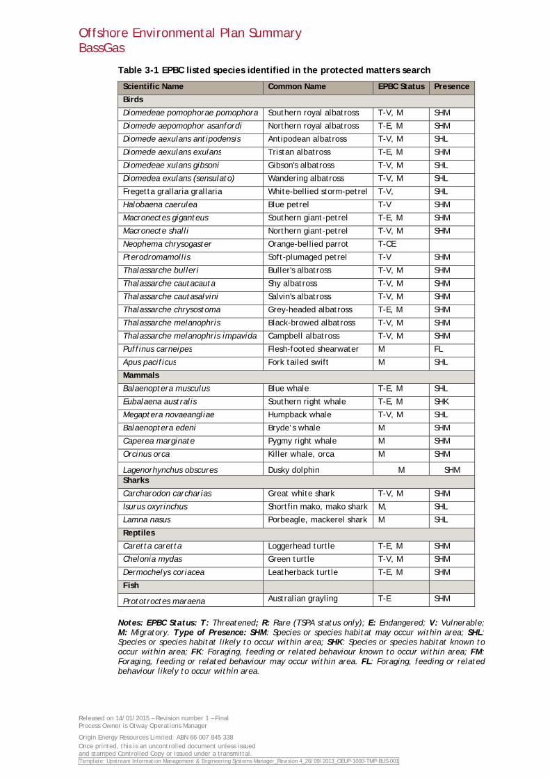
The EPBC Act protected matters database was used to identify threatened and migratory species potentially occurring within the Otway offshore operations area. The search of the protected matters database was conducted using the Bass Gas Offshore operations pipeline and well field inclusive of a five kilometre buffer area. A total of 26 threatened species and 27 migratory species were identified as potentially occurring within the operations area. These species are listed in Table 3-1.
Offshore Environmental Plan Summary BassGas
Released on 14/01/2015 – Revision number 1 – Final Process Owner is Otway Operations Manager
Origin Energy Resources Limited: ABN 66 007 845 338 Once printed, this is an uncontrolled document unless issued and stamped Controlled Copy or issued under a transmittal. Template: Upstream Information Management & Engineering Systems Manager_Revision 4_26/09/2013_OEUP-1000-TMP-BUS-001
Table 3-1 EPBC listed species identified in the protected matters search
Scientific Name Common Name EPBC Status Presence
Birds
Diomedeae pomophorae pomophora Southern royal albatross T-V, M SHM
Diomede aepomophor asanfordi Northern royal albatross T-E, M SHM
Diomede aexulans antipodensis Antipodean albatross T-V, M SHL
Diomede aexulans exulans Tristan albatross T-E, M SHM
Diomedeae xulans gibsoni Gibson's albatross T-V, M SHL
Diomedea exulans (sensulato) Wandering albatross T-V, M SHL
Fregetta grallaria grallaria White-bellied storm-petrel T-V, SHL
Halobaena caerulea Blue petrel T-V SHM
Macronectes giganteus Southern giant-petrel T-E, M SHM
Macronecte shalli Northern giant-petrel T-V, M SHM
Neophema chrysogaster Orange-bellied parrot T-CE
Pterodromamollis Soft-plumaged petrel T-V SHM
Thalassarche bulleri Buller's albatross T-V, M SHM
Thalassarche cautacauta Shy albatross T-V, M SHM
Thalassarche cautasalvini Salvin's albatross T-V, M SHM
Thalassarche chrysostoma Grey-headed albatross T-E, M SHM
Thalassarche melanophris Black-browed albatross T-V, M SHM
Thalassarche melanophris impavida Campbell albatross T-V, M SHM
Puffinus carneipes Flesh-footed shearwater M FL
Apus pacificus Fork tailed swift M SHL
Mammals
Balaenoptera musculus Blue whale T-E, M SHL
Eubalaena australis Southern right whale T-E, M SHK
Megaptera novaeangliae Humpback whale T-V, M SHL
Balaenoptera edeni Bryde’s whale M SHM
Caperea marginate Pygmy right whale M SHM
Orcinus orca Killer whale, orca M SHM
Lagenorhynchus obscures Dusky dolphin M SHM Sharks
Carcharodon carcharias Great white shark T-V, M SHM
Isurus oxyrinchus Shortfin mako, mako shark M, SHL
Lamna nasus Porbeagle, mackerel shark M SHL
Reptiles
Caretta caretta Loggerhead turtle T-E, M SHM
Chelonia mydas Green turtle T-V, M SHM
Dermochelys coriacea Leatherback turtle T-E, M SHM
Fish
Prototroctes maraena Australian grayling T-E SHM
Notes: EPBC Status: T: Threatened; R: Rare (TSPA status only); E: Endangered; V: Vulnerable; M: Migratory. Type of Presence: SHM: Species or species habitat may occur within area; SHL: Species or species habitat likely to occur within area; SHK: Species or species habitat known to occur within area; FK: Foraging, feeding or related behaviour known to occur within area; FM: Foraging, feeding or related behaviour may occur within area. FL: Foraging, feeding or related behaviour likely to occur within area.
Offshore Environmental Plan Summary BassGas
Released on 14/01/2015 – Revision number 1 – Final Process Owner is Otway Operations Manager
Origin Energy Resources Limited: ABN 66 007 845 338 Once printed, this is an uncontrolled document unless issued and stamped Controlled Copy or issued under a transmittal. Template: Upstream Information Management & Engineering Systems Manager_Revision 4_26/09/2013_OEUP-1000-TMP-BUS-001
3.2.2 Birds
A number of important coastal and pelagic bird habitats are found in Bass Strait. Pelagic habitats support penguins and a range of albatrosses, petrels, shearwaters, storm-petrels, terns and skuas. Colonies of the Little Penguin (Eudyptula minor) are located at a number of sites along the coast of Southern Australia. Albatross prefer small, remote islands in the Southern Ocean for breeding. The closest breeding habitat to the area is Albatross Island, to the northwest of Tasmania.
The area surrounding the Yolla A platform does not contain any known seabird nesting habitats, however many species may be found migrating and foraging through Victorian waters.
3.2.3 Mammals
3.2.3.1 Ceteceans
There were seven cetacean species within the operation area identified in the protected matters search as threatened or migratory. Two species, the blue whale (Balaenoptera musculus) and southern right whale (Eubalaena australis) are listed as endangered; and one, the humpback whale (Megaptera novaeangliae), as vulnerable. Three other whales, Bryde’s whale (Balaenoptera edeni), pygmy right whale (Caperea marginata) and killer whale (Orcinus orca) are listed as migratory.
Blue Whales have extensive migration patterns that are not known to follow any particular coastlines or oceanographic features. They are observed frequently in western Victoria and western Tasmania and the Otway region in western Victoria (region west of King Island) is an important migratory and feeding corridor. Current data indicates that blue whales are seasonally distributed. They concentrate between the Great Australian Bight in South Australia and Cape Nelson in far western Victoria in November, occur widely in the Otway region from January to April and then decrease between May and June.
Southern right whales migrate each year from summer feeding grounds in the sub-Antarctic to calve and mate in warmer waters off the southern Australian coast during winter. Since the 1970's, southern right whale sightings along the Victorian coast have increased significantly.
During winter and spring, southern right whales use coastal waters to breed, rearing calves close to shore, sometimes in waters less than 5 m depth. The closest known calving areas to the offshore facilities are off the coast at Warrnambool, Port Fairy and Portland. There are no known aggregations or calving zones of the southern right whale in the CBS bioregion.
3.2.3.2 Pinnipeds
There are two species of fur seals which predominate in the area surrounding the Yolla field – the New Zealand fur seal and the Australian fur seal. Australian fur seals have a relatively restricted distribution around the islands of Bass Strait, where it is the most common seal. At least five significant non-breeding haul-out sites occur within Bass Strait. Adult tagged seals have shown travel paths from Flinders Island to King Island, presumably passing through central Bass Strait. Their preferred habitat, especially for breeding, is a rocky island with boulder or pebble beach’s and gradually sloping rocky ledges.
Significant seal colonies in Central Bass Strait are located at Seal Rocks off Phillip Island, Kanowna Island and Rag Island within the Wilsons Promontory Marine National Park. Australian fur seals also frequent Albatross Island between the North Western tip of Tasmania and King Island. Seal Rocks is one of Australia’s largest fur seal colonies, supporting around a quarter of all Victorian seals.
3.2.4 Reptiles
Three reptile species were identified in the protected matters search as potentially occurring in the area: the loggerhead turtle (Caretta caretta), the Green Turtle (Chelonia mydas) and the leatherback turtle (Dermochelys coriacea).

Offshore Environmental Plan Summary BassGas
Released on 14/01/2015 – Revision number 1 – Final Process Owner is Otway Operations Manager
Origin Energy Resources Limited: ABN 66 007 845 338 Once printed, this is an uncontrolled document unless issued and stamped Controlled Copy or issued under a transmittal. Template: Upstream Information Management & Engineering Systems Manager_Revision 4_26/09/2013_OEUP-1000-TMP-BUS-001
The loggerhead turtle is distributed globally in near-shore subtropical waters and is rare in Victorian waters. The loggerhead is a carnivorous turtle, feeding primarily on benthic invertebrates in a habitat ranging from near shore to 55m in depth. The main breeding areas for loggerheads are generally confined to southern Queensland and Western Australia. No known loggerhead turtle foraging or breeding areas are identified in Victoria waters and are only infrequently identified in southern Australian waters.
The leatherback turtle is the most pelagic of all marine turtles, and is found in tropical, subtropical, and temperate waters around the world. Leatherbacks are known to migrate significant distances between foraging and breeding areas, and show a fidelity to larger breeding areas or a particular beach type. No major nesting areas have been identified in Australia although isolated nesting occurs in Queensland and the Northern Territory. Some nesting has occurred in northern New South Wales near Ballina, but none have been observed since 1996.
Green Turtles nest, forage and migrate across tropical northern Australia. They usually occur between the 20°C isotherms, although individuals can stray into temperate waters as vagrant visitors. Green Turtles spend their first five to ten years drifting on ocean currents. During this pelagic (ocean-going) phase, they are often found in association with drift lines and rafts.
3.2.5 Sharks and ray finned fish
There is a wide range of sharks in Bass Strait including gummy, school, draftboard, Port Jackson and various other saw and dog sharks. Many of these sharks are caught by mesh netting and long-lining in Commonwealth waters along the entire Tasmanian and Victorian coastlines.
The great white shark, short finned mako and porbeagle are identified in the EPBC search as potentially occurring in the region. These species would be transient within the operational area.
3.2.6 Fish
A large number of fish species inhabit Bass Strait, with over 200 known species of bony fish (teleosts) and 50 species of shark and rays (elasmobranchs). Historic studies have concentrated on species of commercial importance.
Opportunistic fish surveys were undertaken in 1998 and 1999 from eastern Bass Strait. These fish surveys were conducted within a 5 nautical mile radius of nine offshore oil and gas platforms in eastern Bass Strait and yielded a total of 55 taxa of larval and early juvenile fish species. The most abundant species recorded were:
Jack mackerel;
Thornfish;
King gar;
Nannygai; and
Australian salmon.
3.2.7 Invertebrates and plankton
The marine invertebrates in the region include porifera (e.g., sponges), cnidarians (e.g., jellyfish, corals, anemones, seapens), bryozoans, arthropods (e.g., sea spiders), crustaceans (e.g., rock lobster, brine and fairy shrimps), molluscs (e.g., scallops, sea slugs), echinoderms (e.g., sea cucumbers), and annelids (e.g, polychaete worms).
Studies by the Museum of Victoria found that invertebrate diversity was high in southern Australian waters, but the distribution of species was irregular, with little evidence of any distinct biogeographic regions. The results of invertebrate sampling undertaken in shallower inshore sediments indicate a high diversity and patchy distribution. In these areas crustaceans, polychaetes, and molluscs were dominant. Surveys of the seabed near the Yolla platform prior to drilling and construction showed sparsely scattered clumps of solitary sponge, sea cucumbers, sea squirts and predatory snails (whelk).
Offshore Environmental Plan Summary BassGas
Released on 14/01/2015 – Revision number 1 – Final Process Owner is Otway Operations Manager
Origin Energy Resources Limited: ABN 66 007 845 338 Once printed, this is an uncontrolled document unless issued and stamped Controlled Copy or issued under a transmittal. Template: Upstream Information Management & Engineering Systems Manager_Revision 4_26/09/2013_OEUP-1000-TMP-BUS-001
Plankton distribution depends upon prevailing ocean currents such as the East Australia Current, west to east flows from Bass Strait and Southern Ocean masses. Populations near the Yolla Project area (including platform and drilling area) can be extremely variable both spatially and temporally and are likely to comprise characteristics of tropical, southern Australian, central Bass Strait and Tasman Sea populations.
3.3 Cultural and Socio-Economic Environment
3.3.1 Marine protected areas and reserves
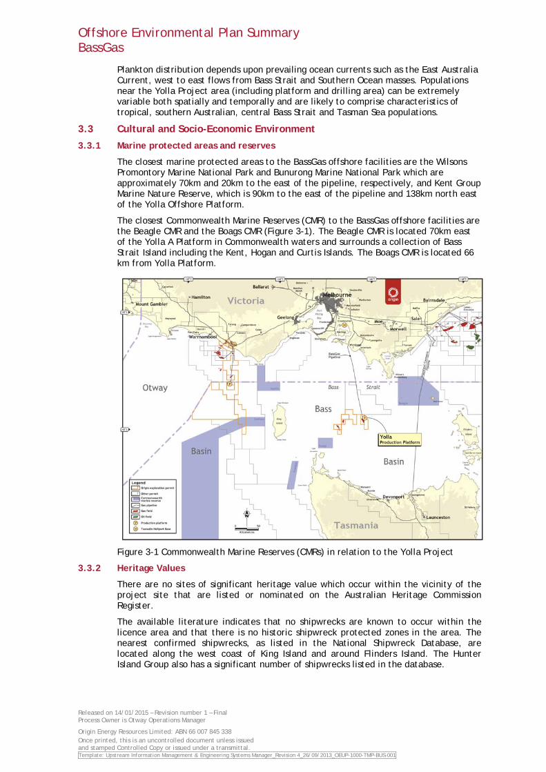
The closest marine protected areas to the BassGas offshore facilities are the Wilsons Promontory Marine National Park and Bunurong Marine National Park which are approximately 70km and 20km to the east of the pipeline, respectively, and Kent Group Marine Nature Reserve, which is 90km to the east of the pipeline and 138km north east of the Yolla Offshore Platform.
The closest Commonwealth Marine Reserves (CMR) to the BassGas offshore facilities are the Beagle CMR and the Boags CMR (Figure 3-1). The Beagle CMR is located 70km east of the Yolla A Platform in Commonwealth waters and surrounds a collection of Bass Strait Island including the Kent, Hogan and Curtis Islands. The Boags CMR is located 66 km from Yolla Platform.
Figure 3-1 Commonwealth Marine Reserves (CMRs) in relation to the Yolla Project
3.3.2 Heritage Values
There are no sites of significant heritage value which occur within the vicinity of the project site that are listed or nominated on the Australian Heritage Commission Register.
The available literature indicates that no shipwrecks are known to occur within the licence area and that there is no historic shipwreck protected zones in the area. The nearest confirmed shipwrecks, as listed in the National Shipwreck Database, are located along the west coast of King Island and around Flinders Island. The Hunter Island Group also has a significant number of shipwrecks listed in the database.
Offshore Environmental Plan Summary BassGas
Released on 14/01/2015 – Revision number 1 – Final Process Owner is Otway Operations Manager
Origin Energy Resources Limited: ABN 66 007 845 338 Once printed, this is an uncontrolled document unless issued and stamped Controlled Copy or issued under a transmittal. Template: Upstream Information Management & Engineering Systems Manager_Revision 4_26/09/2013_OEUP-1000-TMP-BUS-001
3.3.3 Commercial fisheries
The pipeline shoreline crossing at Kilcunda is within an area of locally active commercial fisheries (for abalone, rock lobster, school whiting, shark, flathead and wrasse, charter), recreational angling (for abalone, rock lobster, flathead, snapper, gummy shark) and game fishing (for mako, thresher shark and tuna). The fishing port of San Remo is located 15km west of the pipeline shore crossing. San Remo and the harbours and boat ramps at Phillip Island provide access for a wide range of fishing vessels to the coastline from Phillip Island to Cape Patterson and the western side of Wilsons Promontory.
A number of Victorian and Commonwealth managed commercial fisheries are conducted along the continental shelf and slope of the central Bass Strait region, although fishing activity limited is limited for many of these. These fisheries are described in Table 3-2.
Table 3-2: Commercial Fisheries in Bass Strait
Description Location Target Species Technique Abalone Fishery
Restricted to rocky substrates of near shore areas
Blacklip and Greenlip abalone
Diving
Rock Lobster Fishery
Restricted to hard rocky substrates of the continental shelf
Southern rock lobster Baited pots
Eastern Tuna and Billfish Fishery
Widely distributed Albacore tuna, bigeye tuna, yellowfin tuna, broadbill swordfish and striped marlin
Pelagic longline and minor line
Skipjack Tuna Fishery Widely distributed Skipjack tuna Purse seine Small Pelagic Fishery Generally coastline
and near shore Jack mackerel, blue mackerel, redbait and Australian sardine
Purse seine and midwater trawl
SESSF - Commonwealth Trawl Sector (comprises South East Trawl Fishery)
Generally continental shelf and upper slope
Blue grenadier, tiger flathead, pink long and spotted warehou
Otter trawl and Danish seine
SESSF - Gillnet, Hook and Trap Sectors
Generally continental shelf
34 species Scalefish hook, shark hook, gillnets, fish traps and automatic longlines
Southern Bluefin Tuna Fishery
Generally continental shelf
Southern bluefin tuna Purse seine
Southern Squid Jig Fishery
Generally continental shelf
Arrow squid Squid jigging
Giant Crab Fishery Generally continental shelf and upper slope
Giant crab Baited pots
Scallop Fishery Continental shelf areas
Commercial scallop Dredged harvester
3.3.4 Shipping
Bass Strait is one of the busiest shipping routes in Australia with more than 3,000 vessels transiting through the area each year. Consultation with the main shipping lines has indicated that the shipping density around the project area is low. By volume, most heavy shipping movements in Bass Strait are east-west and west-east, north of the licence area (approximately 32 nautical miles from the platform), between the ports of Fremantle, Western Australia, and Melbourne and Sydney.
Offshore Environmental Plan Summary BassGas
Released on 14/01/2015 – Revision number 1 – Final Process Owner is Otway Operations Manager
Origin Energy Resources Limited: ABN 66 007 845 338 Once printed, this is an uncontrolled document unless issued and stamped Controlled Copy or issued under a transmittal. Template: Upstream Information Management & Engineering Systems Manager_Revision 4_26/09/2013_OEUP-1000-TMP-BUS-001
4. Environmental Risks, Impacts and Controls
Origin has undertaken an environmental risk assessment for the BassGas Offshore operations using the Origin risk assessment process which is consistent with the Australian Standard for Risk Management: AS/NZS ISO 31000:2009 Risk management – Principles and Guidelines.
The process of environmental impact and risk assessment used for the BassGas Offshore operations is as follows:
• Identify the hazard under consideration
• Identify the consequence rating corresponding to the maximum reasonable impact associated with the hazard (Figure 4-1). The assessment of impacts is limited to this step
• Identify the likelihood rating (Figure 4-2) based on an assessment of probability and exposure
• Identify risk rating based on the consequence rating and likelihood rating using the Origin risk toolkit matrix (Figure 4-2).
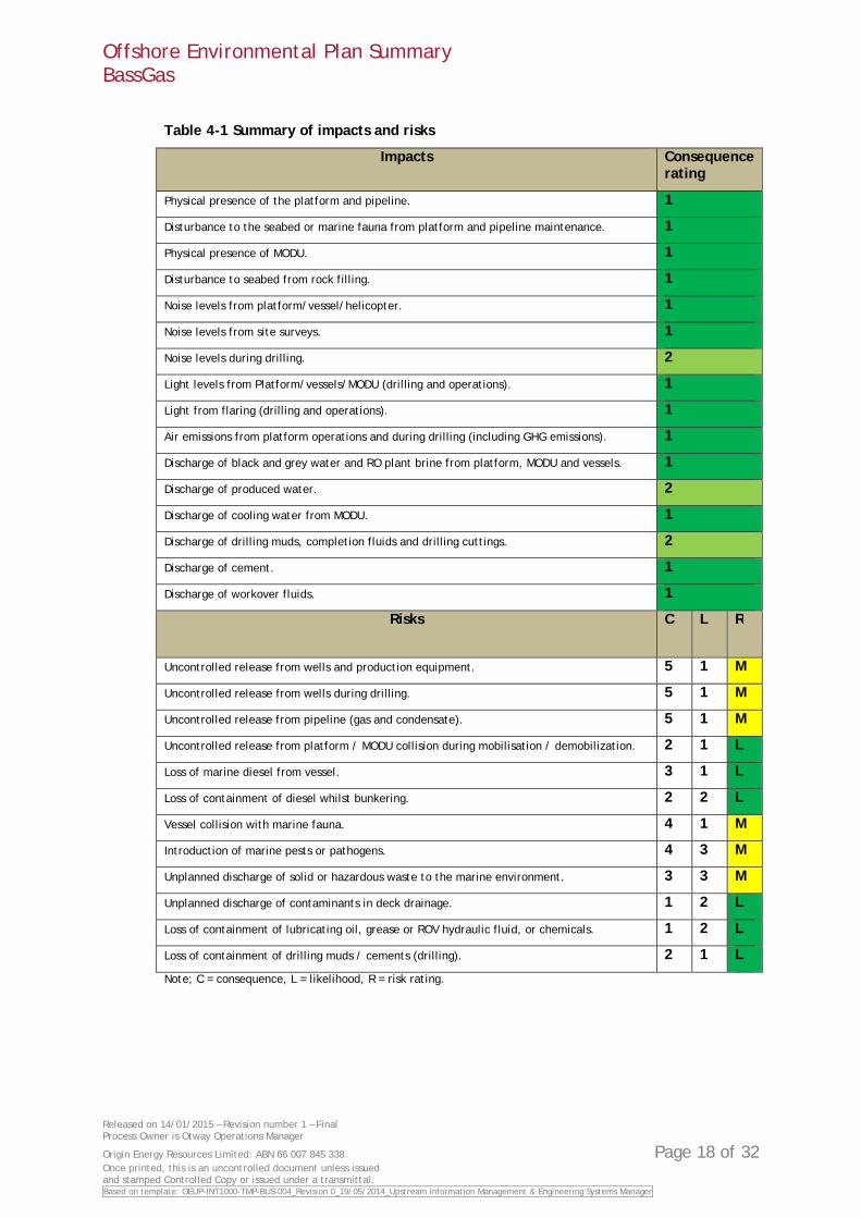
Three environmental impacts were assessed to have a consequence of moderate. These impacts are:
• Noise levels during drilling
• Discharge of produced water
• Discharge of drilling muds, completion fluids and drilling cuttings.
All other impacts were assessed to have a minor consequence. Note that no likelihood rating and therefore risk rating is calculated for environmental impacts.
Six environmental risks were assessed to be medium, should they occur. These risks are listed below:
• Uncontrolled release from wells and production equipment
• Uncontrolled release from wells during drilling
• Uncontrolled release from pipeline (gas and condensate)
• Vessel collision with marine fauna.
• Introduction of marine pests or pathogens
• Unplanned discharge of solid or hazardous waste to the marine environment.
All other environmental risks were assessed as low.
Consequence and likelihood ratings for all identified environmental impacts and risks are presented in Table 4-1.
The risk assessment process undertaken for the BassGas Offshore operations operations is an ongoing process. Risks are regularly assessed and if necessary new controls implemented to reduce potential risks to As Low as Reasonably Possible (ALARP). This process of continual assessment is integral to Origin’s risk management process.
After taking into consideration the control measures proposed, the likelihood of the event occurring and the environmental conditions at the site all residual risks were considered to be reduced to ALARP and acceptable levels. A summary of risks, potential environmental hazard and controls for the BassGas Offshore operations is presented in Appendix B.
Offshore Environmental Plan Summary BassGas
Released on 14/01/2015 – Revision number 1 – Final Process Owner is Otway Operations Manager
Origin Energy Resources Limited: ABN 66 007 845 338 Page 16 of 32 Once printed, this is an uncontrolled document unless issued and stamped Controlled Copy or issued under a transmittal. Template: Upstream Information Management & Engineering Systems Manager_Revision 4_26/09/2013_OEUP-1000-TMP-BUS-001
Figure 4-1 Consequence rating
Offshore Environmental Plan Summary BassGas
Released on 14/01/2015 – Revision number 1 – Final Process Owner is Otway Operations Manager
Origin Energy Resources Limited: ABN 66 007 845 338 Once printed, this is an uncontrolled document unless issued and stamped Controlled Copy or issued under a transmittal. Template: Upstream Information Management & Engineering Systems Manager_Revision 4_26/09/2013_OEUP-1000-TMP-BUS-001
Figure 4-2 Risk rating
Offshore Environmental Plan Summary BassGas
Released on 14/01/2015 – Revision number 1 – Final Process Owner is Otway Operations Manager
Origin Energy Resources Limited: ABN 66 007 845 338 Page 18 of 32 Once printed, this is an uncontrolled document unless issued and stamped Controlled Copy or issued under a transmittal. Based on template: OEUP-INT1000-TMP-BUS-004_Revision 0_19/05/2014_Upstream Information Management & Engineering Systems Manager
Table 4-1 Summary of impacts and risks
Impacts Consequence rating
Physical presence of the platform and pipeline. 1
Disturbance to the seabed or marine fauna from platform and pipeline maintenance. 1
Physical presence of MODU. 1
Disturbance to seabed from rock filling. 1
Noise levels from platform/vessel/helicopter. 1
Noise levels from site surveys. 1
Noise levels during drilling. 2
Light levels from Platform/vessels/MODU (drilling and operations). 1
Light from flaring (drilling and operations). 1
Air emissions from platform operations and during drilling (including GHG emissions). 1
Discharge of black and grey water and RO plant brine from platform, MODU and vessels. 1
Discharge of produced water. 2
Discharge of cooling water from MODU. 1
Discharge of drilling muds, completion fluids and drilling cuttings. 2
Discharge of cement. 1
Discharge of workover fluids. 1
Risks C L R
Uncontrolled release from wells and production equipment. 5 1 M
Uncontrolled release from wells during drilling. 5 1 M
Uncontrolled release from pipeline (gas and condensate). 5 1 M
Uncontrolled release from platform / MODU collision during mobilisation / demobilization. 2 1 L
Loss of marine diesel from vessel. 3 1 L
Loss of containment of diesel whilst bunkering. 2 2 L
Vessel collision with marine fauna. 4 1 M
Introduction of marine pests or pathogens. 4 3 M
Unplanned discharge of solid or hazardous waste to the marine environment. 3 3 M
Unplanned discharge of contaminants in deck drainage. 1 2 L
Loss of containment of lubricating oil, grease or ROV hydraulic fluid, or chemicals. 1 2 L
Loss of containment of drilling muds / cements (drilling). 2 1 L
Note; C = consequence, L = likelihood, R = risk rating.
Offshore Environmental Plan Summary BassGas
Released on 14/01/2015 – Revision number 1 – Final Process Owner is Otway Operations Manager
Origin Energy Resources Limited: ABN 66 007 845 338 Page 19 of 32 Once printed, this is an uncontrolled document unless issued and stamped Controlled Copy or issued under a transmittal. Based on template: OEUP-INT1000-TMP-BUS-004_Revision 0_19/05/2014_Upstream Information Management & Engineering Systems Manager
5. Management and monitoring
Origins overall environmental objective for the BassGas offshore operations is to avoid or reduce environmental risks to as low as reasonably practicable (ALARP). Specific environmental performance objectives, standards and measurement criteria have been developed for each environmental impact or risk identified for the BassGas offshore operations. Environmental performance will be measured and reported against these objectives and standards.
Management of the BassGas offshore operations is undertaken in accordance with the Origin Health, Safety and Environment Management System (HSEMS). The HSEMS includes the Origin HSE Policy and 20 HSEMS Standards which provide performance requirements for all Origin operations that are aligned with commitments made in the HSE Policy. The HSEMS provides a management framework to achieve HSE objectives systematically while allowing flexibility to effectively target impacts and risks.
The Origin HSE Policy can be accessed at: http://www.originenergy.com.au/files/HSEPolicy.pdf
The Origin HSEMS can be accessed at: http://www.originenergy.com.au/1780/files/HSEManagementsystem.pdf
The BassGas offshore operations are also managed to comply with the relevant State and Commonwealth Acts and Regulations.
Audits will be undertaken to determine compliance with the requirements of the EP as part of Origins HSE auditing program under the HSEMS. Audits will assess and report against the performance outcomes, standards and measurement criteria for the BassGas offshore operations.
If any new or increased risks are identified during the life of the BassGas offshore operations, an assessment of the risk and review of the EP will be undertaken. If it is determined that any new or increased risks are significant the revised EP will be submitted to NOSPEMA for approval prior to the commencement of the activity causing the risk. Revision of the EP will also occur on an annual basis in addition to any reviews triggered by new or increased risks.
All environmental incidents and non-conformances are managed in accordance with Origin incident management processes including reporting, classification, investigation and close out. Reporting of incidents and non-conformances to NOPSEMA will be undertaken in accordance with the OPGGS (E) Regulations 2009.
Monthly reporting to NOPSEMA will be undertaken detailing performance against environmental performance objectives and standards. An annual environmental performance report for the BassGas offshore operations will also be submitted to NOPSEMA. The annual report will summarise environmental performance over the reporting period.
Origin will also store and maintain environmental documents and records from the BassGas offshore operations for the period of 5 years, as required by the OPGGS (E) Regulations 2009.

Offshore Environmental Plan Summary BassGas
Released on 14/01/2015 – Revision number 1 – Final Process Owner is Otway Operations Manager
Origin Energy Resources Limited: ABN 66 007 845 338 Page 20 of 32 Once printed, this is an uncontrolled document unless issued and stamped Controlled Copy or issued under a transmittal. Based on template: OEUP-INT1000-TMP-BUS-004_Revision 0_19/05/2014_Upstream Information Management & Engineering Systems Manager
6. Consultation
Development of the BassGas project began in 2001, with production commencing in 2006. Throughout the history of the BassGas offshore facilities Origin has ongoing consultation with stakeholders through the BassGas Environmental Liaison Group (ELG) in the region, on the operation and development of the project. As part of NOPSEMA taking on the role of sole regulator for all offshore oil and gas developments in Commonwealth waters, Origin were required to resubmit and update the BassGas Environment Plan in line with the updated Offshore Petroleum and Greenhouse Gas Storage (Environment) regulations.
As part of the process of developing a new Environment Plan Origin undertook an extensive round of consultation with stakeholders. Origin will continue to consult with stakeholders as required throughout the life of the operations.
Key stakeholders identified and consulted with in relation to this Environment Plan are:
• Australian Fisheries Management Authority (AFMA)
• Australian Marine Oil Spill Centre (AMOSC)
• Aviation Agencies – Bristow’s & Australasian Jet
• Australian Marine Safety Authority (AMSA)
• Border Protection Control Command
• Department of Defence
• Fisheries Victoria
• Victorian Minister for Energy and Resources
• Victorian State Member of Parliament for Bass
• Tasmanian Department of Primary Industries, Parks, Water and Environment
• Victorian Department of State Development, Business and Innovation
• Victorian Department of Transport, Planning & Local Infrastructure
• Commonwealth Fisheries Association
• South East Trawl Fishing Industry Association
• Sustainable Shark Fishing Inc (SSFI)
• Southern Shark Industry Alliance (SSIA)
• Scallop Fisherman’s Association of Tasmania
• Bass Strait Central Zone Scallop Fishery Management Authority
• Relevant individual commercial fishermen
• Various contractors
The BassGas offshore facilities are an ongoing operation and the purpose of this consultation was to address regulatory requirements that require consultation to be undertaken in the development of an Environment Plan. Stakeholders have been kept informed of the project and comments received on the project were limited and addressed appropriately. Origin also undertakes routine high level meetings with both relevant Commonwealth and State ministers. Typically, Ministerial updates on the operations of the BassGas project are provided as part of a larger briefing on Origin’s operations within Victoria.
ELG meetings are held on a bi annual basis. Where appropriate this forum can be used as a conduit to distribute project information and seek feedback on the project.
Offshore Environmental Plan Summary BassGas
Released on 14/01/2015 – Revision number 1 – Final Process Owner is Otway Operations Manager
Origin Energy Resources Limited: ABN 66 007 845 338 Page 21 of 32 Once printed, this is an uncontrolled document unless issued and stamped Controlled Copy or issued under a transmittal. Based on template: OEUP-INT1000-TMP-BUS-004_Revision 0_19/05/2014_Upstream Information Management & Engineering Systems Manager
Origin is committed to fair and equitable dealings with all stakeholders, and will use its best endeavours to provide accurate, up-to-date information to all the project stakeholders and address any concerns.
7. Contact details
The nominated liaison person for this activity is:
Mr Mat Quinn
BassGas Operations Manager
5775 South Gippsland Highway
Lang Lang, Victoria, 3984
(03) 5654 9304
Offshore Environmental Plan Summary BassGas
Released on 14/01/2015 – Revision number 1 – Final Process Owner is Otway Operations Manager
Origin Energy Resources Limited: ABN 66 007 845 338 Page 22 of 32 Once printed, this is an uncontrolled document unless issued and stamped Controlled Copy or issued under a transmittal. Based on template: OEUP-INT1000-TMP-BUS-004_Revision 0_19/05/2014_Upstream Information Management & Engineering Systems Manager
Appendix A Oil Pollution Emergency Plan
Origin has developed an Oil Pollution Emergency Plan (OPEP) for the BassGas offshore facilities. The OPEP outlines the response arrangements to be undertaken in the unlikely event of a spill and the responsibilities of Origin, contractors and response agencies. The OPEP recognises the divisions of responsibility as defined under the terms of the "National Plan".
The responsibility for an oil spill is dependent on the location and the nature of the spill. The National plan for Maritime Environmental Emergencies sets out the division of responsibility for an oil spill response. For offshore petroleum exploration and production activities Origin is responsible for spills emanating from its offshore facilities. For vessel spills including those associated with the maintenance and support activities for the BassGas offshore operations, the Australian Maritime Safety Authority (AMSA) is the designated Control Agency for spill emanating from commonwealth waters.
Origin has consulted with AMSA in the development of the OPEP. Under existing agreements AMSA will take over control of a spill originating from vessels for all spill volumes. Origin will provide support to AMSA in this response.
Vessels used for Origin activities at the BassGas offshore facilities will have a vessel specific Shipboard Oil Pollution Emergency Plan (SOPEP) in accordance with the requirements of MARPOL 73/78 Annex I. These plans outline responsibilities, specify procedures and identify resources available in the event of an oil or chemical spill from a vessel.
Response Actions
The objectives of any hydrocarbon spill response are to minimise the risks to human life, environmental and socio-economic resources and property. In addressing strategies for oil spill response Origin have focused on the identification of vulnerable habitats located within the trajectory of the oil spill modelling for the operation rather than focusing on the open water environment. These strategies are specifically tailored to the light, highly evaporative condensate produced from the operation and the receiving environment comprised of a highly energetic marine environment with remote shorelines.
Oil spill modelling undertaken as part of the EP has indicated that impacts from a large scale loss of marine diesel or condensate would be limited to the open ocean surrounding the infrastructure. Shore line impacts would be unlikely and localised and minor in scale. Origin has also developed well relief plans in line with best practice guideline developed through the Oil and Gas UK industry body, to bring a well under control in the highly unlikely event of loss of well control.
Origin have determined through a net environmental benefits analysis (NEBA) that in the event of a large scale gas condensate spill that given the highly evaporative nature of the product, distance from shore and nature of the environment (highly energetic sea with remote and highly energetic coast lines) the only viable response option would be natural degradation and monitoring and evaluate. All NEBA assessments would be revisited in the case of an incident and updated if required based on the actual characteristics of the spill and metocean conditions.
The nature of the hydrocarbons potentially released from the site makes then unsuitable or undesirable for dispersant application. The high rates of evaporation, physical dispersion into the water column and physical weathering of these products, combined with the typical sea conditions in the area and distance from sensitive shoreline or shallow water environments (modelling predicts no or very minimal contact with these environments) make the deployment of booms and skimming techniques unnecessary and unfeasible.
Primary response strategies that may be employed in parallel with these response strategies in a worst case spill scenario include operational and scientific monitoring programs.

Offshore Environmental Plan Summary BassGas
Released on 14/01/2015 – Revision number 1 – Final Process Owner is Otway Operations Manager
Origin Energy Resources Limited: ABN 66 007 845 338 Page 23 of 32 Once printed, this is an uncontrolled document unless issued and stamped Controlled Copy or issued under a transmittal. Based on template: OEUP-INT1000-TMP-BUS-004_Revision 0_19/05/2014_Upstream Information Management & Engineering Systems Manager
Monitor and evaluate
Understanding the behaviour and trajectory of hydrocarbon slicks is required in all spill scenarios to confirm the potential for environmental harm from the spill. There are a number of methods that can be used to monitor and evaluate hydrocarbon spills including;
• Direct observation (surveillance by air, vessel or tracking buoys);
• Manual calculations; and
• Computer modelling with real time metocean inputs from direct observations.
Operational and Scientific monitoring
Operational monitoring studies are undertaken to help guide and support operational spill response activities. These studies provide information on the extent and characteristics of the spill, the predicted fate of the spilled hydrocarbon and its immediate consequences, and assess the efficacy of response activities that are being undertaken.
Triggers associated with the operational monitoring program are designed to comply with Australian and New Zealand Environment Conservation Council (ANZECC) guidelines on water quality. Associated with the operational monitoring program is a scientific monitoring program that will be implemented (if triggered by the operational monitoring program).
The operational monitoring programs include;
• Hydrocarbon distribution and fate studies; • Shoreline assessment surveys; and • Wildlife surveys.
The scientific monitoring program includes;
• Monitoring hydrocarbon fate and distribution in waters and sediments; • Assessment of subtidal ecological effects; • Assessment of intertidal ecological effects; • Wildlife impact and monitoring studies; and • Monitoring hydrocarbon contamination and exposure of fish.
Baseline information from which the results of environmental monitoring will be considered will come from various sources including;
• Previous extensive studies of the Central Bass basin and Victorian coastal environments; • Published information and data from research institutions; • Equivalent ecological studies of suitable reference sites, selected in consultation with local
experts; and • Sampling from outside potentially impacted areas.
In all cases of sourcing baseline information, advice would be obtained from credible scientific experts (e.g. academics from independent research institutions) and sources of detailed local knowledge (e.g. Parks Victoria, local fishing and dive operators).
Offshore Environmental Plan Summary BassGas
Released on 14/01/2015 – Revision number 1 – Final Process Owner is Otway Operations Manager
Origin Energy Resources Limited: ABN 66 007 845 338 Page 24 of 32 Once printed, this is an uncontrolled document unless issued and stamped Controlled Copy or issued under a transmittal. Based on template: OEUP-INT1000-TMP-BUS-004_Revision 0_19/05/2014_Upstream Information Management & Engineering Systems Manager
Appendix B Risk Assessment tables
Impacts
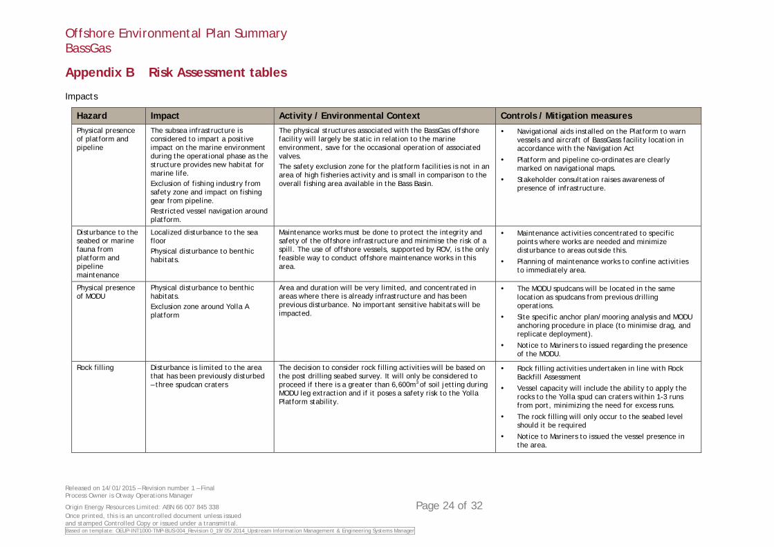
Hazard Impact Activity / Environmental Context Controls / Mitigation measures Physical presence of platform and pipeline
The subsea infrastructure is considered to impart a positive impact on the marine environment during the operational phase as the structure provides new habitat for marine life. Exclusion of fishing industry from safety zone and impact on fishing gear from pipeline. Restricted vessel navigation around platform.
The physical structures associated with the BassGas offshore facility will largely be static in relation to the marine environment, save for the occasional operation of associated valves. The safety exclusion zone for the platform facilities is not in an area of high fisheries activity and is small in comparison to the overall fishing area available in the Bass Basin.
Navigational aids installed on the Platform to warn vessels and aircraft of BassGass facility location in accordance with the Navigation Act
Platform and pipeline co-ordinates are clearly marked on navigational maps.
Stakeholder consultation raises awareness of presence of infrastructure.
Disturbance to the seabed or marine fauna from platform and pipeline maintenance
Localized disturbance to the sea floor Physical disturbance to benthic habitats.
Maintenance works must be done to protect the integrity and safety of the offshore infrastructure and minimise the risk of a spill. The use of offshore vessels, supported by ROV, is the only feasible way to conduct offshore maintenance works in this area.
Maintenance activities concentrated to specific points where works are needed and minimize disturbance to areas outside this.
Planning of maintenance works to confine activities to immediately area.
Physical presence of MODU
Physical disturbance to benthic habitats. Exclusion zone around Yolla A platform
Area and duration will be very limited, and concentrated in areas where there is already infrastructure and has been previous disturbance. No important sensitive habitats will be impacted.
The MODU spudcans will be located in the same location as spudcans from previous drilling operations.
Site specific anchor plan/mooring analysis and MODU anchoring procedure in place (to minimise drag, and replicate deployment).
Notice to Mariners to issued regarding the presence of the MODU.
Rock filling Disturbance is limited to the area that has been previously disturbed – three spudcan craters
The decision to consider rock filling activities will be based on the post drilling seabed survey. It will only be considered to proceed if there is a greater than 6,600m3 of soil jetting during MODU leg extraction and if it poses a safety risk to the Yolla Platform stability.
Rock filling activities undertaken in line with Rock Backfill Assessment
Vessel capacity will include the ability to apply the rocks to the Yolla spud can craters within 1-3 runs from port, minimizing the need for excess runs.
The rock filling will only occur to the seabed level should it be required
Notice to Mariners to issued the vessel presence in the area.

Offshore Environmental Plan Summary BassGas
Released on 14/01/2015 – Revision number 1 – Final Process Owner is Otway Operations Manager
Origin Energy Resources Limited: ABN 66 007 845 338 Page 25 of 32 Once printed, this is an uncontrolled document unless issued and stamped Controlled Copy or issued under a transmittal. Based on template: OEUP-INT1000-TMP-BUS-004_Revision 0_19/05/2014_Upstream Information Management & Engineering Systems Manager
Hazard Impact Activity / Environmental Context Controls / Mitigation measures Noise levels from platform/ operations/general vessel activities/general helicopter activities
Impact on marine life, sea birds and or migrating birds on or around the platform. Behavioral change in marine fauna (localized avoidance/attraction) Hearing impartment and pathological damage to marine fauna Increase stress levels in marine fauna Disruption to marine fauna underwater acoustic cues Secondary ecological effects – alteration of predator prey relationship
There is no feasible alternative to the use of vessels and helicopters, and visits are kept to a minimum to safely provide for personnel and supply transport. Solar power generation is considered unfeasible due to space available and the power demands of the platform. Generally low levels of noise generation from all sources and vessel movements are not significant in the context of other marine traffic in the area. Birds appear little affected by noise as they are known to roost on the helideck and other areas. The facility has been operating since 2006 and seals have been noted to haul themselves out on the jacket trusses and marine fauna are noted in the vicinity of the operating facility indicating they are habituated to any noise produced.
Gas engines and generators on the platform are enclosed.
Vessel’s operating in accordance with Marine Order 59 (Offshore support vessel operations) 2011: equipment, in good working order, appropriate to the operation of the vessel is on board the vessel.
Helicopters and vessels will comply with the Australian National Guidelines for Whale and Dolphin Watching 2005
Environmental Awareness training packaging includes DEH guideline requirements
Noise monitoring will be undertaken before, during and after drilling
Noise levels from site surveys
Behavioural changes of cetaceans Site surveys are a critical control requirement for the safe operation and jack-up of the MODU and prevent damage to any sub-sea infrastructure. Noise from these low level sources will be of short duration and limited to sounders and sonar equipment commonly used by vessels.
No seismic sources (e.g. airguns) will be used in this survey work.
Vessel’s operating in accordance with Marine Order 59 (Offshore support vessel operations) 2011.
Vessels will comply with Australian National Guidelines for Whale and Dolphin Watching 2005
Noise levels during drilling
Behavioral change in marine fauna (localised avoidance/attraction) Hearing impairment and pathological damage to marine fauna Increased stress levels in marine fauna Disruption to marine fauna underwater acoustic cues
Compared to semi-submersible MODUs, the jack-up MODU with its hull clear of the water has a reduced amount of noise propagation in the marine environment. There is limited access in Australia to MODUs capable of undertaking the technical requirements in the geographically restricted locations of the Yolla field. The final MODU selection will be based on safe working abilities to operate in the field. It is expected that any impacts on marine fauna will be limited to behavioural changes of species close to the location and will not result in any ecosystem level effects. The Yolla site is not in a major pathway for marine mammal migrations and there are large areas of open water surrounding the site to allow safe passage.
All equipment will be maintained onboard the MODU via a preventative maintenance system or equivalent.
Cetacean sightings logged in the daily environment log.
Project induction delivered to all personnel including requirement to report should any fauna be sighted.
Light levels from Platform/vessels/MODU (excluding flaring)
Aggregations of marine life, sea birds and or migrating birds on the platform. Disturbance of migration of seabirds and other marine life that may be attracted to lighting from the platform, MODU, and vessels.
Project lighting is not a significant addition to lighting from other vessels and activities in the area. Full time, bright lighting on the platform and MODU is essential to safe operations and navigation, and the use of less lighting is not feasible due to increased safety risk.
Process work lights are directed onto work areas and shielded.
Any additional lighting that may be required in the Platform well bay area due to MODU being cantilevered will be inward facing.
Environmental awareness training including reporting requirements for wildlife incident or injuries
Offshore Environmental Plan Summary BassGas
Released on 14/01/2015 – Revision number 1 – Final Process Owner is Otway Operations Manager
Origin Energy Resources Limited: ABN 66 007 845 338 Page 26 of 32 Once printed, this is an uncontrolled document unless issued and stamped Controlled Copy or issued under a transmittal. Based on template: OEUP-INT1000-TMP-BUS-004_Revision 0_19/05/2014_Upstream Information Management & Engineering Systems Manager
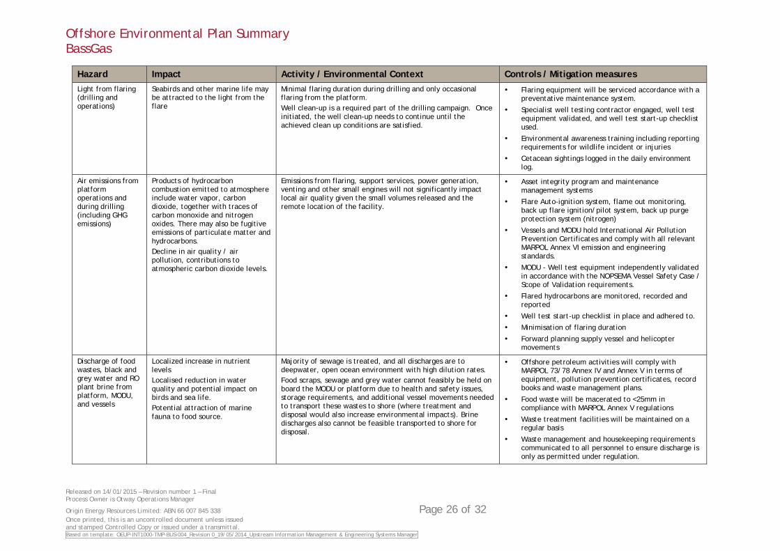
Hazard Impact Activity / Environmental Context Controls / Mitigation measures Light from flaring (drilling and operations)
Seabirds and other marine life may be attracted to the light from the flare
Minimal flaring duration during drilling and only occasional flaring from the platform. Well clean-up is a required part of the drilling campaign. Once initiated, the well clean-up needs to continue until the achieved clean up conditions are satisfied.
Flaring equipment will be serviced accordance with a preventative maintenance system.
Specialist well testing contractor engaged, well test equipment validated, and well test start-up checklist used.
Environmental awareness training including reporting requirements for wildlife incident or injuries
Cetacean sightings logged in the daily environment log.
Air emissions from platform operations and during drilling (including GHG emissions)
Products of hydrocarbon combustion emitted to atmosphere include water vapor, carbon dioxide, together with traces of carbon monoxide and nitrogen oxides. There may also be fugitive emissions of particulate matter and hydrocarbons. Decline in air quality / air pollution, contributions to atmospheric carbon dioxide levels.
Emissions from flaring, support services, power generation, venting and other small engines will not significantly impact local air quality given the small volumes released and the remote location of the facility.
Asset integrity program and maintenance management systems
Flare Auto-ignition system, flame out monitoring, back up flare ignition/pilot system, back up purge protection system (nitrogen)
Vessels and MODU hold International Air Pollution Prevention Certificates and comply with all relevant MARPOL Annex VI emission and engineering standards.
MODU - Well test equipment independently validated in accordance with the NOPSEMA Vessel Safety Case / Scope of Validation requirements.
Flared hydrocarbons are monitored, recorded and reported
Well test start-up checklist in place and adhered to.
Minimisation of flaring duration
Forward planning supply vessel and helicopter movements
Discharge of food wastes, black and grey water and RO plant brine from platform, MODU, and vessels
Localized increase in nutrient levels Localised reduction in water quality and potential impact on birds and sea life. Potential attraction of marine fauna to food source.
Majority of sewage is treated, and all discharges are to deepwater, open ocean environment with high dilution rates. Food scraps, sewage and grey water cannot feasibly be held on board the MODU or platform due to health and safety issues, storage requirements, and additional vessel movements needed to transport these wastes to shore (where treatment and disposal would also increase environmental impacts). Brine discharges also cannot be feasible transported to shore for disposal.
Offshore petroleum activities will comply with MARPOL 73/78 Annex IV and Annex V in terms of equipment, pollution prevention certificates, record books and waste management plans.
Food waste will be macerated to <25mm in compliance with MARPOL Annex V regulations
Waste treatment facilities will be maintained on a regular basis
Waste management and housekeeping requirements communicated to all personnel to ensure discharge is only as permitted under regulation.
Offshore Environmental Plan Summary BassGas
Released on 14/01/2015 – Revision number 1 – Final Process Owner is Otway Operations Manager
Origin Energy Resources Limited: ABN 66 007 845 338 Page 27 of 32 Once printed, this is an uncontrolled document unless issued and stamped Controlled Copy or issued under a transmittal. Based on template: OEUP-INT1000-TMP-BUS-004_Revision 0_19/05/2014_Upstream Information Management & Engineering Systems Manager
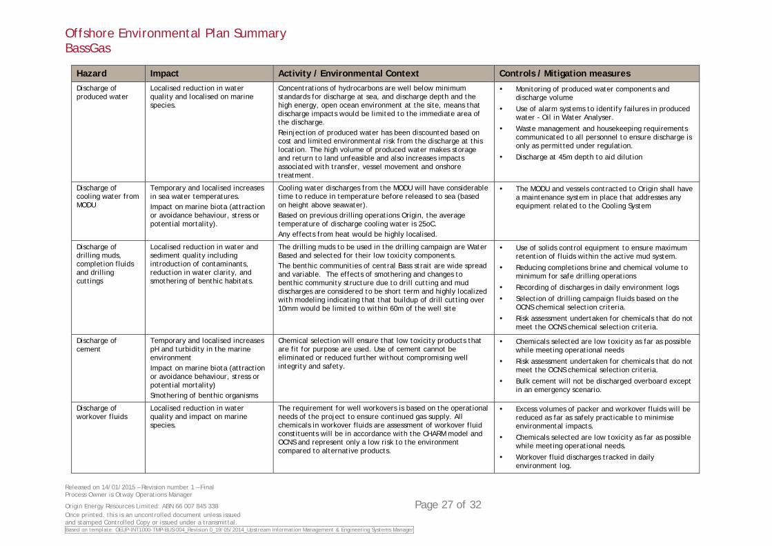
Hazard Impact Activity / Environmental Context Controls / Mitigation measures Discharge of produced water
Localised reduction in water quality and localised on marine species.
Concentrations of hydrocarbons are well below minimum standards for discharge at sea, and discharge depth and the high energy, open ocean environment at the site, means that discharge impacts would be limited to the immediate area of the discharge. Reinjection of produced water has been discounted based on cost and limited environmental risk from the discharge at this location. The high volume of produced water makes storage and return to land unfeasible and also increases impacts associated with transfer, vessel movement and onshore treatment.
Monitoring of produced water components and discharge volume
Use of alarm systems to identify failures in produced water - Oil in Water Analyser.
Waste management and housekeeping requirements communicated to all personnel to ensure discharge is only as permitted under regulation.
Discharge at 45m depth to aid dilution
Discharge of cooling water from MODU
Temporary and localised increases in sea water temperatures. Impact on marine biota (attraction or avoidance behaviour, stress or potential mortality).
Cooling water discharges from the MODU will have considerable time to reduce in temperature before released to sea (based on height above seawater). Based on previous drilling operations Origin, the average temperature of discharge cooling water is 25oC. Any effects from heat would be highly localised.
The MODU and vessels contracted to Origin shall have a maintenance system in place that addresses any equipment related to the Cooling System
Discharge of drilling muds, completion fluids and drilling cuttings
Localised reduction in water and sediment quality including introduction of contaminants, reduction in water clarity, and smothering of benthic habitats.
The drilling muds to be used in the drilling campaign are Water Based and selected for their low toxicity components. The benthic communities of central Bass strait are wide spread and variable. The effects of smothering and changes to benthic community structure due to drill cutting and mud discharges are considered to be short term and highly localized with modeling indicating that that buildup of drill cutting over 10mm would be limited to within 60m of the well site
Use of solids control equipment to ensure maximum retention of fluids within the active mud system.
Reducing completions brine and chemical volume to minimum for safe drilling operations
Recording of discharges in daily environment logs
Selection of drilling campaign fluids based on the OCNS chemical selection criteria.
Risk assessment undertaken for chemicals that do not meet the OCNS chemical selection criteria.
Discharge of cement
Temporary and localised increases pH and turbidity in the marine environment Impact on marine biota (attraction or avoidance behaviour, stress or potential mortality) Smothering of benthic organisms
Chemical selection will ensure that low toxicity products that are fit for purpose are used. Use of cement cannot be eliminated or reduced further without compromising well integrity and safety.
Chemicals selected are low toxicity as far as possible while meeting operational needs
Risk assessment undertaken for chemicals that do not meet the OCNS chemical selection criteria.
Bulk cement will not be discharged overboard except in an emergency scenario.
Discharge of workover fluids
Localised reduction in water quality and impact on marine species.
The requirement for well workovers is based on the operational needs of the project to ensure continued gas supply. All chemicals in workover fluids are assessment of workover fluid constituents will be in accordance with the CHARM model and OCNS and represent only a low risk to the environment compared to alternative products.
Excess volumes of packer and workover fluids will be reduced as far as safely practicable to minimise environmental impacts.
Chemicals selected are low toxicity as far as possible while meeting operational needs.
Workover fluid discharges tracked in daily environment log.
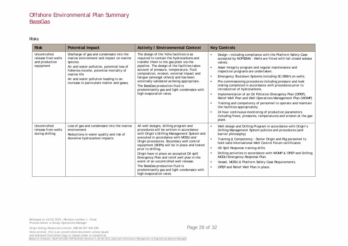
Offshore Environmental Plan Summary BassGas
Released on 14/01/2015 – Revision number 1 – Final Process Owner is Otway Operations Manager
Origin Energy Resources Limited: ABN 66 007 845 338 Page 28 of 32 Once printed, this is an uncontrolled document unless issued and stamped Controlled Copy or issued under a transmittal. Based on template: OEUP-INT1000-TMP-BUS-004_Revision 0_19/05/2014_Upstream Information Management & Engineering Systems Manager
Risks
Risk Potential Impact Activity / Environmental Context Key Controls Uncontrolled release from wells and production equipment
Discharge of gas and condensate into the marine environment and impact on marine species. Air and water pollution, potential loss of fisheries income, potential mortality of marine life Air and water pollution leading to an increase in particulate matter and gases.
The design of the Yolla facilities is as required to contain the hydrocarbons and transfer them to the gas plant via the pipeline. The design of the facilities takes account of pressure, temperature, fluid composition, erosion, external impact and fatigue (amongst others) and has been externally validated as being appropriate. The BassGas production fluid is predominantly gas and light condensate with high evaporation rates.
Design – including compliance with the Platform Safety Case accepted by NOPSEMA - Wells are fitted with fail closed subsea valves.
Asset Integrity program and regular maintenance and inspection programs are undertaken.
Emergency Shutdown Systems including SC-SSSV's on wells.
Pre-commissioning procedures including pressure and leak testing completed in accordance with procedures prior to introduction of hydrocarbons.
Implementation of an Oil Pollution Emergency Plan (OPEP), Relief Well Plan and Well Operations Management Plan (WOMP)
Training and competency of personnel to operate and maintain the facilities appropriately.
24 hour continuous monitoring of production parameters including flows, pressures, temperatures and erosion at the gas plant.
Uncontrolled release from wells during drilling
Loss of gas and condensate into the marine environment Reductions in water quality and risk of shoreline hydrocarbon impacts
All well designs, drilling program and procedures will be written in accordance with Origin’s Drilling Management System and executed in accordance with MODU and Origin procedures. Secondary well control equipment (BOPs) will be in place and tested prior to drilling. Origin have in place an accepted Oil spill Emergency Plan and relief well plan in the event of an uncontrolled well release. The BassGas production fluid is predominantly gas and light condensate with high evaporation rates.
Well design and Drilling Program in accordance with Origin’s Drilling Management System policies and procedures (and barrier philosophy)
Training & Competency - Senior Origin and Rig personnel to hold valid International Well Control Forum certificates
Oil Spill Response training drills
Drilling activities in accordance with WOMP & OPEP and Drilling MODU Emergency Response Plan.
Vessel, MODU & Platform Safety Case Requirements.
OPEP and Relief Well Plan in place.
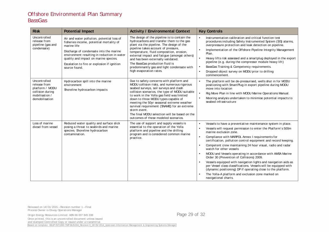
Offshore Environmental Plan Summary BassGas
Released on 14/01/2015 – Revision number 1 – Final Process Owner is Otway Operations Manager
Origin Energy Resources Limited: ABN 66 007 845 338 Page 29 of 32 Once printed, this is an uncontrolled document unless issued and stamped Controlled Copy or issued under a transmittal. Based on template: OEUP-INT1000-TMP-BUS-004_Revision 0_19/05/2014_Upstream Information Management & Engineering Systems Manager
Risk Potential Impact Activity / Environmental Context Key Controls Uncontrolled release from pipeline (gas and condensate)
Air and water pollution, potential loss of fisheries income, potential mortality of marine life
Discharge of condensate into the marine environment resulting in reduction in water quality and impact on marine species.
Escalation to fire or explosion if ignition source found.
The design of the pipeline is to contain the hydrocarbons and transfer them to the gas plant via the pipeline. The design of the pipeline takes account of pressure, temperature, fluid composition, erosion, external impact and fatigue (amongst others) and has been externally validated. The BassGas production fluid is predominantly gas and light condensate with high evaporation rates.
Instrumentation calibration and critical function test procedures including Safety Instrumented System (SIS) alarms, overpressure protection and leak detection on pipeline.
Implementation of the Offshore Pipeline Integrity Management Plan.
Heavy lifts risk assessed and a smartplug deployed in the export pipeline (e.g. during the compressor module heavy lift)
BassGas Training & Competency requirements.
Dropped object survey on MODU prior to drilling commencement.
Uncontrolled release from platform / MODU collision during mobilisation / demobilisation
Hydrocarbon spill into the marine environment
Shoreline hydrocarbon impacts
Due to safety concerns with platform and MODU collision risks, and numerous rigorous seabed surveys, soil surveys and clash collision scenarios, the type of MODU suitable to work in the Yolla gas field was limited down to three MODU types capable of meeting the 50yr seasonal extreme weather survival requirement (SNAME) for an extreme storm event. The final MODU selection will be based on the outcomes of these modeled scenarios.
The platform will be de-pressurised, wells shut in for MODU positioning with SmartPlug in export pipeline during MODU move into location
Rig Move Plan in line with MODU Marine Operations Manual.
Mooring analysis undertaken to minimise potential impacts to seabed infrastructure
Loss of marine diesel from vessel
Reduced water quality and surface slick posing a threat to seabirds and marine species. Shoreline hydrocarbon contamination.
The use of support and supply vessels is essential to the operation of the Yolla platform and pipeline and the drilling program and is considered common marine practice.
Vessels to have a preventative maintenance system in place.
Vessels will request permission to enter the Platform’s 500m marine exclusion zone.
Compliance with MARPOL Annex I requirements for certification, pollution control equipment and record keeping.
Competent crew maintaining 24 hour visual, radio and radar watch for other vessels
MODU and Vessels operating in accordance with AMSA Marine Order 30 (Prevention of Collisions) 2009.
Vessels equipped with navigation lights and navigation aids as per Vessel class classifications. Vessels will be equipped with (dynamic positioning) DP if operating close to the platform.
The Yolla-A platform and exclusion zone marked on navigational charts.
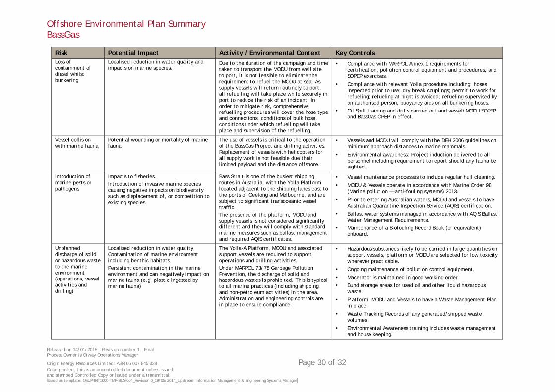
Offshore Environmental Plan Summary BassGas
Released on 14/01/2015 – Revision number 1 – Final Process Owner is Otway Operations Manager
Origin Energy Resources Limited: ABN 66 007 845 338 Page 30 of 32 Once printed, this is an uncontrolled document unless issued and stamped Controlled Copy or issued under a transmittal. Based on template: OEUP-INT1000-TMP-BUS-004_Revision 0_19/05/2014_Upstream Information Management & Engineering Systems Manager
Risk Potential Impact Activity / Environmental Context Key Controls Loss of containment of diesel whilst bunkering
Localised reduction in water quality and impacts on marine species.
Due to the duration of the campaign and time taken to transport the MODU from well site to port, it is not feasible to eliminate the requirement to refuel the MODU at sea. As supply vessels will return routinely to port, all refuelling will take place while securely in port to reduce the risk of an incident. In order to mitigate risk, comprehensive refuelling procedures will cover the hose type and connections, conditions of bulk hose, conditions under which refuelling will take place and supervision of the refuelling.
Compliance with MARPOL Annex 1 requirements for certification, pollution control equipment and procedures, and SOPEP exercises.
Compliance with relevant Yolla procedure including: hoses inspected prior to use; dry break couplings; permit to work for refueling; refueling at night is avoided; refueling supervised by an authorised person; buoyancy aids on all bunkering hoses.
Oil Spill training and drills carried out and vessel/MODU SOPEP and BassGas OPEP in effect.
Vessel collision with marine fauna
Potential wounding or mortality of marine fauna
The use of vessels is critical to the operation of the BassGas Project and drilling activities. Replacement of vessels with helicopters for all supply work is not feasible due their limited payload and the distance offshore.
Vessels and MODU will comply with the DEH 2006 guidelines on minimum approach distances to marine mammals.
Environmental awareness: Project induction delivered to all personnel including requirement to report should any fauna be sighted.
Introduction of marine pests or pathogens
Impacts to fisheries. Introduction of invasive marine species causing negative impacts on biodiversity such as displacement of, or competition to existing species.
Bass Strait is one of the busiest shipping routes in Australia, with the Yolla Platform located adjacent to the shipping lanes east to the ports of Geelong and Melbourne, and are subject to significant transoceanic vessel traffic. The presence of the platform, MODU and supply vessels is not considered significantly different and they will comply with standard marine measures such as ballast management and required AQIS certificates.
Vessel maintenance processes to include regular hull cleaning.
MODU & Vessels operate in accordance with Marine Order 98 (Marine pollution — anti-fouling systems) 2013.
Prior to entering Australian waters, MODU and vessels to have Australian Quarantine Inspection Service (AQIS) certification.
Ballast water systems managed in accordance with AQIS Ballast Water Management Requirements.
Maintenance of a Biofouling Record Book (or equivalent) onboard.
Unplanned discharge of solid or hazardous waste to the marine environment (operations, vessel activities and drilling)
Localised reduction in water quality. Contamination of marine environment including benthic habitats. Persistent contamination in the marine environment and can negatively impact on marine fauna (e.g. plastic ingested by marine fauna)
The Yolla-A Platform, MODU and associated support vessels are required to support operations and drilling activities. Under MARPOL 73/78 Garbage Pollution Prevention, the discharge of solid and hazardous wastes is prohibited. This is typical to all marine practices (including shipping and non-petroleum activities) in the area. Administration and engineering controls are in place to ensure compliance.
Hazardous substances likely to be carried in large quantities on support vessels, platform or MODU are selected for low toxicity wherever practicable.
Ongoing maintenance of pollution control equipment.
Macerator is maintained in good working order
Bund storage areas for used oil and other liquid hazardous waste.
Platform, MODU and Vessels to have a Waste Management Plan in place.
Waste Tracking Records of any generated/shipped waste volumes
Environmental Awareness training includes waste management and house keeping.
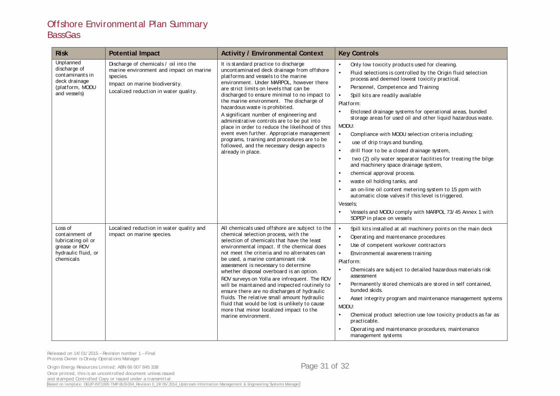
Offshore Environmental Plan Summary BassGas
Released on 14/01/2015 – Revision number 1 – Final Process Owner is Otway Operations Manager
Origin Energy Resources Limited: ABN 66 007 845 338 Page 31 of 32 Once printed, this is an uncontrolled document unless issued and stamped Controlled Copy or issued under a transmittal. Based on template: OEUP-INT1000-TMP-BUS-004_Revision 0_19/05/2014_Upstream Information Management & Engineering Systems Manager
Risk Potential Impact Activity / Environmental Context Key Controls Unplanned discharge of contaminants in deck drainage (platform, MODU and vessels)
Discharge of chemicals / oil into the marine environment and impact on marine species. Impact on marine biodiversity. Localized reduction in water quality.
It is standard practice to discharge uncontaminated deck drainage from offshore platforms and vessels to the marine environment. Under MARPOL, however there are strict limits on levels that can be discharged to ensure minimal to no impact to the marine environment. The discharge of hazardous waste is prohibited. A significant number of engineering and administrative controls are to be put into place in order to reduce the likelihood of this event even further. Appropriate management programs, training and procedures are to be followed, and the necessary design aspects already in place.
Only low toxicity products used for cleaning.
Fluid selections is controlled by the Origin fluid selection process and deemed lowest toxicity practical.
Personnel, Competence and Training
Spill kits are readily available
Platform:
Enclosed drainage systems for operational areas, bunded storage areas for used oil and other liquid hazardous waste.
MODU:
Compliance with MODU selection criteria including;
use of drip trays and bunding,
drill floor to be a closed drainage system,
two (2) oily water separator facilities for treating the bilge and machinery space drainage system,
chemical approval process.
waste oil holding tanks, and
an on-line oil content metering system to 15 ppm with automatic close valves if this level is triggered.
Vessels;
Vessels and MODU comply with MARPOL 73/45 Annex 1 with SOPEP in place on vessels
Loss of containment of lubricating oil or grease or ROV hydraulic fluid, or chemicals
Localised reduction in water quality and impact on marine species.
All chemicals used offshore are subject to the chemical selection process, with the selection of chemicals that have the least environmental impact. If the chemical does not meet the criteria and no alternates can be used, a marine contaminant risk assessment is necessary to determine whether disposal overboard is an option. ROV surveys on Yolla are infrequent. The ROV will be maintained and inspected routinely to ensure there are no discharges of hydraulic fluids. The relative small amount hydraulic fluid that would be lost is unlikely to cause more that minor localized impact to the marine environment.
Spill kits installed at all machinery points on the main deck
Operating and maintenance procedures
Use of competent workover contractors
Environmental awareness training
Platform:
Chemicals are subject to detailed hazardous materials risk assessment
Permanently stored chemicals are stored in self contained, bunded skids.
Asset integrity program and maintenance management systems
MODU:
Chemical product selection use low toxicity products as far as practicable.
Operating and maintenance procedures, maintenance management systems
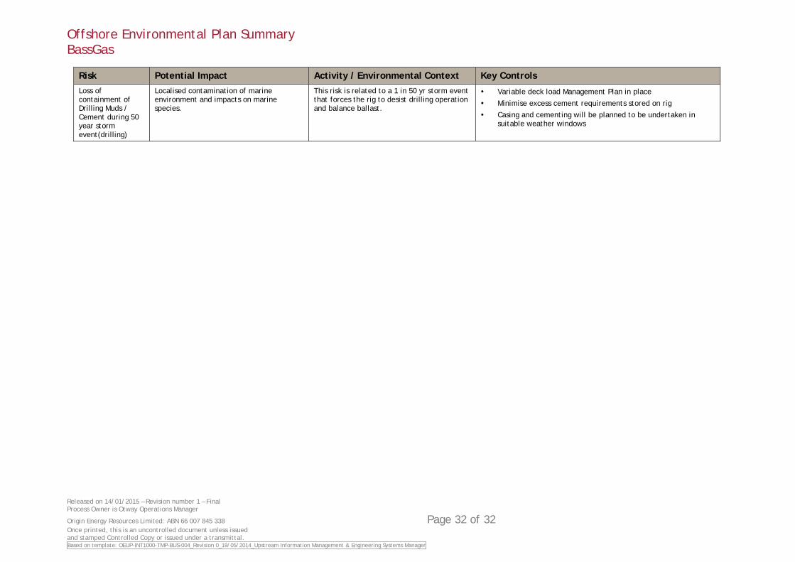
Offshore Environmental Plan Summary BassGas
Released on 14/01/2015 – Revision number 1 – Final Process Owner is Otway Operations Manager
Origin Energy Resources Limited: ABN 66 007 845 338 Page 32 of 32 Once printed, this is an uncontrolled document unless issued and stamped Controlled Copy or issued under a transmittal. Based on template: OEUP-INT1000-TMP-BUS-004_Revision 0_19/05/2014_Upstream Information Management & Engineering Systems Manager
Risk Potential Impact Activity / Environmental Context Key Controls Loss of containment of Drilling Muds / Cement during 50 year storm event(drilling)
Localised contamination of marine environment and impacts on marine species.
This risk is related to a 1 in 50 yr storm event that forces the rig to desist drilling operation and balance ballast.
Variable deck load Management Plan in place
Minimise excess cement requirements stored on rig
Casing and cementing will be planned to be undertaken in suitable weather windows


![WELCOME [] · Paul Gostick – Seacor Marine Dave Nicholls – Step Change in Safety Maurice Pickles – Chevron Upstream Europe John Fraser – Sparrows Offshore Services Mike Munro](https://static.fdocuments.us/doc/165x107/6067bb681c7ee82d481cc645/welcome-paul-gostick-a-seacor-marine-dave-nicholls-a-step-change-in-safety.jpg)