
Unit Six: Africa
11
Unit Six: Africa Name __________________________ Date ____________ Hour __________ In our sixth unit of the year, we begin regional studies of the globe. In the unit we cover physical, political, and human geography topics. Our study of Africa includes issues such as the current AIDS epidemic, political instability, desertification, and physical features. Page(s) Topic Date 1 How Much Do You Know About Africa 2 Africa Gapminder 3-4 Hope for Africa? 5-6 Latitude and Longitude Activity 7-8 Africa Physical Map 9-11 Africa’s Landforms 12-13 Africa’s Climate and Vegetation 14 African Climographs 15 Problem # 1: Climate Change 16-19 Desertification 20 Problem # 2: Ecological Impact 21-24 African Aids Map 25-28 South Africa’s Struggle With AIDS 29 Problem # 3: Islam 30-32 Suffering in Sudan 33-37 Problem # 4: Depopulating Slave Trade 38-40 Problem # 5: Colonialism 41 Problem # 6: Cold War 42-43 Democracy Map 44 Problem # 7: Globalization 45-47 Africa’s Economy Today 48 Problem # 8: Failure of Leadership 49-50 Kenya Video 51 Hope for Africa Mind Map
Transcript of Unit Six: Africa

Unit Six: Africa
Name __________________________ Date ____________ Hour __________ In our sixth unit of the year, we begin regional studies of the globe. In the unit we cover physical, political, and
human geography topics. Our study of Africa includes issues such as the current AIDS epidemic, political instability,
desertification, and physical features.
Page(s) Topic Date
1
How Much Do You Know About Africa
2 Africa Gapminder
3-4 Hope for Africa?
5-6 Latitude and Longitude Activity
7-8 Africa Physical Map
9-11 Africa’s Landforms
12-13 Africa’s Climate and Vegetation
14 African Climographs
15 Problem # 1: Climate Change
16-19 Desertification
20 Problem # 2: Ecological Impact
21-24 African Aids Map
25-28 South Africa’s Struggle With AIDS
29 Problem # 3: Islam
30-32 Suffering in Sudan
33-37 Problem # 4: Depopulating Slave Trade
38-40 Problem # 5: Colonialism
41 Problem # 6: Cold War
42-43 Democracy Map
44 Problem # 7: Globalization
45-47 Africa’s Economy Today
48 Problem # 8: Failure of Leadership
49-50 Kenya Video
51 Hope for Africa Mind Map

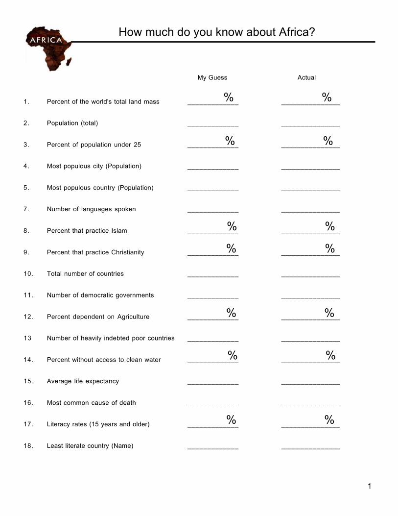
How much do you know about Africa?
1
My Guess Actual
1. Percent of the world's total land mass __________%___ ___________%____ 2. Population (total) _____________ _______________
3. Percent of population under 25 __________%___ ___________%____ 4. Most populous city (Population) _____________ _______________
5. Most populous country (Population) _____________ _______________
7. Number of languages spoken _____________ _______________
8. Percent that practice Islam __________%___ ____________%___
9. Percent that practice Christianity __________%___ ____________%___ 10. Total number of countries _____________ _______________
11. Number of democratic governments _____________ _______________
12. Percent dependent on Agriculture __________%___ ___________%____ 13 Number of heavily indebted poor countries _____________ _______________
14. Percent without access to clean water ___________%__ ____________%___ 15. Average life expectancy _____________ _______________
16. Most common cause of death _____________ _______________
17. Literacy rates (15 years and older) __________%___ ___________%____ 18. Least literate country (Name) _____________ _______________
2
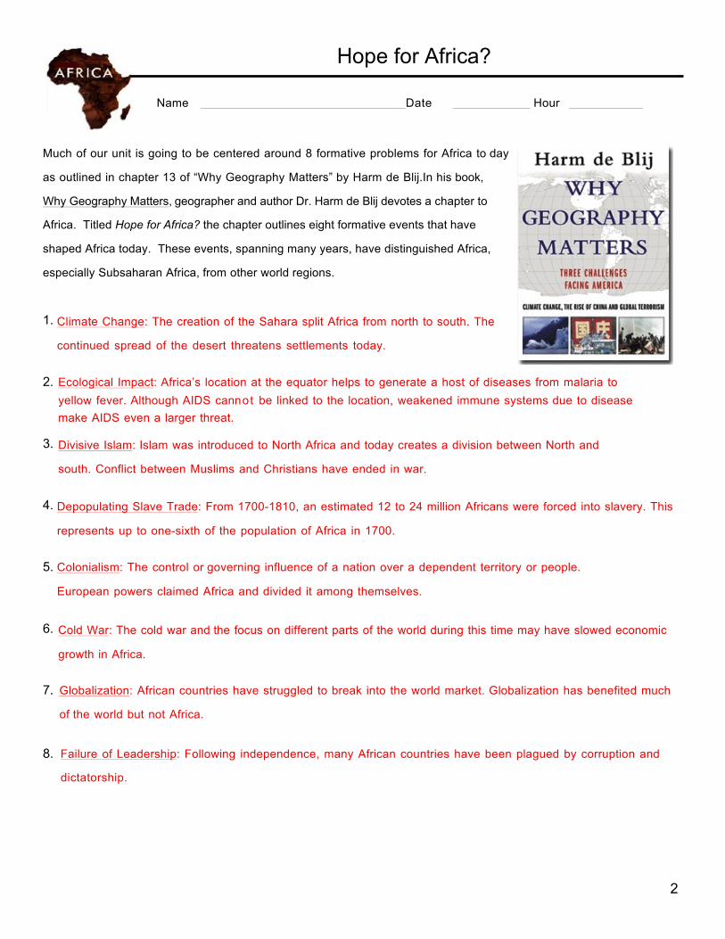
Hope for Africa?
Name Date Hour Much of our unit is going to be centered around 8 formative problems for Africa to day
as outlined in chapter 13 of “Why Geography Matters” by Harm de Blij.In his book,
Why Geography Matters, geographer and author Dr. Harm de Blij devotes a chapter to
Africa. Titled Hope for Africa? the chapter outlines eight formative events that have
shaped Africa today. These events, spanning many years, have distinguished Africa,
especially Subsaharan Africa, from other world regions.
1. Climate Change: The creation of the Sahara split Africa from north to south. The
continued spread of the desert threatens settlements today. 2. Ecological Impact: Africa’s location at the equator helps to generate a host of diseases from malaria to
yellow fever. Although AIDS cannot be linked to the location, weakened immune systems due to disease make AIDS even a larger threat.
3. Divisive Islam: Islam was introduced to North Africa and today creates a division between North and
south. Conflict between Muslims and Christians have ended in war.
4. Depopulating Slave Trade: From 1700-1810, an estimated 12 to 24 million Africans were forced into slavery. This
represents up to one-sixth of the population of Africa in 1700.
5. Colonialism: The control or governing influence of a nation over a dependent territory or people.
European powers claimed Africa and divided it among themselves.
6. Cold War: The cold war and the focus on different parts of the world during this time may have slowed economic
growth in Africa.
7. Globalization: African countries have struggled to break into the world market. Globalization has benefited much
of the world but not Africa.
8. Failure of Leadership: Following independence, many African countries have been plagued by corruption and
dictatorship.
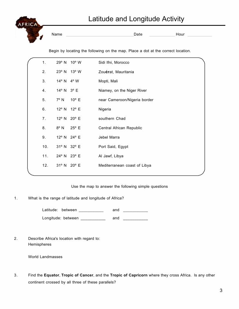
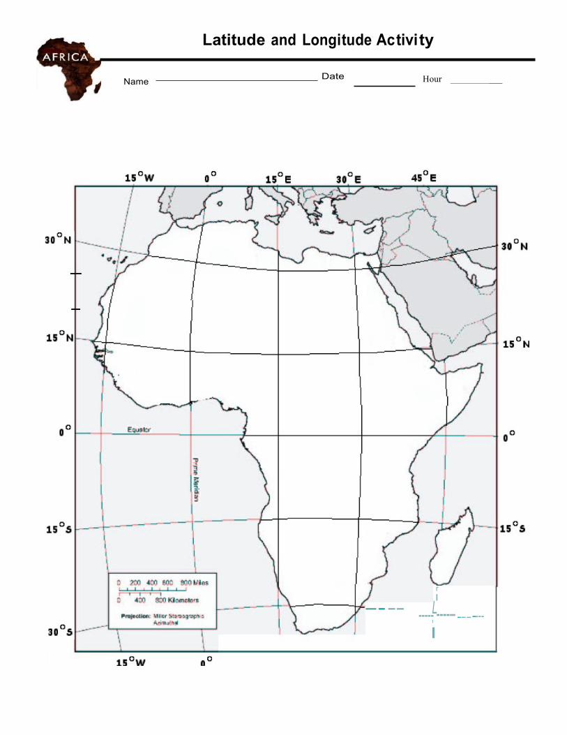
Latitude and Longitude Activity
Name Date Hour
3
Begin by locating the following on the map. Place a dot at the correct location.
1. 29º N 10º W Sidi Ifni, Morocco
2.
23º N
13º W
Zouérat, Mauritania
3.
14º N
4º W
Mopti, Mali
4.
14º N
3º E
Niamey, on the Niger River
5.
7º N
10º E
near Cameroon/Nigeria border
6.
12º N
12º E
Nigeria
7.
12º N
20º E
southern Chad
8.
8º N
25º E
Central African Republic
9.
12º N
24º E
Jebel Marra
10.
31º N
32º E
Port Said, Egypt
11.
24º N
23º E
Al Jawf, Libya
12.
31º N
20º E
Mediterranean coast of Libya
Use the map to answer the following simple questions 1. What is the range of latitude and longitude of Africa?
Latitude: between ___________ and ___________
Longitude: between ___________ and ___________
2. Describe Africa's location with regard to:
Hemispheres
World Landmasses
3. Find the Equator, Tropic of Cancer, and the Tropic of Capricorn where they cross Africa. Is any other
continent crossed by all three of these parallels?
Latitude
1
Name Date Hour _
-- -- r I
-----L------------ I
Africa Physical Map
Name Date Hour
5
Use maps in the back of your textbook as well as atlases from the room to find the following locations in Africa. 1. Locate the following rivers, label them, and color them BLUE.
NILE CONGO NIGER ORANGE ZAMBEZI
2. Locate the following water bodies, label them, and color them BLUE.
GULF OF GUINEA LAKE VICTORIA STRAIT OF GIBRALTAR RED SEA LAKE CHAD MEDITERRANEAN SEA PERSIAN GULF LAKE TANGANYIKA ATLANTIC OCEAN INDIAN OCEAN LAKE NYASA GULF OF ADEN
3. Locate the following highland areas, label them, and color them BROWN.
ATLAS MOUNTAINS ETHIOPIAN PLATEAU AHAGGAR MOUNTAINS DRAKENSBURG MT. KILIMANJARO
4. Locate the following deserts, label them, and color them YELLOW.
SAHARA KALAHARI NAMIB 5. Locate the SERENGETI PLAIN and color it GREEN.
6. Locate the GREAT RIFT VALLEY and color it PURPLE.
7. Locate the following, label them, and outline them in RED.
CAPE OF GOOD HOPE CANARY ISLANDS HORN OF AFRICA CAPE VERDE ISLANDS MADAGASCAR COMORO ISLANDS
8. Locate the following lowland areas, label them, and color them ORANGE.
CONGO BASIN SUDD 9. Locate and label the following lines of latitude and longitude.
TROPIC OF CANCER TROPIC OF CAPRICORN EQUATOR 10. Locate the following continents, label them, and color them GRAY.
EUROPE SOUTHWEST ASIA 11. Include TODALS on your final map
I
'------ --- --"J
- \ I \ I
--- - -- - -- -
---- 1- - ' ,_ -- \ --"
I I \
8
Africa’s Landforms
Name Date Hour
7
Africa's shape and landforms are the result of its location on the southern part of the ancient supercontinent of Pangaea. About 200 million years ago, Pangaea began to break up. Over thousands of years, North and South America, Antarctica, Australia, and India drifted into their current positions. Present-day Africa, however, moved very little.
AFRICA'S PLATEAU
A huge plateau covers most of Africa. It rises inland from narrow lowlands along the cast. Except for the coasts of Mozambique and Somalia, much if the continent lies at least 1,000 feet above sea level. This plateau is Africa's most prominent physical feature. As a result, geographers sometimes refer to Africa-the world's second largest continent- as the “plateau continent.”
BASINS AND RIVERS
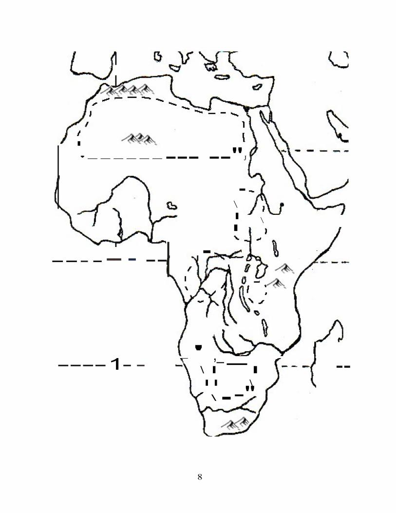
Throughout this plateau lie several huge basins, or depressions, which you'll notice on the map on the right. Each basin spans more than 625 miles across and is as much as 5,000 feet deep. Water collects in the Chad Basin, and rivers flow through the Sudan, Congo, and Djouf basins.
The world's longest river, the Nile River, flows more than 4,000 miles through Uganda and Sudan and into Egypt. Its waters have provided irrigation fro the region for thousands of years. More than 95 percent of Egyptians depend on the Nile for their water. In fact, the average population density along the Nile is more than 3,320 people per square mile. Compare that average population density of 177 people per square mile in all o f Egypt.
Africa's rivers contain many waterfall, rapids, and gorges. These features make the rivers less useful for transportation than shorter rivers on other continents. The 2,900-mile-long Congo River forms the continent's largest network of waterways. But a series of 32 cataracts, or waterfalls, makes large portions of that river impassable.
Furthermore, meandering courses also make Africa's rivers difficult to use for transportation. For example, the Niger River begins in West Africa and flows north toward the Sahara, where it forms an interior delta and turns to the Southeast. It then cuts through Nigeria and forms another huge delta as it empties into the Gulf of Guinea.
Distinctive African Landforms
Africa does not have a long chain of mountains, such as the Rockies in North America or the Himalayas in Asia. However, Africa's valleys and lakes add to the continent's varied landscape.
8
RIFT VALLEYS AND LAKES The continent's most distinctive landforms are in East Africa. As the continental plates pulled apart over millions of years, huge cracks appeared in the earth. The land then sank to form long, thin valleys-called rift valleys. The rift valleys show that the eastern part of Africa is pulling away from the rest of Africa. These rift valleys stretch over 4,000 miles from Jordan in Southwest Asia to Mozambique in Southern Africa.
A cluster of lakes formed at the bottoms of some these rift valleys. These African lakes are unusually long and deep. Lake Tanganyika, the longest freshwater lake in the world, stretches about 420 miles and reaches a depth of more that 4,700 feet. However, Africa's largest lake, Lake Victoria, sits in a shallow basin between two rift valleys. It is the world's second largest freshwater lake but is only 270 feet deep.
MOUNTAINS
Africa contains mainly volcanic mountains. Mount Kenya and Mount Kilimanjaro, Africa's highest mountain, are both volcanoes. Volcanic activity also produced the Ethiopian Highlands, the Tibesti Mountains in the Sahara, and Mount Cameroon in West Africa. In addition, volcanic rock covers the Great Escarpment in Southern Africa. An escarpment is a steep slope with a nearly flat plateau on top. The Great Escarpment marks the edge of the continent's plateau in Southern Africa.
1. According to theory, when Pangea broke up, what happened to present day Africa?
2. A huge ___________________ covers most of Africa.
3. Define Basin:
4. What is the world’s longest river?
5. Through what countries does this river flow?
6. African rivers contain many ___________ , _____________ , & ___________ .
7. Why are African rivers less useful than shorter rivers on other continents?
8. What is a rift valley?
9. Where in Africa are these found?
10. Explain how they form.
11. ______________________ is the worlds longest freshwater lake.
12. ______________________ is Africa’s largest lake.
13. ______________________ is Africa’s highest mountain.
14. Define escarpment.
Africa Climate and Vegetation
Name Date Hour
9
Tropical rain forests are regions where it rains nearly all the time. The moisture supports a rich environment of trees, plants, and animals. Find the tropical rain forest region on your map. The tropical rain forest region used to be much larger. It covered much of Central Africa. Through the years, people cut trees from the forest to use the wood or to clear land for farming. Rain forest lands, however, do not make good farmland. Once the trees are cut down, heavy rains wash away the nutrients that make soil fertile.
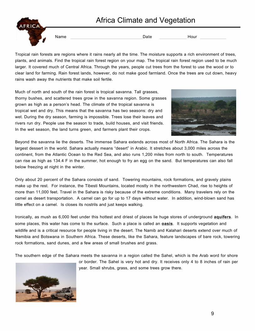
Much of north and south of the rain forest is tropical savanna. Tall grasses, thorny bushes, and scattered trees grow in the savanna region. Some grasses grown as high as a person’s head. The climate of the tropical savanna is tropical wet and dry. This means that the savanna has two seasons: dry and wet. During the dry season, farming is impossible. Trees lose their leaves and rivers run dry. People use the season to trade, build houses, and visit friends. In the wet season, the land turns green, and farmers plant their crops.
Beyond the savanna lie the deserts. The immense Sahara extends across most of North Africa. The Sahara is the largest dessert in the world. Sahara actually means “desert” in Arabic. It stretches about 3,000 miles across the continent, from the Atlantic Ocean to the Red Sea, and also runs 1,200 miles from north to south. Temperatures can rise as high as 134.4 F in the summer, hot enough to fry an egg on the sand. But temperatures can also fall below freezing at night in the winter.
Only about 20 percent of the Sahara consists of sand. Towering mountains, rock formations, and gravely plains make up the rest. For instance, the Tibesti Mountains, located mostly in the northwestern Chad, rise to heights of more than 11,000 feet. Travel in the Sahara is risky because of the extreme conditions. Many travelers rely on the camel as desert transportation. A camel can go for up to 17 days without water. In addition, wind-blown sand has little effect on a camel. Is closes its nostrils and just keeps walking. Ironically, as mush as 6,000 feet under this hottest and driest of places lie huge stores of underground aquifers. In some places, this water has come to the surface. Such a place is called an oasis. It supports vegetation and wildlife and is a critical resource for people living in the desert. The Namib and Kalahari deserts extend over much of Namibia and Botswana in Southern Africa. These deserts, like the Sahara, feature landscapes of bare rock, towering rock formations, sand dunes, and a few areas of small brushes and grass.
The southern edge of the Sahara meets the savanna in a region called the Sahel, which is the Arab word for shore
or border. The Sahel is very hot and dry. It receives only 4 to 8 inches of rain per year. Small shrubs, grass, and some trees grow there.