TriNet/CISN Engineering Strong Motion Data Center and · PDF fileTriNet/CISN Engineering...
12
53 TriNet/CISN Engineering Strong Motion Data Center and the Internet Quick Report Kuo-Wan Lin, Anthony Shakal Strong Motion Instrumentation Program, Calif. Dept. Conservation/Div. Mines & Geology, Sacramento, California and Christopher Stephens U.S. Geological Survey Abstract The development of the TriNet/CISN Engineering Data Center is in progress. As one part of the Engineering Data Center, the California Division of Mines and Geology’s Strong Motion Instrumentation Program has developed a prototype Internet Quick Report (IQR) that uses Internet technology to distribute processed strong-motion data immediately after an earthquake. The IQR is dynamic and cumulative, containing an up-to-date table listing recorded peak ground and structural accelerations arranged in either epicentral distance or alphabetical order. Also, users will have direct access to processed strong-motion data and detailed information on instrumented stations from the IQR. The Engineering Data Center is in the process of compiling detailed structural information on instrumented stations to assist users in utilizing the strong-motion data and to allow users to search for data from specific structure types. Introduction Earthquake monitoring in California is a multi-institutional effort involving state, federal, and private agencies. The TriNet project, funded by the Federal Emergency Management Agency (FEMA) through the California Office of Emergency Services (OES), is a cooperative effort of three agencies, the California Division of Mines and Geology, the California Institute of Technology and the Pasadena Office of the U.S. Geological Survey. Based on the TriNet project, the California Integrated Seismic Network (CISN) is a newly formed consortium of institutions engaged in earthquake monitoring and will extend to include statewide coverage with two additional core members, the Menlo Park Office of the U.S. Geological Survey and the University of California, Berkeley. The OES serves as an ex-officio participant in the CISN. A key component of the CISN is the Engineering Strong Motion Data Center. The data center will be operated by the California Department of Conservation’s Strong Motion Instrumentation Program (CSMIP) in cooperation with the USGS/National Strong Motion Program (NSMP). A primary goal of the Engineering Data Center as well as the other two Data Management Centers in CISN is to provide rapid information after an earthquake, ranging from the ShakeMap to distribution of the data and calculated parameters. Under the TriNet project the SMIP01 Seminar Proceedings
Transcript of TriNet/CISN Engineering Strong Motion Data Center and · PDF fileTriNet/CISN Engineering...

53
TriNet/CISN Engineering Strong Motion Data Center and the Internet Quick Report
Kuo-Wan Lin, Anthony ShakalStrong Motion Instrumentation Program, Calif. Dept. Conservation/Div. Mines & Geology,
Sacramento, California
and
Christopher StephensU.S. Geological Survey
Abstract
The development of the TriNet/CISN Engineering Data Center is in progress. As onepart of the Engineering Data Center, the California Division of Mines and Geology’s StrongMotion Instrumentation Program has developed a prototype Internet Quick Report (IQR) thatuses Internet technology to distribute processed strong-motion data immediately after anearthquake. The IQR is dynamic and cumulative, containing an up-to-date table listing recordedpeak ground and structural accelerations arranged in either epicentral distance or alphabeticalorder. Also, users will have direct access to processed strong-motion data and detailedinformation on instrumented stations from the IQR. The Engineering Data Center is in theprocess of compiling detailed structural information on instrumented stations to assist users inutilizing the strong-motion data and to allow users to search for data from specific structuretypes.
Introduction
Earthquake monitoring in California is a multi-institutional effort involving state, federal,and private agencies. The TriNet project, funded by the Federal Emergency ManagementAgency (FEMA) through the California Office of Emergency Services (OES), is a cooperativeeffort of three agencies, the California Division of Mines and Geology, the California Institute ofTechnology and the Pasadena Office of the U.S. Geological Survey.
Based on the TriNet project, the California Integrated Seismic Network (CISN) is anewly formed consortium of institutions engaged in earthquake monitoring and will extend toinclude statewide coverage with two additional core members, the Menlo Park Office of the U.S.Geological Survey and the University of California, Berkeley. The OES serves as an ex-officioparticipant in the CISN.
A key component of the CISN is the Engineering Strong Motion Data Center. The datacenter will be operated by the California Department of Conservation’s Strong MotionInstrumentation Program (CSMIP) in cooperation with the USGS/National Strong MotionProgram (NSMP). A primary goal of the Engineering Data Center as well as the other two DataManagement Centers in CISN is to provide rapid information after an earthquake, ranging fromthe ShakeMap to distribution of the data and calculated parameters. Under the TriNet project the
SMIP01 Seminar Proceedings

54
CSMIP has established backup ShakeMap production in Sacramento. Currently it is in theprocess of expanding the coverage area of ShakeMap from southern California to statewidebackup under the CISN project. In addition, the Engineering Data Center will assemble strong-motion data sets for the earthquake engineering community incorporating data from all CISNstations. To effectively disseminate strong-motion data for engineering applications right aftermajor earthquakes, an Internet-based Quick Report has been developed, based on the concept ofthe traditional hardcopy Quick Report method.
Internet Quick Report
The purpose of the Internet Quick Report (IQR) is to rapidly distribute strong-motiondata and related information in standard World Wide Web format by using advanced Internettechnology. The design concept for the IQR not only transforms the traditional Quick Reportinto an Internet page for rapid, broad, and convenient distribution, but also streamlines the QuickReport production process in an automatic fashion. To accomplish this, a suite of computerutilities and modules have been developed that serve as an add-on capability to the CSMIPmonitoring system.
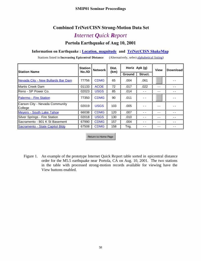
Upon the occurrence of an earthquake, the IQR programs will be activated during aperiod of time after the event. While the IQR modules are active, they develop and maintain alist of triggered strong-motion stations and a list of processed strong-motion data that is availablefor download. Peak ground and structural acceleration values recorded at stations are parsedfrom a summary table of peak accelerations in the CSMIP monitoring system and from incomingdata from partner CISN agencies. The immediate outputs of the IQR programs are two Internetpages such as shown in Figure 1 and 2. They list all data recorded up to that time in two tables,one sorted for user convenience in increasing epicentral distance order and the other inalphabetical order by station name/location. The contents of these two Internet pages arecumulative and are updated continuously as the number of call-in stations increases and moredata has been processed and made available for public access.
Each IQR Internet page is based on an internal key table of peak acceleration values ofstrong-motion data recorded at stations. As shown in Figure 1, at the top of the IQR Internetpage is the name and the date of the earthquake and links to earthquake related information atother CISN sites regarding location, magnitude, and the ShakeMap. The contents of the table aresorted in either alphabetical or epicentral distance order. Each row of the table represents onerecord entry including station name, station number, network, epicentral distance, and peakacceleration on the ground and the structure. The buttons that are linked for viewing anddownloading processed strong-motion data are enabled when data becomes available at theEngineering Data Center. Since the list of the recorded stations is dynamic and cumulative, theIQR tables are expanded by insertion of new station data into the IQR tables when it is received,either from the CSMIP monitoring system or from the CISN partners. At the same time, thestatus of the View and the Download buttons for each record are also updated based on fileavailability through or at the Data Center.
SMIP01 Seminar Proceedings

55
Internet Pages for Strong-motion Stations
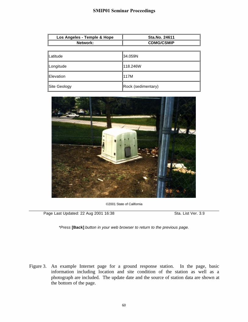
There are four general types of the strong-motion stations, ground response, building,lifeline (bridge and dam), and special (geotechnical array and other). To help users acquire siteand structural information for the recording stations, the Engineering Data Center is preparingInternet pages for CISN strong-motion stations. At the time of this paper, we are still in theprocess of creating Internet pages for the CSMIP stations. For ground response stations, a totalof more than 600 Internet pages have been completed. For each station, the page containsinformation on location, elevation, and site geology, and also a photograph of the station. Alsoincluded are the modification date of the Internet page and the source of the station data. Figure3 shows an example of a typical page for a ground response station.
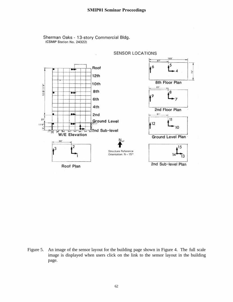
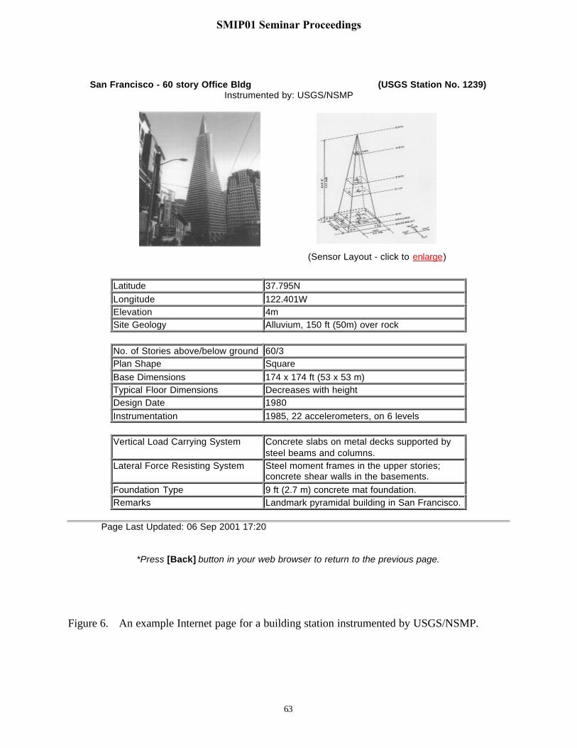
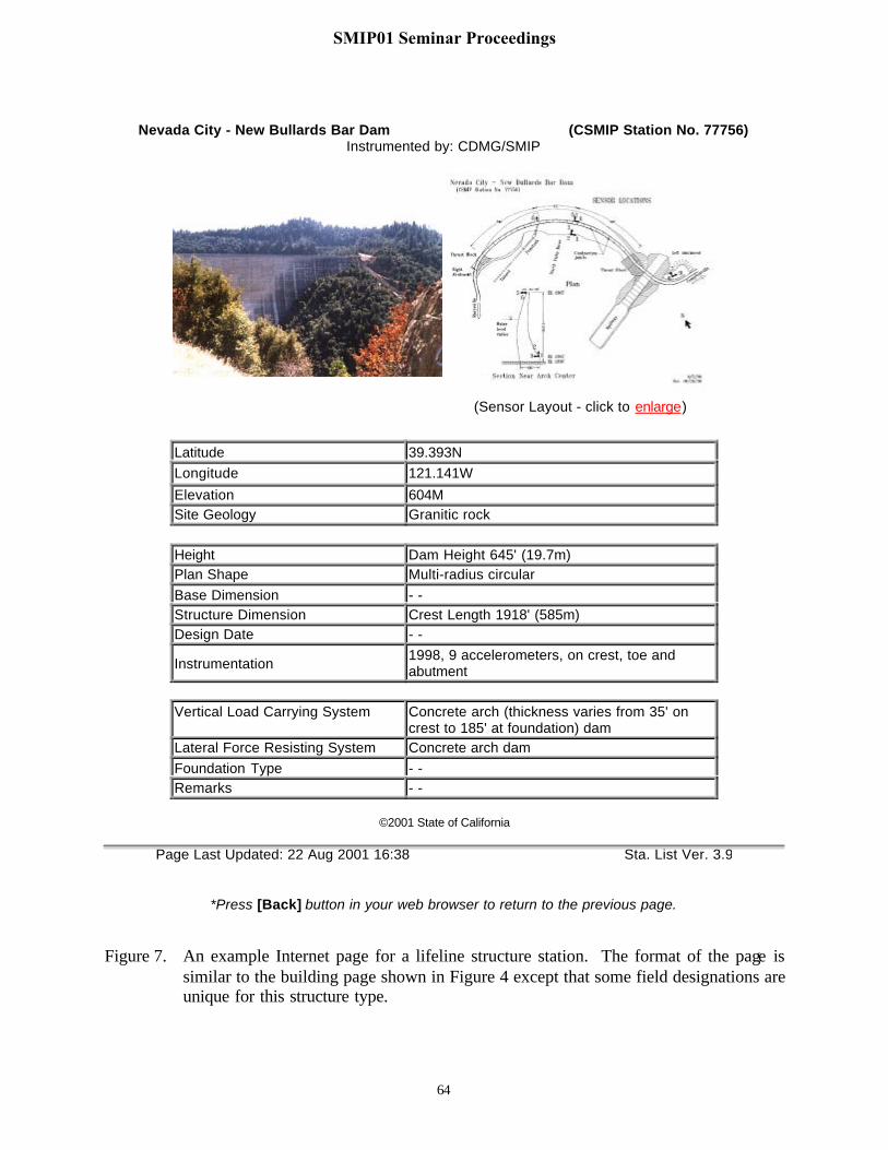
For the other station types, detailed information regarding the instrumented structure isincluded to describe the station. Shown in Figure 4 is an example of a building Internet page. Inthe figure, basic data as well as detailed design information and sensor layouts of theinstrumented building are listed. Also, the image of the building sensor layout is available at fullscale so that users can click on the link to view the image full size as shown in Figure 5. Figure6 shows another example of a building Internet page for a building station instrumented byUSGS/NSMP. Internet pages of lifeline and special station types such as bridges, dams andgeotechnical arrays will have similar formats as the building page with changes in some fieldentries. An example for a dam station is shown in Figure 7. Creation of the Internet web pagesfor structural stations is in progress.
Once the Internet pages for the CISN strong-motion stations have been prepared, thecontents of the station Internet pages will be updated when there are changes to station lists. Autility program module has been developed to automatically update the station Internet pages.
The TriNet/CISN Engineering Data Center and the COSMOS Virtual Data Center
The COSMOS virtual data center (Archuleta, 2000) is a web based virtual library ofprimarily ground response strong-motion data from networks and stations throughout the world.The primary features of the virtual data center are to allow users to search its database, to provideusers easy access to the data, and to allow data collecting agencies to be the source of the data.In terms of functionality, the COSMOS virtual data center and the TriNet/CISN EngineeringData Center complement and will be linked to each other. The TriNet/CISN Engineering DataCenter provides data immediately after earthquakes and provides detailed information onstructural stations not available in the COSMOS data center. The large database search andaccess of ground motion records that the COSMOS data center has developed will not beduplicated in the TriNet/CISN Engineering Data Center.
Even though the TriNet/CISN Engineering Data Center will not support full databasesearch and access features, it will allow users to search for recorded strong-motion data andinformation on various structures. The design of the search function of the TriNet/CISNEngineering Data Center is to provide engineers a tool to access strong-motion records based onstructure system such as structure design type, structure height, and the level of groundaccelerations, etc. Structural engineers will be able to quickly access records of structural
SMIP01 Seminar Proceedings

56
response for the type of building of interest for different earthquakes without going throughevery event in the Data Center. The search function of the Engineering Data Center is currentlyin prototype stage development, and will be finalized with engineering staff of CSMIP andNSMP in conjunction with the compilation of structure design information for structure Internetpages of the CISN stations.
Future Plans
The Governor signed the California budget in July 2001, which includes funds for theCISN. The primary missions of the CISN are to operate statewide seismic monitoring and toprovide tools for emergency responders and earthquake engineers to reduce damage fromearthquakes. As to the Engineering Data Center, the development of the data center iscontinuing as planned and it will become fully operational under CISN. In terms of dataexchange and communication, we plan to increase the interactions with the other CISN DataCenters and to improve robustness of established data communication pathways. Methods ofdata exchange for strong ground motion and station data with collaborative agencies, primarilyNSMP, are in development. With integrated data, the IQR will be a key feature of theEngineering Data Center. Site and structural information of CISN instrumented stations will becompiled for Web access. When the compilation of site and structural information of stations iscompleted, the search feature of the TriNet/CISN Engineering Data Center will becomeavailable. The station data will be updated routinely as new stations are installed and/or existingstations are upgraded.
Summary
The TriNet/CISN Engineering Data Center will manage strong-motion data forapplications in earthquake engineering and the development of the data center is summarizedbelow:
• A prototype Internet Quick Report has been developed to provide earthquakeengineering users rapid and easy access to strong-motion records and processed datafor recent earthquakes recorded by all five CISN institutions. The prototype IQR iscurrently linked to the CSMIP web site and can be accessed via the Internet address:
http://docinet3.consrv.ca.gov /csmip/iqr_dist.htm
• The Engineering Data Center will provide users rapid, detailed information oninstrumented structures and other stations including location, site geology, structuresystem, sensor layouts, etc.
• Developing station information pages in web accessible format is continuing withmore than 600 ground response station pages and eight structure pages completed.
• The Engineering Data Center will provide users a search function for accessingstrong-motion data from various earthquakes based on the designs of instrumentedstations instead of the sources of earthquakes.
SMIP01 Seminar Proceedings

57
References
Archuleta, R. (2000). “COSMOS Virtual Data Center”, in SMIP2000 Seminar on Utilization ofStrong-Motion Data, 2000, 97-114.
Shakal, A.F. and C.W. Scrivner (2000). “TriNet Engineering Strong Motion Data Center”, inSMIP2000 Seminar on Utilization of Strong-Motion Data, 2000, 115-124.
SMIP01 Seminar Proceedings
58
Combined TriNet/CISN Strong-Motion Data Set
Internet Quick ReportPortola Earthquake of Aug 10, 2001
Information on Earthquake : Location, magnitude and TriNet/CISN ShakeMap Stations listed in Increasing Epicentral Distance (Alternatively, select alphabetical listing)
Horiz Apk (g)Station Name
StationNo./ID Network
Dist.(km)
Ground Struct.View Download
Nevada City - New Bullards Bar Dam 77756 CDMG 65 .004 .061 - -
Martis Creek Dam 01133 ACOE 72 .017 .022 - - - -Reno - SP Power Co. 02023 USGS 85 .014 - - - - - -
Palermo - Fire Station 77350 CDMG 90 .011 - - - -
Carson City - Nevada CommunityCollege
02019 USGS 103 .005 - - - - - -
Meyers - South Lake Tahoe 66038 CDMG 120 .007 - - - - - -Silver Springs - Fire Station 02018 USGS 130 .010 - - - - - -Sacramento - 801 K St Basement 67990 CDMG 157 .004 - - - - - -Sacramento - State Capitol Bldg 67508 CDMG 158 Trig. - - - - - -
Return to Home Page
Figure 1. An example of the prototype Internet Quick Report table sorted in epicentral distanceorder for the M5.5 earthquake near Portola, CA on Aug. 10, 2001. The two stationsin the table with processed strong-motion records available for viewing have theView buttons enabled.
SMIP01 Seminar Proceedings

59
Combined TriNet/CISN Strong-Motion Data Set
Internet Quick ReportPortola Earthquake of Aug 10, 2001
Information on Earthquake : Location, magnitude and TriNet/CISN ShakeMap Stations listed in Alphabetical Order (Alternatively, select increasing epicentral distance listing)
Horiz Apk (g)Station Name
StationNo./ID Network
Dist.(km)
Ground Struct.View Download
Carson City - Nevada CommunityCollege
02019 USGS 103 .005 - - - - - -
Martis Creek Dam 01133 ACOE 72 .017 .022 - - - -Meyers - South Lake Tahoe 66038 CDMG 120 .007 - - - - - -
Nevada City - New Bullards Bar Dam 77756 CDMG 65 .004 .061 - -
Palermo - Fire Station 77350 CDMG 90 .011 - - - -
Reno - SP Power Co. 02023 USGS 85 .014 - - - - - -Sacramento - 801 K St Basement 67990 CDMG 157 .004 - - - - - -Sacramento - State Capitol Bldg 67508 CDMG 158 Trig. - - - - - -Silver Springs - Fire Station 02018 USGS 130 .010 - - - - - -
Return to Home Page
Figure 2. The Internet Quick Report table sorted in alphabetical order of station name/locationfor the M5.5 earthquake near Portola, CA on Aug. 10, 2001.
SMIP01 Seminar Proceedings
60
Los Angeles - Temple & Hope Sta.No. 24611Network: CDMG/CSMIP
Latitude 34.059N
Longitude 118.246W
Elevation 117M
Site Geology Rock (sedimentary)
©2001 State of California
Page Last Updated: 22 Aug 2001 16:38 Sta. List Ver. 3.9
*Press [Back] button in your web browser to return to the previous page.
Figure 3. An example Internet page for a ground response station. In the page, basicinformation including location and site condition of the station as well as aphotograph are included. The update date and the source of station data are shown atthe bottom of the page.
SMIP01 Seminar Proceedings

61
Sherman Oaks - 13-story Commercial Bldg (CSMIP Station No. 24322)Instrumented by: CDMG/SMIP
(Sensor Layout - click to enlarge)
Latitude 34.154NLongitude 118.465WElevation 215MSite Geology Alluvium
No. of Stories above/below ground 13/2Plan Shape RectangularBase Dimensions 209 x 125 ft (63.7 x 38.1 m)Typical Floor Dimensions 193 x 75 ft (58.8 x 22.9 m)Design Date 1964Instrumentation 1977, 15 accelerometers, on 6 levels
Vertical Load Carrying System 4.5 in. (11.4 cm) concrete slabs supported byconcrete beams and columns.
Lateral Force Resisting System Moment resisting concrete frames in bothdirections for the upper stories; concrete shearwalls in the basements.
Foundation Type Concrete piles.Remarks The building was retrofit with friction dampers
after the 1994 Northridge Earthquake.
©2001 State of California
Sta. Last Updated: 16 Aug 2001 09:40 Sta. List Ver. 3.9
*Press [Back] button in your web browser to return to the previous page.
Figure 4. An example Internet page for a building station. Details on the structural system ofthe instrumented building are included in addition to the basic station data.
SMIP01 Seminar Proceedings
62
Figure 5. An image of the sensor layout for the building page shown in Figure 4. The full scaleimage is displayed when users click on the link to the sensor layout in the buildingpage.
SMIP01 Seminar Proceedings
63
San Francisco - 60 story Office Bldg (USGS Station No. 1239)Instrumented by: USGS/NSMP
(Sensor Layout - click to enlarge)
Latitude 37.795NLongitude 122.401WElevation 4mSite Geology Alluvium, 150 ft (50m) over rock
No. of Stories above/below ground 60/3Plan Shape SquareBase Dimensions 174 x 174 ft (53 x 53 m)Typical Floor Dimensions Decreases with heightDesign Date 1980Instrumentation 1985, 22 accelerometers, on 6 levels
Vertical Load Carrying System Concrete slabs on metal decks supported bysteel beams and columns.
Lateral Force Resisting System Steel moment frames in the upper stories;concrete shear walls in the basements.
Foundation Type 9 ft (2.7 m) concrete mat foundation.Remarks Landmark pyramidal building in San Francisco.
Page Last Updated: 06 Sep 2001 17:20
*Press [Back] button in your web browser to return to the previous page.
Figure 6. An example Internet page for a building station instrumented by USGS/NSMP.
SMIP01 Seminar Proceedings
64
Nevada City - New Bullards Bar Dam (CSMIP Station No. 77756)Instrumented by: CDMG/SMIP
(Sensor Layout - click to enlarge)
Latitude 39.393NLongitude 121.141W
Elevation 604MSite Geology Granitic rock
Height Dam Height 645' (19.7m)Plan Shape Multi-radius circularBase Dimension - -Structure Dimension Crest Length 1918' (585m)Design Date - -
Instrumentation1998, 9 accelerometers, on crest, toe andabutment
Vertical Load Carrying System Concrete arch (thickness varies from 35' oncrest to 185' at foundation) dam
Lateral Force Resisting System Concrete arch damFoundation Type - -Remarks - -
©2001 State of California
Page Last Updated: 22 Aug 2001 16:38 Sta. List Ver. 3.9
*Press [Back] button in your web browser to return to the previous page.
Figure 7. An example Internet page for a lifeline structure station. The format of the page issimilar to the building page shown in Figure 4 except that some field designations areunique for this structure type.
SMIP01 Seminar Proceedings