Transport Statement - RPR Planning
39
Practical Planning Permissions Practical Planning Permissions Page 1 Transport Statement Focus International Christian Centre, 123 Uxbridge Road, Hillingdon March 2011
Transcript of Transport Statement - RPR Planning
Practical Planning Permissions
Practical Planning Permissions Page 1
Transport Statement
Focus International Christian Centre,
123 Uxbridge Road, Hillingdon
March 2011

Practical Planning Permissions
Practical Planning Permissions Page 2
Introduction P 3
Site Description, Existing Conditions and Accessibility P 5
Policy Context P10
The Development Proposal in Highway and Transport Terms P15
Sustainable Travel Initiatives P20
Summary and Conclusions P21
Appendices
Practical Planning Permissions
Practical Planning Permissions Page 3
1.0 Introduction and Background
1.1 This Transport Statement has been produced as part of the re-submission of a previously
refused planning application for the change of use of the building at 123 Uxbridge Road to
incorporate a Place of Worship/Church Use and also residential accommodation on the
upper floor level. This property is currently known as the RSPCA building and its most
recent use was as a veterinary surgery until the surgery relocated around the corner to
Crescent Parade.
1.2 Although the previous application was refused for a number of reasons, the primary
reason was that the application failed to demonstrate that the proposal would not be
detrimental to highway function and safety. In the delegated report the following was the
stated reason:
“The applicant has failed to demonstrate that the traffic generated by the proposed
development would not have an adverse impact on the surrounding highway network,
prejudicial to the free flow of traffic and detrimental to highway and pedestrian safety. The
proposal also fails to demonstrate that sufficient off street parking provision (which meets
the councils approved parking standards to service the proposed development) would be
made. The development would therefore lead to additional on street parking to the
detriment of public and highway safety. The proposal therefore fails to comply with policies
R9, AM2, AM7 and AM14 of the Hillingdon Unitary Development Plan Saved Policies
(September 2007).”
1.3 Subsequently this report is designed to provide commentary on highway, traffic and
transport elementals of the proposal. In determining the scope for the work required to
support the scheme, reference has been made to the Department of Transport (DfT)/
Department for Communities and Local Government (DCLG) Guidance on Transport
Assessment document, published in 2007 (with particular reference to Appendix B) and
Transport for London’s (TfL’s) Transport Assessment Best Practice Document.
1.4 Although this proposal was refused on transport grounds on the previous application,
this report will address the concerns raised by the local authority in relation to that
application and illustrate that this use would not be detrimental to the locality in terms of
highway function and safety.

Practical Planning Permissions
Practical Planning Permissions Page 4
The remainder of this transport statement will be structured as follows:
Site Description, Existing Conditions and Accessibility: describes the existing
conditions in the area which were informed by a site audit.
Policy Context: Outlines the current policy context associated with the
development proposals.
Proposed Development and Transport Impacts: Summarises the development
proposals, forecasts the trip generation associated with the development, and
addresses other issues including on street parking availability, scheme layout, access
and servicing arrangements
Sustainable Travel Initiatives: Outlines sustainable travel initiatives that would be
adopted and encouraged amongst the congregation
Summary and Conclusion: Summarises and concludes the issues discussed within
the report.

Practical Planning Permissions
Practical Planning Permissions Page 5
2.0 Site Description Existing Conditions, and Accessibility
2.1 Site Description in Transport terms
2.1.1 The site is located at 123 Uxbridge Road, Hillingdon. As referred to in the introductory
chapter it is currently known as the RSPCA building. The site is currently accessed off
Uxbridge Road which forms part of the Strategic Road Network. The site has two access
points, one off Uxbridge Road with the second access from an alleyway off Churchill Avenue.
2.1.2 The site currently has 5 parking spaces to the front of the site and also a yard space to
the rear of the site where deliveries are undertaken. This also provides additional parking
facilities in relation to the site.
2.1.3 As referred to earlier Uxbridge Road forms part of the Strategic Road Network and is a
key road artery for this area of London, therefore is a very heavily trafficked route. With the
exception of Long Lane which also forms part of the Strategic Road Network, the majority of
the roads in this area would be classed as Local Access Roads in the road hierarchy. With the
exception of this section of Uxbridge Road this area is primarily made up of much quieter
residential streets.
A location map and aerial photograph illustrating the site and surrounding area are shown in
the following figures:
Figure 1 Location Map

Practical Planning Permissions
Practical Planning Permissions Page 6
Figure 2: Aerial Image
2.1.4 As can be seen from the above figures the development site is situated on the North
side of Uxbridge Road and to the east of the junction with Uxbridge Road and Long Lane.
Pedestrian Access to the site is taken directly from Uxbridge Road where there is a relatively
wide footway.
2.1.5 The site has a site specific Public Transport Accessibility Level (PTAL) rating of 2, in a
category where 1a is classed as the lowest and 6b as the highest. Although this PTAL rating
would be classed as relatively low, it is a typical rating for the majority of outer London
areas which are primarily of a residential character. There has been much debate about
how the PTAL rating should be characterised, differentiating between city centre areas of
obvious higher public transport accessibility and suburban areas such as the site in question.
Nevertheless it is considered this site has a good level of public transport accessibility in
terms of its suburban location.
2.1.6 The site is not located in a Controlled Parking Zone and from inspection the only area
in relation to the site where parking appears to be restricted is on Long Lane and sections of
Uxbridge Road.

Practical Planning Permissions
Practical Planning Permissions Page 7
2.2 Public Transport Accessibility
2.2.1 The Public Transport Accessibility Level is a measure of accessibility to the site an
initiative promoted by TfL. It considers walk time to a bus stop or railway station, waiting
time, frequency and reliability of transport services. The levels range from high accessibility
(level 6) to low accessibility (level 1).
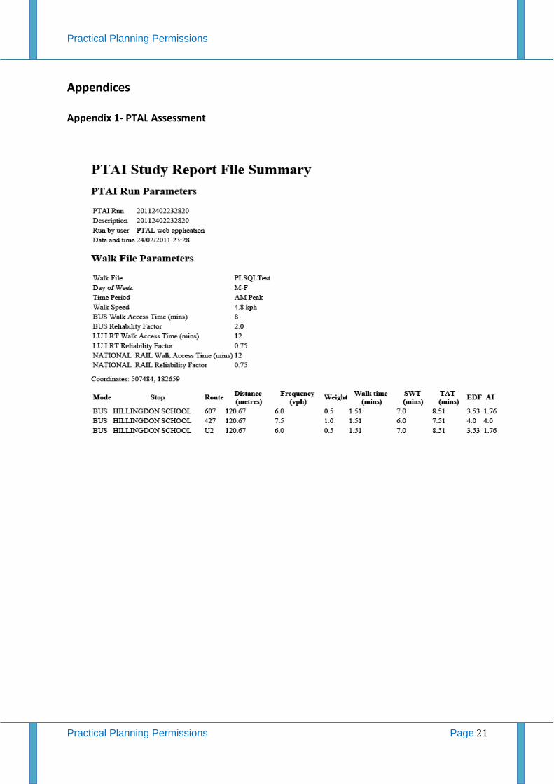
2.2.2 The PTAL for this site, endorsed by a site- specific PTAL assessment is 2. As referred to
earlier this is considered a low level of public transport accessibility but is a normal rating for
suburban areas such as this. An output file containing the site specific PTAL assessment
calculation is located in Appendix 1.
2.2.3 With respect to bus services there are bus stops within close proximity on Uxbridge
Road to the east of the site. In addition there are also a number of bus stops to the west of
the site on Uxbridge Road and also bus stops located on Long Lane a short walk from the
site.
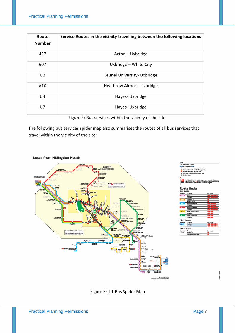
2.2.4 The locations of the main bus stops that serve the area within the vicinity of the site
are shown in Figure 3:
2.2.5 The bus routes served by bus stops within a short walking distance of the site are
summarised in the following figure:
Practical Planning Permissions
Practical Planning Permissions Page 8
Route
Number
Service Routes in the vicinity travelling between the following locations
427 Acton – Uxbridge
607 Uxbridge – White City
U2 Brunel University- Uxbridge
A10 Heathrow Airport- Uxbridge
U4 Hayes- Uxbridge
U7 Hayes- Uxbridge
Figure 4: Bus services within the vicinity of the site.
The following bus services spider map also summarises the routes of all bus services that
travel within the vicinity of the site:
Figure 5: TfL Bus Spider Map

Practical Planning Permissions
Practical Planning Permissions Page 9
2.2.6 It can be seen from the bus route spider maps that as well as other bus services; this
area, although not immediately, is served by a number of rail stations on both mainland and
underground services. The nearest stations in relation to the site are Uxbridge and
Hillingdon both on the Metropolitan Line. It must also be noted that the majority of the bus
services operating within the vicinity originate, end or are routed via these rail stations
thereby offering good public transport interchange capabilities.
3.0 Policy Context This section of the Transport Report provides an overview of the transport planning policy guidance in the context of the development proposals for the site. It examines the national (PPG13), regional (London Plan) and local (Hillingdon Plan) policies. 3.1 Planning Policy Guidance Note 13
3.1.1 The Government’s Planning Policy Guidance Note 13: Transport (PPG13), published in March 2001, encourages the integration of planning and transport processes at all levels from national to local. It is underpinned by three stated objectives, which set out to (4): · Promote more sustainable transport choices for both people and for moving freight; · Promote accessibility to jobs, shopping, leisure facilities and services by public transport, walking and cycling; and
· Reduce the need to travel, especially by car. 3.1.2 PPG13 notes that, ‘by shaping the pattern of development and influencing the location, scale, density, design and mix of land uses, planning can help to reduce the need to travel, reduce the length of journeys and make it safer and easier for people to access jobs, shopping, leisure facilities and services by public transport, walking and cycling’. 3.1.3 PPG13 advises local authorities to, inter alia (6): · Use parking policies, alongside other planning and transport measures, to promote
sustainable transport choices and reduce reliance on the car for work and other journeys; · Give priority to people over ease of traffic movement and plan to provide more road space to pedestrians, cyclists and public transport in town centres, local neighbourhoods and other areas with a mixture of land uses; and
· Ensure that the needs of disabled people – as pedestrians, public transport users and
motorists – are taken into account in the implementation of planning policies and traffic management schemes, and in the design of individual developments. 3.1.4 PPG13 states that for particular proposals, “the assessment should illustrate accessibility to the site by all modes and the likely modal split of journeys to and from the site. It should also give details of proposed measures to improve access by public transport,

Practical Planning Permissions
Practical Planning Permissions Page 10
walking and cycling, to reduce the need for parking associated with the proposal and to mitigate the transport impacts” · PPG13 observes, as good practice, efforts to “hold early discussions with the local authority in order to clarify whether [development] proposals are acceptable in transport terms and to scope the requirements of reporting those issues” (25); and · With regard to the needs of disabled people, PPG13 acknowledges that for some, the use
of a private car is important and that their needs in terms of access arrangements and parking spaces should be taken into account. 3.1.5 PPG13 recognises that the availability of car parking has a major influence on the means of transport people choose for their journeys (49). The document also notes that the amount of good quality cycle parking in developments should be increased to promote more cycle use. 3.1.6 Local authorities are therefore advised to (51): · Ensure that, as part of a package of planning and transport measures, levels of parking
provided in association with development proposals will promote sustainable transport choices; · Require developers to provide designated parking spaces for disabled people in
accordance with current good practice; and · Require convenient, safe and secure cycle parking in development at least at levels
consistent with the cycle strategy in the local transport plan. 3.1.7 PPG 13 emphasises the potential for walking as an appropriate and sustainable alternative to short car trips, particularly for journeys of less than 2 kilometres (75). In addition, it highlights the potential for cycle trips for journeys of less than 5 kilometres and provides advice to Local Authorities when considering the cycling aspects of planning applications (78). 3.1.8 It is considered that the application proposal provides an appropriate response to all of the above points, by providing a D1 use commensurate with the maximum parking standards as identified in the borough’s policies and plans, as well as regional planning guidance as set out in The London Plan. The location of the application site, with its excellent level of access to public transport and shops / amenities, adds to the viability of the proposals.

Practical Planning Permissions
Practical Planning Permissions Page 11
3.2 Regional Policy and Strategic Regional Guidance – The London Plan – Spatial Development Strategy for Greater London consolidated with alterations since 2004 – February 2008: 3.2.1 Policy 3C.23 [Parking Strategy] states: “The Mayor, in conjunction with boroughs, will seek to ensure that on-site car parking at new developments is the minimum necessary and that there is no over-provision that could undermine the use of more sustainable non-car modes. The only exception to this approach will be to ensure that developments are accessible for disabled people. DPD policies and transport Local Implementation Plans should: · Adopt on and off-street parking policies that encourage access by sustainable means of transport, assist in limiting the use of the car and contribute to minimising road traffic; · Adopt the maximum parking standards set out in the annex on parking standards [Annex
4] where appropriate, taking account of local circumstances and allowing for reduced car
parking provision in areas of good public transport accessibility; · Reduce the amount of existing, private, non-residential parking as opportunities arise; · Recognise the needs of disabled people and provide adequate parking for them; · Take account of the needs of business for delivery and servicing movements; · Provide adequate facilities for coaches that minimise impact on the road network capacity
and are off-road wherever possible; · Generally resist the introduction of temporary car-parks; · Encourage good standards of car parking design; and
· Seek to reallocate space to provide for cycle parking where this does not meet the
recommended levels of provision in TfL’s cycle parking standards”
3.2.2 In line with the advice contained in both PPG13, in terms of parking provision, the applicant has sought to provide a scheme which respects the wishes of national policies, as well as also respecting the Mayor’s aspirations as identified above in Policy 3C.23. 3.2.3 Policy 4B.1 [Design principles for a compact city] States: “The Mayor will, and boroughs should, seek to ensure that developments: · maximise the potential of sites; · promote high quality inclusive design and create or enhance the public realm; · contribute to the adaptation to, and mitigation of, the effects of climate change; · respect local context, history, built heritage, character and communities; · be accessible, usable and permeable for all users; · be sustainable, durable and adaptable in terms of design, construction and use; · address security issues and provide safe, secure and sustainable environments [Policy
4B.6]; · be practical and legible; · be attractive to look at and, where appropriate, inspire, excite and delight; · respect the natural environment and biodiversity, and enhance green networks and the
Blue Ribbon Network; and
· address health inequalities.

Practical Planning Permissions
Practical Planning Permissions Page 12
These principles should be used in assessing planning applications and in drawing up area planning frameworks and DPD policies. Design and access statements showing how they have been incorporated should be submitted with proposals to illustrate their impacts.” 3.2.4 In terms of the traffic aspects of the proposal, it is clear that the development maximises the potential of the site in an area with excellent access to public transport / local facilities. 3.2.5 Annex 4 of the London Plan also provides several important statements when considering a proposal such as this. 3.2.6 Paragraph 4 of Annex 4 states: “Managing the level of on-site parking provision is seen as a key reinforcing measure to promote alternative means of transport. It is also important that boroughs manage on-street and off-street parking as a whole and prepare a Parking and Enforcement Plan, which forms part of the transport Local implementation Plan. The Parking and Enforcement Plan should make explicit how the needs of disabled people are being addressed in a climate of parking restraint, recognising that some people will require Blue Badge parking bays to be designated and enforced and supply monitored to meet demand, both on and off street.” 3.2.7 The development site provides significant opportunity to implement a scheme that makes use of the existing site for a D1 use in line with Southwark’s maximum parking standards, as well as national and regional advice. 3.2.8 Paragraph 7 of Annex 4 states, inter alia, that: “There is evidence that car use reduces as access to public transport increase. Therefore, given the need to avoid over-provision, car parking provision should also reduce as public transport accessibility increases.” 3.2.9 The site benefits from excellent access to public transport and local shops / facilities. In order to respect the advice in paragraph 7 of Annex 4, as well as the advice regarding maximising the potential of sites, the scheme does not have any dedicated off-street car parking facilities. This will ensure that public transport is used to a high potential and that the scheme remains viable. 3.3 Local Policy - London Borough of Hillingdon – Hillingdon Plan Policy AM2 states that all proposals for development will be assessed against: (i) their contribution to traffic generation and their impact on congestion, particularly on the principal road network as defined in paragraph 14.14 of the plan, and (ii) the present and potential availability of public transport, and its capacity to meet increased demand. The following chapter of this transport statement outlines a trip/traffic generation assessment that illustrates that this proposal is in keeping with this Policy and will create any significant impacts in terms of traffic generation.

Practical Planning Permissions
Practical Planning Permissions Page 13
Policy AM7 states the local planning authority will consider whether the traffic generated by proposed developments is acceptable in terms of the capacity and functions of existing and committed principal roads only, and will wholly discount any potential which local distributor and access roads may have for carrying through traffic. The local planning authority will not grant permission for developments whose traffic generation is likely to: (i) unacceptably increase demand along roads or through junctions which are already used to capacity, especially where such roads or junctions form part of the strategic london road network; or (ii) prejudice the free flow of traffic or conditions of general highway or pedestrian safety; or (iii) diminish materially the environmental benefits brought about by new or improved roads; or (iv) infiltrate streets classed as local roads in the borough road hierarchy unless satisfactory traffic calming measures can be installed. Chapter 4 of this transport statement will also that this proposal does not contravene the above Policy. Policy AM14 states that new development will only be permitted where it is in accordance with the council's adopted car parking standards as set out in annex 1. Chapter 4 also outlines the car parking situation in relation to this proposal. In addition to the proposed parking provisions on site it also illustrates that this proposal would not have a detrimental impact to neighbouring streets via a detailed car parking survey.

Practical Planning Permissions
Practical Planning Permissions Page 14
4.0 The Development Proposal in Highway and Transport Terms 4.1 Overview 4.1.1 The principal element of this development proposal in transport terms involves the change of use of the building from its current use as a veterinary clinic to a religious facility (D1). In transport terms there are no significant changes to be made to the site with the exception of regularising the parking spaces at the front, 5 in total which will include one disabled bay. In addition there will be an additional two parking spaces to the rear of the site along with a larger parking/turning area for the churches private minibus. There will also be a number of cycle parking spaces provided in accordance with minimum cycle parking standards outlined in Hillingdon’s UDP. 4.1.2 The applicant is to be the intended occupier of the building. The primary objective surrounding this proposal is that this building would cater for one main religious service on Sunday mornings between 9.30am and 12.30pm. The attendance at these services is intended to be in the region of 150 people. There is no specific schedule outlined for activities on other weekdays with the exception of potentially small gatherings a few evenings during the week for children’s playgroup. For the purposes of this report the transport issues in relation to the larger congregation on Sunday mornings is the only element that needs to be considered. 4.2 Trip Generation 4.2.1 As stated the previous use for the site was for a veterinary clinic. Such a use has potential to generate staff trips, but obviously a significant number of customer trips. By nature of its use it would be reasonable to assume that many of these trips would be made by private vehicles bringing animals to the clinic for treatment. 4.2.2. In order to derive an understanding of the potential trip generation associated with the existing/previous use, veterinary surveys within the TRAVL database have been consulted. In order to ensure that the assessment is robust, comparable veterinary sites, with similar public transport accessibility, and highway conditions have only been considered. Following a full interrogation of the TRAVL database it was found that there were no comparable surveys examples that would be considered useful or robust enough to assess against this proposal. 4.2.3 However, it is considered reasonable to assume that over a weekly period, total trips and particularly vehicle trips in relation to the previous veterinary use would be much greater than for the proposed D1 religious use. By nature of its use, customers or RSPCA officers bringing animals to the clinic need to do so via private vehicles. Although, it would be difficult to ascertain the total levels of trips to the previous veterinary clinic, in comparison to the proposed religious use, total trips, especially vehicle trips to the previous veterinary use would be greater. As the primary objective of the proposed change of use is to cater for Sunday morning religious congregations, obviously the levels of trips during this time period would be greater than a veterinary practice on a Sunday morning. However

Practical Planning Permissions
Practical Planning Permissions Page 15
other elements later in this report including a travel survey of the existing congregation and Sunday morning parking survey will outline that this proposal will not create any significant highway issues in relation to Sunday morning services. 4.2.4 In order to obtain an understanding of the impact of the development proposal, and how it will compare with the existing use of the site, information has been obtained directly from the church that will operate from the building. In addition a second interrogation of the TRAVL database has been conducted to investigate travel patterns primarily modal split in relation to church congregations. Similarly, to the previous investigation based on proposed floor space, PTAL ratings and other location information, no suitable comparable sites were retrieved from the TRAVL database. Although there were a number of D1 religious uses surveyed, many of the surveyed sites were much larger than the proposed site and were also of variable PTAL levels and road network accessibility. 4.2.5 Therefore to ascertain the modal split in relation to the current church congregation, a travel survey was conducted on Sunday 13th of February at the current church site at Stonebridge Day Centre, Stonebridge NW10 0ST. As stated earlier this application proposes to cater for up to 150 church members with one main service on Sunday morning between 9:30 am and 12:30pm. 4.2.6 On that day a total of 130 church members were in attendance made up of 35 different family groups. The following table illustrates the results of the church travel survey:
Mode of Transport Survey Figures % Modal Split
Car Driver 20 15.38% Car Passenger 63 48.4%
Car Share 6 4.6% Bus 15 11.5% Rail 2 1.5%
Church Minibus 16 12.3% Walk 5 3.8% Cycle 3 2.3%
Figure 6: Existing Church Congregation Travel Survey 4.2.7 From reviewing the travel survey information outlined above it can be seen that although vehicle trips are the primary mode of travel to the site at present a total of only 21 vehicle journeys (20 private and 1 minibus) were undertaken to the church service on that day. The family orientation surrounding the congregation is obvious with vehicle passengers mainly children providing for the highest mode share of the congregation at approximately 48%. In terms of this survey car passenger and car share modes are relatively similar. Generally the church members that conveyed themselves under the car share mode, received lifts from other church members from their immediate residential area. It must also be noted that apart from the current level of trips via sustainable modes, the church is already employing a very sustainable travel initiative by using its own 16 seater mini-bus
Practical Planning Permissions
Practical Planning Permissions Page 16
service to transport church members. 4.2.8 It must also be noted that a large percentage of the church members reside in West London, many within close proximity of the proposed site at 123 Uxbridge Road. Therefore in terms of this proposal it would be reasonable to assume that a much larger percentage of church goers would use more sustainable travel modes to go to church most notably via local bus services and also walking to the site. 4.2.9 Based on the above survey figures and correlating these results with the proposal to accommodate 150 church goers at the proposed site, it is considered that this proposal will have an insignificant impact in terms of traffic generation within this area. If the travel survey results were to be assigned to the proposed site there would be potential for there to be approximately a maximum of 23-25 vehicle trips on a Sunday morning associated with the site. As discussed earlier in this report it must also be noted that Uxbridge Road and Long Lane form part of the Strategic road network and are already very heavily trafficked routes. It is considered that any additional traffic associated with this proposal will have a relatively negligible impact in terms of overall traffic in this area. 4.2.10 It must also be noted that the church is proposing to purchase a second minibus for the purposes of day events and group outing days. In addition the church leaders are proposing to use the two minibuses to undertake two journeys each on Sunday mornings to transport frail, elderly and other local church members to the site, but also collect more distant church members from local rail stations for instance Hillingdon and Uxbridge underground stations. 4.2.11 In summary, the traffic generated by this development will not have a significant impact in terms of capacity on the road network in this area. As earlier discussed the site is already located in a very heavily trafficked area. The level of additional vehicle trips surrounding this church use will not create a significant impact. In addition many of the church goers will benefit from residing closer to the proposed site and have more sustainable options in terms of walking and using public transport, but also benefit from the minibus services that would be operated by the church leaders. 4.3 – The Development Proposal in relation to Car and Cycle Parking Provisions 4.3.1 There would be 7 on site car parking spaces (including 1 disabled space) provided as
part of this development proposal. It is considered this provision is in keeping with
Hilingdon’s Adopted Parking Standards. There are no specific criteria stipulated for D1
Places of Worship as each case is assessed on its own merits.
4.3.2 The potential impact of the proposal to on street parking conditions was one of the
primary concerns raised under the previous refused application. In response, to support this
re-submission, a detailed parking survey has been conducted to ascertain the level of on
street parking in the area. A full description of the parking survey methodology and results is
highlighted in Appendix 2.

Practical Planning Permissions
Practical Planning Permissions Page 17
4.3.3 As already discussed the primary church gathering will be on a Sunday morning
between 9.30am and 12.30pm. It was during this time period on Sunday 20th of February
that the parking survey was undertaken. For robustness all relevant streets within 300
metres (4-5 minute walk) of the site were surveyed to determine the levels of on street
parking capacity in the area during that Sunday morning time period. In addition the survey
was based on a factor that each vehicle requires 6 metres of kerb space for parking and
manoeuvring purposes. Also the degree of useable and restricted kerb space was measured
on each surveyed street. The following table illustrates the survey results:
Street Useable Kerb Space
(metres)
Restricted Kerb
Space (metres)
No of Vehicles
Parked
Number of
available vehicle
spaces
% Parking Stress
Churchill Avenue-
Churchill Close 324 50 33 22 61%
Denziloe Avenue 220 245 20 17 54%
Charlville Lane
West, west of
Baxter Close
72 125 3 9 25%
Charlville Lane
west, east of
Baxter Close
110 40 2 16 11%
Baxter Close 210 100 11 26 31%
Long Lane to
Junction with
Ashworth Road
230 N/A 11 27 29%
Long Lane, Close
behind Petrol
Station
14 N/A 10 4 71.5%
Brambles Farm
Drive
260 50 16 28 37%
Parkfield Avenue 180 340 23 7 76%
Uxbridge Road
adjacent the site
80 N/A 9 4 61%
Figure 7: Parking Survey Results
4.3.4 There are a number of obvious conclusions to make from these survey results. It is
clear that during the surveyed period parking stress on the majority of surveyed streets was
relatively low. In fact, based on the criteria that each vehicle would require 6 metres of kerb
space, there were a total of 160 available parking spaces within all surveyed streets. For
those streets within immediate vicinity of the site namely, Churchill Avenue, Uxbridge Road,
Denziloe Avenue and Brambles Farm Drive there was a total of 71 vehicle spaces available
during the surveyed period.

Practical Planning Permissions
Practical Planning Permissions Page 18
4.3.5 Based on these survey results, the predicted level of vehicle trips (23-25) to the site
and the proposed on site parking spaces, it is evident that this proposal will not result in
creating a detrimental impact to on street parking conditions in the area. Even if the
proportion of vehicle trips associated with church were to rise, based on this recorded level
of available parking space in the area, this proposal would remain to have a negligible
impact in terms of on street parking availability. Therefore to conclude it is considered that
there would be no negative car parking issues associated with this proposal.
4.3.6 The use of bicycles as an alternative to the car is an effective means of reducing the
impact of emissions on the environment and as a means of reducing the need for non-
essential car journeys. It is a mode of transport that is supported and encouraged by all
Local Authorities. As part of this proposal there will be a number of cycle parking spaces
provided for church members. This will help encourage sustainable travel behaviour.

Practical Planning Permissions
Practical Planning Permissions Page 19
5.0 Sustainable Travel Initiatives
5.1 As discussed earlier in this report for an outer London area there is a decent level of transport services available in the area to serve the site. It is recognised that for any Sustainable Travel Initiatives associated with the proposal to be successful the information provided to staff, visitors and church members must be effective, in that it is both accurate and up-to-date. 5.2 It is intended that staff and church members associated with the proposed scheme will be able to access public transport journey information in the form of maps, so that they will be able to make informed choices about any journey they intend to make. 5.3 New congregation members attending the facility will be provided with a “welcome pack” that includes public transport maps, timetables and contact telephone numbers for transport operators. The contact list provided within the pack can also include the relevant web site addresses for transport operators and service providers, as well as links to Passenger Representative Organisations, to allow the information to be updated directly, as and when required by individual occupiers. 5.4 Based on the information from the Parking Survey discussed in Chapter 4 and shown in Appendix 2, those family’s/members that use a vehicle as their main mode of transport to the site will be designated streets/ areas to park their vehicles during Sunday services. These designations will include the on site parking spaces and will be based upon member’s ages and physical capabilities, for instance all disabled members would be allowed to park on site. 5.5 To encourage cycling particularly amongst the younger members of the congregation there will be regular cycle events and cycle training programmes conducted. 5.6 A complete database of church member’s postcodes will be compiled as and initiative to reduce the number of vehicle trips to the site, whilst also encouraging car sharing as a sustainable mode of travel.

Practical Planning Permissions
Practical Planning Permissions Page 20
6.0 Summary and Conclusions 6.1 This transport statement has been produced as part of the re-submission of the proposal for change of use of the old RSPCA veterinary surgery to a D1 Place of Worship. This previous application was refused on transport grounds, based on the lack of information in terms of traffic generation and the potential impact to on street parking provisions in the area. It is considered that these concerns are now addressed and that this proposal does not pose any significant impact in terms of highway function in the area. It is considered that the information in this re-submitted scheme meets all the traffic, parking and transportation requirements expected from a proposal for change of use to a religious facility within the London Borough of Hillingdon. 6.2 For an Outer London area the site is regarded as having a decent level of Public Transport Accessibility. 6.3 Access arrangements associated with the development have been provided in accordance with Council standards. 6.4 In summary the main points of this proposal in terms of traffic and transport are: 1.The proposal will not create a significant in terms of traffic generation to what is already a heavily trafficked area. 2.The proposal will not result in creating a significant impact in terms of on street parking stress in the local area. 3.The scheme is in compliance with transport policy in terms of on site Car and cycle parking provisions. 4.The church leaders have shown a clear commitment to promoting sustainable travel in relation to the site and managing the transport arrangement in a sustainable manner, e.g. Initiative to introduce 2 private mini-buses. 6.5 In conclusion it is considered that that the transport issues that resulted in refusal of the original planning application have now been addressed and that there are now no transport/highway reasons that would warrant a refusal of this re-submitted application.
Practical Planning Permissions
Practical Planning Permissions Page 21
Appendices Appendix 1- PTAL Assessment

Practical Planning Permissions
Practical Planning Permissions Page 22
Appendix 2 Parking Survey
Parking Survey in relation to D1 Place of Worship Proposal, 123 Uxbridge Road. In order to address the concerns in relation to on street parking provisions surrounding the original planning application, it was deemed necessary to undertake a parking survey to examine the existing level of on street parking provisions in surrounding streets. Standard Parking Survey methodology typical to many of the London Local Authorities was applied. The following were the criteria: 1.An average on street car parking space is measured at 6 metres accounting for manoeuvring space. 2.Usable Kerb-space was accurately measured on each street. 3.Restricted Kerb-space (Crossover and Yellow Line Markings) was accurately measured on each street. 4.Total number of parked cars on each surveyed street were recorded. 5.Streets within a reasonable walking distance of the site (300 metres) were surveyed. 6.Degree of existing number of parked vehicles on each street was recorded. The following streets were included in the survey: 1.Uxbridge Road, adjacent the site 2.Churchill Avenue 3.Charville Lane west, west of Baxter Close. 4.Charville Lane west, east of Baxter Close. 5.Baxter Close 6.Long Lane to junction of Ashdown Road 7.Long Lane Close 8.Brambles Farm Drive 9.Parkfields Avenue.
Figure 1: Map Displaying Streets included in the Parking Survey

Practical Planning Permissions
Practical Planning Permissions Page 23
The parking survey was undertaken on Sunday 20th of February between the hours of 9.30am and 12.30pm to correlate with the same time period as the main Sunday church service. The following table illustrates the survey results.
Street Useable Kerb Space
(metres)
Restricted Kerb
Space (metres)
No of Vehicles
Parked
Number of
available vehicle
spaces
% Parking Stress
Churchill Avenue 324 50 33 22 61%
Denziloe Avenue 220 245 20 17 54%
Charlville Lane
West, west of
Baxter Close
72 125 3 9 25%
Charlville Lane
west, east of
Baxter Close
110 40 2 16 11%
Baxter Close 210 100 11 26 31%
Long Lane to
Junction with
Ashworth Road
230 N/A 11 27 29%
Long Lane, Close
behind Petrol
Station
14 N/A 10 4 71.5%
Brambles Farm
Drive
260 50 16 28 37%
Parkfields
Avenue
180 340 23 7 76%
Uxbridge Road
adjacent the site
80 N/A 9 4 61%
Analysis of Survey Results 1.Parking Stress particularly in the nearby streets is low. Average parking stress is 50%. 2.The area experiences no on street parking stress issues. 3.There was a total of 160 available on street parking space on surveyed streets 4.There were a total of 71 available parking spaces within immediate walking distance of the site.

Practical Planning Permissions
Practical Planning Permissions Page 24
Photographic Evidence to Support Parking Survey
Churchville Avenue
Charville Lane West

Practical Planning Permissions
Practical Planning Permissions Page 25
Baxter Close
Long Lane

Practical Planning Permissions
Practical Planning Permissions Page 26
Brambles Farm Drive
Uxbridge Road Adjacent proposed site
14 Townsend Lane,
Kingsbury,
London,
NW9 7JH.
Tel: 020 3565 4515
Mob: 078 9661 7854
Email: [email protected]
Parking Survey
Accompanying a Planning Application for:
Conversion of 1st and 2nd Floors Levels to 2X2 Self Contained Residential Flats
255 Westwood Lane, Blackfen, Kent, DA15 9PS.
20th November 2011.

Practical Planning Permissions
Practical Planning Permissions Page 2
1.0 Introduction Page 3
2.0 The Site and Surrounding Area Page 4
3.0 Methodology Page 5
4.0 Survey Results and Discussion Page 7
5.0 Conclusion Page 13

Practical Planning Permissions
Practical Planning Permissions Page 3
1.0 Introduction
1.1 This parking survey has been carried out at the request of the owner of 255
Westwood Lane, Blackfen, Kent DA15 9PS.
1.2 This parking survey has been produced as supporting information in relation to a
planning application proposal to convert the upper floor levels, floors 1 and 2 into
self-contained residential units.
1.3 This proposal has already been applied for under a previous planning application to Bexley Council: 11/01550/FUL. This application was refused due to the following reason:
The proposal would lead to additional on-street parking on the highways in the vicinity of the application site exacerbating the existing level of parking congestion to the serious detriment of highway safety and amenity of local residents, contrary to Policies G7 and T17 of the Unitary Development Plan (2004).
1.4 This parking survey has been produced in accordance with Bexley Councils parking
survey methodology, to justify the proposal on parking grounds and illustrate that
the on street parking conditions in the area would not warrant refusing this planning
application.
1.5 The parking survey was carried out on the nights of Wednesday 16th November and
Thursday 17th of November between the hours of 1am to 4am.
1.6 The remainder of the report will be structured as follows:
2.0 Site Description
3.0 Methodology and Survey Area.
4.0 Survey Results and Discussion
5.0 Conclusion

Practical Planning Permissions
Practical Planning Permissions Page 4
2.0 The Site and Surrounding Area
2.1 The site address is 255 Westwood Lane, Blackfen, Kent DA15 9PS. The property is
arranged over three floors with an Italian restaurant at ground floor level and
residential accommodation provided for over 1st and 2nd floor levels. It is both of
these residential floors that is the subject of this planning application and parking
survey. The site has a PTAL rating of 2 and for an Outer London area such as this can
be regarded as reasonable.
Figure 1: Image of Application Premises.
2.2 The site is located in a relatively urban setting with a broad mix of residential and
commercial uses. There is a large supermarket within a very close proximity of the
site and many of the other commercial uses with primarily A1 to A3 uses in the
nearby streets. There is a pub across the road.
2.3 The highway network in the area in the direct proximity of the site restricts car
parking, with full parking restrictions via double yellow lines on Westwood Lane,
Blackfen Road and Wellington Avenue.
2.4 However, just outside the immediate proximity of the site there are a number of
residential streets within close walking distance of the proposed site (2-3 minute
walk). These streets could be classed as normal residential streets and none of the
streets are located in Controlled Parking Zones. These streets include Sutherland
Avenue, Groombridge Close, Lyndon Avenue, Wynns Avenue, Days Lane, Ashcroft
Practical Planning Permissions
Practical Planning Permissions Page 5
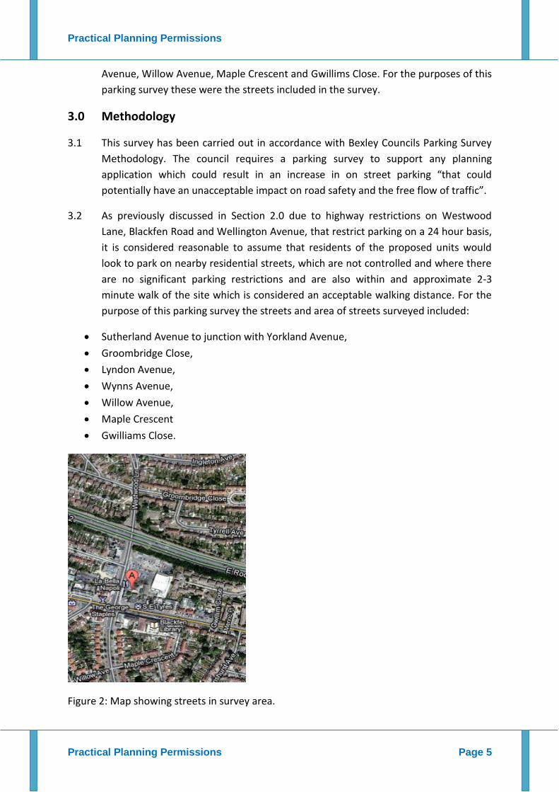
Avenue, Willow Avenue, Maple Crescent and Gwillims Close. For the purposes of this
parking survey these were the streets included in the survey.
3.0 Methodology
3.1 This survey has been carried out in accordance with Bexley Councils Parking Survey
Methodology. The council requires a parking survey to support any planning
application which could result in an increase in on street parking “that could
potentially have an unacceptable impact on road safety and the free flow of traffic”.
3.2 As previously discussed in Section 2.0 due to highway restrictions on Westwood
Lane, Blackfen Road and Wellington Avenue, that restrict parking on a 24 hour basis,
it is considered reasonable to assume that residents of the proposed units would
look to park on nearby residential streets, which are not controlled and where there
are no significant parking restrictions and are also within and approximate 2-3
minute walk of the site which is considered an acceptable walking distance. For the
purpose of this parking survey the streets and area of streets surveyed included:
Sutherland Avenue to junction with Yorkland Avenue,
Groombridge Close,
Lyndon Avenue,
Wynns Avenue,
Willow Avenue,
Maple Crescent
Gwilliams Close.
Figure 2: Map showing streets in survey area.

Practical Planning Permissions
Practical Planning Permissions Page 6
3.3 The survey was carried out on Wednesday 16th of November and Thursday 17th of
November 2011. All streets included in the survey are not in Controlled Parking
Zones.
3.4 The survey took into account all other restrictions e.g. double Yellow lines, other
yellow line restrictions, kerb build outs and crossovers. For the purposes of this
survey to calculate parking stress, it is assumed that each vehicle measures 5 metres
in length, as outlined in the councils parking survey methodology.
3.5 The survey tools used included a measuring wheel, measuring tape, camera, notepad
and handheld counting clicker.

Practical Planning Permissions
Practical Planning Permissions Page 7
4.0 Survey Results and Discussion
Survey Results
4.1 The survey results are included in the tables outlined as below. To reiterate due to
the 24 hour parking restrictions on Westwood Lane, Blackfen Road and Wellington
Avenue to the junction with Willow Avenue and Maple Crescent these streets have
not been included in the survey. There are a number of Pay and Display bays on
Blackfen Road, but due to the overnight and permanent nature of residential parking
it is considered that residents of the proposed units would not use these parking
bays.
Table 1: Results of Parking Survey Undertaken Wednesday 16th Nov 2011- 1am-
4am.
Street Name Total Length of Kerbspce
Length of Unrestricted Kerbspace
No of Parking Spaces
No of car parked on unrestricted kerbspace
Unrestricted Parking Stress (%)
Length of SYL
No of Parking Spaces
No of cars Parked
SYL Parking Stress
Sutherland Ave to Yorkland Avenue
280 115 23 14 61% 0 0 0 0
Groombridge Close
870 425 85 35 41% 20 0 Restricted 24h
0 0
Lyndon Avenue to Wynn Ave
500 70 14 10 71.5% 0 0 0 0
Wynn Avenue
90 80 16 6 37.5% 0 0 0 0
Willow Avenue
160 65 13 5 38.5% 0 0 0 0
Maple Crescent
480 140 28 17 61% 135 0 Restricted 24h
0 0
Gwilliam Close
460 145 29 16 55% 0 0 0 0

Practical Planning Permissions
Practical Planning Permissions Page 8
Table 2: Results of Parking Survey Undertaken Thursday 17th Nov 2011- 1am-
2.30am.
Street Name Total Length of Kerbspce
Length of Unrestricted Kerbspace
No of Parking Spaces
No of car parked on unrestricted kerbspace
Unrestricted Parking Stress (%)
Length of SYL
No of Parking Spaces
No of cars Parked
SYL Parking Stress
Sutherland Ave to Yorkland Avenue
280 115 23 16 69.5% 0 0 0 0
Groombridge Close
870 425 85 40 47% 20 0 Restricted 24h
0 0
Lyndon Avenue to Wynn Ave
500 70 14 9 64% 0 0 0 0
Wynn Avenue
90 80 16 5 31.5% 0 0 0 0
Willow Avenue
160 65 13 6 46% 0 0 0 0
Maple Crescent
480 140 28 15 53.5% 135 0 Restricted 24h
0 0
Gwilliam Close
460 145 29 16 55% 0 0 0 0
Survey Results Discussion
Sutherland Avenue to Yorkland Avenue
This is a typical stretch of residential street. There is 60 metres of DYL on each side of the
street on the approach from Westwood Lane (120 in total). There were about 9 dropped
kerbs for driveways measuring in total 45 metres, leaving useable kerbspace of 115 metres.
There was some instances of 2 up 2 down parking spaces in what appeared to be painted
marked bays. The parking stress on this street was relatively high but still there were 9
spaces available on the first survey night and 7 on the second survey night. This street is
considered to be within a feasible walking distance of the application site.
Figure 3 + 4 Photographic Evidence Available Space at Sutherland Ave/Yorkland Avenue

Practical Planning Permissions
Practical Planning Permissions Page 9
Groombridge Close
This is a relatively narrow street which only allows for parking on one side of the street
which renders approximately 180 metres of kerbspace on the south side unsuitable for
parking. On the entrance from Westwood Avenue, there is a short section of DYL on either
side approximately 15 metres on each side. There are two separate sections to this street,
the main stretch that leads in from Westwood Lane and the section at the end of the cul de
sac around the roundabout.
There are 18 dropped kerbs encompassing altogether 90 metres of kerbspace. There are
also two disabled parking bays which encompass about a further 12 metres of kerbspace.
It was found from measuring the street that 425 metres of the kerbspace would be usable,
this was particularly evident at the lower end of the street where cars were parked
perpendicular and in a herringbone style to the kerb which naturally created more available
kerbspace. The parking stress on this street was found to be relatively low it is considered
although it is outside of the 200 metre distance from the property it would provide a
suitable area for residents of the proposed scheme to park (including visitors) within
creating and impact on the residents of this street. There were 50 and 45 available parking
spaces on this street over the two consecutive nights.
Figure 5: Available Space Groombridge Close Figure 6 Perpendicular Parking on this street.
Figure 7 Long Stretch of Parking Space on Groombridge Close.

Practical Planning Permissions
Practical Planning Permissions Page 10
Lyndon Avenue to junction with Wynn Avenue
On the approach to Lyndon Avenue there were 70 metres of DYL on one side and 15 metres on the opposite side. The majority of kerbspace on the surveyed section of Lyndon Avenue was dropped kerb. It was found that only 70 metres could be regarded as usable. However there were 4 and 5 available space found on the consecutive survey nights. This street is a short 2 minute walk from the application location and it would be very reasonable to assume that future residents of the proposed units at 255 Westwood Avenue would use this street to park.
Figure 7 + 8 Parking Spaces on Lyndon Ave on Consecutive Nights
Wynn Avenue
Wynn Avenue is a short street 45 metres long off Lyndon Avenue, approximately 2-3 minutes from the proposed site. There are two dropped kerbs each measuring approximately 5 metre in length totalling 10 metres altogether leaving 80 metres of useable kerbspace.
On Wednesday 16th there were 10 available parking spaces. On Thursday 17th there were 11 available parking spaces.
Figure 9 Length of Available Space Wed 16th, Fig 10 Similar amount of space Thurs 17th.

Practical Planning Permissions
Practical Planning Permissions Page 11
Willow Avenue
Although there no yellow marked lines, this street is too narrow for parking on both sides and this was evident during the surveyed as all vehicles were parked on one side. Taking this into account excluding dropped kerbs there was 65 metres of available parking space on the side that vehicles were parked. Over both nights parking stress equated on average to 35%.
Figure 11: Available Parking Spaces on Willow Avenue.
Maple Crescent
Similarly to Willow Avenue, Maple Crescent is only wide enough to accommodate parking on one side, which on both nights was on the south side of the street. On the approach from Wellington Avenue there was DYL’s stretching 5 metres around the corner with a further 15 metres of SYL on one side. Additionally on the approach from Blackfen Road there was 45 metres of DYL on both sides with a 24h restricted SYL carrying on for a further 50 metres around the corner on the approach to Wellington Avenue. Excluding dropped kerbs it was established there was 140 usable kerbspace on this street, that could be used whilst providing for the free-flow of traffic on the street. There were 11 and 13 parking spaces available respectively over both nights.
Figure 12: Available Kerbspace Wed 16th
. Figure 13: Available Kerbspace Thursday 17th
.

Practical Planning Permissions
Practical Planning Permissions Page 12
Gwillim Close
Gwillim Close leads off Blackfen Road and again it is within a short walking distance of the site 2-3 minutes or approximately 250 metres, therefore it is again reasonable to assume that future residents of the proposed units would use this street to park. Similar to many of the other streets it is too narrow to park on both sides. Therefore, people generally parked on one side of the street. On the stretch of Gwillim Close from Blackfen Road, there was 40 metres of usable kerbspace on one side, totalling 8 parking spaces in which 4 vehicles were parked leaving 4 available parking spaces.
On the main section of Gwillim Close appoaching Parkmead it was established that after leaving out kerb build outs and dropped kerbs there was 115 metres of kerbspace equating to 23 parking spaces. Over both nights there were 12 cars parked along this section of Gwillim Close, leaving approximately 10-11 parking bays available on both nights. In general the parking stress on Gwillim Close was found to be relatively low.
Figure 14: Junction Gwillim Close/Parkmead Figure 15: Available Parking Space on Gwillim Close
Figure 12: Empty Kerbspace on Gwillim Close.

Practical Planning Permissions
Practical Planning Permissions Page 13
5.0 Conclusions
5.1 This parking survey has been carried out at the request of the owner of 255
Westwood Lane, Blackfen, Kent, DA15 9PS. This parking survey has been produced
as supporting information in relation to a planning application proposal to convert
the upper floor levels, floors 1 and 2 into self-contained residential units.
5.2 The survey was carried out in accordance with Bexley Council’s Parking Survey
Methodology and was carried out over the nights of Wednesday 16th and Thursday
17th of November 2011.
5.3 It was quickly established that the streets within immediate proximity of the
proposed site, Westwood Lane, Blackfen Road and Wellington Avenue were
completely restrictive for the purposes of car parking on a 24 hour basis. There was
only one exception on Blackfen Road where there were a number of Pay and Display
bays, however these were deemed unsuitable to the permanency of residential
parking.
5.4 However a number of neighbouring residential streets within a close walking
distance were surveyed for the purposes of this proposal.
5.5 On all surveyed streets parking stress was found to be low to medium. In fact it can
be concluded that this area does not have a parking problem, and there a number of
options available for residents that live and would live on roads like Westwood Lane
and Blackfen Road, without impacting residents of the nearby residential streets
especially those included in this survey.
5.6 To conclude this proposal for 2 X 2 residential flats will have a negligible impact to on
street parking availability in this area and it is considered that these survey results
overcome the previous reason for refusal in relation to application 11/01150/FUL.