Transit Corridor & Group Transit · PDF fileGulf of Aden Internationally Recommended Transit...
13
Gulf of Aden Internationally Recommended Transit Corridor & Group Transit Explanation The following information is intended to clarify the purpose & scope of the Transit Corridor and to outline the practical aspects for merchant vessels participating in Group Transits. August 2010
Transcript of Transit Corridor & Group Transit · PDF fileGulf of Aden Internationally Recommended Transit...

Gulf of Aden Internationally
Recommended Transit Corridor &
Group Transit Explanation
The following information is intended to clarify the
purpose & scope of the Transit Corridor and to
outline the practical aspects for merchant
vessels participating in Group Transits.
August 2010

IR Transit Corridor
The IRTC was amended in 2009 to reflect revised analysis of GOA
pirate activity and shipping industry feedback. The new corridor has
been positioned further from established fishing areas resulting in a
decrease in false piracy alerts.
The corridor is 492 miles
long and has an
East bound
and a
West bound
lane.
Each lane is 5 miles wide
with a 2 mile separation
between the lanes.
The corridor is not marked or defined by navigational aids, and is not intended
to be a TSS. However to make warship patrols more effective, vessels
transiting the GOA are strongly recommended to adhere to the Transit Corridor
and Group Transit guidelines.

IR Transit CorridorThe East bound corridor starts at 45°E between 11°53’N & 11°48’N
and ends at 53°E between 14°23’N & 14°18’N.
The West bound corridor starts at 53°E between 14°30’N & 14°25’N
and ends at 45°E between 12°00’N & 11°55’N.
252°
072°
053°E
045°E
All illustrations & distances are approximate
Group Transits
Analysis of successful and attempted pirate attacks in the region
clearly indicate that attacks during darkness are rare and, to date, have
a zero success rate. Many of the successful attacks have occurred
around first or last light in the area between 47E & 49E.
In 2010 statistics show that there have been no successful
attacks on ships keeping to “Group Transit” times & speeds.
“Group Transits” are designed to put ships into different speed groups
in order to exploit the additional protection and assurance of being in a
group. The times for different groups to enter the IRTC are calculated
so that they pass through the area of statistically greatest danger,
between 47E & 49E, at night and ensures that all ships, regardless of
speed, are together at first light. This allows the military forces in the
area to best position their assets in the area so as to protect ships
against piracy and to give assistance in case of attack.
“GROUP TRANSITS” ARE NOT “CONVOYS”!

Group TransitsArea of greatest threat – statistically – between 47E & 49E
(This is area is constantly reviewed and may be changed.)
Night time / darkness transit section (approximate)
Point “A”
Point “B”
Most vulnerable time / area of GT
All illustrations & distances are approximate
Region where military forces are
concentrating piracy surveillance efforts.
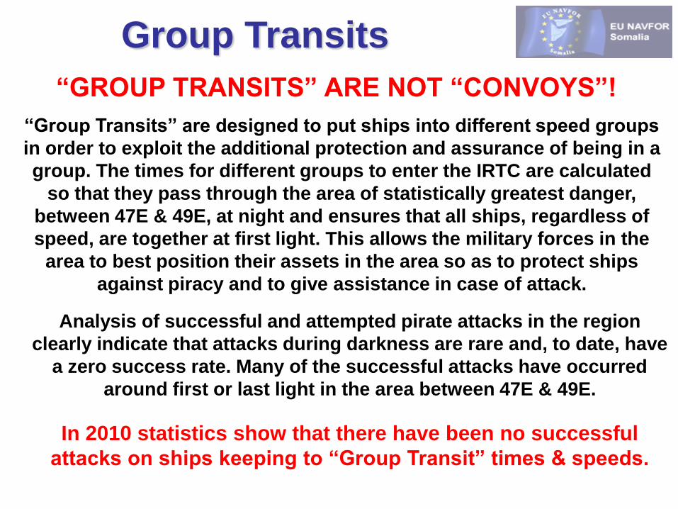
Group Transit GroupingsSpeed
(SOG)
Eastbound
Point “A”
Westbound
Point “B”
10 kts 01:00 Z 04:00 LT 15:00 Z 18:00 LT
12 kts 05:30 Z 08:30 LT 21:00 Z 00:01 LT
14 kts 08:30 Z 11:30 LT 01:00 Z 04:00 LT
16 kts 11:00 Z 14:00 LT 05:30 Z 08:30 LT
18 kts 13:00 Z 16:00 LT 07:00 Z 10:00 LT
Point “A”Point “B”
All illustrations & distances are approximate

All illustrations & distances are approximate
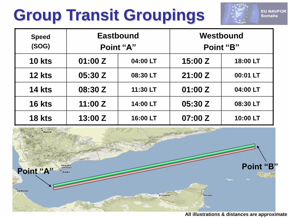
Westbound GT Case StudyVessel ID Vessel Type Transit Speed Vessel ID Vessel Type Transit Speed
Ship A VLCC 12 kts Ship D Offshore Supply 10 kts
Ship B Bulk Carrier 14 kts Ship E Car Carrier 14 kts
Ship C LNG Carrier 18 kts Ship F General Cargo 12 kts
A
F
D
Time :
15:00Z
18:00LT

Westbound GT Case StudyVessel ID Vessel Type Transit Speed Vessel ID Vessel Type Transit Speed
Ship A VLCC 12 kts Ship D Offshore Supply 10 kts
Ship B Bulk Carrier 14 kts Ship E Car Carrier 14 kts
Ship C LNG Carrier 18 kts Ship F General Cargo 12 kts
AF
D
All illustrations & distances are approximate
BE
C
Time :
01:00Z
04:00LT

Westbound GT Case StudyVessel ID Vessel Type Transit Speed Vessel ID Vessel Type Transit Speed
Ship A VLCC 12 kts Ship D Offshore Supply 10 kts
Ship B Bulk Carrier 14 kts Ship E Car Carrier 14 kts
Ship C LNG Carrier 18 kts Ship F General Cargo 12 kts
AF
All illustrations & distances are approximate
BE
C
D
Time :
15:30Z
18:30LT

Westbound GT Case StudyVessel ID Vessel Type Transit Speed Vessel ID Vessel Type Transit Speed
Ship A VLCC 12 kts Ship D Offshore Supply 10 kts
Ship B Bulk Carrier 14 kts Ship E Car Carrier 14 kts
Ship C LNG Carrier 18 kts Ship F General Cargo 12 kts
AFD
All illustrations & distances are approximate
BEC
Time : 03:00Z (06:00LT)
All Westbound Transit vessels are grouped together when
passing through what EU NAVFOR believe to be the most
vulnerable phase of the transit which allows naval forces to
offer protection for all transit vessels during this time.
Westbound GT Case StudyVessel ID Vessel Type Transit Speed Vessel ID Vessel Type Transit Speed
Ship A VLCC 12 kts Ship D Offshore Supply 10 kts
Ship B Bulk Carrier 14 kts Ship E Car Carrier 14 kts
Ship C LNG Carrier 18 kts Ship F General Cargo 12 kts
AFD
All illustrations & distances are approximate
BEC
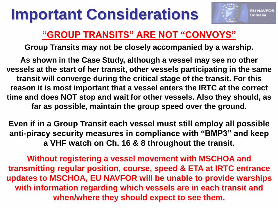
Important Considerations
“GROUP TRANSITS” ARE NOT “CONVOYS”
Group Transits may not be closely accompanied by a warship.
As shown in the Case Study, although a vessel may see no other
vessels at the start of her transit, other vessels participating in the same
transit will converge during the critical stage of the transit. For this
reason it is most important that a vessel enters the IRTC at the correct
time and does NOT stop and wait for other vessels. Also they should, as
far as possible, maintain the group speed over the ground.
Even if in a Group Transit each vessel must still employ all possible
anti-piracy security measures in compliance with “BMP3” and keep
a VHF watch on Ch. 16 & 8 throughout the transit.
Without registering a vessel movement with MSCHOA and
transmitting regular position, course, speed & ETA at IRTC entrance
updates to MSCHOA, EU NAVFOR will be unable to provide warships
with information regarding which vessels are in each transit and
when/where they should expect to see them.

Further Information
WWW.MSCHOA.ORG
A website created by EU NAVFOR Somalia in order to
inform the Merchant Shipping community with regard to
the continued threat of Piracy off the Horn of Africa.
(User registration is required to access all areas of the website)
Email address monitored by EU Maritime Security Centre
military and merchant navy personnel where questions
regarding the Transit Corridor and Group Transits may be
directed.