timnath.org TOWN OF TIMNATH TOWN COUNCIL TUESDAY, JULY 28, 2015 IMMEDIATELY FOLLOWING THE TIMNATH...
147
1 TOWN OF TIMNATH TOWN COUNCIL TUESDAY, JULY 28, 2015 IMMEDIATELY FOLLOWING THE TIMNATH LIQUOR BOARD MEETING AT 6:00 p.m. Meeting will be held at Timnath Administration Building, 4800 Goodman Street, Timnath, Colorado 1. CALL TO ORDER AND ROLL CALL Mayor Jill Grossman-Belisle Councilmember Bill Neal Councilmember Aaron Pearson Councilmember Paul Steinway Councilmember Bryan Voronin 2. AMENDMENTS TO THE AGENDA Note: The Council may add to this agenda, any item for discussion or action. 3. PUBLIC COMMENT: Note: It is requested that public comments be limited to three minutes. When several people wish to speak with the same position on a given item, they are requested to select a spokesperson to state that position. 4. CONSENT AGENDA a. Approval of the Check Register 5. REPORTS a. Mayor and Council b. Staff 6. ORDER OF BUSINESS: a. ORDINANCE NO. 9, SERIES 2015, SECOND READING, PUBLIC HEARING, An Ordinance Amending the Official Zoning Map of the Town of Timnath for the Purpose of Zoning Certain Real Property Located at 4025 Kern Street Presented by Matt Blakely, Contracted Town Planner b. ORDINANCE NO. 10, SERIES 2015, FIRST READING, An Ordinance Providing for an Election Concerning Amendments to the Home Rule Charter of the Town of Timnath, Colorado and set for Public Hearing on August 11, 2015, at 6:00 p.m. Presented by Robert Rogers, Contracted Town Attorney c. RESOLUTION NO. 49, SERIES 2015, A Resolution Approving Timnath Reservoir Lease Extension Presented by April Getchius, Town Manager d. RESOLUTION NO. 50, SERIES 2015, A Resolution Approving the Sketch Planned Development Overlay for Wildwing Subdivision Presented by Matt Blakely, Contracted Town Planner e. RESOLUTION NO. 51, SERIES 2015, A Resolution Approving the Serratoga Falls Subdivision Final Plat Presented by Matt Blakely, Contracted Town Planner
Transcript of timnath.org TOWN OF TIMNATH TOWN COUNCIL TUESDAY, JULY 28, 2015 IMMEDIATELY FOLLOWING THE TIMNATH...
1
TOWN OF TIMNATH TOWN COUNCIL
TUESDAY, JULY 28, 2015 IMMEDIATELY FOLLOWING THE TIMNATH LIQUOR BOARD MEETING AT 6:00 p.m.
Meeting will be held at Timnath Administration Building, 4800 Goodman Street, Timnath, Colorado
1. CALL TO ORDER AND ROLL CALL Mayor Jill Grossman-Belisle Councilmember Bill Neal Councilmember Aaron Pearson Councilmember Paul Steinway Councilmember Bryan Voronin
2. AMENDMENTS TO THE AGENDA Note: The Council may add to this agenda, any item for discussion or action.
3. PUBLIC COMMENT: Note: It is requested that public comments be limited to three minutes. When several people wish to speak with the same position on a given item, they are requested to select a spokesperson to state that position.
4. CONSENT AGENDA a. Approval of the Check Register
5. REPORTS
a. Mayor and Council b. Staff
6. ORDER OF BUSINESS:
a. ORDINANCE NO. 9, SERIES 2015, SECOND READING, PUBLIC HEARING, An Ordinance Amending the Official Zoning Map of the Town of Timnath for the Purpose of Zoning Certain Real Property Located at 4025 Kern Street
Presented by Matt Blakely, Contracted Town Planner
b. ORDINANCE NO. 10, SERIES 2015, FIRST READING, An Ordinance Providing for an Election Concerning Amendments to the Home Rule Charter of the Town of Timnath, Colorado and set for Public Hearing on August 11, 2015, at 6:00 p.m.
Presented by Robert Rogers, Contracted Town Attorney
c. RESOLUTION NO. 49, SERIES 2015, A Resolution Approving Timnath Reservoir Lease Extension Presented by April Getchius, Town Manager
d. RESOLUTION NO. 50, SERIES 2015, A Resolution Approving the Sketch Planned Development
Overlay for Wildwing Subdivision Presented by Matt Blakely, Contracted Town Planner
e. RESOLUTION NO. 51, SERIES 2015, A Resolution Approving the Serratoga Falls Subdivision
Final Plat Presented by Matt Blakely, Contracted Town Planner

2
f. EXECUTIVE SESSION: “For the purposes of discussion concerning the purchase, acquisition,
lease, transfer, or sale of real, personal, or other property interests under Section §24-6-402(a), C.R.S.; discussion concerning personnel matters under §24-6-402(4)(f), C.R.S.; discussion regarding positions relative to matters that may be subject to negotiations and development of a strategy for negotiations under §24-6-402(4)(e), C.R.S.; and conferences with the Town’s attorney for purposes of receiving legal advice on specific legal questions under §24-6-402(4)(b), C.R.S.”
Presented by Robert Rogers, Contracted Town Attorney
7. ADJOURNMENT
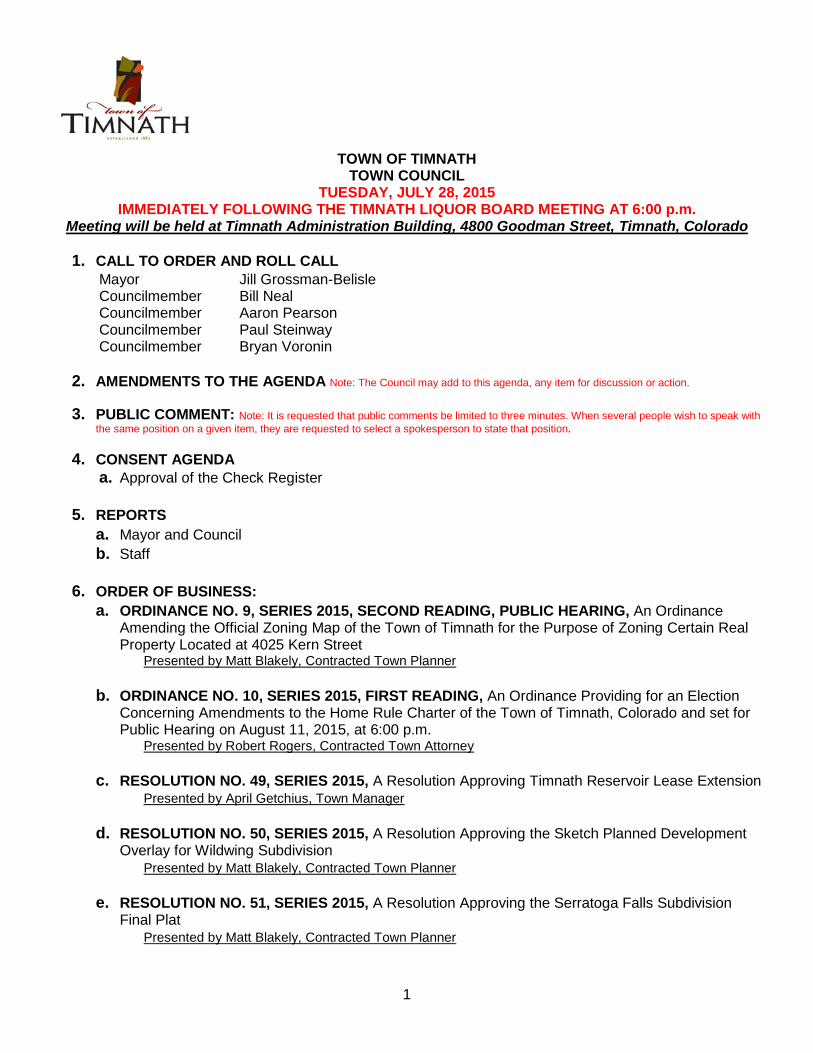
Town of Timnath Payment Approval Report - check register Page: 1
Report dates: 6/1/2015-7/31/2015 Jul 22, 2015 09:28AM
Vendor Vendor Name Invoice Number Description Invoice Date Net Invoice Amount
ADVANCED FIRE & HYDRO SERVICES
5012
398 ADVANCED FIRE & HYDRO SE 5012 Recharge Fire Extinguisher 07/07/2015 24.50
Total 5012: 24.50
Total ADVANCED FIRE & HYDRO SERVICES: 24.50
Alsco
LLAR1040864
272 Alsco LLAR1040864 07/16/2015 Mat Service 07/16/2015 45.14
Total LLAR1040864: 45.14
Total Alsco: 45.14
APEX Shredding
15509
735 APEX Shredding 15509 Shredding Services 07/15/2015 40.00
Total 15509: 40.00
Total APEX Shredding: 40.00
BLANCO LAW OFFICE
JUNE 2015
444 BLANCO LAW OFFICE JUNE 2015 May 2015 Prosecutor 07/09/2015 1,100.00
444 BLANCO LAW OFFICE JUNE 2015 Jun 2015 Prosecutor 07/09/2015 1,100.00
Total JUNE 2015: 2,200.00
Total BLANCO LAW OFFICE: 2,200.00
CENTURY LINK
07012015
39 CENTURY LINK 07012015 Jul 2015 T1 Line 07/01/2015 300.48
Total 07012015: 300.48
Total CENTURY LINK: 300.48
CLIFTONLARSONALLEN LLP
1084481
580 CLIFTONLARSONALLEN LLP 1084481 Jun 2015 Financial Consultants - 07/16/2015 1,092.75-
580 CLIFTONLARSONALLEN LLP 1084481 Jun 2015 Financial Consultants 07/16/2015 21,788.60
580 CLIFTONLARSONALLEN LLP 1084481 Jun 2015 Financial Consultants - 07/16/2015 1,712.00
Total 1084481: 22,407.85
Total CLIFTONLARSONALLEN LLP: 22,407.85
Coyote Ridge Construction, LLC
PAY APP 1
689 Coyote Ridge Construction, LLC PAY APP 1 Old Town Sewer Connections 07/10/2015 27,686.99
Total PAY APP 1: 27,686.99
Town of Timnath Payment Approval Report - check register Page: 2
Report dates: 6/1/2015-7/31/2015 Jul 22, 2015 09:28AM
Vendor Vendor Name Invoice Number Description Invoice Date Net Invoice Amount
Total Coyote Ridge Construction, LLC: 27,686.99
Cummins Rocky Mountain
001-92239
809 Cummins Rocky Mountain 001-92239 Emergency Portable Generator 07/16/2015 52,895.00
Total 001-92239: 52,895.00
Total Cummins Rocky Mountain: 52,895.00
Felsburg, Holt & Ullevig
14067
786 Felsburg, Holt & Ullevig 14067 2015 Traffic Study 05/11/2015 12,821.23
Total 14067: 12,821.23
14363
786 Felsburg, Holt & Ullevig 14363 2015 Traffic Study 06/11/2015 7,869.41
Total 14363: 7,869.41
Total Felsburg, Holt & Ullevig: 20,690.64
FORT COLLINS LOVELAND WATER DIST
07142015A
14 FORT COLLINS LOVELAND WA 07142015A Jul 2015 4800 Goodman Street 07/14/2015 146.02
Total 07142015A: 146.02
07142015B
14 FORT COLLINS LOVELAND WA 07142015B Jul 2015-Irrigation Weitzel Stret 07/14/2015 13.52
Total 07142015B: 13.52
07142015C
14 FORT COLLINS LOVELAND WA 07142015C Jul 2015 3930 Main Street 07/14/2015 33.69
Total 07142015C: 33.69
Total FORT COLLINS LOVELAND WATER DIST: 193.23
Front Range Pest Control
24392
727 Front Range Pest Control 24392 May 2015 Pest Control Services a 05/13/2015 75.00
Total 24392: 75.00
24460
727 Front Range Pest Control 24460 May 2015 Pest Control Services a 05/28/2015 75.00
Total 24460: 75.00
Total Front Range Pest Control: 150.00
Greystone Web Services, LLC
27935
729 Greystone Web Services, LLC 27935 Website Development 06/30/2015 625.00

Town of Timnath Payment Approval Report - check register Page: 3
Report dates: 6/1/2015-7/31/2015 Jul 22, 2015 09:28AM
Vendor Vendor Name Invoice Number Description Invoice Date Net Invoice Amount
Total 27935: 625.00
Total Greystone Web Services, LLC: 625.00
ICMA
2015 RENEWAL
766 ICMA 2015 RENEWA 2015 Membership Dues 07/01/2015 1,064.96
Total 2015 RENEWAL: 1,064.96
Total ICMA: 1,064.96
JOHN DEERE GOVERNMENT & NATION
1580049
517 JOHN DEERE GOVERNMENT & 1580049 Jun 2015 lease payment 06/28/2015 1,176.34
Total 1580049: 1,176.34
Total JOHN DEERE GOVERNMENT & NATION: 1,176.34
Mantooth Marketing Company
4624
674 Mantooth Marketing Company 4624 Marketing Retainer 07/15/2015 1,200.00
674 Mantooth Marketing Company 4624 BBQ-Face Painter 07/15/2015 339.30
674 Mantooth Marketing Company 4624 Movie Night - Post cards 07/15/2015 86.53
674 Mantooth Marketing Company 4624 BBQ-Light Tower 07/15/2015 332.35
674 Mantooth Marketing Company 4624 BBQ-Trash Service 07/15/2015 890.01
674 Mantooth Marketing Company 4624 Movie Night-Target 07/15/2015 76.62
674 Mantooth Marketing Company 4624 BBQ-Dollar Store 07/15/2015 79.16
674 Mantooth Marketing Company 4624 BBQ-WalMart 07/15/2015 99.80
674 Mantooth Marketing Company 4624 BBQ-WalMart 07/15/2015 24.93
674 Mantooth Marketing Company 4624 Movie Night-The Great Loudini 07/15/2015 234.00
Total 4624: 3,362.70
Total Mantooth Marketing Company: 3,362.70
MARCH, OLIVE & PHARRIS, LLC
137225
28 MARCH, OLIVE & PHARRIS, LLC 137225 Jun 2015 Judge 06/21/2015 225.00
Total 137225: 225.00
Total MARCH, OLIVE & PHARRIS, LLC: 225.00
Mtn States Employers Council
127525
219 Mtn States Employers Council 127525 Compensation Survey 07/06/2015 70.00
Total 127525: 70.00
127616
219 Mtn States Employers Council 127616 Compensation Survey 07/07/2015 187.50
Total 127616: 187.50

Town of Timnath Payment Approval Report - check register Page: 4
Report dates: 6/1/2015-7/31/2015 Jul 22, 2015 09:28AM
Vendor Vendor Name Invoice Number Description Invoice Date Net Invoice Amount
Total Mtn States Employers Council: 257.50
Northern Colorado Air, Inc
120674
654 Northern Colorado Air, Inc 120674 Replace blower 06/18/2015 671.70
Total 120674: 671.70
Total Northern Colorado Air, Inc: 671.70
OFFICE DEPOT
778863262001
419 OFFICE DEPOT 778863262001 2015 Office Supplies 07/06/2015 121.77
Total 778863262001: 121.77
778864410001
419 OFFICE DEPOT 778864410001 2015 Office Supplies 07/06/2015 15.99
Total 778864410001: 15.99
Total OFFICE DEPOT: 137.76
ORION PLANNING GROUP
LUC20
581 ORION PLANNING GROUP LUC20 Jun 2015 Land Use Code 07/02/2015 2,061.89
Total LUC20: 2,061.89
Total ORION PLANNING GROUP: 2,061.89
Poudre Valley REA
07072015A
209 Poudre Valley REA 07072015A Jul 2015 Harmony & Weitzel 07/07/2015 144.47
Total 07072015A: 144.47
07072015B
209 Poudre Valley REA 07072015B Jul 2015 Cty 3 & Harmony 07/07/2015 58.85
Total 07072015B: 58.85
07072015C
209 Poudre Valley REA 07072015C Jul 2015 Weitzel Street 07/07/2015 152.20
Total 07072015C: 152.20
07072015D
209 Poudre Valley REA 07072015D Jul 2015 Cty 38 & RR 07/07/2015 21.62
Total 07072015D: 21.62
Total Poudre Valley REA: 377.14
Precision Pavement Marking
348156
714 Precision Pavement Marking 348156 Sign Replacement 07/06/2015 59.21

Town of Timnath Payment Approval Report - check register Page: 5
Report dates: 6/1/2015-7/31/2015 Jul 22, 2015 09:28AM
Vendor Vendor Name Invoice Number Description Invoice Date Net Invoice Amount
Total 348156: 59.21
Total Precision Pavement Marking: 59.21
RJ McNutt & Associates, LLC
8558
811 RJ McNutt & Associates, LLC 8558 Engineering services for Generato 03/31/2015 4,500.00
Total 8558: 4,500.00
Total RJ McNutt & Associates, LLC: 4,500.00
SECURITY AND SOUND DESIGN
20506
546 SECURITY AND SOUND DESIG 20506 3rd Qtr 2015 Fire Monitoring & Ins 07/01/2015 120.00
Total 20506: 120.00
Total SECURITY AND SOUND DESIGN: 120.00
Skybeam
07192015
768 Skybeam 07192015 Jul 2015 Internet 07/19/2015 469.00
Total 07192015: 469.00
Total Skybeam: 469.00
Staples Advantage
8035045125
759 Staples Advantage 8035045125 2015 Office Supplies 07/04/2015 232.96
Total 8035045125: 232.96
Total Staples Advantage: 232.96
Verizon Wireless
9747882920
810 Verizon Wireless 9747882920 June 2015 Wireless Air Cards 06/26/2015 234.63
Total 9747882920: 234.63
Total Verizon Wireless: 234.63
Xcel Energy
460412202
47 Xcel Energy 460412202 Jun 2015 3909 Main Street 06/15/2015 17.92
Total 460412202: 17.92
460910068
47 Xcel Energy 460910068 Jun 2015 4100 Main Street 06/18/2015 179.55
Total 460910068: 179.55
461012656
47 Xcel Energy 461012656 Jun 2015 5096 County Rd 38 06/18/2015 87.83

Town of Timnath Payment Approval Report - check register Page: 6
Report dates: 6/1/2015-7/31/2015 Jul 22, 2015 09:28AM
Vendor Vendor Name Invoice Number Description Invoice Date Net Invoice Amount
Total 461012656: 87.83
461285941
47 Xcel Energy 461285941 Jun 2015 68W-7N-34-21/08 Area 06/22/2015 35.82
Total 461285941: 35.82
461411797
47 Xcel Energy 461411797 Jun0 2015 2221 S County Line R 06/23/2015 30.59
Total 461411797: 30.59
462136006
47 Xcel Energy 462136006 Jun 2015 4800 Goodman Street 06/29/2015 748.09
Total 462136006: 748.09
462485566
47 Xcel Energy 462485566 Jun 2015 Tax Address 07/01/2015 3,800.71
Total 462485566: 3,800.71
463774319
47 Xcel Energy 463774319 Jul 2015 3909 Main Street 07/13/2015 17.81
Total 463774319: 17.81
Total Xcel Energy: 4,918.32
Grand Totals: 147,127.94
Dated: ______________________________________________________
Mayor: ______________________________________________________
City Council: ______________________________________________________
______________________________________________________
______________________________________________________
______________________________________________________
______________________________________________________
______________________________________________________
City Recorder: _____________________________________________________

TOWN COUNCIL COMMUNICATION Date: 7/22/15 Council Meeting Date: 7/28/15
Item: Finance Update Report
Ordinance �Resolution � Discussion �
For Information X Presented by: Christine Harwell
1. Financial statements for the five months ended May 31, 2015 are attached for Council’s review and
acceptance. 2. May sales tax revenue was 138% higher than same month last year. May sales tax revenue, not including
Costco, was 14% higher than same month last year. 3. Five months into 2015, certain significant (favorable or unfavorable) variances in the revenues and
expenditures continue to be mainly due to timing (delays) related to building activities and capital projects.
4. The Town’s auditor had presented the December 31, 2014 audited financial statements to the Council. These audited December 31, 2014 financial statements will be filed with the State on or before July 31, 2015.

TOWN OF TIMNATH FINANCIAL STATEMENTS
May 31, 2015
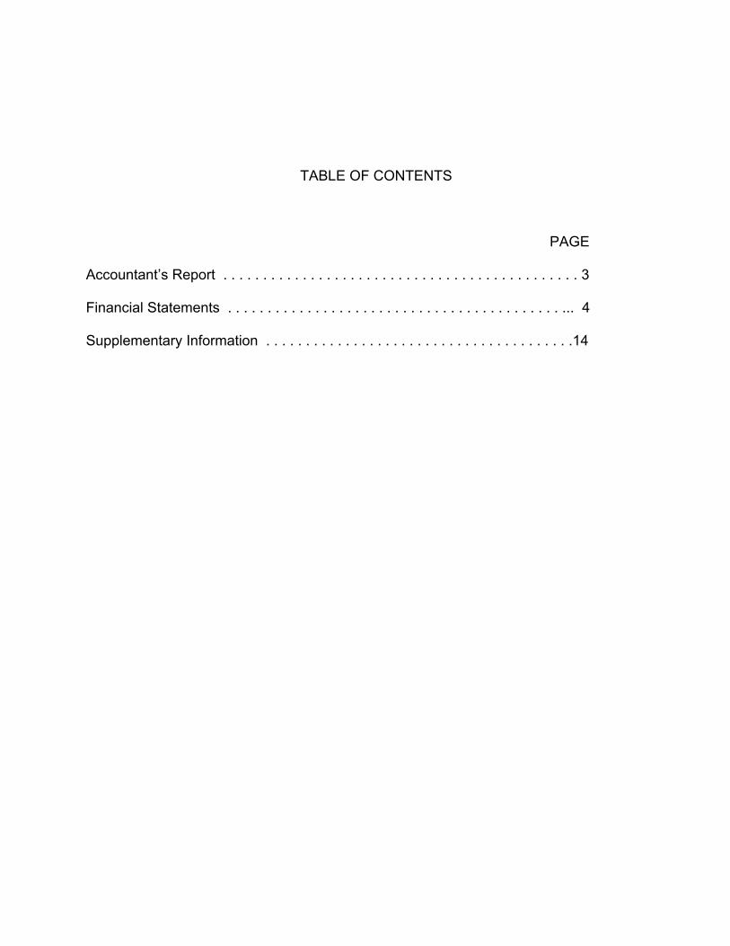
TABLE OF CONTENTS
PAGE
Accountant’s Report . . . . . . . . . . . . . . . . . . . . . . . . . . . . . . . . . . . . . . . . . . . . . 3 Financial Statements . . . . . . . . . . . . . . . . . . . . . . . . . . . . . . . . . . . . . . . . . . ... 4 Supplementary Information . . . . . . . . . . . . . . . . . . . . . . . . . . . . . . . . . . . . . . .14
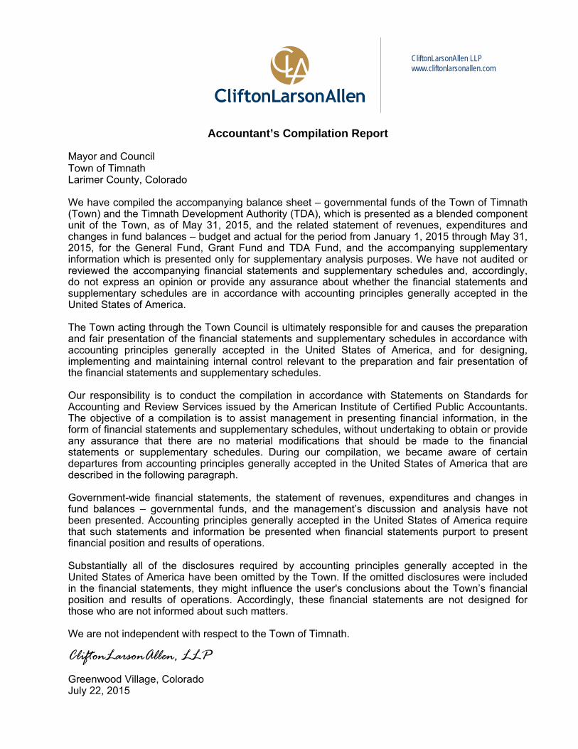
Accountant’s Compilation Report Mayor and Council Town of Timnath Larimer County, Colorado We have compiled the accompanying balance sheet – governmental funds of the Town of Timnath (Town) and the Timnath Development Authority (TDA), which is presented as a blended component unit of the Town, as of May 31, 2015, and the related statement of revenues, expenditures and changes in fund balances – budget and actual for the period from January 1, 2015 through May 31, 2015, for the General Fund, Grant Fund and TDA Fund, and the accompanying supplementary information which is presented only for supplementary analysis purposes. We have not audited or reviewed the accompanying financial statements and supplementary schedules and, accordingly, do not express an opinion or provide any assurance about whether the financial statements and supplementary schedules are in accordance with accounting principles generally accepted in the United States of America. The Town acting through the Town Council is ultimately responsible for and causes the preparation and fair presentation of the financial statements and supplementary schedules in accordance with accounting principles generally accepted in the United States of America, and for designing, implementing and maintaining internal control relevant to the preparation and fair presentation of the financial statements and supplementary schedules. Our responsibility is to conduct the compilation in accordance with Statements on Standards for Accounting and Review Services issued by the American Institute of Certified Public Accountants. The objective of a compilation is to assist management in presenting financial information, in the form of financial statements and supplementary schedules, without undertaking to obtain or provide any assurance that there are no material modifications that should be made to the financial statements or supplementary schedules. During our compilation, we became aware of certain departures from accounting principles generally accepted in the United States of America that are described in the following paragraph. Government-wide financial statements, the statement of revenues, expenditures and changes in fund balances – governmental funds, and the management’s discussion and analysis have not been presented. Accounting principles generally accepted in the United States of America require that such statements and information be presented when financial statements purport to present financial position and results of operations. Substantially all of the disclosures required by accounting principles generally accepted in the United States of America have been omitted by the Town. If the omitted disclosures were included in the financial statements, they might influence the user's conclusions about the Town’s financial position and results of operations. Accordingly, these financial statements are not designed for those who are not informed about such matters. We are not independent with respect to the Town of Timnath. CliftonLarsonAllen, LLP Greenwood Village, Colorado July 22, 2015
CliftonLarsonAllen LLP www.cliftonlarsonallen.com
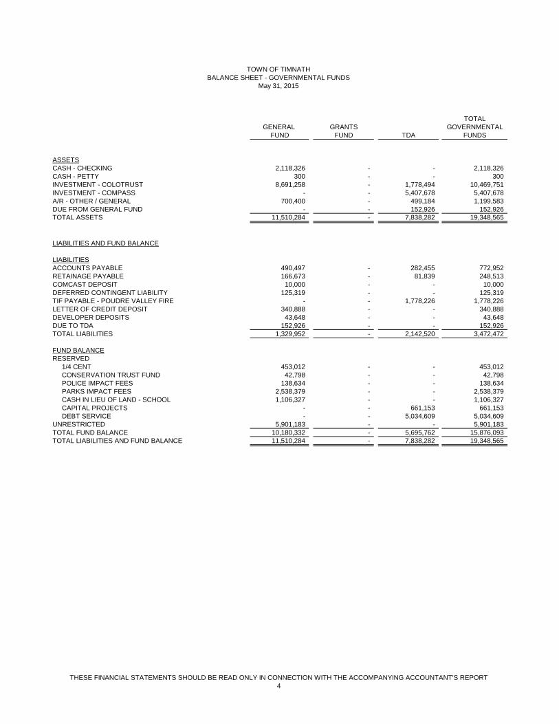
THESE FINANCIAL STATEMENTS SHOULD BE READ ONLY IN CONNECTION WITH THE ACCOMPANYING ACCOUNTANT'S REPORT4
TOTALGENERAL GRANTS GOVERNMENTAL
FUND FUND TDA FUNDS
ASSETSCASH - CHECKING 2,118,326 - - 2,118,326 CASH - PETTY 300 - - 300 INVESTMENT - COLOTRUST 8,691,258 - 1,778,494 10,469,751 INVESTMENT - COMPASS - - 5,407,678 5,407,678 A/R - OTHER / GENERAL 700,400 - 499,184 1,199,583 DUE FROM GENERAL FUND - - 152,926 152,926 TOTAL ASSETS 11,510,284 - 7,838,282 19,348,565
LIABILITIES AND FUND BALANCE
LIABILITIESACCOUNTS PAYABLE 490,497 - 282,455 772,952 RETAINAGE PAYABLE 166,673 - 81,839 248,513 COMCAST DEPOSIT 10,000 - - 10,000 DEFERRED CONTINGENT LIABILITY 125,319 - - 125,319 TIF PAYABLE - POUDRE VALLEY FIRE - - 1,778,226 1,778,226 LETTER OF CREDIT DEPOSIT 340,888 - - 340,888 DEVELOPER DEPOSITS 43,648 - - 43,648 DUE TO TDA 152,926 - - 152,926 TOTAL LIABILITIES 1,329,952 - 2,142,520 3,472,472
FUND BALANCERESERVED 1/4 CENT 453,012 - - 453,012 CONSERVATION TRUST FUND 42,798 - - 42,798 POLICE IMPACT FEES 138,634 - - 138,634 PARKS IMPACT FEES 2,538,379 - - 2,538,379 CASH IN LIEU OF LAND - SCHOOL 1,106,327 - - 1,106,327 CAPITAL PROJECTS - - 661,153 661,153 DEBT SERVICE - - 5,034,609 5,034,609 UNRESTRICTED 5,901,183 - - 5,901,183 TOTAL FUND BALANCE 10,180,332 - 5,695,762 15,876,093 TOTAL LIABILITIES AND FUND BALANCE 11,510,284 - 7,838,282 19,348,565
TOWN OF TIMNATHBALANCE SHEET - GOVERNMENTAL FUNDS
May 31, 2015
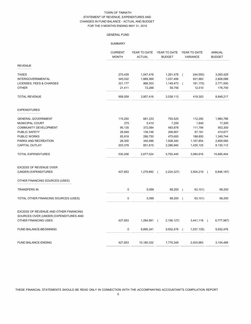
TOWN OF TIMNATH
STATEMENT OF REVENUE, EXPENDITURES AND
CHANGES IN FUND BALANCE - ACTUAL AND BUDGET
FOR THE 5 MONTHS ENDING MAY 31, 2015
GENERAL FUND
SUMMARY
CURRENT YEAR TO DATE YEAR TO DATE YEAR TO DATE ANNUAL
MONTH ACTUAL BUDGET VARIANCE BUDGET
THESE FINANCIAL STATEMENTS SHOULD BE READ ONLY IN CONNECTION WITH THE ACCOMPANYING ACCOUNTANT'S COMPILATION REPORT
5
REVENUE
TAXES 270,439 1,047,478 1,291,478 ( 244,000) 3,093,429
INTERGOVERNMENTAL 345,032 1,869,369 1,037,406 831,963 2,808,088
LICENSES, FEES & CHARGES 321,177 968,303 1,149,473 ( 181,170) 2,771,000
OTHER 21,411 72,266 59,756 12,510 176,700
TOTAL REVENUE 958,059 3,957,416 3,538,113 419,303 8,849,217
EXPENDITURES
GENERAL GOVERNMENT 115,250 681,233 793,525 112,292 1,960,786
MUNICIPAL COURT 275 5,410 7,250 1,840 17,200
COMMUNITY DEVELOPMENT 90,135 372,084 483,878 111,794 953,300
PUBLIC SAFETY 26,949 139,746 206,907 67,161 474,677
PUBLIC WORKS 65,918 286,750 475,600 188,850 1,349,744
PARKS AND RECREATION 28,300 340,486 1,508,340 1,167,854 2,809,585
CAPITAL OUTLAY 203,378 851,815 2,286,940 1,435,125 8,130,112
TOTAL EXPENDITURES 530,206 2,677,524 5,762,440 3,084,916 15,695,404
EXCESS OF REVENUE OVER
(UNDER) EXPENDITURES 427,853 1,279,892 ( 2,224,327) 3,504,219 ( 6,846,187)
OTHER FINANCING SOURCES (USES)
TRANSFERS IN 0 5,099 68,200 ( 63,101) 68,200
TOTAL OTHER FINANCING SOURCES (USES) 0 5,099 68,200 ( 63,101) 68,200
EXCESS OF REVENUE AND OTHER FINANCING
SOURCES OVER (UNDER) EXPENDITURES AND
OTHER FINANCING USES 427,853 1,284,991 ( 2,156,127) 3,441,118 ( 6,777,987)
FUND BALANCE-BEGINNING 0 8,895,341 9,932,476 ( 1,037,135) 9,932,476
FUND BALANCE-ENDING 427,853 10,180,332 7,776,349 2,403,983 3,154,489
TOWN OF TIMNATH
STATEMENT OF REVENUE, EXPENDITURES AND
CHANGES IN FUND BALANCE - ACTUAL AND BUDGET
FOR THE 5 MONTHS ENDING MAY 31, 2015
GENERAL FUND
REVENUE DETAIL
CURRENT YEAR TO DATE YEAR TO DATE YEAR TO DATE ANNUAL
MONTH ACTUAL BUDGET VARIANCE BUDGET
THESE FINANCIAL STATEMENTS SHOULD BE READ ONLY IN CONNECTION WITH THE ACCOMPANYING ACCOUNTANT'S COMPILATION REPORT
6
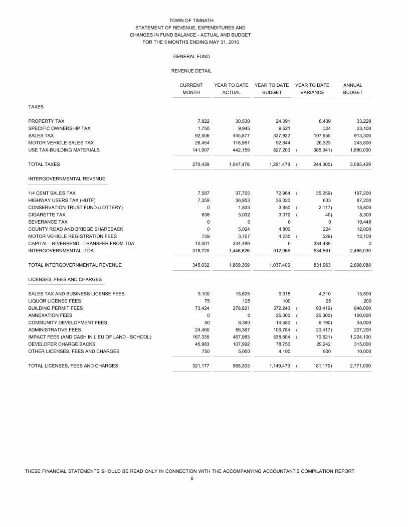
TAXES
PROPERTY TAX 7,822 30,530 24,091 6,439 33,229
SPECIFIC OWNERSHIP TAX 1,750 9,945 9,621 324 23,100
SALES TAX 92,506 445,877 337,922 107,955 913,300
MOTOR VEHICLE SALES TAX 26,454 118,967 92,644 26,323 243,800
USE TAX-BUILDING MATERIALS 141,907 442,159 827,200 ( 385,041) 1,880,000
TOTAL TAXES 270,439 1,047,478 1,291,478 ( 244,000) 3,093,429
INTERGOVERNMENTAL REVENUE
1/4 CENT SALES TAX 7,587 37,705 72,964 ( 35,259) 197,200
HIGHWAY USERS TAX (HUTF) 7,359 36,953 36,320 633 87,200
CONSERVATION TRUST FUND (LOTTERY) 0 1,833 3,950 ( 2,117) 15,800
CIGARETTE TAX 636 3,032 3,072 ( 40) 8,300
SEVERANCE TAX 0 0 0 0 10,449
COUNTY ROAD AND BRIDGE SHAREBACK 0 5,024 4,800 224 12,000
MOTOR VEHICLE REGISTRATION FEES 729 3,707 4,235 ( 529) 12,100
CAPITAL - RIVERBEND - TRANSFER FROM TDA 10,001 334,489 0 334,489 0
INTERGOVERNMENTAL -TDA 318,720 1,446,626 912,065 534,561 2,465,039
TOTAL INTERGOVERNMENTAL REVENUE 345,032 1,869,369 1,037,406 831,963 2,808,088
LICENSES, FEES AND CHARGES
SALES TAX AND BUSINESS LICENSE FEES 9,100 13,625 9,315 4,310 13,500
LIQUOR LICENSE FEES 75 125 100 25 200
BUILDING PERMIT FEES 73,424 278,821 372,240 ( 93,419) 846,000
ANNEXATION FEES 0 0 25,000 ( 25,000) 100,000
COMMUNITY DEVELOPMENT FEES 50 8,390 14,580 ( 6,190) 35,000
ADMINISTRATIVE FEES 24,460 86,367 106,784 ( 20,417) 227,200
IMPACT FEES (AND CASH IN LIEU OF LAND - SCHOOL) 167,335 467,983 538,604 ( 70,621) 1,224,100
DEVELOPER CHARGE BACKS 45,983 107,992 78,750 29,242 315,000
OTHER LICENSES, FEES AND CHARGES 750 5,000 4,100 900 10,000
TOTAL LICENSES, FEES AND CHARGES 321,177 968,303 1,149,473 ( 181,170) 2,771,000

TOWN OF TIMNATH
STATEMENT OF REVENUE, EXPENDITURES AND
CHANGES IN FUND BALANCE - ACTUAL AND BUDGET
FOR THE 5 MONTHS ENDING MAY 31, 2015
GENERAL FUND
REVENUE DETAIL
CURRENT YEAR TO DATE YEAR TO DATE YEAR TO DATE ANNUAL
MONTH ACTUAL BUDGET VARIANCE BUDGET
THESE FINANCIAL STATEMENTS SHOULD BE READ ONLY IN CONNECTION WITH THE ACCOMPANYING ACCOUNTANT'S COMPILATION REPORT
7
OTHER
FRANCHISE FEES 1,998 16,957 38,841 ( 21,884) 117,700
FINES AND FORFEITURES 420 2,154 2,915 ( 761) 7,000
NET INVESTMENT INCOME 1,054 4,641 5,000 ( 359) 12,000
CONTRACT REIMBURSEMENTS 0 0 5,000 ( 5,000) 20,000
MISCELLANEOUS 17,939 48,514 8,000 40,514 20,000
TOTAL OTHER 21,411 72,266 59,756 12,510 176,700
TOTAL REVENUE 958,059 3,957,416 3,538,113 419,303 8,849,217

TOWN OF TIMNATH
STATEMENT OF REVENUE, EXPENDITURES AND
CHANGES IN FUND BALANCE - ACTUAL AND BUDGET
FOR THE 5 MONTHS ENDING MAY 31, 2015
GENERAL FUND
EXPENDITURE DETAIL
CURRENT YEAR TO DATE YEAR TO DATE YEAR TO DATE ANNUAL
MONTH ACTUAL BUDGET VARIANCE BUDGET
THESE FINANCIAL STATEMENTS SHOULD BE READ ONLY IN CONNECTION WITH THE ACCOMPANYING ACCOUNTANT'S COMPILATION REPORT
8
GENERAL GOVERNMENT
TOWN COUNCIL EXPENDITURES 2,145 3,617 1,400 ( 2,217) 4,000
TOWN ADMINISTRATION - SALARIES AND BENEFITS 32,206 167,625 175,535 7,910 421,286
TOWN CLERK - ELECTIONS 0 0 2,000 2,000 2,000
COUNTY TREASURER AND OTHER FEES 2,475 11,736 14,065 2,329 19,400
DUES AND MEMBERSHIPS 246 3,348 2,790 ( 558) 15,500
FINANCE - CONTRACTED 15,470 104,930 112,500 7,570 266,000
HUMAN RESOURCES - CONTRACTED 45 4,685 250 ( 4,435) 3,500
INFORMATION TECHNOLOGY-CONTRACTED 2,195 21,163 31,240 10,077 75,000
INFORMATION TECHNOLOGY-HARDWARE & SOFTWARE 1,014 10,956 25,650 14,694 42,000
LEGAL - CONTRACTED 33,019 142,771 135,000 ( 7,771) 324,000
LEGAL - OUT OF SCOPE 1,907 50,272 12,500 ( 37,772) 25,000
LEGAL - SPECIAL COUNSEL 514 15,182 41,000 25,818 100,000
AUDIT 0 0 6,685 6,685 19,100
CONSULTING ( 729) 19,155 17,500 ( 1,655) 35,000
INSURANCE 0 21,475 21,000 ( 475) 42,000
GENERAL OFFICE AND ADMINISTRATION 5,247 23,373 49,910 26,537 101,000
TOWN EVENTS 2,578 4,641 28,250 23,609 172,000
COMMUNITY ENGAGEMENT 0 3,245 12,500 9,255 25,000
ECONOMIC DEVELOPMENT 16,905 64,870 91,250 26,380 219,000
OTHER 13 8,190 12,500 4,310 50,000
TOTAL GENERAL GOVERNMENT 115,250 681,233 793,525 112,292 1,960,786

TOWN OF TIMNATH
STATEMENT OF REVENUE, EXPENDITURES AND
CHANGES IN FUND BALANCE - ACTUAL AND BUDGET
FOR THE 5 MONTHS ENDING MAY 31, 2015
GENERAL FUND
EXPENDITURE DETAIL
CURRENT YEAR TO DATE YEAR TO DATE YEAR TO DATE ANNUAL
MONTH ACTUAL BUDGET VARIANCE BUDGET
THESE FINANCIAL STATEMENTS SHOULD BE READ ONLY IN CONNECTION WITH THE ACCOMPANYING ACCOUNTANT'S COMPILATION REPORT
9
MUNICIPAL COURT
MUNICIPAL JUDGE 195 930 1,250 320 3,000
LEGAL 0 4,400 5,500 1,100 13,200
TRANSLATOR 80 80 500 420 1,000
TOTAL MUNICIPAL COURT 275 5,410 7,250 1,840 17,200
COMMUNITY DEVELOPMENT
PLANNING SERVICES - CONTRACTED 22,428 128,912 127,082 ( 1,830) 305,000
MASTER PLANNING STUDIES 9,385 40,221 169,950 129,729 206,000
CONSULTING SERVICES 0 6,006 5,000 ( 1,006) 10,000
BUILDING PERMITS - CONTRACTED 2,995 14,851 16,600 1,749 40,000
CODE ENFORCEMENT - CONTRACTED 1,625 5,429 10,416 4,987 25,000
DEVELOPMENT REVIEW 53,164 173,168 145,830 ( 27,338) 350,000
GENERAL OFFICE AND ADMINISTRATION 500 3,403 5,600 2,197 13,500
OTHER 38 94 3,400 3,306 3,800
TOTAL COMMUNITY DEVELOPMENT 90,135 372,084 483,878 111,794 953,300
PUBLIC SAFETY
SALARIES AND BENEFITS 23,652 99,691 106,333 6,643 318,438
GENERAL OFFICE AND ADMINISTRATION 275 1,873 2,375 502 5,700
EQUIPMENT 2,271 7,336 9,600 2,264 19,200
CONTRACTED SERVICES 0 23,605 24,494 889 50,289
VEHICLES AND MAINTENANCE 203 1,927 57,410 55,483 67,000
TRAINING 0 0 2,100 2,100 4,200
OTHER 548 5,314 4,595 ( 719) 9,850
TOTAL PUBLIC SAFETY 26,949 139,746 206,907 67,161 474,677
TOWN OF TIMNATH
STATEMENT OF REVENUE, EXPENDITURES AND
CHANGES IN FUND BALANCE - ACTUAL AND BUDGET
FOR THE 5 MONTHS ENDING MAY 31, 2015
GENERAL FUND
EXPENDITURE DETAIL
CURRENT YEAR TO DATE YEAR TO DATE YEAR TO DATE ANNUAL
MONTH ACTUAL BUDGET VARIANCE BUDGET
THESE FINANCIAL STATEMENTS SHOULD BE READ ONLY IN CONNECTION WITH THE ACCOMPANYING ACCOUNTANT'S COMPILATION REPORT
10
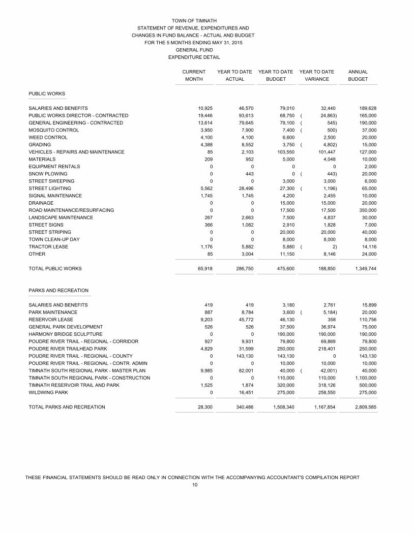
PUBLIC WORKS
SALARIES AND BENEFITS 10,925 46,570 79,010 32,440 189,628
PUBLIC WORKS DIRECTOR - CONTRACTED 19,446 93,613 68,750 ( 24,863) 165,000
GENERAL ENGINEERING - CONTRACTED 13,614 79,645 79,100 ( 545) 190,000
MOSQUITO CONTROL 3,950 7,900 7,400 ( 500) 37,000
WEED CONTROL 4,100 4,100 6,600 2,500 20,000
GRADING 4,388 8,552 3,750 ( 4,802) 15,000
VEHICLES - REPAIRS AND MAINTENANCE 85 2,103 103,550 101,447 127,000
MATERIALS 209 952 5,000 4,048 10,000
EQUIPMENT RENTALS 0 0 0 0 2,000
SNOW PLOWING 0 443 0 ( 443) 20,000
STREET SWEEPING 0 0 3,000 3,000 6,000
STREET LIGHTING 5,562 28,496 27,300 ( 1,196) 65,000
SIGNAL MAINTENANCE 1,745 1,745 4,200 2,455 10,000
DRAINAGE 0 0 15,000 15,000 20,000
ROAD MAINTENANCE/RESURFACING 0 0 17,500 17,500 350,000
LANDSCAPE MAINTENANCE 267 2,663 7,500 4,837 30,000
STREET SIGNS 366 1,082 2,910 1,828 7,000
STREET STRIPING 0 0 20,000 20,000 40,000
TOWN CLEAN-UP DAY 0 0 8,000 8,000 8,000
TRACTOR LEASE 1,176 5,882 5,880 ( 2) 14,116
OTHER 85 3,004 11,150 8,146 24,000
TOTAL PUBLIC WORKS 65,918 286,750 475,600 188,850 1,349,744
PARKS AND RECREATION
SALARIES AND BENEFITS 419 419 3,180 2,761 15,899
PARK MAINTENANCE 887 8,784 3,600 ( 5,184) 20,000
RESERVOIR LEASE 9,203 45,772 46,130 358 110,756
GENERAL PARK DEVELOPMENT 526 526 37,500 36,974 75,000
HARMONY BRIDGE SCULPTURE 0 0 190,000 190,000 190,000
POUDRE RIVER TRAIL - REGIONAL - CORRIDOR 927 9,931 79,800 69,869 79,800
POUDRE RIVER TRAILHEAD PARK 4,829 31,599 250,000 218,401 250,000
POUDRE RIVER TRAIL - REGIONAL - COUNTY 0 143,130 143,130 0 143,130
POUDRE RIVER TRAIL - REGIONAL - CONTR. ADMIN 0 0 10,000 10,000 10,000
TIMNATH SOUTH REGIONAL PARK - MASTER PLAN 9,985 82,001 40,000 ( 42,001) 40,000
TIMNATH SOUTH REGIONAL PARK - CONSTRUCTION 0 0 110,000 110,000 1,100,000
TIMNATH RESERVOIR TRAIL AND PARK 1,525 1,874 320,000 318,126 500,000
WILDWING PARK 0 16,451 275,000 258,550 275,000
TOTAL PARKS AND RECREATION 28,300 340,486 1,508,340 1,167,854 2,809,585

TOWN OF TIMNATH
STATEMENT OF REVENUE, EXPENDITURES AND
CHANGES IN FUND BALANCE - ACTUAL AND BUDGET
FOR THE 5 MONTHS ENDING MAY 31, 2015
GENERAL FUND
EXPENDITURE DETAIL
CURRENT YEAR TO DATE YEAR TO DATE YEAR TO DATE ANNUAL
MONTH ACTUAL BUDGET VARIANCE BUDGET
THESE FINANCIAL STATEMENTS SHOULD BE READ ONLY IN CONNECTION WITH THE ACCOMPANYING ACCOUNTANT'S COMPILATION REPORT
11
CAPITAL OUTLAY
ROADS
BETHKE WARNING LIGHTS 0 0 0 0 36,000
HARMONY ROAD PHASE IIA 11,613 20,780 0 ( 20,780) 0
HARMONY ROAD PHASE III 660 18,994 160,000 141,006 1,400,000
RIVERBEND ROAD 10,001 334,489 850,000 515,511 1,150,000
SUMMERFIELD PARKWAY DITCH CROSSING 0 35,069 60,000 24,931 490,000
BUILDINGS AND EQUIPMENT
EMERGENCY PREPAREDNESS 0 0 55,000 55,000 70,000
PUBLIC WORKS/TOWN ADMIN BUILDING 383 1,577 90,000 88,423 150,000
SPEEDING SIGN 0 0 25,000 25,000 25,000
WEBSITE UPGRADE 781 1,281 2,500 1,219 5,000
UTILITIES
OFFISTE SEWER EXTENSION 50,092 248,454 200,000 ( 48,454) 200,000
OLD TOWN IMPROVEMENTS - PHASE II 19,847 80,906 59,400 ( 21,506) 90,000
OLD TOWN SEWER CONNECTIONS 0 264 158,400 158,136 240,000
OLD TOWN SEWER TAP FEES 110,000 110,000 101,640 ( 8,360) 154,000
STORMWATER
BOXELDER - FORT COLLINS IGA 0 0 0 0 1,900,000
OTHER
COMMUNITY REVITALIZATION 0 0 462,500 462,500 1,850,000
CONTINGENCY 0 0 12,500 12,500 50,000
SIGNAGE AND MONUMENTATION 0 0 50,000 50,000 250,000
DOLA LOAN 0 0 0 0 70,112
TOTAL CAPITAL OUTLAY 203,378 851,815 2,286,940 1,435,125 8,130,112
TOTAL EXPENDITURES 530,206 2,677,524 5,762,440 3,084,916 15,695,404
TOWN OF TIMNATH
STATEMENT OF REVENUE, EXPENDITURES AND
CHANGES IN FUND BALANCE - ACTUAL AND BUDGET
FOR THE 5 MONTHS ENDING MAY 31, 2015
SPECIAL REVENUE FUND - GRANTS
CURRENT YEAR TO DATE YEAR TO DATE YEAR TO DATE ANNUAL
MONTH ACTUAL BUDGET VARIANCE BUDGET
THESE FINANCIAL STATEMENTS SHOULD BE READ ONLY IN CONNECTION WITH THE ACCOMPANYING ACCOUNTANT'S COMPILATION REPORT
12
REVENUE
STATE GRANTS
TIMNATH SOUTH - REGIONAL PARK - MASTER PLANNING 0 5,099 68,200 ( 63,101) 68,200
TOTAL REVENUE 0 5,099 68,200 ( 63,101) 68,200
EXPENDITURES
TOTAL EXPENDITURES 0 0 0 0 0
EXCESS OF REVENUE OVER
(UNDER) EXPENDITURES 0 5,099 68,200 ( 63,101) 68,200
OTHER FINANCING SOURCES (USES)
TRANSFERS OUT 0 ( 5,099) ( 68,200) 63,101 ( 68,200)
TOTAL OTHER FINANCING SOURCES (USES) 0 ( 5,099) ( 68,200) 63,101 ( 68,200)
EXCESS OF REVENUE AND OTHER FINANCING
SOURCES OVER (UNDER) EXPENDITURES AND
OTHER FINANCING USES 0 0 0 0 0
FUND BALANCE-ENDING 0 0 0 0 0

TIMNATH DEVELOPMENT AUTHORITY (TDA)
STATEMENT OF REVENUE, EXPENDITURES AND
CHANGES IN FUND BALANCES - ACTUAL AND BUDGET
FOR THE 5 MONTHS ENDING MAY 31, 2015
DEBT SERVICE FUND
CURRENT YEAR TO DATE YEAR TO DATE YEAR TO DATE ANNUAL
MONTH ACTUAL BUDGET VARIANCE BUDGET
THESE FINANCIAL STATEMENTS SHOULD BE READ ONLY IN CONNECTION WITH THE ACCOMPANYING ACCOUNTANT'S COMPILATION REPORT
13
REVENUE
TIF - PROPERTY TAXES 362,902 2,288,823 2,203,734 85,089 3,039,632
TIF - SALES TAXES 318,720 1,446,626 1,486,180 ( 39,554) 4,016,700
NET INVESTMENT INCOME 241 1,076 2,910 ( 1,834) 7,000
TOTAL REVENUE 681,863 3,736,526 3,692,824 43,702 7,063,332
EXPENDITURES
LOAN INTEREST 0 0 0 0 1,370,793
LOAN PRINCIPAL 0 0 0 0 1,800,000
MISCELLANEOUS 63 100 175 75 500
CAPITAL OUTLAY
BOXELDER - BBRSA IGA 0 0 250,000 250,000 250,000
DEVELOPER SHAREBACK INCENTIVE 0 239,849 258,940 19,091 1,177,000
RIVERBEND PROJECT - TRANSFER TO TOWN 10,001 334,489 0 ( 334,489) 0
TRANSFER TO TOWN - GENERAL 318,720 1,446,626 912,065 ( 534,561) 2,465,039
TOTAL EXPENDITURES 328,785 2,021,065 1,421,180 ( 599,885) 7,063,332
EXCESS OF REVENUE OVER
(UNDER) EXPENDITURES 353,078 1,715,461 2,271,644 ( 556,183) 0
OTHER FINANCING SOURCES (USES)
TOTAL OTHER FINANCING SOURCES (USES) 0 0 0 0 0
EXCESS OF REVENUE AND OTHER FINANCING
SOURCES OVER (UNDER) EXPENDITURES AND
OTHER FINANCING USES 353,078 1,715,461 2,271,644 ( 556,183) 0
FUND BALANCE-BEGINNING 0 3,980,300 2,500,000 1,480,300 2,500,000
FUND BALANCE-ENDING 353,078 5,695,761 4,771,644 924,117 2,500,000

SUPPLEMENTARY INFORMATION
This financial information should be read only in connection with the accompanying accountant's compilation report.14a
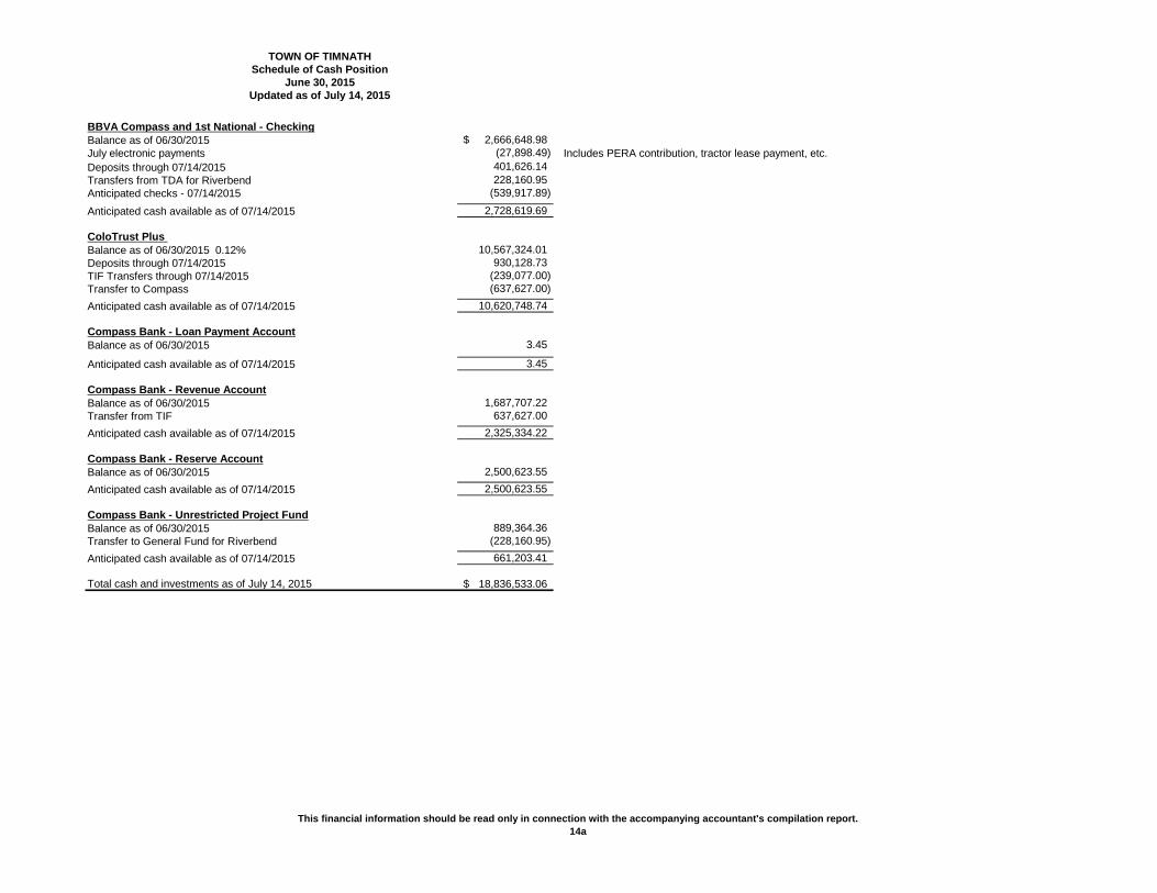
TOWN OF TIMNATHSchedule of Cash Position
June 30, 2015
BBVA Compass and 1st National - CheckingBalance as of 06/30/2015 2,666,648.98$ July electronic payments (27,898.49) Includes PERA contribution, tractor lease payment, etc.Deposits through 07/14/2015 401,626.14 Transfers from TDA for Riverbend 228,160.95 Anticipated checks - 07/14/2015 (539,917.89)
Anticipated cash available as of 07/14/2015 2,728,619.69
ColoTrust Plus Balance as of 06/30/2015 0.12% 10,567,324.01 Deposits through 07/14/2015 930,128.73 TIF Transfers through 07/14/2015 (239,077.00) Transfer to Compass (637,627.00) Anticipated cash available as of 07/14/2015 10,620,748.74
Compass Bank - Loan Payment AccountBalance as of 06/30/2015 3.45
Anticipated cash available as of 07/14/2015 3.45
Compass Bank - Revenue AccountBalance as of 06/30/2015 1,687,707.22 Transfer from TIF 637,627.00 Anticipated cash available as of 07/14/2015 2,325,334.22
Compass Bank - Reserve AccountBalance as of 06/30/2015 2,500,623.55 Anticipated cash available as of 07/14/2015 2,500,623.55
Compass Bank - Unrestricted Project FundBalance as of 06/30/2015 889,364.36 Transfer to General Fund for Riverbend (228,160.95) Anticipated cash available as of 07/14/2015 661,203.41
Total cash and investments as of July 14, 2015 18,836,533.06$
Updated as of July 14, 2015

This financial information should be read only in connection with the accompanying accountant's compilation report.14b
TOWN OF TIMNATHSchedule of Cash Position
June 30, 2015
Cash and investments restricted and designated for:
Restricted 1/4 cent sales tax 461,143.18 Funds can be used for open space acquisition & preservation of public open space Conservation trust fund 44,971.43 Funds can be used for acquisition, development & maintenance for park and recreation Impact Fee - Police 143,094.33 Capital only related to Public Safety Impact Fee - Parks 2,585,976.63 Capital only related to Parks Cash in Lieu of Land - Schools 1,132,246.61 Capital only related to Schools TDA - Capital Project Fund 661,203.41 Available to draw from Compass Bank for capital funding-to be used for Riverbend Project TDA - Poudre Valley Fire 1,900,212.90 Pass through of property taxes for Fire District TDA - Debt Service 4,825,961.22 Restricted revenues pledged to debt and reserve account
Total restricted and designated cash and investments as of July 14, 2015 11,754,809.71
Unrestricted Fund Balance as of July 14, 2015 7,081,723.35$
Updated as of July 14, 2015Continued
This financial information should be read only in connection with the accompanying accountant's compilation report.15
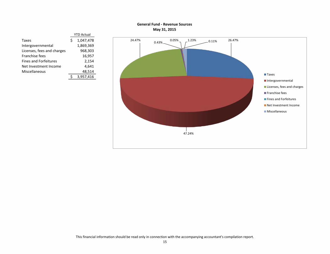
YTD Actual
Taxes 1,047,478$ Intergovernmental 1,869,369 Licenses, fees and charges 968,303 Franchise fees 16,957 Fines and Forfeitures 2,154 Net Investment Income 4,641 Miscellaneous 48,514
3,957,416$
General Fund - Revenue SourcesMay 31, 2015
26.47%
47.24%
24.47% 0.43%
0.05% 0.11% 1.23%
Taxes
Intergovernmental
Licenses, fees and charges
Franchise fees
Fines and Forfeitures
Net Investment Income
Miscellaneous

This financial information should be read only in connection with the accompanying accountant's compilation report16
General Fund YTD ActualProperty Tax 30,530$ Specific Ownership Tax 9,945Sales Tax 445,877Use Tax-Building Materials 442,159Motor Vehicle Sales Tax 118,967Total 1,047,478$
TDA YTD ActualTIF - Property Taxes 2,288,823$ TIF - Sales Taxes 1,446,626Total 3,735,449$
Tax Total 4,782,927$
Tax Breakdown - General Fund and TDAMay 31, 2015
$-
$20,000
$40,000
$60,000
$80,000
$100,000
$120,000
$140,000
$160,000
Jan-15 Feb-15 Mar-15 Apr-15 May-15
Property Tax
Specific Ownership Tax
Sales Tax
Use Tax-Building Materials
Motor Vehicle Sales Tax
$-
$200,000
$400,000
$600,000
$800,000
$1,000,000
$1,200,000
Jan-15 Feb-15 Mar-15 Apr-15 May-15
TIF - Property Taxes
TIF - Sales Taxes
This financial information should be read only in connection with the accompanying accountant's compilation report.17
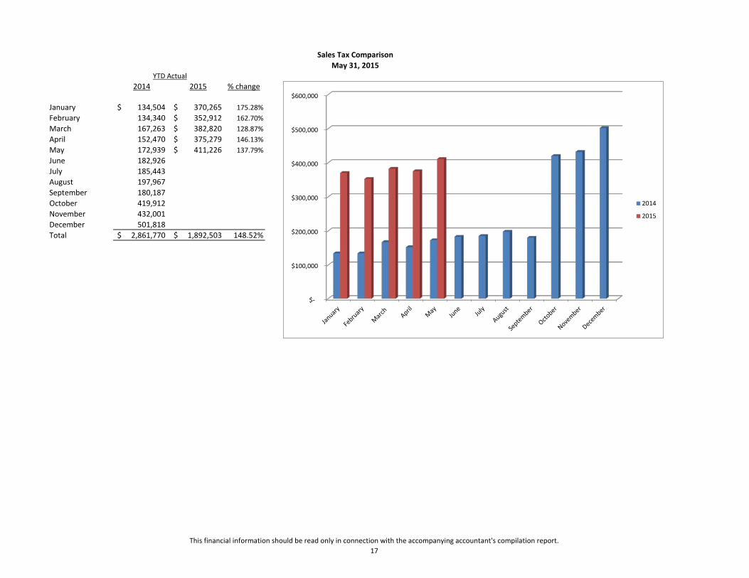
2014 2015 % change
January 134,504$ 370,265$ 175.28%February 134,340 352,912$ 162.70%March 167,263 382,820$ 128.87%April 152,470 375,279$ 146.13%May 172,939 411,226$ 137.79%June 182,926 July 185,443 August 197,967 September 180,187 October 419,912 November 432,001 December 501,818 Total 2,861,770$ 1,892,503$ 148.52%
May 31, 2015YTD Actual
Sales Tax Comparison
$-
$100,000
$200,000
$300,000
$400,000
$500,000
$600,000
2014
2015

This financial information should be read only in connection with the accompanying accountant's compilation report.18
2014 2015 % change
January 14 9 -35.71%February 15 16 6.67%March 14 18 28.57%April 20 9 -55.00%May 21 27 28.57%June 12July 17August 12September 8October 11November 12December 11Total 167 79 -5.95%
May 31, 2015YTD Actual
Single Family Residential Building Permits
0
5
10
15
20
25
30
2014
2015

This financial information should be read only in connection with the accompanying accountant's compilation report.19
YTD YTDRevenue Actual Budget
Taxes 1,047,478$ 1,291,478$ Intergovernmental 1,869,369 1,037,406 Licenses, Fees and Charges 968,303 1,149,473 Franchise Fees 16,957 38,841 Fines and Forfeitures 2,154 2,915 Interest Income 4,641 5,000 Contract Reimbursements - 5,000 Other Income 48,514 8,000 Total 3,957,416$ 3,538,113$
YTD YTDExpenditures Actual Budget
General Government 681,233$ 793,525$ Municipal Court 5,410 7,250 Community Development 372,084 483,878 Public Safety 139,746 206,907 Public Works 286,750 475,600 Park and Recreation 340,486 1,508,340 Capital Outlay 851,815 2,286,940 Total 2,677,524$ 5,762,440$
General Fund - Revenue and Expenditures - Actual to Budget ComparisonMay 31, 2015
$-
$200,000
$400,000
$600,000
$800,000
$1,000,000
$1,200,000
$1,400,000
$1,600,000
$1,800,000
$2,000,000
Actual
Budget
$-
$500,000
$1,000,000
$1,500,000
$2,000,000
$2,500,000
Actual
Budget
TOWN COUNCIL COMMUNICATION
Meeting Date: July 28, 2015
Item: Engineering & Public Works Report Ordinance
Resolution For Information X Presented by:
Don Taranto KEY POINTS/SUPPORTING INFORMATION:
1. Old Town Improvement Project / Offsite Sewer (Phase 1)
a. There is a section north of the school that will need to be repaired in the spring before the District will accept the line. Gerrard is preparing a schedule for the repair. They have been told it must be completed before school starts.
b. Connections are underway. As of 7/21/15, there have been 19 conversions completed. Pumping of tanks and rehabilitation of those properties underway. All but 2 properties have returned the required paperwork to accept Town assistance.
2. Riverbend Infrastructure
a. Project is complete and road has been opened.
3. Harmony Road Phase 3 a. Design finalization underway.
4. Summerfield Parkway RR Crossing
a. Final Design in progress. We have met with the railroad, but are waiting on them to provide a crossing agreement for approval for their part of the design.
5. 2015 Road Maintenance Program
a. Agreements for both Road Maintenance and Striping are being executed
6. Development Construction Activities a. Brunner Farm – Phase 1 is complete pending Initial Acceptance. Construction of the
remaining phases is underway. b. Wild Wing (Latham Pkwy) – Developer is required to complete the off-site roadway
improvements by fall of this year. Construction has started and is scheduled to be complete by October 31, 2015
7. Commercial Construction Activities
a. NoCo Self Storage – Construction continues. b. Hartford Homes Office Building – Complete with TCO issued.

5 year CIP 2015
(July 2015 update in red)
o Bethke School Zone
o 2015: $36,000
For improvements of school zone & crosswalk signage around Bethke
Waiting for full construction of School House Drive this year, then action
will be taken
o Harmony Road IIA Landscape
o 2015: $150,000
For design and installation of the Harmony Phase II Medians
Bid in May 2015, Construction June/July 2015
Bid opening on July 24th, Construction Starting in early August.
Update for Council on 7/28 Meeting.
o Harmony Road Widening Phase III
o 2015: $500,000
For design, property acquisition, and utility relocations that can be done
before project start.
Timnath Landings responsible for ~1/2 of costs per SIA
On Schedule
o 2016: $5,200,000
For widening of Harmony Road from the RR tracks to the east side of the
TROC crossing
Includes finishing median west of the tracks and landscaping
Includes RR crossing
Includes widening intersection at Three Bell with new signals
Includes new TROC crossing
o Harmony Road Widening Phase IV
o 2016: $6,700,000
Widening of Harmony Road from Three Bell to the County Line
o Harmony Interchange Landscape South
o 2016: $10,000
Review and Coordination with Adjacent property owner for ROW
improvements between Weitzel and I‐25
o Harmony Interchange Landscape North
o 2017: $30,000
Design of improvements on north side of Harmony between Weitzel and
I‐25
o 2018: $250,000
Construction of improvements
o Main Street Traffic Circle
o 2015: $15,000
Temporary improvements to the traffic circle in Main Street
To be combined with Harmony Median Project, will be change ordered
into contract, once pricing received from contractor.
o 4th Street Pedestrian Improvements
o 2015: $15,000
Design of improvements between Main St and the Parkway
o 2018: $ 500,000
Final design and construction of streetscape improvements
o Parkway Improvements
o 2018: $1,000,000
Town participation with developer on first phase of parkway construction
o 2019: $1,000,000
Town participation with developer on next phase of parkway
construction
o Riverbend Infrastructure
o 2015: $2,023,000
Completion of Signal Tree & Stone Fly
Includes allotment for dry utilities, street lights, and landscape
On Schedule
o Riverbend Fire Station Emergency Signal
o 2016: $200,000
Installation of emergency traffic signal at Harmony Rd & Signal Tree Dr.
intersection
o Summerfield Parkway Ditch Crossing
o 2015: $200,000
Completion of design and RR design fees
On Schedule
o 2016: $ 650,000
Construction of crossing
o Offsite Sewer Extension (TDA)
o 2015: $215,000
For work completed on the offsite sewer but not billed yet by contractor
On Schedule
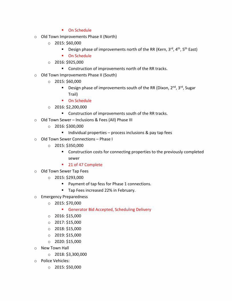
o Old Town Improvements Phase II (North)
o 2015: $60,000
Design phase of improvements north of the RR (Kern, 3rd, 4th, 5th East)
On Schedule
o 2016: $925,000
Construction of improvements north of the RR tracks.
o Old Town Improvements Phase II (South)
o 2015: $60,000
Design phase of improvements south of the RR (Dixon, 2nd, 3rd, Sugar
Trail)
On Schedule
o 2016: $2,200,000
Construction of improvements south of the RR tracks.
o Old Town Sewer – Inclusions & Fees (All) Phase III
o 2016: $300,000
Individual properties – process inclusions & pay tap fees
o Old Town Sewer Connections – Phase I
o 2015: $350,000
Construction costs for connecting properties to the previously completed
sewer
21 of 47 Complete
o Old Town Sewer Tap Fees
o 2015: $293,000
Payment of tap fess for Phase 1 connections.
Tap Fees increased 22% in February.
o Emergency Preparedness
o 2015: $70,000
Generator Bid Accepted, Scheduling Delivery
o 2016: $15,000
o 2017: $15,000
o 2018: $15,000
o 2019: $15,000
o 2020: $15,000
o New Town Hall
o 2018: $3,300,000
o Police Vehicles:
o 2015: $50,000

Purchased
o 2016: $51,000
o 2017: $52,000
o 2018: $53,000
o 2019: $54,000
o 2020: $55,000
o Public Works/Town Admin Building
o 2015: $150,000
Public Works out Building / Site Plan
Design 95% complete, out to Bid in August, construction in September
o 2016: $75,000
Fencing and other improvements
o Public Works Vehicles and Equipment
o 2015: $90,000
Take Delivery of New Plow Truck in Late July
o 2016: $100,000
o 2017: $100,000
o 2018: $100,000
o 2019: $100,000
o 2020: $100,000
o Speeding Sign
o 2015: $25,000
Portable trailer that shows speed limit & driver’s speed
Waiting for Quotes on multiple models
o Tractor Lease
o 2015: $14,116
On Schedule
o 2016: $14,116
o 2017: $1,176
o Website Upgrade
o 2015: $15,000
Complete
o 2018: $25,000
o 2020: $25,000
o General Park Development
o 2015: $50,000
Funds for Small Projects ie. Benches for Old Town, Bike Racks, contribute
to Metro Dist Park enhancements, etc.

o 2016: $75,000
o 2017: $75,000
o 2018: $75,000
o 2019: $75,000
o 2020: $75,000
o Harmony Bridge Sculpture
o 2015: $100,000
North West Abutment
Under Design
o 2016: $100,000
Other 3 corners small improvements
o Park and Recreation Center
o 2020: $4,000,000
Placeholder for Town Facility or Contribution to shared facility
o Poudre River Trailhead Park
o 2015: 170,000
Parking Lot improvements and landscaping
Does not include $69,510.00 in Grant Revenue
On Schedule
o 2016: $200,000
Fishing improvements, Dock and Personal Watercraft Launch
o 2017: $100,000
Soft Trail and Shelters around Lake
o Poudre River Trail – Regional – Corridor
o 2015: $79,800
Timnath Match for GOCO Trail Grant easements
Some of this may not be utilized, we will know by the end of the summer
o Poudre Trail Regional – County
o 2015: $175,000
Timnath match for GOCO Trail Grant Construction
Includes projected project overuns
o Poudre Trail Regional – Design/Constr. Admin
o 2015: $10,000
Const Admin for the Trail Project
95% Complete
o Timnath South Regional Park – Master Plan
o 2016: $35,000
Update Master Plan based on phase one improvements

Grant applications for construction funding
o 2017: $7,500
Grant applications for construction funding
o 2018: $7,500
Grant applications for construction funding
o 2019: $7,500
Grant applications for construction funding
o Timnath South Regional Park – Construction
o 2015: $2,250,000
Initial improvements to north
Project to be bid in early August, Construction to start in September
o 2016: $750,000
Additional improvements on the North side of park site
o 2017: $1,500,000
Improvements to the south side of the park site
o 2018: $500,000
Future improvements
o 2019: $200,000
Future improvements
o 2020: $150,000
Future improvements
o Timnath Reservoir Trail and Park
o 2015: $450,000
Masterplan
Shoreline Improvements
Irrigation Pump / System
Water Share
Masterplan for end of the year, Pursuing Water Share and Irrigation
Design. Shore Line Improvements when water goes down.
o 2016: $350,000
Trail Improvements
Courtesy Dock
o 2017: $100,000
Future Improvements Per Master Plan
o 2018: $200,000
Future Improvements Per Master Plan
o 2019: $200,000
Future Improvements Per Master Plan
o 2020: $150,000
Future Improvements Per Master Plan
o General Trail Improvements
o 2016: $150,000
Potential Old Town to Fairview Connection
o 2017: $550,000
Harmony Road Underpass and Bridge of TROC
o 2018: $650,000
Harmony Road Trail improvements
o 2019: $150,000
Future Trail Improvements
o 2020: $250,000
Future Trail Improvements
o Wildwing Park
o 2015: $175,000
Landscape and irrigation Improvements
Amenities – Shade Structures and benches / tables
Doors for trash enclosure
Need Additional Parking lot improvements for Storm Soccer use, const in
August/Sept
o 2017: $200,000
Master Plan
o 2018: $200,000
Master Plan Improvements
o 2019: $500,000
Master Plan Improvements
o 2020: $500,000
Master Plan Improvements
o Boxelder Storm Water – Fort Collins Projects
o 2015: $2,000,000
Payment for the Prospect Road & Lake Canal crossing projects being done
by the City per agreement
Required for opening of culverts under I‐25
Contract Awarded
Construction in Late August
Project behind schedule but still should be completed in early 2016
Should not affect the Harmony Road and Summerfields Project
Construction

o Community Revitalization
o 2015: $1,850,000
o 2015: $1,000,000
o Contingency
o 2016: $50,000
o 2017: $50,000
o 2018: $50,000
o 2019: $50,000
o Railroad Crossing Improvements – Three Bell
o 2017: $500,000
Improve crossing to include arms
o Signage and monumentation
o 2015: $150,000
Refurb existing signage
Master Plan for Signage
Waiting for Bids on Refurb – MasterPlan in Fall/ Winter
o 2016: $100,000
Signage improvements town wide per Master Plan
o 2017: $50,000
Signage improvements town wide per Master Plan
o Poudre River Bridge (3rd to Gateway Park)
o 2017: $250,000
Design and CLOMR
o 2018: $1,000,000
Construction and LOMR
o Main Street Railroad Crossing Conversion
o 2018: $100,000
Convert the Main Street crossing for pedestrian use after the Parkway
opens
o Fire Station
o 2015: $148,000
Timnath Contribution to Fire Station Construction Pending IGA
Waiting on Developer
o Boxelder Stormwater Authority
o Ongoing loan payments per agreement with the authority
o 2015: $250,000
o 2016: $200,000
o 2017: $200,000

o 2018: $200,000
o 2019: $200,000
o 2020: $200,000
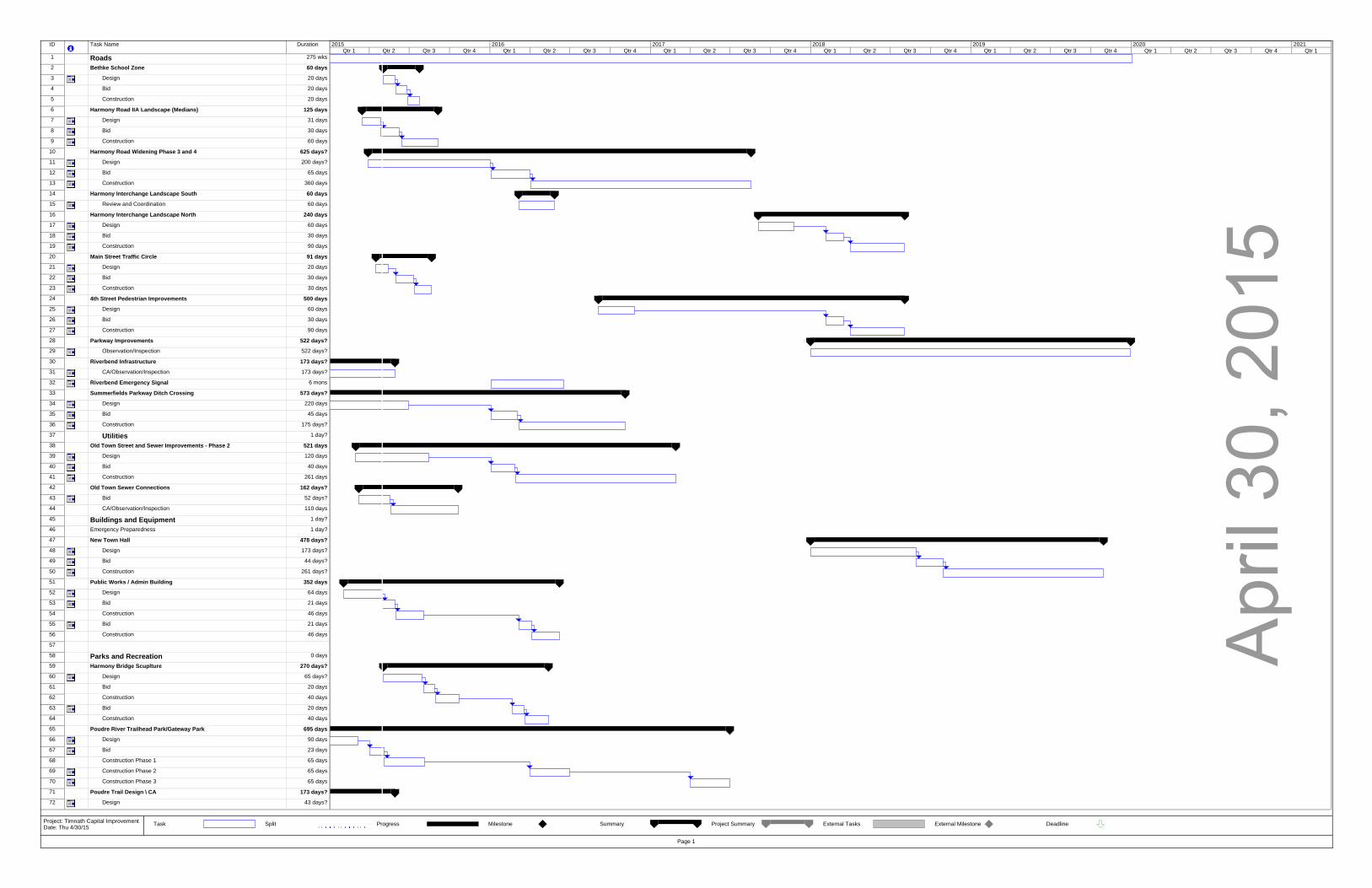
Apr
il 30
, 201
5
ID Task Name Duration
1 Roads 275 wks
2 Bethke School Zone 60 days
3 Design 20 days
4 Bid 20 days
5 Construction 20 days
6 Harmony Road IIA Landscape (Medians) 125 days
7 Design 31 days
8 Bid 30 days
9 Construction 60 days
10 Harmony Road Widening Phase 3 and 4 625 days?
11 Design 200 days?
12 Bid 65 days
13 Construction 360 days
14 Harmony Interchange Landscape South 60 days
15 Review and Coordination 60 days
16 Harmony Interchange Landscape North 240 days
17 Design 60 days
18 Bid 30 days
19 Construction 90 days
20 Main Street Traffic Circle 91 days
21 Design 20 days
22 Bid 30 days
23 Construction 30 days
24 4th Street Pedestrian Improvements 500 days
25 Design 60 days
26 Bid 30 days
27 Construction 90 days
28 Parkway Improvements 522 days?
29 Observation/Inspection 522 days?
30 Riverbend Infrastructure 173 days?
31 CA/Observation/Inspection 173 days?
32 Riverbend Emergency Signal 6 mons
33 Summerfields Parkway Ditch Crossing 573 days?
34 Design 220 days
35 Bid 45 days
36 Construction 175 days?
37 Utilities 1 day?
38 Old Town Street and Sewer Improvements - Phase 2 521 days
39 Design 120 days
40 Bid 40 days
41 Construction 261 days
42 Old Town Sewer Connections 162 days?
43 Bid 52 days?
44 CA/Observation/Inspection 110 days
45 Buildings and Equipment 1 day?
46 Emergency Preparedness 1 day?
47 New Town Hall 478 days?
48 Design 173 days?
49 Bid 44 days?
50 Construction 261 days?
51 Public Works / Admin Building 352 days
52 Design 64 days
53 Bid 21 days
54 Construction 46 days
55 Bid 21 days
56 Construction 46 days
57
58 Parks and Recreation 0 days
59 Harmony Bridge Scuplture 270 days?
60 Design 65 days?
61 Bid 20 days
62 Construction 40 days
63 Bid 20 days
64 Construction 40 days
65 Poudre River Trailhead Park/Gateway Park 695 days
66 Design 90 days
67 Bid 23 days
68 Construction Phase 1 65 days
69 Construction Phase 2 65 days
70 Construction Phase 3 65 days
71 Poudre Trail Design \ CA 173 days?
72 Design 43 days?
Qtr 1 Qtr 2 Qtr 3 Qtr 4 Qtr 1 Qtr 2 Qtr 3 Qtr 4 Qtr 1 Qtr 2 Qtr 3 Qtr 4 Qtr 1 Qtr 2 Qtr 3 Qtr 4 Qtr 1 Qtr 2 Qtr 3 Qtr 4 Qtr 1 Qtr 2 Qtr 3 Qtr 4 Qtr 12015 2016 2017 2018 2019 2020 2021
Task Split Progress Milestone Summary Project Summary External Tasks External Milestone Deadline
Page 1
Project: Timnath Capital Improvement Date: Thu 4/30/15

Apr
il 30
, 201
5
ID Task Name Duration
73 CA/Observation/Inspection 130 days
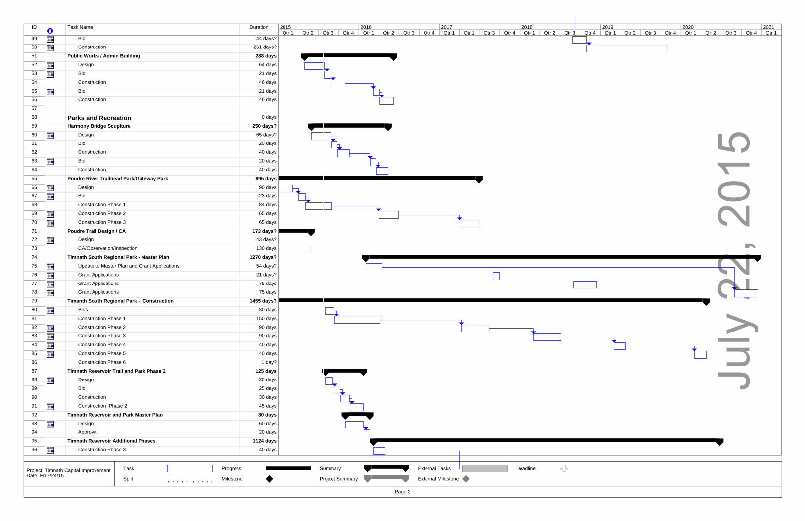
74 Timnath South Regional Park - Master Plan 1270 days?
75 Update to Master Plan and Grant Applications 54 days?
76 Grant Applications 21 days?
77 Grant Applications 75 days
78 Grant Applications 75 days
79 Timanth South Regional Park - Construction 1339 days
80 Bids 30 days
81 Construction Phase 1 110 days
82 Construction Phase 2 90 days
83 Construction Phase 3 90 days
84 Construction Phase 4 40 days
85 Construction Phase 5 40 days
86 Construction Phase 6 40 days
87 Timnath Reservoir Trail and Park Phase 2 198 days
88 Design 45 days
89 Bid 20 days
90 Construction 45 days
91 Construction Phase 2 45 days
92 Timnath Reservoir and Park Master Plan 80 days
93 Design 60 days
94 Approval 20 days
95 Timnath Reservoir Additional Phases 1124 days
96 Construction Phase 3 40 days
97 Construction Phase 4 40 days
98 Construction Phase 5 40 days
99 Construction Phase 6 40 days
100 Construction Phase 7 40 days
101 General Trail Improvements 1286 days
102 Trail Improvement Plan 90 days
103 Construction 2016 90 days
104 Construction 2017 90 days
105 Construction 2018 90 days
106 Construction 2019 90 days
107 Construction 2020 90 days
108 Wildwing Park Phase 2 80 days
109 Design 20 days
110 Bid 20 days
111 Construction 40 days
112 Wildwing Park Masterplan 65 days
113 Design 45 days
114 Approval 20 days
115 Wildwing Park Future Construction 561 days
116 Construction Phase 3 60 days
117 Construction Phase 4 60 days
118 Construction Phase 5 60 days
119
120 Stormwater 1 day?
121 Boxelder Stormwater - Fort Collins Projects 259 days
122 Coordination 259 days
123
124 Other 1 day?
125 Railroad Crossing Improvements 3 Bell 190 days
126 Design 90 days
127 Bid 40 days
128 Construction 60 days
129 Signage and Monuments 588 days
130 Design 40 days
131 Bid 20 days
132 Construction 40 days
133 Construction 2016 40 days
134 Construction 2017 40 days
135 Poudre River Bridge (3rd to Gateway) + River Enhancement 280 days
136 Design 120 days
137 Bid 40 days
138 Construction 120 days
139 Main Street Railroad Crossing Conversion 100 days
140 Design 40 days
141 Bid 20 days
142 Construction 40 days
143 Latham Parkway - Bus Grove to Wildwing 153 days?
144 Observation/Inspection 153 days?
Qtr 1 Qtr 2 Qtr 3 Qtr 4 Qtr 1 Qtr 2 Qtr 3 Qtr 4 Qtr 1 Qtr 2 Qtr 3 Qtr 4 Qtr 1 Qtr 2 Qtr 3 Qtr 4 Qtr 1 Qtr 2 Qtr 3 Qtr 4 Qtr 1 Qtr 2 Qtr 3 Qtr 4 Qtr 12015 2016 2017 2018 2019 2020 2021
Task Split Progress Milestone Summary Project Summary External Tasks External Milestone Deadline
Page 2
Project: Timnath Capital Improvement Date: Thu 4/30/15
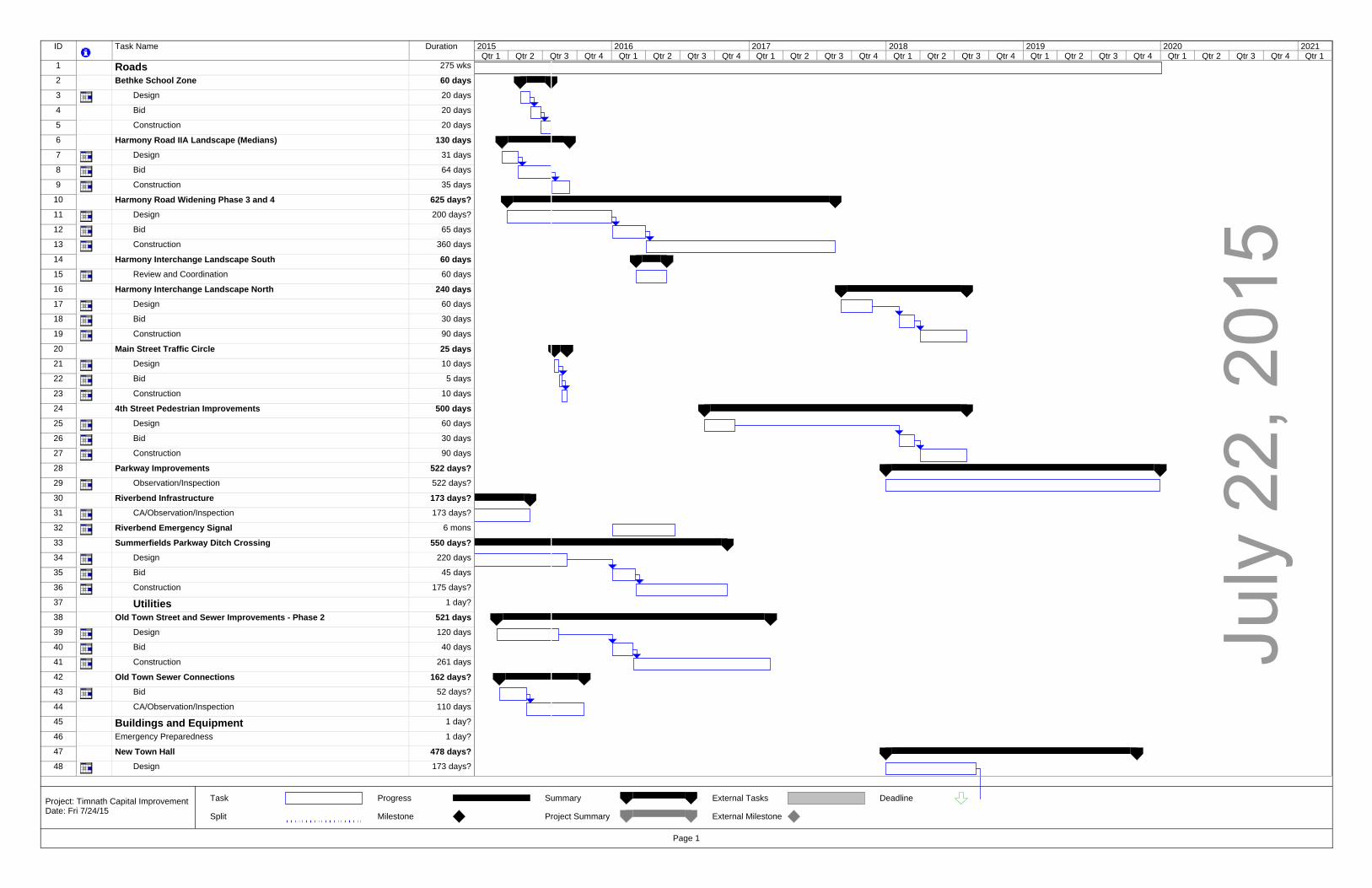
July
22,
201
5
ID Task Name Duration
1 Roads 275 wks
2 Bethke School Zone 60 days3 Design 20 days
4 Bid 20 days
5 Construction 20 days
6 Harmony Road IIA Landscape (Medians) 130 days7 Design 31 days
8 Bid 64 days
9 Construction 35 days
10 Harmony Road Widening Phase 3 and 4 625 days?11 Design 200 days?
12 Bid 65 days
13 Construction 360 days
14 Harmony Interchange Landscape South 60 days15 Review and Coordination 60 days
16 Harmony Interchange Landscape North 240 days17 Design 60 days
18 Bid 30 days
19 Construction 90 days
20 Main Street Traffic Circle 25 days21 Design 10 days
22 Bid 5 days
23 Construction 10 days
24 4th Street Pedestrian Improvements 500 days25 Design 60 days
26 Bid 30 days
27 Construction 90 days
28 Parkway Improvements 522 days?29 Observation/Inspection 522 days?
30 Riverbend Infrastructure 173 days?31 CA/Observation/Inspection 173 days?
32 Riverbend Emergency Signal 6 mons
33 Summerfields Parkway Ditch Crossing 550 days?34 Design 220 days
35 Bid 45 days
36 Construction 175 days?
37 Utilities 1 day?
38 Old Town Street and Sewer Improvements - Phase 2 521 days39 Design 120 days
40 Bid 40 days
41 Construction 261 days
42 Old Town Sewer Connections 162 days?43 Bid 52 days?
44 CA/Observation/Inspection 110 days
45 Buildings and Equipment 1 day?
46 Emergency Preparedness 1 day?
47 New Town Hall 478 days?48 Design 173 days?
Qtr 1 Qtr 2 Qtr 3 Qtr 4 Qtr 1 Qtr 2 Qtr 3 Qtr 4 Qtr 1 Qtr 2 Qtr 3 Qtr 4 Qtr 1 Qtr 2 Qtr 3 Qtr 4 Qtr 1 Qtr 2 Qtr 3 Qtr 4 Qtr 1 Qtr 2 Qtr 3 Qtr 4 Qtr 12015 2016 2017 2018 2019 2020 2021
Task
Split
Progress
Milestone
Summary
Project Summary
External Tasks
External Milestone
Deadline
Page 1
Project: Timnath Capital Improvement Date: Fri 7/24/15
July
22,
201
5
ID Task Name Duration
49 Bid 44 days?
50 Construction 261 days?
51 Public Works / Admin Building 288 days52 Design 64 days
53 Bid 21 days
54 Construction 46 days
55 Bid 21 days
56 Construction 46 days
57
58 Parks and Recreation 0 days
59 Harmony Bridge Scuplture 250 days?60 Design 65 days?
61 Bid 20 days
62 Construction 40 days
63 Bid 20 days
64 Construction 40 days
65 Poudre River Trailhead Park/Gateway Park 695 days66 Design 90 days
67 Bid 23 days
68 Construction Phase 1 84 days
69 Construction Phase 2 65 days
70 Construction Phase 3 65 days
71 Poudre Trail Design \ CA 173 days?72 Design 43 days?
73 CA/Observation/Inspection 130 days
74 Timnath South Regional Park - Master Plan 1270 days?75 Update to Master Plan and Grant Applications 54 days?
76 Grant Applications 21 days?
77 Grant Applications 75 days
78 Grant Applications 75 days
79 Timanth South Regional Park - Construction 1455 days?80 Bids 30 days
81 Construction Phase 1 150 days
82 Construction Phase 2 90 days
83 Construction Phase 3 90 days
84 Construction Phase 4 40 days
85 Construction Phase 5 40 days
86 Construction Phase 6 1 day?
87 Timnath Reservoir Trail and Park Phase 2 125 days88 Design 25 days
89 Bid 25 days
90 Construction 30 days
91 Construction Phase 2 45 days
92 Timnath Reservoir and Park Master Plan 80 days93 Design 60 days
94 Approval 20 days
95 Timnath Reservoir Additional Phases 1124 days96 Construction Phase 3 40 days
Qtr 1 Qtr 2 Qtr 3 Qtr 4 Qtr 1 Qtr 2 Qtr 3 Qtr 4 Qtr 1 Qtr 2 Qtr 3 Qtr 4 Qtr 1 Qtr 2 Qtr 3 Qtr 4 Qtr 1 Qtr 2 Qtr 3 Qtr 4 Qtr 1 Qtr 2 Qtr 3 Qtr 4 Qtr 12015 2016 2017 2018 2019 2020 2021
Task
Split
Progress
Milestone
Summary
Project Summary
External Tasks
External Milestone
Deadline
Page 2
Project: Timnath Capital Improvement Date: Fri 7/24/15
July
22,
201
5
ID Task Name Duration
97 Construction Phase 4 40 days
98 Construction Phase 5 40 days
99 Construction Phase 6 40 days
100 Construction Phase 7 40 days
101 General Trail Improvements 1286 days102 Trail Improvement Plan 90 days
103 Construction 2016 90 days
104 Construction 2017 90 days
105 Construction 2018 90 days
106 Construction 2019 90 days
107 Construction 2020 90 days
108 Wildwing Park Phase 2 80 days109 Design 20 days
110 Bid 20 days
111 Construction 40 days
112 Wildwing Park Masterplan 65 days113 Design 45 days
114 Approval 20 days
115 Wildwing Park Future Construction 561 days116 Construction Phase 3 60 days
117 Construction Phase 4 60 days
118 Construction Phase 5 60 days
119
120 Stormwater 1 day?
121 Boxelder Stormwater - Fort Collins Projects 281 days122 Coordination 281 days
123
124 Other 1 day?
125 Railroad Crossing Improvements 3 Bell 190 days126 Design 90 days
127 Bid 40 days
128 Construction 60 days
129 Signage and Monuments 490 days130 Design 40 days
131 Bid 20 days
132 Construction 40 days
133 Construction 2016 40 days
134 Construction 2017 40 days
135 Poudre River Bridge (3rd to Gateway) + River Enhancement 280 days136 Design 120 days
137 Bid 40 days
138 Construction 120 days
139 Main Street Railroad Crossing Conversion 100 days140 Design 40 days
141 Bid 20 days
142 Construction 40 days
143 Latham Parkway - Bus Grove to Wildwing 153 days?144 Observation/Inspection 153 days?
Qtr 1 Qtr 2 Qtr 3 Qtr 4 Qtr 1 Qtr 2 Qtr 3 Qtr 4 Qtr 1 Qtr 2 Qtr 3 Qtr 4 Qtr 1 Qtr 2 Qtr 3 Qtr 4 Qtr 1 Qtr 2 Qtr 3 Qtr 4 Qtr 1 Qtr 2 Qtr 3 Qtr 4 Qtr 12015 2016 2017 2018 2019 2020 2021
Task
Split
Progress
Milestone
Summary
Project Summary
External Tasks
External Milestone
Deadline
Page 3
Project: Timnath Capital Improvement Date: Fri 7/24/15

TOWN COUNCIL COMMUNICATION
Meeting Date: July 28, 2015
Item: Community Development Report
Ordinance Resolution Discussion
For Information X
Presented by: Matt Blakely
KEY POINTS/SUPPORTING INFORMATION:
1. Issued Building Permits: 2011 Single-Family Residential Total = 132 2012 Single-Family Residential Total = 141 2013 Single-Family Residential Total = 166 2014 Single-Family Residential Total = 167 2015 Single-Family Residential July = 17 2015 Single-Family Residential YTD (1/1/15 to 7/22/15) = 118
2. Current Development Actions:
a. Fisher Annexation and Sketch Plan: This is an annexation application for a 236 acre parcel located west of CR 5 and north of CR 40. Applicant has submitted an application and is out for Town and referral agency review
b. Timnath Commercial Center Annexation: This is an annexation application for a 115 acre parcel located north of Kechter Road and east of I-25. Staff is waiting on a resubmittal.
c. Wildwing PD Overlay: This is a PD Overlay application for the entire subdivision excepting the 1st filing lots. Typical R-2 zone requirements apply with the exception of several street standards criteria and density and dimensional standards. A Planning Commission Public Hearing was held on 7/21/2015 and the Sketch Plan was recommended for approval to Town Council unanimously by a 5-0 vote
d. Serratoga Falls Final Plat: This is a Final Plat proposal for approximately 250 lots that range in size from 6,500 square feet to 21,000 square feet on approximately 331 acres with a gross density of 1.6 DU/AC. The property is zoned R-2 and the proposal is consistent with the Sketch Plan and Preliminary Plat. A Planning Commission Public Hearing was held on 7/21/2015 and the Sketch Plan was recommended for approval to Town Council unanimously by a 5-0 vote
e. Timnath Landing Preliminary Plat: This is a Preliminary Plat proposal for approximately 607 single family detached lots that range in size from 4,275 square feet to 7,700 square feet on approximately 504 acres. The property has multiple zoning districts to accommodate the desired lot sizes. The Applicant has made a resubmittal and it is currently under review by Town Staff.
f. Timnath Landing Final Plat: This is a Final Plat proposal for approximately 214 single family detached lots that range in size from 4,275 square feet to 7,700 square feet on approximately 82 acres. The property has multiple zoning districts to accommodate the desired lot sizes. The Applicant has made a resubmittal and it is currently under review by Town Staff.
g. Timnath Landing PD Overlay: This is a PD Overlay application for the entire subdivision. The underlying zone district requirements will apply with the exception of modifications to several street standards criteria, density and dimensional standards, and Town Council Sketch Plan conditions. A Planning Commission Public Hearing was held on 7/21/2015 and the

Sketch Planned Development Overlay was recommended for approval to Town Council unanimously by a 5-0 vote. On 7/28/2015 the Town Council held a Public Hearing and continued the action to a future date
h. Timnath Ranch 6th Filing Final Plat: This is a Final Plat proposal for approximately 54 single family detached lots ranging in size from 6,000 square feet to 11,000 square feet on approximately 42 acres. This property is zoned R-2 and the proposal is consistent with that zoning. The Applicant has made a submittal and it is currently under review by Town Staff.
3. Projects: a. Land Use Code Update: Staff has met with the development community and presented the
draft land use code to the public. Comments are due back 6/26/2015 from the public and development community. Staff will be incorporating changes and preparing a final draft for Planning Commission and Town Council review in July, 2015.
b. Timnath Community Park: A Planning Commission Public Hearing was held on 11/4/14 and was recommended for approval to the Town Council with conditions. On 11/11/14 the Town Council held a Public Hearing and approved the plan with conditions. Staff is currently working on Phase 1 CD’s and provided Council with an update on April 14, 2015. Staff is currently getting bid documents together to bid out the project at the end of July.
c. Wildwing Park: Plans for landscape improvements are being prepared for summer of 2015 bidding and installation. Currently 2 acres are being improved to level out the fields and to improve water infiltration. Storm Academy has been awarded a grant to help supplement the turf improvements.
d. Gateway Park: Connell Resources has been awarded trailhead improvements and the park is currently under construction with a estimated completion at the end of August.
ADVANTAGES: N/A
DISADVANTAGES: N/A
FINANCIAL IMPACT: N/A
RECOMMENDATIONS: N/A
Phone: (970) 224-3211 FAX: (970) 224-3217 www.timnathgov.com 4800 Goodman St. Timnath, CO 80547
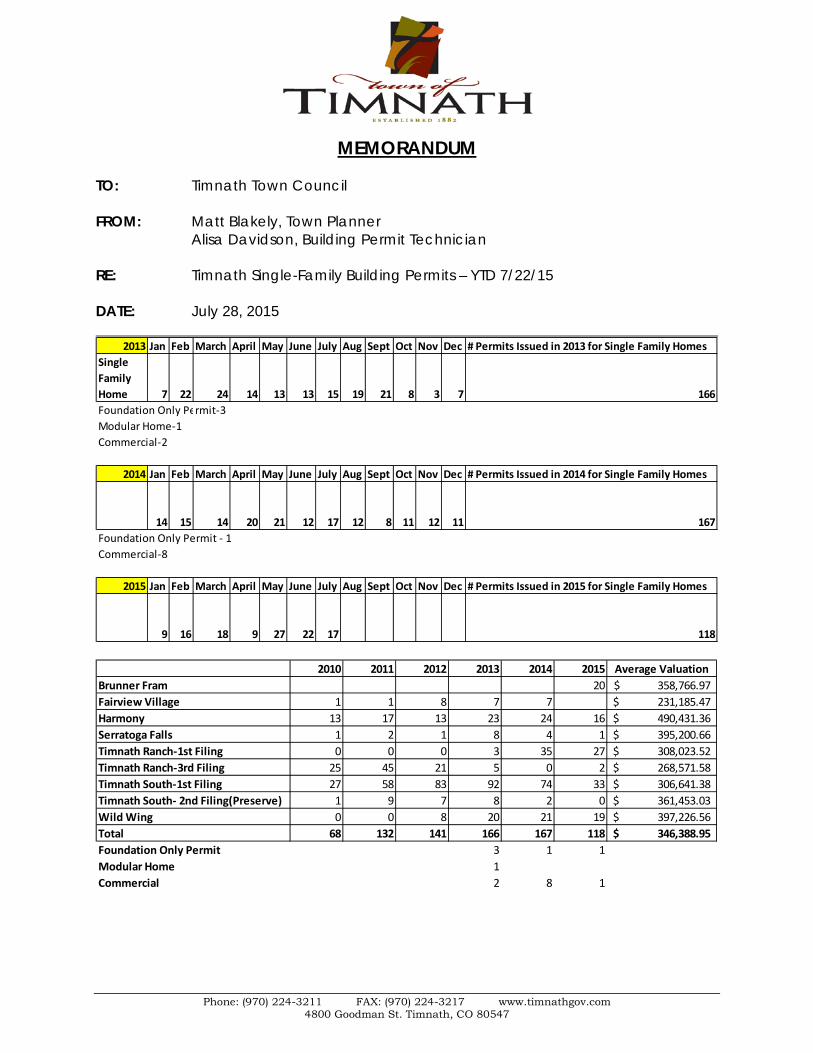
MEMORANDUM TO: Timnath Town Council FROM: Matt Blakely, Town Planner Alisa Davidson, Building Permit Technician RE: Timnath Single-Family Building Permits – YTD 7/22/15 DATE: July 28, 2015
2013 Jan Feb March April May June July Aug Sept Oct Nov Dec # Permits Issued in 2013 for Single Family HomesSingle Family Home 7 22 24 14 13 13 15 19 21 8 3 7 166Foundation Only Permit-3Modular Home-1Commercial-2
2014 Jan Feb March April May June July Aug Sept Oct Nov Dec # Permits Issued in 2014 for Single Family Homes
14 15 14 20 21 12 17 12 8 11 12 11 167Foundation Only Permit - 1Commercial-8
2015 Jan Feb March April May June July Aug Sept Oct Nov Dec # Permits Issued in 2015 for Single Family Homes
9 16 18 9 27 22 17 118
2010 2011 2012 2013 2014 2015 Average ValuationBrunner Fram 20 358,766.97$ Fairview Village 1 1 8 7 7 231,185.47$ Harmony 13 17 13 23 24 16 490,431.36$ Serratoga Falls 1 2 1 8 4 1 395,200.66$ Timnath Ranch-1st Filing 0 0 0 3 35 27 308,023.52$ Timnath Ranch-3rd Filing 25 45 21 5 0 2 268,571.58$ Timnath South-1st Filing 27 58 83 92 74 33 306,641.38$ Timnath South- 2nd Filing(Preserve) 1 9 7 8 2 0 361,453.03$ Wild Wing 0 0 8 20 21 19 397,226.56$ Total 68 132 141 166 167 118 346,388.95$ Foundation Only Permit 3 1 1Modular Home 1Commercial 2 8 1

TOWN COUNCIL COMMUNICATION
Meeting Date: July 28, 2015
Item: June 2015 Law Enforcement Update
For Information
Presented by: Sherri Wagner
1) Meetings
a. Chief’s b. Timnath staff meeting c. Meeting with Harmony developer/staff concerning traffic issues and construction
thefts 2) Continued meetings with Chiefs/District Attorney’s office concerning the state mandated
multi-jurisdictional officer involved shooting agreement and protocol. If an officer is involved in a shooting the state requires another agency to handle the investigation to provide transparency to the incident. Updating protocol.
3) Robert attended crime scene tech training at Fort Collins Police Services and Reid
Interview and Interrogation training at Loveland Police Department.
4) Meetings and work on public safety addition to strategic plan and budget 5) Town Manager interview of police candidates. . 6) On-site inspection by Colorado Department of Public Safety to confirm our compliance with
juvenile holding requirements

Law Enforcement Incidents
Timnath Police Dept Apr-15 May-15 Jun-15
Call TypeAlarm 3 1 9Animal 3 1 4Assist Other 12 7 8Child Welfare 0 0 1Criminal Mischief 1 0 1Directed Patrol/School/Extra 12 19 9Disturbance 0 0 1Family/Neighbor Problem 0 0 1Follow-up 6 15 11Fraud 1 4 1Harassment 2 4 1Juvenile 0 0 1Lost/found Property 0 0 1Vehicle accident/non-inj 5 4 3Private Tow 2 1 1Subject Stop 0 0 5Suspicious Circumstance 1 8 9Theft 5 4 8Traffic 10 31 30Trespass 1 0 1Welfare Check 3 0 4Total Incidents 76 109 110Total cases 17 21 16

TPD MISCELLANEOUS Apr-15 May-15 Jun-15Budget Prep/ Meeting/Fleet 4 4 5CCIC/NCIC Quality Control 2 3 2DA/Chief's Meeting/judges 2 2 2Job Analysis/MSEC 6 0Hiring Process 4 6 2Motor Vehicle Accident Reports (each 2 hours) 10 8 6Multi-jurisdictional Team 10 6Municipal Court 3 3 3NIBRS/Numbers to CBI/FBI 4 5 4Report Writing (Approx 2 hrs per case) 34 42 26Manual/Policy update 7 2 0Training 160 80 0classroom education 3 10 80
LCSO Response & Call Type Apr-15 May-15 Jun-15Call TypeAlarm 1 2 8Animal 0 0 1Assist Other 4 8 6Directed, Extra Patrol/School 14 12 21Disturbance 1 0 2DUI 0 0 1Juvenile 1 1 1Family Problem 1 0 1Follow up 4 1 3Harassment 0 1 1Motor Vehicle Accident 0 1 3Noise/Party 0 1 1Private Tow 0 1 0Reddi 1 0 1Suspicious Circumstance 4 11 11Theft 0 4 3Traffic 44 16 21Warrant 0 2 1Welfare check 2 0 3Total Incidents 83 66 88Total Cases 7 10 10

Phone: (970) 224-3211 FAX: (970) 224-3217 www.timnathcolorado.org 4800 Goodman St. Timnath, CO 80547
To: Town Council and Community From: April D. Getchius, AICP Town Manager Date: July 21, 2015 Subject: Town Manager’s Report Railroad Meeting I attended a meeting hosted by CML intended to bring railroads and municipalities together to discuss railroad noise, quiet crossings and other similar matters. Unfortunately, Omnitrax which is the railroad operator in Timnath was not in attendance. Many of the issues still revolve around Federal Railroad Administration rules, including the length and number of times a train is required to blow the whistle. The only real solution to minimizing that impact is to create the quiet crossings which staff is working on with the railroad company. Oil and Gas Update I received confirmation from Peterson Energy that their drilling plans are still on hold. The price of crude oil dropped to $50.15 as of this writing. Peterson Energy is pausing any further drilling at this site until the price of crude oil increases to an appropriate price for them. Staffing Alisa Davidson started with the Town as administrative assistant/permit technician on July 15. We are thrilled to have her here and look forward to working with her. In addition, Shane Alton who was previously working at Timnath Reservoir, is now a full time employee with public works. Welcome to both Alisa and Shane. Budget Preparation Staff will be preparing the 2016 Budget. In order to provide necessary direction to staff, Council will have a strategic planning work session on August 11 from 3 to 5 p.m. Dinner will be provided.
New Development Town staff has had several conversations with new developments. The two most recent are Taco Bell, which will go near Costco, and Starbucks which will go on the north side of Harmony! Upcoming Dates
• August 14 – Last movie night of the season! • October 3 – Fall Fesitval/Founder’s Day

TOWN COUNCIL COMMUNICATION
Meeting Date: July 28, 2015
Item: 4025 Kern Street Amendment to the Official Zoning Map
Ordinance√ Resolution
Discussion For Information
Presented by: Matt Blakely Town Planner
EXECUTIVE SUMMARY: The project is proposed at 4025 Kern Street. The proposal is for an Amendment to the Official Zoning Map on the property from R-1 (Old-Town Residential) to B (Business) PLANNING COMMISSION ACTION ON 7/7/2015: Planning Commission made a motion to recommend approval of the Rezoning to the Timnath Town Council on 7/7/2015. That motion passed by a unanimous vote of 5 in favor and 0 opposed. KEY POINTS/SUPPORTING INFORMATION: Owner: Steve Whittall Applicant: Aubrey Carson Application Type: Rezoning Case Number: RZ-2015-001 Legal Description/Address: 4025 Kern Street.
Rezoning Process Schedule Task Description Date
Application Submitted 4/8/2015
Acceptance of Application 4/8/2015
Referral Agency Notification Referral comments were due by5/1/2015 4/20/2015
Comments Issued 5/8/2015
2nd Submittal 5/29/2015
2nd Submittal Comments 6/19/2015
3rd Submittal 6/26/2015
Planning Commission Passed Unanimously (5-0) by voice vote 7/7/2015
Town Council 1st Reading 7/14/2015
Town Council 2nd Reading 7/28/2015

Parcel Size (square feet): 17,383 Existing Zoning: R-1 Old Town Residential Proposed Zoning: Business Existing Land Use: Single Family Residential Proposed Land Use: Single-Family Residential Comprehensive Plan Designation: Downtown Core SERVICES:
Water: Fort Collins Loveland Water District Sewer: South Fort Collins Sanitation District Fire: Poudre Fire Authority Electric: Xcel
Adjacent Zoning/Land Uses:
Direction Zoning Land Use North R-1 Single Family Residential South R-1 Single Family Residential West R-1 Single Family Residential East B Single Family Residential
The rezoning application conforms to the requirements set forth in section 16.3.10.D in the Timnath Land Use Code. Criteria for Amendments to the Official Zoning Map. For the purpose of establishing and maintaining sound, stable and desirable development within the Town, the official zoning map shall not be amended except:
1. To correct a manifest error in an ordinance establishing the zoning for a specific property; Response: N/A
2. To rezone an area or extend the boundary of an existing district because of changed or
changing conditions in a particular area or in the Town generally; or Response: N/A
3. The land to be rezoned was zoned in error and as presently zoned is inconsistent with
the policies and goals of the Town Comprehensive Plan; or Response: N/A
4. The proposed rezoning is necessary to provide land for a community-related use that
was not anticipated at the time of the adoption of the Town Comprehensive Plan, and the rezoning will be consistent with the policies and goals of the Comprehensive Plan; or

Response: The current Town Comprehensive Plan has this area designated as Downtown Core. This designation is directly related to the B zoning as it provides for multiple uses on the property, and not just residential, along with larger lot sizes and more generous setbacks for the potential of a retail or commercial.
5. The area requested for rezoning has changed or is changing to such a degree that it is in
the public interest to encourage development or redevelopment of the area; or Response: N/A
6. A rezoning to Planned Unit Development overlay district is requested to encourage
innovative and creative design and to promote a mix of land uses in the development. Response: N/A
This declaration of criteria for zoning map amendments shall not control an amendment that occurs incidentally to a general revision of the zoning map.
REFERRAL COMMENTS: Not returned: AT&T Communications, Poudre School District, Poudre River Public Library District, CenturyLink, Timnath Finance, Timnath Public Works, Xcel Energy, Timnath Town Attorney, Timnath Post Office, Xcel Returned with no comments: Safebuilt, Larimer County Department of Natural Resources, Larimer County Department of Health and Environemnt Returned with comments: Poudre Fire Authority, Timnath Community Development, Timnath Engineering, Fort Collins/Loveland Water District/South Fort Collins Sanitation District
RECOMMENDED MOTION: Finding that a complete application was submitted and reviewed in accordance with all applicable Town regulations, the application conforms with the mission and goals of the Timnath Comprehensive Plan, and all criteria outlined in Section 16.3.10.D. of the Timnath Land Use Code have been met, I move to recommend approval of the Rezoning Amendment for 4025 Kern Street, with the following conditions:
1. Allow staff to work with the owner applicant to address minor, non-substantive modifications and unresolved comments prior to final signatures
ATTACHMENTS: 1. Rezoning Map 2. Comprehensive Plan Map 3. Timnath Zoning Map 4. Ordinance 9, Series 2015
TOWN OF TIMNATH, COLORADO ORDINANCE NO. 9, SERIES 2015
AN ORDINANCE AMENDING THE OFFICIAL ZONING MAP OF THE TOWN OF
TIMNATH FOR THE PURPOSE OF ZONING CERTAIN REAL PROPERTY LOCATED AT 4025 KERN STREET
WHEREAS, STEVE WHITTALL, has submitted a request for zoning of real property within the Town of Timnath more particularly described in Exhibit A and attached hereto and incorporated herein by this reference; and WHEREAS, the Town Council finds the location of the zoning to be appropriate and in conformance with the Town Comprehensive Plan; and WHEREAS, the zone change was recommended for approval to Business at a public hearing held by the Town of Timnath Planning Commission on Tuesday, July 7, 2015. NOW, THEREFORE, BE IT ORDAINED BY THE TOWN COUNCIL OF THE TOWN OF TIMNATH, COLORADO:
Section 1. Property Zoned That Article 3 of the Timnath Land Use Codes and the map referred to therein as the "Official Zoning Map of the Town of Timnath", said map being part of said Zoning Code and showing the boundaries of the district specified, shall be and the same is hereby amended in the following particulars, to wit:
B - Business – See attached Exhibit A
Section 2. Public Hearing The Town Council held a public hearing on Tuesday, July 28, 2015 regarding the zoning of the property.
Section 3. Severability If any article, section, paragraph, sentence, clause, or phrase of this Ordinance is held to be unconstitutional or invalid for any reason, such decision shall not affect the validity or constitutionality of the remaining portions of this Ordinance. The Council hereby declares that it would have passed this Ordinance and each part or parts hereof irrespective of the fact that any one or parts be declared unconstitutional or invalid. Section 4. Effective Date This Ordinance shall take effect upon adoption at second reading, as provided by Section 3.5.5 of the Charter. The Town Clerk shall certify to the passage of this ordinance and make not less than one copy of the adopted Ordinance available for inspection by the public during regular business hours.

INTRODUCED, MOVED, AND ADOPTED BY THE TOWN COUNCIL OF THE TOWN OF TIMNATH ON FIRST READING, ON JULY 14, 2015, AND SET FOR PUBLIC HEARING, AND SECOND READING AT 6:00 P.M. ON JULY 28, 2015 AT THE TIMNATH ADMINISTRATION BUILDING, 4800 GOODMAN STREET, TIMNATH COLORADO AND ORDERED PUBLISHED BY TITLE THIS 8 DAY OF JULY, 2015. MOVED, SECONDED AND FINALLY ADOPTED ON SECOND READING FOLLOWING PUBLIC HEARING BY THE TIMNATH TOWN COUNCIL ON JULY 28, 2015. TOWN OF TIMNATH, COLORADO Jill Grossman-Belisle, Mayor ATTEST: Milissa Peters, CMC Town Clerk

EXHIBIT A
Legal Description of Property Proposed for Zoning Lot 23 Less North 8 2/3 feet and all Lot 24, Block 8, Timnath
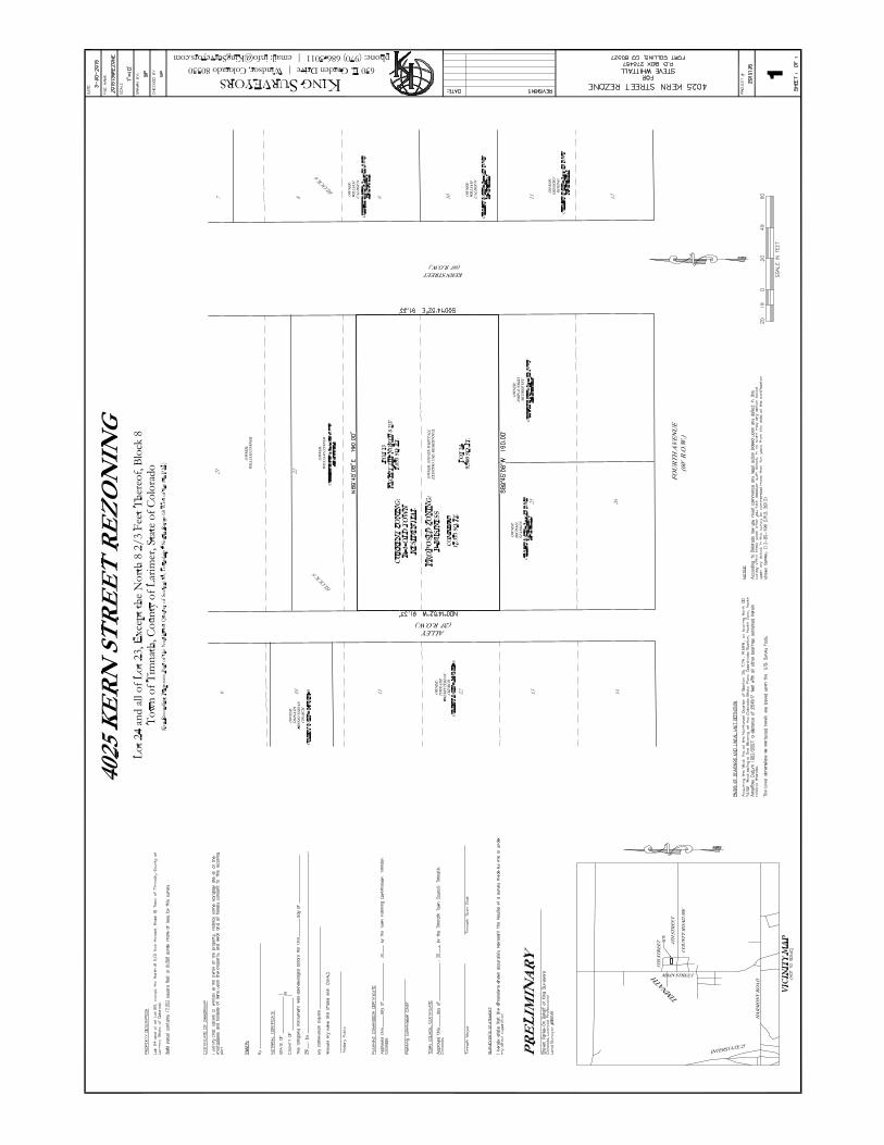
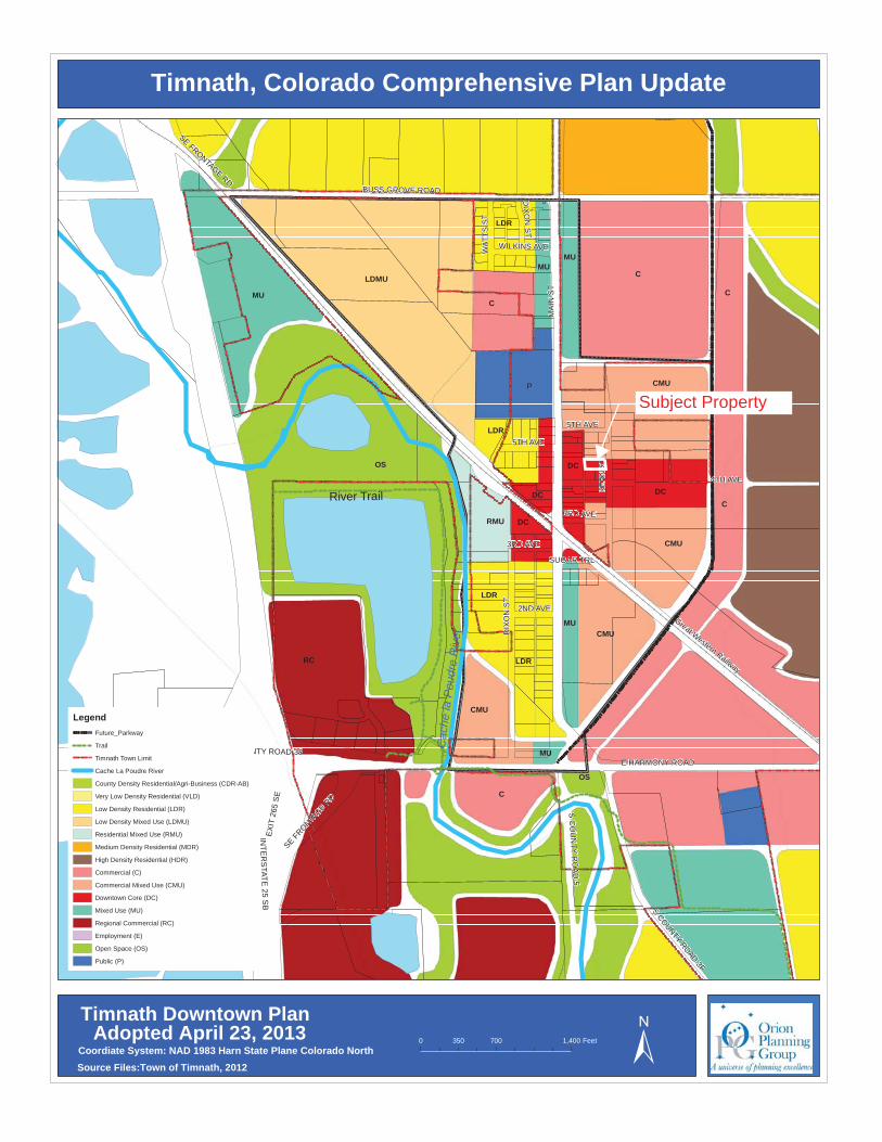
XY XY XY XY XY XY XY XY XY XY XY XY XY XY XY XY XY XY XY XY XY XY XY XY XY XY XY XY XY XY XY XY XY XY XY XY XY XY XY XY XY XY XY XY XY XY XY XY XY XY XY XY XY XY XY XY XY XY XY XY XY XY XY XY XY XY XY XY XY XY XY XY XY XY XY XY XY XY XY XY XY XY XY XY XY XY XY
XY
XY
XY
XY
XY
XY
XY
XY
XY
XY
XY
XY
XY
XY
XY
XY
XY
XY
XY
XY
XY
XY
XY
XY
XY
XY
XY
XY
XY
XY
XY
XY
XY
XY
XY
XY
XY
XY
XY
XY XY XY XY XY XY XY XY XY XY XY XY XY XY XY XY XY XY XY XY XY XY XY XY XY XY XY XY XY XY XY XY XY
XY
XY
XY
XY
XY
XY
XY
XY
XY
XY
XY
XY
XY
XY
XY
XY
XY
XY
XY
XY
XY
XY
XY
XY
XY
XY
XY
XY
XY
XY
XY
XY
XY
XY
XY
XY
XY
XY
XY
XY
XY
XY
XY
XY
XY
XY
XY
XY
XY
XY
XY
XY
XY
XYXY
XY
XY
XY
XY
XY
XY
XY
XYXY
XYXY
XY
XY
XY
XY
XY
XY
XY
XY
XY
XY
XY
XY
XY
XY
XY
XY
XY
XY
XY
XY
XY
XY
XY
XY
XY
XY
XY
XY
XY
XY
XY
XY
XY
XY
XY
XY
XY
XY
XY
XY
XY
XY
XY
XY
XY
XY
XY
XYXYXYXYXYXYXYXYXYXYXYXYXYXYXYXYXYXYXYXYXYXYXYXYXYXYXYXYXYXYXYXYXYXYXYXY
XY
XY
XY
XY
XY
XY
XY
XY
XY
XY
XY
XY
XY
XY
XY
XY
XY
XY
XY
XY
XY
XY
XY
XY
XY
XY
XY
XY
XY
XY
XY
XY
XY
XY
XY
XY
XY
XY
XY
XY
XY
XY
XY
XY
XY
XY
XY
XY
XY
XY
XY
XY
XY
XY
XY
XY
XY
XY
XY
XY
XY
XY
XY
XY
XY
XY
XY
XY
XY
XY
XY
XY
XY
XY
XY
XY
XY
XY
XY
XY
XY
XY
XY
XY
XYXYXYXYXYXYXYXYXYXYXYXYXYXYXYXYXYXYXYXYXYXYXYXYXYXYXYXYXYXYXYXYXYXYXYXYXYXYXYXYXYXYXYXYXYXYXYXYXYXYXYXYXYXYXYXYXYXYXYXYXYXYXYXYXYXYXYXYXYXYXYXYXYXYXYXYXYXYXYXYXYXYXY
Futu
re P
arkw
ay
Cac
he la
Pou
dre
Riv
er
River Trail
MA
IN S
T
INTE
RS
TATE 25 S
B
4TH AVE
BUSS GROVE ROAD
E HARMONY ROAD
DIX
ON
ST
SE FRONTAGE R
D
S COUNTY ROAD 3F
S C
OU
NTY R
OA
D 5
E HARMONY RD
KE
RN
ST
EXIT
265
SE
ENTER
265 SW
3RD AVE
WAT
TS S
T
5TH AVE
2ND AVE
WILKINS AVE
E COUNTY ROAD 38
SUGAR TRL
SE FRONTAGE RD
3RD AVE
DIX
ON
ST
5TH AVE
Great Western Railway
Timnath, Colorado Comprehensive Plan Update
Timnath Downtown Plan
±0 700 1,400350 Feet
LDMU
P CMU
CMU
DC
DC
DC
LDR
LDR
LDR
MUCMU
DC
OS
C
RC
CMU
MU
RMU
Adopted April 23, 2013Coordiate System: NAD 1983 Harn State Plane Colorado NorthSource Files:Town of Timnath, 2012
C
C
OS
C
C
LDR
MUMU
MU
LegendFuture_Parkway
Trail
Timnath Town Limit
Cache La Poudre River
County Density Residential/Agri-Business (CDR-AB)
Very Low Density Residential (VLD)
Low Density Residential (LDR)
Low Density Mixed Use (LDMU)
Residential Mixed Use (RMU)
Medium Density Residential (MDR)
High Density Residential (HDR)
Commercial (C)
Commercial Mixed Use (CMU)
Downtown Core (DC)
Mixed Use (MU)
Regional Commercial (RC)
Employment (E)
Open Space (OS)
Public (P)
Subject Property

A
B
BC
R-1
R-1
R-3
R-1
C
R-1
R-3
R-1MA
IN S
T
DIXO
N ST
KERN
ST
5TH AVE
4TH AVE
3RD AVE
SUGAR TRL3RD AVE
35
bwilliamson
Polygonal Line
bwilliamson
Callout
Subject Property
bwilliamson
Text Box
Current Zoning Map
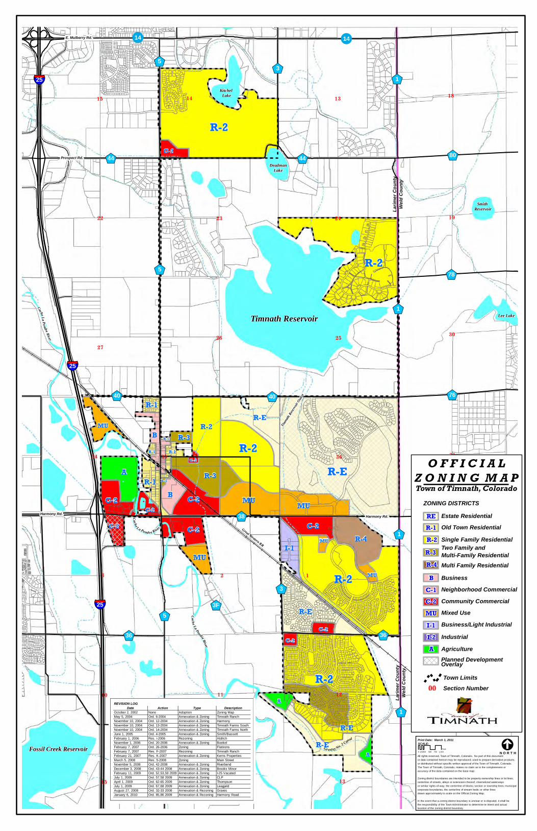
!!
§̈¦$+
$+
$+
$+$+
$+
$+ $+
$+
§̈¦
$+
$+
$+
$+
$+
$+$+
§̈¦
$+
$+
$+
$+
E. Mulberry Rd.
Prospect Rd.
Harmony Rd. Harmony Rd.
Cache La Po udre River
Ca che La Poud re River
Cache La Poudre River
Great Western RR
Timnat
h Rese
rvoir O
utlet
Gr eel ey No. 2 Canal
Larim
er C
ount
yWe
ld Co
unty
Larim
er C
ount
yWe
ld Co
unty
R-E
R-2
R-2
R-2
R-2
A
R-2
R-E
R-E
R-ER-E
R-2
R-4
B
MUB
R-3
C-2
C-2
I-1
C-2
C-2
R-1
MU
MU
A
MU
C-2
A
C-2
C-2
R-1
C-2
R-3
C-2
R-1
MU
MU
C-2R-1
R-3
R-1
Timnath Reservoir
Fossil Creek Reservoir
Lee Lake
Kitchel Lake
DeadmanLake
Lake Canal Reservoir No. 1
Smith Reservoir
5
1
1
3
1
5
1
53
76
78
80
36
25 3F
36
38
25
4040
44 44
25
14 14
3 2 1
7
6
24
10
15
35
22
26 25
34 36
13
11
14
23
27
12
31
18
30
19
14 1315 18
ZONING DISTRICTSEstate ResidentialOld Town ResidentialSingle Family ResidentialTwo Family and Multi-Family ResidentialMulti Family ResidentialBusinessNeighborhood CommercialCommunity CommercialMixed UseBusiness/Light IndustrialIndustrialAgriculturePlanned Development OverlayTown Limits
RE
Section Number00
O F F I C I A LZ O N I N G M A PTown of Timnath, Colorado
R-1R-2R-3R-4B
C-1C-2MUI-1I-2A
Print Date: March 1, 2011
All rights reserved, Town of Timnath, Colorado. No part of this documentor data contained hereon may be reproduced; used to prepare derivative products;or distributed without specific written approval of the Town of Timnath, Colorado. The Town of Timnath, Colorado, makes no claim as to the completeness oraccuracy of the data contained on the base map.
Zoning district boundaries are intended to be property ownership lines or lot lines; centerline of streets, alleys or extensions thereof, channelized waterwaysor similar rights-of-way; the centerline of blocks; section or township lines; municipal corporate boundaries, the centerline of stream beds; or other linesdrawn approximately to scale on the Official Zoning Map.
In the event that a zoning district boundary is unclear or is disputed, it shall bethe responsibility of the Town Administrator to determine te intent and actuallocation of the zoning district boundary.
SCALE:
0 250 500 750 1,000125Feet &
N O R T H
REVISION LOGDate Action Type Description
October 2, 2002 None Adoption Zoning MapMay 5, 2004 Ord. 6-2004 Annexation & Zoning Timnath RanchNovember 10, 2004 Ord. 12-2004 Annexation & Zoning HarmonyNovember 10, 2004 Ord. 13-2004 Annexation & Zoning Timnath Farms SouthNovember 10, 2004 Ord. 14-2004 Annexation & Zoning Timnath Farms NorthJune 1, 2005 Ord. 4-2005 Annexation & Zoning Smith/BassettFebruary 1, 2006 Res. i-2006 Rezoning AldrichNovember 1, 2006 Ord. 20-2006 Annexation & Zoning BoekelFebruary 7, 2007 Ord. 26-2006 Zoning FlatironsFebruary 7, 2007 Res. F-2007 Rezoning Timnath RanchFebruary 21, 2007 Res. K-2007 Annexation & Zoning Kerns PropertiesMarch 5, 2008 Res. 5-2008 Zoning Main StreetNovember 5, 2008 Ord. 42-2008 Annexation & Zoning RiverbendDecember 3, 2008 Ord. 43-44 2008 Annexation & Zoning Brooks MinorFebruary 11, 2009 Ord. 52,53,59 2009 Annexation & Zoning I-25 VacatedJuly 1, 2009 Ord. 57,58 2009 Annexation & Zoning CLPApril 1, 2009 Ord. 62-65 2009 Annexation & Zoning ThompsonJuly 1, 2009 Ord. 67,68 2009 Annexation & Zoning LeagjeldAugust 27, 2008 Ord. 32-33 2008 Annexation & Rezoning GravesJanuary 6, 2010 Ord. 85,86 2009 Annexation & Rezoning Harmony Road

TIMNATH TOWN COUNCIL COMMUNICATION
Meeting Date: July 28, 2015
Item: An Ordinance Providing for an Election Concerning Amendments to the Home Rule Charter of the Town of Timnath, Colorado
Ordinance √ Resolution Discussion
For Information
Presented by: Town Attorney
EXECUTIVE SUMMARY: This Ordinance sets for election the question of whether to amend the Timnath Charter to incorporate the following changes: (1) increase the elector threshold at which the Town Council membership will be increased from 1,200 electors to 8,000 electors; (2) reduce limitations on the Town’s ability to appropriate funds for unanticipated expenditures; (3) extend the deadline for filing of the Town’s annual audit so that it is consistent with state law; (4) remove lax Council Member meeting attendance requirements and delegate responsibility for setting such requirements to the Town Council; (5) provide more flexibility to the Council in addressing potential future budget shortfalls; (6) remove one year waiting period required between the end of a term as a council member and subsequent employment with the Town; (7) amend the procedural requirements for council removal of the Town Manager and Town Commission members from their positions; and (8) incorporate various administrative and grammatical recommendations made by Town staff and consultants. STAFF RECOMMENDATION: Staff recommends approval of the attached Ordinance. KEY POINTS/SUPPORTING INFORMATION:
• These changes will allow Timnath to continue to operate efficiently and effectively, while serving the best interest of the residents.
• Reducing limitations on fund appropriations gives the Town additional flexibility in regards to spending to take advantage of retail, job generating and other investment opportunities.
o This flexibility will be safeguarded by a requirement to initiate any additional appropriations with a budget amendment through the ordinance process, which requires two meetings and a public hearing.
• Removing lax Council Member meeting attendance and delegating this responsibility to the Council, will hold the Town Council more accountable for attendance.
• Providing more flexibility for budget shortfalls reduces unnecessary limitations on the Council’s ability to address unforeseen financial challenges.
• Removing the one year waiting period allows the Town to hire the best person for a job, and other Charter and Code provisions prevent overlapping employment and Town Council service.
• Amending procedural requirements for Council removal of the Town Manager and Town Commission members enhances accountability to the Council.
ADVANTAGES:
• The Ordinance will set for election Charter amendments to save taxpayer money, remove unnecessary constraints from the Charter, reduce administrative burdens, and generally help the Town operate more efficiently and effectively.

DISADVANTAGES: None.
FINANCIAL IMPACT: Minimal financial impact in the form of reduced work time and administrative burdens.
RECOMMENDED MOTION: I move approval of Ordinance No. 10, Series 2015 entitled An Ordinance Providing for an Election Concerning Amendments to the Home Rule Charter of the Town of Timnath, Colorado
ATTACHMENTS: 1. Ordinance
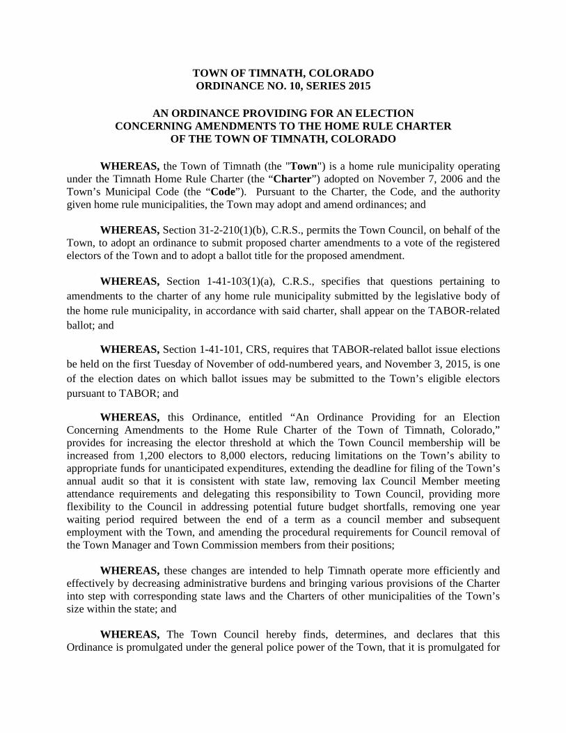
TOWN OF TIMNATH, COLORADO ORDINANCE NO. 10, SERIES 2015
AN ORDINANCE PROVIDING FOR AN ELECTION
CONCERNING AMENDMENTS TO THE HOME RULE CHARTER OF THE TOWN OF TIMNATH, COLORADO
WHEREAS, the Town of Timnath (the "Town") is a home rule municipality operating
under the Timnath Home Rule Charter (the “Charter”) adopted on November 7, 2006 and the Town’s Municipal Code (the “Code”). Pursuant to the Charter, the Code, and the authority given home rule municipalities, the Town may adopt and amend ordinances; and
WHEREAS, Section 31-2-210(1)(b), C.R.S., permits the Town Council, on behalf of the Town, to adopt an ordinance to submit proposed charter amendments to a vote of the registered electors of the Town and to adopt a ballot title for the proposed amendment.
WHEREAS, Section 1-41-103(1)(a), C.R.S., specifies that questions pertaining to
amendments to the charter of any home rule municipality submitted by the legislative body of the home rule municipality, in accordance with said charter, shall appear on the TABOR-related ballot; and
WHEREAS, Section 1-41-101, CRS, requires that TABOR-related ballot issue elections be held on the first Tuesday of November of odd-numbered years, and November 3, 2015, is one of the election dates on which ballot issues may be submitted to the Town’s eligible electors pursuant to TABOR; and
WHEREAS, this Ordinance, entitled “An Ordinance Providing for an Election Concerning Amendments to the Home Rule Charter of the Town of Timnath, Colorado,” provides for increasing the elector threshold at which the Town Council membership will be increased from 1,200 electors to 8,000 electors, reducing limitations on the Town’s ability to appropriate funds for unanticipated expenditures, extending the deadline for filing of the Town’s annual audit so that it is consistent with state law, removing lax Council Member meeting attendance requirements and delegating this responsibility to Town Council, providing more flexibility to the Council in addressing potential future budget shortfalls, removing one year waiting period required between the end of a term as a council member and subsequent employment with the Town, and amending the procedural requirements for Council removal of the Town Manager and Town Commission members from their positions;
WHEREAS, these changes are intended to help Timnath operate more efficiently and
effectively by decreasing administrative burdens and bringing various provisions of the Charter into step with corresponding state laws and the Charters of other municipalities of the Town’s size within the state; and
WHEREAS, The Town Council hereby finds, determines, and declares that this
Ordinance is promulgated under the general police power of the Town, that it is promulgated for

the preservation of public health, welfare, peace, safety and property and that this Ordinance is necessary for the protection of public convenience and welfare. NOW, THEREFORE, BE IT ORDAINED BY THE COUNCIL OF THE TOWN OF TIMNATH, COLORADO:
Section 1. Short Title. This ordinance shall be known as and may be cited by the short title “2015 Charter Amendment Election Ordinance”.
Section 2. Election Actions. All actions heretofore taken (consistent with the provisions of this ordinance) by or on behalf of the Town and the officers thereof directed toward the election and the objects and purposes herein stated are hereby ratified, approved and confirmed.
Section 3. Uniform Election Code. Pursuant to § 31-10-102.7, C.R.S., the Town Council elects to utilize the provisions of the Uniform Election Code of 1992, and in particular the provisions of Article 7.5 thereof, for the election called pursuant to Section 4 below. Unless otherwise defined herein, all terms used herein shall have the meanings defined in the Uniform Election Code of 1992, Title 1, Articles 1 to 13, C.R.S., Title 31, Article 25, Part 6, C.R.S. and TABOR.
Section 4. Calling of Election. Pursuant to TABOR, Title 1, Articles 1 to 13, C.R.S., Title 31, and Article 25, Part 6, C.R.S., the Town Council hereby calls a special election to be conducted on November 3, 2015, as a mail ballot election (the “Election”). Because the Election will be a mail ballot election, the Town Council directs the designated election official named in Section 6 below to file a mail ballot election plan with the Colorado Secretary of State.
Section 5. Election Questions. At the Election, there shall be submitted to the eligible electors of the Town a question or questions regarding various proposed amendments to the Town’s Charter, including but not limited to amendments that would: (1) INCREASE THE ELECTOR THRESHOLD AT WHICH THE TOWN COUNCIL MEMBERSHIP WILL BE INCREASED FROM 1,200 ELECTORS TO 8,000 ELECTORS; (2) REDUCE LIMITATIONS ON THE TOWN’S ABILITY TO APPROPRIATE FUNDS FOR UNANTICIPATED EXPENDITURES; (3) EXTEND THE DEADLINE FOR FILING OF THE TOWN’S ANNUAL AUDIT SO THAT IT IS CONSISTENT WITH STATE LAW; (4) REMOVE LAX COUNCIL MEMBER MEETING ATTENDANCE REQUIREMENTS AND DELEGATE THIS RESPONSIBILITY TO TOWN COUNCIL; (5) PROVIDE MORE FLEXIBILITY TO THE COUNCIL IN ADDRESSING POTENTIAL FUTURE BUDGET SHORTFALLS; (5) REMOVE ONE YEAR WAITING PERIOD REQUIRED BETWEEN THE END OF A TERM AS A COUNCIL MEMBER AND SUBSEQUENT EMPLOYMENT WITH THE TOWN; (6) AMEND THE PROCEDURAL REQUIREMENTS FOR COUNCIL REMOVAL OF THE TOWN MANAGER AND TOWN COMMISSION MEMBERS FROM THEIR POSITIONS; AND (7) INCORPORATE VARIOUS ADMINISTRATIVE AND GRAMATICAL CHANGES RECOMMENDED BY TOWN STAFF AND CONSULTANTS.
Section 6. Designated Election Official Appointment. Larimer County Clerk and Recorder is hereby appointed as the Designated Election Official of the Town for purposes of

performing acts required or permitted by law in connection with the election. November elections must be county-coordinated under § 1-7-116, C.R.S., which requires the county clerk and recorder to coordinate elections when more than one overlapping political subdivision holds an election on the same day in November. See also, § 1-1-104(6.5). State elections overlap on November 3, 2015, therefore pursuant to § 1-7-116, C.R.S., the Larimer County Clerk and Recorder is required to be the Designated Election Official.
Section 7. Miscellaneous.
Without limiting the foregoing, the following specific determinations also are made:
a. The Town Council hereby directs the Town Attorney to approve the final form of the ballot to be submitted to the eligible electors of the District and authorizes the Designated Election Official to certify those questions and take any required action therewith.
b. The Board hereby directs the Town Clerk to oversee the general conduct of the Election and authorizes the Designated Election Official to take all action necessary for the proper conduct thereof and to exercise the authority of the Town Council in conducting the Election, including, but not limited to appointment, training and setting compensation of election judges and a board of canvassers, as necessary; all required notices of election, including notices required pursuant to TABOR; printing of ballots; supervision of the counting of ballots and certification of election results; and all other appropriate actions.
c. If any section, subsection, paragraph, clause, or provision of this Ordinance shall for any reason be held to be invalid or unenforceable, the invalidity or unenforceability of such section, subsection, paragraph, clause, or provision shall in no manner affect any remaining provisions of this Ordinance, the intent being that the same are severable.
d. All orders, resolutions, ordinances or regulations of the Town, or parts thereof, inconsistent with this Ordinance are hereby repealed to the extent only of such inconsistency.
Section 8. Effective Date. This Ordinance shall take effect upon adoption at second reading, as provided by Section 3.5.5 of the Charter.
INTRODUCED, MOVED, AND ADOPTED BY THE TOWN COUNCIL OF THE TOWN OF TIMNATH ON FIRST READING, ON JULY 28, 2015, AND SET FOR PUBLIC HEARING AND SECOND READING AT 6:00 PM ON AUGUST 11, 2015 AT THE TIMNATH ADMINISTRATION BUILDING, 4800 GOODMAN STREET, TIMNATH COLORADO AND ORDERED PUBLISHED BY TITLE THIS 28TH DAY OF JULY, 2015. MOVED, SECONDED AND FINALLY ADOPTED ON SECOND READING FOLLOWING PUBLIC HEARING BY THE TIMNATH TOWN COUNCIL ON AUGUST 11, 2015.

TOWN OF TIMNATH, COLORADO
Jill Grossman-Belisle, Mayor ATTEST: Milissa Peters, CMC Town Clerk

TIMNATH COUNCIL COMMUNICATION
Meeting Date: 7/28/15
Item: A Resolution Authorizing The Town Manager To Enter Into A Six Month Lease Extension With The Cache La Poudre Reservoir Company
Ordinance Resolution √ Discussion
For Information
Presented by: April D. Getchius, AICP Town Manager
EXECUTIVE SUMMARY: Staff and The Cache La Poudre Reservoir Company are still engaged in negotiations for the long term extension of the Town’s lease of Timnath Reservoir. The Council authorized a lease extension in 2015 which expires August 16, 2015. Staff is requesting a further lease extension to complete negotiations. The Cache La Poudre staff has been unable to meet to further the lease terms. STAFF RECOMMENDATION: Staff recommends approval of the resolution. KEY POINTS/SUPPORTING INFORMATION: This resolution will extend the lease for another six months under the same terms and conditions of the existing lease.
ADVANTAGES: Allows staff to complete the negotiations on lease renewal.
DISADVANTAGES: None.
FINANCIAL IMPACT: None beyond the existing lease payment.
RECOMMENDED MOTION: I move approval of Resolution No. 49, Series 2015 entitled “A Resolution Authorizing the Town Manager to Enter Into a Six Month Lease Extension with the Cache La Poudre Reservoir Company.”
ATTACHMENTS: Resolution.
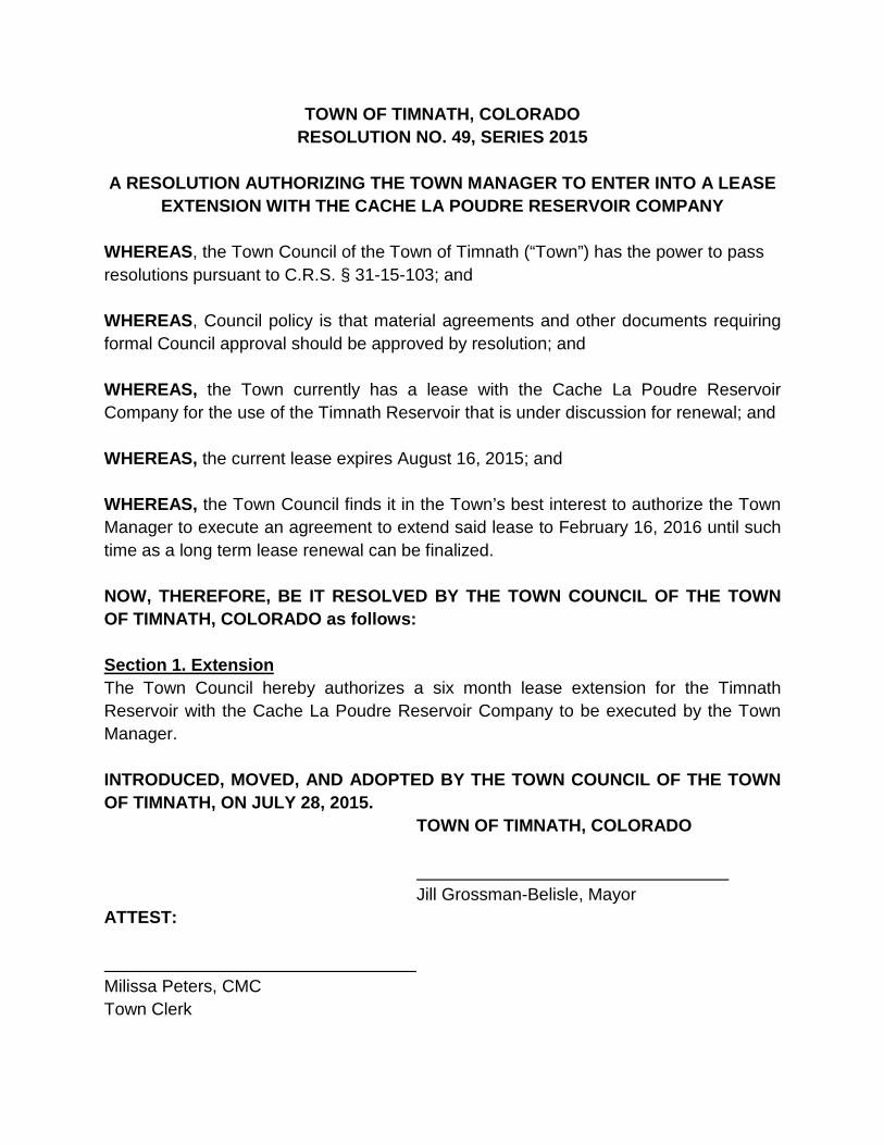
TOWN OF TIMNATH, COLORADO RESOLUTION NO. 49, SERIES 2015
A RESOLUTION AUTHORIZING THE TOWN MANAGER TO ENTER INTO A LEASE
EXTENSION WITH THE CACHE LA POUDRE RESERVOIR COMPANY
WHEREAS, the Town Council of the Town of Timnath (“Town”) has the power to pass resolutions pursuant to C.R.S. § 31-15-103; and
WHEREAS, Council policy is that material agreements and other documents requiring formal Council approval should be approved by resolution; and WHEREAS, the Town currently has a lease with the Cache La Poudre Reservoir Company for the use of the Timnath Reservoir that is under discussion for renewal; and WHEREAS, the current lease expires August 16, 2015; and WHEREAS, the Town Council finds it in the Town’s best interest to authorize the Town Manager to execute an agreement to extend said lease to February 16, 2016 until such time as a long term lease renewal can be finalized. NOW, THEREFORE, BE IT RESOLVED BY THE TOWN COUNCIL OF THE TOWN OF TIMNATH, COLORADO as follows: Section 1. Extension The Town Council hereby authorizes a six month lease extension for the Timnath Reservoir with the Cache La Poudre Reservoir Company to be executed by the Town Manager.
INTRODUCED, MOVED, AND ADOPTED BY THE TOWN COUNCIL OF THE TOWN OF TIMNATH, ON JULY 28, 2015.
TOWN OF TIMNATH, COLORADO Jill Grossman-Belisle, Mayor ATTEST: Milissa Peters, CMC Town Clerk

TOWN COUNCIL COMMUNICATION
Meeting Date: 7/28/2015
Item: Sketch Planned Development Overlay District for the Wildwing Subdivision
Ordinance Resolution √
Discussion For Information
Presented by: Matt Blakely Town Planner
EXECUTIVE SUMMARY: Planned Development Overlay to modify the underlying R-2 District dimensional standards as follows:
• Reduce side yard setback on approximately 71 patio home lots in Phase 3 only from 7’ to 5’ • Reduce minimum lot size on approximately 17 patio home lots in Phase 3 only from 6,000 to 5,500
The Sketch PD Development Plan is the first step in creating a Planned Development Overlay District. This district will contain the entire Wildwing Subdivision (excluding the first filing and the previously approved PD Overlay for the existing patio homes), and seeks to modify two of the dimensional standards of the underlying R-2 Zoning district. These modifications are detailed on Page 1 of the Project Narrative submitted by the applicant and are listed in this staff report. There are two additional steps in the PD Overlay process, the Preliminary PD Overlay and the Final PD Overlay. Each of these will be brought back to the Planning Commission and Town Council along with the Preliminary and Final Plats. PLANNING COMMISSION DECISION: At its regularly scheduled meeting on 7/21/2015 the Planning Commission recommended approval to the Timnath Town Council unanimously (5-0) by voice vote.
STAFF RECOMMENDATION: Staff recommends approval of the Sketch Planned Development Overlay District for the Wildwing Subdivision.
KEY POINTS/SUPPORTING INFORMATION: Owner: Gary Hoover, WW Development, LLC Applicant: Gary Hoover, WW Development, LLC Application Type: Rezoning Case Number: RZ-2014-001 Legal Description/Address: Parcel(s) of land located at the southwest corner of Wildwing Drive and Latham Parkway (LCR1) in the Wildwing Subdivision.
Sketch Plan Process Schedule Task Description Date Sketch PD Overlay Application
5/28/2014
Application Certification 5/28/2014
2nd Submittal 3/11/2015
3rd Submittal 7/9/2015
Notice to Public and Posting of Property
7/10/2015
Planning Commission Public Hearing
Passed unanimously (5-0) by voice vote 7/21/2015
Town Council Public Hearing
7/28/2015
Parcel Size (Acres): 283.28 +/- total acres Number of Lots: Approximately 256-301 Dwelling Units Existing Zoning: R-2 Proposed Zoning: R-2 with PD Overlay Existing Land Use: Vacant Proposed Land Use: Single-Family Residential Comprehensive Plan Designation: Low Density Residential SERVICES:
Water: North Weld Water District Sewer: Boxelder Sanitation District Fire: Poudre Fire Authority Special Districts: Wildwing Metro District
Adjacent Zoning/Land Uses:
Direction Zoning Land Use North FA-1, Unincorporated Larimer
County Farming
South R-2; Single Family Residential Residential West FA-1, Unincorporated Larimer
County Farming
East Unincorporated Weld County AG-A DENSITY AND DIMENSIONAL STANDARDS EXCEPTIONS:
1. Modify the R-2 / SFD Density and dimensional standards Table 3-B for the Phase 3 lots only as follows:
a. Reduce Minimum lot area per dwelling (sf) from 6,000 to 5,500. b. Reduce the Minimum side yard setback (feet) from 7 to 5.
REVIEW CRITERIA: From Section 13.3.4.N.8.a of the Land Use Code:
i. The proposed benefits offset the proposed exceptions to the Zoning and Subdivision standards, and that such exceptions are in the best interest of the public health, safety and welfare.
a. The exceptions that are being proposed are focused on a specific portion of the project (phase 3 – patio homes). The exceptions include reducing the side yard setback from 7’ to 5’ and the minimum lot size from 6,000 sf to 5,500 sf. One of the proposed benefits to offset these requested exceptions is a provision of open space behind each of the lots being considered for
the exception. Also, a benefit of common maintenance of the landscaping and open space on each of the lots will ensure the landscape areas will be uniformly considered for all of the lots. The building types proposed are all patio homes and are being suggested as ranch type units. This will reduce the visual impact of the closer setbacks.
ii. The proposed PD conforms to the PD restrictions, and that the proposed zoning is compatible with the surrounding land uses.
a. This PD conforms to the PD Restrictions listed in Section 13.3.4.N.3 in the Timnath Land Use Code, and is compatible with the surrounding land uses.
iii. The PD proposes creative and innovative design, and high quality development thereby protecting and promoting public safety, convenience, health and general welfare
a. This project does not compromise public safety, all applicable international building standards are being met. This project will improve connectivity throughout the subdivision, and will also allow alternative transportation routes such as biking and walking. Open space is being provided behind each lot in the subdivision and those open spaces are being proposed as useable open spaces for trails and park amenities. The open space network is interconnected and includes trails providing alternative off street pedestrian circulation options. The lots in the area considered for the exceptions are to be patio homes. These will be consistently landscaped and maintained promoting a high quality development.
iv. The uses and densities in the proposed PD are compatible, and will be effectively integrated with adjacent neighborhoods which now exist or are proposed for the future.
a. This PD Overlay will allow for additional patio home lots within the development. These lots will be larger than the existing patio homes in Block 23, but will have consistent architecture and landscaping. The densities will be less than the existing Block 23 density and greater than the proposed larger lots to the west and south.
v. The proposed PD is in general conformance with the Town of Timnath Comprehensive Plan
a. This PD Overlay is in conformance with the Comprehensive Plan.
vi. One or more of the criteria for amendment of the official Zoning Map has been satisfied. a. This PD Overlay satisfies condition 5 of the official criteria for the amendment of the official
zoning map: The area requested for rezoning has changed or is changing to such a degree that it is in the public interest to encourage development or redevelopment of the area. It is in the public’s best interest to have this property to continue to develop and create connectivity among the existing development.
b. This PD Overlay satisfies condition 6 of the official criteria for the amendment of the official zoning map: A rezoning to Planned Unit Development overlay district is requested to encourage innovative and creative design and to promote a mix of land uses in the development. The proposed amendment will allow for the addition of patio homes that provides another housing option within the development adding to the mix of residential housing types.
Referral Comments: Not Returned: AT&T Communications, Poudre School District, Poudre River Public Library District, CenturyLink, Timnath Finance, Timnath Public Works, Xcel Energy, Larimer County Department of Natural

Resources, Timnath Town Attorney, Timnath Post Office, , Comcast, Geological Survey, North Weld County Water District, Boxelder Sanitation, Larimer County Department of Health Returned with no comments: SafeBuilt, Timnath Police Department, Poudre Fire Authority, Timnath Engineering, Returned with comments: Timnath Community Development
RECOMMENDED MOTION: I move to approve Resolution No. 50, Series 2015, the Wildwing Sketch Planned Development Overlay District with the following conditions:
a. Allow staff to continue to work with applicant to address all unresolved non-substantive technical comments to the satisfaction of Town Staff and Referral Agencies
ATTACHMENTS: 1. Resolution 2. Wildwing Sketch Plan 3. PD Overlay Narrative 4. Wildwing Sketch PD Overlay Map
TOWN OF TIMNATH, COLORADO RESOLUTION NO. 50, SERIES 2015
A RESOLUTION OF THE TOWN COUNCIL OF THE TOWN OF TIMNATH APPROVING THE
SKETCH PLANNED DEVELOPMENT OVERLAY FOR WILDWING SUBDIVISION, GENERALLY LOCATED WEST OF AND ADJACENT TO CR 1/MAIN LATHAM PARKWAY,
AND SOUTH OF AND ADJACENT TO WILDWING DRIVE
WHEREAS, WW Development, LLC (the “Developer”) has submitted a Sketch Planned Development Overlay for the Wildwing Subdivision, more particularly described in Exhibit A (legal description) and Exhibit B (Sketch Planned Development Overlay) and attached hereto and incorporated herein by this reference (the “Property”); and WHEREAS, a properly noticed public hearing was held on July 21, 2015, and the above described Sketch Planned Development Overlay was recommended for approval to the Town Council by the Town of Timnath Planning Commission with the following conditions:
1. Allow staff to continue to work with applicant to address all unresolved non-substantive technical comments to the satisfaction of Town Staff and Referral Agencies
WHEREAS, a properly noticed public hearing with the Town Council was held on July 28, 2015 and upon hearing the statements of staff, the applicant(s) and giving consideration to the recommendations, the Town Council determines as provided below.
BE IT RESOLVED BY THE TOWN COUNCIL OF THE TOWN OF TIMNATH, COLORADO:
Section 1. Sketch Planned Development Overlay
The Sketch Planned Development Overlay for Wildwing Subdivision is approved as presented. PASSED, APPROVED AND ADOPTED THIS 28 DAY OF JULY, 2015.
TOWN OF TIMNATH, COLORADO
Jill Grossman-Belisle, Mayor ATTEST: Milissa Peters, CMC Town Clerk

EXHIBIT A
Legal Description of Property Proposed for Sketch Planned Development Overlay

EXHIBIT B
Sketch Planned Development Overlay
[attached]
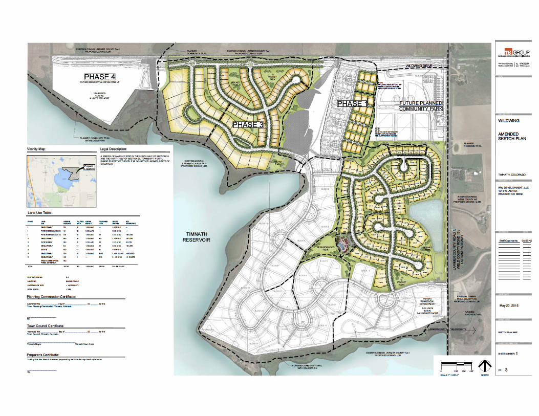


WILDWING SUBDIVISION
SKETCH PD OVERLAY
PD Overlay Description:
The Wildwing Subdivision was approved in 2008. A PD Overlay was requested and approved for density and dimensional standards for specific patio homes in Block 23. Subsequently, most of the Phase 1 infrastructure and lots have been constructed. It was concluded that a PD Overlay would be requested for the patio home lots located in Phase 3 with the exception of the above-mentioned patio home lots.
All Town of Timnath Land Use requirements for the R-2 Zone district shall be applicable to this PD Overlay with the exception of the following:
1. Phase 3 Lot Size:
Minimum Lot Size per R-2 Zone = 6,000 sq. ft.
Minimum Lot Size PD Overlay = 5,500 sq. ft.
2. Phase 3 Setbacks:
Minimum Site Yard Setback R-2 Zone = 7’
Minimum Side Yard Setback PD Overlay = 5’
The following is a part of the Written PD Description required per Section 16.3.3.N.5.b:
i. List all subdivision regulation exceptions proposed for the PD.
See above.
ii. Identify the underlying zoning district(s) for the property and describe any proposed modifications and/or restrictions to the allowed uses and/or standards within the district(s). If any conditional uses are requested, explain how the conditional use review criteria will be addressed.
The underlying zone district is R-2. There are 61 proposed patio home lots in Phase 3 that will be less than the minimum lot size and have a lesser side yard setback than is otherwise required by the Code. There are no conditional uses requested at this time.
iii. Identify and explain the benefits which will be provided by the PD to offset the impact of the modifications requested (i.e., if the minimum lot size is decreased, additional functional, centrally located common open space will be provided; or if the width of the local street right-of-way is decreased by eliminating on-street parking, then there will be designated parking areas within 500 feet of all residences, etc.). All proposed benefits must offset the proposed modifications.

The patio homes within the proposed PD Overlay are typical of other similar developments where the homes are grouped closer together. This is offset by larger pockets of open space. Each home will back to open space to help counteract the smaller lots and lesser setbacks. In addition, most all of the lots will be ranch plans with main floor master bedrooms, therefore the two-story buildings will be minimized. All of the home are in close proximity to two pocket parks as well.
iv. Explain how the proposed PD will be compatible with adjacent neighborhoods which now exist or are proposed in the future. Describe any proposed buffering techniques which serve to achieve such compatibility.
The project will be compatible with the adjacent neighborhood by providing sufficient open space and large green belt tracts to provide buffering. The open space will be planted with a mix of deciduous and evergreen trees and native grasses. The architecture of the buildings will be consistent with the high quality established theme of the Wildwing neighborhood. In addition to a pocket park with picnic tables, there is a planned trail along the eastern edge of the lots.

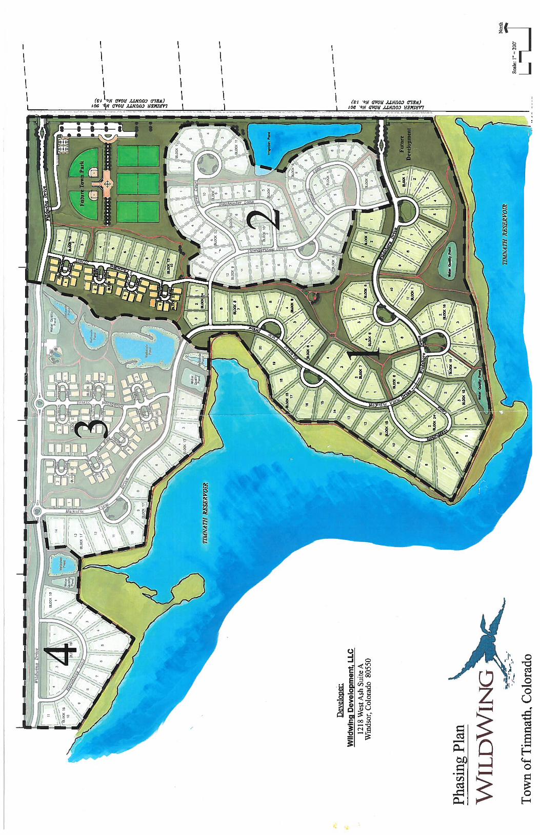

TOWN COUNCIL COMMUNICATION
Meeting Date: 7/28/2015
Item: SERRATOGA FALLS SUBDIVISION 2nd FILING, FINAL PLAT
Ordinance
Resolution √ Discussion
For Information Presented by: Brian Williamson Town Planner EXECUTIVE SUMMARY:
• Final Plat approval of approximately 321 acres and 250 single family detached residential dwelling units and 2 future development tracts.
Subdivision of +/-321.4 acres (generally located north of Prospect Road, east of Main Street, and west of Three Bell Parkway) into 250 single family lots and 2 future development tracts. The overall density for this phase will be 1.72 dwelling units per acre which conforms with the R-2 zoning requirements.
PLANING COMMISSION DECISION: At its regular scheduled meeting on July 21, 2015 the Planning Commission recommended approval to the Timnath Town council unanimously (5-0) by voice vote, with the following conditions: a. Allow staff to continue to work with the applicant to address all unresolved technical comments to
the satisfaction of Town Staff and referral agencies b. Allow Staff to work with the Town Attorney to meet all obligations of the Town to resolve the
Kiefer/Glover ditch easement conflict.
STAFF RECOMMENDATION: Staff recommends the approval of the Serratoga Falls Subdivision, 2nd Filing Final Plat.
KEY POINTS/SUPPORTING INFORMATION: Final Plat Process Schedule
Task Description Date Final Plat Application 4/3/2015
Application Certification 4/3/2015
Referral Agency Notification Referral comments were due by 5/1/2015 4/10/2015
Comments Issued Comments submitted to applicant 5/8/2015
2nd Submittal 5/27/2015
2nd Submittal Comments Issued 6/19/2015
3rd Submittal 7/7/2015
3rd Submittal Comments Issued Note: Final Comments issued after Town Hearing
Notice to Neighboring Property Owners 7/10/2015
Planning Commission 7/21/2015
Public Hearing
Town Council Public Hearing 7/28/2015
Owner: Serratoga Falls LLC Applicant: Mark Goldstein, Serratoga Falls LLC Application Type: Final Plat Case Number: FP 2015-002 Legal Description/Address: Parcel(s) of land located at the northeast corner of Prospect Road and Main Street Project Description: Subdivision of +/-321.4 acres into 250 single family lots and 2 future development tracts. Proposed uses consist of single-family dwelling units that will range from 6,598 square feet to 21,000 square feet. The overall density for this phase will be 1.72 dwelling units per acre which conforms with the R-2 zoning. On-street detached sidewalks are provided throughout the subdivision providing linkages within the subdivision that will tie into the required community trail per the PROST plan. The open space requirement has been met by the two neighborhood parks and 5 pocket parks and open greenbelt areas. The neighborhood parks will both have ponds, trail access with shelters and benches. One of the neighborhood parks will contain an active play area along with a plaza and amphitheater. Intersections to Main Street and Prospect Road are shown to conform to LCUASS standards as well as the approved Town of Timnath Transportation Master Plan. A determination of a 2-lane arterial street classification for Prospect Road will also allow for additional full movement intersections at ¼ mile spacing. Additional right in/right-outs will be allowed at 660 feet intervals. Future improvements to Prospect Road with a future filing will include adjustments to the alignment around Deadman Lake, bringing it up to the current design standards. Pedestrian movements through the development will be provided by the trail and sidewalk amenities mentioned above. The existing infrastructure for Serratoga Falls Filing 1 will allow for access to both the new and existing development as it was initially designed for that capacity. Overall, the plan is consistent with Town Land Use Code, the PROST Plan, and furthers the goals of the Comprehensive Plan. In addition, it generally conforms to Town of Timnath Engineering Standards. The proposed density and land uses are consistent with the existing zoning of the parcel and the approved Sketch Plan. Buffering and similar lot sizes have been provided where the proposed development is adjacent to the First Filing. Parcel Size (Acres): 321.4 +/- total acres Number of Lots: 250 single-family lots, 2 future development tracts Existing Zoning: C-2 & R-2 Proposed Zoning: C-2 & R-2 Existing Land Use: Single-Family Dwellings & Vacant land Proposed Land Use: Single Family Homes & Commercial SERVICES:
Water: ELCO Water District

Sewer: Boxelder Sanitation District Fire: Poudre Fire Authority Special Districts: Serratoga Falls Metropolitan Districts 1-3
Adjacent Zoning/Land Uses:
Direction Zoning Land Use North FA-1 Unincorporated Larimer County County Residential South FA-1, E-1 Unincorporated Larimer
County Farming; Estate Residential
West FA-1 Unincorporated Larimer County; UE City of Fort Collins
Farming
East FA-1 Unincorporated Larimer County Farming Reference Timnath Land Use Code Section 16.4.7.C Final Plat for details on the Final Plat Process
Final Plat Review Criteria. In addition to all provisions of this Code, the Town shall use the following criteria to evaluate the applicant’s final plat application:
1. The final plat conforms to the approved preliminary plat and incorporates required changes,
modifications and conditions attached to the approval of the preliminary plat unless otherwise approved by the Board. Note: The Final Plat is in conformance with the Preliminary Plat that was approved by Town Council on June 8th, 2015
2. The development will substantially comply with this Code.
Note: The Final Plat complies with the Town’s Land Use Code 3. All applicable technical standards have been met. (Ord. 10-2002; Ord. 4-2003; Ord. 10-
2004) Note: The Final Plat complies with the Town’s technical standards
REFERRAL COMMENTS: Not Returned: AT&T Communications, Poudre School District, Poudre River Public Library District, CenturyLink, Timnath Finance, Timnath Public Works, Xcel Energy, Larimer County Department of Natural Resources, Timnath Town Attorney, Colorado Geological Survey, Timnath Post Office Returned with no comments: Timnath Police Department, Safebuilt, Comcast, Greeley Water, Magellan Pipeline Returned with comments: Poudre Fire Authority, Timnath Engineering, Cache La Poudre Reservoir Company, Boxelder Sanitation, Colorado Historical Society
RECOMMENDED MOTION: Finding that a complete application was submitted and reviewed in accordance with all applicable Town regulations, the application conforms with the mission and goals of the Timnath Comprehensive Plan, and all criteria outlined in Section 16.4.7.C. of the Timnath Municipal Code have been met, I move to recommend
approval of the Serratoga Falls Final Plat with the following conditions:
a. Allow staff to continue to work with applicant to address all unresolved technical comments to the satisfaction of Town Staff and Referral Agencies.
b. Allow Staff to work with the Town Attorney to meet all obligations of the Town to resolve the Kiefer/Glover ditch easement conflict.
c. Approval of a Subdivision Improvement Agreement
ATTACHMENTS: 1. Resolution 2. Final Plat 3. Final Landscape Plan 4. Final Plat Narrative 5. Approved Preliminary Plat 6. Letter from Dow Law Firm regarding Kiefer/Glover ditch 7. Email response from Serratoga Falls LLC to Town Staff regarding the Kiefer/Glover ditch letter
TOWN OF TIMNATH, COLORADO RESOLUTION NO. 51, SERIES 2015
A RESOLUTION APPROVING THE FINAL PLAT FOR SERRATOGA FALLS
SUBDIVISION 2nd FILING, GENERALLY LOCATED NORTH OF AND ADJACENT TO CR 44 (PROSPECT RD), AND EAST OF AND ADJACENT TO CR 5 (MAIN ST)
WHEREAS, the Town Council of the Town of Timnath (“Town”) pursuant to C.R.S. §
31-15-103, has the power to pass resolutions; and WHEREAS, Serratoga Falls, LLC (the “Developer”) has submitted a Final Plat for Serratoga Falls Subdivision, more particularly described in Exhibit A (legal description) and Exhibit B (Final Plat) and attached hereto and incorporated herein by this reference (the “Property”); and
WHEREAS, a properly noticed public hearing with the Planning Commission was held on July 21, 2015, and the above described Preliminary Plat was unanimously recommended to Town Council for approval with the following conditions:
a. Allow staff to continue to work with applicant to address all unresolved technical
comments to the satisfaction of Town Staff and Referral Agencies. b. Allow Staff to work with the Town Attorney to meet all obligations of the Town
to resolve the easement conflict
WHEREAS, a properly noticed public hearing with the Town Council was held on July 28, 2015 and upon hearing the statements of staff, the applicant(s) and giving consideration to the recommendations, the Town Council determines as provided below;
NOW, THEREFORE, BE IT RESOLVED BY THE TOWN COUNCIL OF THE TOWN OF TIMNATH, COLORADO as follows:
Section 1. Approval The Final Plat for Serratoga Falls Subdivision is approved with the following conditions: a. Allow staff to continue to work with applicant to address all unresolved technical comments
to the satisfaction of Town Staff and Referral Agencies. b. Allow Staff to work with the Town Attorney to meet all obligations of the Town to resolve
the Kiefer/Glover ditch easement conflict. c. Approval of a Subdivision Improvement Agreement

INTRODUCED, MOVED, AND ADOPTED BY THE TOWN COUNCIL OF THE TOWN OF TIMNATH, ON JULY 28, 2015. TOWN OF TIMNATH, COLORADO Jill Grossman-Belisle, Mayor ATTEST: Milissa Peters, CMC Town Clerk
EXHIBIT A Legal Description of Property
PARCEL 1: A TRACT OF LAND SITUATE IN THE NORTHWEST QUARTER OF SECTION 2, TOWNSHIP 6 NORTH, RANGE 68 WEST OF THE 6TH P.M., WHICH CONSIDERING THE NORTH LINE OF SAID NORTHWEST QUARTER AS BEARING EAST AND WEST AND WITH ALL BEARINGS CONTAINED HEREIN RELATIVE THERETO, IS CONTAINED WITHIN THE BOUNDARY LINES WHICH BEGIN AT A POINT WHICH BEARS EAST 424.04 FEET FROM THE NORTHWEST CORNER OF SAID SECTION 2, AND RUNS THENCE EAST 1410.70 FEET; THENCE SOUTH 09°58' EAST 1340.56 FEET; THENCE SOUTH 88°18' WEST 1195.25 FEET; THENCE NORTH 39°11' 30" WEST 31.31 FEET; THENCE NORTH 33°25' WEST 29.39 FEET; THENCE NORTH 88°18' EAST 296.22 FEET; THENCE NORTH 09°58' WEST 1070.74 FEET; THENCE WEST 465.73 FEET; THENCE NORTH 13°11' WEST 250.22 FEET TO THE POINT OF BEGINNING, EXCEPT THAT PORTION CONVEYED BY DEED RECORDED MARCH 5, 2009 AT RECEPTION NO. 20090013519, AND EXCEPT THAT PORTION CONVEYED BY DEED RECORDED MAY 23, 2012 AT RECEPTION NO. 20120033802, COUNTY OF LARIMER, STATE OF COLORADO PARCEL 2: A TRACT OF LAND SITUATE IN THE NORTHWEST QUARTER OF SECTION 2, TOWNSHIP 6 NORTH, RANGE 68 WEST OF THE 6TH P.M., WHICH CONSIDERING THE NORTH LINE OF SAID NORTHWEST QUARTER AS BEARING EAST AND WEST AND WITH ALL BEARINGS CONTAINED HEREIN RELATIVE THERETO, IS CONTAINED WITHIN BOUNDARY LINES WHICH BEGIN AT POINT WHICH BEARS EAST 424.04 FEET AND AGAIN SOUTH 13°11' EAST 550.22 FEET; AND AGAIN SOUTH 15°53' EAST 220.00 FEET; AND AGAIN SOUTH 18°33' EAST 465.00 FEET; AND AGAIN SOUTH 33°25' EAST 171.75 FEET, AND AGAIN SOUTH 39°11'30" EAST 31.31 FEET FROM THE NORTHWEST CORNER OF SAID SECTION 2, AND RUN THENCE NORTH 88°18' EAST 1195.25 FEET; THENCE SOUTH 10°13' EAST 1258.41 FEET TO THE EAST-WEST CENTERLINE OF SAID SECTION 2; THENCE ALONG SAID CENTERLINE SOUTH 89°02'54" WEST 445.04 FEET; THENCE NORTH 34°23'30" WEST 128.95 FEET; THENCE NORTH 39°11'30" WEST 1424.43 FEET TO THE POINT OF BEGINNING, COUNTY OF LARIMER, STATE OF COLORADO PARCEL 3: THAT PORTION OF THE NORTHWEST QUARTER OF THE NORTHWEST QUARTER OF SECTION 2, TOWNSHIP 6 NORTH, RANGE 68 WEST OF THE 6TH P.M., LYING WEST OF COUNTY ROAD 3F, COUNTY OF LARIMER, STATE OF COLORADO, EXCEPT THOSE PORTIONS CONVEYED IN DEEDS RECORDED AUGUST 21, 1972 IN BOOK 1517 AT PAGE 471 AND IN BOOK 1517 AT PAGE 473, EXCEPT THAT PORTION CONVEYED BY DEED RECORDED MAY 23, 2012 AT RECEPTION NO. 20120033802
PARCEL 4: LOT 1, THE RAE M.R.D. NO. 97-EX1013, COUNTY OF LARIMER, STATE OF COLORADO PARCEL 5: A TRACT OF LAND LOCATED IN THE NORTHWEST QUARTER OF SECTION 2, TOWNSHIP 6 NORTH, RANGE 68 WEST OF THE 6TH P.M., COUNTY OF LARIMER, STATE OF COLORADO, BEING MORE PARTICULARLY DESCRIBED AS FOLLOWS: CONSIDERING THE NORTH LINE OF SAID NORTHWEST QUARTER AS BEARING SOUTH 89°39'06" EAST, AND WITH ALL BEARINGS CONTAINED HEREIN RELATIVE THERETO: COMMENCING AT THE NORTHWEST CORNER OF SAID SECTION 2; THENCE ALONG THE NORTH LINE OF SAID SECTION 2, SOUTH 89°39'06" EAST, 108.78 FEET; THENCE DEPARTING SAID NORTH LINE, SOUTH 00°20'54" WEST, 30.00 FEET TO THE SOUTH RIGHT OF WAY LINE OF EAST COUNTY ROAD 38; THENCE ALONG SAID SOUTH LINE, SOUTH 89°39'06" EAST, 1378.16 FEET TO THE POINT OF BEGINNING; THENCE SOUTH 89°39'06' EAST, 353.08 FEET; THENCE SOUTH 09°37'06" EAST, 339.30 FEET; THENCE SOUTH 80°39'07" WEST, 392.36 FEET; THENCE NORTH 06°18'50" WEST, 172.52 FEET; THENCE ALONG A CURVE CONCAVE TO THE EAST HAVING A CENTRAL ANGLE OF 6°18'50", A RADIUS OF 600.00 FEET, AND ARC LENGTH OF 66.12 FEET AND THE CHORD OF WHICH BEARS NORTH 03°09'25" WEST, 66.09 FEET; THENCE NORTH 00°00'00" EAST, 162.95 FEET TO THE POINT OF BEGINNING, EXCEPT THAT PORTION CONVEYED BY DEED RECORDED MAY 23, 2012 AT RECEPTION NO. 20120033802,

SHEET 14
SHEET 15
SHEET 4
SHEET 5
SHEET 6 SHEET 7
SHEET 8 SHEET 9
SHEET 11
SHEET10
SHEET13SHEET 12
Springer Dr
Ruidosa Dr
Sierra Vista D
rBAKERLAKE
Orr
Camino Real Orilla De
l Lago
i
aD e ag
m
o
a
no
C
i
DelM
undo
Lo
ma
Lin
da
Dr
Carriage
Rd
Meadow
aire
Dr
McL
augh
lin L
n
Redondo Lago
E. MULBERRY STREET
CO
UN
TY R
OA
D 5
PROSPECT ROAD
CO
UN
TY R
OA
D 3
INTE
RS
TATE
25
BURLINGTON NORTHERNRAILROAD
RE
VIE
WE
D B
Y:
E. S
mith
DE
SIG
NE
D B
Y:
DR
AW
N B
Y:
SC
ALE
:
DA
TE:
7/7/
15P
RO
JEC
T:69
4-00
3
Sheet
Of 15 Sheets
FIN
AL
PLA
T O
FN
OTI
CE :
Acc
ordi
ng to
Col
orad
o la
w y
ou m
ust c
omm
ence
any
lega
l act
ion
base
dup
on a
ny d
efec
t in
this
surv
ey w
ithin
thre
e ye
ars a
fter y
ou d
isco
ver s
uch
defe
ct.
In n
o ev
ent m
ay a
ny a
ctio
n ba
sed
upon
any
def
ect i
n th
is su
rvey
be c
omm
ence
d m
ore
than
ten
year
s afte
r the
dat
e of
the
certi
ficat
e sh
own
here
on.
RA
NG
E:
TO
WN
SH
IP:
SE
CT
ION
:
301 N
orth
How
es S
tree
t, S
uite
100
Fort
Col
lins,
Col
orad
o 8
0521
EN
GIN
EE
RN
GIE
HTRON
RNPH
ON
E: 9
70.2
21.4
158
ww
w.n
orth
erne
ngin
eerin
g.co
m
1
S
ER
RA
TO
GA
FA
LLS
- S
EC
ON
D F
ILIN
G
TO
WN
OF
TIM
NA
TH
, CO
LOR
AD
OL
. S
mith
N.A
.
14 7N 68 W
of th
e 6
th P
M
FINAL PLAT OFSERRATOGA FALLS - SECOND FILING
A REPLAT OF TRACTS B, D, E AND F, SERRATOGA FALLS - FIRST FILING, LOCATED IN SECTION 14, TOWNSHIP 7 NORTH,RANGE 68 WEST OF THE 6th PRINCIPAL MERIDIAN, TOWN OF TIMNATH, COUNTY OF LARIMER, STATE OF COLORADO
SHEET INDEX
NORTH
SITE
VICINITY MAP1"=2500'NORTH
The Birdsall Group, LLCJim Birdsall444 Mountain AvenueBerthoud, CO 80513(970) 532-5891
Serratoga Falls, LLC1530 16th Street, Suite 300Denver, CO 80202(720) 723-2850
Northern Engineering Services, Inc.George Schock301 N. Howes Street, Suite 100Fort Collins, Colorado 80521(970) 221-4158
PLANNER/LANDSCAPE ARCHITECT
OWNER/DEVELOPER/APPLICANT SITE ENGINEER
Northern Engineering Services, Inc.Eric R. Smith, PLS301 N. Howes Street, Suite 100Fort Collins, Colorado 80521(970) 221-4158
SURVEYOR
LEGAL DESCRIPTION:
A tract of land located in Section 14, Township 7 North, Range 68 West of the 6th Principal Meridian, Town of Timnath, County of Larimer, State ofColorado and being more particularly described as follows:
Tracts B, D, E and F, Serratoga Falls - First Filing and that tract of land recorded at Book 82, Page 504
The above described tract of land contains 14,536,671 square feet or 333.716 acres more or less and is subject to all easements and right-of-way now onrecord or existing.
DEDICATION OF PUBLIC PROPERTY
Know all men by these presents that Serratoga Falls, LLC, a Colorado limited liability company, being the owner of the real property described in this Plat hascaused the real property to be surveyed, laid out and subdivided under the name of SERRATOGA FALLS - SECOND FILING, and does hereby sell, grant,dedicate and convey to the Town of Timnath in fee simple, free and clear of all liens and encumbrances, and set apart all of the streets, roads, alleys,easements, and other public ways and places as shown on the accompanying plat to the use of the public forever. The owner shall be responsible forconstruction and maintenance of all improvements of said streets, alleys, easements, public ways and places, until acceptance of maintenance therefor by theTown as provided in the Timnath Municipal Code.
CERTIFICATE OF OWNERSHIP
I certify that Serratoga Falls, LLC, a Colorado limited liability company, is the owner of the property and hereby consents to this plat and to the conveyanceand dedication all of the streets, roads, alleys, easements, public ways, and places shown hereon.
OWNER: Serratoga Falls, LLC, a Colorado limited liability company
By: ___________________________________________ Authorized Representative
NOTARIAL CERTIFICATE:
STATE OF COLORADO )
COUNTY OF _________ )
The foregoing instrument was acknowledged before me this __________ day of __________________, 2015, by _____________________ as AuthorizedRepresentative of Serratoga Falls, LLC, a limited liability company.
Witness my hand and official seal.
My commission expires: _______________________________________
__________________________Notary Public
TOWN COUNCIL CERTIFICATE
Approved this _______________ day of _________________, 2015, by the Town Council, Timnath, Colorado. This approval is conditionalupon all expenses involving necessary improvements for all utility services, paving, grading, landscaping, curbs, gutter, street lights, streetsigns, and sidewalks shall be financed by others and not the Town.
________________________ _________________________Timnath Mayor Timnath Town Clerk
BASIS OF BEARINGS
The South line of the Southwest Quarter of Section 14, T7N, R68W, as bearing South 89°31'17" East as monumented on drawing (assumedbearing).
SURVEYOR'S CERTIFICATE
I, Eric R. Smith, PLS # 37987, a duly registered land surveyor in the State of Colorado, do hereby certify that this plat ofSERRATOGA FALLS - SECOND FILING was performed by me or under my direct supervision, and that this plat has beenprepared in compliance with all applicable laws of the state of Colorado at the time of this survey and within my control and isaccurate to the best of my knowledge, information and belief.
Eric R. SmithColorado Registered L.S. No. 37987For and on Behalf of Northern Engineering Services, Inc.
NOTES:
1. The lineal unit of measurement for this plat is U.S. Survey Feet.
POUDRE FIRE AUTHORITY APPROVAL
___________________________________________ Fire Marshal
)ss.
PLANNING COMMISSION CERTIFICATE
Approved this _______________ day of ________________, 2015,By the Town Planning Commission, Timnath, Colorado.
______________________________________Planning Commission Chairperson
FLOODPLAIN STATEMENT
Property does not lie in floodplain per Flood Insurance Rate Maps for Larimer County Map Number 08069C1003G, revised May 5, 2012 andPanel No. 08069C1025F.
RESTRICTION ON CONVEYANCE AND BUILDING PERMITS
There shall be no issuance of any Building Permit on a lot or tract of land until such time as the required Site Plan for each individual lot, lots,tract, or tracts of land (which site plan shall include provision for the necessary infrastructure improvements to service said lot, lots, tract, ortracts of land including but not limited to all streets, curb, gutter, sidewalks, pans, drainage facilities, water and sewer improvements,landscaping, and street fixtures per the Town of Timnath Municipal Code) is approved. Infrastructure and building construction can occursimultaneously, but no certificate of occupancy shall be issued for any building until such time as the necessary infrastructure improvementsto serve that building (as set forth in the Site Plan) are preliminarily accepted by the Town.EASEMENT APPROVAL
Utility easements are adequate as shown and are hereby approved.
____________________________________________ ______________________________________________CenturyLink Xcel Energy
BOXELDER SANITATION DISTRICT APPROVAL
Easements are adequate as shown and are hereby approved.
_________________________________________Boxelder Sanitation District
CACHE LA POUDRE IRRIGATING COMPANY APPROVAL
Easements are adequate as shown and are hereby approved.
_________________________________________New Cache La Poudre Irrigating Company
EAST LARIMER COUNTY WATER DISTRICT APPROVAL
Easements are adequate as shown and are hereby approved.
_________________________________________East Larimer County Water District
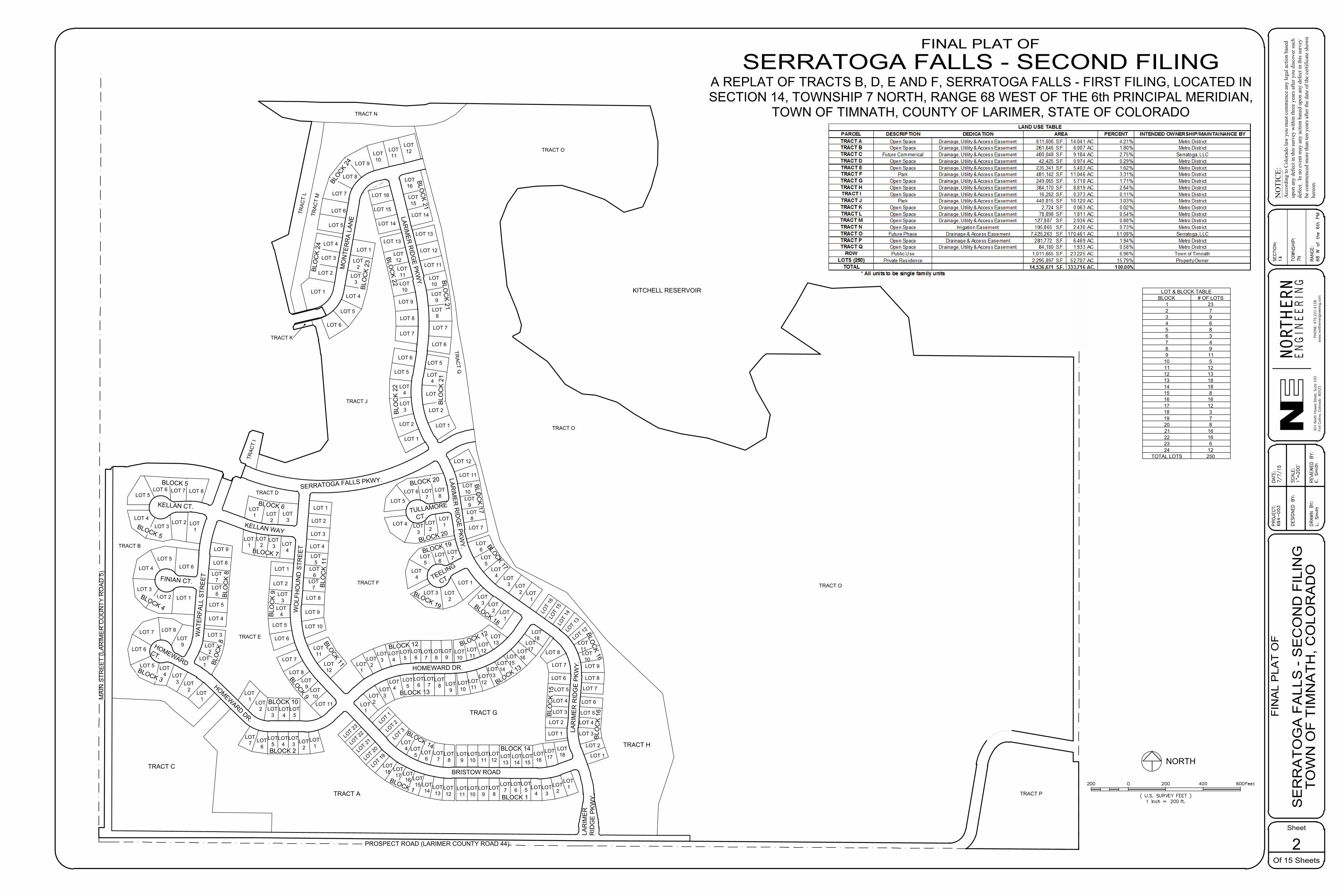
LOT1
LOT 1LOT 2LOT 3
LOT 4
LOT 5LOT 6
LOT 5LOT 6
LOT 4LOT 3
LOT 8LOT 7
LOT 2 LOT1
LOT 4
LOT 5
LOT 6
LOT2
LOT1
LOT7
LOT8
LOT 7
LOT8
LOT9
LOT10
LOT 11
LOT 12
LOT 1
LOT 2
LOT3 LOT 2
LOT 1
LOT4 LOT 3
LOT4
LOT 5
LOT 6LOT 5
LOT 6
LOT 7
LOT 8
LOT 7
LOT8
LOT9LOT 9
LOT10
LOT11 LOT
10
LOT 11
LOT12
LOT 13
LOT 12
LOT 13
LOT 14
LOT15
LOT16
LOT 16
LOT 15
LOT 1
LOT2
LOT3
LOT 4
LOT 5
LOT 6
LOT 1
LOT 2
LOT 3
LOT 4
LOT 5
LOT 6
LOT 7
LOT 8
LOT 9
LOT10
LOT11
LOT12
TRACT B
TRACT D
TRACT J
TRACT O
TRACT O
TRACT O
TRAC
T L
KELLAN CT.
FINIAN CT.
HOMEWARDCT.
TULLAMORE
CT.
LAR
IME
RR
IDG
E P
KW
Y.
WAT
ERFA
LL S
TREE
T
MO
NTE
RR
A LA
NE
SERRATOGA FALLS PKWY.
LARIM
ER R
IDG
E PKWY.
BLOCK 3
BLOCK 4
BLOCK 5
BLOCK 20 BLOC
K 17
BLO
CK
22
BLO
CK
21
BLOCK
24
BLO
CK
23
TRAC
T I
TRAC
T M
TRAC
T Q
TRACT K
KITCHELL RESERVOIR
MA
IN S
TRE
ET
(LA
RIM
ER
CO
UN
TY R
OA
D 5
)
PROSPECT ROAD (LARIMER COUNTY ROAD 44)
LOT2
LOT3
LOT4
LOT5
LOT6
LOT7LOT
8LOT
9LOT10
LOT11
LOT12
LOT13
LOT14
LOT15
LOT16
LOT17
LOT18
LOT 23
LOT1
LOT2
LOT3
LOT4
LOT5
LOT6
LOT7
LOT1
LOT2
LOT3
LOT4
LOT 5
LOT 6
LOT 7 LOT 8LOT
9
LOT1
LOT2
LOT 3
LOT 4
LOT 5
LOT6
LOT7
LOT 8
LOT 9
LOT 1
LOT 2
LOT3
LOT4
LOT 5
LOT 6
LOT 7
LOT 8LOT
9
LOT 11
LOT10
LOT5
LOT4
LOT3
LOT2
LOT1
LOT1
LOT2
LOT3 LOT
4
LOT3
LOT2
LOT1
LOT18
LOT17LOT
16LOT15
LOT14
LOT13
LOT12
LOT11
LOT10
LOT9
LOT8
LOT7
LOT6
LOT5
LOT4
LOT1
LOT2
LOT3
LOT4
LOT5
LOT6
LOT7
LOT8
LOT9
LOT10
LOT11
LOT12
LOT13
LOT9
LOT8
LOT7
LOT6
LOT5
LOT4LOT
3LOT2LOT
1
LOT10
LOT11
LOT12
LOT13
LOT14
LOT15
LOT16
LOT17
LOT18
LOT7LOT
6LOT
5LOT
4
LOT2
LOT6LOT
5LOT
4 LOT3 LOT
2 LOT1LOT
3 LOT2 LOT
1
LOT
16
LOT 1
LOT 2
LOT 3
LOT 4
LOT5
LOT6
LOT7
LOT 8
LOT 9
LOT 10
LOT11
LOT12
LOT 3
LOT 1
LOT 8
LOT 7
LOT 6
LOT 5
LOT 4
LOT 3
LOT 2
LOT 1
LOT11LOT10LOT 9
LOT 8
LOT 7
LOT 6
LOT 5
LOT 4
LOT 3
LOT 2
LOT 1
LOT3
LOT 14
LOT 22
LOT 21
LOT 20
LOT 19
BRISTOW ROAD
HOMEWARD DR.
KELLAN WAY
WO
LFH
OU
ND
STR
EET
HOMEWARD DR.
TRACT G
TRACT A
TRACT C
TRACT E
TRACT F
TRACT H
LOT 1
LOT 2
LOT 3 LA
RIM
ER
RID
GE
PK
WY
.
LOT
15LO
T 14
LOT 13
LOT 12
BLOCK 17
BLOCK 19
TEELING
CT.
LARIM
ER R
IDG
E PKWY.
TRACT N
TRACT P
BLO
CK
24
BLOC
K 21
BLOC
K 21
BLOC
K 22
BLOCK 5
BLO
CK
8
BLO
CK
8
BLOCK 6
BLOCK 7
BLO
CK
9
BLOCK 9
BLOCK 10
BLOCK 2
BLO
CK
11
BLOCK 12
BLOCK 18
BLOCK 11
BLOCK 12
BLOCK 14
BLOCK 1
BLOCK 13
BLOCK 13
BLOCK 14
BLOCK 1
BLO
CK
16BLO
CK
15
BLOCK 16
BLOCK 20
BLOCK 19
RE
VIE
WE
D B
Y:
E. S
mith
DE
SIG
NE
D B
Y:
DR
AW
N B
Y:
SC
ALE
:
DA
TE:
7/7/
15P
RO
JEC
T:69
4-00
3
Sheet
Of 15 Sheets
FIN
AL
PLA
T O
FN
OTI
CE :
Acc
ordi
ng to
Col
orad
o la
w y
ou m
ust c
omm
ence
any
lega
l act
ion
base
dup
on a
ny d
efec
t in
this
surv
ey w
ithin
thre
e ye
ars a
fter y
ou d
isco
ver s
uch
defe
ct.
In n
o ev
ent m
ay a
ny a
ctio
n ba
sed
upon
any
def
ect i
n th
is su
rvey
be c
omm
ence
d m
ore
than
ten
year
s afte
r the
dat
e of
the
certi
ficat
e sh
own
here
on.
RA
NG
E:
TO
WN
SH
IP:
SE
CT
ION
:
301 N
orth
How
es S
tree
t, S
uite
100
Fort
Col
lins,
Col
orad
o 8
0521
EN
GIN
EE
RN
GIE
HTRON
RNPH
ON
E: 9
70.2
21.4
158
ww
w.n
orth
erne
ngin
eerin
g.co
m
2
S
ER
RA
TO
GA
FA
LLS
- S
EC
ON
D F
ILIN
G
TO
WN
OF
TIM
NA
TH
, CO
LOR
AD
OL
. S
mith
1"=
200'
14 7N 68 W
of th
e 6
th P
M
NORTH
( U.S. SURVEY FEET )1 inch = ft.
Feet0XX XX
XX
XX XX
FINAL PLAT OFSERRATOGA FALLS - SECOND FILING
A REPLAT OF TRACTS B, D, E AND F, SERRATOGA FALLS - FIRST FILING, LOCATED INSECTION 14, TOWNSHIP 7 NORTH, RANGE 68 WEST OF THE 6th PRINCIPAL MERIDIAN,
TOWN OF TIMNATH, COUNTY OF LARIMER, STATE OF COLORADO
LOT & BLOCK TABLEBLOCK # OF LOTS
1 232 73 94 65 86 37 48 99 11
10 511 1212 1313 1814 1815 816 1617 1218 319 720 821 1622 1623 624 12
TOTAL LOTS 250
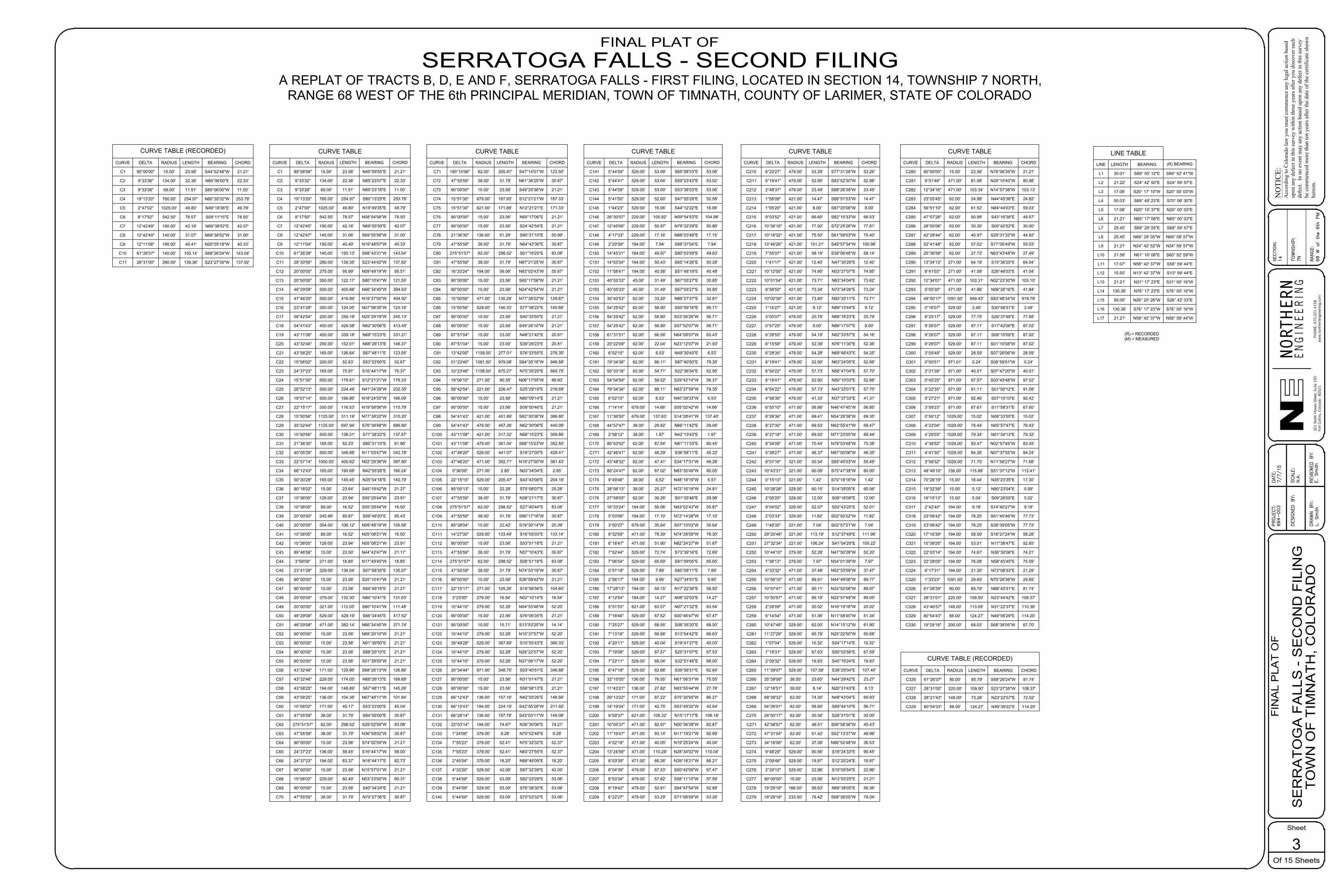
CURVE TABLE
CURVE
C1
C2
C3
C4
C5
C6
C7
C8
C9
C10
C11
C12
C13
C14
C15
C16
C17
C18
C19
C20
C21
C22
C23
C24
C25
C26
C27
C28
C29
C30
C31
C32
C33
C34
C35
C36
C37
C38
C39
C40
C41
C42
C43
C44
C45
C46
C47
C48
C49
C50
C51
C52
C53
C54
C55
C56
C57
C58
C59
C60
C61
C62
C63
C64
C65
C66
C67
C68
C69
C70
DELTA
89°58'58"
9°33'32"
9°33'26"
19°13'20"
2°47'00"
8°17'50"
12°42'45"
12°42'47"
12°11'04"
61°26'38"
28°30'56"
20°00'00"
20°00'00"
46°29'08"
47°46'20"
23°41'28"
58°42'54"
54°41'43"
43°11'08"
43°32'46"
43°58'25"
15°08'02"
24°37'23"
15°51'30"
26°52'13"
19°07'14"
22°15'17"
15°50'56"
35°32'44"
15°50'56"
21°36'30"
40°05'35"
22°57'14"
66°12'43"
50°30'28"
90°18'02"
10°38'05"
10°38'05"
20°00'00"
20°00'00"
10°38'05"
10°38'05"
89°46'56"
3°59'09"
23°41'28"
90°00'00"
90°00'00"
20°00'00"
20°00'00"
46°29'08"
46°29'08"
90°00'00"
90°00'00"
90°00'00"
90°00'00"
43°32'46"
43°32'46"
43°58'25"
43°58'25"
15°08'02"
47°55'59"
275°51'57"
47°55'59"
90°00'00"
24°37'23"
24°37'23"
90°00'00"
15°08'02"
90°00'00"
47°55'59"
RADIUS
15.00'
134.00'
69.00'
760.00'
1025.00'
542.55'
190.00'
140.00'
190.00'
140.00'
280.00'
275.00'
350.00'
500.00'
500.00'
300.00'
250.00'
450.00'
450.00'
200.00'
165.00'
200.00'
165.00'
650.00'
500.00'
500.00'
300.00'
1125.00'
1125.00'
500.00'
165.00'
500.00'
1000.00'
165.00'
165.00'
15.00'
129.00'
89.00'
245.99'
304.00'
89.00'
129.00'
15.00'
271.00'
329.00'
15.00'
15.00'
379.00'
321.00'
529.00'
471.00'
15.00'
15.00'
15.00'
15.00'
171.00'
229.00'
194.00'
136.00'
171.00'
38.00'
62.00'
38.00'
15.00'
136.00'
194.00'
15.00'
229.00'
15.00'
38.00'
LENGTH
23.56'
22.36'
11.51'
254.97'
49.80'
78.57'
42.16'
31.06'
40.40'
150.13'
139.35'
95.99'
122.17'
405.66'
416.89'
124.05'
256.19'
429.58'
339.18'
152.01'
126.64'
52.83'
70.91'
179.91'
234.49'
166.86'
116.53'
311.19'
697.94'
138.31'
62.23'
349.88'
400.62'
190.68'
145.45'
23.64'
23.94'
16.52'
85.87'
106.12'
16.52'
23.94'
23.50'
18.85'
136.04'
23.56'
23.56'
132.30'
112.05'
429.19'
382.14'
23.56'
23.56'
23.56'
23.56'
129.96'
174.05'
148.89'
104.38'
45.17'
31.79'
298.52'
31.79'
23.56'
58.45'
83.37'
23.56'
60.49'
23.56'
31.79'
BEARING
N45°09'55"E
N85°23'07"E
N85°23'16"E
S80°13'25"E
N19°49'35"E
N08°54'08"W
N69°55'59"E
S69°55'58"W
N19°48'07"W
S68°43'31"W
S23°44'42"W
N09°49'19"W
S80°10'41"W
N66°34'45"W
N19°27'00"W
N07°58'35"W
N25°29'19"W
N62°30'06"E
N68°15'23"E
N68°26'13"E
S67°48'11"E
S53°23'00"E
S16°44'17"W
S12°21'21"W
N41°24'39"W
N18°24'55"W
N19°58'56"W
N77°38'22"W
S76°39'48"W
S77°38'22"E
S80°31'10"E
N11°03'47"W
N02°29'36"W
N42°55'26"E
N35°04'18"E
S45°19'42"W
S05°29'44"W
S05°29'44"W
S09°49'20"E
N09°49'19"W
N05°08'21"W
N05°08'21"W
N44°42'47"W
N17°49'45"W
S07°58'35"E
S25°10'41"W
S64°49'19"E
N80°10'41"E
S80°10'41"W
S66°34'45"E
N66°34'45"W
N88°20'10"W
N01°39'50"E
S88°20'10"E
S01°39'50"W
S68°26'13"W
N68°26'13"E
S67°48'11"E
N67°48'11"W
S53°23'00"E
S84°55'00"E
S29°02'59"W
N36°59'02"W
S74°02'59"W
S16°44'17"W
N16°44'17"E
N15°57'01"W
N53°23'00"W
S40°34'24"E
N70°27'36"E
CHORD
21.21'
22.33'
11.50'
253.78'
49.79'
78.50'
42.07'
31.00'
40.33'
143.04'
137.92'
95.51'
121.55'
394.63'
404.92'
123.16'
245.13'
413.45'
331.21'
148.37'
123.55'
52.67'
70.37'
179.33'
232.35'
166.09'
115.79'
310.20'
686.80'
137.87'
61.86'
342.78'
397.95'
180.24'
140.79'
21.27'
23.91'
16.50'
85.43'
105.58'
16.50'
23.91'
21.17'
18.85'
135.07'
21.21'
21.21'
131.63'
111.48'
417.52'
371.74'
21.21'
21.21'
21.21'
21.21'
126.86'
169.89'
145.26'
101.84'
45.04'
30.87'
83.08'
30.87'
21.21'
58.00'
82.73'
21.21'
60.31'
21.21'
30.87'
CURVE TABLE
CURVE
C71
C72
C73
C74
C75
C76
C77
C78
C79
C80
C81
C82
C83
C84
C85
C86
C87
C88
C89
C90
C91
C92
C93
C94
C95
C96
C97
C98
C99
C100
C101
C102
C103
C104
C105
C106
C107
C108
C109
C110
C111
C112
C113
C114
C115
C116
C117
C118
C119
C120
C121
C122
C123
C124
C125
C126
C127
C128
C129
C130
C131
C132
C133
C134
C135
C136
C137
C138
C139
C140
DELTA
190°15'06"
47°55'59"
90°00'00"
15°51'30"
15°51'30"
90°00'00"
90°00'00"
21°36'30"
47°55'59"
275°51'57"
47°55'59"
16°33'24"
90°00'00"
90°00'00"
15°50'56"
15°50'56"
90°00'00"
90°00'00"
87°51'04"
87°51'04"
13°42'00"
51°23'40"
33°23'48"
19°06'10"
58°42'54"
90°00'00"
90°00'00"
54°41'43"
54°41'43"
43°11'08"
43°11'08"
47°46'20"
47°46'20"
0°36'09"
22°15'15"
85°05'13"
47°55'59"
275°51'57"
47°55'59"
85°38'04"
14°27'30"
90°00'00"
47°55'59"
275°51'57"
47°55'59"
90°00'00"
22°15'17"
3°23'50"
10°44'10"
90°00'00"
90°00'00"
10°44'10"
39°49'28"
10°44'10"
10°44'10"
20°34'44"
90°00'00"
90°00'00"
66°12'43"
66°12'43"
66°28'14"
22°03'14"
1°24'09"
7°55'23"
7°55'23"
2°45'04"
4°33'20"
5°44'59"
5°44'59"
5°44'59"
RADIUS
62.00'
38.00'
15.00'
679.00'
621.00'
15.00'
15.00'
136.00'
38.00'
62.00'
38.00'
194.00'
15.00'
15.00'
471.00'
529.00'
15.00'
15.00'
15.00'
15.00'
1158.50'
1091.50'
1158.50'
271.00'
221.00'
15.00'
15.00'
421.00'
479.00'
421.00'
479.00'
529.00'
471.00'
271.00'
529.00'
15.00'
38.00'
62.00'
38.00'
15.00'
529.00'
15.00'
38.00'
62.00'
38.00'
15.00'
271.00'
279.00'
279.00'
15.00'
10.00'
279.00'
529.00'
279.00'
279.00'
971.00'
15.00'
15.00'
136.00'
194.00'
136.00'
194.00'
379.00'
379.00'
379.00'
379.00'
529.00'
529.00'
529.00'
529.00'
LENGTH
205.87'
31.79'
23.56'
187.93'
171.88'
23.56'
23.56'
51.29'
31.79'
298.52'
31.79'
56.06'
23.56'
23.56'
130.29'
146.33'
23.56'
23.56'
23.00'
23.00'
277.01'
979.08'
675.27'
90.35'
226.47'
23.56'
23.56'
401.89'
457.26'
317.32'
361.04'
441.07'
392.71'
2.85'
205.47'
22.28'
31.79'
298.52'
31.79'
22.42'
133.49'
23.56'
31.79'
298.52'
31.79'
23.56'
105.26'
16.54'
52.28'
23.56'
15.71'
52.28'
367.69'
52.28'
52.28'
348.75'
23.56'
23.56'
157.16'
224.19'
157.78'
74.67'
9.28'
52.41'
52.41'
18.20'
42.06'
53.09'
53.09'
53.09'
BEARING
S47°14'01"W
N61°36'25"W
S49°25'36"W
S12°21'21"W
N12°21'21"E
N65°17'06"E
S24°42'54"E
S80°31'10"E
N64°42'36"E
S01°19'25"E
N67°21'25"W
N83°02'43"W
S65°17'06"W
N24°42'54"W
N77°38'22"W
S77°38'22"E
S40°33'50"E
S49°26'10"W
N48°21'42"E
S39°29'23"E
S76°33'55"E
S84°35'16"W
N75°35'20"E
N06°17'05"W
S25°29'19"E
N80°09'14"E
S09°50'46"E
S62°30'06"W
N62°30'06"E
N68°15'23"E
S68°15'23"W
S19°27'00"E
N19°27'00"W
N03°34'04"E
S43°43'08"E
S75°08'07"E
N38°21'17"E
S27°40'44"E
S86°17'16"W
S19°30'14"W
S16°05'03"E
S53°51'18"E
N57°10'43"E
S08°51'18"E
N74°53'19"W
S36°08'42"W
S19°58'56"E
N02°10'14"E
N04°53'46"W
S76°06'35"E
S13°53'25"W
N15°37'57"W
S10°55'43"E
N26°22'07"W
N37°06'17"W
S03°40'51"E
N31°01'47"E
S58°58'13"E
N42°55'26"E
S42°55'26"W
S43°03'11"W
N36°30'06"E
N70°52'46"E
N75°32'32"E
N83°27'55"E
N88°48'09"E
S87°32'39"E
S82°23'29"E
S76°38'30"E
S70°53'32"E
CHORD
123.50'
30.87'
21.21'
187.33'
171.33'
21.21'
21.21'
50.99'
30.87'
83.08'
30.87'
55.87'
21.21'
21.21'
129.87'
145.86'
21.21'
21.21'
20.81'
20.81'
276.35'
946.58'
665.75'
89.93'
216.69'
21.21'
21.21'
386.80'
440.09'
309.86'
352.55'
428.41'
381.43'
2.85'
204.18'
20.28'
30.87'
83.08'
30.87'
20.39'
133.14'
21.21'
30.87'
83.08'
30.87'
21.21'
104.60'
16.54'
52.20'
21.21'
14.14'
52.20'
360.33'
52.20'
52.20'
346.88'
21.21'
21.21'
148.56'
211.92'
149.08'
74.21'
9.28'
52.37'
52.37'
18.20'
42.05'
53.06'
53.06'
53.06'
CURVE TABLE
CURVE
C141
C142
C143
C144
C145
C146
C147
C148
C149
C150
C151
C152
C153
C153
C154
C155
C156
C157
C158
C159
C160
C161
C162
C163
C164
C165
C166
C167
C168
C169
C170
C171
C172
C173
C174
C175
C176
C177
C178
C179
C180
C181
C182
C183
C184
C185
C186
C187
C188
C189
C190
C191
C192
C193
C194
C195
C196
C197
C198
C199
C200
C201
C202
C203
C204
C205
C206
C207
C208
C209
DELTA
5°44'59"
5°44'41"
5°44'59"
5°41'50"
1°44'23"
26°30'07"
12°45'06"
4°17'33"
2°20'39"
14°45'31"
14°53'34"
11°58'41"
40°05'33"
40°05'33"
30°40'53"
54°25'42"
54°25'42"
54°25'42"
61°31'51"
20°22'09"
6°02'15"
79°34'36"
50°33'16"
54°04'59"
79°34'36"
6°02'15"
1°14'14"
11°36'50"
44°57'47"
2°58'12"
80°53'52"
42°46'41"
43°48'32"
80°24'47"
9°49'46"
38°06'13"
27°58'05"
16°33'24"
5°03'06"
3°00'27"
9°32'09"
6°18'47"
7°52'44"
7°06'54"
0°51'18"
2°56'17"
17°28'13"
4°12'54"
5°51'53"
7°18'46"
7°25'27"
7°13'18"
4°20'11"
7°19'08"
7°22'11"
6°47'19"
32°15'05"
11°43'21"
29°13'22"
14°19'24"
9°59'37"
10°05'37"
11°19'47"
4°52'18"
13°24'59"
8°03'39"
8°04'39"
6°53'34"
6°19'42"
6°22'27"
RADIUS
529.00'
529.00'
529.00'
529.00'
529.00'
229.00'
229.00'
229.00'
194.00'
194.00'
194.00'
194.00'
45.00'
45.00'
62.00'
62.00'
62.00'
62.00'
62.00'
62.00'
62.00'
62.00'
62.00'
62.00'
62.00'
62.00'
679.00'
679.00'
38.00'
38.00'
62.00'
62.00'
62.00'
62.00'
38.00'
38.00'
62.00'
194.00'
194.00'
679.00'
471.00'
471.00'
529.00'
529.00'
529.00'
194.00'
194.00'
194.00'
621.00'
529.00'
529.00'
529.00'
529.00'
529.00'
529.00'
529.00'
136.00'
136.00'
171.00'
171.00'
621.00'
471.00'
471.00'
471.00'
471.00'
471.00'
479.00'
479.00'
479.00'
479.00'
LENGTH
53.09'
53.04'
53.09'
52.60'
16.06'
105.92'
50.97'
17.16'
7.94'
49.97'
50.43'
40.56'
31.49'
31.49'
33.20'
58.90'
58.90'
58.90'
66.58'
22.04'
6.53'
86.11'
54.71'
58.52'
86.11'
6.53'
14.66'
137.63'
29.82'
1.97'
87.54'
46.29'
47.41'
87.02'
6.52'
25.27'
30.26'
56.06'
17.10'
35.64'
78.39'
51.90'
72.74'
65.69'
7.89'
9.95'
59.15'
14.27'
63.57'
67.52'
68.55'
66.68'
40.04'
67.57'
68.04'
62.68'
76.55'
27.82'
87.22'
42.75'
108.32'
82.97'
93.14'
40.05'
110.29'
66.26'
67.53'
57.62'
52.91'
53.29'
BEARING
S65°08'33"E
S59°23'43"E
S53°38'53"E
S47°55'28"E
S44°12'22"E
N59°54'53"E
N79°32'29"E
N88°03'49"E
S88°37'04"E
S80°03'59"E
S65°14'26"E
S51°48'19"E
S67°05'27"E
S67°05'27"E
N86°27'27"E
S50°59'16"E
S03°26'26"W
S57°52'07"W
N64°09'07"W
N23°12'07"W
N49°30'45"E
S87°40'50"E
S22°36'54"E
S29°42'14"W
N83°27'59"W
N40°39'33"W
S05°02'42"W
S14°28'41"W
N66°11'42"E
N42°13'43"E
N81°11'33"E
S36°58'11"E
S34°17'31"W
N83°35'49"W
N48°18'19"W
N72°16'18"W
S01°35'48"E
N83°02'43"W
N72°14'28"W
S07°10'03"W
N74°28'59"W
N82°24'27"W
S73°39'16"E
S81°09'05"E
S85°08'11"E
N27°34'51"E
N17°22'36"E
N06°32'03"E
N07°21'32"E
S00°46'47"W
S06°35'20"E
S13°54'42"E
S19°41'27"E
S25°31'07"E
S32°51'46"E
S39°56'31"E
N61°56'31"W
N83°55'44"W
S75°35'55"W
S53°49'32"W
N15°17'17"E
N00°36'39"W
N11°19'21"W
N19°25'24"W
N28°34'02"W
N39°18'21"W
S50°42'09"W
S58°11'15"W
S64°47'54"W
S71°08'59"W
CHORD
53.06'
53.02'
53.06'
52.58'
16.06'
104.98'
50.86'
17.15'
7.94'
49.83'
50.28'
40.48'
30.85'
30.85'
32.81'
56.71'
56.71'
56.71'
63.43'
21.93'
6.53'
79.35'
52.95'
56.37'
79.35'
6.53'
14.66'
137.40'
29.06'
1.97'
80.45'
45.22'
46.26'
80.05'
6.51'
24.81'
29.96'
55.87'
17.10'
35.64'
78.30'
51.87'
72.69'
65.65'
7.89'
9.95'
58.92'
14.27'
63.54'
67.47'
68.50'
66.63'
40.03'
67.53'
68.00'
62.64'
75.55'
27.78'
86.27'
42.64'
108.18'
82.87'
92.99'
40.04'
110.04'
66.21'
67.47'
57.59'
52.88'
53.26'
CURVE TABLE
CURVE
C210
C211
C212
C213
C214
C215
C216
C217
C218
C219
C220
C221
C222
C223
C224
C225
C226
C227
C228
C229
C230
C231
C232
C233
C234
C235
C236
C237
C238
C239
C240
C241
C242
C243
C244
C245
C246
C247
C248
C249
C250
C251
C252
C253
C254
C255
C256
C257
C258
C259
C260
C261
C262
C263
C264
C265
C266
C267
C268
C269
C270
C271
C272
C273
C274
C275
C276
C277
C278
C279
DELTA
6°22'27"
6°19'41"
2°48'37"
1°58'09"
1°05'20"
9°03'52"
10°36'18"
10°16'32"
13°46'26"
7°55'07"
1°41'17"
10°12'00"
10°01'54"
9°58'50"
10°02'39"
1°14'27"
3°05'07"
0°57'25"
6°28'55"
6°15'58"
6°29'35"
6°19'41"
6°54'22"
6°19'41"
6°54'22"
4°56'36"
6°55'10"
8°26'36"
8°27'30"
8°27'18"
8°34'09"
5°38'27"
9°01'16"
10°43'31"
0°15'13"
10°28'28"
2°05'25"
9°04'02"
2°03'33"
1°49'35"
29°20'46"
27°32'34"
10°44'10"
1°38'13"
4°33'32"
10°56'15"
10°57'41"
10°50'57"
2°26'09"
6°14'54"
10°47'48"
11°27'29"
1°07'04"
7°19'31"
2°09'32"
11°39'07"
35°39'08"
12°16'51"
68°39'32"
54°26'01"
28°00'17"
42°58'57"
47°31'04"
34°16'06"
9°48'29"
2°09'48"
2°29'12"
90°00'00"
19°29'18"
19°29'18"
RADIUS
479.00'
479.00'
479.00'
421.00'
421.00'
421.00'
421.00'
421.00'
421.00'
421.00'
421.00'
421.00'
421.00'
421.00'
421.00'
421.00'
479.00'
479.00'
479.00'
479.00'
479.00'
479.00'
479.00'
479.00'
479.00'
479.00'
471.00'
471.00'
471.00'
471.00'
471.00'
471.00'
321.00'
321.00'
321.00'
329.00'
329.00'
329.00'
329.00'
221.00'
221.00'
221.00'
279.00'
279.00'
471.00'
471.00'
471.00'
471.00'
471.00'
471.00'
329.00'
329.00'
529.00'
529.00'
529.00'
529.00'
38.00'
38.00'
62.00'
62.00'
62.00'
62.00'
62.00'
62.00'
529.00'
529.00'
529.00'
15.00'
166.50'
233.50'
LENGTH
53.29'
52.90'
23.49'
14.47'
8.00'
66.60'
77.92'
75.50'
101.21'
58.19'
12.40'
74.95'
73.71'
73.34'
73.80'
9.12'
25.79'
8.00'
54.19'
52.39'
54.28'
52.90'
57.73'
52.90'
57.73'
41.33'
56.88'
69.41'
69.53'
69.50'
70.44'
46.37'
50.54'
60.09'
1.42'
60.15'
12.00'
52.07'
11.82'
7.04'
113.19'
106.24'
52.28'
7.97'
37.48'
89.91'
90.11'
89.19'
20.02'
51.36'
62.00'
65.79'
10.32'
67.63'
19.93'
107.58'
23.65'
8.14'
74.30'
58.90'
30.30'
46.51'
51.42'
37.08'
90.56'
19.97'
22.96'
23.56'
56.63'
79.42'
BEARING
S77°31'26"W
S83°52'30"W
S88°26'39"W
S88°51'53"W
S87°20'08"W
S82°15'33"W
S72°25'28"W
S61°59'03"W
S49°57'34"W
S39°06'48"W
N47°30'28"E
N53°27'07"E
N63°34'04"E
N73°34'26"E
N83°35'11"E
N89°13'44"E
N88°18'23"E
N86°17'07"E
N82°33'57"E
N76°11'30"E
N69°48'43"E
N63°24'05"E
N56°47'04"E
N50°10'03"E
N43°33'01"E
N37°37'33"E
N46°47'45"W
N54°28'38"W
N62°55'41"W
N71°23'05"W
N79°53'48"W
N87°00'06"W
S85°40'03"W
S75°47'39"W
S70°18'18"W
S14°35'05"E
S08°18'08"E
S02°43'25"E
S02°50'22"W
S02°57'21"W
S12°37'49"E
S41°04'29"E
N47°50'28"W
N54°01'39"W
N52°33'59"W
N44°49'06"W
N33°52'08"W
N22°57'49"W
N16°19'16"W
N11°58'45"W
N14°15'12"W
N25°22'50"W
S54°17'14"E
S50°03'56"E
S45°19'24"E
S38°25'04"E
N44°29'42"E
N20°31'43"E
N48°43'04"E
S69°44'10"E
S28°31'01"E
S06°58'36"W
S52°13'37"W
N86°52'48"W
S18°24'33"E
S12°25'24"E
S10°05'54"E
N13°53'25"E
N68°38'05"E
S68°38'05"W
CHORD
53.26'
52.88'
23.49'
14.47'
8.00'
66.53'
77.81'
75.40'
100.96'
58.14'
12.40'
74.85'
73.62'
73.24'
73.71'
9.12'
25.79'
8.00'
54.16'
52.36'
54.25'
52.88'
57.70'
52.88'
57.70'
41.31'
56.85'
69.35'
69.47'
69.44'
70.38'
46.35'
50.49'
60.00'
1.42'
60.06'
12.00'
52.01'
11.82'
7.04'
111.96'
105.22'
52.20'
7.97'
37.47'
89.77'
89.97'
89.05'
20.02'
51.34'
61.90'
65.68'
10.32'
67.59'
19.93'
107.40'
23.27'
8.13'
69.93'
56.71'
30.00'
45.43'
49.96'
36.53'
90.45'
19.97'
22.96'
21.21'
56.36'
79.04'
CURVE TABLE
CURVE
C280
C281
C282
C283
C284
C285
C286
C287
C288
C289
C290
C291
C292
C293
C294
C295
C296
C297
C298
C299
C300
C301
C302
C303
C304
C305
C306
C307
C308
C309
C310
C311
C312
C313
C314
C315
C316
C317
C318
C319
C320
C321
C322
C323
C324
C325
C326
C327
C328
C329
C330
DELTA
90°00'00"
9°51'48"
12°34'16"
23°05'45"
56°51'10"
47°07'26"
28°00'06"
42°28'44"
52°41'48"
25°36'58"
13°34'13"
8°41'03"
12°34'01"
5°05'30"
49°50'17"
0°16'07"
8°25'17"
9°26'07"
9°26'07"
9°26'07"
3°05'49"
0°00'51"
2°21'39"
5°45'25"
5°22'35"
5°27'21"
3°59'23"
0°50'12"
4°22'04"
4°25'03"
4°38'52"
4°41'30"
3°59'32"
48°49'10"
70°26'19"
19°32'39"
19°15'13"
2°42'40"
23°06'42"
23°06'42"
17°16'39"
15°39'25"
22°03'14"
22°28'05"
6°17'31"
1°33'23"
61°26'39"
28°31'01"
43°46'57"
80°54'43"
19°29'18"
RADIUS
15.00'
471.00'
471.00'
62.00'
62.00'
62.00'
62.00'
62.00'
62.00'
62.00'
271.00'
271.00'
471.00'
471.00'
1091.50'
529.00'
529.00'
529.00'
529.00'
529.00'
529.00'
971.01'
971.00'
971.00'
971.00'
971.00'
971.00'
1029.00'
1029.00'
1029.00'
1029.00'
1029.00'
1029.00'
136.00'
15.00'
15.00'
15.00'
194.00'
194.00'
194.00'
194.00'
194.00'
194.00'
194.00'
194.00'
1091.50'
80.00'
220.00'
148.00'
88.00'
200.00'
LENGTH
23.56'
81.08'
103.34'
24.99'
61.52'
50.99'
30.30'
45.97'
57.02'
27.72'
64.19'
41.08'
103.31'
41.86'
949.43'
2.48'
77.75'
87.11'
87.11'
87.11'
28.59'
0.24'
40.01'
97.57'
91.11'
92.46'
67.61'
15.02'
78.44'
79.34'
83.47'
84.26'
71.70'
115.88'
18.44'
5.12'
5.04'
9.18'
78.25'
78.25'
58.50'
53.01'
74.67'
76.08'
21.30'
29.65'
85.79'
109.50'
113.09'
124.27'
68.03'
BEARING
N76°06'35"W
N26°10'40"W
N14°57'38"W
N44°45'36"E
N84°44'03"E
S43°16'38"E
S05°42'52"E
S29°31'32"W
S77°06'49"W
N63°43'48"W
S15°38'25"E
S26°46'03"E
N02°23'30"W
N06°26'16"E
S83°48'34"W
S30°58'31"E
S26°37'48"E
S17°42'06"E
S08°15'59"E
S01°10'08"W
S07°26'06"W
S08°59'01"W
S07°47'20"W
S03°43'48"W
S01°50'12"E
S07°15'10"E
S11°58'31"E
N08°33'55"E
N05°57'47"E
N01°34'13"E
N02°57'45"W
N07°37'55"W
N11°58'27"W
S51°37'12"W
N35°23'35"E
N80°23'04"E
S09°26'55"E
S74°40'27"W
S61°45'46"W
S38°39'05"W
S18°27'24"W
N17°38'47"E
N36°30'06"E
N58°45'45"E
N73°08'33"E
N70°29'36"W
N68°43'31"E
N23°44'42"E
N31°22'37"E
N49°56'29"E
S68°38'05"W
CHORD
21.21'
80.98'
103.13'
24.82'
59.03'
49.57'
30.00'
44.92'
55.03'
27.49'
64.04'
41.04'
103.10'
41.84'
919.78'
2.48'
77.68'
87.02'
87.02'
87.02'
28.59'
0.24'
40.01'
97.52'
91.08'
92.42'
67.60'
15.02'
78.43'
79.32'
83.45'
84.24'
71.68'
112.41'
17.30'
5.09'
5.02'
9.18'
77.73'
77.73'
58.28'
52.85'
74.21'
75.59'
21.29'
29.65'
81.74'
108.37'
110.36'
114.20'
67.70'
C327
C328
C329
28°31'00"
28°21'43"
80°54'33"
220.00'
148.00'
88.00'
109.50'
73.26'
124.27'
S23°27'35"W
N23°22'57"E
N49°39'22"E
108.37'
72.52'
114.20'
CURVE TABLE (RECORDED)
CURVE DELTA RADIUS LENGTH BEARING CHORD
C326 61°26'37" 80.00' 85.79' S68°26'24"W 81.74'
LINE TABLE
LINE
L1
L2
L3
L4
L5
L6
L7
L8
L9
L10
L11
L12
L13
L14
L15
L16
L17
LENGTH
30.01'
21.22'
17.08'
50.03'
17.08'
21.21'
25.45'
25.45'
21.21'
21.56'
17.07'
15.50'
21.21'
130.36'
50.00'
130.36'
21.21'
BEARING
S89° 50' 12"E
S24° 42' 50"E
S20° 17' 10"W
S69° 49' 23"E
N20° 10' 37"E
N65° 17' 08"E
S69° 29' 05"E
N69° 29' 05"W
N24° 42' 52"W
N61° 10' 06"E
N58° 42' 37"W
N13° 42' 37"W
N31° 17' 23"E
N76° 17' 23"E
N26° 25' 26"W
S76° 17' 23"W
N58° 42' 37"W
(R) BEARING
S89° 52' 41"W
S24° 59' 57"E
S20° 00' 03"W
S70° 06' 30"E
N20° 00' 03"E
N65° 00' 03"E
S69° 59' 57"E
N69° 59' 57"W
N24° 59' 57"W
S60° 52' 59"W
S58° 59' 44"E
S13° 59' 44"E
S31° 00' 16"W
S76° 00' 16"W
S26° 42' 33"E
S76° 00' 16"W
N58° 59' 44"W
(R) = RECORDED(M) = MEASURED
CURVE TABLE (RECORDED)
CURVE
C1
C2
C3
C4
C5
C6
C7
DELTA
90°00'00"
9°33'36"
9°33'36"
19°13'20"
8°17'52"
12°42'49"
12°42'49"
RADIUS
15.00'
134.00'
69.00'
760.00'
542.50'
190.00'
140.00'
LENGTH
23.56'
22.36'
11.51'
254.97'
78.57'
42.16'
31.07'
BEARING
S44°52'48"W
N85°06'00"E
S85°06'00"W
N80°30'32"W
S09°11'15"E
N69°38'52"E
N69°38'52"W
CHORD
21.21'
22.33'
11.50'
253.78'
78.50'
42.07'
31.00'C8
2°47'02" 1025.00' 49.80' N49°18'36"E 49.79'
C9
C10
C11
12°11'08"
61°26'37"
28°31'00"
190.00'
140.00'
280.00'
40.41'
150.14'
139.36'
N20°05'18"W
S68°26'24"W
S23°27'35"W
40.33'
143.04'
137.92'
RE
VIE
WE
D B
Y:
E. S
mith
DE
SIG
NE
D B
Y:
DR
AW
N B
Y:
SC
ALE
:
DA
TE:
7/7/
15P
RO
JEC
T:69
4-00
3
Sheet
Of 15 Sheets
FIN
AL
PLA
T O
FN
OTI
CE :
Acc
ordi
ng to
Col
orad
o la
w y
ou m
ust c
omm
ence
any
lega
l act
ion
base
dup
on a
ny d
efec
t in
this
surv
ey w
ithin
thre
e ye
ars a
fter y
ou d
isco
ver s
uch
defe
ct.
In n
o ev
ent m
ay a
ny a
ctio
n ba
sed
upon
any
def
ect i
n th
is su
rvey
be c
omm
ence
d m
ore
than
ten
year
s afte
r the
dat
e of
the
certi
ficat
e sh
own
here
on.
RA
NG
E:
TO
WN
SH
IP:
SE
CT
ION
:
301 N
orth
How
es S
tree
t, S
uite
100
Fort
Col
lins,
Col
orad
o 8
0521
EN
GIN
EE
RN
GIE
HTRON
RNPH
ON
E: 9
70.2
21.4
158
ww
w.n
orth
erne
ngin
eerin
g.co
m
3
S
ER
RA
TO
GA
FA
LLS
- S
EC
ON
D F
ILIN
G
TO
WN
OF
TIM
NA
TH
, CO
LOR
AD
OL
. S
mith
N.A
.
14 7N 68 W
of th
e 6
th P
M
FINAL PLAT OFSERRATOGA FALLS - SECOND FILING
A REPLAT OF TRACTS B, D, E AND F, SERRATOGA FALLS - FIRST FILING, LOCATED IN SECTION 14, TOWNSHIP 7 NORTH,RANGE 68 WEST OF THE 6th PRINCIPAL MERIDIAN, TOWN OF TIMNATH, COUNTY OF LARIMER, STATE OF COLORADO

29.0'29.0'
29.0'
29.0'
FND #4 REBARW/YPC "TST LS 31169"
FND #4 REBARW/YPC "TST LS 31169"
FND #4 REBARW/YPC "TST LS 31169"
FND #4 REBARW/YPC "HAMMER LS 24307"
FND #4 REBARW/YPC "TST LS 31169"
FND #4 REBARW/YPC "TST LS 31169"
LOT 10
BLO
CK
2
LOT 14
LOT 13
LOT 12
LOT 11
TRACT A
SERRATOGA FALLSFIRST FILING
SER
RAT
OG
A FA
LLS
FIR
ST F
ILIN
G
SKIP
PIN
G S
TON
E C
OU
RT
(50'
RO
W P
ER S
ERR
ATO
GA
FALL
SFI
RST
FIL
ING
)
LARIM
ER R
IDG
E PKWY.
(58' RO
W)
C127
N76°01'47"E 134.06'
S14°
48'5
1"E
5
69.2
2'
N09
°49'
04"E
4
83.8
0'
C129
N76°01'47"E
37.66'
C128
S13°
58'1
3"E
5
44.4
0'
S76°01'47"W 248.29'
C130
S09°
49'0
4"W
4
83.8
0'
S14°
48'5
1"E
5
69.2
2'
N13
°58'
13"W
588.
39'
C34N76°01'47"E
81.66'
N76°01'47"E
177.63'
TRACT MOPEN SPACE
D,U&AE127,887 sq. ft.
2.936 ac.
LOT 914328 sq.ft.
LOT 1012105 sq.ft.
LOT 511760 sq.ft.
LOT 611760 sq.ft.
LOT 713599 sq.ft.
LOT 814303 sq.ft.
LOT 1310148 sq.ft.
LOT 1510200 sq.ft.
LOT 1410920 sq.ft.
LOT 1612339 sq.ft.
LOT 169600 sq.ft.
LOT 159600 sq.ft.
LOT 149682 sq.ft.
LOT 1212578 sq.ft.
N13
°58'
13"W
83.9
1'
S76°39'18"W 120.01'
N76°01'47"E 120.00'
N13
°58'
13"W
91.0
0'
N13
°58'
13"W
85.0
0'
N13
°58'
13"W
103.
23'
29.06'
N76°39'18"E 120.01'
80.3
7'
N76°01'47"E
N13
°58'
13"W
80.0
2'
N76°01'47"E
120.00'
81.3
3'
S76°39'18"W 120.01'
N13
°58'
13"W
80.0
0'
N76°01'47"E
120.00'
80.0
0'
N13
°58'
13"W
80.0
0'
N76°01'47"E
120.00'
80.0
0'
N76°01'47"E
120.00'
N76°01'47"E
120.00'
105.00'
N80°10'56"W 120.00'
208.
43'
23.6
4'
20.0
0'
N09
°49'
04"E
81.2
3'
S80°10'56"E 140.00'
N09
°49'
04"E
84.0
0'
S80°10'56"E140.00'
84.0
0'
N80°10'56"W 140.00'
N09
°49'
04"E
84.0
0'
S80°10'56"E140.00'
84.0
0'
N16
°59'
51"E
120.
59'
S62°54'16"E140.00'
C32
0
20.4
4'
N38°3
9'05"
E13
3.82'
S39°47'34"E
140.00'
C319
N61°36'22"E
133.89'
S16°
40'5
3"E
140.
37'
C318
C317
N76°01'47"E
89.78'
S13°
58'1
3"E
140.
00'
73.96'
N76°01'47"E
89.35'
S14°
22'1
2"E
140.
00'
90.33'
N13
°58'
13"W
140.
00'
S76°01'47"W
84.00'
20.0
0'
N11
°39'
04"E
821.
36'
N07
°35'
11"E
117.
95'
10.56'
LOT 1111760 sq.ft.
84.00'
N14
°48'
51"W
58.0
2'
S84°39'01"E179.27'
N82°56'48"E
51.00'
N72°26'27"E
63.66'
N60°08'37"E
70.08'
N45°2
0'44"E
83.79
'
TRACT NOPEN SPACE
IRRIGATION EASEMENT105,865 sq. ft.
2.430 ac.
MO
NTE
RR
A LA
NE
(58'
RO
W)
BLOCK
24
TRACT JPARK
D,U&AE440,815 sq. ft.
10.120 ac.
TRACT LOPEN SPACE
D,U&AE78,898 sq. ft.
1.811 ac.
TRACT OFUTURE PHASE
D&AE7,425,263 sq. ft.
170.461 ac.
BLO
CK
22
BLO
CK
21
LARIMER AND WELD CANAL
S87°55'26"E187.70'
N88°50'34"E 166.66'
S87°55'26"E67.43'
197.02'
49.94'116.72'
(R) S89°35'40"E 1179.98'S89°18'33"E 1180.00'
(R) S89°35'40"WN89°40'55"E 185.40' (R) N86°01'31"WS85°44'24"E 270.93' (R) S85°56'04"W
N86°13'11"E 102.28'
N72°19'37"E 28.22'(R) S72°01'57"W 28.21'
(R) N89°35'40"WS89°18'33"E 233.46'
S67°06'23"E 1.75'(R) N67°23'30"W
(R) N88°07'12"WS87°50'05"E 101.15'
N56°12'16"W 153.81'
(R) S56°29'23"E
N77°14'19"W 101.59'(R) S77°31'26"E N87°55'26"W59.03'
(R) S88°12'33"E
(R) S
11°2
6'38
"WN
11°4
3'45
"E 6
16.5
2'
(R) S63°49'09"W
N64°06'13"E 98.79'
50' EASEMENT TO ROCKYMOUNTAIN PIPELINE
REC. NO. 20060031332
10' UE
10' UE
14' UE
14' UE
10' UE
10' UE
14' UE14' UE
20' IRRIGATIONEASEMENT20' IRRIGATION
EASEMENT
20' IRRIGATIONEASEMENT
20' IRRIGATIONEASEMENT
20' IRRIGATIONEASEMENT
TRAC
T Q
OPEN
SPAC
E
D,U
&A
E
21.3
7'
85.2
2'
91.0
0'
85.0
0'
88.2
3'
N09
°49'
04"E
4
83.8
0'
S09°
49'0
4"W
4
83.8
0'
N80°13'27"W20.00'
S09°
49'0
4"W
83.7
9'
N80°10'56"W
S76°39'18"W11.08'
S53°01'00"W36.17'N80°10'56"W
96.99'S76°39'18"W7.11'
S53°01'00"W40.64'
20.0
0'
105.64'
N13°58'13"W
157.46'
S76°39'18"W 140.01'
S61°43'42"W 157.87'
SIGHT DISTANCEEASEMENT
C313
FND #4 REBARW/BPC ILLEG.
FND #4 REBARW/BPC ILLEG.
FND #4 REBARW/BPC ILLEG. FND #4 REBAR
W/YPC "KSI LS 22098"FND #4 REBARW/YPC "KSI LS 22098"FND #4 REBAR
W/YPC "KSI LS 22098"
FND #4 REBARW/YPC "KSI LS 22098"
FND #4 REBARW/BPC ILLEG.
FND #4 REBARW/YPC "KSI LS 22098"
FND #4 REBARW/YPC "TST LS 31169"
JACKSON HEIGHTS 1ST
RE
VIE
WE
D B
Y:
E. S
mith
DE
SIG
NE
D B
Y:
DR
AW
N B
Y:
SC
ALE
:
DA
TE:
7/7/
15P
RO
JEC
T:69
4-00
3
Sheet
Of 15 Sheets
FIN
AL
PLA
T O
FN
OTI
CE :
Acc
ordi
ng to
Col
orad
o la
w y
ou m
ust c
omm
ence
any
lega
l act
ion
base
dup
on a
ny d
efec
t in
this
surv
ey w
ithin
thre
e ye
ars a
fter y
ou d
isco
ver s
uch
defe
ct.
In n
o ev
ent m
ay a
ny a
ctio
n ba
sed
upon
any
def
ect i
n th
is su
rvey
be c
omm
ence
d m
ore
than
ten
year
s afte
r the
dat
e of
the
certi
ficat
e sh
own
here
on.
RA
NG
E:
TO
WN
SH
IP:
SE
CT
ION
:
301 N
orth
How
es S
tree
t, S
uite
100
Fort
Col
lins,
Col
orad
o 8
0521
EN
GIN
EE
RN
GIE
HTRON
RNPH
ON
E: 9
70.2
21.4
158
ww
w.n
orth
erne
ngin
eerin
g.co
m
4
S
ER
RA
TO
GA
FA
LLS
- S
EC
ON
D F
ILIN
G
TO
WN
OF
TIM
NA
TH
, CO
LOR
AD
OL
. S
mith
1"=
50'
14 7N 68 W
of th
e 6
th P
M
NORTH
( U.S. SURVEY FEET )1 inch = ft.
Feet0
LEGEND
PLATTED BOUNDARY LINE
CENTERLINE
EASEMENT LINE
LOT LINE
EXISTING RIGHT-OF-WAY
SECTION CORNER
FOUND CORNER AS DESCRIBED
RIGHT-OF-WAY
SECTION LINE
SET #4 REBAR WITH 1"PLASTIC CAP, LS 37987
SET NAIL & SHINER, LS 37987
UTILITY EASEMENTUE
UTILITY & ACCESS EASEMENTU&AE
DRAINAGE & ACCESS EASEMENTD&AE
DRAINAGE, UTILITY & ACCESSEASEMENT
D,U&AE
XX XX
XX
XX XX
SEE SHEET 5
SE
E S
HE
ET
14
FINAL PLAT OFSERRATOGA FALLS - SECOND FILING
A REPLAT OF TRACTS B, D, E AND F, SERRATOGA FALLS - FIRST FILING, LOCATED IN SECTION 14, TOWNSHIP 7 NORTH,RANGE 68 WEST OF THE 6th PRINCIPAL MERIDIAN, TOWN OF TIMNATH, COUNTY OF LARIMER, STATE OF COLORADO
RECORDED BEARING & DISTANCE(R)

29.0' 29.0'
29.0' 29.0'
FND #4 REBARW/YPC "HAMMER
LS 24307"
FND #4 REBARW/YPC "TST LS 31169"
FND #4 REBARW/YPC "HAMMER LS 24307"
FND #4 REBARW/YPC "TST LS 31169"
LOT 8
LOT 10
BLO
CK
1
LOT 6
LOT 7
LOT 9
LOT 14
SER
RAT
OG
A FA
LLS
FIR
ST F
ILIN
G
TER
RAC
E VI
EW S
TREE
T
(50'
RO
W P
ER S
ERR
ATO
GA
FALL
S
FIR
ST F
ILIN
G)
MO
NTE
RR
A LA
NE
(58'
RO
W)
S10°
37'5
6"E
4
03.1
6'
S06°
45'5
2"E
1
25.9
6'
S10°
05'2
9"E
1
96.2
5'
S07°
50'3
5"E
4
75.9
7'
N76°17'19"E124.88'
C132
N09
°49'
04"E
4
83.8
0'
S13°
58'1
3"E
5
44.4
0'
C12
6
S08°
59'0
1"W
1
30.1
8'
S09°
49'0
4"W
4
83.8
0'
C131
N08
°59'
01"E
130.
18'
C33
N13
°58'
13"W
588.
39'
C35
N09
°49'
04"E
483.
80'
LOT 810554 sq.ft.
LOT 710036 sq.ft.
LOT 910640 sq.ft.
LOT 109990 sq.ft.
LOT 119696 sq.ft.
LOT 1210200 sq.ft.
LOT 410859 sq.ft.
LOT 511249 sq.ft.
LOT 310080 sq.ft.
LOT 210081 sq.ft.
LOT 211368 sq.ft.
LOT 311368 sq.ft.
LOT 411372 sq.ft.
LOT 69600 sq.ft.
LOT 411483 sq.ft.
LOT 511760 sq.ft.
LOT 310996 sq.ft.
LOT 1010034 sq.ft.
LOT 119750 sq.ft.
LOT 129721 sq.ft.
LOT 710726 sq.ft.
LOT 810371 sq.ft.
LOT 910456 sq.ft.
LOT 1310148 sq.ft.
LOT 139639 sq.ft.
LOT 410191 sq.ft.
LOT 610007 sq.ft.
LOT 149682 sq.ft.
LOT 611407 sq.ft.
LOT 110080 sq.ft.TRACT L
OPEN SPACED,U&AE
78,898 sq. ft.1.811 ac.
LOT 59237 sq.ft.
LOT 121501 sq.ft.
N02
°36'
09"W
77.2
5'N
07°5
6'02
"E78
.57'
N08
°51'
53"E
77.0
7'
N81°00'59"W 120.01'
S81°00'59"E 119.82'
N06
°07'
53"E
89.3
1'N
01°4
3'55
"E88
.58'
N03
°06'
58"W
93.1
9'
N07
°37'
55"W
94.0
6'
N12
°09'
02"W
87.8
1'
N13
°58'
13"W
80.8
0'
N13
°58'
13"W
85.0
0'
N13
°58'
13"W
83.9
1'
S76°39'18"W 120.01'
N76°01'47"E 120.00'
LOT 59841 sq.ft.
N86°27'05"E
120.00'
N01
°10'
08"E
106.
76'
S84°06'48"E120.00'
C29
9
N08
°20'
54"E
85.4
8'
S81°00'59"E120.00'
50.4
1'C
300
N08
°59'
01"E
80.0
0'
S81°00'59"E120.00'
C301
79.7
6'
N81°14'16"E
120.67'
S86°26'35"E120.29'
S80°52'09"E120.17'
N03
°35'
47"E
79.0
7'
S89°46'08"E120.90'
C30
3
N81°00'59"W121.00'
N01
°44'
10"W
79.6
3'
N84°48'02"E
120.89'
C30
4
N07
°20'
42"W
79.4
5'
N78°39'36"E
121.25'
C305
N12
°00'
56"W
80.4
9'
N76°41'55"E
120.74' 17.0
4'
C306
N13
°27'
22"W
81.0
0'
N76°41'55"E
120.01'
81.0
1'
N13
°58'
13"W
81.0
1'
N76°41'55"E
120.01'
81.0
1'
N13
°58'
13"W
80.2
8'
N76°39'18"E 120.01'
80.3
7'
S86°13'15"E120.00'
N89°21'41"E
120.25'
N84°42'50"E
120.00'
N80°01'19"E
120.00'
N76°01'47"E
120.00'
N76°01'47"E
120.00'
N76°01'47"E
120.00'
N13
°58'
13"W
80.0
2'
81.3
3'
S76°39'18"W 120.01'
C324
S21°03'09"E
120.92'
N58°08'08"E
120.35'
N36°3
5'45"
E11
9.67
'
N15
°57'
42"E
109.
22'
N09
°49'
04"E
84.0
0'N
09°4
9'04
"E84
.01'
N09
°49'
04"E
84.0
0'
N80°10'56"W 120.00'
208.
43'
20.0
0'
C30
2
N13°42'41"W26.41'
30.36'
C323
S42°28'05"E
119.99'
C322
S64°17'37"E120.10'
C32
123
.36'
S80°10'56"E120.00'
84.0
0'
S80°10'56"E120.00'
84.0
1'
S80°10'56"E120.00'
84.0
0'
N13
°41'
20"W
140.
11'
N48°32
'40"E
57.09
'
S80°10'56"E140.00'
31.7
3'
41.58'
N09
°49'
04"E
81.2
0'
S80°10'56"E140.00'
81.2
0'
N09
°49'
04"E
81.2
0'
S80°10'56"E140.00'
81.2
0'
N09
°49'
04"E
81.2
3'
S80°10'56"E 140.00'
81.2
3'
N09
°49'
04"E
84.0
0'
84.0
0'
N80°10'56"W 140.00'
20.0
0'
66.89'
N13
°41'
20"W
105.
76'
N11
°39'
04"E
16.22'
94.53'
LARIM
ER R
IDG
E PKWY.
(58' RO
W)
FND #4 REBARW/YPC "TST LS 31169"
BLO
CK
22
BLO
CK
21
BLO
CK
23
TRACT JPARK
D,U&AE440,815 sq. ft.
10.120 ac.
TRACT JPARK
D,U&AE440,815 sq. ft.
10.120 ac.
TRACT MOPEN SPACE
D,U&AE127,887 sq. ft.
2.936 ac.
TRACT OFUTURE PHASE
D&AE7,425,263 sq. ft.
170.461 ac.
BLO
CK
24
TERR
ACE VIEW
STREET
(50' RO
W PER
SERR
ATOG
A FALLS
FIRST FILIN
G)
(R) S63°49'09"W
N64°06'13"E 98.79'
N13°42'37"W
347.41'
(R) N
13°59'44"W
S76°17'23"W
105.43'
(R) N76°00'16"E
N13°40'55"W
72.99'
(R) S13°58'02"E
(R) S
05°0
2'20
"E
N04
°45'
13"W
458
.69'
10' UE
50' EASEMENT TO ROCKYMOUNTAIN PIPELINE
REC. NO. 20060031332
10' UE
10' UE
14' UE
14' UE
10' UE
14' UE
14' UE
10' UE
10' UE14' UE
14' UE
20' IRRIGATIONEASEMENT
20' IRRIGATIONEASEMENT20' IRRIGATION
EASEMENT
20' IRRIGATIONEASEMENT
20' IRRIGATIONEASEMENT
TRACT QOPEN SPACE
D,U&AE84,180 sq. ft.
1.933 ac.
4.98'
C307
21.3
7'
361.
78'
C2 92
48.4
3'C
293
76.7
6'
S77°34'00"W26.77'
C30
8C
309
C31 0
C311
C312
7.77'
80.8
0'
85.0
0'
85.2
2'
N09
°49'
04"E
4
83.8
0'
S09°
49'0
4"W
4
83.8
0'
N80°10'56"W 74.62'
N80°13'27"W20.00'
S09°
49'0
4"W
83.7
9'
N80°10'56"W54.62'
262.
28'
20.4
3'
S76°39'18"W11.08'
S53°01'00"W36.17'N80°10'56"W
96.99'S76°39'18"W7.11'
S53°01'00"W40.64'
20.0
0'
105.64'
S77°34'00"W7.30'
N13°58'13"W
157.46'
S76°39'18"W 140.01'
C9
L17L16
C8
L15
C7
L14
L13
L12
L11
C6
TRACT KOPEN SPACE
D,U&AE2,724 sq. ft.
0.063 ac.
FND #4 REBARW/YPC "TST LS 31169"
FND #4 REBARW/YPC "TST LS 31169"
FND #4 REBARW/YPC "TST LS 31169"
FND #4REBARW/YPC "TSTLS 31169"
FND #4 REBARNO CAP, BENT
FND #4 REBARW/YPC "TST
LS 31169"S76°17'19"W
124.70'MONTERRA
LANE
RE
VIE
WE
D B
Y:
E. S
mith
DE
SIG
NE
D B
Y:
DR
AW
N B
Y:
SC
ALE
:
DA
TE:
7/7/
15P
RO
JEC
T:69
4-00
3
Sheet
Of 15 Sheets
FIN
AL
PLA
T O
FN
OTI
CE :
Acc
ordi
ng to
Col
orad
o la
w y
ou m
ust c
omm
ence
any
lega
l act
ion
base
dup
on a
ny d
efec
t in
this
surv
ey w
ithin
thre
e ye
ars a
fter y
ou d
isco
ver s
uch
defe
ct.
In n
o ev
ent m
ay a
ny a
ctio
n ba
sed
upon
any
def
ect i
n th
is su
rvey
be c
omm
ence
d m
ore
than
ten
year
s afte
r the
dat
e of
the
certi
ficat
e sh
own
here
on.
RA
NG
E:
TO
WN
SH
IP:
SE
CT
ION
:
301 N
orth
How
es S
tree
t, S
uite
100
Fort
Col
lins,
Col
orad
o 8
0521
EN
GIN
EE
RN
GIE
HTRON
RNPH
ON
E: 9
70.2
21.4
158
ww
w.n
orth
erne
ngin
eerin
g.co
m
5
S
ER
RA
TO
GA
FA
LLS
- S
EC
ON
D F
ILIN
G
TO
WN
OF
TIM
NA
TH
, CO
LOR
AD
OL
. S
mith
1"=
50'
14 7N 68 W
of th
e 6
th P
M
NORTH
( U.S. SURVEY FEET )1 inch = ft.
Feet0XX XX
XX
XX XX
SEE SHEET 7
SE
E S
HE
ET
14
SEE SHEET 4
FINAL PLAT OFSERRATOGA FALLS - SECOND FILING
A REPLAT OF TRACTS B, D, E AND F, SERRATOGA FALLS - FIRST FILING, LOCATED IN SECTION 14, TOWNSHIP 7 NORTH,RANGE 68 WEST OF THE 6th PRINCIPAL MERIDIAN, TOWN OF TIMNATH, COUNTY OF LARIMER, STATE OF COLORADO
LEGEND
PLATTED BOUNDARY LINE
CENTERLINE
EASEMENT LINE
LOT LINE
EXISTING RIGHT-OF-WAY
SECTION CORNER
FOUND CORNER AS DESCRIBED
RIGHT-OF-WAY
SECTION LINE
SET #4 REBAR WITH 1"PLASTIC CAP, LS 37987
SET NAIL & SHINER, LS 37987
UTILITY EASEMENTUE
UTILITY & ACCESS EASEMENTU&AE
DRAINAGE & ACCESS EASEMENTD&AE
DRAINAGE, UTILITY & ACCESSEASEMENT
D,U&AE
RECORDED BEARING & DISTANCE(R)

C3
29.0' 29.0'
29.0
'29
.0'
29.0
'29
.0'
33.5
'33
.5'
FND #4 REBARW/YPC "TST LS 31169"
FND #4 REBARW/YPC "TST LS 31169"
FND #4 REBARW/YPC "TST LS 31169"
LOT 5
BLOCK 8
LOT 1
LOT 2
LOT 3
LOT 4
LOT 6
LOT 1
LOT 2
LOT 4
LOT 5LOT 6
LOT 7
LOT 3
TRACT A
BLOCK 7
BLOCK 1
FND #4 REBARW/YPC "TST LS 31169"
FND #4 REBARW/YPC "TST LS 31169"
LOT
3
MA
IN S
TRE
ET
(LA
RIM
ER
CO
UN
TY R
OA
D 5
)
FND #4 REBARW/YPC "TST LS 31169"
FND #4 REBARW/YPC "TST LS 31169"
29.0'29.0'
40' ADDITIONALRIGHT-OF-WAY
90' ROW
60'30'
30'
30'
60' ROW
TER
RAC
E VI
EW S
TREE
T
(50'
RO
W P
ER S
ERR
ATO
GA
FALL
S
FIR
ST F
ILIN
G)
SERRATOGA FALLS PARKWAY(80' ROW PER SERRATOGA FALLS 1ST)
SERRATOGA FALLS FIRST FILING
SERRATOGA FALLS PARKWAY(67' ROW)
WAT
ERFA
LLST
REE
T(5
8' R
OW
)
KELLAN COURT(58' ROW)
KIT
CH
ELL
SU
BD
IVIS
ION
LOT
3O
WN
ER
: CO
CH
RA
N, B
RA
D M
.S
AN
DR
A J
.LO
T 3
KIT
CH
ELL
SU
BD
IVIS
ION
LOT
2O
WN
ER
: DU
NN
, RIC
HA
RD
L.
CA
RO
L B
.
WAT
ERFA
LL S
TREE
T
(50'
RO
W P
ER S
ERR
ATO
GA
FALL
S
FIR
ST F
ILIN
G)
(58' ROW)
KELLAN WAYS2
0°17
'06"
W
166
.88'
C8323.00'
C82S88°40'35"W 88.96'C81
C80
C79 N88°40'35"E 88.96' C7823.00'
C77
2.58
'
C74
S04°
25'3
6"W
1
12.8
2'
C75
2.58
'
C76
S69°42'54"E 131.47'
C86
S85°33'50"E 122.81'
C87
S04°
26'1
0"W
3
50.1
1'
N04
°26'
10"E
5
96.0
3'
C89
31.67'
31.68'
C91
C90
S04°
26'1
0"W
1
57.9
2'
C88N85°33'50"W 122.81'
C85
N69°42'54"W 131.47'
C84
N20
°17'
06"E
1
67.0
5'
N04
°26'
10"E
394.
11'
N04
°26'
10"E
249.
60'
S20°
17'0
6"W
189.
88'
S20°
17'0
6"W
46.5
8'
C24
S04°
25'3
6"W
156.
82'
N88°40'35"E163.19' C31
S69°42'54"E67.00'
S69°42'54"E175.47'
C30S85°33'50"E
166.81'
C28
N69°42'54"W31.75'
LOT 111559 sq.ft.
LOT 38229 sq.ft.
LOT 28051 sq.ft. LOT 4
9314 sq.ft.
LOT 48280 sq.ft.
LOT 38280 sq.ft.
LOT 28280 sq.ft.
8280 sq.ft.
LOT 58280 sq.ft.
LOT 18292 sq.ft.
LOT 29882 sq.ft.
LOT 1
TRACT DOPEN SPACE
D,U&AE42,425 sq. ft.
0.974 ac.
LOT 98014 sq.ft.
LOT 88050 sq.ft.
LOT 812464 sq.ft.
LOT 514637 sq.ft.
LOT 114417 sq.ft.
LOT 710937 sq.ft.
LOT 611734 sq.ft.
LOT 617494 sq.ft.
LOT 415161 sq.ft.
LOT 513336 sq.ft.
LOT 313706 sq.ft.
LOT 414310 sq.ft.
LOT 212945 sq.ft.
TRACT IOPEN SPACE
D,U&AE16,262 sq. ft.
0.373 ac.
LOT 312094 sq.ft.
N12
°56'
28"E
105.
68'
N55°21'32"E
89.22'
S24°55'25"E
120.84'
C164
N75°00'27"E
77.20'
S83°06'17"E65.78'
S04°
25'3
6"W
131.
08'
C166
S82°52'39"E122.19'
19.24'C
167
N81°19'44"W77.09'
N04
°07'
55"E
159.
45'
C168 69.72'
N81°19'44"W74.99'
N04
°32'
16"W
134.
81'
C170 C169
S79°40'15"W
51.31'
N80°05'24"W92.75'
N23°
51'3
3"E
124.
49'
C171
N52°30'45"W94.78'
N14
°38'
18"W
95.7
6'
S89°50'09"E 122.57'
C172
N89°50'09"W 121.17'
N04
°00'
06"E
43.8
8'
N31°
23'20
"E13
0.06
'
19.46'
S26°13'58"E
128.99'
C174C173
S86°24'15"E 190.12'
S02
°27'
11"E
120.
51'
60.08'C175
34.12' 58.43'
S01
°40'
51"W
122.
44'
C17728.87'
S88°00'05"E 177.62'
S17°
09'4
0"W
130.
12'
C178
C17 6
C17
9
119.19'
136.54'
S73°32'20"E94.82'
S10°
44'5
7"W
120.
03'
C180
15.79'
N04°25'36"E21.08'
N11
°39'
04"E
9
9.40
' S83°54'45"E75.25'
S04°
26'5
0"W
119.
99'
36.60'C181
S85°34'16"E101.18'
105.
00'
86.20'
115.68'
52.9
2'
N04
°07'
12"E
124.
07'
C182
S06°
58'4
5"W
120.
44'
N75°45'22"W66.06'
C183
S05°
17'2
8"W
120.
00'
N81°39'16"W69.17'
C18459.81'
S04°
26'1
0"W
120.
00'
N85°30'16"W69.49'
63.00'
105.
06'
N85°31'19"W78.00'
75.0
0'
N04
°26'
10"E
75.0
0'
S85°34'24"E
70.0
0'
S85°34'24"E115.00'
11.68'
C18
8
S79°42'31"E115.00'
C20
0
20.0
0'
S06°
49'1
0"W
63.4
4'
70.0
0'
N04
°26'
10"E
75.0
0'
S85°33'50"E121.00'
N85°33'50"W
69.0
0'
N85°33'50"W120.00'
69.0
0'
N85°33'50"W120.00'
69.0
0'
N85°33'50"W120.00'
69.0
0'
N85°33'50"W120.00'
69.0
0'
30.6
1'
N11
°37'
15"E
82.7
3'
C325
WO
LFH
OU
ND
STR
EET
(58'
RO
W)
29.0' 29.0'
BLOCK 5
BLOCK 6
BLOCK 7
TRACT BOPEN SPACE
D,U&AE261,646 sq. ft.
6.007 ac.
TRACT BOPEN SPACE
D,U&AE261,646 sq. ft.
6.007 ac.
TRACT EOPEN SPACE
D,U&AE235,341 sq. ft.
5.403 ac.
BLOCK 4
BLO
CK
8
FND #4 REBARW/YPC "TST LS 31169"
FND #4 REBARW/YPC "TST LS 31169"
FND #4 REBARW/YPC "TSTLS 31169"
(R) N
20°0
0'03
"EN
19°4
9'35
"E 1
01.0
0'
(R) N
00°0
7'12
"WN
00°0
9'55
"E 1
918.
86'
(R) S
36°2
3'57"
W
(R) S70°41'54"W
N70°59'01"E 197.35'(R) N72°20'12"W
S71°49'21"E 147.17'
(R) N11°20'12"ES11°37'19"W113.00'
(R) N75°01'10"WS74°44'03"E59.61'
(R) N
20°0
0'03
"EN
20°1
7'10
"E80
.00'
(R) S89°52'48"WS89°50'05"E 156.99'(R) N78°09'43"E
N78°26'50"E
79.67'(R) S89°52'48"WS89°50'05"E
61.64'
14' UE
14' UE
10' UE
14' UE
14' UE
14' UE
14' UE
10' UE
14' UE
10' UE
10' UE
10' UE
10' UE
14' UE
14' UE
10' UE
14' UE
20' COMMUNICATIONS EASEMENTTO AT&T BOOK 1380, PAGE 211
TO BE VACATED PER THIS PLAT
20' COMMUNICATIONS EASEMENTTO AT&T BOOK 1380, PAGE 211
SANITARY SEWER EASEMENTTO BOXELDER SANITATION DISTRICTPER SERRATOGA FALLS FIRST FILING
50' EASEMENT TO ROCKYMOUNTAIN PIPELINE
REC. NO. 20060031332
50' EASEMENT TO ROCKYMOUNTAIN PIPELINE
REC. NO. 20060031332
50' EASEMENT TO ROCKYMOUNTAIN PIPELINE
REC. NO. 20060031332
S85°41'30"W 244.29'
67.25'
S20°13'58"E30.00'
S70°59'01"W30.00'
N20°13'58"W30.00'
FND #4 REBARW/YPC "TST LS 31169"
FND #4 REBARW/YPC "TST LS 31169"
30' UTILITY EASEMENT PERSERRATOGA FALLS 1ST
N12°38'41"W
135.31'
N00°09'55"E43.87'
S89°50'05"E 233.33' N85°41'30"E 289.07'
N04°18'30"W53.18'
N20
°17'
10"E
91.
16'
S20°
17'1
0"W
130
.38'
N89°50'05"W 262.16'
S00
°09'
55"W
685
.74'
10.06' 14.97'
9.97'
15.03'
BLOCK 5
S00
°09'
55"W
1
932.
92'
1239
.28'
15.61'
C314
FND #4 REBARW/YPC "TST LS 31169"
FND #4 REBARW/YPC "TST LS 31169"
C315
N11
°39'
08"E
449
.89'
N11
°39'
08"E
444
.08'
10.02'
49.61'L10
C5
L9
L8
L7L6
L5
L4
L3
L2
C4C2
C1L1
518.
86'
FND #4 REBARW/YPC "TST LS 31169"
FND #4 REBARW/YPC "TST LS 31169"
FND #4 REBARW/YPC "TST LS 31169"
FND #4 REBARW/YPC "TST LS 31169"
RE
VIE
WE
D B
Y:
E. S
mith
DE
SIG
NE
D B
Y:
DR
AW
N B
Y:
SC
ALE
:
DA
TE:
7/7/
15P
RO
JEC
T:69
4-00
3
Sheet
Of 15 Sheets
FIN
AL
PLA
T O
FN
OTI
CE :
Acc
ordi
ng to
Col
orad
o la
w y
ou m
ust c
omm
ence
any
lega
l act
ion
base
dup
on a
ny d
efec
t in
this
surv
ey w
ithin
thre
e ye
ars a
fter y
ou d
isco
ver s
uch
defe
ct.
In n
o ev
ent m
ay a
ny a
ctio
n ba
sed
upon
any
def
ect i
n th
is su
rvey
be c
omm
ence
d m
ore
than
ten
year
s afte
r the
dat
e of
the
certi
ficat
e sh
own
here
on.
RA
NG
E:
TO
WN
SH
IP:
SE
CT
ION
:
301 N
orth
How
es S
tree
t, S
uite
100
Fort
Col
lins,
Col
orad
o 8
0521
EN
GIN
EE
RN
GIE
HTRON
RNPH
ON
E: 9
70.2
21.4
158
ww
w.n
orth
erne
ngin
eerin
g.co
m
6
S
ER
RA
TO
GA
FA
LLS
- S
EC
ON
D F
ILIN
G
TO
WN
OF
TIM
NA
TH
, CO
LOR
AD
OL
. S
mith
1"=
50'
14 7N 68 W
of th
e 6
th P
M
NORTH
( U.S. SURVEY FEET )1 inch = ft.
Feet0XX XX
XX
XX XX
SEE SHEET 8
SE
E S
HE
ET
7
FINAL PLAT OFSERRATOGA FALLS - SECOND FILING
A REPLAT OF TRACTS B, D, E AND F, SERRATOGA FALLS - FIRST FILING, LOCATED IN SECTION 14, TOWNSHIP 7 NORTH,RANGE 68 WEST OF THE 6th PRINCIPAL MERIDIAN, TOWN OF TIMNATH, COUNTY OF LARIMER, STATE OF COLORADO
LEGEND
PLATTED BOUNDARY LINE
CENTERLINE
EASEMENT LINE
LOT LINE
EXISTING RIGHT-OF-WAY
SECTION CORNER
FOUND CORNER AS DESCRIBED
RIGHT-OF-WAY
SECTION LINE
SET #4 REBAR WITH 1"PLASTIC CAP, LS 37987
SET NAIL & SHINER, LS 37987
UTILITY EASEMENTUE
UTILITY & ACCESS EASEMENTU&AE
DRAINAGE & ACCESS EASEMENTD&AE
DRAINAGE, UTILITY & ACCESSEASEMENT
D,U&AE
RECORDED BEARING & DISTANCE(R)
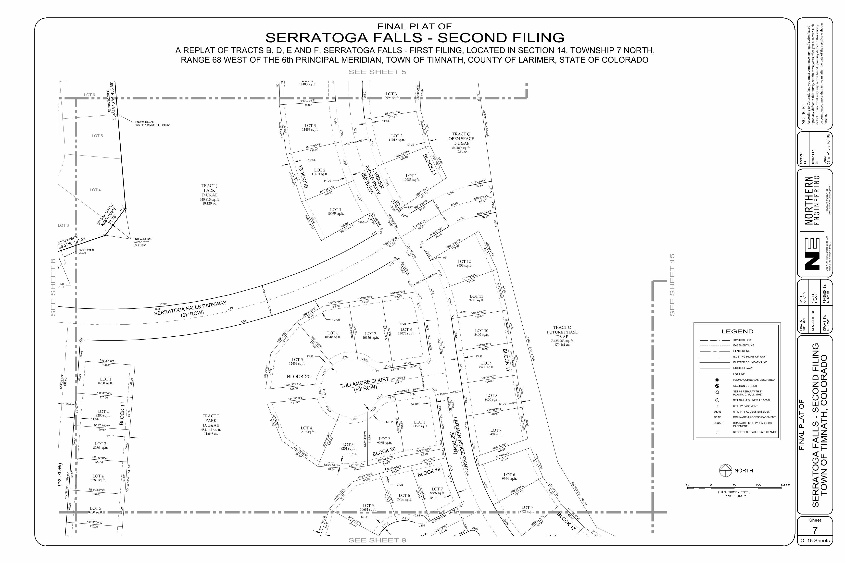
29.0' 29.0'
29.0'29.0'
29.0'29.0'
29.0'29.0'
29.0'29.0'
FND #4 REBARW/YPC "TSTLS 31169"
FND #4 REBARW/YPC "HAMMER LS 24307"
FND #4 REBAR
LOT 5
LOT 3
LOT 4
LOT 6
BLOCK 1
FIR
ST F
ILIN
G)
LARIMER
RIDGE PKW
Y.
(58' ROW
)
TEELING COURT
LARIM
ER R
IDG
E PKWY.
(58' RO
W)
TULLAMORE COURT
(58' ROW)
SERRATOGA FALLS PARKWAY
(67' ROW)
N04
°26'
10"E
5
96.0
3'
C89
C93
3.11'
C120
S31°06'35"E
26.67'
C11
7
S08°
51'1
8"E
7
3.10
'C11
6
S81°08'42"W 86.31'C115
C11
4
C113N81°08'42"E 86.31' C112
S08°
51'1
8"E
9
1.71
'
C11
1
C11
0
S62°19'16"W 66.29'
C109
N62°19'16"E 66.71'
C106
S07°
50'3
5"E
4
75.9
7'
S14°
27'4
5"E
5
02.0
2'
S30°52'32"E 161.11'
C12
3
S31°06'35"E
31.98'
C12
1
8.11'
C92
N04
°26'
10"E
249.
60'
C26
N08
°51'
18"W
135.
71'
N08
°51'
18"W
117.
10'
C27
N31°06'35"W
75.17'
N31°06'35"W
75.48'
C32
S58°53'25"W
100.00'
N62°19'16"E
182.96'
N81°08'42"E
204.54'
S58°53'25"W
47.11'
C29
TRACT JPARK
D,U&AE440,815 sq. ft.
10.120 ac.
LOT 119221 sq.ft.
LOT 108400 sq.ft.
LOT 98400 sq.ft.
LOT 88400 sq.ft.
LOT 59721 sq.ft.
LOT 4
LOT 79494 sq.ft.
LOT 69594 sq.ft.
LOT 311483 sq.ft.
LOT 411483 sq.ft.
LOT 211012 sq.ft.
LOT 310996 sq.ft.
LOT 211483 sq.ft.
LOT 48280 sq.ft.
LOT 38280 sq.ft.
LOT 28280 sq.ft.
LOT 18280 sq.ft.
LOT 58280 sq.ft.
LOT 110095 sq.ft.
LOT 129353 sq.ft.
LOT 413519 sq.ft.
LOT 111152 sq.ft.
LOT 512439 sq.ft.
LOT 812073 sq.ft.LOT 7
10156 sq.ft.LOT 6
10518 sq.ft.
LOT 510681 sq.ft.
LOT 67914 sq.ft.
LOT 78586 sq.ft.
LOT 110985 sq.ft.
LOT 29065 sq.ft.LOT 3
9201 sq.ft.
69.0
0'
N85°33'50"W120.00'
69.0
0'
S85°33'50"E120.00'
69.0
0'
N85°33'50"W120.00'
69.0
0'
69.0
0'
N85°33'50"W120.00'
69.0
0'
S04°
26'1
0"W
4
83.0
0'
N85°33'50"W120.00'
69.0
0'
69.0
0'
N85°33'50"W120.00'
69.0
0'69
.00'
S61°31'55"E120.00'
S20°28'03"E
109.13'
C272
2.64'C273
S19°
24'0
9"E
124.
02'
N76°54'36"E
77.84'
C274
63.66'
S79°47'58"W
86.20'
N08
°51'
18"W
131.
69'
70.68'
C27 6
S74°45'23"W
81.53'
N00
°14'
12"W
114.
79'
C283
15.63'
S82°58'11"W
45.42'N85°42'41"W
61.54'
N23°
09'3
8"E
120.
00'
C284
N54°28'09"W93.76'
N21°30'28"W
85.80'
N84°17'08"E
121.58'
C285
N39°2
6'49"
E87
.93' S39°14'06"E
120.00'
C28
7
S84°17'08"W
121.50'
N08
°24'
15"E
77.0
6'
N81°56'16"E
55.08'
S08°
51'1
8"E
123.
03'
C288
N59°24'07"E
65.15'
N81°01'30"E
71.00'
S08°
51'1
8"E
151.
53'
20.31'
C289
N81°01'30"E
73.43'
C290
66.00'
C275
30.6
1'
C291
C2 8 6
69.0
0'
N53°11'49"W73.42'
N44°56'10"W
68.65'
N33°49'13"W
68.76'
N22°42'02"W
67.75'
S70°58'42"W
121.21'
N70°58'42"E
120.27'
N09
°50'
37"W
68.2
3'
N08
°51'
18"W
70.0
0'
N08
°51'
18"W
70.0
0'
N08
°51'
18"W
70.0
0'
N13
°58'
24"W
89.0
9'
N25°02'14"W
90.77'
S58°53'25"W
120.65'
N56°35'59"E
120.60'
N27°14'27"W77.25'
N14
°55'
18"W
77.2
5'
N02
°36'
09"W
77.2
5'
N50°52'10"E
121.34'
N60°54'04"E
121.31'
N81°08'42"E
120.00'
N81°08'42"E
120.00'
N81°08'42"E
120.00'
N81°08'42"E
120.00'
N70°20'55"E
120.00'
N18
°18'
21"E
66.6
6'
N72°41'55"E
59.85'
N40°3
9'28"
E76
.25'
N76°30'35"E
68.47'
N26°30'38"W92.12'
N67°34'50"E
120.00'
C296
S60°41'02"W120.00'
N17
°42'
06"W
106.
76'
N77°00'58"E
120.00'
C297
N08
°15'
59"W
106.
76'
N86°27'05"E
120.00'
C298
N01
°10'
08"E
106.
76'
C2
N68°55'07"E
120.60'
N81°14'16"E
120.67'
C295
C294
(58'
RO
W)
29.0'
33.5'33.5'
BLOC
K 17
BLOCK 20
BLO
CK
22
BLOCK 21
BLOCK 17
TRACT OFUTURE PHASE
D&AE7,425,263 sq. ft.
170.461 ac.
BLO
CK
11
TRACT FPARK
D,U&AE481,142 sq. ft.
11.046 ac.
BLOCK 19
(R) S
05°0
2'20
"E
N04
°45'
13"W
458
.69'
(R) S
36°2
3'57"
W
N36°4
1'04"
E71
.76'
(R) S70°41'54"W
N70°59'01"E 197.35'
10' UE
14' UE
10' UE
14' UE
14' UE
14' UE
10' UE
10' UE
14' UE
10' UE
10' UE
14' UE
10' UE
14' UE
10' UE
14' UE
14' UE
14' UE
TRACT QOPEN SPACE
D,U&AE84,180 sq. ft.
1.933 ac.
25.61'
N58°53'25"E
56.00'
N78°22'44"E
48.41'
47.0
4'
C282
C256
C257
C258
C2 7
7
C278
C259
38.1
8'70
.00'
70.0
0'70
.00'
4.62'
C260
C261
1.06'
C280
4.77'
361.
78'
S78°22'44"W
52.84'
C279
S58°53'25"W
56.00'
N31°06'35"W
26.98'
C281
C2 92
S20°13'58"E30.00'
30' UTILITY EASEMENT PERSERRATOGA FALLS 1ST
BLOCK 2022.21'
33.5
7'33
.57'
S78°22'44"W
50.62'
C33033.5'
33.5'
RE
VIE
WE
D B
Y:
E. S
mith
DE
SIG
NE
D B
Y:
DR
AW
N B
Y:
SC
ALE
:
DA
TE:
7/7/
15P
RO
JEC
T:69
4-00
3
Sheet
Of 15 Sheets
FIN
AL
PLA
T O
FN
OTI
CE :
Acc
ordi
ng to
Col
orad
o la
w y
ou m
ust c
omm
ence
any
lega
l act
ion
base
dup
on a
ny d
efec
t in
this
surv
ey w
ithin
thre
e ye
ars a
fter y
ou d
isco
ver s
uch
defe
ct.
In n
o ev
ent m
ay a
ny a
ctio
n ba
sed
upon
any
def
ect i
n th
is su
rvey
be c
omm
ence
d m
ore
than
ten
year
s afte
r the
dat
e of
the
certi
ficat
e sh
own
here
on.
RA
NG
E:
TO
WN
SH
IP:
SE
CT
ION
:
301 N
orth
How
es S
tree
t, S
uite
100
Fort
Col
lins,
Col
orad
o 8
0521
EN
GIN
EE
RN
GIE
HTRON
RNPH
ON
E: 9
70.2
21.4
158
ww
w.n
orth
erne
ngin
eerin
g.co
m
7
S
ER
RA
TO
GA
FA
LLS
- S
EC
ON
D F
ILIN
G
TO
WN
OF
TIM
NA
TH
, CO
LOR
AD
OL
. S
mith
1"=
50'
14 7N 68 W
of th
e 6
th P
M
NORTH
( U.S. SURVEY FEET )1 inch = ft.
Feet0XX XX
XX
XX XX
SEE SHEET 9
SE
E S
HE
ET
15
SEE SHEET 5
SE
E S
HE
ET
8
FINAL PLAT OFSERRATOGA FALLS - SECOND FILING
A REPLAT OF TRACTS B, D, E AND F, SERRATOGA FALLS - FIRST FILING, LOCATED IN SECTION 14, TOWNSHIP 7 NORTH,RANGE 68 WEST OF THE 6th PRINCIPAL MERIDIAN, TOWN OF TIMNATH, COUNTY OF LARIMER, STATE OF COLORADO
LEGEND
PLATTED BOUNDARY LINE
CENTERLINE
EASEMENT LINE
LOT LINE
EXISTING RIGHT-OF-WAY
SECTION CORNER
FOUND CORNER AS DESCRIBED
RIGHT-OF-WAY
SECTION LINE
SET #4 REBAR WITH 1"PLASTIC CAP, LS 37987
SET NAIL & SHINER, LS 37987
UTILITY EASEMENTUE
UTILITY & ACCESS EASEMENTU&AE
DRAINAGE & ACCESS EASEMENTD&AE
DRAINAGE, UTILITY & ACCESSEASEMENT
D,U&AE
RECORDED BEARING & DISTANCE(R)
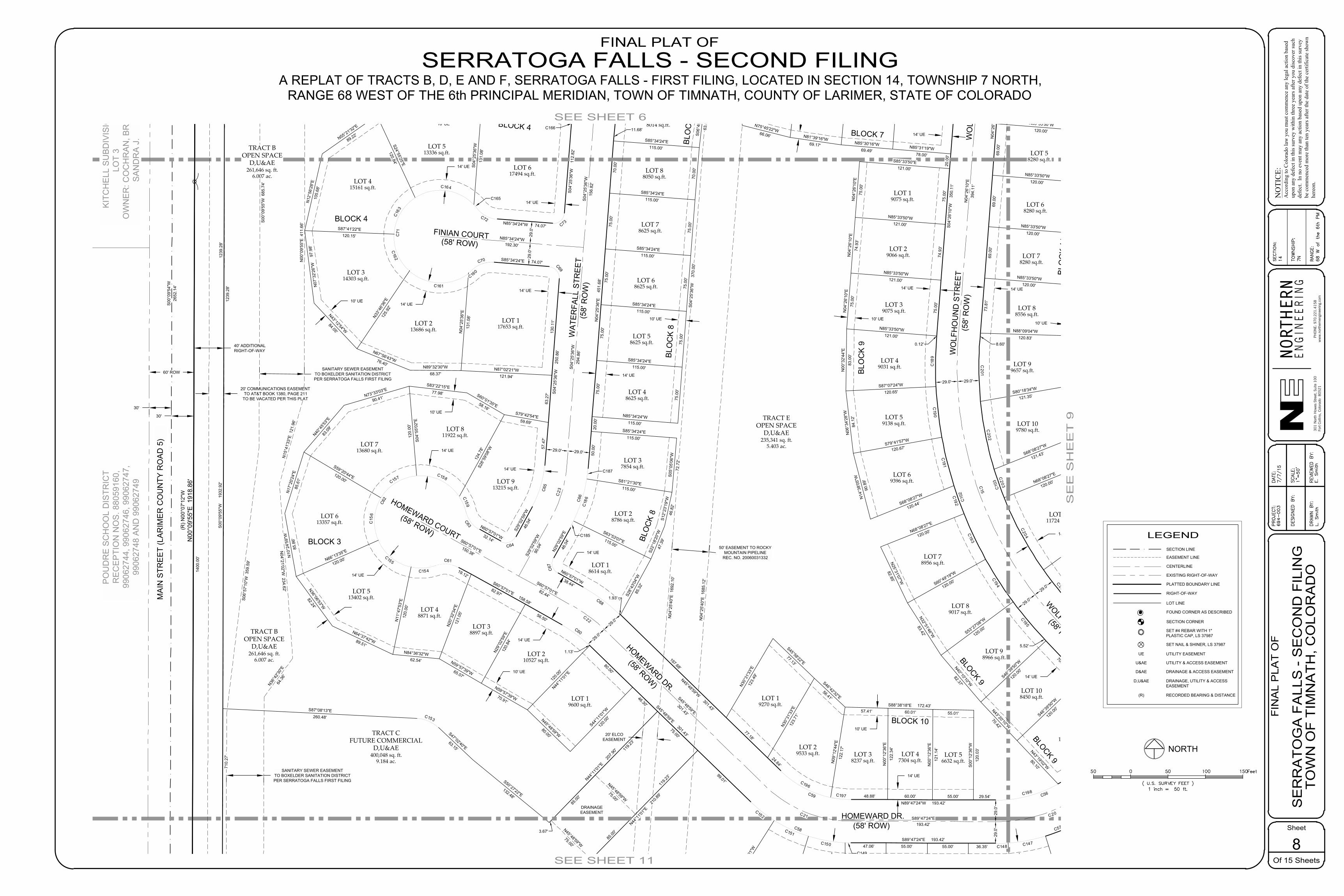
29.0
'29
.0'
29.0'
29.0'
29.0' 29.0'
29.0' 29.0'
LOT
3
MA
IN S
TRE
ET
(LA
RIM
ER
CO
UN
TY R
OA
D 5
)S
00°0
9'54
"W26
52.1
4'
30'
30'
60' ROW
40' ADDITIONALRIGHT-OF-WAY
WOLFHOUND ST.
(58' ROW)
HOMEWARD DR.(58' ROW)
WAT
ERFA
LL S
TREE
T(5
8' R
OW
)
PO
UD
RE
SC
HO
OL
DIS
TRIC
TR
EC
EP
TIO
N N
OS
. 880
5916
0,99
0627
44, 9
9062
746,
990
6274
7,99
0627
48 A
ND
990
6274
9
KIT
CH
ELL
SU
BD
IVIS
ION
LOT
3O
WN
ER
: CO
CH
RA
N, B
RA
D M
.S
AN
DR
A J
.
FINIAN COURT(58' ROW)
HOMEWARD COURT
(58' ROW)
S04°
25'3
6"W
1
12.8
2'
C73N85°34'24"W 74.07'
C72
C71
C70 S85°34'24"E 74.07' C69
S04°
25'3
6"W
2
50.8
6'
C65
S29°
02'59
"W46
.04'
C64
N60°57'01"W32.14'
C63
C62
C61
S60°57'01"E 158.58'
C60
S45°48'59"E 301.43'
C58
S89°47'24"E 193.42'
C57
C56
N89°47'24"W 193.42'
C59
N45°48'59"W 301.43'
C68
N60°57'01"W38.44'
C67
N29°
02'59
"E46
.04'
C66
N04
°25'
36"E
4
51.6
8'
S04°
26'1
0"W
3
50.1
1'
C10
2
C10
3N
04°2
6'10
"E
596
.03'
C15
N04
°26'
10"E
394.
11'
S60°57'01"E150.38'
S60°57'01"E82.44'
C22
C21 S89°47'24"E193.42'
C20
S04°
25'3
6"W
156.
82'
S04°
25'3
6"W
294.
86'
C23
S29°
02'59
"W90
.04'
N85°34'24"W192.30'
TRACT EOPEN SPACE
D,U&AE235,341 sq. ft.
5.403 ac.
LOT 28786 sq.ft.
LOT 108450 sq.ft.
LOT 89017 sq.ft.
LOT 98966 sq.ft.
LOT 1110129 sq.ft.
LOT 48871 sq.ft.
LOT 513402 sq.ft.
LOT 613357 sq.ft.
LOT 713680 sq.ft.
LOT 811922 sq.ft.
LOT 18614 sq.ft.
LOT 19270 sq.ft.
LOT 29533 sq.ft.
LOT 210527 sq.ft.
LOT 19600 sq.ft.
LOT 88556 sq.ft.
LOT 68280 sq.ft.
LOT 58280 sq.ft.
LOT 99657 sq.ft.
LOT 59138 sq.ft.
LOT 49031 sq.ft.
LOT 39075 sq.ft.
LOT 69396 sq.ft.
LOT 109780 sq.ft.
LOT 78956 sq.ft.
LOT 1111724 sq.ft.
LOT 19075 sq.ft.
LOT 37854 sq.ft.
8014 sq.ft.
LOT 88050 sq.ft.
LOT 78625 sq.ft.
LOT 68625 sq.ft.
LOT 58625 sq.ft.
LOT 48625 sq.ft.
LOT 117653 sq.ft.
LOT 617494 sq.ft.
LOT 415161 sq.ft.
LOT 513336 sq.ft.
LOT 213686 sq.ft.
LOT 314303 sq.ft.
LOT 38237 sq.ft.
LOT 56632 sq.ft.
LOT 47304 sq.ft.
LOT 38897 sq.ft.
N44°1
1'01"E
21
0.89'
99.01'
C152
S32°
12'21
"W12
0.00
'
N44°1
1'01"E
20
7.90'
75.00'
S87°08'13"E260.48' C153
S47°02'40"E63.15'
S50°27'22"E132.48'
C147C148
C149
C150
C151
47.06' 55.00' 55.00' 36.35'
LOT 913215 sq.ft.
80.00'
S44°1
1'01"W
120.0
0'N45°48'59"W80.00'
N44°1
1'01"E
120.0
0'
56.50'
1.13'
N59°57'39"W70.91'
N29°
02'59
"E12
0.84
'
82.97'
N59°57'39"W65.07'
N20
°32'
34"E
121.
05'
C154 19.12'
N84°36'32"W62.54'
N11
°47'
53"E
120.
00'
C155
N64°37'42"W89.51'
N36°06'53"W
82.24'
N66°13'35"E
120.00'
C15
6
N10
°24'
59"W
85.8
6'N
17°2
0'24
"E85
.61'
S59°20'44"E120.00' C157
N40°4
5'53"
E83
.09'
N73°33'03"E
90.41'
S04°
55'0
2"E
120.
00'
C158
S83°22'15"E77.98' S60°01'35"E58.16'
S28°
59'08
"W
124.
78' 57
.47'
C159
S79°42'54"E59.69'
C160
130.
11'
N87°02'21"W121.94'
N04
°25'
36"E
131.
08'
C161
N89°32'30"W68.37'
N67°56'43"W76.40'
N33°
46'36
"E12
5.92
'
C162
N43°12'54"W
84.05'
N07
°32'
26"W
9
7.98
'
S87°41'22"E120.15'
C16
3
N12
°56'
28"E
105.
68'
N55°21'32"E
89.22'
S24°55'25"E
120.84'
C164
S04°
25'3
6"W
131.
08'
C166
C165
63.2
7'
46.30'
N75°45'22"W66.06' N81°39'16"W
69.17' N85°30'16"W69.49'
N85°31'19"W78.00'
75.0
0'
N04
°26'
10"E
75.0
0'
74.9
3'
N85°33'50"W121.00'
N04
°26'
10"E
74.9
3'
N04
°26'
10"E
75.0
0'
75.0
0'
N85°33'50"W121.00'
N00
°32'
44"E
83.0
0'
0.12'
C18
9
S87°07'24"W
120.65'
N06
°34'
28"W
84.1
2'
C190
S79°41'57"W
120.67'
S68°08'27"W
120.44'
N14
°38'
05"W
90.8
9'
C191
N68°08'27"E
120.00' C193
S60°49'19"W
120.00'
N25°31'07"W
82.85' C194
S53°27'08"W
120.00'
N32°51'46"W
83.42'
C195
5.52'
S46°39
'50"W
120.0
0'
N40°10'10"W
82.37'
70.42'
S46°39
'50"W
120.0
0'N43°20'10"W
70.42'
N43°19'02"W
80.10'N00
°12'
36"E
121.
14'
55.01'
S00
°12'
36"W
120.
03'
55.00'
N00
°12'
36"E
122.
34'
S88°38'18"E 172.43'
60.00'C197
N09
°12'
44"E
122.
17'
57.41'
48.88'
S46°42'32"E56.41'
C196
24.64'
N30°
31'33
"E12
3.71
'
S45°58'22"E77.13'
77.18'N3
0°31
'33"E
123.
49'
S28°
43'04
"W85
.32'
1.93'
C185S63°53'07"E115.00'
C18
6
S81°21'30"E115.00'
S12°
23'1
9"W
46.8
2'
S22°
18'2
0"W
47.3
9'
S85°34'24"E115.00'
S05°
05'0
6"W
72.7
2'
C187
50.0
0'
N85°34'24"W115.00'
75.0
0'
S85°34'24"E115.00'
75.0
0'
S85°34'24"E115.00'
75.0
0'
S85°34'24"E115.00'
75.0
0'
S85°34'24"E115.00'
70.0
0'
S85°34'24"E115.00'
11.68'
20.0
0'
20.0
0'
C192
C19829.54'
197.68'
LOT 29066 sq.ft.
S06°
49'1
0"W
63.4
4'
70.0
0'S0
4°25
'36"
W
370
.00'
75.0
0'75
.00'
75.0
0'
N04
°26'
10"E
75.0
0'
S85°33'50"E121.00'
N85°33'50"W121.00'
60.01'
75.0
0'
N85°33'50"W120.00'
N85°33'50"W120.00'
69.0
0'
N85°33'50"W120.00'
69.0
0'
N85°33'50"W120.00'
69.0
0'
N88°09'04"W120.83'
73.8
1'
S80°18'34"W
121.35'
C201
8.60'
S68°08'27"W
121.43'
C202
N68°08'27"E
120.00'
C204
C20
C203
LOT 78280 sq.ft.
29.0'
29.0'
HOMEWARD DR.
(58' ROW)
29.0
'29
.0'
WO
LFH
OU
ND
STR
EET
WO
LFH
OU
ND
STR
EET
(58'
RO
W)
BLOCK 3
BLOCK 4
BLO
CK
8
BLO
CK
9
BLO
CK
11
BLOCK 10
BLOCK 9
BLOCK 7
TRACT BOPEN SPACE
D,U&AE261,646 sq. ft.
6.007 ac.
TRACT BOPEN SPACE
D,U&AE261,646 sq. ft.
6.007 ac.
BLOCK 4
BLO
CK
8
BLOCK 9
S45°48'59"E301.43'
(R) N
00°0
7'12
"WN
00°0
9'55
"E 1
918.
86'
10' UE
14' UE
14' UE
14' UE
10' UE
14' UE
10' UE
14' UE
14' UE
14' UE
14' UE
20' COMMUNICATIONS EASEMENTTO AT&T BOOK 1380, PAGE 211
TO BE VACATED PER THIS PLAT
10' UE
14' UE
14' UE
10' UE
10' UE
14' UE
10' UE
14' UE
10' UE
10' UE
14' UE
SANITARY SEWER EASEMENTTO BOXELDER SANITATION DISTRICTPER SERRATOGA FALLS FIRST FILING
SANITARY SEWER EASEMENTTO BOXELDER SANITATION DISTRICTPER SERRATOGA FALLS FIRST FILING
50' EASEMENT TO ROCKYMOUNTAIN PIPELINE
REC. NO. 20060031332
14' UE
14' UE
14' UE
N36°4
2'30"
E64
.36'
N04°21'02"W
234.62'
N15
°41'
33"E
121
.96'
N00
°09'
55"E
411
.66'
S00
°09'
55"W
685
.74'
S06°
57'1
0"W
359
.59'
1239
.28'
S00
°09'
55"W
1
932.
92'
710.
27'
1239
.28'
N04
°25'
40"E
169
2.10
'
N04
°25'
40"E
168
5.12
'
BLO
CK
8
TRACT CFUTURE COMMERCIAL
D,U&AE400,048 sq. ft.
9.184 ac.
20' ELCOEASEMENT
DRAINAGEEASEMENT
N45°48'59"W75.00'
N45°48'59"W75.00'
3.67'
85.00
'
119.2
3'
119.2
3'
85.00
'
1400
.00'
RE
VIE
WE
D B
Y:
E. S
mith
DE
SIG
NE
D B
Y:
DR
AW
N B
Y:
SC
ALE
:
DA
TE:
7/7/
15P
RO
JEC
T:69
4-00
3
Sheet
Of 15 Sheets
FIN
AL
PLA
T O
FN
OTI
CE :
Acc
ordi
ng to
Col
orad
o la
w y
ou m
ust c
omm
ence
any
lega
l act
ion
base
dup
on a
ny d
efec
t in
this
surv
ey w
ithin
thre
e ye
ars a
fter y
ou d
isco
ver s
uch
defe
ct.
In n
o ev
ent m
ay a
ny a
ctio
n ba
sed
upon
any
def
ect i
n th
is su
rvey
be c
omm
ence
d m
ore
than
ten
year
s afte
r the
dat
e of
the
certi
ficat
e sh
own
here
on.
RA
NG
E:
TO
WN
SH
IP:
SE
CT
ION
:
301 N
orth
How
es S
tree
t, S
uite
100
Fort
Col
lins,
Col
orad
o 8
0521
EN
GIN
EE
RN
GIE
HTRON
RNPH
ON
E: 9
70.2
21.4
158
ww
w.n
orth
erne
ngin
eerin
g.co
m
8
S
ER
RA
TO
GA
FA
LLS
- S
EC
ON
D F
ILIN
G
TO
WN
OF
TIM
NA
TH
, CO
LOR
AD
OL
. S
mith
1"=
50'
14 7N 68 W
of th
e 6
th P
M
NORTH
( U.S. SURVEY FEET )1 inch = ft.
Feet0XX XX
XX
XX XX
SEE SHEET 11
SE
E S
HE
ET
9
SEE SHEET 6
FINAL PLAT OFSERRATOGA FALLS - SECOND FILING
A REPLAT OF TRACTS B, D, E AND F, SERRATOGA FALLS - FIRST FILING, LOCATED IN SECTION 14, TOWNSHIP 7 NORTH,RANGE 68 WEST OF THE 6th PRINCIPAL MERIDIAN, TOWN OF TIMNATH, COUNTY OF LARIMER, STATE OF COLORADO
LEGEND
PLATTED BOUNDARY LINE
CENTERLINE
EASEMENT LINE
LOT LINE
EXISTING RIGHT-OF-WAY
SECTION CORNER
FOUND CORNER AS DESCRIBED
RIGHT-OF-WAY
SECTION LINE
SET #4 REBAR WITH 1"PLASTIC CAP, LS 37987
SET NAIL & SHINER, LS 37987
UTILITY EASEMENTUE
UTILITY & ACCESS EASEMENTU&AE
DRAINAGE & ACCESS EASEMENTD&AE
DRAINAGE, UTILITY & ACCESSEASEMENT
D,U&AE
RECORDED BEARING & DISTANCE(R)

29.0
'29
.0'
29.0'29.0'
29.0
'
29.0
'
29.0'
29.0'
29.0'29.0'
TEELING COURT
(58' ROW)
LARIMER RIDGE PKWY.
(58' ROW)
WOLFHOUND ST.
(58' ROW)
C57
N46°39
'50"E
62
.72'
C54
S43°20'10"E 257.16'
C55
S46°39
'50"W
62
.72'
C56
S43°20'10"E 146.36'
C53
N46°39
'50"E
45
.69'
C100
N89°50'57"E 188.39'
C99
N35°
09'14
"E
67.
00'
C96
S54°50'46"E 126.58'
N43°20'10"W 257.16'
C52
N43°20'10"W 146.36'
C10
3N
04°2
6'10
"E
596
.03'
C11
0
S62°19'16"W 66.29'
C109
C108
C107
N62°19'16"E 66.71'
C106
C105
S54°50'46"E 170.67'
C97
S35°
09'14
"W
67.
00'
C98
S89°50'57"W 188.39'
C101
S46°39
'50"W
45
.69'
S30°52'32"E 161.11'
S63°20'35"E 308.04'
N43°20'10"W
301.16'
N43°20'10"W
190.36'
C15
N54°50'46"W170.58'
N54°50'46"W214.67'
C25
C20
N46°39
'50"E
106.7
2'
N46°39
'50"E
89.69
'
C19
N89°50'57"E188.39'
C18
N35°
09'14
"E11
1.00
'
N62°19'16"E
182.96'
TRACT FPARK
D,U&AE481,142 sq. ft.
11.046 ac.
TRACT GOPEN SPACE
D,U&AE249,065 sq. ft.
5.718 ac.
LOT 59721 sq.ft.
LOT 49698 sq.ft.
LOT 108450 sq.ft.
LOT 98966 sq.ft.
LOT 1110129 sq.ft.
LOT 27102 sq.ft.
LOT 37155 sq.ft.
LOT 47155 sq.ft.
LOT 57103 sq.ft.
LOT 66826 sq.ft.
LOT 17731 sq.ft.
LOT 211676 sq.ft.
LOT 26603 sq.ft.
LOT 236600 sq.ft.
LOT 314808 sq.ft.
LOT 412127 sq.ft.
LOT 88556 sq.ft.
LOT 68280 sq.ft.
LOT 58280 sq.ft.
LOT 99657 sq.ft.
LOT 127824 sq.ft.
LOT 117893 sq.ft.
LOT 86600 sq.ft.
LOT 109780 sq.ft.
LOT 1111724 sq.ft.
LOT 1212145 sq.ft.
LOT 39612 sq.ft.
LOT 28400 sq.ft.
LOT 18400 sq.ft.
LOT 139130 sq.ft.
LOT 18400 sq.ft.
LOT 28491 sq.ft.
LOT 38963 sq.ft.
LOT 177029 sq.ft.
LOT 167794 sq.ft.
LOT 157150 sq.ft.
LOT 147794 sq.ft.
LOT 137150 sq.ft.
LOT 127326 sq.ft.
LOT 117064 sq.ft.
LOT 27756 sq.ft.
LOT 37628 sq.ft.
LOT 47587 sq.ft.
LOT 57635 sq.ft.
LOT 66720 sq.ft.
LOT 76600 sq.ft.
LOT 86600 sq.ft.
LOT 97067 sq.ft.
LOT 510681 sq.ft.
LOT 67914 sq.ft.
8586 sq.ft.
LOT 114811 sq.ft.
LOT 188397 sq.ft.
LOT 107444 sq.ft.
LOT 18515 sq.ft.
LOT 16600 sq.ft.
LOT 107458 sq.ft.
LOT 97101 sq.ft.
N46°39
'50"E
55.00'
N46°39
'50"E
120.0
0'
55.00'
C146
53.22'
C147C14836.35'
C194
S53°27'08"W
120.00'
C195
5.52'
S46°39
'50"W
120.0
0'
70.42'
S46°39
'50"W
120.0
0'N43°20'10"W
70.42'
70.42'
C199
N43°19'02"W
80.10'
C19829.54'
120.00'
69.0
0'
N85°33'50"W120.00'
69.0
0'
69.0
0'
N85°33'50"W120.00'
69.0
0'
N85°33'50"W120.00'
69.0
0'
S03°
50'5
1"W
68.3
6'
N88°09'04"W120.83'
73.8
1'
S00
°47'
25"W
67.1
2'
S80°18'34"W
121.35'
C201
8.60'
S68°08'27"W
121.43'
C202
S09°
41'2
6"E
67.3
5'
N68°08'27"E
120.00'
S29°18'42"E
81.88'
S54°43'28"W
121.07'
C204
S46°39
'50"W
120.0
0'
42.14'
C205
S40°29'37"E
91.32'
N35°15'32"W
120.00'
N58°11'20"E
72.05'
S28°21'10"E
120.00'
C207
N64°47'59"E
66.10'
S22°02'15"E
120.00'
C208
N71°08'59"E
66.61'
S15°
39'4
8"E
120.
00'
C209
N77°31'26"E
66.61'
S09°
17'2
1"E
120.
00'
C210
N83°52'30"E
66.12'
S02
°57'
40"E
120.
00'
C211
N89°09'38"E
59.94'
S00
°09'
03"E
120.
00'
30.57'C212
N89°50'57"E55.00'
S00
°09'
03"E
120.
00'
55.00'
N89°50'57"E55.00'
S00
°09'
03"E
120.
00'
55.00'
N89°49'45"E56.06'
S03
°07'
30"E
1
19.9
3'
C213
47.82'
N82°06'39"E
56.52'
S07°
53'2
1"E
120.
34'
C215
N03
°07'
30"W
1
20.5
8'
N70°38'21"E
52.91'
S19°
48'0
7"E
120.
36'
C216
N58°51'45"E
53.19'
S30°24'22"E
122.13'
C217
N53°58'13"E
49.74'S54°50'46"E120.95'
C218
N54°50'46"W70.00'
N35°
09'14
"E12
0.00
'
70.00'
S35°
09'14
"W12
0.00
'
N36°1
6'18"
E12
0.00
'
C26259.30'
N43°3
5'50"E
120.0
0'
C263S50°01'03"W
126.73'
N27°40'44"W
139.11'
C266
C265
S55°34'04"W
56.61'
S73°16'44"W
61.40'
N06
°57'
10"W
120.
00'
C268
C267
N81°42'18"W95.73'
N49°25'54"W105.63'
N62°19'16"E
121.10'
C269
S61°31'55"E120.00'
C27
1
S62°19'16"W121.01'
S20°28'03"E
109.13'
C272
2.64'C273
S19°
24'0
9"E
124.
02'
63.66'
C270
C264
41.37'
C219
C214
C206
104.23'
C203
69.0
0'LOT 78280 sq.ft.
LOT 76600 sq.ft.
S46°46
'17"W
69.56
'
105.00'
C220
S41°38'53"E
120.00'
S53°31'03"W
53.51'
C221
S31°26'53"E
120.06'
S63°32'42"W
52.62'
C222
S21°24'59"E
120.04'
S73°31'47"W
52.36'
C223
S11°
26'0
9"E
120.
00'
S83°35'11"W
52.70'
C224
S01
°23'
30"E
120.
00'
C225
48.17'
S00
°09'
03"E
120.
00'
S89°46'31"W54.69'
55.00'
S00
°09'
03"E
120.
00'
S89°50'57"W55.00'
55.00'
S00
°09'
03"E
120.
00'
S89°50'57"W55.00'
S89°08'36"W
62.01'
30.22' C226
S03
°00'
56"E
1
20.0
8'
N03
°00'
56"W
1
20.3
5'
C228
S10°
40'3
1"E
120.
44'
S82°46'27"W
70.24'
S76°12'16"W
65.53'
C229
S16°
56'2
9"E
120.
46'
S70°01'06"W
67.91'
C230
S23°26'04"E
120.70'
S63°24'05"W
66.20'
C231
S29°45'45"E
120.70'
C232
S36°40'07"E
120.70'
S56°47'04"W
72.24'
S50°10'03"W
66.20'
C233
S42°59'48"E
120.70'
C234
S49°54'09"E120.70'
S43°3
3'01"W
72.24
'
S37°
03'05
"W63
.71'
C235
12.00' S54°50'46"E120.58'
55.0
0' 105.70'
N42°01'28"W
50.62'
S43°20'10"E
55.00'
S46°39
'50"W
120.0
0'
55.00'
N46°39
'50"E
120.0
0'
S43°26'48"E
55.00'
S46°39
'50"W
120.1
1'
55.00'
S46°31'05"E51.48'
S53°27'22"E51.83'
26.60'
C227
N35°
09'14
"E12
0.00
'
N35°
09'14
"E12
0.00
'
N54°50'46"W70.00'
N54°50'46"W70.00'
N53°11'49"W73.42'
N44°56'10"W
68.65'
N33°49'13"W
68.76'
N35°
09'14
"E12
0.00
'
N35°
09'14
"E12
0.00
'
N40°5
2'34"
E12
1.23'
N50°52'10"E
121.34'
N60°54'04"E
121.31'
N54°44'52"W71.96'
N50°03'56"W82.92'
N18
°18'
21"E
66.6
6'
N08
°13'
00"W
96.2
0'
N40°3
9'28"
E76
.25'
29.0'
29.0'
29.0'
29.0' HOMEWARD DRIVE(58' ROW)
BLOCK 12
BLOCK 19
BLO
CK
11
BLOCK 9
BLOCK 13
BLOCK 12
BLOCK 13
BLOCK 14
BLOCK 17
BLOCK 18
BLOCK 9
14' UE
10' UE
14' UE
14' UE
14' UE
10' UE
10' UE
14' UE
14' UE
14' UE
10' UE
14' UE
10' UE
14' UE
14' UE
14' UE
10' UE
14' UE
14' UE
10' UE
10' UE
14' UE
10' UE
10' UE
OPEN SPACE
384,170 sq. ft.
40.00'
55.48'
70.00'
70.00'
48.03'
C254
C255
C256
BLOCK 19
BLOCK 11
RE
VIE
WE
D B
Y:
E. S
mith
DE
SIG
NE
D B
Y:
DR
AW
N B
Y:
SC
ALE
:
DA
TE:
7/7/
15P
RO
JEC
T:69
4-00
3
Sheet
Of 15 Sheets
FIN
AL
PLA
T O
FN
OTI
CE :
Acc
ordi
ng to
Col
orad
o la
w y
ou m
ust c
omm
ence
any
lega
l act
ion
base
dup
on a
ny d
efec
t in
this
surv
ey w
ithin
thre
e ye
ars a
fter y
ou d
isco
ver s
uch
defe
ct.
In n
o ev
ent m
ay a
ny a
ctio
n ba
sed
upon
any
def
ect i
n th
is su
rvey
be c
omm
ence
d m
ore
than
ten
year
s afte
r the
dat
e of
the
certi
ficat
e sh
own
here
on.
RA
NG
E:
TO
WN
SH
IP:
SE
CT
ION
:
301 N
orth
How
es S
tree
t, S
uite
100
Fort
Col
lins,
Col
orad
o 8
0521
EN
GIN
EE
RN
GIE
HTRON
RNPH
ON
E: 9
70.2
21.4
158
ww
w.n
orth
erne
ngin
eerin
g.co
m
9
S
ER
RA
TO
GA
FA
LLS
- S
EC
ON
D F
ILIN
G
TO
WN
OF
TIM
NA
TH
, CO
LOR
AD
OL
. S
mith
1"=
50'
14 7N 68 W
of th
e 6
th P
M
NORTH
( U.S. SURVEY FEET )1 inch = ft.
Feet0XX XX
XX
XX XX
SEE SHEET 12
SE
E S
HE
ET
10
SEE SHEET 7
SE
E S
HE
ET
8
FINAL PLAT OFSERRATOGA FALLS - SECOND FILING
A REPLAT OF TRACTS B, D, E AND F, SERRATOGA FALLS - FIRST FILING, LOCATED IN SECTION 14, TOWNSHIP 7 NORTH,RANGE 68 WEST OF THE 6th PRINCIPAL MERIDIAN, TOWN OF TIMNATH, COUNTY OF LARIMER, STATE OF COLORADO
LEGEND
PLATTED BOUNDARY LINE
CENTERLINE
EASEMENT LINE
LOT LINE
EXISTING RIGHT-OF-WAY
SECTION CORNER
FOUND CORNER AS DESCRIBED
RIGHT-OF-WAY
SECTION LINE
SET #4 REBAR WITH 1"PLASTIC CAP, LS 37987
SET NAIL & SHINER, LS 37987
UTILITY EASEMENTUE
UTILITY & ACCESS EASEMENTU&AE
DRAINAGE & ACCESS EASEMENTD&AE
DRAINAGE, UTILITY & ACCESSEASEMENT
D,U&AE
RECORDED BEARING & DISTANCE(R)

29.0
'
29.0
'
N35°
09'14
"E
67.
00'
C96
S54°50'46"E 126.58'
C95
S03°
52'0
9"W
2
75.8
3'
S63°20'35"E 308.04'
S39°56'28"E 340.35'
S46°38'35"E 406.34'
S09°
53'3
2"E
3
47.7
7'
N03
°52'
09"E
275.
83'
C17
N54°50'46"W170.58'
LOT 26766 sq.ft.
LOT 47188 sq.ft.
LOT 57200 sq.ft.
LOT 710008 sq.ft.
LOT 18400 sq.ft.
LOT 86954 sq.ft.
LOT 166658 sq.ft.
LOT 97536 sq.ft.
LOT 107536 sq.ft.
LOT 117536 sq.ft.
LOT 127536 sq.ft.
LOT 137536 sq.ft.
LOT 146682 sq.ft.
LOT 76684 sq.ft.
LOT 156684 sq.ft.
LOT 177029 sq.ft.
LOT 37032 sq.ft.
LOT 188397 sq.ft.
LOT 89613 sq.ft.
LOT 67202 sq.ft.
LOT 56600 sq.ft.
LOT 66600 sq.ft.
LOT 46600 sq.ft.
S49°54'09"E
S43°3
3'01"W
72.24
'
S37°
03'05
"W63
.71'
S54°50'46"E120.58'
S35°
15'09
"W70
.00'
55.0
0' 105.70'
N35°5
9'56"
E12
0.23
'
0.88'
C251
S62°41'48"W
120.00'
N42°01'28"W
50.62' C250
N87°57'26"W120.00'
N12
°37'
49"W
51.1
7'
N86°07'51"W120.00'
N03
°49'
08"E
58.0
9'
C249
54.8
7'
N86°07'51"W120.00'
N03
°52'
07"E
60.0
0'
60.0
0'
N86°07'51"W120.00'
N03
°52'
09"E
59.9
0'
59.9
0'58
.60'
N86°07'51"W120.00'
N03
°52'
09"E
58.6
0'
42.4
6'
C248N88°11'24"W
120.00'
N03
°35'
08"E
58.5
9'
N01
°48'
30"W
C
20.00'
S06°
32'1
7"E
48.8
7'
S86°07'51"E120.00'
S03°
51'1
2"W
55.0
0'
S86°07'51"E120.00'
S03°
52'0
9"W
55.0
0'
S86°07'51"E120.00'
S03°
52'0
9"W
55.0
0'
S86°07'51"E120.00'
S03°
52'0
9"W
55.7
0'
N86°07'51"W120.00'
S86°07'51"E120.00'
S03
°13'
02"W
61.6
3'
S89°31'41"E120.00'
N79°44'08"E
120.00'
S04°
53'4
6"E
74.6
6'
N68°59'58"E
120.00'
S15°
37'5
7"E
74.6
6'
N58°15'48"E
120.00'
S26°22'07"E
74.66'
N47°31
'37"E
120.0
0'
S37°06'17"E
74.66'
N36°4
7'27"
E12
0.00
'
S47°50'28"E74.66'
S54°41'01"E57.43'
N35°
09'14
"E12
0.00
'
S54°50'46"E55.70'
N35°
09'14
"E12
0.00
'
S54°50'46"E55.48'
N35°
09'14
"E12
0.00
'
N35°
09'14
"E12
0.00
'
N54°50'46"W70.00'
N54°50'46"W
LAR
IMER
RID
GE
PKW
Y.(5
8' R
OW
)
29.0' 29.0'
BLO
CK
15
BLOCK 16
BLO
CK
16
TRACT OFUTURE PHASE
D&AE7,425,263 sq. ft.
170.461 ac.
10' UE
14' UE
14' UE
14' UE
10' UE
10' UE
14' UE
TRACT HOPEN SPACE
D,U&AE384,170 sq. ft.
8.819 ac.
TRACT HOPEN SPACE
D,U&AE384,170 sq. ft.
8.819 ac.
20.0
0'
40.00'
C104
52.1
5'55
.00'
55.0
0'55
.70'
37.9
8'C
118
C119
C122
C124
C125
C252
C25346.04'
55.70'
55.48'
BLO
CK
15
RE
VIE
WE
D B
Y:
E. S
mith
DE
SIG
NE
D B
Y:
DR
AW
N B
Y:
SC
ALE
:
DA
TE:
7/7/
15P
RO
JEC
T:69
4-00
3
Sheet
Of 15 Sheets
FIN
AL
PLA
T O
FN
OTI
CE :
Acc
ordi
ng to
Col
orad
o la
w y
ou m
ust c
omm
ence
any
lega
l act
ion
base
dup
on a
ny d
efec
t in
this
surv
ey w
ithin
thre
e ye
ars a
fter y
ou d
isco
ver s
uch
defe
ct.
In n
o ev
ent m
ay a
ny a
ctio
n ba
sed
upon
any
def
ect i
n th
is su
rvey
be c
omm
ence
d m
ore
than
ten
year
s afte
r the
dat
e of
the
certi
ficat
e sh
own
here
on.
RA
NG
E:
TO
WN
SH
IP:
SE
CT
ION
:
301 N
orth
How
es S
tree
t, S
uite
100
Fort
Col
lins,
Col
orad
o 8
0521
EN
GIN
EE
RN
GIE
HTRON
RNPH
ON
E: 9
70.2
21.4
158
ww
w.n
orth
erne
ngin
eerin
g.co
m
10
S
ER
RA
TO
GA
FA
LLS
- S
EC
ON
D F
ILIN
G
TO
WN
OF
TIM
NA
TH
, CO
LOR
AD
OL
. S
mith
1"=
50'
14 7N 68 W
of th
e 6
th P
M
NORTH
( U.S. SURVEY FEET )1 inch = ft.
Feet0XX XX
XX
XX XX
SEE SHEET 13
SE
E S
HE
ET
15
SE
E S
HE
ET
9SEE SHEET 15
FINAL PLAT OFSERRATOGA FALLS - SECOND FILING
A REPLAT OF TRACTS B, D, E AND F, SERRATOGA FALLS - FIRST FILING, LOCATED IN SECTION 14, TOWNSHIP 7 NORTH,RANGE 68 WEST OF THE 6th PRINCIPAL MERIDIAN, TOWN OF TIMNATH, COUNTY OF LARIMER, STATE OF COLORADO
LEGEND
PLATTED BOUNDARY LINE
CENTERLINE
EASEMENT LINE
LOT LINE
EXISTING RIGHT-OF-WAY
SECTION CORNER
FOUND CORNER AS DESCRIBED
RIGHT-OF-WAY
SECTION LINE
SET #4 REBAR WITH 1"PLASTIC CAP, LS 37987
SET NAIL & SHINER, LS 37987
UTILITY EASEMENTUE
UTILITY & ACCESS EASEMENTU&AE
DRAINAGE & ACCESS EASEMENTD&AE
DRAINAGE, UTILITY & ACCESSEASEMENT
D,U&AE
RECORDED BEARING & DISTANCE(R)

29.0
'29
.0'
SOUTHWEST CORNERSECTION14-7-68
FND #6 REBAR w/2-1/2" ALUMINUM CAP
IN MONUMENT BOXLS 5028 1995
BASIS OF BEARINGSSOUTH LINE OF SW 14
SECTION 14-7-68
32' ADDITIONALRIGHT-OF-WAY
S89°31'17"E 2619.63'
28'
MA
IN S
TRE
ET
(LA
RIM
ER
CO
UN
TY R
OA
D 5
)
PROSPECT ROAD (LARIMER COUNTY ROAD 44)
30'
30'
60' ROW
40' ADDITIONALRIGHT-OF-WAY
HOMEWARD DR.(58' ROW)
PO
UD
RE
SC
HO
OL
DIS
TRIC
TR
EC
EP
TIO
N N
OS
. 880
5916
0,99
0627
44, 9
9062
746,
990
6274
7,99
0627
48 A
ND
990
6274
9
C58
S89°47'24"E 193.42'
C57
C56
N89°47'24"W 193.42'
C59
C21 S89°47'24"E193.42'
C20
LOT 77779 sq.ft.
LOT 67976 sq.ft.
LOT 56596 sq.ft.
LOT 46600 sq.ft.
LOT 36600 sq.ft.
LOT 26939 sq.ft.
LOT 17626 sq.ft.
N00
°28'
39"E
102.
12'
N89°32'11"W 318.50'
N04
°25'
36"E
329.
01'
N43°32'05"W
107.44'
N44°1
1'01"E
21
0.89'
C152
S32°
12'21
"W12
0.00
'
S65°14'26"E81.39'
S80°33'20"E85.52'
N16
°59'
44"W
120.
00'
S50°27'22"E132.48'
C147C148
C149
C150
C151
S17°
18'4
7"W
120.
00'
S00
°12'
36"W
120.
00'
N89°37'15"W55.00'
47.06'
S00
°12'
36"W
120.
00'
N89°47'24"W55.00'
55.00'
S00
°12'
36"W
120.
00'
N89°47'24"W55.00'
55.00'
S00
°12'
36"W
120.
00'
S89°18'44"W
62.48'
36.35'
S04°
04'5
7"E
120.
00'
S79°30'50"W
77.85'
55.00'60.00'C197 48.88' C1929.54'
BLOCK 2
TRACT AOPEN SPACE
D,U&AE611,606 sq. ft.
14.041 ac.
(R) N
00°0
7'12
"WN
00°0
9'55
"E 1
918.
86'
N89°31'17"W 1792.93'(R) N89°48'24"W
10' UE
14' UE
20' COMMUNICATIONS EASEMENTTO AT&T BOOK 1380, PAGE 211
TO BE VACATED PER THIS PLAT
SANITARY SEWER EASEMENTTO BOXELDER SANITATION DISTRICTPER SERRATOGA FALLS FIRST FILING
50' EASEMENT TO ROCKYMOUNTAIN PIPELINE
REC. NO. 20060031332
10' UE
14' UE
APPROXIMATE FUTURERIGHT-OF-WAY OF CR44/
PROSPECT ROAD
S89°56'36"E50.02'
N00
°09'
55"E
661
.68'
S00
°09'
55"W
639
.50'
S00
°09'
55"W
1
932.
92'
102.
12'
43.10' 20.05'
S89°56'36"E30.00'
N00
°10'
34"E
54.0
0'
N89°56'36"W 826.85'N00°28'43"E 0.21'
S04°25'36"W20.98'
N89°56'36"W196.00'
710.
27'
N89°31'17"W 856.98'
TRACT CFUTURE COMMERCIAL
D,U&AE400,048 sq. ft.
9.184 ac.
N04°25'36"E47.16'
N00°03'24"E4.30'N89°56'36"W
50.00'S00°01'45"W28.61'
20' EASEMENT TO EAST LARIMERCOUNTY WATER DISTRICT
BOOK 1197, PAGE 507TO BE VACATED PER THIS PLAT
30' ELCO EASEMENTREC. NO. ________________30' ELCO EASEMENT
REC. NO. ________________55' CACHE LA POUDRE
RESERVOIR CO. EASEMENTREC. NO. _________________
25.0
0'30
.00'
30' ELCO EASEMENTREC. NO. __________________
S89°31'17"E 767.21'
S44°50'09"E
35.55'
S89°31'17"E 779.71'
S44°50'09"E 78.21'
21.97'42.66'
55' CACHE LA POUDRERESERVOIR CO. EASEMENT
REC. NO. __________________
S89°56'36"E50.15'
210.80'50.12'
S04°25'36"W20.61'
S04°25'36"W20.98'
50' EASEMENT TO ROCKYMOUNTAIN PIPELINE
20' ELCOEASEMENT
IRRIGATIONEASEMENT
DRAINAGEEASEMENT
N45°48'59"W75.00'
N45°48'59"W75.00'
3.67'
85.00
'
85.00
'
6.66'
1400
.00'
FND #4 REBARw/CAP, ILLEG.
22.1
2'
RE
VIE
WE
D B
Y:
E. S
mith
DE
SIG
NE
D B
Y:
DR
AW
N B
Y:
SC
ALE
:
DA
TE:
7/7/
15P
RO
JEC
T:69
4-00
3
Sheet
Of 15 Sheets
FIN
AL
PLA
T O
FN
OTI
CE :
Acc
ordi
ng to
Col
orad
o la
w y
ou m
ust c
omm
ence
any
lega
l act
ion
base
dup
on a
ny d
efec
t in
this
surv
ey w
ithin
thre
e ye
ars a
fter y
ou d
isco
ver s
uch
defe
ct.
In n
o ev
ent m
ay a
ny a
ctio
n ba
sed
upon
any
def
ect i
n th
is su
rvey
be c
omm
ence
d m
ore
than
ten
year
s afte
r the
dat
e of
the
certi
ficat
e sh
own
here
on.
RA
NG
E:
TO
WN
SH
IP:
SE
CT
ION
:
301 N
orth
How
es S
tree
t, S
uite
100
Fort
Col
lins,
Col
orad
o 8
0521
EN
GIN
EE
RN
GIE
HTRON
RNPH
ON
E: 9
70.2
21.4
158
ww
w.n
orth
erne
ngin
eerin
g.co
m
11
S
ER
RA
TO
GA
FA
LLS
- S
EC
ON
D F
ILIN
G
TO
WN
OF
TIM
NA
TH
, CO
LOR
AD
OL
. S
mith
1"=
50'
14 7N 68 W
of th
e 6
th P
M
NORTH
( U.S. SURVEY FEET )1 inch = ft.
Feet0XX XX
XX
XX XX
SEE SHEET 8
SE
E S
HE
ET
12
FINAL PLAT OFSERRATOGA FALLS - SECOND FILING
A REPLAT OF TRACTS B, D, E AND F, SERRATOGA FALLS - FIRST FILING, LOCATED IN SECTION 14, TOWNSHIP 7 NORTH,RANGE 68 WEST OF THE 6th PRINCIPAL MERIDIAN, TOWN OF TIMNATH, COUNTY OF LARIMER, STATE OF COLORADO
LEGEND
PLATTED BOUNDARY LINE
CENTERLINE
EASEMENT LINE
LOT LINE
EXISTING RIGHT-OF-WAY
SECTION CORNER
FOUND CORNER AS DESCRIBED
RIGHT-OF-WAY
SECTION LINE
SET #4 REBAR WITH 1"PLASTIC CAP, LS 37987
SET NAIL & SHINER, LS 37987
UTILITY EASEMENTUE
UTILITY & ACCESS EASEMENTU&AE
DRAINAGE & ACCESS EASEMENTD&AE
DRAINAGE, UTILITY & ACCESSEASEMENT
D,U&AE
RECORDED BEARING & DISTANCE(R)

29.0
'29
.0'
29.0
'29
.0'
32' ADDITIONALRIGHT-OF-WAY
S89°31'17"E 2619.63'
28' PROSPECT ROAD (LARIMER COUNTY ROAD 44)
BRISTOW ROAD(58' ROW)
REC. NO. 20100031164OWNER: MARJORIE R. KIEFER
MARITAL TRUST
BASIS OF BEARINGSSOUTH LINE OF SW 14
SECTION 14-7-68
N89°31'17"W 2486.42'
C57
N46°39
'50"E
62
.72'
S43°20'10"E 257.16'
C50
S89°49'19"E 460.34'
C56
N89°49'19"W 460.34'
C51
N43°20'10"W 257.16'
N89°49'19"W460.34'
C14
N43°20'10"W
301.16'C20
LOT 46819 sq.ft.
LOT 66600 sq.ft.
LOT 77200 sq.ft.
LOT 97200 sq.ft.
LOT 106600 sq.ft.
LOT 117440 sq.ft.
LOT 86600 sq.ft.
LOT 26939 sq.ft.
LOT 57379 sq.ft.
LOT 37503 sq.ft.
LOT 26603 sq.ft.
LOT 137057 sq.ft.
LOT 147057 sq.ft.
LOT 157057 sq.ft.
LOT 167057 sq.ft.
LOT 177051 sq.ft.
LOT 187057 sq.ft.
LOT 197206 sq.ft.
LOT 206596 sq.ft.
LOT 216600 sq.ft.
LOT 226600 sq.ft.
LOT 236600 sq.ft.
LOT 46819 sq.ft.
LOT 66600 sq.ft.
LOT 77200 sq.ft.
LOT 97200 sq.ft.
LOT 106600 sq.ft.
LOT 117440 sq.ft.
LOT 147200 sq.ft.
LOT 137200 sq.ft.
LOT 126600 sq.ft.
LOT 117200 sq.ft.
LOT 106600 sq.ft.
LOT 97440 sq.ft.
LOT 168017 sq.ft.LOT 15
7200 sq.ft.
LOT 17626 sq.ft.
TRACT AOPEN SPACE
D,U&AE611,606 sq. ft.
14.041 ac.
LOT 77399 sq.ft.
LOT 47378 sq.ft.
LOT 16600 sq.ft.
LOT 67366 sq.ft.
LOT 87029 sq.ft.
LOT 86600 sq.ft.
N02
°34'
23"W
120.
00'
N00
°10'
41"E
120.
00'
35.85' C136
N00
°10'
43"E
120.
00'
55.00'
N00
°10'
41"E
120.
00'
55.00'
N00
°10'
43"E
120.
00'
60.00'
N00
°10'
41"E
120.
00'
55.00'
N00
°10'
43"E
120.
00'
60.00'
N00
°10'
41"E
120.
00'
55.00'
N00
°10'
41"E
1
20.0
0'
62.00'
N04
°44'
01"E
120.
00'
C137
14.49'
S00
°10'
41"W
1
20.0
6'
N87°59'17"W66.08'
N10
°29'
00"E
120.
00'
C138
N82°23'29"W65.10'
N16
°13'
59"E
120.
00'
C139
N76°38'30"W65.10'
N21
°58'
58"E
120.
00'
C140
N70°53'32"W65.10'
N27°
43'56
"E12
0.00
'
C141
N65°08'33"W65.10'
N33°
28'38
"E12
0.00
'
C142
N59°23'43"W65.05'
N39°1
3'37"
E12
0.00'
C143
N53°38'53"W65.10'
N46°39
'50"E
120.0
5'
C144
N47°45'49"W68.15'
N46°39
'50"E
120.0
0'
38.94'
C145
N43°32'36"W
55.00'
N46°39
'50"E
120.0
0'
55.00'
55.00'
N46°39
'50"E
120.0
0'
55.00'
N43°20'10"W 165.00'
N46°39
'50"E
120.0
0'
55.00'
55.00'
LOT 56600 sq.ft.
N00
°10'
41"E
120.
00'
S89°37'37"W59.80'
55.00'
N00
°10'
43"E
120.
00'
55.00'
N00
°10'
41"E
120.
00'
60.00'
N00
°10'
43"E
120.
00'
N89°49'19"W 402.00'
60.00'55.00'62.00' 55.00'
N16
°59'
44"W
120.
00'
C146
53.22'
8.00'
LOT 127329 sq.ft.
55.00'
C147C148
S89°18'44"W
62.48'
36.35'
S04°
04'5
7"E
120.
00'
S79°30'50"W
77.85'
C19829.54'
S46°39
'50"W
120.0
0'
55.00'
S43°26'48"E
55.00'
S46°39
'50"W
120.1
1'
55.00'
S46°31'05"E51.48'
S36°
44'35
"W12
1.35
'
C236
15.56'
S53°27'22"E51.83'
S28°
26'51
"W12
1.32
'
C237
S61°47'04"E51.81'
S20°
04'3
4"W
121.
15'
C238
S70°11'32"E51.81'
S11°
42'1
5"W
120.
91'
C239
S78°37'05"E51.68'
S02
°48'
19"W
120.
69'
C240
S00
°10'
41"W
1
20.3
1'
14.49'
C241
S87°11'41"E55.31'
S89°49'19"E62.00'
S00
°10'
41"W
120.
00'
62.00'
N00
°10'
41"E
1
20.0
0'
S89°49'19"E55.00'
S00
°10'
41"W
120.
00'
55.00'
S00
°10'
41"W
120.
00'
60.00'
S89°49'19"E60.00'
S89°49'19"E55.00'
S00
°10'
41"W
120.
00'
55.00'
S89°49'19"E60.00'
S00
°10'
41"W
120.
00'
60.00'
S89°49'19"E60.00'
S00
°10'
41"W
120.
00'
60.00'
S89°49'19"E60.00'
S00
°10'
41"W
120.
00'
60.00'
N80°37'01"E
52.90'
S10°
42'4
1"E
C24225.85'
8.00'
26.60'
BLOCK 1
BLOCK 1
BLOCK 14
BLOCK 14
TRACT GOPEN SPACE
D,U&AE249,065 sq. ft.
5.718 ac.
N89°31'17"W 1792.93'(R) N89°48'24"W
10' IRRIGATIONEASEMENT
10' UE
14' UE
10' UE
10' UE
10' UE
14' UE
14' UE
10' UE
10' UE
14' UE
14' UE
APPROXIMATE FUTURERIGHT-OF-WAY OF CR44/
PROSPECT ROAD
894.01'
N89°31'17"W 907.13'S00°35'30"W
10.00'
896.47'896.55'
RE
VIE
WE
D B
Y:
E. S
mith
DE
SIG
NE
D B
Y:
DR
AW
N B
Y:
SC
ALE
:
DA
TE:
7/7/
15P
RO
JEC
T:69
4-00
3
Sheet
Of 15 Sheets
FIN
AL
PLA
T O
FN
OTI
CE :
Acc
ordi
ng to
Col
orad
o la
w y
ou m
ust c
omm
ence
any
lega
l act
ion
base
dup
on a
ny d
efec
t in
this
surv
ey w
ithin
thre
e ye
ars a
fter y
ou d
isco
ver s
uch
defe
ct.
In n
o ev
ent m
ay a
ny a
ctio
n ba
sed
upon
any
def
ect i
n th
is su
rvey
be c
omm
ence
d m
ore
than
ten
year
s afte
r the
dat
e of
the
certi
ficat
e sh
own
here
on.
RA
NG
E:
TO
WN
SH
IP:
SE
CT
ION
:
301 N
orth
How
es S
tree
t, S
uite
100
Fort
Col
lins,
Col
orad
o 8
0521
EN
GIN
EE
RN
GIE
HTRON
RNPH
ON
E: 9
70.2
21.4
158
ww
w.n
orth
erne
ngin
eerin
g.co
m
12
S
ER
RA
TO
GA
FA
LLS
- S
EC
ON
D F
ILIN
G
TO
WN
OF
TIM
NA
TH
, CO
LOR
AD
OL
. S
mith
1"=
50'
14 7N 68 W
of th
e 6
th P
M
NORTH
( U.S. SURVEY FEET )1 inch = ft.
Feet0XX XX
XX
XX XX
SEE SHEET 9
SE
E S
HE
ET
13
SE
E S
HE
ET
11
FINAL PLAT OFSERRATOGA FALLS - SECOND FILING
A REPLAT OF TRACTS B, D, E AND F, SERRATOGA FALLS - FIRST FILING, LOCATED IN SECTION 14, TOWNSHIP 7 NORTH,RANGE 68 WEST OF THE 6th PRINCIPAL MERIDIAN, TOWN OF TIMNATH, COUNTY OF LARIMER, STATE OF COLORADO
LEGEND
PLATTED BOUNDARY LINE
CENTERLINE
EASEMENT LINE
LOT LINE
EXISTING RIGHT-OF-WAY
SECTION CORNER
FOUND CORNER AS DESCRIBED
RIGHT-OF-WAY
SECTION LINE
SET #4 REBAR WITH 1"PLASTIC CAP, LS 37987
SET NAIL & SHINER, LS 37987
UTILITY EASEMENTUE
UTILITY & ACCESS EASEMENTU&AE
DRAINAGE & ACCESS EASEMENTD&AE
DRAINAGE, UTILITY & ACCESSEASEMENT
D,U&AE
RECORDED BEARING & DISTANCE(R)

54.0' 54.0'
29.0'29.0'
32' ADDITIONALRIGHT-OF-WAY
32' ADDITIONALRIGHT-OF-WAY
28'28'
SOUTH 1/4 CORNERSECTION14-7-68
FND #4 REBAR w/2-1/2" ALUMINUM CAP
(ILLEGIBLE)
PROSPECT ROAD (LARIMER COUNTY ROAD 44)
LAR
IME
R R
IDG
E D
R.
(RO
W V
AR
IES
)
REC. NO. 20100031165OWNER: BLAIR A. KIEFER
FAMILY TRUST
S89°31'17"E 2619.63'
S00
°10'
41"W
25.0
6'C
38
S10°
48'4
6"W
1
15.1
8'
C37
L16
C36
C48
N70°10'41"E 73.38'C47
S19°
49'1
9"E
39.0
3'
C39
C45
S19°
49'1
9"E
26.7
2'C4
6
S70°10'41"W 73.38'
C49
N89°36'15"W 473.17'
C43
L17
C42
N10
°27'
24"W
1
15.1
8'C
41N
00°1
0'41
"E25
.06'
S09°
53'3
2"E
3
47.7
7'
S18°
11'0
4"W
2
67.4
4'
S02
°04'
10"W
1
63.1
3'
S70°10'41"W
117.38'
C13
N00
°10'
41"E
251.
19'
C12
N19
°49'
19"W
83.0
3'
N19
°49'
19"W
70.7
2'
C16
LOT 37230 sq.ft.LOT 4
6819 sq.ft.6600 sq.ft.
LOT 17315 sq.ft.
LOT 27230 sq.ft.
LOT 188966 sq.ft.LOT 17
7521 sq.ft.
LOT 17361 sq.ft.
LOT 26766 sq.ft.
LOT 16600 sq.ft.
LOT 37230 sq.ft.LOT 4
6819 sq.ft.6600 sq.ft.
LOT 17315 sq.ft.
LOT 27230 sq.ft.
LOT 147200 sq.ft.
LOT 168017 sq.ft.LOT 15
7200 sq.ft.
LOT 37032 sq.ft.
LOT 56600 sq.ft.
LOT 26865 sq.ft.
LOT 38431 sq.ft.
LOT 46600 sq.ft.
N18
°25'
10"W
120.
00'
C133
50.25'
S19°
49'1
9"E
120.
00'
N10
°29'
46"W
120.
00'
C134
N02
°34'
23"W
120.
00'
C135
N00
°10'
41"E
120.
00'
35.85' C136
N00
°10'
43"E
120.
00'
55.00'
LOT 56600 sq.ft.
S70°18'55"W
62.46'
S75°32'32"W
68.95'S83°27'55"W
68.95'
N00
°10'
41"E
120.
00'
S89°37'37"W59.80'
55.00'
N00
°10'
43"E
120.
00'
23.13'
58.6
0'
N86°07'51"W120.00'
N03
°52'
09"E
58.6
0'
42.4
6'
C248N88°11'24"W
120.00'
N03
°35'
08"E
58.5
9'
N01
°48'
30"W
71.0
8'
C2
4 7
S82°44'34"W 121.14'
S89°49'19"E
S00
°10'
41"W
120.
00'
S89°49'19"E60.00'
S00
°10'
41"W
120.
00'
60.00'
N80°37'01"E
52.90'
S10°
42'4
1"E
127.
11'
C24225.85'
N82°27'06"E
61.00'
S10°
13'3
7"E
120.
09'
C243
N82°49'01"E
77.14'
C245
C244
C246
S70°10'41"W
119.92'
N70°10'41"E
120.00'
S19°
49'1
9"E
55.0
0'
S19°
25'3
6"E
52.9
6'N74°09'50"E
120.00'
S06°
32'1
7"E
48.8
7'
S86°07'51"E120.00'
S03°
51'1
2"W
55.0
0'
S86°07'51"E120.00'
S03°
52'0
9"W
55.0
0'
N00°23'41"E32.00'
175.33'
BRISTOW RD.
(58' ROW)
29.0'29.0'
BLO
CK
16
BLOCK 1
BLOCK 14
N89°31'17"W 1792.93'(R) N89°48'24"W
N89°36'15"W 1937.62'(R) N89°53'22"W
10' IRRIGATIONEASEMENT 10' UE
14' UE10' UE
10' UE
14' UE
10' UE
40' UE
10' UE
10' UE
14' UE
10' UE
14' UE
APPROXIMATE FUTURERIGHT-OF-WAY OF CR44/
PROSPECT ROAD
C40
TRACT HOPEN SPACE
D,U&AE384,170 sq. ft.
8.819 ac.
46.6
3'
9.66'
297.84'
10.04'44
.96'
42.4
6'
C44
C9
4
C104
52.1
5'55
.00'
S89°36'15"E 314.11'
N89°36'15"W 283.33'
N44°32'43"W14.13'
18.67'
40.0
2'25.0
6'
C316
BLO
CK
15
547.62'
FND #4 REBARW/YPC "TST LS 31169"
RE
VIE
WE
D B
Y:
E. S
mith
DE
SIG
NE
D B
Y:
DR
AW
N B
Y:
SC
ALE
:
DA
TE:
7/7/
15P
RO
JEC
T:69
4-00
3
Sheet
Of 15 Sheets
FIN
AL
PLA
T O
FN
OTI
CE :
Acc
ordi
ng to
Col
orad
o la
w y
ou m
ust c
omm
ence
any
lega
l act
ion
base
dup
on a
ny d
efec
t in
this
surv
ey w
ithin
thre
e ye
ars a
fter y
ou d
isco
ver s
uch
defe
ct.
In n
o ev
ent m
ay a
ny a
ctio
n ba
sed
upon
any
def
ect i
n th
is su
rvey
be c
omm
ence
d m
ore
than
ten
year
s afte
r the
dat
e of
the
certi
ficat
e sh
own
here
on.
RA
NG
E:
TO
WN
SH
IP:
SE
CT
ION
:
301 N
orth
How
es S
tree
t, S
uite
100
Fort
Col
lins,
Col
orad
o 8
0521
EN
GIN
EE
RN
GIE
HTRON
RNPH
ON
E: 9
70.2
21.4
158
ww
w.n
orth
erne
ngin
eerin
g.co
m
13
S
ER
RA
TO
GA
FA
LLS
- S
EC
ON
D F
ILIN
G
TO
WN
OF
TIM
NA
TH
, CO
LOR
AD
OL
. S
mith
1"=
50'
14 7N 68 W
of th
e 6
th P
M
NORTH
( U.S. SURVEY FEET )1 inch = ft.
Feet0XX XX
XX
XX XX
SEE SHEET 10
SE
E S
HE
ET
15
SE
E S
HE
ET
12
FINAL PLAT OFSERRATOGA FALLS - SECOND FILING
A REPLAT OF TRACTS B, D, E AND F, SERRATOGA FALLS - FIRST FILING, LOCATED IN SECTION 14, TOWNSHIP 7 NORTH,RANGE 68 WEST OF THE 6th PRINCIPAL MERIDIAN, TOWN OF TIMNATH, COUNTY OF LARIMER, STATE OF COLORADO
LEGEND
PLATTED BOUNDARY LINE
CENTERLINE
EASEMENT LINE
LOT LINE
EXISTING RIGHT-OF-WAY
SECTION CORNER
FOUND CORNER AS DESCRIBED
RIGHT-OF-WAY
SECTION LINE
SET #4 REBAR WITH 1"PLASTIC CAP, LS 37987
SET NAIL & SHINER, LS 37987
UTILITY EASEMENTUE
UTILITY & ACCESS EASEMENTU&AE
DRAINAGE & ACCESS EASEMENTD&AE
DRAINAGE, UTILITY & ACCESSEASEMENT
D,U&AE
RECORDED BEARING & DISTANCE(R)

N55°46'01"W 254.17'
(R) S56°03'08"E
(R) N72°25'24"WS72°08'17"E 213.02'
FND #4 REBARW/YPC "TST LS 31169"
FND #4 REBARW/YPC "KSI LS 22098" FND #4 REBAR
W/YPC "KSI LS 22098"FND #4 REBARW/YPC "KSI LS 22098"
FND #4 REBARW/YPC "KSI LS 22098"
FND #4 REBARW/YPC "KSI LS 22098"
FND #4 REBARW/YPC "KSI LS 22098"
FND #5 REBARW/YPC "HAMMER LS 24307
FND #4 REBARW/YPC "KSI LS 22098"
FND #4 REBARW/YPC "KSI LS 22098"
FND #4 REBARW/YPC "KSI LS 22098"
FND #4 REBARW/YPC "KSI LS 22098"
FND #4 REBARW/YPC "KSI LS 22098"
FND #4 REBARW/YPC "KSI LS 22098"
FND #4 REBARW/YPC
"KSI LS 22098"
FND #4 REBARW/YPC
"KSI LS 22098"
FND #4 REBARW/YPC "KSI LS 22098"
FND N&S"KSI LS 22098"
FND 3 1/4" ALUM CAPCEN 1/4 S1-7N-68W
FND #4 REBARW/YPC "KSI LS 22098"
FND #4 REBARNO CAP
FND #4 REBARW/YPC "TST LS 31169"
FND #4 REBARW/YPC "KSI LS 22098"
FND #4 REBARW/YPC "KSI LS 22098"
FND #4 REBARW/YPC "KSI LS 22098"
FND #4 REBARW/YPC "KSI LS 22098"
FND #4 REBARW/YPC "KSI LS 22098"
FND #4 REBARW/YPC "KSI LS 22098"
FND #4 REBARW/YPC "KSI LS 22098"
FND #4 REBARW/YPC "KSI LS 22098"
FND #4 REBARW/YPC "KSI LS 22098"
FND #4 REBARW/YPC "KSI LS 22098"
FND #4 REBARW/YPC "KSI LS 22098"
FND #4 REBARW/YPC "KSI LS 22098"
FND #4 REBARW/YPC "TST LS 31169"
FND #5 REBARW/YPC "HAMMER LS 24307"
FND #4 REBARW/YPC "KSI LS 22098"
FND #4 REBARW/YPC "KSI LS 22098"
FND #4 REBARW/YPC "KSI LS 22098"
FND #4 REBARW/YPC "KSI LS 22098"
FND #4 REBARNO CAP, BENT
FND #4 REBARW/YPC "KSI LS 22098"
FND #4 REBARW/YPC "KSI LS 22098"
EAST 1/4 CORNERSECTION 14-7-68
FND 2-1/2" ALUM CAP
FND 3 1/4" ALUM CAPN 1/16 COR S14-7N-68W
KITCHELL RESERVOIR
NORTH LINE OF TRACT B AS PLATTED
RE
C. N
O. 2
0060
0121
95O
WN
ER
: P
HIL
LIP
S, M
AR
IE L
.O
WN
ER
: R
EM
ING
TON
, TH
OM
AS
E.
LAR
IME
R C
OU
NTY
RO
AD
3
FND #4 REBARW/YPC "KSI LS 22098"
FND #4 REBARW/YPC "KSI LS 22098"
FND #4 REBARW/YPC "KSI LS 22098"
TRACT OFUTURE PHASE
D&AE7,425,263 sq. ft.
170.461 ac.
TRACT OFUTURE PHASE
D&AE7,425,263 sq. ft.
170.461 ac.
(R) S89°35'40"E 1179.98'S89°18'33"E 1180.00'
(R)N
14°09'13"W
(R) 79.05'
S13°51'30"E
79.02'
(R) N
11°18'11"W
S11°01'04"E
118.46'
S01
°26'
32"W
(R) N
01°0
9'25
"E12
3.51
'
S15°
18'0
0"W
(R) N
15°0
0'53
"E12
5.10
'
S23°
45'1
4"W
(R) N
23°2
8'07
"E11
4.66
'
S74°28'02"W
(R) N74°10'55"E
104.70'
N56°30'45"W
(R) S56°47'52"E123.88'
N70°32'09"W(R) S70°49'16"E116.92'
N73°11'31"W(R) S73°28'38"E123.16'
S88°43'36"W(R) N88°26'29"E
138.78'S82°51'24"W 99.96'(R) N82°34'17"E
S34°26'30"W 96.02'(R) N34°09'23"E
S21°
41'5
2"W
(R) N
21°2
4'45
"E10
7.81
'
S06°45'08"E
(R) N
07°02'15"W
114.12'
S06°16'04"E(R
) N06°33'11"W
115.91'
S22°53'00"E
(R) N23°10'07"W
138.58'
S16°16'06"E
(R) N
16°33'13"W
83.66'
S10°54'02"W 39.55' (R) N10°36'55"ES63°04'37"W 44.46' (R) N62°47'30"E
(R) N55°19'24"W
S55°02'17"E 224.90'
(R) N38°05'22"W
S37°48'15"E
152.75' (R) N60°09'07"W
S59°52'00"E106.17'
S85°36'55"E 70.85'(R) N85°54'02"W
(R) N71°43'10"WS71°26'03"E120.77'(R) N56°10'06"W
S55°52'59"E110.01' (R) N60°10'19"W
S59°53'12"E151.52' (R) N75°46'02"WS75°28'55"E124.10'
(R) N81°12'12"WS80°55'05"E143.97'
(R) S58°18'39"W
N58°35'46"E
130.14'
N10°12'39"E 124.35'(R) S09°55'32"W
N29°48'35"W
(R) S30°05'42"E
151.82'
N19°24'14"W
(R) S19°41'21"E
101.82'
(R) S
39°4
5'53"
W
N40°0
3'21"
E10
7.77'
N50°56'27"E 25.29'(R) S50°46'22"W
(R) S87°41'52"W
N87°58'59"E 258.00'(R) N42°08'08"W
S42°51'07"E 226.00'
S05°21'15"E(R) N05°38'22"W116.93'
(R) S
31°2
6'52"
W
N31°
43'59
"E15
0.00
'(R
) S28
°46'5
2"W
N29°
03'59
"E12
8.00
'
(R) N77°58'08"WS77°41'01"E133.00'
(R) N89°40'41"W 290.52'S89°23'01"E 290.55'
(R) N
07°28'08"W
S07°11'07"E 204.34' (R) N89°40'41"W 886.43'S89°23'40"E 856.43'
S31°26'33"E 8.18' (R) N31°43'40"W
S00
°01'
30"W
205
6.24
'(R
) S00
°15'
37"E
FND #4 REBARW/YPC "KSI LS 22098"
FND #4 REBARNO CAP
NOT FOUND OR SETLOCATION UNDER WATER
RE
VIE
WE
D B
Y:
E. S
mith
DE
SIG
NE
D B
Y:
DR
AW
N B
Y:
SC
ALE
:
DA
TE:
7/7/
15P
RO
JEC
T:69
4-00
3
Sheet
Of 15 Sheets
FIN
AL
PLA
T O
FN
OTI
CE :
Acc
ordi
ng to
Col
orad
o la
w y
ou m
ust c
omm
ence
any
lega
l act
ion
base
dup
on a
ny d
efec
t in
this
surv
ey w
ithin
thre
e ye
ars a
fter y
ou d
isco
ver s
uch
defe
ct.
In n
o ev
ent m
ay a
ny a
ctio
n ba
sed
upon
any
def
ect i
n th
is su
rvey
be c
omm
ence
d m
ore
than
ten
year
s afte
r the
dat
e of
the
certi
ficat
e sh
own
here
on.
RA
NG
E:
TO
WN
SH
IP:
SE
CT
ION
:
301 N
orth
How
es S
tree
t, S
uite
100
Fort
Col
lins,
Col
orad
o 8
0521
EN
GIN
EE
RN
GIE
HTRON
RNPH
ON
E: 9
70.2
21.4
158
ww
w.n
orth
erne
ngin
eerin
g.co
m
14
S
ER
RA
TO
GA
FA
LLS
- S
EC
ON
D F
ILIN
G
TO
WN
OF
TIM
NA
TH
, CO
LOR
AD
OL
. S
mith
1"=
100'
14 7N 68 W
of th
e 6
th P
M
NORTH
( U.S. SURVEY FEET )1 inch = ft.
Feet0XX XX
XX
XX XX
SEE SHEET 15
SE
E S
HE
ET
4S
EE
SH
EE
T 5
SE
E S
HE
ET
7
NOTE: THE SCALE FOR SHEETS 14 & 15 HAS BEENCHANGED TO 1"=100' FOR CLARITY PURPOSES
FINAL PLAT OFSERRATOGA FALLS - SECOND FILING
A REPLAT OF TRACTS B, D, E AND F, SERRATOGA FALLS - FIRST FILING, LOCATED IN SECTION 14,TOWNSHIP 7 NORTH, RANGE 68 WEST OF THE 6th PRINCIPAL MERIDIAN,
TOWN OF TIMNATH, COUNTY OF LARIMER, STATE OF COLORADO
LEGEND
PLATTED BOUNDARY LINE
CENTERLINE
EASEMENT LINE
LOT LINE
EXISTING RIGHT-OF-WAY
SECTION CORNER
FOUND CORNER AS DESCRIBED
RIGHT-OF-WAY
SECTION LINE
SET #4 REBAR WITH 1"PLASTIC CAP, LS 37987
SET NAIL & SHINER, LS 37987
UTILITY EASEMENTUE
UTILITY & ACCESS EASEMENTU&AE
DRAINAGE & ACCESS EASEMENTD&AE
DRAINAGE, UTILITY & ACCESSEASEMENT
D,U&AE
RECORDED BEARING & DISTANCE(R)
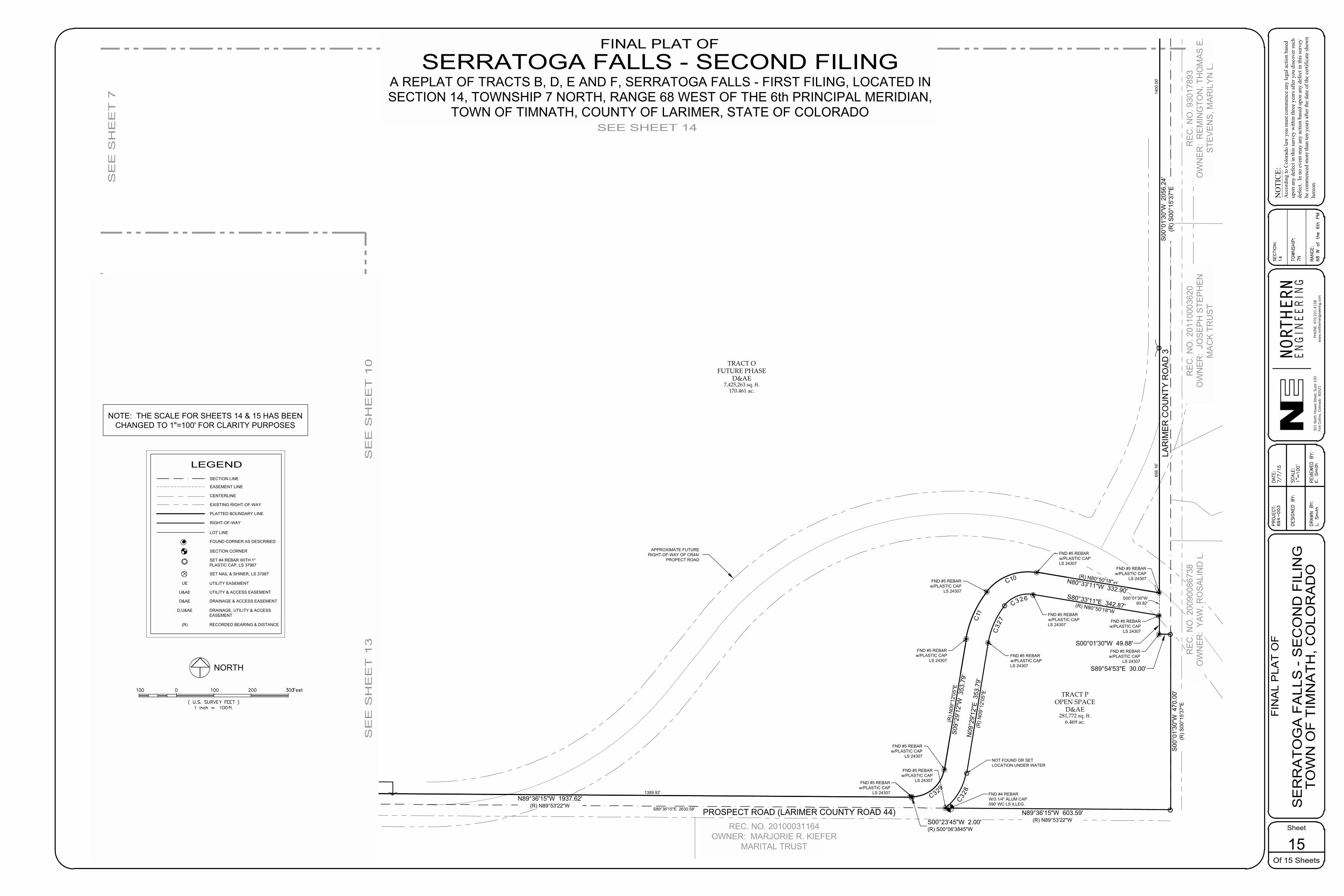
54.0' 54.0'
29.0'29.0'
FND #4 REBARW/3 1/4" ALUM CAP590' WC LS ILLEG.
32' ADDITIONALRIGHT-OF-WAY
32' ADDITIONALRIGHT-OF-WAY
28'28'
SOUTH 1/4 CORNERSECTION14-7-68
FND #4 REBAR w/2-1/2" ALUMINUM CAP
(ILLEGIBLE)
PROSPECT ROAD (LARIMER COUNTY ROAD 44) S89°36'15"E 2630.58'
LAR
IME
R R
IDG
E D
R.
(RO
W V
AR
IES
)
REC. NO. 20100031165OWNER: BLAIR A. KIEFER
FAMILY TRUST
REC. NO. 20100031164OWNER: MARJORIE R. KIEFER
MARITAL TRUST
RE
C. N
O. 9
3017
893
OW
NE
R:
RE
MIN
GTO
N, T
HO
MA
S E
.S
TEV
EN
S, M
AR
ILY
N L
.
RE
C. N
O. 2
0110
0036
20O
WN
ER
: JO
SE
PH
STE
PH
EN
MA
CK
TR
US
T
PROSPECT ROAD (LARIMER COUNTY ROAD 44)
LAR
IME
R C
OU
NTY
RO
AD
3
LOT 37230 sq.ft.
LOT 17315 sq.ft.LOT 2
7230 sq.ft.
LOT 188966 sq.ft.LOT 17
7521 sq.ft.
LOT 17361 sq.ft.
LOT 26766 sq.ft.
LOT 47188 sq.ft.
LOT 57200 sq.ft.
LOT 710008 sq.ft.
LOT 86954 sq.ft.
LOT 166658 sq.ft.
LOT 97536 sq.ft.
LOT 107536 sq.ft.
LOT 117536 sq.ft.
LOT 127536 sq.ft.
LOT 137536 sq.ft.
LOT 146682 sq.ft.
LOT 76684 sq.ft.
LOT 156684 sq.ft.
LOT 16600 sq.ft.
LOT 37230 sq.ft.
LOT 17315 sq.ft.LOT 2
7230 sq.ft.
LOT 168017 sq.ft.
LOT 37032 sq.ft.
LOT 89613 sq.ft.
LOT 67202 sq.ft.
LOT 56600 sq.ft.
LOT 26865 sq.ft.
LOT 66600 sq.ft.
LOT 38431 sq.ft.
LOT 46600 sq.ft.
TRACT OFUTURE PHASE
D&AE7,425,263 sq. ft.
170.461 ac.
BRISTOW RD.
(58' ROW)
LAR
IMER
RID
GE
PKW
Y.(5
8' R
OW
)
29.0'29.0'
29.0' 29.0'
BLO
CK
15
BLOCK 16
BLO
CK
16
TRACT OFUTURE PHASE
D&AE7,425,263 sq. ft.
170.461 ac.
BLO
CK
16
BLOCK 1
BLOCK 14
N89°31'17"W 1792.93'(R) N89°48'24"W
N89°36'15"W 1937.62'(R) N89°53'22"W
S00°01'30"W 49.88'
S89°54'53"E 30.00'
(R) N80°50'18"WN80°33'11"W 332.90'
(R) N
09°1
2'05
"ES0
9°29
'12"
W 3
53.7
9'
N89°36'15"W 1937.62'(R) N89°53'22"W
S00
°01'
30"W
205
6.24
'(R
) S00
°15'
37"E
S00
°01'
30"W
470
.00'
(R) S
00°1
5'37
"E
N89°36'15"W 603.59'(R) N89°53'22"WS00°23'45"W 2.00'
(R) S00°06'3845"W
10' IRRIGATIONEASEMENT 10' UE
14' UE10' UE
10' UE
14' UE
14' UE
14' UE
10' UE
40' UE
10' UE
10' UE
14' UE
10' UE
14' UE
10' UE
14' UE
APPROXIMATE FUTURERIGHT-OF-WAY OF CR44/
PROPECT ROAD
APPROXIMATE FUTURERIGHT-OF-WAY OF CR44/
PROSPECT ROAD
TRACT POPEN SPACE
D&AE281,772 sq. ft.
6.469 ac.
C328
C32
7
C326
TRACT HOPEN SPACE
D,U&AE384,170 sq. ft.
8.819 ac.
TRACT HOPEN SPACE
D,U&AE384,170 sq. ft.
8.819 ac.
TRACT HOPEN SPACE
D,U&AE384,170 sq. ft.
8.819 ac.
S89°36'15"E 314.11'
N89°36'15"W 283.33'N44°32'43"W
14.13'18.67'40
.02'
25.0
6'
RE
C. N
O. 2
0090
0867
38O
WN
ER
: Y
AW
, RO
SA
LIN
D L
.
S00°01'30"W60.82'
C329
C11
C10
N09
°29'
12"E
353
.79'
(R) N
09°1
2'05
"E
S80°33'11"E 342.87'(R) N80°50'18"W
BLO
CK
15
547.62' 1389.92'
1400
.00'
656.
16'
FND #5 REBARw/PLASTIC CAP
LS 24307
FND #5 REBARw/PLASTIC CAPLS 24307
FND #5 REBARw/PLASTIC CAPLS 24307
FND #5 REBARw/PLASTIC CAP
LS 24307
FND #5 REBARw/PLASTIC CAP
LS 24307
FND #5 REBARw/PLASTIC CAPLS 24307
FND #5 REBARw/PLASTIC CAP
LS 24307
FND #5 REBARw/PLASTIC CAP
LS 24307
FND #5 REBARw/PLASTIC CAP
LS 24307
FND #5 REBARw/PLASTIC CAP
LS 24307
FND #5 REBARw/PLASTIC CAP
LS 24307
FND #4 REBARW/YPC "TST LS 31169"
NOT FOUND OR SETLOCATION UNDER WATER
RE
VIE
WE
D B
Y:
E. S
mith
DE
SIG
NE
D B
Y:
DR
AW
N B
Y:
SC
ALE
:
DA
TE:
7/7/
15P
RO
JEC
T:69
4-00
3
Sheet
Of 15 Sheets
FIN
AL
PLA
T O
FN
OTI
CE :
Acc
ordi
ng to
Col
orad
o la
w y
ou m
ust c
omm
ence
any
lega
l act
ion
base
dup
on a
ny d
efec
t in
this
surv
ey w
ithin
thre
e ye
ars a
fter y
ou d
isco
ver s
uch
defe
ct.
In n
o ev
ent m
ay a
ny a
ctio
n ba
sed
upon
any
def
ect i
n th
is su
rvey
be c
omm
ence
d m
ore
than
ten
year
s afte
r the
dat
e of
the
certi
ficat
e sh
own
here
on.
RA
NG
E:
TO
WN
SH
IP:
SE
CT
ION
:
301 N
orth
How
es S
tree
t, S
uite
100
Fort
Col
lins,
Col
orad
o 8
0521
EN
GIN
EE
RN
GIE
HTRON
RNPH
ON
E: 9
70.2
21.4
158
ww
w.n
orth
erne
ngin
eerin
g.co
m
15
S
ER
RA
TO
GA
FA
LLS
- S
EC
ON
D F
ILIN
G
TO
WN
OF
TIM
NA
TH
, CO
LOR
AD
OL
. S
mith
1"=
100'
14 7N 68 W
of th
e 6
th P
M
SEE SHEET 14
SE
E S
HE
ET
7
NORTH
( U.S. SURVEY FEET )1 inch = ft.
Feet0XX XX
XX
XX XX
NOTE: THE SCALE FOR SHEETS 14 & 15 HAS BEENCHANGED TO 1"=100' FOR CLARITY PURPOSES
FINAL PLAT OFSERRATOGA FALLS - SECOND FILING
A REPLAT OF TRACTS B, D, E AND F, SERRATOGA FALLS - FIRST FILING, LOCATED INSECTION 14, TOWNSHIP 7 NORTH, RANGE 68 WEST OF THE 6th PRINCIPAL MERIDIAN,
TOWN OF TIMNATH, COUNTY OF LARIMER, STATE OF COLORADO
SE
E S
HE
ET
13
SE
E S
HE
ET
10
LEGEND
PLATTED BOUNDARY LINE
CENTERLINE
EASEMENT LINE
LOT LINE
EXISTING RIGHT-OF-WAY
SECTION CORNER
FOUND CORNER AS DESCRIBED
RIGHT-OF-WAY
SECTION LINE
SET #4 REBAR WITH 1"PLASTIC CAP, LS 37987
SET NAIL & SHINER, LS 37987
UTILITY EASEMENTUE
UTILITY & ACCESS EASEMENTU&AE
DRAINAGE & ACCESS EASEMENTD&AE
DRAINAGE, UTILITY & ACCESSEASEMENT
D,U&AE
RECORDED BEARING & DISTANCE(R)


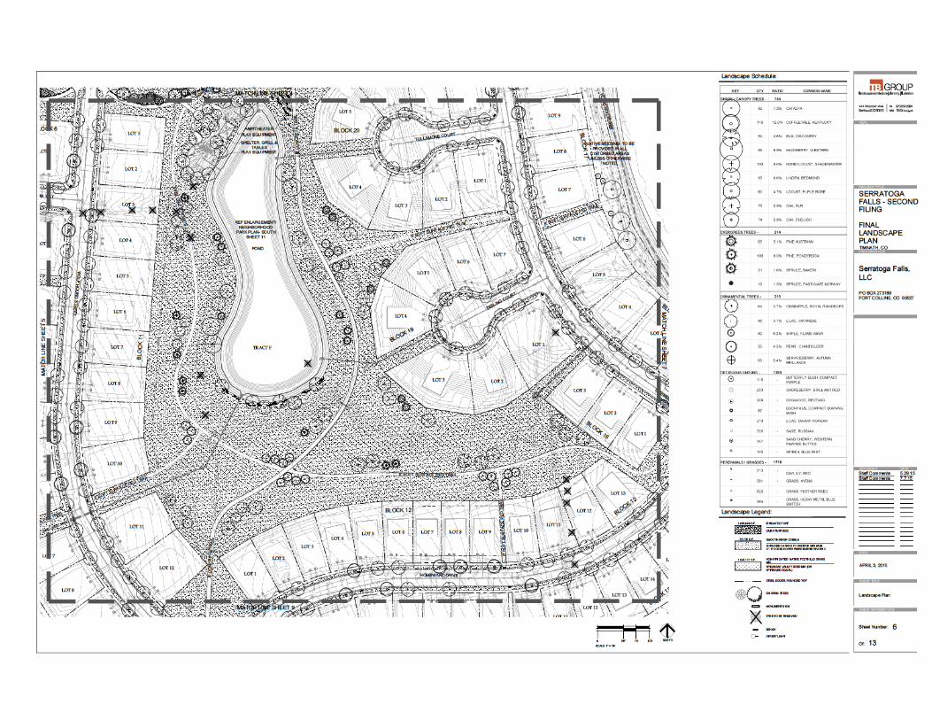
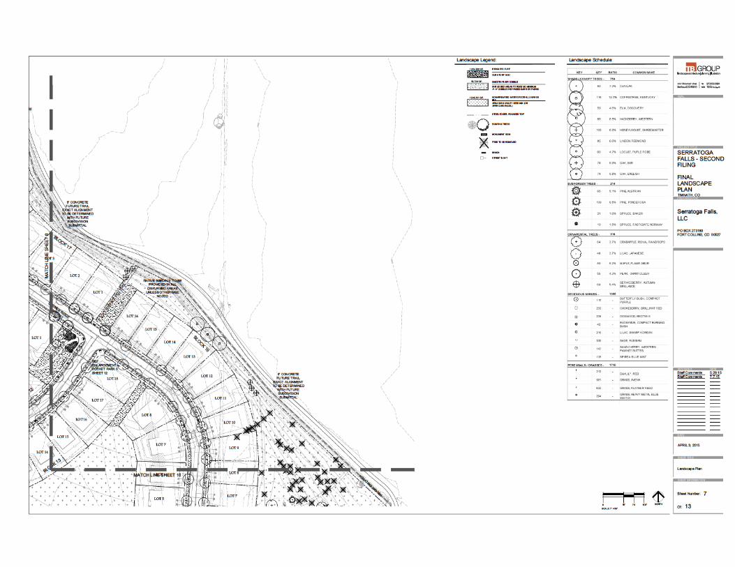


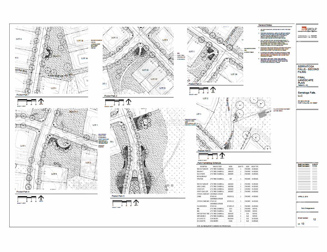

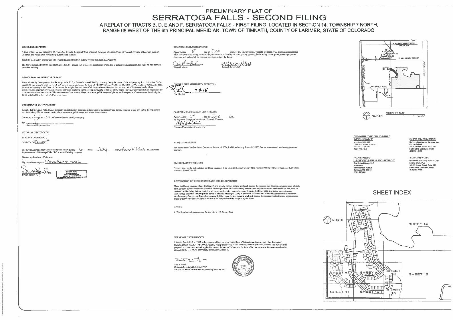


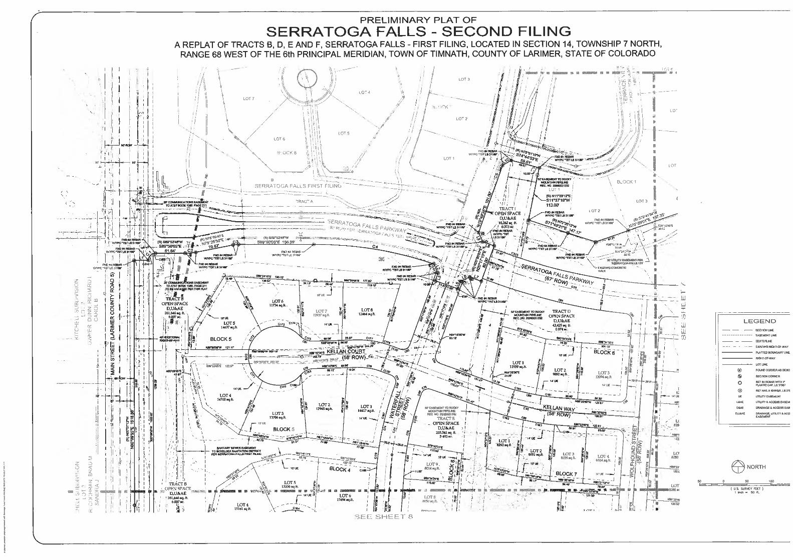
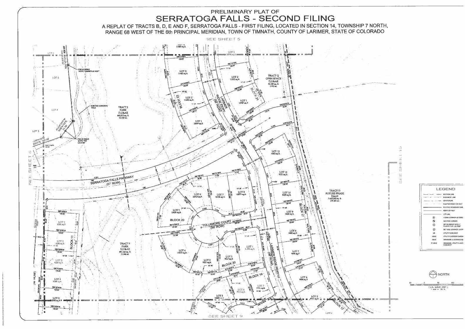
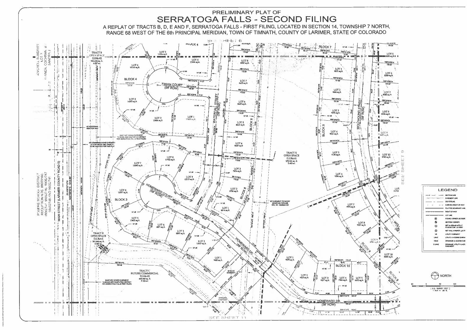
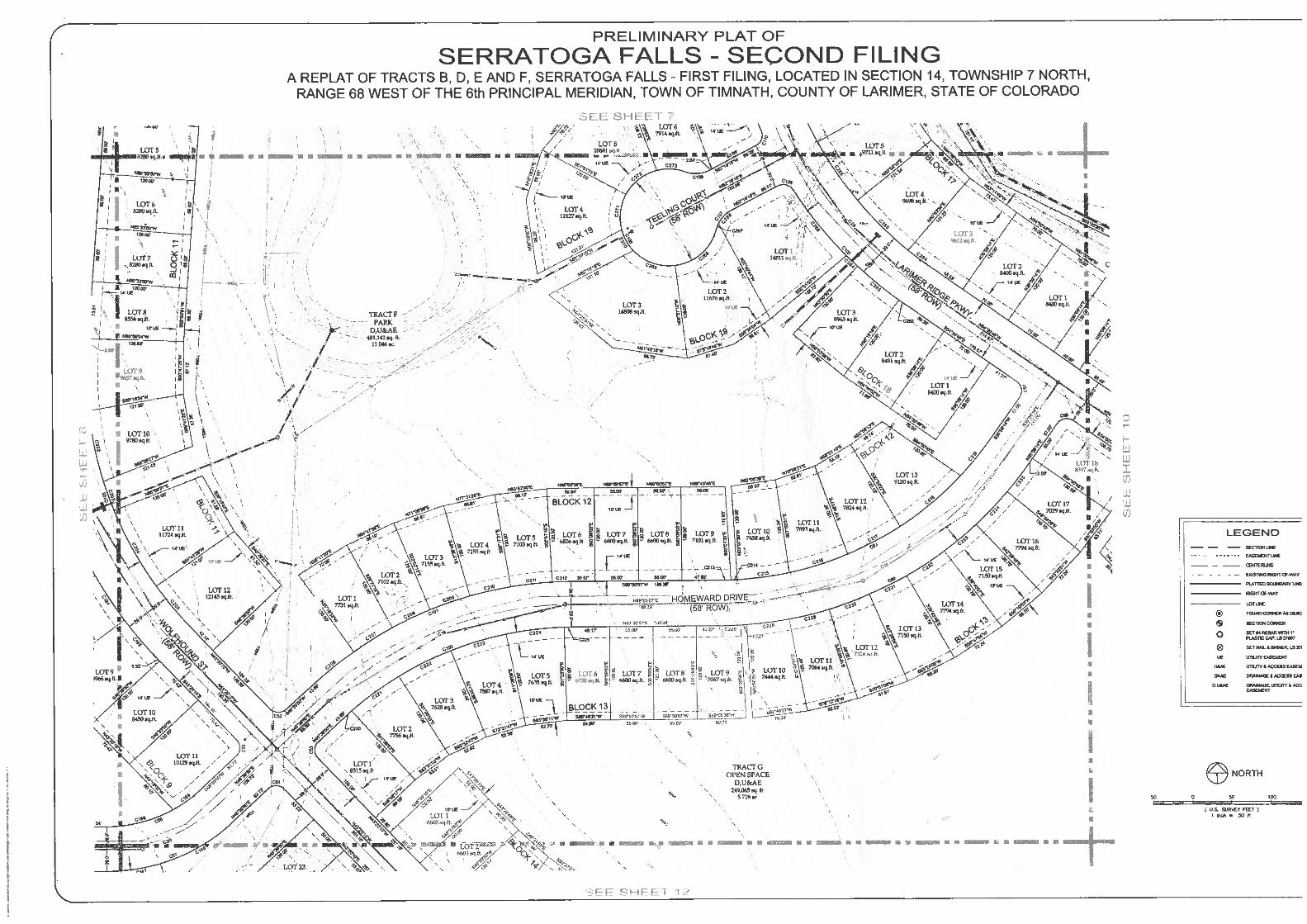


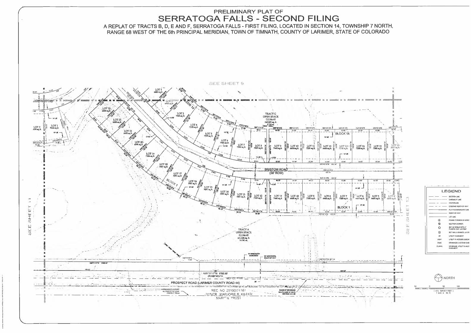


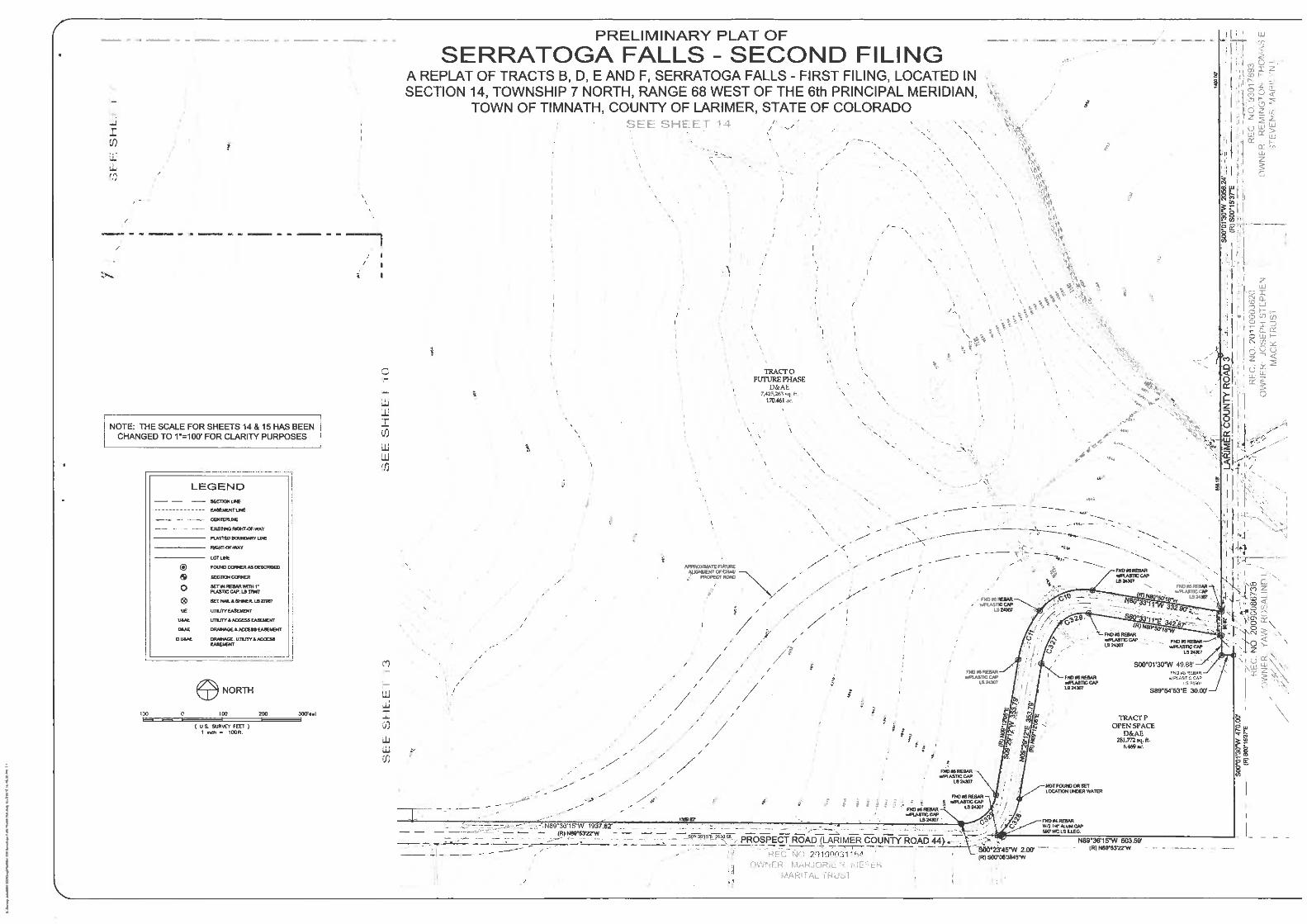

1
Serratoga Falls Final Plat General Development Information
This request is for subdivision plat for approximately 330.478 acres known as the Serratoga Falls Second Filing
Subdivision. There will be total of 250 lots averaging from 6,596 sq. ft. to 21,501 sq. ft. Overall gross density is
1.60 dwelling units per acre. The project has densities that are consistent with the R-2 Zone District Standards
and the Land Use Map of the Comprehensive Plan, which is designated as Low Density Residential.
The Serratoga Falls Subdivision is consistent with the following sections of Chapter 16.2 of the Land Use Code:
16.2.1 Vision and intent
.
16.2.7. Lots and blocks
2
16.2.8. Streets
16.2.10 Sidewalks, multi-use pathways and trails
16.2.12 Parks and open space

3
16.2.17 Fences and walls
16.2.18 Residential architecture
16.3.6 Density and dimensional standards
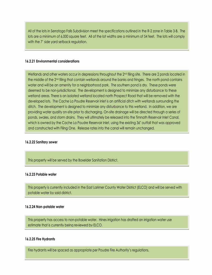
4
16.2.21 Environmental considerations
16.2.22 Sanitary sewer
16.2.23 Potable water
16.2.24 Non-potable water
16.2.25 Fire Hydrants
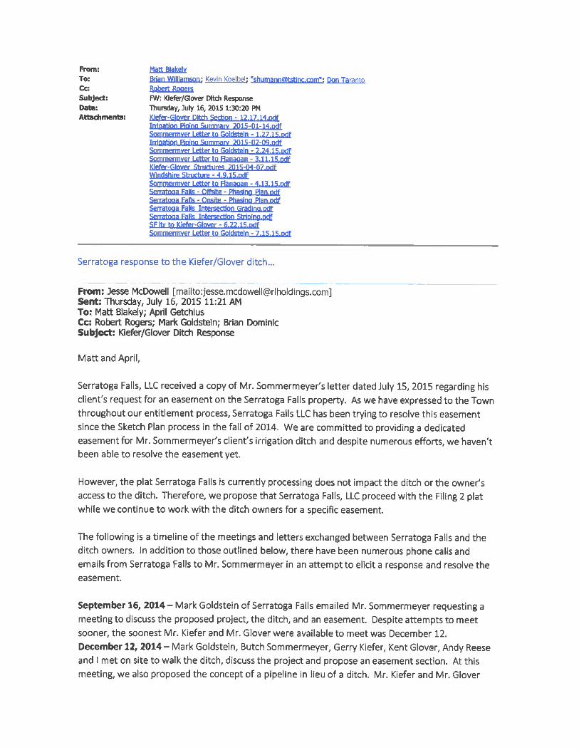


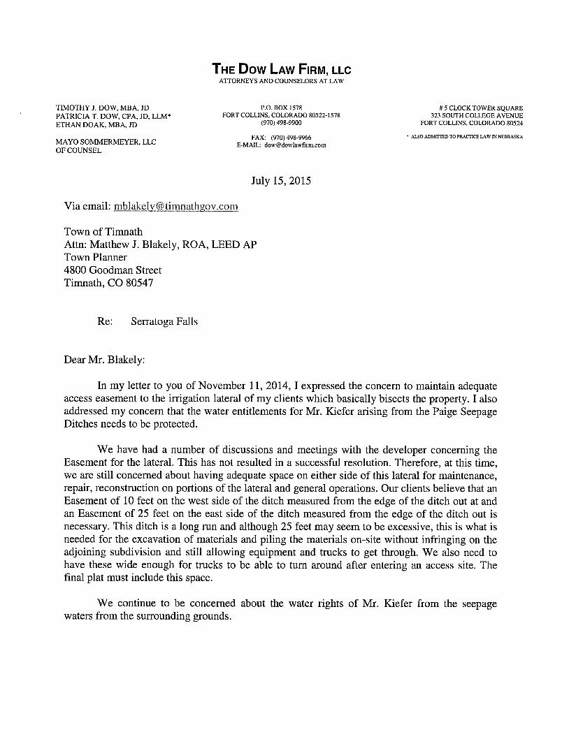

TOWN COUNCIL COMMUNICATION
Meeting Date:
Item: EXECUTIVE SESSION: “For the purposes of discussion concerning the purchase, acquisition, lease, transfer, or sale of real, personal, or other property interests under Section §24-6-402(a), C.R.S.; discussion concerning personnel matters under §24-6-402(4)(f), C.R.S.; discussion regarding positions relative to matters that may be subject to negotiations and development of a strategy for negotiations under §24-6-402(4)(e), C.R.S.; and conferences with the Town’s attorney for purposes of receiving legal advice on specific legal questions under §24-6-402(4)(b), C.R.S.”
Ordinance Resolution Discussion X
Presented by: Town Attorney
KEY POINTS/SUPPORTING INFORMATION: EXECUTIVE SESSION: “For the purposes of discussion concerning the purchase, acquisition, lease, transfer, or sale of real, personal, or other property interests under Section §24-6-402(a), C.R.S.; discussion concerning personnel matters under §24-6-402(4)(f), C.R.S.; discussion regarding positions relative to matters that may be subject to negotiations and development of a strategy for negotiations under §24-6-402(4)(e), C.R.S.; and conferences with the Town’s attorney for purposes of receiving legal advice on specific legal questions under §24-6-402(4)(b), C.R.S.” ADVANTAGES: N/A
DISADVANTAGES: N/A
FINANCIAL IMPACT: N/A
RECOMMENDATIONS: I move to enter into Executive Session “For _____________________________________________.”
ATTACHMENTS: N/A