
TOWN OF PINEVILLE
253
i TOWN OF PINEVILLE NORTH CAROLINA ZONING ORDINANCE Town of Pineville, North Carolina Adopted May 10, 2016
Transcript of TOWN OF PINEVILLE

i
TOWN OF PINEVILLE NORTH CAROLINA
ZONING ORDINANCE
Town of Pineville, North Carolina Adopted May 10, 2016

ii
Table of Contents
CHAPTER SECTION TITLE PAGES
1 AUTHORITY & PURPOSE 1 1.1 Title 1.2 Authority and Enactment Clause 1.3 Purpose 1.4 Applicability and Jurisdiction 1.5 Official Zoning Map 1.6 Interpretation and Conflict 1.7 Relation to Other Regulations and Private Agreements 1.8 Liability for Damages 1.9 Severability 1.10 Effective Date/Transitional Provisions
2 ADMINISTRATION 9
2.1 Review and Decision-Making Bodies 2.2 Common Review Procedures 2.3 Re-Submission of Petition 2.4 Applications and Requirements for Board of Adjustment 2.5 Conflict with Other Laws 2.6 Conditional Uses 2.7 Zoning Administration 2.8 Nonconformities
3 DEFINITIONS 46
3.1 Purpose and Intent 3.2 Interpretation of Terms and Words 3.3 Definitions of Specific Terms and Words
4 OFF-STREET PARKING REQUIREMENTS 84
4.1 Off-Street Parking 4.2 Off-Street Loading Requirements 4.3 Parking in Residential Zones 4.4 Obstructions and Restrictions 4.5 Parking Lot Design Standards
5 SIGNS 99
5.1 Purpose and Intent 5.2 Signs Not Requiring a Permit 5.3 Prohibited Signs
5.4 District Signs 5.5 Specifications for Signs Requiring a Permit 5.6 Reserved 5.7 Sign Illumination 5.8 Enforcement

iii
5.9 Illumination & Height
6 DISTRICTS AND REGULATIONS 121 6.1 Zoning and Overlay Districts 6.2 District Boundaries 6.3 Rules Governing Boundaries 6.4 Regulations 6.5 Supplemental Use Regulations 6.6 Applicable Dimensional Requirements
7 GENERAL PROVISION 169
7.1 Application 7.2 Reduction of Lot and Yard Areas Prohibited 7.3 Trees and Landscaping 7.4 Screening and Landscaping 7.5 Fences or Walls Permitted 7.6 Lot to Abut a Dedicated Street 7.7 One Principal Building 7.8 Temporary Structures and Uses
7.9 Accessory Structures and Uses 7.10 Use of Manufactured Homes and Similar Structures 7.11 Height Limitations and Exceptions 7.12 Construction Begun Prior to Adoption of Ordinance 7.13 Uses Not Expressly Permitted or Conditional 7.14 Location of Required Yards & Setbacks on Irregular Lots 7.15 Exterior Lighting 7.16 Restoring Unsafe buildings 7.17 Vibration 7.18 Noise 7.19 Odor 7.20 Outparcels 7.21 Parking of Commercial & Recreational Vehicles 7.22 Yard & Garage Sales 7.23 Reserved 7.24 Preservation of Existing Housing Stock 7.25 Community Appearance 7.26 Sidewalks and Planting Strips
7.27 Pedestrian Walkway & Sidewalk Connections 7.28 Damage to Town Property 152 Floodplain Regulation 210 153 SWIM Buffers 243

1
CHAPTER 1 AUTHORITY & PURPOSE
1.1 TITLE
These Regulations shall be officially known as the “Pineville Zoning Ordinance,” and may be referred to as the “Zoning Ordinance,” or “this Ordinance.”
1.2 AUTHORITY AND ENACTMENT CLAUSE 1.2.1 General
Pursuant to authority conferred by Chapter 160A, Article 19, Parts 1 and 3 of the North Carolina General Statutes as amended, and for the purpose of promoting the health, safety, morals or general welfare of the inhabitants of the Town of Pineville by lessening congestion in the streets; securing safety from fire, panic, and other dangers; providing adequate light and air; preventing the overcrowding of land; avoiding undue congestion of population; facilitating the adequate provision of transportation, water, sewerage, schools, parks, and other public requirements; and by other means in accordance with the Pineville Land Development Plan, the Pineville Town Council hereby enacts this Zoning Ordinance.
1.2.2 Authority to Regulate Zoning, Subdivision and Building Practices in ETJ
Pursuant to the North Carolina General Statutes, the Town Council establishes the boundaries of the Town’s extraterritorial jurisdiction to enforce the following regulations: zoning ordinance; subdivision regulations; North Carolina State Building Code; minimum housing standards code; and ordinances creating the Town’s Planning Board, and Planning Department.
1.2.3 Reference to North Carolina General Statutes
Whenever any provision of this Ordinance refers to or cites a section of the North Carolina General Statutes and that section is later amended or superseded, this Ordinance shall be deemed amended to refer to the amended section or the section that most nearly corresponds to the superseded section.
1.2.4 Jurisdiction The provisions of this Ordinance shall apply within the corporate limits of the Town of Pineville and within the extraterritorial area as defined by ordinance and as now or hereafter fixed, and any property thereto annexed in the future. The boundaries of the zones are shown upon the map accompanying this Ordinance and made a part thereof, and said map shall be known as the "Official Zoning Map of Pineville, North Carolina". Said map and all notations, references and all amendments thereto, and other information shown thereon are hereby made a part of this Ordinance the same as if such information set forth on the map was all fully described and set out herein. The zoning map properly attested is on file in the Town Hall and is available for inspection by the public.

2
1.3 PURPOSE
1.3.1 General These zoning regulations have been designed to lessen congestion in the streets, to secure safety from fire, panic and other dangers, to promote health and the general welfare, to provide adequate light and air, to prevent the overcrowding of land, to avoid undue concentration of population, and to facilitate the adequate and economic provision of transportation, water sewerage, schools, parks and other public facilities and services. Maintaining and enhancing property value and community character through design guidelines.
1.3.2 Specific This Ordinance is adopted for the following particular purposes: Implement Policies of the Land Use Plan, and Overlay Districts To implement the goals and policies of the Pineville Land Use Plan and Overlay Districts, as well as other goals and policies adopted by the Town Council related to growth and development. Protect Small-Town Character To protect and improve the established small-town character of Pineville and the social and economic stability of the existing residential, commercial and other land uses within the Town. Promote Good Planning Practice To promote good planning practice and to provide a regulatory mechanism, which includes appropriate performance standards for development within the Town. Prevent Adverse Impacts on Environment To prevent the adverse impacts of development on natural resources and features and water quality, roads and transportation, and flood plains in the Town. Efficient Use of Land and Public Services To encourage a more efficient use of land and public services and to reflect changes in technology of land development. Promote Alternative Land Development Practices To promote alternative land development practices, which will otherwise promote the public health, safety and general welfare. Discourage Sprawl To discourage sprawling development patterns such as single dimensional residential development, leap-frog development and strip commercial development. Encourage Mixed Use Development and Interconnectivity To encourage mixed-use development and interconnectivity between developments.

3
1.4 APPLICABILITY AND JURISDICTION
1.4.1 General This Ordinance is in part carried forward by re-enactment of some of the provisions of the Zoning Ordinance of the Town of Pineville (adopted by the Town Council on December 21, 1970, as amended), (second amendment was March 15, 1988), and it is not the intention to repeal but rather to re-enact and continue in force such existing provisions so that all rights and liabilities that have accrued hereunder are preserved and may be enforced. All provisions of the Zoning Ordinance of the Town of Pineville enacted in 1970, as amended, which are not re-enacted herein are hereby repealed. All suits at law or in equity and/or all prosecutions resulting from the violation of any Zoning Ordinance heretofore in effect, which are now pending in any of the courts of this State or of the United States, shall not be abated or abandoned by reason of the adoption of this Ordinance but shall be prosecuted to their finality, the same as if this Ordinance had not been adopted, and any and all violations of the existing Zoning Ordinance, prosecutions for which have not yet been instituted, may be hereafter filed and prosecuted. Nothing in this Ordinance shall be construed as to abandon, abate or dismiss any litigation or prosecution now pending, and/or which may heretofore have been instituted or prosecuted.
1.4.2 Application to Town
Use of all structures and land owned by the Town or by Town agencies or departments shall comply with all requirements of this Ordinance, except that the Town or Town agencies or departments may be exempt from the provisions of this Ordinance when an emergency exists that it is impossible to submit to the normal procedures and requirements of this Ordinance and quick and instant action is necessary to secure the public health, safety or welfare. The Town Council shall ratify such exemption after-the-fact at its next regularly scheduled meeting, and shall base its ratification on specified findings of fact related to the emergency involved.
1.4.3 No Development Until Compliance with this Ordinance No structure, or part thereof shall hereafter be located, erected, moved, reconstructed, extended, converted or structurally altered without full compliance with the provisions of this Ordinance and all other applicable Town, State, and Federal regulations, including the Pineville Overlay District Plans. For the purposes of this section, development or use of land shall include land disturbance activities such as clearing and grading, or otherwise disturbing the existing vegetative cover.
1.5 OFFICIAL ZONING MAP
1.5.1 Official Zoning Map The Official Zoning Map designates the location and a boundary of the various zoning districts established in this Ordinance within the Town and any future ETJ, and is incorporated herein by reference. The Official Zoning Map shall be determined and kept on file in the office of the Planning Director and is available for public inspection during normal business hours.
4
1.5.2 Incorporated by Reference The Official Zoning Map, Overlay District Maps, and adopted Stormwater ordinances and all the notations thereon are hereby incorporated by reference and made part of this Ordinance.
1.5.3 Zoning District Boundaries Unless Otherwise specified, zoning district boundaries are lot lines or the centerline of street, alleys, railroad rights-of-way, or such lines extended. Where a zoning district boundary divides a land parcel under a single ownership into two districts, then the entire parcel shall be zoned for the more restrictive use by the adjustment of the boundaries.
1.5.4 Changes to the Official Zoning Map Changes made in zoning district boundaries or other matters portrayed on the Official Zoning Map shall be made in accordance with the provisions of this Ordinance. Changes shall be entered on the Official Zoning Map promptly after the amendment has been approved by the Town Council with an entry on the Official Zoning Map. No amendment shall become effective until after such change entries are made on the Official Zoning Map by the Planning Director.
1.5.5 Mapping Disputes and Disparities The Planning Director shall have the authority to interpret the Official Zoning Map and determine the zoning designation and boundaries of the different zoning districts if in question.
1.5.6 Zoning Map Interpretation
The map adopted or amended by the Pineville Town Council and kept at Pineville Town Hall as the Zoning Map of Pineville, North Carolina, as certified as such by the Planning Director is hereby declared to be the proper zoning for said districts as of the effective date of this Ordinance.
For purposes of interpretation of district boundaries as shown on the zoning map, the following rules shall apply:
A) Boundaries indicated as approximately following the center line of streets,
highways, or alleys shall be construed to follow such center lines.
B) Boundaries indicated as approximately following lot lines shall be construed as following such lot lines.
C) Boundaries indicated as approximately following corporate limits shall be
construed as following such corporate limits. D) Boundaries indicated as following railroad lines shall be construed to be
midway between the main tracks.

5
E) Boundaries indicated as parallel to or extensions of features indicated in this section shall be construed as such. Distances not specifically indicated on the Official Zoning Map shall be determined by the scale of the map.
1.6 INTERPRETATION AND CONFLICT
1.6.1 Meaning and Intent
All provisions, terms, phases, and expressions contained in this Ordinance shall be construed according to this Ordinance’s stated purpose and intent.
1.6.2 Text Controls
In case of any difference of meaning or implication between the text of this Ordinance and any heading, drawing, table, or figure, the text shall control.
1.6.3 Authority for Interpretation The Planning Director is responsible for interpreting the text of this Ordinance in accordance with the standards set forth in this Section and applicable Ordinance standards and requirements. Interpretations of the Planning Director may be appealed to the Board of Adjustment unless otherwise stated.
1.6.4 Statutory References All references to state law in this Ordinance refer to the North Carolina General Statutes, as amended.
1.6.5 Computation of Time Periods of time defined by a number of days shall mean a number of consecutive calendar days, (unless specified elsewhere in this Ordinance) including all weekend days, holidays, and other non-business days; except if the last day is a Saturday, Sunday, or legal holiday, that day shall be excluded.
1.6.6 Delegation of Authority Whenever a provision appears requiring the head of the department or another officer or employee of the Town to perform an act or duty, that provision shall be construed as authorizing the department head or officer to delegate the responsibility to subordinates, unless the terms of the provision specify otherwise.
1.6.7 Technical and Non-Technical Words Words and phrases not otherwise defined in this Ordinance shall be construed according to the common and relevant use of the language as interpreted by the Planning Director.
1.6.8 Mandatory and Discretionary Terms The words “shall” and “must” are always mandatory, and the words “may” or “should” are always permissive.
1.6.9 Conjunctions Unless the context clearly suggests the contrary, conjunctions shall be interpreted as

6
follows: A) “And”
And indicates that all connected items, conditions, provisions, or events shall apply; and
B) “Or” Or indicates that one or more of the connected items, conditions, provisions, or events shall apply.
1.6.10 Tense and Usage
Words used in one tense (past, present, or future) include other tenses, unless the context clearly indicates the contrary. The singular shall include the plural and the plural shall include the singular.
1.6.11 Gender The masculine shall include the feminine.
1.7 RELATIONSHIP TO OTHER REGULATIONS AND PRIVATE AGREEMENTS 1.7.1 Conflicts with Other Regulations
When the provisions of this Ordinance are inconsistent with one another or when the provisions of this Ordinance conflict with provisions found in other adopted ordinances or regulations, the more restrictive provision shall govern unless the terms of the provisions specify otherwise.
1.7.2 Relationship with Private-Party Easements, Covenants or Agreements In developing land, private parties are free to exceed the mandatory standards provided in this Ordinance through easements, agreements, or otherwise. However, the Town shall not be obligated to enforce private agreements.
1.7.3 Repeal of Inconsistent or Conflicting Provisions All other ordinances or parts of ordinance of the Town inconsistent or conflicting with this Ordinance, to the extent of the inconsistency only, are hereby repealed or modified.
1.8 LIABILITY FOR DAMAGES This Ordinance shall not be construed to hold the Town or its authorized representatives responsible for any damage to persons or property by reason of the inspection or reinspection authorized in this Ordinance, or for any actions taken by landowners of developers to comply with the procedures or standards of this Ordinance.

7
1.9 SEVERABILITY It is the legislative intent of the Town Council in adopting this Ordinance that all provisions shall be liberally construed to protect and preserve the peace, health, safety, and general welfare of the inhabitants of the Town. If any Section, subsection, sentence, clause or phase of this Ordinance is for any reason held by a court of competent jurisdiction to be invalid, such decision shall not affect the validity of the remaining portions of this Ordinance. The Town Council hereby declares that it would have passed this Ordinance and any Section, subsection, sentence, clause and phase, thereof, irrespective of the fact that any one or more Sections, subsections, sentence, clause sentences, clauses or phrases be declared invalid.
1.10 EFFECTIVE DATE / TRANSITIONAL PROVISIONS
1.10.1 Effective Date This Ordinance shall be effective upon enactment.
1.10.2 Final Approval
A) Permits
Any building, structure, or development which has prior town approval where a valid legal permit was issued and had not expired prior to the effective date of this Ordinance may, at the applicant’s option, be completed only in conformance with the issued permit including size, density, location, dimensional standards in addition to any conditions specified on the approved plans. The permits may be completed even if such building, structure, or development does not fully comply with provisions of this Ordinance so long as all conditions and requirements from the date of approval are met. If a valid building permit is not obtained within the time allowed under the original ordinance then the building, structure, or development may be constructed, completed, or occupied only in compliance with this Ordinance.
B) Subdivision
1) General Any subdivision for which a master subdivision plan or minor subdivision was approved prior to the effective date of this Ordinance may, at the applicant’s option, be completed according to the subdivision approval, except when Sec. 1.10.2 (B-2) applies, even if the subdivision does not fully comply with the provisions of this Ordinance. If the subdivision is not completed within the time requirements established by prior ordinance or within any schedule included in the approval of the subdivision approval, the Town Council may grant one extension of not more than one year for the completion of the subdivision under the terms of the previous ordinance(s) if good cause is shown. If the subdivision is not

8
completed within the time required under the original approval or any extension granted, then the subdivision may be completed only in compliance with this Ordinance.
2) Expiration Any major subdivision plan that was approved prior to the effective date of this Ordinance that does not have an expiration date under the prior ordinance or the specific subdivision approval shall expire two years after the effective date of this Ordinance unless required improvements are built and completed for at least one phase of the subdivision within two years of the effective date of this Ordinance. (For the purposes of this subsection, required improvements are the streets, potable water facilities, wastewater treatment facilities and sidewalks identified in the subdivision approval for the relevant phase.) If such a major subdivision plan expires, then development of the subdivision must comply with this Ordinance.
1.10.3 Complete Applications
All projects for which a complete application for site plan or subdivision was submitted and accepted by the Town on or before March 15, 2008 shall be exempt from complying with all site plan and subdivision provisions of this Ordinance if the application is approved and development occurs in conformity with the permit terms and the requirements of the previously applicable site plan or subdivision ordinance(s). Such site plans are subject to Section 1.10.2 (A) and such subdivision plans are subject to Section 1.10.2 (B-2).
1.10.4 Violations Continue Any violation under previous ordinances repeated by this Ordinance shall continue to be a violation under this Ordinance and be subject to penalties and enforcement under this Ordinance, unless the use, development, construction, or other activity complies with the provisions of this Ordinance.
1.10.5 Legal Nonconformities Under Previous Ordinance Any legal nonconformity under any previous ordinances repealed by this Ordinance is also a legal nonconformity under this Ordinance, as long as the situation that resulted in the nonconforming status under the previous ordinances continues to exist.

9
CHAPTER 2 ADMINISTRATION
2.1 REVIEW AND DECISION-MAKING BODIES The following review and decision-making bodies shall have the following duties and responsibilities in the administration of this Ordinance, and shall be governed by the following rules.
2.1.1 Town Council A) Powers and Duties
In addition to any authority granted the Town Council by general or special law, the Town Council shall have the following powers and duties: 1) Review and Approve or Disapprove
To review, hear, consider and approve or disapprove:
a) The adoption of an ordinance to amend the Official Zoning Map (Rezoning).
b) The adoption of an ordinance to amend the text of this
Ordinance (Text amendment).
2) Review and Approve, Approve with Conditions or Disapprove To review, hear, consider and approve, approve with conditions or disapprove:
a) The adoption of an ordinance to amend the Official Zoning
Map, with conditions (Conditional rezoning).
b) The adoption of an ordinance approving a PUD, or TND for zoning district designation.
c) Applications for conditional use permits. d) Applications for subdivision approval.
3) Appoint Planning Board and Board of Adjustment Officers
To designate and appoint Planning Board and Board of Adjustment Officers to make decisions as the Town Council may deem appropriate.
4) Other
To take any other action not delegated to the Planning Board; Board of Adjustment; the Parks, Recreation, and Cultural Advisory Committee; the Planning Director; or heads of Town departments, as

10
the Town Council may deem desirable and necessary to implement the provisions of this Ordinance.
B) Interest
Per NCGS 160A-381(d), Town Council members shall not vote on any zoning map or text amendment where the outcome of the matter being considered is reasonably likely to have a direct, substantial, and readily identifiable financial impact on the member. Per NCGS 160A-388(e1), Town Council members shall not participate in or vote on any quasi-judicial matter in a manner that would violate affected persons’ constitutional rights to an impartial decision maker. Impermissible conflicts include, but are not limited to, a member having a fixed opinion prior to hearing the matter that is not susceptible to change, undisclosed ex parte communications, a close familial, business, or other associational relationship with an affected person, or a financial interest in the outcome of the matter. If an objection is raised to a member’s participation and that member does not recluse himself or herself, the remaining members shall by majority vote rule on the objection.
2.1.2 Planning Board
A) Powers and Duties The Planning Board shall have the following powers and duties
1) Review and Make Recommendations to Approve or Disapprove
To review, hear, consider and make recommendations to the Town Council to approve or disapprove: a) The adoption of an ordinance to amend the Official Zoning
Map (Rezoning). b) The adoption of an ordinance to amend the text of this Ordinance
(Text amendment).
2) Review and Make Recommendations to Approve, Approve with Conditions or Disapprove To hear, review, consider and make recommendations to the Town Council to approve, approve with conditions or disapprove: a) The adoption of an ordinance to amend the Official Zoning
Map, with conditions.
b) The adoption of an ordinance approving a zoning district designation.

11
3) Amendments to the Official Zoning Map and Text To consider and make recommendations to the Town Council to adopt an ordinance amending the Official Zoning Map or text of this Ordinance.
B) Membership 1) Number
The Planning Board shall consist of five members.
2) No Elected Official or Town employees No member of the Town Council or an employee of the Town shall serve on the Planning Board. To the greatest extent possible, a majority of the membership on the Planning Board should consist of persons with special training or experience in planning, real estate and development, architecture, landscape architecture and the law.
3) Appointment
Members shall be appointed by Town Council.
4) Initial establishment At the initial establishment of the Planning Board, two members shall be appointed for a three year term, and two members shall be appointed to a two year term. Thereafter, new appointments for terms of three years shall be made.
5) Removal
Any member of the Planning Board shall be removed for cause (neglect of duty, malfeasance, misconduct or failure to faithfully attend meetings) by the Town Council upon written charge.
6) Filling of Vacancy Vacancies occurring for reasons other than expiration of terms shall be filled for the period of the unexpired term by the same method as the original appointment.
C) Officers
1) Chair and vice-chair
The chair and vice-chair of the Planning Board shall be elected by the members of the Board. The term of the chair and vice-chair shall be one year. A past chair or vice-chair may be re-appointed. Vacancies within a term shall be filled by the same method as the original appointment. The chair shall decide all points of order on procedure, and shall take such action as shall be necessary to preserve the order and integrity of all proceedings before the Planning Board. In the absence of the chair, the vice-chair shall act

12
as chair and shall have all powers of the chair. In the absence of both the chair and vice-chair, an acting chair shall be selected for that meeting by a simple majority of those members present. The acting chair shall have the authority and responsibilities of the chair for that meeting.
2) Secretary The Town Clerk or their designee shall serve as Secretary of the Planning Board and shall keep minutes of all proceedings. These minutes shall be a summary of all proceedings before the Planning Board, which shall include the vote of all members upon every consideration, and be attested to by the Secretary. The minutes shall be approved by a majority of the Planning Board members voting. In addition, the Secretary shall maintain all records of the Planning Board meetings, hearings, proceedings, and correspondence, as public records in the offices of the Planning Department.
D) Quorum
No meeting of the Planning Board shall be called to order, nor may any business be transacted by the Planning Board, without a quorum consisting of the majority of the Planning Board’s membership excluding vacant seats being present.
E) Interest Any member who has a conflict of interest in a matter under consideration by the Planning Board shall declare such interest prior to the consideration of the matter and the board member shall abstain from voting if he/she believes that they cannot render an impartial decision on the matter on the question. The member declaring the interest is not exempted from participation in the discussions of the Board on the matter prior to its vote, except as required by NCGS 160A-388(e1) as stated below.
F) Staff The Planning Department shall be the professional staff to the Planning Board.
G) Rules of Procedure
The Planning Board shall, by a majority vote of the entire membership, adopt rules and regulations governing its procedure as it may consider necessary or advisable.
H) Meetings Meetings of the Planning Board shall be held monthly as needed. Additional meetings may be called by the Chair or in writing by a majority of the Board. All meetings and public hearings shall be held in the Town and in a place accessible and open to the public.
13
I) Compensation The members of the Planning Board shall serve with minor compensation as determined by Town Council.
2.1.3 Board of Adjustment
A) Powers and Duties The Board of Adjustment shall have all the powers and duties as authorized by Section 160A-388 of the General Statutes of North Carolina and as otherwise provided for in this Ordinance. Generally, such powers and duties shall include, but no be restricted to the following: 1) Hearing and deciding all appeals from decisions made by the Zoning
Administrator.
2) Hearing and deciding appeals from the Zoning Administrator, which require interpretation of this Zoning Ordinance.
3) Hearing and granting variances from the provisions of this Ordinance.
4) Hearing and granting appeals to replace one nonconforming use with another or replace a nonconforming use which has been destroyed.
B) Establishment of Board of Adjustment
1) Members
The Board of Adjustment shall consist of five (5) regular members. Four (4) members shall be appointed by the Town Council, and one (1) member, who shall be a resident of the extraterritorial fringe area, shall be appointed by the Board of County Commissioners of Mecklenburg County. In addition, the Town Council and the Board of County Commissioners of Mecklenburg County shall each appoint one (1) alternate member to serve on the Board in the absence of any regular member. Initial appointment of the regular members appointed by Town Council under this composition shall be as follows: two (2) members appointed for a term of three (3) years and two (2) members appointed for a term of two (2) years.
Each alternate member shall be appointed for an initial two (2) year
term. Thereafter, all members and alternate members appointed by the Town Council for terms of three (3) years each. All members appointed by the Board of County Commissioners of Mecklenburg shall be for three (3) year terms. Any vacancy in the membership shall be filled for the unexpired term in the same manner as the initial appointment. Such alternate members while attending any regular or special meeting of the Board of Adjustment and serving in the absence of any regular member shall have and exercise all the powers and duties

14
of such regular members.
2) Jurisdiction Each regular member or an alternate member acting on behalf of a regular member of the Board of Adjustment shall have equal rights, privileges and duties in all matters coming under its purview. Alternate members who are replacing regular members for any action for which a public hearing is necessary shall be considered regular members with regard to that action.
C) Officers
1) Chair and vice-chair
The chair and vice-chair of the Board of Adjustment shall be appointed by the Mayor from the members of the Board. The term of the chair and vice-chair shall be one year. A past chair or vice-chair may be re-appointed. Vacancies within a term shall be filled by the same method as the original appointment. The chair shall decide all points of order on procedure, and shall take such action as shall be necessary to preserve the order and integrity of all proceedings before the Board of Adjustment.
The chair, on behalf of the Board of Adjustment, is authorized to subpoena witnesses and compel the production of evidence, and to administer oaths to witnesses before the Board. In the absence of the chair, the vice-chair shall act as chair and shall have all powers of the chair. In the absence of both the chair and vice-chair, an acting chair shall be selected for that meeting by a simple majority of those members present. The acting chair shall have the authority and responsibilities of the chair for that meeting.
2) Secretary
The Town Clerk or their designee shall serve as Secretary of the Board of Adjustment and shall keep minutes of all the Board of Adjustment, and a record of all resolutions, findings of fact and determinations of the Board of Adjustment. These minutes shall be a summary of all proceedings before the Board of Adjustment, which shall include the vote of all members upon every consideration, and be attested to by the Secretary, and the final disposition of all appeals indicating the vote of the Board of Adjustment and the reasons for the vote. The minutes shall also indicate whether a member is absent or disqualified from voting. The minutes shall be approved by a majority of the Board of Adjustment members voting. In addition, the Secretary shall maintain all records of the Board of Adjustment meetings, hearings, proceedings, and correspondence, as public records in the offices of the Planning Department.

15
D) Quorum No meeting of the Board of Adjustment shall be called to order, nor may any business be transacted by the Board of Adjustment, without a quorum consisting of at least three members (either regular or alternate) being present. A decision to reverse a decision, action, or interpretation of the Planning Director or any approval of a variance permit shall be disallowed, unless the concurring vote of four-fifths of the members of the Board of Adjustment shall favor reversal of the decision or interpretation, or approval of the variance permit. Per NCGS 160A-388(e), vacant positions on the board and members who are disqualified from voting on a quasi-judicial matter shall not be considered ‘members of the board’ for calculation of the requisite supermajority if there are no qualified alternates available to take the place of such members.
E) Interest Per NCGS 160A-388(e1), Board of Adjustment members shall not participate in or vote on any quasi-judicial matter in a manner that would violate affected persons’ constitutional rights to an impartial decision maker. Impermissible conflicts include, but are not limited to, a member having a fixed opinion prior to hearing the matter that is not susceptible to change, undisclosed ex parte communications, a close familial, business, or other associational relationship with an affected person, or a financial interest in the outcome of the matter. If an objection is raised to a member’s participation and that member does not recluse himself or herself, the remaining members shall by majority vote rule on the objection.
F) Rules of Procedure The Board of Adjustment shall, by a majority vote of its entire membership, adopt rules and regulations governing its procedure, as it may consider necessary or advisable.
G) Meetings Meetings of the Board of Adjustment shall be held once a month, or on an as needed basis. All meetings and public hearings shall be held in the Town in a place accessible and open to the public.
H) Compensation The members of the Board of Adjustment shall serve with minor compensation as determined by Town Council.
2.1.4 Planning Director/Zoning Administrator A) Powers and Duties
In addition to the jurisdiction, authority and duties that may be conferred upon the Planning Director by general or special law, the Planning Director shall have the following jurisdiction, powers and duties:

16
1) Consider and Approve, Approve with Conditions or Disapprove To consider and approve, approve with conditions, or disapprove:
a) Applications for construction plans for subdivision, site
plans, and other related construction plans.
b) Applications for final plats for subdivision.
c) Applications for minor subdivision and administrative subdivision.
d) Applications for administrative adjustments.
e) Applications for temporary use permits.
f) Applications for certificates of zoning compliance.
2) Text Amendments To consider and make recommendations to the Town Council to adopt ordinances to amend the text of this Ordinance and the Official Zoning Map.
3) Interpretations To render interpretations of all provisions of this Ordinance, including interpretations of the text of this Ordinance; interpretation of the zoning district boundaries; and determinations of whether an unspecified use falls within a use classification or use group allowed in a zoning district.
4) Administer Ordinance To establish applications requirements and schedules for review of applications and appeals, to review and make recommendations to the Planning Board, Board of Adjustment and/or Town Council on all applications for development considered by those boards, and take any other actions necessary to administer the provisions of this Ordinance.
5) Provide Expertise and Technical Assistance To provide expertise and technical assistance to the Town Council, Planning Board, and Board of Adjustment upon request.
2.2 COMMON REVIEW PROCEDURES
The general provisions of this section apply to all development/redevelopment applications and procedures under this Ordinance, unless otherwise stated.
17
2.2.1 Authority to File Applications Applications under this article shall be submitted to the Planning Director by the owner, or any other person having a recognized interest in the land for which the development is proposed, or their authorized agent. A) Applicant is Not the Owner
If the applicant is not the owner of the land, or is a contract purchaser of the land, a letter signed by the owner consenting to the submission of the application shall be submitted.
B) Applicant is Not the Sole Owner If the applicant is not the sole owner of the land, a letter signed by the other owners or an association representing the owners consenting to or joining in the application for development approval shall be submitted.
2.2.2 Planning Director Authorized to Establish Application Submission Schedule The schedule for the submission of applications shall be established by the Planning Director and made available to the public.
2.2.3 Form of Application Applications required under this article shall be submitted in a form established by the Planning Director and made available to the public.
2.2.4 Fees
A) Determination of Fees The Town Council shall determine the fees to accompany all applications submitted under this Ordinance. The Council may adjust fee amounts from time to time. The fee amount shall defray the actual cost of processing the application.
B) Fees to be Paid No application shall be processed until the established fee has been paid.
C) Refund of Fees Application fees are not refundable except where the Planning Director determines that an application was accepted in error, or the fee paid exceeded the amount due, in which case the amount of the overpayment will be refunded to the applicant.
2.2.5 Pre-Application Conference A) General Overview A pre-application conference is optional, per the Planning Director’s
discretion, prior to submission of any application under this Ordinance. The purpose of a pre-application conference is to familiarize the applicant and the Town staff with the applicable provisions of this Ordinance required to

18
permit the proposed development.
B) Initiation of Pre-Applicant Conference Any potential applicant may request a pre-application conference, in writing, with the Planning Director. Along with the request for the pre-application conference, the applicant shall provide to the Planning Director a description of the character, location, and magnitude of the proposed development and any other supporting documents such as maps, drawings, models, and the type of development permit sought.
C) Pre-Application Conference The Planning Director shall schedule a pre-application conference after receipt of the written request from the applicant or after deciding for a conference. At the pre-application conference, the applicant, the Planning Director, and any other Town staff and/or County and/or State and/or Federal representatives the Planning Director deems is appropriate to attend the pre-application conference, shall discuss the proposed development, and based upon the information provided by the applicant and the provisions of this Ordinance, discuss in general what provisions of this Ordinance apply to the proposed development.
2.2.6 Amendments to Text and Map
Zoning regulations and restrictions as contained in this Ordinance, and zoning district boundaries shown on the Official Zoning Map of Pineville, North Carolina, may from time to time be amended, supplemented, changed, modified or repealed, in the following manner:
A) Applications for a change in the Zoning Ordinance text or map, except for
Conditional Use Districts may be instituted by the Planning Board, Town Council, resident of the Town or other interested parties. Conditional Use District rezonings may only be initiated by the property owner or an agent of the property owner.
2.2.7 Application Requirements for Rezoning
The application for a rezoning shall be made in duplicate on a form provided by the Zoning Administrator. A) Each non-contiguous parcel of land for which a rezoning is requested shall be
considered as a separate application, and a fee (as established by the Town Council) shall accompany each application. There shall be no fee for applications instituted by any Town of Pineville governmental agency. For the purpose of this Article, land traversed and separated by a road, stream, right-of-way, or any similar natural or man-made configuration, shall be considered as contiguous.
B) Each application shall be signed, be submitted in duplicate and contain the
following information:

19
1) Applicant's full name, address and telephone number; the property owner's full name, address and telephone number, if different from applicant.
2) Applicant's interest in the property.
3) The current zoning of the property, and the type of rezoning requested.
4) Reference to a specific section, subsection and paragraph or item of text
proposed to be changed as well as the wording of the proposed change.
5) If the proposed change would require a change in the zoning map, an accurate and scaled diagram showing:
a) All property lines with dimensions, distances of lot from the
nearest street intersection and north arrow. In addition, the Deed Map and Book Number and/or Parcel ID number.
b) Adjoining streets with rights-of-way and paving widths.
c) Existing location of buildings on lot.
d) Zoning classification of all abutting lots.
e) The names and addresses of all adjoining property owners as
shown on the current records of the Mecklenburg County Tax Supervisor's Office. Adjoining property shall be construed to mean and include property bounded by the opposite side of any street, stream, railroad, road or highway from the property sought to be rezoned.
6) In addition, Conditional Use District applications shall contain the
following information:
a) All existing easements, reservations, rights-of-way and all yard requirements on the property or properties, which are subject to the application.
b) Proposed size, layout and setbacks of all proposed structures.
For residential uses and multi-family developments (including but not limited to apartments and assisted care facilities), this shall include the number of units and an outline of the area where the structures will be located. For nonresidential uses, this shall include the approximate gross floor area of all structures and an outline of the area where the structures will be located.

20
c) Traffic, parking and circulation plans, showing the proposed locations and arrangement of parking spaces and access points to adjacent streets.
d) Landscape plans showing proposed screening and landscaping,
including walls, fences or planted areas as well as treatment of any existing natural features within the site.
e) Delineation of areas within the regulatory floodplain as shown
on the Official Flood Hazard Boundary Maps.
f) Proposed number, type and location of all free-standing identification signs.
g) Proposed phasing, if any, and approximate completion time of
the project. 2.2.8 Requirements for Text Change/Rezoning
The application for a change in the text shall be made in duplicate, on a form provided by the Planning Director and the filing fee (as established by the Town Council; shall be paid). The application shall contain a reference to the specific section, subsection, paragraph or item proposed to be changed, as well as the wording of the proposed change.
When considering a petition for rezoning, except in the case of a conditional rezoning, neither the Planning Board nor the Town Board shall evaluate the petition based on any specific proposal for the use or development of the property. The petitioner will refrain from using any graphic materials or descriptions of the proposed development except for those, which would apply to any use permitted by the requested classification.
A) Upon receipt of the application, the Planning Director shall refer it to both the Town Council and Planning Board. Before a public hearing may be held on any change to the Official Zoning Ordinance or Map, the Planning Board shall hold an informational meeting to elicit input. The petitioner must file in the Office of the Town Clerk and the Pineville Planning Department, a complete application at least 30 days prior to the informational meeting. The petitioner is responsible for providing adjacent property owner information.
A summary of issues discussed at the meeting, and a description of any changes to the rezoning petition will be prepared by staff prior to the joint public hearing.
The petitioner must provide staff any revised plans no later than 10 days after the informational meeting is held. If these requirements are not met, the petitioner's case will be deferred.

21
B) The Town Council and the Planning Board shall receive additional public comment on applications for amendments to this Ordinance in a Joint Public Hearing at a time and place to be announced by public notice. A Quorum of both the Council and Planning Board is required for such hearing. Notification of the public hearing shall be made in the following manner:
1) A notice shall be published in the newspaper having general circulation
in the area once a week for two (2) successive weeks, the first notice to be published not less than ten (10) days nor more than twenty-five (25) days prior to the date established for the hearing. In computing such time, the date of publication is not to be included, but the date of the hearing shall be included.
2) A notice shall be conspicuously placed in the Pineville Town Hall not
less than ten (10) days nor more than twenty-five (25) days before the date established for the public hearing. In addition, a conspicuous sign shall be placed in a conspicuous location on the subject property (ies) or on an adjacent street or highway right-of-way indicating the nature of the public hearing and date, time and place at which it is to occur. Said sign shall be placed on the property (ies) at least five (5) working days prior to the public hearing. When multiple parcels are included within a proposed zoning map amendment, a posting on each individual parcel is not required, but the Town shall post sufficient notices to provide reasonable notice to interested parties.
3) At least ten (10) days but not more than twenty-five (25) days prior to the public hearing, a notice of the proposed zoning change shall be sent by first class mail to the applicant and all abutting property owners. In the case of large-scale rezonings (more than fifty (50) properties owned by a total of at least fifty (50) different property owners), the Town may elect to publish notice of the hearing per 2.2.8(A), provided that each of the advertisements shall not be less than one-half of a newspaper page in size. The advertisement shall only be effective for property owners who reside in the area of general circulations of the newspaper, which publishes the notice. Property owners who reside outside of the newspaper circulation area, according to the address listed on the most recent property tax listing for the affected property, shall be notified by first class mail.
4) The Town Clerk shall file an affidavit certifying that the requirements of
Section 2.2.8(1-3) have been met.
5) The Town Council shall have the right to adjourn the public hearing to another place or time to be announced once the public hearing has been opened.
22
C) No application will be considered by the Town Council and the Planning Board unless it has been properly completed and submitted to the Town Clerk at least thirty (30) days prior to the meeting at which it is to be reviewed.
D) The Planning Board shall consider the application for amendment at its next
regularly scheduled meeting after the public hearing is held if a recommendation is not ready at the close of the joint public hearing. The Planning Board shall have a maximum of thirty (30) days from the date of referral to make a recommendation on the application. If a recommendation is not made during said time period, the application shall be forwarded to the Town Council without a recommendation from the Planning Board. If a petition for rezoning is proposed, the Planning Board may make any of the following recommendations:
1) Grant the rezoning as requested. 2) Grant the rezoning with a reduction of the area or parcels requested.
3) Grant the rezoning to a more or less restrictive zoning district or districts as shown in Section 2.2.9. In no case, however, shall the rezoning be to a zoning district more restrictive than the existing district, unless agreed by the applicant.
4) Grant the rezoning as part of a conditional development if mutually
agreed with the applicant.
5) Grant the rezoning with a combination of the above sections.
6) Deny the application.
E) Upon making a recommendation, the Planning Board shall advise and comment if the proposed amendment is not consistent with any comprehensive plan that has been adopted and any other officially adopted plan that is applicable. A comment by the Planning Board that a proposed amendment is inconsistent with the comprehensive plan shall not preclude Council consideration or approval of the proposed amendment.
F) If a petition to amend the text of this Ordinance is proposed, the Planning Board
shall consider the matter. If a recommendation is made to the Town Council, it shall be as follows:
1) Adoption of the amendment(s) as written, or 2) Adoption of the amendment as revised by the Planning Board, or 3) Rejection of the amendment.
23
G) A Planning Board member shall not vote on any zoning map or text amendment where the outcome of the matter being considered is reasonably likely to have a direct, substantial, and readily identifiable financial impact on the member.
2.2.9 Zoning District Restrictiveness
The list of all zoning districts in descending degrees of restrictiveness is: 1. R-44 (Most Restrictive) 7. RMX 2. R-12 8. DC 3. R-7 9. B-3 4. R-MF 10. B-4 5. O-I 11. B-P 6. O-C 12. G-I (Least Restrictive) 2.2.10 Recommendation
The Town Council shall not consider the adoption of any proposed application for amendment until after the Planning Board makes a recommendation, or fails to make a recommendation within the time allowed. Once the Town Council has received the recommendation of the Planning Board or the thirty (30) day period elapses without a recommendation, the Town Council shall consider the application at its next scheduled meeting. Alternatively, the Town Council may send the application back to the Planning Board for further study and consideration.
2.2.11 Additional Meeting The Town Council shall have the authority to call for additional or extend public hearings on any proposal brought before them.
2.2.12 Consistency with Adopted Plans Prior to adopting or rejecting any zoning amendment, the Town Council shall consider all adopted plans including overlay districts as part of any proposal. Consistency with adopted plans or lack thereof shall be a factor in council’s decision.
2.2.13 Decision of Town Council
A) Once the public hearing has been conducted and officially closed, the Town Council shall render a decision concerning the proposal. A Town Council member shall not vote on any zoning map or text amendment where the outcome of the matter being considered is reasonably likely to have a direct, substantial, and readily identifiable financial impact on the member.
B) Once Town Council has made a decision a written copy shall be provided to the applicant by staff.
2.3 RE-SUBMISSION OF PETITION
2.3.1 Denial of Application
If the Town Council has denied an application for the rezoning of a piece of

24
property or has approved a rezoning to a general zoning district which is more restrictive than that which was originally requested, the Planning Board shall not review any applications for the same or substantially same changes affecting the same property or any portion thereof until the expiration of one (1) year from the date of such previous denial except as provided in Section 2.3.2.
2.3.2 Re-submission
The Planning Director may allow re-submission of such petition within said one (1) year period if he determines that, since the date of action on the prior petition:
A) There has been a significant change in the zoning district
classification of an adjacent piece of property; or
B) The Town Council has adopted a plan that changes public policy regarding how the property affected by the amendment should be developed;
C) Construction or expansion of a road, water line, sewer line, or other
such facilities has occurred to serve the property and can adequately accommodate the intensity of development allowed under the proposed classification; or
D) There has been some other extraordinary change in conditions or
circumstances, outside the control of the petitioner, which justifies waiver of the one-year restriction on a new petition; this, however, shall not include a change in the ownership of the subject property.
2.4 APPLICATIONS AND REQUIREMENTS FOR BOARD OF ADJUSTMENT 2.4.1 Administrative Review
The Board of Adjustment shall hear and decide appeals from and review any order, requirement, decision, or determination made by an administrative official charged with the enforcement of this Ordinance. A) Appeal
A written appeal may be taken by any person who has first requested and received a ruling from the Zoning Administrator. An appeal to the Board of Adjustment shall be made within ten (10) days of the decision made by the Zoning Administrator.
B) Reverse or Affirm The Board of Adjustment may reverse or affirm, wholly or partly, or may modify the order, requirement, decision, or determination that in its opinion ought to be made in the premises. To this end, the board shall have all the powers from whom the appeal is taken.

25
2.4.2 Variances When practical difficulties, special conditions, or unnecessary hardships would result from carrying out the strict letter of this Ordinance, the Board of Adjustment shall have the power to vary or modify any of the regulations or provisions of this Ordinance relating to the, among other things, construction or alteration of buildings or structures, in order that the spirit of the Ordinance is observed, public safety and welfare secured and substantial justice done.
A) Under no circumstances shall the Board of Adjustment grant a variance to allow
a use of land or structure not permitted under the terms of this Ordinance in the district involved or for a use expressly, or by inference, prohibited in said district.
B) The Board of Adjustment, after having held a public hearing, may only grant a
variance after having determined the following findings of fact are TRUE: 1) The hardship is unique and peculiar to the applicant’s property.
3) The hardship is not the result of the applicant’s own
action.
4) The variance is in harmony with the general purpose and intent of the Ordinance and preserves its spirit.
5) That the reasons set forth in the application justify the
granting of a variance, and that the variance is a minimum one that will make possible the reasonable use of land or structures.
6) If the property owner complies with the provisions of
this ordinance, they can secure no reasonable return from or make no reasonable use of the property.
7) In the granting of the variance public safety and
welfare have been assured and substantial justice has been done.
C) The Board of Adjustment, in granting a variance, may prescribe appropriate
conditions and safeguards in conformity with this Ordinance. Violation of such conditions and safeguards, when made a part of the terms
under which a variance is granted, shall be deemed a violation of this Ordinance and punishable as prescribed in Section 2.7.7 of this Ordinance.
D) Any order of the Board of Adjustment in granting a variance shall expire, if a
building permit or Certificate of Occupancy for a use has not been obtained, within one (1) year from the date of the decision.
2.4.3 Nonconformities
26
The Board of Adjustment shall hear and decide appeals from any land owner to consider changing one nonconformity into another or replacing a nonconforming use, which has been destroyed.
A) In considering an application for any of these changes, the Board of Adjustment
shall make the following findings:
1) That the decision to approve or deny the nonconformity is based on whether it would be more suitable and appropriate for the lot(s) on which it is to be located than the existing nonconformity, and
2) That the proposed change would have a less harmful effect than the
existing nonconformity on the properties surrounding the lot(s) in question, and
3) That the decision to grant the change will be in harmony with the general
purpose and intent of this Ordinance, and will not be injurious to the neighborhood or otherwise be detrimental to the public welfare.
B) The Board of Adjustment, in granting said change, may prescribe appropriate
conditions and safeguards in conformity with this Ordinance in order to conform with Sections 2.4.3 (1 & 2). Violation of such conditions and safeguards when made a part of the terms upon which the change was granted, shall be deemed a violation of this Ordinance and shall be punishable as prescribed in Section 2.7.7 of this Ordinance.
C) An application shall be filed in a manner as described in Section 2.4.5 before the
Board of Adjustment may consider a change in nonconformity.
D) A rehearing of the proposed change may occur in a manner similar to that as prescribed in Section 2.4.6.
2.4.4 RESERVED
2.4.5 Application Procedure
The following regulations apply to all applications submitted to the Board of Adjustment:
A) Before a petition for an interpretation, appeal, or variance shall be considered, a
completed application on a form provided by the Town of Pineville accompanied by a fee (as established by the Town Council) shall be submitted to the Town Clerk. The fee shall be waived for any petition initiated by the Zoning Administrator. The application shall contain the name, address, and telephone number of the applicant(s), and property owner if different from the applicant(s), description of subject property with reference to deed book and page. The application shall also contain a list of names and addresses of adjoining and contiguous property

27
owners on all sides and across any street and public right-of-way from subject property. This information shall be based upon the current year Mecklenburg County tax records. The application shall be accompanied by a map clearly showing the subject property and all contiguous property on either side and all property across any street or public right-of-way from the subject property.
B) The filing of any application stays all proceedings unless the Zoning
Administrator certifies that a stay in his opinion will cause imminent peril to life or property, or, that because the violation charged is transitory in nature, a stay would seriously interfere with enforcement of the Ordinance. In that event, proceedings shall not be stayed except by a restraining order, which may be granted by the Board of Adjustment, or by a court of record.
C) Reserved
D) The Board of Adjustment shall hold a public hearing on an application no later than forty-five (45) days after the completed application has been filed with the Town Clerk. The Board of Adjustment shall decide on the matter, which was presented at the public hearing within thirty-one (31) days of the close of the public hearing. The decision of the Board of Adjustment shall be in writing and shall be sent by certified mail to the applicant within five (5) working days after a final decision has been made by the Board of Adjustment.
E) The Board of Adjustment shall give notice of all public hearings. Said notice shall
become a part of the record of the proceedings of the Board of Adjustment. Notice shall be given in the following manner:
1) Appeals of the Zoning Administrator
a) Notice shall be sent by first class mail to the applicant at least five (5) working days prior to the public hearing.
b) Notice shall be posted in a conspicuous location in the Pineville
Town Hall at least five (5) working days prior to the public hearing. Said notice shall indicate the nature of the public hearing and the date, time and place at which it is to occur.
2) Variances and Changes in Nonconformities
a) Notices shall be sent by first class mail to the applicant and to all adjacent property owners at least five (5) working days prior to the public hearing.
b) A conspicuous sign shall be placed in a conspicuous location on
the subject property (ies) indicating the nature of the public hearing and date, time and place at which it is to occur. Said sign shall be placed on the property (ies) at least five (5) working days prior to the public hearing.

28
F) The concurrent vote of four-fifths (4/5) of the members of the Board of
Adjustment shall be necessary to waive or amend any screening requirements, make an interpretation of the Zoning Ordinance, reverse any order, requirement, decision or determination of the Zoning Administrator, or to decide in favor of the applicant on any matter upon which it is required to pass under this Ordinance or to effect any variation of this Ordinance. For the purposes of this subsection, vacant positions on the board and members who are disqualified from voting on a quasi-judicial matter shall not be considered 'members of the board' for calculation of the requisite supermajority if there are no qualified alternates available to take the place of such members. In all matters before the Board of Adjustment, the applicant shall have the burden of providing clear, competent and material evidence in support of the application.
G) Any member(s) of the Board who declares that a potential conflict of interest
may exist with respect to any petition or application before the Board may be excused and replaced by an alternate. Impermissible conflicts include, but are not limited to, a member having a fixed opinion prior to hearing the matter that is not susceptible to change, undisclosed ex parte communications, a close familial, business, or other associational relationship with an affected person, or a financial interest in the outcome of the matter. If an objection is raised to a member's participation and that member does not recluse himself or herself, the remaining members shall by majority vote rule on the objection.
2.4.6 Appeals from the Board of Adjustment
A) A written application for a rehearing shall be made in the same manner as
provided for in the original hearing within a period of fifteen (15) days after the date of denial of the original application. In addition, specific information to enable the Board of Adjustment to determine whether or not there has been a substantial change in facts, evidence, or conditions in the case, shall be presented in writing, or graphically. A rehearing shall be denied by the Board, if, in its judgment, such change in facts, evidence or conditions has not been proven. In the event that the Board finds that a rehearing is warranted, it shall thereupon proceed in the same manner as for the original hearing.
B) Upon the denial of the most recent application, or upon the denial of an
application for which a rehearing has been conducted, a similar application may not be filed for a period of one year after the date of denial of the original application.
C) Every decision of the Board of Adjustment shall be subject to review by the
Superior Court Division of the General Courts of Justice of the State of North Carolina by proceedings in the nature of certiorari. Any petition for review by the Superior Court shall be duly verified and filed with the Clerk of Superior Court within thirty (30) days after the decision of the Board of Adjustment is filed with the Town Clerk, or after a written copy thereof is delivered to every aggrieved party who has filed a written request for such copy with the Secretary

29
or Chairman of the Board of Adjustment at the time of its hearing of the case, whichever is later.
2.5 CONFLICT WITH OTHER LAWS
2.5.1 Conflict with Other Laws and Ordinances
Whenever the regulations of the Ordinance require a greater width or size of yards, or other open space, or require a lower height of buildings or lesser number of stories or require a greater percentage of lot to be left unoccupied, or impose other more restrictive standards than are required in or under any other statutes or agreements, the regulations and requirements of this Ordinance shall govern.
Whenever the provisions of any other statute or agreement require more restrictive standards than are required by this Ordinance, the provisions of such statute or agreement shall govern. This Ordinance is in part carried forward by re-enactment of some of the provisions of the Zoning Ordinance of the Town of Pineville (adopted by the Town Council on December 21, 1970, as amended) and it is not the intention to repeal but rather to re-enact and continue in force such existing provisions so that all rights and liabilities that have accrued hereunder are preserved and may be enforced. All provisions of the Zoning Ordinance of the Town of Pineville enacted in 1970, as amended, which are not re-enacted herein, are hereby repealed. All suits at law or in equity and/or all prosecutions resulting from the violation of any Zoning Ordinance heretofore in effect, which are now pending in any of the courts of this State or of the United States, shall not be abated or abandoned by reason of the adoption of this Ordinance but shall be prosecuted to their finality, the same as if this Ordinance had not been adopted, and any and all violations of the existing Zoning Ordinance, prosecutions for which have not yet been instituted, may be hereafter filed and prosecuted. Nothing in this Ordinance shall be construed as to abandon, abate or dismiss any litigation or prosecution now pending, and/or which may heretofore have been instituted or prosecuted.
2.5.2 Separability If any portion(s) or provision(s) of this Ordinance are found unconstitutional, or
otherwise unlawful such invalidity shall not affect any other portion of this Ordinance.
2.6 CONDITIONAL USES 2.6.1 Intent
This Ordinance provides for certain uses to be located by right in certain districts where the uses are compatible with the purpose of the district and provides for other uses to be located in certain districts only by complying with additional development standards to ensure that same compatibility. However, certain uses, which are basically in keeping with the intent and purposes of the district, may have substantial impacts on the surrounding area and should only be allowed after a review of the specific proposal. In order to ensure that these uses would be compatible with surrounding development and be in keeping with the purposes of the district in which they are proposed to be placed,

30
such uses may be permitted by the Town Council as a site specific conditional approval only.
2.6.2 Conditional Uses
Conditional uses listed in this Ordinance shall require the issuance of a Conditional Use Permit or similar by the Town Council prior to the issuance of a zoning permit by the Zoning Administrator. Procedures for securing a conditional approval shall be observed in accordance with this ordinance. Conditional uses shall include conditional permits and conditional zoning, and all other similar procedures allowed under state and federal law.
2.6.3 Procedures
A) A completed written application for a conditional approval shall be filed with the Town Clerk. The application, at a minimum, shall include the following items:
1) Name, address, and phone number of the applicant and property
owner(s) (if different from the applicant) and deed book and page number of the property description.
2) A scaled boundary survey showing the total acreage, present zoning
classification(s), date and north arrow. On this survey shall be sketched the information required in numbers 4-8 of this section.
3) The owners' names and addresses, the tax parcel numbers, and the
existing land use(s) of all adjoining properties.
4) All existing easements, reservations, rights-of-way and all yard requirements on the property or properties, which are subject to the application.
5) Proposed size, layout and setbacks of all proposed structures. For
residential uses and multi-family developments (including but not limited to apartments and assisted care facilities), this shall include the number of units and an outline of the area where the structures will be located. For nonresidential uses, this shall include the approximate gross floor area of all structures and an outline of the area where the structures will be located.
6) Traffic, parking and circulation plans, showing the proposed locations
and arrangement of parking spaces and access points to adjacent streets.
7) Landscape plans showing proposed screening and landscaping, including walls, fences or planted areas as well as treatment of any existing natural features within the site.
8) Delineation of areas within the regulatory floodplain as shown on the
Official Flood Hazard Boundary Maps.

31
9) Proposed number, type and location of all free-standing identification signs.
10) Proposed phasing, if any, and approximate completion time of the
project.
11) No application shall be considered complete unless a fee, in accordance with a fee schedule approved by the Town Council, has been paid to the Town Clerk.
B) No application will be considered by the Town Council unless it has been
properly completed and submitted to the Town Clerk at least thirty (30) days prior to the meeting at which it is to be reviewed.
C) The Town Council shall receive public comment on applications for the
conditional proposal in a Public Hearing at a time and place to be announced by public notice. A Quorum of the Council is required for such hearing. Due notice of said public hearing shall be as prescribed in Section 2.2.8(A) of this Ordinance.
D) When dealing with the conditional zoning or use permit process, it may be desirable to request additional information in order to evaluate a proposed use and its relationship to the surrounding area. Therefore, the Town Council and/or the Planning Board may request needed additional information of the applicant, as it deems necessary.
2.6.4 Town Council Decision
If the Town Council should find, after conducting a public hearing, that the proposed Conditional Zoning/Use Permit should be granted, the Town Council may impose such additional reasonable and appropriate special conditions upon such approval, as is deemed necessary. Any conditions should relate to the relationship of the proposed use to surrounding property, proposed support facilities such as parking areas and driveways, pedestrian and vehicular circulation systems, screening and buffer areas, the timing of development and other matters that the Town Council may find appropriate or the petitioner may propose. The petitioner will have a reasonable opportunity to consider and respond to any additional requirements prior to approval or denial by the Town Council.
In no instance shall any of these conditions be less restrictive than any requirements which would pertain to that particular development found elsewhere in this Ordinance unless the Town Council determines that the lessening of any individual requirement for a particular conditional proposal will be in the Town's best interest and in harmony with the general welfare of the public. In such instance, the Town Council may impose less stringent conditions for that conditional proposal.

32
When deciding conditional use permits, the Town Council shall follow quasi-judicial procedures. When deciding Conditional Zoning or similar, the Town Council shall follow legislative procedures. No vote greater than a majority vote shall be required for the Council to issue such permits. For the purposes of this section, vacant positions on the Council and members who are disqualified from voting on a quasi-judicial matter shall not be considered 'members of the Council' for calculation of the requisite majority.
2.6.5 Burden of Proof
The applicant has the burden of producing competent, material and substantial evidence tending to establish the facts and conditions which Sections 2.6.5(a)(2) and (4) of this Ordinance require. If any person submits competent, material and substantial evidence deemed contrary to any of the facts or conditions listed in Sections 2.6.5(1) and (3) of this Ordinance, the burden of proof for overcoming such evidence shall rest with the applicant.
A) The Town Council shall issue conditional Use Permit only after having evaluated
an application and having determined that:
1) The use will not materially endanger the public health or safety if located where proposed and developed according to plan.
2) The use meets all required conditions and specifications.
3) The use will not substantially injure the value of adjoining or abutting property unless the use is a public necessity.
4) The location and character of the use, if developed according to the plan
as submitted and approved, will be in harmony with the area in which it is to be located and will be in conformity with the appropriate Small Area Plan.
6) Must comply with the requirements set forth in the appropriate Small Area
Plan. 2.6.6 Perpetuity
Any Conditional Use Permit so authorized shall be perpetually binding to the property included in such permit unless subsequently changed or amended by the Town Council. However, minor changes in the detail of the approved plan which A) will not alter the basic relationship of the proposed development to adjacent
property, and B) will not alter the uses permitted or increase the density or intensity of
development, and

33
C) will not decrease the off-street parking ratio or reduce the yards provided at the
boundary of the site may be made with the approval of the Zoning Administrator.
Any applicant may appeal the decision of the Zoning Administrator to the Board of Adjustment for a decision as to whether an amendment to the Conditional Use Permit shall be required.
2.6.7 Certificate of Occupancy
No certificate of occupancy shall be issued for any building or land use on a piece of property which has received conditional approval unless the building or structure is constructed or used, or the land is developed, in conformity with said conditional approval. In the event that only a segment of a proposed development has been approved, the certificate of occupancy shall be issued only for that portion of the development as approved.
2.6.8 One Year Limitation
A) If a Conditional Use Permit request is denied by the Town Council, a similar application for a Conditional Use Permit for the same property or any portion thereof shall not be filed until the expiration of a twelve (12) month period from the date of the most recent denial by the Town Council.
B) This waiting period shall not be applicable where the application for a
Conditional Use Permit is substantially different from the original application. 2.6.9 Changes to Conditional Approvals
Any request to change any conditional approval once it has been granted shall first be reviewed by the Town Council in accordance with Section 2.6.3. The Town Council may thereafter change or amend any previously approved conditional proposal only after having held a public hearing. Notice of public hearing shall be in accordance with Section 2.2.10 of this Ordinance. Amendment by Town Council of a Conditional Use Permit shall be subject to the same considerations as provided for in Section 2.6.4 and 2.6.5 of this Ordinance.
2.6.10 Implementation of Conditional Use Permit
Unless the Town Council issues a Conditional Use Permit, which either is specifically exempted from any time constraints or has some other specified time period for implementation, the Town Council shall initiate steps to rescind, the Conditional Use Permit if, after two (2) years of approval, implementation of the activities authorized in the conditional use permit has not occurred. Implementation, as a minimum, shall mean that the applicant has made substantial progress toward the realization of the project. The Town Council, after having conducted a public hearing to consider the rescission, may then rescind the Conditional Use Permit, or extend the life of the conditional Use Permit for a specified period of time. Due notice of said public hearing shall be given as prescribed in Section 2.2.10 of this Ordinance.

34
2.7 ZONING ADMINISTRATION
2.7.1 Zoning Administrator The provisions of this Ordinance shall be administered and enforced by the Zoning Administrator who shall be appointed by the Town Council.
2.7.2 Zoning Inspection: Duties Specified
If the Zoning Administrator shall find that any of the provisions of the Ordinance are being violated, he shall notify, in writing, the person responsible for such violations, indicating the nature of the violation and order that necessary actions be taken to correct the deficiency. He shall order discontinuances of illegal uses of land, buildings, or structures, removal of illegal buildings or structures or of illegal additions, alterations or structural changes, discontinuance of any illegal work being done and shall take any other action authorized by this Ordinance to insure its compliance. The Zoning Administrator shall maintain records of all matters, which require his action. All decisions of the Zoning Administrator shall be in writing.
2.7.3 Zoning Permit
It is illegal for any person to begin the construction or reconstruction of a structure or any part of a structure, or to begin to excavate for a structure, or to make any structural repairs, alterations, or additions to any structure without obtaining a zoning permit from the Zoning Administrator.
The Zoning Administrator will not issue a zoning permit unless the plans, specifications and intended used of the structure conform to the requirements of this Ordinance. The application for a zoning permit must be accompanied by information sufficient to allow the Zoning Administrator to act on the request.
Any zoning permit issued in accordance with this section will lapse and become invalid unless the work for which it was issued is started within six months of the date of issue, or if the work authorized by it is suspended or abandoned for one year.
A fee for processing each application for a zoning permit shall be charged in accordance with a fee schedule established for such permits by the Town Council. Zoning permits for conditional uses may be issued only after a Conditional Use Permit has been approved by the Town Council.
2.7.4 Certificate of Occupancy
No building hereafter erected, moved, structurally altered or changed in use shall be used or occupied until a Certificate of Occupancy has been issued by the Zoning Administrator. The Certificate of Occupancy shall state that the building or portion of a building is in compliance with the Ordinance and the information stated on the zoning permit.
2.7.5 Right of Appeal

35
If a request for a zoning permit or Certificate of Occupancy has been disapproved or a ruling of the Zoning Administrator is questioned, the aggrieved party may appeal such ruling to the Board of Adjustment. Such appeal may be made by filing with the Zoning Administrator and the Board of Adjustment a notice of appeal in accordance with Section 2.4.1.
2.7.6 Complaints Regarding Violations
Whenever a violation of this Ordinance occurs, or is alleged to have occurred, any person may file a written complaint with the Zoning Administrator stating fully the cause and basis thereof. The Zoning Administrator shall properly record such complaint, immediately investigate, and take action as provided by this Ordinance including:
A) Issue a letter of warning to the violator; and B) Where warranted, issue one or more citations to the violator; and
C) Upon direction of the Zoning Administrator, have a process issued directing the violator to the proper court.
2.7.7 Penalties
In case any structure is erected, constructed, reconstructed, altered, repaired, converted or maintained in violation of this ordinance, an action for injunction, mandamus, or other appropriate action or proceeding to prevent such violation may be instituted by the Zoning Administrator or other authority designated by the Town Council as enforcement agent(s) for this ordinance. Penalties and remedies are as follows:
A) Criminal
Any person, firm or corporation convicted of violating the provisions of this ordinance shall, upon conviction, be guilty of a misdemeanor and shall be fined an amount not to exceed five hundred dollars ($500) and/or imprisoned for a period not to exceed thirty (30) days. Each day of violation shall be considered a separate offense, provided that the violation of this ordinance is not corrected within thirty (30) days after notice of said violation is given.
B) Equitable Remedy
The Zoning Administrator may apply to a court of competent jurisdiction for any appropriate equitable remedy to enforce the provisions of this ordinance. It is not a defense to the Zoning Administrator’s application for equitable relief that there are other remedies provided under general law or this ordinance.
C) Injunction
Enforcement of the provisions of this ordinance may also be achieved by injunction. When a violation occurs, the Zoning Administrator may, either before or after the institution of other authorized action, apply to the appropriate division of the General Court for a mandatory or prohibitory injunction commanding the defendant to correct the unlawful condition or cease the unlawful use of the property.

36
D) Order of Abatement
In addition to an injunction, the Zoning Administrator may apply for and the court may enter into an order of abatement as part of the judgment in the case. An order of abatement may direct any of the following actions:
1) Buildings or other structures on the property be closed, demolished,
or removed;
2) Fixtures, furniture or other moveable property be moved or removed entirely;
3) Improvements, alterations, modifications or repairs be made; or
4) Any other action be taken that is necessary to bring the property into
compliance with this ordinance.
E) Execution of Court Decisions If the defendant fails or refuses to comply with an injunction or with an order of abatement within the time allowed by the court, he or she may be cited for contempt. The Zoning Administrator may execute the order of abatement and will have a lien on the property in the nature of a mechanic or materialman’s lien for the cost of executing the order. The defendant may secure cancellation of an order of abatement by paying all costs of the proceedings and by posting a bond for compliance with the order. The bond must be given with sureties approved by the Clerk of Superior Court in an amount approved by the judge before whom the matter was heard and shall be conditioned on the defendant’s full compliance with the terms of the order of abatement within the time fixed by the judge. Cancellation of an order of abatement does not suspend or cancel an injunction issued in conjunction with the order.
F) Stop Work Order Issuance and Revocation of Permits
Whenever a building, structure or part thereof is being constructed, demolished, renovated, altered, or repaired in substantial violation of any applicable provision of this ordinance, the Zoning Administrator may order the specific part of the work that is in violation, or would be when the work is completed, to be immediately stopped. The stop work order shall be in writing, directed to the person doing the work, and shall state the specific work to be stopped, the specific reasons for cessation and the action(s) necessary to lawfully resume work.
The Zoning Administrator may revoke any permit (e.g., building, certificate of occupancy) by written notification to the permit holder when violations of this ordinance have occurred. Permits may be revoked when false statements or misrepresentations were made in securing the permit, work is being or has been done in substantial departure from the approved application or plan, there has been a failure to comply with the requirements of this ordinance, or a permit has been mistakenly issued in violation of this ordinance.

37
G) Civil Penalty
In addition to the other remedies cited in this ordinance for the enforcement of its provisions, and pursuant to NC General Statute 160A-175, the regulations and standards of this ordinance may be enforced through the issuance of civil penalties by the Zoning Administrator.
Subsequent citations for the same violation may be issued by the Zoning Administrator if the offender does not pay the citation (except as otherwise provided in a warning situation) after it has been issued unless the offender has sought an appeal to the decision of the Zoning Administrator through the Board of Adjustment. Once the ten-day warning period has expired, each day, which the violation continues, shall subject the violator to additional citations to be issued by the Zoning Administrator.
The following penalties are hereby established:
Warning Citation Correct Violation Within 10 Days
First Citation $50.00
Second Citation for Same Offense up to $200.00
Third and Subsequent Citations for Same Offense up to $500.00
If the offender fails to pay the civil penalties within ten (10) days after having been cited, the Town may recover the penalties in a civil action in the nature of debt.
2.7.8 Repeat Violations If an owner or occupant repeats the same violation within a one (1) year period from the date of initial violation, it shall be considered to be a continuation of the initial violation and shall be subject to additional penalties and remedies.
2.7.9 Early Vesting of Development Rights Upon Approval of Site Plan
Pursuant to G.S. 160-A 385.1 and not withstanding any other provision of this Ordinance or amendment thereto, a landowner may apply for a site specific development plan approval which shall entitle said landowner to develop property in accordance with said site specific development plan. The procedure for establishing a vested right is set forth in this section.
A) Definitions
For the purpose of this section only, the following definitions shall apply: 1. Landowner

38
Any owner of a legal or equitable interest in real property, including the heirs, devisees, successors, assigns, and personal representative of such owner. The landowner may allow a person holding a valid option to purchase to act as his agent or representative for purposes of submitting a proposed site specific development plan in the manner allowed by Ordinance.
2. Property
All real property subject to zoning regulations and restrictions and zone boundaries of the Town of Pineville.
3. Vested Right
The right to undertake and complete the development and use of property under the terms and conditions of an approved site specific development plan.
B) Submission Of A Site Specific Development Plan
To apply for vested right, a landowner shall first submit to the Town Clerk a site specific development plan. The plan shall be submitted in completed form at least seven (7) days prior to the next regularly scheduled or called Planning Board meeting. The site specific development plan shall be considered complete if submitted with a fee (in accordance with a fee schedule adopted by the Town Council) and an accompanying application, which, at a minimum, contains all information listed in Section 2.6.3 of this Ordinance.
C) Planning Board Review
The Planning Board shall have a maximum of forty-five (45) days from the date it initially met to review the application to submit a recommendation to the Town Council. The Planning Board may at any time during this period, require additional information to evaluate an application. Should such information be requested, the review period shall not resume being counted until such information is presented to the Planning Board.
If no recommendation is made to the Town Council after the end of the forty-five (45) day review period, the application shall be forwarded to the Town Council without a recommendation.
D) Public Hearing
Once a recommendation is received from the Planning Board (or the forty-five day period expires without a recommendation) the Town Council shall conduct a public hearing on the application. Notice of the public hearing shall be given as follows:
1) A notice shall be published in a newspaper having general circulation in
the Pineville area once a week, for two (2) successive weeks, the first notice to be published not less than ten (10) days nor more than twenty-five (25) days prior to the date established for the public hearing.

39
2) At least one (1) notice shall be conspicuously posted at the Pineville Town Hall at least ten (10) days prior to the public hearing. Such notice shall state the nature of the public hearing and the date, time and location at which it is to be held. The notice shall be removed only after the public hearing has been held.
3) A notice of the public hearing shall be sent by first class mail by the Town
Clerk to all contiguous property owners at least ten (10) days prior to the public hearing.
E) Town Council Action
Once the public hearing has been held, the Town Council shall determine whether or not to approve the site-specific development plan and accord the vested right. In approving an application for vested right of a site-specific development plan, the Town Council may attach fair and reasonable conditions to the approval, such conditions being necessary to protect the public's health, safety and welfare. The petitioner shall be given reasonable opportunity to consider and respond to any additional requirements prior to approval or denial by the Town Council. The Town Council may not require the landowner to waive his vested right as a condition of developmental approval.
If the use or development for which the site specific development plan is submitted is a conditional use, the Town Council may approve the site specific development plan contemporaneously with the approval of the conditional use permit. In no case, however, may a site specific development plan be approved for a use or development, which requires the issuance of a conditional use permit without the conditional use permit having first been issued.
F) Effect Of Approval
The effect of the Town Council approving a site-specific development plan shall be to vest such site plan for a period of two (2) years from the date of approval. If the landowner requests, however, the Town Council may approve a vesting period not to exceed five (5) years from the date of approval. The vesting of any site plan beyond a two (2) year period may only be authorized by the Town Council where it is found that due to the size or magnitude of the proposed development a two-year vesting period would not be sufficient time for the landowner to commence the project.
A vested right shall confer upon the landowner the right to undertake and complete the development and use of said property under the terms and conditions of the approved site-specific development plan. Failure to abide by the terms and conditions placed upon such approval will result in the forfeiture of the vested right so accorded.
A vested right, once established as herein provided, shall preclude any zoning action by the Town which would change, alter, impair, prevent, diminish or otherwise delay the development or use of the property as set forth in the approved site specific development except under the following conditions:

40
1) The affected landowner provides written consent to the Town of his
desire to terminate the vested right; or,
2) The Town determines, after having advertised and held a public hearing (as provided for in Section 2.7.9), that natural or man-made hazards exist on or in the immediate vicinity of the property which pose a serious threat to the public health, safety and welfare if the project were to proceed as indicated in the site specific development plan; or,
3) Compensation is made by the Town to the landowner for all costs,
expenses, and other losses incurred including, but not limited to, all fees paid in consideration of financing, and all architectural, planning, marketing, legal, and any other consultant's fees incurred after approval together with interest thereon at the legal rate until paid; or,
4) The Town determines, after having advertised and held a public hearing
(as provided for in Section 2.7.9), that the landowner or his representative intentionally supplied inaccurate information or made material misrepresentations which made a difference in the approval by the Town of the site specific development plan; or,
5) Upon the enactment or promulgation of a State or Federal law or
regulations which precludes development as contemplated in the site-specific development plan. In such case the Town may (after having advertised and conducted a public hearing as provided for in Section 2.7.9) modify the affected provisions upon a finding that the change in State or Federal law has a fundamental effect on the plan.
Once a vested right is granted to a particular site-specific development plan, nothing in this section shall preclude the Town from conducting subsequent reviews and approvals to ensure compliance with the terms and conditions of the original approval, provided such reviews and approvals are not inconsistent with the original approval.
G) Revocation Or Expiration Of A Vested Right
The vested right resulting from the approval of a site-specific development plan may be revoked by the Town Council as provided for in Section 12.6.6. In addition, a revocation may occur if the Town Council determines that the landowner has failed to comply with the terms and conditions of the approval or with any other applicable portion of the Zoning Ordinance.
The vested right granted to the landowner shall automatically terminate two (2) years from the date of the approval of the site specific development plan (unless a longer vesting period was previously approved by the Town Council. In such case, the vested right shall terminate at the end of such period).
H) Revocation of Building Permit

41
A building permit issued by Mecklenburg County pursuant to G.S. 160A-417 may not be revoked because of the running of time for the building permit on a piece of property for which a site-specific development plan has been approved and the vested right period has not otherwise expired.
I) Amendments to the Zoning Ordinance
The establishment of a vested right on a piece of property for a site-specific development plan shall not preclude the Town from establishing and putting into place one or more overlay districts which may impose additional restrictions on said property, provided such restrictions do not affect the allowable type or intensity or use. Otherwise such regulations shall become effective with respect to the subject property upon the expiration or termination of the vested right. The Town may also enforce on the property any additional regulations (adopted during the time the vested right was in effect) which are general in nature and applicable to all property subject to the regulations of this Ordinance.
2.8 NONCONFORMITIES
2.8.1 General Intent and Exceptions
Nonconforming uses, which are uses of buildings or of land existing at the time of the adoption of this Ordinance, or any amendment thereto but which do not comply with the provisions of this Ordinance, are declared by this Ordinance to be incompatible with permitted uses in the various districts. The intent of this Article is to permit the continued use of a structure, or portion thereof, or of the use of land legally existing prior to the effective date of this Ordinance or any amendment subsequent thereto, but not to encourage its survival. Such nonconformities shall not be expanded or extended or changed in any manner, except as provided for in this Article. Creation of any nonconformities after the effective date of this Ordinance shall not be permitted.
2.8.2 Nonconforming Use of Conforming Structures
A) A non-conforming use may be extended through any portion of a completed building that, when the use was made non-conforming by this Ordinance, was originally designed or arranged to accommodate such use. However, a non-conforming use may not be extended to additional buildings or to land outside the original building.
B) No structural changes shall be made in any structure occupied by a
nonconforming use except as follows:
1) Those structural changes ordered by an authorized governmental official in order to insure the safety of the structure.
2) Maintenance and repairs to keep a structure in sound condition shall be
permitted.
3) The structural changes necessary to convert the nonconforming use to a conforming use.

42
4) An existing nonconforming residential use located in a Business (B) or
Industrial (G-I) District may, however, be enlarged or altered, provided that no additional dwelling units result there from. Any such enlargement or alteration shall be in compliance with all yard requirements of such structures as required in the R-7 District.
C) Said structure and its accompanying use may be moved to another location on
the lot so long as the structure and the use meets all applicable requirements of the district.
D) A nonconforming use may be changed to another nonconforming use only in
accordance with a permit issued by the Board of Adjustment as indicated in Section 2.1.3 of this Ordinance.
E) When a nonconforming use of a structure has been changed to a conforming
use, it shall not thereafter be used for any nonconforming use.
F) If a nonconforming use is discontinued for ninety (90) days* or more, the use shall not be allowed to re-establish. All new uses in said structure shall thereafter be conforming. If said use is destroyed (i.e., receives damage to an extent of more than sixty percent (60%) of its replacement cost at the time of destruction), it may only be allowed to re-establish in accordance with a permit issued by the Board of Adjustment as indicated in Section 2.7.7 of this Ordinance.
2.8.3 Nonconforming Uses of Land
Nonconforming uses of land, which generally contain no principal structure but may include structures incidental and accessory to the use of the land, such as, but not limited to, storage yards for various materials, or areas used for recreation purposes, shall not be used for other nonconforming purposes, once the nonconforming use has been discontinued.
A) No such nonconforming use of land shall be enlarged, increased or extended
beyond the boundaries of the lot(s) of record on which said nonconforming use is located at the effective date of adoption or amendment of this Ordinance.
B) If said land use is discontinued for ninety (90) days* or more, the use shall not be
allowed to re-establish. All new uses on said lot shall thereafter be conforming. 2.8.4 Nonconforming Structures
A) A nonconforming structure is a structure the size, dimensions or location of which was lawful prior to the adoption, revision or amendment to this Ordinance, but which fails by reason of such adoption, revision or amendment, to conform to the present requirements of the zoning district in which it is located.

43
1) A nonconforming structure may not, under any circumstances be enlarged or altered in a way which increases its nonconformity.
2) If a nonconforming structure or nonconforming portion of structure is
destroyed to an extent of more than sixty (60) percent of its replacement cost at the time of destruction, it may be replaced in accordance with a permit approved by the Planning Director. A structure or portion thereof, which is destroyed to such extent, may be reconstructed to the same degree of nonconformity provided that substantial and sustained reconstruction begins no later than six (6) months from the date of loss.
If substantial and sustained reconstruction does not occur within this
period, the structure, or portion thereof, may not be reconstructed.
3) Should a nonconforming structure be moved for any distance on the lot of record, it shall either conform with all applicable provisions of this Ordinance or be moved to a location on the lot of record more in conformance with this Ordinance.
2.8.5 Nonconforming Lots of Record
A) In any district where a lot of record has been recorded on a plat filed with the Mecklenburg County Office of the Register of Deeds, and is not in violation of the Zoning Ordinance of the Town of Pineville, North Carolina prior to the effective date of this Ordinance, and such lot of record does not comply with the minimum lot area and width requirements for the zoning district in which such lot of record is located, such lot of record may be used for any use permitted in that zoning district provided that the principal and accessory structures meet all applicable front, side, rear yard requirements for that zoning district as provided in this Ordinance.
B) If two or more adjacent unimproved lots, neither one of which meet the lot width
and/or area requirements of the zoning district in which they are located are of single ownership and are of record at the time of adoption of this Ordinance or any amendment thereto, and if these lots, in combination, meet the dimensional requirements established for lot width and area, the lands involved shall be considered to be an undivided lot. For the purpose of this Ordinance, said lot(s) shall be use or sold by the owner and all future assigns in a manner, which is in compliance with lot, width, and area requirements or as otherwise provided in this Ordinance.
2.8.6 Discontinuance of Non-Conforming Adult Oriented Businesses
Notwithstanding the provisions of this Article as listed above, Adult Oriented Businesses shall be governed by the following:
A) Any Adult Oriented Business that fails to comply with the use and location
requirements of this Ordinance but which was lawfully operating before the effective date of this Ordinance shall not be deemed to be in violation of this

44
Ordinance but shall be a nonconformity. Any such business, which ceases active operation for a period of thirty (30) days regardless of the purpose or reason, shall be subject to all the requirements of this Ordinance and the property may thereafter be used only for conforming uses.
B) Any Adult Oriented Business lawfully operating as of the effective date of this
Ordinance but which subsequently fails to comply with the use and location requirements of this Ordinance as the result of changes within the vicinity or amendment to this Ordinance, shall not be deemed to be in violation of this Ordinance but shall be a non-conformity. Any such business, which ceases active operation for a period of thirty (30) days regardless of purpose or reason, shall be subject to all the requirements of this Ordinance and the property may thereafter be used only for conforming uses.
2.8.7 Replacement of Non-Conforming Manufactured Homes
A) Manufactured Homes may be placed and replaced in nonconforming manufactured home parks so long as the manufactured home park retains its non-conforming status and so long as the space was designed and arranged as a manufactured home space prior to the adoption of this Ordinance.
B) Individually established non-conforming manufactured homes may be
replaced provided that the new manufactured home meets the standards set forth in this Ordinance.
2.8.8 Non-Conforming Signs
Any sign existing prior to the adoption of this Ordinance, which does not conform to the provisions set forth in this Ordinance, shall be considered legally non-conforming. Such signs shall not be altered, enlarged, or extended.
A) Maintenance Permitted
Nothing in this chapter shall prevent the ordinary maintenance repair of a nonconforming sign or replacement of a broken part of a nonconforming sign. The nonconforming condition of a sign shall not be increased or cause a previously conforming sign to become nonconforming. Whenever any nonconforming sign or part thereof (including the copy) is altered, replaced, converted or changed, the entire sign must immediately comply with the provisions of this Chapter.
B) Excessive Damage or Destruction
Non-conforming signs, which are destroyed or damaged by fifty (50) percent or more of their value, shall not be rebuilt or repaired except in conformance with this Chapter.
C) Vacancy
When the establishment to which a sign is related ceases or is vacated, the sign shall be classified as 'obsolete', and such sign, including all of its attendant supports, frames, and hardware, shall be removed within one

45
hundred eighty (180) days of the cessation or vacating of the use or establishment unless such sign is used by a new use or establishment on the premises in accordance with all other provisions of this Chapter.
c) Expansions: If there is an expansion of the heated square footage of an
existing business, or a change in use to an existing building (except multi-tenant buildings), and there were one or more on-premise nonconforming signs which advertised the former or current business or use, any new signs and all new sign faces for the new use or business must meet all sign requirements for the district.
2.8.9 Change of Tenancy or Ownership
There may be a change in tenancy, ownership or management in an existing nonconforming use, structure or lot of record provided all applicable requirements of this Ordinance are met.

46
CHAPTER 3 DEFINITIONS
3.1 PURPOSE AND INTENT For the purpose of interpreting this Ordinance, certain words or terms are herein defined. Except as defined herein, all other words used in this Ordinance shall have their customary dictionary definition.
3.2 INTERPRETATION OF TERMS AND WORDS
A) Words used in the present tense include the future tense. B) Words used in the singular number include the plural, and words used in the
plural number include the singular.
C) The word "person" includes a firm, association, organization, partnership, corporation, trust and company as well as an individual.
D) The word "lot" includes the word "plot" or "parcel". E) The word "building" includes the word "structure". F) The word "shall" is always mandatory and not merely directory. G) The words "used" or "occupied" as applied to any land or building shall be
construed to include the words "intended, arranged, or designed to be used or occupied".
H) The word "Map", or "Zoning Map", or "Pineville Zoning Map" shall mean the
"Official Zoning Map of the Town of Pineville, North Carolina".
I) Any word denoting gender includes the female and the male. J) The term "Town Council" shall mean the "Town Council of Pineville, North
Carolina". H) The term "Planning Board" shall mean the "Planning Board of Pineville, North
Carolina".
L) The term "Board of Adjustment" shall mean the "Board of Adjustment of Pineville, North Carolina".
M) The term "Pineville Land Development Plan" shall mean the Pineville Land Development Plan adopted by the Pineville Town Council on March 15, 1988, and any amendments thereto.
N) The term "Zoning Administrator" shall mean the Zoning Administrator of Pineville, North Carolina.

47
3.3 DEFINITIONS OF SPECIFIC TERMS AND WORDS Abandoned Sign Any sign that advertises any enterprise or activity, including but not limited to a business, service, commodity, accommodation, or attraction that is no longer operating or being offered or conducted and has been vacated for a period of more than 90 days of the enterprise or activity ceasing. Accessory Use A use customarily incidental and subordinate to the principal use or building and located on the same lot with such principal use or building. Addition (to an existing building) Any walled and roofed expansion to the perimeter of a building in which the addition is connected by a common load-bearing wall other than a firewall. Any walled and roofed addition that is connected by a firewall or is separated by independent perimeter load-bearing walls is new construction. Adult Establishments Any structure or use of land, which meets the definition of adult establishment as outlined in North Carolina General Statute Sec. 14-202.10 as the same, may be amended from time to time. Also included are any establishments which receive a majority of its gross income during any calendar month from the sale or rental of films, motion pictures, video cassettes or video reproductions, slides, computer media, or other visual representations that depict or describe "specific sexual activities" or specific "anatomical areas" as defined in N.C.G.S. 14-202.10. Alley A public or private vehicular way providing secondary service access along rear or side property lines of lots, which are also served by one of the previously listed higher order street types. Alteration A change in the size, configuration, or location of a structure; or a change in the use of a structure or lot from a previously approved or legally existing size, configuration, location, or use. Amusement Park, Indoors Establishments that provide a variety of commercial recreation activities available to all age groups completely within an enclosed structure such as pinball arcades, rides, food, movie theaters, skating rinks, roller rinks, and bowling alleys. Amusement Park, Outdoors Establishments that provide a variety of commercial recreation activities available to all age groups such as pinball arcades, rides, food, movie theaters, skating rinks, roller rinks, bowling alleys, or similar that have any open air or outdoor facilities.

48
Animal Hospital (Indoor) A place where animals are given medical or surgical treatment and the boarding of animals is incidental to the hospital use. All facilities associated with an animal hospital shall be located indoors. Animal Kennel A commercial enterprise where more than six (6) dogs or other domesticated animals are bred or boarded. Animal Shelter A public, non-profit or not-for-profit facility at which dogs, cats, and other domesticated animals are kept (primarily outdoors) for purposes of distribution to the general public. Animal Supply Store A retail establishment whose business is limited to the sale of supplies (e.g., feeds and pharmaceuticals) and equipment (e.g., bridles, barbed wire) related to the keeping of horses and farm animals. Animated Sign or Attracting Device Any sign that uses movement or change of lighting to depict action or create a special effect, scene, or attract attention, including beacons, pennants, hand-held signs, streamers, balloons or other inflatables used as signs, spot lights and search lights, high-intensity illuminated signs, electronic or mechanical indications of time and temperature, or other moving or flashing signs. Arborist An individual trained in arboriculture, forestry, landscape architecture, horticulture, or related fields and experienced in the conservation and preservation of native ornamental trees. Arborist, Certified A person who is licensed (Combination of either preservation of native ornamental trees). Arborist, Consulting A consulting arborist is a registered member of the American Society of Consulting Arborists or a professional in the field of arboriculture, who, on a regular basis, provides expert advice for a fee about trees and other woody plants, their care, safety, preservation and value. The consultant does not have a vested economic interest in the delivery of the services recommended, nor does the consultant deliver any paid service in lieu of a consulting fee. The consultant must be able to demonstrate his proficiency and credibility through evidence of the following:
Documentation of substantial experience in arboricultural practice; Documentation of degree acquisition and/or other forms of certified training.
49
Documentation of a referential record of practice in the field as a consultant through examples of arboricultural consultation problem-solving situations. Evidence of current membership in professional organizations within the field of arboriculture such as the National Arborist Association, International Society of Arboriculture, American Society of Consulting Arborists, Council of Tree and Landscape Appraisers, Utility Arborists Association, and Society of Municipal Arborists.
Art Gallery A commercial establishment where individual pieces of art are sold to the general public on a retail basis. Works of art may also be sold on an auction basis at such an establishment. Auction House A facility, which is used for the purpose of having auctions on a regularly established basis. Automobile Body and Repair A business involving the painting, exterior or interior modification, detailing, and/or repair of damaged vehicles including transmissions and engine work. Automobile Parts Supply Store An establishment, which sells new and/or rebuilt automobile parts and accessories but does not include junk yards, used auto parts sales, or the installation of such parts. Automobile Servicing and Installation An establishment involving the general routine maintenance and physical installation or servicing of vehicles including but not limited to: oil changes, tires, car batteries, and sound systems. Automobile Salvage Yard See "Junk Yard and Automobile Salvage Yard". Automobile Storage Garage The storage of vehicles that is not public customer parking such as commercial fleet vehicles, general short and/or long term vehicle storage lots, vehicle overflow storage such as with dealerships, car rental businesses, or vehicle transport services. Automotive Towing and Wrecker Service An establishment primarily engaged in the towing of motor vehicles and vehicular storage associated with vehicle accidents and violations. This shall not include vehicular salvaging operations or the sale of salvaged vehicular parts. This use is not to be construed as a junkyard or an automobile salvage yard. Automobile Wash, (self-service car washes)

50
A commercial establishment primarily engaged in the open air washing of automobiles, motorcycles, and pick-up and panel trucks. Such washing shall be done manually by the customer or by similar customer operated exterior machines. Secondary merchandise sales and vacuuming are permitted as accessory uses. Automobile Wash, Class 2 (i.e., automatic car wash) A commercial establishment primarily engaged in the indoor automated washing of automobiles, motorcycles, and pick-up and panel trucks. Secondary merchandise sales and vacuuming are permitted as accessory uses. Awning A structure made of cloth, metal, or other material affixed to a building in such a manner that the structure may be raised or retracted from a building to a flat position against the building, but not a canopy. Banner A sign intended to be hung either with or without a frame, possessing characters, letters, illustrations, or ornamentations applied to plastic or fabric of any kind, excluding flags and emblems of religious or governmental entities. Basement The lowest level or story of a building that has its floor sub-grade on all sides. Bed and Breakfast Inn A use that (i) takes place within a building that prior to such establishment, was designed and used as a single-family residence, (ii) that consists of renting one or more dwelling rooms on a daily basis to tourists, vacationers and similar transients, and (iii) where the bed and breakfast operation is conducted primarily by persons who reside in the dwelling unit. The number of rooms for rent shall be between two (2) and five (5) with a maximum length of stay of fourteen (14) days. Berm An undulating mound of soil, designed to provide visual interest, screen undesirable views, and/or reduce noise. The berm must be replanted with sufficient vegetation to meet the opacity desired. Billboard An off-premise outdoor advertising sign owned by a person, corporation, or other entity that engages in the business of selling the advertising or communicative space on that sign. Book Store A commercial establishment where books are the primary item sold. An establishment, which sells books and meets the definition of "adult use", as herein defined, shall not be considered a "book store".

51
Bracket Sign A ground sign with one post and extending arm from which the sign hangs. Buffer A combination of physical space and vertical elements such as plants, berms, fences, or walls, the purpose of which is to separate and screen land uses from each other. Buffer, base An area of land with existing vegetation that includes trees with a minimum tree size of 2 ½ -inch Caliper potentially for buffer reforestation. This is the threshold to determine if the existing vegetation is mature enough to be considered as the base buffer. If the buffer is inferior to the base buffer requirements, the buffer may be graded. The buffer must be upgraded to meet the opacity requirements at the time of site or subdivision plan approval. Building Any structure having a roof supported by columns or walls and intended for the shelter, housing or enclosure of an individual, animal, process, equipment, goods or materials of any kind or nature. Building, Façade The entire area of a building facing or side extending from the roof or parapet to the ground and from one corner of the building to another but does not include any structural or nonstructural elements, which extend beyond the roof of a building. Building, Height The vertical distance from the mean elevation of the finished grade along the front of the building to the highest point of a flat roof, or to the deck line of a mansard roof, or to the mean height level between eaves and ridges for gable, hip and gambrel roofs. Building, Principal A building in which is conducted the principal use of the lot on which said building is situated. Building Wall The entire surface area, including windows and doors, of an exterior wall of a building. For the purposes of this Ordinance, the area of a wall will be calculated for only the first three (3) stories, or fifty (50) feet in height of a building, whichever is less. Bulletin Board A sign used to announce meetings or programs to be held on the premises of a church, school, auditorium, library, museum, community recreation center, or similar noncommercial places of public assembly. Built-upon area For the purposes of complying with the standards and requirements of the Watershed Protection Overlay Districts, calculation of the built-upon area within the proposed development shall include, but not be limited to, all existing public and
52
private streets, proposed public streets, sidewalks, driveways, rooftops, parking lots, patios, and all other impervious and partially impervious surfaces, including CABC and gravel within the development. Swimming pools and wooden decks shall not be included in the calculation of the built-upon area. Business Support Services These establishments provide any of the following document preparation, telephone answering, telemarketing, mailing (except direct mail advertising), court reporting, and steno typing. They may operate copy centers, which provide photocopying, duplicating, blueprinting, or other copying services besides printing. They may provide a range of support activities, including mailing services, document copying, facsimiles, word processing, on-site PC rental, and office product sales. Caliper The diameter of a tree trunk measured in inches to determine the graded size. The caliper of the trunk is measured 6 inches above the ground, up to and including four-inch caliper trees, and 12 inches above ground for trees larger than four-inch caliper. Campaign or Election Sign A sign that advertises a candidate or issue to be voted upon on a definited election day. Canopy A roof-like cover that may be temporary or permanent in nature for the purpose of shielding areas from the elements. Canopy and Awning Signs A sign attached to or painted or printed onto a canopy or awning. For the purposes of this Ordinance, the permitted size of a canopy or awning sign will be calculated based on the size of the building wall to which the canopy is attached. It will, for measuring purposes, be considered a wall sign. Catalogue Sales Store A store where a large variety of household items are sold to the general public on a retail basis primarily through the use of in-store catalogues. Cemetery Property used for the commercial sale and location of burial lots and/or crypts, and/or vaults for use exclusively on the subject property, which is not accessory to a house of worship. Change of occupancy or use A change of occupancy or use as defined by the North Carolina State Building Code. Changeable Copy A sign or portion of a sign with characters, letters or illustrations that is designed be changed or rearranged without altering the face or the surface of the sign.
Childcare Operator/Primary Caregiver

53
The person or entity that is granted permission by the State of North Carolina to operate a childcare facility and to be held legally responsible for the childcare business.
Church A building or structure, or group of buildings or structures, which by design and construction are primarily intended for conducting organized religious services and whose site may include an accessory area for the interment of the dead. Commercial Message Any sign, wording, logo, graphic, or other representation that names or advertises a business, product, service or other commercial activity. Community Center A building used for recreational, social, educational and cultural activities, usually owned and operated by a public or non-profit group or agency. Community Service Organization A public or quasi-public establishment providing social and/or rehabilitation services, serving persons with social or personal problems requiring special services, the handicapped, and the otherwise disadvantaged such as counseling centers, welfare offices, job counseling and training centers, vocational rehabilitation agencies, and community improvement and neighborhood redevelopment, but does not include any services providing on-site residential or accommodation services. Conditional Use Any use authorized by similar conditional zoning or similar procedure as permitted under North Carolina General Statutes. A special authorization for a specific use - other than a permitted use within the zoning district - which is subject to any special restrictions or conditions on its location, size, extent or character of use as determined by the Town Council in order to insure consistency with the intent and character of the zoning district in which the use is located. Construction Sign A sign placed at a construction site identifying or announcing the project or the name of the architect, engineer, contractor, financier, or others involved in the development of the project. Construction Trailer A trailer, which is designed for neither overnight nor year-round occupancy and is used exclusively at a construction project on a temporary basis for office purposes only. Convenience Store An establishment, which is open for extended hours which sells packaged and/or prepared foods and other conveniences (excluding gasoline) primarily for consumption and use off premises. Sales of items are highly dependent upon convenience of

54
location, store hours, speed of service and highway accessibility and are less dependent on comparison shopping. Corner lot A lot that abuts the right-of-way of two public street intersections. Correctional Facility A facility operated by Mecklenburg County or the State of North Carolina (or a private contractor thereof) used primarily for the incarceration or housing of persons serving criminal sentences. State prisons, prison camps, and penitentiaries are examples of such a facility. Country Club A land area and buildings containing recreational facilities, clubhouses and usual accessory uses, open only to members and their guests for a membership fee. Critical Root Zone (CRZ) A circular region measured outward from a tree trunk representing the essential area of the roots that must be maintained in order for the tree’s survival. The critical root zone is one foot of radial distance for each inch of tree diameter-a-breast-height, with a minimum of eight feet. Crosswalk A public pedestrian right-of-way that cuts across a block to facilitate pedestrian access to adjacent streets and properties. Cul-de-sac A short local street having one end open to traffic and the other permanently terminated by a vehicular turn-around. Cultural Amenities Historic or culturally significant buildings or structures. Customary Home Occupation A nonresidential use conducted within a dwelling unit by the resident occupants, which is clearly customarily incidental and subordinate to its use for residential purposes and, when observed from beyond the property boundaries, does not give visual, audible, sensory, or physical evidence that the property is used for any nonresidential purpose. Day Care Center (Childcare Center) An individual, agency or organization, licensed by the North Carolina department of Health and Human Services, providing supervision or care on a regular basis to between thirteen (13) and seventy-nine (79) children who are not related by blood or marriage to, and who are not the legal wards or foster children of, the supervising adult. Day Care Center, Small Group

55
A place where daytime care is provided to not more than 10 children unrelated by blood or marriage to, and not the legal wards or foster children of the attendant adult, within an occupied residence. Deciduous Those plants that annually lose their leaves. Dedication A gift by the owner of a right to use land for specified purposes. Because a transfer of property rights is entailed, dedication must be made by written instrument, which transfer is completed with an acceptance. Acceptance by the town for land dedicated as a street does not obligate the town to open such street. Demolition The act of razing, dismantling, removing, or otherwise altering a building or structure, or portion thereof, to the ground level. Density, Gross A ratio expressed as the number of dwelling units per gross acre. The ratio is derived by dividing the total number of dwelling units by the total land area (in acres) used or proposed to be used for purposes such as buildings, roads, public facilities, and open spaces. Development Any man-made change to improved or unimproved real estate, including, but not limited to, buildings or other structures, mining, dredging, filling, grading, paving, excavation or drilling operations, or storage of equipment or materials. Diameter at breast height (DBH) Diameter of a tree measured 4.5 feet from the ground. Directory Sign A secondary sign on which the names and locations of occupants or the use of a building or property is identified. Discontinuance of Use The discontinuance of a use with the intent not to re-establish such use. Any of the following shall constitute evidence of discontinuance or intent to discontinue: A) The use is discontinued for a consecutive period of 90 days; or B) Premises have been devoted to another use; or C) Failure to take all positive action to resume the nonconforming use including
the failure to advertise the property for sale or lease; or

56
D) When characteristic equipment and furnishings of a nonconforming nonresidential use have been removed from the premises and have not been replaced by the same or similar equipment within 90 days.
Display Area An outdoor open area where merchandise is stored, sold or leased. Drip Line An imaginary vertical line extending from the outermost edge of the tree canopy or shrub branch to the ground. Dry Cleaning and Laundry Plant A commercial facility at which clothes are brought to be dry cleaned and/or laundered from individual dry cleaning service outlets. Such a facility may be a free-standing use or may be combined with a dry cleaning service outlet. Dry Cleaning Service Outlet An establishment engaged in providing laundry, dry cleaning, and other related services on a pick up and drop off basis to individual customers. The actual laundering and/or dry cleaning of clothes may take place at that facility. If laundering and/or dry cleaning of clothes from other service outlets takes place, it shall be considered a "dry cleaning and laundry plant". Dwelling Unit A building, or portion thereof, providing complete and permanent living facilities for one (1) family. The term "dwelling" shall not be deemed to include a motel, hotel, tourist home, mobile home, or other structure designed for transient residence. Dwelling, Apartment A living arrangement in which an occupant leases from an organization or property owner a housing unit (usually within a larger housing complex) for an arranged upon amount of time. There are some apartments called co-op’s in which apartment dwellers own shares in the company or development in which they reside but typically do not directly own the property or building in which they reside. Dwelling, Condominium A condominium in itself is a multi-unit structure or development where each unit is individually owned and the common areas such as hallways and recreational facilities are jointly owned (usually as "tenants in common" or "common areas") by all the unit owners in the building. Condominiums or Condo’s for short are most commonly referenced in terms of residential developments. Dwelling, Duplex A duplex house is a two-unit apartment building or condominium, usually indistinguishable from a normal house on the exterior. Duplex can also refer to three- and four-unit buildings, sometimes called, respectively, triplex and fourplex/quadraplex. The line between an apartment building and a duplex is
57
therefore somewhat blurred, with apartment buildings tending to be bigger, while duplexes are usually the size of a normal house. Unlike townhomes, duplexes are often purchased/sold as a single piece of real estate. Dwelling, Multi-Family A building or portion thereof used or designed as a residence for three (3) or more families living independently of each other, including Town Homes, Condominiums and duplexes. Dwelling, Single-Family A detached building designed for or occupied exclusively by one (1) family.
Dwelling, Town Home An organization in which an owner owns both the property and the building for which they often reside much as a single family residence with the notable exception that one (1) or more walls are shared with an adjacent neighbor.
Dwelling, Two-Family A building arranged or designed to be occupied by two (2) families living independently of each other.
Essential Services Publicly or privately owned facilities or systems for the distribution of gas, electricity, steam, or water; the collection and disposal of sewage or refuse; the transmission of communications; or similar functions necessary for the provision of public services. Essential Services are divided into the following three classes: A) Class 1
Transmission lines-whether subterranean or overhead-including electrical, natural gas, and water distribution lines; sewer gravity lines and pressure mains; underground septic tanks and drain fields; cable television and telephone transmission lines; or similar utility lines.
B) Class 2
Booster stations, pumping stations, switching facilities, substations, lift stations, or other similarly required facilities in connection with telephone, electric, steam, water, sewer, or other similar utilities.
C) Class 3
Generation, production, or treatment facilities such as power plants, sewage treatment plants, or similar utilities except sanitary landfills.
Evergreen Those plants that retain foliage throughout the year. Facade area

58
The overall width times the overall height of a structure's front, side or rear facade or wall. Face, Sign The portion of the sign used for display of sign copy including all background area, pictures, and any other advertising devices shown in the sign. Excluded from this definition are the sign frame and supports. Sign area shall be as computed in Article 5. Family An individual, or two or more persons related by blood, marriage or adoption living together as a single housekeeping unit; or a group of not more than six persons who need not be related by blood, marriage, or adoption living together as a single housekeeping unit. Family Care Home A home with support and supervisory personnel that provides room and board, personal care and habilitation services in a family environment for not more than six resident handicapped persons, six unwed mothers and their children, or six battered persons and their children, as defined by North Carolina General Statute 168-21(2). Family Childcare Home A facility run by an individual that resides in single family residence that provides supervision or care on a regular basis in the individual’s home for (10) or fewer children who are not related by blood or marriage to, and are not the legal wards or foster children of, the supervising adult. Family Childcare homes must be licensed by the North Carolina Department of Health and Human Services. Farm Supply Store An establishment where feed, seed, animal and agricultural supplies are primarily sold in bulk quantities. Farmers' Market A market (normally conducted outdoors) on pre-established dates at which locally and regionally grown fruits and vegetables are sold on a retail basis. Baked good items, hand-made crafts, and produce items not native to this region may also be sold but may not constitute a majority of total sales. Fence A device made of chain links, posts, wires, or boards designed to serve as a barrier or otherwise to mark off the boundaries of a piece of property, or portion thereof. Finance Company A commercial establishment primarily involved in the lending of money to individuals on a short-term basis. Financial Institution A commercial bank, mortgage bank, savings and loan association, or credit union, any of which are licensed, insured, and chartered by the United States of America or the State of North Carolina.

59
Fitness center, indoor sports, heath club, spa, or gym A business located entirely indoors where customers participate in fitness, sports, health or therapeutic activities. Such facilities shall be no larger than 15,000 square feet. Facilities larger than 15,000 square feet shall be classified as a recreation center. Fitness and meeting facilities that are part of a home owners association for residents and their guests shall be permitted in residential districts as complimentary accessory uses only. Flag A piece of durable fabric of distinctive design attached to a permanent pole, which is used as a symbol for civic or governmental organizations. Flag Lot An irregularly shaped lot where the build able portion (flag) of the lot is connected to a public street by a narrow non-build able strip (pole). The front setback line will be measured from that lot line more or less lying parallel to the public street. Flashing Sign A sign that uses an intermittent or flashing light source to attract attention. Flea Market An open-air market for new and/or second-hand articles and goods sold by one or more merchants, which is conducted on an open nonresidential lot. Yard sales conducted by individuals shall not be considered flea markets. Floor Area Ratio The gross floor area of all buildings on a lot divided by the lot area. When computing this figure, the gross floor area of all enclosed parking deck buildings shall be excluded. Flood or flooding A) A general and temporary condition of partial or complete inundation of
normally dry land areas from the overflow of inland waters, or B) The unusual and rapid accumulation of runoff of surface
waters from any source. Flood Insurance The insurance coverage provided under the National Flood Insurance Program. Flood Insurance Rate Map (FIRM) An official map of a community, on which the Federal Emergency Management Agency has delineated both the Special Flood Hazard Areas and the risk premium zones applicable to the community. Flood Prone Area See Floodplain. Floodplain Any land area susceptible to being inundated by water from any source.

60
Floodplain Administrator The individual appointed to administer and enforce the floodplain management regulations. Floor The top surface of an enclosed area in a building (including basement), i.e., top of slab in concrete slab construction or top of wood flooring in wood-frame construction. The term does not include the floor of a garage used solely for parking vehicles. Florist, Retail A retail commercial establishment where flowers or ornamental plants are sold indoors. Food Catering Facility A facility at which a pre-arranged amount and type of food is prepared for consumption off-premises or in a meeting room on-premises. A food catering facility differs from a restaurant in that food is not offered for sale to the general public on a retail basis. Food Store An establishment greater than three-thousand (3,000) square feet in area which may sell a wide variety of fresh produce, canned and packaged food items, small household goods and similar items which are consumed and used off premises. In addition, the store may contain a delicatessen section in which prepared foods are sold and may be consumed on premises in a specially designed sit-down area. Sales of grocery items are highly dependent on comparison shopping. The sale of fuel at fuel stations shall not be permitted. A food store may be open twenty-four (24) hours a day. Fraternal and Service Organization Meeting Facility (Non-Profit and Not-For-Profit) A facility operated by an association of persons for activities which include, but are not limited to social, literary, political, educational, fraternal, charitable, or labor activities, but which are not operated for profit or to render a service, which is customarily conducted as a business. Free-Standing Sign Any sign that is not affixed or attached to a building and is securely and permanently mounted in the ground. Such sign may be a ground-mounted sign, pole sign, or monument sign. Frontage, Road A local street parallel and adjacent to a major thoroughfare or railroad, which provides access to abutting properties, protection from through traffic and control of access to the major thoroughfare.
61
Funeral Home A facility used for the preparation of the deceased for burial and the display of the deceased and ceremonies connected therewith before burial or cremation. Garden Supply and Seed Store A retail establishment at which animal feed, crop seeds and related products are sold. The milling and grinding of feed or flour at such establishments shall be prohibited, as shall the storage of milled products. The sale of agricultural chemicals shall be limited to general retail use (as distinguished from an "animal supply store" where large quantities of agricultural chemicals are sold for agricultural purposes). Gasoline Sales Sign A Service Station sign advertising fuel prices in accordance with North Carolina General Statutes. Gas Station and Express Fuel
A retail establishment primarily engaged in the sale of automotive fuels to the general public. Other products which may be sold on-premises include accessory automobile supplies including (but not limited to) vehicle lubricants, batteries, tires, and convenience items (e.g., sodas, candy, newspaper, tobacco products). Vehicle servicing and repair services shall be prohibited. Secondary automatic car wash may be provided on-site. Such use shall be distinguished from a "convenience store" or "mini-mart" given that the primary product for sale is automotive fuels.
Glass Contractor An establishment, which provides mobile on-site glass repair and/or installation services. Golf Course A tract of land for playing golf, improved with tees, fairways, and hazards and may include clubhouses and shelters. Golf Course, Miniature and Golf Driving Range A commercial enterprise consisting of a golf course open to the general public where each hole is enclosed in a contained area. Government Sign Any temporary or permanent sign erected and maintained for any governmental purposes. Grade The height of the top of the curb, or if no curb exists, the height of the edge of pavement in the lane of travel adjacent to the sign.

62
Greenhouse, Commercial An establishment whose primary business is the growing of plants through the use of one or more on-premises greenhouses.
Gross Floor Area The sum of the gross horizontal areas of each floor of a building measured from the interior surfaces of exterior walls or from the center line of party walls, including the floor area of all accessory buildings. The term does not include any area used exclusively for the parking of motor vehicles or for building or equipment access such as stairs, escalators, elevator shafts, other shafts, utility rooms, mechanical rooms and maintenance crawlspaces. This term also excludes pedestrian corridor areas and malls within enclosed shopping areas. Ground Cover A prostrate plant growing less than 2 feet in height at maturity that is grown for ornamental purposes. Ground covers are used as an alternative to grasses. On slopes, ground covers control erosion while eliminating the maintenance of mowing on hillsides. Many ground covers survive in poor soils, shade and other adverse conditions. Ground-Mounted Sign A sign which extends from the ground or which has a support which places the bottom thereof less than two (2) feet from the ground. Government Services Includes Federal, State, and Local government agencies that administer, oversee, and manage public programs and have executive, legislative, and judicial authority. Handicapped Person A person with a temporary or permanent physical, emotional, or mental disability including but not limited to mental retardation, cerebral palsy, epilepsy, autism, hearing and sight impairments, emotional disturbances and orthopedic impairments but not including mentally ill persons who are dangerous to others as defined in N.C.G.S 122C-3(11)b. Home Center (i.e., home improvement store) An establishment which sells various household goods, tools and building materials, durable household goods (e.g., refrigerators, lawn care machines, washing machines), electronic equipment, household animal supplies, nursery products, etc. Retail stock (e.g., nursery items, lumber goods,) may be kept outdoors. All such stock (except plant materials) shall be screened in accordance with Section 7.4. At least seventy-five (75%) of all indoor floor-good space shall be for retail sales. Likely examples of such uses include "Lowe's", "Home Depot", etc. Homeowners Association An incorporated, non- profit organization established by a developer or an association of property owners whose membership shall consist of individual property owners within a subdivision and operating under recorded legal agreements.
63
Hospital An institution providing physical and mental health services primarily for human in-patient medical or surgical care for the sick or injured, including related facilities such as laboratories, out-patient services, training facilities, central service facilities, emergency services, nurses dormitories, and staff offices. Identification Sign A non-commercial sign identifying the street address for general and emergency service identification. Illegal Sign A sign erected, maintained, replaced, or altered without proper permits or otherwise in violation of this Ordinance. Illuminated Sign A sign either internally or externally illuminated.
Impervious Surface Materials that allow little or no infiltration of precipitation into the soil. Impervious surfaces include, but are not limited to, public and private streets, sidewalks, driveways, rooftops, parking lots, patios, and all other impervious and partially impervious surfaces, including CABC and gravel within the development. Swimming pools and wooden decks shall not be considered impervious surfaces and shall not be included in the calculation of the built-upon area. Incidental Sign A sign used in normal conjunction with equipment or other functional elements of a use or operation. These shall include, but not be limited to drive-through window menu boards, and signs on gas pumps, automatic teller machines, vending machines, or newspaper delivery boxes. Interconnectivity Design and development patterns that connects residences, businesses, shopping and recreation uses in a pedestrian friendly way. Interconnectivity may occur through the use of sidewalks, pedestrian-ways, trails and other similar features that are designed to encourage pedestrian travel. Integrated Development, Multiple Use Development, Mixed Use Development A group of 2 or more uses allowed in a zoning district planned and developed in a jointly beneficial manner such as residential and commercial uses. This type of development is governed by a common business, tenant, homeowner or other association or by common conditions, covenants, and restrictions, regardless of whether such uses or entities are located on the same lot or parcel.

64
Junk Yard and Automobile Salvage Yard The use of more than three-hundred (300) square feet of the area of any lot for the storage, keeping, or abandonment of junk, including scrap metals or other scrap materials, or for the dismantling, demolition or abandonment of automobiles or other vehicles or machinery or parts thereof. Landfill, Demolition A landfill that is limited to receiving stumps, limbs, leaves, concrete, brick, wood, uncontaminated earth or other solid wastes meeting the standards of the State of North Carolina. A clean fill operation which is conducted to improve or recontour land using only soil or a fill operation, as defined by N.C.G.S 130A-294(m), which consists of used asphalt or used asphalt mixed with dirt, sand, gravel, rock, concrete or similar nonhazardous materials shall not be construed to be such a landfill.
Landscape Area A portion of a site or property containing vegetation to exist after construction is completed. Landscaped areas include, but are not limited to, natural areas, buffers, plantings, and streetscapes. Landscape Plan The portion of the development plan that is submitted to show existing vegetation and proposed location of plant material utilized to conform to site plan application requirements. Large Childcare Center An individual, agency or organization, licensed by the North Carolina Department of health and Human Services, providing supervision or care on a regular basis for eighty (80) or more children who are not related by blood or marriage to, and who are not the legal wards or foster children of, the supervising adult. Large Maturing Tree Any tree whose height exceeds 35 feet at maturity. Loading Space, Off-Street An off-street space or berth on the same lot with a building or contiguous to a group of buildings for the temporary parking of commercial vehicles while loading or unloading merchandise or materials. Logo The graphic or pictorial presentation of a message and shall include, but not be limited to, the use of shapes, designs, decorations, emblems, symbols or illustrations, or the superimposition of letters or numbers or other use of graphics or images other than the sequential use of letters and numbers. Lot A parcel of land occupied or capable of being occupied by a building or group of buildings devoted to a common use or combination of uses, together with the

65
customary accessories and open spaces belonging to the same. Easements located within the lot shall be construed to be a part of that lot. A) Lot Area The total area within the lot lines of a lot exclusive of any public street rights-
of-way. B) Lot, Corner
A lot which occupies the interior angle at the intersection of two (2) street lines which make an angle of more than forty-five (45) degrees and less than one-hundred and thirty-five (135) degrees with each other.
C) Lot Depth The horizontal distance between the front and rear lot lines. D) Lot, Interior A lot other than a corner lot. E) Lot Line
A line of record bounding a lot, which separates one lot from another lot or separates that lot from a public or private street or any other public space.
F) Lot Line, Front The lot line separating a lot from a street right-of-way. G) Lot Line, Interior A lot line, which does not have road frontage. H) Lot Line, Rear The lot line opposite and most distant from the front lot line. I) Lot Line, Side Any lot line other than a front or rear lot line. J) Lot of Record
A lot or combination of contiguous lots described pursuant to the most current plat or metes and bounds description or description recorded in the office of the Mecklenburg County Register of Deeds.
K) Lot, Through
A lot which fronts upon two parallel streets, or which fronts upon two streets which do not intersect at the boundaries of the lot.
L) Lot Width The distance between side lot lines measured at the minimum front yard line.
Lounge

66
An establishment (e.g., bar, tavern) used primarily for the serving of alcoholic beverages to patrons and where the sale of prepared food, if provided, is accessory to the primary use. Live entertainment and dancing facilities may be provided. Any lounge, which provides facilities or services, which satisfy any portion of the definition of “adult establishment” per G.S. 14.202.10, shall be considered an "adult establishment". Lounges located within restaurants or motels shall be considered as accessory uses to such uses and are allowed in a particular zoning district to the same extent that the restaurant or motel are allowed. Any lounge whether public or private, which serves alcoholic beverages shall be licensed to dispense such beverages by the State of North Carolina. Major Entrance The principal vehicular full access point from which to enter and exit. Manufactured Goods, Class 1 Industrial, refining, processing, or assembly of goods or products subject to the following limitations (Note: The term "SIC" shall refer to the Standard Industrial Classification System as set forth in the SIC Manual published by the United States of America, Executive Office of the President, Office of Management and Budget and unless a use is defined in this Ordinance, the SIC Manual shall be used to define, clarify or more specifically identify the uses and groups of uses listed. While the SIC Manual uses the term "establishments primarily engaged in" in defining types of Industrial operations, this Ordinance shall be construed to mean that if the activity is conducted at all within the use and that activity is listed as being conditional, then the entire use shall be deemed a "conditional use" as opposed to a "permitted use".) All Industrial industries (i.e., those industries shown in the SIC Manual under Division D, and including Major Groups 20-39) except those listed herein as "Industrial Goods, Class 2", shall be considered a Class 1 Industrial Goods industry. All such uses shall be classified as a "Class 1" or "Class 2" use based on the primary use taking place at the site. For example, if a Class 2 use is taking place in an accessory capacity at a site having a Class 1 primary use, the use as a whole shall be classified as a Class 1 use. Manufactured Goods, Class 2 The following Industrial industries as identified by their SIC Group Number, Division or Industry Number(s): A) Meat packing plants and poultry dressing plants (SIC #2011, 2013, 2015) B) Pickled fruits and vegetables (SIC #2035) C) Flour and other grain mill products, sugar refining (SIC #2041, 2061, 2062,
2063) D) Animal feeds and pet foods (SIC #2047, 2048) E) Fats and oils (SIC Group #207)

67
F) Beer/malt beverages (other than microbreweries), wines, brandy, distilled and
blended liquor, roasted coffee (SIC #2082, 2083, 2084, 2085, 2095) G) Processing and packing of canned, cured, fresh, or frozen fish and seafood (SIC
#2091, 2092) H) The following Industrial listed under SIC #2099: 1) Yeast 2) Molasses and sweetening syrups 3) Vinegar I) Tobacco products (SIC Major Group #21) J) Reserved K) Coated fabrics, rubberized and not rubberized; canvas and related products
(SIC #2295, 2394, 3069) L) Logging (SIC #2411) M) Sawmills and planing mills, general (SIC #2421) N) Wood building and mobile homes (SIC Group #245) O) Wood preserving; reconstituted wood products; pulp mills; paper mills;
paperboard mills (SIC #2491, 2493; SIC Group #261; SIC Group 262; SIC Group 263)
P) Industrial inorganic chemicals; Plastic materials, synthetic resins and rubber,
cellulosic and other manmade fibers, except glass (SIC Group #281; SIC Group #282)
Q) Soaps, detergents and cleaning preparations; perfumes, cosmetics, and other
toilet preparations (SIC Group #284) R) Paints, varnishes, lacquers, enamels and allied products (SIC Group #285) S) Industrial organic chemicals; agricultural chemicals (fertilizers, pesticides, etc.)
(SIC Group #286; SIC Group #287) T) Miscellaneous chemical products (all products listed under SIC Group #289)
(e.g., adhesives, sealants, explosives, printing ink, carbon black, and "other chemical and chemical preparations" listed in SIC #2899)
U) Petroleum refining (SIC Group #291)

68
V) Asphalt paving and roofing materials (SIC Group #295) W) Lubricating oils and greases (SIC #2992) X) Products of petroleum and coal classified under SIC #2999 Y) Tires and inner tubes (SIC Group #301) Z) Plastic products found under SIC Group #308 when resins are made at the
same facility AA) Leather tanning and finishing (SIC Group #311) BB) Flat glass; glass and glassware; (SIC Group #321; SIC Group #322) CC) Cement, hydraulic (SIC Group #324) DD) Structural clay products (SIC Group #325) EE) Pottery and related products (SIC Group #326) except handmade pottery and
arts and crafts operations involving no more than 1,000 cubic feet of kiln space FF) Concrete gypsum plaster products; cut stone and stone products (SIC Group
#327; SIC Group #328) GG) Abrasive products; asbestos products; mineral wool; (SIC #3291; SIC #3292;
SIC #3296) HH) Minerals and earths, ground or otherwise treated (SIC #3295) II) Non-clay refractories (SIC #3297) JJ) Miscellaneous nonmetallic mineral products listed under SIC Code #3299 KK) Steel works, blast furnaces, and rolling and finishing mills; iron and steel
foundries; primary and secondary smelting and refining of nonferrous metals; rolling, drawing and extruding of nonferrous metals; nonferrous foundries (other than when such activities are incidental to the manufacture of other products on premises); (SIC Group #331; SIC Group #332; SIC Group #333 and 334; SIC Group #335; SIC Group #336)
LL) Metal heat treating; metal forging-iron, steel and nonferrous; coating and
engraving of metals and allied services (SIC #3398, SIC #3462 and #3463; SIC Group #347)
MM) Manufacture of other primary metal products listed under SIC #3399
69
NN) Manufacture of ordnance (arms, ammunition, etc.) and accessories except vehicles and guided missiles (SIC Group #348)
OO) Reserved PP) Reserved QQ) Reserved RR) Electrical industrial carbon and graphic products (SIC #3624) SS) Storage batteries; primary batteries, dry and wet (SIC #3691; SIC #3692) TT) Under SIC #3861 - all photographic supplies but not photographic equipment UU) Under SIC #3952 all inks, paints, oils, enamels, and crayons VV) Carbon paper and inked ribbons (SIC #3955) WW) Linoleum, asphalt - felt-base, and other hard surface floor covering listed under
SIC #3996) XX) Mining (all of SIC Division B) Manufactured Home A residential dwelling unit that: A) Is not constructed in accordance with the standards set forth in the North
Carolina State Building Code.
B) Is composed of one or more components, each of which was substantially assembled in a Industrial plant and designed to be transported to the home site on its own chassis.
C) Exceeds forty feet in length and eight feet in width. A manufactured home may also be referred to as a "mobile home".
Manufactured Home, Class A A manufactured home constructed after July 1, 1976 that meets or exceeds the construction standards promulgated by the U.S. Department of Housing and Urban Development that were in effect at the time of construction and that satisfies each of the following additional criteria: A) The minimum width (the width being the narrower of the two overall
dimensions) of the main body of the manufactured home as assembled on the site shall be at least twenty-two (22) feet for a distance extending along the length (the length being the longer of the two overall dimensions) for at least twenty (20) feet.

70
B) The pitch of the roof of the manufactured home has a minimum vertical rise of
two and two-tenths (2.2) feet for each twelve (12) feet of horizontal run; the roof is finished with a type of shingle that is commonly used in standard residential construction and which does not exceed the reflectivity of gloss white paint; the roof has an overhang (eave) extending at least ten (10) inches from each vertical exterior wall. A site installed gutter may be counted in the width of the eave.
C) The exterior siding consists of wood, hardboard, vinyl, brick or aluminum and
shall be comparable in composition, appearance, and durability to the exterior siding commonly used in standard residential construction, and which does not exceed the reflectivity of gloss white paint.
D) A continuous, permanent masonry foundation or masonry curtain wall,
unpierced except for required ventilation and access, shall be installed upon a poured concrete footer after placement on the lot, and before occupancy.
E) The tongue, axles, transporting lights, and removable towing apparatus are
removed after placement on the lot and before occupancy. F) The manufactured home is set up on the site in accordance with the standards
set by the N.C. Department of Insurance (i.e., Building Code). G) Stairs, porches, entrance platforms and other means of entrance and exit to the
manufactured home shall be installed and constructed in accordance with the standards set by the Building Code.
H) The manufactured home is oriented on the site in such a manner that the side
having the main entrance, and by design intended to be the front of the manufactured home, is generally parallel to a public street abutting the site.
Manufactured Home Park (Mobile Home Park) Any premises where two or more manufactured homes are parked for living and sleeping purposes, or any premises used for or set apart for the purpose of supplying to the public parking space for two or more manufactured homes for living and sleeping purposes. Material Recovery Facility A facility or a lot used for the collection and processing of recyclable materials. "Processing" includes the preparation of materials for efficient shipment, or to an end-user's specifications, by such means as baling, brisquetting, compacting, flattening, grinding, crushing, mechanical sorting, shredding or cleaning. For the purpose of this ordinance, "recyclable materials" shall not include biodegradable wastes (excluding wood, wood pulp, and fiber), hazardous materials, industrial scrap metals, or used clothing, furniture, appliances, vehicles, or parts thereof. Meeting Facilities

71
Meeting/ conference facilities that include room(s) or space(s) used for assembly purposes by 50 or more persons including fraternal halls (VFW lodges, etc.) and banquet facilities. Memorial Sign or Plaque A sign designating names of buildings and/or date of erection and other items such as architect, contractor, or others involved in the building's creation, cut into or attached to a building surface. Micro-Brewery
A facility for the production, blending, fermentation, processing, and packaging of
alcoholic beverages with a maximum yearly output of 25,000 barrels or as otherwise
defined or amended by the State of North Carolina. Mini-Warehouse A structure containing separate storage spaces, which are used for storage purposes only and are rented or leased on an individual basis. Modular Home A dwelling unit constructed in accordance with the standards set forth in the North Carolina Building Code (Uniform Residential Code for one and two-family dwellings) and composed of components substantially assembled in a Industrial plant and transported to the building site on a transport carrier (this includes all wheels, axles, and metal frame work used for support in transporting the home to the building site) that shall be removed from the building site when the structure is placed on a permanent foundation. A modular home shall be deemed to be a single-family dwelling as defined in this ordinance. Monument Sign A monolithic sign in which the bottom of the sign is flush with the ground and the vertical dimension of the sign is greater than the horizontal dimension. Motel/Hotel A building or buildings used to accommodate the traveling public for compensation, by supplying them with sleeping accommodation and accessory services such as restaurants, cooking facilities, and meeting space. Motels/hotels may include short-term or long-term stays, with a maximum length of one stay being 30 days. Multi-Family Development A tract of land under single individual, corporate, firm, partnership or association ownership, or under common control evidenced by duly recorded contracts or agreements; planned and developed as an integral unit in a single development operation or in a definitely programmed series of development operations. Such development may consist of two or more duplex buildings, or three (3) or more multi-family units. The development shall have a unified or coordinated design of buildings and a coordinated organization of service areas and common open space area.

72
Natural Amenities Environmentally sensitive areas, wildlife habitats, stands of trees, ponds, rock outcroppings, streams, scenic vistas or other unique natural features. Neotraditional Principles (or New Urbanism Principles) Planning and design principles that seek to integrate or re-integrate the components of modern life. Generally, neo-traditional principles results in development that is compact and interconnects work, housing, shopping and recreation uses in a pedestrian friendly way. Newsstand An establishment, which sells newspapers, magazines, candy, tobacco, and sundry products at the retail level. A newsstand may not sell materials so as to conform with the term "adult establishment" as defined in G.S. 14.202.10. Nonconforming Lot Any lot of record, which does not meet the minimum yard or area requirements, established in these regulations at the time of this Ordinance's adoption or any amendment thereto. Nonconforming Sign Any sign which was lawfully erected in compliance with applicable code provisions and maintained prior to the effective date of this Ordinance, and which fails to conform to all applicable standards and restrictions of this Ordinance. Nonconforming Structure Any structure lawfully existing on the effective date of these regulations, or any amendment to it rendering such structure nonconforming, which does not comply with all of the standards and regulations of these regulations or any amendment thereto. Nonconforming Use Any use of a building or land which does not conform to the use regulations of this Ordinance for the district in which it is located, either at the effective date of this Ordinance or as a result of subsequent amendments which may be incorporated into this Ordinance. Nursery A commercial enterprise conducted on land where flowers, shrubs and similar horticultural products are raised and sold to general public. Nurseries may include the use of greenhouses for growing purposes. Nursing Facility An institution licensed by the State of North Carolina to provide basic living and medical needs to seven or more elderly in-house residents. Congregate meals are served to residents. Such facilities have a 24-hour licensed in-house professional nursing staff with doctors on call.

73
Nursing Home See "Nursing Facility" Off-premise Sign A sign that directs attention to a business commodity, service, or establishment conducted, sold, or offered at a location other than the premises where the sign is erected or affixed. Office A room or group of rooms used for the conduct of a business, profession, service, industry or government where retail trade is not conducted.
Office Building A building used primarily for conducting affairs of businesses, professions, services, industries or a government, or like activities, that may include ancillary services for office workers such as a restaurant, coffee shop, newspaper or candy stand. On-premise Sign A sign that directs attention to a business commodity, service, or establishment conducted, sold, or offered on the premises on which the sign is erected or affixed. Open-Air Storage An unroofed area or a structure with a roof but no walls used for the storage of bulk materials or discarded items but not including items and non-bulk materials openly displayed for the purpose of retail sale. Outparcel A lot, which is located within a planned shopping center or office park and is used for office, commercial or institutional purposes. Such lot shall not be required to have direct access upon a public road. Off-street parking and loading requirements for the use located on the out parcel lot may be waived as provided in this Ordinance. Parapet That portion of a building wall or false front that extends above the roof line. Parking Bay The parking module consisting of one or more sets of one or two rows of parking spaces and the aisle from which motor vehicles enter and leave. Parking Lot Plantings Planting areas within and adjacent to parking areas designed to shade and improve the attractiveness of large areas of pavement. Parking Space A storage space of not less than nine (9) feet by eighteen (18) feet [except as permitted in Section 4] for one (1) automobile, plus the necessary access space. All off-street parking spaces shall be located outside the dedicated street right-of-way. Pawn Shop

74
A shop where money is leant on the security of personal property pledged. Such property may then later be sold at the shop. Pharmacy A retail store which sells prescription drugs and which may also sell other items at the retail level. A pharmacy may have a maximum gross floor area of fifteen-thousand (15,000) square feet. Prescription drugs may also be sold in department stores, variety stores and food stores but such a store shall not be deemed to be a "pharmacy". Photocopy Service An establishment which makes photocopies of items and related printing services and which may provide a variety of auxiliary services including the use of in-house computer equipment and the retail sale of papered goods and other products for the office. Planting Area The ground surface free of impervious cover and/or paved material reserved for accommodating the planting of trees, shrubs, and ground cover. Pole Sign A detached sign erected and maintained on a free-standing frame, mast, or pole and not attached to any building but not including ground-mounted signs. Pool Hall An establishment, which provides three or more pool tables for use by the general public. Portable Sign Any free-standing sign that is not permanently affixed to the ground and can freely and easily be removed from one location to another. A sign is permanently affixed to the ground if its supporting elements are set in such a manner as to manifestly indicate that the sign is intended to remain in one location for an indefinite period. Without limiting the generality of the foregoing, portable signs shall include any sign mounted on a trailer or on wheels as well as "V-shaped" or "Sandwich" signs that can with little difficulty be moved from place to place. Postal Store and Contract Station A retail establishment that provides post office services (i.e., the vending of stamps, mailing of items and rental of post office boxes) and which may sell other auxiliary goods including boxes, envelopes, and other paper products. Premises A parcel of real property with a separate and distinct number or designation shown on a recorded plat, record of survey, parcel map or subdivision map. When a lot is used together with one or more contiguous lots for a single use or unified development, all of the lots so used, including any lots used for off-street parking, shall be considered a single premise for purposes of these regulations.

75
Primary Sign The main or principal sign located on a premise. Private Residential Quarters An accessory dwelling either attached or part of the principal residential use or separate from the principal use in the form of a guest house or garage apartment provided that such dwelling is occupied only by a relative to persons living in the principal residential use and provided that no accessory building containing such use is constructed on a lot until the construction of the main building has commenced. The principal dwelling on the lot containing the private residential quarters shall be owner-occupied. Produce Stand The sale of any form of agricultural or horticultural products at a free-standing retail stand structure. Projecting Sign Any sign other than a wall, awning, canopy, or marquee sign, which is affixed to a building and is supported only by the wall on which the sign is mounted. Professional Services Services provided that make available the knowledge and skills of their employees to sell expertise and perform professional, scientific, and technical services to others such as legal services; accounting, tax, bookkeeping, and payroll services; architectural, engineering, and related services; graphic, industrial, and interior design services; consulting services; research and development services; advertising, media, and photography services; real estate services; investment banking, securities, brokerages; and insurance-related services; and, medical services such as physician’s and dentist’s offices. Pruning The act of removing, or cutting back parts of a tree or shrub. Public Interest Sign A sign on private property that displays information pertinent to the safety or legal responsibilities of the general public such as "Warning" and "No Trespassing" signs. Real Estate Sign A sign that is used to offer for sale, lease, or rent the premises upon which such sign is placed. Recreation Center Public or private indoor sports and recreation including such structures and uses as: health or exercise clubs, gymnasiums, indoor running tracks, climbing facilities, sports facilities, soccer, tennis or other racquet ball courts, swimming pools, YMCA's, YWCA's or similar uses that are located indoors with additional outdoor sports facilities not to exceed the related indoor square footage. Outdoor storage shall be prohibited. Recreation Centers are intended as generally operated on a fee or membership basis for the use of persons who do not reside on the same property.
76
Recreation Complex A tract of land, owned and operated by a private or non-municipal entity, designated and used for active and/or passive recreation, primarily conducted outdoors. A Recreation Complex may include Recreation Center uses. The term shall not include the terms “racetrack”, “outdoor firing range”, “amphitheaters”, “amusement park”, “baseball hitting ranges”, “country club”, or “golf course”. Recreation Facility, Public A tract of land, owned and operated by a public municipal entity, designated and used by the general public for active and/or passive recreation, primarily conducted outdoors. An example of such a facility shall include a public park. The term shall not include the terms "racetrack", "outdoor firing range", "stadiums", "amphitheaters", "amusement park", "baseball hitting ranges", "country club", or "golf course".
Recreational vehicle A vehicle that is: built on a single chassis; four hundred square feet or less when measured at the largest horizontal projection; designed to be self-propelled or permanently towable by a light duty truck; and designed primarily not for use as a permanent dwelling, but as temporary living quarters for recreational, camping, travel or seasonal use.
Recyclable Materials Those materials, such as aluminum, glass, plastic bottles, corrugated cardboard, newspaper and office paper, which are capable of being recycled and which would otherwise be processed or disposed of as solid waste. Recycling Collection Drop Off Point A secondary incidental screened area (excluding residential and customary business trash facilities) containing one or more portable "recycling containers" operated by a unit of local Government, or its designee, which is set aside and used by members of the public, including business entities, to collect recyclable materials as a collection point before transport to a recycling deposit station. Recycling Container Containers used exclusively for the collection and temporary storage of recyclable materials. Recycling Processing Facility A facility where recyclables are collected, sorted, or processed. Restaurant A commercial establishment other than a drive-in or fast food restaurant where food and drink are prepared, served and consumed primarily within the principal building. Restaurants serving alcoholic beverages shall also qualify as a "restaurant" according to the North Carolina General Statutes as related to ABC permits. Restaurant, Drive-In

77
A building or portion thereof where food and/or beverage are sold in a form ready for consumption and where all or a significant portion of the consumption takes place or is designed to take place outside the confines of the building, often in a motor vehicle on the site. Restaurant, Drive-Through An establishment whose principal business is the sale of pre-cooked or rapidly prepared food directly to the customer in a ready-to-consume state for consumption on the restaurant premises or off-premises. Unlike a fast food restaurant, a drive-through restaurant does not contain any indoor customer dining areas. Unlike a drive-in restaurant, orders are taken from customers from centrally located drive-in windows rather than from individual calling stations. Restaurant, Fast Food An establishment whose principal business is the sale of prepared or rapidly prepared food directly to the customer in a ready-to-consume state for consumption either within the restaurant building, on the restaurant premises or off-premises. Road Right-Of-Way An area of land occupied or intended to be occupied by a public road, including areas offered for dedication to the public for such purpose, areas claimed by the State of North Carolina for such purposes, or actually used for such purposes. Roof Sign A sign located in whole or in part upon or across an angled roof surface or above the parapet of a building. Root Protection Zone Generally 18-24 inches deep at a distance from the trunk equal to one-half of its height or to its drip line, whichever is greater. Salvage Yard Any non-residential property used for the storage, collection, and/or recycling of any type of equipment, and including but not limited to vehicles, appliances and related machinery. Sandwich Board Sign A sign consisting of two panels joined together at the top and configured in the shape of an inverted “V” so that the bottom of the sign rests upon or near the ground. Satellite Dish An apparatus capable of receiving a communications signals from a transmitter relay located in planetary orbit.

78
Second-Hand and Consignment Shop A retail establishment where clothes, furniture, and other household goods are sold to the general public on a consignment, retail, or not-for-profit basis. A "pawn shop" shall not be considered as being a "second-hand shop". Service Station Any building, land area or other premises, or portion thereof, primarily used or intended to be used for the retail dispensing or sales of fuels for vehicles and for any minor repair work conducted as an accessory use. In addition, sales of beverages, packaged foods, tobacco products, and similar convenience goods for customers, as accessory and incidental to principal operations are permitted. Wrecker service shall be considered an accessory use provided that any inoperative vehicle towed to the service station by a wrecker vehicle be stored on premises either inside or outside the service station for a period not to exceed 30 days. Uses permissible at a service station do not include major mechanical and body work, straightening of body parts, painting, welding, or other work involving an excessive amount of noise, glare, fumes, or smoke. Setback A minimum distance specified for the various zoning districts measured inward from a property line, which shall remain unoccupied and unobstructed upward except as, may be permitted elsewhere in this Ordinance. Setback, Front That portion of the front yard, which shall remain unoccupied and unobstructed from the ground upward except as, may be permitted elsewhere in this Ordinance. Setback, Rear That portion of the rear yard, which shall remain unoccupied and unobstructed from the ground upward except as, may be permitted elsewhere in this Ordinance. Setback, Side That portion of the side yard, which shall remain unoccupied and unobstructed from the ground upward except as, may be permitted in this Ordinance. Shopping Center A group of two or more commercial establishments planned, constructed and developed in one or more phases with customer and employee parking and merchandise and other loading facilities provided on-site. A shopping center may be located and developed on one (1) or more lots and may include one (1) or more principal buildings. Sight Triangle A triangular-shaped portion of land established at street intersections in which nothing is erected, placed, planted, or allowed to grow in such a manner as to limit or obstruct the sight distance of motorists entering or leaving the intersection. In Pineville, the triangular area formed by a diagonal line connecting two points measured back from intersecting property lines.

79
*Where property lines do not exist and/or are questionable, irregular, or conflict with the purpose or intent of this section; the applicable sight triangle shall be created by establishing a line 10 (ten) feet back from back of curb(s) and otherwise follow the provisions stated herein relating to sight triangles. The following sight triangles will apply to all streets within the Pineville Town Limits: MINIMUM R.O.W. STREET TYPE FEET Major Arterial (Class III) 100 State 10’ x 70’, County/Town 35’ x 35’ Any Town Maintained Road intersecting with a State Maintained Road would be required both Sight Triangles listed above. Minor Arterial (Class IV) 70 State 10’ x 70’, County/Town 35’ x 35’ Any Town Maintained Road intersecting with a State Maintained Road would be required both Sight Triangles listed above. Collector (Class V) 60 State 10’ x 70’, County/Town 35’ x 35’ Any Town Maintained Road intersecting with a State Maintained Road would be required both Sight Triangles listed above. Local (Class VI) 50 Town 25’ x 25’, Alleys 10’ x 10’ If two (2) Local Class Roads intersect the Sight Triangles would be a minimum 25’ x 25’. If a Local Road intersects with a Collector Street or State Maintained Road it will require a 35’ x 35’ & 10’ x 70’ Sight Triangles. If an Alley intersects a Local Class Road a 10’ x 10’ Sight Triangle may be used. Local Limited (Class VI-L) 40 Town 25’ x 25’, Alleys 10’ x 10’ If two (2) Local Limited Class Roads intersect the Sight Triangles would be a minimum 25’ x 25’. If a Local Limited Road intersects with a Local Class Road the Sight Triangles would be a minimum 25’ x 25’. If a Local Limited Road intersects with a Collector Street it will require a 35’ x 35’ Sight Triangle. If an Alley intersects a Local Class Road a 10’ x 10’ Sight Triangle may be used. Sign Any object, device, or structure, or part thereof, which is used to advertise, identify, display, direct, or attract attention to an object, person, institution, organization, business, product, service, event or location by any means, including words, letters, figures, graphics, designs, symbols, fixtures, colors, illumination, or projected images. Signs do not include works of art which in no way identify a product; or scoreboards located on athletic fields.

80
Sign Face The entire surface area of a sign upon, against, or through which copy is placed. Sign Height The vertical distance measured from the sign’s average grade level, provided that no filling, berming, or mounding solely for the purpose of locating the sign at a higher level is done. Sign Surface Area The entire area of a sign shall be the smallest rectangle that encloses the entire sign inclusive of any border or trim and all the elements of the matter displayed, but excluding the base or apron, supports, and other structural members. In the case of three-dimensional or painted letters located directly on a wall surface, the surface area shall be defined as the area encompassing the individual letters themselves including any trim or harder and excluding the background that supports the three-dimensional or painted letters. Site Any plot or parcel of land or combination of contiguous lots or parcels of land. Small Maturing Tree Any tree whose height is less than 35 feet at maturity. Stadium A large open or enclosed place used for games and major events and partially or completely surrounded by tiers of at least three-hundred (300) seats for spectators. Street, Public A dedicated and accepted public right-of-way, drive or way for vehicular traffic, which affords the principal means of access to abutting properties. Street Tree A tree planted along the street behind the right-of-way. Street Yard A planting area parallel to a public or private right-of-way designed to provide continuity of vegetation along the right-of-way and to soften the impact of development by providing a pleasing view from the road. Structure A combination of materials to form a construction for use, occupancy, or ornamentation whether installed on, above or below the surface of land or water. Structure, Accessory A structure detached from a principal building on the same lot and customarily incidental and subordinate to the principal building or use.

81
Tattoo and Piercing Business A business engaged in the creation of any indelible design, letter, word, figure, symbol,
or other mark placed upon or under the skin including and/or also engaged in the piercing of any part of the body for the purpose of inserting jewelry for non-medical purposes excluding piercing of the earlobes as accessory use. Temporary Sign A sign that is used in connection with a circumstances, situation or event that is designed, intended, or expected to take place or to be completed within a definite period of time after the erection of such sign. If a sign display area is permanent but the message displayed is subject to periodic changes, that sign shall not be regarded as temporary. Theater, Live Performances Includes concert halls and other structures with fixed seats arranged on a sloped or stepped floor; may seat 300 to 3,000 people. Theater, Movie A specialized theater for showing movies or motion pictures on a projection screen. This category also includes cineplexes and megaplexes, complex structures with multiple movie theaters, each theater capable of an independent performance. Tobacco Sales Shop A retail sales establishment engaged in the sales of tobacco and other smoking products that are not consumed on site. Total Care Facility A facility, which contracts with individuals providing residences, and guaranteeing appropriate medical facilities and support for the rest of their lives. Trailer A structure standing on wheels, towed or hauled by another vehicle and used for short-term human occupancy, carrying materials, goods or objects or as a temporary office. Transit Station - Passenger Facilities for ground passenger transit systems using multiple modes of transport over regular routes and on regular schedules within the city or that operated over long distances between metropolitan areas. Tree Topping The removal or cutting back of major portions of a tree crown by cutting branches to stubs and/or to the trunk. Topping is also referred to as heading, stubbing, or dehorning. Truck Stop

82
A facility typically offering multiple services to truck and automobile patrons, which are particularly designed to serve the need of freight trucks and their drivers. Such facilities typically include fuel stations (dispensing fuel for trucks and, perhaps, for automobiles), one or more eating establishments and/or sale of prepared food, sales of convenience and sundry items, truck washing facilities, and overnight lodging facilities. Not all such facilities are provided at all truck stops. The foregoing definition distinguishes a "truck stop" from (i) a convenience store, (ii) mini-mart (iii) shopping center, (iv) planned multi-tenant development, and (v) motel or hotel. Truck Terminal A facility where cargo is stored and where trucks load and unload cargo on a regular basis. Unobstructed Open Space Land not covered by buildings or structures. Utilities Publicly or privately owned facilities or systems for the distribution of gas, electricity, steam, or water, the collection and disposal of sewage or refuse; the transmission of communications; of similar functions necessary for the provision of public services. Radio transmission facilities for use by ham radio operators or two-way radio facilities for business or governmental communications shall be deemed accessory uses and not utilities, provided no transmitter or antenna tower exceeds 180 ft in height. Utilities are divided into 3 classes:
A) Class 1 Transmission lines (above and below ground) including electrical, natural, gas
and water distribution lines; pumping stations, lift stations, and telephone switching facilities (up to 200 sq. ft.).
B) Class 2
Elevated water storage tanks; package treatment plants, telephone switching facilities (over 200 sq. ft.), substations, or other similar facilities in connection with telephone, electric, steam and water facilities.
C) Class 3 Generation, production, or treatment facilities such as power plants, water and
sewer plants, and landfills. Variance A relaxation of the strict terms of a specific provision of this Ordinance by the Board of Adjustment in accord with the provisions of Article 2. Vehicular Sign

83
Signs on parked vehicles that are visible from the public right-of-way where the purpose of the vehicle is to advertise a product or to direct people to a business or activity located on the same or nearby property. Veterinary Hospital A facility established to provide treatment to animals, which may remain in the facility for the duration of the treatment, and consist of a main building with offices and treatment rooms, as well as outdoor kennels and runways. Wall Sign Any sign directly attached to an exterior wall (including windows) of a building or dependent upon a building for its support with its exposed face parallel or approximately parallel to the plane of the building or structure on which the sign is affixed. Signs directly painted on walls shall be considered wall signs. Warehouse A building or group of buildings for the storage of goods or wares belonging either to the owner of the facility or to one or more lessees of space in the facility, or both, with access to contents only through management personnel. Yard, Front An open space between a building or structure and the street line of the lot on which the building or structure is located, unoccupied and unobstructed from the ground upward, except by fences or as otherwise provided in these regulations. In measuring a front yard, the horizontal distance between the street line and the closet projection of the building shall be used. Every required front yard shall be measured in a parallel manner from the street line. Yard, Rear A yard extending the full width of the lot on which a principal building is located and situated between the rear lot line and a line parallel thereto and passing through the point of the principal building nearest the rear lot line. Yard, Side A space extending from the front yard to the rear yard between the principal building and the side lot line as measured perpendicular from the side lot line to the closest point of the principal building. Yard Sale An outdoor sale of merchandise conducted entirely upon a residentially or institutionally developed lot by one or more households or civic groups.
84
CHAPTER 4 OFF-STREET PARKING REQUIREMETS
4.1 OFF-STREET PARKING 4.1.1 Applicability
A) New Development
The off-street parking and loading standards of this section shall apply to the erection of any building, and to any new use established.
B) Downtown Exemption However, in the Downtown Core District, there shall be no minimum parking requirements in existing platted areas that are, or previously have been, in commercial use.
C) Expansions and Alterations The off-street parking and loading standards of this section shall apply when an existing structure or use is expanded or enlarged. Additional off-street parking and loading spaces shall be required to serve only the enlarged or expanded area, provided that in all cases the number of off-street parking and loading spaces provided for the entire use (pre-existing plus expansion) must equal at least 75 percent of the minimum ration established in the Off-Street Parking Schedule of this section.
D) Change of Use Off-street parking and loading must be provided for any change of use or manner of operation that would, based on the Off-Street Parking Schedule of this section, result in a requirement for more parking or loading spaces than the existing use.
4.1.2 Requirements A) Off-Street Requirements
Unless otherwise expressly stated in this Ordinance, off-street parking spaces shall be provided in accordance with Table 4.1-1.

85
Table 4.1-1 Off-Street Parking
Use Parking Requirements Single-Family / Duplex Two (2) spaces per dwelling unit.
Multi-Family Efficiency Units - 2.5 Spaces / Unit
1 or 2 Bedroom Units - - 3.0 Spaces / Unit
3+ Bedrooms Per Unit -3.25 Spaces / Unit (Over flow parking shall be evenly spaced throughout any development) Dwellings designed specifically for the
Elderly or Disabled - 1.25 Spaces / Unit
Rest Homes/Nursing Homes One (1) per employee during the shift of greatest employment plus one (1) per vehicle used in the operation plus one (1) space per four (4) beds, plus one (1) space per visiting doctor.
Home Occupation One (1) space for each employee who does not
reside on-premises plus the required spaces for the residential dwelling unit plus one (1) space for each three hundred square feet of gross floor area devoted to the home occupation (up to a maximum of three such spaces.)
Rooming / Boarding One (1) space per room rented in the dwelling
unit plus the required spaces for the dwelling unit.
Family Care Home Four (4) spaces per family care home. Amusement Park One (1) space for every three persons that the
facilities are designed to accommodate when used to the maximum capacity plus one (1) space per employee during the shift of greatest employment.
Animal Shelter One (1) space per employee during the shift of
greatest employment plus one (1) space for each vehicle used in the operation. In addition, in order to accommodate visitors, one additional space per ten (10) required spaces shall be provided with a minimum of five (5)

86
and a maximum of ten (10) such "visitor" spaces being required.
Auditorium / Assembly Hall One (1) space per four (4) spectator seats (or
spectator capacity in the largest gymnasium or assembly hall) plus one (1) space per employee during the shift of greatest employment.
Auto / Boat Sales Four (4) spaces for each salesperson plus one
(1) space per each other employee during the shift of greatest employment. These spaces shall be in addition to those used for vehicle/boat display purposes. If repair and/or auto/boat body services are provided on-site, these shall be computed separately.
Auto Repair/Body Shop One (1) space per employee during the shift of
greatest employment plus three (3) spaces per service bay. Service bays shall not be considered as being off-street parking spaces.
Auto Service Station One (1) space located away from pumps for
each fuel nozzle plus three (3) spaces for each service bay plus one (1) space for each employee during the shift of greatest employment.
Bank / Financial Inst. One (1) space per two hundred-fifty (250)
square feet of gross floor area, plus one hundred (100) linear feet of queuing area per drive-in window plus two (2) spaces per automatic teller.
Barber / Beauty Shop Three (3) spaces per barber, or beautician Bed and Breakfast One (1) space per guest bedroom plus one (1)
space per employee on the shift of maximum employment.
Bowling / Golf Course Two (2) spaces per bowling lane, batting range
or golf hole plus one (1) space per employee during the shift of greatest employment plus one (1) space per vehicle used in the operation.
Bus Terminal One (1) space per one hundred-fifty (150)
square feet of waiting area.

87
Campground One (1) space per camp site plus one (1) space per employee during the shift of greatest employment plus one (1) space per vehicle used in the operation.
Car Wash One (1) space per employee during the shift of greatest employment; and reserve spaces equal to five times the number of washing bays at the facility or capacity of the mechanical washing system (for automatic car washes), whichever is greater.
Cemetery One (1) space per employee during the shift of
greatest employment plus parking on private internal roads with room for cars to pass parked cars on said roads.
Church/Place of Worship One (1) space for each four (4) seats in the
sanctuary. Where seats consist of pews or benches, each twenty (20) inches of a pew or bench shall be considered as one seat.
College / University One (1) space for each three (3) students plus
one (1) space per employee during the shift of greatest employment.
Day Care One (1) space per employee during the shift of
greatest employment plus one space per each ten (10) children the business is capable of handling.
Day Care, Home One (1) space plus additional required parking
spaces for the residential dwelling. Doctor’s Office Two (2) spaces per patient treatment or
examination room (or similar patient treatment space) plus one (1) space per doctor practicing at the clinic or office plus one (1) space per each additional employee during the shift of greatest employment.
Funeral Home One (1) space per three (3) seats in the
chapel(s), plus one space for each employee during the shift of greatest employment. In addition, off-street parking area shall be provided to accommodate a minimum of thirty (30) passenger vehicles for the purpose of forming a funeral procession.
88
Golf Courses One (1) space for the largest number of
employees per shift plus four (4) spaces per hole plus one (1) space for each vehicle used in the operation (excluding golf carts).
Hospital / Clinic Two (2) spaces per bed, not including
bassinets. Hotel / Motel .75 space per each sleeping unit plus one space
for each 200 square feet of public meeting area and restaurant space.
Indoor Recreation Facility One (1) space per one-hundred (100) square
feet of water; plus one space per tennis or racquetball court (outdoor or indoor) and one (1) space per two-hundred (200) square feet of exercise area not otherwise calculated for parking purposes.
Indoor Theater One (1) space per employee during the shift of
greatest employment plus one (1) space for each three patron seats.
Laboratories 1.2 spaces per employee during the shift of
greatest employment. Library, Museum, Art Gallery One (1) space per employee during the shift of
greatest employment plus one space per vehicle used in the operation plus one space per two (2) patron seats; or one (1) space per three auditorium or similar spectator seats, whichever is greater.
Manufactured Goods, Class 1 and 2 One (1) space per employee during the shift of
greatest employment plus one (1) space per vehicle used in the operation. In order to accommodate visitors, one additional space for each twenty (20) required spaces shall also be required.
Miniature Golf / Driving Range One (1) space per employee during the shift of
greatest employment plus three (3) spaces per hole. If an amusement arcade is provided on-site, parking requirements for it shall be computed separately.

89
Mini-Mart One (1) space for each two hundred (200) square feet of gross floor area plus two (2) spaces for each fuel nozzle.
Mini-Warehouses/Indoor Storage One (1) space per ten (10) storage units plus
one (1) space per employee during the shift of greatest employment.
Office, Public or Private One (1) space per three hundred (300) square
feet of office area. Outdoor Sales or Display Area One (1) space per 750 square feet (3,000 sq ft or less) Outdoor Sales or Display Area One (1) space per 1,000 square feet (over 3,000 sq ft) Post Office, Town Hall One (1) space per employee during the shift of
greatest employment plus one (1) space for each two hundred (200) square feet of gross floor area.
Public Safety Substations One (1) space for each employee during the shift
of greatest employment. Recreation Facility, Outdoor One (1) space for each three (3) persons that
the facilities are designed to accommodate when fully utilized (if such a measurement can be made), plus one (1) space two hundred (200) feet of gross floor area used in a manner not susceptible to such calculation.
Restaurant One (1) space per one hundred (100) square
feet of gross floor area; or one space for each employee during the shift of greatest employment plus one (1) space per each three (3) customer seats, whichever is greater. If drive-in window service is provided, a reservoir area equal to at least three (3) spaces per drive-in window shall be provided.
Retail Uses (General) One (1) space per five hundred (500) square
feet of gross floor area.
School for the Arts One (1) space per two students during the shift of greatest enrollment. If an auditorium is provided for performances, parking spaces for this shall be computed separately.

90
Schools, Public & Private One (1) space per staff member plus 1.6 spaces
per classroom; or one (1) space for each three seats used for assembly purposes, whichever is greater.
Warehouse One (1) space per one-thousand (1,000) square
feet of manufacturing and/or storage area. Wholesale Sales One (1) space per employee during the shift of
greatest employment, plus one (1) space for each vehicle used in the operation plus one (1) space for each six-hundred (600) square feet of retail display or wholesale cash and carry area.

91
4.2 OFF-STREET LOADING REQUIREMENTS 4.2.1 Purpose
In order to assure a proper and uniform development of off-street loading areas and to relieve traffic congestion in the streets, the off-street loading requirements set forth in Section 4.2.2 will apply in all zoning districts. These requirements will apply to new buildings and uses and to additions to existing buildings and uses.
4.2.2 Minimum Off-Street Loading Space Requirements The following minimum loading space requirements shall apply for the uses listed: Gross Required Floor Area Number of Use (Square Feet) Loading Spaces Any Single Retail 0 to 20,000: None Establishment 20,001 to 50,000: One Berth (not located in a 50,001 to 250,000: Two Berths shopping center) Over 250,000 Three Berths Shopping Centers 0 to 50,000: None 50,001 to 100,000: One Berth Each Additional 100,000 One Berth Office Buildings, 0 to 100,000: None Hospitals, Health 100,001 to 200,000: One Berth Care Establishments, More than 200,000: Two Berths Hotels and Motels Manufacturing, Up to 15,000 One Berth Wholesaling and the 15,001 to 40,000: Two Berths like 40,001 to 65,000: Three Berths Each Additional 80,000 One Berth 4.2.3 Design of Loading Spaces
Off-street loading spaces must be designed and constructed so that all maneuvering of vehicles for loading and unloading can take place entirely within the property lines of the premises. Loading spaces must be designed so as to not to interfere with the normal movement of vehicles and pedestrians on public rights-of-way. Where feasible, off-street loading shall be located in the rear yard. In no instance, however, shall an off-street loading area be located in any required screening area.
Each loading berth shall have a paved surface and be a minimum of twelve (12) feet in width and fourty-five (45) feet in length. Each such berth shall also have a minimum vertical clearance of fourteen (14) feet.

92
4.2.4 Location Off-Street Parking Shall Be Located As Follows: A) Off-street parking spaces shall be in the rear or side yard for new development.
B) Off-street parking spaces shall generally be provided on the same lot of record
as the principal use. In instances where such parking cannot be reasonably provided on the same lot of record, it shall be provided on a separate lot of record and located within five-hundred (500) feet of the lot of record on which the principal use is located.
B) Cooperative provisions for off-street parking may be made by a legally binding
contract between owners of two or more adjacent properties. The parking area provided on any lot may not be reduced to less than one-half (1/2) the number of parking spaces required for the use occupying such lot. The aggregate number of parking spaces provided in accordance with such cooperative parking mechanisms shall not be less than the sum of the parking spaces required for the uses if computed separately.
The sharing of off-street parking spaces may also be provided where two or
more uses share the same parking area and the uses do not use the shared parking spaces at the same time. To this degree, the same parking spaces may be credited to these uses. For example, if a parking lot is used in connection with an office building, which is in operation on a Monday through Friday basis, an adjacent use that is in operation only on weekends could be credited with those parking spaces provided by the office building. Similarly, if a church parking lot is only 10 percent occupied on days other than Sunday, another use could be credited on Mondays through Saturdays with 90 percent of the parking spaces provided on said parking lot.
In order to be credited with either of these cooperative parking mechanisms, a
legally binding contract between the parties (i.e., the party(ies) providing the cooperatively used parking and the party(ies) seeking to make use of the cooperative parking) shall first be submitted to the Zoning Administrator for his review and approval.
Any zoning permit or certificate of occupancy issued for a use which is party to
a cooperative parking agreement shall be valid (with regard to having satisfied the off-street parking requirements of this Ordinance) so long as the terms of the contract and the terms upon which the contract was predicated are maintained.
C) No parking area shall be located over an active septic tank field. D) The temporary parking or storage of mobile homes shall be prohibited in all
areas not zoned for mobile homes (excluding mobile home sales lots or when used on a temporary basis in accordance with Section 7.8 of this Ordinance). Boats, motor homes and camping trailers may, however, be stored or

93
temporarily parked on any residentially-developed lot so long as they are not occupied for residential purposes.
4.2.5 Design Standards Design Standards For Parking Areas Are As Follows:
A) Except as herein provided, a parking space shall be not less than nine (9) feet in
width nor less than eighteen (18) feet in length. In lots of more than twenty (20) spaces, compact parking spaces may be permitted on the basis of one compact space for each five (5) standard spaces. Each compact space shall be a minimum of seven (7) feet wide and seventeen (17) feet long, and shall be clearly marked, "small cars only". All parking spaces shall be clearly marked and such markings shall be maintained so as to be easily seen.
B) Parking bays shall be designed in accordance with accepted standard practice
for parking at various angles, with aisles being of such widths as to permit the entering and leaving of a parking space with ease and safety.
C) Access to, but not necessarily within, all required off-street parking areas shall
be by roads adequate in width to accommodate two-way traffic. Except by way of approved driveways, access from or egress to a public road from a parking area shall be expressly prohibited. Adequate provisions shall be made to insure compliance by the use of fences, walls, wheel stops or landscaping, or a combination of these devices.
D) Wheel stops, curbs, or other devices shall be provided in such locations as to
prevent any vehicle from encroaching either on a public right-of-way or on adjacent property. All paved parking spaces shall be clearly marked by either painted lines or wheel stops.
E) Driveways shall be considered as providing off-street parking spaces for all
single-family and two-family dwellings. F) All off-street parking areas shall be constructed in such a manner that
contamination by dust or dust clouds will not exist. This shall be accomplished by concrete, black top, crushed gravel or other non-dust producing surfacing.
4.2.6 Driveway Permits Permits for driveway locations on State-maintained roads shall be obtained from the
North Carolina Department of Transportation. Permits for driveway locations on Town-maintained roads shall be obtained from Mecklenburg County Land Development after Town approval.
4.2.7 Drainage Storm drainage facilities shall be required, and shall be so designed as to protect any
public right-of-way or adjacent property from damage.

94
4.2.8 Computation of Spaces The requirements for off-street parking spaces shall be computed as follows:
A) When units of measurement determining the number of required parking
spaces result in a fractional space, any fraction of one-half (1/2) or more shall require one (1) parking space.
B) Where seats consist of pews or benches, each twenty (20) inches of pew or a
bench shall be considered as one seat. C) For the purpose of computing parking requirements based on the number of
employees, the on-site owners or managers shall also be considered employees. D) Lots containing more than one principal use shall provide parking in the
amount equal to the total of the requirements for each use.
4.3 PARKING IN RESIDENTIAL ZONES
All parking areas located in a residential (R) zone or for a residential use shall be compliant with this ordinance. All such parking areas shall meet the following design standards. A) Parking areas shall have adequate drainage, and shall be provided with bumper
guards where required. B) Parking areas shall be used for the parking of automobiles only, with no sales,
storage, repair work, dismantling, or servicing of any kind to be permitted unless as otherwise permitted in this ordinance.
C) All required parking spaces shall be of such design and located so as to be
convenient and readily usable by the patrons. D) Sufficient area shall be provided within the property lines so that all vehicles
may enter and leave in a forward motion. E) All parking lots shall be constructed in such a manner that contamination by
dust or dust clouds will not exist. This is to be accomplished by concrete, asphalt, crushed gravel or similar.
F) If lighting is provided it must meet the lighting requirements of this ordinance
or otherwise shielded and dimmed so as not to create a nuisance onto adjoining properties.
G) For residential structures a maximum of twenty-five (25) percent of the front
yard may be used for parking unless conditionally approved otherwise.

95
4.4 OBSTRUCTIONS AND RESTRICTIONS 4.4.1 Obstructions with Public Right of Way
Except as otherwise permitted by these regulations, no material, vehicle, structure or refuse container shall be permitted which obstructs or otherwise interferes with public use of a street right-of-way or other public easement.
Materials, vehicles, structures or refuse containers shall not be stored or parked within a public right-of-way. These regulations shall not apply to lawful on-street parking, or for the temporary placement of refuse containers for curbside pick-up.
4.4.2 Restriction on use of off-street parking and loading spaces
The storage of merchandise, materials, containers, the repair of motor vehicles, or any kind of equipment except as permitted with a valid licensed temporary construction project shall be prohibited in all parking lots and loading spaces.
4.5 PARKING LOT DESIGN STANDARDS
4.5.1 Parking Lots Because parking areas frequently predominate the visual impact of a development, this section is intended to beautify and enhance these spaces without compromising vehicular and pedestrian safety. The Town does not desire parking areas that dominate a site and advocates de-emphasized parking in favor of architectural design, landscape buffers and pedestrian amenities. Site development shall also address the safety and comfort of the pedestrian in walking within and between areas of automobile movement.
4.5.2 Site Layout
Refer to appropriate Small Area Plan as to how each site should be designed.
4.5.3 Dimensions A) General
Required off-street parking spaces shall comply with the following dimensional standards:
Table 4.5.3 General Dimensional Standards for Off-Street Parking
USE TYPE OF SPACE DIMENSIONS (FEET)
Residential Spaces in Garage or Carport 10 x 22
Uncovered 9 x 18
Nonresidential Angle Spaces 9 x 18
All Parallel 8 x 22
B) Spaces Near Obstructions
Each parking space adjoining a wall, column, or other obstruction higher

96
than six inches shall be increased by two feet on the obstructed side.
C) Access to Parking Areas 1) All off-street parking spaces shall be accessible without backing into
or otherwise reentering a public right-of-way, unless it is physically impossible to provide for such access. An alley may be used as maneuvering space for access to off-street parking.
2) When an off-street parking area does not abut a public street, there
shall be provided an access drive not less than 24 feet in width for two-way traffic, connecting the off-street parking area with a public street. The access drive shall be paved in the manner required for off-street parking lots and may not traverse property in a residential district unless the drive provides access to a parking area serving a use allowed in a residential district. Where an access or service drive is such that satisfactory turn-around is not possible, a turn-around shall be provided as required by the Fire Department.
4.5.4 Use of Off-Street Parking Areas Required off-street parking areas are to be used for the parking of licensed, motor vehicles in operating condition. Required spaces may not be used for the display of goods for sale or lease or for long-term storage of vehicles, boats, motor homes, campers, mobile homes, or building materials.
A) Vehicle Stacking Areas The vehicle stacking standards of this subsection shall apply unless otherwise
expressly approved by the Planning Director/Zoning Administrator. 1) Minimum Number of Spaces Off-street stacking spaces shall be provided as follows:
Table 4.5.4: Minimum Required Vehicle Stacking Spaces
Activity Type Minimum Stacking Spaces Measured From
Bank Teller Lane 4 Teller or Window
Restaurant Drive-In 6 Order Box
Restaurant Drive-Through 4 Order Box to Pick-Up Window
Car Wash, Automatic 6 Entrance
Car Wash, Self-Service 3 Entrance
Gasoline Pump Island 2 Pump Island
2) Design and Layout
Required stacking spaces are subject to the following design and layout standards.
3) Size Stacking spaces shall be a minimum of 8 feet by 20 feet in size.

97
4) Location Stacking spaces shall not impede on- or off-site traffic movements or movements into or out of off-street parking spaces.
5) Design Stacking spaces shall be separated from other internal driveways by
raised medians if deemed necessary by the Planning Director for traffic movement and safety.
4.5.5 Accessible Parking for Physically Handicapped Persons A portion of the total number of required off-street parking spaces shall be specifically designed, located, and reserved for use of persons with physical disabilities. The number of spaces required shall be determined by the Mecklenburg County Land Development Standards Manual.
4.5.6 Off-Site Parking The Planning Director may approve the location of required off-street parking spaces on a separate lot from the primary lot in question if the off-site parking complies with all of the following standards. A) Ineligible Activities
Off-site parking may not be used to satisfy the off-street parking standards for residential uses (except for guest parking), restaurants, convenience stores, or other convenience-oriented uses. Required parking spaces reserved for persons with disabilities may not be located off-site.
B) Location No off-site parking space may be located more than 600 feet from the primary entrance of the use served (measured along the shortest legal pedestrian route) unless remote parking shuttle bus service is provided. Off-site parking spaces may not be separated from the use served by a street right-of-way with a width of more than 80 feet, unless a grade-separated pedestrian walkway is provided, or other traffic control or remote parking shuttle bus service is provided.
C) Zoning Classification Off-site parking areas require the same or a more intensive zoning classification than required for the use served unless conditionally approved.
D) Agreement for Off-Site Parking In the event that an off-site parking area is not under the same ownership as the principal use served, a written agreement between the record owners will be required. The agreement must guarantee the use of the off-site parking area for at least 10 years. An attested copy of the agreement between the owners of record must be submitted to the Planning Director for recordation in form established by the Town Attorney. Recordation of the agreement must take place before issuance of a Certificate of Zoning Compliance for any use to be served by the off-site parking area. An off-site parking

98
agreement may be revoked only if all required off-street parking spaces will be provided, in accordance with the Off-Street Parking Schedules (Section 4.1.2). No use shall be continued if the parking is removed unless substitute parking facilities are provided, and the Planning Director shall be notified at least 60 days prior to the termination of a lease for off-site parking.
4.5.7 Shared Parking The Planning Director may approve shared parking facilities for developments or
uses with different operating hours or different peak business periods if the shared parking complies with all of the following standards. A) Location
Shared parking spaces must be located within 600 feet of the primary entrance of all uses served, unless remote parking shuttle bus service is provided.
B) Shared Parking Study
Those wishing to use shared parking as a means of satisfying off-street parking requirements must submit a shared parking analysis to the Planning Director that clearly demonstrates the feasibility of shared parking. The study must be provided in a form established by the Planning Director and made available to the public. It must address, at a minimum, the size and type of the proposed development, the composition of tenants, the anticipated rate of parking turnover and the anticipated peak parking and traffic loads for all uses that will be sharing off-street parking spaces.
4.5.8 Bicycle Parking
For lots where more than 19 spaces are provided, provide 1 bike parking space for every 50 car spaces. Inverted U or “Cora” –type racks are suggested though others of similar durability and ease of use may be approved. Bike racks should be located close to the main building entrance(s) so they are highly visible and convenient. To facilitate access, install a curb ramp in any drive near the bike parking.
4.5.9 On street Parking
Where public on street parking is provided, parking shall be for customers, temporary deliveries or with approval from the town manager only. Signage or storage in this area shall be prohibited.

99
CHAPTER 5 SIGNS
5.1 PURPOSE AND INTENT
The purpose and intent of this Article is to support and complement the various land uses allowed in Pineville and its extraterritorial area by the adoption of policies and regulations concerning the placement of signs.
The Pineville Town Council does hereby find and declare the outdoor placement of signs to be a legitimate use of private property but that the erection of signs should be controlled and regulated in order to promote the health, safety, welfare and convenience and enjoyment of travel on and protection of the public investment in streets and roads in Pineville and to promote the reasonable, orderly and effective display of such signs, displays and devices. It is also the intent of this Ordinance to prevent signs from dominating the visual appearance of the area in which they are located.
5.1.1 Permitted Signs
Unless specifically exempted by other sections of the Article, all signs will be required to have proper permits prior to construction or installation. Whether the sign is new, part of new construction, or an existing sign, the following information will be required as part of the permit application
A) A detailed description of any new sign for which a permit is requested. This
will include, but not necessarily be limited to, a detailed drawing of the sign showing size, height and site location relative to property lines and street right-of-way.
B) Existing signs must meet the Article requirements if, for any reason, the sign
is to be changed or altered structurally. (Normal copy changes and routine maintenance matters are exceptions to this requirement).
C) To obtain a sign permit, all fees, in accordance with the associated fee
schedule shall be paid.
D) Upon notification of completion by the permit holder, the Zoning Administrator shall inspect the sign to verify conformance with applicable codes.
5.2 SIGNS NOT REQUIRING A PERMIT
Signs listed in this Section are exempt from the permit requirements of Section 5.1.1 and may be erected in any zoning district provided they comply with the conditions described herein.

100
5.2.1 Government signs Temporary or permanent sign erected and maintained by or required by the Town, Mecklenburg County, North Carolina, or Federal government and meets the following conditions. Governmental signs are allowed to include but are not limited to the following: A) Municipal, County, State and Federal traffic signs.
B) Historical markers, monuments or signs erected by public authority.
C) Signs denoting the location of underground utilities.
D) Signs posted by or under the authority of Municipal, County, State, or
Federal authorities for crime prevention, public safety, health, zoning, and identification.
5.2.2 Incidental
A sign, generally informational, that has a purpose to the use of the subject property on which it is located, such as “no parking”, “entrance”, “loading only”, and other similar directives and meets the conditions below:
Incidental signs shall be allowed and include but are not limited to the following: A) Signs or plates on structures or premises giving the name or address of the
occupant, mailboxes, paper tubes and similar uses customarily associated with structures.
B) Signs posted upon private property relating to private parking or warning the public against trespassing against danger from animals or other dangers or dangerous conditions so long as such signs are of an allowed size and description.
C) Private unofficial traffic signs indicating onsite directions, entrances, exits, or hazards.
D) Such signs shall not include logos or commercial messages or be extended to support structure.
E) The size of such signs shall not exceed 2 square feet.
5.2.3 Flags A Fabric, usually rectangular or triangular in shape, representing a country, state or other officially recognized government entity, designed to be flown from a flag pole and meets the following conditions:
Flags shall be allowed provided that:

101
A) No more than one flag of each type (e.g. state, national, non-profit organization, may be displayed on any lot unless the lot has more than one road frontage, in which case there may be one flag of each type along each road frontage.
B) A maximum of 2 flags shall be allowed per a flag pole.
C) Flag poles shall not exceed 30 feet in height nor shall flags on these poles exceed a size of five (5) feet by eight (8) feet. Town, state, and federal facilities are exempt.
D) Flag poles exceeding thirty (30) feet in height on March 15, 2008 may remain, however, flags flown on taller poles shall not exceed a size proportionate to a five-foot by eight-foot flag on a thirty-foot pole.
5.2.4 Real Estate
Temporary real estate signs advertising specific property for sale, lease, rent or development shall be located as follows:
A) Signs advertising individual single-family and two-family uses and lots shall
have a maximum area of six (6) square feet apiece. B) Signs advertising all other uses shall not exceed thirty-two (32) square feet
apiece. C) Only one (1) sign per street front shall be erected. D) Signs shall not be illuminated. E) Signs shall be removed within seven (7) days after the sale is closed or rent or
other lease transaction is finalized.
5.2.5 Political Signs Campaign and election signs provided that: A) One Large sign is allowed per property and shall not exceed sixteen (16)
square feet in area. Two Smaller signs are allowed per property and shall not exceed six (6) square feet.
B) All such signs shall be erected no sooner than thirty (30) days prior to the
election and removed within seven (7) days after the election for which they were made.
C) The party responsible for erecting the sign shall be held responsible for
violations. D) No Political signs are allowed on Town owned property.
102
E) No Political sign is allowed in the Right-of-Way.
5.2.6 Construction Signs An on-site temporary sign identifying the names of the individuals and/or firms connected with the construction of a non-residential active project. Such sign may incorporate the name of the project, lender, owner, developer, architect, engineers, rental agencies, real estate agent/broker, financial institutions, contractor, address of business and telephone number, or other principals involved in the sponsorship, design, or construction of a structure or project, and meets the following conditions. Any redevelopment or remodeling project must follow the same requirements.
A) Signs in conjunction with any single-family residential use or duplex shall not
exceed six (6) square feet apiece. B) Signs in conjunction with all other uses shall have a maximum area of sixty-
four (64) square feet apiece. C) Only one (1) sign per street front per premises shall be erected. D) Signs shall not be illuminated. E) Signs shall only appear at the construction site. F) Signs shall be removed within seven (7) days after the completion of the
project.
G) Sign shall be made of durable material (Wood, Hard Plastic or other material as approved by Staff).
5.2.7 Religious Institutions and Other Non-Profit Organizations
Temporary special event signs or banners for religious, charitable, civic, fraternal or similar noncommercial organizations provided that: A) Only one on-premise sign per premises shall be permitted per event.
Portable signs may be used for such purposes. B) Signs shall be erected no sooner than 14 days before and removed 7 days
after the event. C) The Town Council may approve other signs or banners to be located in or
across a public road right-of-way. The number, location and direction of such signs shall be determined by the Town Council.
E) Church Signs. Church, non-profit and other non-commercial signage providing
directions or organizational messages.

103
5.2.8 Agricultural Temporary farm product signs provided that:
A) Only two (2) signs per premises shall be erected. B) Such sign shall be located on the premises where the products are grown and
sold. C) Signs shall not exceed 32 square feet in area apiece. D) Signs shall be removed within 7 days of the termination of sale activities.
5.2.9 Grand Opening/Now Hiring/Closing A sign advertising the initial opening/closing of a business, and a sign requesting the need for hiring individuals. These signs shall be allowed under the following conditions:
A) Such signs shall be attached to the building wall.
B) Any such sign shall not exceed thirty-two (32) square feet.
C) Sign material must be staff approval. Signs made from non-permanent type
material are acceptable with staff approval.
D) Sign shall be limited to fourteen (14) days.
5.2.10 Miscellaneous Exemptions A) Such as handicapped parking space signs; with the operation of equipment or
other functional elements such as menu boards, automatic teller machines, gas pumps, vending machines, scoreboards, license plates and similar incidental signs; signs visible only from the premises, markers which are non-commercial in nature.
B) Memorial signs, plaques or grave markers, which are noncommercial in nature.
C) On-premises directional and instruction signs not exceeding two (2) square feet in area apiece. These signs shall not contain advertising matter.
D) Window signs with a total copy area not exceeding twenty-five (25) percent of the window or glass door onto which the sign(s) are located.
E) Permanent subdivision identification signs not exceeding fifteen (15) square feet.
F) One on-premise and three off-premises yard sale signs per yard sale. All such signs shall be removed within 24 hours after the yard sale has been

104
terminated. No such sign shall exceed four square feet. All such yard sale signs shall be approved by Pineville Town Hall. All other yard sale signs shall be prohibited. Signs may not be placed on Town owned property, or on any street sign or utility pole.
G) Public interest signs. (Example: Historical Markers)
H) Identification signs not exceeding three (3) square feet in area (one (1) only per premises).
I) Address and Name Signs. Signs or plates on residential structures giving the name and/or address of the occupant.
5.3 PROHIBITED SIGNS
The following list of signs are prohibited in the Town, any violation is subject to the regulations as stated in this Article.
A) Any sign, which the Zoning Administrator determines, obstructs the view of
bicyclists, pedestrians or motorists using any street, approach to any street intersection, or which interferes with the effectiveness of or obscures any traffic sign, device, or signal shall be prohibited.
B) Illuminated, highly reflective signs or spot lights that the Zoning
Administrator determines hampers the vision of motorists or bicyclists. C) Signs, lights, rotating disks, words, and other devices, which resemble traffic
signals, traffic signs, or emergency vehicle lights. D) Signs, other than government signs, which contain lights, rotating disks,
words and other devices not erected by a public authority, which may be erroneously construed as government signs, or emergency warning signs.
E) Any sign, which interferes with free passage from or obstructs any fire
escape, downspout, door, stairway, ladder, or opening intended as a means of ingress or egress or providing light or air.
F) Any sign placed on any curb, sidewalk, post, pole, hydrant, bridge, tree, or
other surface located on, over, or across any public street or right-of-way unless authorized by the Pineville Town Council or the North Carolina Department of Transportation.
G) Any sign located in such a way as to intentionally deny an adjoining property
owner visual access to an existing sign. H) Flashing, fluttering, swinging, rotating signs (except government signs and
signs, which give time and temperature and other noncommercial public information messages).

105
I) Portable signs (excluding temporary signs otherwise permitted in Section 5.2
of this Ordinance). J) Vehicular signs. Vehicles used in the normal operation of a business that
contains graphics promoting the business are allowed. However, if it is determined that the vehicle in question is not being used for its intended purpose the Zoning Administrator shall determine it to be in violation.
K) Off-Premise Advertising Sign (Billboard). Any sign which is not located on
the premises that it identifies or advertises. L) Roof signs, or signs above the parapet of a building. M) Other signs not expressly permitted by this Ordinance. N) Electronic message boards in all Residential (R) Districts O) Obsolete or Abandoned Signs. Non-conforming signs or parts of signs
which advertise or pertain to a business, product, service, commodity, event, activity or purpose which either no longer exists, has been discontinued or has not been in use for one hundred eighty days or more shall be deemed to be an abandoned sign and shall be removed upon notice by the Zoning Administrator.
P) Obscenity. Signs, which contain obscene words or words, and pictures,
which offend the public. Q) Pylon or pole signs. R) Banners.
S) Windblown devices such as pennant, streamers, spinners, balloons, gas filled
figures and other similar devices.
T) Illuminated tubing (that is neon) or string of lights outlining property lines, open sales areas, doors, windows or wall edges of any building.
5.4 DISTRICT SIGNS
5.4.1 Residential District Signs
Residential districts contain developments that require signage. Such developments include, but are not limited to: Single Family Subdivisions and Multi-Family Developments designated with the letter ‘R’ in zoning classification. Total allowable wall sign area shall not exceed one square foot per linear foot of the front of all community owed buildings such as club and pool houses. One (1) ground mounted
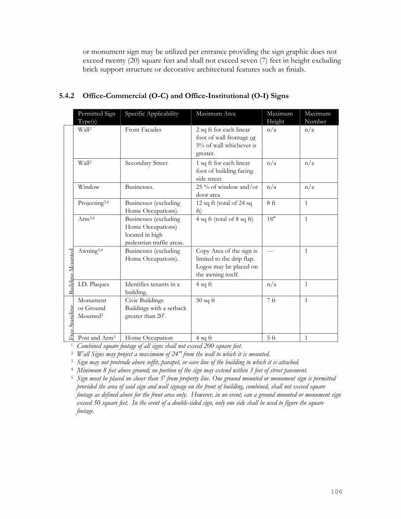
106
or monument sign may be utilized per entrance providing the sign graphic does not exceed twenty (20) square feet and shall not exceed seven (7) feet in height excluding brick support structure or decorative architectural features such as finials.
5.4.2 Office-Commercial (O-C) and Office-Institutional (O-I) Signs
Permitted Sign
Type(s)
Specific Applicability Maximum Area Maximum
Height
Maximum
Number
Build
ing
Mo
un
ted
Wall2 Front Facades 2 sq ft for each linear
foot of wall frontage or
5% of wall whichever is
greater.
n/a n/a
Wall2 Secondary Street 1 sq ft for each linear
foot of building facing
side street
n/a n/a
Window Businesses. 25 % of window and/or
door area
n/a n/a
Projecting3,4
Businesses (excluding
Home Occupations).
12 sq ft (total of 24 sq
ft)
8 ft 1
Arm3,4
Businesses (excluding
Home Occupations)
located in high
pedestrian traffic areas.
4 sq ft (total of 8 sq ft) 18"
1
Awning3,4 Businesses (excluding
Home Occupations).
Copy Area of the sign is
limited to the drip flap.
Logos may be placed on
the awning itself.
--- 1
I.D. Plaques
Identifies tenants in a
building.
4 sq ft n/a 1
Fre
e Sta
nd
ing
Monument
or Ground
Mounted5
Civic Buildings
Buildings with a setback
greater than 20'.
50 sq ft 7 ft
1
Post and Arm5 Home Occupation 4 sq ft 5 ft 1 1 Combined square footage of all signs shall not exceed 200 square feet. 2 Wall Signs may project a maximum of 24'' from the wall to which it is mounted. 3 Sign may not protrude above soffit, parapet, or eave line of the building to which it is attached. 4 Minimum 8 feet above ground; no portion of the sign may extend within 3 feet of street pavement. 5 Sign must be placed no closer than 5' from property line. One ground mounted or monument sign is permitted
provided the area of said sign and wall signage on the front of building, combined, shall not exceed square footage as defined above for the front area only. However, in no event, can a ground mounted or monument sign exceed 50 square feet. In the event of a double-sided sign, only one side shall be used to figure the square footage.

107
5.4.3 General Business (B-3) Signs
Permitted Sign
Type(s)
Specific Applicability Maximum Area Maximum
Height
Maximum
Number B
uild
ing
Mo
un
ted
Wall2 Front Facades 2 sq ft for each linear
foot of wall frontage
n/a n/a
Wall2 Secondary Street 1 sq ft for each linear
foot of building facing
side street
n/a n/a
Window Businesses. 25 % of window and/or
door area
n/a n/a
Projecting3,4
Businesses (excluding
Home Occupations).
12 sq ft (total of 24 sq
ft)
8 ft 1
Arm3,4
Businesses (excluding
Home Occupations)
located in high
pedestrian traffic areas.
4 sq ft (total of 8 sq ft) 18"
1
Awning3,4 Businesses (excluding
Home Occupations).
Copy Area of the sign is
limited to the drip flap.
Logos may be placed on
the awning itself.
--- 1
I.D. Plaques
Identifies tenants in a
building.
4 sq ft n/a 1
Fre
e Sta
nd
ing
Monument
or Ground
Mounted5
Civic Buildings
Buildings with a setback
greater than 20'.
50 sq ft 7 ft
1
Post and Arm5 Home Occupation 4 sq ft 5 ft 1 1 Combined square footage of all signs shall not exceed 200 square feet. 2 Wall Signs may project a maximum of 24'' from the wall to which it is mounted. 3 Sign may not protrude above soffit, parapet, or eave line of the building to which it is attached. 4 Minimum 8 feet above ground; no portion of the sign may extend within 3 feet of street pavement. 5 Sign must be placed no closer than 5' from property line. One ground mounted or monument sign is permitted
provided the area of said sign and wall signage on the front of building, combined, shall not exceed square footage as defined above for the front area only. However, in no event, can a ground mounted or monument sign exceed 50 square feet. In the event of a double-sided sign, only one side shall be used to figure the square footage.

108
5.4.4 Highway Business (B-4) and Planned Business Signs (B-P)
Permitted Sign
Type(s)
Specific Applicability Maximum Area Maximum
Height
Maximum
Number B
uild
ing
Mo
un
ted
Wall2 Front Facades 2 sq ft for each linear
foot of wall frontage
n/a n/a
Wall2 Secondary Street 1 sq ft for each linear
foot of building facing
side street (150 sq ft
max)
n/a n/a
Window Businesses. 25 % of window and/or
door area
n/a n/a
Projecting3,4
Businesses (excluding
Home Occupations).
12 sq ft (total of 24 sq
ft)
8 ft 1
Arm3,4
Businesses (excluding
Home Occupations)
located in high
pedestrian traffic areas.
4 sq ft (total of 8 sq ft) 18"
1
Awning3,4 Businesses (excluding
Home Occupations).
Copy Area of the sign is
limited to the drip flap.
Logos may be placed on
the awning itself.
--- 1
I.D. Plaques
Identifies tenants in a
building.
4 sq ft n/a 1
Fre
e Sta
nd
ing
Monument
or Ground
Mounted5
Civic Buildings
Buildings with a setback
greater than 20'.
50 sq ft 7 ft
1
Post and Arm5 Home Occupation 4 sq ft 5 ft 1 1 Combined square footage of all signs shall not exceed 300 square feet. 2 Wall Signs may project a maximum of 24'' from the wall to which it is mounted. 3 Sign may not protrude above soffit, parapet, or eave line of the building to which it is attached. 4 Minimum 8 feet above ground; no portion of the sign may extend within 3 feet of street pavement. 5 Sign must be placed no closer than 5' from property line. One ground mounted or monument sign is permitted
provided the area of said sign and wall signage on the front of building, combined, shall not exceed square footage as defined above for the front area only. However, in no event, can a ground mounted or monument sign exceed 50 square feet. In the event of a double-sided sign, only one side shall be used to figure the square footage.
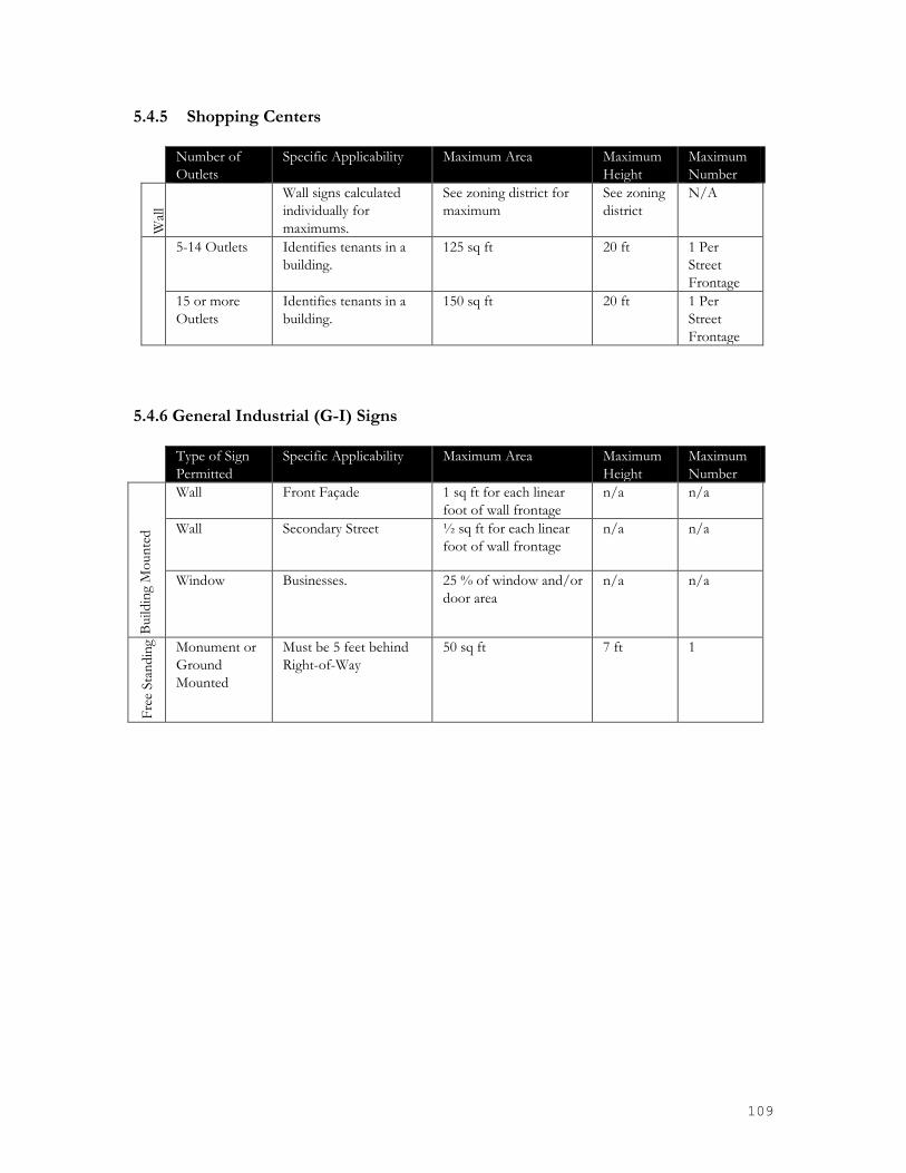
109
5.4.5 Shopping Centers
Number of
Outlets
Specific Applicability Maximum Area Maximum
Height
Maximum
Number W
all
Wall signs calculated
individually for
maximums.
See zoning district for
maximum
See zoning
district
N/A
5-14 Outlets Identifies tenants in a
building.
125 sq ft 20 ft 1 Per
Street
Frontage
15 or more
Outlets
Identifies tenants in a
building.
150 sq ft 20 ft 1 Per
Street
Frontage
5.4.6 General Industrial (G-I) Signs Type of Sign
Permitted
Specific Applicability Maximum Area Maximum
Height
Maximum
Number
Build
ing
Mo
un
ted
Wall Front Façade 1 sq ft for each linear
foot of wall frontage
n/a n/a
Wall Secondary Street ½ sq ft for each linear
foot of wall frontage
n/a n/a
Window Businesses. 25 % of window and/or
door area
n/a n/a
Fre
e Sta
nd
ing Monument or
Ground
Mounted
Must be 5 feet behind
Right-of-Way
50 sq ft 7 ft
1

110
5.4.7 Downtown Core (DC) District
Permitted Sign
Type(s)
Specific Applicability Maximum Area Maximum
Height
Maximum
Number B
uild
ing
Mo
un
ted
Wall2 Front Facades 2 sq ft for each linear
foot of wall frontage or
5% of wall whichever is
greater.
n/a n/a
Wall2 All other facades 5% of wall n/a n/a
Window Businesses and
Live/Work Units.
25 % of window and/or
door area
n/a n/a
Projecting3,4
Businesses (excluding
Home Occupations).
12 sq ft (total of 24 sq
ft)
8 ft 1
Arm3,4
Businesses (excluding
Home Occupations)
located in high
pedestrian traffic areas.
4 sq ft (total of 8 sq ft) 18"
1
Awning3,4 Businesses (excluding
Home Occupations).
Permitted as part of
allowable wall signage
--- 1
I.D. Plaques
Identifies tenants in a
building.
4 sq ft n/a 1
Fre
e Sta
nd
ing
Monument5 Civic Buildings
Buildings with a setback
greater than 20'.
16 sq ft (total of 32 sq
ft)
5 ft
1
Portable6 A-Frame, Menu Board 6 sq ft (24" x 36") 4 ft 1
Post and Arm5 Home Occupation 4 sq ft 5 ft 1 1 Combined square footage of all signs shall not exceed 100 square feet. 2 Wall Signs may project a maximum of 24'' from the wall to which it is mounted. 3 Sign may not protrude above soffit, parapet, or eave line of the building to which it is attached. 4 Minimum 8 feet above ground; no portion of the sign may extend within 3 feet of street pavement. 5 Sign must be placed no closer than 10' from back of curb/pavement. 6 A-Frame signs are allowed during business hours, and must be removed at the close of the business day. All
signs must be no further than 5 feet from the front door of the business.

111
5.4.9 Residential Mixed-Use (RMX) District
Permitted Sign
Type(s)
Specific Applicability Maximum Area Maximum
Height
Maximum
Number
Build
ing
Mo
un
ted
Wall2 Front Facades 5% of wall n/a n/a
Window Businesses (excluding
Home Occupations).
25 % of window and/or
door area.
n/a n/a
Projecting3,4
Or Arm Signs
Businesses (excluding
Home Occupations).
8 sq ft Must not
extend
above wall
1
Awning3,4
Businesses (excluding
Home Occupations).
Counted as part of wall
sign allowance
n/a 1
I.D. Plaques Identifies tenants in a
building.
4 sq ft n/a 1
Fre
e Sta
nd
ing
Monument5 Civic Buildings
Buildings with a setback
greater than 20'.
12 sq ft 4 ft
1
Portable6 A-Frame, Menu Board 6 sq ft (24" x 36") 4 ft 1
Post and Arm5 Home Occupations 4 sq ft 5 1 1 Combined square footage of all signs shall not exceed 40 square feet. 2 Wall Signs may project a maximum of 24'' from the wall to which it is mounted. 3 Sign may not protrude above soffit, parapet, or eave line of the building to which it is attached. 4 Minimum 8 feet above ground; no portion of the sign may extend into any road right-of-way. 5 Sign must be inside property and placed no closer than 10' from back of curb/pavement. 6 A-Frame signs are allowed during business hours, and must be removed at the close of the business day. All
signs must be no further than 5 feet from the front door of the business.

112
5.4.10 Removal of Illegal Signs in Right-Of-Way and Public Properties The Zoning Administrator may remove and destroy or otherwise dispose of any sign placed on public property or within any right-of-way of any public or private street. Penalties may be levied for each such sign as prescribed in this Article.
5.4.11 Sign Area
The surface area of a sign is computed as including the entire area within a parallelogram, triangle, circle, semi-circle or other regular geometric figure, including all of the elements of the display, but not including blank masking (a plain strip, bearing no advertising matter around the edge of a sign), frames, display of identification or licensing officially required by any governmental body, or structural elements outside the sign surface and bearing no advertising matter. In the case of signs mounted back-to-back, only one side of the sign is to be included in the area. Otherwise, the surface area of each sign is to be separately computed. In the case of cylindrical signs, signs in the shape of cubes, or other signs, which are substantially three-dimensional with respect to their display surfaces, the entire display surface or surfaces, is included in computations of area.
In the case of embellishments (display portions of signs extending outside the general display area), surface area extending outside the general display area and bearing advertising material is to be computed as part of the total surface area of the sign. If a sign is attached to an entrance wall or fence, only that portion of that wall or fence on which the sign face or letters are placed shall be calculated in the sign area onto which the sign face or letter.
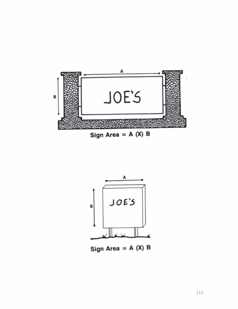
113

114

115
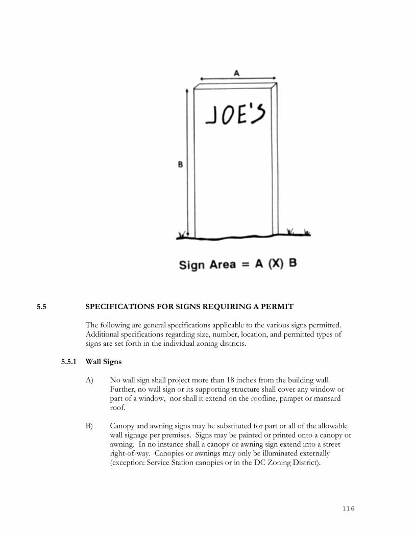
116
5.5 SPECIFICATIONS FOR SIGNS REQUIRING A PERMIT
The following are general specifications applicable to the various signs permitted. Additional specifications regarding size, number, location, and permitted types of signs are set forth in the individual zoning districts.
5.5.1 Wall Signs
A) No wall sign shall project more than 18 inches from the building wall. Further, no wall sign or its supporting structure shall cover any window or part of a window, nor shall it extend on the roofline, parapet or mansard roof.
B) Canopy and awning signs may be substituted for part or all of the allowable
wall signage per premises. Signs may be painted or printed onto a canopy or awning. In no instance shall a canopy or awning sign extend into a street right-of-way. Canopies or awnings may only be illuminated externally (exception: Service Station canopies or in the DC Zoning District).

117
C) No wall sign shall be attached to any cupola, tower, or other architectural feature that is above the roofline.
D) Sign area may not exceed two hundred (200) square feet on any building wall. 5.5.2 Free-Standing Signs
A) All free-standing signs shall be a minimum of five (5) feet behind the street right-of-way. Any such sign shall be located outside the required sight triangle.
No free-standing sign shall be located closer than five (5) feet to any adjacent lot line.
5.5.3 Projecting Signs
A) All Projecting Signs
1) A projecting sign will not project more than four (4) feet from a building wall.
2) A projecting sign will not extend vertically above the roofline or parapet of a building.
3) The sign shall be a minimum of eight (8) feet from the bottom of the sign above the finished grade.
B) Projecting Sign in Shopping Centers
Projecting signs may be permitted for individual tenants of a shopping center without altering detached sign provisions. Such sign shall be permitted provided:
1) Subject to the same provisions of 5.5.3 (1), (2) and (3) above. 2) A projecting sign shall not project into any required setback or yard.
3) The maximum area for the projecting sign shall be calculated as
though it was a wall sign. The maximum area of a projecting sign shall be seventy-five (75) square feet.
4) No More than one projecting sign per business entrance.
5.6 RESERVED

118
5.7 SIGN ILLUMINATION Unless otherwise prohibited by this section, signs may be illuminated if such illumination is in accordance with this section. All electric signs shall be in accordance with Section 7.15 Exterior Lighting, the Building and National Electric Code and shall obtain all required building permits. All wiring to ground signs or to lighting equipment erected after the effective date of this section must be underground. 1) Signs near residential premises. No sign within 150 feet of a residential
premise may be illuminated between the hours of midnight and 6 a.m., unless there is no spillover of lighting or glare to the residential area beyond the boundaries of the lot where the lighting is located.
2) Shielding of lights. External lighting directed toward a sign shall be
shielded so that it illuminates only the face of the sign and does not shine directly into or cause glare onto a public right-of-way or residential premises.
3) Flashing or intermittent lights. No sign shall contain or be illuminated by
flashing or intermittent light or lights of changing degrees of intensity.
5.8 ENFORCEMENT 5.8.1 Inspections and Investigations
A) The Zoning Administrator will periodically inspect signs in order to determine whether there are any violations of this Ordinance.
B) The Zoning Administrator shall have the power to conduct such
investigations as it may reasonably deem necessary to carry out its duties as prescribed in these regulations, and for this purpose to enter at reasonable times upon any property, public or private, for the purpose of investigating and inspecting signs. No person shall refuse entry or access to any authorized representative of the Zoning Administrator who requests entry for purposes of inspection, and who presents appropriate credentials, nor shall any person obstruct, hamper, or interfere with any such representative while in the process of carrying out his official duties.
C) The Zoning Administrator may require written statements, or the filing of
reports with respect to pertinent questions relating to signs. 5.8.2 Citations
If, through inspection, it is determined that a person has failed to comply with the provisions of these regulations, the Zoning Administrator shall issue a warning citation to the violator. Violations shall be corrected within three days of the issuance of such citation. If the violation is not corrected within the specified time period, the violator is subject to Section 2.7.7(g), ‘Civil Penalty’, of this Ordinance, which is incorporated by reference herein as if fully stated.
119
5.8.3 Other Enforcement Methods In addition to the civil penalties, the provisions of these regulations may be enforced by one or more of the methods described in Section 2.7 of the Zoning Ordinance.
5.9 ILLUMINATION & HEIGHT
5.9.1 Sign Illumination
Unless otherwise indicated in this Ordinance, all signs may be illuminated. All illuminated signs shall have their lighting directed in such a manner as to illuminate only the face of the sign.
5.9.2 Electric Signs No electric sign shall be located with relation to pedestrian traffic as to permit such sign to be easily reached by any person. The bottom of such sign shall be located a minimum of ten (10) feet above the grade immediately under said sign, if the sign is within fifteen (15) feet of the edge of the street right-of-way. All illuminated signs shall be installed in accordance with the applicable provisions of the North Carolina State Electrical Code. All illuminated detached signs shall utilize an underground electrical source.
5.9.3 Sign Height The height of a sign shall be measured from the highest point of a sign to the grade.

120
CHAPTER 6 DISTRICTS AND REGULATIONS See Table 6-1 for Use Classifications within Zoning Districts
6.1 ZONING and OVERLAY DISTRICTS
In order to achieve the purpose of this Ordinance, the following districts and overlays are hereby established. In addition to the primary uses, other uses including accessory uses, off-street parking and signage, are permitted as described in this Ordinance.
6.1.1 Single-Family Residential Districts (R-44 and R-12)
These districts are established to provide areas consisting primarily of larger lot single-family residences located in both urban and suburban settings. In addition to single-family residences, a limited number of private and public community uses are allowed.
6.1.2 Residential District (R-7)
This district permits single-family residences, on lots a minimum of seven-thousand (7,000) square feet in area, and duplexes located on corner lots only.
6.1.3 Multi-Family District (R-MF) This district is intended primarily for attached residential development such as townhomes and similar multi-family dwellings. Other single family, private, or community uses may be allowed.
6.1.4 Office-Institutional District (O-I) This district is for medium to larger lots and intended to accommodate institutional uses such as hospitals, short and long term care facilities as well as for offices and services that assist these uses.
6.1.5 Office-Commercial District (O-C) This district is intended as a mixed-use district allowing for both offices and lighter commercial uses and business services. The O-C district is meant to provide for consolidated professional services and less retail sales than business or “B” zoning designations.
6.1.9 General Business District (B-3) This is a business district is located adjacent to Pineville’s historic Downtown Core and intended to closely reflect that. This district is designed to accommodate a wide variety of smaller and medium-sized retail and commercial uses. Shopping centers and mixed-use buildings are allowed in this district depending on ordinance requirements.
6.1.10 Highway Business District (B-4) This is a business district along major highways for the placement of a wide variety of
retail uses including large shopping and commercial complexes.
6.1.11 Planned Business District (B-P) This is a business district designed for large master planned and generally commercial uses. The purpose of this district is to provide for the development of large-scale

121
developments in consolidated manner to enhance traffic flow, limit driveway curb cuts on public roads, and provide pedestrian sidewalk connectivity between businesses and along roadways. All areas zoned B-P shall initially contain an area of at least ten (10) acres.
6.1.12 General Industrial District (G-I) This district is designed to accommodate industrial and warehousing operations which can be operated in a clean and quite manner that will not produce detectable noise, odor, light, or similar detriment to adjacent residential or commercial properties.
6.1.13 Downtown Core District (DC) The Downtown Core District permits the sensitive continuation of the Historic Main Street environment and its secondary streets and include on street parking. The ground floor of buildings that are not entirely residential should be active uses including retail or restaurants with office and residential uses located on upper stories.
6.1.14 Residential Mixed-Use (RMX) The Residential Mixed-Use District allows for a variety of residential uses but also encourages mixed-use walkable master planned communities with commercial uses. Development must follow new urbanist development patterns and include on street parking for new or improved streets.
6.1.15 Downtown Overlay District The overall intent of the Overlay District is to guide the design of all projects within the this overlay district into the most attractive, long lasting, sustainable, and pedestrian friendly environment possible. Design features within this overlay district include placing buildings closer to each other as well as closer to the street to foster a more comfortable pedestrian streetscape where activity and amenities are expected to occur. As sidewalks remain the principal place of pedestrian movement and casual social interaction, designs and uses should therefore be complementary, and reinforce that function. All development in this district shall comply with the requirements within the Downtown Overlay Plan.
6.1.17 Corridor Overlay District The Corridor Overlay District is intended to manage and guide the continued development/redevelopment of the primary transportation corridors of Main Street, Polk Street, and Dorman Road as they pass through the Town of Pineville. This district has been established based on the primarily commercial viability of properties along these roads. It is anticipated that best use for any residential development in this district will take the form of live/work units, condominiums, or for larger parcels lighter use residential units to be located a significant distance behind these travel corridors and well buffered allowing commercial units to best utilize the traffic and visibility along the front portions of these thoroughfares. High architectural integrity and additional streetscape features such as street trees, seating, bicycle lanes, and wide sidewalks will greatly improve both the aesthetics and pedestrian oriented potential in these areas. Ground floor uses facing any primary travel corridor in this district shall be comprised of pedestrian friendly and/or active

122
uses. Mixed and multiple tenant buildings are encouraged as are additional connector roads to ease traffic burdens on existing roads and to provide more options to travel between destinations.
It is the ultimate intent to encourage both well-planned and high quality sustainable development. Uses in this district are foreseen to be primarily commercial, commercial/residential mixed-use, higher density residential, offices, and neighborhood services. All development in this district shall comply with the requirements within the Corridor Overlay Plan.
6.1.18 Neighborhood Mixed-Use Overlay District The Neighborhood Mixed-Use Overlay District is intended to manage and guide continued growth and development pressure. This district has been established based on location, land use plans, and the general neighborhood/light mixed-use potential of these areas. It is anticipated that the development model in these areas will be primarily lighter to moderate density residential uses with light to moderate neighborhood retail and neighborhood services. These retail and service uses shall be located around local neighborhood centers and/or higher traffic locations. High architectural integrity and additional streetscape features such as street trees, seating, bicycle lanes, and wide sidewalks will greatly improve both the aesthetics and pedestrian oriented potential in these areas.
Ground floor uses facing any primary travel corridor in this district shall be comprised of pedestrian friendly and/or active uses. Mixed and multiple tenant buildings are encouraged as are additional connector roads to ease traffic burdens on existing roads and to provide more options to travel between destinations. Existing zoning designations such as ‘RMX’ and the subsequent allowable uses are seen to be a good fit for this area. It is the ultimate intent to encourage both well-planned and high quality sustainable development. Uses in this district are foreseen to be primarily a mixture of light commercial, neighborhood services, and offices with light to medium residential uses arranged around hierarchical neighborhood centers. All development in this district shall comply with the requirements within the Neighborhood Mixed-Use Overlay Plan.
6.1.19 Residential Overlay District The Residential Overlay District is intended to manage and guide continued growth and development pressure for the district shown on the right in green. This district has been established based on location, land use plans, and the general development trend in these areas.
It is anticipated that the development model in these areas will be the creation of attractive and classic time proven residential (generally single family) neighborhood designs. High architectural integrity and additional streetscape features such as street trees, seating, bicycle lanes, and wide sidewalks are required and intended to greatly improve both the aesthetics and pedestrian oriented potential in these areas.

123
It is the ultimate intent to encourage both well-planned and high quality sustainable development. Uses in this district are foreseen to be primarily single-family detached residences arranged around a neighborhood center and/or usable common open spaces. All development in this district shall comply with the requirements within the Residential Overlay Plan.
6.1.20 Industrial Overlay District The Industrial Overlay District is intended to manage and guide the continued development/redevelopment of the current industrial area. This area defined in this district is an established and relatively stable area with no foreseeable development pressure that would challenge the current uses, viability or character within this district. Added streetscape features such as street trees, seating, bicycle lanes, and sidewalks will greatly improve both the aesthetics and pedestrian friendly nature needed in this area, in keeping with general town goals and objectives. Pedestrian streetscape features, greenway improvements, and limiting pollution are the primary objectives desired for this district.
It is the ultimate intent to encourage both well-planned and high quality sustainable development. Uses in this district are foreseen to be primarily light industrial uses such as, warehousing, light manufacturing/processing/distribution, and industrial offices. All development in this district shall comply with the requirements within the Industrial Overlay Plan.
6.1.21 Conditional Developments (CD) Conditional developments are permitted in all zoning districts as described in this ordinance and shall be designated with a (CD) designation after the zoning classification as verified by planning staff.
6.2 DISTRICT BOUNDARIES The boundaries of these districts are hereby established as shown on a map entitled "Official Zoning Map of Pineville, North Carolina", adopted by the Town Council and certified by the Town Clerk. Said map and all explanatory matter thereon accompanies and is hereby made part of this Ordinance. Said map shall be retained in the office of the Town Clerk.
6.3 RULES GOVERNING BOUNDARIES
Where uncertainty exists with respect to the boundaries of any of the previously mentioned districts as shown on the zoning map, the following rules shall apply:
6.3.1 Where district boundaries are indicated as approximately following the centerlines of streets or highways, street lines or railroad right-of-way lines, or such lines extended,

124
such centerlines, street lines, or railroad right-of-way lines or such lines extended shall be construed to be such boundaries.
6.3.2 Where district boundaries are so indicated that they approximately follow lot lines, such lot lines shall be construed to be said boundaries.
6.3.3 Where district boundaries are so indicated that they are approximately parallel to the centerlines of streets, highways or railroads, or rights-of-way of same, such district boundaries shall be construed as being parallel thereto and at such distance there from as indicated on the zoning map. If no distance is given, such dimensions shall be determined by use of the scale shown on said zoning map.
6.4 REGULATIONS
6.4.1 Table of Uses
The list of uses allowed in each general zoning district is indicated in Table 6-1. For any use listed in this table, the Zoning Administrator shall be able to determine if the use is (i) permitted, (ii) permitted subject to the adherence of certain identified performance criteria, (iii) permitted subject to conditional approval, (iv) permitted subject to conditional approval and also having to meet certain performance criteria, or (v) not permitted.
A use shall be permitted in a certain zoning district if it is accordingly designated in Table 6-1 with a "P". A use permitted subject to certain performance criteria, which would not be applicable to other uses, is designated by a "PS". A use that is subject to conditional approval is indicated by a "C". If performance criteria pertain to a certain conditional use, this would be indicated by a "CS". If a use does not have a "P", "PS", "C", or "CS" designation in a particular zoning district, that use shall not be allowed in that zoning district.
No building or structure, sign or land shall hereafter be used, erected or occupied and no building or structure shall be erected, expanded or moved except in conformity with the regulations of this Ordinance. This Ordinance specifies uses, which are allowed in each zone. Uses designated as "permitted uses" in Table 6-1 are allowed in a zone as a matter of right. Uses designated as "conditional uses" in Table 6-1 are allowed only after approval by the Town Council pursuant to Section 2.6 of this Ordinance.
Supplemental regulations as listed in Table 6-1 are found in Section 6.5 of this ordinance. See Section 7.8 for temporary uses.

125
6.4.2 Uses Not Expressly Permitted or Conditional It is recognized that new types of land use will develop and forms of land use not anticipated may seek to locate in Pineville. In order to provide for such changes and contingencies, a determination as to the appropriate classification of any new or unlisted form of land use shall be made as follows: For any use not listed in this Ordinance, the Planning Director, at their discretion, may determine if said use can reasonably be interpreted to fit into a use category where similar uses are described in this Ordinance. The Board of Adjustment, after conducting a public hearing may make the same determination upon request of the Planning Director or by appeal of the Planning Directors classification. If a similar zoning use and associated regulation cannot be found in this Ordinance as determined by the Planning Director or Board of Adjustment, a text amendment for the proposed land use or regulation shall be applied for following standard zoning text change procedure.
6.5 SUPPLEMENTAL USE REGULATIONS The following performance criteria and/or supplemental regulations shall pertain to the various uses listed in Table 6-1. If not otherwise listed, these regulations shall be applicable in all districts in which the individual uses are allowed. For any use, which requires the issuance of any conditional approval or conditional district, the performance criteria listed herein shall be in addition to any other fair and reasonable conditions placed on such use by the Planning Board or Town Council. Such conditions may impose greater restrictions or offer relief from regulation authorized from this Ordinance.
6.5.1 Adult Establishments
Adult Establishments are recognized as having serious objectionable operational characteristics upon adjacent uses of a less intense nature, specifically residential neighborhoods, schools, and churches. The following special regulations must be adhered to ensure that any adverse effects to the surrounding neighborhoods will be eliminated:
A) No two (2) adult establishments may be located within a radius of one-thousand
(1,000) linear feet from each other, or any other use providing for the sale of alcoholic beverages, using the shortest straight line distance between lot lines.
B) No adult establishment may be located within one-thousand (1,000) linear feet
of any Residential (R) zoning district or pre-existing residential use, using the shortest straight line distance between the lot line of the adult establishment and the zoning district boundary or the lot line of the pre-existing residential use.
C) No adult establishment may be located within one-thousand (1,000) linear feet of any
church/house of worship, private or public elementary, middle, junior high, or high school, parks and/or playgrounds for public use, or other similar public uses, using the shortest straight line distance between lot lines.

126
6.5.2 Animal Grooming Establishment; Animal Obedience School
A) Animal boarding facilities shall not be permitted.
B) All operations shall be conducted indoors
6.5.3 Animal Shelter; Animal Kennels; Animal Hospital Any structure, which houses animals, which is not fully enclosed, and all animal runs, shall be, located at least one hundred (100) linear feet from any lot line and three-hundred (300) linear feet from any pre-existing principal residential structure located on an adjacent lot.
6.5.4 Commercial Uses
A) Any individual commercial use having greater than 100,000 square feet gross leasable floor area must be issued a conditional use permit in accordance with Section 2.6 of this Ordinance.
6.5.5 Auction House
All activity must take place indoors. 6.5.6 Auditorium, Assembly Hall, Amphitheaters
A) Access to the site shall be provided by major or minor thoroughfares only.
B) The lot containing an outdoor amphitheater shall be located at least five-hundred (500) linear feet from any pre-existing residential dwelling unit (as measured between lot lines.
C) A Conditional Use Permit is required if the use has more than 500 seats.
6.5.7 Automobile Servicing and Body Shop
A) If located adjacent to a Residential (R) use, the hours of operation may be
from 7:00 A.M. to 9:00 P.M. only. This shall not apply in the case of lots
containing this use, which are separated from such R-zoned lots by a major or
minor thoroughfare.
B) All work including vehicle servicing and inspections must take place indoors.
C) Unless structures and site design meet current zoning and overlay district
requirements; the use shall not be permitted.
D) Must meet overlay façade requirements, be all brick store front type design,
and no street facing service bay doors or utility elements

127
E) Façade must be at least 75% of width of primary street front.
F) Approved primary building materials must be used within 200 feet of any
street.
G) Elevated vehicle platforms or displays are prohibited.
H) Site and Parking lot lighting will be limited to a maximum height of 35 feet
and equipped with full cut-off fixtures. Site and Parking lot lighting may not
shine on adjacent properties. 6.5.8 Automobile Parking Lot Parking lot must be used in accordance with approved permitted uses in each zoning district only. 6.5.9 Automobile Towing and Wrecking Service
A) Any outdoor vehicle storage area shall be located a minimum of one-hundred (100) linear feet from any street right-of-way; and two-hundred (200) linear feet from any Residential (R) zoning district or lots which contain a pre-existing principal residential use.
B) Vehicle storage areas shall not be located at an elevation whereby the storage
is visible from a public street after the required screening is in place. 6.5.10 Cemetery
A) Tombstones, crypts, monuments and mausoleums shall be located a minimum of twenty (20) feet from any side or rear lot line and at least thirty (30) feet from a street right-of-way. Greater setbacks shall be observed if otherwise required by the zoning district in which it is located. Gravesites shall also be set back at least twenty (20) feet from any side or rear lot lines in cemeteries (or cemetery expansions) occurring after the effective date of this Ordinance.
B) Sales of crypts shall be allowed as an accessory use on premises (for
cemeteries as a principal use only).
C) Notwithstanding any other provisions of this Ordinance, a minimum of thirty (30) acres shall be needed for any cemetery being developed as a principal use.
6.5.11 Church/House of Worship

128
A) On-site schools providing elementary or secondary education and having an enrollment capacity of three-hundred (300) students or greater shall have direct access to the site provided by major or minor thoroughfares only.
B) If a school is operated on-premises, parking needs may be satisfied by that
already provided by the church. A school having an enrollment certification of one-hundred (100) or more students shall be considered a separate principal use and may be allowed on the same lot so long as the school meets all applicable area, bulk and setback requirements.
C) A single-family residential use, occupied by the pastor, priest, rabbi, etc. of
the facility, may be placed on the lot containing the church/house of worship. Said structure shall meet all setback requirements for single-family dwellings for the zoning district in which the lot is located. Said structure may not be used for day care facilities.
D) Any church having a sanctuary capacity of five-hundred (500) or more seats
shall be located on and have direct access to a major or minor thoroughfare.
E) Church schools shall be allowed to have up to two (2) modular classrooms without having to submit and receive site plan approval. All modular classrooms, however, shall have their foundations skirted and shall have shrubs planted five (5) feet on center around the periphery of the structure.
F) A conversion of a dwelling unit into a church/house of worship shall be a
conditional use. 6.5.12 Communication Facilities and Towers
In recognition of the Telecommunications Act of 1996, it is the intent of the Town of Pineville to allow communication providers the opportunity to locate towers and related facilities within its jurisdiction in order to provide an adequate level of service to its customers while protecting the health, safety, and welfare of the citizens of Pineville and its ETJ. Wireless towers may be considered undesirable with other types of uses, most notably residential, therefore, special regulations are necessary to ensure that any adverse affects to existing and future development are mitigated.
A) Wireless telecommunication towers, (including cellular towers, digital towers, and PCS towers), are permitted uses by right in the G-I district pursuant to the regulations set forth in this section. Telecommunication towers require the conditional zoning approval from town council in all other zoning districts pursuant to the regulations set forth in this section and in accordance with Article 9 of this Ordinance.
B) All telecommunication towers constructed must be of the monopole variety,
unless the tower exceeds 199.9 feet, in which case a lattice type tower may be used to insure structural safety. Towers within the G-I district may be either a monopole or lattice type where the property currently has no structure or is

129
developed for non-residential purposes. Towers constructed on property, which includes residential development, must be of the monopole variety.
C) It is the intent of the Town to encourage providers to co-locate facilities in
an effort to reduce the number of towers in Pineville’s jurisdiction. Providers shall exhaust all potential co-location possibilities and provide documentation to such effect before the Town considers any application. The Town encourages providers to construct telecommunication towers such that additional telecommunication providers may be afforded the opportunity to co-locate facilities on the tower. The owners of the towers with co-location space shall negotiate in good faith with other providers’ space at a reasonable lease cost, and publicize the fact that space is available on a lease basis. The Town further reserves the right to make co-location a condition of any tower permitted as a conditional use under the guidelines listed above.
D) The maximum height of any tower located in all Residential (R) districts,
Business (B) districts, and Office (O) districts is 125 feet unless documentation is provided to show a taller tower is required to meet minimal service levels (i.e. cannot meet reasonable service coverage area). Towers located in the G-I district have a maximum height limitation of 199.9 feet unless documentation is provided to demonstrate a taller tower is required for a minimal level of service and need. If the property on which the tower is located is developed for residential purposes, the tower will have a maximum height of 125 feet.
E) No telecommunication tower is allowed to be located within the front or side
yards of any existing development.
F) The Town of Pineville, by federal law, cannot prohibit a telecommunication tower nor deny a Conditional Use permit on the basis of environmental or health concerns relating to radio emissions if the tower complies with the Federal Radio Frequency Emission Standards. The Town requires that the provider must provide documentation proving that the proposed tower does comply with the Federal Radio Frequency Emission Standards.
G) A minimum lot size as listed in the underlying zoning district is required,
provided all setbacks required herein are met.
H) Wherever feasible, all accessory structures on the ground which contain switching equipment or other related equipment must be designed to closely resemble the neighborhood’s basic architecture, or the architecture and style of the principal use on the property. Every effort should be made to conceal a tower within Residential (R) Districts.
I) Screening is required along all sides of the perimeter of the tower site in
accordance with the provisions set forth in Article 5 of this Ordinance. It

130
will be the responsibility of the provider and/or the property owner to keep all landscaping material free from disease and properly maintained in order to fulfill the purpose for which it was established. The owners of the property, and any tenant on the property where screening is required, shall be jointly and severally responsible for the maintenance of all screen materials. Such maintenance shall include all actions necessary to keep the screened area free of litter and debris, to keep plantings healthy, and to keep planting areas neat in appearance. Any vegetation that constitutes part of the screening shall be replaced in the event it dies. In addition, an eight (8) foot high fence must be placed around the structure (before the screening) to avoid creating a nuisance.
J) In all districts, a minimum setback requirement, on all sides of the property,
shall be 150 feet or two feet for every one (1) foot of actual tower height (i.e. a 150 foot tower would require a 300 foot setback), whichever is greater. If the applicant can document a reduced collapse area, then the setback shall be the greater of that distance or 150 feet.
K) Telecommunication towers located in all residential districts and having a
height of 199.9 feet or less, shall not contain lights or light fixtures at a height exceeding fifteen (15) feet. Furthermore, lighting of all towers in any district shall be directed toward the tower and/or equipment shelters to reduce the effect of glare.
L) Towers and related facilities must be removed by the provider and/or the
property owner if abandoned (no longer used for its original intent) for a period greater than six (6) consecutive months.
M) Additional provider antennas and equipment shelters to an approved
telecommunication tower site may be made with the approval of the Zoning Administrator, without additional review by the Planning Board and Town Council, provided said changes do not increase the height of the tower or the type of tower construction.
N) Free-standing signs for telecommunication towers are prohibited. One wall sign, for the purpose of identification, is allowed on any equipment shelter provided it does not exceed ten (10) percent of the total wall area of the wall on which it is located.
O) The provider must show proof of adequate insurance coverage for any
potential damage caused by or to the telecommunication tower prior to the issuance of a conditional use permit.
P) Outdoor storage of equipment or other related items is prohibited on a
telecommunication tower site.
Q) Provider must notify the Town of sale or lease of structure.

131
R) All applications for a conditional use permit for a telecommunication tower
must include the following information:
1) Identification of intended provider(s);
2) Documentation by a registered engineer that the tower has sufficient structural integrity to accommodate more than one user;
3) A statement from the owner indicating intent to allow shared use of
the tower and how others will be accommodated;
4) Evidence that the property owners of residentially zoned property within 300 feet of the site have been notified by the applicant of the proposed tower height and design;
5) Documentation that the telecommunication tower complies with the
Federal Radio Frequency Emission Standards;
6) Documentation that towers over 125 feet (or 199.9 feet in the G-I district) are necessary for a minimal level of service;
7) Screening must be shown on the site plan detailing the type, amount
of plantings, and location; and
8) Documentation of collapse zones. 6.5.13 Contractors' Storage and Equipment Yard
A) If more than one (1) acre of outdoor storage area is provided, this shall be a conditional use.
B) All outdoor storage must be materially screened on all sides whereby no
materials are visible to any adjacent lot or public street.
6.5.14 Convenience Store; Mini-Mart
A) Vacuuming facilities may be located outside the building, but may not be located within any required yard or buffer area adjacent to a Residential (R) use.
B) If a mini-mart is located adjacent to a Residential (R) district, hours of
operation may be from 5:00 A.M. to Midnight only.
C) A mini-mart may contain a free-standing automatic car wash facility.

132
D) If a mini mart lies within fifty (50) feet of a Residential (R) use, a dense buffer at least fifty (50) feet in width shall be placed in the side or rear yard closest to the R district.
6.5.15 Correctional Facility
A) A two hundred (200) foot setback for all principal and accessory structures shall be observed if the facility is adjacent to any lot located in a Residential (R) Zoning District or any pre-existing principal residential structure.
B) Any fence, which is barbed or contains razors shall be located at least twenty
(20) feet from any lot line.
C) All lighting for the facility must be oriented so that direct beams of light shine away from all adjoining properties.
D) All lots containing a correctional facility must have a minimum of 30 acres.
6.5.16 Customary Home Occupations
Customary home occupations may be established in any dwelling unit. The following requirements shall apply in addition to all other applicable requirements of this Ordinance for the district in which such uses are located:
A) The home occupation shall be clearly incidental and subordinate to the residential
use of the dwelling and shall not change the residential character of the dwelling.
B) No accessory buildings or outside storage shall be used in connection with the home occupation.
C) Use of the dwelling for the home occupation shall be limited to twenty-five
percent (25%) of the area of the principal building.
D) Residents of the dwelling may only be engaged in a home occupation.
E) No external alterations inconsistent with the residential use of the building shall be permitted.
F) Only vehicles used primarily in connection with the conduct of the customary
home occupation shall be permitted
G) Chemical, mechanical, or electrical equipment that creates odors, light emission, noises, or interference in radio or television reception detectable outside the dwelling shall be prohibited.
H) Customary home occupations may be conducted in an accessory building subject
to the issuance of a Conditional Use Permit by the Town Board.

133
I) All home occupations shall be conducted between the hours of 7:00 A.M. and 9:00 P.M. only.
J) No traffic shall be generated by the home occupation in greater volumes than
would normally be expected in a residential neighborhood. Any need for parking generated by the conduct of the home occupation shall be provided off the road right-of-way.
6.5.17 Dwelling, Two-Family
A) Two-family dwellings shall only be located on corner lots. The architectural front of each dwelling unit must face separate streets. Street ingress and egress to each unit shall also be from separate streets. The structure must meet the minimum front setbacks from both streets. Minimum lot area on corner lots for a two-family dwelling shall be ten-thousand (10,000) square feet.
6.5.18 Family Care Homes
A) A family care home shall be a use by right, except that no family care home shall be located within one-quarter (1/4) mile of another family care home unless a special exception is granted by the Board of Adjustment for such reduced separation. Prior to issuing such special exception, the Board of Adjustment, after having first held a public hearing, must have first determined from the evidence presented at the hearing that:
Such reduced separation will not result in further clustering of family care
homes, which could promote the clustering and isolation of handicapped persons instead of the integration and interaction of handicapped persons with the community mainstream.
The Board of Adjustment shall only consider evidence relevant to the above finding in reaching a decision to grant the special exception.
B) The structure must maintain its residential character.
C) Family Home Care does not include the provision of services for contagious
disease, alcoholics, drug addicts, or mentally ill patients deemed to be dangerous.
6.5.19 Food Catering Facility
The maximum square footage of any food catering facility in the B-3 district shall be fifteen-thousand (15,000) square feet.
6.5.20 Golf Course (Miniature and Golf Driving Range)
A) Fencing, netting, trees, berms, or other control measures shall be provided around the perimeter of the driving or playing areas so as to prevent golf

134
balls from going onto adjacent properties. Such devices, where applicable, may be counted towards any required screening provided.
B) No direct beam of light from outdoor lighting fixtures or signs shall shine
onto any lots located in a Residential (R) district or containing an existing residential use.
6.5.21 State and Municipal lines
No residence, business, or structure shall be split between two or more municipalities or states. Shared land uses utilizing parking or other elements that allow cross state/municipal access and services shall be a conditionally approved only.
6.5.22 Laboratories
A) All research or testing service must be conducted within an enclosed building.
B) Any research involving, using, or developing contagious toxins, nuclear
elements, explosives, or other potentially dangerous elements that if released would constitute a hazard shall be a conditional use.
6.5.23 RESERVED 6.5.24 Manufactured Home Park Standards
This section sets forth the standards required for all new manufactured home parks and expansions of existing manufactured home parks. Where the intent of the standards herein contained can be met by other means not specifically listed, the Town Board may approve other methods and designs to solve unique problems associated with individual developments, on an individual basis. In no case may the Town Board approve a design of less than the minimum standards herein contained.
A) Minimum Park Area
Manufactured Home Park - Five (5) acres with a density not to exceed seven (7) homes per acre.
B) Occupancy There must be at least five (5) improved manufactured home spaces at first occupancy. Any existing manufactured home park containing less than five (5) manufactured home spaces shall not be considered nonconforming if otherwise in conformance with the standards contained in this Ordinance. No manufactured home space shall be occupied, nor may a certificate of occupancy be issued unless the requirements of this Ordinance have been met. The requirement of a minimum of five (5) spaces at first occupancy shall apply only to the first five (5) spaces of a new manufactured home park.

135
In all other situations, a manufactured home park may increase in size in any increments of spaces.
C) Space Sizes
All manufactured homes within the park shall be located in designated manufactured home spaces. Minimum space sizes shall be as follows:
1) Where a well and septic tank are on the same space - Twenty
thousand (20,000) square feet.
2) Where one of either public or community water service, or public or community sewer service is provided to each space, a minimum of ten-thousand (10,000) square feet shall be required.
3) Where both public water and sewer services are provided to each
space - Five thousand (5,000) square feet.
4) The above space sizes are to be deemed the minimum size requirements and may be increased due to requirements for placement of well and septic tank systems (such as soil conditions and separation distances), the topography of the land, watershed requirements or other factors. The applicant shall indicate on the application the specific number of bedrooms per manufactured home for which the septic tank system should be evaluated.
D) Space Widths
Each manufactured home space shall be at least thirty (30) feet in width at the interior street right-of-way line and forty-five (45) feet in width at the front yard setback line.
E) Setbacks
Minimum separation distances between manufactured homes within a manufactured home park shall be observed. In addition, setbacks of manufactured homes from property lines and publicly maintained street right-of-way lines shall also be observed as herein required.
1) The minimum setback for any structure within a manufactured home
park from a publicly maintained street right-of-way line or any property line shall be fifty (50) feet. Where a required screen area lies between a manufactured home space and a property line or street right-of-way line, all required setbacks shall be measured from the edge of the required screen nearest the manufactured home. In addition to these requirements, a thirty (30) foot minimum front setback from any interior street right-of-way line shall be observed. In addition, a ten (10) foot minimum side setback shall be observed.
2) All manufactured homes within a manufactured home park shall be
located no closer than twenty (20) feet from each other.

136
F) Location on Suitable Land
Each manufactured home space shall be located on ground not located within the one-hundred (100) year flood plain as established by the most recently issued maps published by the Federal Emergency Management Agency. No manufactured home shall be placed on land having excessive slope or other characteristics making the land unsuitable for placement of manufactured homes. Each manufactured home space shall be graded so as to prevent any water from ponding or accumulating on the space.
G) Manufactured Home Standards
All manufactured homes shall bear a valid seal indicating conformance with the 1976 National Manufactured Housing Construction and Safety Standards Act. These homes shall meet the following standards:
1) The structure shall be set up in accordance with the standards set by
the North Carolina Department of Insurance (including tie-down standards).
2) The structure will have all wheels, axles, transporting lights, and
towing apparatus removed. If any of these items is nonremovable, then it shall be screened with landscaping if it is still visible after the unit is underpinned.
3) The structure must be at least 14 feet in width.
H) Stand, Underpinning and Tiedown of Manufactured Homes
The location of each manufactured home stand must be at an elevation, distance and angle in relation to the adjacent access drive so that placement and removal of the manufactured home is practical by means of customary moving equipment. All manufactured homes shall have continuous underpinning from the bottom of the walls to the ground made of brick, pressure-treated wood (see below), or vinyl, pre-painted aluminum material, or other material specifically manufactured for manufactured homes, unpierced except for required ventilation and an access door.
Each manufactured home in the park shall conform to North Carolina Department of Insurance Standards for tiedown requirements.
If pressure-treated wood skirting is used, it shall consist of lumber and plywood treated in compliance with American Wood Preserver Bureau Standards. All plywood and lumber used for skirting shall be stamped with trademarks identifying the appropriate grades of lumber and plywood and the treatment identification.
I) Steps
All manufactured homes within the park shall be equipped with two (2) sets of steps.

137
J) Location of Accessory Structures and Common Structures
Structures accessory to a particular manufactured home shall be located only on the lot containing that manufactured home. All such structures shall be (i) residential in character; (ii) no closer than five (5) feet from the mobile home space boundary and no closer than ten (10) feet from any manufactured home on another space within the park. However, for carports having a capacity not exceeding two (2) car spaces, the only requirements shall be that such structures observe the same front yard setback as required for the manufactured home and that such structures be located no closer than five (5) feet from any property line, or from the edge of any required buffer. In no instance shall an accessory or common structure be located in a required buffer area. Accessory structures of benefit to all residents of the manufactured home park shall be permitted within the park. Said structures (i.e., community pools, laundry facilities, game rooms, club houses, etc.) shall be located at least twenty (20) feet from any interior street line and thirty (30) feet from any manufactured home located within the park. Outdoor vending machines may be located in the manufactured home park. All vending machines must be located indoors or, if outdoors, under a covered surface adjacent to a common building (e.g., administrative office) or facility (e.g., community pool). Vending machines on individual manufactured home spaces shall be prohibited. No retail establishments (other than customary home occupations) may be allowed within the manufactured home park.
K) Public Road Frontage
All manufactured home parks shall abut and have at least fifty (50) feet of frontage on a public road. No manufactured home lots shall be directly accessible from the public street.
L) Ingress and Egress
Manufactured home parks shall not be located on through lots unless the park is designed in a manner, which does not encourage motorists from using the park as a means of traveling from one public street to another.
Manufactured home parks with twenty (20) or more manufactured home spaces shall have at least two (2) separately designated areas, which contain both an entrance and exit to the manufactured home park. All manufactured home parks containing less than twenty (20) manufactured home spaces shall have at least one area containing both an entrance and an exit to the manufactured home park. Manufactured home parks requiring only one entrance and exit area shall provide at least one permanent turn-around within the park.

138
M) Interior Streets, Drainage, and Markings No structure within a manufactured home park shall have direct access to a public street. Access to all manufactured homes and accessory structures within the manufactured home park shall be made using internal one-way or two-way streets. All internal streets within a manufactured home park shall be privately owned and maintained. All such streets shall be constructed and paved to minimum NCDOT subdivision road standards except that all such one-way streets shall be paved to a minimum width of fifteen (15) feet; all two-way streets shall be paved to a minimum width of twenty-four (24) feet. All streets shall be located within a minimum sixty (60) foot wide dedicated right-of-way area. Such area shall be used for street maintenance, underground utility and drainage purposes. The developer may be required to increase the width of said area to properly accommodate the slope and natural terrain of the area. If curb and gutter is provided, a right-of-way area of forty (40) feet may be approved. Permanent street names shall be assigned to all internal streets. Permanent street name signs shall also be installed at street intersections within the park. All streets shall be named lots and all street signs shall be in accordance with local requirements. Upon completion of the construction site, these signs will be installed. The developer will be responsible for advising tenants of the property address assignments for respective manufactured home spaces and instructing them in the purpose of these addresses. Addresses must be posted, constructed and visible from street per Rowan County requirements.
Permanent traffic control signs shall be installed within the park. Such signs shall include, as a minimum the following:
1) Stop sign(s) where park streets access public roads;
2) Stop sign(s) at the intersection of interior streets, (it is recommended
that all four-way intersections be controlled by four-way stop signs);
3) "No Parking" signs along interior streets at intervals sufficient to be readable except where streets have been paved to a width of at least thirty (30) feet.
4) One way streets shall be marked as such at appropriate intervals and
"Do Not Enter" signs shall be posted where streets become one way or where streets intersect with one way streets.
Roads in manufactured home parks must be designed and graded in such a manner as to allow for the adequate runoff of storm water from interior streets and other surface areas within the manufactured home park.

139
Speed reduction bumps on paved internal streets are permissible, but they shall be painted and appropriate signs indicating the bump must be placed along the street.
All dead-end internal streets, which provide access to three (3) or more manufactured home spaces shall be provided with a permanent turn-around. All such turn-arounds shall have a minimum paved surface diameter of fifty (50).
Streets and roads within the manufactured home park shall intersect as nearly as possible at right angles, with a 20' radius of intersection and no street shall intersect at an angle of less than seventy (70) degrees. Where streets intersect with a State maintained road, the design standards of NCDOT shall apply.
Maintenance of all internal streets, signage, and all drainage facilities shall be the responsibility of the owner of the manufactured home park. Such streets shall be maintained in a manner to be free from pot holes, breaks in the pavement, rough surfaces, ponding of water during rainy periods, excessive washing of drainage ditches, and other associated problems, which would impede or cause hazards to motor vehicles.
Street jogs ("T" intersections with a street or road, on opposite sides of said road) of less than one-hundred twenty-five (125) feet within and abutting the manufactured home park shall be prohibited.
N) Parking
At least two (2) off-street parking spaces with not less than four (4) inches of crushed stone or other suitable material (such as asphalt paving or bituminous surface treatment (BST) paving) on a well compacted sub-base shall be provided for each manufactured home space. Required parking spaces may be located in the required front or side yards of the manufactured home space. Parking spaces shall not be located in the street right-of-way the shoulder, or drainage ditches. One or more separate common visitor parking areas may be designated within any manufactured home park. Such common visitor parking areas shall be separate from any manufactured home space, roadway, drainage facility or buffer, and shall not be located in the street right-of-way, shoulder, or drainage ditches.
O) Trash Facilities
At least one (1) fly tight, water-tight and rodent proof garbage or trash container with a twenty-four (24) gallon minimum container and forty (40) gallon maximum container capacity, shall be provided for each occupied manufactured home space. Containers shall be placed on racks and such racks shall be located within the manufactured home park at a point, which

140
is readily accessible for collection. All refuse must be placed in refuse containers and it shall be the responsibility of the park operator to provide sufficient container capacity to meet the needs of the manufactured home park. The burning of refuse within the manufactured home park is not permitted. When suitable collection service is not available from municipal or private agencies, the manufacture home park operator shall provide this service.
P) Lighting
Manufactured home parks shall contain street lights throughout the manufactured home park. Such lights shall be located at all internal street intersections, at the intersection of any internal street and a public street and elsewhere in the park at a maximum of three hundred (300) feet intervals.
Q) Electric, Telephone and Cable Television Utilities
Each manufactured home space shall have individual electric and telephone service connections provided.
All electric, telephone, and cable television utilities, and other utility lines shall be placed underground unless unsuitable underground conditions (e.g., rock, swamp, etc.) exist. In such cases, above-ground utility lines may be provided.
Each manufactured home must have an individual metered connection to an electric supply and must have an approved fuse disconnect box at the metered location. All wires from the meter to the manufactured home must be buried underground cable in conformance with the North Carolina Electrical Code. Each meter box shall be properly and distinctly identified with either paint or indelible ink.
R) Mailboxes
Mailbox spaces within the manufactured home park shall be provided in accordance with United States Postal Services Standards. At least one (1) mailbox per manufactured home space shall be provided. Where twenty (20) or more mailboxes are provided in one centralized location, the owner of the manufactured home park shall provide at least two (2) parking spaces in the vicinity of the mailboxes specifically designated for persons using the mailbox area.
S) Administrative Office
One manufactured home may be used solely as an administrative office within the park or an administrative office may be located in a manufactured home, which is used as a residence by the resident manager. An administrative office is not required.

141
T) Water Service An accessible, adequate, safe and potable supply of water shall be provided in each manufactured home park. Where connection to a municipal water supply is available, connection shall be made thereto and its supply used exclusively. Each lot to be individually metered for water. All lines, meters, boxes, and connections are to be constructed to the specification of the Charlotte/Mecklenburg Utility Department.
When municipal water supply is not available, adequate water supply shall be developed and its supply used exclusively, in accordance with the standards of the State of North Carolina and the Mecklenburg County Health Department. Any water supply must be capable of providing three hundred (300) gallons of water per day manufactured home space.
Each space shall be provided a minimum three fourth (3/4) inch size copper or PVC water service line.
Fire hydrants must be installed at a minimum of every 1,000 foot of road frontage, additional hydrants or other provisions per the Pineville Town Board may be required.
U) Sewage Facilities
Adequate and safe sewage disposal facilities shall be provided. Where public sewer is available, connection to the park and individual lots must be made. All lines and connections are to be constructed to the specifications of the Charlotte/Mecklenburg Utility Department. Any individual clean-out is required per lot/space.
If public sewer is not available, collection systems and sewage treatment plants complying with the requirements of the N.C. Department of Health and Environment and the Mecklenburg County Health Department. Individual septic tank systems are permissible in accordance with the requirements of the Mecklenburg County Health Department regulations. There shall be no more than one (1) manufactured home connected to an individual septic tank.
V) Screening
All manufactured home parks shall provide screening along all adjoining properties on the side and rear property lines. Such screening shall be located within the manufactured home park and shall materially screen all structures within the manufactured home park from all adjacent properties. All manufactured home setbacks shall be measured from the edge of the screened area nearest the manufactured home.
Required screening shall be installed and maintained in conformance with the standards set forth in Section 7.4 of this Ordinance. If a wall, fence or

142
planted berm is used as a supplement to the required screening, it shall be installed in accordance with Section 7.4.6 of this Ordinance.
W) Maintenance
The grounds of a manufactured home park shall be kept free of trash, litter, debris, noxious weeds, open sewage or other unhealthy matter. Any septic tanks, which fail, shall be immediately repaired or replaced by the manufactured home park owner. Grounds, buildings and storage areas shall be properly maintained. The manufactured home park or operator shall take all necessary steps to prevent infestation by rodents, vermin and insects. All grounds shall have proper drainage to prevent the accumulation of water. It shall be the responsibility of the manufactured home park owner or operator to maintain the manufactured home park in accordance with these standards at all times.
X) Future Ownership
The sale of individual manufactured home spaces or lots to individual owners shall be prohibited. The manufactured home park, as a whole, shall remain in ownership of a single entity.
Y) Guarantee of Improvements The required improvements specified in this Section shall be completed, inspected, and accepted prior to connection to permanent electric power and/or the occupancy of any lot.
Where the required improvements have not been completed due to weather or other identifiable conditions not the fault of the owner, the park owner may petition the Town Board in writing to allow the occupancy of a limited number of lots (a phased portion of the entire park) by posting a performance bond or cash.
6.5.25 RESERVED 6.5.26 Gas Station, Express fuel
A) Gasoline pump islands shall be located no closer than fifteen (15) feet from
any lot line.
B) Pump island canopies may not be extended into to the street right-of-way.
C) Suitable landscaping shall be provided along all sides of the property, which abut Residential (R) Districts as per Section 7.4).
E) Any associated building must be located along the most dominant street(s)
with the pumping stations and canopies located behind and provide a pedestrian friendly entrance, façade and connections to the dominant street(s) in question.

143
F) Canopies do not count toward minimum building frontage. G) Signs and logos may be placed on canopies but do not count as wall frontage
for additional signage. 6.5.27 Monument Sales
Monument sales establishments are only allowed in conjunction with existing cemeteries and must be located on the same parcel as said cemetery.
6.5.28 Office, Mixed and Multiple use Buildings and Development
A) Developments having an aggregate gross leasable area of 0-50,000 square feet shall be provided access by at least one minor arterial, as defined by the most recent Town of Pineville Subdivision Ordinance.
B) Developments having an aggregate gross leasable area of 50,001-100,000
square feet shall be provided direct access by (i) one major arterial or (ii) two minor arterials as defined by the most recent Town of Pineville Subdivision Ordinance
C) Developments having an aggregate gross leasable area of 100,001+ square
feet shall be conditionally approved and provide direct access by: (i) one major arterial or (ii) two minor arterials as defined by the most recent Town of Pineville Subdivision Ordinance (iii) and conduct a traffic study and are responsible for the improvements recommended therein
6.5.29 Petroleum Sales and Bulk Storage
A) Petroleum storage containers shall be located at least 1,500 linear feet from any Residential District or pre-existing residential use and a setback a minimum of 50 feet inside the property.
B) Petroleum and similar combustible storage of more than 50,000 gallons of
aggregate storage capacity shall be a conditional use.
C) All fire and safety regulations must be met. 6.5.30 Restaurant and Fast Food
A) Loudspeakers, automobile service order devices, and similar instruments shall not be located within 40 feet of any residential zone or used property.
B) Restaurants, which incorporate drive-through windows, shall conform to the
following design criteria:

144
1) Automobile reservoir and stacking areas shall be designed so as not to overflow into streets or roadways, with stacking lanes capable of accommodating 8 cars per service lane.
2) Pickup window and similar stacking areas shall not conflict with parking or other vehicle movement.
3 All outdoor speakers shall be directed away from any residentially zone or used
property.
4 Drive up, drive through, or pick up window shall be located on the least visible building façade.
6.5.31 Restaurant (Within Other Facilities)
A) A restaurant may be allowed as a permitted accessory use in an O-I, and O-C district, where located within a use allowed in such a district. Such restaurant shall be designed to serve customers or users of such use. Examples of such uses include snack shops in department or variety stores; employee cafeterias; snack shops or canteens in office buildings, bowling alleys, etc.
B) Access to such restaurants shall not be directly available from outdoors
(except for emergency exits). C) Separate off-street parking spaces for such uses shall not be required.
D) The restaurant shall be allowed up to sixteen (16) square feet of exterior wall identification signage. Said signage shall be included as part of the signage allowed for the principal use. No freestanding signs for said restaurant shall be allowed.
E) For any building not designed primarily for retail use, the aggregate gross
area of all restaurants within any building shall occupy no greater than 10 percent of the gross leasable area.
6.5.32 Elementary, Junior, and Senior High Schools (Public and Private)
A) Schools having an enrollment capacity of three-hundred (300) students or greater shall have direct access to the site provided by major or minor arterials only, as defined in the most recent Town of Pineville Subdivision Ordinance.
B) All schools shall be allowed to have up to two (2) modular classrooms
without having to submit and receive site plan approval. All modular classrooms, however, shall have their foundations skirted and shall have shrubs planted five (5) feet on center around the periphery of the structure.

145
6.5.33 Hotels/Motels
A) All hotels/motels must be licensed by the State of North Carolina. B) The maximum allowable density (in terms of living quarters) shall be 40 units per
acre.
C) Lodging for an extended period of time shall not exceed 30 consecutive days.
D) Open space on site shall equal 25% of the lot or as otherwise permitted or mitigated through Mecklenburg County.
E) Properties adjacent to Residential (R) Districts or residentially developed
property must be designed to be compatible with and complimentary to the neighborhood in terms of architectural design and potentially intrusive elements. This shall include but not be limited to;
1) Traffic circulation;
2) Height, scale, mass, and bulk of buildings; 3) Design of outdoor lighting so that glare is not intrusive to the
surrounding environment; and 4) Signage in harmony with the surrounding area.
5) On-site detention ponds shall not be above ground.
6.5.34 Auto, Truck, Boat and Motorcycle Sales Auto, truck, boat, and motorcycle sales, and associated secondary long term dealership leases; where permitted, are limited under the following specific conditions in addition to the normal development standards for those districts.
A) Minimum lot size: 4 acres.
B) Minimum area contained within an enclosed building or buildings: 28,000 sq. ft.
C) Buildings must be designed so that the façade is varied in terms of rooflines, building wall articulation, entrances, materials, and scale to respect the built environment and to reduce the overall visual impact on the community.
D) Buildings must be oriented and located on the site in an effort to separate and shield large vehicle storage lots from view from the public street. Building materials may consist of a variety of materials including glass, steel, brick, stone, other masonry or similar products, or other high quality materials so as to create a high quality façade on buildings that relate to the street. Metal or vinyl materials, industrial prefabricated buildings, or other building types normally associated with industrial, warehouse, or manufacturing type uses are not permitted on building

146
facades that face the street or on any part of the building within 200 feet of the street.
E) Site and parking lot lighting will be limited to fixtures designed to cast light downward into the site and that lighting, except for security lighting, may not be illuminated between the hours of 11:00 p.m. and 6:00 a.m.
F) Site and Parking lot lighting will be limited to a maximum height of 35 feet and equipped with full cut-off fixtures. Site and Parking lot lighting may not shine on adjacent properties.
G) Elevated vehicle platforms or displays are prohibited.
H) To prevent widespread saturation of vehicular sales new dealerships are limited to parcels of land located within a half mile radius of interstate onramps.
I) All work including vehicle servicing and inspections must take place indoors.
J) Unless structures and site design meet current zoning and overlay district requirements; the use shall not be permitted.
K) Must meet overlay façade requirements, be all brick store front type design, and no street facing service bay doors or utility elements
L) Façade must be at least 75% of width of primary street front.
6.5.35 Dwelling, Secondary Secondary dwelling units or “in-law suites” within residential districts shall be encouraged to meet housing needs. The accessory dwelling unit shall be subordinate to the primary living quarters. A) Any secondary dwelling unit shall be located in the rear yard or above a
detached garage of any residential lot subject to the requirements of this Section.
B) Secondary dwelling units may be created behind or as a second story within detached garages provided that the height of the accessory unit and/or garage does not exceed the height of the principle structure on the lot. Not more than one (1) secondary dwelling unit is permitted. There shall be a two (2) story height maximum.
C) The secondary dwelling unit may not be larger than fifty (50) percent of the gross floor area of the principle structure.

147
D) At least one (1) additional parking space shall be provided.
E) Secondary dwelling units shall be located, designed, constructed, landscaped and decorated in such a manner to match the appearance of the principle building.
F) The property owner(s) on which the accessory dwelling unit is to be located shall occupy at least one (1) of the dwelling units on the premises.
6.5.36 Live/ Work Unit Construction shall meet requirements of the International Residential Code, and the following: A) Non-residential use areas shall meet accessibility requirements of the North
Carolina Accessibility Code (including site access and parking).
B) The work area must occupy equal or less than 50% of total unit.
C) The same tenant must occupy the work area and living area.
D) There shall be a maximum of five (5) non-resident worker/employees allowed in the Live-Work unit at one time.
E) Each room of the work area must have access to two (2) remotely located exits or have a direct exit to the outside, one of which is handicap accessible.
F) Stairs when enclosed or separated at the top or bottom must be one-hour fire construction.
6.5.37 Group Care Facility (More than 6 persons) A) Any structure used for such facility in a residential district shall maintain an
appearance of a residence which is compatible with the surrounding neighborhood.
B) Such facilities shall have an enclosed rear yard by a fence or wall.
C) Indoor space must be at least 50 square feet of floor area per person excluding bathrooms, hallways and other similar areas unsuitable as activity space.
D) Outdoor leisure space must be at least 500 square feet per person, 100 square
feet which shall be in lawn (as opposed to woodlands) of well drained area enclosed on all sides by building, and/or permitted types of walls or fences; it may not include driveways, parking areas, or land otherwise unsuitable for leisure space; this space may not be in the established front yard.

148
E) The minimum lot size requirement shall be increased by seven hundred and fifty (750) square feet for each person in excess of six (6) people who are is provided.
F) No more than one facility may be located within a one half (1/2)mile radius
of another similar facility, nursing home, adult, or child care facility.
6.5.38 Bar/ Tavern/ Night Club/ Lounge A) Any bar or similar shall be located at least three-hundred (300) linear feet
from a Residential (R) zoning district or dwelling unit, hospital, school, daycare, or church.
B) No more than two bars or similar shall be located within any single tax parcel or shopping center unless conditionally approved.
E) All applicable ABC permits shall be required. Adherence to such permits shall at all times be required.
F) No sound that would constitute a nuisance due to decibel, high or low pitch, vibration, or similar shall be audible from outside the structure.
G) No light other than permitted illuminated signage is permitted to be seen,
shine on, or reflect, at all onto adjacent properties.
H) Bars and similar located in the DC zoning district shall be exempted from the above provisions A and B; however, bars directly touching church use property lines shall be conditionally approved only.
6.5.39 Day Care Facilities Adult day care, adult care centers, day care centers, day care centers in a residence, family day care homes, and large childcare centers shall grouped by the below count of individuals at a location and must meet this, and all other state or federal regulation. Children and child day care shall include the same services provided to adults. Facilities for the temporary care of children are divided into four classes – family day care homes, day care centers in a residence, day care centers, and large day care centers. A family day care home serves six (6) or fewer children. A day care center in a residence serves between seven (7) and twelve (12) children. A day care center serves between one (1) and seventy-nine (79) children. A large childcare center serves eighty (80) or more children.

149
The development requirements for each class of facility are indicated below: (A) Family Day Care Homes
All family day care homes for six (6) or fewer children must be licensed as required by the North Carolina Department of Health and Human Services, may be established as an accessory use to a single family detached dwelling unit or/and where allowed in the table of uses chart and according to the following requirements:
(1) A dwelling unit containing the family childcare home must be the
primary residence of the operator/primary caregiver.
(2) The minimum lot area must be equivalent to the minimum lot area for a single-family detached dwelling for the district in which it is located.
(3) The dwelling unit must meet the minimum setback, yards, and height
requirements for the district in which it is located.
(4) New family day care homes must be separated from other day care facilities in a residential district by a distance of 400 feet measured in a straight line from the closest point of each lot property line, excluding day care facilities operating as accessory use to a religious institution.
(5) Any building additions and/or ornamentations to the residential
dwelling unit must be in general character with other homes facing the same street as the family childcare home.
(6) Outdoor play space and play equipment must be located in the
required or established rear yard but outside of any required buffers. (7) Outdoor play space must be screened and fenced from adjoining
properties by way of a solid six (6) foot tall fence (excluding chain link). Finished side of fencing must face out from property.
(8) No outdoor play is permitted after sundown. (9) One (1) unlighted identification sign, not to exceed four (4) square
feet, may be attached to the residence. Detached identification signs are not permitted.
(10) No more than one (1) person, at any one time, who resides outside of
the residence, may be an employee. (11) The operator’s own children must be counted in the number of
children allowed.

150
(12) No additional parking is permitted beyond four (4) parking spaces.
(B) Day Care Centers in a Residence
All day care centers in a residence for seven (7) to twelve (12) children must be licensed as required by the North Carolina Department of Health and Human Services, may be established as an accessory use to a single family detached dwelling unit or/and where allowed in the table of uses chart and according to the following requirements:
(1) The single family detached dwelling unit containing the childcare
center in a residence must be the primary residence of the operator/primary caregiver.
(2) The minimum lot area must be equivalent to the minimum lot area
for a duplex dwelling for the district in which it is located. (3) The dwelling unit must meet the minimum setback, yards, and height
requirements for the district in which it is located.
(4) New childcare centers in a residence must be separated from existing family childcare homes and childcare centers in a residence in a single family residential district by a distance of 400 feet measured in a straight line from the closest point of each lot property line, excluding childcare facilities operating as accessory use to a religious institution.
(5) Any building additions and/or ornamentations to the residential
dwelling unit must be in general character with other homes facing the same street as the family childcare home.
(6) Outdoor play space and play equipment must be located in the
required or established rear yard but outside of any required buffers. (7) Outdoor play space must be screened and fenced from adjoining
properties by way of a solid six (6) foot tall fence (excluding chain link). Finished side of fencing must face out from property.
(8) No outdoor play is permitted after sundown. (9) One (1) unlighted identification sign, not to exceed four (4) square
feet, may be attached to the residence. Detached identification signs are not permitted.
(10) No more than two (2) persons, at any one time, who reside outside
of the residence, may be employees.

151
(11) The operator’s own children must be counted in the number of children allowed.
(12) No additional parking is permitted beyond four (4) parking spaces.
(C) Day Care Centers
Day Care centers for between one (1) and seventy-nine (79) children licensed by the North Carolina Department of Health and Human Services may be established in the zoning districts as stated in Table of Uses in this Ordinance with the requirements listed below. Day care centers are also permitted as an accessory to the following uses; religious institutions, elementary, junior and senior high schools, and government buildings, and are exempt from the requirements listed below. (1) Day care centers in the multi-family residential districts must meet
the minimum lot area of 12,000 square feet. (2) In all other districts where childcare centers are permitted, they must
meet the minimum lot size or floor area ratio of the district where located.
(3) Setback, yard and height requirements must meet the requirements of
the district where located. (4) Day care centers must have frontage on a collector street or a minor
or major thoroughfare. Primary access to the center may be provided by way of a local residential street that directly intersects a collector street or a minor or major thoroughfare.
(5) Outdoor play space and equipment must be located in the required
or established rear yard in all residential districts but outside of any required buffers. In nonresidential districts, outdoor play space and equipment must be located outside of the required setback and side yards.
(6) There is no limit on the hours of operation of a childcare center, but
no outdoor play shall be permitted after sundown. (7) In residential districts, building additions and/or ornamentation must
be in general character with other residential uses facing the same street as the childcare center.
(8) Buffers and screening requirements as set forth in this Ordinance.
(9) In residential districts, detached signage will be limited to one (1) sign
with a maximum of sixteen (16) square feet in area and a maximum

152
height of four (4) feet. Signage in nonresidential districts will be permitted according to requirements of the district where located.
(10) Parking spaces are required based upon one (1) space per employee,
plus one (1) space per ten (10) children.
(D) Large Day care Centers Large day care centers for eighty (80) or more children, licensed by the North Carolina Department of Health and Human Services, may be established in the districts as stated in the Table of Uses in this Ordinance, and according to the requirements listed below. (1) Large childcare centers must meet the minimum lot size or floor area
ratio of the district where located. (2) There is no limit on the hours of operation for large childcare
centers, but no outdoor play shall be permitted after sundown. (3) Outdoor play space and equipment must be located outside of the
required setback and side yards and be outside of any required buffers.
(4) Buffers and screening requirements as set forth in section 7 of this
Ordinance. (5) Signage will be permitted according to requirements of the zoning
district where located. (6) Parking spaces are required based upon one (1) space per employee,
plus one (1) space per ten (10) children. (7) Large day care centers must have frontage on a collector street or a
minor or major thoroughfare. 6.5.40 Recreation Complex
(A) Any Outdoor Fields must be a minimum fifty feet from any property line. (B) Any lighting associated with active recreation must not cast onto any adjacent lot.
A lighting plan must be provided prior to approval. Parking lot and pedestrian lights must follow the lighting requirements set forth in the Zoning Ordinance.
(C) All field lighting must be turned off by 10 P.M.
(D) Internal Driveways must be of sufficient length to prevent both conflicting internal traffic movements and stacking on the public road.

153
(E) Minimum Size of any recreational complex must be 10 Acres.
(F) A Trip Generation Report must be provided and any recommendations from the report must be completed by the applicant.
(G) Access to the complex must be provided by a Collector Street (or higher road classification) as defined by the Pineville Subdivision Ordinance.
(H) If adjacent to another residential lot a fifty foot screen buffer must be installed on the property’s perimeter, where proposed active uses (including parking) lie within 300’ of the adjoining residential lot. Existing vegetation may be preserved and utilized to meet the buffer requirements. Additional plantings may be required to meet the minimum buffer requirements.
6.5.41 Auto, Truck, Boat and Motorcycle Leasing including Taxi and Limo
Auto, Truck, Boat and Motorcycles for lease shall exclude long term multiple year
dealership leases and also exclude vehicles with a gross actual curb weight over
16,400 lbs. Auto, truck boat and motorcycle lease where permitted are limited
under the following specific conditions in addition to the normal development
standards for those districts.
A) Unless structures and site design meet current zoning and overlay
district requirements; the use shall not be permitted.
B) Approved primary building materials must be used within 200 feet of
any street
C) Up to five (5) vehicles (restricted to passenger sedans, coupes, or
convertibles only) available for rent with council approval may be
located between the principal building and the street within the font or
side yard. The remainder of the vehicles available for rent must be
located in the rear yard.
D) Site and Parking lot lighting will be limited to a maximum height of 35
feet and equipped with full cut-off fixtures. Site and Parking lot
lighting may not shine on adjacent properties.
E) See ‘Industrial Equipment Sales, Supply, and Repair’ for Large
equipment or vehicles over 16,400 gross curb weight.
F) Elevated vehicle platforms or displays are prohibited.

154
6.5.42 Tattoo and Piercing
A) One location per property or tax parcel.
B) Minimum lot size: 45 acres.
C) Must be located within a shopping center. D) Minimum shopping center size: 900,000 square feet. 6.5.43 Automotive Supply Store No servicing of vehicles permitted including oil changes, battery replacement, tires, or
similar. 6.5.44 Microbrewery
A) Maximum annual production is limited to 25,000 barrels per year or as otherwise
amended by the State of North Carolina.
B) Microbreweries must also contain at least contain two of the following
commercial uses: (1) a bar or tasting room, (2) event space, or (3) a restaurant or
other food option provided such as pre-packaged foods/vending machine, or
similar.
C) Event space shall be exterior or interior space. It shall be no smaller than one-
thousand (1,000) square feet and programmed for typical and customary
microbrewery associated uses such as additional seating areas, games, and music.
D) Outdoor, open air, or similar seating and customer recreational area not to exceed
twice the gross interior square footage area utilized by the microbrewery.
E) All production and storage must take place within an enclosed structure.
F) Parking in the front yard or anywhere between the front façade and the street shall
be passenger vehicles only. No parking, loading, or storage of commercial
vehicles or equipment including but not limited to: box trucks, forklifts, tractor
trailers, etc. in the front yard.
G) Parking shall be calculated using restaurant parking calculations for all interior
space excluding production related areas. Production areas and outdoor event
space parking requirements shall be calculated using warehouse parking
requirements.
H) Noise, odor, or light that would have a substantial negative impact upon the
normal expected use or enjoyment of adjacent parcels is not permitted.
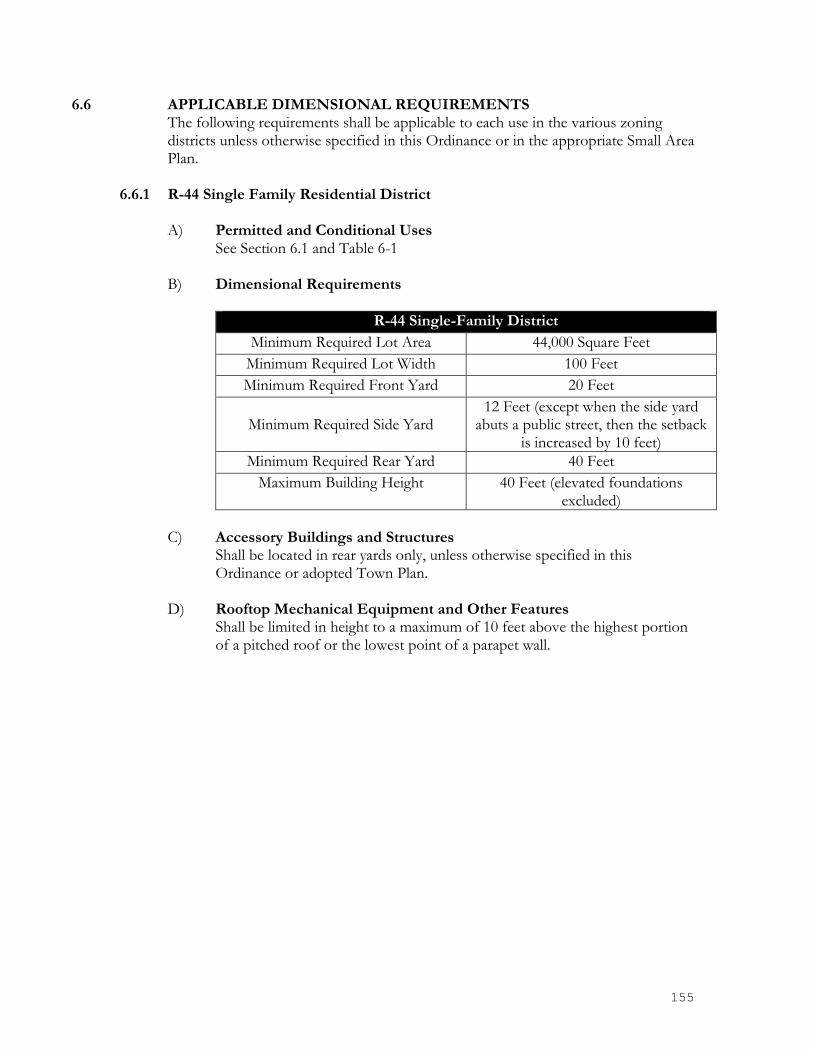
155
6.6 APPLICABLE DIMENSIONAL REQUIREMENTS The following requirements shall be applicable to each use in the various zoning
districts unless otherwise specified in this Ordinance or in the appropriate Small Area Plan.
6.6.1 R-44 Single Family Residential District
A) Permitted and Conditional Uses
See Section 6.1 and Table 6-1 B) Dimensional Requirements
R-44 Single-Family District
Minimum Required Lot Area 44,000 Square Feet
Minimum Required Lot Width 100 Feet
Minimum Required Front Yard 20 Feet
Minimum Required Side Yard
12 Feet (except when the side yard abuts a public street, then the setback
is increased by 10 feet)
Minimum Required Rear Yard 40 Feet
Maximum Building Height 40 Feet (elevated foundations excluded)
C) Accessory Buildings and Structures
Shall be located in rear yards only, unless otherwise specified in this Ordinance or adopted Town Plan.
D) Rooftop Mechanical Equipment and Other Features Shall be limited in height to a maximum of 10 feet above the highest portion of a pitched roof or the lowest point of a parapet wall.

156
6.6.2 R-12 Single Family Residential District A) Permitted and Conditional Uses
See Section 6.1 and Table 6-1 B) Dimensional Requirements
R-12 Single-Family District
Minimum Required Lot Area 12,000 Square Feet
Minimum Required Lot Width 70 Feet
Minimum Required Front Yard 20 Feet
Minimum Required Side Yard
10 Feet ( except when the side yard abuts a public street, then the setback
is increased by 10 feet)
Minimum Required Rear Yard 40 Feet
Maximum Building Height 40 Feet (elevated foundations excluded)
C) Accessory Buildings and Structures
Shall be located in rear yards only, unless otherwise specified in this Ordinance or adopted Town Plan.
D) Rooftop Mechanical Equipment and Other Features Shall be limited in height to a maximum of 10 feet above the highest portion of a pitched roof or the lowest point of a parapet wall.
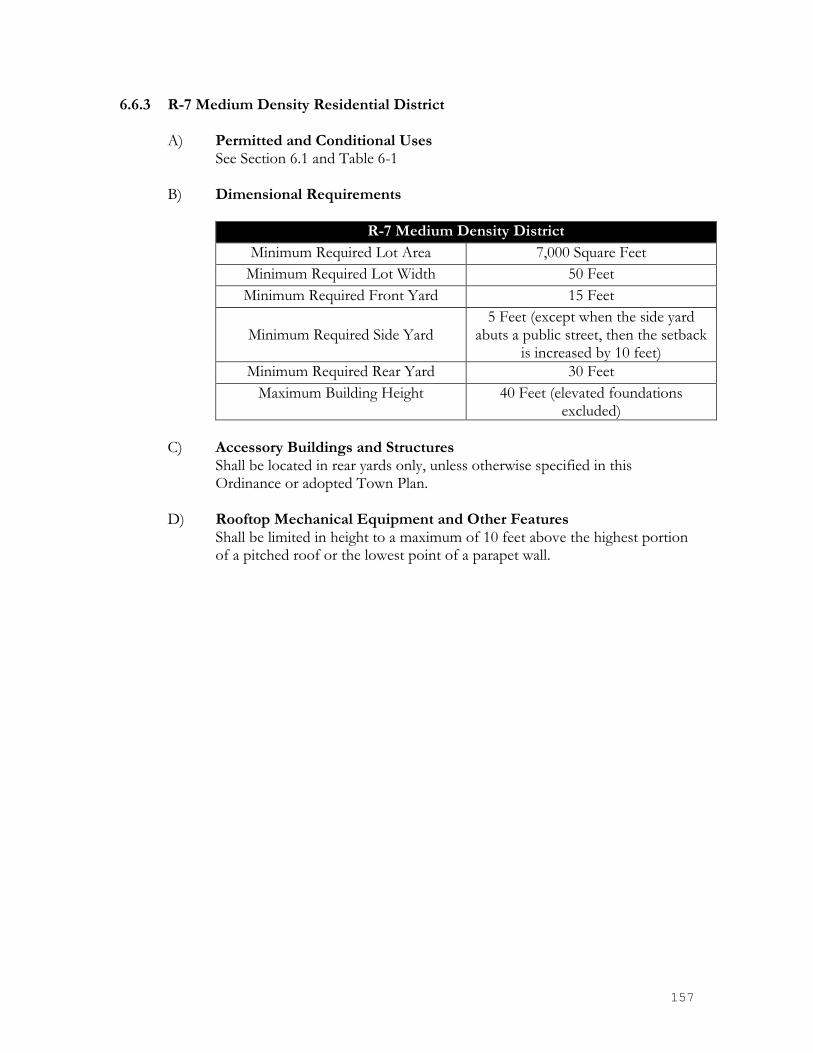
157
6.6.3 R-7 Medium Density Residential District A) Permitted and Conditional Uses
See Section 6.1 and Table 6-1 B) Dimensional Requirements
R-7 Medium Density District
Minimum Required Lot Area 7,000 Square Feet
Minimum Required Lot Width 50 Feet
Minimum Required Front Yard 15 Feet
Minimum Required Side Yard
5 Feet (except when the side yard abuts a public street, then the setback
is increased by 10 feet)
Minimum Required Rear Yard 30 Feet
Maximum Building Height 40 Feet (elevated foundations excluded)
C) Accessory Buildings and Structures
Shall be located in rear yards only, unless otherwise specified in this Ordinance or adopted Town Plan.
D) Rooftop Mechanical Equipment and Other Features Shall be limited in height to a maximum of 10 feet above the highest portion of a pitched roof or the lowest point of a parapet wall.

158
6.6.4 R-MF Multi-Family Density Residential District A) Permitted and Conditional Uses
See Section 6.1 and Table 6-1 B) Dimensional Requirements
R-MF Multi-Family District (Single-Family Developments)
Minimum Required Lot Area 7,000 Square Feet
Minimum Required Lot Width 50 Feet
Minimum Required Front Yard 20 Feet
Minimum Required Side Yard
5 Feet (except when the side yard abuts a public street, then the setback
is increased by 10 feet)
Minimum Required Rear Yard 30 Feet
Maximum Building Height 40 Feet (elevated foundations excluded)
R-MF Multi-Family District (Master Planned Apartment and Other Developments)
Minimum Required Lot Area 43,560 Square Feet (1 acre)
Maximum Density
10 Units Per Acre (unless otherwise granted by Town Council during the
conditional approval process)
Minimum Front Yard Lot Width 100 Feet of project road frontage
Minimum Side Yard Width (at Project Boundary)
30 Feet
Minimum Rear Yard Width (at Project Boundary)
30 Feet
Minimum Lot Width (Townhome Parcels)
15 Feet
Maximum Building Height 40 Feet (elevated foundations excluded)
C) Accessory Buildings and Structures
Shall be located in rear yards only, unless otherwise specified in this Ordinance or adopted Town Plan.
D) Rooftop Mechanical Equipment and Other Features Shall be limited in height to a maximum of 10 feet above the highest portion of a pitched roof or the lowest point of a parapet wall.

159
6.6.8 O-I Office Institutional District A) Permitted and Conditional Uses
See Section 6.1 and Table 6-1 B) Dimensional Requirements
O-I Office-Institutional District
Minimum Required Lot Area None
Minimum Required Lot Width 50 Feet
Minimum Required Front Yard See applicable small area plan
Minimum Required Side Yard None (Buffer requirements still apply)
Minimum Required Rear Yard None (Buffer requirements still apply)
Maximum Building Height None (Maximum stories see applicable small area plan)
Maximum Gross Floor Area Allowed Per Tenant
See applicable small area plan
C) Accessory Buildings and Structures
Shall be located in rear yards only, unless otherwise specified in this Ordinance or adopted Town Plan.
D) Rooftop Mechanical Equipment and Other Features Shall be limited in height to a maximum of 10 feet above the highest portion of a pitched roof or the lowest point of a parapet wall.

160
6.6.9 O-C Office-Commercial District A) Permitted and Conditional Uses
See Section 6.1 and Table 6-1 B) Dimensional Requirements
O-C Office-Commercial District
Minimum Required Lot Area None
Minimum Required Lot Width None
Minimum Required Front Yard See applicable small area plan
Minimum Required Side Yard None (Buffer requirements still apply)
Minimum Required Rear Yard None (Buffer requirements still apply)
Maximum Building Height None (Maximum stories see applicable small area plan)
Maximum Gross Floor Area Allowed Per Tenant
See applicable small area plan
C) Accessory Buildings and Structures
Shall be located in rear yards only, unless otherwise specified in this Ordinance or adopted Town Plan.
D) Rooftop Mechanical Equipment and Other Features Shall be limited in height to a maximum of 10 feet above the highest portion of a pitched roof or the lowest point of a parapet wall.
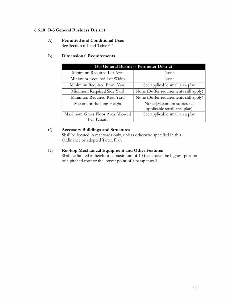
161
6.6.10 B-3 General Business District A) Permitted and Conditional Uses
See Section 6.1 and Table 6-1 B) Dimensional Requirements
B-3 General Business Perimeter District
Minimum Required Lot Area None
Minimum Required Lot Width None
Minimum Required Front Yard See applicable small area plan
Minimum Required Side Yard None (Buffer requirements still apply)
Minimum Required Rear Yard None (Buffer requirements still apply)
Maximum Building Height None (Maximum stories see applicable small area plan)
Maximum Gross Floor Area Allowed Per Tenant
See applicable small area plan
C) Accessory Buildings and Structures
Shall be located in rear yards only, unless otherwise specified in this Ordinance or adopted Town Plan.
D) Rooftop Mechanical Equipment and Other Features Shall be limited in height to a maximum of 10 feet above the highest portion of a pitched roof or the lowest point of a parapet wall.

162
6.6.11 B-4 Highway Business District A) Permitted and Conditional Uses
See Section 6.1 and Table 6-1 B) Dimensional Requirements
B-4 Highway Business Perimeter District
Minimum Required Lot Area None
Minimum Required Lot Width None
Minimum Required Front Yard See applicable small area plan
Minimum Required Side Yard None (Buffer requirements still apply)
Minimum Required Rear Yard None (Buffer requirements still apply)
Maximum Building Height None (Maximum stories see applicable small area plan)
Maximum Gross Floor Area Allowed Per Tenant
See applicable small area plan
C) Accessory Buildings and Structures
Shall be located in rear yards only, unless otherwise specified in this Ordinance or adopted Town Plan.
D) Rooftop Mechanical Equipment and Other Features Shall be limited in height to a maximum of 10 feet above the highest portion of a pitched roof or the lowest point of a parapet wall.

163
6.6.12 B-P Planned Business District A) Permitted and Conditional Uses
See Section 6.1 and Table 6-1 B) Dimensional Requirements
B-P Highway Business Perimeter District
Minimum Required Lot Area None
Minimum Required Lot Width None
Minimum Required Front Yard See applicable small area plan
Minimum Required Side Yard None (Buffer requirements still apply)
Minimum Required Rear Yard
None (Buffer requirements still apply)
Maximum Building Height None (Maximum stories see applicable small area plan)
Maximum Gross Floor Area See applicable small area plan
C) Accessory Buildings and Structures
Shall be located in rear yards only, unless otherwise specified in this Ordinance or adopted Town Plan.
D) Rooftop Mechanical Equipment and Other Features Shall be limited in height to a maximum of 10 feet above the highest portion of a pitched roof or the lowest point of a parapet wall.

164
6.6.13 DC Downtown Core District A) Permitted and Conditional Uses
See Section 6.1 and Table 6-1 B) Dimensional Requirements
DC Downtown Core District
Minimum Required Lot Area None
Minimum Required Lot Width None
Minimum Required Front Yard See applicable small area plan
Minimum Required Side Yard None (Buffer requirements still apply)
Minimum Required Rear Yard None (Buffer requirements still apply)
Minimum Building Height None (Maximum stories see applicable small area plan)
Maximum Building Height See applicable small area plan
Maximum Gross Floor Area Allowed Per Tenant
See applicable small area plan
C) Accessory Buildings and Structures
Shall be located in rear yards only, unless otherwise specified in this Ordinance or adopted Town Plan.
D) Rooftop Mechanical Equipment and Other Features Shall be limited in height to a maximum of 10 feet above the highest portion of a pitched roof or the lowest point of a parapet wall.

165
6.6.15 RMX Residential Mixed-Use District A) Permitted and Conditional Uses
See Section 6.1 and Table 6-1 B) Dimensional Requirements
RMX Residential Mixed-Use District
Minimum Required Lot Area 5,000 Square Feet
Minimum Required Lot Width 40 Feet
Minimum Required Front Yard See applicable small area plan
Minimum Required Side Yard 5 Feet (except when the side yard abuts a public street, then the setback
is increased by 10 feet)
Minimum Required Rear Yard
5 Feet (Buffer requirements still apply)
Maximum Building Height None (Maximum stories see applicable small area plan)
Maximum Gross Floor Area Allowed Per Tenant
25, 000 Square Feet
C) Accessory Buildings and Structures
Shall be located in rear yards only, unless otherwise specified in this Ordinance or adopted Town Plan.
D) Rooftop Mechanical Equipment and Other Features Shall be limited in height to a maximum of 10 feet above the highest portion of a pitched roof or the lowest point of a parapet wall.

166
6.6.16 G-I General Industrial District A) Permitted and Conditional Uses
See Section 6.1 and Table 6-1 B) Dimensional Requirements
G-I General Industrial District
Minimum Required Lot Area None
Minimum Required Lot Width None
Minimum Required Front Yard See applicable small area plan
Minimum Required Side Yard 10 Feet (30 Feet When Abutting a Residential Use)
Minimum Required Rear Yard
10 Feet (30 Feet When Abutting a Residential Use)
Maximum Height 50 Feet (Maximum stories see applicable small area plan)
Maximum Gross Floor Area Allowed Per Tenant
150,000 Square Feet
C) Accessory Buildings and Structures
Shall be located in side and rear yards only, unless otherwise specified in this Ordinance or adopted Town Plan.
D) Rooftop Mechanical Equipment and Other Features Shall be limited in height to a maximum of 10 feet above the highest portion of a pitched roof or the lowest point of a parapet wall.

167
6.6.17 Conditional Development Approvals Conditionally approved developments are established to consider situations where a particular use requires site specific special accommodations such as road access, safety, adjacent development buffers, density allowances, or similar. In such instances the property owner or applicant and Pineville Town Council may agree and adopt site plan specific development plan.
Conditional approved development may take the form of any method permitted under the law including conditional use permits, conditional districts, or conditional zoning depending on the applicant’s request. Zoning for a conditional approval shall be a voluntary procedure on the part of the property owner or agent of the property owner and is intended for firm and specific development proposals. It is not intended for securing early zoning for tentative proposals. All zoning districts may have a parallel Conditional Use District.
Conditional zoning shall follow legislative process conditional districts and permits shall be quasi-judicial as allowed and detailed by state law. In considering any petition for a conditional approval, the council shall act in accordance with Section 2 of this ordinance. Pineville Town Council alone shall vote on all conditional approvals and conditional rezoning’s. In approving a petition for a conditional development, the the Town Council will review and request that reasonable and appropriate conditions be attached to approval of the petition. Any such conditions should relate to the relationship of the proposed use to surrounding property, proposed support facilities such as parking areas and driveways, pedestrian and vehicular circulation systems, screening and buffer areas, the timing of development, street and right-of-way improvements, water and sewer improvements, stormwater drainage, the provision of open space, and other matters that the Town Council may find appropriate or the petitioner may propose. The petitioner shall have a reasonable opportunity to consider and respond to any such conditions prior to final action by the city council. If a petition for conditional zoning is approved, the development and use of the property shall be governed by this zoning ordinance, requirements by Mecklenburg County, and any additional approved rules, regulations, and conditions, all of which shall constitute the zoning regulations for the approved conditional plan and are binding on the property as an amendment to these regulations and to the zoning maps.

168
CHAPTER 7 GENERAL PROVISION
7.1 APPLICATION
No building or land shall hereafter be used and no building or part thereof shall be erected, moved or altered except in conformity with the regulations herein specified, or amended thereto, for the district in which it is located.
7.2 REDUCTION OF LOT AND YARD AREAS PROHIBITED
No yard or lot existing at the time of adoption of this Ordinance, or any subsequent amendments, shall be reduced in size or area below the minimum requirements set forth herein, except for street widening or similar takeage for public use. Yards or lots created after the effective date of this Ordinance shall meet at least the minimum requirements established by this Ordinance. This prohibition shall not be construed to prevent the condemnation of narrow strips of land for public use.
7.3 TREES AND LANDSCAPING
The purpose and intent of these regulations are to establish a landscape planting area parallel to the recorded public street right-of-way, internal landscaping, and tree planting within residential subdivisions. These areas shall contain plantings of trees and other live vegetation to provide a more pleasing view from the ways of travel, to provide a continuity of vegetation throughout the Town, to reduce the amount of impervious surface and reduce stormwater runoff, to filter air, provide shade, improve the microclimate, and to protect and preserve Pineville’s existing vegetative cover by:
• Saving trees on public property from indiscriminate destruction or unnecessary removal
• Diversifying the tree species in the area
• Establishing standards limiting and regulating the removal of trees
• Establishing a process for the removal of trees
• Building an awareness of the need for and value of preserving trees
• Providing information and guidelines for tree preservation and maintenance
• Establishing standards for tree regulation, maintenance, and protection 7.3.1 Benefits of Trees and Landscaping
The Town of Pineville finds it important to adopt an ordinance to preserve and protect trees since numerous benefits are derived from this practice, including the following:
• Assists in the stabilization and fertilization of soil and in the prevention of soil erosion.
• Contributes to the process of ground water recharge and storm water run-off retardation and protecting against flood hazards and the risk of landslides
• Contributes to the process of air purification and oxygen regeneration.

169
• Intercepts air-born particulate matter, and reduces some air pollutants.
• Aids in glare, heat, and noise abatement, maintaining the climatic balance and decreasing wind velocity.
• Provides important psychological, sociological, and aesthetic counterpoints to the man-made urban setting.
• Provides aesthetic qualities, which enhance livability.
• Promotes energy conservation by maximizing the shading and cooling effects of trees.
• Increases property values.
• Buffers uncomplimentary and often incompatible land uses by providing a transitional area.
7.3.2 Required Landscaping in New Residential Subdivisions
As a requirement of subdivision approval, the subdivider shall plant trees in the front setback of each lot, on both sides of all existing and proposed public and private right-of-ways in the subdivision.
A) In calculating the number of trees required per lot frontage, tree types have
been assigned a value in linear feet based on the average mature canopy spread. The values are 40’ for large maturing trees and 30’ for small maturing trees. Large maturing shall be required unless the Planning Director determines overhead utilities or similar require otherwise. Each lot, including approved recreation/open space areas, must have one (1) large maturing tree per street frontage (value of 40’). The number of trees to be planted on the remaining frontage (total frontage less value for one large maturing tree) is determined by dividing the remaining frontage by the value(s) assigned to tree types selected for planting by the subdivider. Fractional numbers shall be rounded up to the next whole tree number.
B) Street trees shall be an approved large maturing species planted within the
planting strip between the sidewalk and road unless specifically noted and approved otherwise. Street trees shall be a minimum of 3” caliper.
C) Existing trees in the front yard setback, which meet the minimum size
specifications noted above, can be substituted towards meeting the planting criteria. The Planning Director shall determine on a case-by-case basis whether the developer shall supplement the plantings.
D) Nothing in this section shall be interpreted to require the removal of existing
trees and vegetation. 7.3.3 RESERVED

170
7.3.4 Tree Topping Tree topping shall be prohibited on all protected, required, or similar screening vegetation falling under the jurisdiction of the ordinance. These shall include, but not limited to: trees lining a street, publicly owned trees, parking lot trees, trees or shrubs shown on any conditionally approved plan, and required vegetation within any buffer areas. Fines for topping shall be $250 for the first plant, plus $500 for the second plant, plus $150 for each additional plant. (For instance: 3 topped plants would equal $900). Vegetation deemed by the Planning Director as topped beyond recovery, or removed without written approval is subject to the above fines plus required similar size replacement.
7.3.5 Preservation of Existing Vegetation Existing trees and vegetation shall be preserved whenever feasible. Deciduous trees at least 12” inches DBH, all coniferous trees at least 12” DBH and all understory trees greater than 2” DBH anywhere on the site shall be preserved to the greatest extent practical and incorporated into the required landscaping. Any removal of trees with 12” DBH or greater requires approval from the Zoning Administrator.
Tree preservation is encouraged on all properties located in business, office, industrial, multi-family, and non-residential uses in a residential zoning district, as well as conditional use districts. A tree landscape plan must be submitted prior to grading. A tree landscape plan must show that there will be no disturbance in the Critical Root Zone. A disturbance is considered trenching, placing backfill in the Critical Root Zone, driving or parking equipment in the Critical Root Zone, and dumping of trash, oil, paint or other materials detrimental to plant health in close proximity of the tree(s).
When selecting which trees to preserve, the following shall be considered: existing and proposed grading; age, condition, and type of tree; and location of site improvements and utility connections.
Should any tree designated for preservation in the tree landscape plan die at any time after approval of the plan or issuance of a Certificate of Occupancy, the owner shall replace sufficient landscaping equal to the tree within 180 days. In the event of a restricted site, the owner may request review by the Zoning Administrator. Replacement trees shall be a minimum of two inches caliper (measured 6” above ground) for a large maturing tree and have a minimum height of eight feet from the ground surface. Small Maturing trees shall be a minimum 2” caliper (measured 6” above ground) and have a minimum height of eight feet from the ground surface.
How to Determine Required Mitigation Trees:
Diameter of Trees Number of Replacement Trees Required
8-14 in. 1 15-24 in. 2 25-34 in. 3 35+ in. 4

171
7.3.6 Protective Measures During Construction
Protective barricades shall be placed around all protected trees designated to be saved in development areas, prior to the start of development activities or grading. Protective barricades shall remain in place until development activities are complete or construction in accordance with standards set forth in this Section commences. The area within the protective barricade shall remain free of all building materials, dirt or other construction debris, construction traffic, storage of vehicles and materials, and grading shall not take place within the dripline of the existing trees to be protected. Barricades shall be erected at a minimum distance from the base of protected trees according to the following standards:
A) For trees 10” or less DBH: Protective barricades shall be placed a minimum
distance of 10’ from the base of each protected tree, or outside the dripline, whichever is greater.
B) For trees greater than 10” DBH: Protective barricades shall be placed at a
minimum distance equal to 10’ from the base of a protected tree plus an additional 1’ for each additional 1” DBH greater than 10” DBH, or outside the dripline, whichever is greater.
C) Construction access to a site should occur where an existing or proposed
entrance/exit is located.
D) Except for driveway access points, sidewalks, curb and gutter, no paving with concrete or other impervious materials within a tree dripline shall be allowed.
E) Where grading within a tree dripline cannot be avoided:
F) Limit cut and fills to ¼ to ½ the area within the dripline.
G) Avoid cut and fill around entire circumference of trunk.
H) Where grading leaves roots exposed, cut roots clean.
I) Avoid filling within the dripline of a tree without some mechanism to allow
air and water to reach the roots. 7.3.7 Tree Removal
A) The Public Work’s Director is authorized to permit the removal and or trimming of trees and shrubs from public properties, and in the public rights-of-way.
B) The Town of Pineville Zoning Board shall hear and decide all matters in the
event of a conflict with property owners with regard to tree removal in the public rights-of way or on public property.

172
A) Trees designated for removal must be dead, diseased, irreparably damaged, hazardous, creating damage to private property, or potentially creating damage to private property.
B) Fines for required or protected trees identified in this ordinance that are removed without Town approval see 7.3.4.
7.3.8 Tree/Landscape Plan A tree/landscaping plan shall be required on all business, conditional-use, office-
institutional, industrial, multi-family, and non-residential uses in a residential district. The plan must contain the following information (a required tree/landscape plan shall be incorporated into the site plan submittal process.)
A) A tree/landscaping plan shall be submitted to the Pineville Planning
Department for administrative approval prior to site disturbance.
B) An accurate drawing of property boundaries.
C) A development summary including the total acres in development, proposed use(s), required parking and provided parking spaces and total building square footage
D) Calculations for total new and proposed impervious area on the site and for
amount of landscape area.
E) The location of proposed buildings, driveways, parking areas, required parking spaces, and traffic patterns.
F) Location of overhead and underground utilities.
G) Location, by species, of all deciduous trees at least 12” DBH, all coniferous
trees at least 12” DBH and all rare, protected, or ornamental trees greater than 2” DBH such as Dogwood and Magnolia trees prior to any site disturbance on area to be developed.
H) Plan of required landscaping.
I) Dimensions from back of curb to back of curb for all landscape islands to
contain trees or a typical detail.
J) Plant lists with common names, quantity, spacing and size of all proposed landscaping and plant material at the time of planting.
K) Name of the project, owner, name and address of engineer, scale, date,
legend and north arrow.
L) Minor changes or additions to existing development or approved plans may submit an abbreviated site plan. An abbreviated site plan shall be allowed

173
when a proposed change is physically limited to only a contained portion of the site. An abbreviated site plan shall include, but not be limited to, items listed in C and E of this section. The Planning Department shall determine when an abbreviated site plan may be submitted for a detailed site plan and what items must be included.
7.3.9 Modifications
Under certain circumstances, the application of the standards of this Ordinance is either inappropriate or ineffective in achieving the purposes of this Ordinance. When planting is required by this Ordinance, and the site design, topography, unique relationships to other properties, natural vegetation, or other special circumstances exist relative to the proposed development, the developer may submit a specific alternative plan for planting to the Planning Department staff. This plan must demonstrate how the purposes and standards of this Ordinance will be met by measures other than those found in the Ordinance. The Planning Department staff shall review the alternate proposal and advise the applicant of the disposition of the request within 15 working days of submission by the applicant. An appeal of the staff’s decision may be made to the Zoning Board of Adjustment.
Requests for a delay in complying with this Ordinance due to poor weather conditions for planting will be considered following written request directed to the Planning Department staff. Certificates of Occupancy will be issued with the approval of a request for planting delay, if deemed reasonable. Such request for a delay shall note the time frame during which the planting shall be completed.
7.3.10 Emergencies
In the case of emergencies such as windstorms, ice storms, fire, or other disasters, the requirements of this Ordinance may be waived by the Town during the emergency period so that the requirements of this Ordinance will in no way hamper private or public work to restore order in the Town. This shall not be interpreted to be a general waiver of the intent of this Ordinance.
7.3.11 Violations and Penalties
Should a violation of the tree and landscaping provisions occur, a non-monetary penalty, in the form of increased or additional planting requirements may be assessed in addition to or in lieu of any other penalties prescribed under this Ordinance.
7.3.12 Reserved
174
7.4 SCREENING AND LANDSCAPING
The intent of these screening requirements shall be to separate certain zoning districts from other zoning districts or to screen certain uses in order to minimize potential nuisances such as the transmission of noise, dust, odor, litter, and glare of lights; to reduce the visual impact of unsightly aspects of adjacent development; to provide for the separation of spaces; and to establish a sense of privacy.
7.4.1 Internal Landscaping
Interior landscaping and parking lots for properties located in all business, office, industrial zones, multi-family, conditional uses, and parking lots other than single family or duplex driveways shall comply with the following regulations:
A) Evergreen shrubs screening the parking lot from the road and adjacent
properties shall be required at a minimum size of 2 feet tall by 2 feet wide at planting and placed no more than 5 feet on center.
B) No parking space shall be further than 60 feet from a tree. This radius must
cover at least 50% of each parking space. C) Large maturing trees shall have a minimum of two inches caliper (measured
6” above ground) and have a minimum height of eight feet from the ground surface. Small maturing trees shall be a minimum of 2” caliper (measured 6” above ground) and have a minimum height of eight feet from the ground surface. All trees shall be selected from an approved species list, which is provided in Appendix A.
Such landscaped areas shall be separated from parking spaces, driveways, and maneuvering areas by a curb at least six (6) inches in height designed to minimize damage by vehicles to plants located in the landscaped area. For an area to be considered as satisfying the internal landscaping provision of this Ordinance, it must contain a minimum contiguous area of three hundred (300) square feet for large maturing trees and two hundred (200) square feet for small maturing trees, and be at minimum of 8 feet wide.
D) All plant material shall be free from disease when planted and shall be
maintained in a healthy condition. All plant material shall be installed in accordance to adopted town and/or county planting specifications.
E) Required landscaping must be properly maintained in order for the
landscaped area to fulfill the purposes for which it is established. The owner of the property and/or any tenant on the property where a landscaped area is required shall be jointly and severally responsible for the maintenance of all plant material located within the landscaped area. Such maintenance shall include all actions necessary to keep the landscaped areas free of litter and debris and to keep plantings healthy and orderly in appearance. The tenant or property owner shall replace any vegetation that constitutes parts of the landscaped area in the event that it dies.

175
F) Total minimum landscape area (pervious or “green” space):shall be equal to
10% of total impervious area for the entire site with new sites and 5% of the total impervious area for renovated sites
7.4.2 Screening and Buffering requirements between certain Zoning Districts
A) When a lot in the Industrial District abuts a lot in a Residential District or a residential use, screening must be provided in the form of a minimum one hundred (100) foot screen/buffer.
B) When a lot in a Business/Office District abuts a lot in a Residential District
or a residential use, screening must be provided in the form of a minimum twenty (20) foot screen/buffer.
C) When a lot in a Residential District or a residential use abuts another lot,
which contains a dissimilar institutional use, multi-family development or manufactured home park, screening must be provided on the lot containing the institutional use, multi-family development or manufactured home park in the form of a minimum twenty (20) foot screen/buffer.
D) When a lot containing a use subject to the issuance of a conditional use
permit in the Industrial District abuts a lot in a Commercial District, the Town Council may stipulate in the conditional use permit that a specific width of screen/buffer must be provided on the Industrial lot.
E) Where a minimum twenty (20) foot screen/buffer is required, the following
plant materials are required per one-hundred (100) linear feet of buffer strip:
F) Minimum 12 trees (one-third shall be evergreen, one third shall be large maturing), and 60 evergreen shrubs shall be required per one hundred linear feet within screen/buffer areas.
G) Existing mature screening vegetation and solid wood, vinyl, or masonry wall a minimum six (6) feet in height may be substituted for letter ‘F’ above.
7.4.3 Screening requirements on Industrial Property located across from
Residential Property When the front yard of a lot developed in the Industrial District is located directly across a public street from a Residential District or a residential use; screening, at a minimum, must be provided on the Industrial lot at a minimum in the form of a twenty (20) foot screen/buffer. Screening shall be in the front yard of the lot in the Industrial district immediately behind the street right-of-way and will meet the design standards of Section 7.4.1. In lieu of said screen, all principal and accessory structures and off-street parking facilities must be set back in the front yard at least one-hundred (100) feet from the edge of the street right-of-way.

176
7.4.4 Screening Requirements for Open Storage and Unenclosed Structures For open-air storage, or an unenclosed structure consisting of a roof, but no walls used for storage of materials, products, wastes or equipment associated with business or industrial uses located in any zoning district, screening must be provided on the subject property so as to materially screen said storage in the form of a berm, wall, solid fence or an appropriate amount of natural plantings as to provide the necessary amounts of screening to effectively screen the storage from view from any adjacent lot or street right-of-way.
7.4.5 Screening Requirements for All Zoning Districts
A) The following uses must be screened from abutting property and from public view from a public street. Screening shall be by approved landscaping or solid fencing. Landscaping shall be positioned and maintained so as to form a continuous tight screen.
1) Parking lots excluding single family, duplex, and townhome
driveways; 2) Dumpsters, recycling containers, or trash handling areas; 3) Service entrances or utility structures; 4) Display or outdoor storage areas; 5) Loading docks facing and visible to any road;
These areas and screening shall be shown on submitted plans.
B) Dumpster screening shall be a minimum of a six (6) foot solid wood, vinyl, or masonry fence including gates.
C) Planting standards are specified in Section 7.4.7.
7.4.6 Screen and Buffer Areas To the extent that the existing natural vegetation located on the same parcel of land as the proposed development can meet the required screening levels of this Section, the use of such material is required. The owner shall designate the land on which such materials are rooted, which shall contain at least the minimum width required for the designated buffer area. Additional plantings shall be added, if the buffer is deficient in any way. The Planning Director shall determine if existing natural vegetation meets minimum standards.
A) Limited amount of clearing may occur within the buffer to promote the
growth of existing vegetation and and/or enhance the aesthetic appeal of the site. The following disturbances are permitted within a buffer:

177
1) Trees may be pruned by hand. No heavy equipment or vehicles are permitted within the buffer.
2) Plant material, when approved by the town for removed, shall be cut
flush with the ground.
3) Dead or diseased limbs may be removed.
4) Weeds and vines may be removed.
5) Trees of less than 2” in caliper may be removed that are clearly within the drip line of a tree that has a caliper of greater than 2”.
6) Dead trees and materials may be removed. Diseased trees may be
removed at the discretion of the Zoning Enforcement Officer.
7) Mulch may be applied within the buffer. Mulch shall be kept 2” to 3” away from the bark of trees.
D) Except as otherwise provided a screen/buffer shall be required along the rear
and/or side lot lines only. No required buffer shall extend nearer to a street than the street right-of-way line.
E) No structure other than a wall, fence, sidewalk, mailbox, sign, or driveway
shall be permitted within the required screen area. If a wall or a fence is used as part of a screen, it shall be no less than six (6) feet in height. No off-street parking may take place in any required screen area.
F) The height of any material in the vicinity of a point of ingress or egress may
not exceed three (3) feet within the sight triangle.
G) Where a wall or a fence will be utilized within a screen/buffer area, and plant materials are required, the required amount of plant materials shall be installed on the side of any wall or fence opposite the new development.
H) Where plant materials are required to be installed, plant types shall be
selected from the list of materials in Appendix A or otherwise approved by the Planning Director.
7.4.7 Walls, Fences, and Berm Standards
Whenever a screening alternative specified is selected which includes a wall, fence, or berm, such wall, fence, or berm shall meet the following requirements:
A) Any wall shall be constructed in a durable fashion of solid treated wood,
brick, stone, or Vinyl. All walls, except those constructed of stone, shall be of a consistent pattern. Gates shall be constructed to the standards for fence materials.

178
B) Chain link fence with plastic, metal or wooden slats may not be used to satisfy the requirements of this ordinance.
C) No wall or fence used as part of a screen shall be less than six (6) feet in
height.
D) All berms shall be grassed and/or planted with other plant materials sufficient to prevent soil erosion. If grassed alone, any berm installed to meet the requirements of this Section shall be no less than four (4) feet in height. No slope of a berm shall exceed a slope greater than one (1) foot of rise for every three (3) feet of run unless approved by the Planning Director. No part of the berm shall be left as bare soil. Any required plant materials accompanying a berm may be planted on the berm and/or along either side of the berm. It is recommended that, where feasible, at least seventy-five percent (75%) of any required shrubs be planted on the slope of the berm opposite the new development.
E) Where a fence or wall is used as part of a required screen area, any required
plantings accompanying the fence or wall shall be located on the side of such fence or wall opposite the new development.
7.4.9 Screen and Buffer Maintenance
The plantings, fences, walls or berms that constitute a required screen shall be properly maintained in order for the screen to fulfill the purpose for which it is established. The owner of the property and any tenant on the property where a screen is required shall be jointly and severally responsible for the maintenance of all screen materials. Such maintenance shall include all actions necessary to keep the screened area free of litter and debris; to keep plantings healthy; to keep plant growth from interfering with safe vehicular and pedestrian travel, or use of parking areas, or from creating nuisances to adjoining properties; and to keep walls, fences, and berms in good repair and neat appearance. Any vegetation that constitutes part of a screen shall be replaced in the event that it dies. All screen materials shall be protected from damage, by erosion, motor vehicles or pedestrians, which could reduce the effectiveness of the screen.

179
Appendix A APPROVED TREES AND SHRUBS
Small Maturing Deciduous Trees: American Hornbeam Cherry Crape Myrtle (single trunk) Dogwood European Hornbeam European White Birch Flowering Crab Apple Maple (Trident, Amur single trunk) Saucer Magnolia (single trunk) Zelkova (City Sprite) Large Maturing Deciduous Trees: Bald Cypress Black Gum or Tupelo (Green Gable var.) Elm (Lacebark) Elm (Princeton) London Plane-Tree Oak (Willow and other as approved) Tulip Poplar Zelkova

180
Evergreen Screening *various cultivars listed.
Groundcover 0-2’ Common Name Latin Name
-Varieties Growth s/m/f
Height Width Sun Requirements Full/Partial/Shade
Juniper, Dwarf Juniper chinensis* -Armstrong -Hughes -Prince of Wales -San Jose
s/m/f
varies
varies
F/P
Jasmine, Asiatic Trachelospermum asiaticum f 6-24” varies F/P/S
Mondo Grass Ophiopogon japonicus m/f 4-12” 4-12” F/P/S
Monkey Grass Liriope
-muscari
-spicata
m/f 6-12” 6-12” F/P/S
Small 1-6’ Common Name Latin Name
-Varieties Growth s/m/f
Height Width Sun Requirements Full/Partial/Shade
Boxwood ,Korean buxus microphylla koreana* -Green velvet -Wintergem -Wintergreen
s 3-4’ 3-4’ F/P
Boxwood, Dwarf buxus* s varies varies F/P
Camellia, Dwarf Camellia sasanqua* Camellia japonica*
s/m s/m
varies varies
varies varies
P/S P/S
Holly, Chinese Ilex cornuta* -Carissa -Compacta -Dwarf burford -Routunda
s/m m m/f s/m
3-4’ 3-4’ 4-6 3-4’
3-4’ 5-6’ 4-6 6-8’
F/P F/P F/P F/P
Holly, Dwarf Youpon
Ilex vomitoria* s/m 2-3’ 2-3’ F/P/S
Holly, Japanese Ilex crenata* -Green luster -Helleri -Hetzi -Sky pencil -Soft touch
m m m m m
2-3 3-5’ 3’ 8-10’ 2-3’
4-6’ 4-6’ 5’ 2-3’ 2-3’
F/P F/P F/P F/P F/P
Indian Hawthorn Raphiolepis indica* -Georgia charm -Georgia petite -Indian princess -Snow white -Yeddo
m 3-5’ 3-5’ F/P
Pine, Dwarf Mugo Pinus mugo* m 3-4’ 3-4’ F/P

181
Medium 7-12’ Common Name Latin Name
-Varieties Growth s/m/f
Height Width Sun Requirements Full/Partial/Shade
Camellia Camellia sasanqua* Camellia japonica*
s s
varies varies
varies varies
P/S P/S
Holly, Inkberry Ilex glabra s 5-8’ 8-10’ F/P/S
Juniper Juniperus Chinensis* -Pfitzer
f
5-7
8-10
F/P
Pine, Mugo Pinus mugo* m 7-10’ 8-12’ F/P
Rhododendron Rhododendron* -catawbiense
s 6-10 5-8’ P/S
Wax Myrtle Myrica cerifera f 10-12’ 8-10’ F/P
Tall 13’+ Common Name Latin Name
-Varieties Growth s/m/f
Height Width Sun Requirements Full/Partial/Shade
Arborvitae Thuja -Green Giant -Steeplechase
f 35-50’ 15-20 F/P
Cedar, Deodar Cedrus deodora* f 30-50’ 20-30’ F/P
Cryptomeria Cryptomeria japonica* -Yoshino
f
45’
15’
F/P
Holly, American Ilex opaca* -Fosters
s/m s/m
40-50’ 15-25
18-40’ 8-12’
F/P/S F/P/S
Holly, Chinese Ilex cornuta* -Burford -Fine line -Needlepoint Nellie R. Stevens
m m m f
15-20’ 20’ 15’ 15-30’
15-20’ 15’ 10’ 10-20’
F/P/S F/P/S F/P/S F/P
Holly, Youpon Ilex vomitoria* -Dodd’s cranberry -Roundleaf
m 15-20’ 6-12’ F/P
Holly, Japanese Ilex crenata*
m/f 15-25’ 10-20’ F/P
Juniper, Upright Juniperus chinensis* -Blue point -Hetzi i -Spartan
m/f 12-20’ 4-8’ F
Juniper, Red Cedar Juniperus virginiana* -Brodie -Burkii
f f
20-25’ 15-25’
4-6’ 8-25’
F/P F/P
Laurel, English/Cherry
Prunus laurocerasus* -Dwarf l eaf Engl ish laurel -Otto luyken -Portugal -Schipka
f 10-20’ 10-20’ F/P
Magnolia Magnolia graniflora* -Alta -Claudia Wannamaker -D.D. Blanchard -Greenback -Little gem
s m s s s
40-50’ 40-60’ 40-50’ 25-40’ 15-20’
15-25’ 20-30 25-30’ 10-15’ 8-10’
F F F F F
Tea Olive Osmanthus fortunei* Osmanthus fragrans*
m m
10-15’ 10-15’
10-15’ 10-15’
F/P F/P

182
7.4.10 Relief to Screening and Buffer Requirements
In the event that the unusual topography or elevation of a development site or the location or size of the parcel to be developed would make strict adherence to the requirements of this section serve no meaningful purpose or would make it physically impossible to install and maintain the required screen and buffer, the Planning Director may alter the requirements of Section 7.4 provided the spirit and intent of the ordinance are maintained. Such an alteration may occur only at the request of the developer, who shall submit a plan to the Planning Director showing existing site features that would screen the proposed use and any additional screen materials the developer may propose to have installed. The Planning Director shall have no authority to alter the screening and buffer requirements unless the developer demonstrates that existing site features and any additional screening materials will screen the proposed use as effectively as the required screen.
The vacancy or non-use of an adjoining parcel shall not constitute grounds for providing relief to the screening and buffering requirements contained in this Ordinance. Neither shall the desire of an owner to make more intensive use or greater economic use of the property be grounds for reducing the screening/buffer requirements of Section 7.4. Where the effect of the screening and buffer requirements of Section 7.4 is to deny the owner reasonable use of the entire tract (or tracts) of property, relief pursuant to this Section may be granted to the extent that reasonable use of such tract or tracts is available. In deciding whether to approve such a plan, the Planning Director may, at his discretion, seek an advisory opinion from the Planning Board.
7.4.11 Existing Screened Areas
In cases where an existing, screened area is located on the same tract as the proposed development, further plantings and or improvements shall not be required so long as said screened area is of sufficient width and depth and contains adequate and sufficient materials to meet the requirements of this Ordinance. If the screened area is deficient, the developer shall make needed improvements and/or additions to satisfy the screening requirements and intent of this Ordinance.
7.4.12 Visibility at Intersections
On a corner lot in a residential district, no planting, structure, sign, fence, wall or artificial obstruction to vision more than three (3) feet in height measured from the center line of the street or road shall be placed or maintained within the triangular area formed by the intersecting street or road right-of-way lines and a straight line connecting points on said street or road right-of-way lines each of which is ten feet distance from the point of intersection.

183
7.4.13 Implementation of Screening Required Prior to Occupancy
Fences, walls, berms, buffers, and landscaping materials required in this ordinance shall be installed prior to occupancy.
A) Improvement Guarantees
It is recognized that vegetation used in landscaping or screening should be planted at certain times of the year to ensure the best chance of survival. In order to ensure compliance with this section and to reduce the potential expense of replacing landscaping or screening materials which were installed in an untimely or improper fashion, in lieu of requiring the completion and installation of these improvements prior to occupancy, the Town of Pineville may enter into an agreement with the subdivider/developer whereby the subdivider/developer shall agree to complete all required landscaping and screening. To secure this agreement, the subdivider/developer shall provide to the Town of Pineville one of the following guarantees. The amount of such guarantee shall be equal to 1.25 times the cost of purchasing, installing, and completing landscaping and screening materials required under this Ordinance. All such guarantees shall be subject to the approval of the Planning Director. The guarantee shall be held by and overseen in accordance with Mecklenburg County standards unless adopted otherwise.
7.4.14 Recycling Center and Container Provisions
A) When a recycling container is placed on a property permitted before May 14,
2002, the minimum number of parking spaces required by these regulations may be reduced by up to three (3) spaces, if necessary, to provide space for the location and servicing of the recycling container. [This provision is included in these regulations to allow existing uses or uses for which building permits have been obtained prior to the date set forth above to place recycling containers on the property without the location of such a recycling container creating a violation of these regulations.]
B) All non-residential uses except multi-family, which are permitted after May 14,
2002, shall be required to set aside space for recycling containers and for dumpsters used for the collection of solid waste; Equal space shall be allocated for both recycling and solid waste containers.
All multi-family complexes, which are permitted after May 14, 2002, shall be required to set aside space for recycling containers and dumpsters used for the collection of solid waste as follows:
Space for Solid Waste Containers Space for Recycling Containers
At a minimum, space for an 8 cu.yd. container per each 30 units or 8 cu.yd. compactor per each 90 units.
Space for five 96-gallon carts per each 80 units (approximately 12x12 foot space).

184
However, if the multi-family complex is of such a nature that individual garbage and/or recycling containers are presented to each unit and no clustered collection points are utilized, then the owner/owners agent shall make a statement to this effect on submitted plans and does not need to show space for recycling and/or solid waste containers.
Exceptions to section 7.4.13, item (B). A permit shall not be denied if: 1) the project for which the permit is sought is for the renovation or
redevelopment of an existing building or facility and 2) the existing building or facility does not have sufficient exterior
property available for a recycling container/s. The minimum number of parking spaces required by these regulations may be reduced by up to three (3) spaces, if necessary, to provide space for the location and servicing of recycling container/s.
7.5 FENCES OR WALLS PERMITTED
Except as otherwise noted, fences or walls are permitted in the various districts subject to the following regulations:
7.5.1 In Residential Districts:
When fences or walls are installed in a front yard, the maximum height of a fence or wall shall be four (4) feet. When fences or walls are installed in a side yard, the maximum height of a fence or wall shall be six (6) feet. When such fence or wall is installed pursuant to Section 7.4 of this Ordinance, or when it is located in the rear yard, it shall not exceed eight (8) feet in height.
7.5.2 In all Other Districts:
Maximum height shall be twelve (12) feet except where otherwise noted in this Ordinance.
7.6 LOT TO ABUT A DEDICATED STREET
No building shall be erected or located, nor shall any lot created, which does not abut a public street.
7.6.1 The Town Council in issuing a conditional approval may allow principal and accessory
buildings on separate lots within an office park or shopping center to be accessed by privately-maintained streets.

185
7.7 ONE PRINCIPAL BUILDING 7.7.1 No more than one principal structure devoted to a residential use shall be permitted
on a lot, except as (i) part of a multi-family development or (ii) as a private secondary residential quarters, or (iii) as a temporary manufactured home as provided in Section 7.8.4 of this Ordinance.
7.8 TEMPORARY STRUCTURES AND USES
Temporary structures and uses, when in compliance with all applicable provisions of this Ordinance, and all other ordinances of the Town of Pineville, shall be allowed. The following temporary structures and uses shall be permitted:
7.8.1 Construction trailers used in conjunction with construction projects provided that the
following conditions are met:
A) Such construction trailers shall be located at a building site where there is a valid building permit for the construction project, or, in the case of a residential subdivision, a valid building permit for at least one of the residential units being constructed.
B) All construction trailers shall be located at least twenty (20) feet off any street
right-of-way and not be placed in any required rear or side yard setback.
In addition to construction trailers, at any construction site for a construction project valued at one million dollars or more, one or more security guard houses may be installed. Use of such structures may include overnight stay provided adequate sanitary facilities are provided and the same conditions for construction trailers (A and B above) are met.
7.8.2 Certain outdoor uses or activities other than Town of Pineville events that are of a
temporary nature are permitted in every zoning district so long as a temporary event permit has been submitted and approved by the planning director or their designee and must meet both the specific conditions listed on the temporary event permit and the general regulations below:
A) The proposed use will not materially endanger the public, health,
welfare and safety.
B) The proposed use will not have a substantial negative effect on adjoining properties.
C) Activities located in any right-of-way or sight triangle are prohibited. D) Handicap access shall be maintained at all times. E) Additional commercial signage is prohibited.
186
F) Failure to satisfy all requirements will automatically void any approved permit.
G) Violations will be fined per day to the amount described in section
2.7.7(G) and begin upon written notice. 7.8.3 Structures, whether temporary or permanent, located in a subdivision containing
twenty-five (25) or more lots, and used as sales offices for the subdivision development are permitted.
Any temporary structure used as a sales office shall be located on a lot, which is in compliance with the regulations of this Ordinance and shall meet all yard requirements for the applicable zoning district. At least five (5) off-street parking spaces shall be provided on the lot to accommodate persons using the sales office.
A manufactured home may be used as a temporary sales office, provided that the following conditions are met:
A) The manufactured home shall be provided with underpinning, from the
bottom of the walls to the ground, made of vinyl, pre-painted aluminum material, or other material specifically manufactured for mobile homes.
B) Landscaping shall be provided to create an aesthetically pleasing appearance.
At the completion of the sales in a tract, or two (2) years from the date the temporary sales office began operation, whichever is sooner, said sales office shall cease operation unless the Planning Director determines that substantial progress is being made in the selling and/or marketing of the lots and/or homes in the subdivision. In such case, one or more extensions (each not to exceed one year in duration) may be so authorized by the Planning Director. If a temporary structure is used as the sales office, it shall be removed after its use as a sales office is terminated.
If a permanent residential structure is used as the sales office, future use of said structure shall be for residential purposes.
7.8.4 Manufactured homes may be allowed on a temporary basis in a zoning district in which
such use is not listed as a permitted use, if a disaster occurs which results in an occupied, single-family dwelling being destroyed (i.e., it receives damage greater than sixty (60) percent of its tax value as indicated on the most current tax listings). In this instance, a manufactured home may be placed on the lot containing the dwelling unit, which was destroyed. The purpose of allowing such manufactured home on said lot is to give the occupants of the destroyed dwelling unit a place to live while a new dwelling unit is being constructed or damage to the original dwelling unit is being repaired. If a manufactured home is used for such an occurrence, it is subject to the following conditions:

187
A) Such manufactured home shall not be placed in the front yard and shall be located no closer than fifteen (15) feet to another principal residential structure on another lot and no closer than ten (10) feet to any lot line.
B) The Planning Director shall be given the authority to issue a zoning permit for
such temporary use on a one-time basis only for a period of up to nine (9) months. Such permit may be renewed on a one-time only basis [for a period of no greater than nine (9) months] if it is determined that:
1) Construction of a new dwelling unit has substantially began and is
proceeding in a diligent manner; and,
2) The granting of such permit will not materially endanger the public, health, welfare or safety; and,
3) The location of the manufactured home on the site does not have a
negative effect on abutting properties. 7.8.5 Manufactured homes may be allowed on a temporary basis in connection with
construction of a permanent structure upon the same property for business, educational, religious, and similar uses in districts where such businesses, schools, religious institutions, etc. are allowed as a permitted use in the district, but will be subject to review by the Planning Director. The purpose of allowing a manufactured home on said lot is to give the owners of the property a place to conduct business while a new structure or building is being constructed.
If a manufactured home is used on such a temporary basis, it is subject to the following conditions:
A) Such manufacture home shall not be placed in the front yard and shall be
located no closer than (15) feet to another principal structure on another lot and no closer than ten (10) feet to any lot line.
B) The manufactured home will only be used for the purpose requested and for
which the permit is issued.
C) The Planning Director may issue a zoning permit for such temporary use for a period of one (1) year. Such permit may be renewed for one (1) year periods if it is determined that:
1) Construction of the permanent building or structure has substantially
began is proceeding in a diligent manner; and,
2) The granting of such permit will not materially endanger the public health, safety, or welfare; and,
3) The location of the manufactured home on the site does not have a
negative effect on abutting properties.

188
7.9 ACCESSORY STRUCTURES AND USES
Accessory structures, except as otherwise permitted or restricted, shall be subject to the following regulations:
7.9.1 Accessory structures with the exception of water-well apparatus shall not be allowed in
any front yard. Water well apparatus may be located in any portion within the front yard. If located on a corner lot, setback requirements found in Section 7.4.11 of this Ordinance shall also be observed. Within any Residential (R) District, detached accessory structures are allowed in the side or rear yard or rear yard area provided that no accessory structure (except for water-well apparatus and fences) shall be allowed within five (5) feet of any side or rear lot line.
If any other zoning districts, accessory structures shall be allowed in a rear yard or rear
setback, provided that no accessory structure (except for water-well apparatus) shall be allowed within twenty (20) feet of any lot line which abuts a Residential (R) District.
On any lot containing a principal residential use, no accessory use or structure shall be
permitted that involves or requires any construction features, which are not primarily residential in nature or character. Accessory uses shall be located on the same lot as the principal use except in instances when an adjoining lot is owned by the same property owner. In such instance, an accessory use may be located on the adjoining lot subject to all required yard restrictions.
7.9.3 Accessory structures (excluding a satellite dish antenna) may not exceed the height of the
principal structure nor exceed one-half the ground floor area of the principal structure. 7.9.4 An accessory structure, attached to, or which is part of a principal structure, shall comply
with all the yard requirements of the principal structure. 7.9.5 Private residential quarters shall require a permit to be issued annually by the Town of
Pineville. Such use, if detached from the principal residential use, shall be located in the rear yard only. Mobile homes shall not be allowed to be used as a private residential quarters. A private residential quarter shall have a maximum living area of eight hundred (800) square feet if it is located in a structure, which is detached from the principal dwelling. All other requirements pertaining to accessory structures shall be met.
7.9.6 There may be more than one accessory building per lot; however, there shall be no
more than three accessory buildings per lot, and all accessory buildings shall be considered together as one in determining whether the buildings comply with the requirements of this Ordinance.
7.10 USE OF MANUFACTURED HOMES AND SIMILAR STRUCTURES
189
A structure constructed as a manufactured home may only be used as a residential structure, except when serving as a manufactured home sales office for a subdivision development or as a construction trailer as per Section 7.8. In no instance may a manufactured home be used for any other nonresidential purposes.
7.11 HEIGHT LIMITATIONS AND EXCEPTIONS
For purposes of this Ordinance, the height of a structure shall be the vertical distance measured from the mean elevation of the finished grade at the front of the structure to the highest point of the structure.
7.11.1 The maximum heights as indicated in the various districts may be exceeded for the
following uses:
A) Roof equipment not intended for human occupancy and which is accessory to the structure upon which it is placed, such as skylights, transmissions or television towers, housing for elevators, stairways, water tanks, ventilating fans, air conditional equipment or similar equipment, steeples, flag poles, spires, belfries, cupolas or chimneys, radio and television antennae, transmission towers or smokestacks.
7.12 CONSTRUCTION BEGUN PRIOR TO ADOPTION OF ORDINANCE
Nothing in this Ordinance shall be deemed to require any change in the plans, construction or designed use of any building or structure upon which a building permit was secured prior to the adoption of this Ordinance, so long as said building permit remains valid.
7.13 USES NOT EXPRESSLY PERMITTED OR CONDITIONAL
No building or structure, sign or land shall hereafter be used, erected or occupied and no building or structure shall be erected, expanded or moved except in conformity with the regulations of this Ordinance. This Ordinance specifies uses, which are allowed in each zone.
7.13.1 Uses designated as "permitted uses" in Table 1 are allowed in a zone as a matter of
right. Uses designated as "conditional uses" in Table 1 are allowed only after approval by the Town Council pursuant to Article 2 of this Ordinance.
7.13.2 It is recognized that new types of land use will develop and forms of land use not
anticipated may seek to locate in Pineville. In order to provide for such changes and contingencies, a determination as to the appropriate classification of any new or unlisted form of land use shall be made as follows:
For any use not listed in this Ordinance, the Zoning Enforcement Officer, at his discretion, may ask the Board of Adjustment to determine if said use can reasonably be interpreted to fit into a use category where similar uses are described in the

190
Ordinance. The Board of Adjustment, after conducting a public hearing may make such a determination.
Certain uses pre-existing the adoption of this Ordinance are allowed to remain as non-conforming uses in accordance with Section 2.8 of this Ordinance. Temporary uses are allowed in accordance with Section 7.8 of this Ordinance. Unless a use is allowed as a "permitted", "conditional", "nonconforming use" or "temporary use", then such use is expressly prohibited in that zone by this Ordinance.
7.14 LOCATION OF REQUIRED YARDS AND SETBACKS ON IRREGULAR
LOTS, CORNER LOTS, AND THROUGH LOTS
The location of required front, side and rear yards on irregularly shaped lots shall be determined by the Zoning Enforcement Officer. The determination will be based on the spirit and intent of this Ordinance to achieve an appropriate spacing and location of buildings and structures on individual lots.
7.14.1 Front Yards and Rear Yards on Corner Lots
On corner lots, the front yard shall be measured perpendicular from the street lot line having the shortest linear footage. If both street lot lines have equal linear footage and no principal structure is located on the lot, the property owner shall determine the location of the front yard. On lots having equal frontage and where a principal structure is already located on such lot, the front yard shall be based on the architectural orientation of the house. Once the front yard is determined, the rear yard shall be the yard opposite the front yard. A graphic example of this is as follows:
7.14.2 Front Yards and Rear Yards and Setbacks On Through Lots, Which Abut Two
Streets
110’
Front YardFront Yard
140’
140’
140’
Main Street
Elm
Street

191
On through lots, the required front and rear yards shall each equal or exceed the greater of either the required front or rear yard setback which would normally be applied in that zoning district. For example, if a through lot were located in a zoning district which normally required a thirty-five (35) foot front setback and a twenty (20) foot rear setback, both front and rear setbacks would have to equal or exceed thirty-five (35) feet. For the purpose of placing accessory structures, however, the rear yard shall be deemed to be the yard opposite the street-side yard, which the architectural front of the building faces. For the purpose of placing a principal residence, the Zoning Enforcement Office shall require the architectural front of the building to be oriented similar to residences on either side. A graphic example of this is as follows:
Main Street
College Street
35’
35’ Rear Yard
Front Yard
A) Example
Regulations for a single family dwelling in the R-15 Zoning District:
Front Setback: 35' Rear Setback: 20'
As this lot abuts both Main Street and College Street, thirty-five (35) foot setbacks in each yard are required.
7.14.3 Front, Rear, and Side Yards and Setbacks on Lots, Which Abut Three Streets
If a lot is abutted by streets on three sides, the front setback requirement for the zoning district shall be applied only on the two opposing street fronts. The required setback on the third street front must be the side yard requirement plus 10' since it is a corner lot. The yard opposite the third street front must be at least the minimum side yard requirement for the zoning district. A) Example
Regulations for a single family dwelling in the R-15 Zoning District:
Front Setback: 35'

192
Rear Setback: 20' Side Yard: 22'
7.15 EXTERIOR LIGHTING
7.15.1 Purpose and Intent
The provision of outdoor lighting heightens nighttime safety and visibility, and is used to enhance the security of property and people. Lighting should be provided in areas of heavy vehicle and pedestrian use, and areas that are dangerous if unlit such as stairs, intersections, or changes in grade. It is important to set clear guidelines so that lighting adequately serves the site while minimizing negative impacts on surrounding properties.
7.15.2 Lighting Plan Any development that proposes exterior lighting shall include a detailed exterior lighting plan as part of the plan submission. This plan shall include:
A) Specifications for the lighting fixtures such as: type of unit (cutoff, non-
cutoff, glare shields, etc.), lamps (wattage, etc.), electrical load requirements, utility company involved, method of wiring, routing/location of lines, location of lights, and mounting heights.
B) An isofootcandle plan that shows typical foot-candle contours or a point
photometric grid that indicates foot-candle levels measured at grade across the site. A point photometric plan is required for major site plans. Other information such as: maximum, average, and minimum site foot-candles, uniformity ratio (average/minimum), and depreciation factors should also be included. Footcandle levels must be shown at initial levels.
C) Cross-sections of all lighted perimeter areas immediately adjacent to existing residential properties indicating how all exterior lighting (site and building mounted lighting) will be designed to limit spillover light and control off-site glare (see Sec. 7.15.4(D)(4)). A cross-section must be provided for each adjoining single-family residential property. Where the developing site adjoins multi-family residential property, a typical cross-section must be provided at 100 foot intervals along the common property line. The cross-sections must accurately represent existing site topography of the residential properties, sections of the residential units, and proposed topography and site/architectural elements (buildings, retaining walls, lights, landscape screening, etc.) of the developing site (see Sec. 7.15.4(A)).
D) Plan certification by a licensed lighting professional holding the PE, LC or CLEP certification or similar certification that indicates proficiency in the design of outdoor lighting, a lighting manufacturer, or the local electric utility. The certification must verify that the plans meet the Town’s design requirements and illumination standards.
7.15.3 Illumination Standards

193
The tables below set forth standards for lighting intensity based upon the land use or activity involved. Values are presented in initial foot-candles measured at grade. Site lighting shall not exceed these initial average foot-candle levels. Average values must be calculated using the levels found within the lighted area; for example, a parking lot must be calculated using the levels found within the curb to curb or paved parking area only.
Table 7.15-1: Lighting Standards for General Parking with Pedestrian Areas (initial foot-candles)(Average/minimum)
Use Horizontal Illuminance Average
Uniformity Ratio (Average Minimum)
Multi-family Residential or Condominium
Retail
4 4/1
• Office
• Industrial
• Educational
• Cultural, civic, and recreational
• Church or place of worship
• Townhomes and other attached residential
2 4/1
Table 7.15-2: Other Exterior Lighting Standards (initial foot-candles) Location
Location Horizontal Illuminance Average
Uniformity Ratio (Average/Minimum)
*Vital locations (entry/exit doors, service areas, ATMs, etc.)
5.0 4/1
Sidewalks 1.0 4/1
Vehicular use area other than parking (service areas, drives and approach ways, private access roads, etc.)
1.0 4/1
Storage yards 4.0 4/1
Loading/unloading docks and platforms
15.0 4/1

194
Auto sales yard/enclosed outdoor display
10.0 4/1
General recreational areas (fields, playgrounds, courts, pools)
10.0 4/1
*Average initial levels for vital locations shall be generally based on an area 10 feet by 10 feet or the limits of the specific area.
7.15.4 Design Requirements
Exterior lighting, such as that used in and around buildings, recreation areas, parking lots, and signs, shall be designed to prevent the excessive spillover of light onto adjacent properties. It shall also be designed to protect against glare onto public rights-of-way thereby impairing the vision of motorists and adversely impacting adjoining properties. All exterior lighting shall be shielded from adjacent properties by existing vegetation, thick evergreen vegetated buffers, berms, walls, or fences, and/or the use of directional lighting, lighting shields, special fixtures, timing devices, appropriate light intensities, luminaries, and mountings at appropriate heights. External and/or internal shields are required on all lights in vehicular use areas and lights mounted to buildings where they are immediately adjacent to residential uses (such as along the edges of parking lots or mounted to the rear of buildings close to residential uses). All outdoor lighting shall conform to the following design standards: A) Mounting Heights
Outdoor lighting fixtures shall be designed, located and mounted at heights shown to be appropriate in cross section (see also Sec. 7.15.2(C)), but in no case shall be greater than:
1) 18-feet above grade for non-cutoff lights (see Sec. 7.15.4(D)(2)) and
building mounted lights (see Sec. 7.15.4(F));
2) 35-feet above grade for cutoff lights (see Sec. 7.15.4(D)(3). ; The height for cutoff lights along the perimeter of non-residential sites where they are immediately adjacent to adjoining residential properties shall be designed based on cross sections as required by Sec. 7.15.2(C);
3) Mounting height is measured from the finished grade or surface and
includes the total height of the fixture, pole, and any base or other supporting structure required to mount the light(s).

195
B) Location
1) All outdoor lighting fixtures shall be located a minimum of 10 feet from a property or right-of-way line, and should be kept out of and at least 2 feet away from any required perimeter or streetscape buffer, and tree save area.
2) The layout of lighting shall be designed so that poles do not interfere
with other elements of the approved site such as trees, landscaping, and parking. In general, poles should be kept at least 20 feet away

196
from the trunk of any large type tree and at least 10 feet away from the trunk of any small type tree.
3) Lighting for outdoor display areas, such as auto dealerships, must be
located inside the illuminated area or no more than 10 feet away from the outside edge of the illuminated area so that the amount of direct glare and the visual field of view does not present a safety hazard to the passing motorist. Location/ Lighting for Outdoor Display

197
C) Architectural/Site Compatibility Lighting fixtures shall be of a design and size compatible with the principal building of a development and adjacent areas, and shall be designed to be an integral part of the entire development site. Light fixtures and poles will be considered neutral elements of the site and must be finished in black or standard metallic finishes. All light fixtures/poles on site including building mounted lighting shall be the same color throughout the development. Bright colors or white are prohibited.
D) Spillover Light and Glare Control
1) All outdoor lighting shall be designed and located such that the
maximum illumination measured in initial foot-candles at the property line shall not exceed 0.3 onto adjacent residential sites and 1.0 onto adjacent non-residential sites and public rights-of-way.
2) Non-cutoff lights are prohibited along the perimeter of non-
residential sites where they are immediately adjacent to adjoining residential properties. Non-cutoff lights may require external caps and/or internal shields to control glare.
3) Cutoff lights shall be full cutoff with no sag-type lenses;
4) Cutoff lights used along the perimeter of non-residential sites where
they are immediately adjacent to adjoining residential properties must be fitted with externally mounted shields placed on the residential side. The shields must be appropriately sized to sufficiently limit visible glare from the light onto the residential properties. Additional internal shields or other devices may be required to direct the light away from residential properties.
E) Wattage
Lamps for non-cutoff fixtures shall not exceed 100 watts. Lamps for cut-off fixtures shall not exceed 250 watts.
F) Building, Ground Mounted Fixtures and Accent Lighting Lighting shall not be mounted to buildings or used to illuminate buildings or other site features unless approved as integral elements on the development plan. Lighting will not be approved unless the light fixtures are carefully selected, located, aimed, and shielded so that light is directed only onto limited parts of the building façade, specimen landscape, and site features, and spillover light is minimized (see also Section. 7.15.4(C) Architectural/Site Compatibility. 7.15.4(D) Spillover Light and Glare Control, and 7.15.4(E) Wattage. Building, ground mounted fixtures and accent lighting must meet the following criteria:

198
1) Lights must not be used to illuminate entire portions of building(s),
landscape, or site features. 2) Building mounted lights such as wall-pack and goose-neck type
fixtures shall be fully shielded, true cutoff type fixtures (concealed lamp/light source). The lighting must be directed downward, and the wattage must not exceed 100 watts.
3) Accent lights must be low-wattage or low-voltage and the maximum
illumination on any surface shall not exceed 3.0 average initial foot-candles.
4) Awnings and canopies used for building accents over doors, windows, and etc. shall not be internally lit (i.e., from underneath or behind). If lit from above, the lighting must be spaced sparingly so that only limited portions of awnings and canopies are accented.
5) Lights that flash, move, revolve, rotate, scintillate, blink, flicker, vary
in intensity or color, or use intermittent electrical pulsation are prohibited. Continuous lighting such as, but not limited to tubes or strings of lights on rooflines and building edges are prohibited (see also Article 5.3 Prohibited Signs).
G) Floodlights
Floodlights or similar types of directional lighting attached to light poles or buildings to illuminate large portions of the site and/or building(s) are prohibited unless the Director of Planning gives special permission and approval is given through the development review process. The use of floodlights or similar types of directional lighting will only be considered for special approval for Industrial type uses or where it can be demonstrated that extreme site or design constraints warrant their use.
H) Lighting for Gas Station/Convenience Store Canopies Lighting for canopies for service stations and similar uses shall be restricted to no more than two 320 watt recessed lighting fixtures (including lenses) mounted flush with the bottom of the canopy on each side of a gasoline pump island, or any other design that meets the standards of this ordinance. Lighting for canopies for service stations and other similar uses such as but not limited to bank and pharmacy drive through, and large covered main entrance canopies shall not exceed an initial maximum level of 12 foot-candles as measured at ground level at the inside of the outside edge of the canopy and an initial average level of 25 foot-candles under the canopy.

199
I) Sports and Athletic Field Lighting Lighting for ball fields may need to exceed illumination standards for general recreational needs in order to meet higher standards required for tournament play. The Director of Planning must approve any deviations from the illumination standards; however, before any changes will be considered the sports lighting must meet these minimum standards:
1) Fixtures must not exceed 80 feet in mounting height (this includes
bases and/or other mounting structures). 2) Fixtures must be fitted with the manufacturer’s glare control package.
If the manufacturer does not have a glare control package, the fixture specification must be changed to a manufacturer that offers a glare control package.
3) Fixtures must be designed and aimed so that their beams fall within
the primary playing area and the immediate surroundings, so that off-site direct illumination is significantly restricted. Spillover levels at the property line must not exceed 0.3 foot-candles onto residential properties.
4) Lighting shall be extinguished no later than one hour after the event
ends.
J) Illuminated Tubing or Strings of Light Illuminated tubing or strings of light on trees and landscaping or outlining property lines or open sales areas, rooflines or wall edges of buildings are prohibited except as provided in Article 5 Signs.
200
7.15.5 Exemptions
The standards of this section shall not apply to: A) Individual residential lighting that is not reviewed as part of a development
plan.
B) Lighting associated with temporary uses that have been permitted, provided that the lighting meets the general standards of this section.
C) Seasonal lighting that is part of customary holiday decorations and annual
civic events. D) Lighting associated with sign illumination as set forth in Section 5.7 Sign
Illumination.
E) Municipal lighting installed within public rights-of-way or on Town-owned property for the benefit of public health, safety, and welfare.
7.15.6 Final Inspection Before certificates of occupancy are released, the owner/builder must supply the Town with a final letter of certification from the lighting engineer, qualified lighting professional (Sec. 7.15.2 (C)), or lighting manufacturer verifying that all site lighting is installed according to Town standards, the approved plans, and any applicable conditions. The certification must include a report indicating that all site and exterior mounted building lighting was inspected and the light levels measured and recorded (including spillover lighting). Any irregularities or deviations from the approved site plan, Town standards, or applicable conditions must be pointed out in the report.
7.16 RESTORING UNSAFE BUILDINGS
Nothing in this Ordinance shall prevent the strengthening or restoring to a safe condition of any part of any building or structure declared unsafe by the Zoning Administrator or the required compliance with his lawful order, except as specified in this Ordinance.
7.17 VIBRATION
No use in any district may operate in such a fashion that any inherent or recurring ground vibrations can be felt or detected at the property line without the use of instruments.
7.18 NOISE
Every use of land must be operated in such a way that regularly recurring noises are not disturbing or unreasonably loud and do not cause injury, detriment, or nuisance to any person or ordinary sensitivities.
7.19 ODOR

201
Every use of land shall be operated in such a way that regularly recurring odors are not disturbing and do not cause injury, detriment or nuisance to any person of ordinary sensitivities on another property.
7.20 OUTPARCELS
The following regulations shall pertain with regard to any outparcel within a planned shopping center or office park.
A) The required amount of off-street parking (as otherwise provided in this
Ordinance) need not be placed on the outparcel lot. If the required amount of off-street parking is not located entirely on the outparcel lot, it shall be provided elsewhere within the planned shopping center or office park.
If the structure on the outparcel is free-standing and does not adjoin any other principal structure within the shopping center or office park, the amount of parking and loading provided for such use shall be determined based on the nature of the use occupying the outparcel lot. If the principal structure on the outparcel lot adjoins one or more other principal structures within the shopping center or the office park, the amount of required off-street parking for such use shall be determined based on the parking requirements of the entire shopping center or office park.
7.21 PARKING OF COMMERCIAL AND RECREATIONAL VEHICLES
202
7.21.1 Recreational Vehicles For purposes of this Ordinance, a recreational vehicle shall not be deemed a dwelling unit and the usage of a recreation vehicle for living, sleeping or housekeeping purposes and the connection of such vehicle to utility services (other than for periodic maintenance and/or repair purposes) shall be prohibited unless the vehicle is located in a camping and recreational vehicle park so designed to accommodate recreation vehicles.
7.21.2 Commercial Vehicles
On any lot of less of than one (1) acre in size which is located in a residential subdivision of more than ten (10) lots, commercial vehicles which may be parked on an overnight basis shall be limited to school buses, vans and pick-up trucks (if no greater than 5,000 pounds). This requirement shall not be interpreted to prohibit vehicles from loading and unloading household goods in any Residential District for a period of up to twenty-four (24) hours nor shall this restrict the overnight parking of freight truck tractors without trailers on any such lot.
No residentially-developed lot may be used as the base of operation for any freight hauling truck.
7.22 YARD AND GARAGE SALES
Yard, garage, tag, patio and apartment sales are permitted with a permit, as an accessory use on any residentially developed lot in any district. Such sales shall be limited to the number of days as described on the Council approved permit.
7.23 RESERVED
7.24 PRESERVATION OF EXISTING HOUSING STOCK
It is important for Pineville to provide for a variety of housing types within its planning jurisdiction in order to ensure it meets the needs of its citizens. To this end, Pineville must consider the existing development patterns and future development issues in an effort to create policy to meet this goal. The availability of viable land and the advent of Light Rail Transit are just two issues that will affect residential development trends. It is therefore necessary to protect the existing housing stock until such time that new areas for potential development of single-family detached housing is identified.
7.24.1 Existing Residential Buildings
Existing residential buildings within Residential (R) Districts (except R-7C) may only be replaced by a building of the same type. For example, the destruction or removal of a single-family detached home shall only permit the erection of a single family detached home in its place.
7.24.2 Exceptions
The following exceptions may be considered:

203
A) Any use deemed to be essential to the provision of public service by an authorized governmental unit or a service provider of the Town may replace an existing residential building.
B) A greater density residential development (i.e. Townhouses replacing Single
Family detached) only after Town Council, upon conducting a public hearing, has determined the change complies with the Pineville Land Development plan and is in harmony with the surrounding area.
C) Institutional uses, including churches, hospitals, schools, and similar uses may
be allowed to reuse or replace existing residential structures only after receiving a Conditional Use Permit from the Town Council. Prior to issuing a CUP, Council must first determine that:
1) The permit will be in the best interest and welfare of the Town,
2) The permit will not adversely effect adjacent residential properties, or encourage the change of use of nearby residential properties, and
3) Every effort will be made to ensure that new uses are compatible with
the surrounding neighborhood and are architecturally designed to meet the scale and appearance of the existing structures.
Any exception can only be granted after a public hearing has been held in compliance with Article 2 of this Ordinance.
7.24.3 Previous Ownership
Any parcel of land owned by a government agency or religious institution, or under contract for purchase by said agency(s) as of April 12, 2000, shall be exempt from Section 7.24. These properties can be developed as allowed by this Ordinance or any other applicable local, state or federal requirements. Ownership authenticity must be proved to the zoning administrator prior to the issuance of any required permits. Any decision of the zoning administrator can be appealed as allowed in Article 2 of this Ordinance.
7.25 COMMUNITY APPEARANCE 7.25.1 Community Appearance Standards
The existence of any of the following conditions on any lot or parcel of land within the zoning jurisdiction of the Town is hereby declared to be unlawful and a violation of the provisions of this section:
A) All fences, retaining walls or similar landscape features that are not firmly
anchored to the ground, maintained in good structural condition and appearance, or free of deterioration. Wooden or other fence features subject to deterioration or weathering shall be properly maintained to retard deterioration or provide protection from the weather. Deteriorated features

204
shall be replaced or repaired, or if not otherwise required to be maintained by the Town of Pineville Zoning Ordinance, shall be completely removed.
B) Any of the following conditions in open places (for purposes of this section,
"open places" are defined as areas of properties or portions thereof that are open to the exterior, including building openings of residential dwelling units, such as carports or porches, and any other exterior portions of properties ordinarily exposed to the outside and/or public view, including front, side and rear yards):
1) Any litter consisting of man-made and used materials which is
scattered, cast, thrown, blown, placed, swept, or deposited anywhere on a persistent, continuous or ongoing basis so as to accumulate on any property in open places. The owner and occupant of any dwelling unit shall exercise reasonable diligence at all times to keep exterior premises clean of litter, including glass, bottles, waste paper, wrapping paper, paper napkins, cartons, package containers, and other used or waste materials intentionally or unintentionally scattered, discarded, thrown, or haphazardly left on such premises on a continuous, ongoing or persistent basis, and to prevent same from drifting or blowing to adjoining premises by removing such waste.
2) Any concentration of unusable building materials, including concrete,
steel or masonry, which due to deterioration or age are no longer suitable for building construction, alterations or repair, and which are in open places.
3) Any worn-out, deteriorated or abandoned household or office
furniture, appliances or other similar products of any kind, which are kept in, open places.
4) Any products with jagged edges of metal or glass that are kept in
open places.
5) Any junk, waste materials, unusable building materials, trash, garbage, oily rags, barrels, cans, papers, bricks and other litter, refuse, rubbish or combustible materials which is scattered, cast, placed or deposited in a yard or yards, so as to constitute an accumulation or concentration in an open area.
C) The presence, accumulation, storage, or placement of:
1) Junk, including but not limited to, deteriorated, unusable or
inoperative furniture, appliances, machinery, equipment, building materials, worn out and disused automobiles or parts, tires, or any

205
other man-made items which are either in whole, or in part, wrecked, junked, disused, worn out, dismantled or inoperative.
a) Storage of junk shall only be allowed on any properties used
for nonresidential purposes if in compliance with all other town codes, or if not addressed by a town code, completely enclosed within a building or otherwise evenly placed or neatly stacked and concealed by a solid fence, cover or other means so as to not be visible at the property line from abutting properties or a public street.
b) Storage of junk shall only be allowed on any property used
for residential purposes if completely stored in an enclosed building or limited to one hundred (100) square feet in area and completely concealed by a solid fence, cover or other means so as not to be visible at the property line from abutting properties or a public street, concentrated in one area within the rear yard and neatly arranged or stacked so as not to exceed six (6) feet in height.
c) Whether stored on a residential or nonresidential property
such storage of junk shall be maintained in such a manner so as to prevent overgrown grass or weeds or an infestation of wild animals, reptiles and rodents.
2) Usable building materials, unless (i) stored on any nonresidential lot,
or (ii) if stored on any residential lot where construction has stopped or never commenced for a period of one (1) year and there is not a current, valid outstanding building permit issued for construction on the residential lot, such storage is inside a completely enclosed building (if otherwise permitted on the lot) or placed in the rear of the lot and stored in accordance with section (a)(2) as set forth above.
3) Firewood, except when such storage is neither in excess of a total
area of one hundred (100) square feet nor stacked to a height more than six (6) feet above the ground.
7.26 SIDEWALKS AND PLANTING STRIPS
The purpose and intent of these regulations are to promote convenient and safe pedestrian passageways in the public interest within the Town of Pineville and its extra-territorial jurisdiction. Sidewalks and planting strips shall be required for new developments in all districts. Sidewalks and planting strips shall be constructed according to the following standards:
A) Wherever possible sidewalks shall provide a continuous pedestrian network.
Sidewalks shall comply with the Americans with Disabilities Act and shall be five (5) feet in width, except as provided elsewhere in this ordinance. Sidewalks

206
shall be required along street frontages. Sidewalks shall be constructed along both sides of all streets except alleys and lanes. All sidewalks shall be paved in concrete and be a minimum of 4” in depth. Sidewalk construction shall conform to the requirements of the Charlotte-Mecklenburg Land Development Standards Manual.
B) Planting strips shall be located between the curb and sidewalk and parallel to
the street. The minimum width of all planting strips shall be determined by the appropriate Small Area Plan the property is in. If existing public street right-of-way is not available, the developer will be required to construct the sidewalk outside the street right-of-way on a permanent easement.
C) For roads that do not have curb and gutter, sidewalks shall be located a
minimum of 6 feet from the pavement. Sidewalks shall be located on the lot side of road side ditches.
7.27 PEDESTRIAN WALKWAY AND SIDEWALK CONNECTIONS
In order to promote and encourage pedestrian circulation, it is important to provide safe and adequate sidewalk facilities. Therefore, sidewalk connections and parking lot pedestrian walkways will be required as described below for new commercial development in business, office or industrial zoning districts, multi-family development, and non-residential uses in residential zoning districts.
7.27.1 Sidewalk Connections
Sidewalk connections shall be required after the effective date of this amendment between commercial buildings and all adjoining public streets except for freeways and expressways.
7.27.2 Design of Parking Lots
Parking lots shall be designed to allow pedestrians to safely move from their vehicles to the building. On small lots, this may be achieved by providing a sidewalk at the perimeter of the lot. Parking lots having greater than one hundred (100) spaces shall place pedestrian walkways through the parking area and over access drives.
The minimum spacing of distinguishable walkways shall be one hundred and eighty feet (180'). All internal pedestrian walkways shall also be distinguished from driving surfaces through the use of some alternative material differing from that used within the parking lot such as pavers, bricks or scored pavement. Pedestrian walkways shall have a minimum width of five (5) feet. Pedestrian walkways shall be designed in such a manner as to insure that the five (5) feet corridor is unobstructed by vehicles or other objects. Pedestrian walkways shall not be placed to the side of or in between parking spaces and not in the drive aisles where vehicle maneuver in and out of spaces.
A) To the extent possible, adjoining parking lots serving non-residential buildings
shall be interconnected.

207
B) Sidewalk connections shall be made to all streets adjoining the use. To the extent possible adjoining non-residential uses shall have sidewalk connections.
D) Sidewalk connections shall be a minimum width of five (5) feet and must be
constructed of concrete, asphalt, or other material suitable to the individual landscape setting as determined by the Planning Department.
7.28 DAMAGE TO TOWN PROPERTY
7.28.1 Damage to Town Property The destruction, damage, or vandalism of Town property shall be prohibited and
punishable by civil and/or criminal charges along with fines stated in this ordinance plus costs incurred for repairs except where approved by the Town for construction projects and similar.
CHAPTER 152: FLOODPLAIN REGULATIONS Section
General Provisions
152.001 Short title
Flood Damage Prevention; Generally

208
152.015 Statutory authorization
152.016 Findings of fact
152.017 Statement of purpose
152.018 Objectives
152.019 Definitions
152.020 Lands to which this chapter applies
152.021 Basis for establishing the areas of special flood hazard
152.022 Floodplain development permit required
152.023 Compliance
152.024 Abrogation and greater restrictions
152.025 Interpretation
152.026 Warning and disclaimer of liability
Administration
152.040 Designation of Floodplain Administrator
152.041 Floodplain development permit and certification requirements
152.042 Duties and responsibilities of Floodplain Administrator
152.043 Administrative procedures
152.044 Variance procedures
152.045 Conditions for variances
152.046 Standard for granting variance
152.047 Miscellaneous conditions
152.048 Notification and recordkeeping
152.049 Appeal from Board of Adjustment
Flood Hazard Reduction
152.060 General requirements
152.061 Specific standards
152.062 Standards for streams with drainage areas of one square mile or greater not
having established base flood elevations and/or floodways
Legal Status Provisions
152.075 Effect on rights and liabilities under the existing floodway regulations
152.076 Effect upon outstanding floodplain development permits
152.077 Expiration of floodplain development permits issued after adoption of this
chapter
152.999 Penalty
Appendix A: Flood map areas
GENERAL PROVISIONS
§ 152.001 SHORT TITLE.
The regulations set out in this chapter (sometimes herein referred to as “this regulation”
or “this chapter” shall be known and may be cited as the “Floodplain Regulations of
Pineville, North Carolina.”
(Ord. 2009-03, passed 2-10-2009; Ord. 2013-02, passed 3-12-2013; Ord. 2014-00, passed
2-11-2014)
FLOOD DAMAGE PREVENTION; GENERALLY
§ 152.015 STATUTORY AUTHORIZATION.

209
The Legislature of the State of North Carolina has in G.S. Chapter 143, Article 21, Part 6;
G.S. Chapter 160A, Article 19, Parts 3, 5, and 8; and G.S. Chapter 160A, Article 8
delegated to local governmental units the responsibility to adopt regulations designed to
promote the public health, safety and general welfare.
(1995 Code, § 26-26) (Ord. 2009-03, passed 2-10-2009; Ord. 2013-02, passed 3-12-2013;
Ord. 2014-00, passed 2-11-2014)
§ 152.016 FINDINGS OF FACT.
(A) The flood hazard areas of the town are subject to periodic inundation which results in
the loss of life, property, health and safety hazards, disruption of commerce and
governmental services, extraordinary public expenditures of flood protection and relief
and impairment of the tax base, all of which adversely affect the public health, safety and
general welfare.
(B) These flood losses are created by the cumulative effect of obstructions in floodplains,
causing increases in flood heights and velocities and by the occupancy in flood hazard
areas by uses vulnerable to floods or hazards to other lands which are inadequately
elevated, floodproofed or otherwise unprotected from flood damages.
(1995 Code, § 26-27) (Ord. 2009-03, passed 2-10-2009; Ord. 2013-02, passed 3-12-2013;
Ord. 2014-00, passed 2-11-2014)
§ 152.017 STATEMENT OF PURPOSE.
It is the purpose of this chapter to promote the public health, safety and general welfare
and to minimize public and private losses due to flood conditions in specific areas by
provisions designed to:
(A) Restrict or prohibit uses which are dangerous to health, safety and property due to
water or erosion hazards or which result in damaging increases in erosion or in flood
heights or velocities;
(B) Require that uses vulnerable to floods, including facilities which serve those uses, be
protected against flood damage at the time of initial construction;
(C) Control the alteration of natural floodplains, stream channels and natural protective
barriers which are involved in the accommodation of flood waters;
(D) Control filling, grading, dredging and other development which may increase erosion
or flood damage; and
(E) Prevent or regulate the construction of flood barriers which will unnaturally divert
flood waters or which may increase flood hazards to other lands.
(1995 Code, § 26-28) (Ord. 2009-03, passed 2-10-2009; Ord. 2013-02, passed 3-12-2013;
Ord. 2014-00, passed 2-11-2014)
§ 152.018 OBJECTIVES.
(A) The regulations of the special flood hazard herein set forth are intended to protect
areas of designated floodplains subject to and necessary for regulating flood waters and
to permit and encourage the retention of open-land uses which will be so located and
designed as to constitute a harmonious and appropriate part of the physical development
of the city as provided in the comprehensive plans as they are adopted and amended from
time to time.
(B) The specific intent in establishing the special flood hazard areas composed of
floodway and floodway fringe districts includes the following:
(1) To control in flood hazard areas, uses such as fill dumping, storage of materials,
structures, buildings and any other works which, acting alone or in combination with

210
other existing or future uses, would cause damaging flood heights and velocities by
obstructing flows and reducing floodplain storage;
(2) To protect human life and health;
(3) To minimize the expenditure of public money for costly flood-control projects;
(4) To minimize the need for rescue and relief efforts associated with flooding and
generally undertaken at the expense of the general public;
(5) To permit certain uses which can be appropriately located in flood hazard areas and to
assure those permitted uses will not impede the flow of flood waters or otherwise cause
danger to life and property at or above or below their locations along the floodways;
(6) To minimize prolonged business interruptions;
(7) To provide sufficient drainage courses to carry abnormal flows of stormwater in
periods of heavy precipitations;
(8) To minimize damage to public facilities and utilities, such as water and gas mains,
electric, telephone and sewer lines and streets and bridges located in floodplains;
(9) To meet the needs of the streams to carry flood waters and protect the creek channels
and floodplains from encroachment so that flood heights and flood damage will not be
increased;
(10) To help maintain a stable tax base by providing for the sound use and development
of flood-prone areas in such a manner as to minimize flood-blight areas; and
(11) To ensure that potential buyers are notified that property is in a flood area.
(C) This chapter is intended to permit only that development within the floodplain which
is appropriate in light of the probability of flood damage and presents a reasonable social
and economic use of land in relation to the hazards involved. The regulations hereinafter
set forth shall apply to all property located within the special flood hazard area and the
future conditions flood fringe area as shown on the Flood Insurance Rate Maps and the
Floodplain Land Use Maps. It is the intent that these regulations combine with and
coordinate with the zoning ordinance regulations for the zoning district in which the
property is located. Any use not permitted by the zoning regulations shall not be
permitted in the floodway districts or the floodway fringe districts, and any use permitted
by the zoning regulations shall be permitted in these districts only upon meeting
conditions and requirements as prescribed in this chapter.
(1995 Code, § 26-29) (Ord. 2009-03, passed 2-10-2009; Ord. 2013-02, passed 3-12-2013;
Ord. 2014-00, passed 2-11-2014)
§ 152.019 DEFINITIONS.
Unless specifically defined below, words or phrases used in this chapter shall be
interpreted so as to give them the meaning they have in common usage and to give this
chapter its most reasonable application.
ACCESSORY STRUCTURE. Structures which are located on the same parcel of
property as the principal structure and the use of which is incidental to the use of the
principal structure. Garages, carports and storage sheds are common urban ACCESSORY
STRUCTURES. Pole barns, hay sheds and the like qualify as ACCESSORY
STRUCTURES on farms, and may or may not be located on the same parcel as the farm
dwelling or shop building.
ADDITION (TO AN EXISTING BUILDING). Any walled and roofed expansion to the
perimeter of a building in which the addition is connected by a common load-bearing

211
wall other than a firewall. Any walled and roofed addition which is connected by a
firewall or is separated by independent perimeter load-bearing walls is new construction.
APPEAL. A request for a review of the Floodplain Administrator's interpretation of any
provision of this chapter or a request for a variance.
BASEMENT. The lowest level or story of a building which has its floor subgrade on all
sides.
BUILDING. Any structure built for support, shelter or enclosure for any occupancy or
storage.
COMMUNITY BASE FLOOD. The flood, determined using future land use conditions,
having a 1% chance of being equaled or exceeded in any given year.
COMMUNITY BASE FLOOD ELEVATION. The water surface elevation shown on the
Flood Insurance Rate Map Flood Hazard Data Table and in the Flood Insurance Study,
having a 1% chance of being equaled or exceeded in any given year, determined using
future land use conditions.
COMMUNITY CONDITIONAL LETTER OF MAP REVISIONS (CoCLOMR). A
letter from the Floodplain Administrator that provides conditional approval of a study
that proposes to change the location of the community encroachment lines, and/or the
location of the community flood fringe line and/or community base flood elevations.
COMMUNITY ENCROACHMENT AREA. The channel of a stream or other
watercourse and the adjacent land areas that must be reserved in order to discharge the
FEMA base flood without cumulatively increasing the water surface elevation more than
0.1 foot (see Appendix A following this chapter).
COMMUNITY ENCROACHMENT LINES. Lateral limits of the community
encroachment area, within which, in the direction of the stream or other body of water, no
structure or fill may be added, unless specifically permitted by this chapter (see Appendix
A following this chapter).
COMMUNITY FLOOD FRINGE AREA. The land area located between the community
encroachment line and the community flood fringe line as defined herein (see Appendix
A following this chapter).
COMMUNITY FLOOD FRINGE LINE. This is the line that depicts the outer limits of
the community flood fringe area (outer limits of the community special flood hazard
area).
COMMUNITY LETTER OF MAP REVISION (CoLOMR). A letter from the
Floodplain Administrator that provides final approval of a study, based on as-built
conditions, that changes the location of the community encroachment lines and/or the
community flood fringe lines.
COMMUNITY SPECIAL FLOOD HAZARD AREA. This is the land subject to a 1% or
greater chance of flooding in any given year from a community base flood. It includes the
FEMA floodway, community encroachment area, FEMA flood fringe area and the
community flood fringe area (see Appendix A following this chapter).
CONDITIONAL LETTER OF MAP REVISION (CLOMR). FEMA's comments on
whether a project, if built as proposed, would meet the minimum NFIP standards.
CRITICAL FACILITY. Building uses including, hospitals, schools, day care facilities,
nursing homes/assisted living centers, police/fire/medic facilities and other uses
determined by the Administrator.

212
DEVELOPMENT. Any human-made change to improved and unimproved real estate,
including but not limited to buildings or other structures, mining, dredging, filling,
grading, paving, excavating or drilling operations.
DISPOSAL. As defined in G.S. § 130A-290(a)(6), the discharge, deposit, injection,
dumping, spilling, leaking or placing of any solid waste into or on any land or water so
that the solid waste or any constituent part of the solid waste may enter the environment
or be emitted into the air or discharged into any waters, including groundwaters.
DRY PUBLIC STREET. A public street at the intersection of an existing or proposed
driveway where the surface of the pavement is at an elevation above the community base
flood elevation.
DRYLAND ACCESS. A gravel, paved or concrete access route, at least 12 feet wide,
which is above the community base flood elevation and connects a habitable building to a
dry public street.
EFFECTIVE DATE. The date Flood Insurance Rate Maps and Flood Insurance Studies
for a community are officially approved by FEMA and are to be used for local regulation
and for compliance with NFIP sanctions.
ELEVATED BUILDING. A non-basement building built to have the lowest floor
elevated above the ground level by means of fill, solid foundation perimeter walls,
pilings, columns (posts and piers), or shear walls.
ENCROACHMENT. The advance or infringement of uses, fill, excavation, buildings,
permanent structures or development into a floodplain, which may impede or alter the
flow capacity of a floodplain. Building renovations contained within the existing building
footprint area are not considered an encroachment.
EXISTING MANUFACTURED HOME PARK OR MANUFACTURED HOME
SUBDIVISION. A parcel (or contiguous parcels) of land divided into two or more
manufactured home lots for rent or sale for which the construction of facilities for
servicing the lot on which the manufactured home is to be affixed (including, at a
minimum, the installation of utilities, either final site grading or the pouring of concrete
pads and the construction of streets) is completed before the effective date of this chapter.
EXPANSION TO AN EXISTING MANUFACTURED HOME PARK OR
SUBDIVISION. The preparation of the additional sites by the construction of facilities
for servicing the lots on which the manufactured homes are to be affixed (including the
installation of utilities, the construction of streets, and with final site grading or the
pouring of concrete slabs.
FEMA. The Federal Emergency Management Agency.
FEMA BASE FLOOD. The flood, determined using land use conditions as of July 1999
having a 1% chance of being equaled or exceeded in any given year.
FEMA BASE FLOOD ELEVATION (BFE). The water surface elevation shown on the
Flood Insurance Rate Map and the Flood Insurance Study having a 1% chance of
equaling or exceeding that level in any given year determined using land use conditions
present at the time of the study
FEMA FLOOD FRINGE AREA. The land area located between the FEMA floodway
encroachment lines and the line depicting the maximum elevation subject to inundation
by the FEMA base flood as defined herein (for illustration see Attachment A of Ord.
2009-03, which is hereby adopted by reference as if set out in full herein).

213
FEMA FLOOD FRINGE LINE. The line on a map that depicts the outer limits of the
FEMA flood fringe area.
FEMA FLOODWAY. The channel of a river or other watercourse and the adjacent land
areas that must be reserved in order to discharge the FEMA base flood, without
cumulatively increasing the water surface elevation more than 0.5 feet.
FEMA FLOODWAY LINES. The lateral limits of the FEMA Floodway (see Attachment
A of Ord. 2009-03, which is hereby adopted by reference as if set out in full herein).
FLOOD or FLOODING. A general and temporary condition of partial or complete
inundation of normally dry land areas from:
(1) The overflow of inland or tidal waters; and
(2) The unusual and rapid accumulation of runoff of surface waters from any source.
FLOOD INSURANCE. The insurance coverage provided under the National Flood
Insurance Program.
FLOOD INSURANCE RATE MAP (FIRM). An official map of a community, in both
digital and printed format, on which the Federal Emergency Management Agency has
delineated both the areas of special flood hazard and the risk premium zones applicable to
the community. The date of the town's original FIRM is March 18, 1987 and this date
should be used to determine whether a structure is pre-FIRM or post-FIRM.
FLOOD INSURANCE STUDY. An examination, evaluation and determination of
special flood hazard areas, corresponding water surface elevations, flood insurance risk
zones and other flood data in a community. The study includes a Flood Insurance Study
report and/or Flood Insurance Rate Map (FIRM).
FLOOD PROTECTION ELEVATION. The elevation to which all structures located
within the community special flood hazard area must be elevated (or floodproofed if
nonresidential). Within areas where base flood elevations (BFEs) have been determined,
this elevation shall be the community base flood elevation plus one foot of freeboard. In
areas where no BFE has been established, all structures and other development must be
elevated (or floodproofed if nonresidential) to two feet above the highest adjacent grade.
FLOODPLAIN. The land subject to inundation by the community base flood and is
encompassed by the community special flood hazard area.
FLOODPLAIN ADMINISTRATOR (or ADMINISTRATOR). The person, agent or his
or her designees appointed to administer, implement and enforce the provisions of this
chapter.
FLOODPLAIN DEVELOPMENT PERMIT. Either an individual floodplain
development permit or a general floodplain development permit issued for development
in the floodplain per the requirements of § 152.041.
FLOODPLAIN MANAGEMENT. The operation of an overall program of corrective and
preventive measures for reducing flood damage and preserving and enhancing, where
possible, natural resources in the floodplain.
FLOODPLAIN REGULATIONS TECHNICAL GUIDANCE DOCUMENT. A
document developed by Charlotte-Mecklenburg Storm Water Services Staff to more
clearly explain the application of the provisions of this chapter, specifically the floodplain
development permit provisions, through the use of charts and related written materials.
The Technical Guidance Document shall not be a part of this chapter, and shall be solely
for illustrative and educational purposes. If there is any discrepancy between the

214
Technical Guidance Document and this chapter, the provisions of this chapter shall
control.
FLOODPROOFING. Any combination of structural and nonstructural additions,
changes or adjustments to structures, which reduce or eliminate risk of flood damage to
real estate or improved real property, water and sanitation facilities, or structures with
their contents.
FLOOD PROTECTION ELEVATION. The elevation to which all structures located
within the Community Special Flood Hazard Area or FEMA Special Flood Hazard Area
must be elevated (or floodproofed if nonresidential). This elevation is the Community
Base Flood Elevation plus one foot of freeboard.
FLOODWALL. A wall built along a shore or bank to protect an area from flooding.
FLOODWAY. Either the FEMA floodway or the community encroachment area.
FLOOD ZONE. A geographical area shown on a Flood Insurance Rate Map that reflects
the severity or type of flooding in the area.
FLOOR. See definition of LOWEST FLOOR.
FREEBOARD. The height added to the base flood elevation (BFE) to account for the
many unknown factors that could contribute to flood heights greater than the height
calculated for a selected size flood and floodway conditions, such as wave action,
blockage of bridge openings, and the hydrological effect of urbanization of the
watershed.
FUNCTIONALLY DEPENDENT FACILITY. A facility which cannot be used for its
intended purpose unless it is located or carried out in close proximity to water, such as a
docking or port facility necessary for the loading and unloading of cargo or passengers,
shipbuilding, ship repair or seafood processing facilities. The term does not include long-
term storage, manufacture, sales or service facilities.
FUTURE CONDITIONS FLOOD FRINGE AREA. The land area located between the
community encroachment lines and the line depicting the maximum elevation subject to
inundation by the community base flood as defined herein (for an illustration, see
Appendix A to this chapter).
GENERAL FLOODPLAIN DEVELOPMENT PERMIT. A permit issued for certain
types of development in the floodplain per § 152.041.
HABITABLE BUILDING. A structure designed primarily for or used for human
habitation. This includes but is not limited to houses, condominiums, townhomes,
restaurants, retail establishments, manufacturing buildings, commercial buildings, office
buildings, manufactured homes and similar uses. It does not include accessory structures
(see definition above).
HAZARDOUS WASTE MANAGEMENT FACILITY. A facility for the collection,
storage, processing, treatment, recycling, recovery or disposal of hazardous waste as
defined in G.S. Chapter 130A, Article 9.
HIGHEST ADJACENT GRADE. The highest natural elevation of the ground surface,
prior to construction, next to the proposed walls of the structure.
HISTORIC STRUCTURE. Any structure that is:
(1) Listed individually in the National Register of Historic Places (a listing maintained by
the U.S. Department of Interior) or preliminarily determined by the Secretary of Interior
as meeting the requirements for individual listing on the National Register;
215
(2) Certified or preliminarily determined by the Secretary of Interior as contributing to
the historical significance of a registered historic district or a district preliminarily
determined by the Secretary to qualify as a registered historic district;
(3) Individually listed on a local inventory of historic landmarks in communities with a
Certified Local Government (CLG) Program; or
(4) Certified as contributing to the historical significance of a historic district designated
by a community with a Certified Local Government (CLG) Program. Certified Local
Government (CLG) Programs are approved by the U.S. Department of the Interior in
cooperation with the North Carolina Department of Cultural Resources through the State
Historic Preservation Officer as having met the requirements of the National Historic
Preservation Act of 1966 as amended in 1980.
INDIVIDUAL FLOODPLAIN DEVELOPMENT PERMIT. A permit for development
in the floodplain that involves activities not listed in § 152.041(B)(1) and may not qualify
for a general floodplain development permit.
LETTER OF MAP AMENDMENT (LOMA). A letter from FEMA that officially
removes a property or building from the FEMA Special Flood Hazard Area (SFHA) that
was inadvertently shown in the SFHA on the FIRM.
LETTER OF MAP REVISION (LOMR). An official amendment to the current effective
FEMA FIRM based on as-built conditions and/or more accurate data. It is issued by
FEMA and may change FEMA Base Flood Elevations, the location of the FEMA
Floodway Lines and/or the location of the FEMA Flood Fringe line.
LETTER OF MAP REVISION BASED ON FILL (LOMR-F). A letter from FEMA that
officially removes a property from the FEMA Special Flood Hazard Area (SFHA) as a
result of placing fill on the property.
LEVEE. A human-made structure, usually an earthen embankment, designed and
constructed in accordance with sound engineering practices to contain, control or divert
the flow of water so as to provide protection from temporary flooding.
LEVEE SYSTEM. A flood protection system which consists of a levee, or levees, and
associated structures, such as closure and drainage devices, which are constructed and
operated in accordance with sound engineering practices.
LOWEST ADJACENT GRADE (LAG). The elevation of the ground, sidewalk or patio
slab immediately next to the building, or deck support, after completion of the building.
LOWEST FLOOR. The lowest floor of the lowest enclosed area (including the basement
and/or attached garage; see definition of FLOOR). An unfinished or flood-resistant
enclosure, usable solely for parking of vehicles, building access or storage in an area
other than a basement area, is not considered a building's LOWEST FLOOR provided
that the enclosure is not built so as to render the structure in violation of the applicable
non-elevation design requirements of this chapter.
MANUFACTURED HOME. A structure, transportable in one or more sections, which is
built on a permanent chassis and designed to be used with or without permanent
foundation when connected to the required utilities. The term MANUFACTURED
HOME does not include a recreational vehicle.
MANUFACTURED HOME PARK OR SUBDIVISION. A parcel (or contiguous
parcels) of land divided into two or more manufactured home lots for rent or sale.
MARKET VALUE. The value of a building, excluding land value, that is determined by
an appraiser certified in the state using the cost approach method. Use of the "income

216
capitalization approach" is not acceptable. Market value must be determined based on the
building condition prior to start of construction (for proposed improvements) or before
damage occurred (for damage repair). The value of the land and site improvements
(landscaping, driveways, detached accessory structures, and the like) is not included. The
values of the use and occupancy (business income) are not included. The Floodplain
Administrator may use the tax value of the building in lieu of other methods described
herein. MARKET VALUE also means the actual cash value (ACV) of a building minus
depreciation. Actual cash value is the cost to replace a building on the same parcel with a
new building of like-kind quality, minus depreciation due to age, use, and neglect. ACV
does not consider loss in value mainly due to outmoded design or location factors.
Depreciation accounts for the physical condition of a structure. Depreciation does not
take into account functional obsolescence or factors that are external to the structure.
MEAN SEA LEVEL. The average height of the sea for all stages of the tide. It is used as
a reference for establishing various elevations within the floodplain. For purposes of this
chapter, the term is synonymous with the NORTH AMERICAN VERTICAL DATUM
OF 1988 (NAVD 88).
NATIONAL FLOOD INSURANCE PROGRAM. A federal program that provides
insurance coverage for flood damage to qualified buildings in communities that agree to
adopt and enforce ordinances that meet or exceed FEMA requirements to reduce the risk
of flooding.
NEW CONSTRUCTION. Construction of a replacement structure commenced after total
demolition, or renovation/rehabilitation of an existing structure that results in the partial
or complete removal of two external walls and has a total cost equal to or exceeding 50%
of the market value of the structure before the start of construction of the improvement.
For flood insurance purposes, NEW CONSTRUCTION also means structures for which
the start of construction commenced on or after March 18, 1987, and includes subsequent
improvements to such structures (see definition of FLOOD INSURANCE RATE MAP).
NEW MANUFACTURED HOME PARK OR SUBDIVISION. A manufactured home
park or subdivision for which the construction of facilities for servicing the lots on which
the manufactured homes are to be affixed (including at a minimum, the installation of
utilities, the construction of streets, and either final site grading or the pouring of concrete
slabs) is completed on or after June 25, 1987.
NONCONFORMING BUILDING OR USE. Any legally existing building or use which
fails to comply with the provisions of this chapter.
NON-SOLID FENCE. A fence with at least 75% open area and with vertical supports
each no more than 25 square inches in cross sectional area.
NORTH AMERICAN VERTICAL DATUM (NAVD). As corrected in 1988, a vertical
control used as a reference for establishing varying elevations within the floodplain. If a
datum other than NAVD 88 is used, then use the datum listed as the reference datum on
the applicable FIRM panel for use on elevation certificate completion. See Flood
Insurance Administration (FIA)-20 part 1, 8.
OPEN HOUSE FORUM. A public meeting held by the owner of the proposed levee and
the Director of Mecklenburg County Storm Water Services, or his or her designee. The
purpose of the OPEN HOUSE FORUM is to provide an opportunity for discussion
between the owner that has submitted an application for the construction of a levee,
nearby property owners and other interested parties.

217
PLOT PLAN. A scaled drawing of a parcel of land showing the location of significant
natural features and existing and proposed manmade features.
POST-FIRM. Construction or other development for which the start of construction
occurred on or after the effective date of the initial Flood Insurance Rate Map.
PRE-FIRM. Construction or other development for which the start of construction
occurred before the effective date of the initial Flood Insurance Rate Map.
PRELIMINARY FLOOD INSURANCE RATE MAP (PFIRM). A map(s) released by
the Federal Emergency Management Agency (FEMA) for public comment prior to the
effective date of the FIRM as established by FEMA. The map may be in both digital and
printed format and shows the Community and FEMA Special Flood Hazard Areas,
Community Encroachment Areas and FEMA Floodways, FEMA and Community Base
Flood Elevations, flood insurance risk premium zones and other data. The data and maps
are subject to change prior to the effective date.
PRELIMINARY FLOOD INSURANCE STUDY (PFIS). A narrative report released by
the Federal Emergency Management Agency for public comment prior to the effective
date. Information contained in the PFIS includes a description of past flooding and
studies, the study area, engineering methods, Community and FEMA Base Flood
Elevations, other community and FEMA flood data. The Flood Insurance Rate Maps are
also included as part of the Flood Insurance Study. The data and maps are subject to
change prior to the effective date.
PRINCIPALLY ABOVE GROUND. At least 51% of the actual cash value of the
structure is above ground.
PROJECT. A development activity that is physically separate, functionally independent
and not constructed at the same time as another development activity.
PUBLIC SAFETY AND/OR NUISANCE. Anything which is injurious to the safety or
health of an entire community or neighborhood, or any considerable number of persons,
or unlawfully obstructs the free passage or use, in the customary manner, of any
navigable lake, or river, bay, stream, canal or basin.
RECREATION VEHICLE. A vehicle which is:
(1) Built on a single chassis;
(2) Four hundred square feet or less when measured at the largest horizontal projection;
(3) Designed to be self-propelled or permanently towable by a car or light-duty truck; and
(4) Designed primarily not for use as a permanent dwelling, but as temporarily living
quarters for recreational, camping, travel or seasonable use.
REFERENCE LEVEL. The top of the lowest floor, for regulatory purposes, of
structures in the FEMA and/or Community Special Flood Hazard Area.
REMEDY A VIOLATION. To bring the structure or other development into compliance
with this chapter or, if this is not possible, to reduce the impacts of its noncompliance.
Ways that impact may be reduced include protecting the structure or other affected
development from flood damages, implementing the enforcement provisions of this
chapter or otherwise deterring future similar violations, or reducing federal financial
exposure with regard to the structure or other development.
REPETITIVE LOSS. Flood-related damages sustained by a structure on two separate
occasions during any ten-year period for which the cost of repairs at the time of each
flood event, on the average, equals or exceeds 25% of the market value of the structure
before the damage occurred.

218
RIVERINE. Relating to, formed by or resembling a river (including tributaries), stream,
brook and the like.
SALVAGE YARD. Any nonresidential property used for the storage, collection and/or
recycling of any type of equipment, and including but not limited to vehicles, appliances
and related machinery.
SOLID WASTE DISPOSAL FACILITY. Any facility involved in the disposal of solid
waste, as defined in G.S. § 130A-290(a)(35).
SOLID WASTE DISPOSAL SITE. As defined in G.S. § 130A-290(a)(36), any place at
which solid wastes are disposed of by incineration, sanitary landfill or any other method.
SPECIAL FLOOD HAZARD AREA. The FEMA Special Flood Hazard Area.
START OF CONSTRUCTION. The date the building permit was issued, provided the
actual start of construction, repair, reconstruction, rehabilitation, addition or improvement
was within 180 days of the permit date. The actual start means the first placement of
permanent construction of a structure (including a manufactured home) on a site, such as
pouring of slabs or footing, installation of piles, construction of columns or any work
beyond the state of excavation or the placement of a manufactured home on a foundation.
Permanent construction does not include the installation of streets and/or walkways; nor
does it include excavation for a basement, footings, piers or foundations, or the erection
of temporary forms; nor does it include the installation on the property of accessory
buildings, such as garages or sheds not occupied as dwelling units or not parts of the
main structure. For substantial improvement, the actual START OF CONSTRUCTION
means the first alteration of any wall, ceiling, floor or other structural part of the building,
whether or not that alteration affects the external dimensions of the building.
STRUCTURE. For floodplain management purposes, a walled and roofed building, a
manufactured home, a gas or liquid storage tank, or other human-made facilities or
infrastructures that are principally above ground.
SUBSTANTIAL DAMAGE. Damage of any origin sustained by a structure whereby the
cost of restoring the structure to its before damaged condition would equal or exceed 50%
of the market value of the structure before the damages occurred. SUBSTANTIAL
DAMAGE also means flood-related damages sustained by a structure on two separate
occasions during a ten-year period where the cost of repairs at the time of each flood
event equals or exceeds 25% of the market value of the structure before the damage
occurred. See definition of SUBSTANTIAL IMPROVEMENT.
SUBSTANTIAL IMPROVEMENT.
(1) Any repairs, reconstruction, rehabilitation, addition, or other improvement of a
structure, or combination thereof, where the total cost equals or exceeds 50% of the
market value of the structure before the start of construction of the improvement. This
term includes structures which have incurred substantial damage, regardless of the actual
repair work performed. The term does not, however, include either:
(a) Any correction of existing violations of state or community health, sanitary, or safety
code specifications which have been identified by the community code enforcement
official and which are the minimum necessary to assure safe living conditions; or
(b) Any alteration of a historic structure, provided that the alteration will not preclude the
structure's continued designation as a historic structure.
(2) SUBSTANTIAL IMPROVEMENT also means any repair, reconstruction, or
improvement to a structure on two separate occasions during a ten-year period, for which

219
the total cost of repairs, reconstruction or improvement at the time of each alteration,
equals or exceeds 25% of the market value of the structure before the damage occurred or
the substantial improvement began. The Floodplain Administrator may determine if
separate actions constitute a single project (§ 152.042(P)).
(3) For the purposes of this definition, SUBSTANTIAL IMPROVEMENT is considered
to occur when the first alteration of any wall, ceiling, floor or other structural part of the
building commences, whether or not that alteration affects the external dimensions of the
structure.
SUBSTANTIALLY IMPROVED EXISTING MANUFACTURED HOME PARK OR
SUBDIVISION. Where the repair, reconstruction, rehabilitation or improvement of the
streets, utilities and pads equals or exceeds 50% of the value of the streets, utilities and
pads before the repair, reconstruction or improvement commenced.
TECHNICALLY MEASURABLE. An activity and/or condition that can be modeled
within the stated or commonly known accuracy of the FEMA approved hydraulic models
or other engineering computations, and may have an impact on base flood elevations. The
Floodplain Administrator will determine if a proposed activity and/or condition meets the
TECHNICALLY MEASURABLE definition.
VARIANCE. A grant of relief to a person from the requirements of this chapter.
VIOLATION. The failure of a structure or other development to be fully compliant with
this chapter. A structure or other development without the elevation certificate, other
certifications or other evidence of compliance required in §§ 152.040 through 152.062 is
presumed to be in violation, until such time as the documentation is provided.
WATER SURFACE ELEVATION (WSE). The height, in relation to mean sea level, of
floods of various magnitudes and frequencies in the floodplains of riverine areas.
WATERCOURSE. A lake, river, creek, stream, channel or other topographic feature
within a special flood hazard area on or over which waters flow at least periodically.
WATERCOURSE includes specifically designated areas in which substantial flood
damage may occur.
(1995 Code, § 26-30) (Ord. 2009-03, passed 2-10-2009; Ord. 2013-02, passed 3-12-2013;
Ord. 2014-00, passed 2-11-2014)
§ 152.020 LANDS TO WHICH THIS CHAPTER APPLIES.
This chapter shall apply to all lands in the land use jurisdiction of the town within the
area shown on the Flood Insurance Rate Maps (FIRMs) or any FEMA and/or locally
approved revisions to data shown on the FIRMs, as being located within the FEMA and
Community Special Flood Hazard Areas or land adjacent to the Special Flood Hazard
Areas if it is affected by the work that is taking place.
(1995 Code, § 26-31) (Ord. 2009-03, passed 2-10-2009; Ord. 2013-02, passed 3-12-2013;
Ord. 2014-00, passed 2-11-2014)
§ 152.021 BASIS FOR ESTABLISHING THE AREAS OF SPECIAL FLOOD
HAZARD.
(A) The FEMA and Community Special Flood Hazard Areas are those identified in the
effective Flood Insurance Study (FIS) dated September 2, 2015 and the accompanying
Mecklenburg County Flood Insurance Rate Maps (FIRM), and local or FEMA approved
revisions to the FIRM and/or FIS, are adopted by reference and declared to be part of this
chapter.

220
(B) In areas where a Preliminary FIRM and Preliminary FIS exist, Community Base
Flood Elevations shown on the Preliminary FIRM and Preliminary FIS shall be used for
local regulatory purposes, if they are higher than those shown on the effective FIRM and
FIS.
(C) Maps are as follows for the jurisdictional areas at the initial date:
(1) Town of Pineville dated March 18, 1987.
(2) City of Charlotte dated August 15 1978.
(3) Mecklenburg County Unincorporated Area, dated June 1, 1981.
(1995 Code, § 26-32) (Ord. 2009-03, passed 2-10-2009; Ord. 2013-02, passed 3-12-2013;
Ord. 2014-00, passed 2-11-2014)
§ 152.022 FLOODPLAIN DEVELOPMENT PERMIT REQUIRED.
A floodplain development permit shall be required in conformance with the provisions of
this chapter prior to the commencement of any development activities. The Floodplain
Regulations Technical Guidance Document may be used for illustrative purposes to assist
in determining the applicable type of floodplain development permit required.
(Ord. 2009-03, passed 2-10-2009; Ord. 2013-02, passed 3-12-2013; Ord. 2014-00, passed
2-11-2014)
§ 152.023 COMPLIANCE.
No structure or land shall hereafter be located, extended, converted or structurally altered
without full compliance with the terms of this chapter and other applicable regulations.
(1995 Code, § 26-33) (Ord. 2009-03, passed 2-10-2009; Ord. 2013-02, passed 3-12-2013;
Ord. 2014-00, passed 2-11-2014)
§ 152.024 ABROGATION AND GREATER RESTRICTIONS.
It is not intended by this chapter to repeal, abrogate, annul or in any way impair or
interfere with any existing provisions of laws or ordinances or any rules, regulations or
permits previously adopted or issued, or which shall be adopted or issued, in conformity
with law, relating to the use of buildings or premises; nor is it intended by this chapter to
interfere with or abrogate or annul any easements, covenants or other agreements
between parties; provided, however, that, where this chapter imposes a greater restriction
upon the use of buildings or premises or requires larger yards, courts or other open spaces
than are imposed or required by the existing provisions of laws or ordinances, or by the
rules, regulations or permits or by the easements, covenants or agreements, the provisions
of this chapter shall control.
(1995 Code, § 26-34) (Ord. 2009-03, passed 2-10-2009; Ord. 2013-02, passed 3-12-2013;
Ord. 2014-00, passed 2-11-2014)
§ 152.025 INTERPRETATION.
In the interpretation and applications of this chapter, all provisions shall be:
(A) Considered as minimum requirements;
(B) Liberally construed in favor of the governing body; and
(C) Deemed neither to limit nor repeal any other powers granted under state statutes.
(1995 Code, § 26-35) (Ord. 2009-03, passed 2-10-2009; Ord. 2013-02, passed 3-12-2013;
Ord. 2014-00, passed 2-11-2014)
§ 152.026 WARNING AND DISCLAIMER OF LIABILITY.
The degree of flood protection required by this chapter is considered reasonable for
regulatory purposes and is based on scientific and engineering consideration. Larger
floods can and will occur on rare occasions. Flood heights may be increased by manmade

221
or natural causes. This chapter does not imply that land outside the areas of special flood
hazard or uses permitted within such areas will be free from flooding or flood damages.
This chapter shall not create liability on the part of the town or by any officer or
employee thereof for any flood damages that result from reliance on this chapter or by
any administrative decision lawfully made hereunder.
(1995 Code, § 26-36) (Ord. 2009-03, passed 2-10-2009; Ord. 2013-02, passed 3-12-2013;
Ord. 2014-00, passed 2-11-2014)
ADMINISTRATION
§ 152.040 DESIGNATION OF FLOODPLAIN ADMINISTRATOR.
The town designates the Planning Director or his or her designee as the Floodplain
Administrator and the County Floodplain Adminisitrator or his or her designated agent
to administer and implement the provisions of this chapter through a properly executed,
legally binding interlocal agreement.
(1995 Code, § 26-51) (Ord. 2009-03, passed 2-10-2009; Ord. 2013-02, passed 3-12-2013;
Ord. 2014-00, passed 2-11-2014)
§ 152.041 FLOODPLAIN DEVELOPMENT PERMIT AND CERTIFICATION
REQUIREMENTS.
(A) A floodplain development permit is required for any development within the
community special flood hazard area (CSFHA) and is subject to the conditions below.
The Floodplain Administrator is authorized to create, and amend from time to time as
necessary, a Floodplain Regulations Technical Guidance Document to help explain the
application of the provisions of this chapter, specifically the floodplain development
permit provisions, through the use of charts and related written materials. The Floodplain
Regulations Technical Guidance Document shall not be a part of this chapter, and shall
be solely for illustrative and educational purposes. If there is any discrepancy between the
Floodplain Regulations Technical Guidance Document and this chapter, the provisions of
this chapter shall control.
(B) Floodplain development permits fall into one of two types: general floodplain
development permits (GFDP) and individual floodplain development permits (IFDP). If
the proposed development activities meet the requirements of the general floodplain
development permit, an individual floodplain development permit is not required.
(1) General floodplain development permit. The intent of the general floodplain
development permit (GFDP) is to allow uses or activities in the community special flood
hazard area (including the FEMA floodway and community encroachment area) which
inherently will not increase FEMA and/or community base flood elevations. The
following uses and activities are permitted under a GFDP, without the need for an
individual floodplain development permit, flood study or variance, as long as they result
in no technically measurable increases in FEMA and/or community base flood
elevations:
(a) General farming, pasture, horticulture, forestry, wildlife sanctuaries, gardens, lawns,
landscaping, mulch 12 inches or less in depth, and other similar activities;
(b) Utility infrastructure (poles, sewer manholes, vent pipes, underground utilities and the
like), sign poles, non-solid fences and other similar activities;
(c) On-grade driveways, trails, sidewalks, boardwalks, roads and road maintenance;
storm drainage system construction, repairs and maintenance (major and minor system)

222
and other similar activities. The Floodplain Administrator must be notified in writing,
including a project description and sketch plan, prior to commencement of these
activities;
(d) Interior renovations with a value of less than $10,000, to a structure with its lowest
floor below the Flood Protection Elevation must meet the requirements of § 152.061(G);
and
(e) Interior renovations of any value, to a structure with its lowest floor at or above the
flood protection elevation.
(2) Individual floodplain development permits. Individual floodplain development
permits are required for projects that do not meet the requirements of a general floodplain
development permit. Application for an individual floodplain development permit (IFDP)
shall be made to the Floodplain Administrator on forms furnished by him or her prior to
any development activities proposed to be located within the community special flood
hazard area. Requirements for submittal are available from the Floodplain Administrator.
(3) Certification requirements.
(a) Final as-built elevation certificate (FEMA Form 086-0-33) (for either residential or
nonresidential buildings) or floodproofing certificate (FEMA Form 086-0-34) is required
after construction is completed and prior to the issuance of a certificate of occupancy or a
temporary certificate of occupancy. It shall be the duty of the permit holder to submit to
the Floodplain Administrator a certification of final as-built construction of the elevation
or floodproofed elevation of the reference level and all attendant utilities. The
certification shall be prepared by or under the direct supervision of a registered land
surveyor or professional engineer and certified by same. When floodproofing is utilized,
the certification shall be prepared by or under the direct supervision of a professional
engineer or architect and certified by same. The Floodplain Administrator shall review
the certificate data submitted. Deficiencies detected by this review shall be corrected by
the permit holder immediately and prior to the issuance of a certificate of occupancy or
temporary certificate of occupancy. In some instances, another certification may be
required to certify corrected as-built construction. Failure to submit the certification or
failure to make the corrections required shall be cause to withhold the issuance of a
certificate of occupancy or temporary certificate of occupancy.
(b) For proposed development to be located in the Community or FEMA Special Flood
Hazard Area outside of the community encroachment area and the FEMA floodway, a
certification from a registered land surveyor or professional engineer that states that no
fill material was placed within the FEMA floodway or community encroachment area of
any watercourse will be required prior to issuance of a certificate of occupancy or
temporary certificate of occupancy.
(c) For proposed development within the community encroachment area or the FEMA
floodway, an as-built topographic map prepared by a registered land surveyor or
professional engineer will be required prior to issuance of a certificate of occupancy or
temporary certificate of occupancy. This is in addition to the requirements of §
152.061(F).
(d) If a manufactured home is placed within the floodplain and the elevation of the
chassis is 36 inches or higher above adjacent grade, an engineered foundation
certification is required.

223
(e) Certification exemptions. The following structures, if located within the floodplain,
are exempt from the elevation/floodproofing certification requirements specified in items
(B)(3)(a) and (B)(3)(b) above:
1. Recreational vehicles meeting requirements of § 152.061(K);
2. Temporary structures meeting requirements of § 152.061(L); and
3. Accessory structures less than 150 square feet meeting requirements of § 152.061(M).
(4) Permit application requirements.
(a) A plot plan drawn to scale which shall include but shall not be limited to the
following specific details of the proposed floodplain development:
1. The nature, location, dimensions and elevations of the area of
development/disturbance; existing and proposed structures, utility systems,
grading/pavement areas, fill materials, storage areas, drainage facilities, and other
development;
2. The location of the community flood fringe line, community encroachment line,
FEMA flood fringe line and FEMA floodway line as shown on the FIRM or other flood
map, or a statement that the entire lot is within the special flood hazard area;
3. Flood zone(s) designation of the proposed development area as determined on the
FIRM or other flood map;
4. The FEMA base flood elevation (BFE), community base flood elevation (CBFE), and
the Flood Protection Elevation (FPE);
5. The existing and proposed location of any watercourse that will be altered or relocated
as a result of proposed development; and
6. The certification of the plot plan by a registered land surveyor or professional engineer
as deemed necessary by the Floodplain Administrator.
(b) Proposed elevation of all development within the community or FEMA special flood
hazard area, including but not limited to:
1. Elevation in relation to mean sea level of the proposed reference level (including
basement) of all structures;
2. Elevation in relation to mean sea level to which any nonresidential structure in Zone
AE will be floodproofed; and
3. Elevation in relation to mean sea level to which any proposed utility systems will be
elevated or floodproofed.
(c) If floodproofing, a floodproofing certificate (FEMA Form 81-65) with supporting data
and an inspection and operational plan that includes but is not limited to installation,
exercise and maintenance of floodproofing measures.
(d) A foundation plan, drawn to scale, which shall include details of the proposed
foundation system to ensure all provisions of this chapter are met. These details include
but are not limited to:
1. The proposed method of elevation, if applicable (i.e., fill, solid foundation perimeter
wall, solid backfilled foundation, open foundation on columns/posts/piers/piles/shear
walls); and
2. Openings to facilitate automatic equalization of hydrostatic flood forces on walls when
solid foundation perimeter walls are used in community or FEMA special flood hazard
area (see § 152.061(D)).
(e) Usage details of any enclosed areas below the lowest floor.

224
(f) Plans and/or details for the protection of public utilities and facilities such as sewer,
gas, electrical and water systems to be located and constructed to minimize flood
damage.
1. Certification that all other local, state and federal permits required prior to floodplain
development permit issuance have been received.
2. Documentation for proper placement of recreational vehicles and/or temporary
structures, when applicable, to ensure that the provisions of § 152.061(K) and (L) are
met.
(g) A description of proposed watercourse alteration or relocation, when applicable,
including an engineering report on the effects of the proposed project on the flood-
carrying capacity of the watercourse and the effects to properties located both upstream
and downstream; and a map (if not shown on plot plan) showing the location of the
proposed watercourse alteration or relocation.
(5) Permit requirements. The floodplain development permit shall include, but not be
limited to:
(a) A description of the development to be permitted under the floodplain development
permit;
(b) The special flood hazard area determination for the proposed development;
(c) The flood protection elevation required for the reference level and all attendant
utilities;
(d) The flood protection elevation required for the protection of all public utilities;
(e) All certification submittal requirements with timelines;
(f) A statement that no fill material or other development shall encroach into the
community and/or FEMA Floodway of any watercourse, as applicable; and
(g) The flood openings requirements per § 152.061(E) (1).
(Ord. 2009-03, passed 2-10-2009; Ord. 2013-02, passed 3-12-2013; Ord. 2014-00, passed
2-11-2014)
§ 152.042 DUTIES AND RESPONSIBILITIES OF FLOODPLAIN
ADMINISTRATOR.
Duties of the Floodplain Administrator or his or her designated agent shall include but
not be limited to:
(A) Reviewing, approving and issuing all floodplain development permits in a timely
manner to assure that the permit requirements of this chapter have been satisfied;
(B) Reviewing, approving and issuing all documents applicable to Letters of Map
Change;
(C) Advising the permittee that additional federal or state permits may be required; and if
specific federal or state permits are known, requiring that copies of the permits be
provided and maintained on file with the floodplain development permit;
(D) Notifying adjacent communities and the North Carolina Department of Public Safety,
Division of Emergency Management, State Coordinator for the National Flood Insurance
Program prior to any alteration or relocation of a watercourse and submitting evidence of
the notification to the Federal Emergency Management Agency;
(E) Assuring that within available resources, maintenance is provided within the altered
or relocated portion of any altered watercourse so that the flood-carrying capacity is
maintained;

225
(F) Not issuing a floodplain development permit for encroachments within the
community encroachment area and/or the FEMA floodway unless the certification and
flood hazard reduction provisions of §§ 152.060 through 152.062 are met;
(G) Reviewing and recording the actual elevation (in relation to mean sea level) of the
reference level (including basement) of all new or substantially improved structures, in
accordance with § 152.061(C);
(H) Reviewing and recording the actual elevation (in relation to mean sea level) to which
the new or substantially improved nonresidential structures have been floodproofed, in
accordance with § 152.061(C);
(I) Obtaining certifications from a registered professional engineer or architect in
accordance with § 152.061(B) when floodproofing is utilized for a particular
nonresidential structure;
(J) Making the interpretation of the exact location of boundaries within the FEMA special
flood hazard area or the community special flood hazard area when, for example, there
appears to be conflict between a mapped boundary and actual field conditions. The
person contesting the location of the boundary shall be given a reasonable opportunity to
appeal the interpretation as provided in this chapter. Procedures for changing flood
hazard area boundaries and lines depicted on the Flood Insurance Rate Maps are
identified in the National Flood Insurance Program regulations (44 C.F.R. pts. 59-78);
(K) Permanently maintain all records that pertain to the administration of this chapter and
make these records available for public inspection, recognizing that such information
may be subject to the Privacy Act of 1974 being 5 U.S.C. § 552a, as amended;
(L) Making on-site inspections of projects;
(M) Serving notices of violation, issuing stop-work orders, revoking permits and taking
corrective actions;
(N) Maintaining a copy of the Letter of Map Amendment issued from FEMA when a
property owner has received a Letter of Map Amendment (LOMA). (A LOMA is
typically applied for and approved when the exact location of boundaries of the FEMA
special flood hazard area conflicts with the current, natural topography information at the
site);
(O) Determining the required information to be submitted with an application for
approval of an individual floodplain development permit;
(P) Reviewing information provided by a property owner or his or her designated agent
for the purpose of making a determination of the total cost of repairs as it relates to a
substantial improvement, including a determination of whether a series of repairs,
reconstructions or improvements constitute one single alteration such that the total cost of
the repairs, reconstructions or improvements will be the cumulative cost from the first
alteration;
(Q) Reviewing information provided by a property owner or his or her designated agent
for the purpose of making a determination of whether the proposed construction activities
constitute new construction for purposes of this chapter;
(R) Reviewing and acknowledging FEMA Conditional Letters of Map Revision and
FEMA Letters of Map Revision;
(S) Reviewing and approving Community Conditional Letters of Map Revision and
Community Letters of Map Revision;

226
(T) Making on-site inspections of work in progress. As the work pursuant to a floodplain
development permit progresses, the Floodplain Administrator shall make as many
inspections of the work as may be necessary to ensure that the work is being done
according to the provisions of the local ordinance and the terms of the permit;
(U) Issuing stop-work orders. Whenever a building or part thereof is being constructed,
reconstructed, altered or repaired in violation of this chapter, the Floodplain
Administrator may order the work to be immediately stopped. The stop-work order shall
be in writing and directed to the person doing the work. The stop-work order shall state
the specific work to be stopped, the specific reasons for the stoppage and the conditions
under which the work may be resumed. Violation of a stop-work order constitutes a
misdemeanor;
(V) Revoking floodplain development permits. The Floodplain Administrator may revoke
and require the return of the floodplain development permit by notifying the permit
holder in writing stating the reason for the revocation. Permits shall be revoked for any
substantial departure from the approved application, plans or specifications; for refusal or
failure to comply with the requirements of state or local laws; or for false statements or
misrepresentation made in securing the permit. Any permit mistakenly issued in violation
of an applicable state or local law may also be revoked. Revoked permits may be
resubmitted for approval using the requirements of the ordinance in effect at the time of
the original submittal unless they were revoked because of the intentional submission of
incorrect information by the permittee or his or her agent, or under other circumstances
where allowing resubmittal using the requirement of the ordinance in effect at the time of
the original submittal would not be equitable or consistent with public policy. However,
base flood elevations that govern the elevation to which the structure is built must comply
with the regulations and flood elevations in effect at the time of application for the
building permit;
(W) Making periodic inspections. The Floodplain Administrator and each member of his
or her Inspections Department shall have a right, upon presentation of proper credentials,
to enter on any premises within the territorial jurisdiction of the Department at any
reasonable hour for the purposes of inspection or other enforcement action; and
(X) Providing owners of structures in the floodplain with information concerning their
flood risk, and (for structures with the lowest floor below the flood protection elevation)
inform potential buyers of substantial improvement restrictions through the recordation of
a notice in the property chain of title or other similar notice.
(Y) Obtain actual elevation (in relation to mean sea level) of the reference level
(including basement) and all attendant utilities of all new and substantially improved
structures.
(Z) Obtain actual elevation (in relation to mean sea level) of all public utilities.
(1995 Code, § 26-52) (Ord. 2009-03, passed 2-10-2009; Ord. 2013-02, passed 3-12-2013;
Ord. 2014-00, passed 2-11-2014)
§ 152.043 ADMINISTRATIVE PROCEDURES.
(A) Violations to be corrected. When the Floodplain Administrator finds violations of
applicable state and local laws, it shall be his or her duty to notify the owner or occupant
of the building of the violation. The owner or occupant shall each immediately remedy
the violation of law in the property he or she owns or occupies.

227
(B) Actions in event of failure to take corrective action. If the owner or occupant of a
building or property shall fail to take prompt corrective action, the Administrator shall
give him or her written notice, by certified or registered mail to his or her last known
address or by personal service that:
(1) The building or property is in violation of the floodplain regulations;
(2) A hearing will be held before the Floodplain Administrator at a designated place and
time, not later than 20 days after the date of the notice; at which time the owner or
occupant shall be entitled to be heard in person or by counsel and to present floodplain
regulations arguments and evidence pertaining to the matter; and
(3) Following the hearing, the Floodplain Administrator may issue an order to alter,
vacate or demolish the building, or to remove fill or unauthorized encroachment, as
appears appropriate.
(4) Order to take corrective action. If, upon a hearing held pursuant to the notice
prescribed above, the Administrator shall find that the building or development is in
violation of the floodplain ordinance, he or she shall make an order in writing to the
owner, requiring the owner to remedy the violation within such period, not less than 60
days, nor more than 180 calendar days. If the Floodplain Administrator determines there
is imminent danger to public health, safety, or welfare, or other property, he or she may
order that immediate corrective action be taken and if no corrective action is taken as
ordered, the Floodplain Administrator, with the written authorization of the Town
Manager, shall have the authority to enter upon the property to perform the work
necessary to correct the condition and the owner or occupant shall be responsible for the
actual costs incurred.
(C) Appeal. Any owner who has received an order to take corrective action may appeal
from the order to the Town Council by giving notice of appeal in writing to the
Administrator and the Clerk within ten days following issuance of the final order. In the
absence of an appeal, the order of the Administrator shall be final. The Town Council
shall hear an appeal within a reasonable time and may affirm, modify and affirm or
revoke the order. All such decisions of the Town Council are subject to review by the
county superior court as provided in G.S. § 143-215.57(c), as the statute may be amended
from time to time.
(D) Failure to comply with order. If the owner of a building or property fails to comply
with an order to take corrective action from which no appeal has been taken, or fails to
comply with an order of the Town Council following an appeal, he or she shall be guilty
of a misdemeanor and shall be punished in the discretion of the court. In addition, the
owner or occupant shall be subject to civil enforcement as described in § 152.999.
(1995 Code, § 26-55) (Ord. 2009-03, passed 2-10-2009; Ord. 2013-02, passed 3-12-2013;
Ord. 2014-00, passed 2-11-2014) Penalty, see § 152.999
§ 152.044 VARIANCE PROCEDURES.
(A) The Board of Adjustment of Pineville shall hear and decide appeals from any order,
decision, determination or interpretation made by the Floodplain Administrator pursuant
to or regarding these regulations.
(B) The Board of Adjustment shall hear and decide petitions for variances from the
requirements of this chapter.
(C) Variances may be issued for the repair or rehabilitation of historic structures upon the
determination that the proposed repair or rehabilitation will not preclude the structure's
228
continued designation as a historic structure and the variance is the minimum necessary
to preserve the historic character and design of the structure.
(D) In passing upon such application, the Board of Adjustment shall consider all
technical evaluations, all relevant factors, all standards specified in other sections of this
chapter and the:
(1) Danger that materials allowed to be placed in the floodway as a result of the variance
may be swept onto other lands to the injury of others during a base flood;
(2) Danger to life and property due to flooding or erosion damage from a base flood;
(3) Susceptibility to the proposed facility and its contents to flood damage and the effect
of such damage during the base flood;
(4) Importance of the services provided by the proposed facility to the community;
(5) Necessity to the facility of a waterfront location, where applicable;
(6) Availability of alternative locations, not subject to flooding or erosion damage during
a base flood, for the proposed use;
(7) Compatibility of the proposed use with existing and anticipated development;
(8) Relationship of the proposed use to the Town Land Use Plan, County Floodplain
Management Guidance Document, County Flood Hazard Mitigation Plans, the County
Greenway Plan and any other adopted land use plans for that area;
(9) Safety of access to the property in times of a community base flood for ordinary and
emergency vehicles;
(10) Expected heights, velocity, duration, rate of rise and sediment transport of the flood
waters during a base flood and the effects of wave action, if applicable, expected at the
site; and
(11) Costs of providing governmental services during and after flood conditions,
including maintenance and repair of public utilities and facilities, such as sewer, gas,
electrical and water systems and streets and bridges.
(E) Upon consideration of the factors listed above and the purposes of this chapter, the
Board of Adjustment may attach such conditions to the granting of variances as it deems
necessary to further the purposes of this chapter.
(F) A written report addressing each of the above factors shall be submitted with the
application for a variance.
(1995 Code, § 26-56) (Ord. 2009-03, passed 2-10-2009; Ord. 2013-02, passed 3-12-2013;
Ord. 2014-00, passed 2-11-2014)
§ 152.045 CONDITIONS FOR VARIANCES.
(A) Variances shall not be issued when the variance will make the structure in violation
of other federal, state or local laws, regulations or ordinances.
(B) Variances shall not be issued within any designated floodway if the variance would
result in any increase in flood levels during the community and/or FEMA base flood
discharge unless the requirements of § 152.061(G) are met.
(C) Variances shall only be issued upon a determination that the variance is the minimum
necessary, considering the flood hazard, to afford relief.
(D) Variances shall only be issued prior to approval of a floodplain development permit.
(Ord. 2009-03, passed 2-10-2009; Ord. 2013-02, passed 3-12-2013; Ord. 2014-00, passed
2-11-2014)
§ 152.046 STANDARDS FOR GRANTING VARIANCE.
Variances shall only be issued upon:
229
(A) A showing of good and sufficient cause;
(B) A determination that the difficulty or exceptional hardship resulting from the
application of this chapter would prevent the owner from securing a reasonable return or
making a reasonable use of the property. The fact that the property could be utilized more
profitably or conveniently with the variance than without the variance shall not be
considered as grounds for granting the variance; and
(C) A determination that the granting of a variance will not result in increased flood
heights (unless the requirements of § 152.060(D) are met), additional threats to public
safety, extraordinary public expense, create nuisance, cause fraud on or victimization of
the public, or conflict with other existing local laws or ordinances.
(Ord. 2009-03, passed 2-10-2009; Ord. 2013-02, passed 3-12-2013; Ord. 2014-00, passed
2-11-2014)
§ 152.047 MISCELLANEOUS CONDITIONS.
(A) In addition to consideration of the items in § 152.044(D)(1) if dryland access cannot
be obtained, a variance to the requirement for dryland access may be granted by the
Board of Adjustment upon consideration of the following conditions:
(1) A determination that all possible alternatives have been investigated in an attempt to
provide the safest access from a proposed habitable building to a dry public street; and
(2) The existence of a site plan prepared by a licensed land surveyor or professional
engineers indicating that the proposed access to habitable buildings on the property poses
the least risk from flooding.
(B) In addition to consideration of the items in § 152.044(D)(1), a variance may be issued
for solid waste disposal facilities, hazardous waste management facilities, salvage yards
and chemical storage facilities that are located in areas of special flood hazard, provided
that all of the following criteria apply:
(1) The use serves a critical need in the community;
(2) No feasible location exists for the use outside the area of special flood hazard;
(3) The lowest floor of any structure is elevated above the base flood elevation or is
designed to be watertight with walls substantially impermeable to the passage of water
and with structural components capable of resisting hydrostatic and hydrodynamic loads
and the effects of buoyancy;
(4) The use complies with all other applicable laws and regulations;
(5) The Floodplain Administrator has notified the Secretary of the North Carolina
Department of Public Safety of its intention to grant a variance at least 30 days prior to
granting the variance; and
(6) There will be no storage of materials or tanks which could flood within the special
flood hazard area unless they are contained in a structure as defined in (B)(3) above.
(Ord. 2009-03, passed 2-10-2009; Ord. 2013-02, passed 3-12-2013; Ord. 2014-00, passed
2-11-2014)
§ 152.048 NOTIFICATION AND RECORDKEEPING.
(A) Any applicant to whom a variance from the FEMA base flood elevation is granted
shall be given written notice specifying the difference between the FEMA base flood
elevation and the elevation to which the structure is to be built and a written statement
that the cost of flood insurance will be commensurate with the increased risk resulting
from the reduced lowest floor elevation. Such notification shall be maintained with a
record of all variance actions.

230
(B) The Floodplain Administrator shall maintain the records of all appeal actions and
report any variances regarding FEMA minimum standards to the Federal Emergency
Management Agency and the state upon request.
(Ord. 2009-03, passed 2-10-2009; Ord. 2013-02, passed 3-12-2013; Ord. 2014-00, passed
2-11-2014)
§ 152.049 APPEAL FROM BOARD OF ADJUSTMENT.
(A) Any person aggrieved by the final decision of the Board of Adjustment to grant or
deny a floodplain development permit shall have 30 days to file an appeal to the county
superior court, as provided in G.S. § 143-215.57(c).
(B) Any party aggrieved by the decision of the Board of Adjustment related to any other
order, decision, determination or interpretation of these regulations, including the
granting or denial of a variance, shall have 30 days from the receipt of the Board's
decision to file a petition for review in the nature of certiorari in the county superior
court.
(Ord. 2009-03, passed 2-10-2009; Ord. 2013-02, passed 3-12-2013; Ord. 2014-00, passed
2-11-2014)
FLOOD HAZARD REDUCTION § 152.060 GENERAL REQUIREMENTS.
In all areas of special flood hazard, the following provisions are required:
(A) All new construction and substantial improvements shall be anchored to prevent
flotation, collapse or lateral movement of the structure;
(B) Manufactured homes shall be anchored to prevent flotation, collapse or lateral
movement. Methods of anchoring may include but are not limited to the use of over-the-
top or frame ties to ground anchors. This standard shall be in addition to and consistent
with applicable state requirements for resisting wind forces;
(C) All new construction and substantial improvements shall be constructed with
materials and utility equipment resistant to flood damage;
(D) All new construction or substantial improvements shall be constructed by methods
and practices that minimize flood damage;
(E) Electrical, heating, ventilation, plumbing, air-conditioning equipment and other
service facilities shall be designed, constructed, installed and/or located at least one foot
above the flood protection elevation. These include but are not limited to HVAC
equipment, water softener units, bath/kitchen fixtures, electric meter panels/boxes,
utility/cable boxes, appliances (i.e., washers, dryers, refrigerator and the like), hot water
heaters, electric wiring and outlets/switches;
(F) New and replacement sanitary sewage systems shall be designed to minimize or
eliminate the infiltration of flood waters into the system and discharges from the systems
into flood waters;
(G) On-site waste disposal systems shall be located and constructed to avoid impairment
to them or contamination from them during flooding;
(H) Any alteration, repair, reconstruction or improvements to a structure, which is in
compliance with the provisions of this chapter, shall meet the requirements of new
construction as contained in this chapter;
(I) Construction of new solid waste disposal facilities, hazardous waste management
facilities, salvage yards and chemical storage facilities shall not be permitted, except by
variance, in areas of special flood hazard. A structure or tank for chemical or fuel storage

231
incidental to an allowed use or to the operation of a water treatment plant or wastewater
treatment facility may be located in an area of special flood hazard only if the structure or
tank is either elevated above base flood elevation or designed to be watertight with walls
substantially impermeable to the passage of water and with structural components
capable of resisting hydrostatic and hydrodynamic loads and the effects of buoyancy.
(J) Any new critical facility must be located outside of the 500-year (0.2%) flood fringe
area and elevated at least one foot above the 500-year (0.2%) base flood elevation or the
community base flood elevation, whichever is greater. The determination of this flood
fringe area and elevation will be provided by the Floodplain Administrator.
(K) For the purpose of determining substantial improvement, the Floodplain
Administrator shall make a determination of the total cost of repairs as it relates to a
substantial improvement, including a determination of whether a series of repairs,
reconstructions or improvements constitute one single alteration such that the total cost of
the repairs, reconstructions or improvements will be the cumulative cost from the first
alteration.
(L) All development proposals submitted for review and approval in accordance with the
Subdivision Ordinance of the town shall also comply with the following provisions:
(1) Locate and construct public utilities and facilities, such as sewer, gas, electrical and
water systems, to minimize flood damage;
(2) Construct all new streets located in a community special flood hazard area in
accordance with the applicable provisions of the subdivision ordinance;
(3) Design and construct adequate drainage to reduce exposure to flood hazards; and
(4) Take any other appropriate measures needed to minimize flood damage.
(M) When a structure is partially located in a community or FEMA special flood hazard
area, the entire structure shall meet the requirements for new construction and substantial
improvements.
(N) When a structure is located in multiple flood hazard zones or in a flood hazard risk
zone with multiple base flood elevations, the provisions for the more restrictive flood
hazard risk zone and the highest base flood elevation shall apply.
(1995 Code, § 26-66) (Ord. 2009-03, passed 2-10-2009; Ord. 2013-02, passed 3-12-2013;
Ord. 2014-00, passed 2-11-2014)
§ 152.061 SPECIFIC STANDARDS.
In all community and FEMA special flood hazard areas where community and FEMA
base flood elevation data have been provided, as set forth in §§ 152.021 and 152.060(J),
the following provisions are required.
(A) Residential construction.
(1) New construction or substantial improvement of any residential structure shall have
the lowest floor, including basement, and attached garages elevation elevated no lower
than one foot above the community base flood elevation.
(2) Nonsubstantial improvements notice. Renovations/rehabilitations costing between
25% and 50% of the market value of the existing building and the building having the
lowest floor below the flood protection elevation, will require the property owner to
record a Notice of Floodplain Improvements (provided in the Floodplain Regulations
Technical Guidance Document) with the County Register of Deeds office prior to the
issuance of a building permit.

232
(B) Nonresidential construction. New construction or substantial improvement of any
commercial, industrial or nonresidential structure shall have the lowest flood, including
basement, elevated no lower than one foot above the level of the community base flood
elevation, or be floodproofed in lieu of elevation, provided that all areas of the structure
below the required elevation are watertight with walls substantially impermeable to the
passage of water, using structural components having the capability of resisting
hydrostatic and hydrodynamic loads and the effects of buoyancy. A registered
professional engineer or architect shall certify that the standards of this division are
satisfied. This certification shall be provided to the Floodplain Administrator.
(C) New buildings removed from the FEMA special flood hazard area by fill. When new
buildings have been constructed on land that has been removed from the FEMA special
flood hazard area by the placement of fill, they must have the lowest floor (including
basement) elevated at least one foot above the community base flood elevation.
(D) Non-substantial Improvements Notice. Renovations/rehabilitations costing between
25% and 50% of the market value of an existing building having the lowest floor below
the flood protection elevation, will require the property owner to record a Notice of
Floodplain Improvements (provided in the Floodplain Regulations Technical Guidance
Document) with the Mecklenburg County Register of Deeds Office prior to the issuance
of a building permit.
(E) Elevated buildings. New construction or substantial improvement of elevated
buildings that include fully enclosed areas formed by foundation and other exterior walls
below the base flood elevation shall be designed to preclude finished living space and
designed to allow for the entry and exit of flood waters to automatically equalize
hydrostatic flood forces on exterior walls.
(1) Designs for complying with this requirement must either be certified by a professional
engineer or architect or meet the following minimum criteria:
(a) Provide a minimum of two openings, having a total net area of not less than one
square inch for every square foot of enclosed area subject to flooding;
(b) The bottom of all openings shall be no higher than one foot above grade;
(c) Openings may be equipped with screens, louvers, valves or other coverings or
devices, provided they permit the automatic flow of flood waters in both directions;
(d) Openings must be on different sides of the enclosed area if possible; and
(e) If the building has more than one enclosed area, each must have openings.
(2) Foundation enclosures:
(a) Vinyl or sheet metal skirting is not considered an enclosure for regulatory and flood
insurance rating purposes. Therefore this skirting does not require hydrostatic openings as
outlined above.
(b) Masonry or wood underpinning, regardless of structural status, is considered an
enclosure and requires hydrostatic openings as outlined above to comply with this
chapter.
1. Access to the enclosed area shall be the minimum necessary to allow for parking of
vehicles (garage door) or limited storage of maintenance equipment used in connection
with the premises (standard exterior door) or enter to the living area (stairway or
elevator).
2. The interior portion of the enclosed area shall not be partitioned or finished into
separate rooms, except to enclosed storage areas.

233
3. The enclosed area shall be constructed entirely of flood resistant materials at least to
the flood protection elevation.
(F) Dryland access. Access to habitable buildings during a flood event is extremely
hazardous. Dryland access must be provided to new or substantially improved habitable
buildings according to the following criteria.
(1) Dryland access is required if any portion of either the habitable building or vehicular
access route, connecting the habitable building to a public street, is within the floodplain.
If dryland access cannot be obtained, a variance to the requirement for dryland access
may be granted by the Board of Adjustment. Plans and details for the dryland access must
be submitted by a registered professional engineer or surveyor and approved by the
Floodplain Administrator.
(2) The following are exempt from the dryland access requirement.
(a) Substantial improvement to an existing habitable building where the property does not
have any access to a dry public street.
(b) Construction of a new habitable building where both the habitable building and the
access route connecting it to a public street are located entirely outside the community
encroachment area and where the property does not have any access to a dry public street.
Under this exemption, access from the habitable building to the public street must:
1. Connect to the highest point of the public street adjacent to the property;
2. Be constructed of gravel, pavement or concrete and be at least 12 feet wide; and
3. Be constructed entirely at or above the elevation of highest point of the public street
adjacent to the property.
(G) FEMA floodway and community encroachment area. The FEMA floodway and the
community encroachment area are very hazardous areas due to the velocity of flood
waters which carry debris and potential projectiles and have erosion potential. The
following provisions shall apply within these areas.
(1) Community encroachment area.
(a) No encroachments, requiring an individual floodplain development permit, including
fill, new construction, substantial improvements and other development shall be
permitted within the community encroachment area unless it has been demonstrated
through hydrologic and hydraulic analysis performed in accordance with standard
engineering practice that the encroachment would not result in increased flood heights of
greater than 0.10 foot during the occurrence of a community base flood. The certification
and associated technical data by a registered engineer shall be approved by the
Floodplain Administrator. Any change which would cause a rise of more than 0.10 foot
in the community base flood elevation will require notification of impacted property
owners, and a Community Conditional Letter of Map Revision (CoCLOMR) from the
Floodplain Administrator. If approved and constructed, as-built plans must be submitted
and approved by the Floodplain Administrator and a Community Letter of Map Revision
(CoLOMR) issued. A certificate of occupancy will not be issued without the above stated
Community Letter of Map Revision.
(b) Projects impacting existing habitable buildings that increase the community base
flood elevation more than 0.00 feet will not be allowed without a variance.
(2) FEMA floodway. No encroachments requiring an individual floodplain development
permit, including fill, new construction, substantial improvements and other development
shall be permitted within the FEMA floodway unless it has been demonstrated through

234
hydrologic and hydraulic analysis performed in accordance with standard engineering
practice that the encroachment would not result in any (0.00 feet) increase in the FEMA
base flood elevations during the occurrence of a FEMA base flood and no increase in the
community base flood elevations during the occurrence of the community base flood.
Such analysis performed by a registered professional engineer shall be approved by the
Floodplain Administrator. Any change which would cause a rise in the FEMA base flood
elevation or an increase in the FEMA floodway width during the occurrence of the
FEMA base flood will require notification of impacted property owners, and a
Conditional Letter of Map Revision from FEMA. If approved and constructed, as-built
plans must be submitted by the property owner and approved by FEMA and a Letter of
Map Revision issued. A certificate of occupancy will not be issued without the above
stated Conditional Letter of Map Revision.
(a) Any change which would cause a rise in the community base flood elevation or an
increase in the width of the community encroachment area during the occurrence of the
community base flood will require notification of impacted property owners, and a
Community Conditional Letter of Map Revision (CoCLOMR).
(b) Projects which cause a rise of greater than 0.00 feet in the FEMA base flood elevation
and impact an existing habitable building will not be allowed.
(H) Manufactured homes. No manufactured homes shall be permitted, except in an
existing manufactured home park or subdivision. A replacement manufactured home may
be placed on a lot in an existing manufactured home park or subdivisions, provided the
anchoring and the elevation standards of § 152.060(A) are met.
(I) Additions/improvements.
(1) Additions and/or improvements to non-compliant areas of pre-FIRM structures
whereas the addition and/or improvements in combination with any interior modifications
to the existing structure:
(a) Are not a substantial improvement, the addition and/or improvements must be
designed to minimize flood damages and must not be any more nonconforming than the
existing structure; or add additional nonconforming enclosed area to the structure.
(b) Are a substantial improvement, both the existing structure and the addition and/or
improvements must comply with the standards of § 152.061.
(2) Additions to post-FIRM structures with no modifications to the existing structure
shall require only the addition to comply with the standards of § 152.061.
(3) Additions and/or improvements to post-FIRM structures whereas the addition and/or
improvements in combination with any interior modifications to the existing structure:
(a) Are not a substantial improvement, the addition and/or improvements only must
comply with the standards for new construction; or
(b) Are a substantial improvement, both the existing structure and the addition and/or
improvements must comply with the standards of § 152.061.
(c) Customary maintenance and/or repair are not considered additions or improvements.
(J) Manufactured homes.
(1) New and replaced manufactured homes must be elevated on a permanent foundation
such that the lowest floor of the manufactured home is elevated at least one foot above
the community base flood elevation and be securely anchored to an adequately anchored
foundation system to resist flotation, collapse and lateral movement. Manufactured
homes that are to be placed or substantially improved on sites in an existing

235
manufactured home park or subdivision that are not subject to the provisions of §
152.061(C) must be elevated so that the lowest floor of the manufactured home is
elevated at least one foot above community base flood elevation, and be securely
anchored to an adequately anchored foundation to resist flotation, collapse and lateral
movement.
(2) Manufactured homes shall be anchored to prevent flotation, collapse or lateral
movement. For the purpose of this requirement, manufactured homes must be anchored
to resist flotation, collapse or lateral movement in accordance with the Regulations for
Mobile Homes and Modular Housing adopted by the Commissioner of Insurance
pursuant to G.S. § 143-143.15. Additionally, when the elevation would be met by raising
the chassis at least 36 inches or less above the grade at the site, the chassis shall be
supported by reinforced piers or other foundation elements of at least equivalent strength.
When the elevation of the chassis is above 36 inches in height, an engineering
certification is required.
(3) An evacuation plan must be developed for evacuation of all residents of all new,
substantially improved or substantially damaged manufactured home parks or subdivision
located within the area of special flood hazard. This plan shall be filed with and approved
by the Floodplain Administrator and the local Emergency Management Coordinator.
(4) All enclosures or skirting below the lowest floor shall meet the requirements of §
152.061(D).
(K) Recreational vehicles. A recreational vehicle is ready for highway use if it is on
wheels or jacking system, is attached to the site only by quick-disconnection type utilities
and security devices, and has no permanent attached additions. Recreation vehicles
placed on sites shall either:
(1) Be on site for fewer than 180 days;
(2) Be fully licensed and ready for highway use; or
(3) Meet the requirements of §§ 152.042, 152.061 and 152.062.
(L) Temporary structures. Prior to issuance of a floodplain development permit for a
temporary structure the following requirements must be met:
(1) All applicants must submit to the Floodplain Administrator a plan for removal of such
structure(s) in the event of a hurricane or flash flood notification. The plan must include
the following information:
(a) The name, address and phone number of the individual responsible for the removal of
the structure;
(b) The time frame prior to the event at which a structure will be removed. The time
specified may not exceed three months, and is renewable up to one year;
(c) A copy of the contract or other suitable instrument with a trucking company to insure
the availability of removal equipment when needed;
(d) Designation, accompanied by documentation, of a location outside the floodplain to
which the temporary structure will be removed; and
(e) A specified time period for which the temporary use will be permitted. The time
specified may not exceed three months, and is renewable up to one year.
(2) The above information shall be submitted in writing to the Floodplain Administrator
for review and written approval.
(M) Accessory structures. When accessory structures (sheds, detached garages and the
like), are to be placed in the floodplain, the following criteria shall be met:
236
(1) Accessory structures shall not be used for human habitation (including working,
sleeping, living, cooking or restroom areas);
(2) Accessory structures shall be designed to have a low flood damage potential;
(3) Accessory structures shall be firmly anchored in accordance with § 152.061(A);
(4) Service facilities such as electrical shall be elevated in accordance with § 152.061(C);
(5) Accessory structures shall have hydrostatic openings per § 152.061(D);
(6) Accessory structures under 150 square feet do not require an elevation or
floodproofing certificate; and
(7) Accessory structures shall not be temperature-controlled.
(N) Parking spaces. The lowest elevation of any parking space required for new or
substantially improved non-single-family habitable buildings must be no more than 0.5
feet below the Community Base Flood Elevation.
(O) Levees. Levees will be treated as development in the floodplain and are subject to all
applicable sections of this chapter.
(1) A levee shall not be constructed solely to protect vacant property from flooding.
(2) With the exception of a levee that protects a building or feature that must be located
in the vicinity of a stream to be functional such as a stream monitor, water/sewer facility
or other uses approved by the Floodplain Administrator, levees require the approval of
the Director of Mecklenburg County Storm Water Services, or his or her designee,
regardless of their location within the community special flood hazard area (entire
floodplain).
(3) With the exception of a levee that protects a building or feature that must be located
in the vicinity of a stream to be functional such as a stream monitor, water/sewer facility
or other uses approved by the Floodplain Administrator, the owner of the levee and the
Director of Mecklenburg County Storm Water Services, or his or her designee, shall
conduct an open house forum prior to consideration of approval. The open house forum
initiates a 30-day comment period for the Director or his or her designee to receive
comments from the public.
(4) Owners of land adjacent to a proposed levee shall be notified of the open house forum
and be provided an opportunity to submit written comments during the 30-day comment
period. Notification is to occur through regular mail, as well as a sign being placed at a
conspicuous place at the creek and along the public and private road(s) of the properties
that would be protected by the proposed levee.
(5) After the end of the 30-day comment period, but no more than 60 days from the end
of the comment period, the Director shall approve or disapprove the application or
request more information from the owner of the levee. If the Director determines that the
additional information is sufficiently significant, the Director may offer an additional 30-
day comment period to all parties involved. Consistent with § 152.049, the Director's
decision may be appealed to the Zoning Board of Adjustment.
(6) Regardless of whether the proposed levee would meet FEMA certification
requirements, floodplain lines and flood elevations will not be modified based on the
location, performance or any other aspects of the levee.
(7) An instrument must be recorded in the chain of title for all parcels protected by a
levee indicating the level of protection provided by the levee and the maintenance
requirements as described in (8)(g) below.

237
(8) Levee permitting requirements. Prior to the issuance of a floodplain development
permit for construction of a proposed levee, the applicant must submit the following
information in writing to the Floodplain Administrator for review and written approval:
(a) Plans and/or specifications showing the location of the proposed levee is as far away
from the adjacent creek as reasonably possible;
(b) Copy of the written approval for the levee received from the Director of County
Storm Water Services;
(c) Verification of notification to owners of land adjacent to the proposed levee (those
within 500 feet of the property lines of the parcel on which the proposed levee is to be
located or within a distance equal to the length of the proposed levee, whichever is
greater). Notification is also to include properties that are in the community special flood
hazard area and within the hydraulic modeling limits as described below;
(d) Copies of all written comments received from property owners referenced above;
(e) Hydrologic and hydraulic flood models showing the proposed conditions if the levee
is proposed to be located within the community encroachment area and:
1. Show no increase in water surface elevations on any existing habitable building using
the current and future discharges for the ten, 25, 50, 100-year frequency flows;
2. Account for all feasible future levees in the area as deemed appropriate by the
Floodplain Administrator;
(f) A copy of the contract with the entity responsible for construction of the proposed
levee; and
(g) A copy of the maintenance plan for the levee which has been certified by a state
professional engineer, which shall include a description of the process by which the levee
will be inspected annually and provide for updated plans to be provided annually to
property owners and residents intended to benefit from the levee.
(h) Levees constructed on an individual single family residential parcel are exempt from
the requirements of § 152.061(M)(2)-(5), (7).
(1995 Code, § 26-67) (Ord. 2009-03, passed 2-10-2009; Ord. 2013-02, passed 3-12-2013;
Ord. 2014-00, passed 2-11-2014)
§ 152.062 STANDARDS FOR STREAMS WITH DRAINAGE AREAS OF ONE
SQUARE MILE OR GREATER NOT HAVING ESTABLISHED BASE FLOOD
ELEVATIONS AND/OR FLOODWAYS.
All streams in the town and the county with drainage areas of one square mile or greater
have established community and FEMA base flood elevations and community
encroachment areas and FEMA floodways.
(Ord. 2009-03, passed 2-10-2009; Ord. 2013-02, passed 3-12-2013; Ord. 2014-00, passed
2-11-2014)
LEGAL STATUS PROVISIONS
§ 152.075 EFFECT ON RIGHTS AND LIABILITIES UNDER THE EXISTING
FLOODWAY REGULATIONS.
This chapter in part comes forward by re-enactment of some of the provisions of the
Floodplain Regulations enacted June 25, 1987, as amended, and it is not the intention to
repeal but rather to re-enact and continue to enforce without interruption those existing
provisions, so that all rights and liabilities that have accrued there under are reserved and
238
may be enforced. The enactment of this chapter shall not affect any action, suit or
proceeding instituted or pending. All provisions of the Floodplain Regulations of Town
of Pineville enacted on June 25, 1987, as amended, which are not reenacted herein, are
repealed.
(Ord. 2009-03, passed 2-10-2009; Ord. 2013-02, passed 3-12-2013; Ord. 2014-00, passed
2-11-2014)
§ 152.076 EFFECT UPON OUTSTANDING FLOODPLAIN DEVELOPMENT
PERMITS.
(A) Nothing herein contained shall require any change in the plans, construction, size or
designated use of any development or any part thereof for which a floodplain
development permit has been granted by the Floodplain Administrator before the time of
passage of this Floodplain Regulation chapter; provided, however, that when construction
is not begun under the outstanding permit within a period of two years subsequent to
passage of this chapter or any revision thereto, the permit shall become void and
construction or use shall be in conformity with the provisions of this chapter.
(B) Any application(s) for a floodplain development permit received prior to the effective
date of these Floodplain Regulations shall be reviewed under the regulations in effect at
the time of the initial application. Any incomplete application(s) for a floodplain
development permit will be valid only for 90 days after the Floodplain Administrator has
requested additional information from the applicant or his or her agent. If 90 days after
the owner or his or her agent has received the request for additional information the
applicant has failed to submit reasonably complete information that demonstrates a good-
faith effort to provide all the additional information requested, as determined by the
Floodplain Administrator, the application will become void. Any subsequent submittals
will be considered as new applications and reviewed under the regulations in effect on the
date the subsequent submittal is received by the Floodplain Administrator.
(Ord. 2009-03, passed 2-10-2009; Ord. 2013-02, passed 3-12-2013; Ord. 2014-00, passed
2-11-2014)
§ 152.077 EXPIRATION OF FLOODPLAIN DEVELOPMENT PERMITS ISSUED
AFTER ADOPTION OF THIS CHAPTER.
(A) Individual floodplain development permits issued pursuant to this chapter expire two
years after the date of issuance unless the work has commenced within two years after the
date of issuance, or the issuance of the permit is legally challenged, in which case the
permit is valid for two years after the challenge has been resolved.
(B) Any incomplete application(s) for an individual floodplain development permit will
be valid only for 90 days after the Floodplain Administrator has requested additional
information from the applicant or his or her agent. If, 90 days after the owner or his or her
agent has received the request for additional information, the applicant has failed to
submit reasonably complete information that demonstrates a good-faith effort to provide
all the additional information requested, as determined by the Floodplain Administrator,
the application will become void. Any subsequent submittals will be considered as new
applications and reviewed under the regulations in effect on the date the subsequent
submittal is received by the Floodplain Administrator.
(Ord. 2009-03, passed 2-10-2009; Ord. 2013-02, passed 3-12-2013; Ord. 2014-00, passed
2-11-2014)
§ 152.999 PENALTY.
239
Violation of the provisions of this chapter or failure to comply with any of its
requirements including violation of conditions and safeguards established in connection
with grants of floodplain development permits, variances or special exceptions, shall
constitute a misdemeanor. Any person who violates this chapter or fails to comply with
any of its requirements shall, upon conviction thereof, be fined not more than $500 or
imprisoned for not more than 30 days. Each day the violation continues shall be
considered a separate offense. Nothing herein contained shall prevent the town or the
Floodplain Administrator from taking such other lawful action as is necessary to prevent
or remedy any violation, including but not limited to seeking injunctive relief, orders of
abatement or other similar equitable relief.
(1995 Code, § 26-37) (Ord. 2009-03, passed 2-10-2009; Ord. 2013-02, passed 3-12-2013;
Ord. 2014-00, passed 2-11-2014)
SEVERABILITY.
If any section, clause, sentence, or phrase of the Ordinance is held to be invalid or
unconstitutional by any court of competent jurisdiction, then said holding shall in no way
effect the validity of the remaining portions of this Ordinance.
EFFECTIVE DATE
This ordinance shall become effective upon adoption.
APPENDIX A: FLOOD MAP AREAS

240
(Ord. 2009, passed 2-10-2009; Ord. 2013, passed 3-12-2013; Ord. 2014, passed 2-11-
2014; Ord 2015, passed 10-13-2015)

241
CHAPTER 153: Surface Water Improvement & Management
(S.W.I.M.) Buffers
Ratified on April 11, 2000
Section
153.001 Purpose
153.002 Definitions
153.003 Applicability
153.004 Buffer Standards
153.005 Incentives
153.006 Mitigation
153.007 Appeals and Variances
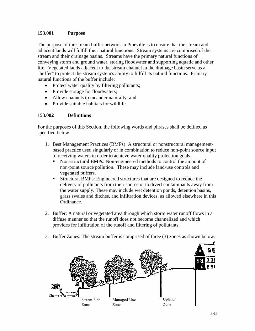
242
153.001 Purpose
The purpose of the stream buffer network in Pineville is to ensure that the stream and
adjacent lands will fulfill their natural functions. Stream systems are comprised of the
stream and their drainage basins. Streams have the primary natural functions of
conveying storm and ground water, storing floodwater and supporting aquatic and other
life. Vegetated lands adjacent to the stream channel in the drainage basin serve as a
"buffer" to protect the stream system's ability to fulfill its natural functions. Primary
natural functions of the buffer include:
• Protect water quality by filtering pollutants;
• Provide storage for floodwaters;
• Allow channels to meander naturally; and
• Provide suitable habitats for wildlife.
153.002 Definitions
For the purposes of this Section, the following words and phrases shall be defined as
specified below.
1. Best Management Practices (BMPs): A structural or nonstructural management-
based practice used singularly or in combination to reduce non-point source input
to receiving waters in order to achieve water quality protection goals.
▪ Non-structural BMPs: Non-engineered methods to control the amount of
nonpoint source pollution. These may include land-use controls and
vegetated buffers.
▪ Structural BMPs: Engineered structures that are designed to reduce the
delivery of pollutants from their source or to divert contaminants away from
the water supply. These may include wet detention ponds, detention basins,
grass swales and ditches, and infiltration devices, as allowed elsewhere in this
Ordinance.
2. Buffer: A natural or vegetated area through which storm water runoff flows in a
diffuse manner so that the runoff does not become channelized and which
provides for infiltration of the runoff and filtering of pollutants.
3. Buffer Zones: The stream buffer is comprised of three (3) zones as shown below.
Stream Side
Zone
Zone
Upland
Zone

243
4. Buffer Widths: Viewed aerially, the stream buffer width is measured horizontally
on a line perpendicular to the surface water, landward from the top of the bank on
each side of the stream.
5. Drainage Basin: The area of land which drains to a given point on a body of
water.
6. Mitigation: Actions taken either on-site or off-site as allowed by this Part to offset
the effects of temporary or permanent loss of the buffer.
7. Stream: A drainage feature on the land surface for conveying water.
8. Top of Bank: The landward edge of the stream channel during high water or
bankfull conditions at the point where the water begins to overflow onto the
floodplain.
153.003 Applicability
1. All properties shall be subject to the buffer requirements of this Section except
those properties which, as of the effective date of April 11, 2000, fit into one of
the following categories:
(a) Have been issued a Certificate of Building Code Compliance.
(b) Have a valid building permit or fill permit.
(c) Have been subdivided by a recorded subdivision plat.
(d) Have been described by metes and bounds in a recorded deed which:
▪ If to be used for residential purposes:
Are 1 acre or less in size.
▪ If to be used for nonresidential purposes:
Are 4 acres or less in size if located on a non-FEMA regulated floodway,
or
Are 7 acres or less in size if located on a FEMA regulated floodway.
(e) Are included on a valid preliminary subdivision plan.
(f) Have otherwise secured a vested property right under State law or local
ordinance, including a fill permit.
2. Redevelopment or expansions to uses included in the above categories are not
subject to the buffer requirements of this Section unless it would result in an
increase in the total impervious area within the buffer.
3. In the event that stream buffers are required by another Section of this Ordinance,
the more stringent stream buffer requirements apply.
153.004 Buffer Standards
Required stream buffer widths vary based on the size of the upstream drainage basin.
Mecklenburg County's Geographic Information System (GIS) will serve as a tool to

244
delineate the size of drainage basins and specify the corresponding buffer widths.
S.W.1.M. stream buffer requirements specified in this Section begin at the point where
the stream drains 100 acres or greater. Refer to the Charlotte-Mecklenburg Storm Water
Design Manual for optional buffers on streams that drain less than 100 acres.
1. Buffer widths for streams draining equal to and greater than 100 acres
Buffers are required for streams draining areas equal to or greater than 100 acres
as specified below. Buffer widths for these streams are measured horizontally on
a line perpendicular to the surface water, landward from the top of the bank on
each side of the stream.
Drainage
Area
Designation
Stream
Side Zone
Managed
Use Zone
Upland
Zone
Total
Width
of Buffer on
each side of
Stream
> 100 acres 20 feet None 15 feet 35 feet
> 300 acres 20 feet 20 feet 10 feet 50 feet
> 640 acres (1) 30 feet 45 feet 25 feet
PLUS 50%
of the
FEMA
Flood Fringe
Area beyond
100 feet
100 feet
PLUS 50%
of the
FEMA
Flood Fringe
Area beyond
100 feet
Footnotes: (1) Buffer widths for drainage areas of > 640 acres:
1. If the floodplain is less than 100 feet wide, the total width of the buffer on
that side of the stream will be 100 feet except as provided in 4. below.
2. The landowner/developer has discretion to designate the buffer zone
beyond the 100-foot minimum. The additional buffer area beyond 100
feet must be contiguous with at least a portion of the required 100-foot
buffer and be configured in such a manner as to benefit water quality.
3. So long as the total buffer width is maintained, the buffer may vary in
width on either side of the stream based on individual stream side
topography provided that the owner(s) control both sides of the stream and
the stream side zone is maintained on both sides of the stream.
2. Buffer description
Buffer function, vegetation and use vary according to the different buffer zones as
described in the following table.
Characteristics Stream Side
Zone Managed Use Zone Upland Zone
Function Protect the
integrity of
the
ecosystems
Provide distance
between upland
development and
the stream side
zone
Prevent
encroachment and
filter runoff
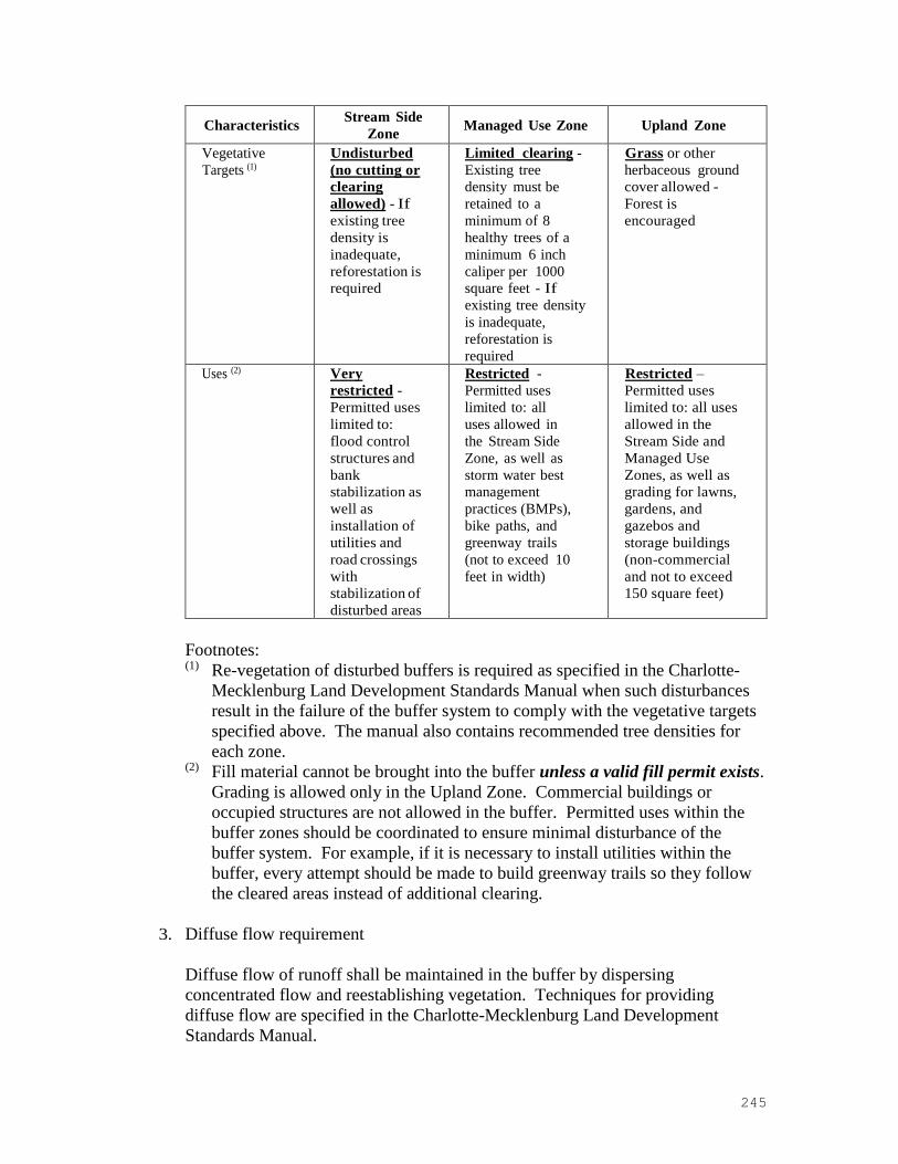
245
Characteristics Stream Side
Zone Managed Use Zone Upland Zone
Vegetative
Targets (1)
Undisturbed
(no cutting or
clearing
allowed) - If
existing tree
density is
inadequate,
reforestation is
required
Limited clearing -
Existing tree
density must be
retained to a
minimum of 8
healthy trees of a
minimum 6 inch
caliper per 1000
square feet - If
existing tree density
is inadequate,
reforestation is
required
Grass or other
herbaceous ground
cover allowed -
Forest is
encouraged
Uses (2) Very
restricted -
Permitted uses
limited to:
flood control
structures and
bank
stabilization as
well as
installation of
utilities and
road crossings
with
stabilization of
disturbed areas
Restricted -
Permitted uses
limited to: all
uses allowed in
the Stream Side
Zone, as well as
storm water best
management
practices (BMPs),
bike paths, and
greenway trails
(not to exceed 10
feet in width)
Restricted –
Permitted uses
limited to: all uses
allowed in the
Stream Side and
Managed Use
Zones, as well as
grading for lawns,
gardens, and
gazebos and
storage buildings
(non-commercial
and not to exceed
150 square feet)
Footnotes: (1) Re-vegetation of disturbed buffers is required as specified in the Charlotte
Mecklenburg Land Development Standards Manual when such disturbances
result in the failure of the buffer system to comply with the vegetative targets
specified above. The manual also contains recommended tree densities for
each zone. (2) Fill material cannot be brought into the buffer unless a valid fill permit exists.
Grading is allowed only in the Upland Zone. Commercial buildings or
occupied structures are not allowed in the buffer. Permitted uses within the
buffer zones should be coordinated to ensure minimal disturbance of the
buffer system. For example, if it is necessary to install utilities within the
buffer, every attempt should be made to build greenway trails so they follow
the cleared areas instead of additional clearing.
3. Diffuse flow requirement
Diffuse flow of runoff shall be maintained in the buffer by dispersing
concentrated flow and reestablishing vegetation. Techniques for providing
diffuse flow are specified in the Charlotte-Mecklenburg Land Development
Standards Manual.

246
(a) Concentrated runoff from ditches or other manmade conveyances shall be
converted to diffuse flow before the runoff enters the buffer.
(b) Periodic corrective action to restore diffuse flow shall be taken by the property
owner as necessary to prevent the formation of erosion gullies.
4. Ponds
Ponds which intersect the stream channel shall have the same buffers as the
original stream measured from the top of the bank of the pond. Buffer
requirements shall not apply to wet ponds used as structural BMPs.
5. Buffer delineation
The following buffer delineations are required:
(a) Streams and buffer boundaries including all buffer zones must be clearly
delineated on all construction plans, including grading and clearing plans,
erosion, drainage and sediment control plans and site plans.
(b) Outside buffer boundaries must be clearly marked on-site prior to any land
disturbing activities.
(c) The outside boundary of the buffer must be permanently marked at highway
stream crossings.
(d) Streams and buffer boundaries including the delineation of each buffer zone
must be specified on all surveys and record plats.
(e) Buffer requirements must be referenced in homeowners' association
documents.
Section 153.005 Incentives
1. Rear setback requirements
For all lots within a residential development requiring a SWIM buffer, rear
setbacks can be 100% within a SWIM buffer.
2. Open space
SWIM buffer areas can be used toward satisfying all or a portion of the required
open space minimums for the development if Town Council determines it is in the
best interest of the Town.
153.006 Mitigation
1. Purpose
The purpose of this Section is to set forth the basis on which mitigation is
required for unavoidable or approved buffer impacts within any of the buffer
zones. This mitigation basis shall allow the property owner or other entity the

247
opportunity to disturb a buffer, provided that steps are taken to offset the buffer
loss. Prior to any buffer impact, any person or entity seeking approval of a buffer
impact shall submit the requisite site and mitigation information for review to the
Charlotte-Mecklenburg Storm Water Services and approval by Town Council as
specified below, to the extent approval is required by this Section.
2. Buffer impacts not requiring mitigation
The following buffer impacts do not require mitigation or specific plan approval
but are required to comply with the specifications provided in the Charlotte-
Mecklenburg Land Development Standards Manual for stabilization of disturbed
areas to minimize negative water quality impacts.
(a) Road crossings for connectivity or transportation links where the Pineville
Planning Board has granted site plan approval.
(b) Utility crossings.
(c) Parallel water and sewer utility installation as approved by Charlotte-
Mecklenburg Utilities.
(d) Public paths and trails parallel to the stream outside the Stream Side Zone and
stream crossings. Pathways must use existing and proposed utility alignments
or previously cleared areas and minimize tree cutting to the maximum extent
practicable. To the extent possible, pathways shall preserve existing drainage
patterns and avoid drainage structures that concentrate storm water.
(e) Incidental drainage improvements/repairs for maintenance.
(f) Individual pedestrian paths connecting homeowners to the stream in the form
of narrow, pervious footpaths with minimal tree disturbance.
(g) New domesticated animal trails (farming) where existing trails are lost as a
result of action beyond the farmer's control. Stream crossings should be
constructed and maintained to minimize impacts to the Stream Side Zone with
fencing perpendicular and through the buffer to direct animal movement.
(h) Mitigation approved by a State or federal agency acting pursuant to Sections
401 or 404 of the federal Clean Water Act.
3. Buffer impacts requiring mitigation
Impacts to stream buffers not specified in Section 153.006.2, proposed to allow
development or other land use in a buffer, shall be required to mitigate or offset
the proposed impact in accordance with this Section. Buffer impacts requiring
mitigation and plan approval include:

248
(a) Filling or piping of streams
(b) Removal of vegetation from the Stream Side or Managed Use Zones other
than as specified by Section 153.004.2 "Vegetative Targets."
(c) Paths proposed within the Stream Side Zone
(d) Stream relocations
(e) Fences and walls requiring tree removal in the Stream Side or Managed Use
Zones
(f) Other buffer impacts not permitted under Section 153.004.2.
The landowner or other entity proposing any of the impacts specified above shall
prepare and submit for review a site specific plan to Charlotte-Mecklenburg
Storm Water Services and for approval by Town Council. This site plan shall
show the extent of the proposed impact and clearly specify the proposed
mitigation technique.
4. Pre-approved mitigation techniques
The following techniques are available to landowners for mitigation of buffer
impacts, upon review and approval of a specific site mitigation plan by Charlotte-
Mecklenburg Storm Water Services. Specifications for these pre-approved
mitigation techniques are provided in the Charlotte-Mecklenburg Land
Development Standards Manual.
(a) Installation of Structural BMPs: The installation of an on-site structural BMP
designed to achieve specified pollutant removal targets will allow for stream
buffer impacts on the specific site. The BMP should remain outside the
Stream Side Zone if practical. A detailed BMP design plan must be submitted
to Charlotte-Mecklenburg Storm Water Services for approval based on
specifications and pollutant removal targets contained in the Charlotte-
Mecklenburg Land Development Standards Manual or the Pineville Zoning
Ordinance. This plan must also include a long-term maintenance strategy for
the BMP complete with the establishment of adequate financing to support the
proposed maintenance practices.
(b) Stream Restoration: The owner may restore and preserve the buffer area on
any stream of equivalent or greater drainage area the condition of which is
determined to be qualified for restoration by Charlotte-Mecklenburg Storm
Water Services on a 1:1 basis in linear feet of stream. This restoration shall
include stream bank improvements and Stream Side and Managed Use Zone
re-vegetation, in accordance with the Charlotte-Mecklenburg Land
Development Standards Manual.
(c) Stream Preservation: The owner may purchase, fee simple, other stream
segments at equivalent or greater drainage area on a 1:1 linear foot basis and
convey fee simple and absolute title to the land to the City/County or other
conservation organization.

249
(d) Wetlands Restoration: On a 2:1 acreage basis for disturbed stream and buffer
area (2 acres of wetland for each acre of disturbed area), the owner may
provide a combination of the preservation and/or restoration of wetlands with
protective easements, and the implementation of structural or non-structural
BMPs to achieve specific pollutant removal targets within the impacted area
as specified in the Charlotte-Mecklenburg Land Development Standards
Manual.
(e) Bottom Land Hardwood Preservation: On a 2:1 acreage basis for impacted
stream and buffer area (2 acres of bottomland hardwood for each acre of
disturbed area), the owner may provide a combination of the preservation of
existing bottom land hardwood forest or other specifically approved natural
heritage area by conservation easement or other legal instrument, and the
implementation of structural or nonstructural BMPs to achieve specific
pollutant removal targets within the impacted area as specified in the
Charlotte-Mecklenburg Land Development Standards Manual.
(f) Controlled Impervious Cover: The owner may commit to, and provide, a
specific site development plan that limits overall site impervious cover equal
to or less than 24%. Development on this basis shall allow for stream buffer
impacts on the specific site. Preservation of the Stream Side Zone is
encouraged.
(g) Open Space Development: The submission of a specific site development
plan which preserves 50% of the total land area as undisturbed open space
shall allow for stream buffer impacts on the specific site.
(h) Mitigation Credits: The purchase of mitigation credits on a 1:1 basis utilizing
linear feet of stream impacted and the prevailing rate of purchase as
established by Charlotte-Mecklenburg Storm Water Services shall allow for
stream buffer impacts on the specific site. Mitigation credits purchased under
any other program (i.e., U.S. Army Corp of Engineers) shall not cover this
requirement unless the issuing agency agrees to relinquish the funds to the
appropriate Town/County agency.
5. Other mitigation techniques
No provision of this Section shall prevent the creative development of alternative
mitigation plans. The owner shall submit such plan with proposed buffer impacts
and detailed mitigation information to Charlotte-Mecklenburg Storm Water
Services for review and to Town Council for approval. The criteria used to judge
the acceptability of any alternative plan shall be the degree to which the plan
addresses the preservation of the four primary natural functions of stream buffers.
Such plans may be submitted in conjunction with a mitigation plan submission to
the U.S. Army Corp of Engineers and N.C. Department of Environment and

250
Natural Resources for proposed stream or wetland impacts. Charlotte-
Mecklenburg Storm Water Services and the Town Council, when considering
proposed mitigation alternatives, shall give equal weight to proposals that utilize
the preservation of unique or endangered habitat or natural areas against proposed
buffer impacts.
6. Posting of financial security required for structural BMPs
When structural BMPs (wet detention ponds and other BMPs) are approved for
mitigation of a buffer disturbance, the approval shall be subject to the owner filing
a surety bond or letter of credit or making other financial arrangements which are
acceptable to Charlotte-Mecklenburg Storm Water Services, in a form which is
satisfactory to the Town Attorney, guaranteeing the installation and maintenance
of the required structural BMPs until the issuance of certificates of occupancy for
seventy-five percent (75%) of all construction which might reasonably be
anticipated to be built within the area which drains into the BMPs, allowing credit
for improvements completed prior to the submission of the final plat. At such
time that this level of occupancy is achieved, written notice thereof must be given
by the owner to Charlotte-Mecklenburg Storm Water Services. The owner must
also verify the adequacy of the maintenance plan for the BMPs including the
necessary financing to support the proposed maintenance practices. Charlotte-
Mecklenburg Storm Water Services will inspect the structural BMPs and verify
the effectiveness of the maintenance plan and if found satisfactory, will within 30
days of the date of the notice notify the owner in writing.
7. Maintenance responsibilities for structural BMPs - Civil Penalties
Maintenance of all structural BMPs shall be the responsibility of the property
owner or his designee. Any person who fails to maintain the required BMPs in
accordance with the approved maintenance plan shall be subject to a civil penalty
of not more than $500. Each day that the violation continues shall constitute a
separate violation. No penalties shall be assessed until the person alleged to be in
violation has been notified in writing of the violation by registered or certified
mail, return receipt requested, or by other means
which are reasonably calculated to give actual notice. The notice shall describe
the nature of the violation with reasonable particularity, specify a reasonable time
period within which the violation must be corrected, and warn that failure to
correct the violation within the time period shall result in assessment of a civil
penalty or other enforcement action.
153.007 Appeals and Variances
Appeals and variances from this Section shall be subject to the provisions of Chapter 2 of
these regulations.


