THE USE OF GEOGRAPHIC NAMES INFORMATION SYSTEM...
45
THE USE OF GEOGRAPHIC NAMES INFORMATION SYSTEM AMONG GOVERNMENT OFFICERS; A CASE STUDY IN TRIPOLI, LIBYA ABOUZED SALAH BERRIM UNIVERSITI SAINS MALAYSIA 2015
-
Upload
nguyencong -
Category
Documents
-
view
213 -
download
0
Transcript of THE USE OF GEOGRAPHIC NAMES INFORMATION SYSTEM...
THE USE OF GEOGRAPHIC NAMES INFORMATION
SYSTEM AMONG GOVERNMENT OFFICERS; A CASE
STUDY IN TRIPOLI, LIBYA
ABOUZED SALAH BERRIM
UNIVERSITI SAINS MALAYSIA
2015

THE USE OF GEOGRAPHIC NAMES INFORMATION
SYSTEM AMONG GOVERNMENT OFFICERS; A CASE
STUDY IN TRIPOLI, LIBYA
BY
ABOUZED SALAH BERRIM
Thesis submitted in fulfillment of the requirements for the degree
of Doctor Philosophy
July 2015

ii
1 ACKNOWLEDGEMENT
The PhD program at the Universiti Sains Malaysia was a wonderful growth and
learning experience for me. I have gained a great deal of knowledge which will help
me personally and professionally. First and foremost, my deepest gratitude and
thanks goes to Allah. Without his will and generosity, either this journey or any other
accomplishment would not have been possible. I would like to express my sincere
gratitude to my supervisor and Dean School of Distance Education, Associate
professor Habibah Hj Lateh. I generously thank her for her time, expertise and moral
guidance throughout my study. I wish to express my sincere thanks and gratitude to
the officers of the Libyan Survey Department for opening their doors to me at all
times regardless day or night for answering the questionnaires. While in the field I
have received help and encouragement from a number of government officials, and I
found most of them willing to talk about modern times. I would also like to thank the
manager of the National Survey Authority in Libya. I would like to express my
gratitude to the Libyan Ministry for their financial support. My thanks to the
Department of Planning and Scientific Research for providing me with both valuable
historical documents and references.
I wish to acknowledge my greatest debt to my family particularly to my wife. They
never stop encouraging me to finish this thesis and they suffered most because of my
academic interests. I would also like to thank my son, Ayeman who is doing his
bachelor’s degree in Civil Engineering at Infrastructure University Kuala Lumpur,
for his ongoing support, my heartfelt thanks to all other individuals and groups that
have contributed in numerous ways to the success of this work. I say, ‘Thank you all
and God bless.
iii
2 TABLES OF CONTENTS Page
ACKNOWLEDGEMENT ....................................................................................... ii
Tables of Contents ................................................................................................. iii
LIST OF TABLES ................................................................................................... xi
LIST OF FIGURES ................................................................................................ xv
LIST OF APPENDIX ............................................................................................ xvi
ABSTRAK ........................................................................................................... xvii
ABSTRACT ........................................................................................................... xix
CHAPTER 1- INTRODUCTION
1.1 Introduction....……………………………………………………………………………………………………..1
1.2 Background of the Study ................................................................................ 3
1.2.1 Location and Population of Libya ..................................................... 3
1.2.2 Geographic Names in the Libyan Context ........................................ 5
1.3 Problem Statement .......................................................................................... 8
1.4 Aim and Scope............................................................................................... 8
1.5 Research Questions ....................................................................................... 10
1.6 Research Objectives ..................................................................................... 11

iv
1.7 Research Hypotheses .................................................................................... 11
1.7.1 Organizational Factors .................................................................... 13
1.7.1.1 Top Management Support …………………..……...……...12
1.7.1.2 Training.........................................................................…...13
1.7.2 Technological Factors ..................................................................... 14
1.7.2.1 Perceived Usefulness……………..……………...……..…...14
1.7.2.2 Perceived Ease of Use…………………………………………………..14
1.7.3 Individual Factors ........................................................................... 15
1.7.3.1 Social Influence ....................................................................... 16
1.7.3.2 Users’ Awareness and Acceptance .......................................... 16
1.7.3.3 Trust ......................................................................................... 15
1.7.3.4 User Attitude ............................................................................ 17
1.8 Research Framework .................................................................................... 17
1.9 Significance of the Study .............................................................................. 22
1.10 Organization of the Thesis ............................................................................ 23
1.11 Operational Definitions ................................................................................ 24
1.12 Chapter Summary ......................................................................................... 25
v
CHAPTER 2- LITERATURE REVIEW
2.1 Introduction .................................................................................................. 26
2.2 Geographic Names ....................................................................................... 27
2.2.1 Function of Names .......................................................................... 34
2.2.2 Identification ................................................................................... 35
2.2.3 Location .......................................................................................... 35
2.2.4 Classification ................................................................................... 35
2.3 Contributions of Muslims Scholars to Geographical Names ....................... 36
2.4 Standardization of Geographical Names ...................................................... 37
2.4.1 Maps, Name Features and Technology ........................................... 39
2.4.2 Naming of places ............................................................................ 41
2.5 Background of Geographic Names in Tripoli .............................................. 49
2.5.1 Tripoli under the Phoenicians Rule ................................................. 50
2.5.2 Tripoli and Greece Time ................................................................. 52
2.5.3 Tripoli and the Roman Time ........................................................... 52
2.5.4 Tripoli and the Vandals Time ......................................................... 53
2.5.5 Arab Islamic conquest of Tripoli .................................................... 53
2.5.6 Libya under the Ottomans Time ..................................................... 55
vi
2.5.7 Tripoli and Italian rule .................................................................... 57
2.5.8 Modern Tripoli ................................................................................ 60
2.5.9 The Cultural Dimension of Tripoli: A Geographical Names
Changes .................................................... …………………………………66
2.5.10 Culture and social transformation in Tripoli ................................... 66
2.6 Geographic Information System (GIS) ......................................................... 71
2.6.1 Applications of Geographic Information System (GIS) ................. 72
2.7 Geographic Names Information System (GNIS) .......................................... 76
2.7.1 The Geographic Information System and Geographic Names
information System Technologies and Name Features. .................................. 78
2.8 Technology Acceptance ............................................................................... 82
2.8.1 The Theory of Reasoned Action (TRA) .......................................... 83
2.8.2 The Theory of Planned Behaviour (TPB) ....................................... 84
2.8.3 The Technology Acceptance Model (TAM) ................................... 85
2.8.4 Limitation of the Technology Acceptance Model .......................... 87
2.9 Geographical Names Information System (GNIS) Factors .......................... 88
2.9.1 Organizational Factors .................................................................... 89
2.9.1.1 Top management support ................................................................. 89

vii
2.9.1.2 Training ........................................................................................... 91
2.9.2 Technological Factors ..................................................................... 92
2.9.2.1 Perceived Usefulness ....................................................................... 92
2.9.2.2 Perceived ease of use ....................................................................... 94
2.9.3 Individual Factors ........................................................................... 95
2.9.3.1 Social Influence…………………………………………………...95
2.9.3.2 Technology awareness and acceptance ........................................... 96
2.9.3.3 User attitude .................................................................................... 96
2.9.3.4 User trust ........................................................................................ 97
2.10 Chapter Summary ......................................................................................... 99
CHAPTER 3 - RESEARCH METHODOLOGY
3.1 Introduction ............................................................................................... 100
3.2 Research Design ........................................................................................ 100
3.3 Research Methods ....................................................................................... 102
3.3.1 Research Approaches ..................................................................... 104
3.3.1.1 Quantitative Research .................................................................... 104
3.3.1.2 Types of Survey research ............................................................. 105

viii
3.3.2 Population and Sample .................................................................. 106
3.3.3 The Structure of Libyan Survey Department in Tripoli Libya ......... 108
3.4 Data Collection Methods ............................................................................ 109
3.4.1 Primary Data ................................................................................. 110
3.4.2 Secondary Data ............................................................................ 111
3.5 Measurement and Instrumentation ............................................................. 113
3.6 Data Analysis .............................................................................................. 115
3.6.1 Reliability and Validity of Instrument .......................................... 116
3.6.2 Descriptive Statistics Analysis ..................................................... 117
3.6.3 Factors Analysis……………………………………………………… 117
3.6.4 ANOVA……………………………………………….…………118
3.7 Chapter Summary ...................................................................................... 119
CHAPTER 4 - DATA ANALYSIS AND DISCUSSION
4.1 Introduction ................................................................................................ 121
4.2 Profile of respondents ................................................................................. 121
4.3 Crosstabs of Demographic Variables ......................................................... 124
4.3.1 Gender ........................................................................................... 124

ix
4.3.2 Education ..................................................................................... 127
4.4 Reliability Testing ...................................................................................... 132
4.5 Factor Analysis ........................................................................................... 133
4.5.1 Independent Variables (Predictors) ............................................... 134
4.5.1.1Top Management Support…………………………………134
4.5.1.2 Training………………………………………………...…135
4.5.1.3 Usefulness of the GNIS ...................................................... 137
4.5.1.4 Perceived Ease of Use of the GNIS .................................... 138
4.5.1.5 Technology Awareness and Acceptance ............................ 140
4.5.1.6 Social Influence .................................................................. 141
4.5.1.7 User Trust in the GNIS Technology ................................... 143
4.5.1.8 Attitude towards the GNIS ................................................ 144
4.5.2 Dependent Variables (outcome) ...................................................... 145
4.5.3 Hypotheses Testing .......................................................................... 147
4.6 Results of Correlations and Multiple Regressions ........................................ 148
4.7 Discussion and Findings ................................................................................ 154
4.7.1 Research Question One ................................................................... 154
4.7.2 Research Question Two ................................................................... 161

x
4.7.3 Research Question Three ................................................................. 162
4.7.4 Research Question Four ................................................................... 163
4.7.5 Research Question Five ................................................................... 165
4.8 Chapter Summary ...................................................................................... 166
CHAPTER 5 -CONCLUSION
5.1 Introduction ............................................................................................... 157
5.2 Contribution of the Study .......................................................................... 173
5.3 Implications and Future Research ............................................................. 173
5.4 Recommendations ..................................................................................... 178
5.5 Conclusion ................................................................................................. 180
REFERENCES .................................................................................................... 182
APPENDIX
3
4

xi
5 LIST OF TABLES
Table Page
1. 1 Summary of Research Hypotheses ................................................................ 18
1. 2 Summary of research question, objective and hypothesis ............................. 21
2. 1 Some Current Applications of Geographical Information Systems (GIS)..... 73
3. 1 Characteristics between quantitative and qualitative research ..................... 102
3.2 Survey Items...............................................................................................102
3.3 Variable Items................................................................................................106
3. 4 Model Variables and Measurement items .................................................... 115
4. 1 Profiles of Respondents ............................................................................... 122
4. 2 Gender Level Management Cross tabulation ............................................. 124
4. 3 Gender Experience cross tabulation ............................................................ 125
4. 4 Gender Computer Software Cross tabulation .............................................. 126
4. 5 Gender Information System Cross tabulation ............................................... 127
4.6 Education Level Management Cross tabulation ........................................... 128
4. 7 Education Experience Cross tabulation ........................................................ 129
4. 8 Education Computer Software Cross tabulation ........................................... 130
4. 9 Education Information System Cross tabulation........................................... 131

xii
4. 10 Reliability Measurement ............................................................................ 133
4. 11 Top Management Support Construct Items Statistics ................................ 134
4. 12 TMS Construct Inter-Item Correlation Matrix ........................................... 135
4. 13 Training Construct Item descriptive Statistics ........................................... 136
4. 14 TRAIN Inter-Item Correlation Matrix ...................................................... 136
4. 15 Perceived Usefulness Items Descriptive Statistics .................................... 137
4. 16 PU Inter-Item Correlation Matrix ............................................................. 138
4. 17 Perceived Ease of Use Items Descriptive Statistics ................................... 139
4. 18 PEOU Inter-Items Correlation Matrix ..................................................... 139
4. 19 AWARE Items Descriptive Statistics ........................................................ 140
4. 20 AWARE Inter-Item Correlation Matrix .................................................... 141
4. 21 Social Influence Items Descriptive Statistics ............................................. 142
4. 22 SOC Inter-Item Correlation Matrix ........................................................... 142
4. 23 Trust Items Descriptive Statistics .............................................................. 143
4. 24 TRUST Inter-Item Correlation Matrix ...................................................... 144
4. 25 Attitude Items Descriptive Statistics .......................................................... 144
4. 26 Attitude Inter-Item Correlation Matrix ...................................................... 145
4. 27 Intention Items Descriptive Statistics......................................................... 146

xiii
4. 28 INT Inter-Item Correlation Matrix ............................................................ 146
4. 29 Research hypotheses .................................................................................. 147
4. 30 Variables and Construct Items ................................................................... 148
4. 31 Descriptive Statistics .................................................................................. 149
4. 32 Model Constructs’ Correlations ................................................................. 150
4. 33 Regression Model Analysis between Independent Variables and Dependent
Variables ................................................................................................... 151
4. 34 ANOVAa ................................................................................................... 152
4. 35 Collinearity Diagnostics ............................................................................ 153
4. 36 Summary of Overall Research Hypotheses............................................... 154
4. 37 Level of Management ............................................................................... 156
4. 38 Level of Management (%) ........................................................................ 156
4. 39 Gender ....................................................................................................... 157
4. 40 Gender (%) ................................................................................................ 157
4. 41 Age ............................................................................................................. 158
4. 42 Age (%) ...................................................................................................... 158
4. 43 Education ................................................................................................... 159
4. 44 Education (%)............................................................................................. 159

xiv
4. 45 Experience .................................................................................................. 160
4. 46 Experience (%) ........................................................................................... 160
6
xv
7 LIST OF FIGURES
FIGURE PAGE
1. 1 Political Boundaries and Major Cities of Libya .............................................. 4
1. 2 Research Frameworks ................................................................................... 20
2. 1 The Technology Acceptance Model ............................................................. 86

xvi
8 LIST OF APPENDIX
Appendix A - Study Questionnaire
Appendix-B - Linear Regressions Results
Appendix C - Distribution and Normality Testing for Support

xvii
KEINGINAN MENGGUNAKAN GNIS DALAM KALANGAN PEGAWTI
KERAJAAN; SATU KAJIAN KES DI TRIPOLI, LIBYA
9 ABSTRAK
Teknologi merupakan kunci utama bagi negara-negara membangun untuk
menggalakkan pertumbuhan ekonomi, kekayaan, martabat dan daya saing. Teknologi
diiktiraf sebagai faktor utama yang meningkatkan keberkesanan dan kecekapan
prestasi kerajaan. Di Libya, Sistem Maklumat Geografi (GIS) dan Sistem Maklumat
Nama Geografi (GNIS) telah diiktiraf sebagai alat yang berkesan untuk
menyelesaikan cabaran yang dihadapi oleh kerajaan. Namun, kesukaran
mengadaptasi teknologi dan kekurangan sumber tenaga mahir dari segi teknikal yang
boleh mengadaptasi teknologi GNIS mengehadkan penggunaannya. Tesis ini
bertujuan untuk menyiasat keinginan pegawai-pegawai kerajaan di Libya terhadap
penggunaan GNIS. Manakala tujuan utama tesis ini adalah untuk mengkaji tahap
keinginan penggunaan Sistem Maklumat Nama Geografi (GNIS) dalam kalangan
kakitangan kerajaan jabatan kaji selidik di bandar Tripoli, Libya dan menganalisis
hubungan antara faktor-faktor organisasi dan keinginan untuk menggunakan GNIS
dalam kalangan pegawai kerajaan di Libya. Kedua; menganalisis hubungan antara
faktor-faktor teknologi dan keinginan menggunakan GNIS dalam kalangan pegawai
kerajaan di Libya. Ketiga; menganalisis hubungan antara faktor-faktor individu dan
keinginan untuk menggunakan GNIS dalam kalangan pegawai kerajaan di Libya.
Terakhir; bagi menentukan faktor-faktor signifikan yang mempengaruhi penggunaan
Sistem Maklumat Geografi. Kajian kuantitatif yang digunakan adalah kaedah soal
selidik, yang diedarkan dalam kalangan pegawai-pegawai kerajaan (GNIS) di Libya.
xviii
Analisis statistik deskriptif dan analisis regresi telah digunakan dalam kajian ini.
ANOVA digunakan untuk memastikan kesahihan dan kebolehpercayaan soal selidik
kajian dan itemnya. Analisis korelasi menilai hubungan antara pembolehubah tak
bersandar dan pembolehubah bersandar. Hasil kajian menunjukkan, tiga
pembolehubah; Latihan, Persepsi mudah digunakan dan Kesedaran adalah
berkolerasi negatif dengan keinginan untuk menggunakan GNIS dalam kalangan
pegawai-pegawai kerajaan di Libya. Kepercayaan (t = 6.348, korelasi R = 0.448)
dikenal pasti sebagai faktor yang paling berhubungkait, diikuti dengan sikap yang
positif terhadap GNIS (t = 4.162, korelasi R = 0.236).Hasil dapatan geografi
mengesahkan bahawa sistem maklumat adalah penting dalam meningkatkan mutu
kerja Jabatan Ukur di Libya, Jabatan Kajian. Kakitangan kerajaan percaya bahawa
dengan penggunaa nteknologi GNIS dapat membantu mereka dalam
penambahbaikan terhadap persekitaran perkerjaan. Lantaran itu, organisasi yang
terlibat harus sedar akan kepentingan faktor ini. Pembuat keputusan sepatutnya harus
tahu keberkesanan sistem ini sebelum mengaplikasikan secara menyeluruh, dan
mereka juga perlu mengambil perhatian dan peka terhadap pendapat dan kehendak
pengguna untuk mempertahankan sebarang tentangan terhadap teknologi GNIS ini.

xix
THE USE OF GNIS AMONG GOVERNMENT OFFICERS; A CASE STUDY
IN TRIPOLI, LIBYA
10 ABSTRACT
Technology has been regarded as a main key of countries developing in economic
growth, wealth, prestige and competitiveness. Technology has also recognized to be
a decisive tool for advancing the effectiveness and efficiency of government
performance. The Geographic Information Systems (GIS) and Geographic Name
Information System (GNIS) have been recognized as effective tools to solve the
challenges that faced by the government. The main challenges are; to cope with new
technology and the lack of technical human resources who can easily cope and adopt
with the GNIS technology. This thesis designed to investigate the intention towards
the use of the GNIS among government officers in Libya. The main objective of this
thesis is to investigate the level of intention to use (GNIS) among government
employees of the survey department at Tripoli city Libya, To analyze the relationship
between the organizational factors and intention to use GNIS among government
officers in Libya, To analyze the relationship between technological factors and
intention to use GNIS among government officers in Libya, To analyze the
relationship between the individual factors and intention to use GNIS among
government officers in Libya and To determine the significant factors that affects the
use of (GNIS) in Libya. This quantitative method research uses survey questionnaire
that was distributed among the Libya government officers. The statistic descriptive
analysis and the regression analysis have been used in this research. The ANOVA
has been used to ensure the validity and reliability of the research questionnaire and

xx
its items. The correlation analysis measures the relationship between the independent
variables and the dependent variables. The correlation analysis measures the
relationship between the independent variables and the dependent variables. The
result shows, three variables; Training, Perceived ease of use and Awareness are
negatively correlated with the intention to use GNIS among the government officers
in Libya. Trust (t= 6.348, correlation R= 0.448) is identified as the most correlating
factor, followed by attitude towards GNIS (t=4.162, correlation R= 0.236).The
findings confirmed that geographic names information system as important in
upgrading the workers in Libyan Survey Department. Thus, Government employees
in the Survey Department believe that the use of GNIS technologies can provide a
sufficient improvement in performance in their work environment. Therefore,
organizations should be aware of the importance of these factors. Policy makers
should assess the usefulness of the system before implementing it fully, and should
pay attention to the users' opinions and demands to prevent any resistance to the
GNIS technologies.

1
11 CHAPTER 1
INTRODUCTION
1.1 Introduction
The phenomenon of geographic names’ features has received attention among
behavioural researchers over the years. Generally, the geographic names landscape of
any country is a window that reflects the historical cultural political and most social
variables of society (Muehrecke, 1992).Thus, names given to places indicate the
essence and existence of a place, as well as the people living there. Similarly, names
usually have very strong historical ties to an area, and it is self-inclusive in terms of
the history of place. In other words, a name is itself a form of living history carrying
with it a multitude of facts and emotions. Whether places are urban or rural, the
unique features of these places can distinguish from neighbouring places. It is largely
for this reason, that it is difficult to change an already existing name for a place.
Names of various places that were derived as a result of historical events, help make
the area become synonymous with the event in the minds of the general populace and
the inhabitant in particular (Powicke et al., 1954). Some of the places named or
synonymous with religious or political events, gain even more fame than the religion
and the political system that are embraced by a large number of people. Few of such
cities include (e.g. Makah and Medina in Saudi Arabia, and the Vatican in Rome),
these places are the holy places for Muslims and Christians. The name of the place is
synonymous to Islam and Christianity, due to the religious and historical background
2
of the area. The Mediterranean Sea, the Arabic Gulf, Tripoli, Benghazi, Kuala
Lumpur, New York, Cameron Highlands, and Langkawi Island, are all names of
places that automatically bring to mind their exact geographical location, due to their
functions and activities. Some names gain deeper significance particularly, when the
information on the history of the location of reference are explicitly conveyed in their
meaning. For instance the name ‘Tripoli’ means, ‘three cities’ and this simply tells a
lot about the history of that place.
Names of many places have experienced various controversies such as authenticity
of the name and changing of the name for political reasons. Consequently, people
who are more attached to the names of the place religiously or politically have more
reasons to the situation which may be termed usurpation. Thus when local people’s
spatial definition of a place differs from administrative definitions of the area with
the same name, the researcher would have to take this into account when researching
the locale, be it a district, field place, cover, opinion, area, neighbourhood or zone
among others (Feld et al., 1996; Hirsch, 1995).
Traditionally, place names are passed orally from one generation to the other.
However, written communication has been intimidating these rich spoken
civilizations and it has been observed that much will be lost except systematic
programmers are introduced to record and preserve oral traditions (Canadian
Permanent Committee on Geographical Names, C.P.C.G.N., 1992). As a part of
locking local languages and traditional heritage, both native populations and non-
native forms are taking steps to ensure that place names are collected and preserved.

3
Among the major reasons for this initiative is that local names often carry with it the
importance of the place to the people geographically, historically, socially, politically
and so on (C.P.C.G.N., 1992).
1.2 Background of the Study
1.2.1 Location and Population of Libya
Libya, located at 19° - 34° N and 10° - 25° E, is one of the fames countries in North
Africa. It is bounded by Egypt in the east (1150 km), Algeria (982 km) and Tunisia
in the west (459 km), the Mediterranean Sea in the north (1700 km), and by Sudan
(382 km), Chad (1054 km) and Niger (355 km) in the south (Libyan Department of
Urban Planning, 2005). Sharing boarders with many countries, positions Libya at a
strategic geographical location at the midpoint of northern frame of African
continents. Similarly, this strategic location has granted Libya significant historical,
cultural and political record. The total area of Libya is approximately 1,750,000
(square kilometres), thus ranks third largest among African countries and ranks
fifteenth in the world, by land mass (Bait-EI-Mall, 1973).
More than 95% of Libya is made up of the Sahara desert which is readily
acknowledged as one of the driest and barren places on Earth. Living conditions in
the Sahara are indeed severe. The dryness of central eastern Sahara because its
command by central tropical air all around the year, which continually descends from
the upper levels of the atmosphere where, in these spaces, there are enduring high
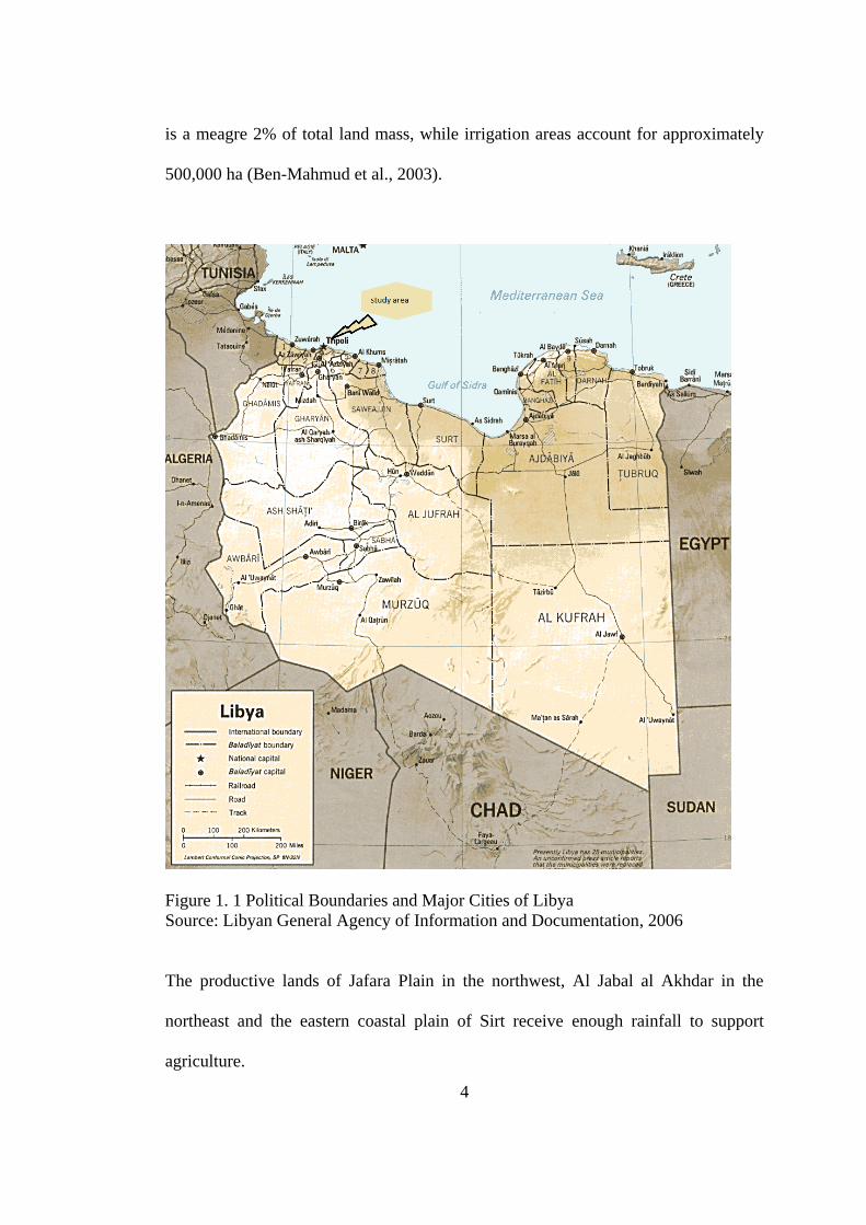
pressure conditions. The land mass as shown in Figure 1.1 susceptible to cultivation
4
is a meagre 2% of total land mass, while irrigation areas account for approximately
500,000 ha (Ben-Mahmud et al., 2003).
Figure 1. 1 Political Boundaries and Major Cities of Libya
Source: Libyan General Agency of Information and Documentation, 2006
The productive lands of Jafara Plain in the northwest, Al Jabal al Akhdar in the
northeast and the eastern coastal plain of Sirt receive enough rainfall to support
agriculture.

5
As a result, more than 90% of the Libyan population reside there (Emgaili, 1995).
Between the productive sea-level agriculture regions, lies the Gulf of Sirt that
stretches 500 km along the coast from which deserts spread northward to the sea.
Libya’s total population was 5.3 million in 2006 with more than 500,000 non-
nationals. (Libyan General Agency of Information and Documentation, 2006).
According to Libyan General Agency of Information and Documentation in (2006),
approximately 94 % of the people lives in the north, and the rest in extensively
dispersed oases in mid- and southern Libya. As a result of the large spatial area
consumed by the desolate Sahara, every human inhabitation is understandably
associated with water resources. Being as such, many of the names marking
significant geographical locations can be traced back to signify some importance of
the water resource. An example of this is the large number of geographical names of
the wells in Libya.
1.2.2 Geographic Names in the Libyan Context
Geographic names are an essential element of human relationship with its physical
and cultural environments, because naming of places represents both the
geographical and cultural use of a space (Al Zoqurti, 1997). However many
controversies have trailed this phenomenon universally, and such cases have been
reported in Libya as a result of inaccurate information gathering done by the United
States Army in 1962. In addition, an attempt to convert a place’s information such as
the maps into digital forms became noticeable that different scales were used for

6
different areas of the country (Libyan Survey Department, 1975). For example,
1:25,000 was used for some coastal areas, instead of the general 1:50,000. Such
attempts particularly by the Unites States Army are few of the cultural insensitivity
and imposition of their sentiment to the geographical and cultural sensitivities of
Libya and its peoples. As a result of such imposition and inconsistencies, there is a
demand for accurate and uniform geographic data both in their digital and non-digital
forms that preserves the cultural history and diversity of Libya.
Traditionally, names of places are approved and transmitted orally from one
generation to another, however, in recent times the trend has not only involved the
oral route and writing, but this has been extended to cartographic, audio and
information technology routes (Hamilton, 1978). The local societies and non-native
organizations are now attractive stages to ensure that place names are collected as a
part of locking native tongues and cultural traditions (Kraft et al., 1997). Names of
places in terms of its spatial dimension is a result of considerations the locale, be it a
district, field place, cover, opinion, area, neighbourhood or zone among others
(Dalton, 1978).
There were few arrangements to coordinate the mapping, surveying and naming of
places in Libya, particularly during the nineteenth and early twentieth century. While
the researcher was working with Libyan Survey Department from 1990 to 2008, it
was found that there were some challenging issues related to the use and organization
of place names. And such names include lack of databases and the illogicality of
place names due to the proliferation of related private and public agencies. Various

7
authorities approved to determine the names of places within their areas of
jurisdiction, were responsible to choose names based on local usage in due
consideration to its cultural heritage, history and religious significance (Cleere,
1995).
The majority of geographic place names are presented from local settlement patterns
and reflects their needs, patterns of society, and events, in the local community life
which is inclusive in their norms and culture (Libyan Survey Department, LSD,
1975). In view of this, present processes for naming places and features, in most
instances, make local communities the decisive factor for the determination of new
names or alterations to place names. For this reason the determination of place names
has mostly, but not exclusively, been devolved to the LSD in Libya.
The development of geographical place names in Libya is ongoing and it important
things role in the nation’s governance ranging from elections, to basic public
services, numerical data compilation, financial aid, security, defence and public
safety, as well as others accountabilities of the government (Libyan Survey
Department , 2007). Standardizing the application form of geographical names and
their submission is becoming more and more necessary in order to develop highly
accurate maps and charts of large-scale advanced transportation, communications,
emergency services and dispatch based on date and geographic mapping data names
(Helen, 2003).
8
The United Nation, (2002) has identified geographical names in both written and
spoken forms as important rudiments of culture due the fact that they are formidable
part of the cultural heritage of countries and are part of the verbal and written
communication in daily activities of the people (Eyuce, 2007). It is observed that
place names are possibly the most normally and broadly used form place names
information. Clear, definite, unmistakable designations for inhabited places and
physical landscapes are important for supply of goods, growth and planning in every
country. They provide an important reference system for communication and
transportation. Every name appears easy, but with rising demands and improvement
in technology, the accuracy of information regarding place names is important and
sometimes serious (Helleland, 2002).
1.3 Problem Statement
Global competition requires expansion of their borders like never before, which
requires efficiency and innovation in all aspects of their business. These challenges
have driven the organizations, worldwide, to turn to Geographic Names Information
Systems (GNIS). This is in accordance to the fact that the significance and
importance of geographical names in human lives cannot be disregarded any longer
(Rodgers et al., 1959). Not only are such names significant in Geography to
recognize places but are also significant in many other fields of sciences such as
history, social sciences and politics among others. Moreover, there remains, to date,
limited studies which have strongly in analysed and justified importance of names,
its collection, documentation and standardization in Libya. Actually, there exist no

9
complete database of geographical names and no standardized frameworks for the
collection, arrangement, change and documentation of geographical names in Libya.
One of the fundamental challenges related to the use and management of
geographical names in Libya is the lack of databases. In some cases there are
contradictions of place names due many establishments that were set up to deal with
these names (LSD, 1973). Therefore, this challenge serves as motivation for this
research which primarily focuses on Libya. Other challenges such as lack of
application of new technology, such as the GIS and the GNIS, in managing
geographical names as well as shortage of studies and frameworks that investigate
the effect of the using of these technologies, are core concern for this study. Factors
affecting the Intention to use of GNIS need to be investigating in order to solve the
problems of using new technology such as GNIS among government officer in
Libya.
1.4 Aim and Scope
The innovative use of technology is not an end in itself, but simply a means to enable
better decision making and facilitate sustainable development processes. GNIS
provides that process in all of the case studies identified.
The main aim of this research is to study the use of Geographical Names Information
System (GNIS) among government officers in Tripoli, Libya.
In order to achieve the aim of the research the scope of the study covers the use of
geographic names information system in Tripoli focusing on government employees
of the Survey Department in Tripoli, Libya as case study.

10
The major aspects of study lead to the success of GNIS implementation that depends
on a suitable information technology. A new implementation model must be able to
identify and measure the impact of information technology deficiencies. This will
cover and focusing in factors such as organizational factor, technological factor and
individual factors. This study is hoped to encourage more government officers to use
GNIS in their technology in future time.
1.5 Research Questions
Research questions were drafted to carry out the research in proper manner. The
research questions that were drawn in this study are, as following:
1. What is the level of usage of Geographical Names Information System (GNIS)
among government employees of the Survey Department in Tripoli, Libya?
2. Does the organizational factor affect the use of GNIS among the government
officers in Libya?
3. Does the technological factor affect the use of GNIS among the government
officers in Libya?
4. Does the individual factor affect the use of GNIS among government officers in
Libya?
5. What are the factors that affect the use of Geographical Names Information
System (GNIS) in Libya?

11
1.6 Research Objectives
The objectives of this study are:
1. To investigate the level of usage of Geographical Names Information System
(GNIS) among government employees of the Survey Department in Tripoli, Libya.
2. To analyse the relationship between the organizational factors and the use of GNIS
among government officers in Libya.
3. To analyse the relationship between technological factors and the use of GNIS
among government officers in Libya.
4. To analyse the relationship between the individual factors and the use of GNIS
among government officers in Libya.
5. To determine the significant factors that affects the use of Geographic Names
Information System (GNIS) in Libya.
1.7 Research Hypotheses
Based on the literature review, the following research hypotheses relating to various
factors which affect the intention to use the GNIS are investigated in this study. The
first two hypotheses test the influence of organizational factors, as top management
support and training, on the intention to use the GNIS. The other two hypotheses
test the impact of technological factors, such as perceived ease of use and perceived
usefulness, on intention to use the GNIS. Lastly, the next four hypotheses test the
impact of individual factors such as social influence, technology awareness and
acceptance, user’s trust and attitude towards GNIS technology and the intention to

12
use. The co-alignment between these factors is very vital in understanding the
intention to use because it highlights the influences of the four effects on this
intention. The hypotheses formulated for the research are as follows.
H1: Top management support has a positive effect on the use of GNIS among
government officers in Libya.
H2: Training has a positive effect on the use of GNIS among government officers in
Libya.
H3: Perceived usefulness has a positive effect on the use of GNIS among
government officers in Libya.
H4: Perceived ease of use has a positive effect on the use of GNIS among
government officers in Libya.
H5: Social influence has a positive effect on the use of GNIS among government
officers in Libya.
H6: Users’ awareness and acceptance has a positive effect on the use of GNIS
among government officers in Libya.
H7: Trust has a positive effect on the use of GNIS among government officers in
Libya.
H8: User attitude has a positive effect on the use of GNIS among government
officers in Libya.

13
1.7.1 Organizational Factors
Two organizational factors that were found dominant with the intention to use new
technology are top management support and training.
1.7.1.1 Top Management Support
Top management support is defined as “the senior executives’ favorable attitude
towards an explicit support for information systems” (Yap, 1989). A large size of
studies that have been conducted by many researches from different disciplines
confirmed the importance of top management support as a key organizational factor
within organizations that adopt technology (Al-Gahtani and King, 1999). The main
support of the top management is to ensure the strategic value of the technologies,
the participation in the adoption of activities and the motivation for the employees to
use this technology. Therefore, this current study suggests the following hypotheses:
H1: Top management support has a positive effect on the use of GNIS among
government officers in Libya.
1.7.1.2 Training
Nelson and Cheney (1987) define training as a “formal effort to transfer required
information systems knowledge such as information systems concepts, technical and
organizational skills and knowledge about specific information systems products”.
Furthermore, McCrae and Costa’s (1987) opinion is that when the trainee comes into
14
a specific assign training program, a critical success factor would be how this
individual absorbs this training and how he applies them in his/her job. However,
many organizations consider training as a critical component in their organizational
strategy. Therefore, this current study suggests the following hypotheses:
H2: Training has a positive effect on the use of GNIS among government officers in
Libya.
1.7.2 Technological Factors
Perceived usefulness and perceived ease of use are the two factors that were
identified as the technological factors that affect the use of GNIS among the Libyan
government officers.
1.7.2.1 Perceived Usefulness
Perceived usefulness is defined as “the degree to which a person believes that using a
particular system would enhance his or her job performance” (Davis, 1989).
Therefore, users of the GNIS will approve the system, only if they believe that the
system is of advantage such as plummeting time spent and improving efficiency
(Rao et al., 2003). Similarly, Davis et al. (1989) study perceived usefulness as a
direct predictor of the customer’s intention to use the new technology. Hu et al.
(2005) found that perceived ease of use describes system usefulness in terms of
improved production and performance as well as decrease in the amount of effort,
time and money. It is expected that the application of the GNIS will effectively

15
manage geographic feature names. Therefore, this current study suggests the
following hypotheses:
H3: Perceived usefulness has a positive effect on the use of GNIS among
government officers in Libya.
1.7.2.2 Perceived Ease of Use
Similar to perceived usefulness, ‘perceived ease of use’ is copied from the
Technology Accept Model (TAM). Although customers may believe that the given
application is useful, yet they believe the system is difficult to use (Davis, 1989).
Therefore, this current study suggests the following hypotheses:
H4: Perceived ease of use has a positive effect on the use of GNIS among
government officers in Libya.
1.7.3 Individual Factors
There are four individual factors that affect the intention to use GNIS among the
government officers. Social influence, users’ awareness and acceptance, trust and
user attitude are the individual factors engaged in this present study.
16
1.7.3.1 Social Influence
Social influence is defined as “the degree to which an individual perceives that
important others believe he or she should use the new system” (Venkatesh et al.,
2003). In the literature, social influence has surfaced as a direct determinant of
behavioural intention in various forms such as subjective norm and social factors
(Davis et al., 1989; Thompson et al., 2000). Considering the complexity in the
management of geographic names feature, social influence could be a powerful
determinant of intention to use among official government employees. Therefore,
this current study suggests the following hypotheses:
H5: Social influence has a positive effect on the use of GNIS among government
officers in Libya.
1.7.3.2 Users’ Awareness and Acceptance
Many researchers have shown that the participation and acceptance of end users for
information technology has direct impact on the level of adoption within an
organization (Doll and Torkzadej, 1988; Yang et al., 2004). Therefore, this current
study suggests:
H6: Users’ awareness and acceptance has a positive effect on the use of GNIS among
government officers in Libya.
17
1.7.3.3 Trust
Trust is an important element which affects consumer behaviour and this determines
the success of technology adoption (Yanga et al., 2004). Amin (2007) confirms that
trust is the core of system application, while Chong et al., (2010) observed that
technology trust determines is whether the system is secured or not. Therefore, this
current study suggests the following hypotheses:
H7: Trust has a positive effect on the use of GNIS among government officers in
Libya.
1.7.3.4 User Attitude
Attitude explains the users’ beliefs about the usage of the technology or system
(Davis, 1989). Wide range of reports, in the literature, on attitude change has
continuously lent support for the critical impact of attitude on behaviour, information
processing, and system usage (Krosnick and Petty, 1995). It is expected that user
attitude will be affected if users will use or intend to use the GNIS. Therefore, this
current study suggests the following hypotheses:
H8: User attitude has a positive effect on the use of GNIS among government
officers in Libya.

18
Table 1. 1: Summary of Research Hypotheses
Context Variable Expected relationship Direction
Organizational
Top
management
Support
Top management support will
positively affect the use of GNIS
positive
technology
training
Trainings will positively affect the
use of GNIS
positive
Technological
Perceived
usefulness
Perceived usefulness will positively
affect the use of GNIS.
positive
Perceived
ease of use
Perceived ease of use will positively
affect the use of GNIS.
positive
Individual
Social
influence
Social influence will positively affect
the use of GNIS.
positive
Technology
awareness
and
acceptance
Technology awareness and
acceptance will positively affect the
use of GNIS.
positive
User trust in
GNIS
technology
User trust in GNIS technology will
positively affect the use of GNIS.
positive
Attitude
towards
GNIS
Attitude towards the GNIS will
positively affect the use of GNIS.
positive
1.8 Research Framework
The research framework used in this study emerged from a comprehensive review of
literature. The research framework consists of four main constructs that would affect
the intention to use the GNIS (dependent variable) as shown in figure (1.2). These
variables are; organizational, technological, and individual. Figure 1.2 depicts the
proposed research model with all the hypothesized linkages to be tested in the

19
present research. Sekaran (2003) discussed that the theoretical framework is a
conceptual model of how several models or concepts make logical sense of the
relationship among several variables that have been recognized as important to the
problems.
Over the years, the phenomenon of geographic names features has received some
attention among the behavioural researchers, the majority of the researches focused
on exploring rather than investigating. A theoretical framework is proposed, in this
study, in order to examine the effects of organizational, technological, and individual
variables on the intention to use the GNIS and consequently, this will facilitate better
understanding of these effects on the intention to use the GNIS among government
officers in Libya.

20
Figure1. 2: Research Frameworks
Source: Fieldwork, 2014
There are various factors that affect the intention to use the GNIS. In some cases,
some employees do have different orientation about geographic name features and
this may be absolutely different from the intention at a specific workplace. Their
attitudes and behaviours’ play vital roles in their performances, thus, intention to use
does not exist in isolation. Identifying these variables in the proposed model will
improve the management of geographic name features within the public sector
context in most developing countries where there is significant gap in the studies on
information systems, particularly the GNIS. Hence, the present study was initiated to
Organizational
Top management Support
Training
H1-H2
Technological Context
Perceived ease of use of the
GNIS
Perceived usefulness of use
of the GNIS
Intention to use the
GNIS among
government officers in
Libya
Individual Context
Social influence
Technology awareness and
acceptance
User trust in the GNIS
technology
Attitude towards the GNIS
H3 –H4
H5-H8

21
investigate the factors which affect the intention to usage the GNIS among
government officers in Tripoli city, as an attempt to fill such research gap.
Table 1. 2 Summary of research question, objective and hypothesis
Research Questions Research Objectives Research Hypotheses
What is the level of
intention to usage of
Geographical Names
Information System
(GNIS) among
government employees of
the Survey Department in
Tripoli, Libya?
To investigate the level of
intention to usage
Geographical Names
Information System
(GNIS) among
government employees of
the Survey Department in
Tripoli, Libya.
__________
Does the organizational
factor affect the using of
GNIS among the
government officers in
Libya?
To analyse the
relationship between the
organizational factors and
the use of GNIS among
government officers in
Libya.
H1: Top management
support has a positive
effect on the use the GNIS
among government
officers in Libya.
H2: Training has a
positive effect on the use
of GNIS among
government officers in
Libya.
Does the technological
factor affect the using of
GNIS among the
government officers in
Libya?
To analyse the
relationship between
technological factors and
the use of GNIS among
government officers in
Libya.
H3: Perceived usefulness
has a positive effect on the
use of GNIS among
government officers in
Libya.
H4: Perceived ease of use
has a positive effect on the
use of GNIS among
government officers in
Libya.
H5: Social influence has a
22
Does the individual factor
affect the using of GNIS
among the government
officers in Libya?
To analyse the
relationship between the
individual factors and use
of GNIS among
government officers in
Libya.
positive effect on the use
of GNIS among
government officers in
Libya.
H6: Users’ awareness and
acceptance has a positive
effect on the use of GNIS
among government
officers in Libya.
H7: Trust has a positive
effect on the use of GNIS
among government
officers in Libya.
H8: User attitude has a
positive effect on the use
of GNIS among
government officers in
Libya.
What are the factors that
affect the intention to use
of Geographic Names
Information System
(GNIS) in Libya?
To determine the
significant factors that
affects the use of
Geographic Names
Information System
(GNIS) in Libya.
_________
1.9 Significance of the Study
Geographic Names Information System (GNIS) and Geographic Information System
(GIS) have been deeply studied and used in developed countries but there is lack of
such usage and studies for the same phenomena in developing countries such as
Libya. Besides that, there is a remarkable lack in the number of researches focusing
on geographical names in such areas of study.
The current study reveals the factors that affect the intention to use GNIS, a
systematic and sophisticated geographic database which will capture, store and

23
present all types of geographical data of Libya. This allows easy management, access
and distribution of geographical information relevant to a wide area of varied
interests, thus contributing immensely to the body of knowledge which is stored in a
single source. The study also investigates the factors affecting intention to use of
GNIS among Libyan Survey Department. This encourages the usage of information
technology in geographical data management. Furthermore, the study of Libya’s
geography encourages a more systematic review of developments in the region and
the impact of development on emerging areas and the disappearance of others. The
richness of Libya’s geographical data which has been studied, collected and stored in
GNIS would be of immense significance to practitioners and policy makers due to its
ease of accessibility and management.
1.10 Organization of the Thesis
The thesis is basically organized into five chapters, where Chapter One is the
introductory chapter which includes the problem statement, research objectives,
research questions, hypotheses, research framework, and significance of the research
and organization of the research. Chapter Two, which is the literature review,
addresses the concept and the importance of maps and the relationship between the
maps and geographical names, a brief background about Libyan geographic names,
how geographical names are collected, approved and managed, and utilization of
technology in geographical names management. The independent variables and the
dependent variables used in the present research discussed briefly in this chapter.
Chapter Three the methodology, while Chapter Four presents data analysis and

24
findings. Finally, Chapter Five discusses the findings, contribution,
recommendations and limitation of the study.
1.11 Operational Definitions
Geographic Names Information System (GNIS): is defined as a “database that
contains names and locative information, physical and human features located
throughout a country and its territories” (United State Geological Survey, 1995).
Geographic names: The United Nation defines a geographical name in their
documents as “a name applied to a feature on the Earth” (UN, 2006).
Technology: is “the making, modification, usage, and knowledge of tools, machines,
techniques, crafts, systems, methods of organization, in order to solve a problem,
improve a pre-existing solution to a problem, achieve a goal or perform a specific
function” (Stiegler, 1998)
Technology Acceptance: can be defined as “how people perceive, accepts, and
adopt some technology to use” (Louho et al., 2006).
Intension to Use ‘Behavioural: is defined as “the individual’s interest in using the
system for future work” (Wu et al., 2008).