The trap efficiency for sediment and carbon in … Trap Efficiency for Sediment and Carbon in...
10
The Trap Efficiency for Sediment and Carbon in Exclosures on Steep Slopes. A Case Study from the Tembien highlands, Tigray, Ethiopia Jozef NaudtsaYb, Karen De Geyndt”, Jan NyssencYd, Jozef Deckersa, Mitiku Hailed, Jan Moeyersonse, Jean Poesen’ aInstitute for Land and Water Management, K. U.Leuven, Vital Decosterstraat 102, B-3000 Leuven, B. “Laboratory for Experimental Geomorphology, K. U. Leuven, Redingenstraat 16, B-3000 Leuven, Belg. dMekelle University, PO Box 231, Mekelle, Ethiopia; jef naudts@,hotmail.com, “Royal Museum for Central Africa, B-3080 Tervuren, Belgium;jmoeversons@,africamuseum.be Abstract In an attempt to reverse land degradation, exclosures have been set up in many places across the highlands of Tigray, northern Ethiopia, to control soi1 erosion and to improve biomass productivity. Local farmers are entitled -under certain conditions- to use some ofthe resources found in the closed lands (by cutting grass, taking wood, etc.). In this way exclosures constitute a valuable alternative for the local communities, notwithstanding the high land pressure in this part of the Ethiopian Highlands. Land management and consequences for soi1 erosion and sediment accumulation were studied during a fïeld survey near the village of Hechi, in the Tembien highlands (northern Ethiopia). Land-use changes over the last 40 y were analysed and different soi1 profiles were described, both in a flat topographical position and on a steep slope (slope gradient of 0.4 - 0.6 m m-l). The research included soi1 profiles under overgrazed rangeland, cropland, recently closed area (15 years) and under dense natural vegetation, which has been protected as a result of its very strict religious status. In the 202 ha large study area, the area covered by forests strongly decreased, from 10 to 4 % between 1963 and 1994. As a consequence of the exclosure policy, which started during the 1980s it increased again to 6 % in 2000. Physical and chemical analysis of the soi1 profiles show that deforestation on steep slopes and cultivation of the cropland of the flat areas had caused much soi1 10s~. In a dense, natural forest on the steep slope, some 1.4 m of sediment was found to be accumulated in the soi1 profile. In a more recent exclosure, 40 cm of sediment has accumulated since the closure of the area (15 years ago). This sediment has an average organic carbon content of 4.1 % of the soi1 weight. In the flat area there was more erosion and less soi1 development in the cropland than in a comparable setting in a protected churchyard. The ‘exclosure’ land management practice brings soi1 erosion in degraded areas to a standstill. Besides improved infiltration, less runoff, improved biomass and biodiversity, this technique brings about the accumulation of large amounts of carbon-rich colluvial material, even on steep slopes, and allows thus for a relatively fast regeneration of soi1 productivity in these areas. Keywords: Exclosure, Land degradation, Soi1 erosion, Soi1 accumulation, Carbon sequestration, Ethiopia Résumé En vue de lutter contre la dégradation du sol dans les hautes terres du Tigré en Ethiopie septentrionale, environ 8 % des terres dans cette région a été mises en défens. Le contrôle de l’érosion et une augmentation de la production en biomasse sont visés. Les paysans locaux peuvent utiliser une partie des ressources de ces terrains en défens (en coupant 615
-
Upload
nguyencong -
Category
Documents
-
view
215 -
download
0
Transcript of The trap efficiency for sediment and carbon in … Trap Efficiency for Sediment and Carbon in...

The Trap Efficiency for Sediment and Carbon in Exclosures on Steep Slopes. A Case Study from the Tembien highlands, Tigray,
Ethiopia Jozef NaudtsaYb, Karen De Geyndt”, Jan NyssencYd, Jozef Deckersa,
Mitiku Hailed, Jan Moeyersonse, Jean Poesen’
aInstitute for Land and Water Management, K. U.Leuven, Vital Decosterstraat 102, B-3000 Leuven, B. “Laboratory for Experimental Geomorphology, K. U. Leuven, Redingenstraat 16, B-3000 Leuven, Belg.
dMekelle University, PO Box 231, Mekelle, Ethiopia; jef naudts@,hotmail.com, “Royal Museum for Central Africa, B-3080 Tervuren, Belgium;jmoeversons@,africamuseum.be
Abstract In an attempt to reverse land degradation, exclosures have been set up in many places
across the highlands of Tigray, northern Ethiopia, to control soi1 erosion and to improve biomass productivity. Local farmers are entitled -under certain conditions- to use some ofthe resources found in the closed lands (by cutting grass, taking wood, etc.). In this way exclosures constitute a valuable alternative for the local communities, notwithstanding the high land pressure in this part of the Ethiopian Highlands.
Land management and consequences for soi1 erosion and sediment accumulation were studied during a fïeld survey near the village of Hechi, in the Tembien highlands (northern Ethiopia). Land-use changes over the last 40 y were analysed and different soi1 profiles were described, both in a flat topographical position and on a steep slope (slope gradient of 0.4 - 0.6 m m-l). The research included soi1 profiles under overgrazed rangeland, cropland, recently closed area (15 years) and under dense natural vegetation, which has been protected as a result of its very strict religious status.
In the 202 ha large study area, the area covered by forests strongly decreased, from 10 to 4 % between 1963 and 1994. As a consequence of the exclosure policy, which started during the 1980s it increased again to 6 % in 2000.
Physical and chemical analysis of the soi1 profiles show that deforestation on steep slopes and cultivation of the cropland of the flat areas had caused much soi1 10s~. In a dense, natural forest on the steep slope, some 1.4 m of sediment was found to be accumulated in the soi1 profile. In a more recent exclosure, 40 cm of sediment has accumulated since the closure of the area (15 years ago). This sediment has an average organic carbon content of 4.1 % of the soi1 weight. In the flat area there was more erosion and less soi1 development in the cropland than in a comparable setting in a protected churchyard.
The ‘exclosure’ land management practice brings soi1 erosion in degraded areas to a standstill. Besides improved infiltration, less runoff, improved biomass and biodiversity, this technique brings about the accumulation of large amounts of carbon-rich colluvial material, even on steep slopes, and allows thus for a relatively fast regeneration of soi1 productivity in these areas.
Keywords: Exclosure, Land degradation, Soi1 erosion, Soi1 accumulation, Carbon sequestration, Ethiopia
Résumé En vue de lutter contre la dégradation du sol dans les hautes terres du Tigré en
Ethiopie septentrionale, environ 8 % des terres dans cette région a été mises en défens. Le contrôle de l’érosion et une augmentation de la production en biomasse sont visés. Les paysans locaux peuvent utiliser une partie des ressources de ces terrains en défens (en coupant
615
de l’herbe, en ramassant du bois etc.). Ainsi, les bois en défens amortissent partiellement la pression humaine sur les terres et forment une alternative valable pour les communautés locales. Une mission sur le terrain a permis d’étudier les effets des mises en défèns sur l’érosion du sol dans les alentours du village d’Hechi, sur les hautes terres du Tembien, dans le Nord de l’Ethiopie. Cette étude comprend une analyse des changements d’utilisation des terres durant les derniers quarante ans, ainsi que la description de plusieurs profils pédologiques, dont certains sont localisés sur une pente raide (0.4 - 0.6 m rn- ) et d’autres sur un terrain plat. Les différents profils se trouvent dans des terrains surpâturés, des parcelles cultivées, un terrain en défens depuis quinze ans et une petite forêt d’église à végétation culminante.
La région d’étude est large de 202 ha. Le pourcentage de sa superficie sous fôret diminuait entre 1963 et 1994 de 10 % à 4 % mais remontait ensuite jusqu’à 6 % en 2000. Cette augmentation est la conséquence de la mise en défens de plusieurs terrains.
L’analyse physique et chimique des profils pédologiques montrent les effets érosifs de la déforestation. Sur la pente raide, 1,4 m de sédiments ont été accumulés sous une forêt dense. Dans un autre terrain sur la pente, mis en défens avant 15 ans, il y a eu une accumulation de 40 cm de dépôts avec un taux moyen de carbone organique de 4.1 % du poids du sol. Dans les champs cultivés sur terrain subhorizontal, l’érosion est plus prononcée et la vitesse de pédogénèse en retard en rapport au terrain protégé autour de l’église.
La pratique des terrains en défens peut arrêter complètement l’érosion dans une région dégradée. En même temps elle améliore la capacité d’infiltration du sol, réduit le ruissellement, augmente la biomasse et la biodiversité. Mais la technique occasionne surtout une accumulation d’importantes volumes de colluvions riches en carbone, même sur des pentes très raides et sur terrains dégradés. Ainsi, elle assure une restauration accélérée de la productivité du sol.
Mots-clés: Mises en défens, Dégradation des terres, Erosion du sol, Accumulation de sol, Séquestration du carbone, Ethiopie
1. Introduction
Land degradation, desertification and soi1 erosion are recurrent phenomena in the northern Ethiopian highlands (Hurni, 1990). In recent decades, the local communities of these regions have been encouraged by the local government and by a local NGO @EST, the Relief Society of Tigray) to fight these phenomena. Hence, different soi1 conservation techniques su& as stone bunds (built in order to obtain progressive terraces) have been introduced.
One of these soi1 conservation techniques which proves to be especially efficient, is the ‘exclosure’ or ‘hillside closure’ land management practice, estimated to caver nowadays 8 % of the highlands in Tigray (Nyssen, 2001). Although cattle are not allowed to enter these closed areas, local farmers are entitled -under certain conditions- to use some of the resources found in these closed lands. In some of these areas local people are for example allowed to hay grasses, but only during one day of the year. In some other places, which are considered to be ‘holy forests’ -protected by a very strong religious statu.+, cutting of trees is only allowed for construction and restoration works in the local church building. Sometimes, only certain groups within the local society (widows or war veterans for example) are given the permission to take wood and branches out of the closed areas. In most places, local guards have been installed in order to control these regulations (Naudts, 2002).
The objective of this research was to study in detail the interactions between land use, soi1 formation and soi1 erosion for a selected catchment in the highlands of northern Ethiopia. This article focuses on the results of one part of the research: the study of soi1 erosion and accumulation of secliment and organic carbon in two closed areas near the village of Hechi.
616
2. Materials and Methods
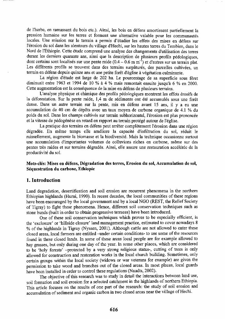
2.1 Presentation of the study area The mountainous Dogua Tembien (Tembien highlands) district, located in the central
part of Tigray (figure l), was selected as research area for this study, since its elevation (1800 - 2800 m) and morphology are typical for the northern part of the Ethiopian highlands. Hagere Selam, the main town of the district, is situated at an altitude of 2650 m, on the road from Mekelle to Adua. The population of the district is mainly rural and population density reaches about 90 inhabitants km2. Since 1990, soi1 and water conservation has been a high priority in the Tembien highlands (Nyssen, 1998).
In this region, Mesozoic sedimentary rock (Amba Aradam sandstone and Antalo limestone) is capped by Tertiary Ashange basaltic flows, which include silicified lacustrine deposits. The numerous subhorizontal layers give rise to a stepped landscape of cliffed tabular structures. On the basaltic rocks, one finds a typical Luvisol-Regosol-Cambisol-Vertisol catena.
The major rainy season extends from June to September with about 700 mm of precipitation. It is preceded by 3 months of dispersed rain. From November to February, the weather is usually almost completely dry. The agricultural system in this part of the northem Ethiopian highlands has been described as a “grain-plough complex” (Westphal, 1975). The main crops are wheat (Triticum SP.), barley (Hordeum vulgare) and tef ((Eragrostis tefi, an endemic
Figure 1: Localisation of the study area. The study area is indicated by the little rectangle, the Dessa state forest by the little oval.
cereal trop. In spite of a generally low soi1 erodibility, reflecting high clay and rock fragment contents, the croplands situated on sometimes steep slopes induce much soi1 erosion (Nyssen et al., 2000).
Alter a preliminary comparison of the lithology, geomorphology, soils and land use of twelve catclmrents on the Tembien highlands, the Zenako-Argaka catchment was found to be the most representative, and selected for this study. Soi1 catenas on both dominant lithologies (basalt and limestone) show in general a clear correspondence between geomorphology, parent material and soils.
Part of the village of Hechi was included in the study area, in view of the presence of two areas which still hold a semi-natural vegetation: a park (churchyard) around the local church, and the Luqmuts slope forest. Special attention was given to the analysis of soi1
erosion (assessment of historical soi1 10s~) and accumulation of eroded material in the surroundings of this village, where different types of land use (cropland, rangeland, exclosures and semi-natural forest) cari be found in the same topographical positions. The total surface area of the selected catchment area is 202 ha.
In order to compare the findings of this study to other similar situations of forested slopes in northern Ethiopia, the observations were complemented by observations made along a transect in the Dessa state forest, located in the eastern part of the Tigray region (May 2002).
2.2 Soi1 survey and land-use inventory for a selected catchment Data on the soils and the land use within the selected catchment were recorded during
a three month field survey (summer 2000). Alter a preliminary prospection, including the description of twelve soi1 profiles in gully walls, augerings were carried out throughout the catchment, with an approximate density of one augering ha-‘. Representative augering sites were selected as much as possible in the middle of a field where soi1 profiles were expected to be less disturbed by erosion or deposition. Physical and morphological characteristics of a11 horizons were recorded. Based on these data, on the geomorphology of the site, and on information from nearby soi1 profiles, the augered soils were classified, using the World Reference Base (WRB) for Soi1 Resources (FAO et al., 1998).
A land-use inventory of the 208 ha large study catchment was made using a GPS- navigation system (accuracy f 4 m). The exact location of each augering site as well as the data on the land use were brought together and analysed in a Mapinfo GIS-environment, using a Digital Terrain Mode1 (DTM).
2.3 Historical changes in land use In order to relate historical changes in land use to soi1 formation and soi1 erosion
processes, stereoscopic Aerial Photo Interpretation (API) and the technique of semi-structured group interview sessions (Hinton & Young, 1999) were used. The land caver as seen from a pair of aerial photographs of December 1963 (EMA, 1963) was compared to that found on aerial photographs of February 1994 (EMA, 1994), and to present-day land use.
2.4 Description of selected soi1 profiles In order to study in more detail the impact of area closure on soi1 erosion and sediment
accumulation, two soi1 / land use transects were investigated in the village of Hechi: a soi1 chronosequence (i.e. a sequence of soi1 profiles in which the major factor of differentiation are different types of land use that have been succeeding to each other through time) in the surroundings of the Luqmuts forest, on a slope of 0.4 - 0.6 m m-l (3 profiles and 5 augerings), and another transect (land-use sequence) in a flat topographical position around the churchyard and church forest of the village (1 profile and 8 augerings).
The location of the soi1 profile pits was based on the information collected from preliminary augerings. Morphological soi1 characteristics were interpreted and recorded according to Ethiopia-specifïc guidelines (De Pauw, 1985), which are based on the FAO guidelines for soi1 description. Al1 horizons of 10 soi1 profile pits, representing the most common soi1 types in the study area, were sampled for further laboratory analysis.
2.5 Physical and chemical soi1 analysis For each of the soi1 samples grain size was analysed by the sieve-pipette method (Gee
& Bauder, 1986), organic C by Walkley-Black method (Allisons, 1965), total nitrogen content by the Kjeldahl method (Avery & Bascomb, 1982). The Cation Exchange Capacity (CEC) was determined by ammonium acetate extraction and measurement by spectrophotometer;
618

exchangeable bases (Ca, K, Mg) were measured in the first CEC percolate, K with flame spectrophotometer, Ca and Mg by atomic adsorption spectrophotometry. Available P was determined by the Bray II extraction method. CaC03 content was obtained through reaction with HC1 (15 %). Al1 the analyses were realised at the laboratories of the ‘Soi1 Service of Belgium’ at Heverlee, Belgium.
2.6 Assessment of soi1 loss and sediment accumulation by comparison of horizons Comparisons of soi1 profiles under cropland or rangeland with nearby profiles in the
same landscape position, but under a semi-natural vegetation or in an closed area, allow calculations of the rates of soi1 loss and sediment accumulation. Morphological description and chemical analyses of the profiles were used to identify corresponding horizons, and hence to contrast soi1 erosion versus sediment accumulation.
3. Results and Discussion
3.1 Historical changes in land use
1963 1994 2000 ha % ha % ha %
Cropland 87 41 109 53 109 53 Fallow 23 11 12 6 11 5
52 58 58 Overgrazed rangeland 33 16 41 20 38 18 Shrubland 45 22 37 18 38 18 Forest 21 10 8 4 12 6 TOTAL 208 100 208 100 208 100
Table 1: Land-use evolution in the selected catchment between 1963 and 2000.
Throughout the studied period, cropland has occupied more than half of the studied catchment, increasing by 6 % in 37 years time. Increase of the surface of cropland was mainly at the expense of shrubland. The relative area of fallow land within the arable land was reduced from 21 to 9 %. As a result of the high pressure on the land, the practice of leaving land fallow is abandoned more and more. The area of the overgrazed rangeland increased by 4 % from 1963 to 1994, after which it slightly decreased. Non-arable shrubland with sparse vegetation also decreased by 4 %, and then increased slightly. The area covered by forests strongly decreased, from 10 to 4 % between 1963 and 1994. Due to exclosure policy, it increased again to 6 % in 2000.
3.2 Estimation of soi1 loss on cropland in the surroundings of the churchyard of Hechi In Hechi’s churchyard no agricultural activity or haymaking are allowed. Neither is
woodcutting, except for construction and reparation works in the church building. Besides gardening activities (plantation of exotic flowering shrubs), the area is relatively undisturbed. In the outer circle, large trees are also growing: Olea europaea ssp. africana, Juniperus procera, Euphorbia sp. In this Park-like area, which holds a closed vegetation caver and where the soi1 is expected to be very similar to the one of the church forest sensu stricto, we were allowed to auger, which allowed us to compare soi1 profiles with the surrounding cropland. The whole site (including churchyard and surrounding cropland) is located on slopes < 0.05 m m-l, and relatively deep soils were expected. The soi1 type, analysed in a nearby profile pit (P 8 in figure 2), is a Protoverti-calcaric Cambisol (Humic), with a dark

cambic horizon with some ver-tic properties, reaching to a depth of 40 cm, where it presents a neat boundary with the weathering limestone parent material. We augered for this boundary at three places in the churchyard (K 10, K 11 and K 13) and one in edaphic grassland (K 15) and found it at a depth of 90 - 120 cm (average: 110 cm). Comparison with augerings in the surrounding, gently sloping cropland (K 8, K9, K14 and K 16) indicate an average historical soi1 loss of 31 f 18 cm.
This relative high soi1 loss for the cropland cari be attributed mainly to tillage erosion. Nyssen et al. (2000) measured unit soi1 transport rates on cropland in Dogua Tembien which vary between 4.8 and 7.2 kg m-’ for slope gradients between 0.03 and 0.06 m m-i. These values represent the mass of soi1 deposited during each tillage operation behind 1 m of lynchet or
LB Rangeland
El Exclosure
Figure 2: Situation of the soi1 profile pits and augering sites for the two soi1 / land use studies in Hechi
stone bund. As farmers till 2 to 4 times per year, values for the annual tillage transport coefficient in this area cari be assessed to range from 9,6 to 28.8 kg 111-l.
3.3 Accumulation of eroded material in closed areas: the Luqmuts slope forest The Luqmuts ‘exclosure’ forest is situated on a limestone cliff (overall dope gradient
0.4 - 0.6 m m-l), immediately downslope from the cropland surrounding Hechi’s churchyard, where estimations for soi1 loss were made. On this slope, three different situations of land use cari be found in a similar topographical position. In the middle, there is a dense natural forest (area A in figure 3), which is nowadays considered as a ‘holy forest’; protected by a very strong religious status. Interviews with local people show however that there used to be some woodcutting and occasional grazing in the forest during recent decades, especially during the civil war (1979 - 1989). Although it is most likely that some scattered trees are thus the only remnants of the indigenous ‘climax’ vegetation, one finds enough evidence to presume that this area has always been covered with a nearly complete vegetation deck, and benefïted from a de facto ‘closed’ status because of its religious protection. Dominant Woody species in this area are: Carissa edulis, Acacia etbaica, Euclea racemosa, Dodonaea angustifolia, Ficus glumosa, Ficus sur, Maytenus senegalensis, Pterolobium stellatum, Rhus natalensis and Rhus vulgaris.
620
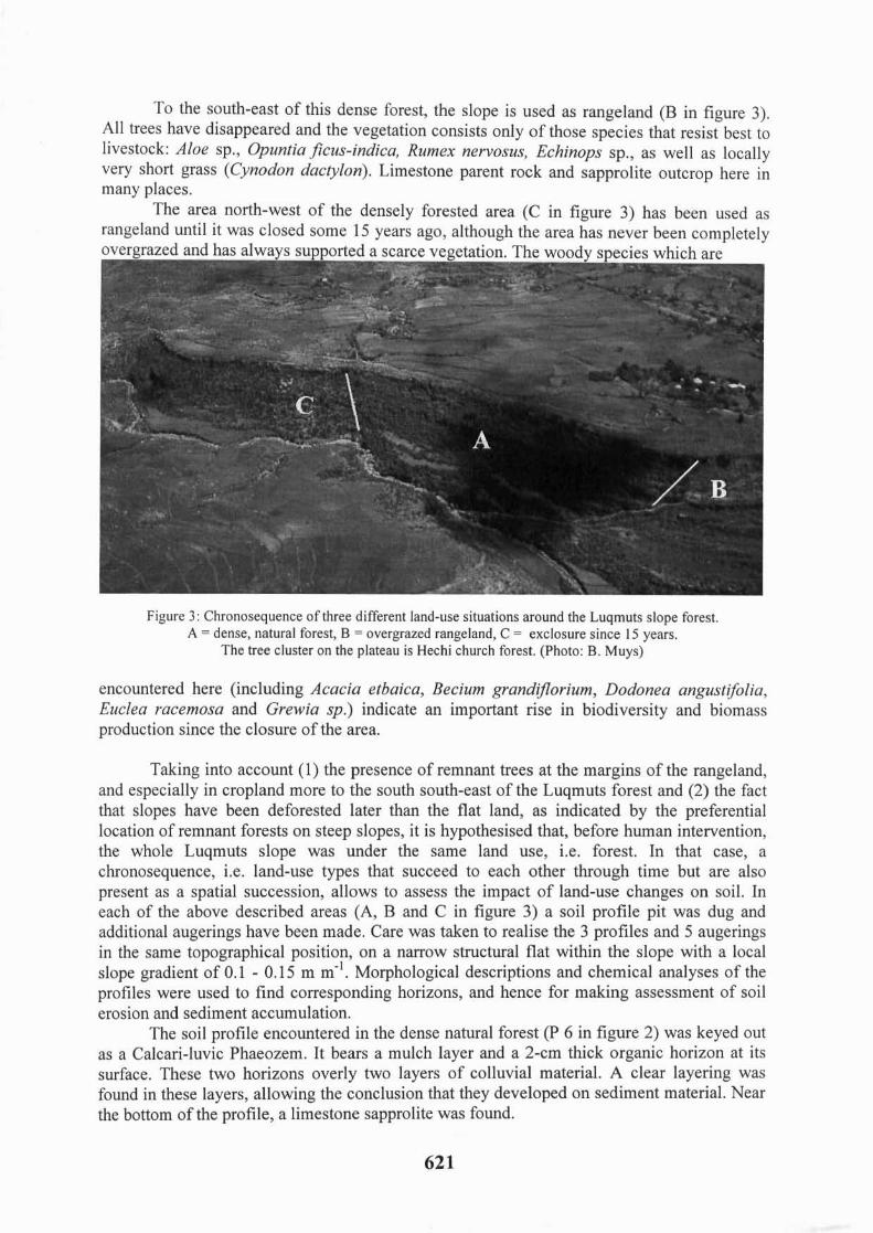
To the south-east of this dense forest, the slope is used as rangeland (B in figure 3). Al1 trees have disappeared and the vegetation consists only of those species that resist best to livestock: Aloe sp., Opuntiajicus-indica, Rumen nervosus, Echinops sp., as well as locally very short grass (Cynodon dactylon). Limestone parent rock and sapprolite outcrop here in many places.
The area north-west of the densely forested area (C in figure 3) has been used as rangeland until it was closed some 15 years ago, although the area has never been completely
Figure 3: Chronosequence of three different land-use situations around the Luqmuts slope forest. A = dense, natural forest, B = overgrazed rangeland, C = exclosure since 15 years.
The tree cluster on the plateau is Hechi church forest. (Photo: B. Muys)
encountered here (including Acacia etbaica, Becium grandzjlorium, Dodonea angustifolia, Euclea racemosa and Grewia sp.) indicate an important rise in biodiversity and biomass production since the closure of the area.
Taking into account (1) the presence of remnant trees at the margins of the rangeland, and especially in cropland more to the south south-east of the Luqmuts forest and (2) the fact that slopes have been deforested later than the flat land, as indicated by the preferential location of remnant forests on steep slopes, it is hypothesised that, before human intervention, the whole Luqmuts slope was under the same land use, i.e. forest. In that case, a chronosequence, i.e. land-use types that succeed to each other through time but are also present as a spatial succession, allows to assess the impact of land-use changes on soil. In each of the above described areas (A, B and C in figure 3) a soil profile pit was dug and additional augerings have been made. Care was taken to realise the 3 profiles and 5 augerings in the same topographical position, on a narrow structural flat within the slope with a local slope gradient of 0.1 - 0.15 m m-'. Morphological descriptions and chemical analyses of the profiles were used to find corresponding horizons, and hence for making assessment of soil erosion and sediment accumulation.
The soil profile encountered in the dense natural forest (P 6 in figure 2) was keyed out as a Calcari-luvic Phaeozem. It bears a mulch layer and a 2-cm thick organic horizon at its surface. These two horizons overly two layers of colluvial material. A clear layering was found in these layers, allowing the conclusion that they developed on sediment material. Near the bottom of the profile, a limestone sapprolite was found.
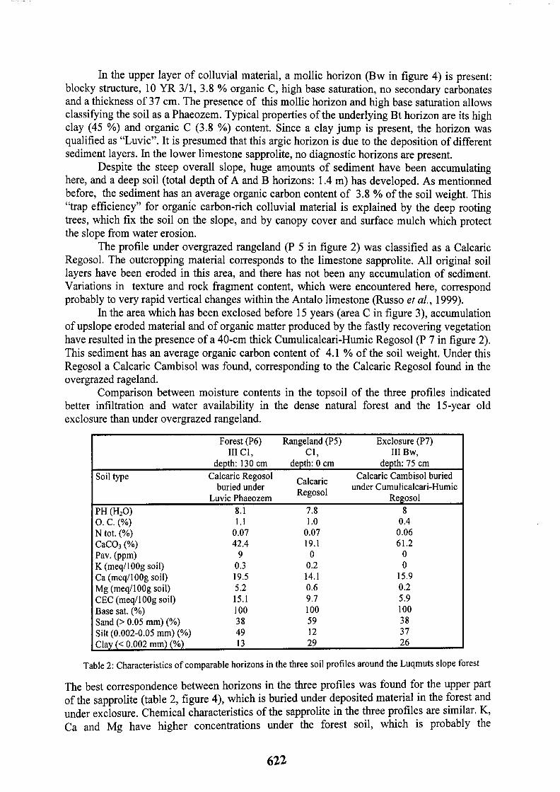
In the Upper layer of colluvial material, a mollit horizon (Bw in figure 4) is present: blocky structure, 10 YR 3/1, 3.8 % organic C, high base saturation, no secondary carbonates and a thickness of 37 cm. The presence of this mollit horizon and high base saturation allows classifying the soi1 as a Phaeozem. Typical properties of the underlying Bt horizon are its high clay (45 %) and organic C (3.8 %) content. Since a clay jump is present, the horizon was qualitïed as “Luvic”. It is presumed that this argic horizon is due to the deposition of different sediment layers. In the lower limestone sapprolite, no diagnostic horizons are present.
Despite the steep overall slope, huge amounts of sediment have been accumulating here, and a deep soi1 (total depth of A and B horizons: 1.4 m) has developed. As mentionned before, the sediment has an average organic carbon content of 3.8 % of the soi1 weight. This “trap efficiency” for organic carbon-rich colluvial material is explained by the deep rooting trees, which fix the soi1 on the slope, and by canopy caver and surface mulch which protect the slope from water erosion.
The profile under overgrazed rangeland (P 5 in figure 2) was classified as a Calcaric Regosol. The outcropping material corresponds to the limestone sapprolite. Al1 original soi1 layers have been eroded in this area, and there has not been any accumulation of sediment. Variations in texture and rock fragment content, which were encountered here, correspond probably to very rapid vertical changes within the Antalo limestone (Russo et al., 1999).
In the area which has been exclosed before 15 years (area C in figure 3), accumulation of upslope eroded material and of organic matter produced by the fastly recovering vegetation have resulted in the presence of a 40-cm thick Cumulicalcari-Humic Regosol (P 7 in figure 2). This sediment has an average organic carbon content of 4.1 % of the soi1 weight. Under this Regosol a Calcaric Cambisol was found, corresponding to the Calcaric Regosol found in the overgrazed rageland.
Comparison between moisture contents in the topsoil of the three profiles indicated better infiltration and water availability in the dense natural forest and the 15-year old exclo m-e than under overgrazed rangeland.
Forest (P6) III Cl,
deoth: 130 cm Soi1 type Calcaric Regosol
buried under Luvic Phaeozem
Rangeland (PS) Exclosure (P7) Cl, III Bw,
denth: 0 cm depth: 75 cm
Calcaric Calcaric Cambisol buried
Regosol under Cumulicalcari-Humic
Regosol 7.8 8 PH W20) 8.1
0. c. (%) 1.1 1.0 0.4 N tot. (%) 0.07 0.07 0.06 CaC03 (%) 42.4 19.1 61.2 Pav. bw-4 9 0 0 K (meq/lOOg soil) 0.3 0.2 0 Ca (meq/lOOg soil) 19.5 14.1 15.9 Mg (meq/lOOg soil) 5.2 0.6 0.2 CEC (meq/lOOg soil) 15.1 9.7 5.9 Base sat. (%) 100 100 100 Sand (> 0.05 mm) (%) 38 59 38 Silt (0.002-0.05 mm) (%) 49 12 37 Clay (< 0.002 mm) (%) 13 29 26
Table 2: Characteristics of comparable horizons in the three soi1 profiles around the Luqmuts slope forest
The best correspondence between horizons in the three profiles was found for the Upper part of the sapprolite (table 2, figure 4), which is buried under deposited material in the forest and under exclosure. Chemical characteristics of the sapprolite in the three profiles are similar. K, Ca and Mg have higher concentrations under the forest soil, which is probably the
622
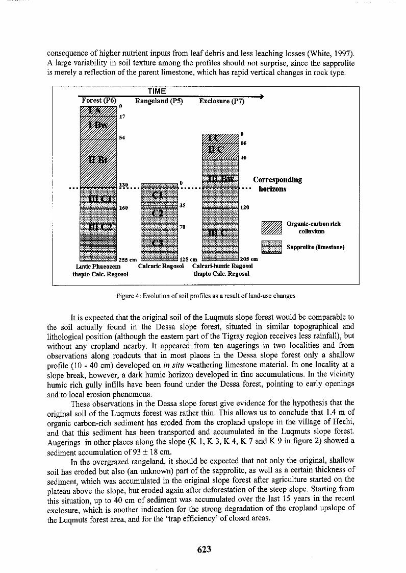
consequence of higher nutrient inputs from leaf debris and less leaching losses (White, 1997). A large variability in soi1 texture among the profiles should not surprise, since the sapprolite is merely a reflection of the parent limestone, which has rapid vertical changes in rock type.
. .
Forest (p6) 0 Rangeland (P5) N
17
54
255 cm 125 cm
0
16
Corresponding I m n = horizons
120
Organk-carl>on rlch colluvhnn
Sapprolite (Nmestone)
Luvic Phaeozem Calcaric Regosol Calcari-humic Regosol thapto Cale. Regosol thapto Cale. Regosol
Figure 4: Evolution of soi1 profiles as a result of land-use changes
It is expected that the original soi1 of the Luqmuts slope forest would be comparable to the soi1 actually found in the Dessa slope forest, situated in similar topographical and lithological position (although the eastern part of the Tigray region receives less rainfall), but without any cropland nearby. It appeared from ten augerings in two localities and from observations along roadcuts that in most places in the Dessa slope forest only a shallow profile (10 - 40 cm) developed on in situ weathering limestone material. In one locality at a slope break, however, a dark humic horizon developed in fine accumulations. In the vicinity humic rich gully infills have been found under the Dessa forest, pointing to early openings and to local erosion phenomena.
These observations in the Dessa slope forest give evidence for the hypothesis that the original soi1 of the Luqmuts forest was rather thin. This allows us to conclude that 1.4 m of organic carbon-rich sediment has eroded from the cropland upslope in the village of Hechi, and that this sediment has been transported and accumulated in the Luqmuts slope forest. Augerings in other places along the slope (K 1, K 3, K 4, K 7 and K 9 in figure 2) showed a sediment accumulation of 93 &Y 18 cm.
In the overgrazed rangeland, it should be expected that not only the original, shallow soi1 bas eroded but also (an unknown) part of the sapprolite, as well as a certain thickness of secliment, which was accumulated in the original slope forest after agriculture started on the plateau above the slope, but eroded again after deforestation of the steep slope. Starting from this situation, up to 40 cm of sediment was accurnulated over the last 15 years in the recent exclosure, which is another indication for the strong degradation of the cropland upslope of the Luqmuts forest area, and for the ‘trap efficiency’ of closed areas.
623
4. Conclusions The ‘exclosure’ land management practice is very effective in bringing soi1 erosion in
degraded areas to a standstill. Besides improved infiltration, less runoff, improved biomass production and a rise in biodiversity, this technique brings about the accumulation of large amounts of organic carbon-rich colluvial material, even on steep slopes, and allows thus for a relative fast regeneration of soi1 productivity in these areas. The high capacity for sediment deposition in the closed areas, together with the improved infiltration, has also important off- site effects: increased ground water recharge, decreased flooding in downstream areas and decreased reservoir siltation. In this way exclosures constitute a valuable alternative for the local communities of the northern Ethiopian highlands.
Acknowledgements This research was conducted within the framework of the research projects “Desertification and anthropogenic
erOsiOn processes in a tropical mountain catchment: Tigray, Ethiopia”, funded by the FWG (Fund for Scientific Research - Flanders, project no G006598.N) and “Fighting desertification in the Tigray Highlands, Ethiopia:
lessons to be learnt from successes and failures of soi1 erosion measures”, funded by the VLIR (Flemish Council for Academic Education, project no VLIR/EI 237). Financial support by the ‘Interfacultaire Raad voor
Ontwikkelingssamenwerking’ of the Katholieke Universiteit Leuven is greatly appreciated.
References Allisons, L.E., (1965). Organic Carbon. In: Black et al. (eds.), Methods of Soi1 Analy,!?is, part 11, Agronomy
monogr. no 9, ASA, Madison, WI, USA, p. 374 - 390 Avery, B.W., & Bascomb, C., (1982). Soi1 Survey Laboratory Methods. Soilsut+vey of Englandand Wales Technical Monograph, no 6, Soi1 Survey of England and Wales, Harpenden, UK. Belay Tegene, (2000). Characteristics and classification of soils of Gora Daget forest, South Welo Highlands, Ethiopia. SINET: Ethiopian Journal of Science, no 23 (l), p. 35-5 1 De Geyndt, K., (200 1). Bodemkartering ten behoeve van bodemconserveringsonderzoek in Hagere Selam, Ethiopië. Unpublished M. SC. Thesis. Faculteit landbouwkundige en toegepast biologische wetenschappen, Katholieke Universiteit Leuven, Belgium. De Pauw, E., (1985). Guidelines for soilprofile description. National Water Resources Commission, Addis Ababa. 57 p. Ethiopian Mapping Authority (EMA), (1963). Aerial photographs VM AST4 1370 PMW R-l 8,2096 and 2097, 11.12.1963, approximate scale 1 : 50.000 Ethiopian Mapping Authority (EMA), (1994). Aerial photographs ETH 1994 R-2 25,753 and 754, approximate scale 1 : 50.000. FAO et al. (1998). World Reference Base for Soi1 Resources. FAO, Rome, ISRIC, Wageningen, ISSR. 91 p. Gee, G.W., & Baudet-, J.W., (1986). Particle size analysis. In: Black et al. (eds.), Methods of Soi1 Analysis, Part Z. Agronomy monogr. no 9, ASA, Madison, WI, USA, p. 393 - 411 Hinton, R., & Young, D., (1999). An introduction to participatory techniques. VS0 Agriculture and Natural Resources Series. http://www.vso.org.uWpubslwpaperslpra/intro.htm (web page consulted on 15 / 03 / 2001) Hurni, H., (1990). Degradation and conservation of soi1 resources in the Ethiopian Highlands. Mountain research and development, no 8 (2-3), p. 123 - 130 Naudts, J., (2001). Land Use in Dogua Tembien, Tigray, Ethiopia. Unpublished M SC. thesis. Faculteit landbouwkundige en toegepast biologische wetenschappen, Katholieke Universiteit Leuven, Belgium. 173 p. Naudts, J., (2002). Les Hautes Terres de Tembien, Tigré, Ethiopie. Un système agraire traditionnel, en limite de fonctionnement. Conséquences sur la dégradation des terres. Mémoire première année cycle ESAT CNEARC, Montpellier, France. Nyssen, J., (1998). Soi1 and water conservation under changing socio-economic conditions in the Tembien Highlands (Tigray, Ethiopia). Bulletin de la Société géographique de Liège, no 35, p. 5-17 Nyssen, J., (2001). Erosion processes and soi1 conservation in a tropical mountain catchment under threat of anthropogenic desertification- a case study from Northern Ethiopia. Ph. D. thesis. Faculteit Wetenschappen, Katholieke Universiteit Leuven, Belgium. 380 p. Nyssen, J., et al. (2000). Tillage erosion on slopes with soi1 conservation structures in the Ethiopian Highlands. Soi1 & Tillage Research, no 57, p. 115-127 Russe, A., Fantozzi, p., & Solomon Tadesse, (1999). Geological map of Mekele Outlier (Western sheet), 1 : 100.000. Cooperazione Italiana. Westphal, E., (1975). Agricultural systems in Ethiopia. Centre for Agricultural Publishing and Documentation, Wageningen, Netherlands, 278 p.
624