THE STUDY ON COMPREHENSIVE RECOVERY ...open_jicareport.jica.go.jp/pdf/11751104_01.pdfBATANG DISTRICT...
52
Japan International Cooperation Agency (JICA) Ministry of Settlement and Regional Infrastructure (MOSRI) The Republic of Indonesia THE STUDY ON COMPREHENSIVE RECOVERY PROGRAM OF IRRIGATION AGRICULTURE VOLUME-4 ANNEX-II (2/3) Priority List of Irrigation Schemes for Rehabilitation (Central Java Province) February 2004 Nippon Koei Co., Ltd. AFA JR 04-18 No.
Transcript of THE STUDY ON COMPREHENSIVE RECOVERY ...open_jicareport.jica.go.jp/pdf/11751104_01.pdfBATANG DISTRICT...

Japan International Cooperation Agency (JICA)
Ministry of Settlement and Regional Infrastructure (MOSRI)
The Republic of Indonesia
THE STUDY
ON
COMPREHENSIVE RECOVERY PROGRAM
OF
IRRIGATION AGRICULTURE
VOLUME-4
ANNEX-II (2/3)
Priority List
of
Irrigation Schemes
for
Rehabilitation
(Central Java Province)
February 2004
Nippon Koei Co., Ltd. AFA
JR
04-18
No.

Name of Scheme
1. Cijalu 2. Mangganti 3. Serayu 4. Banjarcahyana 5. Kaligending 6. Pesucen 7. Bedegolan 8. Kedung Putri 9. Sudagaran10. Rebug11. Kalimeneng12. Kedung GW13. Waduk Cengklik14. Ploso Wareng15. Jaban16. Colo Kanan17. Bonggo18. Pangkalan19. Sentul20. Widodaren21. Klambu Kanan22. Jragung23. Guntur24. Klambu Kiri25. Kedungdowo Kramat26. Sungapan Kanan27. Mejagong28. Sungapan Kiri29. Kabuyutan30. Babakan31. Kemaron Jambe32. Jengkelok33. Gung34. Parakankidang35. Kumisik36. Pesantren Kletak37. Sragi38. Sudikampir39. Padurekso40. Kedung Asem41. Bodri42. Trompo43. Kedung Pengilon44. Pasekan45. Kosar46. Notog47. Sidorejo48. Glapan49. Klambu Kanan50. Kaliwadas
T : Technical Irrigation
RegisteredArea (Ha)
1,37718,89515,8694,8592,9811,6668,4304,3413,6651,2021,2621,1291,5791,1001,191
18,1081,8111,7651,7593,652
10,3914,5972,020
21,4191,2501,8511,9975,2294,1822,1811,0266,505
12,9991,6973,7364,2633,5401,5642,7643,7268,5381,2633,1341,0781,617
27,68214,62218,6966,8417,520
TTTTTTTTTTTTTTTTTTTTTTTTTTTTTTTTTTTTTTTTTTTTTTTTTT
SubjectArea (Ha)
1,37722,64420,7955,0012,9231,6598,4014,4513,6651,2021,2621,1292,1201,1001,191
22,9821,406
6541,7392,6166,2164,4161,543
20,7381,2501,8512,0495,5703,8762,5281,4836,173
12,6411,6313,7783,6363,5391,5502,7642,8457,7101,2292,686
9883,243
25,5405,717
18,78411,0787,722
Irrigation Scheme
LEGEND
Capital City of Province
Capital Town of District
Provincial Boundary
District Boundary
Provincial Road
District Road
River
Irrigation Scheme
Technical Irrigation
The Study on Comprehensive Recovery Programof Irrigation Agriculture
Japan International Cooperation Agency
Location Map of Irrigation Schemesin Central Java Province
E 111o
E 110o
S 7o
S 8o
E 109o
E 111o
S 7o
S 8o
E 110o
Study Area: Central Java Province
J a v a S e a
I n d i a n O c e a n
SUMATRA
SULAWESI
IRIAN JAYA
MALAYSIA
JAVA
CENTRALJAVA
KALIMANTAN
E 100O
E 110O
E 120O E 140O
E 130O
S 5O
S 10O
N 5O
0O
0 10 20 30 40 50 Km
SCALE
N
10
11
1
4
5
6
7 89
12
13
1415
18
19
21
2223
24
2526
27
29 30
31
32
33
34
35
36
37
38
39
40
44
46
4748
495041
17
28
20
2
3
4542
43
16
E 109oJ a v a S e a
I n d i a n O c e a n
EASTJAVA
WESTJAVA
YOGYAKARTAPROVINCE
RawapeningReservoir
WadaslintangReservoir
KedungomboReservoir
MahalayaReservoir
CacabanReservoir
Gajah MungkurReservoir
SUKOHARJODISTRICT
CILACAPDISTRICT
BREBESDISTRICT
TEGALDISTRICT PEMALANG
DISTRICT
PEKALONGANDISTRICT
BATANGDISTRICT KENDAL
DISTRICT
DEMAKDISTRICT
PATIDISTRICT
SRAGENDISTRICT
BOYOLALIDISTRICT
MAGELANGDISTRICT
KEBUMENDISTRICT
BANJARNEGARADISTRICTPURBALINGGA
DISTRICT
PURWODADIDISTRICT
WONOGIRIDISTRICT
SEMARANGDISTRICT
BANYUMASDISTRICT
BLORADISTRICT
WONOSOBODISTRICT
KUDUSDISTRICT
KARANGANYARDISTRICT
JEPARADISTRICT
PURWOREJODISTRICT
KLATENDISTRICT
REMBANGDISTRICT
TEMANGGUNGDISTRICT
YOGYAKARTA
SEMARANG
Sukoharjo
Brebes
Kendal
Cilacap
Purworejo
Pemalang
Magelang
Wonosobo
Banjarnegara
Purbalingga
Klaten
Wonogiri
BoyolaliKaranganyar
Sragen
Purwodadi
Pati
Jepara
Kudus
DemakBatang
Temanggung
Blora
Ungaran
Purwokerto
Rembang
Tegal
Kebumen
Pekalongan
i
THE STUDY ON
COMPREHENSIVE RECOVERY PROGRAM OF
IRRIGATION AGRICULTURE IN
THE REPUBLIC OF INDONESIA
Volume-4
ANNEX-II (2/3) PRIORITY LIST OF THE IRRIGATION SCHEMES FOR REHABILITATION
(Central Java Province)
Table of Contents
Location Map for the Province
Part I PRESENT CONDITION OF THE IRRIGATION SCHEMES
(PROVINCIAL SUMMARY)
Page
Identified Common Problems on Irrigation System.................................................................1-1 Provincial Summary of Irrigation Schemes .............................................................................1-2 Present Condition of Water Resources Facility ........................................................................1-3 Present Condition of Irrigation Canal.......................................................................................1-4 Present Ratio of Irrigation Facility Provision...........................................................................1-5 Summary of Existing Condition and Development Plan .........................................................1-6
Part II METHOD AND RESULT OF PRIORITIZATION OF IRRIGATION SCHEMES
FOR REHABILITATION
Page
Method and Process Flow of Prioritization ..............................................................................2-1 Evaluation Indicators for Weighted Scoring ............................................................................2-5 Priority List of Irrigation Schemes for Rehabilitation..............................................................2-6
ii
Part III PRESENT CONDITION AND PRE-F/S LEVEL DEVELOPMENT PLAN FOR EACH IRRIGAITON SCHEME
Page
Location Map of Irrigation Schemes in Cilacap District 1. Cijalu Scheme (Cilacap District)........................................................................................3-1 2. Mangganti Scheme (Cilacap District) ................................................................................3-5 3. Serayu Scheme (Cilacap District) ......................................................................................3-9 Location Map of Irrigation Schemes in Banjarnegara District 4. Banjarcahyana Scheme (Banjarnegara District)...............................................................3-13 Location Map of Irrigation Schemes in Kebumen District 5. Kaligending Scheme (Kebumen District) ........................................................................3-17 6. Pesucen Scheme (Kebumen District) ...............................................................................3-21 7. Bedegolan Scheme (Kebumen District) ...........................................................................3-25 Location Map of Irrigation Schemes in Purworejo District 8. Kedung Putri Scheme (Purworejo District)......................................................................3-29 9. Sudagaran Scheme (Purworejo District) ..........................................................................3-33 10. Rebug Scheme (Purworejo District).................................................................................3-37 11. Kalimeneng Scheme (Purworejo District)........................................................................3-41 12. Kedung GW Scheme (Purworejo District).......................................................................3-45 Location Map of Irrigation Schemes in Boyolali District 13. Waduk Cengklik Scheme (Boyolali District) ...................................................................3-49 Location Map of Irrigation Schemes in Klaten District 14. Ploso Wareng Scheme (Klaten District)...........................................................................3-53 15. Jaban Scheme (Klaten District) ........................................................................................3-57 Location Map of Irrigation Schemes in Sragen, Karanganyar and Sukoharjo District 16. Colo Kanan Scheme (Sragen District) .............................................................................3-61 17. Bonggo Scheme (Sragen District) ....................................................................................3-65 Location Map of Irrigation Schemes in Pati District 18. Pangkalan Scheme (Pati District).....................................................................................3-69 19. Sentul Scheme (Pati District) ...........................................................................................3-73

iii
Page
20. Widodaren Scheme (Pati District)....................................................................................3-77 21. Klambu Kanan Scheme (Pati District) .............................................................................3-81 Location Map of Irrigation Schemes in Kudus, Demak and Grobogan District 22. Jragung Scheme (Demak District)....................................................................................3-85 23. Guntur Scheme (Demak District).....................................................................................3-89 24. Klambu Kiri Scheme (Demak District)............................................................................3-93 Location Map of Irrigation Schemes in Batang District 25. Kedungdowo Kramat Scheme (Batang District)..............................................................3-97 Location Map of Irrigation Schemes in Pemalang District 26. Sungapan Kanan Scheme (Pemalang District)...............................................................3-101 27. Mejagong Scheme (Pemalang District)..........................................................................3-105 28. Sungapan Kiri Scheme (Pemalang District)...................................................................3-109 Location Map of Irrigation Schemes in Brebes District 29. Kabuyutan Scheme (Brebes District) .............................................................................3-113 30. Babakan Scheme (Brebes District).................................................................................3-117 31. Kemaron Jambe Scheme (Brebes District).....................................................................3-121 32. Jengkelok Scheme (Brebes District) ..............................................................................3-125 Location Map of Irrigation Schemes in Tegal District 33. Gung Scheme (Tegal & Kodia Tegal District) ...............................................................3-129 34. Parakankidang Scheme (Tegal & Kodia Tegal District).................................................3-133 35. Kumisik Scheme (Tegal & Kodia Tegal District)...........................................................3-137 Location Map of Irrigation Schemes in Pekalongan District 36. Pesantren Kletak Scheme (Pekalongan & Kodia P. District) .........................................3-141 37. Sragi Scheme (Pekalongan & Kodia P. District) ............................................................3-145 38. Sudikampir Scheme (Pekalongan & Kodia P. District)..................................................3-149 39. Padurekso Scheme (Pekalongan & Kodia P. District)....................................................3-153 Location Map of Irrigation Schemes in Kendal District 40. Kedung Asem Scheme (Kendal & Kodia Semarang District)........................................3-157 41. Bodri Scheme (Kendal & Kodia Semarang District) .....................................................3-161 42. Trompo Scheme (Kendal & Kodia Semarang District)..................................................3-165

iv
Page
43. Kedung Pengilon Scheme (Kendal & Kodia Semarang District) ..................................3-169 Location Map of Irrigation Schemes in Magelang District 44. Pasekan Scheme (Magelang and Kodia Mag. District)..................................................3-173 Location Map of Irrigation Schemes in Batang District 45. Kosar Scheme (Batang / Pekalongan District) ...............................................................3-177 Location Map of Irrigation Schemes in Brebes District 46. Notog Scheme (Brebes / Tegal District).........................................................................3-181 Location Map of Irrigation Schemes in Kudus, Demak and Grobogan District 47. Sidorejo Scheme (Grobogan / Boyolali District) ...........................................................3-185 48. Glapan Scheme (Grobogan / Demak District)................................................................3-189 49. Klambu Kanan Scheme (Grobogan / Kudus / Pati District)...........................................3-193 Location Map of Irrigation Schemes in Pemalang District 50. Kaliwadas Scheme (Pekalongan / Pemalang District) ...................................................3-197

PART-I Present Condition of
the Irrigation Schemes
(Provincial Summary)


Remarks:
Provincial Summary of Irrigation Schemes
(Central Java Province)
Explanation of graph shows 1) Classification,
2) Number of schemes, and 3) percentage.
Type of Water Resources Facility
Free Intake, 0,
0%
Fixed Weir, 43
86%
Dam, 1, 2%
Movable Weir,
5, 10%
Unknown, 1,
2%
Headworks, 49,
98%
Technical Level
Technical, 50,
100%
Semi-technical,
0, 0%Non-technical,
0, 0%
Size of Registered Area (ha)
Total = 284,569 ha
Average = 5,691 ha
1,000-2,000ha,
20, 40%
5,000-
10,000ha, 6,
12%
more than
10,000ha, 9,
18%
2,000-5,000ha,
15, 30%
Age of Irrigation Facility
Average = 16 years
15-30 years,
15, 31%
not available, 3,
6%
30-50 years, 1,
2%
less than 15
years, 29, 61%
Provision of Settling Basin
provided, 39,
83%
not provided, 8,
17%
Condition of Water Resources Facility
A: Functioning
well, 2, 4%
C: Not
functioning
well, 33, 66%
D: Serious
condition for
operation, 3, B: Partially
6% deteriorated, 12,
24%
Provision of Lined Canal (% for total canal length)
Average = 56 %
50-75 %, 15,
30%
25-50 %, 14,
28%
more than 75 %,
12, 24%
less than 25 %,
9, 18%
Provision of Inspection Road(% for total canal length)
Average = 59 %
50-75 %, 13,
26%
less than 25 %,
6, 12%more than 75
%, 14, 28%
25-50 %, 17,
34%
Condition of Secondary Canal System
A: Functioning
well, 0, 0%
B: Partially
deteriorated, 1,
2%
D: Serious
condition for
operation, 10,
20%
C: Not
functioning
well, 39, 78% Provision of Structure (number / canal length)
Average = 1/279 m
more than
1/100 m, 3, 6%
1/500-1/1,000
m, 6, 12%
1/100-1/300 m,
30, 60%
less than
1/1,000 m, 0,
0%
1/300-1/500 m,
11, 22%
Condition of Main Canal System
A: Functioning
well, 0, 0%
C: Not
functioning
well, 41, 82%
D: Serious
condition for
operation, 5,
10%
B: Partially
deteriorated, 4,
8%
Condition of On-farm System
A: Functioning
well, 0, 0%
C: Not
functioning
well, 48, 96%
D: Serious
condition for
operation, 2,
4%
B: Partially
deteriorated, 0,
0%
1 - 2

1. Cijalu Cilacap T 1,377 16 70 Headworks Fixed weir 68 2.7 2 2 not provided unknown C2. Mangganti Cilacap T 18,895 6 2,546 Headworks Movable weir 76 56.3 - 6 provided provided B3. Serayu Cilacap T 15,869 9 3,719 Headworks Movable weir 12 32.0 - 4 provided provided B4. Banjarcahyana Banjarnegara T 4,859 17 1,022 Dam - - 11.0 - N/A - - A5. Kaligending Kebumen T 2,981 4 281 Headworks Fixed weir 88 3.5 2 N/A provided not provided B6. Pesucen Kebumen T 1,666 1 81 Headworks Fixed weir 40 3.0 5 N/A provided not provided A7. Bedegolan Kebumen T 8,430 5 211 Headworks Fixed weir 58 13.5 2 4 provided not provided B8. Kedung Putri Purworejo T 4,341 15 364 Headworks Fixed weir 53 5.5 2 3 provided not provided C9. Sudagaran Purworejo T 3,665 - 500 Headworks Fixed weir 43 7.0 N/A N/A not provided unknown C
10. Rebug Purworejo T 1,202 15 88 Headworks Fixed weir 45 0.0 1 N/A provided provided C11. Kalimeneng Purworejo T 1,262 19 12 Headworks Fixed weir 36 2.0 2 2 provided provided C12. Kedung GW Purworejo T 1,129 64 11 Headworks Fixed weir 68 2.0 2 2 not provided provided D13. Waduk Cengklik Boyolali T 1,579 3 - Headworks Fixed weir 40 4.7 3 2 provided not provided C14. Ploso Wareng Klaten T 1,100 11 - Headworks Fixed weir 20 1.6 1 2 provided not provided C15. Jaban Klaten T 1,191 11 - Headworks Fixed weir 13 2.7 1 1 not provided not provided C16. Colo Kanan Sragen T 18,108 18 2,743 Headworks Fixed weir 112 31.6 2 5 provided provided C17. Bonggo Sragen T 1,811 18 66 Headworks Fixed weir 50 1.5 1 2 provided not provided D18. Pangkalan Pati T 1,765 10 23 Headworks Fixed weir 31 2.5 1 2 not provided unknown C19. Sentul Pati T 1,759 11 - Headworks Fixed weir 30 2.0 1 2 provided unknown C20. Widodaren Pati T 3,652 13 - Headworks Fixed weir 22 2.0 N/A 2 provided unknown B21. Klambu Kanan Pati T 10,391 13 2,854 Headworks Fixed weir 33 9.0 N/A N/A provided unknown C22. Jragung Demak T 4,597 14 - Headworks Fixed weir 33 8.0 1 1 provided provided C23. Guntur Demak T 2,020 24 - Headworks Movable weir 30 3.5 - 3 provided provided C24. Klambu Kiri Demak T 21,419 11 2,101 Headworks Fixed weir 100 21.0 6 4 provided unknown B25. Kedungdowo Kramat Batang T 1,250 27 95 Headworks Fixed weir 50 2.1 2 1 not provided provided C26. Sungapan Kanan Pemalang T 1,851 3 160 Headworks Fixed weir 72 4.0 3 4 provided unknown B27. Mejagong Pemalang T 1,997 11 - Headworks Fixed weir 50 8.0 2 2 provided unknown C28. Sungapan Kiri Pemalang T 5,229 3 - Headworks Fixed weir 72 8.5 3 4 provided unknown B29. Kabuyutan Brebes T 4,182 17 127 Headworks Fixed weir 67 8.5 2 3 provided not provided C30. Babakan Brebes T 2,181 11 - Headworks Fixed weir 68 3.7 2 2 provided not provided C31. Kemaron Jambe Brebes T 1,026 12 145 Headworks Fixed weir 15 3.1 1 1 provided not provided C32. Jengkelok Brebes T 6,505 13 206 Headworks Fixed weir 40 8.6 1 2 provided not provided C33. Gung Tegal & Kodia Tegal T 12,999 5 156 Headworks Fixed weir 65 5.4 2 2 provided unknown C34. Parakankidang Tegal & Kodia Tegal T 1,697 9 45 Headworks Fixed weir 23 3.6 N/A N/A provided unknown C35. Kumisik Tegal & Kodia Tegal T 3,736 5 23 Headworks Fixed weir 24 5.4 1 3 provided unknown C36. Pesantren Kletak Pekalongan & Kodia P. T 4,263 8 289 Headworks Fixed weir 123 6.0 3 3 provided not provided B37. Sragi Pekalongan & Kodia P. T 3,540 29 - Headworks Movable weir 25 N/A - N/A unknown provided C38. Sudikampir Pekalongan & Kodia P. T 1,564 28 289 Headworks Fixed weir 37 1.2 1 3 provided not provided C39. Padurekso Pekalongan & Kodia P. T 2,764 88 106 Headworks Fixed weir 64 6.5 2 3 provided not provided C40. Kedung Asem Kendal & Kodia Semarang T 3,726 13 200 Headworks Fixed weir 45 4.9 1 1 provided unknown C41. Bodri Kendal & Kodia Semarang T 8,538 - 320 Headworks Fixed weir 60 11.3 2 2 provided provided C42. Trompo Kendal & Kodia Semarang T 1,263 13 26 Headworks Movable weir 15 3.5 - 2 not provided provided D43. Kedung Pengilon Kendal & Kodia Semarang T 3,134 - 150 Headworks Fixed weir 25 4.0 2 2 not provided unknown C44. Pasekan Magelang dan Kodia Mag. T 1,078 3 73 Headworks Fixed weir 35 1.1 2 2 provided not provided C45. Kosar Batang / Pekalongan T 1,617 28 199 Headworks Fixed weir 37 6.7 1 3 provided not provided C46. Notog Brebes / Tegal T 27,682 31 - Headworks Fixed weir 85 27.0 4 7 provided not provided C47. Sidorejo Grobogan / Boyolali T 14,622 13 63 Headworks Fixed weir 80 11.0 2 2 provided provided B48. Glapan Grobogan / Demak T 18,696 26 - Headworks Fixed weir 100 14.0 1 2 provided not provided C49. Klambu Kanan Grobogan / Kudus / Pati T 6,841 13 - Headworks N/A N/A N/A N/A N/A unknown unknown B50. Kaliwadas Pekalogan / Pemalang T 7,520 29 765 Headworks Fixed weir 85 10.0 2 4 provided provided B
Total 284,569Average 5,691 16 403 51Itemized Total T : 50 dam: 1 fixed weir: 43 provided: 39 provided: 14 A : 2
ST : 0 headworks: 49 movable weir: 5 not provided: 8 not provided: 19 B : 12NT : 0 free intake: 0 gabion weir: 0 C : 33
D : 3Note: 1): T: Technical, ST: Semi-technical, NT: Non-technical
N/A : no information was available
Condition: A: Functioning well, B: Partially deteriorated, C: Not functioning well, D: Serious condition for operation
Source: Inventory Survey Works for the Study on Comprehensive Recovery Program of Irrigation Agriculture
Condition
Present Condition of Water Resource FacilityCentral Java Province
No. of
Scouring
Sluice Gate
No. of Intake
Gate
Provision of
Setting Basin
Provision of
Inspection BridgeNo.
Design Intake
Discharge (m3/s)Irrigation Scheme
Registered
Area (ha)
Technical
Level 1)DistrictLength of
Weir (m)Type of WeirType of Facility
Age of the
Facility
(years)
Catchment
Area (km2)
1 - 3

On-farm
1. Cijalu Cilacap T 1,377 16 2,000 3,331 94 2,000 C 530 16,142 212 15,000 C C2. Mangganti Cilacap T 18,895 6 69,687 0 170 40,000 C 170,000 20,500 205 100,000 C C3. Serayu Cilacap T 15,869 9 4,108 91,839 306 50,000 D 4,567 111,285 639 50,000 D C4. Banjarcahyana Banjarnegara T 4,859 17 24,540 16,360 316 40,900 C 8,730 5,820 113 9,312 C C5. Kaligending Kebumen T 2,981 4 12,000 0 92 12,000 C 6,000 9,000 76 15,000 C C6. Pesucen Kebumen T 1,666 1 224 0 4 224 B 9,000 8,000 150 8,500 C C7. Bedegolan Kebumen T 8,430 5 3,500 2,730 29 6,230 B 40,500 40,760 294 17,000 C C8. Kedung Putri Purworejo T 4,341 15 6,644 2,656 66 9,300 C 3,527 1,328 292 2,500 C C9. Sudagaran Purworejo T 3,665 - 1,000 3,100 3 2,000 C 16,000 25,700 87 15,000 C C
10. Rebug Purworejo T 1,202 15 0 0 0 0 D 6,000 13,000 40 8,000 D D11. Kalimeneng Purworejo T 1,262 19 906 180 10 1,086 C 9,941 5,200 139 8,100 C C12. Kedung GW Purworejo T 1,129 64 748 435 13 200 C 13,000 2,929 124 10,000 C C13. Waduk Cengklik Boyolali T 1,579 3 1,891 2,765 42 4,656 C 11,003 17,246 191 28,249 C C14. Ploso Wareng Klaten T 1,100 11 250 0 3 250 C 6,205 4,075 96 10,280 C C15. Jaban Klaten T 1,191 11 3,627 400 2 4,027 C 9,275 3,970 142 13,245 C C16. Colo Kanan Sragen T 18,108 18 17,816 46,684 428 64,500 D 110,378 9,800 199 120,178 C C17. Bonggo Sragen T 1,811 18 600 1,200 5 1,800 C 6,508 9,570 160 16,078 C C18. Pangkalan Pati T 1,765 10 700 0 4 700 C 5,650 1,152 58 3,000 C C19. Sentul Pati T 1,759 11 1,357 1,408 26 1,889 C 5,456 8,348 59 3,257 C C20. Widodaren Pati T 3,652 13 0 5,778 38 5,778 D 5,500 15,640 72 7,000 D C21. Klambu Kanan Pati T 10,391 13 37,270 0 37 37,270 C 50,200 5,900 170 31,570 C C22. Jragung Demak T 4,597 14 7,325 0 13 2,391 C 17,504 10,300 90 8,482 C C23. Guntur Demak T 2,020 24 500 0 11 0 C 3,000 12,303 57 3,000 C C24. Klambu Kiri Demak T 21,419 11 34,130 0 155 32,000 C 105,689 0 373 32,000 C C25. Kedungdowo Kramat Batang T 1,250 27 700 2,140 25 932 C 1,200 4,330 33 2,000 D C26. Sungapan Kanan Pemalang T 1,851 3 2,004 4,676 18 6,680 B 4,828 3,219 19 5,362 C C27. Mejagong Pemalang T 1,997 11 218 0 37 218 C 1,663 16,202 46 9,265 D C28. Sungapan Kiri Pemalang T 5,229 3 4,396 3,529 28 7,925 C 19,539 15,988 108 18,000 C C29. Kabuyutan Brebes T 4,182 17 3,100 340 29 1,614 C 30,707 12,440 139 20,000 C C30. Babakan Brebes T 2,181 11 2,547 0 5 1,200 C 7,360 17,140 54 5,000 D C31. Kemaron Jambe Brebes T 1,026 12 10,000 0 34 10,000 C 17,600 6,000 86 5,000 C C32. Jengkelok Brebes T 6,505 13 3,100 2,100 10 5,200 C 12,800 32,227 171 3,800 D D33. Gung Tegal & Kodia Tegal T 12,999 5 13,500 0 27 8,576 C 20,000 17,000 165 37,000 C C34. Parakankidang Tegal & Kodia Tegal T 1,697 9 1,200 510 5 1,710 B 4,400 10,290 65 14,690 B C35. Kumisik Tegal & Kodia Tegal T 3,736 5 4,500 10,700 51 15,200 C 5,200 12,077 31 17,277 D C36. Pesantren Kletak Pekalongan & Kodia P. T 4,263 8 1,300 12,747 34 9,686 C 14,139 24,016 126 20,000 C C37. Sragi Pekalongan & Kodia P. T 3,540 29 3,626 2,967 18 1,500 C 5,703 25,303 38 5,000 C C38. Sudikampir Pekalongan & Kodia P. T 1,564 28 2,595 7,777 0 3,000 C 4,582 7,774 39 10,200 D C39. Padurekso Pekalongan & Kodia P. T 2,764 88 550 3,000 10 3,550 D 4,857 14,571 104 7,500 D C40. Kedung Asem Kendal & Kodia Semarang T 3,726 13 2,500 0 10 2,250 C 28,854 0 151 9,325 C C41. Bodri Kendal & Kodia Semarang T 8,538 - 3,429 0 46 2,200 C 60,499 0 149 30,000 C C42. Trompo Kendal & Kodia Semarang T 1,263 13 1,200 0 3 0 C 10,690 0 42 2,000 C C43. Kedung Pengilon Kendal & Kodia Semarang T 3,134 - 655 0 16 655 C 32,620 0 79 7,800 C C44. Pasekan Magelang dan Kodia Mag. T 1,078 3 0 0 0 0 C 8,350 1,754 191 0 C C45. Kosar Batang / Pekalongan T 1,617 28 1,246 4,854 19 2,660 C 9,895 34,145 164 34,000 C C46. Notog Brebes / Tegal T 27,682 31 3,750 13,350 9 31,000 C 159,563 239,345 504 250,000 C C47. Sidorejo Grobogan / Boyolali T 14,622 13 13,500 0 133 13,500 C 20,000 17,000 316 37,000 C C48. Glapan Grobogan / Demak T 18,696 26 7,100 10,880 52 17,980 C 14,931 36,619 205 16,000 C C49. Klambu Kanan Grobogan / Kudus / Pati T 6,841 13 12,619 0 28 12,000 C 45,057 5,533 132 30,000 C C50. Kaliwadas Pekalogan / Pemalang T 7,520 29 7,737 9,457 47 914 C 38,976 31,890 128 22,712 C C
Total 284,569 337,895 267,893 2,561 479,351 1,208,176 942,831 7,323 1,153,682 Average 5,691 16 6,758 5,358 51 9,587 24,164 18,857 146 23,074 Itemized Total T : 50 A : 0 A : 0 A : 0
ST : 0 B : 4 B : 1 B : 0NT : 0 C : 41 C : 39 C : 48
D : 5 D : 10 D : 2Note: 1): T: Technical, ST: Semi-technical, NT: Non-technical
Condition: A: Functioning well, B: Partially deteriorated, C: Not functioning well, D: Serious condition for operationSource: Inventory Survey Works for the Study on Comprehensive Recovery Program of Irrigation Agriculture
Present Condition of Irrigation CanalCentral Java Province
No.Registered Area
(ha)TechnicalLevel 1)
Main Canal
No. ofRelated
StructuresCondition
Secondary Canal
Lined Length(m)
Length ofInspectionRoad (m)
Length ofInspectionRoad (m)
Irrigation SchemeAge of theFacilities
(years)Lined Length
(m)Unlined
Length (m)District
ConditionUnlined
Length (m)
No. ofRelated
StructuresCondition
1 - 4
MC SC Total MC SC Total MC SC Total MC SC Total
1. Cijalu Cilacap T 1,377 16 3.9 12.1 16.0 38% 3% 11% 38% 90% 77% 57 79 72
2. Mangganti Cilacap T 18,895 6 3.1 8.4 11.5 100% 89% 92% 57% 52% 54% 410 929 694
3. Serayu Cilacap T 15,869 9 4.6 5.6 10.2 4% 4% 4% 52% 43% 47% 314 181 224
4. Banjarcahyana Banjarnegara T 4,859 17 8.2 2.9 11.1 60% 60% 60% 100% 64% 91% 129 129 129
5. Kaligending Kebumen T 2,981 4 4.1 5.1 9.2 100% 40% 67% 100% 100% 100% 130 197 161
6. Pesucen Kebumen T 1,666 1 0.1 10.2 10.4 100% 53% 54% 100% 50% 51% 56 113 112
7. Bedegolan Kebumen T 8,430 5 0.7 9.7 10.4 56% 50% 50% 100% 21% 27% 215 276 271
8. Kedung Putri Purworejo T 4,341 15 2.1 1.1 3.2 71% 73% 72% 100% 51% 83% 141 17 40
9. Sudagaran Purworejo T 3,665 - 1.1 11.4 12.5 24% 38% 37% 49% 36% 37% 1,367 479 509
10. Rebug Purworejo T 1,202 15 0.0 15.8 15.8 No Canal 32% 32% No Canal 42% 42% No Canal 475 475
11. Kalimeneng Purworejo T 1,262 19 0.9 12.0 12.9 83% 66% 67% 100% 53% 57% 109 109 109
12. Kedung GW Purworejo T 1,129 64 1.0 14.1 15.2 63% 82% 80% 17% 63% 60% 91 128 125
13. Waduk Cengklik Boyolali T 1,579 3 2.2 13.3 15.5 41% 39% 39% 100% 100% 100% 111 148 141
14. Ploso Wareng Klaten T 1,100 11 0.2 9.3 9.6 100% 60% 61% 100% 100% 100% 83 107 106
15. Jaban Klaten T 1,191 11 3.4 11.1 14.5 90% 70% 75% 100% 100% 100% 2,014 93 120
16. Colo Kanan Sragen T 18,108 18 2.8 5.2 8.0 28% 92% 69% 100% 100% 100% 151 604 295
17. Bonggo Sragen T 1,811 18 1.3 11.4 12.7 33% 40% 40% 100% 100% 100% 360 100 108
18. Pangkalan Pati T 1,765 10 1.1 10.4 11.5 100% 83% 85% 100% 44% 49% 175 117 121
19. Sentul Pati T 1,759 11 1.6 7.9 9.5 49% 40% 41% 68% 24% 31% 106 234 195
20. Widodaren Pati T 3,652 13 2.2 8.1 10.3 0% 26% 20% 100% 33% 47% 152 294 245
21. Klambu Kanan Pati T 10,391 13 6.0 9.0 15.0 100% 89% 94% 100% 56% 74% 1,007 330 451
22. Jragung Demak T 4,597 14 1.7 6.3 8.0 100% 63% 71% 33% 31% 31% 563 309 341
23. Guntur Demak T 2,020 24 0.3 9.9 10.2 100% 20% 22% 0% 20% 19% 45 268 232
24. Klambu Kiri Demak T 21,419 11 1.6 5.1 6.7 100% 100% 100% 94% 30% 46% 220 283 265
25. Kedungdowo Kramat Batang T 1,250 27 2.3 4.4 6.7 25% 22% 23% 33% 36% 35% 114 168 144
26. Sungapan Kanan Pemalang T 1,851 3 3.6 4.3 8.0 30% 60% 46% 100% 67% 82% 371 424 398
27. Mejagong Pemalang T 1,997 11 0.1 8.7 8.8 100% 9% 10% 100% 52% 52% 6 388 218
28. Sungapan Kiri Pemalang T 5,229 3 1.4 6.4 7.8 55% 55% 55% 100% 51% 60% 283 329 320
29. Kabuyutan Brebes T 4,182 17 0.9 11.1 12.0 90% 71% 73% 47% 46% 46% 119 310 277
30. Babakan Brebes T 2,181 11 1.0 9.7 10.7 100% 30% 37% 47% 20% 23% 509 454 458
31. Kemaron Jambe Brebes T 1,026 12 6.7 15.9 22.7 100% 75% 82% 100% 21% 45% 294 274 280
32. Jengkelok Brebes T 6,505 13 0.8 7.3 8.1 60% 28% 32% 100% 8% 18% 520 263 277
33. Gung Tegal & Kodia Tegal T 12,999 5 1.1 2.9 4.0 100% 54% 66% 64% 100% 90% 500 224 263
34. Parakankidang Tegal & Kodia Tegal T 1,697 9 1.0 9.0 10.1 70% 30% 34% 100% 100% 100% 342 226 234
35. Kumisik Tegal & Kodia Tegal T 3,736 5 4.0 4.6 8.6 30% 30% 30% 100% 100% 100% 298 557 396
36. Pesantren Kletak Pekalongan & Kodia P. T 4,263 8 3.9 10.5 14.4 9% 37% 30% 69% 52% 57% 413 303 326
37. Sragi Pekalongan & Kodia P. T 3,540 29 1.9 8.8 10.6 55% 18% 25% 23% 16% 17% 366 816 671
38. Sudikampir Pekalongan & Kodia P. T 1,564 28 6.7 8.0 14.7 25% 37% 32% 29% 83% 58% No Structure 317 583
39. Padurekso Pekalongan & Kodia P. T 2,764 88 1.3 7.0 8.3 15% 25% 24% 100% 39% 48% 355 187 202
40. Kedung Asem Kendal & Kodia Semarang T 3,726 13 0.9 10.1 11.0 100% 100% 100% 90% 32% 37% 250 191 195
41. Bodri Kendal & Kodia Semarang T 8,538 - 0.4 7.8 8.3 100% 100% 100% 64% 50% 50% 75 406 328
42. Trompo Kendal & Kodia Semarang T 1,263 13 1.0 8.7 9.7 100% 100% 100% 0% 19% 17% 400 255 264
43. Kedung Pengilon Kendal & Kodia Semarang T 3,134 - 0.2 12.1 12.4 100% 100% 100% 100% 24% 25% 41 413 350
44. Pasekan Magelang dan Kodia Mag. T 1,078 3 0.0 10.2 10.2 No Canal 83% 83% No Canal 0% 0% No Canal 53 53
45. Kosar Batang / Pekalongan T 1,617 28 1.9 13.6 15.5 20% 22% 22% 44% 77% 73% 321 269 274
46. Notog Brebes / Tegal T 27,682 31 0.7 15.6 16.3 22% 40% 39% 181% 63% 68% 1,900 791 811
47. Sidorejo Grobogan / Boyolali T 14,622 13 2.4 6.5 8.8 100% 54% 66% 100% 100% 100% 102 117 112
48. Glapan Grobogan / Demak T 18,696 26 1.0 2.7 3.7 39% 29% 32% 100% 31% 49% 346 251 271
49. Klambu Kanan Grobogan / Kudus / Pati T 6,841 13 1.1 4.6 5.7 100% 89% 91% 95% 59% 66% 451 383 395
50. Kaliwadas Pekalogan / Pemalang T 7,520 29 2.2 9.2 11.4 45% 55% 53% 5% 32% 27% 366 554 503
Total 284,569
Average of the province 5,691 16 2.1 7.6 9.7 56% 56% 56% 79% 54% 59% 237 294 279
Itemized Total T : 50
ST : 0
NT : 0Note: 1): T: Technical, ST: Semi-technical, NT: Non-technical
MC: Main Canal, SC: Secondary Canal
Source: Inventory Survey Works for the Study on Comprehensive Recovery Program of Irrigation Agriculture
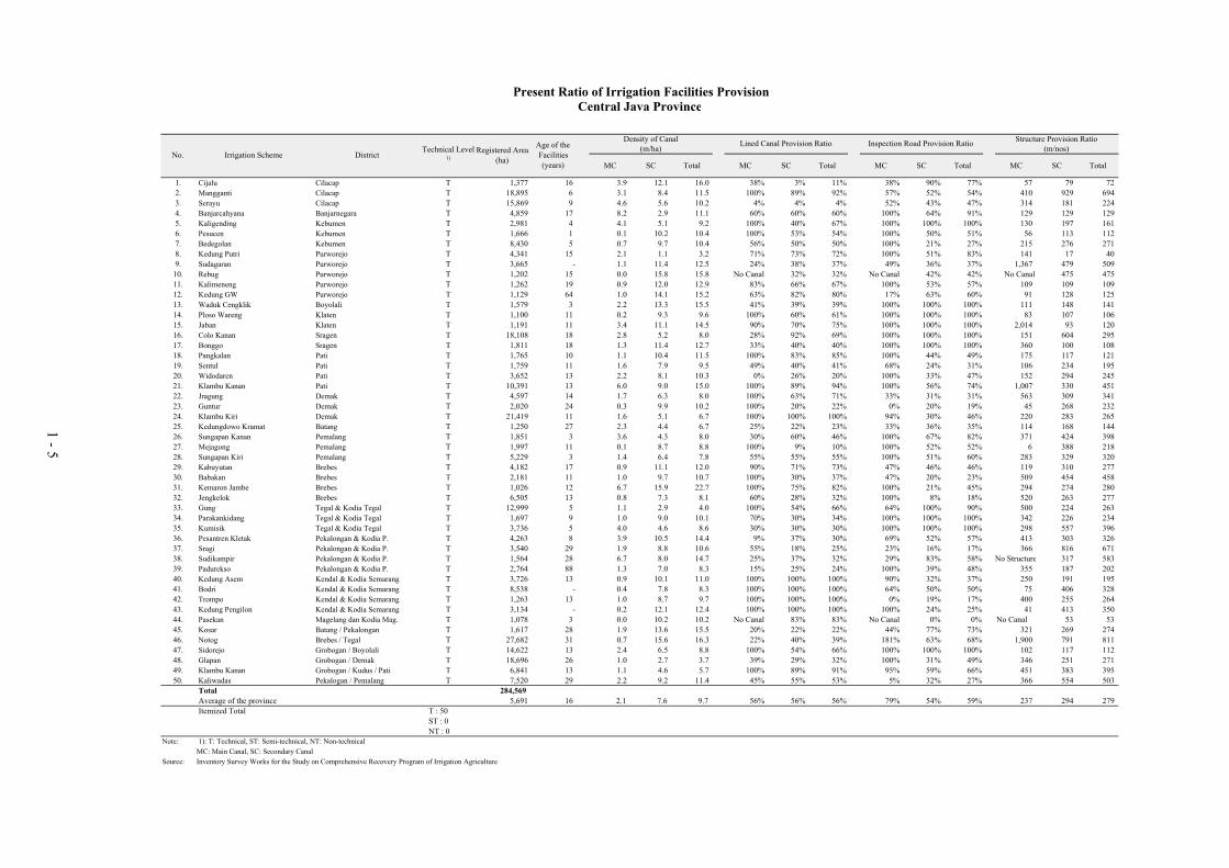
Present Ratio of Irrigation Facilities ProvisionCentral Java Province
Irrigation Scheme
Structure Provision Ratio(m/nos)Age of the
Facilities
(years)
Lined Canal Provision Ratio
DistrictNo.Registered Area
(ha)
Technical Level1)
Density of Canal(m/ha)
Inspection Road Provision Ratio
1 - 5

Terminal
Facility and
On Farm
MC SC MC SCPotential
Area
Non-
Potential
Area
1 Cijalu Cilacap T 1,377 16 Headworks not provided C 5.331 16.672 306 C C C 1,377 RG3 new construction RG3 & RG4 RG3 & RG4 5.331 21.442 358 1,377 -
2 Mangganti Cilacap T 18,895 6 Headworks provided B 69.687 190.500 375 C C C 22,644 RG2 minor rehabili. RG3 & RG4 RG3 & RG4 69.687 190.500 433 22,644 -
3 Serayu Cilacap T 15,869 9 Headworks provided B 95.947 115.852 945 D D C 20,795 RG2 minor rehabili. RG4 RG4 95.947 115.852 1,103 20,795 -
4 Banjarcahyana Banjarnegara T 4,859 17 Dam - A 40.900 14.550 429 C C C 5,001 RG1 not required RG3 & RG4 RG3 & RG4 40.900 14.550 483 5,001 -
5 Kaligending Kebumen T 2,981 4 Headworks provided B 12.000 15.000 168 C C C 2,923 RG2 large rehabili. RG3 & RG4 RG3 & RG4 12.000 15.000 192 2,923 -
6 Pesucen Kebumen T 1,666 1 Headworks provided A 0.224 17.000 154 B C C 1,659 RG1 no rehabili. RG2 RG3 & RG4 0.224 17.000 184 1,659 -
7 Bedegolan Kebumen T 8,430 5 Headworks provided B 6.230 81.260 323 B C C 8,401 RG2 replacement RG2 RG3 & RG4 6.230 81.260 385 8,401 -
8 Kedung Putri Purworejo T 4,341 15 Headworks provided C 9.300 4.855 358 C C C 4,451 RG3 replacement RG3 & RG4 RG3 & RG4 9.300 27.804 423 4,451 -
9 Sudagaran Purworejo T 3,665 - Headworks not provided C 4.100 41.700 90 C C C 3,665 RG3 new construction RG3 & RG4 RG3 & RG4 4.100 41.700 108 3,665 -
10 Rebug Purworejo T 1,202 15 Headworks provided C 0.000 19.000 40 D D D 1,202 RG3 large rehabili. RG4 RG4 - 19.000 48 1,202 -
11 Kalimeneng Purworejo T 1,262 19 Headworks provided C 1.086 15.141 149 C C C 1,262 RG3 large rehabili. RG3 & RG4 RG3 & RG4 1.086 15.141 178 1,262 -
12 Kedung GW Purworejo T 1,129 64 Headworks not provided D 1.183 15.929 137 C C C 1,129 RG4 new construction RG4 RG4 1.183 15.929 163 1,129 -
13 Waduk Cengklik Boyolali T 1,579 3 Headworks provided C 4.656 28.249 233 C C C 2,120 RG3 large rehabili. RG3 & RG4 RG3 & RG4 4.656 28.249 275 2,120 -
14 Ploso Wareng Klaten T 1,100 11 Headworks provided C 0.250 10.280 99 C C C 1,100 RG3 large rehabili. RG3 & RG4 RG3 & RG4 0.250 10.280 119 1,100 -
15 Jaban Klaten T 1,191 11 Headworks not provided C 4.027 13.245 144 C C C 1,191 RG3 new construction RG3 & RG4 RG3 & RG4 4.027 13.245 217 1,191 -
16 Colo Kanan Sragen T 18,108 18 Headworks provided C 64.500 120.178 627 D C C 22,982 RG3 replacement RG4 RG3 & RG4 64.500 120.178 710 22,982 -
17 Bonggo Sragen T 1,811 18 Headworks provided D 1.800 16.078 165 C C C 1,406 RG4 replacement RG3 & RG4 RG3 & RG4 1.800 16.078 198 1,406 -
18 Pangkalan Pati T 1,765 10 Headworks not provided C 0.700 6.802 62 C C C 654 RG3 new construction RG3 & RG4 RG3 & RG4 0.700 6.802 74 654 -
19 Sentul Pati T 1,759 11 Headworks provided C 2.765 13.804 85 C C C 1,739 RG3 large rehabili. RG3 & RG4 RG3 & RG4 2.765 13.804 99 1,739 -
20 Widodaren Pati T 3,652 13 Headworks provided B 5.778 21.140 110 D D C 2,616 RG2 minor rehabili. RG4 RG4 5.778 21.140 128 2,616 -
21 Klambu Kanan Pati T 10,391 13 Headworks provided C 37.270 56.100 207 C C C 6,216 RG3 large rehabili. RG3 & RG4 RG3 & RG4 37.270 56.100 245 6,216 -
22 Jragung Demak T 4,597 14 Headworks provided C 7.325 27.804 103 C C C 4,416 RG3 replacement RG3 & RG4 RG3 & RG4 7.325 27.804 122 4,416 -
23 Guntur Demak T 2,020 24 Headworks provided C 0.500 15.303 68 C C C 1,543 RG3 replacement RG4 RG4 0.500 15.303 81 1,543 -
24 Klambu Kiri Demak T 21,419 11 Headworks provided B 34.130 105.689 528 C C C 20,738 RG2 minor rehabili. RG3 & RG4 RG3 & RG4 34.130 105.689 618 20,738 -
25 Kedungdowo Kramat Batang T 1,250 27 Headworks not provided C 2.840 5.530 58 C D C 1,250 RG3 new construction RG4 RG4 2.840 5.530 67 1,250 -
26 Sungapan Kanan Pemalang T 1,851 3 Headworks provided B 6.680 8.047 37 B C C 1,851 RG2 minor rehabili. RG2 RG3 & RG4 6.680 8.047 43 1,851 -
27 Mejagong Pemalang T 1,997 11 Headworks provided C 0.218 17.865 83 C D C 2,049 RG3 large rehabili. RG3 & RG4 RG4 0.218 17.865 96 2,049 -
28 Sungapan Kiri Pemalang T 5,229 3 Headworks provided B 7.925 35.527 136 C C C 5,570 RG2 minor rehabili. RG3 & RG4 RG3 & RG4 7.925 35.527 160 5,570 -
29 Kabuyutan Brebes T 4,182 17 Headworks provided C 3.440 43.147 168 C C C 3,876 RG3 large rehabili. RG3 & RG4 RG3 & RG4 3.440 43.147 199 3,876 -
30 Babakan Brebes T 2,181 11 Headworks provided C 2.547 24.500 59 C D C 2,528 RG3 large rehabili. RG3 & RG4 RG4 2.547 24.500 70 2,528 -
31 Kemaron Jambe Brebes T 1,026 12 Headworks provided C 10.000 23.600 120 C C C 1,483 RG3 large rehabili. RG3 & RG4 RG3 & RG4 10.000 23.600 141 1,483 -
32 Jengkelok Brebes T 6,505 13 Headworks provided C 5.200 45.027 181 C D D 6,173 RG3 large rehabili. RG3 & RG4 RG4 5.200 45.027 216 6,173 -
33 Gung Tegal & Kodia Tegal T 12,999 5 Headworks provided C 13.500 37.000 192 C C C 12,641 RG3 large rehabili. RG3 & RG4 RG3 & RG4 13.500 37.000 228 12,641 -
34 Parakankidang Tegal & Kodia Tegal T 1,697 9 Headworks provided C 1.710 14.690 70 B B C 1,631 RG3 large rehabili. RG2 RG2 1.710 14.690 84 1,631 -
35 Kumisik Tegal & Kodia Tegal T 3,736 5 Headworks provided C 15.200 17.277 82 C D C 3,778 RG3 large rehabili. RG3 & RG4 RG4 15.200 17.277 93 3,778 -
36 Pesantren Kletak Pekalongan & Kodia P. T 4,263 8 Headworks provided B 14.047 38.155 160 C C C 3,636 RG2 large rehabili. RG3 & RG4 RG3 & RG4 14.047 38.155 189 3,636 -
37 Sragi Pekalongan & Kodia P. T 3,540 29 Headworks unknown C 6.593 31.006 56 C C C 3,539 RG3 new construction RG4 RG4 6.593 31.006 65 3,539 -
38 Sudikampir Pekalongan & Kodia P. T 1,564 28 Headworks provided C 10.372 12.356 39 C D C 1,550 RG3 large rehabili. RG4 RG4 10.372 12.356 84 1,550 -
39 Padurekso Pekalongan & Kodia P. T 2,764 88 Headworks provided C 3.550 19.428 114 D D C 2,764 RG4 replacement RG4 RG4 3.550 19.428 136 2,764 -
40 Kedung Asem Kendal & Kodia Semarang T 3,726 13 Headworks provided C 2.500 28.854 161 C C C 2,845 RG3 large rehabili. RG3 & RG4 RG3 & RG4 2.500 28.854 192 2,845 -
41 Bodri Kendal & Kodia Semarang T 8,538 - Headworks provided C 3.429 60.499 195 C C C 7,710 RG3 replacement RG3 & RG4 RG3 & RG4 3.429 60.499 229 7,710 -
42 Trompo Kendal & Kodia Semarang T 1,263 13 Headworks not provided D 1.200 10.690 45 C C C 1,229 RG4 new construction RG3 & RG4 RG3 & RG4 1.200 10.690 54 1,229 -
43 Kedung Pengilon Kendal & Kodia Semarang T 3,134 - Headworks not provided C 0.655 32.620 95 C C C 2,686 RG3 new construction RG3 & RG4 RG3 & RG4 0.655 32.620 112 2,686 -
44 Pasekan Magelang dan Kodia Mag. T 1,078 3 Headworks provided C 0.000 10.104 191 C C C 988 RG3 large rehabili. RG3 & RG4 RG3 & RG4 - 10.104 229 988 -
45 Kosar Batang / Pekalongan T 1,617 28 Headworks provided C 6.100 44.040 183 C C C 3,243 RG3 large rehabili. RG4 RG4 6.100 44.040 218 3,243 -
46 Notog Brebes / Tegal T 27,682 31 Headworks provided C 17.100 398.908 513 C C C 25,540 RG3 minor rehabili. RG4 RG4 17.100 398.908 662 25,540 -
47 Sidorejo Grobogan / Boyolali T 14,622 13 Headworks provided B 13.500 37.000 449 C C C 5,717 RG2 not required RG3 & RG4 RG3 & RG4 13.500 37.000 526 5,717 -
48 Glapan Grobogan / Demak T 18,696 26 Headworks provided C 17.980 51.550 257 C C C 18,784 RG3 large rehabili. RG4 RG4 17.980 51.550 303 18,784 -
49 Klambu Kanan Grobogan / Kudus / Pati T 6,841 13 Headworks unknown B 12.619 50.590 160 C C C 11,078 RG2 new construction RG3 & RG4 RG3 & RG4 12.619 50.590 189 11,078 -
50 Kaliwadas Pekalogan / Pemalang T 7,520 29 Headworks provided B 17.194 70.866 175 C C C 7,722 RG2 replacement RG4 RG4 17.194 70.866 205 7,722 -
Note: 1): T: Technical, ST: Semi-technical, NT: Non-technical
Condition: A: Functioning well, B: Partially deteriorated, C: Not functioning well, D: Serious condition for operation
Grade of rehabilitation: RG1: No rehabilitation, RG2: Minor rehabilitation, RG3: Large scale rehabilitation, RG4: Replacement or new construction
No. Irrigation Scheme District
Facility
Existing Condition
Technical
Level1)
Age of
Facility as
of year
2003
(years) ConditionCondition
Nos. of
Related
Structures
(nos.)
Development Plan
Terminal Facility and
On FarmWater Resources Facility
MC length
(km)
Canal and Related Facility
MC length
(km)
Canal and Related Facility
Grade of Rehabilitation
Settling BasinGrade of
Rehabilitation
SC length
(km)
Registered
Area (ha)
Settling Basin
Summary of Existing Condition and Development PlanCentral Java Province
Water Resources Facility
On-farm Development
(ha)SC length
(km)
Nos. of
Related
Structures
(nos.)
Subject
Area
(ha)Condition
1 - 6

PART-II Method and Result of
Prioritization of
Irrigation Schemes
for Rehabilitation

2 - 1
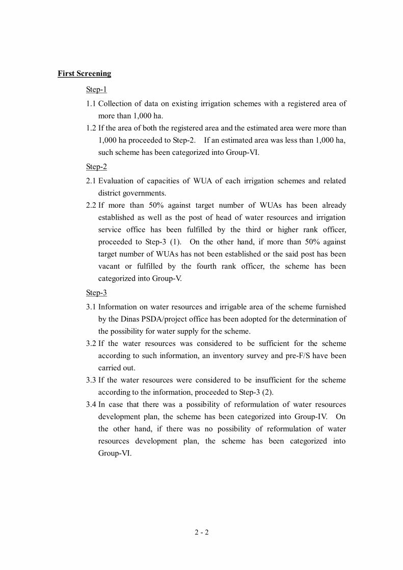
METHOD AND PROCESS FLOW OF PRIORITIZATION
General Flow
General flow of prioritization of irrigation schemes for rehabilitation is shown
below and detail descriptions of the flow are presented in following sections.
All irrigation schemes of which registered area are
larger than 1,000 ha in the province
Start
Is preliminary estimated
irrigable area larger than
1,000 ha?
Are more than 50% against target
number of WUAs already established
and capacity of local government
sufficient?
Are water resources
seems to be enough for
the scheme?
First Screening
Pre-F/S level field investigation
(inventory survey)
Prioritization of irrigation schemes for
rehabilitation based on Pre-F/S result
Is the scheme
technically sustaible
and contribute social
affairs?
Group-I Group-II Group-III
F/S within Short
Term
Group-IV Group-V Group-VI
Second Screening
F/S within
Middle TermF/S within Long
Term
Formulation of
Action Plan
Formulation of
Action Plan
Formulation of
Action Plan
Implementation
within Short Term
(if it is feasible)
Implementation
within Middle
Term (if it is
feasible)
Implementation
within Long Term
(if it is feas ible)
Reformulation of
Water Resouces
Development
Plan
Acceralation of
WUAs
Establishment
and Institutional
Development
Development by
Ohter Category
or Method
Is there possibility of
improving usage of
water resources?
Future Imple-
mentation
(rehabilitation is
suspended until
status meets
required criteria)
Future Imple-
mentation
(rehabilitation is
suspended until
status meets
required criteria)
Future Imple-
mentation
(rehabilitation is
suspended until
status meets
required criteria)
Prioritized Group
Yes
No
No
No
Yes
Yes
Yes
No
Yes
No
Pre-feasibility Study (Pre-F/S)
Step 1
Step 2
Step 3
Step 4
Step 5
2 - 2
First Screening
Step-1
1.1 Collection of data on existing irrigation schemes with a registered area of
more than 1,000 ha.
1.2 If the area of both the registered area and the estimated area were more than
1,000 ha proceeded to Step-2. If an estimated area was less than 1,000 ha,
such scheme has been categorized into Group-VI.
Step-2
2.1 Evaluation of capacities of WUA of each irrigation schemes and related
district governments.
2.2 If more than 50% against target number of WUAs has been already
established as well as the post of head of water resources and irrigation
service office has been fulfilled by the third or higher rank officer,
proceeded to Step-3 (1). On the other hand, if more than 50% against
target number of WUAs has not been established or the said post has been
vacant or fulfilled by the fourth rank officer, the scheme has been
categorized into Group-V.
Step-3
3.1 Information on water resources and irrigable area of the scheme furnished
by the Dinas PSDA/project office has been adopted for the determination of
the possibility for water supply for the scheme.
3.2 If the water resources was considered to be sufficient for the scheme
according to such information, an inventory survey and pre-F/S have been
carried out.
3.3 If the water resources were considered to be insufficient for the scheme
according to the information, proceeded to Step-3 (2).
3.4 In case that there was a possibility of reformulation of water resources
development plan, the scheme has been categorized into Group-IV. On
the other hand, if there was no possibility of reformulation of water
resources development plan, the scheme has been categorized into
Group-VI.

2 - 3
Second Screening
Step-4
4.1 If there are such problems as low technical sustainability (high construction
cost and low economic feasibility) and less contribution to the society, such
scheme has been categorized into Group-VI.
Prioritization by Weighted Scoring Method
Step-5
5.1 Evaluation indicators for prioritization consist of issues of: (a) irrigation,
(b) agricultural productivity, (c) society, and (d) economic and financial
impacts. Weight of indicators are as follows and detail is shown in page 2-4
“Evaluation Indicators for Weighted Scoring”.
Evaluation Indicators for Weighted Scoring
Evaluation Indicator Weighted Score 1. Issue of Irrigation Indicator 50 1.1 Utilization of irrigation potential (10) 1.2 Urgency of rehabilitation (25) 1.3 Sustainability (15) 2. Issue of Agriculture Productivity 20 2.1 Current cropping intensity (10) 2.2 Current unit yield of paddy (10) 3. Issue of Society 15 3.1 Number of beneficiaries (7.5) 3.2 Provision of social infrastructure (7.5)
4. Issue of Economic and Financial Impact 15 4.1 Feasibility (Pre-F/S level EIRR) (7.5) 4.2 Agriculture return per hectare (7.5)
5.2 Based on the comprehensive examination of the above evaluation
indicators in pre-F/S, priority of the schemes to be rehabilitated has been
determined and listed.
Priority
Based on the priority list thus prepared, recommendation of implementation
procedure is made as follows:
Group-I: Recommended as the first priority
Group-II: Recommended as the second priority
Group-III: Recommended as the third priority
Group-IV: Recommended to reformulate water resources development plan
Group-V: Recommended to accelerate WUA establishment and to empower

2 - 4
district government officials concerned
Group-VI: Recommended to formulate development method by other
categories
The priority list classified into Groups-I to VI is presented in page 2-5 “Priority
List of Irrigation Schemes for Rehabilitation”.

Full Score WeightWeighted
ScoreSituation for High
Priority
1 50.01.1 10.0 (1) Less than 50 % 1.0 10.0
(2) 50 - 69 % 0.8 8.0
(3) 70 - 100 % 0.5 5.0
1.2 25.0
1.2.1 Function of Water Resources Facility 10.0 (1) Serious condition for operation (Evaluation: D) 1.0 10.0
(2) Not functioning well (Evaluation: C) 0.8 8.0
(3) Partially deteriorated (Evaluation: B) 0.6 6.0
(4) Functioning well (Evaluation: A) 0.4 4.0
1.2.2 Function of Main Canal System 7.0 (1) Serious condition for operation (Evaluation: D) 1.0 7.0
(2) Not functioning well (Evaluation: C) 0.8 5.6
(3) Partially deteriorated (Evaluation: B) 0.6 4.2
(4) Functioning well (Evaluation: A) 0.4 2.8
1.2.3 Function of Secondary Canal System 5.0 (1) Serious condition for operation (Evaluation: D) 1.0 5.0
(2) Not functioning well (Evaluation: C) 0.8 4.0
(3) Partially deteriorated (Evaluation: B) 0.6 3.0
(4) Functioning well (Evaluation: A) 0.4 2.0
1.2.4 Function of On-farm System 3.0 (1) Serious condition for operation (Evaluation: D) 1.0 3.0
(2) Not functioning well (Evaluation: C) 0.8 2.4
(3) Partially deteriorated (Evaluation: B) 0.6 1.8
(4) Functioning well (Evaluation: A) 0.4 1.2
1.3 15.0
1.3.1 Age of the Facility 7.5 (1) More than 50 years 1.0 7.5
(2) 30 - 49 years 0.8 6.0
(3) 15 - 29 years 0.6 4.5
(4) Less than 15 years 0.4 3.0
1.3.2 Technical Level 7.5 (1) Non-technical level 1.0 7.5
(2) Semi-technical level 0.8 6.0
(3) Technical level 0.5 3.8
2 20.02.1 10.0 (1) Less than 100 % 1.0 10.0
(2) 100 - 149 % 0.8 8.0
(3) 150 - 199 % 0.6 6.0
(4) More than 200 % 0.4 4.0
2.2 10.0 (1) Less than 60 % of planned target yield 1.0 10.0
(2) 60 - 79 % of planned target yield 0.8 8.0
(3) 80 - 100 % of planned target yield 0.5 5.0
3 15.0 Severe social problem
3.1 7.5 (1) Less than 30 % of with project beneficiaries 1.0 7.5
(2) 30 - 59 % of with project beneficiaries 0.8 6.0
(3) 60 - 89 % of with project beneficiaries 0.6 4.5
(4) More than 90 % of with project beneficiaries 0.4 3.0
3.2 7.5 (1) Less than 40 % of total canal length of main &secondary canal
1.0 7.5
(2) 40 - 59 % of total canal length of main & secondarycanal
0.8 6.0
(3) 60 - 79 % of total canal length of main & secondarycanal
0.6 4.5
(4) 80 - 100 % of total canal length of main & secondarycanal
0.4 3.0
4 15.04.1 7.5 (1) More than 20 % 1.0 7.5
(2) 15 - 19 % 0.8 6.0
(3) 10 - 14 % 0.6 4.5
(4) Less than 10 % 0.4 3.0
4.2 7.5 (1) More than 200 % 1.0 7.5
(2) 150 - 199 % 0.8 6.0
(3) Less than 150 % 0.6 4.5
100.0
Current Unit Yield of Paddy
Severe problem onsustainability
Evaluation Indicators for Weighted Scoring
Evaluation IndexIssue for Evaluation
Severe problem onirrigation programachievement.
Urgency of Rehabilitation
Rate of Utilization of Irrigation Potential
(= present irrigation paddy area / irrigatedpaddy area with project x 100)
Severe problem onirrigation facilities
(= annual cropped area of paddy / subject areax 100)
TOTAL
Issue of Irrigation System
Issue of Agricultural Productivity
Issue of Society
Issue of Economic and Financial Impact
(= planned annual gross retern per ha / currentanuual gross retern per ha x 100)
Sustainability of Irrigation System
(Pre-F/S level EIRR)
Rate of Increase of Agricultural Retern per ha
Feasibility
High economic andfinancial impact
Current Cropping Intensity of Paddy
Severe problem onagriculture(low productivity)
Severe problem onagriculture(low productivity)
(= weighted average unit yield of irrigated &rainfed paddy in the scheme)
(Current ratio of Inspcetion Road Provision)
Contribution to Regional Economy
(Current Number of Beneficiaries)
Provision of Social Infrastructure
2 - 5
Irrigation Scheme
Uti
liza
tio
n o
f Ir
rig
atio
n P
ote
nti
al
Fu
nct
ion
of
Wat
er R
eso
urc
es F
acil
ity
Fu
nct
ion
of
Mai
n C
anal
Fu
nct
ion
of
Sec
on
dar
y C
anal
Fu
nct
ion
of
On
-far
m
Fac
tor
of
Det
erio
rati
on
by
Yea
r o
f C
on
stru
ctio
n
Tec
hn
ical
Lev
el
Cur
rent
Cro
ppin
g In
tent
sity
Cu
rren
t U
nit
Yie
ld o
f P
add
y
Con
tibu
tion
to
Reg
iona
l E
cono
my
Pro
vis
ion
of
soci
al i
nfr
astr
uct
ure
EIR
R
Rat
e o
f In
crea
se o
f G
ross
Ag
ricu
ltu
ral
Ret
urn
TotalScore
Ranking
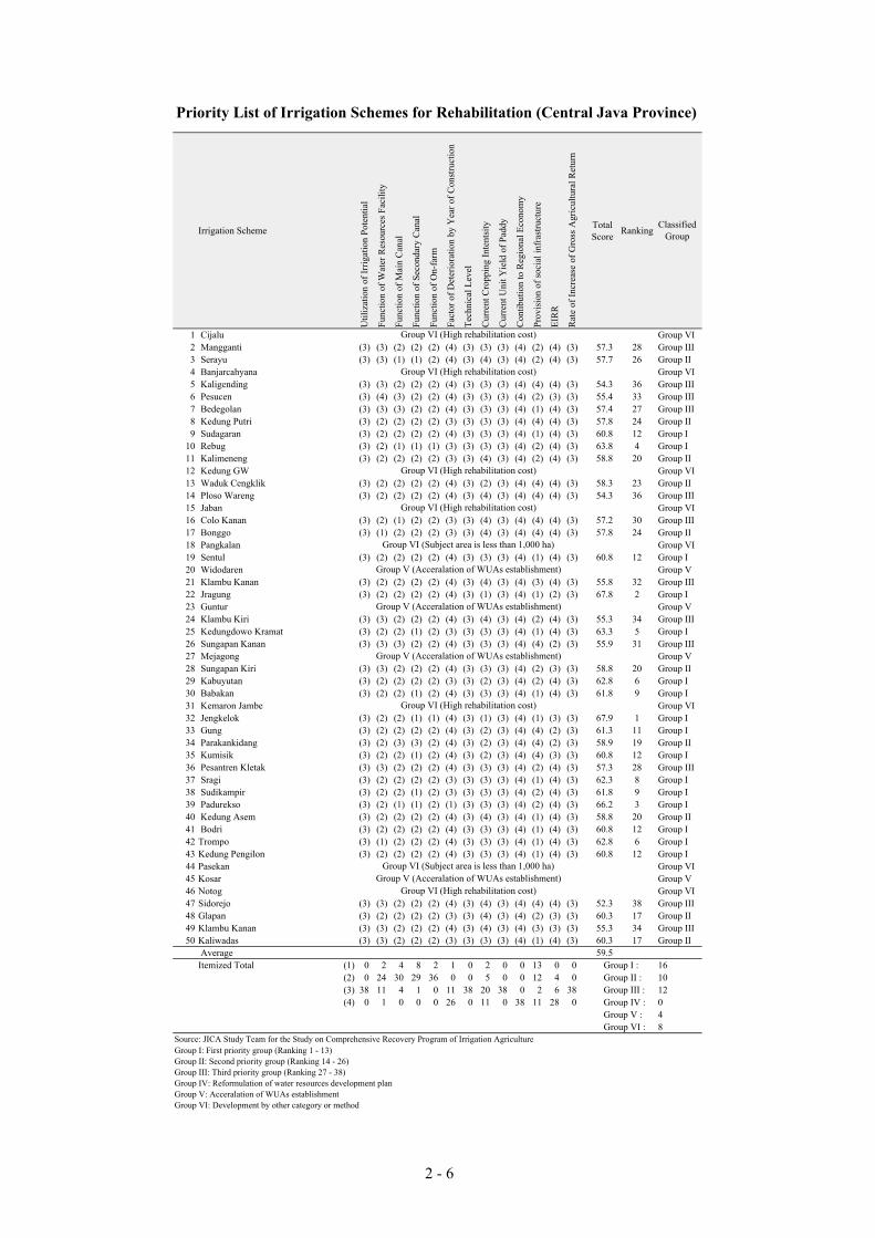
1 Cijalu Group VI
2 Mangganti (3) (3) (2) (2) (2) (4) (3) (3) (3) (4) (2) (4) (3) 57.3 28 Group III
3 Serayu (3) (3) (1) (1) (2) (4) (3) (4) (3) (4) (2) (4) (3) 57.7 26 Group II
4 Banjarcahyana Group VI
5 Kaligending (3) (3) (2) (2) (2) (4) (3) (3) (3) (4) (4) (4) (3) 54.3 36 Group III
6 Pesucen (3) (4) (3) (2) (2) (4) (3) (3) (3) (4) (2) (3) (3) 55.4 33 Group III
7 Bedegolan (3) (3) (3) (2) (2) (4) (3) (3) (3) (4) (1) (4) (3) 57.4 27 Group III
8 Kedung Putri (3) (2) (2) (2) (2) (3) (3) (3) (3) (4) (4) (4) (3) 57.8 24 Group II
9 Sudagaran (3) (2) (2) (2) (2) (4) (3) (3) (3) (4) (1) (4) (3) 60.8 12 Group I
10 Rebug (3) (2) (1) (1) (1) (3) (3) (3) (3) (4) (2) (4) (3) 63.8 4 Group I
11 Kalimeneng (3) (2) (2) (2) (2) (3) (3) (4) (3) (4) (2) (4) (3) 58.8 20 Group II
12 Kedung GW Group VI
13 Waduk Cengklik (3) (2) (2) (2) (2) (4) (3) (2) (3) (4) (4) (4) (3) 58.3 23 Group II
14 Ploso Wareng (3) (2) (2) (2) (2) (4) (3) (4) (3) (4) (4) (4) (3) 54.3 36 Group III
15 Jaban Group VI
16 Colo Kanan (3) (2) (1) (2) (2) (3) (3) (4) (3) (4) (4) (4) (3) 57.2 30 Group III
17 Bonggo (3) (1) (2) (2) (2) (3) (3) (4) (3) (4) (4) (4) (3) 57.8 24 Group II
18 Pangkalan Group VI
19 Sentul (3) (2) (2) (2) (2) (4) (3) (3) (3) (4) (1) (4) (3) 60.8 12 Group I
20 Widodaren Group V
21 Klambu Kanan (3) (2) (2) (2) (2) (4) (3) (4) (3) (4) (3) (4) (3) 55.8 32 Group III
22 Jragung (3) (2) (2) (2) (2) (4) (3) (1) (3) (4) (1) (2) (3) 67.8 2 Group I
23 Guntur Group V
24 Klambu Kiri (3) (3) (2) (2) (2) (4) (3) (4) (3) (4) (2) (4) (3) 55.3 34 Group III
25 Kedungdowo Kramat (3) (2) (2) (1) (2) (3) (3) (3) (3) (4) (1) (4) (3) 63.3 5 Group I
26 Sungapan Kanan (3) (3) (3) (2) (2) (4) (3) (3) (3) (4) (4) (2) (3) 55.9 31 Group III
27 Mejagong Group V
28 Sungapan Kiri (3) (3) (2) (2) (2) (4) (3) (3) (3) (4) (2) (3) (3) 58.8 20 Group II
29 Kabuyutan (3) (2) (2) (2) (2) (3) (3) (2) (3) (4) (2) (4) (3) 62.8 6 Group I
30 Babakan (3) (2) (2) (1) (2) (4) (3) (3) (3) (4) (1) (4) (3) 61.8 9 Group I
31 Kemaron Jambe Group VI
32 Jengkelok (3) (2) (2) (1) (1) (4) (3) (1) (3) (4) (1) (3) (3) 67.9 1 Group I
33 Gung (3) (2) (2) (2) (2) (4) (3) (2) (3) (4) (4) (2) (3) 61.3 11 Group I
34 Parakankidang (3) (2) (3) (3) (2) (4) (3) (2) (3) (4) (4) (2) (3) 58.9 19 Group II
35 Kumisik (3) (2) (2) (1) (2) (4) (3) (2) (3) (4) (4) (3) (3) 60.8 12 Group I
36 Pesantren Kletak (3) (3) (2) (2) (2) (4) (3) (3) (3) (4) (2) (4) (3) 57.3 28 Group III
37 Sragi (3) (2) (2) (2) (2) (3) (3) (3) (3) (4) (1) (4) (3) 62.3 8 Group I
38 Sudikampir (3) (2) (2) (1) (2) (3) (3) (3) (3) (4) (2) (4) (3) 61.8 9 Group I
39 Padurekso (3) (2) (1) (1) (2) (1) (3) (3) (3) (4) (2) (4) (3) 66.2 3 Group I
40 Kedung Asem (3) (2) (2) (2) (2) (4) (3) (4) (3) (4) (1) (4) (3) 58.8 20 Group II
41 Bodri (3) (2) (2) (2) (2) (4) (3) (3) (3) (4) (1) (4) (3) 60.8 12 Group I
42 Trompo (3) (1) (2) (2) (2) (4) (3) (3) (3) (4) (1) (4) (3) 62.8 6 Group I
43 Kedung Pengilon (3) (2) (2) (2) (2) (4) (3) (3) (3) (4) (1) (4) (3) 60.8 12 Group I
44 Pasekan Group VI
45 Kosar Group V
46 Notog Group VI
47 Sidorejo (3) (3) (2) (2) (2) (4) (3) (4) (3) (4) (4) (4) (3) 52.3 38 Group III
48 Glapan (3) (2) (2) (2) (2) (3) (3) (4) (3) (4) (2) (3) (3) 60.3 17 Group II
49 Klambu Kanan (3) (3) (2) (2) (2) (4) (3) (4) (3) (4) (3) (3) (3) 55.3 34 Group III
50 Kaliwadas (3) (3) (2) (2) (2) (3) (3) (3) (3) (4) (1) (4) (3) 60.3 17 Group II
Average 59.5
Itemized Total (1) 0 2 4 8 2 1 0 2 0 0 13 0 0 Group I : 16
(2) 0 24 30 29 36 0 0 5 0 0 12 4 0 Group II : 10
(3) 38 11 4 1 0 11 38 20 38 0 2 6 38 Group III : 12
(4) 0 1 0 0 0 26 0 11 0 38 11 28 0 Group IV : 0
Group V : 4
Group VI : 8Source: JICA Study Team for the Study on Comprehensive Recovery Program of Irrigation Agriculture
Group I: First priority group (Ranking 1 - 13)
Group II: Second priority group (Ranking 14 - 26)
Group III: Third priority group (Ranking 27 - 38)
Group IV: Reformulation of water resources development plan
Group V: Acceralation of WUAs establishment
Group VI: Development by other category or method
Group VI (Subject area is less than 1,000 ha)
Group VI (High rehabilitation cost)
Group V (Acceralation of WUAs establishment)
Group VI (High rehabilitation cost)
Group V (Acceralation of WUAs establishment)
Group V (Acceralation of WUAs establishment)
Group V (Acceralation of WUAs establishment)
Group VI (High rehabilitation cost)
Group VI (Subject area is less than 1,000 ha)
Group VI (High rehabilitation cost)
Group VI (High rehabilitation cost)
Priority List of Irrigation Schemes for Rehabilitation (Central Java Province)
ClassifiedGroup
Group VI (High rehabilitation cost)
2 - 6

PART-III Present Condition and
Pre-F/S level Development Plan
for Each Irrigation Scheme
Name of Scheme
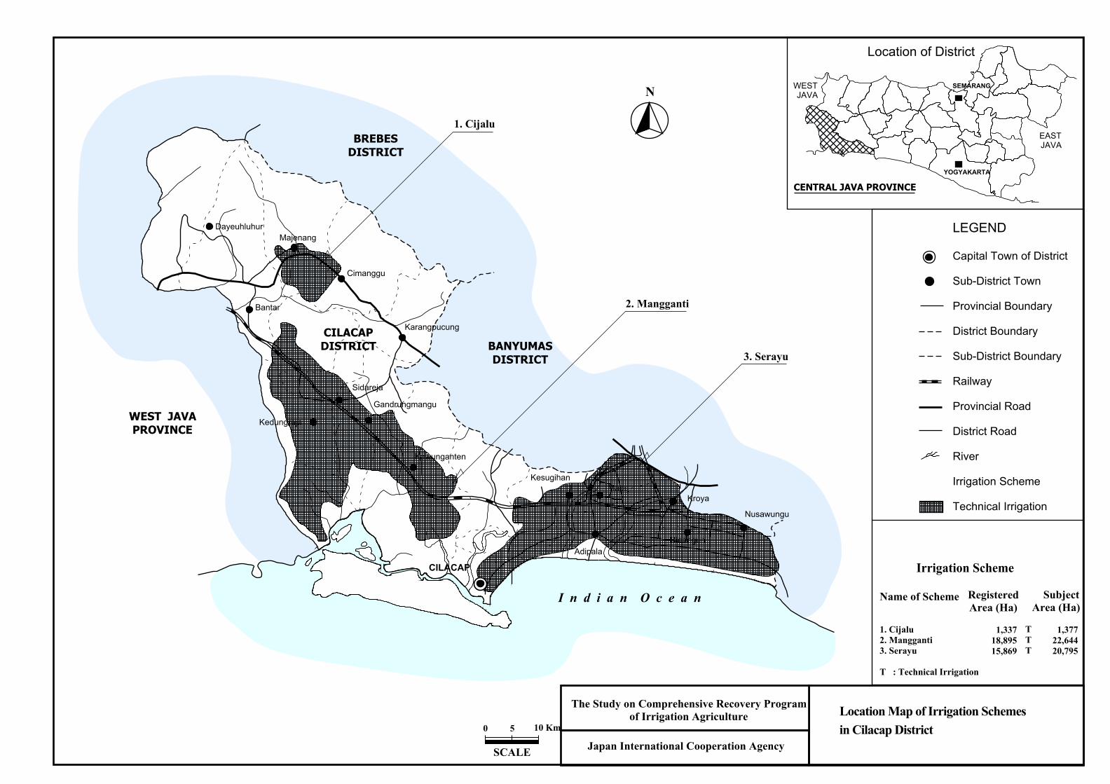
1. Cijalu2. Mangganti3. Serayu
T : Technical Irrigation
RegisteredArea (Ha)
1,33718,89515,869
SubjectArea (Ha)
1,37722,64420,795
Irrigation Scheme
TTT
Location Map of Irrigation Schemesin Cilacap District
Location of District
N
YOGYAKARTA
CENTRAL JAVA PROVINCE
SEMARANG
LEGEND
Capital Town of District
Sub-District Town
Provincial Boundary
District Boundary
Sub-District Boundary
Railway
Provincial Road
District Road
River
Irrigation Scheme
Technical Irrigation
WEST JAVA
EASTJAVA
Japan International Cooperation Agency
The Study on Comprehensive Recovery Programof Irrigation Agriculture
0 5
SCALE
10 Km
Bantar
Sidareja
Kedungreja
Gandrungmangu
Kawunganten
DayeuhluhurMajenang
Cimanggu
Karangpucung
AdipalaBinangun
Nusawungu
Kroya
KesugihanMaos
CILACAP
1. Cijalu
2. Mangganti
3. Serayu
BREBESDISTRICT
BANYUMASDISTRICT
WEST JAVAPROVINCE
CILACAPDISTRICT
I n d i a n O c e a n
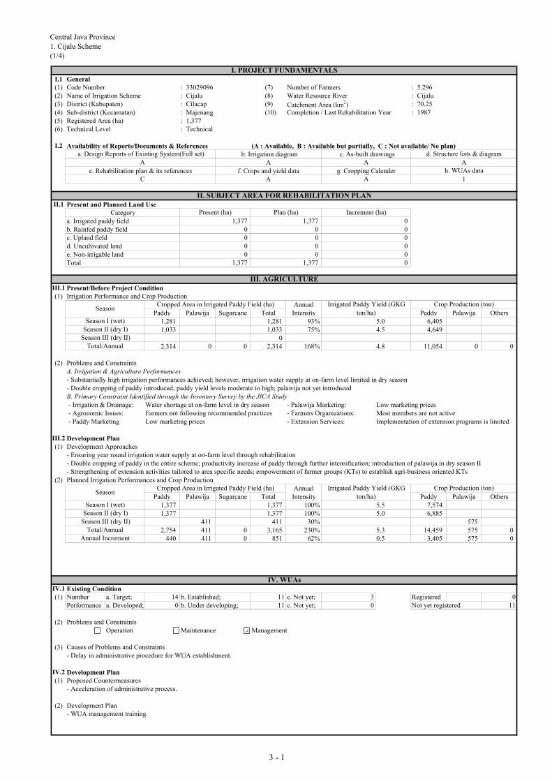
Central Java Province
1. Cijalu Scheme
(1/4)
I.1 General(1) Code Number : 33029096 (7) Number of Farmers : 5.296(2) Name of Irrigation Scheme : Cijalu (8) Water Resource River : Cijalu(3) District (Kabupaten) : Cilacap (9) Catchment Area (km2) : 70.25(4) Sub-district (Kecamatan) : Majenang (10) Completion / Last Rehabilitation Year : 1987(5) Registered Area (ha) : 1,377(6) Technical Level : Technical
I.2 Availability of Reports/Documents & References (A : Available, B : Available but partially, C : Not available/ No plan) b. Irrigation diagram c. As-built drawings
A Ae. Rehabilitation plan & its references f. Crops and yield data g. Cropping Calender
A 1
II.1 Present and Planned Land UseCategory
a. Irrigated paddy field 1,377 1,377 0b. Rainfed paddy field 0 0 0c. Upland field 0 0 0d. Uncultivated land 0 0 0e. Non-irrigable land 0 0 0Total 1,377 1,377 0
III.1 Present/Before Project Condition(1) Irrigation Performance and Crop Production
AnnualPaddy Palawija Sugarcane Total Intensity Paddy Palawija Others
1,281 1,281 93% 5.0 6,4051,033 1,033 75% 4.5 4,649
02,314 0 0 2,314 168% 4.8 11,054 0 0
(2) Problems and ConstraintsA. Irrigation & Agriculture Performances- Substantially high irrigation performances achieved; however, irrigation water supply at on-farm level limited in dry season- Double cropping of paddy introduced; paddy yield levels moderate to high; palawija not yet introduced B. Primary Constraint Identified through the Inventory Survey by the JICA Study - Irrigation & Drainage: Water shortage at on-farm level in dry season - Palawija Marketing: Low marketing prices - Agronomic Issues: Farmers not following recommended practices - Farmers Organizations: Most members are not active - Paddy Marketing Low marketing prices - Extension Services: Implementation of extension programs is limited
III.2 Development Plan(1) Development Approaches
- Ensuring year round irrigation water supply at on-farm level through rehabilitation - Double cropping of paddy in the entire scheme; productivity increase of paddy through further intensification; introduction of palawija in dry season II- Strengthening of extension activities tailored to area specific needs; empowerment of farmer groups (KTs) to establish agri-business oriented KTs
(2) Planned Irrigation Performances and Crop ProductionAnnual
Paddy Palawija Sugarcane Total Intensity Paddy Palawija Others1,377 1,377 100% 5.5 7,5741,377 1,377 100% 5.0 6,885
411 411 30% 5752,754 411 0 3,165 230% 5.3 14,459 575 0
440 411 0 851 62% 0.5 3,405 575 0
IV.1 Existing Condition(1) Number a. Target; 14 b. Established; 11 c. Not yet; 3 Registered 0
Performance a. Developed; 0 b. Under developing; 11 c. Not yet; 0 Not yet registered 11
(2) Problems and ConstraintsOperation Maintenance Management
(3) Causes of Problems and Constraints- Delay in administrative procedure for WUA establishment.
IV.2 Development Plan(1) Proposed Countermeasures
- Acceleration of administrative process.
(2) Development Plan- WUA management training.
I. PROJECT FUNDAMENTALS
a. Design Reports of Existing System(Full set) d. Structure lists & diagramA A
h. WUAs dataC A
II. SUBJECT AREA FOR REHABILITATION PLAN
Present (ha) Plan (ha) Increment (ha)
III. AGRICULTURE
SeasonCropped Area in Irrigated Paddy Field (ha) Irrigated Paddy Yield (GKG
ton/ha)
Crop Production (ton)
Season I (wet)Season II (dry I)
Season III (dry II)Total/Annual
IV. WUAs
Total/AnnualAnnual Increment
Cropped Area in Irrigated Paddy Field (ha) Irrigated Paddy Yield (GKG
ton/ha)
Crop Production (ton)
Season I (wet)Season II (dry I)
Season III (dry II)
Season
3 - 1

Central Java Province
1. Cijalu Scheme
(2/4)
V.1 Existing Condition(1) Overall Irrigation System : C (A: Functioning well, B: Partially deteriorated, C: Not functioning well, D: Serious condition for operation)
Water Resources Facility : C Main Canal System : C Secondary Canal System : C On-farm : C(2) Water Resources Facilty
a. Type of facility : Headworks e. Scouring sluice gate : 2 nos. i. Condition : Cb. Type of weir : Fixed weir f. Intake gate : 2 nos.c. Length of weir : 68 m g. Settling basin : not providedd. Design intake discharge : 2.7 m3/s h. Inspection bridge : no info. (no info.: no information)
(3) Irrigation Canal and Inspection RoadCanal Lined (m) Unlined (m) Total (m)
Main 2,000 3,331 5,331Secondary 530 16,142 16,672
(4) Major Problems and Constrains- Water Resources Facility
Physical operational problem on flood/scouring sluice gate(s) of headworksInsufficient diversion water due to sedimentation in front of intakePhysical operational problem on intake gate(s)
- Irrigation Canal and Related StructureSedimentation or obstruction of water flowLower function of regulating structure on canalDifficulty on O&M
(5) Causes of Major Problems and Constraints- Water Resources Facility
Improper design, installation and/or maintenance of flood/scouring sluice gate(s); breakdown of hoist, stem, guide frame or leafSedimentation in front of intakeImproper design, installation and/or maintenance of intake gate(s); breakdown of hoist, stem, guide frame or leaf
- Irrigation Canal and Related StructureNo provision of settling basin(sediments), improper management of canal (sediments, water plant) Deterioration of regulating structure on canal, especially gate and metal worksNo provision or damage of inspection road, difficulty on passing of inspection road due to damage, broken
V.2 Development Plan(1) Proposed Countermeasures for Major Problems
- Water Resources FacilityReplacement of control system or damaged equipment of flood/scouring sluice gate(s)Dredging or flushing of sediment, proper gate operation of headworks and intakeReplacement of intake gate(s)
- Irrigation Canal and Related StructureRemoval of sediment soil and foreign materials from canal, grass cutting Replacement and reconstruction of regulating structure on canalProvision or repair of inspection road with all weather type/pavement
(2) Water Resources Facility Dam/Headworks body Intake, civil Intake, mechanicalSettling basin
(3) Irrigation Canal and Related Structure
MainSecondaryMainSecondary
(4) On-farm Development (Unit: ha)
a. Potential Irrigated paddy field 1,377 d. Non-potential paddy field 0b. Potential non-irrigated paddy field 0 e. Non-potenttial non-paddy field 0c. Potential non-paddy field 0 1,377
(5) Rehabilitation Cost (Direct Cost) (Unit: Million Rp.)
On-Farm Project CostDevelop. Facility per ha
3,691 37,958 3,796 2,823 1,260 49,527 36.0 (W.R.F: Water Resources Facility, Develop.: Development)
VI.1 EIRR 4.8%
VI.2 Prioritization ScoringEvaluation Index Full Score Score Evaluation Index Full Score Score Total Score
Utilization of Irrigation Potential 10.0 - Agricultural Productivity 20.0 - 0.0Urgency 25.0 - Social Problem 15.0 -Sustainability 15.0 - Economic Impact 15.0 -
VI.3 Priority Group Group VI: Development by other category VI.4 Priority Ranking in the Province -
(High rehabilitation cost)
(A: Functioning well, B: Partially deteriorated, C: Not
functioning well, D: Serious condition for operation)
: minor rehabilitation
C94
Structure (nos)2,000
15,000212
: minor rehabilitation
Irrigation
System
VI. PROJECT EVALUATION
42
Total
Total
0
Irrigation
94
(A: Functioning well,
B: Partially deteriorated,
C: Not functioning well,
D: Serious condition for
operation)
0New construction
0
CCondition
Total5,331
21,442
V. IRRIGATION FACILITY
Inspection road (m)
212
Rehabilitation5,331
: minor rehabilitation
921,442
: replacement or new
No rehabilitaion
103254
Works
Drainage
Canal (m)
Structure
(nos)
W.R.F
0
00
3 - 2

Central Java Province1. Cijalu Scheme(3/4)
CategoryIrrigation (Headworks)
StructureFixed Weir
Condition
Problems
CategoryIrrigation (Headworks)
StructureFixed Weir
Condition
Problems
CategoryIrrigation (Headworks)
StructureIntake
Condition
Problems
Condition: A: Functioning well, B: Partially deteriorated, C: Not functioning well, D: Serious condition for operation
No settling basin is provided
D
Minor repairs for weir body and gates are required
A B C D
A B
Technical Level
CilacapCijalu
1,377 haTechnical
District
Registered Area
Scheme
D
1987
Minor repairs for weir body and gates are required
Year of Construction
A B C
C
3 - 3

Central Java Province
1. Cijalu Scheme
(4/4)
CategoryIrrigation (Main Canal)
StructureDivision Structure
Condition
Problems
CategoryIrrigation (Main Canal)
StructureDivision Structure
Condition
Problems
CategoryIrrigation (Secondary Canal)
StructureCanal and Division Box
Condition
Problems
Condition: A: Functioning well, B: Partially deteriorated, C: Not functioning well, D: Serious condition for operation
D
Require minor repair
Technical 1,377 ha Year of Construction
A B C
1987
D
Gates are required repair / replace
Technical Level Registered Area
A B C
Scheme Cijalu District Cilacap
DA B C
3 - 4

Central Java Province
2. Mangganti Scheme
(1/4)
I.1 General(1) Code Number : 33029134-40 (7) Number of Farmers : 87,092(2) Name of Irrigation Scheme : Mangganti (8) Water Resource River : Citanduy(3) District (Kabupaten) : Cilacap (9) Catchment Area (km2) : 25.46(4) Sub-district (Kecamatan) : Patimuan (10) Completion / Last Rehabilitation Year : 1997(5) Registered Area (ha) : 18,895(6) Technical Level : Technical
I.2 Availability of Reports/Documents & References (A : Available, B : Available but partially, C : Not available/ No plan) b. Irrigation diagram c. As-built drawings
A Ae. Rehabilitation plan & its references f. Crops and yield data g. Cropping Calender
A 2
II.1 Present and Planned Land UseCategory
a. Irrigated paddy field 22,644 22,644 0b. Rainfed paddy field 0 0 0c. Upland field 0 0 0d. Uncultivated land 0 0 0e. Non-irrigable land 0 0 0Total 22,644 22,644 0
III.1 Present/Before Project Condition(1) Irrigation Performance and Crop Production
AnnualPaddy Palawija Sugarcane Total Intensity Paddy Palawija Others
22,644 22,644 100% 5.0 113,22018,147 4,492 22,639 100% 4.5 81,662 13,476
5,317 5,317 23% 6,38040,791 9,809 0 50,600 223% 4.8 194,882 19,856 0
(2) Problems and ConstraintsA. Irrigation & Agriculture Performances- High irrigation performances achieved; however, irrigation water supply at on-farm level limited in dry season- Double cropping of paddy practiced almost in the entire irrigated area; paddy yield levels still low; palawija introduced extensivelyB. Primary Constraint Identified through the Inventory Survey by the JICA Study - Irrigation & Drainage: Water shortage at on-farm level in dry season - Palawija Marketing: Limited market outlet - Agronomic Issues: Damage caused by rat - Farmers Organizations: Managerial capacity of KTs are limited - Paddy Marketing Low marketing prices - Extension Services: Capability & experiences of PPLs are limited
III.2 Development Plan(1) Development Approaches
- Ensuring year round irrigation water supply at on-farm level through rehabilitation - Expansion of palawija production in dry season II; productivity increase of paddy & palawija through further intensification- Strengthening of extension activities tailored to area specific needs; empowerment of farmer groups (KTs) to establish agri-business oriented KTs
(2) Planned Irrigation Performances and Crop ProductionAnnual
Paddy Palawija Sugarcane Total Intensity Paddy Palawija Others22,644 22,644 100% 5.5 124,54218,115 4,529 22,644 100% 5.0 90,575 22,645
9,058 9,058 40% 12,68140,759 13,587 0 54,346 240% 5.3 215,117 35,326 0
(32) 3,778 0 3,746 17% 0.5 20,236 15,470 0
IV.1 Existing Condition(1) Number a. Target; 189 b. Established; 152 c. Not yet; 37 Registered 0
Performance a. Developed; 0 b. Under developing; 152 c. Not yet; 0 Not yet registered 152
(2) Problems and ConstraintsOperation Maintenance Management
(3) Causes of Problems and Constraints- Delay in administrative procedure for WUA establishment.
IV.2 Development Plan(1) Proposed Countermeasures
- Acceleration of administrative process.
(2) Development Plan- WUA management training.
I. PROJECT FUNDAMENTALS
a. Design Reports of Existing System(Full set) d. Structure lists & diagramA A
h. WUAs dataC A
II. SUBJECT AREA FOR REHABILITATION PLAN
Cropped Area in Irrigated Paddy Field (ha) Irrigated Paddy Yield (GKG
ton/ha)
Crop Production (ton)
Present (ha) Plan (ha) Increment (ha)
III. AGRICULTURE
Season II (dry I)Season III (dry II)
Season
Season
Season I (wet)Season II (dry I)
Season III (dry II)Total/Annual
IV. WUAs
Cropped Area in Irrigated Paddy Field (ha) Irrigated Paddy Yield (GKG
ton/ha)
Crop Production (ton)
Total/AnnualAnnual Increment
Season I (wet)
3 - 5

Central Java Province
2. Mangganti Scheme
(2/4)
V.1 Existing Condition(1) Overall Irrigation System : B (A: Functioning well, B: Partially deteriorated, C: Not functioning well, D: Serious condition for operation)
Water Resources Facility : B Main Canal System : C Secondary Canal System : C On-farm : C(2) Water Resources Facilty
a. Type of facility : Headworks e. Scouring sluice gate : - i. Condition : Bb. Type of weir : Movable weir f. Intake gate : 6 nos.c. Length of weir : 76 m g. Settling basin : providedd. Design intake discharge : 56.3 m3/s h. Inspection bridge : provided (no info.: no information)
(3) Irrigation Canal and Inspection RoadCanal Lined (m) Unlined (m) Total (m)
Main 69,687 0 69,687Secondary 170,000 20,500 190,500
(4) Major Problems and Constrains- Water Resources Facility
Problem on management for flood/scouring sluice gate(s) operationProblem on management for intake gate(s) operation
- Irrigation Canal and Related StructureImpassable of inspection road along canalLower function of regulating structure on canalDifficulty on O&M
(5) Causes of Major Problems and Constraints- Water Resources Facility
Improper maintenance of flood or scouring sluice gate(s) of headworks (no greasing and anti-rust painting)Improper management or deterioration of intake gate(s)
- Irrigation Canal and Related StructureImproper routine O&M works due to no or narrow wide of road, slope erosion by rainfall then in flow into canalDeterioration of regulating structure on canal, especially gate and metal worksNo provision or damage of inspection road, difficulty on passing of inspection road due to damage, broken
V.2 Development Plan(1) Proposed Countermeasures for Major Problems
- Water Resources FacilityReplacement of control system or damaged equipment of flood/scouring sluice gate(s) of headworksReplacement of control system or damaged equipment of intake
- Irrigation Canal and Related StructureProvision of inspection road both main and secondary canal with pavementReplacement and reconstruction of regulating structure on canalProvision or repair of inspection road with all weather type/pavement
(2) Water Resources Facility Dam/Headworks body Intake, civil Intake, mechanicalSettling basin
(3) Irrigation Canal and Related Structure
MainSecondaryMainSecondary
(4) On-farm Development (Unit: ha)
a. Potential Irrigated paddy field 22,644 d. Non-potential paddy field 0b. Potential non-irrigated paddy field 0 e. Non-potenttial non-paddy field 0c. Potential non-paddy field 0 22,644
(5) Rehabilitation Cost (Direct Cost) (Unit: Million Rp.)
On-Farm Project CostDevelop. Facility per ha
5,835 221,488 22,149 46,420 3,600 299,493 13.2 (W.R.F: Water Resources Facility, Develop.: Development)
VI.1 EIRR 7.5%
VI.2 Prioritization ScoringEvaluation Index Full Score Score Evaluation Index Full Score Score Total Score
Utilization of Irrigation Potential 10.0 5.0 Agricultural Productivity 20.0 11.0 57.3Urgency 25.0 18.0 Social Problem 15.0 9.0Sustainability 15.0 6.8 Economic Impact 15.0 7.5
VI.3 Priority Group VI.4 Priority Ranking in the Province 29
Structure
(nos)
34,0003643
Rehabilitation55,750
Canal (m)
Works
Total
Irrigation
System
VI. PROJECT EVALUATION
Irrigation Drainage TotalW.R.F
Group III: Third priority group
V. IRRIGATION FACILITY
Inspection road (m)40,000 C
(A: Functioning well, B: Partially deteriorated, C: Not
functioning well, D: Serious condition for operation)
(A: Functioning well,
B: Partially deteriorated,
C: Not functioning well,
D: Serious condition for
operation)
ConditionStructure (nos)170205
187156,500
2461741
134162
: minor rehabilitation
100,000
0
New construction0 69,687
C
: minor rehabilitation
Total
190,500
: minor rehabilitation: minor rehabilitation
No rehabilitaion13,937
3 - 6

Central Java Province2. Mangganti Scheme(3/4)
CategoryIrrigation (Headworks)
StructureMovable Weir
Condition
Problems
CategoryIrrigation (Headworks)
StructureMovable Weir
Condition
Problems
CategoryIrrigation (Headworks)
StructureIntake
Condition
Problems
Condition: A: Functioning well, B: Partially deteriorated, C: Not functioning well, D: Serious condition for operation
In good condition
D
In good condition
A B C D
A B
Technical Level
CilacapMangganti
18,895 haTechnical
District
Registered Area
Scheme
D
1997
In good condition
Year of Construction
A B C
C
3 - 7
Central Java Province2. Mangganti Scheme
(4/4)
CategoryIrrigation (Headworks)
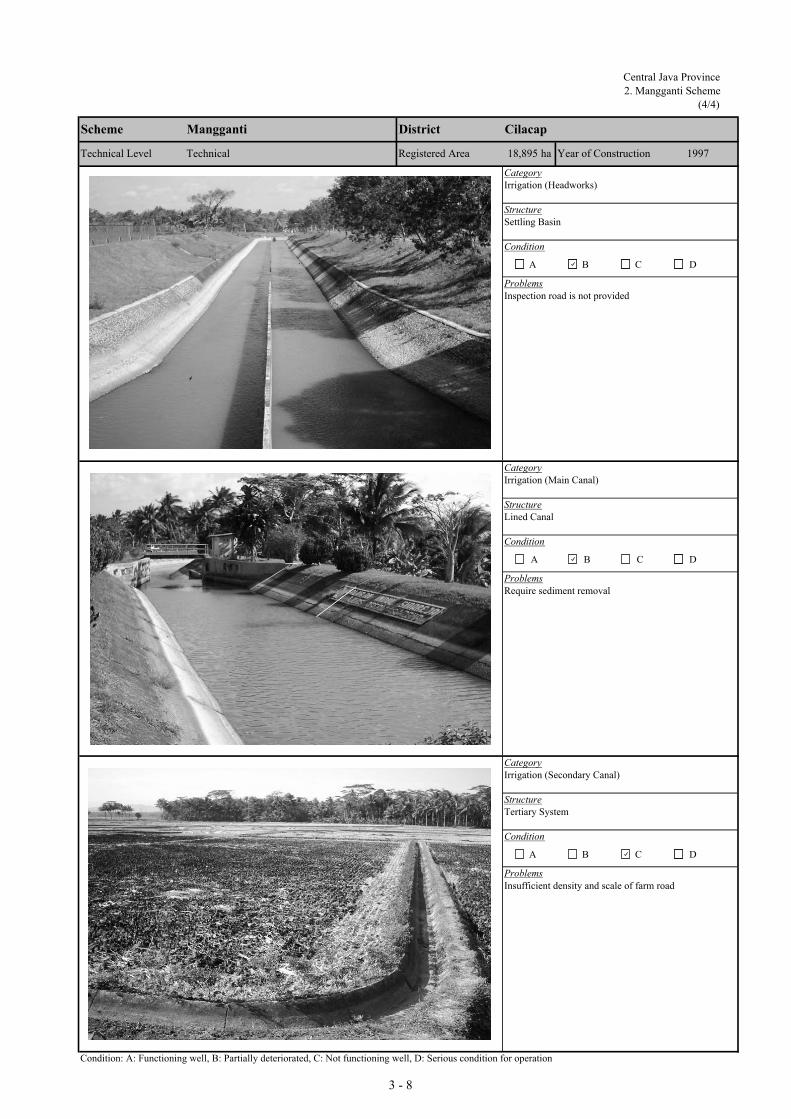
StructureSettling Basin
Condition
Problems
CategoryIrrigation (Main Canal)
StructureLined Canal
Condition
Problems
CategoryIrrigation (Secondary Canal)
StructureTertiary System
Condition
Problems
Condition: A: Functioning well, B: Partially deteriorated, C: Not functioning well, D: Serious condition for operation
D
Require sediment removal
Technical 18,895 ha Year of Construction
A B C
1997
D
Inspection road is not provided
Technical Level Registered Area
A B C
Scheme Mangganti District Cilacap
D
Insufficient density and scale of farm road
A B C
3 - 8
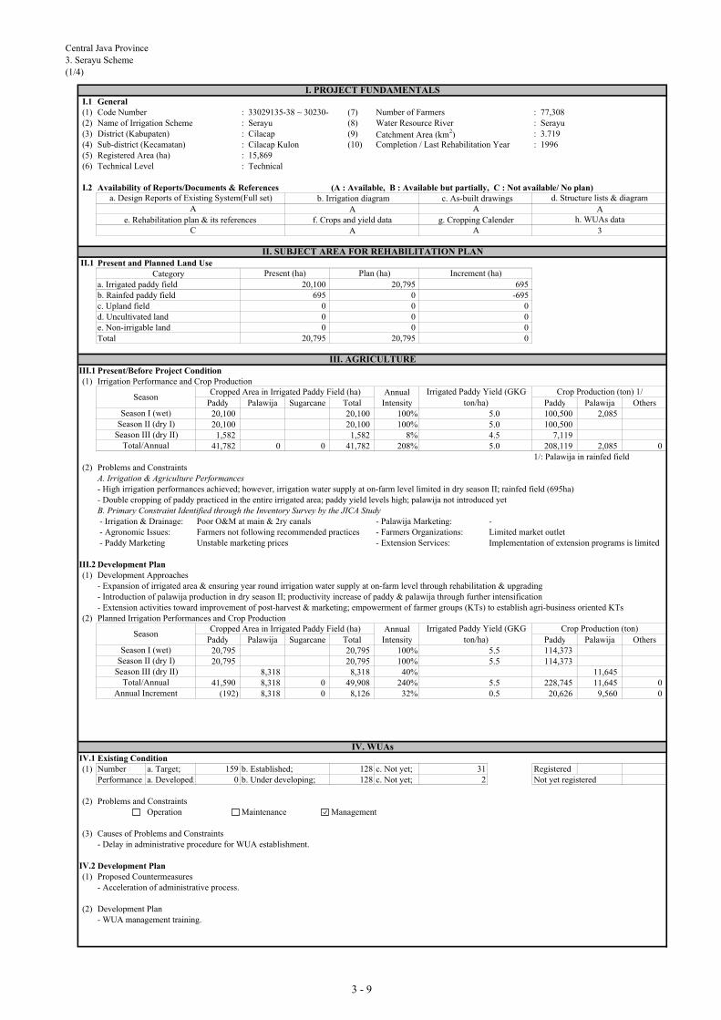
Central Java Province
3. Serayu Scheme
(1/4)
I.1 General(1) Code Number : 33029135-38 ~ 30230-3 (7) Number of Farmers : 77,308(2) Name of Irrigation Scheme : Serayu (8) Water Resource River : Serayu(3) District (Kabupaten) : Cilacap (9) Catchment Area (km2) : 3.719(4) Sub-district (Kecamatan) : Cilacap Kulon (10) Completion / Last Rehabilitation Year : 1996(5) Registered Area (ha) : 15,869(6) Technical Level : Technical
I.2 Availability of Reports/Documents & References (A : Available, B : Available but partially, C : Not available/ No plan) b. Irrigation diagram c. As-built drawings
A Ae. Rehabilitation plan & its references f. Crops and yield data g. Cropping Calender
A 3
II.1 Present and Planned Land UseCategory
a. Irrigated paddy field 20,100 20,795 695b. Rainfed paddy field 695 0 -695c. Upland field 0 0 0d. Uncultivated land 0 0 0e. Non-irrigable land 0 0 0Total 20,795 20,795 0
III.1 Present/Before Project Condition(1) Irrigation Performance and Crop Production
AnnualPaddy Palawija Sugarcane Total Intensity Paddy Palawija Others
20,100 20,100 100% 5.0 100,500 2,08520,100 20,100 100% 5.0 100,500
1,582 1,582 8% 4.5 7,11941,782 0 0 41,782 208% 5.0 208,119 2,085 0
1/: Palawija in rainfed field(2) Problems and Constraints
A. Irrigation & Agriculture Performances- High irrigation performances achieved; however, irrigation water supply at on-farm level limited in dry season II; rainfed field (695ha)- Double cropping of paddy practiced in the entire irrigated area; paddy yield levels high; palawija not introduced yetB. Primary Constraint Identified through the Inventory Survey by the JICA Study - Irrigation & Drainage: Poor O&M at main & 2ry canals - Palawija Marketing: - - Agronomic Issues: Farmers not following recommended practices - Farmers Organizations: Limited market outlet - Paddy Marketing Unstable marketing prices - Extension Services: Implementation of extension programs is limited
III.2 Development Plan(1) Development Approaches
- Expansion of irrigated area & ensuring year round irrigation water supply at on-farm level through rehabilitation & upgrading- Introduction of palawija production in dry season II; productivity increase of paddy & palawija through further intensification- Extension activities toward improvement of post-harvest & marketing; empowerment of farmer groups (KTs) to establish agri-business oriented KTs
(2) Planned Irrigation Performances and Crop ProductionAnnual
Paddy Palawija Sugarcane Total Intensity Paddy Palawija Others20,795 20,795 100% 5.5 114,37320,795 20,795 100% 5.5 114,373
8,318 8,318 40% 11,64541,590 8,318 0 49,908 240% 5.5 228,745 11,645 0
(192) 8,318 0 8,126 32% 0.5 20,626 9,560 0
IV.1 Existing Condition(1) Number a. Target; 159 b. Established; 128 c. Not yet; 31 Registered
Performance a. Developed; 0 b. Under developing; 128 c. Not yet; 2 Not yet registered
(2) Problems and ConstraintsOperation Maintenance Management
(3) Causes of Problems and Constraints- Delay in administrative procedure for WUA establishment.
IV.2 Development Plan(1) Proposed Countermeasures
- Acceleration of administrative process.
(2) Development Plan- WUA management training.
I. PROJECT FUNDAMENTALS
a. Design Reports of Existing System(Full set) d. Structure lists & diagramA A
h. WUAs dataC A
II. SUBJECT AREA FOR REHABILITATION PLAN
Present (ha) Plan (ha) Increment (ha)
III. AGRICULTURE
SeasonCropped Area in Irrigated Paddy Field (ha) Irrigated Paddy Yield (GKG
ton/ha)
Crop Production (ton) 1/
Season I (wet)Season II (dry I)
Season III (dry II)Total/Annual
IV. WUAs
Total/AnnualAnnual Increment
Cropped Area in Irrigated Paddy Field (ha) Irrigated Paddy Yield (GKG
ton/ha)
Crop Production (ton)
Season I (wet)Season II (dry I)
Season III (dry II)
Season
3 - 9

Central Java Province
3. Serayu Scheme
(2/4)
V.1 Existing Condition(1) Overall Irrigation System : C (A: Functioning well, B: Partially deteriorated, C: Not functioning well, D: Serious condition for operation)
Water Resources Facility : B Main Canal System : D Secondary Canal System : D On-farm : C(2) Water Resources Facilty
a. Type of facility : Headworks e. Scouring sluice gate : - i. Condition : Bb. Type of weir : Movable weir f. Intake gate : 4 nos.c. Length of weir : 12 m g. Settling basin : providedd. Design intake discharge : 32.0 m3/s h. Inspection bridge : provided (no info.: no information)
(3) Irrigation Canal and Inspection RoadCanal Lined (m) Unlined (m) Total (m)
Main 4,108 91,839 95,947Secondary 4,567 111,285 115,852
(4) Major Problems and Constrains- Water Resources Facility
Insufficient diversion water due to sedimentation in front of intake
- Irrigation Canal and Related StructureLeakage from canalImpassable of inspection road along canalDifficulty on water distribution
(5) Causes of Major Problems and Constraints- Water Resources Facility
Sedimentation in front of intake
- Irrigation Canal and Related StructureImproper regular maintenance of canal, settlement of canal then insufficient freeboard and overtopping Improper routine O&M works due to no or narrow wide of road, slope erosion by rainfall then in flow into canalNo provision of water level gauge/facility
V.2 Development Plan(1) Proposed Countermeasures for Major Problems
- Water Resources FacilityDredging or flushing of sediment, proper gate operation of headworks and intake
- Irrigation Canal and Related StructureRepair of leakage from canal, widen canal wide, recompaction of embankmentProvision of inspection road both main and secondary canal with pavementProvision of water level gauge/facility
(2) Water Resources Facility Dam/Headworks body Intake, civil Intake, mechanicalSettling basin
(3) Irrigation Canal and Related Structure
MainSecondaryMainSecondary
(4) On-farm Development (Unit: ha)
a. Potential Irrigated paddy field 20,100 d. Non-potential paddy field 0b. Potential non-irrigated paddy field 695 e. Non-potenttial non-paddy field 0c. Potential non-paddy field 0 20,795
(5) Rehabilitation Cost (Direct Cost) (Unit: Million Rp.)
On-Farm Project CostDevelop. Facility per ha
4,098 472,366 47,237 42,986 3,600 570,286 27.4 (W.R.F: Water Resources Facility, Develop.: Development)
VI.1 EIRR 1.7%
VI.2 Prioritization ScoringEvaluation Index Full Score Score Evaluation Index Full Score Score Total Score
Utilization of Irrigation Potential 10.0 5.0 Agricultural Productivity 20.0 9.0 57.7Urgency 25.0 20.4 Social Problem 15.0 9.0Sustainability 15.0 6.8 Economic Impact 15.0 7.5
VI.3 Priority Group VI.4 Priority Ranking in the Province 27Group III: Third priority group
63142
Total
497
New construction
031243
Rehabilitation95,125 0
Works
W.R.F
114,939
V. IRRIGATION FACILITY
Inspection road (m)
639
(A: Functioning well,
B: Partially deteriorated,
C: Not functioning well,
D: Serious condition for
operation)
ConditionStructure (nos)
D
128
Irrigation
System
No rehabilitaion822
Irrigation Drainage
VI. PROJECT EVALUATION
Canal (m)
Structure
(nos)
Total
: no rehabilitation
913
(A: Functioning well, B: Partially deteriorated, C: Not
functioning well, D: Serious condition for operation)
: minor rehabilitation: minor rehabilitation
50,00050,000
D
: no rehabilitation
306
767
Total95,947
115,852337
3 - 10

Central Java Province3. Serayu Scheme(3/4)
CategoryIrrigation (Headworks)
StructureMovable Weir
Condition
Problems
CategoryIrrigation (Headworks)
StructureIntake, Gantry Crane
Condition
Problems
CategoryIrrigation (Headworks)
StructureSettling Basin
Condition
Problems
Condition: A: Functioning well, B: Partially deteriorated, C: Not functioning well, D: Serious condition for operation
In good condition
D
In good condition
A B C D
A B
Technical Level
CilacapSerayu
15,869 haTechnical
District
Registered Area
Scheme
D
1996
In good condition
Year of Construction
A B C
C
3 - 11
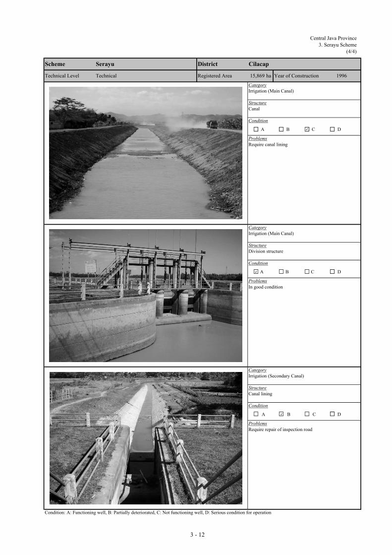
Central Java Province
3. Serayu Scheme
(4/4)
CategoryIrrigation (Main Canal)
StructureCanal
Condition
Problems
CategoryIrrigation (Main Canal)
StructureDivision structure
Condition
Problems
CategoryIrrigation (Secondary Canal)
StructureCanal lining
Condition
Problems
Condition: A: Functioning well, B: Partially deteriorated, C: Not functioning well, D: Serious condition for operation
D
Require repair of inspection road
A B C
Scheme Serayu District Cilacap
D
Require canal lining
Technical Level Registered Area
A B C
D
In good condition
Technical 15,869 ha Year of Construction
A B C
1996
3 - 12
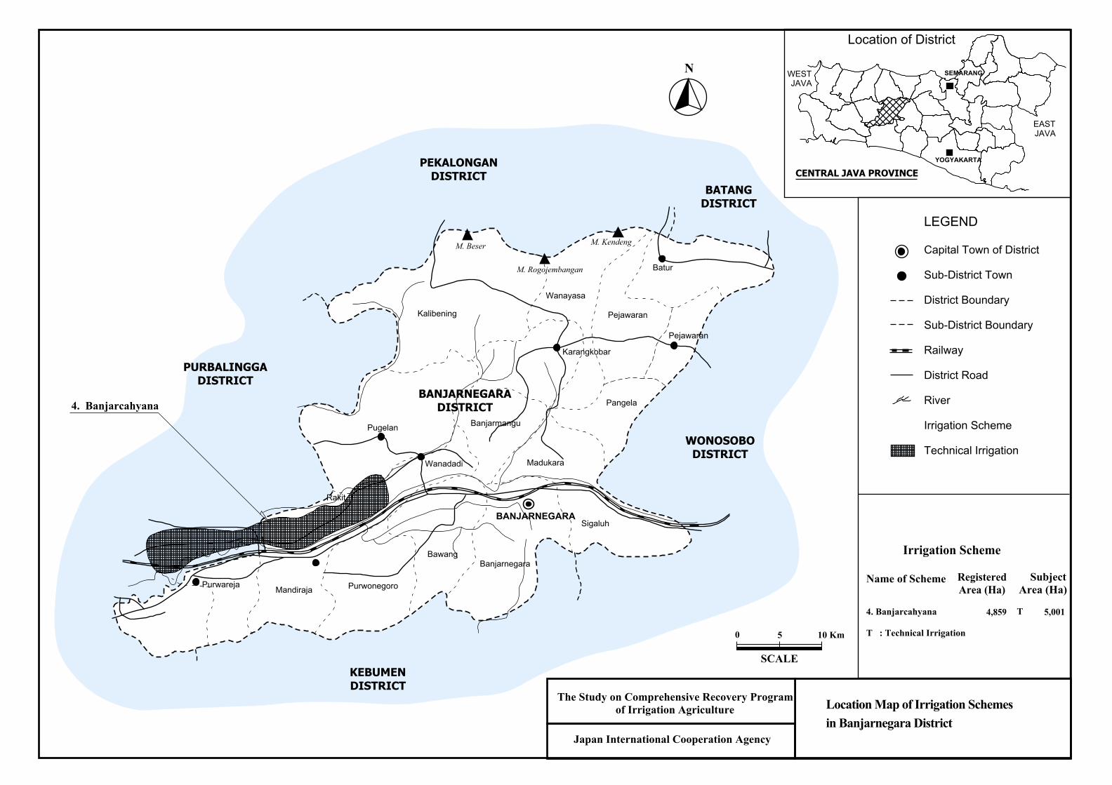
Name of Scheme
4. Banjarcahyana
T : Technical Irrigation
RegisteredArea (Ha)
4,859
SubjectArea (Ha)
5,001
Irrigation Scheme
T
Location Map of Irrigation Schemesin Banjarnegara District
LEGEND
Capital Town of District
Sub-District Town
District Boundary
Sub-District Boundary
Railway
District Road
River
Irrigation Scheme
Technical Irrigation
N
Japan International Cooperation Agency
The Study on Comprehensive Recovery Programof Irrigation Agriculture
Location of District
YOGYAKARTA
CENTRAL JAVA PROVINCE
SEMARANGWEST JAVA
EASTJAVA
0 5 10 Km
SCALE
Kalibening
Pugelan
Wanayasa
Pejawaran
Pangela
Madukara
Purwonegoro
BawangBanjarnegara
Sigaluh
Banjarmangu
MandirajaPurwareja
Karangkobar
Pejawaran
Rakit
BANJARNEGARA
BANJARNEGARADISTRICT
Wanadadi
M. Beser
BaturM. Rogojembangan
M. Kendeng
PEKALONGANDISTRICT
PURBALINGGADISTRICT
KEBUMENDISTRICT
WONOSOBODISTRICT
BATANGDISTRICT
4. Banjarcahyana

Central Java Province
4. Banjarcahyana Scheme
(1/4)
I.1 General(1) Code Number : 33027166-69 (7) Number of Farmers : 45,464(2) Name of Irrigation Scheme : Banjarcahyana (8) Water Resource River : Serayu(3) District (Kabupaten) : Banjarnegara (9) Catchment Area (km2) : 10.22(4) Sub-district (Kecamatan) : Rakit (10) Completion / Last Rehabilitation Year : 1986(5) Registered Area (ha) : 4,859(6) Technical Level : Technical
I.2 Availability of Reports/Documents & References (A : Available, B : Available but partially, C : Not available/ No plan) b. Irrigation diagram c. As-built drawings
A Ae. Rehabilitation plan & its references f. Crops and yield data g. Cropping Calender
A 3
II.1 Present and Planned Land UseCategory
a. Irrigated paddy field 5,001 5,001 0b. Rainfed paddy field 0 0 0c. Upland field 0 0 0d. Uncultivated land 0 0 0e. Non-irrigable land 0 0 0Total 5,001 5,001 0
III.1 Present/Before Project Condition(1) Irrigation Performance and Crop Production
AnnualPaddy Palawija Sugarcane Total Intensity Paddy Palawija Others
5,001 5,001 100% 5.5 27,5064,001 4,001 80% 5.5 22,006
09,002 0 0 9,002 180% 5.5 49,511 0 0
(2) Problems and ConstraintsA. Irrigation & Agriculture Performances- Substantially high irrigation performances achieved; however, irrigation water supply at on-farm level limited in dry season- Double cropping of paddy practiced almost in the entire irrigated area; paddy yield levels high; palawija not introduced yetB. Primary Constraint Identified through the Inventory Survey by the JICA Study - Irrigation & Drainage: Water shortage at on-farm level in dry season - Palawija Marketing: Low marketing prices - Agronomic Issues: Farmers not following recommended practices - Farmers Organizations: Most members are not active - Paddy Marketing Low marketing prices - Extension Services: Implementation of extension programs is limited
III.2 Development Plan(1) Development Approaches
- Ensuring year round irrigation water supply at on-farm level through rehabilitation - Double cropping of paddy in the entire scheme; productivity increase of paddy through further intensification; introduction of palawija in dry season II- Extension activities toward improvement of post-harvest & marketing; empowerment of farmer groups (KTs) to establish agri-business oriented KTs
(2) Planned Irrigation Performances and Crop ProductionAnnual
Paddy Palawija Sugarcane Total Intensity Paddy Palawija Others5,001 5,001 100% 6.0 30,0065,001 5,001 100% 6.0 30,006
1,500 1,500 30% 2,10010,002 1,500 0 11,502 230% 6.0 60,012 2,100 0
1,000 1,500 0 2,500 50% 0.5 10,501 2,100 0
IV.1 Existing Condition(1) Number a. Target; 49 b. Established; 40 c. Not yet; 9 Registered 0
Performance a. Developed; 0 b. Under developing; 40 c. Not yet; 0 Not yet registered 40
(2) Problems and ConstraintsOperation Maintenance Management
(3) Causes of Problems and Constraints- Low level function of irrigation facilities- Delay in administrative procedure for WUA establishment.
IV.2 Development Plan(1) Proposed Countermeasures
- Improvement of O&M technology.- Acceleration of administrative process.
(2) Development Plan- WUA O&M training.
I. PROJECT FUNDAMENTALS
a. Design Reports of Existing System(Full set) d. Structure lists & diagramA A
h. WUAs dataC A
II. SUBJECT AREA FOR REHABILITATION PLAN
Present (ha) Plan (ha) Increment (ha)
III. AGRICULTURE
SeasonCropped Area in Irrigated Paddy Field (ha) Irrigated Paddy Yield (GKG
ton/ha)
Crop Production (ton)
Season I (wet)Season II (dry I)
Season III (dry II)Total/Annual
IV. WUAs
Total/AnnualAnnual Increment
Cropped Area in Irrigated Paddy Field (ha) Irrigated Paddy Yield (GKG
ton/ha)
Crop Production (ton)
Season I (wet)Season II (dry I)
Season III (dry II)
Season
3 - 13
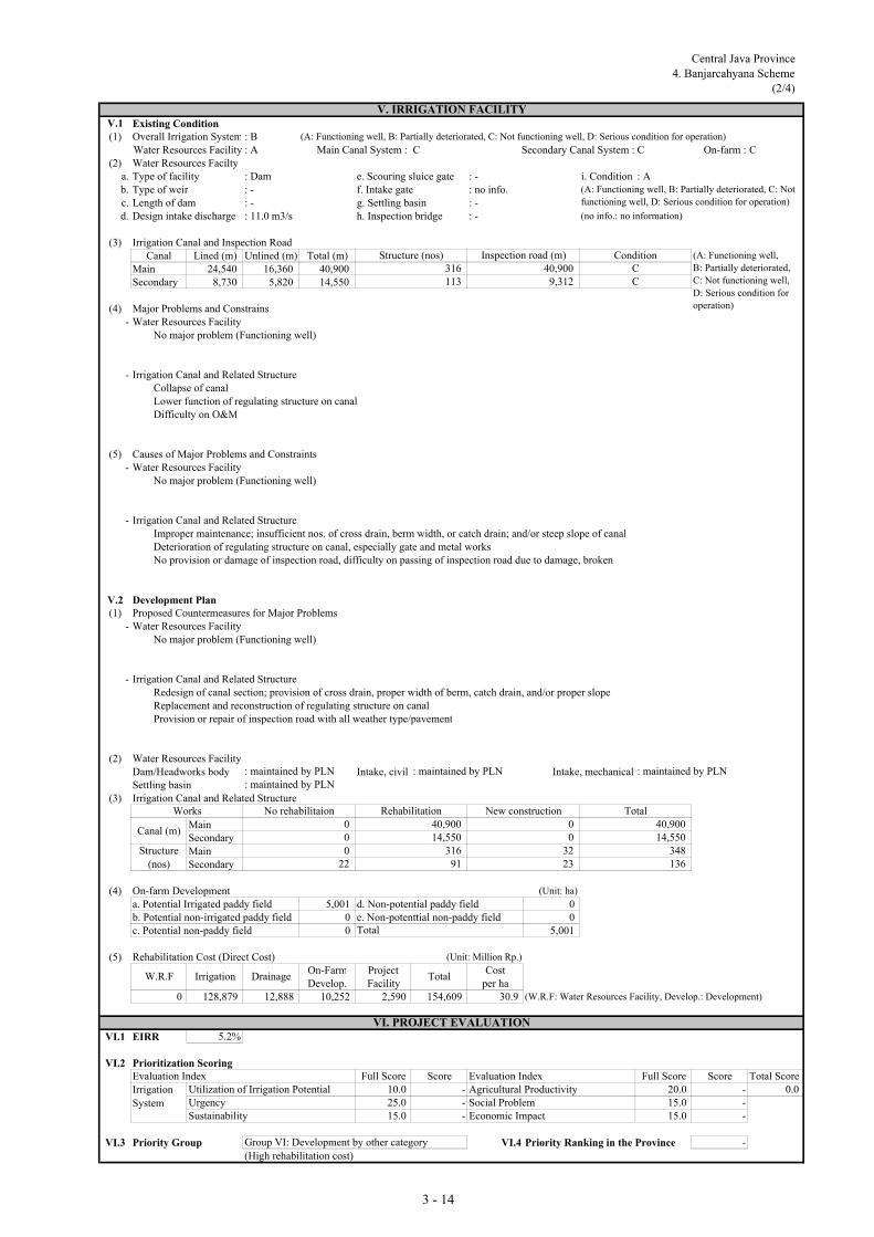
Central Java Province
4. Banjarcahyana Scheme
(2/4)
V.1 Existing Condition(1) Overall Irrigation System : B (A: Functioning well, B: Partially deteriorated, C: Not functioning well, D: Serious condition for operation)
Water Resources Facility : A Main Canal System : C Secondary Canal System : C On-farm : C(2) Water Resources Facilty
a. Type of facility : Dam e. Scouring sluice gate : - i. Condition : Ab. Type of weir : - f. Intake gate : no info.c. Length of dam : - g. Settling basin : -d. Design intake discharge : 11.0 m3/s h. Inspection bridge : - (no info.: no information)
(3) Irrigation Canal and Inspection RoadCanal Lined (m) Unlined (m) Total (m)
Main 24,540 16,360 40,900Secondary 8,730 5,820 14,550
(4) Major Problems and Constrains- Water Resources Facility
No major problem (Functioning well)
- Irrigation Canal and Related StructureCollapse of canalLower function of regulating structure on canalDifficulty on O&M
(5) Causes of Major Problems and Constraints- Water Resources Facility
No major problem (Functioning well)
- Irrigation Canal and Related StructureImproper maintenance; insufficient nos. of cross drain, berm width, or catch drain; and/or steep slope of canalDeterioration of regulating structure on canal, especially gate and metal worksNo provision or damage of inspection road, difficulty on passing of inspection road due to damage, broken
V.2 Development Plan(1) Proposed Countermeasures for Major Problems
- Water Resources FacilityNo major problem (Functioning well)
- Irrigation Canal and Related StructureRedesign of canal section; provision of cross drain, proper width of berm, catch drain, and/or proper slopeReplacement and reconstruction of regulating structure on canalProvision or repair of inspection road with all weather type/pavement
(2) Water Resources Facility Dam/Headworks body Intake, civil Intake, mechanicalSettling basin
(3) Irrigation Canal and Related Structure
MainSecondaryMainSecondary
(4) On-farm Development (Unit: ha)
a. Potential Irrigated paddy field 5,001 d. Non-potential paddy field 0b. Potential non-irrigated paddy field 0 e. Non-potenttial non-paddy field 0c. Potential non-paddy field 0 5,001
(5) Rehabilitation Cost (Direct Cost) (Unit: Million Rp.)
On-Farm Project CostDevelop. Facility per ha
0 128,879 12,888 10,252 2,590 154,609 30.9 (W.R.F: Water Resources Facility, Develop.: Development)
VI.1 EIRR 5.2%
VI.2 Prioritization ScoringEvaluation Index Full Score Score Evaluation Index Full Score Score Total Score
Utilization of Irrigation Potential 10.0 - Agricultural Productivity 20.0 - 0.0Urgency 25.0 - Social Problem 15.0 -Sustainability 15.0 - Economic Impact 15.0 -
VI.3 Priority Group Group VI: Development by other category VI.4 Priority Ranking in the Province -
(High rehabilitation cost)
(A: Functioning well, B: Partially deteriorated, C: Not
functioning well, D: Serious condition for operation)
0
VI. PROJECT EVALUATION
Canal (m)
Structure
(nos)
Total
022
32
W.R.F
: maintained by PLN: maintained by PLN
V. IRRIGATION FACILITY
Inspection road (m)
113
(A: Functioning well,
B: Partially deteriorated,
C: Not functioning well,
D: Serious condition for
operation)
ConditionStructure (nos)
C316
0
23316
91
Total
0
: maintained by PLN
40,9009,312
14,550
Rehabilitation40,900
C
New constructionWorks
: maintained by PLN
Irrigation
System
No rehabilitaion0
Irrigation Drainage
136
Total40,90014,550
348
3 - 14

Central Java Province4. Banjarcahyana Scheme(3/4)
CategoryIrrigation (Headworks)
StructureFixed Weir
Condition
Problems
CategoryIrrigation (Headworks)
StructureScouring Sluice and Intake
Condition
Problems
CategoryIrrigation (Headworks)
StructureScouring Sluice Gate
Condition
Problems
Condition: A: Functioning well, B: Partially deteriorated, C: Not functioning well, D: Serious condition for operation
Deterioration and require repair
D
Sediment in front of intake
A B C D
A B
Technical Level
BanjarnegaraBanjarcahyana
4,859 haTechnical
District
Registered Area
Scheme
D
1986
Sediment in front of intake
Year of Construction
A B C
C
3 -15

Central Java Province4. Banjarcahyana Scheme
(4/4)
CategoryIrrigation (Headworks)
StructureIntake
Condition
Problems
CategoryIrrigation (Main Canal)
StructureCulvert
Condition
Problems
Category
Structure
Condition
Problems
Condition: A: Functioning well, B: Partially deteriorated, C: Not functioning well, D: Serious condition for operation
D
Lost / broken safety facility, found sediment at inside of
barrel
Technical 4,859 ha Year of Construction
A B C
1986
D
Require minor repair
Technical Level Registered Area
A B C
Scheme Banjarcahyana District Banjarnegara
DA B C
3 - 16

Name of Scheme
5. Kaligending6. Pesucen7. Bedegolan
T : Technical Irrigation
RegisteredArea (Ha)
2.9811,6668,430
SubjectArea (Ha)
2.9231,6598,401
Irrigation Scheme
TTT
Location Map of Irrigation Schemesin Kebumen District
LEGEND
Capital Town of District
Municipal City
Sub-District Town
District Boundary
Sub-District Boundary
Railway
Provincial Road
District Road
River
Irrigation Scheme
Technical Irrigation
Location of District
N
YOGYAKARTA
CENTRAL JAVA PROVINCE
SEMARANGWEST JAVA
EASTJAVA
Japan International Cooperation Agency
The Study on Comprehensive Recovery Programof Irrigation Agriculture
WadaslintangReservoir
SemporReservoir
Ayah
Karangbolong
Kuarasari
Karanganyar
Puring Petanahan
Klirong Buluspesantren
Ambal
Mirit
Prembun
Kutowinangun
Alian
GOMBONG
KEBUMEN
5. Kaligending 6. Pesucen 7. Bedegolan
WONOSOBODISTRICT
PURWOREJODISTRICT
BANJARNEGARADISTRICT
BANYUMASDISTRICT
I n d i a n O c e a n
KEBUMENDISTRICT
0 5 10 Km
SCALE

Central Java Province
5. Kaligending Scheme
(1/4
I.1 General(1) Code Number : 33025084-87 (7) Number of Farmers : 14,615(2) Name of Irrigation Scheme : Kaligending (8) Water Resource River : Luk Ulo(3) District (Kabupaten) : Kebumen (9) Catchment Area (km2) : -(4) Sub-district (Kecamatan) : Bulu Pesantren/Karang (10) Completion / Last Rehabilitation Year : 1986/1999(5) Registered Area (ha) : 2,981(6) Technical Level : Technical
I.2 Availability of Reports/Documents & References (A : Available, B : Available but partially, C : Not available/ No plan) b. Irrigation diagram c. As-built drawings
A Ae. Rehabilitation plan & its references f. Crops and yield data g. Cropping Calender
A 40
II.1 Present and Planned Land UseCategory
a. Irrigated paddy field 2,923 2,923 0b. Rainfed paddy field 0 0 0c. Upland field 0 0 0d. Uncultivated land 0 0 0e. Non-irrigable land 0 0 0Total 2,923 2,923 0
III.1 Present/Before Project Condition(1) Irrigation Performance and Crop Production
AnnualPaddy Palawija Sugarcane Total Intensity Paddy Palawija Others
2,923 2,923 100% 5.0 14,6152,842 2,842 97% 4.5 12,789
657 657 22% 7885,765 657 0 6,422 220% 4.8 27,404 788 0
(2) Problems and ConstraintsA. Irrigation & Agriculture Performances- High irrigation performances achieved; however, water shortage in dry season reported- Double cropping of paddy practiced almost in the entire irrigated area; paddy yield levels moderate to high; palawija introduced substantiallyB. Primary Constraint Identified through the Inventory Survey by the JICA Study - Irrigation & Drainage: Water shortage at on-farm level in dry season - Palawija Marketing: Low marketing prices - Agronomic Issues: Farmers not following recommended practices - Farmers Organizations: Most members are not active - Paddy Marketing Low marketing prices - Extension Services: Capability & experiences of PPLs are limited
III.2 Development Plan(1) Development Approaches
- Ensuring year round irrigation water supply at on-farm level through rehabilitation - Double cropping of paddy in the entire scheme; productivity increase of paddy through further intensification; expansion of palawija in dry season II- Strengthening of extension activities tailored to area specific needs; empowerment of farmer groups (KTs) to establish agri-business oriented KTs
(2) Planned Irrigation Performances and Crop ProductionAnnual
Paddy Palawija Sugarcane Total Intensity Paddy Palawija Others2,923 2,923 100% 5.5 16,0772,923 2,923 100% 5.0 14,615
1,169 1,169 40% 1,6375,846 1,169 0 7,015 240% 5.3 30,692 1,637 0
81 512 0 593 20% 0.5 3,288 849 0
IV.1 Existing Condition(1) Number a. Target; 26 b. Established; 26 c. Not yet; 0 Registered 0
Performance a. Developed; 7 b. Under developing; 19 c. Not yet; 0 Not yet registered 26
(2) Problems and ConstraintsOperation Maintenance Management
(3) Causes of Problems and Constraints- Management system not functioned well.
IV.2 Development Plan(1) Proposed Countermeasures
- Improvement of WUA management capability.
(2) Development Plan- WUA management training.
I. PROJECT FUNDAMENTALS
a. Design Reports of Existing System(Full set) d. Structure lists & diagramA A
h. WUAs dataC A
II. SUBJECT AREA FOR REHABILITATION PLAN
Cropped Area in Irrigated Paddy Field (ha) Irrigated Paddy Yield (GKG
ton/ha)
Crop Production (ton)
Present (ha) Plan (ha) Increment (ha)
III. AGRICULTURE
Season II (dry I)Season III (dry II)
Season
Season
Season I (wet)Season II (dry I)
Season III (dry II)Total/Annual
IV. WUAs
Cropped Area in Irrigated Paddy Field (ha) Irrigated Paddy Yield (GKG
ton/ha)
Crop Production (ton)
Total/AnnualAnnual Increment
Season I (wet)
3 - 17

Central Java Province
5. Kaligending Scheme
(2/4)
V.1 Existing Condition(1) Overall Irrigation System : B (A: Functioning well, B: Partially deteriorated, C: Not functioning well, D: Serious condition for operation)
Water Resources Facility : B Main Canal System : C Secondary Canal System : C On-farm : C(2) Water Resources Facilty
a. Type of facility : Headworks e. Scouring sluice gate : 2 nos. i. Condition : Bb. Type of weir : Fixed weir f. Intake gate : no info.c. Length of weir : 88 m g. Settling basin : providedd. Design intake discharge : 3.5 m3/s h. Inspection bridge : not provided (no info.: no information)
(3) Irrigation Canal and Inspection RoadCanal Lined (m) Unlined (m) Total (m)
Main 12,000 0 12,000Secondary 6,000 9,000 15,000
(4) Major Problems and Constrains- Water Resources Facility
Problem on management for flood/scouring sluice gate(s) operationInsufficient diversion water due to sedimentation in front of intake
- Irrigation Canal and Related StructureSedimentation or obstruction of water flowCollapse of canalLower function of regulating structure on canalDifficulty on O&MDifficulty on water distribution
(5) Causes of Major Problems and Constraints- Water Resources Facility
Improper maintenance of flood or scouring sluice gate(s) of headworks (no greasing and anti-rust painting)Sedimentation in front of intake
- Irrigation Canal and Related StructureNo provision of settling basin(sediments), improper management of canal (sediments, water plant) Improper maintenance; insufficient nos. of cross drain, berm width, or catch drain; and/or steep slope of canalDeterioration of regulating structure on canal, especially gate and metal worksNo provision or damage of inspection road, difficulty on passing of inspection road due to damage, brokenNo provision of water level gauge/facility
V.2 Development Plan(1) Proposed Countermeasures for Major Problems
- Water Resources FacilityReplacement of control system or damaged equipment of flood/scouring sluice gate(s) of headworksDredging or flushing of sediment, proper gate operation of headworks and intake
- Irrigation Canal and Related StructureRemoval of sediment soil and foreign materials from canal, grass cutting Redesign of canal section; provision of cross drain, proper width of berm, catch drain, and/or proper slopeReplacement and reconstruction of regulating structure on canalProvision or repair of inspection road with all weather type/pavementProvision of water level gauge/facility
(2) Water Resources Facility Dam/Headworks body Intake, civil Intake, mechanicalSettling basin
(3) Irrigation Canal and Related Structure
MainSecondaryMainSecondary
(4) On-farm Development (Unit: ha)
a. Potential Irrigated paddy field 2,923 d. Non-potential paddy field 0b. Potential non-irrigated paddy field 0 e. Non-potenttial non-paddy field 0c. Potential non-paddy field 0 2,923
(5) Rehabilitation Cost (Direct Cost) (Unit: Million Rp.)
On-Farm Project CostDevelop. Facility per ha
2,537 28,943 2,894 5,992 1,570 41,936 14.3 (W.R.F: Water Resources Facility, Develop.: Development)
VI.1 EIRR 6.8%
VI.2 Prioritization ScoringEvaluation Index Full Score Score Evaluation Index Full Score Score Total Score
Utilization of Irrigation Potential 10.0 5.0 Agricultural Productivity 20.0 11.0 54.3Urgency 25.0 18.0 Social Problem 15.0 6.0Sustainability 15.0 6.8 Economic Impact 15.0 7.5
VI.3 Priority Group VI.4 Priority Ranking in the Province 37Group III: Third priority group
0
W.R.F
Works
: minor rehabilitation
Irrigation
System
No rehabilitaion
Total
Canal (m)
Structure
(nos)
Total
181,200
V. IRRIGATION FACILITY
Inspection road (m)
76
(A: Functioning well,
B: Partially deteriorated,
C: Not functioning well,
D: Serious condition for
operation)
ConditionStructure (nos)
C92
(A: Functioning well, B: Partially deteriorated, C: Not
functioning well, D: Serious condition for operation)
157476
: minor rehabilitation
0
9
: minor rehabilitation
12,00015,000
13,800
Rehabilitation9,600
C
New construction
0
: large rehabilitation
VI. PROJECT EVALUATION
91
Total12,00015,000
101
2,400
Irrigation Drainage
3 - 18

Central Java Province5. Kaligending Scheme(3/4)
CategoryIrrigation (Headworks)
StructureFixed Weir
Condition
Problems
CategoryIrrigation (Headworks)
StructureFixed Weir
Condition
Problems
CategoryIrrigation (Headworks)
StructureFixed Weir
Condition
Problems
Condition: A: Functioning well, B: Partially deteriorated, C: Not functioning well, D: Serious condition for operation
Heightening of crest weir is required
D
Problem of water intake due to miss match of river and
river water level
A B C D
A B
Technical Level
KebumenKaligending
2,981 haTechnical
District
Registered Area
Scheme
D
1986/1999
Problem of water intake due to miss match of river and
river water level
Year of Construction
A B C
C
3 - 19

Central Java Province5. Kaligending Scheme
(4/4)
CategoryIrrigation (Main Canal)
StructureCanal
Condition
Problems
CategoryIrrigation (Main Canal)
StructureDivision Structure and Canal
Condition
Problems
CategoryIrrigation (Secondary Canal)
StructureTertiary Box and Paddy Field
Condition
Problems
Condition: A: Functioning well, B: Partially deteriorated, C: Not functioning well, D: Serious condition for operation
D
In good condition
Technical 2,981 ha Year of Construction
A B C
1986/1999
D
Found sedimentation / debris at inside of canal
Technical Level Registered Area
A B C
Scheme Kaligending District Kebumen
D
Require minor repair
A B C
3 - 20

Central Java Province
6. Pesucen Scheme
(1/4)
I.1 General(1) Code Number : 33025062-64 (7) Number of Farmers : 8,295(2) Name of Irrigation Scheme : Pesucen (8) Water Resource River : Kedung Bener(3) District (Kabupaten) : Kebumen (9) Catchment Area (km2) : -(4) Sub-district (Kecamatan) : Bulu Pesantren (10) Completion / Last Rehabilitation Year : 1998/ 2002(5) Registered Area (ha) : 1,666(6) Technical Level : Technical
I.2 Availability of Reports/Documents & References (A : Available, B : Available but partially, C : Not available/ No plan) b. Irrigation diagram c. As-built drawings
A Ae. Rehabilitation plan & its references f. Crops and yield data g. Cropping Calender
A 18
II.1 Present and Planned Land UseCategory
a. Irrigated paddy field 1,659 1,659 0b. Rainfed paddy field 0 0 0c. Upland field 0 0 0d. Uncultivated land 0 0 0e. Non-irrigable land 0 0 0Total 1,659 1,659 0
III.1 Present/Before Project Condition(1) Irrigation Performance and Crop Production
AnnualPaddy Palawija Sugarcane Total Intensity Paddy Palawija Others
1,659 1,659 100% 4.5 7,466960 699 1,659 100% 4.5 4,320 2,097
0 0%2,619 699 0 3,318 200% 4.5 11,786 2,097 0
(2) Problems and ConstraintsA. Irrigation & Agriculture Performances- High irrigation performances achieved; however, irrigation water supply at on-farm level limited in dry season- Double cropping of paddy introduced; paddy yield levels moderate; palawija introduced extensively B. Primary Constraint Identified through the Inventory Survey by the JICA Study - Irrigation & Drainage: Water shortage at on-farm level in dry season - Palawija Marketing: Unstable marketing prices - Agronomic Issues: Damage caused by rat - Farmers Organizations: Most members are not active - Paddy Marketing Low marketing prices - Extension Services: Implementation of extension programs is limited
III.2 Development Plan(1) Development Approaches
- Ensuring year round irrigation water supply at on-farm level through rehabilitation - Expansion of double cropped area of paddy; productivity increase of paddy through further intensification; introduction of palawija in dry season I & II- Strengthening of extension activities tailored to area specific needs; empowerment of farmer groups (KTs) to establish agri-business oriented KTs
(2) Planned Irrigation Performances and Crop ProductionAnnual
Paddy Palawija Sugarcane Total Intensity Paddy Palawija Others1,659 1,659 100% 5.0 8,2951,327 332 1,659 100% 5.0 6,635 1,660
498 498 30% 6972,986 830 0 3,816 230% 5.0 14,930 2,357 0
367 131 0 498 30% 0.5 3,145 260 0
IV.1 Existing Condition(1) Number a. Target; 30 b. Established; 30 c. Not yet; 0 Registered 0
Performance a. Developed; 3 b. Under developing; 27 c. Not yet; 0 Not yet registered 30
(2) Problems and ConstraintsOperation Maintenance Management
(3) Causes of Problems and Constraints- Management system not functioned well.
IV.2 Development Plan(1) Proposed Countermeasures
- Improvement of WUA management system.
(2) Development Plan- WUA management training.
I. PROJECT FUNDAMENTALS
a. Design Reports of Existing System(Full set) d. Structure lists & diagramA A
h. WUAs dataC A
II. SUBJECT AREA FOR REHABILITATION PLAN
Present (ha) Plan (ha) Increment (ha)
III. AGRICULTURE
SeasonCropped Area in Irrigated Paddy Field (ha) Irrigated Paddy Yield (GKG
ton/ha)
Crop Production (ton)
Season I (wet)Season II (dry I)
Season III (dry II)Total/Annual
IV. WUAs
Total/AnnualAnnual Increment
Cropped Area in Irrigated Paddy Field (ha) Irrigated Paddy Yield (GKG
ton/ha)
Crop Production (ton)
Season I (wet)Season II (dry I)
Season III (dry II)
Season
3 - 21

Central Java Province
6. Pesucen Scheme
(2/4)
V.1 Existing Condition(1) Overall Irrigation System : A (A: Functioning well, B: Partially deteriorated, C: Not functioning well, D: Serious condition for operation)
Water Resources Facility : A Main Canal System : B Secondary Canal System : C On-farm : C(2) Water Resources Facilty
a. Type of facility : Headworks e. Scouring sluice gate : 5 nos. i. Condition : Ab. Type of weir : Fixed weir f. Intake gate : no info.c. Length of weir : 40 m g. Settling basin : providedd. Design intake discharge : 3.0 m3/s h. Inspection bridge : not provided (no info.: no information)
(3) Irrigation Canal and Inspection RoadCanal Lined (m) Unlined (m) Total (m)
Main 224 0 224Secondary 9,000 8,000 17,000
(4) Major Problems and Constrains- Water Resources Facility
No problem (Functioning well)
- Irrigation Canal and Related StructureLeakage from canalCollapse of canalLower function of regulating structure on canalPhysical operation problem on regulating structure on canalDifficulty on O&M
(5) Causes of Major Problems and Constraints- Water Resources Facility
No problem (Functioning well)
- Irrigation Canal and Related StructureImproper regular maintenance of canal, settlement of canal then insufficient freeboard and overtopping Improper maintenance; insufficient nos. of cross drain, berm width, or catch drain; and/or steep slope of canalDeterioration of regulating structure on canal, especially gate and metal worksDeterioration, breakdown and/or insufficient maintenance of gate(s) for regulating structure on canalNo provision or damage of inspection road, difficulty on passing of inspection road due to damage, broken
V.2 Development Plan(1) Proposed Countermeasures for Major Problems
- Water Resources FacilityNo problem (Functioning well)
- Irrigation Canal and Related StructureRepair of leakage from canal, widen canal wide, recompaction of embankmentRedesign of canal section; provision of cross drain, proper width of berm, catch drain, and/or proper slopeReplacement and reconstruction of regulating structure on canalReplacement of gate(s) for regulating structure on canalProvision or repair of inspection road with all weather type/pavement
(2) Water Resources Facility Dam/Headworks body Intake, civil Intake, mechanicalSettling basin
(3) Irrigation Canal and Related Structure
MainSecondaryMainSecondary
(4) On-farm Development (Unit: ha)
a. Potential Irrigated paddy field 1,659 d. Non-potential paddy field 0b. Potential non-irrigated paddy field 0 e. Non-potenttial non-paddy field 0c. Potential non-paddy field 0 1,659
(5) Rehabilitation Cost (Direct Cost) (Unit: Million Rp.)
On-Farm Project CostDevelop. Facility per ha
0 20,387 2,039 3,401 1,260 27,087 16.3 (W.R.F: Water Resources Facility, Develop.: Development)
VI.1 EIRR 14.2%
VI.2 Prioritization ScoringEvaluation Index Full Score Score Evaluation Index Full Score Score Total Score
Utilization of Irrigation Potential 10.0 5.0 Agricultural Productivity 20.0 11.0 55.4Urgency 25.0 14.6 Social Problem 15.0 9.0Sustainability 15.0 6.8 Economic Impact 15.0 9.0
VI.3 Priority Group VI.4 Priority Ranking in the Province 34Group III: Third priority group
V. IRRIGATION FACILITY
Inspection road (m)
Canal (m)
Structure
(nos)
0
ConditionStructure (nos)4
150
: no rehabilitation
0
Total
Total
15,200
Rehabilitation179
180
Total
30 304
120
: no rehabilitation
1,800
(A: Functioning well,
B: Partially deteriorated,
C: Not functioning well,
D: Serious condition for
operation)
BC
: no rehabilitation : no rehabilitation
2248,500
No rehabilitaionWorks
Irrigation
System
W.R.F
VI. PROJECT EVALUATION
Irrigation Drainage
New construction
045
0
22417,000
4
(A: Functioning well, B: Partially deteriorated, C: Not
functioning well, D: Serious condition for operation)
3 - 22
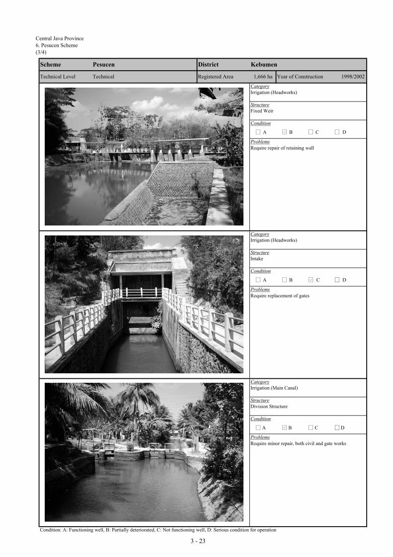
Central Java Province
6. Pesucen Scheme
(3/4)
CategoryIrrigation (Headworks)
StructureFixed Weir
Condition
Problems
CategoryIrrigation (Headworks)
StructureIntake
Condition
Problems
CategoryIrrigation (Main Canal)
StructureDivision Structure
Condition
Problems
Condition: A: Functioning well, B: Partially deteriorated, C: Not functioning well, D: Serious condition for operation
Require minor repair, both civil and gate works
D
Require repair of retaining wall
A B C D
A B
Technical Level
KebumenPesucen
1,666 haTechnical
District
Registered Area
Scheme
D
1998/2002
Require replacement of gates
Year of Construction
A B C
C
3 - 23

Central Java Province6. Pesucen Scheme
(4/4)
CategoryIrrigation (Secondary Canal)
StructureEarth Canal
Condition
Problems
CategoryIrrigation (Secondary Canal)
StructureOff-take Structure
Condition
Problems
CategoryIrrigation (Paddy Field)
StructureTertiary Canal and Paddy Field
Condition
Problems
Condition: A: Functioning well, B: Partially deteriorated, C: Not functioning well, D: Serious condition for operation
D
Require minor repair and gate
Technical 1,666 ha Year of Construction
A B C
1998/2002
D
Require lining, inspection road
Technical Level Registered Area
A B C
Scheme Pesucen District Kebumen
D
Require farm road
A B C
3 - 24

Central Java Province
7. Bedegolan Scheme
(1/4)
I.1 General(1) Code Number : 33025016-21 (7) Number of Farmers : 42,005(2) Name of Irrigation Scheme : Bedegolan (8) Water Resource River : Bedegolan(3) District (Kabupaten) : Kebumen (9) Catchment Area (km2) : 211.7(4) Sub-district (Kecamatan) : Mirit (10) Completion / Last Rehabilitation Year : 1998(5) Registered Area (ha) : 8,430(6) Technical Level : Technical
I.2 Availability of Reports/Documents & References (A : Available, B : Available but partially, C : Not available/ No plan) b. Irrigation diagram c. As-built drawings
A Ae. Rehabilitation plan & its references f. Crops and yield data g. Cropping Calender
A 65
II.1 Present and Planned Land UseCategory
a. Irrigated paddy field 8,401 8,401 0b. Rainfed paddy field 0 0 0c. Upland field 0 0 0d. Uncultivated land 0 0 0e. Non-irrigable land 0 0 0Total 8,401 8,401 0
III.1 Present/Before Project Condition(1) Irrigation Performance and Crop Production
AnnualPaddy Palawija Sugarcane Total Intensity Paddy Palawija Others
8,401 8,401 100% 5.5 46,2068,167 95 8,262 98% 5.0 40,835 285
200 200 2% 24016,568 295 0 16,863 201% 5.3 87,041 525 0
(2) Problems and ConstraintsA. Irrigation & Agriculture Performances- High irrigation performances achieved; however, irrigation water supply at on-farm level limited in dry season; poor drainage problem reported- Double cropping of paddy practiced almost in the entire irrigated area; paddy yield levels high; palawija introduced production still limitedB. Primary Constraint Identified through the Inventory Survey by the JICA Study - Irrigation & Drainage: Poor drainage - Palawija Marketing: Low marketing prices - Agronomic Issues: Farmers not following recommended practices - Farmers Organizations: Most members are not active - Paddy Marketing Low marketing prices - Extension Services: Extension activities of PPLs are limited
III.2 Development Plan(1) Development Approaches
- Ensuring year round irrigation water supply at on-farm level through rehabilitation - Double cropping of paddy in the entire scheme; productivity increase of paddy through further intensification; expansion of palawija in dry season II- Extension activities toward improvement of post-harvest & marketing; empowerment of farmer groups (KTs) to establish agri-business oriented KTs
(2) Planned Irrigation Performances and Crop ProductionAnnual
Paddy Palawija Sugarcane Total Intensity Paddy Palawija Others8,401 8,401 100% 6.0 50,4068,401 8,401 100% 5.5 46,206
2,520 2,520 30% 3,52916,802 2,520 0 19,322 230% 5.8 96,612 3,529 0
234 2,225 0 2,459 29% 0.5 9,571 3,004 0
IV.1 Existing Condition(1) Number a. Target; 74 b. Established; 74 c. Not yet; 0 Registered 0
Performance a. Developed; 3 b. Under developing; 51 c. Not yet; 20 Not yet registered 74
(2) Problems and ConstraintsOperation Maintenance Management
(3) Causes of Problems and Constraints- Management system not functioned well.
IV.2 Development Plan(1) Proposed Countermeasures
- Improvement of WUA management system.
(2) Development Plan- WUA management training.
I. PROJECT FUNDAMENTALS
a. Design Reports of Existing System(Full set) d. Structure lists & diagramA A
h. WUAs dataC A
II. SUBJECT AREA FOR REHABILITATION PLAN
Cropped Area in Irrigated Paddy Field (ha) Irrigated Paddy Yield (GKG
ton/ha)
Crop Production (ton)
Present (ha) Plan (ha) Increment (ha)
III. AGRICULTURE
Season II (dry I)Season III (dry II)
Season
Season
Season I (wet)Season II (dry I)
Season III (dry II)Total/Annual
IV. WUAs
Cropped Area in Irrigated Paddy Field (ha) Irrigated Paddy Yield (GKG
ton/ha)
Crop Production (ton)
Total/AnnualAnnual Increment
Season I (wet)
3 - 25
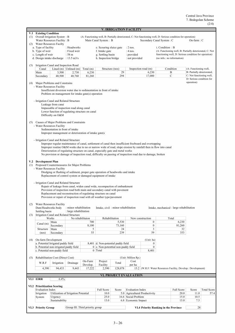
Central Java Province
7. Bedegolan Scheme
(2/4)
V.1 Existing Condition(1) Overall Irrigation System : B (A: Functioning well, B: Partially deteriorated, C: Not functioning well, D: Serious condition for operation)
Water Resources Facility : B Main Canal System : B Secondary Canal System : C On-farm : C(2) Water Resources Facilty
a. Type of facility : Headworks e. Scouring sluice gate : 2 nos. i. Condition : Bb. Type of weir : Fixed weir f. Intake gate : 4 nos.c. Length of weir : 58 m g. Settling basin : providedd. Design intake discharge : 13.5 m3/s h. Inspection bridge : not provided (no info.: no information)
(3) Irrigation Canal and Inspection RoadCanal Lined (m) Unlined (m) Total (m)
Main 3,500 2,730 6,230Secondary 40,500 40,760 81,260
(4) Major Problems and Constrains- Water Resources Facility
Insufficient diversion water due to sedimentation in front of intakeProblem on management for intake gate(s) operation
- Irrigation Canal and Related StructureLeakage from canalImpassable of inspection road along canalLower function of regulating structure on canalDifficulty on O&M
(5) Causes of Major Problems and Constraints- Water Resources Facility
Sedimentation in front of intakeImproper management or deterioration of intake gate(s)
- Irrigation Canal and Related StructureImproper regular maintenance of canal, settlement of canal then insufficient freeboard and overtopping Improper routine O&M works due to no or narrow wide of road, slope erosion by rainfall then in flow into canalDeterioration of regulating structure on canal, especially gate and metal worksNo provision or damage of inspection road, difficulty on passing of inspection road due to damage, broken
V.2 Development Plan(1) Proposed Countermeasures for Major Problems
- Water Resources FacilityDredging or flushing of sediment, proper gate operation of headworks and intakeReplacement of control system or damaged equipment of intake
- Irrigation Canal and Related StructureRepair of leakage from canal, widen canal wide, recompaction of embankmentProvision of inspection road both main and secondary canal with pavementReplacement and reconstruction of regulating structure on canalProvision or repair of inspection road with all weather type/pavement
(2) Water Resources Facility Dam/Headworks body Intake, civil Intake, mechanicalSettling basin
(3) Irrigation Canal and Related Structure
MainSecondaryMainSecondary
(4) On-farm Development (Unit: ha)
a. Potential Irrigated paddy field 8,401 d. Non-potential paddy field 0b. Potential non-irrigated paddy field 0 e. Non-potenttial non-paddy field 0c. Potential non-paddy field 0 8,401
(5) Rehabilitation Cost (Direct Cost) (Unit: Million Rp.)
On-Farm Project CostDevelop. Facility per ha
4,390 94,433 9,443 17,222 2,590 128,078 15.2 (W.R.F: Water Resources Facility, Develop.: Development)
VI.1 EIRR 6.4%
VI.2 Prioritization ScoringEvaluation Index Full Score Score Evaluation Index Full Score Score Total Score
Utilization of Irrigation Potential 10.0 5.0 Agricultural Productivity 20.0 11.0 57.4Urgency 25.0 16.6 Social Problem 15.0 10.5Sustainability 15.0 6.8 Economic Impact 15.0 7.5
VI.3 Priority Group VI.4 Priority Ranking in the Province 28Group III: Third priority group
55
W.R.F
Works
: minor rehabilitation
Irrigation
System
No rehabilitaion
Total
Canal (m)
Structure
(nos)
Total
58,100
V. IRRIGATION FACILITY
Inspection road (m)
294
(A: Functioning well,
B: Partially deteriorated,
C: Not functioning well,
D: Serious condition for
operation)
ConditionStructure (nos)
C29
(A: Functioning well, B: Partially deteriorated, C: Not
functioning well, D: Serious condition for operation)
5924
239
: minor rehabilitation
0
3
: large rehabilitation
6,23017,000
73,160
Rehabilitation5,530
B
New construction
0
: large rehabilitation
VI. PROJECT EVALUATION
353
Total6,230
81,26032
700
Irrigation Drainage
3 - 26
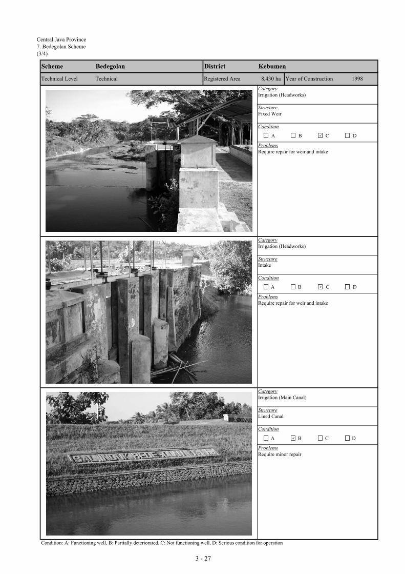
Central Java Province7. Bedegolan Scheme(3/4)
CategoryIrrigation (Headworks)
StructureFixed Weir
Condition
Problems
CategoryIrrigation (Headworks)
StructureIntake
Condition
Problems
CategoryIrrigation (Main Canal)
StructureLined Canal
Condition
Problems
Condition: A: Functioning well, B: Partially deteriorated, C: Not functioning well, D: Serious condition for operation
Require minor repair
D
Require repair for weir and intake
A B C D
A B
Technical Level
KebumenBedegolan
8,430 haTechnical
District
Registered Area
Scheme
D
1998
Require repair for weir and intake
Year of Construction
A B C
C
3 - 27

Central Java Province7. Bedegolan Scheme
(4/4)
CategoryIrrigation (Secondary Canal)
StructureDivision Structure
Condition
Problems
CategoryIrrigation (Secondary Canal)
StructureLined Canal
Condition
Problems
CategoryIrrigation (Secondary Canal)
StructureEarth Canal
Condition
Problems
Condition: A: Functioning well, B: Partially deteriorated, C: Not functioning well, D: Serious condition for operation
D
Require major repair for lining
Technical 8,430 ha Year of Construction
A B C
1998
D
Require minor repair
Technical Level Registered Area
A B C
Scheme Bedegolan District Kebumen
D
Require canal lining
A B C
3 - 28