THE SEAWAY HANDBOOK - K&L Gates€¦ · · 2008-02-06THE SEAWAY HANDBOOK Issued by THE ST....
136
THE SEAWAY HANDBOOK Issued by THE ST. LAWRENCE SEAWAY MANAGEMENT CORPORATION 2006 EDITION Also available on the Internet http://www.greatlakes-seaway.com
Transcript of THE SEAWAY HANDBOOK - K&L Gates€¦ · · 2008-02-06THE SEAWAY HANDBOOK Issued by THE ST....

THE
SEAWAY HANDBOOK
Issued by THE ST. LAWRENCE SEAWAY MANAGEMENT CORPORATION 2006 EDITION
Also available on the Internet http://www.greatlakes-seaway.com

Amended February 23, 2000
FOREWORD
This Seaway Handbook contains the joint St. Lawrence Seaway Management Corporation's
Seaway Practices and Procedures established under Section 99 of the Canada Marine Act
and the Saint Lawrence Seaway Development Corporation's Seaway Regulations established
pursuant to the Saint Lawrence Seaway Act of May 13, 1954, as amended. It also contains the
St. Lawrence Seaway Schedule of Tolls, the St. Lawrence Seaway Schedule of Charges on
Goods or Cargo, Landed, Shipped, Transhipped or Stored and other information pertinent to the
use of the Seaway.
Insofar as they are applicable in the United States they may be cited as "Seaway Regulations"and in Canada they may be cited as "Seaway Practices and Procedures".
In addition to the Seaway Practices and Procedures, the Canada Marine Act, the Canada
Shipping Act and Regulations made thereunder as well as the marine, navigation and shipping
laws and regulations of the United States of America apply to ships in the Seaway.
The numbering system used in the Seaway Practices and Procedures differs from the one
used in the Seaway Regulations (U.S.) The following are some terms used in the Seaway
Handbook that differ from the Seaway Regulations (U.S.):
"ship" is used in Seaway Practices and Procedures and is defined in the CanadaMarine Act while vessel is used in Seaway Regulations (U.S.).
«ship traffic controller» is used in the Seaway Practices and Procedures while vesseltraffic controller" is used in the Seaway Regulations (U.S.).
"schedule of tolls" is used in the Seaway Practices and Procedures while "tariff oftolls" is used in the Seaway Regulations (U.S.);
"fees" is used in the Seaway Practices and Procedures while "toll" "tolls" and"Tolls and charges" are used throughout the Seaway Regulations (U.S.)
The difference in the terms and numbering does not affect the application of the SeawayPractices and Procedures.
i

1
TABLE OF CONTENTS
FOREWORD ..... ....................................................................................................... i JOINT PRACTICES AND PROCEDURES RESPECTING THE TRANSIT OF SHIPS ON THE ST. LAWRENCE SEAWAY (ORANGE SECTION)
Part I – Condition of Ships Anchor Marking Buoys ................................................................................... 8 Automatic Identification System ..................................................................... 10 Disposal and Discharge Systems................................................................... 9 Fairleads. ....................................................................................................... 6 Fenders .. ....................................................................................................... 4 Hand Lines ..................................................................................................... 8 Interpretation .................................................................................................. 1 Landing Booms............................................................................................... 4 Markings. ....................................................................................................... 3 Maximum Ship Dimensions ............................................................................ 3 Minimum Length and Weight .......................................................................... 3 Minimum Requirements – Mooring Lines and Fairleads................................. 6 Mooring Lines ................................................................................................. 5 Pitch Indicators and Alarms............................................................................ 9 Propeller Direction Alarms.............................................................................. 9 Radio Telephone Equipment .......................................................................... 5 Requirements for U.S. Waters of the St. Lawrence Seaway .......................... 11 Required Equipment....................................................................................... 3 Short Title ....................................................................................................... 1 Stern Anchors................................................................................................. 8 Steering Lights................................................................................................ 9 Part II – Preclearance and Security for fees Application for Preclearance........................................................................... 12 Approval of Preclearance ............................................................................... 12 Liability Insurance........................................................................................... 12 Preclearance of Ships .................................................................................... 11 Security for fees.............................................................................................. 12 Part III – Seaway Navigation Anchorage Areas............................................................................................ 22 Attending Lines............................................................................................... 20 Ballast Water and Trim ………………………………………………………… ... 14 Cargo Booms – Deck Cargo........................................................................... 16 Compliance with Instructions.......................................................................... 14 Damaging or Defacing Seaway Property........................................................ 23 Disembarking or Boarding .............................................................................. 23
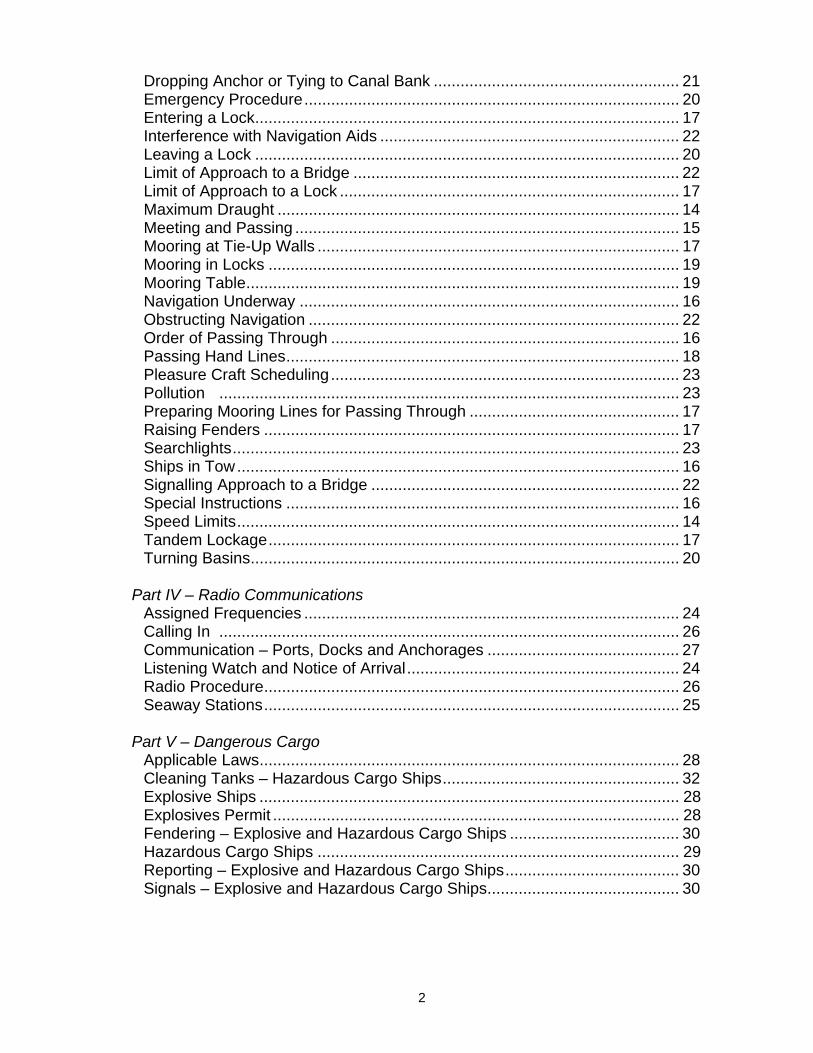
2
Dropping Anchor or Tying to Canal Bank ....................................................... 21 Emergency Procedure.................................................................................... 20 Entering a Lock............................................................................................... 17 Interference with Navigation Aids ................................................................... 22 Leaving a Lock ............................................................................................... 20 Limit of Approach to a Bridge ......................................................................... 22 Limit of Approach to a Lock ............................................................................ 17 Maximum Draught .......................................................................................... 14 Meeting and Passing ...................................................................................... 15 Mooring at Tie-Up Walls ................................................................................. 17 Mooring in Locks ............................................................................................ 19 Mooring Table................................................................................................. 19 Navigation Underway ..................................................................................... 16 Obstructing Navigation ................................................................................... 22 Order of Passing Through .............................................................................. 16 Passing Hand Lines........................................................................................ 18 Pleasure Craft Scheduling.............................................................................. 23 Pollution ....................................................................................................... 23 Preparing Mooring Lines for Passing Through ............................................... 17 Raising Fenders ............................................................................................. 17 Searchlights.................................................................................................... 23 Ships in Tow................................................................................................... 16 Signalling Approach to a Bridge ..................................................................... 22 Special Instructions ........................................................................................ 16 Speed Limits................................................................................................... 14 Tandem Lockage............................................................................................ 17 Turning Basins................................................................................................ 20 Part IV – Radio Communications Assigned Frequencies .................................................................................... 24 Calling In ....................................................................................................... 26 Communication – Ports, Docks and Anchorages ........................................... 27 Listening Watch and Notice of Arrival............................................................. 24 Radio Procedure............................................................................................. 26 Seaway Stations............................................................................................. 25 Part V – Dangerous Cargo Applicable Laws.............................................................................................. 28 Cleaning Tanks – Hazardous Cargo Ships..................................................... 32 Explosive Ships .............................................................................................. 28 Explosives Permit ........................................................................................... 28 Fendering – Explosive and Hazardous Cargo Ships ...................................... 30 Hazardous Cargo Ships ................................................................................. 29 Reporting – Explosive and Hazardous Cargo Ships....................................... 30 Signals – Explosive and Hazardous Cargo Ships........................................... 30

3
Part VI – Fees Assessment and Payment In-Transit Cargo.............................................................................................. 33 Payment of Fees ............................................................................................ 33 Transit Declaration ......................................................................................... 32 Part VII – Information and Reports Advance Notice of Arrival, Ships Requiring Inspection................................... 33 Reporting an Accident or Dangerous Occurrence .......................................... 34 Reporting Dangerous Cargo........................................................................... 34 Reporting Mast Height.................................................................................... 34 Reporting of Impairment or Other Hazard by Ships Intending to Transit the Seaway..................................................................................................... 35 Reporting of Impairment or Other Hazard by Ships Transiting within the Seaway ....................................................................................................... 34 Reporting Position at Anchor, Wharf, etc........................................................ 34 Required Information ...................................................................................... 33 Part VIII – Detention and Sale in U.S. Waters Detention for Fee Arrears or Violations .......................................................... 35 Power of Sale for Fee Arrears ........................................................................ 36 Security for Damages or Injury ....................................................................... 35 Part IX – General Access to Seaway Property............................................................................ 38 Boarding for Inspection................................................................................... 37 Compliance with Practices and Procedures ................................................... 39 Keeping Copies of Documents ....................................................................... 38 Removal of Obstructions ................................................................................ 38 Transit Refused .............................................................................................. 37 Wintering and Lying-Up .................................................................................. 38 Part X – Navigation closing procedures Appendix I – Ship Dimensions........................................................................ 52 Closing Procedures ........................................................................................ 39 Schedule I – Ships Transiting U.S. Waters..................................................... 41 Schedule II – Table of Speeds........................................................................ 43 Schedule III – Calling in Table ........................................................................ 44 Warning .. ....................................................................................................... 42 ST. LAWRENCE SEAWAY SCHEDULE OF TOLLS (BLUE SECTION) Appendix 3 – Operational Surcharges after Postponements............................. 7 Appendix 2 – Operational Surcharges – No Postponements ............................ 6 Appendix 1 – Tolls............................................................................................. 4 Coming into Force............................................................................................. 3 Interpretation ..................................................................................................... 1 Description and Weight of Cargo ...................................................................... 3 Post-Clearance Date Operational Surcharges .................................................. 3 Tolls................................................................................................................... 2

4
SCHEDULE OF CHARGES ON GOODS OR CARGO LANDED, SHIPPED, TRANSSHIPPED OR STORED (RED SECTION) Appendix I – Prescribed Tolls............................................................................ 4 Interpretation ..................................................................................................... 1 Short Title.......................................................................................................... 1 Tolls................................................................................................................... 2 CONVERSION TABLE (YELLOW SECTION)....................................... .................. 1 INFORMATION ON SHIP TRANSIT AND EQUIPMENT REQUIREMENTS (GREEN SECTION) General Transit Information Anchor Marking Buoys ................................................................................... 12 Approach Walls (Fendering) .......................................................................... 7 Bridges (Canadian Sectors) ........................................................................... 3 Bridges – Signal Light System........................................................................ 3
Bridge Wings Encroachment .......................................................................... 26 Bulwark Ladders............................................................................................. 15
Crane Working Position vs Crane in Stowed Position .................................... 27 Embarking or Disembarking in Lock Chambers.............................................. 15 Example of When the Fairlead Follows the Bow Flare…................................ 19 Example - Reporting Dangerous Cargo.......................................................... 25 Flat Bar Rubbing Strip Design Below Maindeck ............................................. 24 Fog ................................................................................................................. 5 General Arrangement for Fender Locations ................................................... 21 Guidelines for Fitting Permanent Steel Fenders ............................................. 22 Guidelines for Portable Wooden Fenders....................................................... 16 Half Round Solid Bar Design Below Maindeck............................................... 23 Hogging .......................................................................................................... 6 Introduction..................................................................................................... 1 Lock Communications .................................................................................... 2 Marine Weather Broadcasting and Data Collection ........................................ 5 Meeting Areas ................................................................................................ 7
Minimum Required – Crane Measurements 28 Navigational Aid Deficiencies ......................................................................... 17 Pilotage Requirements ................................................................................... 2 Ship Location Information............................................................................... 4 Ships Operating in Restricted Channels......................................................... 8 Ships with Bulbous Bows ............................................................................... 7 Stern Anchor................................................................................................... 9 Suggested Location of Landing Booms .......................................................... 14 Traffic Control ................................................................................................. 2 Typical Double Roller Fairlead (for 2 wires).................................................... 18

5
Typical Double Roller Fairlead (for 2 wires).................................................... 20 Typical Landing Boom .................................................................................... 13 Typical Pedestal ............................................................................................. 17 Use of Portable Fenders................................................................................. 15 Use of VHF Radio........................................................................................... 5 Walk-through Procedures (Lock 8 - Welland Canal)....................................... 9 Water Level Information (Tele-Announcers) ................................................... 10 Wind ............................................................................................................... 6
Navigation Signal Light System (Canadian Locks) General........................................................................................................... 29 L/A Signs ........................................................................................................ 30 Lock Signal Light Panels ................................................................................ 31 Operation of Signal Light Panels .................................................................... 32
Ship Manoeuvres (Canadian Locks) General........................................................................................................... 35 Modified Passing Entry................................................................................... 37 Passing Entry ................................................................................................. 35 Passing Entry Where a Road Bridge Crosses Over One End of a Lock......... 38
Turnback Lockage (Canadian Locks) General........................................................................................................... 40 Turnback for Downbound Ships ..................................................................... 41 Turnback for Upbound Ships .......................................................................... 40 Mooring Ships (Canadian Locks) Mooring Lines ................................................................................................. 43 Safety Precautions ......................................................................................... 42 Ship Mooring Locations .................................................................................. 43 American Locks Navigation Signal Light System...................................................................... 44 Tie-Up Walls ................................................................................................... 45 Appendices Appendix 1 – Seaway Mileages to Principal Locations................................... 47 Appendix 2 – Table of True Orientation - Canal Locks ................................... 49
Appendix 3 – Free Drawing Review Service .................................................. 50 Pre-Entry Information Required from Foreign Flag Vessels
Forms Application for Vessel Ship Pre-Clearance
Tie-up Service at Lock Approach Walls Transit Declaration Form
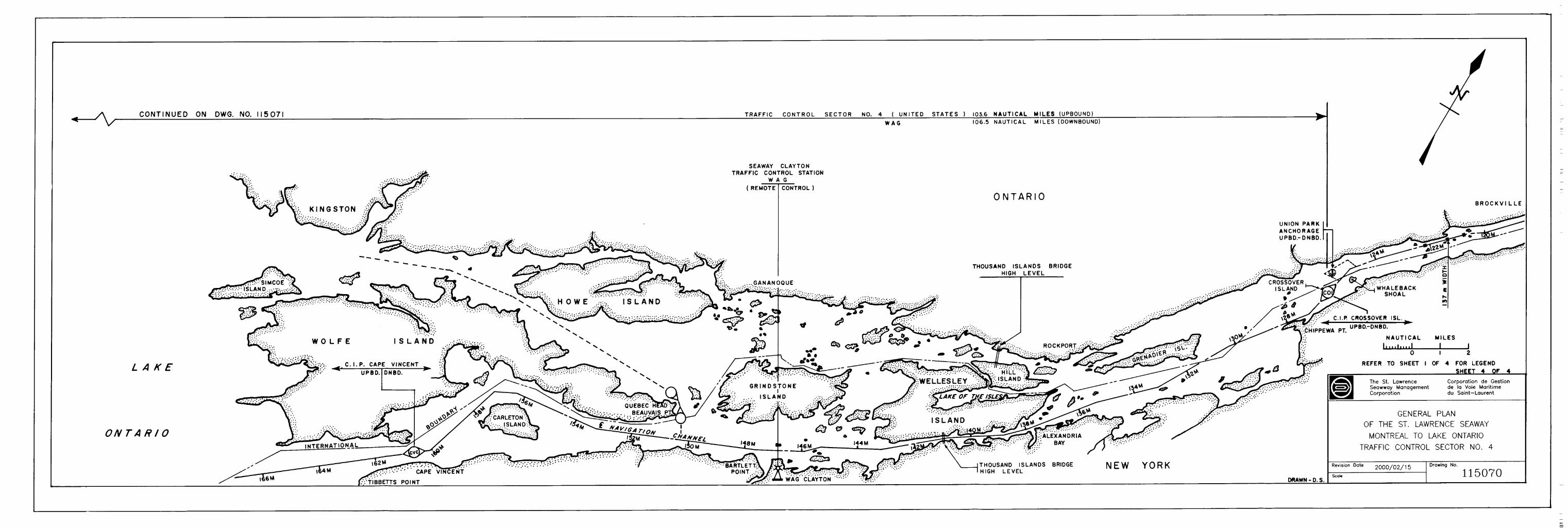
GENERAL PLANS OF THE ST. LAWRENCE SEAWAY (PURPLE SECTION)

Seaway Practices and Procedures (January 2006) Page 1 of 52
JOINT PRACTICES AND PROCEDURES RESPECTING THE TRANSIT OF SHIPS ON THE ST. LAWRENCE SEAWAY
(U.S. Rules 401.1 to 401.97)```````` Short Title 1. These Practices and Procedures may be cited as the Seaway Practices and
Procedures. Interpretation 2. In these Practices and Procedures, «Act» in Canada means the Canada Marine Act; in the United States means the
Saint Lawrence Seaway Act (Loi) «Corporation» means the Saint Lawrence Seaway Development Corporation;
(Corporation)
«fees» is defined in the Canada Marine Act and includes "Toll(s)" or "tolls and charges" as used in the United States.
«flashpoint» means the lowest temperature of a flammable liquid at which its vapour forms an ignitable mixture with air as determined by the closed-cup method; (point d’éclair)
«Manager» means The St. Lawrence Seaway Management Corporation
(gestionnaire)
«navigation season» means the annual period designated by the Manager and the Corporation, that is appropriate to weather and ice conditions or ship traffic demands, during which the Seaway is open for navigation; (saison de navigation)
«officer» means a person employed by the Manager or the Corporation to direct
some phase of operation or use of the Seaway; (fonctionnaire) «passing through» means in transit through a lock or through the waters
enclosed by the approach walls at either end of a lock chamber; (éclusage) «pleasure craft» means a ship, however propelled, that is used exclusively for
pleasure and that does not carry passengers who have paid a fare for passage; (embarcation de plaisance)
«preclearance» means the authorization given by the Manager or the Corporation
or a ship to transit; (congé préalable)
Seaway Practices and Procedures (January 2006) Page 2 of 52
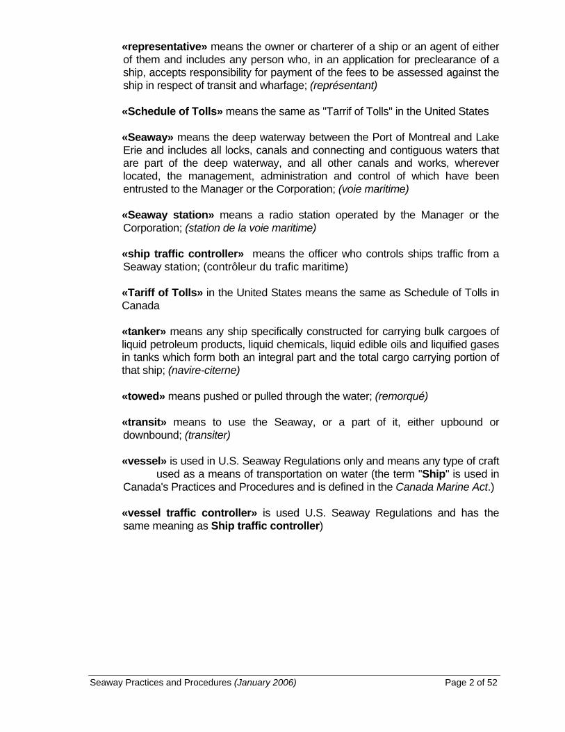
«representative» means the owner or charterer of a ship or an agent of either of them and includes any person who, in an application for preclearance of a ship, accepts responsibility for payment of the fees to be assessed against the ship in respect of transit and wharfage; (représentant) «Schedule of Tolls» means the same as "Tarrif of Tolls" in the United States
«Seaway» means the deep waterway between the Port of Montreal and Lake Erie and includes all locks, canals and connecting and contiguous waters that are part of the deep waterway, and all other canals and works, wherever located, the management, administration and control of which have been entrusted to the Manager or the Corporation; (voie maritime)
«Seaway station» means a radio station operated by the Manager or the
Corporation; (station de la voie maritime) «ship traffic controller» means the officer who controls ships traffic from a
Seaway station; (contrôleur du trafic maritime) «Tariff of Tolls» in the United States means the same as Schedule of Tolls in Canada
«tanker» means any ship specifically constructed for carrying bulk cargoes of liquid petroleum products, liquid chemicals, liquid edible oils and liquified gases in tanks which form both an integral part and the total cargo carrying portion of that ship; (navire-citerne)
«towed» means pushed or pulled through the water; (remorqué) «transit» means to use the Seaway, or a part of it, either upbound or
downbound; (transiter) «vessel» is used in U.S. Seaway Regulations only and means any type of craft
used as a means of transportation on water (the term "Ship" is used in Canada's Practices and Procedures and is defined in the Canada Marine Act.)
«vessel traffic controller» is used U.S. Seaway Regulations and has the same meaning as Ship traffic controller)

Seaway Practices and Procedures (January 2006) Page 3 of 52
PART I - CONDITION OF SHIPS
Maximum Ship Dimensions 3. (1) Subject to subsection (5), no ship of more than 222.5 m in overall length
or 23.2 m in extreme breadth shall transit. (2) No ship shall transit if any part of the ship or anything on the ship
extends more than 35.5 m above water level. (3) No ship shall transit if any part of its bridges or anything on the ship
protrudes beyond the hull. (4) No ship's hull or superstructure when alongside a lock wall shall extend
beyond the limits of the lock wall, as illustrated in Appendix I.
(5) A ship having a beam width in excess of 23.2 m but not more than 23.8 m and having dimensions that do not exceed the limits set out in the block diagram illustrated in Appendix I, or overall length in excess of 222.5 m but not more than 225.5 m shall, on application to the Manager or the Corporation, be considered for transit after review of the ship's drawings and, if accepted, shall transit in accordance with directions issued by the Manager and the Corporation.
(6) Ships beam greater than 23.20 m may be subject to transit restrictions
and/or delays during periods of ice cover. Minimum Length and Weight 4. No ship of less than 6 m in overall length or 900 kg in weight shall transit
through Seaway Locks. Required Equipment 5. No ship shall transit unless it is (a) propelled by motor power that is adequate in the opinion of an officer;
and (b) marked and equipped in accordance with the requirements of sections 6
to 21. Markings 6. (1) Ships of more than 20 m in overall length shall be correctly and distinctly
marked and equipped with draught markings on both sides at the bow and stern.

Seaway Practices and Procedures (January 2006) Page 4 of 52
(2) In addition to the markings required by subsection (1), ships of more than 110 m in overall length shall be marked on both sides with midship draught markings.
(3) Where a ship's bulbous bow extends forward beyond her stem head, a
symbol of a bulbous bow shall be marked above the ship’s summer load line draught mark in addition to a + symbol followed by a number indicating the total length in metres by which the bulbous bow projects beyond the stem.
Fenders 7. (1) Where any structural part of a ship protrudes so as to endanger Seaway
installations, the ship shall be equipped with permanent fenders (a) that are made of steel, hardwood or teflon or a combination of two
or all of those materials, are of a thickness not exceeding 15 cm, with well tapered ends, and are located along the hull, close to the main deck level; and
(b) on special application, portable fenders, other than rope hawsers,
may be allowed for a single transit if the portable fenders are (i) made of a material that will float, and (ii) securely fastened and suspended from the ship in a horizontal
position by a steel cable or a fibre rope in such a way that they can be raised or lowered in a manner that does not damage Seaway installations. For details refer to Ship Transit and Equipment Requirements.
(2) Tires shall not be used as fenders.
(3) On special application, ships of unusual design may be permitted to
utilize temporary or permanent fenders not greater than 30 cm in thickness.
Landing Booms 8. (1) Ships of more than 50 m in overall length shall be equipped with at least
one adequate landing boom on each side. For details refer to Ship Transit and Equipment Requirements.
(2) Ship’s crews shall be adequately trained in the use of landing booms. (3) Ships not equipped with landing booms must use the Seaway's tie-up
service at approach wall.

Seaway Practices and Procedures (January 2006) Page 5 of 52
Radio Telephone Equipment 9. (1) Self-propelled ships, other than pleasure craft of less than 20 m in
overall length, shall be equipped with VHF (very high frequency) radio telephone equipment.
(2) The radio transmitters on a ship shall
(a) have sufficient power output to enable the ship to communicate with
Seaway stations from a distance of 48 km; and
(b) be fitted to operate from the conning position in the wheelhouse and to communicate on channels 11, 12, 13, 14, 16, 17 and 66a.
Mooring Lines 10. (1) Mooring lines shall
(a) be of a uniform thickness throughout their length; (b) have a diameter not greater than 28mm
(c) be fitted with a hand spliced eye or Flemish type mechanical
spliced eye not less than 2.4 m long;
(d) have sufficient strength to check the ship; and
(e) be arranged so that they may be led to either side of the ship as required.
(f) be certified and a test certificate for each mooring line shall be
available onboard for inspection.
(2) Unless otherwise permitted by an officer, only wire rope mooring lines with a breaking strength that complies with the minimum specifications set out in the table to this section shall be used for securing a ship in lock chambers.
(3) Synthetic lines may be used for mooring at approach walls, tie-up walls
and docks within the Seaway. (4) Notwithstanding the above, nylon line is not permitted.

Seaway Practices and Procedures (January 2006) Page 6 of 52
TABLE
OVERALL LENGTH OF SHIPS LENGTH OF MOORING LINE
BREAKING STRENGTH
40 m or more but not more than 60 m 110 m 10 MT
more than 60 m but not more than 90 m 110 m 15 MT
more than 90 m but not more than 120 m 110 m 20 MT
more than 120 m but not more than 180 m 110 m 28 MT
more than 180 m but not more than 222.5 m 110 m 35 MT
Fairleads 11. Mooring lines, and synthetic hawsers where permitted, shall
(a) be led at the ship's side through a type of fairlead acceptable to the Manager and the Corporation;
(b) pass through not more than three inboard rollers that are fixed in place
and equipped with horns to ensure that lines will not slip off when slackened and provided with free-running sheaves or rollers; and
(c) where the fairleads are mounted flush with the hull, be permanently
fendered to prevent the lines from being pinched between the ship and a wall.
Minimum Requirements - Mooring Lines and Fairleads 12. (1) The minimum requirements in respect of mooring lines which shall be
available for securing on either side of the ship, winches and the location of fairleads on ships are as follows:
(a) ships of 80 m or less in overall length shall have at least three
synthetic hawsers, two of which shall be independently power operated and one which shall be hand held;
(i) one synthetic hawser shall lead forward from the break of
the bow and one synthetic hawser shall lead astern from the quarter and be independently power operated by winches, capstans or windlasses and lead through closed chocks or fairleads acceptable to the Manager and the Corporation; and
(ii) one synthetic hawser shall be hand held and lead astern
from the break of the bow through closed chocks to suitable mooring bitts on deck;

Seaway Practices and Procedures (January 2006) Page 7 of 52
(b) ships of more than 80 m but not more than 100 in overall length
shall have four synthetic hawsers, of which three shall be independently power operated by winches, capstans or windlasses and one being hand held. All lines shall be led through closed chocks or fairleads acceptable to the Manager and the Corporation, of which three mooring lines
(i) one shall lead forward and one shall lead astern from the
break of the bow and one lead astern from the quarter and all three lines shall be independently power operated, and
(ii) one shall lead forward from the quarter and be hand held;
(c) ships of more than 100 m but not more than 120 m in overall length shall have four mooring lines or synthetic hawsers independently power operated by winches, capstan or windlasses as follows:
(i) one mooring line shall lead forward and one mooring line shall
lead astern from the break of the bow and shall be independently power operated by the main drums of adequate power operated winches, and
(ii) one synthetic hawser shall lead forward and one synthetic
hawser shall lead astern from the quarter and shall be independently power operated by either winches, capstan or windlasses;
(d) ships of more than 120 m in overall length shall have four mooring
lines, two of which shall lead from the break of the bow and two of which shall lead from the quarter, and
(i) all shall be independently power operated by the main drums
of adequate power operated winches and not by capstans or windlasses; and
(ii) all shall be led through a type of fairlead acceptable to the
Manager and the Corporation.
(e) every ship shall have a minimum of two spare mooring lines available and ready for immediate use.

Seaway Practices and Procedures (January 2006) Page 8 of 52
(2) The following table sets out the requirements for the location of fairleads
for ships of 80 m or more in overall length:
TABLE
OVERALL LENGTH OF
SHIPS
FOR MOORING LINES NOS. 1 AND 2
FOR MOORING LINES NOS. 3 AND 4
80 m or more but not more than 120 m
Between 12 m & 30 m from the stem Between 15 m & 35 m from the stern
more than 120 m but not more than 150 m
Between 12 m & 35 m from the stem Between 15 m & 40 m from the stern
more than 150 m but not more than 180 m
Between 15 m & 40 m from the stem Between 20 m & 45 m from the stern
more than 180 m but not more than 222.5m
Between 20 m & 50 m from the stem Between 20 m & 50 m from the stern
Hand Lines 13. Hand lines shall
(a) be made of material acceptable to the Manager and the Corporation, and
(b) be of uniform thickness and have a diameter of not less than 15 mm and
not more than 17 mm and a minimum length of 30 m. The ends of the lines shall be back spliced or tapered.
(c) not be weighted or have knotted ends. Anchor Marking Buoys 14. A highly visible anchor marking buoy of a type approved by the Manager and
the Corporation, fitted with 22 m of suitable line, shall be secured directly to each anchor so that the buoy will mark the location of the anchor when the anchor is dropped. For details refer to Ship Transit and Equipment Requirements.
Stern Anchors 15. Every ship of more than 110 m in overall length, the keel of which is laid after
January 1, 1975, shall be equipped with a stern anchor.
Every integrated tug and barge or articulated tug and barge unit greater than 110 m in overall length which is constructed after January 1, 2003 shall be equipped with a stern anchor. For details refer to Ship Transit and Equipment Requirements.

Seaway Practices and Procedures (January 2006) Page 9 of 52
Propeller Direction Alarms 16. Every ship of 1600 gross registered tons or integrated tug and barge or
articulated tug and barge unit of combined 1,600 gross registered tons or more shall be equipped with
(a) propeller direction and shaft r.p.m. indicators located in the wheelhouse
and the engine room; and (b) visible and audible wrong-way propeller direction alarms, with a time
delay of not greater than 8 seconds, located in the wheelhouse and the engine room, unless the ship is fitted with a device which renders it impossible to operate engines against orders from the bridge telegraph.
Pitch Indicators and Alarms 17. Every ship of 1,600 gross registered tons or integrated tug and barge or
articulated tug and barge unit of combined 1,600 gross registered tons or more equipped with a variable pitch propeller shall be equipped with
(a) a pitch indicator in the wheelhouse and the engine room; and
(b) effective April 1, 1984, visible and audible pitch alarms, with a time
delay of not greater than 8 seconds, in the wheelhouse and engine room to indicate wrong pitch.
Steering Lights 18. Every ship shall be equipped with (a) a steering light located on the centreline at or near the stem of the ship
and clearly visible from the helm; or (b) two steering lights located at equal distances either side of the centreline
at the forepart of the ship and clearly visible from the bridge along a line parallel to the keel.
Disposal and Discharge Systems 19. (1) Every ship not equipped with containers for ordure shall be equipped
with a sewage disposal system enabling compliance with the Canadian Garbage Pollution Prevention Regulations, the Canadian Great Lakes Sewage Pollution Prevention Regulations, the U.S. Clean Water Act and the U.S .River and Harbor Act, and amendments thereto.

Seaway Practices and Procedures (January 2006) Page 10 of 52
(2) Garbage on a ship shall be (a) destroyed by means of an incinerator or other garbage disposal
device; or
(b) retained on board in covered, leak-proof containers, until such time as it can be disposed of in accordance with the provisions of the Canadian Garbage Pollution Prevention Regulations, the Canadian Great Lakes Sewage Pollution Prevention Regulations, the U.S. Clean Water Act and the U.S. River and Harbor Act, and amendments thereto.
(3) No substance shall be discharged or disposed of onto a lock wall or tie-
up wall by any means, including overboard discharge pipes.
(4) Burning of shipboard garbage is prohibited between CIP2 & Cardinal and between CIP 15 & CIP 16.
Automatic Identification System
20. (1) Each of the following vessels must use an Automatic Identification System (AIS) transponder to transit the Seaway:
(a) each commercial vessel that requires pre-clearance in accordance
with section 22 and has a 300 gross tonnage or greater, has a Length Over All (LOA) over 20 meters, or carries more than 50 passengers for hire; and
(b) each dredge, floating plant or towing vessel over 8 meters in
length, except only each lead unit of combined and multiple units (tugs and tows).
(2) Each vessel listed in paragraph (1) of this section must meet the
following requirements to transit the Seaway:
(a) International Maritime Organization (IMO) Resolution MSC.74(69), Annex 3, Recommendation on Performance Standards for a Universal Shipborne AIS, as amended;
(b) International Telecommunication Union, ITU-R
Recommendation M.1371-1: 2000, Technical Characteristics For A Universal Shipborne AIS Using Time Division Multiple Access In The VHF Maritime Mobile Band, as amended;
(c) International Electrotechnical Commission, IEC 61993-2 Ed.1,
Maritime Navigation and Radio Communication Equipment and Systems –AIS – Part 2: Class A Shipborne Equipment of the Universal AIS – Operational and Performance Requirements, Methods of Test and Required Test Results, as amended;

Seaway Practices and Procedures (January 2006) Page 11 of 52
(d) International Maritime Organization (IMO) Guidelines for
Installation of Shipborne Automatic Identification System (AIS), NAV 48/18, 6 January 2003, as amended, and, for ocean vessels only, with a pilot plug, as specified in Section 3.2 of those Guidelines, installed close to the primary conning position in the navigation bridge and a standard 120 Volt, AC, 3-prong power receptacle accessible for the pilot’s laptop computer; and
(e) The Minimum Keyboard Display (MKD) shall be located as close to
the primary conning position and be visible; (f) Computation of AIS position reports using differential GPS
corrections from the U.S. and Canadian Coast Guards’ maritime Differential Global Positioning System radiobeacon services; or
(g) The use of a temporary unit meeting the requirements of
subparagraphs (2)(a) through (e) of this section is permissible; or
(h) For each vessel with LOA less than 30 meters, the use of
portable AIS compatible with the requirements of subparagraphs (2)(a) through (c) and subparagraph (e) of this section is permissible.
Requirements for U.S. Waters of the St. Lawrence Seaway
21. In addition to the requirements set forth elsewhere in these Practices and
Procedures, ships transiting the U.S. waters of the St. Lawrence Seaway are subject to the requirements set out in Schedule 1.
PART II - PRECLEARANCE AND SECURITY FOR FEES Preclearance of Ships 22. (1) No ship, other than a pleasure craft of 300 gross registered tonnage or
less, shall transit until an application for preclearance has been made, in accordance with section 24 to the Manager by the ship's representative and the application has been approved by the Manager and the Corporation pursuant to section 25.
(2) No ship shall transit while its preclearance is suspended or has
terminated by reason of (a) the expiration of the representative's guarantee of fee payment, (b) a change of ownership or representative of the ship, or

Seaway Practices and Procedures (January 2006) Page 12 of 52
(c) a material alteration in the physical characteristics of the ship, until
another application for preclearance has been made and approved.
(3) A non-commercial ship of 300 gross registered tonnage or less cannot apply for pre-clearance status and must transit as a pleasure craft.
Liability Insurance 23. (1) It is a condition of approval of an application for preclearance that the
ship is covered by liability insurance equal to or exceeding $100 per gross registered ton.
(2) No ship shall transit while its liability insurance is not in full force and
effect. Application for Preclearance 24. The representative of a ship may, on a preclearance form (3 copies) obtained
from the Manager, St. Lambert, Quebec, or downloaded from the St. Lawrence Seaway website (www.greatlakes-seaway.com), apply for preclearance, giving particulars of the ownership, liability insurance and physical characteristics of the ship and guaranteeing payment of the fees that may be incurred by the ship.
Approval of Preclearance 25. Where the Manager and the Corporation approve an application for
preclearance, it shall (a) give the approval; and (b) assign a number to the approval. Security for fees 26. (1) Before transit by a ship to which the requirement of preclearance
applies, security for the payment of fees in accordance with the St. Lawrence Seaway Schedule of Tolls as well as security for any other charges, shall be provided by the representative by means of
(a) a deposit of money with the Manager;
(b) a deposit of money to the credit of the Manager with a bank in the
United States or a member of the Canadian Payment Association, a corporation established by section 3 of the Canadian Payments Association Act, or a local cooperative credit society that is a member of a central cooperative credit society having membership in the Canadian Payments Association.

Seaway Practices and Procedures (January 2006) Page 13 of 52
(c) a deposit with the Manager of negotiable bonds of the Government
of Canada or of the Government of the United States;
(d) a letter of guarantee to the Manager given by an institution referred to in paragraph (1)(b) of this section; or
(e) a letter of guarantee or bond given to the Manager by an
acceptable Bonding Company. Bonding Companies may be accepted if they: i) appear on the list of acceptable bonding companies as issued
by the Treasury Board of Canada; and ii) meet financial soundness requirements as may be defined by
the Manager (or the Corporation) at the time of the request. (2) The security for the fees of a ship shall be sufficient to
cover the fees as established in the “St. Lawrence Seaway Schedule of Tolls” for the gross registered tonnage of a ship, cargo carried, lockage tolls as well as security for any other charges, as estimated by the manager.
(3) Where a number of ships: (a) for each of which a preclearance has been given;
(b) are owned or controlled by the same individual or company; and
(c) have the same representative,
the security for the fees is not required if the individual, company or representative has paid every fee invoice received in the preceding five years within the period set out in subsection 75(1).
(4) Notwithstanding subsection of this section, where (3) a number of ships,
for each of which a preclearance has been given, are owned or controlled by the same individual or company and have the same representative, the security for the fees may be reduced or eliminated provided the representative has paid every fees invoice received in the preceding five years within the period set out in subsection 75(1). The representative must provide the Manager with a financial statement that meets the requirements established by the Manager.
(5) Where, in the opinion of the Manager, the security provided by the
representative is insufficient to secure the fees incurred or likely to be incurred by a ship, the Manager may suspend the preclearance of the ship.
Seaway Practices and Procedures (January 2006) Page 14 of 52
PART III - SEAWAY NAVIGATION
Compliance with Instructions 27. Every ship shall comply promptly with transit instructions given by the ship
traffic controller or any other officer. Speed Limits 28. (1) The maximum speed over the bottom for a ship of more than 12 m in
overall length shall be regulated so as not to adversely affect other ships or shore property, and in no event shall such a ship proceeding in any area between a place set out in column I of an item of Schedule II and a place set out in column II of that item exceed the speed set out in column III or column IV of that item, whichever speed is designated by the Manager and the Corporation in a Seaway Notice from time to time as being appropriate to existing water levels.
(1.1) Where the Manager or the Corporation designates any speed less than
the maximum speeds set out in Schedule II, that speed shall be transmitted as transit instructions referred to in section 27.
(2) Every ship under way shall proceed at a reasonable speed so as not to
cause undue delay to other ships. (3) Every ship passing a moored ship or equipment working in a canal shall
proceed at a speed that will not endanger the moored ship, the moored equipment or the occupants of either.
Maximum Draught 29. (1) The loading, draught and speed of a ship in transit shall be controlled by
the master, who shall take into account the ship's individual characteristics and its tendency to list or squat, so as to avoid striking bottom. (The main channels between the Port of Montreal and Lake Erie have a controlling depth of 8.23 m.)
(2) The draught of a ship shall not, in any case, exceed 79.2 dm or the
maximum permissible draught designated in a Seaway Notice by the Manager and the Corporation for the part of the Seaway in which a ship is passing.
Ballast Water and Trim
30. (1) Every ship shall be adequately
(a) ballasted, (b) trimmed, and

Seaway Practices and Procedures (January 2006) Page 15 of 52
(c) no ship, other than under exceptional circumstances and with special permission, shall be accepted for transit whose trim by the stern exceeds 45.7 dm.
(d) any ship that is not adequately ballasted and trimmed in the opinion of an officer, may be refused transit or may be delayed.
(2) To obtain clearance to transit the Seaway:
(a) every ship entering the Seaway after operating beyond the exclusive economic zone must agree to comply with the “Code of Best Practices for Ballast Water Management” of the Shipping Federation of Canada dated September 28, 2000, while operating anywhere within the Great Lakes and the Seaway; and
(b) every other ship entering the Seaway that operated within the
Great Lakes and the Seaway must agree to comply with the “Voluntary Management Practices to Reduce the Transfer of Aquatic Nuisance Species Within the Great Lakes by U.S. and Canadian Domestic Shipping” of the Lake Carriers Association and Canadian Shipowners Association dated January 26, 2001, while operating anywhere within the Great lakes and the Seaway.
For copies of the “Code of Best Practices for Ballast Water Management” and of the “Voluntary Management Practices to Reduce the Transfer Of Aquatic Nuisance Species within the Great Lakes by U.S. and Domestic Shipping” refer to the St. Lawrence Seaway website at www.greatlakes-seaway.com
Meeting and Passing 31. (1) The Collision Regulations and the United States Inland Rules apply in
respect of the meeting and passing of ships. (2) No ship shall meet another ship within the area between the caution
signs at bridges or within any area that is designated as a no meeting area by signs erected by the Manager or the Corporation in that area.
(3) Except as instructed by the ship traffic controller, no ship shall overtake
and pass or attempt to overtake and pass another ship (a) in any canal; (b) within 600 m of a canal or lock entrance; or (c) after the order of passing through has been established by the ship
traffic controller.

Seaway Practices and Procedures (January 2006) Page 16 of 52
Cargo Booms - Deck Cargo 32. (1) Every ship shall have cargo booms secured in a manner that affords
maximum visibility from the wheelhouse. (2) Cargo or containers carried, forward or aft, on deck shall be stowed in a
manner that (a) affords an unrestricted view from the wheelhouse for the purpose
of navigation; and (b) does not interfere with mooring equipment. Special Instructions 33. No ship of unusual design, ship or part of a ship under tow or ship whose
dimensions exceed the maximum ship dimensions prescribed in section 3 shall transit the Seaway except in accordance with special instructions of the Manager or the Corporation given on the application of the representative of the ship.
Ships in Tow 34. No vessel that is not self-propelled (including but not limited to tug/tows
and/or deadship/tows) shall be underway in any Seaway waters unless it is securely tied to an adequate tug or tugs, in accordance with special instructions given by the Manager or the Corporation pursuant to section 33.
Navigation Underway 35. Every ship transiting between calling-in point 2 and Tibbetts Point and between
calling-in points 15 and 16 shall (a) man the propulsion machinery of the ship, including the main engine
control station; (b) operate the propulsion machinery so that it can respond immediately
through its full operating range; (c) man the wheelhouse of the ship at all times by either the master or
certified deck officer, and a helmsman, and; (d) have sufficient well rested crewmembers available for mooring
operations and other essential duties. Order of Passing Through 36. Ships shall advance to a lock in the order instructed by the ship traffic
controller.

Seaway Practices and Procedures (January 2006) Page 17 of 52
Mooring at Tie-Up Walls 37. (1) Upon arrival at a lock, a ship awaiting instructions to advance shall moor
at the tie-up wall, close up to the designated limit of approach sign or to the ship preceding it, whichever is specified by an officer.
(2) Crew members being put ashore on landing booms and handling
mooring lines on tie-up walls shall wear approved life jackets. Limit of Approach to a Lock 38. A ship approaching a lock or the guard gate cut shall comply with directions
indicated by the signal light system associated with the lock or guard gate cut and in no case shall its stem pass the designated limit of approach sign while a red light or no light is displayed.
Preparing Mooring Lines for Passing Through 39. Before a ship enters a lock, (a) winches shall be capable of paying out at a minimum speed of 46 m per
minute; and (b) the eye of each mooring line shall be passed outward through the
fairleads at the side. Raising Fenders 39.1 Every ship equipped with fenders that are not permanently attached shall raise
its fenders when passing a lock gate in Snell or Eisenhower Locks. Entering a Lock 40. (1) No ship shall proceed into a lock in such a manner that the stem passes
the stop symbol on the lock wall nearest the closed gates. (2) Every ship proceeding into a lock shall be positioned and moored as
directed by the officer in charge of the lock. (3) No ship shall use thrusters when passing a lock gate. Tandem Lockage 41. Where two or more ships are being locked together, ships astern of the leading
ship shall (a) come to a full stop a sufficient distance from the preceding ship to avoid
a collision; and (b) be moved into mooring position as directed by the officer in charge of the
lock.

Seaway Practices and Procedures (January 2006) Page 18 of 52
Passing Hand Lines 42. (1) At locks, hand lines shall be secured to the mooring lines and passed as
follows: (a) a downbound ship shall use its own hand lines, secured to the eye
at the end of the mooring lines by means of a bowline, which hand lines shall be passed to the linehandlers at the lock as soon as the ship passes the open gates;
(b) hand lines shall be passed to upbound ships by the linehandlers as
soon as the ship passes the open gates, and secured, by means of a clove hitch, to the mooring lines 60 cm behind the splice of the eye;
(c) at Iroquois Lock and Lock 8, Welland Canal, both upbound and
downbound ships shall use their own hand lines as provided in paragraph (a); and
(d) upbound ships of overall length in excess of 218 m in Locks 4 and
5, Welland Canal, shall secure the hand line to the eye of the No.1 mooring wire by means of a bowline.
(2) Mooring lines shall not be passed over the side of a ship in a manner
dangerous to a lock crew.

Seaway Practices and Procedures (January 2006) Page 19 of 52
Mooring Table
43. Unless otherwise directed by an officer, ships passing through the locks shall
moor at the side of the tie-up wall or lock as shown in the table to this section.
MONTREAL TO IROQUOIS
South Shore Beauharnois Wiley-Dondero Iroquois
St. Lambert
Côte Ste. Catherine
Lower Pool Upper Snell Eisenhower
Locks
Upbound P P S S S S P
Downbound S S P P P P S
Tie-up Walls
Upbound S S P P S S S
Downbound P P S S P P P
WELLAND CANAL
1 2 3 4 5 6 7 Guard Gate Cut
8
Locks
Upbound S S P P P P P S
Downbound P P S P P P S P
Tie-up Walls
Upbound S S S S S S PorS
Downbound P P P S S P PorS
NOTE: S = Starboard; P= Port Mooring in Locks 44. (1) Mooring lines shall only be placed on mooring posts as directed by the
officer in charge of the mooring operation. (2) No winch from which a mooring line runs shall be operated until the
officer in charge of a mooring operation has signalled that the line has been placed on a mooring post.

Seaway Practices and Procedures (January 2006) Page 20 of 52
Emergency Procedure 45. When the speed of a ship entering a lock chamber has to be checked in an
emergency, a signal consisting of five blasts on a horn shall be given by the master, and all mooring lines shall be put out as quickly as possible.
Attending Lines 46. (1) Lines of a ship shall be under visual control and attended by members of
its crew during the time the ship is passing through a lock. (2) While a ship is within a lock chamber and lines are hand held for tension
control, each line shall be attended by at least one member of the ship's crew.
Leaving a Lock 47. (1) Mooring lines shall only be cast off as directed by the officer in charge of
a mooring operation. (2) No ship shall proceed out of a lock until the exit gates, ship arresters and
the bridge, if any, are in a fully open position. (3) No ship shall use thrusters when passing a lock gate. Turning Basins 48. No ship shall be turned about in any canal, except (a) with permission from the ship traffic controller; and (b) at the locations set out in the table to this section.

Seaway Practices and Procedures (January 2006) Page 21 of 52
TURNING BASINS
South Shore Canal:
a) Turning Basin No. 1 - Opposite Brossard
b) Turning Basin No. 2 - Immediately below Côte Ste. Catherine Lock
Welland Canal:
a) Turning Basin No. 1 Between Lock 7 and the Guard Gate Cut for ships up to 180 m in overall length
b) Turning Basin No. 2 - Immediately south of Port Robinson (mile 13)
c) Turning Basin No. 3 - North of Lock No. 8 for ships up to 170 m in overall length
d) For ships up to 80 m in overall length
(i) North end of Wharf No. 1
(ii) Tie-up wall above Lock 1,
(iii) Tie-up wall below Lock 2,
(iv) Wharf No. 9,
(v) Between the southerly extremities of Wharves 18-2 and 18-3
Dropping Anchor or Tying to Canal Bank 49. Except in an emergency, no ship shall drop anchor in any canal or tie-up to any
canal bank unless authorized to do so by the ship traffic controller.

Seaway Practices and Procedures (January 2006) Page 22 of 52
Anchorage Areas 50. Except in an emergency, or unless authorized to do so by the ship traffic
controller, no ship shall drop anchor in any part of the Seaway except in the following designated anchorage areas:
(a) Point Fortier (Lake St. Louis) (b) Melocheville (Beauharnois Canal) (c) St. Zotique, Dickerson Island and Stonehouse Point (Lake St. Francis) (d) Wilson Hill Island and Morrisburg (Lake St. Lawrence) (e) Prescott and Union Park (St. Lawrence River) (f) Off Port Weller (Lake Ontario) (g) Off Port Colborne (Lake Erie)
Signalling Approach to a Bridge
51. (1) Unless a ship's approach has been recognized by a flashing signal, the
master shall signal the ship's presence to the bridgemaster by VHF radio when it comes abreast of any of the bridge whistle signs.
(2) The signs referred to in subsection (1) shall be placed at distances
varying between 550 m and 2990 m upstream and downstream from moveable bridges at sites other than lock sites.
Limit of Approach to a Bridge 52. (1) No ship shall pass the limit of approach sign at any moveable bridge
until the bridge is in a fully open position and the signal light shows green.
(2) No ship shall pass the limit of approach sign at the twin Railway Bridges
on the South Shore Canal at Kahnawake, until both bridges are in a fully open position and both signal lights show green.
Obstructing Navigation
53. No ship shall be operated, drop anchor or be fastened or moored in a manner
that obstructs or hinders navigation. Interference with Navigation Aids 54. (1) Aids to navigation shall not be interfered with or used as moorings. (2) No person shall, unless authorized by the Manager or the Corporation,
set out buoys or navigation markers on the Seaway.
Seaway Practices and Procedures (January 2006) Page 23 of 52
Searchlights 55. No searchlight shall be used in such a manner that its beam interferes with the
operators at a Seaway structure or on any ship. Damaging or Defacing Seaway Property 56. The master of every ship shall (a) navigate so as to avoid damage to Seaway property; and (b) prevent defacement of Seaway property by any member of the ship's
crew. Disembarking or Boarding
57. (1) Except as authorized by an officer, no person, other than a member of
the crew of a ship passing through, shall disembark or board any ship while the ship is passing through.
(2) No member of the crew of a ship passing through shall disembark or
board except for the purpose of carrying out essential duties as directed by the Master.
(3) Persons disembarking or boarding shall be assisted by a member of the
ship’s crew. Pleasure Craft Scheduling 58. (1) The transit of pleasure craft shall be scheduled by the ship traffic
controller or the officer in charge of a lock and may be delayed so as to avoid interference with other ships; and
(2) Every pleasure craft seeking to transit shall stop at a pleasure craft dock
and arrange for transit by contacting the lock personnel using the direct-line phone and make the lockage fee payment by purchasing a ticket using the automated ticket dispensers.
Pollution 59. (1) No ship shall (a) emit sparks or excessive smoke; or (b) blow boiler tubes.

Seaway Practices and Procedures (January 2006) Page 24 of 52
(2) No ship shall discharge into Seaway waters any substance not in
conformity with applicable United States Federal Regulations and Canadian Regulations with the exception of the waters of the Welland Canal where two specific zones are established in which no substance shall be discharged, namely,
(a) from lock 7 (Thorold) to mile 17 (Welland); and (b) from lock 8 (Port Colborne) to the outer Port Colborne Piers (Lake
Erie). (3) A record shall be kept by the ship of each location within the Seaway or
adjacent waters where bilge water has been discharged. (4) Except as authorized by the Manager or the Corporation, no ship shall
discharge garbage, ashes, ordure, litter or other materials.
PART IV - RADIO COMMUNICATIONS Listening Watch and Notice of Arrival 60. (1) Ships shall be on radio listening watch on the applicable assigned
frequency while within a Seaway traffic control sector as shown on the General Seaway Plan and shall give notice of arrival in the manner prescribed in section 64 upon reaching any designated calling in point.
(2) Notice of arrival shall be deemed to have been given when it is
acknowledged by a Seaway station. Assigned Frequencies 61. The Seaway stations operate on the following assigned VHF frequencies: (a) 156.8 MHz (channel 16) Distress and calling; (b) 156.7 MHz (channel 14) Working (Canadian stations in Sector 1 and
the Welland Canal); (c) 156.65 MHz (channel 13) Working (U.S. stations in Lake Ontario and
Sector 4 of the River); (d) 156.6 MHz (channel 12) Working (U.S. stations in Sector 2 of the
River); and (e) 156.55 MHz (channel 11) Working (Canadian stations in Sector 3, Lake
Ontario and Lake Erie).
Seaway Practices and Procedures (January 2006) Page 25 of 52
Seaway Stations 62. The Seaway stations are located as follows: VDX20 (Seaway Beauharnois) Upper Beauharnois Lock Traffic Control Sector No.1 KEF (Seaway Eisenhower) Eisenhower Lock Traffic Control Sector No.2 VDX21 (Seaway lroquois) Iroquois Lock Traffic Control Sector No.3 WAG (Seaway Clayton) Clayton, N.Y. Traffic Control Sector No. 4 WAG (Seaway Sodus) Sodus, N.Y. Traffic Control Sector No. 4 VDX72 (Seaway Newcastle) Port Hope, Ontario Traffic Control Sector No. 5 VDX70 (Seaway Newcastle) Port Weller, Ontario Traffic Control Sector No. 5 VDX22 (Seaway Welland) St. Catharines, Ontario Traffic Control Sector No. 6 VDX68 (Seaway Long Point) Port Colborne, Ontario Traffic Control Sector No. 7

Seaway Practices and Procedures (January 2006) Page 26 of 52
Radio Procedure 63. Every ship shall use the channels of communication in each control sector as
listed in the table to this section.
CHANNELS OF COMMUNICATION
STATION CONTROL SECTOR NUMBER
SECTOR LIMITS CALL IN WORK LISTENING WATCH
Seaway C.I.P. No. 2 to
Beauharnois 1 C.I.P. No. 6-7 Ch. 14 Ch. 14 Ch. 14
Seaway C.I.P. No. 6-7 to
Eisenhower 2 C.I.P. No. 10-11 Ch. 12 Ch. 12 Ch. 12
Seaway C.I.P. No. 10-11
Iroquois 3 to Crossover Island Ch. 11 Ch. 11 Ch. 11
Seaway Crossover Island to
Clayton 4 Cape Vincent Ch. 13 Ch. 13 Ch. 13
Seaway Cape Vincent to
Sodus 4 Mid Lake Ontario Ch. 13 Ch. 13 Ch. 16
Seaway Mid Lake Ontario
Newcastle 5 to C.I.P. No. 15 Ch. 11 Ch. 11 Ch. 16
Seaway C.I.P. No. 15 to
Welland 6 C.I.P. No. 16 Ch. 14 Ch. 14 Ch. 14
Seaway C.I.P. No. 16 to
Long Point 7 Long Point Ch. 11 Ch. 11 Ch. 16
Calling In
64. (1) Every ship, intending to transit or in transit, shall report on the assigned
frequency to the designated Seaway station when opposite any calling in point or checkpoint (indicated on the General Seaway Plan) and, when reporting, shall give the information indicated in Schedule III.
(2) Changes in information provided under subsection (1), including up-
dated ETAs that vary from the ETAs provided under the subsection by 30 minutes or more, shall be reported to the appropriate Seaway station.

Seaway Practices and Procedures (January 2006) Page 27 of 52
(3) A downbound ship in St. Lambert Lock shall switch to channel 10 (156.5 MHz) for a traffic report from Montreal Ship Traffic Management Centre.
(4) After obtaining the situation report referred to in subsection (3), the
downbound ship shall return to guarding channel 14 (156.7 MHz) and remain on that channel until it is clear of St. Lambert Lock chamber.
(5) When the downbound ship has cleared the downstream end of the lower
approach wall of St. Lambert Lock, the master of the ship shall call "Seaway Beauharnois" and request permission to switch to channel 10 (156.5 MHz).
(6) Seaway Beauharnois shall grant the permission requested pursuant to
subsection (5) and advise the downbound ship of any upbound traffic that may be cleared for Seaway entry but not yet at C.I.P. 2.
(7) In the event of an expected meeting of ships between the downstream
end of the lower approach wall and C.I.P. 2, the downbound ship shall remain on channel 14 (156.7 MHz) until the meeting has been completed.
(8) After the meeting, the downbound ship shall call ``Seaway Beauharnois''
before switching to channel 10 (156.5 MHz). Communication - Ports, Docks and Anchorages 65. (1) Every ship entering or leaving a lake port shall report to the appropriate
Seaway station at the following check points: (a) for the lake ports of Toronto and Hamilton, 1 nautical mile outside
of the harbour limits; and (b) for other lake ports, when crossing the harbour entrance. (2) Every ship arriving at a port, dock or anchorage shall report to the
appropriate Seaway station, giving an estimated time of departure if possible, and, at least four hours prior to departure, every ship departing from a port, dock or anchorage shall report in the same way giving its destination and the expected time of arrival at the next check point.
(3) Every ship departing from a port, dock or anchorage shall report to the
appropriate Seaway station its destination and its expected time of arrival at the next check point.
Seaway Practices and Procedures (January 2006) Page 28 of 52
PART V - DANGEROUS CARGO Applicable Laws 66. (a) Ships carrying a cargo or part cargo of fuel oil, gasoline, crude oil or other
flammable goods in bulk, including empty tankers which are not gas free, and ships carrying dangerous substances whether break-bulk or containerized to which regulations made under the Canada Shipping Act or under the Transportation of Dangerous Goods Act or to which the Dangerous Cargo Act or the Hazardous Materials Transportation Act of the United States or regulations issued pursuant thereto apply, shall be deemed to carry dangerous substances and shall not transit unless all requirements of the said Statutes and regulations and of these Practices and Procedures have been fulfilled.
(b) Every ship carrying dangerous cargo, as described in this Part, and all
tankers carrying liquid cargo in bulk shall file with the Manager and the Corporation a copy of the current load plan described in subsection 72(5).
Explosive Ships 67. A ship carrying explosives, either Government or commercial, as defined in the
Dangerous Cargo Act of the United States and in the International Maritime Dangerous Goods Code, Class 1, Divisions 1.1 to 1.5 inclusive, shall be deemed for the purpose of these Practices and Procedures to be an explosive ship.
Explosives Permit 68. (1) A Seaway Explosives Permit is required for an explosive ship in the
following cases: (a) for all ships carrying any quantity of explosives with a mass
explosive risk, up to a maximum of 2 tonnes (IMO Class 1, Division 1.1 and 1.5);
(b) for all ships carrying more than 10 tonnes and up to a maximum of
50 tonnes of explosives that do not explode en masse (IMO Class 1, Division 1.2);
(c) for all ships carrying more than 100 tonnes and up to a maximum
of 500 tonnes of explosives having a fire hazard without explosive effect (IM0 Class 1, Division 1.3); and
(d) for all ships carrying more than 100 tonnes and up to a maximum
of 500 tonnes of safety explosives and shop goods (IMO Class 1, Divisions 1.4).

Seaway Practices and Procedures (January 2006) Page 29 of 52
(2) When an explosive ship is carrying quantities of explosives above the maximum mentioned in subsection (1), no Seaway Explosives Permit shall be granted and the ship shall not transit.
(3) A written application for a Seaway Explosives Permit certifying that the
cargo is packed, marked and stowed in accordance with the Dangerous Goods Shipping Regulations, the United States regulations under the Dangerous Cargo Act and the International Maritime Dangerous Goods Code may be made to The St. Lawrence Seaway Management Corporation, 202 Pitt Street, Cornwall, Ontario, K6J 3P7, or to the Saint Lawrence Seaway Development Corporation, P.O. Box 520, Massena, New York, U.S.A., 13662.
(4) A signed copy of a Seaway Explosives Permit and a true copy of any
certificate as to the loading of dangerous cargo shall be kept on board every explosive ship in transit and shall be made available to any officer requiring production of such copies.
Hazardous Cargo Ships 69. For the purpose of these Practices and Procedures, a ship shall be deemed to
be a hazardous cargo ship in the following cases: (a) a tanker carrying fuel oil, gasoline, crude oil or other flammable liquids in
bulk, having a flashpoint below 61°C, including a tanker that is not gas free where its previous cargo had a flashpoint below 61°C;
(b) a tanker carrying compressed liquified gases, bulk acids or liquified
chemicals; (c) a dry cargo ship carrying the following dangerous substances, whether
in bulk, break-bulk or containerized, that are (i) in excess of 50 tonnes of gases, compressed, liquified or
dissolved under pressure (IMO Class 2), (ii) in excess of 50 tonnes of flammable liquids having a flashpoint
below 61°C (IMO Class 3), (iii) in excess of 50 tonnes of flammable solids, spontaneously
combustible material or substances emitting combustible gases when wet (IMO Class 4),
(iv) in excess of 50 tonnes of oxidizing substances or organic
peroxides (IMO Class 5), (v) any quantity of poisonous (toxic) substances and infectious
substances (IMO Class 6), (vi) any quantity of radioactive substances (IMO Class 7),

Seaway Practices and Procedures (January 2006) Page 30 of 52
(vii) in excess of 50 tonnes of corrosive substances (IMO Class 8), (viii) any quantity of metal turnings, borings, cuttings, or shavings, in
bulk having a temperature on loading or in transit in excess of 65.5°C.
(ix) any quantity of grain that is under fumigation, where the chemical
being used is hazardous to human life, and (x) any quantity of direct reduced iron (DRI). Fendering - Explosive and Hazardous Cargo Ships 70. All explosive ships requiring a permit in accordance with Section 68 and all
tankers carrying cargo with a flashpoint of up to 61°C, except those carrying such cargo in center tanks with gas free wing tanks, shall be equipped with a sufficient number of non-metallic fenders on each side to prevent any metallic part of the ship from touching the side of a dock or lock wall.
Signals - Explosive and Hazardous Cargo Ships 71. An explosive ship or hazardous cargo ship shall display at the masthead or at
an equivalent conspicuous position a "B" flag. Reporting - Explosive and Hazardous Cargo Ships 72. (1) Every explosive ship or hazardous cargo ship shall, when reporting
information related to cargo as required by subsection 64(1), report the nature and tonnage of its explosive or hazardous cargo and the flashpoint of that cargo where applicable. Every ship carrying grain which is under fumigation shall declare to the nearest traffic control centre the nature of the fumigant, its properties and cargo holds affected.
(2) Every explosive ship requiring a Seaway Explosives Permit shall, when
reporting in, give the number of its Seaway Explosives Permit. (3) Every hazardous cargo ship carrying metal turnings, shavings, cuttings
or borings in bulk shall, when reporting information related to cargo as required by subsection 64(1), give the high temperature reading of each compartment at that time, together with the high temperature reading in each compartment taken on completion of loading.
(4) Every ship carrying radioactive substances shall, when reporting in, give
the number and date of issue of any required certificate issued by the Atomic Energy Control Board authorizing such shipment.
Seaway Practices and Procedures (January 2006) Page 31 of 52
(5) Every ship carrying dangerous cargo, as described in section 66, and all tankers carrying liquid cargo in bulk, and all ships carrying grain under fumigation shall, prior to transiting any part of the Seaway, file with the Manager a copy of the current load plan that includes the following information:
(a) the name of the cargo, its IMO class and UN number as set out in
the International Maritime Dangerous Goods Code, if applicable, or, if the cargo is not classed by the IMO and does not have a UN number, the words "NOT CLASSED";
(b) the approximate total weight in metric tonnes or total volume in
cubic metres and the stowage location of each commodity; (c) the approximate weight in metric tonnes or the approximate volume
in cubic metres in each hold or tank; (d) the flashpoint of the cargo, if applicable; and (e) the estimated date of entry into the Seaway and the date and time
that the load plan was last issued or amended; (f) tankers in ballast shall report the previous cargo of each cargo hold
on a plan as above. (6) For tankers, the information required under this section shall be detailed
on a plan showing the general layout of the tanks, and a midships cross-section showing the double bottom tanks and ballast side tanks. For details refer to Ship Transit and Equipment Requirements.
(7) If a Material Safety Data Sheet (MSDS) on a hazardous cargo that a
ship is carrying is not available in a Seaway Traffic Control Centre, the ship shall provide information enabling the preparation of an MSDS.
(8) Every ship shall submit its load plan to the nearest Seaway Traffic
Control Centre from which it will be distributed to all other Seaway Traffic Control Centres. Any changes in stowage, including loading and discharging during a transit, the ship shall submit an updated plan before departing from any port between St. Lambert and Long Point.
(9) Failure to comply with these requirements may result in unnecessary
delays or transit refusal.
Seaway Practices and Procedures (January 2006) Page 32 of 52
Cleaning Tanks - Hazardous Cargo Ships 73. Cleaning and gas-freeing of tanks shall not take place (a) in a canal or a lock; (b) in an area that is not clear of other ships or structures; and (c) before gas-freeing and tank cleaning has been reported to the nearest
Seaway station.
PART VI - FEES ASSESSMENT AND PAYMENT
Transit Declaration 74. (1) A Seaway Transit Declaration Form (Cargo and Passenger) shall be
forwarded to the Manager by the representative of a ship, for each ship that has an approved preclearance except non cargo ships, within fourteen days after the ship enters the Seaway on any upbound or downbound transit. The form may be obtained from The St. Lawrence Seaway Management Corporation,151 Ecluse Street, St. Lambert, Quebec, J4R 2V6 or from the St. Lawrence Seaway website at www.greatlakes-seaway.com.
(2) The loaded or manifest weight of cargo shall be shown on the Seaway
Transit Declaration Form, except in the case of petroleum products where gallonage meters are not available at the point of loading, in which case offloaded weights may be shown on the Declaration Form.
(3) Where a ship carried cargo to or from an overseas port, a copy of the
cargo manifest, duly certified, shall be forwarded with the Seaway Transit Declaration Form.
(4) A Weigh-Scale Certificate or similar document issued in the place of a
cargo manifest may be accepted in lieu thereof.
(5) Where a Seaway Transit Declaration Form is found to be inaccurate concerning the destination, cargo or passengers, the representative shall immediately forward to the Manager, a revised Declaration Form.
(6) Seaway Transit Declaration Forms shall be used in assessing fees in
accordance with the St. Lawrence Seaway Schedule of Tolls, and fees accounts shall be forwarded to the representative or its designated agent.
(7) Where government aid cargo is declared, appropriate Canadian or US
customs form or a stamped and signed certification letter from Canada or U.S. Customs must accompany the transit declaration form.

Seaway Practices and Procedures (January 2006) Page 33 of 52
Payment of Fees
75. (1) Every fee invoice shall be paid in Canadian funds, within 45 days after the ship enters the Seaway, and any adjustment of the amount payable shall be provided for in a subsequent invoice.
(2) Fees, established by agreement between Canada and the United
States, and known as the St. Lawrence Seaway Schedule of Tolls, shall be paid by pleasure crafts for the transits of each Canadian lock with prepaid tickets purchased in Canadian funds using credit card ticket dispensers located at pleasure craft docks. At U.S. locks, the fee is paid in U.S. funds or the pre-established equivalent in Canadian funds.
In-Transit Cargo 76. Cargo that is carried both upbound and downbound in the course of the same
voyage shall be reported in the Seaway Transit Declaration Form, but is deemed to be ballast and not subject to fee assessment.
77. (reserved)
PART VII - INFORMATION AND REPORTS Required Information 78. (1) Documentary evidence, comprising inspection certificates, load line
certificates, crew lists, dangerous cargo manifest and the cargo stowage plan, shall be carried on board and shall be made available to any officer requiring production of such evidence.
(2) Documentary evidence, comprising evidence of cargo declared, cargo
manifest, dangerous cargo manifest and bills of lading, shall be kept by the agent, owner or operator for a period of five years, or until an audit has been performed by the Manager or Corporation, whichever occurs first, and such documents shall be made available to an officer requiring production of such evidence.
Advance Notice of Arrival, Ships Requiring Inspection 79. Every ship shall provide at least 96 hours notice of arrival to the nearest
Seaway station prior to all transits or in case of reinspection of the ship is required.

Seaway Practices and Procedures (January 2006) Page 34 of 52
Reporting Dangerous Cargo 80. (1) The master of any explosive ship or hazardous cargo ship shall report to
a Seaway station, as set out in Schedule III, the nature, quantity and IMO classification of the dangerous cargo and where it is stowed on the ship.
(2) The master of any ship, that takes on explosive or hazardous cargo
while in the Seaway, shall report to the nearest Seaway station at least four hours prior to commencing transit from a port, dock or wharf, the nature, quantity and IMO classification of the dangerous cargo and where it is stowed on the ship.
Reporting an Accident or Dangerous Occurrence 81. (1) Where a ship on the Seaway is involved in an accident or a dangerous
occurrence, the master of the ship shall report the accident or occurrence, pursuant to the requirements of the Transportation Safety Board Regulations, to the nearest Seaway and Canadian or U.S. Coast Guard radio or traffic station, as soon as possible and prior to departing the Seaway system.
(2) Where a ship approaching the Seaway with intent to transit has been
involved in an accident in the course of its last voyage that might affect its ability to transit safely and expeditiously, the master of the ship shall report the accident to the nearest Seaway station before entering the Seaway.
Reporting Mast Height 82. A ship, any part of which extends more than 33.5 m above water level, shall not
transit any part of the Seaway until precise information concerning the height of the ship has been furnished to the nearest Seaway station.
Reporting Position at Anchor, Wharf, etc. 83. A ship anchoring in a designated anchorage area, or elsewhere, and a ship
mooring at a wharf or dock, tying-up to a canal bank or being held on a canal bank in any manner shall immediately report its position to the ship traffic controller and it shall not resume its voyage without the ship traffic controller's permission.
Reporting of Impairment or Other Hazard by Ships Transiting within the Seaway 84. While transiting the Seaway, the master of a ship shall immediately report to
the nearest Seaway station: (a) any condition of the ship that might impair its ability to transit safely and
expeditiously;
Seaway Practices and Procedures (January 2006) Page 35 of 52
(b) any hazardous condition of the ship; (c) any malfunction on the ship of equipment required by sections 5 to21
and subsections (5) to (10) of Schedule I;
(d) any difficulty on the part of the ship in controlling its tow or tows;
(e) any hazard, dangerous situation or malfunctioning aid to navigation which has not been published in a notice to mariners;
(f) any loss of anchor with particulars of the precise location of the loss; and (g) any location where visibility is less than one nautical mile. Reporting of Impairment or Other Hazard by Ships Intending to Transit the Seaway 85. The master of any ship which intends to transit the Seaway shall report to the
nearest Seaway station, prior to entering the Seaway, any of the conditions set out in paragraphs 84 (a) to (d).
PART VIII - DETENTION AND SALE IN U.S. WATERS (The Canada Marine Act applies in Canadian waters)
Security for Damages or Injury 86. An officer may detain a ship that causes (a) damage to property of the Corporation; (b) damage to goods or cargo stored on property of the Corporation; or (c) injury to employees of the Corporation; until security satisfactory to the
Corporation has been provided. Detention for Fee Arrears or Violations 87. (1) An officer may detain a ship where (a) the fees levied against the ship have not been paid; or (b) a violation of these Practices and Procedures or U.S Seaway
Regulations has taken place in respect of the ship.

Seaway Practices and Procedures (January 2006) Page 36 of 52
(2) A ship detained pursuant to paragraph (1)(a) shall be released when the unpaid fees are paid.
(3) A ship detained pursuant to paragraph (1)(b) may be released when a
sum of money in an amount, determined by the Corporation to be the maximum fine or civil penalty that may be imposed for the violation in respect of which the ship has been detained, is deposited with the Corporation as security for the payment of any fine or civil penalty that may be imposed.
(4) Where a sum of money has been deposited pursuant to subsection (3),
the Corporation may (a) return the deposit; (b) hold the deposit in trust as security for the payment of any fine that
may be imposed; or (c) retain the deposit if the depositor agrees to retention by the
Corporation of the sum deposited. (5) Although the depositor may have agreed to retention by the Corporation
of an amount deposited under subsection (3), he may bring an action for the recovery of the amount deposited on the ground that there has been no violation of these Practices and Procedures or U.S. Seaway Regulations.
Power of Sale for Fee Arrears 88. Where a ship has been detained pursuant to subsection 87(1) and payment of
the fees or the fine imposed has not been made within a reasonable time after (a) the time of the detention, in the case of arrears of fees, or
(b) the imposition of the fine or penalty, in the case of a violation,
the Corporation may direct that the ship or its cargo or any part thereof be seized and sold subject to and in accordance with an order of a court of competent jurisdiction.

Seaway Practices and Procedures (January 2006) Page 37 of 52
PART IX - GENERAL
Transit Refused 89. An officer may refuse to allow a ship to transit when (a) the ship is not equipped in accordance with sections 5 to 21 and
subsections (5) to (10) of Schedule I when transiting the Canadian waters of the Seaway;
(b) the ship, its cargo, equipment or machinery are in a condition that will
prevent safe or expeditious transit by that ship; or
(c) the ship is manned with a crew that is considered to be incompetent or inadequate.
Boarding for Inspection 90. (1) For the purpose of enforcing these Practices and Procedures, in both
Canadian and U.S. waters, an officer may board any ship and
(a) examine the ship and its cargo; and
(b) determine that the ship is adequately manned. (2) In addition to subsection 90(1)(a) and 90(1)(b) in Canadian waters, a Manager's officer may also
(a) require any person appearing to be in charge of the ship to produce for inspection, or for the purpose of making copies or extracts, any log book, document or paper;
(b) in carrying out an inspection, a Manager's officer may
(i) use or cause to be used any computer system or data
processing system on the ship to examine any data contained in, or available to, the system;
(ii) reproduce any record, or cause it to be reproduced from the
data, in the form of a print-out or other intelligible output and remove the print-out or other output for examination or copying; and
(iii) use or cause to be used any copying equipment on the ship to
make copies of any books, records, electronic data or other documents.

Seaway Practices and Procedures (January 2006) Page 38 of 52
(c) In Canadian waters, the owner or person who is in possession or control of a ship that is inspected, and every person who is found on the ship, shall
(i) give the officer all reasonable assistance to enable the officer
to carry out the inspection and exercise any power conferred by the Canada Marine Act; and
(ii) provide the officer with any information relevant to the
administration of these practices and procedures that the officer may reasonable require.
Removal of Obstructions 91. The Manager or the Corporation may, at the owner's expense, move any ship,
cargo or thing that obstructs or hinders transit on any part of the Seaway. Wintering and Lying-Up 92. No ship shall winter within the Seaway or lie-up within the Seaway during the
navigation season except with the written permission of the Manager or the Corporation and subject to the conditions and charges that may be imposed.
Access to Seaway Property 93. (1) Except as authorized by an officer, no person shall load or unload goods
on property of the Manager or the Corporation. (2) Except as authorized by an officer or by the Seaway Property
Regulations or its successors no person shall enter upon any land or structure of the Manager or the Corporation or swim in any Seaway canal or lock area.
Keeping Copies of Documents 94. (1) A copy of these Practices and Procedures, a copy of the ship's latest
Ship Inspection Report and the Seaway Notices for the current navigation year shall be kept on board every ship in transit.
(2) Onboard every ship transiting the Seaway a duplicate set of the Ship’s
Fire Control Plans shall be permanently stored in a prominently marked weather-tight enclosure outside the deckhouse for the assistance of shore side fire-fighting personnel.

Seaway Practices and Procedures (January 2006) Page 39 of 52
Compliance with Practices and Procedures 95. The master or owner of a ship shall ensure that all requirements of these
Practices and Procedures and Seaway Notices applicable to that ship are complied with.
PART X - NAVIGATION CLOSING PROCEDURES 96. In this Part, «clearance date» means the date designated in each year by the Manager
and the Corporation as the date by which ships must report at the applicable calling in point referred to in subsection 97(3) for final transit of the Montreal-Lake Ontario Section of the Seaway; (date-limite)
«closing date» means the date designated in each year by the Manager and the Corporation as the date on which the Seaway is closed to ships at
the end of the navigation season; (date de fermeture) «closing period» means the period that commences on the date designated in each year by the Manager and the Corporation as the date on which
the closing procedures in section 97 apply and that ends on the closing date; (période de fermeture)
«Montreal-Lake Ontario Section of the Seaway» means the portion of the Seaway between the Port of Montreal and mid-Lake Ontario; (section
Montréal-lac Ontario de la voie maritime) «wintering ship» means a ship that enters the Seaway upbound after a date designated each year by the Manager and the Corporation and
transits above Port Colborne. (navire hivernant) Closing Procedures 97. (1) No wintering ship shall return downbound through the Montreal-Lake
Ontario Section of the Seaway in the same navigation season in which it entered the Seaway unless the transit is authorized by the Manager and the Corporation.
(2) No ship shall transit the Montreal-Lake Ontario Section of the Seaway
during the closing period in a navigation season unless (a) it reports at the applicable calling in point referred to in subsection
(3) on or before the clearance date in that navigation season; or

Seaway Practices and Procedures (January 2006) Page 40 of 52
(b) it reports at the applicable calling in point referred to in subsection (3) within a period of 96 hours after the clearance date in that navigation season, it complies with the provisions of the agreement between Canada and the United States known as the St. Lawrence Seaway Schedule of Tolls and the transit is authorized by the Manager and the Corporation.
(3) For the purposes of subsection (2), the calling in point is, (a) in the case of an upbound ship, Cap St. Michel; and (b) in the case of a downbound ship, Cape Vincent. (4) No ship shall transit the Montreal/Lake Ontario Section of the Seaway
after the period of 96 hours referred to in paragraph (2)(b) unless the transit is authorized by the Manager and the Corporation.
(5) Every ship that, during a closing period, enters the Montreal/Lake
Ontario Section of the Seaway, upbound or downbound, or departs upbound from any port, dock, wharf or anchorage in that Section shall,
(a) at the time of such entry or departure, report to the nearest Seaway
station the furthermost destination of the ship's voyage and any intermediate destinations within that Section; and
(b) at the time of any change in those destinations, report such
changes to the nearest Seaway station. (6) Where ice conditions restrict navigation during a closing period, (a) no upbound ship that has a power to length ratio of less than
24:1(kW/metre) and a forward draft of less than 50 dm, and (b) no downbound ship that has a power to length ratio of less than
15:1 (kW/metre) and a forward draft of less than 25 dm shall transit between the St. Lambert Lock and the Iroquois Lock of the
Montreal/Lake Ontario Section of the Seaway.

Seaway Practices and Procedures (January 2006) Page 41 of 52
SCHEDULE I (Sections 21, 84 and 89) SHIPS TRANSITING U.S. WATERS No ship of 1600 gross tons or more shall transit the U.S. Waters of the St. Lawrence Seaway unless it is equipped with the following manoeuvring data and equipment: (1) Charts of the Seaway that are currently corrected and of large enough scale
and sufficient detail to enable safe navigation. These may be published by a foreign government if the charts contain similar information to those published by the U.S. Government.
(2) U.S. Coast Guard Light List, currently corrected. (3) Current Seaway Notices Affecting Navigation. (4) The following manoeuvring data prominently displayed on a fact sheet in the
wheelhouse: (a) for full and half speed, a turning circle diagram to port and starboard that
shows the time and distance of advance and transfer required to alter the course 90 degrees with maximum rudder angle and constant power settings;
(b) the time and distance to stop the ship from full and half speed while
maintaining approximately the initial heading with maximum application of rudder;
(c) for each ship with a fixed propeller, a table of shaft revolutions per
minute, for a representative range of speeds, and a notice showing any critical range of revolutions at which the engine designers recommend that the engine not be operated on a continuous basis;
(d) for each ship that is fitted with a controllable pitch propeller, a table of
control settings for a representative range of speeds; (e) for each ship that is fitted with an auxiliary device to assist in
manoeuvring, such as a bow thruster, a table of ship speeds at which the auxiliary device is effective in manoeuvring the ship;
(f) the manoeuvring information for the normal load and normal ballast
condition for (i) calm weather - wind 10 knots or less, calm sea; (ii) no current;

Seaway Practices and Procedures (January 2006) Page 42 of 52
(iii) deep water conditions water depth twice the ship's draft or greater;
and (iv) clean hull; (g) at the bottom of the fact sheet, the following statement:
WARNING "The response of the (name of the ship) may be different from the above if any of the following conditions, on which the manoeuvring is based, are varied: (a) calm weather wind 10 knots or less, calm sea; (b) no current; (c) deep water conditions water depth twice the ship's draft or greater; (d) clean hull; (e) intermediate drafts or unusual trim." (5) Illuminated magnetic compass at the main steering station with compass
deviation table, graph or record. (6) Gyro-compass with illuminated gyro-repeater at the main steering station. (7) Marine radar system for surface navigation. Additionally, ships of 10,000 gross
tons or more must have a second main radar system that operates independently of the first.
(8) Efficient echo sounding device. (9) Illuminated rudder angle indicator or repeaters that are (a) located in the wheelhouse; and (b) arranged so that they can easily be read from any position on the bridge. (10) Illuminated indicator showing the operating mode of that device when ship is
equipped with auxiliary manoeuvring devices.
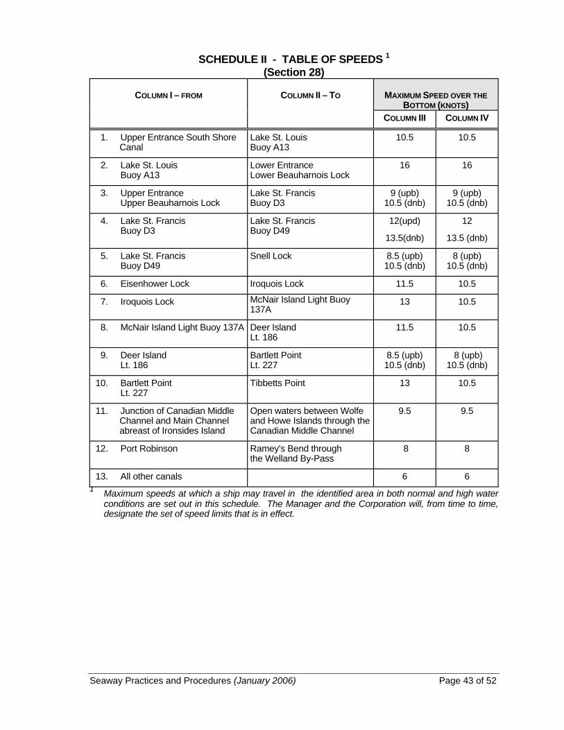
Seaway Practices and Procedures (January 2006) Page 43 of 52
SCHEDULE II - TABLE OF SPEEDS 1 (Section 28)
COLUMN I – FROM COLUMN II – TO MAXIMUM SPEED OVER THE BOTTOM (KNOTS)
COLUMN III COLUMN IV
1. Upper Entrance South Shore Canal
Lake St. Louis Buoy A13
10.5 10.5
2. Lake St. Louis Buoy A13
Lower Entrance Lower Beauharnois Lock
16 16
3. Upper Entrance Upper Beauharnois Lock
Lake St. Francis Buoy D3
9 (upb) 10.5 (dnb)
9 (upb) 10.5 (dnb)
4. Lake St. Francis Buoy D3
Lake St. Francis Buoy D49
12(upd)
13.5(dnb)
12
13.5 (dnb)
5. Lake St. Francis Buoy D49
Snell Lock 8.5 (upb) 10.5 (dnb)
8 (upb) 10.5 (dnb)
6. Eisenhower Lock Iroquois Lock 11.5 10.5
7. Iroquois Lock McNair Island Light Buoy 137A
13 10.5
8. McNair Island Light Buoy 137A Deer Island Lt. 186
11.5 10.5
9. Deer Island Lt. 186
Bartlett Point Lt. 227
8.5 (upb) 10.5 (dnb)
8 (upb) 10.5 (dnb)
10. Bartlett Point Lt. 227
Tibbetts Point 13 10.5
11. Junction of Canadian Middle Channel and Main Channel abreast of Ironsides Island
Open waters between Wolfe and Howe Islands through the Canadian Middle Channel
9.5 9.5
12. Port Robinson Ramey's Bend through the Welland By-Pass
8 8
13. All other canals 6 6 1 Maximum speeds at which a ship may travel in the identified area in both normal and high water
conditions are set out in this schedule. The Manager and the Corporation will, from time to time, designate the set of speed limits that is in effect.

Seaway Practices and Procedures (January 2006) Page 44 of 52
SCHEDULE III - CALLING IN TABLE C.I.P. and Check Point Station to Call Message Content UPBOUND SHIPS: 1. C.I.P. Entering Sector 1 (order of passing through established) (a) Ships transiting from the Seaway 1. Name of Ship Lower St. Lawrence River Beauharnois 2. Location Ch. 14 3. Destination 4. Drafts, fore and aft 5. Cargo 6. Manifested dangerous cargo - nature and quantity - IMO classification - location where dangerous
cargo is stowed 7. Pilot requirement - Lake Ontario 8. Confirm pilot requirement - Upper Beauharnois Lock (inland ships only) (b) Ships in Montreal Harbour, dock, berth or anchorage (i) Before getting underway Seaway 1. Name of Ship Beauharnois 2. Location Ch. 14 3. Destination 4. Drafts, fore and aft 5. Cargo 6. Manifested dangerous cargo - nature and quantity - IMO classification - location where dangerous
cargo is stowed 7. Pilot requirement - Lake Ontario 8. Confirm pilot requirement - Upper Beauharnois Lock
(inland ships only) (ii) C.I.P. 2 - Entering Sector 1 Seaway 1. Name of Ship (order of passing through Beauharnois 2. Location established) Ch. 14

Seaway Practices and Procedures (January 2006) Page 45 of 52
C.I.P. and Check Point Station to Call Message Content UPBOUND SHIPS: 2. C.I.P. 3 - (order of passing Seaway 1. Name of Ship through established) Beauharnois 2. Location Ch. l4 3. Exiting Upper Seaway 1. Name of Ship Beauharnois Lock Beauharnois 2. Location Ch. 14 3. ETA C.I.P. 7 4. Confirm pilot requirement - Snell Lock (inland ships
only) 4. C.I.P. 7 - Seaway 1. Name of Ship Leaving Sector 1 Beauharnois 2. Location Ch. 14 5. C.I.P. 7 - Seaway 1. Name of Ship Entering Sector 2 Eisenhower 2. Location Ch. 12 3. ETA Snell Lock 6. C.I.P. 8 - Seaway 1. Name of Ship (order of passing Eisenhower 2. Location through established) Ch. 12 7. C.I.P. 8A Seaway 1. Name of Ship Eisenhower 2. Location Ch. 12 8. Exiting Eisenhower Lock Seaway 1. Name of Ship Eisenhower 2. Location Ch. 12 3. ETA C.I.P. II 4. Confirm pilot requirement - Lake Ontario 5. All ports of call 9. C.I.P. 11 - Seaway 1. Name of Ship Leaving Sector 2 Eisenhower 2. Location Ch. 12 10. C.I.P. 11 - Seaway 1. Name of Ship Entering Sector 3 Iroquois 2. Location Ch. 11 11. C.I.P. 12 - Seaway 1. Name of Ship (order of passing Iroquois 2. Location through established) Ch. 11

Seaway Practices and Procedures (January 2006) Page 46 of 52
C.I.P. and Check Point Station to Call Message Content UPBOUND SHIPS: 12. Exiting Iroquois Lock Seaway 1. Name of Ship Iroquois 2. Location Ch.11 3. ETA Crossover Island 13. Crossover Island - Seaway 1. Name of Ship Leaving Sector 3 Iroquois 2. Location Ch. 11 14. Crossover Island - Seaway 1. Name of Ship Entering Sector 4 Clayton 2. Location Ch. 13 3. ETA Cape Vincent or River Port
4. Confirm pilot requirement - Lake Ontario 15. Wolfe Is. Cut Seaway 1. Name of Ship (Beauvais Point) -Ships Clayton 2. Location leaving main channel Ch. 13 3. ETA Kingston 16. Cape Vincent Seaway 1. Name of Ship Clayton 2. Location Ch. 13 3. ETA Sodus Point 4. ETA Port Weller (CIP 15) or Lake Ontario Port 5. Pilot requirement - Port Weller 17. Sodus Pt. Seaway 1. Name of Ship Sodus 2. Location Ch. 13 3. ETA mid-Lake Ontario 4. ETA Newcastle 18. Mid-Lake Ontario - Seaway 1. Name of Ship Leaving Sector 4 Sodus 2. Location Ch. 13

Seaway Practices and Procedures (January 2006) Page 47 of 52
C.I.P. and Check Point Station to Call Message Content UPBOUND SHIPS: 19. Mid-Lake Ontario - Seaway 1. Name of Ship Entering Sector 5 Newcastle 2. Location Ch. 11 3. Pilot requirement - Lake Erie 20. Newcastle Seaway 1. Name of Ship Newcastle 2. Location Ch. 11 3. Updated ETA Port Weller (CIP 15) or Lake Ontario Port 4. Confirm pilot requirement - Port Weller 21. C.I.P. 15 - Seaway 1. Name of Ship (order of passing Welland 2. Location through established) Ch. 14 22. Port Colborne Piers Seaway 1. Name of Ship Welland 2. Location Ch. 14 3. ETA Long Point 23. C.I.P. 16 Seaway 1. Name of Ship Long Point 2. Location Ch. 11 24. Long Point - Seaway 1. Name of Ship Leaving Sector 7 Long Point 2. Location Ch. 11 25. (Revoked) 26. (Revoked) 27. (Revoked) 28. (Revoked)

Seaway Practices and Procedures (January 2006) Page 48 of 52
C.I.P. and Check Point Station to Call Message Content DOWNBOUND SHIPS: 29. Long Point - Seaway 1. Name of Ship Entering Sector 7 Long Point 2. Location Ch. 11 3. ETA C.I.P. 16 or Port 4. Dangerous cargo, as
indicated on the manifest including
(a) nature and quantity (b) IMO classification (c) location where
dangerous cargo is stowed and, if proceeding to Welland Canal
5. Destination 6. Drafts, fore and aft 7. Cargo 8. Pilot requirement - Lake Ontario 30. C.I.P. 16 - Seaway 1. Name of Ship (order of passing Welland 2. Location through established) Ch. 14 31. Exiting Lock No. 1 - Seaway 1. Name of Ship Welland Canal Welland 2. Location Ch. 14 3. ETA Newcastle 4. ETA Cape Vincent or Lake Ontario Port 5. Pilot requirement - Cape Vincent 32. C.I.P. 15 Seaway 1. Name of Ship Newcastle 2. Location Ch. 11 33. Newcastle Seaway 1. Name of Ship Newcastle 2. Location Ch. 11 3. ETA Mid-Lake Ontario 4. ETA Sodus Point 34. Mid-Lake Ontario - Seaway 1. Name of Ship Leaving Sector 5 Newcastle 2. Location Ch. 11
Seaway Practices and Procedures (January 2006) Page 49 of 52
C.I.P. and Check Point Station to Call Message Content DOWNBOUND SHIPS: 35. Mid-Lake Ontario - Seaway 1. Name of Ship Entering Sector 4 Sodus 2. Location Ch. 13 36. Sodus Point Seaway 1. Name of Ship Sodus 2. Location Ch. 13 3. Updated ETA Cape Vincent
or Lake Ontario Port 4. Confirm river pilot
requirement - Cape Vincent 5. Pilot requirement - Snell
Lock and/or Upper Beauharnois Lock (inland ships only)
37. Cape Vincent Seaway 1. Name of Ship Clayton 2. Location Ch. 13 3. ETA Crossover Island or
river port 38. Wolfe Is. Cut (Quebec Head) - Seaway 1. Name of Ship Ships Entering Main Channel Clayton 2. Location Ch. 13 3. ETA Crossover Island or river port 39. Crossover Island - Seaway 1. Name of Ship Leaving Sector 4 Clayton 2. Location Ch. 13 40. Crossover Island - Seaway 1. Name of Ship Entering Sector 3 Iroquois 2. Location Ch. 11 41. C.I.P. 14 Seaway 1. Name of Ship Iroquois 2. Location Ch. 11
Seaway Practices and Procedures (January 2006) Page 50 of 52
C.I.P. and Check Point Station to Call Message Content DOWNBOUND SHIPS: 42. C.I.P. 13 - Seaway 1. Name of Ship (order of passing Iroquois 2. Location through established) Ch. 11 43. Exiting Iroquois Lock Seaway 1. Name of Ship Iroquois 2. Location Ch. 11 3. ETA C.I.P. 10 4. Harbor or river pilot
requirement St. Lambert 5. Confirm pilot requirement - Snell Lock (inland ships
only) 44. C.I.P. 10 - Seaway 1. Name of Ship Leaving Sector 3 Iroquois 2. Location Ch.11 45. C.I.P. 10 - Seaway 1. Name of Ship Entering Sector 2 Eisenhower 2. Location Ch. 12 46. C.I.P. 9 - Seaway 1. Name of Ship (order of passing Eisenhower 2. Location through established) Ch. 12 3. ETA Snell Lock 47. Exiting Snell Lock Seaway 1. Name of Ship Eisenhower 2. Location Ch. 12 3. ETA C.I.P. 6 48. Revoked 49. C.I.P. 6 - Seaway 1. Name of ship Leaving Sector 2 Eisenhower 2. Location Ch. 12 50. C.I.P. 6 - Seaway 1. Name of ship Entering Sector 1 Beauharnois 2. Location Ch. 14 51. C.I.P. 5 - Seaway 1. Name of ship (order of passing Beauharnois 2. Location through established) Ch. 14

Seaway Practices and Procedures (January 2006) Page 51 of 52
C.I.P. and Check Point Station to Call Message Content DOWNBOUND SHIPS: 52. Exiting Lower Seaway 1. Name of Ship Beauharnois Lock Beauharnois 2. Location Ch. 14 3. Confirm harbour or river
pilot requirement - St. Lambert 4. Montreal Harbour Berth No.
(if applicable) 53. St. Nicholas Island Seaway 1. Name of Ship Beauharnois 2. Location Ch. 14 54. St. Lambert Lock to C.I.P. 2 - Seaway 1. Name of Ship Leaving Sector 1 Beauharnois 2. Location Ch. 14 UPBOUND AND DOWNBOUND SHIPS 55. Ships departing from ports Appropriate 1. Name of Ship between mid-Lake Ontario and Seaway station 2. Location Long Point, (except ships for sector 3. Dangerous cargo, as departing westbound from a Lake indicated on the manifest, Erie port and not transiting in including the Welland Canal) a) nature and quantity b) IMO classification c) location where
dangerous cargo is stowed and, if proceeding to Welland Canal
4. Destination 5. Drafts, fore and aft 6. Cargo 7. Pilot requirement - Lake Erie if upbound or
Lake Ontario if downbound

Seaway Practices and Procedures (January 2006) Page 52 of 52
APPENDIX I SHIP DIMENSIONS Structures are located at a number of Seaway locks which, when fully raised, overhang the lock wall at a given point, thereby limiting: (a) the height of a ship above the water line measured at the ship's side; and (b) the height of other structures that are located near the sides of the ship, such
as derricks, crosstrees, antennas, etc. The following block diagram shows the limits beyond which a ship's hull or superstructure cannot extend when the ship is alongside the lock wall. For details, refer to Ship Transit and Equipment Requirements. The limits in the block diagram are based on ships with a maximum allowable beam of 23.2 m. For ships that have a beam width less than this and that have dimensions exceeding the limits of the block diagram (measured with the ship alongside the lock wall), a special permission to transit must be obtained. (Accurate measurements may be required before such permission is granted.) Caution: Masters must take into account the ballast draft of the ship when
verifying the maximum permissible dimensions.

2006 ST. LAWRENCE SEAWAY SCHEDULE OF TOLLS (2006/01/31) Page 1 of 8
ST. LAWRENCE SEAWAY SCHEDULE OF TOLLS 2006
INTERPRETATION
1. The definitions in this section apply in this Schedule.
“bulk cargo” means cargo consisting of goods, loose or in mass, that generally must be shovelled, pumped, blown, scooped or forked in the handling and includes:
(a) cement, loose or in sacks;
(b) coke and petroleum coke, loose or in sacks;
(c) domestic cargo;
(d) liquids carried in ships' tanks;
(e) ores and minerals (crude, screened, sized or concentrated, but not otherwise processed), loose or in sacks, including alumina, bauxite, gravel, phosphate rock, sand, stone and sulphur;
(f) pig iron and scrap metals;
(g) lumber, pulpwood, poles and logs, loose or bundled;
(h) raw sugar and flour, loose or in sacks;
(i) woodpulp, loose or in bales; and
(j) material for recycling, scrap material, refuse and waste. (cargaison en vrac)
“cargo” means all goods aboard a ship whether carried as revenue or non-revenue freight or carried for the ship owner, but does not include
(a) empty containers or the tare weight of loaded containers;
(b) ships' fuel, ballast or stores;
(c) the personal effects of crew or passengers; or
(d) in-transit cargo that is carried both upbound and downbound in the course of the same voyage. (cargaison)
“containerized cargo” means cargo shipped in a container that is enclosed, permanent, reusable, nondisposable and weathertight. (cargaison conteneurisée)
“Corporation” means the Saint Lawrence Seaway Development Corporation. (Corporation)
“domestic cargo” means cargo the shipment of which originates at one Canadian point and terminates at another Canadian point, or originates at one United States point and terminates at another United States point, but does not include import or export cargo designated at the point of origin for transshipment by water at a point in Canada or in the United States. (cargaison domestique)

2006 ST. LAWRENCE SEAWAY SCHEDULE OF TOLLS (2006/01/31) Page 2 of 8
“general cargo” means goods other than bulk cargo, grain, government aid cargo, steel slabs and coal. (cargaison générale)
“government aid cargo” means
(a) processed food products that are donated by, or the purchase of which has been financed on concessional terms by, the federal government of the United States or Canada for the purposes of nutrition, economic development, emergency or disaster relief programs; and
(b) food cargo that is
(i) owned or financed by a non-profit organization or cooperative,
(ii) intended for use in humanitarian or development assistance overseas, and
(iii) stamped or otherwise shown to have been declared as such to the customs service of the United States or Canada. (cargaison d’aide gouvernementale)
“grain” means barley, corn, oats, flaxseed, rapeseed, soybeans, field crop seeds, buckwheat, dried beans, dried peas, rye, wheat, grain screenings or meal from those grains. (céréale)
“Manager” means The St. Lawrence Seaway Management Corporation. (Gestionnaire)
“metric ton” means 1 000 kg (2,204.62 pounds). (tonne métrique)
“new cargo – MLO Section” means either containerized cargo or cargo which has not moved through the MLO Section in an average annual amount, over the navigation seasons 2001-2002-2003, greater than 10,000 metric tonnes. (nouvelle cargaison – Section MLO)
“new cargo – Welland Canal” means either containerized cargo or cargo which has not moved through the Welland Canal in an average annual amount, over the navigation seasons 2001-2002-2003, greater than 10,000 metric tonnes. (nouvelle cargaison – Canal Welland)
“passenger” means a person being transported through the Seaway who has paid a fare for passage. (passager)
“pleasure craft” means a ship, however propelled, that is used exclusively for pleasure and does not carry passengers. (embarcation de plaisance)
“Seaway” has the meaning ascribed to it under the Canada Marine Act. (voie maritime)
“ship” means every type of craft used as a means of transportation on water, except a ship owned or employed by the Manager or the Corporation. (navire)
TOLLS
2. (1) Every ship entering, passing through or leaving the Seaway shall pay a toll that is the sum of each applicable charge in Appendix 1. Each charge is calculated based on the description set out in column 1 of Appendix 1 and the rate set out in column 2 or 3.

2006 ST. LAWRENCE SEAWAY SCHEDULE OF TOLLS (2006/01/31) Page 3 of 8
(2) The toll is assessed against the ship, its cargo and its passengers for a complete or partial transit of the Seaway and covers a single trip in one direction.
(3) The toll is due from the representative of the ship within 45 days after the day on which the ship enters the first lock of a transit of the Seaway.
(4) As part of the fees applicable under the New Cargo - Welland Canal and the New Cargo - MLO Section, once a cargo has qualified as new cargo, it will remain qualified for the navigation seasons 2006 and 2007.
(5) For a transit to be accepted under the New Cargo - Welland Canal or the New Cargo - MLO Section, more than 50% of the cargo carried on that transit for each section must qualify as new cargo.
(6) Barges transiting the Welland Canal together as one unit pulled by the same tug or tugs shall, for the purpose of calculating lockage fees, be deemed to be a combination unit and will pay lockage fees as a single barge.
DESCRIPTION AND WEIGHT OF CARGO
3. For the purposes of calculating applicable tolls,
(a) a cord of pulpwood is taken to weigh 1 450 kg (3,196.70 pounds); and
(b) the cargo tonnage shall be rounded to the nearest 1 000 kg (2,204.62 pounds).
POST-CLEARANCE DATE OPERATIONAL SURCHARGES
4. (1) Subject to subsection (2), a ship that reports for its final transit of the Seaway from a place set out in column 1 of Appendix 2 within the period after the clearance date established by the Manager and the Corporation set out in column 2 shall pay operational surcharges in the amount set out in column 3, prorated on a per-lock basis.
(2) If surcharges are postponed for operational or climatic reasons, a ship that reports for its final transit of the Seaway from a place set out in column 1 of Appendix 3 within the period after the clearance date established by the Manager and the Corporation set out in column 2 shall pay operational surcharges in the amount set out in column 3, prorated on a per-lock basis.
5. A ship that is authorized to transit the Seaway after the period of 96 hours after the clearance date established by the Manager and the Corporation shall pay, in addition to the operational surcharge, an amount equal to the incremental expenses incurred by the Manager to keep the Seaway open for the transit of the ship.
COMING INTO FORCE
6. This Schedule and the fees set forth herein come into force from the date on which this Schedule is filed with the Canadian Transportation Agency.
2006 ST. LAWRENCE SEAWAY SCHEDULE OF TOLLS (2006/01/31) Page 4 of 8
APPENDIX 1 (Section 2)
TOLLS
Column 1 Column 2 Column 3 Item
Description of Charges
Rate ($) Montreal to or
from Lake Ontario (5 locks)
Rate ($) Welland
Canal – Lake Ontario to or
from Lake Erie (8 locks)
1. Subject to item 3, for complete transit of the Seaway, a composite toll, comprising:
(1) a charge per gross registered ton of the ship, applicable whether the ship is wholly or partially laden, or is in ballast, and the gross registered tonnage being calculated according to prescribed rules for measurement under the International Convention on Tonnage Measurement of Ships, 1969, as amended from time to time
0.0947 0.1537
(2) a charge per metric ton of cargo as certified on the ship's manifest or other document, as follows:
(a) bulk cargo 0.9816 0.6504
(b) general cargo 2.3651 1.0408
(c) steel slab 2.1405 0.7451
(d) containerized cargo 0.9816 0.6504
(e) government aid cargo n/a n/a
(f) grain 0.6030 0.6504
(g) coal 0.5795 0.6504
(3) a charge per passenger per lock 1.3954 1.3954
(4) a charge per lock for transit of the Welland Canal in either direction by cargo ships:
(a) loaded n/a 519.40
(b) in ballast
n/a
383.75

2006 ST. LAWRENCE SEAWAY SCHEDULE OF TOLLS (2006/01/31) Page 5 of 8
Column 1 Column 2 Column 3 Item
Description of Charges
Rate ($) Montreal to or
from Lake Ontario (5 locks)
Rate ($) Welland
Canal – Lake Ontario to or
from Lake Erie (8 locks)
2. Subject to item 3, for partial transit of the Seaway 20 per cent per lock of the applicable charge under items 1(1) and (2) plus the applicable charge under items 1(3) and (4)
13 per cent per lock of the applicable charge under items 1(1) and (2) plus the applicable charge under items 1(3) and (4)
3. Minimum charge per ship per lock transited for full or partial transit of the Seaway
20.40 20.40
4. A rebate applicable to the rates of item 1 to 3 n/a n/a
5. A charge per pleasure craft per lock transited for full or partial transit of the Seaway, including applicable federal taxes *
20.00 20.00
* the applicable charge at the Saint Lawrence Seaway Development Corporation's locks (Eisenhower, Snell) is $25 US per lock.
6. Subject to item 3, in lieu of item 1(4), for vessel carrying new cargo on the Welland Canal or returning ballast after carrying new cargo on the Welland Canal, a charge per gross registered ton of the ship, the gross registered tonnage being calculated according to item 1(1):
(a) loaded n/a 0.1530
(b) in ballast n/a 0.1122
7. Subject to item 3, in lieu of item 1(1), for vessel carrying new cargo on the MLO Section or returning ballast after carrying new cargo on the MLO Section, a charge per gross registered ton of the ship, the gross registered tonnage being calculated according to item 1(1):
0.0000 n/a

2006 ST. LAWRENCE SEAWAY SCHEDULE OF TOLLS (2006/01/31) Page 6 of 8
APPENDIX 2 (Subsection 4(1))
OPERATIONAL SURCHARGES – NO POSTPONEMENTS
Column 1 Column 2 Column 3
Item
Place in Montreal-Lake Ontario Section
Period after Clearance Date
Amount ($) (5 locks)*
1. (a) 24 hours 20,000
Cape Vincent (downbound) or Cap Saint-Michel (upbound) (b) 24 hours or more but less
than 48 hours 40,000
(c) 48 hours or more but less than 72 hours
60,000
(d) 72 hours or more but less than 96 hours
80,000
2. (a) 24 hours n/a
Port, dock or wharf within St. Lambert - Iroquois lock segment (b) 24 hours or more but less
than 48 hours 20,000
(c) 48 hours or more but less than 72 hours
40,000
(d) 72 hours or more but less than 96 hours
60,000
* prorated on a per-lock basis

2006 ST. LAWRENCE SEAWAY SCHEDULE OF TOLLS (2006/01/31) Page 7 of 8
APPENDIX 3 (Subsection 4(2))
OPERATIONAL SURCHARGES AFTER POSTPONEMENTS
Column 1 Column 2 Column 3
Item
Place in Montreal-Lake Ontario Section
Period after Clearance Date
Amount ($) (5 locks)*
1. Cape Vincent (downbound) or Cap Saint-Michel (upbound)
(1) if the postponement is for 24 hours
(a) 24 hours or more but less than 36 hours
20,000
(b) 36 hours or more but less than 48 hours
40,000
(c) 48 hours or more but less than 72 hours
60,000
(d) 72 hours or more but less than 96 hours
80,000
(2) if the postponement is for 48 hours
(a) 48 hours or more but less than 56 hours
20,000
(b) 56 hours or more but less than 64 hours
40,000
(c) 64 hours or more but less than 72 hours
60,000
(d) 72 hours or more but less than 96 hours
80,000
(3) if the postponement is for 72 hours
(a) 72 hours or more but less than 78 hours
20,000
(b) 78 hours or more but less than 84 hours
40,000
(c) 84 hours or more but less than 90 hours
60,000
(d) 90 hours or more but less than 96 hours
80,000

2006 ST. LAWRENCE SEAWAY SCHEDULE OF TOLLS (2006/01/31) Page 8 of 8
Column 1 Column 2 Column 3
Item
Place in Montreal-Lake Ontario Section
Period after Clearance Date
Amount ($) (5 locks)*
2. Port, dock or wharf within St. Lambert - Iroquois lock segment
(1) if the postponement is for 24 hours
(a) 24 hours or more but less than 48 hours
n/a
(b) 48 hours or more but less than 60 hours
20,000
(c) 60 hours or more but less than 72 hours
40,000
(d) 72 hours or more but less than 96 hours
60,000
(2) if the postponement is for 48 hours
(a) 48 hours or more but less than 72 hours
n/a
(b) 72 hours or more but less than 80 hours
20,000
(c) 80 hours or more but less than 88 hours
40,000
(d) 88 hours or more but less than 96 hours
60,000
(3) if the postponement is for 72 hours or more
n/a
* prorated on a per-lock basis

ST. Lawrence Seaway Wharfage and Storage Charges Tariff February 20, 2006 Page 1 of 4
SCHEDULE OF CHARGES ON GOODS OR CARGO LANDED, SHIPPED, TRANSSHIPPED OR STORED
Short Title
1. This Schedule may be cited as the Schedule of St. Lawrence Seaway Wharfage and Storage Charges.
Interpretation
2. In this Schedule, «bulk cargo» means such goods as are loose or in mass and generally must
be shovelled, pumped, blown, scooped or forked in the handling and, without limiting the generality of the foregoing, shall be deemed to include:
(a) barley, buckwheat, corn, dried beans, dried peas, flaxseed,
rapeseed and other oil seeds, flour, grain screenings, mill feed containing not more than 35 per cent of ingredients other than grain or grain products, oats, rye and wheat, loose or in sacks,
(b) cement, loose or in sacks, (c) coke and petroleum coke, loose or in sacks, (d) domestic package freight, (e) liquids carried in ships' tanks, (f) ores and minerals (crude, screened, sized or concentrated, but not
otherwise processed) loose or in sacks, including alumina, bauxite, coal, gravel, phosphate rock, sand, stone and sulphur,
(g) pig iron, scrap iron and scrap steel, (h) pulpwood, poles and logs, loose or bundled, (i) raw sugar, loose or in sacks, and (j) woodpulp, loose or in bales; (cargaison en vrac)

ST. Lawrence Seaway Wharfage and Storage Charges Tariff February 20, 2006 Page 2 of 4
«canal» means any constructed part of the St. Lawrence Seaway and includes any canals and lands appurtenant thereto that are under the administration and control of the Manager; (canal)
«containerized cargo» means any general cargo shipped in an enclosed,
permanent, reusable, nondisposable, watertight shipping conveyance that has a capacity of 18 cubic metres or more and that is fitted with at least one hinged door; (cargaison conteneurisée)
«general cargo» means all goods other than bulk cargo; (marchandises
diverses) «Manager» means The St. Lawrence Seaway Management Corporation «owner» includes (a) in respect of goods, the consignor and consignee of the goods, and (b) in respect of a ship, every person who is a representative as defined in
section 2 of the Seaway Regulations; (propriétaire) «side wharfage» means a toll charged on a ship in respect of the period of
time that the ship is loading, unloading or lying in wait in a canal; (droit d'accostage)
«storage charge» means a toll charged on goods in respect of the period of
time that the goods are stored at a canal; (droit d'emmagasinage) «tonne» means one thousand kilograms; (tonne) «top wharfage» means a toll charged on goods that are unloaded from or
loaded onto a ship or transshipped between ships in a canal; (droit de terre-plein)
Tolls 3. (1) The toll set out in column II of an item in Appendix I is payable in respect
of the goods or ship described in column I of that item for the type of goods or period set out in column I of that item.
(2) Top wharfage is not payable in respect of grain or grain products that are
destined for export from Canada. (3) Where the Manager has leased any area at a canal, the Manager may
exempt persons from the payment of top wharfage in respect of goods loaded or unloaded at that area.

ST. Lawrence Seaway Wharfage and Storage Charges Tariff February 20, 2006 Page 3 of 4
4. The tolls prescribed by this Schedule are due (a) jointly from the owner of the goods and the owner of the ship from which
the goods are transshipped, in the case of tolls prescribed in respect of goods where the goods are transshipped from one ship to another ship at a canal,
(b) jointly from the owner of the goods and the owner of the ship on which
the goods are shipped in the case of tolls prescribed in respect of goods where the goods are loaded to or from a ship at a canal other than by transshipment between ships,
(c) from the owner of the goods in the case of tolls prescribed for the storage
of goods, and (d) from the owner of the ship in the case of tolls prescribed in respect of a
ship, and such tolls are due as soon as they are incurred and shall be paid to the
appropriate officer of the Manager at the canal at which they are incurred. 5. Top wharfage at a canal is payable only once in respect of goods other than
goods that are (a) reshipped at a canal after having been removed therefrom; or (b) reshipped at a canal after being altered in form or composition.

ST. Lawrence Seaway Wharfage and Storage Charges Tariff February 20, 2006 Page 4 of 4
APPENDIX I (s. 3)
PRESCRIBED TOLLS Column I Column II Description of Goods or Ship Top Wharfage 1. Goods loaded, unloaded or transshipped at a canal (a) bulk cargo .............................................................. $ 0.3749 per tonne (b) general cargo ......................................................... $ 0.8568 per tonne (c) containerized cargo ................................................ $ 0.3749 per tonne Storage Charge 2. Goods stored at a Canal on land other than land leased by the Manager to any person (a) first 48 hours ........................................................... no charge (b) each period of 7 days or part thereof after first 48 hours . ......................................................... $ 0.48 per square ................................................................................ metre of area occu- ................................................................................ pied for storage Side Wharfage 3. A ship berthed in a canal (a) first 48 hours ........................................................... no charge (b) each period of 24 hours or part thereof after first 48 hours ........................................................... $ 0.0964 per gross ................................................................................ registered ton Lying-Up Charge 4. A ship lying-up at a canal or area that has been set aside by the Manager for that purpose (a) for each period of 30 days or part thereof during the navigation season ............................................ $ 0.1122 per gross ................................................................................ registered ton (b) for the whole or part of the season during which navigation is closed ............................................... $0.31 per linear meter
per day (minimum toll $185)
CONVERSION TABLES Page 1 of 2
Conversion
For the purposes of the St. Lawrence Seaway Wharfage and Storage ChargeTariff, the quantity set out in column II of an item of Schedule I in respect of thegoods set out in column I of that item is deemed to weigh the number of kilogramsset out in column III of that item.
SCHEDULE I - CONVERSION TABLE(s.6)
COLUMN IGOODS
COLUMN IIQUANTITY
COLUMN IIIWEIGHT (KG)
1. Lumber, logs, polesand ties
m3 (SOFTWOOD)m3 (HARDWOOD)
400600
2. Crude oil KL 830
3. Crushed stone m3 1,500
4. Fuel oilKLKL
830950
5. Gasoline KL 750
6. Pulpwood m3 400
7. Refined oil KL 810
8. Sand and gravel m3 1,720

CONVERSION TABLES Page 2 of 2
SCHEDULE II - CONVERSION TABLE
BRITISH - U.S. - INTERNATIONAL AND METRIC UNITS
British - U.S. - International Units Metric Units (SI)
LENGTH
1 nautical mile (U.S.-Int.) = 1.852 km0.53996 nautical mile (U.S.-Int.) = 1 km1 nautical mile (Br) = 1.853 184 km0.539612 nautical mile (Br) = 1 km
1 mile = 1.609 344 km0.621371 mile = 1 km
1 inch = 2.540 cm0.39370 inch = 1 cm
1 foot = 0.304 8 m3.2808 feet = 1 m
MASS
1 ton (long) = 1016.046 908 8 kg0.9842065 ton (long) = 1000.0 kg
1 ton (short) = 907.184 74 kg1.10231 tons (short) = 1000.0 kg
1 pound = 0.453 592 37 kg2.20462262 pounds = 1 kg
CAPACITY
1 gallon (Br) = 4.546 092 dm3
0.219969 gallon (Br) = 1 dm3
1 gallon (U.S.) = 3.785 412 dm3
0.264172 gallon (U.S.) = 1 dm3
Note: Relevant units used with the S1a) 1 tonne (t) or 1 metric ton = 1000 kgb) 1 litre = 1 dm3

INFORMATION ON SHIP TRANSIT AND EQUIPMENT REQUIREMENTS Page 1 of 50
JANUARY 2006
INTRODUCTION This section of the Seaway Handbook has been prepared to provide shipmasters and pilots with general transit and required equipment information for the St. Lawrence Seaway and is intended to complement the Practices and procedures. The information herein contained does not supersede the Seaway Practices and Procedures. The capacity of the Seaway system is limited principally by the locks and, in order to achieve maximum utilization of the facilities, a number of procedures, methods and special aids have been introduced. Many of the subjects described in this section are designed to minimize the idle time at locks and to thus achieve the prime aim of minimizing round trip transit times for ships. To achieve complete success in realizing our mutual goal, the full cooperation of masters, pilots and Seaway operations personnel is essential and is hereby requested. If any additional information is required, you are asked to direct your inquiries to: Marine Services THE ST. LAWRENCE SEAWAY MANAGEMENT CORPORATION 202 Pitt Street Cornwall, Ontario Canada K6J 3P7 Tel.: (613) 932-5170 Fax.: (613) 932-5204 OR Director, Office Lock Operations SAINT LAWRENCE SEAWAY DEVELOPMENT CORPORATION Post Office Box 520 Massena, New York 13662 - 0520 U.S.A. Tel.: (315) 764-3294 Fax.: (315) 764-3250
INFORMATION ON SHIP TRANSIT AND EQUIPMENT REQUIREMENTS Page 2 of 50
JANUARY 2006
GENERAL TRANSIT INFORMATION 1. Traffic Control The purpose of Seaway Traffic Control is principally to provide the safe and efficient
scheduling of ships. Associated with this is the information service in connection with Search and Rescue, pilot scheduling and ship information to the shipping entities and the public.
Ship traffic in the Seaway is controlled from three main centres: one located in St. Lambert,
Quebec, one in Massena, New York, and the other in St. Catharines, Ontario. The St. Lambert centre operates through two radio stations: Seaway Beauharnois and Seaway lroquois. The Massena centre operates through three radio stations: Seaway Eisenhower (KEF), Seaway Clayton (WAG) and Seaway Sodus, while the St. Catharines centre operates through three stations: Seaway Welland, Seaway Newcastle and Seaway Long Point.
In each control centre the traffic controllers have a number of aids available to assist them in
their work. Some of these aids are: computerization, closed circuit television, display boards and an extensive communications network.
2. Pilotage Requirements Masters or agents of ships in ports or at docks wishing to order a pilot should do so directly
via Landline communication with the nearest pilotage dispatch office. Procedures regarding the reporting of pilotage requirements when in transit are described in
the Seaway Regulations. 3. Lock Communications Within the lock areas, mooring instructions between the lock personnel and the ship is
carried out via VHF radio using the following channels:
Lock No. 1 - St. Lambert Channel 17 Lock No. 2 - Côte Ste. Catherine Channel 13 Lock No. 3 - Beauharnois Channel 17 Lock No. 4 - Beauharnois Channel 13 Lock No. 5 - Snell Channel 17 Lock No. 6 - Eisenhower Channel 13 Lock No. 7 - Iroquois Channel 17
In the Welland Canal, channel 17 is used for upbound ships and channel 66A is used for downbound ships. Ships must also continue to monitor channel 14.

INFORMATION ON SHIP TRANSIT AND EQUIPMENT REQUIREMENTS Page 3 of 50
JANUARY 2006
This system of communications is used solely for transmitting mooring instructions or in an
emergency. All other radio communications must be directed to the appropriate Traffic Control Centres.
4. Bridges (Canadian Sectors) V.H.F. transceivers fitted with Channel 14 have been installed at the following bridges:
Kahnawake, St. Louis and Valleyfield in Sector 1 and Bridges 1, 3A, 4, 5, 11 and 21 on the Welland Canal. The use of these is limited to periods of reduced visibility and emergencies only. The radio call sign is the applicable bridge name or number, i.e.
``VALLEYFIELD BRIDGE, THIS IS SHIP ... or ``BRIDGE 11, THIS IS ...'' To further assist traffic and enhance safety during periods of reduced visibility, radar has
been fitted at the following bridges: St. Louis, Valleyfield, in Sector 1, and Bridges 4, 11 and 21 on the Welland Canal. At the Valleyfield and St. Louis Bridges, vertical markers are installed on the centre line of the mobile spans. At night, the markers are floodlit.
Bascule Bridges: Ships with high raking counters, superstructures and/or flared bows which
could overhang the top of lock walls when the ship is not parallel to the wall must exercise extreme care in navigating past bascule bridges. Bascule bridges impose restrictions on ship dimensions and, in this regard, specific reference is made to Seaway Regulation No. 3 and Appendix I.
At bridges 7A, 7B, St. Louis and Valleyfield in sector 1 and bridges 4,5,11 and 21 in the Welland Canal, when a vessel has cleared the draw of the bridge, the bridge operator will communicate with the vessel by VHF radio prior to initiating the closing/lowering of the bridge. The master/pilot of the vessel is not required to call back unless a problem situation warrants it.
In case of a malfunction of the bridge or a power failure, the bridgemaster will display a red
safety flare at the bridge and a ship must not pass the limit of approach sign. 5. Bridges - Signal Light System A system of navigation light signals and signs is in effect at all free-standing lift bridges in
both the Montreal/Lake Ontario section and the Welland Canal. The system includes: a) A red and green bridge navigation light display on the moveable bridge span
b) A limit of approach sign (L/A) - (red background, white letters, diamond shape) c) A caution sign equipped with amber lights - (yellow-black checkerboard, triangular
shape) d) A whistle sign (yellow background - black lettering square shape).
INFORMATION ON SHIP TRANSIT AND EQUIPMENT REQUIREMENTS Page 4 of 50
JANUARY 2006
The operation of the system is as follows: 1. When the ship's stem arrives at the WHISTLE sign, the AMBER lights on the CAUTION
sign start to flash. This acknowledges that the bridgemaster has seen the ship and will commence the bridge operation. The master shall signal the bridge if he does not receive a FLASHING AMBER light at this time.
NOTE: At this time, the RED BRIDGE NAVIGATION light will be displayed on the
bridge span. 2. After the bridgemaster acknowledges the presence of the ship at the WHISTLE sign, he
will commence the bridge raising operation. When the bridge starts to rise, the RED BRIDGE NAVIGATION lights will commence flashing.
3. When the ship's stem is abeam of the CAUTION sign and the GREEN BRIDGE
NAVIGATION lights are displayed, the ship is allowed to proceed through the bridge draw. If, however, the GREEN BRIDGE NAVIGATION lights are not displayed at the time the stem of the ship is abeam of the CAUTION sign, the Master should take any action necessary to ensure that the ship does not pass the L/A sign before the bridge span is fully raised and the GREEN BRIDGE NAVIGATION lights are displayed.
NOTE: Under normal conditions the bridge span should be fully raised by the time the
ship reaches the CAUTION sign. 6. Ship Location Information
a) MONTREAL/LAKE ONTARIO SECTION: The Regional Information Centre, Montreal, is responsible for providing to the public and shipping interests information relative to ship movements within the Montreal/Lake Ontario section. The telephone number is (450) 672-4115.
b) WELLAND CANAL AREA: For information regarding the position of ships in and
around the Welland Canal, the telephone number is (905)688-6462.
c) ST. LAWRENCE SEAWAY: Information on ship location is also available on the Seaway Web site at www.greatlakes-seaway.com, under navigation.

INFORMATION ON SHIP TRANSIT AND EQUIPMENT REQUIREMENTS Page 5 of 50
JANUARY 2006
7. Marine Weather Broadcasting and Data Collection a) During the navigation season, general marine weather broadcasts will be routinely
issued by the Canadian Coast Guard Seaway Eisenhower - 0245 and every six hours thereafter Seaway Clayton - 0245 and every six hours thereafter Seaway Sodus - 0245 and every six hours thereafter b) Ship Weather Data Stations Ships encountering adverse weather or sailing conditions are urged to notify the
appropriate Seaway Control Centre giving pertinent information. This information will in turn be broadcast to other ships and relayed to the meteorological branch offices concerned.
8. Use of VHF Radio The use of Seaway working frequencies as outlined in the Seaway Regulations is restricted
to ship-to-shore (Ship Traffic Management) communications. ship-to-ship communications must be carried out on the designated VHF channels. Strict adherence to these regulations is required.
9. Fog The incidence of fog is most prevalent in the American Narrows, CIP 9 (Richards Point) to
Light 41, west end of mooring cells above Eisenhower Lock, St. Regis Island to Grasse River below Snell Lock, in the vicinity of the Valleyfield Bridge and in the upper reach of the Welland Canal.
In the American Narrows, navigation will be suspended when the visibility is 1/2 mile or less.
High intensity strobe lights have been installed at the lower wall of Snell Lock and the upper wall at Eisenhower lock to assist ship masters in locating the wall in times of poor visibility.
In Canadian waters, navigation will be suspended by the Traffic Control Centre when visibility
becomes insufficient to permit safe navigation. In general, navigation will be suspended when visibility falls to less than a ¼ M, except in the Beauharnois Canal where two-way navigation will be permitted until visibility falls to 3/4 M, at which point navigation will be suspended. Ships downbound under conditions of reduced visibility must have a competent crew member in attendance at the stern anchor when approaching bridges.

INFORMATION ON SHIP TRANSIT AND EQUIPMENT REQUIREMENTS Page 6 of 50
JANUARY 2006
In some locations, under certain conditions, one-way navigation will be permitted when visibility is between ¼ M and ½ M. In these cases, ships will be asked to proceed by invitation only.
When fog is forecast, ships may be assembled in anchorages or on approach walls or
wharves to permit localized operation during the period when navigation is suspended elsewhere.
A strobe light is located on the approach wall above the upper Beauharnois Lock and above
Iroquois Lock. 10. Wind When high winds prevail, or are forecasted, ships are permitted to transit in accordance with
established wind scales which take into account wind velocity and direction, ship draft and exposed "sail area". The scales serve as guidelines in scheduling ship traffic under adverse wind conditions.
NOTE: 1) When a ship becomes windbound in a Traffic Sector, it is essential that it be
moored or anchored in a location which does not prevent the safe manoeuvring of other ships that are able and allowed to transit.
2) Under conditions of wind or low visibility ships are not normally kept in lock
chambers. 11. Hogging During hot summer weather, the heat radiated by the sun causes expansion of the exposed
deck area, while the lower plates which are submerged remain comparatively cool. The expansion of the upper deck results in a bending effect commonly known as "hogging". This "hogging", particularly in the case of ships with a large expanse of open deck, may increase the "fore and aft" draft by as much as 13 cm and create an overdraft condition.
Masters, aware of this possibility, usually take the precaution of running water over the deck
during daytime periods of extreme heat. It is recommended that masters of ships with a large expanse of open deck take the
precaution mentioned above to prevent deck expansion and avoid delays while adjusting drafts.

INFORMATION ON SHIP TRANSIT AND EQUIPMENT REQUIREMENTS Page 7 of 50
JANUARY 2006
12. Approach Walls (Fendering) Approach walls are situated above and below all locks to assist ships entering the locks and
also for securing while awaiting their turn for the lock. Pneumatic fendering is provided at the south transition point below the Lower Beauharnois Lock and above the Upper Beauharnois Lock to facilitate ship entries.
In the Welland Canal, pneumatic fender units are located at the east and west wall transition
points immediately below Lock 7 to facilitate ship entries and exits at this lock. 13. Ships with Bulbous Bows Certain lock approach walls are supported by timber or concrete piles. It has been found that
extensive damage is occurring to this timber piling. It is reported that ships with bulbous bows may be causing this damage when the angle of approach to the wall is too great. Mariners are therefore requested to keep the angle of approach as small as possible, consistent with the safety of the ship, and to advise the nearest Seaway radio station immediately if they suspect the bulbous bow may have contacted the pilings of an approach wall.
14. Meeting Areas Due to restricted channel width in the Welland Canal from former Bridge 10 Piers to Mile
11.3 (overhead power line crossing), only ships with a combined beam of less than 30 m will be initially dispatched to meet in this area. Exceptions may arise when, for example, a downbound ship finds herself close to Mile 11.3 while an upbound ship, because of slow transit, is just through the draw of Bridge 11. Another exception may be made when the Masters of both upbound and downbound ships request that they be permitted to meet.
Guard Gate Cut (Buoys WC31 to WC33) Due to restricted channel width this area is a no meeting area. Port Colborne Harbour When ships are dispatched to meet in Port Colborne Harbour, each ship will be notified of
the name, dimensions and load condition of the opposing ship.

INFORMATION ON SHIP TRANSIT AND EQUIPMENT REQUIREMENTS Page 8 of 50
JANUARY 2006
15. Ships Operating in Restricted Channels When using restricted channels ships are subjected to certain conditions which are normally
not found when transiting wide rivers, lakes or other water expanses. Of importance are the following conditions and Masters should take these into account when sailing in restricted channels:
(a) Bank Suction (b) Ship Meeting (c) Squat a) BANK SUCTION - A ship sailing in the proximity of one of the banks of a channel will
experience bank suction forces, which are caused by the asymmetrical flow of water around the ship. The closer a ship nears a bank the larger the bank suction forces become. It is therefore important that ships do not get too close to any of the banks.
b) SHIP MEETING - Hydrodynamic interaction will take place between two ships meeting
or passing each other, either going in the same direction or in opposite directions. The interaction forces and moments on the ships will cause course deviation and yaw to occur. It is important that ships maintain adequate separation when passing or meeting. At present there is insufficient information to determine a "safe" separation distance based on ship size, speed, rudder activity, etc. However, for ships meeting, it is considered that a separation of half the combined beam width of the ships should provide a safe minimum distance. For ships overtaking, the Ministry of Transport recommends a separation of not less than one to two beam widths of the larger ship.
c) SQUAT - A ship moving through the water will generate pressure forces that will bring a
reduction in the water level and cause the ship to sink bodily in the water and change its trim. Generally, depending on initial trim, full-bodied ships trim down by the bow and slender ships down by the stern.
Squat increases proportionally with the length of the ship and with the square of the
forward speed. In general, the speed limits, which have been established in Seaway waters, take into
account squat conditions. Apart from other considerations, it is therefore important that ships operate within the established speed limits.

INFORMATION ON SHIP TRANSIT AND EQUIPMENT REQUIREMENTS Page 9 of 50
JANUARY 2006
16. Walk-through Procedures (Lock 8 - Welland Canal) When water conditions permit, a walk-through procedure will be used at Lock 8, Welland
Canal. With this procedure, a ship passing through the lock will not be required to secure in the lock
but will proceed under her own power at a speed consistent with safety. The ship's mooring lines will be carried by the lock personnel as the ship proceeds through
the lock. The ship should be prepared to moor if necessary. The walk-through procedure is designed to reduce ship transit times. Downbound ships with drafts of '79.5dm' or more will not be afforded the walk-through
procedure. 17. Stern Anchor Ships required by Seaway Regulation No. 15 to be equipped with a stern anchor must
ensure it is properly rigged and available for use throughout the Seaway transit.
Every ship of more than 110 metres (360 feet) overall length whose keel is laid after January 1, 1975 shall be equipped with a fully operational stern anchor suitably rigged for immediate release, holding and retrieving.
The stern anchor shall be arranged to the satisfaction of the ship’s Classification Society or National Authority. The anchor shall have a weight of not less than 50% of the Classification Society’s or National Authority’s rules for the ship’s bower anchor and the length of cable to suit the anchor shall not be less than 110 metres (60 fathoms).
Wire cable may be used but it shall be of the same tensile strength as the chain cable required for the anchor, and the first fathom attached to the anchor shackle shall be chain cable. The wire cable shall be attached to a windlass. However, the anchor may be attached to a power-operated winch drum, provided it has the same strength as that required of an anchor windlass and can perform the same function as an anchor windlass.
The anchor windlass or power-operated winch drum must be capable of retrieving the anchor at a mean speed of 9 metre per minute and be capable of retrieving the anchor with 80 metre of chain cable or wire cable.

INFORMATION ON SHIP TRANSIT AND EQUIPMENT REQUIREMENTS Page 10 of 50
JANUARY 2006
If the vessel’s spare bower anchor is the be used as a stern anchor, then the chain cable should have a minimum strength of not less than 60% of that required for the bower anchor. 18. Water Level Information (Tele-Announcers)
Tele-announcers are installed at various locations. Water level information can be obtained
from these locations by dialling:
Summerstown 1-613-931-2089 (English or French)
Morrisburg 1-613-543-3361 (English or French)
Iroquois Lock - Upper End 1-613-652-4426 (English or French)
Brockville 1-613-345-0095 (English or French)
Kingston 1-613-544-9264 (English or French)
Port Weller 1-905-646-9568 (English or French)
Port Colborne 1-905-835-2501 (English or French) The telephone will ring briefly and an announcement will be heard. In order to obtain the water level in feet, a conversion must be performed. All conversions
are in reference to chart datum.
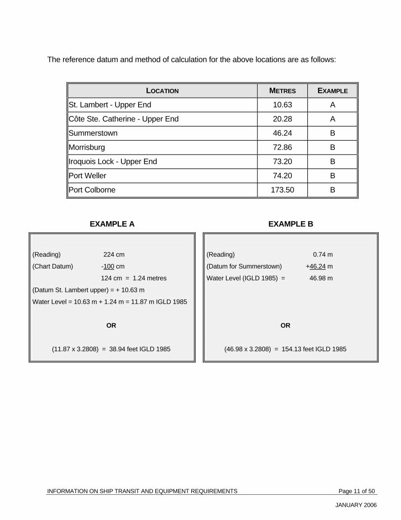
INFORMATION ON SHIP TRANSIT AND EQUIPMENT REQUIREMENTS Page 11 of 50
JANUARY 2006
The reference datum and method of calculation for the above locations are as follows:
LOCATION METRES EXAMPLE
St. Lambert - Upper End 10.63 A
Côte Ste. Catherine - Upper End 20.28 A
Summerstown 46.24 B
Morrisburg 72.86 B
Iroquois Lock - Upper End 73.20 B
Port Weller 74.20 B
Port Colborne 173.50 B
EXAMPLE A EXAMPLE B
(Reading) 224 cm
(Chart Datum) -100 cm
124 cm = 1.24 metres
(Datum St. Lambert upper) = + 10.63 m
Water Level = 10.63 m + 1.24 m = 11.87 m IGLD 1985
OR
(11.87 x 3.2808) = 38.94 feet IGLD 1985
(Reading) 0.74 m
(Datum for Summerstown) +46.24 m
Water Level (IGLD 1985) = 46.98 m
OR
(46.98 x 3.2808) = 154.13 feet IGLD 1985

INFORMATION ON SHIP TRANSIT AND EQUIPMENT REQUIREMENTS Page 12 of 50
JANUARY 2006
19. Anchor Marking Buoys Seaway Regulation 14 requires the installation of an orange coloured anchor marking buoy.
Typical acceptable buoys are shown in the following sketch, together with a rigging arrangement.
ANCHOR BUOY RIGGING
TYPICAL ANCHOR BUOYS

INFORMATION ON SHIP TRANSIT AND EQUIPMENT REQUIREMENTS Page 13 of 50
JANUARY 2006
20. Typical Landing Boom
Seaway Regulation 8 requires ships of more than 50 m in overall length to be equipped with at least one landing boom on each side. A typical arrangement of the rigging of the landing boom is provided in the following sketch. It is recommended that a Safe Working Load (SWL) of 185 kilograms be used for the landing booms.
RIGGING OF LANDING BOOM
It is important that the landing booms be maintained in good working condition because the
lives of the crew members being landed may depend on such maintenance. It is suggested that prior to the first transit of each season, and at intervals of not more than three months, the boom goosenecks be lifted, cleaned and greased, shackles checked for wear, greased and tightened, spans, guys and landing ropes checked for deterioration and broken strands. Any doubtful items of equipment should be renewed immediately. Landing booms must be capable of swinging outboard on their own. To facilitate this, the kingposts are usually canted outboard one to two degrees.

INFORMATION ON SHIP TRANSIT AND EQUIPMENT REQUIREMENTS Page 14 of 50
JANUARY 2006
On completion of any new installation or the
completion of each overhaul, the boom should be test swung with an adequate static load to ensure the integrity of all working parts. It is recommended that a timber safety block, with sufficient length of line for it to be lowered to the waterline at light draft, be stowed in close proximity to each boom, ready for immediate use. Safety Block

INFORMATION ON SHIP TRANSIT AND EQUIPMENT REQUIREMENTS Page 15 of 50
JANUARY 2006
21. Embarking or Disembarking in Lock Chambers It is important that safe working practices are followed for embarking or disembarking in
Seaway locks. This should only be carried out when the ship is right alongside the lock wall and completely stopped. Crew members must not board or land from the ship between the two forward or the two after lines. Furthermore, they should not step over the mooring lines.
If there is a difference in height between the deck of the ship and the lock wall, a ladder
should be used and a crew member should assist the person boarding or disembarking. At no time should one attempt to disembark by jumping from the ship.
22. Bulwark Ladders For the safety of persons using bulwark ladders to board or disembark from a ship, Masters
must assure that such ladders are secure. Hand-hold stanchions which do not form part of the ladder must be secured rigidly to the bulwark or the ship's rail. In cases where the stanchions and/or hand rails do form part of the ladder, the ladder itself must be secured firmly to the ship's structure.
23. Use of Portable Fenders While the use of permanent fendering is required by the Seaway entities, the use of portable
fenders may be allowed on a single transit basis provided they are made of a material that will float. They must be securely fastened and suspended from the ship in a horizontal position by means of a steel cable or a fibre rope in such a way that they can be raised or lowered so as to avoid damage to Seaway installations. Rope hawsers or automobile tires shall not be used as fenders.
Masters should note that the successful use of portable fenders depends on their careful
handling.

INFORMATION ON SHIP TRANSIT AND EQUIPMENT REQUIREMENTS Page 16 of 50
JANUARY 2006

INFORMATION ON SHIP TRANSIT AND EQUIPMENT REQUIREMENTS Page 17 of 50
JANUARY 2006
24. Navigational Aid Deficiencies Navigational aid deficiencies in the Canadian and U.S. waters of the Seaway can be
reported to the Seaway Traffic Control Centres for transmission to the appropriate Coast Guard Traffic Centre.
25. Typical Pedestal
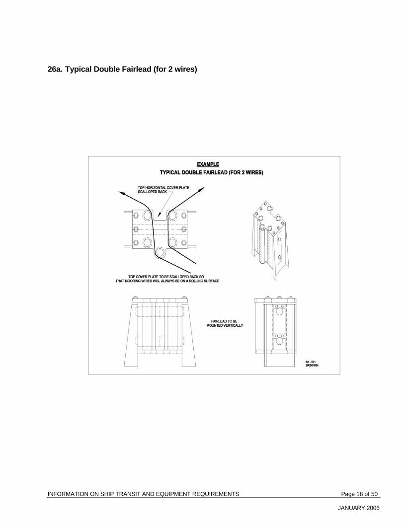
INFORMATION ON SHIP TRANSIT AND EQUIPMENT REQUIREMENTS Page 18 of 50
JANUARY 2006
26a. Typical Double Fairlead (for 2 wires)

INFORMATION ON SHIP TRANSIT AND EQUIPMENT REQUIREMENTS Page 19 of 50
JANUARY 2006
26b. Example of when the fairlead follows the bow flare and the fairleads are full beam
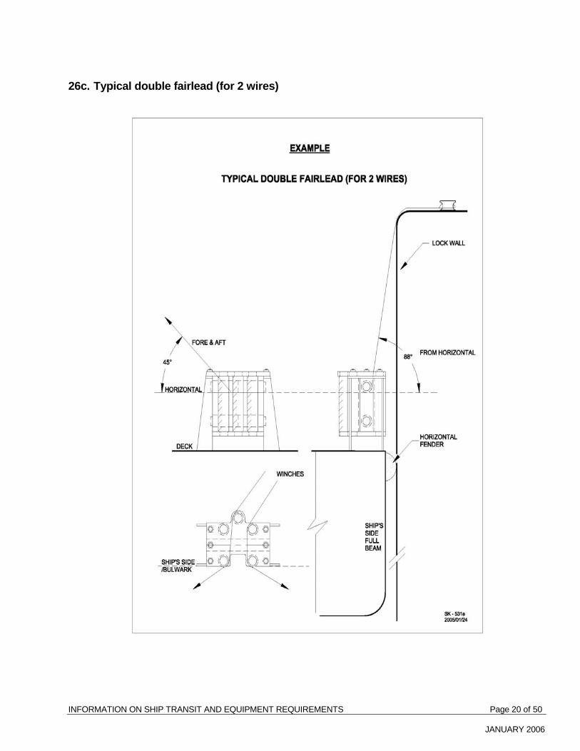
INFORMATION ON SHIP TRANSIT AND EQUIPMENT REQUIREMENTS Page 20 of 50
JANUARY 2006
26c. Typical double fairlead (for 2 wires)

INFORMATION ON SHIP TRANSIT AND EQUIPMENT REQUIREMENTS Page 21 of 50
JANUARY 2006
27a. General arrangement for fender locations

INFORMATION ON SHIP TRANSIT AND EQUIPMENT REQUIREMENTS Page 22 of 50
JANUARY 2006
27b. Guidelines for fitting permanent steel fenders
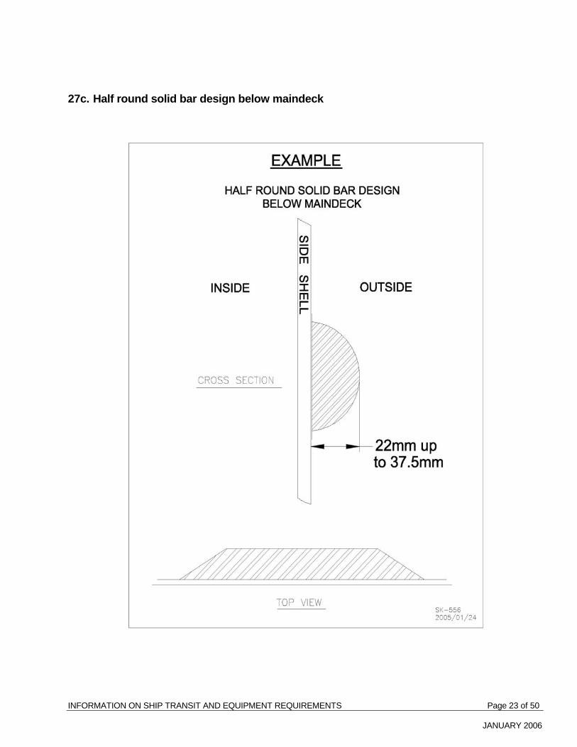
INFORMATION ON SHIP TRANSIT AND EQUIPMENT REQUIREMENTS Page 23 of 50
JANUARY 2006
27c. Half round solid bar design below maindeck
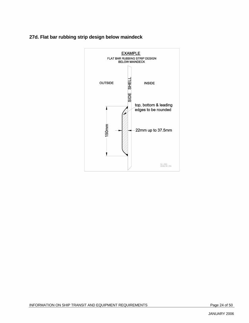
INFORMATION ON SHIP TRANSIT AND EQUIPMENT REQUIREMENTS Page 24 of 50
JANUARY 2006
27d. Flat bar rubbing strip design below maindeck

INFORMATION ON SHIP TRANSIT AND EQUIPMENT REQUIREMENTS Page 25 of 47
JANUARY 2006
28. EXAMPLE & Please adapt to suit your own ship
Owner's / Agent's Name: Phone No: Address: Fax No:
Seaway Practices & Procedures no 72 – Reporting Dangerous Cargo
St. Lambert, Qué.: Fax : 450-672-3668 Massena, N. Y.: Fax: 315-764-1886 St. Catharines, Ont.: Fax: 905-641-4632
CARGO LOAD PLAN
Ship's Name : Date: Time: Cell / Fax : Voyage No:
Port of Origin: Next port:
Draft Fwd. / Aft: Fwd:__________, Aft_____________ ETA – St. Lawrence Seaway System
Please indicate only one arrival location St.Lambert / Cape Vincent / Port Weller / Port Colborne Date: Time: Loaded Transverse Midship Section Ballast Gas free Yes No General Layout
BWT 6 P BWT 5 P BWT 4 P BWT 3 P BWT 2 P BWT 1 P COT 6 P COT 5 P COT 4 P COT 3 P COT 2 P COT 1 P
COT 6 S COT 5 S COT 4 S COT 3 S COT 2 S COT 1 S
BWT 6 S BWT 5 S BWT 4 S BWT 3 S BWT 2 S BWT 1 S
Quantity Cargo Previous Cargo if in Ballast
Location – COT Cu. m m / t
IMO Class
UN No: Flash Pt.
- P & S
Total 0 0 Master:___________________________________ Date:_________________________
BWT BWT
Cargo Cargo Tank Tank
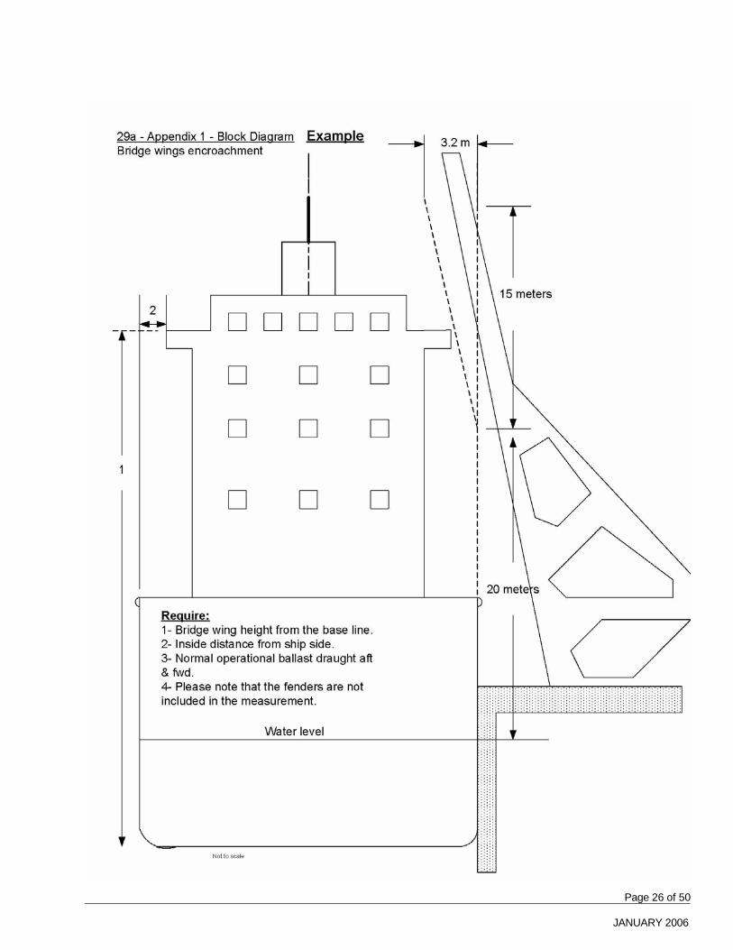
INFORMATION ON SHIP TRANSIT AND EQUIPMENT REQUIREMENTS Page 26 of 50
JANUARY 2006

INFORMATION ON SHIP TRANSIT AND EQUIPMENT REQUIREMENTS Page 27 of 50
JANUARY 2006

INFORMATION ON SHIP TRANSIT AND EQUIPMENT REQUIREMENTS Page 28 of 50
JANUARY 2006
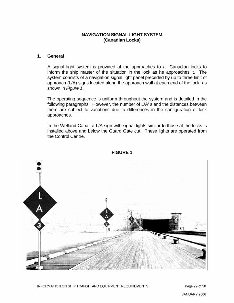
INFORMATION ON SHIP TRANSIT AND EQUIPMENT REQUIREMENTS Page 29 of 50
JANUARY 2006
NAVIGATION SIGNAL LIGHT SYSTEM (Canadian Locks)
1. General A signal light system is provided at the approaches to all Canadian locks to
inform the ship master of the situation in the lock as he approaches it. The system consists of a navigation signal light panel preceded by up to three limit of approach (L/A) signs located along the approach wall at each end of the lock, as shown in Figure 1.
The operating sequence is uniform throughout the system and is detailed in the
following paragraphs. However, the number of L/A' s and the distances between them are subject to variations due to differences in the configuration of lock approaches.
In the Welland Canal, a L/A sign with signal lights similar to those at the locks is
installed above and below the Guard Gate cut. These lights are operated from the Control Centre.
FIGURE 1

INFORMATION ON SHIP TRANSIT AND EQUIPMENT REQUIREMENTS Page 30 of 50
JANUARY 2006
2. L/A Signs The L/A signs are intended as an aid to the ship master in approaching a lock as
promptly as possible. Their operation is as follows: (a) Limit of Approach No. 3 The L/A signs are equipped with red navigation lights only, and are used: (i) as a distance marker only by a ship making a passing entry
manoeuvre; (ii) as a mooring L/A for modified passing entry manoeuvre. (b) Limit of Approach No. 2 The L/A signs are equipped with red navigation lights only, and are used: (i) by a ship waiting for the first stage of a dump or fill during a turnback
lockage at locks where turbulence above or below the gates exists - see "Turnback Lockages - General".
(ii) as a distance marker only by two ships executing a passing entry
manoeuvre; (See Ship Manoeuvres) (iii) by a moored ship waiting for an outbound to pass, when a passing
entry is not possible. (c) Limit of Approach No. 1 The L/A signs are equipped with red and green navigation lights, and are
used: (i) as a distance marker by a ship for which the lock is being turned back
(final stage of dump or fill); (ii) as a mooring position at certain locks when the lock is being turned
back in favour of the ship. (See Turnback Lockages). (iii) to indicate that the last piece of equipment at that end of the lock has
started to open (lock gates, bridge or ship arrester as applicable) when the L/A 1 red lights start to flash.

INFORMATION ON SHIP TRANSIT AND EQUIPMENT REQUIREMENTS Page 31 of 50
JANUARY 2006
The RED LIGHTS on the limit of approach (L/A) signs have two
characteristics: Fixed or Flashing. Under no circumstances should a ship pass an L/A sign displaying a
RED SIGNAL. In addition, a flashing L/A sign indicates that the lock is being readied and
the ship should: (i) continue to approach, with caution, as it will be able to pass this L/A
soon; OR (ii) be prepared to cast off and move ahead to the next L/A sign displaying
the navigation signal. N.B. The flashing signal is used when an "opposing" ship is departing
from a lock, and also to indicate a lock is turning back for you. N.B. In the pool between the Upper and Lower Beauharnois Locks, an
L/A and a light standard bearing twin red and green navigation lights only are located at each end of the pool to warn the ship master of the lock condition. The signal lights on the standard operate as follows:
(i) Fixed Red - "Do not pass this L/A" (ii) Flashing Red - "Gates will open shortly" (iii) Green - "Lock is ready for you" 3. Lock Signal Light Panels Lock signal light panels are prominently displayed at the end of each lock to
assist ship masters in timing their ship movements for an optimum speed of entry. However, because of inherent limitations, no signal panels have been installed on the ends facing the pool between the Upper and Lower Beauharnois Locks and between the flight locks (Locks 4, 5 and 6) on the Welland Canal.
The purpose of the lock signal light panel is to indicate to an approaching ship
the state of readiness of the lock. The mode of operation of the lights indicates the dumping or filling of the lock, whether one or more ship(s) is in the lock and whether the approaching ship will be handled next or held at the wall while the lock is turned back against it.

INFORMATION ON SHIP TRANSIT AND EQUIPMENT REQUIREMENTS Page 32 of 50
JANUARY 2006
4. Operation of Signal Light Panels a) Red Lights The RED LIGHTS operate in conjunction with the associated limit of
approach light system and have identical characteristics, namely: i) Fixed Red - "lock is occupied, do not pass illuminated L/A" ii) Red Flashing Together - "lock is occupied by one ship, do not pass
illuminated L/A, but stand by to move into lock when outbound ship has passed you"
OR "lock is turning back for you, do not pass illuminated L/A but stand by
to move into lock" iii) Red Flashing Alternately - "lock is occupied by more than one ship,
do not pass illuminated L/ A but stand by to move into lock when outbound ships have passed you"
NOTE: L/A I will start to flash only after the last piece of equipment at that
end of the lock starts to open (bridge, gates or ship arrester). b) Amber Lights In the Montreal/Lake Ontario section, each illuminated AMBER LIGHT
indicates two minutes of time while each flashing amber light indicates one minute of time. The lights will go out in sequence, starting from the top of the panel, with the last amber light being extinguished when the end of the lock becomes fully open (Figure 2).
Upbound ships will observe that, during the dump of a lock, the amber lights
on the lower end navigation signal light panel operate as follows:
- at the beginning of dump, the appropriate number of amber lights turn on. - at end of first minute, uppermost amber light begins flashing, - at end of second minute, first amber light is extinguished.
INFORMATION ON SHIP TRANSIT AND EQUIPMENT REQUIREMENTS Page 33 of 50
JANUARY 2006
- at end of third minute, second amber light begins flashing. - at end of fourth minute, second amber light is extinguished.
- and so on, until the lower end of the lock is fully open, at which time the bottom amber light is extinguished.
Downbound ships will observe that: - During the fill of a lock, the amber lights on the upper end navigation
signal light panel operate in the same manner as for upbound ships; - By counting the illuminated amber lights, it is therefore possible to
determine time until the lock is fully open in minutes, e.g. two fixed amber and one flashing amber indicate "five minutes until the upper end of the lock is fully open".
At Locks 1 to 7 inclusive, in the Welland Canal, the light timing sequence
makes use of only two amber lights as follows: - Two steady amber lights are shown 10 minutes before the lock end is fully
opened. - One steady and one flashing amber light are shown 7 1/2 minutes before
the lock is fully opened. - One steady amber light only shows 5 minutes before the lock is fully
opened. - A single flashing amber light shows 2 1/2 minutes before the lock is fully
opened. - When the two amber lights are extinguished, the lock is fully opened and
the ship can enter as soon as the green light is exhibited.

INFORMATION ON SHIP TRANSIT AND EQUIPMENT REQUIREMENTS Page 34 of 50
JANUARY 2006
c) Green Lights GREEN navigation lights work in conjunction with the green lights on L/A I
and their only characteristic is: Fixed green - "lock is ready for you - enter as promptly as possible". FIGURE 2 Example of Signal Light Panel at St. Lambert Lock - SHIP IN LOCK - DUMPING IN PROGRESS - 7 MINUTES TO GO

INFORMATION ON SHIP TRANSIT AND EQUIPMENT REQUIREMENTS Page 35 of 50
JANUARY 2006
SHIP MANOEUVRES (Canadian Locks) 1. General Two prime factors in providing efficient ship transits are the reduction of "dead
time" at a lock, which is that period between the exit of one ship from a lock and the entry of another, and the elimination of the need to tie up at the approach walls. With the increase in traffic, new Control Centre facilities and procedures, and additional aids to navigation, it is desired to make much greater use of the ``passing entry'' procedures as described hereunder, when two ships meet immediately outside a lock and when weather conditions permit.
2. Passing Entry Ideally, to execute the "passing entry" the ship approaching the lock should be
450 m to 915 m from the end of the approach wall when the lock starts to dump or fill. This distance allows for variations in ship speed. At this point, the navigation lights and L/A 3 are fixed red. The amber lights come on with the start of the dump or fill (Figure 3).
FIGURE 3

INFORMATION ON SHIP TRANSIT AND EQUIPMENT REQUIREMENTS Page 36 of 50
JANUARY 2006
When the lock gates open, the navigation lights on L/A 3 begin to flash. As the ship in the lock casts off, L/A 3 is extinguished and L/A 2 starts to flash. At this time, the inbound ship should be at the end of the approach wall (Figure 4).
FIGURE 4
As the stern of the last outbound ship clears the lock, L/A 2 is extinguished and
the green lights are shown on the navigation panel and L/A 1. The bow of the inbound ship should be at L/A 3 at this time (Figure 5).
(See variation below, when a road bridge is involved) FIGURE 5

INFORMATION ON SHIP TRANSIT AND EQUIPMENT REQUIREMENTS Page 37 of 50
JANUARY 2006
As the ships continue to approach each other, the ideal meeting point is when the bow of the inbound and the stern of the outbound are abeam of L/A 2 (Figure 6).
FIGURE 6
Experience, confirmed by theoretical calculation, proves that the inbound ship
moving along a wall faces much less suction from the outbound than it does if moored at the wall.
When the ships have passed each other, the inbound ship continues into the
lock as smartly as is prudent and possible. 3. Modified Passing Entry In cases where a ship is obviously going to reach a wall well in advance of the
outbound ship leaving the lock, the inbound ship will moor at L/A 3. When the lockage in progress has completed its dump or fill and the end of the
lock is completely open, the red navigation lights and the L/A 3 begin flashing and the inbound ship prepares to cast off, the outbound ship at this time will be casting off and moving out of the lock.
Immediately upon completion of the outbound ship casting off (i.e. the last ship in
the case of a tandem lockage) the L/A 3 flashing lights will be extinguished and the L/A 2 flashing lights will come on.

INFORMATION ON SHIP TRANSIT AND EQUIPMENT REQUIREMENTS Page 38 of 50
JANUARY 2006
The inbound ship should then commence entry to ensure that its bow is abeam of L/A 2 at the time the stern of the outbound ship is abeam this same L/A.
NOTE: The green lights on L/A 1 and the lock navigation lights will be
activated when the stern of the last outbound ship has cleared the lock chamber.
4. Passing Entry Where a Road Bridge Crosses Over One End of a Lock When the bridge remains up between exit and entry of ships, the sequence will
be as described above for the Passing Entry. However, when it becomes necessary to lower the bridge between the times of exit and entry, the sequence is modified as follows:
As the lock fills or dumps, the outer L/A and navigation lights are fixed red with
the time remaining indicated by the amber lights. The approaching ship is then at some distance from the L/A 3 as shown in Figure 7.
FIGURE 7

INFORMATION ON SHIP TRANSIT AND EQUIPMENT REQUIREMENTS Page 39 of 50
JANUARY 2006
When the lock gates open, the navigation lights and L/A 3 begin to flash. As the ship in the lock casts off, L/A 3 is extinguished and L/A 2 starts to flash, which indicates that the inbound ship shall prepare to proceed to L/A 1, or stand by to cast off and move along the wall (Figure 8).
FIGURE 8
As the bridge is lowering behind the outbound ship. L/A 2 is extinguished, L/A 1
commences flashing red and goes to steady red once the bridge is fully lowered, indicating that the ship may approach but not pass this point (Figure 9).
FIGURE 9

INFORMATION ON SHIP TRANSIT AND EQUIPMENT REQUIREMENTS Page 40 of 50
JANUARY 2006
TURNBACK LOCKAGE (Canadian Locks) 1. General In the execution of turnback lockages where water turbulence is a problem in the
vicinity of lock gates, provisions have been made for the automatic transfer of flashing red lights from L/A 2 to steady red lights on L/A 1 as follows:
Eastern Section: Upper end - 3 minutes before upper end opens Lower end - 6 minutes before lower end opens Western Section: Lower end - 5 minutes before lower end opens This automatic transfer serves to prevent a ship approaching too close to the
lock gates until the turbulence has subsided to an acceptable level. 2. Turnback for Upbound Ships The above features have been provided for upbound ships at the following
locations: a) St. Lambert Lock b) Côte Ste. Catherine Lock c) Lower Beauharnois Lock d) Lock 1 - Welland Canal e) Lock 2 - Welland Canal f) Lock 3 - Welland Canal g) Lock 4 - Welland Canal NOTE: 1) At Lock 4, the automatic transfer takes place nine (9) minutes
before gates open. 2) At St. Lambert Lock, the automatic transfer takes place four (4)
minutes before gates open. At these locations, masters may observe the following prior to a turnback: a) Red flashing navigation lights - "will turn back for you" b) Red fixed on L/A 2 - "dump not started, do not pass this L/A"

INFORMATION ON SHIP TRANSIT AND EQUIPMENT REQUIREMENTS Page 41 of 50
JANUARY 2006
c) Six (6) minutes (Eastern Section) or five (5) minutes (Welland Canal) before gates are fully opened, the following is observed: red navigation lights continue flashing, amber lights are operating and steady red signals on L/A 1 are displayed. L/A 1 will start to flash when the last piece of equipment at that end of the lock starts to open (lock gates, bridge or ship arrester as applicable).
d) When lock is fully opened: - the navigation lights and L/A I show fixed green. - "the lock is ready for you, enter as promptly as possible". 3. Turnback For Downbound Ships The automatic transfer of red flashing lights (3 minutes before gates open) from
L/A 2 to L/A 1 has been provided at the following locations: a) St. Lambert Lock b) Côte Ste. Catherine Lock c) Upper Beauharnois Lock The display of lights to waiting ships is the same as that described in the
preceding paragraph for upbound ships except for the difference in timing. At all other locations when the lock is being turned back to receive the inbound
ship, the following is observed: a) Lock navigation signal lights and the signals on L/A 1 display flashing red
and, during the dump or fill, the amber lights are operating. b) Since the ship is already at the nearest L/A to the lock, and turbulence does
not cause any problem, no move is necessary until the lock is fully open, at which time the navigation and L/A signal lights show fixed green.

INFORMATION ON SHIP TRANSIT AND EQUIPMENT REQUIREMENTS Page 42 of 50
JANUARY 2006
MOORING SHIPS (Canadian Locks) 1. Safety Precautions To prevent accidents on lock walls, especially those that could be caused by
breaking mooring wires, Seaway linesmen have been trained in the safe handling of mooring wires and in the proper hand signals to be used when working with ship crews.
At all Canadian locks the standard hand signals as shown hereunder will be
used during the ship mooring operation. STOP EMERGENCY STOP
SLACK Safety Rules: 1. Always slack mooring wires as required. 2. Avoid giving too much slack.
HEAVE Safety Rules: 1. Never heave on a mooring wire until the lock crew member gives the hand signal. 2. For their own safety, the lock crew members will always get well clear
of mooring wire before giving signal to heave. 3. Always use slow speed to heave up wire when slack.

INFORMATION ON SHIP TRANSIT AND EQUIPMENT REQUIREMENTS Page 43 of 50
JANUARY 2006
2. Mooring Lines The length of the eye of a mooring line must be 2.44
metres, measured from the splice to the extreme end of the eye (see drawing).
NOTE: The breaking strength of mooring lines as
given in Seaway Practices and Procedures no. 10(3) is expressed in kilonewtons (kN) and 8.9 kN is equal to one short ton (2000 lbs).
3. Ship Mooring Locations The ship mooring locations at Canadian locks in the Seaway system have
been standardized as much as possible. The following table shows the appropriate position of the ship's stem in the
lock for each ship length category.
Ship Length Ship Mooring Position (Stem at Lock Wall Marker)
211.00 m - 222.5 m (692' - 730') "stop" marker
202.00 m - 210.99 m (663' - 692') 5 m marker
185.00 m - 201.99 m (607' - 663') 10 m marker
145.00 m - 184.99 m (476' - 607') 25 m marker
105.00 m - 144.99 m (344' - 476') 50 m marker
less than 105.00 m (less than 344') 75 m marker Mooring positions are the same for upbound and downbound lockages. Exceptions: The table does not apply (1) at Lock 8, Welland Canal (2) at Lock 6 - West - Welland Canal for upbound lockages
(3) multiple lockages at all locks (4) vessels with OAL greater than 222.5 (730')
For these exceptions ships will be moored as directed by the lockcrew.
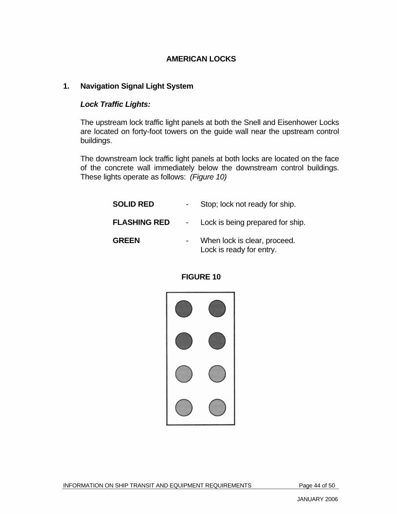
INFORMATION ON SHIP TRANSIT AND EQUIPMENT REQUIREMENTS Page 44 of 50
JANUARY 2006
AMERICAN LOCKS 1. Navigation Signal Light System Lock Traffic Lights: The upstream lock traffic light panels at both the Snell and Eisenhower Locks
are located on forty-foot towers on the guide wall near the upstream control buildings.
The downstream lock traffic light panels at both locks are located on the face
of the concrete wall immediately below the downstream control buildings. These lights operate as follows: (Figure 10)
SOLID RED - Stop; lock not ready for ship. FLASHING RED - Lock is being prepared for ship. GREEN - When lock is clear, proceed. Lock is ready for entry. FIGURE 10

INFORMATION ON SHIP TRANSIT AND EQUIPMENT REQUIREMENTS Page 45 of 50
JANUARY 2006
2. Tie-up Walls a) Length of Lock Walls Eisenhower Lock: Upstream Wall - Heading 268° - 088° true L/A 1 to end of wall .................................... 358 m L/A 2 to end of wall .................................... 319 m Downstream Wall - Heading 253° - 073° true L/A 1 to end of wall .................................... 250 m L/A 2 to end of wall .................................... 211 m Snell Lock: Upstream Wall - Heading 269°- 089° true L/A 1 to end of wall .................................... 246 m L/A 2 to end of wall .................................... 208 m Downstream Wall - Heading 251° - 071° true L/A 1 to end of wall .................................... 461 m L/A 2 to end of wall .................................... 422 m b) Berthing Stations
There are two (2) berthing stations located on the upper and lower tie up walls at each American lock. These are the limits of approach and there are signs labeled "Limit of Approach No. 1" (L/A-1) and "Limit of Approach No. 2" (L/A-2) on each wall. Vessels with a beam of 18.3 m or less shall tie up at L/A-1 and vessels with beams between 18.3 m and 23.8 m shall tie up at L/A-2.

INFORMATION ON SHIP TRANSIT AND EQUIPMENT REQUIREMENTS Page 46 of 50
JANUARY 2006
c) Lock Gate Assembly Area A lock gate assembly area is located at the end of the downstream guide
wall at Eisenhower Lock. This facility enables the emergency assembly and later installation of spare downstream gate leaves at Eisenhower Lock in the event that the installed lock gate leaves are severely damaged. Components of the new facility include a slip, bulkhead wall, two (2) assembly towers and pads and a steel sheet pile cell at the end of the existing downstream guide wall. Ship masters and pilots are advised to approach the downstream guide wall with caution to avoid entering the slip area.

INFORMATION ON SHIP TRANSIT AND EQUIPMENT REQUIREMENTS Page 47 of 50
JANUARY 2006
APPENDIX 1 SEAWAY MILEAGES TO PRINCIPAL LOCATIONS Appendix I indicates distances from the origin of the Seaway to Long Point, on Lake Erie, broken down as follows: - Montreal/Lake Ontario Section (Origin of Seaway to Cape Vincent) - Lake Ontario (Cape Vincent to Breakwater, Port Weller) - Welland Canal (Breakwater, Port Weller, to Long Point). Distances are expressed in nautical miles MONTREAL/LAKE ONTARIO SECTION
MILE (nautical) LOCATION
0.0 Origin of Seaway - across from Laurier Pier, Montreal Harbour
0.8 CIP 2
2.8 St. Lambert Lock
10.3 Côte Ste. Catherine Lock
14.6 Caughnawaga Bridge
27.5 Lower Beauharnois Lock
28.4 Upper Beauharnois Lock
33.8 St. Louis Bridge
38.8 Valleyfield Bridge
72.4 Snell Lock
75.6 Eisenhower Lock
97.9 lroquois Lock
161.2 Cape Vincent

INFORMATION ON SHIP TRANSIT AND EQUIPMENT REQUIREMENTS Page 48 of 50
JANUARY 2006
LAKE ONTARIO MILEAGE (Nautical Miles) Upbound Downbound
Cape Vincent Sodus Point 41.1 43.0
Mid-Lake Ontario 27.7 28.7 Newcastle 33.6 32.9 Breakwater, Port Weller 37.5 35.8 TOTAL 139.9 140.4 WELLAND CANAL
MILE (nautical) LOCATION
0.0 Breakwater at Port Weller
1.7 Lock 1
3.2 Lock 2
4.9 Bridge 4
5.5 Lock 3
6.8 Locks 4, 5, 6
7.5 Lock 7
8.3 Guard Gate Cut
9.2 Former Bridge 10 Piers
10.4 Bridge 11
21.2 Lock 8
21.9 Bridge 21
23.5 Breakwater at Port Colborne
26.1 CIP 16 Distance between CIP 16 and Long Point - Upbound 38.2 - Downbound 39.1

INFORMATION ON SHIP TRANSIT AND EQUIPMENT REQUIREMENTS Page 49 of 50
JANUARY 2006
APPENDIX 2 TABLE OF TRUE ORIENTATION - Canal Locks The table indicates true bearings of locks in the St. Lawrence Seaway for ships proceeding upbound.
MONTREAL/LAKE ONTARIO WELLAND
St. Lambert Lock 167°46'30" Lock 1 164°23'00"
Côte Ste. Catherine Lock 270°02'00" Lock 2 156°26'00"
Upper and Lower Beauharnois Locks 203°44'22" Lock 3 174°25'30"
Snell Lock 260°18'55" Locks 4,5 & 6 183°10'30"
Eisenhower Lock 260°18'55" Lock 7 190°08'46"
Iroquois Lock 205°49'00" Lock 8 189°50'32"

INFORMATION ON SHIP TRANSIT AND EQUIPMENT REQUIREMENTS Page 50 of 50
JANUARY 2006
APPENDIX 3
Free Drawing Review Service The St. Lawrence Seaway Management Corporation will review at no cost ship's plans of new buildings, as well as those of ships arranging a first voyage. Plans should include two copies of the following documents: - General Arrangement - Lines Plans - Forward Moorings & Anchor Arrangement - Aft Arrangement & Anchor Arrangement - Cross Section - in way of Superstructures / Cranes - Normal operating ballast draughts One copy of the above will be returned with our recommendations. Ships plan packages should indicate "no commercial value" and be sent to: Marine Services The St. Lawrence Seaway Management Corporation 202 Pitt Street Cornwall, Ontario K6J 3P7 Tel: (613) 932-5170, ext. 3205 Fax: (613) 932-5204
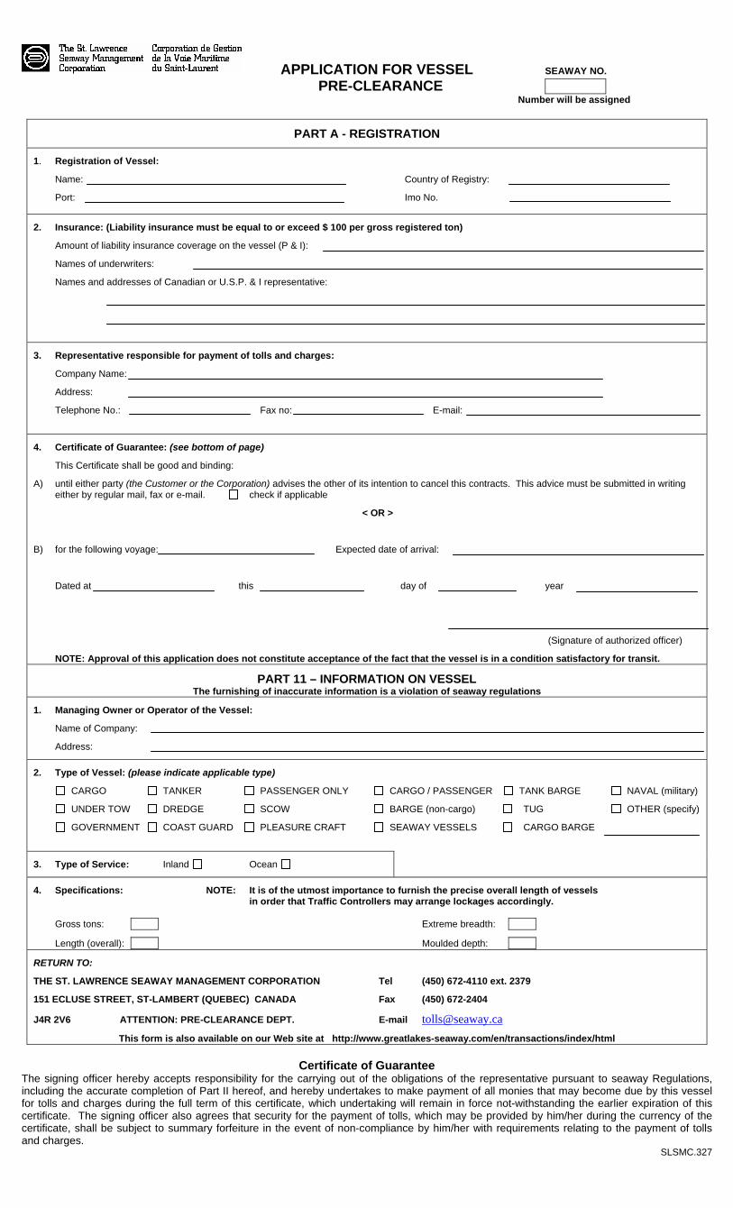
APPLICATION FOR VESSEL SEAWAY NO. PRE-CLEARANCE Number will be assigned
PART A - REGISTRATION
1. Registration of Vessel:
Name: Country of Registry:
Port: Imo No.
2. Insurance: (Liability insurance must be equal to or exceed $ 100 per gross registered ton)
Amount of liability insurance coverage on the vessel (P & I):
Names of underwriters:
Names and addresses of Canadian or U.S.P. & I representative:
3. Representative responsible for payment of tolls and charges:
Company Name:
Address:
Telephone No.: Fax no: E-mail:
4. Certificate of Guarantee: (see bottom of page)
This Certificate shall be good and binding:
A) until either party (the Customer or the Corporation) advises the other of its intention to cancel this contracts. This advice must be submitted in writing either by regular mail, fax or e-mail. check if applicable
< OR >
B) for the following voyage: Expected date of arrival:
Dated at this day of year
(Signature of authorized officer)
NOTE: Approval of this application does not constitute acceptance of the fact that the vessel is in a condition satisfactory for transit.
PART 11 – INFORMATION ON VESSEL The furnishing of inaccurate information is a violation of seaway regulations
1. Managing Owner or Operator of the Vessel:
Name of Company:
Address:
2. Type of Vessel: (please indicate applicable type)
CARGO TANKER PASSENGER ONLY CARGO / PASSENGER TANK BARGE NAVAL (military)
UNDER TOW DREDGE SCOW BARGE (non-cargo) TUG OTHER (specify)
GOVERNMENT COAST GUARD PLEASURE CRAFT SEAWAY VESSELS CARGO BARGE
3. Type of Service: Inland Ocean
4. Specifications: NOTE: It is of the utmost importance to furnish the precise overall length of vessels in order that Traffic Controllers may arrange lockages accordingly. Gross tons: Extreme breadth:
Length (overall): Moulded depth:
RETURN TO:
THE ST. LAWRENCE SEAWAY MANAGEMENT CORPORATION Tel (450) 672-4110 ext. 2379
151 ECLUSE STREET, ST-LAMBERT (QUEBEC) CANADA Fax (450) 672-2404
J4R 2V6 ATTENTION: PRE-CLEARANCE DEPT. E-mail [email protected]
This form is also available on our Web site at http://www.greatlakes-seaway.com/en/transactions/index/html
Certificate of Guarantee The signing officer hereby accepts responsibility for the carrying out of the obligations of the representative pursuant to seaway Regulations, including the accurate completion of Part II hereof, and hereby undertakes to make payment of all monies that may become due by this vessel for tolls and charges during the full term of this certificate, which undertaking will remain in force not-withstanding the earlier expiration of this certificate. The signing officer also agrees that security for the payment of tolls, which may be provided by him/her during the currency of the certificate, shall be subject to summary forfeiture in the event of non-compliance by him/her with requirements relating to the payment of tolls and charges.
SLSMC.327

Mail: The St. Lawrence Seaway Management Corporation Billing Department 151 Ecluse Street St. Lambert, Quebec, J4R 2V6
STANDARD TRANSIT DECLARATION FORM * Phone: (450) 672-4115 ext. 2354 Fax: (450) 672-2404 E-mail: [email protected] SLSMC use
S / O # NOTE: This form must be submitted within 14 days of entry into the 1st lock
Seaway No. Date of entry Direction Agent No. / Vessel No. Year Month Day
/
Vessel Name:
TDF EN (rev. 03.2006)
Port of Origin: Port of destination:
REPRESENTATIVE RESPONSIBLE FOR PAYMENT OF TOLLS AND CHARGES Name: Address: Check if Ballast OR Fill Area Below
CARGO LOADING PORT UNLOADING PORT TONNES (KG)
CONTAINERS
PASSENGERS
GOVERNMENT AID CARGO
MUST SUBMIT FORM B-13 (CDN) OR FORM 7525 (U.S.)
GST DECLARATION FOR A NON-RESIDENT OF CANADA: The undersigned certifies that this declaration, for shipment of merchandise ro or from Canada, is submitted by a carrier/agent acting on behalf of a carrier non-resident of Canada not registered for GST purposes, and thus tolls are to be zero-rated under the Goods and Services Tax legislation. CHECK IF APPLICABLE Name of non-resident carrier: Address: Country:
QST DECLARATION FOR A NON-RESIDENT OF QUEBEC: The undersigned certifies that this declaration, for shipment of merchandise to or from Quebec, is submitted by a carrier/agent on behalf of a carrier non-resident of Quebec not registered for QST purposes, and thus tolls are to be zero-rated under the Quebec Sales Tax legislation. CHECK IF APPLICABLE
The undersigned warrants that all dangerous cargo as defined in the Dangerous Goods Shipping Regulations made under the Canada Shipping Act, carried by the above-described vessel, has been fully disclosed and has been packed, labeled and stowed in accordance with these Regulations. The undersigned also certifies that the information given in this declaration and in any document attached is true, correct and complete in every respect. Dated at: on: Signature: Title: *FOR LAKERS, BARGES OR COMBINED BARGES, PLEASE USE THE SPECIAL TRANSIT DECLARATION FORM

CIAL TRANSIT DECLARATION FORM * SPEMail: The St. Lawrence Seaway Management Corporation LAKER BARGE COMBINED BARGES Billing Department Check one of the above 151 Écluse Street St-Lambert, Quebec, J4R 2V6 Telephone: (450) 672-4115 ext. 2354 Company Name: Fax: (450) 672-2404 E-mail: [email protected] Address: NOTE: THIS FORM MUST BE SUBMITED WITHIN 14 DAYS OF ENTRY INTO THE 1st LOCK
VESSEL INFORMATION
COMMODITY INFORMATION
SLSMC USE
Vessel Name
Agent No.
Vessel
No.
Date of Entry
Port of Origin
Port of
Destination
Dir. U/D
Commodity
Loading
Port
Unloading
Port
Tonnage
(KG)
Sales Order #
GST DECLARATION FOR A NON-RESIDENT OF CANADA: The undersigned certifies that this declaration, for shipment of merchandise to or from Canada, is submitted by a carrier/agent acting on behalf of a carrier non-resident of Canada not registered for GST purposes, and thus tolls are to be zero-related under the Goods and Services Tax legislation. Check if applicable
QST DECLARATION FOR A NON-RESIDENT OF QUEBEC: The undersigned certifies that this declaration, for shipment of merchandise to or from Quebec, is submitted by a carrier/agent acting on behalf of a carrier non-resident of Quebec not registered for QST purposes, and thus tolls are to be zero-rated under the Quebec Sales Tax legislation. Check if applicable
The undersigned also certifies that the information given in this declaration and in any document attached hereto is true, correct and complete in very respect. Dated at: on: Signature: Title: * FOR OCEANS, PLEASE USE THE STANDARD TRANSIT DECLARATION FORM
TDF multi EN (rev. 03.2006)

REQUEST FOR TIEUP SERVICE ON APPROACH WALLS (this service does not include castoff service at approach walls)
* Note that a maximum of 4 lines will be handled by Seaway personnel AS INDICATED IN PART 3 OF THE PRECLEARANCE APPLICATION
NAME OF AGENT/OWNER WHO PRECLEARED THE VESSEL
ADDRESS
SIGNATURE DATE OF ENTRY
REQUEST APPROACH WALL TIEUP SERVICES BE PROVIDED FOR THE FOLOWING VESSEL
NAME OF VESSEL PRECLEARANCE N°
MONTREALLAKE ONTARIO SECTION OR PORTION THEREOF : YES NO
WELLAND CANAL OR PORTION THEREOF : YES NO
THE FEES WILL BE AS FOLLOWS :
$750.00 (CANADIAN) PER ROUND TRIP OR PORTION THEREOF OF THE MONTREALLAKE ONTARIO SECTION $750.00 (CANADIAN) PER ROUND TRIP OR PORTION THEREOF OF THE WELLAND CANAL
G.S.T. DECLARATION FOR A NON RESIDENT OF CANADA THE UNDERSIGNED CERTIFIES THAT THIS DECLARATION, FOR SHIPMENT OF MERCHANDISE TO OR FROM CANADA, IS SUBMITTED BY A CARRIER/AGENT ACTING ON BEHALF OF A CARRIER NONRESIDENT OF CANADA NOT REGISTERED FOR G.S.T. PURPOSES, AND THUS TOLLS ARE TO BE ZERORATED UNDER THE GOODS AND SERVICES TAX LEGISLATION.
CHECK BOX IF APPLICABLE
Q.S.T. DECLARATION FOR A NON RESIDENT OF QUEBEC THE UNDERSIGNED CERTIFIES THAT THIS DECLARATION, FOR SHIPMENT OF MERCHANDISE TO OR FROM QUEBEC, IS SUBMITTED BY A CARRIER/AGENT ACTING ON BEHALF OF A CARRIER NONRESIDENT OF QUEBEC NOT REGISTERED FOR Q.S.T. PURPOSES, AND THUS TOLLS ARE TO BE ZERORATED UNDER THE QUEBEC SALES TAX LEGISLATION.
CHECK BOX IF APPLICABLE
NAME OF NONRESIDENT CARRIER AND/OR NONQUEBEC RESIDENT
ADDRESS
COUNTRY
FAX TO : THE ST. LAWRENCE SEAWAY MANAGEMENT CORPORATION
MAISONNEUVE SHIP INSPECTORS FAX N° (450) 6723668
Slsmc 353042005A

GENERAL SEAWAY PLAN
INDEX
Plan No:
115070 Montreal to Lake Ontario – Traffic Control Sector No. 1
115070 Montreal to Lake Ontario – Traffic Control Sector No. 2
115070 Montreal to Lake Ontario – Traffic Control Sector No. 3
115070 Montreal to Lake Ontario – Traffic Control Sector No. 4
115071 Montreal to Lake Ontario – Traffic Control Sector No. 4,5
115072 Welland Canal Section – Traffic Control Sector No. 6
115073 Lake Erie Section – Traffic Control Sector No. 7