The PONTChARTRAIN LeVee DISTRICT …leveedistrict.org/documents/2014PLDProgressReport.pdf2014 The...
29
2014 THE PONTCHARTRAIN LEVEE DISTRICT PROGRESS REPORT PONTCHARTRAIN LEVEE DISTRICT • 2204 ALbERT ST., P.O. bOx 426, LuTCHER, LA 70071 • 225-869-9723 • LEVEEDISTRICT.ORg • St. CharleS PariSh eaSt Bank UrBan Flood Control FeaSiBility StUdy • lake PontChartrain and ViCinity, loUiSiana ProJeCt north oF airline hiGhWay, St. CharleS PariSh 100 year hUrriCane ProteCtion • WeSt Shore-lake PontChartrain, la hUrriCane ProteCtion ProJeCt • amite riVer and triBUtarieS BayoU manChaC, la ProJeCt • BayoU ConWay & Panama Canal drainaGe imProVement ProJeCt • laUrel ridGe leVee eXtenSion • St. CharleS PariSh hUrriCane ProteCtion leVee Shoreline enhanCement and laBranChe WetlandS reStoration • St. CharleS PariSh hydrodynamiC and Water QUality model oF the laBranChe WetlandS 2014 THE PONTCHARTRAIN LEVEE DISTRICT ProGreSS rePort Prepared by GCr inc. 2021 lakeshore drive, Suite 500 new orleans, la 70122 504-304-2500 fax 504-304-2525 www.GCrincorporated.com March, 2014 Pontchartrain levee district 2204 albert Street P.o. Box 426 lutcher, la 70071 225-869-9721 fax 225-869-9723 www.leveedistrict.org
Transcript of The PONTChARTRAIN LeVee DISTRICT …leveedistrict.org/documents/2014PLDProgressReport.pdf2014 The...
2014The PONTChARTRAIN LeVee DISTRICT
p r o g r e s s r e p o r t
PONTCHARTRAIN LEVEE D ISTR ICT • 2204 ALbERT ST. , P.O . bOx 426 , LuTCHER, LA 70071 • 225-869-9723 • LEVEEDISTRICT.ORg
• S t . C h a r l e S P a r i S h e a S t B a n k U r B a n F l o o d C o n t r o l
F e a S i B i l i t y S t U d y
• l a k e P o n t C h a r t r a i n a n d V i C i n i t y , l o U i S i a n a
P r o J e C t n o r t h o F a i r l i n e h i G h W a y , S t . C h a r l e S
P a r i S h 1 0 0 y e a r h U r r i C a n e P r o t e C t i o n
• W e S t S h o r e - l a k e P o n t C h a r t r a i n , l a
h U r r i C a n e P r o t e C t i o n P r o J e C t
• a m i t e r i V e r a n d t r i B U t a r i e S B a y o U m a n C h a C , l a
P r o J e C t
• B a y o U C o n W a y & P a n a m a C a n a l d r a i n a G e
i m P r o V e m e n t P r o J e C t
• l a U r e l r i d G e l e V e e e X t e n S i o n
• S t . C h a r l e S P a r i S h h U r r i C a n e P r o t e C t i o n l e V e e
S h o r e l i n e e n h a n C e m e n t a n d l a B r a n C h e W e t l a n d S
r e S t o r a t i o n
• S t . C h a r l e S P a r i S h h y d r o d y n a m i C a n d W a t e r
Q U a l i t y m o d e l o F t h e l a B r a n C h e W e t l a n d S
2014The PONTChARTRAIN LeVee DISTRICT
P r o G r e S S r e P o r t
PreparedbyGCrinc.2021lakeshoredrive,Suite500neworleans,la70122504-304-2500fax504-304-2525www.GCrincorporated.com
March, 2014
Pontchartrainleveedistrict2204albertStreetP.o.Box426lutcher,la70071 225-869-9721fax225-869-9723www.leveedistrict.org
2014The PONTChARTRAIN LeVee DISTRICT
p r o g r e s s r e p o r t
PONTCHARTRAIN LEVEE D ISTR ICT • 2204 ALbERT ST. , P.O . bOx 426 , LuTCHER, LA 70071 • 225-869-9723 • LEVEEDISTRICT.ORg PaGe 1
2014The PONTChARTRAIN LeVee DISTRICT
p r o g r e s s r e p o r t
PONTCHARTRAIN LEVEE D ISTR ICT • 2204 ALbERT ST. , P.O . bOx 426 , LuTCHER, LA 70071 • 225-869-9723 • LEVEEDISTRICT.ORg PaGe 2
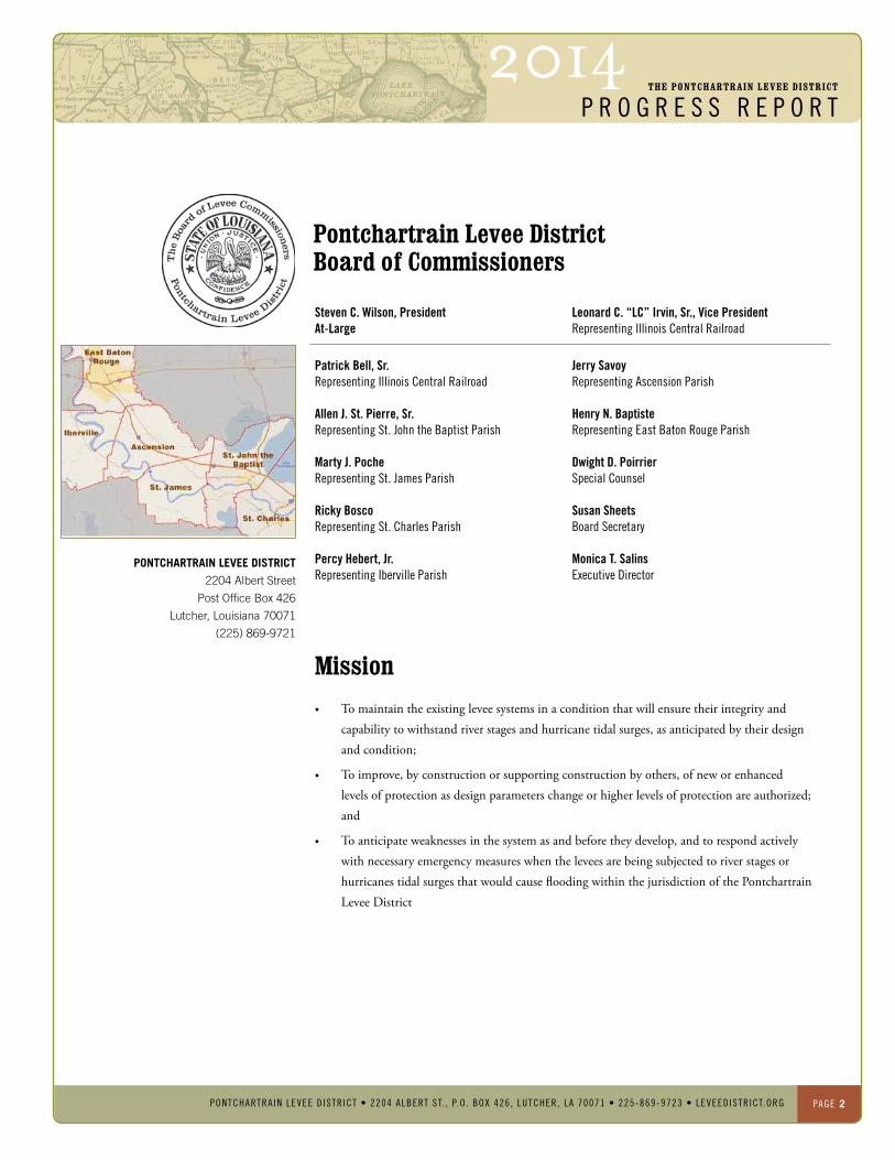
Patrick Bell, Sr.representingillinoisCentralrailroad
Allen J. St. Pierre, Sr.representingSt.JohntheBaptistParishMarty J. PocherepresentingSt.JamesParish
Ricky BoscorepresentingSt.CharlesParishPercy Hebert, Jr.representingibervilleParish
Jerry SavoyrepresentingascensionParish
Henry N. Baptiste representingeastBatonrougeParish
Dwight D. PoirrierSpecialCounsel
Susan SheetsBoardSecretary
Monica T. Salinsexecutivedirector
PONTCHARTRAIN LEVEE DISTRICT
2204 Albert Street
Post Office Box 426
Lutcher, Louisiana 70071
(225) 869-9721
Pontchartrain Levee DistrictBoard of Commissioners
Mission• To maintain the existing levee systems in a condition that will ensure their integrity and
capability to withstand river stages and hurricane tidal surges, as anticipated by their design and condition;
• To improve, by construction or supporting construction by others, of new or enhanced levels of protection as design parameters change or higher levels of protection are authorized; and
• To anticipate weaknesses in the system as and before they develop, and to respond actively with necessary emergency measures when the levees are being subjected to river stages or hurricanes tidal surges that would cause flooding within the jurisdiction of the Pontchartrain Levee District
Steven C. Wilson, PresidentAt-Large
Leonard C. “LC” Irvin, Sr., Vice PresidentrepresentingillinoisCentralrailroad
2014The PONTChARTRAIN LeVee DISTRICT
p r o g r e s s r e p o r t
PONTCHARTRAIN LEVEE D ISTR ICT • 2204 ALbERT ST. , P.O . bOx 426 , LuTCHER, LA 70071 • 225-869-9723 • LEVEEDISTRICT.ORg PaGe 3
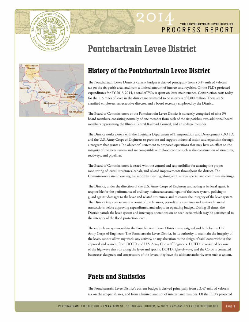
history of the Pontchartrain Levee District The Pontchartrain Levee District’s current budget is derived principally from a 3.47 mils ad valorem tax on the six-parish area, and from a limited amount of interest and royalties. Of the PLD’s projected expenditures for FY 2013-2014, a total of 75% is spent on levee maintenance. Construction costs today for the 115 miles of levee in the district are estimated to be in excess of $300 million. There are 51 classified employees, an executive director, and a board secretary employed by the District.
The Board of Commissioners of the Pontchartrain Levee District is currently comprised of nine (9) board members, consisting normally of one member from each of the six parishes, two additional board members representing the Illinois Central Railroad Council, and an at-large member.
The District works closely with the Louisiana Department of Transportation and Development (DOTD) and the U.S. Army Corps of Engineers to promote and support industrial action and expansion through a program that grants a “no objection” statement to proposed operations that may have an effect on the integrity of the levee system and are compatible with flood control such as the construction of structures, roadways, and pipelines.
The Board of Commissioners is vested with the control and responsibility for assuring the proper monitoring of levees, structures, canals, and related improvements throughout the district. The Commissioners attend one regular monthly meeting, along with various special and committee meetings.
The District, under the direction of the U.S. Army Corps of Engineers and acting as its local agent, is responsible for the performance of ordinary maintenance and repair of the levee system, policing to guard against damages to the levee and related structures, and to ensure the integrity of the levee system. The District keeps an accurate account of the finances, periodically examines and reviews financial transactions before approving expenditures, and adopts an operating budget. During all times, the District patrols the levee system and interrupts operations on or near levees which may be detrimental to the integrity of the flood protection levee.
The entire levee system within the Pontchartrain Levee District was designed and built by the U.S. Army Corps of Engineers. The Pontchartrain Levee District, in its authority to maintain the integrity of the levee, cannot allow any work, any activity, or any alteration to the design of said levees without the approval and consent from DOTD and U.S. Army Corps of Engineers. DOTD is consulted because of the highways that run along the levee and specific DOTD right-of-ways, and the Corps is consulted because as designers and constructors of the levees, they have the ultimate authority over such a system.
Facts and StatisticsThe Pontchartrain Levee District’s current budget is derived principally from a 3.47-mils ad valorem tax on the six-parish area, and from a limited amount of interest and royalties. Of the PLD’s projected
PONTChARTRAIN LeVee DISTRICT
Pontchartrain Levee District

2014The PONTChARTRAIN LeVee DISTRICT
p r o g r e s s r e p o r t
PONTCHARTRAIN LEVEE D ISTR ICT • 2204 ALbERT ST. , P.O . bOx 426 , LuTCHER, LA 70071 • 225-869-9723 • LEVEEDISTRICT.ORg PaGe 4
expenditures for FY 2012-2013, a total of 75% is spent on levee maintenance. Construction costs today for the 115 miles of levee in the district are estimated to be in excess of $300 million. There are 47 classified employees, an executive director, and a board secretary employed by the District.
The Pontchartrain Levee District conservatively estimates that its levees protect $1.2 to $1.5 billion in assessed taxable property and improvements, as well as highways, bridges, airports, schools, court-houses, and parks. The PLD protects an estimated 500,000 people within its six-parish jurisdiction, and incorporates the primary evacuation routes for 1.1 million people from the southeast (greater New Orleans), and an additional 300,000 people from the southwest via routes U.S. 61, U.S. 90, and Interstates 10 and 310.
The U.S. Army Corps of Engineers is responsible for levee construction and related works under the federal Mississippi River & Tributaries Flood Control Project (MR&T). The Pontchartrain Levee District, as a local assuring agency, works with the Corps to furnish rights-of-way and maintain levees, canals and caving banks. The New Orleans District of the Corps of Engineers continues to work toward completion of the MR&T Project by letting contracts for slope pavement and levee enlargements. These projects are financed through federal appropriations and are completed as part of a total upgrading of the levee system. Bank caving is being solved by a sophisticated “revetment program.” Completion of the MR&T Project, which began in 1928, depends solely on availability of federal funds appropriated in the yearly federal budget.
The Pontchartrain Levee District (PLD) is the local sponsor for the projects referenced herein. Currently, there are projects in each of the six parishes comprising the PLD’s jurisdiction. As presented in more detail throughout this report, ongoing feasibility studies are underway for many projects, some of which are federally authorized, and many where the PLD has assumed full responsibility at the local level. Additionally, several projects are currently under construction, which when completed, will provide the East Bank community of St. Charles Parish with increased protection from storm induced flooding and rainfall events.
The total cost of these projects is estimated to be $750,000,000. The PLD is confident that the findings and recommendations in the ongoing studies will establish the forward path for future construction of critical drainage, coastal restoration and hurricane protection projects. An integral part of several of the local studies includes the incorporation of recreational features which provide economic opportunities and a better quality of life for the citizens residing on the east side of the Mississippi River in the Parishes of St. Charles, St. John the Baptist, St. James, Ascension, Iberville and East Baton Rouge. The PLD appreciates the interest and support of the Congressional Delegation, the U.S. Army Corps of Engineers (Corps) and state and local government with regard to these projects.
Ongoing Feasibility Studies (Federal Participation)
•St.CharlesParishEastBankUrbanFloodControlProject
•WestShore–LakePontchartrain,LAHurricaneProtectionProject
PONTChARTRAIN LeVee DISTRICT
Pontchartrain Levee District
2014The PONTChARTRAIN LeVee DISTRICT
p r o g r e s s r e p o r t
PONTCHARTRAIN LEVEE D ISTR ICT • 2204 ALbERT ST. , P.O . bOx 426 , LuTCHER, LA 70071 • 225-869-9723 • LEVEEDISTRICT.ORg PaGe 5
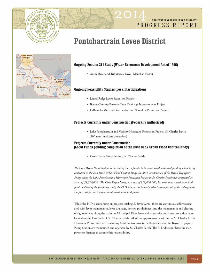
Ongoing Section 211 Study (Water Resources Development Act of 1996)
•AmiteRiverandTributaries,BayouManchacProject
Ongoing Feasibility Studies (Local Participation)
•LaurelRidgeLeveeExtensionProject
•BayouConway/PanamaCanalDrainageImprovementsProject
•LaBrancheWetlandsRestorationandShorelineProtectionProject
Projects Currently under Construction (Federally Authorized)
•LakePontchartrainandVicinityHurricaneProtectionProject,St.CharlesParish (100 year hurricane protection)
Projects Currently under Construction (Local Funds pending completion of the east Bank Urban Flood Control Study)
•CrossBayouPumpStation,St.CharlesParish
The Cross Bayou Pump Station is the 2nd of 4 or 5 pumps to be constructed with local funding while being evaluated in the East Bank Urban Flood Control Study. In 2004, construction of the Bayou Trepagnier Pump along the Lake Pontchartrain Hurricane Protection Project in St. Charles Parish was completed at a cost of $8,500,000. The Cross Bayou Pump, at a cost of $18,800,000, has been constructed with local funds. Following the feasibility study, the PLD will pursue federal authorization for this project along with Corps credit for the 2 pumps constructed with local funds.
WhilethePLDisembarkingonprojectstotaling$750,000,000,therearecontinuouseffortsassoci-ated with levee maintenance, levee drainage, borrow-pit drainage, and the maintenance and clearing of rights-of-way along the mainline Mississippi River levee and a ten-mile hurricane protection levee located on the East Bank of St. Charles Parish. All of the appurtenances within the St. Charles Parish HurricaneProtectionLeveeincludingfloodcontrolstructures,floodwallsandtheBayouTrepagnierPump Station are maintained and operated by St. Charles Parish. The PLD does not have the man-power or finances to assume this responsibility.
PONTChARTRAIN LeVee DISTRICT
Pontchartrain Levee District

2014The PONTChARTRAIN LeVee DISTRICT
p r o g r e s s r e p o r t
PONTCHARTRAIN LEVEE D ISTR ICT • 2204 ALbERT ST. , P.O . bOx 426 , LuTCHER, LA 70071 • 225-869-9723 • LEVEEDISTRICT.ORg PaGe 6
PONTChARTRAIN LeVee DISTRICT
Pontchartrain Levee DistrictPLDsupportstheCorpsFY2014/2015appropriationsrequestforMississippiRiverandTributaries(MR&T) and Operations and Maintenance (O&M) as outlined below.
MR&T (FY 2014/2015) $3,500,000
laCongressionaldistricts1,2,3,5and6
Fundingrequiredforongoingsupervisionandadministrationofthemanchacpointleveeconstructionscontract.
inaddition,fundingisrequiredforengineeringanddesign,environmentalinvestigations,andconstruction
contractawardoftheSt.Gabrielleveeenlargment.
O&M (FY 2014/2015) $1,200,000
laCongressionaldistricts1,2,3,4,5,6and7
Fundingrequiredforpermitreviews,o&mleveeinspections,leveeSafetyProgramandnationalleveedatum
supportandinstrumentation.
2014The PONTChARTRAIN LeVee DISTRICT
p r o g r e s s r e p o r t
PONTCHARTRAIN LEVEE D ISTR ICT • 2204 ALbERT ST. , P.O . bOx 426 , LuTCHER, LA 70071 • 225-869-9723 • LEVEEDISTRICT.ORg PaGe 7
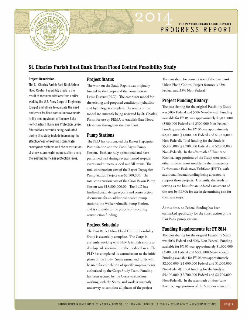
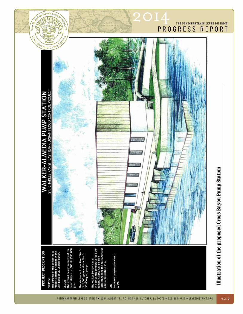
Project Description:
theSt.CharlesParisheastBankUrban
FloodControlFeasibilityStudyisthe
resultofrecommendationsfromearlier
workbytheU.S.armyCorpsofengineers
(Corps)andotherstoevaluatetheneed
andcostsforfloodcontrolimprovements
intheareaupstreamofthenewlake
PontchartrainhurricaneProtectionlevee.
alternativescurrentlybeingevaluated
duringthisstudyincludeincreasingthe
effectivenessofexistingstormwater
conveyancesystemsandtheconstruction
ofanewstormwaterpumpstationalong
theexistinghurricaneprotectionlevee.
St. Charles Parish east Bank Urban Flood Control Feasibility Study
PONTChARTRAIN LeVee DISTRICT
Project Status The work on the Study Report was originally funded by the Corps and the Pontchartrain Levee District (PLD). The computer model for the existing and proposed conditions hydraulics and hydrology is complete. The results of the model are currently being reviewed by St. Charles Parish for use by FEMA to establish Base Flood Elevations throughout the East Bank.
Pump Stations The PLD has constructed the Bayou Trepagnier Pump Station and the Cross Bayou Pump Station. Both are fully operational and have performed well during several named tropical events and numerous local rainfall events. The total construction cost of the Bayou Trepagnier Pump Station Project was $8,500,000. The total construction cost of the Cross Bayou Pump Station was $18,800,000.00. The PLD has finalized detail design reports and construction documents for an additional needed pump stations,theWalker-AlmediaPumpStation,and is currently in the process of procuring construction funding.
Project Schedule The East Bank Urban Flood Control Feasibility Study is essentially complete. The Corps is currently working with FEMA in their efforts to develop risk assessment in the modeled area. The PLD has completed its commitment to the initial phase of the Study. Some earmarked funds will be used for completion of specific improvements authorized by the Corps Study Team. Funding has been secured by the Corps to continue working with the Study, and work is currently underway to complete all phases of the project
The cost share for construction of the East Bank Urban Flood Control Project features is 65% Federal and 35% Non-Federal.
Project Funding history The cost sharing for the original Feasibility Study was 50% Federal and 50% Non-Federal. Funding available for FY 05 was approximately $1,000,000 ($500,000 Federal and $500,000 Non-Federal). Funding available for FY 06 was approximately $2,000,000 ($1,000,000 Federal and $1,000,000 Non-Federal). Total funding for the Study is $5,400,000 ($2,700,000 Federal and $2,700,000 Non-Federal).IntheaftermathofHurricaneKatrina, large portions of the Study were used in other projects, most notably by the Interagency Performance Evaluation Taskforce (IPET), with additional Federal funding being allocated to support those projects. Currently, the Study is serving as the basis for an updated assessment of the area by FEMA for use in determining risk for their rate maps.
At this time, no Federal funding has been earmarked specifically for the construction of the East Bank pump stations.
Funding Requirements for FY 2014 The cost sharing for the original Feasibility Study was 50% Federal and 50% Non-Federal. Funding available for FY 05 was approximately $1,000,000 ($500,000 Federal and $500,000 Non-Federal). Funding available for FY 06 was approximately $2,000,000 ($1,000,000 Federal and $1,000,000 Non-Federal). Total funding for the Study is $5,400,000 ($2,700,000 Federal and $2,700,000 Non-Federal).IntheaftermathofHurricaneKatrina, large portions of the Study were used in

2014The PONTChARTRAIN LeVee DISTRICT
p r o g r e s s r e p o r t
PONTCHARTRAIN LEVEE D ISTR ICT • 2204 ALbERT ST. , P.O . bOx 426 , LuTCHER, LA 70071 • 225-869-9723 • LEVEEDISTRICT.ORg PaGe 8
St. Charles Parish east Bank Urban Flood Control Feasibility Study
PONTChARTRAIN LeVee DISTRICT
At this time, no Federal funding has been earmarked specifically for the construction of the East Bank pump stations.
Funding Requirements Outside the east Bank Urban Flood Control Study During FY 2014, the Corps should release its recommendations for the alternative mitigation analyses portion of the East Bank Study. The Non-Federal funds associated with the design portion of this effort have been allocated and much of the permitting and preliminary design work has already been undertaken. Upon completion of the analyses and design, funding will be required for construction of the mitigation projects. The expected cost of the mitigation construction is $40,000,000 total over five years. Additionally, the expected cost for the design and construction of the remaining two Lake Pontchartrain HurricaneProtectionLeveePumpStationswillbe$50,000,000,andcost shared 65% Federal and 35% Non-Federal. The total cost of all portions of this project not currently authorized for Federal funding is $122,000,000 over the next five years.
2014The PONTChARTRAIN LeVee DISTRICT
p r o g r e s s r e p o r t
PONTCHARTRAIN LEVEE D ISTR ICT • 2204 ALbERT ST. , P.O . bOx 426 , LuTCHER, LA 70071 • 225-869-9723 • LEVEEDISTRICT.ORg PaGe 9
Illus
trat
ion
of th
e pr
opos
ed C
ross
Bay
ou P
ump
Stat
ion
PONTChARTRAIN LeVee DISTRICT
Cro
ss B
ayou
Pum
p S
tatio
n.dw
gC
ross
Bay
ou P
ump
Sta
tion
v2.p
df02
-26-
10G
.C.R
. & A
ssoc
iate
s, In
c.
PRO
JECT
DES
CRIP
TIO
NW
ALK
ER-A
LMED
IA P
UM
P ST
ATI
ON
ST.
CHAR
LES
PARI
SH E
AST
BAN
K U
RBAN
FLO
OD
CO
NTR
OL
PRO
JECT
The
purp
ose
of t
he p
roje
ct is
to
redu
ce lo
caliz
ed f
lood
ing
in t
heEa
st B
ank
of S
t. C
harl
es P
aris
h.
PURP
OSE
Proj
ecte
d co
nstr
ucti
on c
ost
is$2
5M.
COST
The
over
all d
esig
n ca
paci
ty o
f th
epu
mp
stat
ion
is 1
300
cfs
(580
,000
gpm
).
The
stat
ion
will
hav
e fi
ve 2
50 c
fs(1
12,0
00 g
pm)
and
one
50 c
fs(3
7,40
0 gp
m)
pum
ps.
The
Wal
ker
Borr
ow C
anal
will
act
as
the
cond
uit
to f
eed
the
pum
ps.
A c
anal
will
be
built
inte
rcon
nect
ing
the
east
and
wes
tsi
des
of In
ters
tate
310
.
DES
IGN
2014The PONTChARTRAIN LeVee DISTRICT
p r o g r e s s r e p o r t
PONTCHARTRAIN LEVEE D ISTR ICT • 2204 ALbERT ST. , P.O . bOx 426 , LuTCHER, LA 70071 • 225-869-9723 • LEVEEDISTRICT.ORg PaGe 10
Project:
lakePontchartrainandVicinityhurricane
ProtectionProject,northofairline
highway,St.CharlesParish
Project Description:
thelakePontchartrain,louisianaand
VicinityhurricaneProtectionProjectwas
authorizedbyPubliclaw298,89thCon-
gress,1stSession,approvedonoctober
27,1965.theoriginalauthorizeddesign
providesstandardhurricaneprotection
(SPh)fromafastmovingCategory3hur-
ricane.theexistinghurricaneprotection
leveesystem,fullyconstructedtothe
originalauthorizeddesigniscurrently
beingconstructedtothenewCorpsofen-
gineersdesignstandardswhichprovides
a100yearlevelofprotection,equivalent
toaslowmovingCategory3hurricane.
theprojectincludesapproximately9.75
milesofearthenlevee,four(4)drainage
structures,two(2)swinggates,two(2)
pre-castconcreteaccessbridgesand
five(5)floodwalls,onebeingamajor
floodwallunderinterstate310.
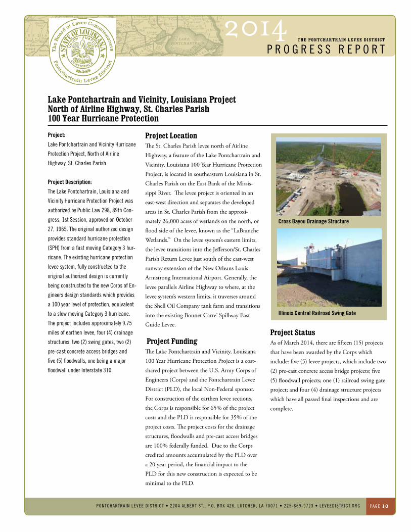
Lake Pontchartrain and Vicinity, Louisiana Project North of Airline highway, St. Charles Parish 100 Year hurricane Protection
PONTChARTRAIN LeVee DISTRICT
Project Location The St. Charles Parish levee north of Airline Highway,afeatureoftheLakePontchartrainandVicinity,Louisiana100YearHurricaneProtectionProject, is located in southeastern Louisiana in St. Charles Parish on the East Bank of the Missis-sippi River. The levee project is oriented in an east-west direction and separates the developed areas in St. Charles Parish from the approxi-mately 26,000 acres of wetlands on the north, or flood side of the levee, known as the “LaBranche Wetlands.”Ontheleveesystem’seasternlimits,theleveetransitionsintotheJefferson/St.CharlesParish Return Levee just south of the east-west runway extension of the New Orleans Louis Armstrong International Airport. Generally, the leveeparallelsAirlineHighwaytowhere,atthelevee system’s western limits, it traverses around the Shell Oil Company tank farm and transitions into the existing Bonnet Carre’ Spillway East Guide Levee.
Project Funding TheLakePontchartrainandVicinity,Louisiana100YearHurricaneProtectionProjectisacost-shared project between the U.S. Army Corps of Engineers (Corps) and the Pontchartrain Levee District (PLD), the local Non-Federal sponsor. For construction of the earthen levee sections, the Corps is responsible for 65% of the project costs and the PLD is responsible for 35% of the project costs. The project costs for the drainage structures, floodwalls and pre-cast access bridges are 100% federally funded. Due to the Corps credited amounts accumulated by the PLD over a 20 year period, the financial impact to the PLD for this new construction is expected to be minimal to the PLD.
Project Status As of March 2014, there are fifteen (15) projects that have been awarded by the Corps which include: five (5) levee projects, which include two (2) pre-cast concrete access bridge projects; five (5) floodwall projects; one (1) railroad swing gate project; and four (4) drainage structure projects which have all passed final inspections and are complete.
Illinois Central Railroad Swing Gate
Cross Bayou Drainage Structure
2014The PONTChARTRAIN LeVee DISTRICT
p r o g r e s s r e p o r t
PONTCHARTRAIN LEVEE D ISTR ICT • 2204 ALbERT ST. , P.O . bOx 426 , LuTCHER, LA 70071 • 225-869-9723 • LEVEEDISTRICT.ORg PaGe 11
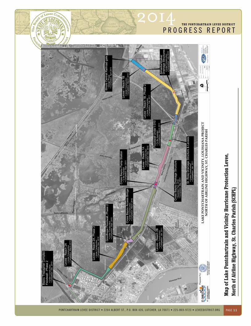
PONTChARTRAIN LeVee DISTRICT
Map
of L
ake
Pont
char
trai
n an
d Vi
cini
ty h
urri
cane
Pro
tect
ion
Leve
e,
Nort
h of
Air
line
high
way
, St.
Char
les
Pari
sh (S
ChPL
)
Floo
dwal
l - P
hase
2B
ayou
Tre
pagn
ier C
ompl
ex
Und
er C
onst
ruct
ion
Com
plet
ion:
Dec
. 201
0
Leve
e - R
each
2A
Und
er C
onst
ruct
ion
Com
plet
ion:
Mar
ch 2
010
Leve
e - R
each
2A
, Pha
se 2
Und
er C
onst
ruct
ion
Com
plet
ion:
Dec
. 201
0
Goo
dhop
e Fl
oodw
all,
Pha
se 2
Und
er C
onst
ruct
ion
Com
plet
ion:
Sep
t. 20
10
Leve
e - R
each
2B
Und
er C
onst
ruct
ion
Com
plet
ion:
Jan
. 201
1
Cro
ss B
ayou
Acc
ess
Brid
geU
nder
Con
stru
ctio
nC
ompl
etio
n: M
arch
201
0
Cro
ss B
ayou
Pum
p S
tatio
nTo
Be
Aw
arde
dC
ompl
etio
n: S
ept.
2011
Cro
ss B
ayou
Dra
inag
e S
truct
ure
Aw
arde
d: F
eb. 2
010
Com
plet
ion:
May
201
1
Leve
e - R
each
1A
Und
er C
onst
ruct
ion
Com
plet
ion:
Dec
. 201
0
St.
Ros
e D
rain
age
Stru
ctur
e &
Lev
ees
Und
er C
onst
ruct
ion
Com
plet
ion:
Jan
. 201
1
Floo
dwal
l Und
er I-
310
To B
e A
war
ded
Com
plet
ion:
Mar
ch 2
011
Leve
e - R
each
1B
, Pha
se 2
Und
er C
onst
ruct
ion
Com
plet
ion:
Feb
. 201
1
Alm
edia
/Wal
ker
Und
er C
onst
ruct
ion
Com
plet
ion:
Jul
y 20
10
Leve
e - R
each
1B
Und
er C
onst
ruct
ion
Com
plet
ion:
Mar
ch 2
010 D
rain
age
Stru
ctur
es
Illin
ois
Cen
tral R
ailro
ad g
ate
Des
ign
Pha
seC
ompl
etio
n: A
pril
2011
Inte
rsta
te 1
0
Loui
sian
a an
d Ar
kans
as R
ailro
ad
Walker Canal
Pipe Line Canal
Bayou LaBranche Bayo
u Tr
aver
se
Bayou
Trepag
nier
Orm
ond
Subd
ivis
ion
Illino
is Cen
tral R
ailro
ad Inter
state
310
Nor
co
Mississippi River
Goo
d H
ope
Faci
lity
Cross Bayou
Airli
ne H
ighw
ay
Airline
High
way
Airli
ne H
ighw
ay
St. Rose Canal
www.
gcr1
.com
Prob
lem
? So
lved.
Pre
pare
d Fo
r:
PO
NT
CH
AR
TR
AIN
NO
RT
H O
F A
IRL
INE
HIG
HW
AY
, ST
. CH
AR
LE
S P
AR
ISH
LE
VE
E D
IST
RIC
T
LA
KE
PO
NT
CH
AR
TR
AIN
AN
D V
ICIN
ITY
, LO
UIS
IAN
A P
RO
JEC
T
DR
AW
ING
:
Met
ro N
O A
eria
l HD
2.dw
gP
LOT
FILE
:
DR
AW
N B
Y:
DA
TE:
SC
ALE
:
leve
e_10
id v
1 02
-25-
10.p
df
SM
G
02/2
5/10
1" =
1,2
00'
Adva
nced
Tech
nolog
y Cen
terUN
O Re
searc
h & Te
chno
logy P
arkNe
w Or
leans
, LA
7012
220
21 La
kesh
ore D
rive
FAX 5
04 30
4 252
5TE
L 504
304 2
500/8
00 25
9 619
2
1,80
01,
200
600
0SC
ALE
: 1" =
1,2
00'
ST. C
HA
RLE
S PA
RIS
HG
OVE
RN
MEN
T
2014The PONTChARTRAIN LeVee DISTRICT
p r o g r e s s r e p o r t
PONTCHARTRAIN LEVEE D ISTR ICT • 2204 ALbERT ST. , P.O . bOx 426 , LuTCHER, LA 70071 • 225-869-9723 • LEVEEDISTRICT.ORg PaGe 12
Project: WestShore–lakePontchartrain,lahurricaneProtectionProject
Project Description and Purpose: inSeptember1965,hurricaneBetsystruckthegreaterneworleansareacauseingseverefloodinginthelower9thWardoforleansParishandalmostallofSt.BernardParish.CongressauthorizedtheU.S.armyCorpsofengineers(Corps)todesignandconstructthelakePontchartrainandVicinity,louisianahurricaneProtectionProjectintheFloodControlactof1965inoctober1965.
in1970,St.JohntheBaptistParish(St.John)raisedobjectionstothelakePontchartrainandVicinity,louisianahurricaneProtectionProjectbaseduponthelackofhurricaneprotectionleveeswestoftheBonnetCarre’Spillway.St.JohnarguedthatthedevelopmentofhurricaneprotectionleveesfromorleansParishtoSt.CharlesParishwouldfunnelthestormsurgetoSt.JohntheBaptistParishthusconsequentlysacrificingSt.Johntosaveothers.
inJuly1971,aresolutionwaspassedintheCommitteeonPublicWorksofthehouseofrepresentativesauthorizingtheCorpstoincludetheremainingportionofSt.CharlesParish(fromtheBonnetCarre’SpillwayUpperGuideleveetotheParishline)andSt.JohntheBaptistParishinthelakePontchartrainandVicinity,louisianahurricaneProtectionProject.inSeptember1974,aresolutionwaspassedintheCommitteeonPublicWorksoftheSenateauthorizingtheCorpstoincludeSt.JamesParishinthelakePontchartrainandVicinity,louisianahurricaneProtectionProject.
West Shore – Lake Pontchartrain hurricane Protection Project
PONTChARTRAIN LeVee DISTRICT
Project Location:TheWestShore–LakePontchartrain,LouisianaHurricaneProtectionProjectstudyareaislocatedin a portion of St. Charles Parish, St. John the Baptist Parish, and St James Parish. The project begins at the Upper Guide Levee of the Bonnet Carre’ Spillway and continues westward towardtheHopeCanalprovidingprotectiontothe communities of Montz, LaPlace, Reserve, Garyville, Mount Airy, Gramercy, Lutcher, Grand Point, Paulina, and Sorrento. Please see attached map.
Status of Work: The work on the Feasibility Study Report is split evenly between the USACE and the PLD. The Feasibility Study has been advanced to a draft format stage. There are three alignments being reviewed; one that followed the wet-dry interface with the wetlands from the Upper GuideLeveetoHopeCanal(EnvironmentallyPreferred Alignment); one that followed the petroleum pipeline right-of-way from the Upper GuideLeveetoHopeCanalthenturningsouthtoward the Mississippi River (Pipeline Avoidance and Storage Capacity Alignment); and one that followed the Interstate-10 route from the Upper Guide Levee to the Marvin Braud Pump Station in Ascension Parish (Locally Preferred Alignment). The Environmentally Preferred and Pipeline Avoidance and Storage Capacity Alignments are considering protection for the St James Parish communities via non-structural methods such as ring levees, property elevations, etc. The Locally Preferred Alignment is the only one that protects the entire study area and all criticalinfrastructure(includingI-10,USHwy61, refineries, petrochemical plants, Port of South Louisiana, etc.) The Pipeline Avoidance and Storage Capacity Alignment was recommended as the Tentatively Selected Plan in June 2013. The Pipeline Avoidance and Storage Capacity
Alignment (Alignment C) was approved as the Tentatively Selected Plan during the Agency Decision Milestone Meeting in November 2013. The USACE and PLD are currently preparing the Feasibility Study Report and Appendices. The current schedule will complete the Feasibility Study Report and have an approved Chief ’s Report in FY 2014.
Funding Requirements for FY 2015: Funding required for completion of the Feasibility Study Phase will be 50% Federal and 50% Non-Federal Local Match. The USACE New Orleans District requested $500,000 for FY2013. The FY2013 Federal funding request has not been fulfilled to date; the project schedule could be adversely affected with a minimum 12 month delay and potentially a 24 month delay. PLD provided a large Non-Federal Cash payment $1,269,305 in 2009 and will provide additional matching funds when requested by the USACE. In 2011, the PLD secured $10,830,000 in Local Match funds through the Louisiana Capital Outlay Program and has executed contractual agreements with the affected Parishes to provide the Local Match for this project. The USACE has the necessary funds to complete the Feasibility Study Report. The USACE needs funding to start Preliminary Engineering Design (PED) after the Chief ’s Report. The FY2015 request is based upon normal PED funding of newly approved projects.
Fy15FederalFundingneededforPed$1,000,000

2014The PONTChARTRAIN LeVee DISTRICT
p r o g r e s s r e p o r t
PONTCHARTRAIN LEVEE D ISTR ICT • 2204 ALbERT ST. , P.O . bOx 426 , LuTCHER, LA 70071 • 225-869-9723 • LEVEEDISTRICT.ORg PaGe 13

2014The PONTChARTRAIN LeVee DISTRICT
p r o g r e s s r e p o r t
PONTCHARTRAIN LEVEE D ISTR ICT • 2204 ALbERT ST. , P.O . bOx 426 , LuTCHER, LA 70071 • 225-869-9723 • LEVEEDISTRICT.ORg PaGe 14
Project:
amiteriverandtributaries,Bayou
manchac,la
Project Description:
The Amite River and Tributaries, Bayou
Manchac, Louisiana feasibility study has
evaluated alternatives and developed
a Tentatively Selected Plan (TSP) to
provide for flood risk reduction and
facilitate ecosystem restoration in the
Bayou Manchac watershed. The TSP
includes watershed management and
replacement of antiquated floodgates
with more efficient structures and
dredging of Alligator Bayou to remove
sediment that has accumulated over the
last 60 years in the Bayou.
Amite River and Tributaries, Bayou Manchac, LA
PONTChARTRAIN LeVee DISTRICT
Project Location The project is in Southeastern Louisiana on the east bank of the Mississippi River and includes portions of East Baton Rouge, Iberville and Ascension parishes.
Project Description The Amite River and Tributaries, Bayou Manchac, Louisiana feasibility study has evaluated alternatives and developed a Tentatively Selected Plan (TSP) to provide for flood risk reduction and facilitate ecosystem restoration in the Bayou Manchac watershed. The TSP includes watershed management and replacement of antiquated floodgates with more efficient structures and dredging of Alligator Bayou to remove sediment that has accumulated over the last 60 years in the Bayou.
Project history
The Amite River and Tributaries, Bayou Manchac, Louisiana feasibilituy study began as a cost-shared study under the Feasibility Cost Share Agreement that was executed between the Pontchartrain Levee District (PLD) and the U.S. Army Corps of Engineers (Corps) on November 29, 2001. In April 2008 the Pontchartrain Levee District Board of Commissioners voted to pursue the study under Section 211 because the study was not progressing at an acceptable rate. The Corps recommended Section 211 as a means of expediting the effort. The Secretary of the Army was notified of the PLD’s intent to pursue the projectunderSection211ofWRDA96andapproval was granted in July 2008. In July 2008 the study was converted to a Section 211 project
when the PLD was not satisfied with the progress of the study due to funding constraints at the Federal level. Shaw Coastal, Inc. as Consultant to the PLD and all project related efforts are in compliance with the Corps Federal project process, to the extent possible, since the intent is for this to become a federally authorized project in which the PLD will seek reimbursement for the equivalent of what would have been the Federal share in accordance with existing laws. The work performed under the previous feasibility cost sharing agreement between the PLD and the Corps is serving as the basis for the Section 211 study effort. During the cost-shared effort, scoping and stakeholder meetings were held and a preliminary screening of alternatives was accomplished. Surveys have been completed and data has been submitted and reviewed by the Corps for the use in both the Amite River Ecosystem and Bayou Manchac studies.
Description of the Tentatively Selected Plan:
Alligator and Frog Bayous Replace the existing water control structure (Floodgates) at Alligator Bayou and Frog Bayou with improved higher capacity floodgates. Dredge Alligator Bayou, beginning at the floodgate structures and extending approximately 7,550 feet upstream. Acquire a 1.25 acre construction staging area that will also accommodate equipment storage. Bank protection will also be placed opposite the Alligator Bayou and Frog Bayou floodgates to prevent additional bank erosion.
2014The PONTChARTRAIN LeVee DISTRICT
p r o g r e s s r e p o r t
PONTCHARTRAIN LEVEE D ISTR ICT • 2204 ALbERT ST. , P.O . bOx 426 , LuTCHER, LA 70071 • 225-869-9723 • LEVEEDISTRICT.ORg PaGe 15
Ward Creek (This part of the plan would be primarily on the lower part of the BRECFairgroundsPark.)ReroutethelowerreachofWardCreek.Construct closures at the upper and lower ends of the abandoned channel to provide bank protection. Construct: a backwater flood restriction structure in Bayou Manchac with a boat ramp for operational purposes; A low levee to prevent backwater from overflowingWardCreekintoBayouManchac.Alsoaminorredesignis needed where protection ties in to the Santa Maria Golf Course.
Project Study Results The proposed plan would lower stages and reduce the flood risk for 3,750 structures in the Bayou Fountain, Spanish Lake and Bluff Swamp watersheds. 964 structures would be removed from the 200-year floodplain and 66 repetitive loss structures in the floodplain would benefit. Engineering & design is estimated at $2M and the construction cost is estimated at $22 M.
Project Funding PLD is pursuing alternative financing, i.e., FEMA or other money to design and implement part of the project. PLD coordinated with the state to determine what, if any, funds are available for implementation of the project. Thus far, the State has not been able to identify any finding.
If non-Federal funding is identified and made available, the part of the project implemented solely with non-Federal funds would remain non-Federal and remain under PLD jurisdiction. Section 211 would not apply to that part of the project.
Amite River and Tributaries, Bayou Manchac, LA

2014The PONTChARTRAIN LeVee DISTRICT
p r o g r e s s r e p o r t
PONTCHARTRAIN LEVEE D ISTR ICT • 2204 ALbERT ST. , P.O . bOx 426 , LuTCHER, LA 70071 • 225-869-9723 • LEVEEDISTRICT.ORg PaGe 16
Amite River and Tributaries, Bayou Manchac, LA

2014The PONTChARTRAIN LeVee DISTRICT
p r o g r e s s r e p o r t
PONTCHARTRAIN LEVEE D ISTR ICT • 2204 ALbERT ST. , P.O . bOx 426 , LuTCHER, LA 70071 • 225-869-9723 • LEVEEDISTRICT.ORg PaGe 17
Project: BayouConway/PanamaCanaldrainageStudy, ascension and St. JamesParishes
Project Location: Bayou Conway and the Panama Canaldrainage basin is located in southernascension Parish and northern St. JamesParish,alongtheproposedascensionParishalignmentsofthelakePontchartrainWestShorehurricaneProtectionleveeProject.
Project Description: the purpose of the Bayou Conway andPanama Canal drainage improvementProject is to provide a reduction in therisk of flooding for the drainage basinthat includes the area near the boundarybetweenascensionandSt.JamesParishes.the modeling component of the projectwillbeutilizedintheWestShorehurricaneProtection levee project for the BayouConway crossing of the levee. themodelingresultsarealsobeingutilizedtoimprovements to the gravity conveyancesystem(channelimprovements)withinthewatershed.theBayouConwaywatershedencompassesthemississippiriverleveeatthe81milepoint (milemarker 180) to its confluencewith Blind river, and travels a distanceofapproximately23.5miles.thePanamaCanal is an 8.3 mile diversion reliefchannel that cuts a more direct channelto the downstream end of BayouConway.the Conway/Panama System serves asthe major conveyance channel for thesoutheastern portion of ascension Parishand a portion of St. James Parish. thedrainage basin encompasses an area ofapproximately 65 square miles, of whicha large portion lies along the mississippiriver corridor. the entire drainage basinliesoutsideoftheareaservedbythemarvinJ.BraudPumpstation locatedatmcelroy,anditsprotectionlevees,whicharelocatedin ascension Parish. the results of theBayou Conway/Panama Canal drainageStudy are being utilized for proposedchannel improvements, and for the lakePontchartrain West Shore hurricaneProtection Project. the study also formsthe basis for future basin planning andwatershedmanagement.
Bayou Conway & Panama Canal Drainage Improvement Project Ascension Parish and St. James Parish
PONTChARTRAIN LeVee DISTRICT
Project Status Thehydraulicanalysis/studywascompletedinJuly 2011. The study determined the existing conditions within the basin based on varying downstream conditions and proposed necessary improvements to the channels to reduce the risk of flooding within the watershed. Downstream conditions were determined utilizing the existing data from existing gage data, FEMA Studies, and data generated from the Amite River Tributaries and Lake PontchartrainWestShoreprojects.Asaresultf this investigation, channel maintenance and a dredging regime is recommended to provide the needed channel capacity for the gravity conveyance improvements within the Bayou Conway and Panama Canal watershed.
Currently, permits are being sought to begin the snagging and clearing of the channels to facilitate the drainage improvements.
The next phase of work will be to begin the implementation of the proposed channel enlargement and improvements. The proposed improvements consist of five phases of work thatwillopenupthesilted/cloggedchannelsand provide needed capacity for the drainage system. The phases of work were divided by assessing the most urgent priorities determined in the modeling phase, and by annual budgetary constraints allowing one phase to be completed per year.
Project Funding The Pontchartrain Levee District and the East Ascension Gravity Drainage District have entered into an intergovernmental agreement that split the funding of the Drainage Study amongst each entity. Funding for the implementation of the recommendations will be funded by the EAGDD and PLD.
estimated Project Construction Costs The preliminary project cost estimates for the snagging and dredging of the selected channels was divided into several phases. The priority phase of work is approximately $2.0M and consists of targeted areas that will have the greatest flood risk reduction and the least environmental impact. Subsequent phases could occur over a period of time, as funds become available. Costs range from $5-8M depending on the project permitting and material disposal methods.

2014The PONTChARTRAIN LeVee DISTRICT
p r o g r e s s r e p o r t
PONTCHARTRAIN LEVEE D ISTR ICT • 2204 ALbERT ST. , P.O . bOx 426 , LuTCHER, LA 70071 • 225-869-9723 • LEVEEDISTRICT.ORg PaGe 18
PONTChARTRAIN LeVee DISTRICT
Bayo
u Co
nway
/Pan
ama
Cana
l Dra
inag
e St
udy
Asce
nsio
n Pa
rish
and
St.
Jam
es P
aris
h

2014The PONTChARTRAIN LeVee DISTRICT
p r o g r e s s r e p o r t
PONTCHARTRAIN LEVEE D ISTR ICT • 2204 ALbERT ST. , P.O . bOx 426 , LuTCHER, LA 70071 • 225-869-9723 • LEVEEDISTRICT.ORg PaGe 19
Project:
laurelridgeleveeextension
ascensionParish
Project Location:
thelaurelridgeleveeextensionProject
islocatedinthenortheastcornerof
ascensionParishalongtheamiteriver.
Project Description: thelaurelridgeleveeextensionProjectconsistsofextendingtheexistinglaurelridgeleveetoprotectadditionalpropertiesalong/withintheamiteriverfloodplainfrombackwaterfloodingandhighwatersontheamiteriver.theproposedleveeextensionwillbeginattheendingpointoftheexistinglaurelridgelevee,andisproposedtoterminateatthenorthernendofWallCemeteryroad
thelaurelridgeleveeextension,ascurrentlyproposed,willbeapproximately4.5mileslong,andwillbeconstructedtoanelevationof15.0naVd.theconstructionwillrequirenearly425,000cubicyardsoffill.
theproposedprojectwillreducefloodstagesbyseveralfeetandwillprovidethisprotectionforapopulationofapproximately4,000people,and1,700structures.
Laurel Ridge Levee extension, Ascension Parish
PONTChARTRAIN LeVee DISTRICT
Project Status The initial reconnaissance level investigation was completed during the summer of 2011. The reconnaissance study investigated the feasibility of the project and helped determine some of the project features, modeling results, and design criteria. In May of 2013, the project scope changed from a project of approximately 3.3 miles long to a total project length of approximately 4.5 miles to provide flood risk reduction to additional residents within the Amite River Flood Plain located along LA 431. This revision required additional surveying and preliminary engineering necessary to incorporate into the original project.
Three alignments were considered.
Alignments 1 & 3 were investigated to minimize environmental impacts to the jurisdictional wetlands. Because of the increased levee lengths and the necessity for multiple pump stations for both alignments, Alignment 1 & 3 were deemed too expensive ($32 and $35 million, respectively) to construct, compared to the benefits that they would have provided.
Alignment 2 is the preferred alignment due to the reduced estimated cost ($24 million) for providing the same benefits and level of protection as Alignments 1 & 3. Alignment 2 would utilize the existing swamp as retention for the internal drainage while the Amite River is at flood stage. This alignment does not require the construction of pump stations and the gravity-driven internal drainage will be handled by a flood gate system. This will allow the swamp area on the protected side of the levee to be used as storm water storage until the Amite River floodwaters recede. The proposed levee is approximately 25,300 feet long with a crest elevation of 15.0. Because the gated system will be operated in an open condition, and only closed during a backwater flooding event from the Amite River, there will be minimal environmental
impacts to the wetlands on the protected side, and it will allow for a shorter levee length.
Project Funding Ascension Parish has previously funded several Master Drainage Plans that have included this levee extension project in the overall plan. There was also, some preliminary geotechnical investigations performed at the expense of the East Ascension Gravity Drainage District (EAGDD), an entity of Ascension Parish.
The Pontchartrain Levee District (PLD) has funded the Laurel Ridge Levee Extension Recon Study, and the Preliminary Permitting efforts.\
At this time, a Memorandum of Understanding has been completed between the PLD and EAGDD, that states that the PLD will be responsible for coming forward with the funds required to complete the engineering, design, and permitting phases of the proposed project, and that the EAGDD will provide the funds for the environmental impacts, real estate acquisition, and construction phases.
Project Breakdown Phase I: Reconnaissance Study
This effort was an investigation into the general project concept. Engineering parameters, project costs, project benefits were investigated to determine whether the project was worthy of further consideration. The results came back favorably for the construction of Alternative Alignment #2. This effort was completed during the summer of 2011.
Phase II: Preliminary Design and Permitting
This effort consists of the data collection necessary to perform the preliminary design services required to better define the project parameters before the design and permitting phase begins.
2014The PONTChARTRAIN LeVee DISTRICT
p r o g r e s s r e p o r t
PONTCHARTRAIN LEVEE D ISTR ICT • 2204 ALbERT ST. , P.O . bOx 426 , LuTCHER, LA 70071 • 225-869-9723 • LEVEEDISTRICT.ORg PaGe 20
Topographical Survey Services will be required to better define the termination point of the proposed levee, and existing boundary maps will be utilized to refine the levee alignments. The proposed project structures will be further investigated for site requirements and alignments.
A 30% set of drawings will be produced for use with the permitting applications.
A wetlands delineation will be performed to determine the boundary of the areas impacted by the proposed improvements, and to assist in the permit submittals.
Pre-Application meeting will be held with the USACE to verify the submittals and assurances that will be needed during the permitting process.
Phase III: 50% Design & Permitting
In addition to collecting the required data, a 50% set of construction drawings will be created based on the preliminary design, so that the permitting process can begin.
The various Consultants that will be required for this phase of work will be the Topographical Survey, Geotechnical Investigation, and Environmental (wetland) Investigation and Delineation. This information will be utilized in the preliminary (50%) design of the project components.
The permitting will be critical to the successful completion of this project. The permitting will require submittal of the preliminary design documents, and will require the approval of the proposed plan. An operation plan for the flood gates will be developed and approved that will dictate the strict ownership and operation parameters for the flood gates. Also, the environmental impacts will have to be identified, and a wetlands mitigation and monitoring plan will have to be established for impacted areas. Once these concerns have been addressed, the various entities having jurisdiction will have to accept the proposed improvements.
Phase IV: Real estate Services, environmental, Final Plans & Specs, and Bidding
This phase will include the acquisition of the necessary real estate easements, wetland mitigation, completion of the final design documents, and bidding of the project.
The real estate easements and wetland mitigation will be handled according to the permitting requirements. And the final design and the necessary construction documents will be put together. Once the final design is completed, a revised construction cost estimate will be produced.
Once these steps are completed, and the construction funds are in place, then the project can be opened for bidding.
Phase V: Construction Administration and Inspection Services
The Construction Administration and Inspection Services will be performed to ensure that the Contractor is constructing the proposed improvements according to the Construction Documents and to protect the interests of the owner. This effort will include the day-to-day management of the project, the inspection of the construction progress, the verification (geotechnical and survey) of the construction materials and quantities, progress meetings, approval of pay applications, processing of change orders, owner updates, and various other construction administration services.
Project estimated Costs
Alignment Option 2- The total preliminary estimated project cost for this alignment option is $24 million dollars.
2014The PONTChARTRAIN LeVee DISTRICT
p r o g r e s s r e p o r t
PONTCHARTRAIN LEVEE D ISTR ICT • 2204 ALbERT ST. , P.O . bOx 426 , LuTCHER, LA 70071 • 225-869-9723 • LEVEEDISTRICT.ORg PaGe 21
Project Schedule
Phase I:Reconnaissance Study – COMPLeTe
Began:September29,2008
Status:Completed-Spring2011
Phase II:Prelim Design and Prelim Permitting – COMPLeTe
Began:July5,2012
Status:Complete
Phase IIa:Additional Data Collection and Design Revision
Began:September2013
Status:CompletedFebruary2014
Future Phase III: Permitting
estimatedduration:16months
Begin:march2014
ProjectedCompletion:July2015*
*Dependent on LADNR & USACE Review/Approval Schedule Future Phase IV: Final Design/Specifications (on-going simultaneous to Permitting)
estimatedduration:12months
ProjectBegan:September2014
ProjectCompletion:September2015*
*Dependent on LADNR & USACE Review/Approval Schedule
Future Phase V:Real estate Services, Wetland Mitigation
estimatedduration:12months
ProjectBegan:September2014
ProjectedCompletion:march2016
Total estimated Project Cost: $24million

2014The PONTChARTRAIN LeVee DISTRICT
p r o g r e s s r e p o r t
PONTCHARTRAIN LEVEE D ISTR ICT • 2204 ALbERT ST. , P.O . bOx 426 , LuTCHER, LA 70071 • 225-869-9723 • LEVEEDISTRICT.ORg PaGe 22
Laur
el R
idge
Lev
ee e
xten
sion
, Asc
ensi
on P
aris
h
PONTChARTRAIN LeVee DISTRICT
2014The PONTChARTRAIN LeVee DISTRICT
p r o g r e s s r e p o r t
PONTCHARTRAIN LEVEE D ISTR ICT • 2204 ALbERT ST. , P.O . bOx 426 , LuTCHER, LA 70071 • 225-869-9723 • LEVEEDISTRICT.ORg PaGe 23
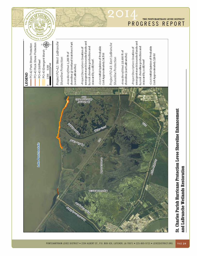
Project Location:
theprojectislocatedalongthe
unprotectedsectionsofSt.CharlesParish
lakePontchartrainshoreline.
Project Description:
theproject’soverallobjectiveistoprotect
northernSt.CharlesParishbystabilizing
thelakePontchartrainshoreline
fromfurthererosion,enhancingthe
shorelinewherepossible,andrestoring
thelaBrancheWetlandstoprovidean
integratedsystemofmultiplelines
ofdefense.theshorelineprotection
measuresareintegratedwithinterior
marshrestorationforacomprehensive
restorationstrategyforthelaBranche
Wetlands.Previouseffortshaveprotected
approximately12,000feetofshoreline.
thereisapproximately20,500feetof
shorelinewhichisnotprotected.the
unprotectedshorelinecontainstwo
componentsofapproximately2,000
lf.(Po-42,WestlaBrancheShoreline
Protection)and18,500lf.(Po-43,east
laBrancheShorelineProtection).
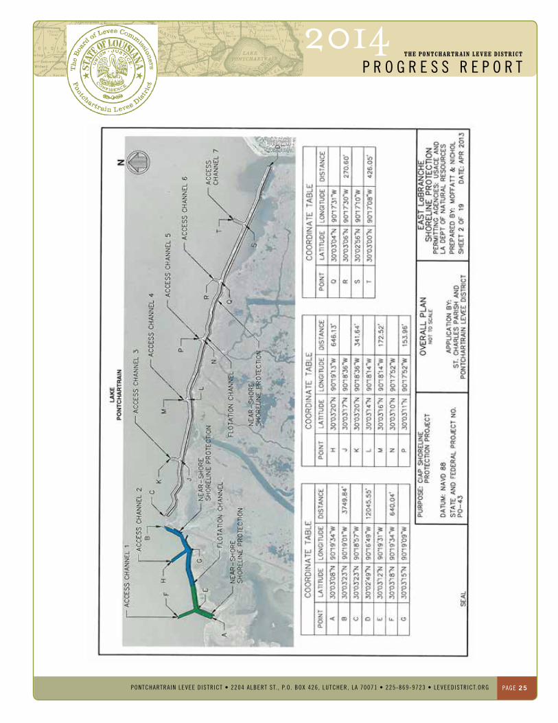
St. Charles Parish hurricane Protection Levee Shoreline enhancement and LaBranche Wetlands Restoration
PONTChARTRAIN LeVee DISTRICT
Project Status The unprotected shoreline contains two com-ponents;WestLaBrancheShorelineProtectionand East LaBranche Shoreline Protection.
West LaBranche Shoreline, PO-42 Project completed construction in June 2013.
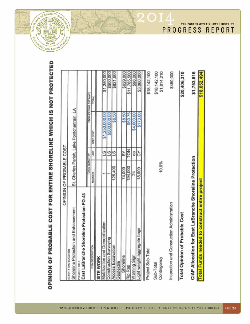
east LaBranche Shoreline, PO-43 Project design is complete. The CIAP portion of the shoreline will be constructed this year (2014).
Project Costs The preliminary opinion of probable cost based on the schematic design of the shore-line stabilization and enhancement (shoreline marshtoearmoringandoffshoresill/reefwithemergent fringe marsh restoration) is approxi-mately $25 Million. Extending the marsh toeprotectiononlytoWetlandWatchersPark (PO-42) on the west and the remaining 18,500 feet to the Parish line (PO-43) to the east without enhancement would be approxi-mately $14 Million.
Project Design Funding In January 2010, the Pontchartrain Levee District (PLD) Board authorized $598,301.00 for the design of approximately 20,500 feet of shoreline protection and enhancement.
Project Construction Funding The Coastal Impact Assistance Program is partially funding these projects. In total CIAP has $4,530,916.99 allocated to these two proj-ects.AsmentionedabovetheWestLaBrancheproject has been constructed. The amount of funds remaining for the East LaBranche project is $1,753,816.
There currently is approximately 18,000 lf of shoreline which has not been protected and is eroding at a rate of 9 feet per year. The CIAP program is funding the East LaBranche Shore-line Protection Project. The allocated funds will construct approximately 1,400 ft. of the 18,000 which has not been protected.
If the remaining shoreline (16,600 feet) cannot be protected in its entirety there is a critical area which needs to be addressed. This area includes a thin strip of land which separates Lake Pontchartrain from open water areas insidetheLaBrancheWetlands.
The opinions of probable estimates have been developed and are:
Protect the entire shoreline Cost required protecting the entire shoreline ($18,700,000). This figure includes the CIAP funds which have been allocated to the East LaBranche project. This area includes all col-ored areas on the attached figure (Green, Blue andWhite)
CIAP Funds only The CIAP program has allocated $1,753,816 for the East LaBranche Shoreline project. These funds will construct approximately 1,400 ft. of shoreline. This area is shown in green on the attached figure.
Critical Areas The costs associated with this estimate ($2,000,000) are the additional costs required to protect the critical areas. This area is shown in blue on the attached figure. The estimate assumes additional funds would be added to the CIAP allocation and the two areas would be constructed at the same time. If the proj-ects are not constructed at the same time an additional $300,000 should be added to cover the mobilization and de-mobilization costs.
2014The PONTChARTRAIN LeVee DISTRICT
p r o g r e s s r e p o r t
PONTCHARTRAIN LEVEE D ISTR ICT • 2204 ALbERT ST. , P.O . bOx 426 , LuTCHER, LA 70071 • 225-869-9723 • LEVEEDISTRICT.ORg PaGe 24
St. C
harl
es P
aris
h hu
rric
ane
Prot
ectio
n Le
vee
Shor
elin
e en
hanc
emen
t an
d La
Bran
che
Wet
land
s Re
stor
atio
n
PONTChARTRAIN LeVee DISTRICT
2014The PONTChARTRAIN LeVee DISTRICT
p r o g r e s s r e p o r t
PONTCHARTRAIN LEVEE D ISTR ICT • 2204 ALbERT ST. , P.O . bOx 426 , LuTCHER, LA 70071 • 225-869-9723 • LEVEEDISTRICT.ORg PaGe 25
2014The PONTChARTRAIN LeVee DISTRICT
p r o g r e s s r e p o r t
PONTCHARTRAIN LEVEE D ISTR ICT • 2204 ALbERT ST. , P.O . bOx 426 , LuTCHER, LA 70071 • 225-869-9723 • LEVEEDISTRICT.ORg PaGe 26

2014The PONTChARTRAIN LeVee DISTRICT
p r o g r e s s r e p o r t
PONTCHARTRAIN LEVEE D ISTR ICT • 2204 ALbERT ST. , P.O . bOx 426 , LuTCHER, LA 70071 • 225-869-9723 • LEVEEDISTRICT.ORg PaGe 27
Project:
theprojectislocatedsouthoflake
Pontchartrainbetweenkennerandthe
eastguideleveeoftheBonnetCarre
Spillway,St.CharlesParish.
Project Location:
theprojectislocatedsouthoflake
Pontchartrainbetweenkennerandthe
eastguideleveeoftheBonnetCarre
Spillway,St.CharlesParish.
Project Description:
aspartofthedevelopmentofan
integratedapproachtotheprotection
andenhancementofthePontchartrain
shoreline,combinedwithinteriormarsh
restoration,m&n,inpartnershipwiththe
USaCeandPldunderaPaSagreement
isdevelopingaplanninglevelmaster
Planforthehydrologicandenvironmental
restorationoftheentirelaBranche
wetlands.Specifically,themasterPlan
will:
1. recommendtheprojectfeatures
requiredtorestoreandsustaina
fresherwatersalinityregimein
thelBWmoresimilartohistorical
conditions.
2. recommendthe“what-when-
where-how-howmuch”detailsof
freshwater/sediment/nutrients
re-introductionintolaBranche;
3. Proposewatercontrolstructuresto
optimizefreshwaterretentionand
minimizesaltwaterintrusion.
St. Charles Parish hydrodynamic and Water Quality Model of the LaBranche Wetlands
PONTChARTRAIN LeVee DISTRICT
Project Status The numerical model is complete and calibrat-ed to a 2010 six-month field data collection program. The numerical model has been used to evaluate the feasibility and effectiveness of proposed freshwater re-introductions into the wetlands. The numerical model was also used to evaluate the efficacy of the rehabilitation of existing water control structures as well as the potential of additional structures in the vicin-ity of openings under the rail road embank-ment and other major conduits for water flow for suppression of salt water intrusion and retention of re-introduced freshwater into the wetlands. In addition to structural measures, this study also evaluated non-structural mea-sures, in the form of fresh water input, to limit saltwaterintrusionintheLaBrancheWetland
Currently, M&N is using the model to assess the potential benefits of proposed hydro-logic restoration projects and combination of projects being explored by St Charles Parish, CWPPRA,USACEandNGO’s.Followingrecommendations in previous reporting and discussion with stakeholders, a set of water management strategies has been selected that are being investigated and discussed within this phase of the study. Analysis of model results will help to converge to an integrated strategy that limits saltwater intrusion and pro-motes low maintenance. Project was completed October 2013.
Project Costs The project costs will be determined under future efforts.
Project Design Funding In January 2011, the Pontchartrain Levee District (PLD) Board and the United States Corps of Engineers entered into agreement for this project. That agreement authorized $100,000.00 for the project. Since this date another $140,000 has been allocated. The cost share for this work is 50-50.
Project Construction Funding Construction funds for this project have not been authorized.

2014The PONTChARTRAIN LeVee DISTRICT
p r o g r e s s r e p o r t
PONTCHARTRAIN LEVEE D ISTR ICT • 2204 ALbERT ST. , P.O . bOx 426 , LuTCHER, LA 70071 • 225-869-9723 • LEVEEDISTRICT.ORg PaGe 28
LaBr
anch
e W
etla
nds
Mod
el G
rid
PONTChARTRAIN LeVee DISTRICT