The Mediterranean ocean Forecasting System - Earth … · EnvisatWorkshop, August25-26, 2004 MFSTEP...
47
Envisat Workshop, August 25-26, 2004 MFSTEP Mediterranean Forecasting System: Toward Environmental Predictions The Mediterranean ocean Forecasting System The Mediterranean ocean Forecasting System State of development and progress up to date N.Pinardi, University of Bologna, Ravenna Campus and INGV, Bologna, Italy
Transcript of The Mediterranean ocean Forecasting System - Earth … · EnvisatWorkshop, August25-26, 2004 MFSTEP...
Envisat Workshop, August 25-26, 2004
MFSTEP Mediterranean Forecasting System: Toward Environmental Predictions
The Mediterranean ocean ForecastingSystem
The Mediterranean ocean ForecastingSystem
State of development and progress up to date
N.Pinardi, University of Bologna, Ravenna Campus
andINGV, Bologna, Italy
Envisat Workshop, August 25-26, 2004
MFSTEP Mediterranean Forecasting System: Toward Environmental Predictions
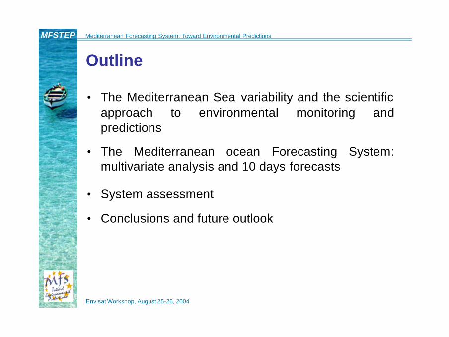
Outline
• The Mediterranean Sea variability and the scientific approach to environmental monitoring and predictions
• The Mediterranean ocean Forecasting System: multivariate analysis and 10 days forecasts
• System assessment
• Conclusions and future outlook
Envisat Workshop, August 25-26, 2004
MFSTEP Mediterranean Forecasting System: Toward Environmental Predictions
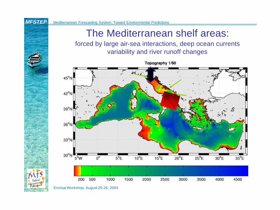
The Mediterranean shelf areas:forced by large air-sea interactions, deep ocean currents
variability and river runoff changes

Envisat Workshop, August 25-26, 2004
MFSTEP Mediterranean Forecasting System: Toward Environmental Predictions
The known large scale variability
August 00August 98 August 99
Sea Level Anomalies from combined analysis of T/P and ERS2 data (blue negative anomalies/ -20 cm, green-red positive anomalies/ +20 cm
Africa
Europe Europe Europe
Africa Africa
Envisat Workshop, August 25-26, 2004
MFSTEP Mediterranean Forecasting System: Toward Environmental Predictions
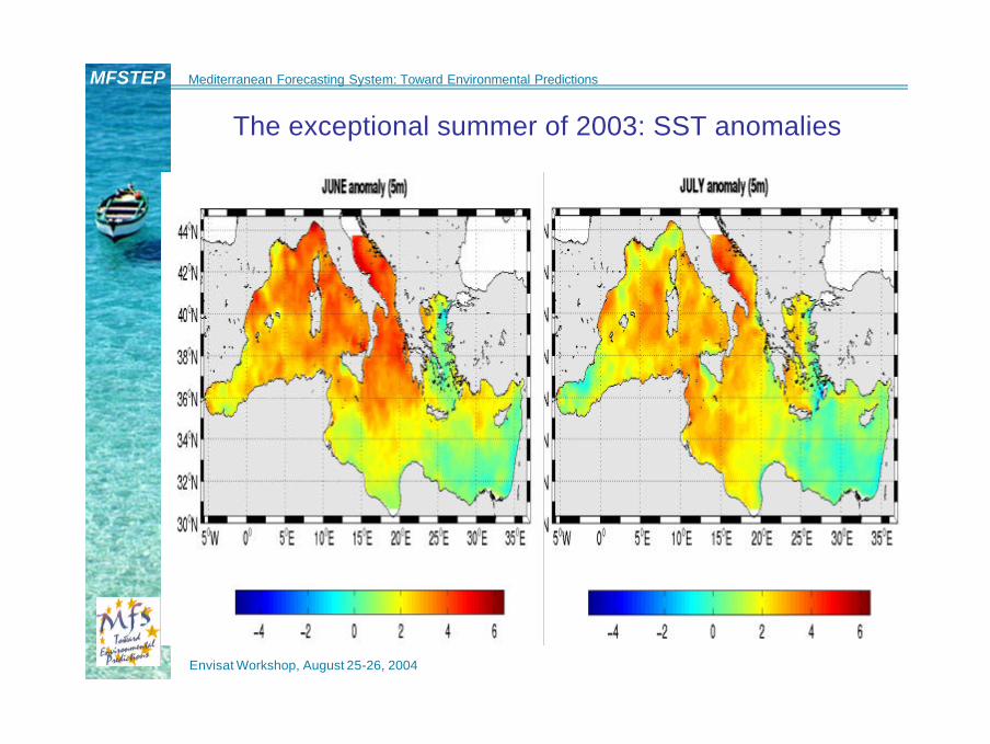
The exceptional summer of 2003: SST anomalies

Envisat Workshop, August 25-26, 2004
MFSTEP Mediterranean Forecasting System: Toward Environmental Predictions
How do we build predictive capabilities?
• Three phases of knowledge are required
(Robinson, 1986):
1. Descriptive/phenomenological with observations
2. Dynamical and calibration/validation with observations and
models
3. Assessment of predictive skills and re-formulation of the
problem
m Practically develop a Marine Environmental Prediction System
Envisat Workshop, August 25-26, 2004
MFSTEP Mediterranean Forecasting System: Toward Environmental Predictions
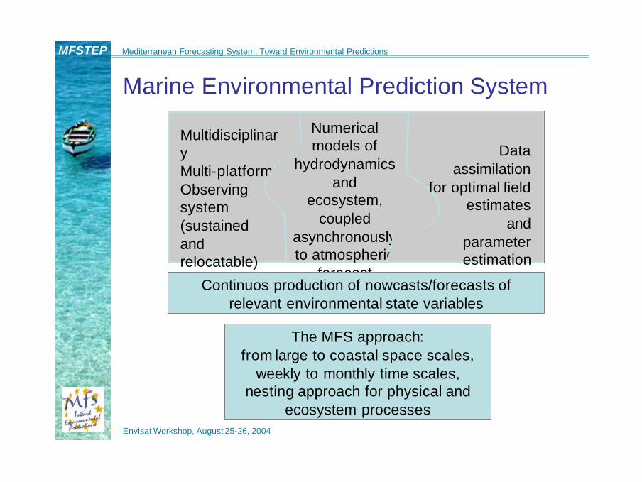
MultidisciplinaryMulti-platformObserving system(sustained and relocatable)
Numerical models of
hydrodynamics and
ecosystem, coupled
asynchronouslyto atmospheric
forecast
Dataassimilation
for optimal field estimates
andparameter estimation
Marine Environmental Prediction System
Continuos production of nowcasts/forecasts of relevant environmental state variables
The MFS approach:from large to coastal space scales,
weekly to monthly time scales,nesting approach for physical and
ecosystem processes

Envisat Workshop, August 25-26, 2004
MFSTEP Mediterranean Forecasting System: Toward Environmental Predictions
LARGE SCALELARGE SCALE SHELF SCALESHELF SCALE
MODEL PHYSICS• PRIMITIVE EQUATION (⊆ 5 KM)• INTERACTIVE OCEAN ATMOSPHERE
COUPLING• TURBULENCE AND LIGHT RAD.
TRANSFER SUBMODELSDATA ASSIMILATION
• OPTIMAL INTERPOLATION AND/OR KALMAN FILTER
• ADJOINT MODELSECOSYSTEM MODELS
• PELAGIC COMPARTMENT• BENTHIC-PELAGIC COUPLING• SEDIMENT DYNAMICS
ATMOSPHERIC FORCING• OPERATIONAL ANALYSES FROM
LARGE SCALE MODELS• LAM and MESOSCALE MODEL
OUTPUT
MODEL PHYSICS• PRIMITIVE EQUATION (⊇ 5 KM)• INTERACTIVE OCEAN
ATMOSPHERE COUPLINGDATA ASSIMILATION
• OPTIMAL INTERPOLATION AND/OR KALMAN FILTER
ECOSYSTEM MODELS• PELAGIC COMPARTMENT• BENTHIC CLOSURE
ATMOSPHERIC FORCING• OPERATIONAL ANALYSES
FROM LARGE SCALE MODELS
• ENSEMBLE FORECASTS
MODELING SYSTEM
• REPEATED MULTIPARAMETRIC SECTIONS ACROSS SHELF*
• SATELLITE: SAME AS FOR THE LARGE SCALE
• FERRY SURVEYS OF SURFACE PARAMETERS
• BUOY STATIONS• MESOSCALE SURVEYS• COASTAL RADAR• AUTONOMOUS UNDERWATER
VEHICLES• RIVER RUNOFF AND LOADING
MONITORING• SEDIMENT ANALYSIS
• MOORED BUOY ARRAYS• VOS XBT AND ONDULATING
INSTRUMENTS• SATELLITE: SEA LEVEL, SEA
SURFACE TEMPERATURE, SURFACE WINDS , SEA SURFACE SALINITY, COLOR,
• DRIFTING BUOYS (SURFACE AND SUBSURFACE)
• GLIDERS• AIRPLAINE SURVEYS WITH
AXBT
OBSERVING SYSTEM
Envisat Workshop, August 25-26, 2004
MFSTEP Mediterranean Forecasting System: Toward Environmental Predictions
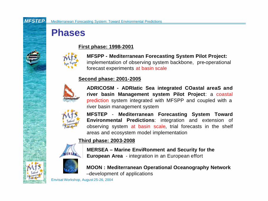
PhasesFirst phase: 1998-2001
MFSPP - Mediterranean Forecasting System Pilot Project:implementation of observing system backbone, pre-operational forecast experiments at basin scale
Second phase: 2001-2005
ADRICOSM - ADRIatic Sea integrated COastal areaS and river basin Management system Pilot Project: a coastal prediction system integrated with MFSPP and coupled with a river basin management system
MFSTEP - Mediterranean Forecasting System Toward Environmental Predictions: integration and extension of observing system at basin scale, trial forecasts in the shelf areas and ecosystem model implementation
Third phase: 2003-2008
MERSEA – Marine EnviRonment and Security for the European Area - integration in an European effort
MOON : Mediterranean Operational Oceanography Network –development of applications

Envisat Workshop, August 25-26, 2004
MFSTEP Mediterranean Forecasting System: Toward Environmental Predictions
MFSTEP components Mediterranean Forecasting System Toward Environmental Predictions
RT Observing Systemsatellite SST, SLA, VOS-
XBT, moored multiparametric buoys,
ARGO and gliders
Upgrade of present basin scale
operational systemNew model and
assimilationEcosystem Models
Validation/calibration of Coupled
physical and biochemical
numerical models
Marine forecastdownscaling
Regional and shelf models nesting
15 nations involved, 48 institutions
End-User applicationsDevelopment of modules for
oil spill monitoring, ICZM and fishery management
Meteorologicalforecast
downscaling10 km LAMs and
4 km N.H. mesoscale models
Envisat Workshop, August 25-26, 2004
MFSTEP Mediterranean Forecasting System: Toward Environmental Predictions
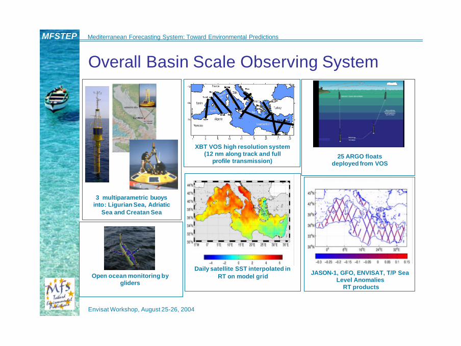
Overall Basin Scale Observing System
3 multiparametric buoysinto: Ligurian Sea, Adriatic
Sea and Creatan Sea
25 ARGO floatsdeployed from VOS
Daily satellite SST interpolated in RT on model grid JASON-1, GFO, ENVISAT, T/P Sea
Level AnomaliesRT products
Open ocean monitoring bygliders
XBT VOS high resolution system (12 nm along track and full
profile transmission)
Envisat Workshop, August 25-26, 2004
MFSTEP Mediterranean Forecasting System: Toward Environmental Predictions
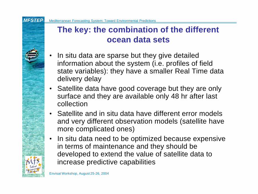
The key: the combination of the different ocean data sets
• In situ data are sparse but they give detailed information about the system (i.e. profiles of field state variables): they have a smaller Real Time data delivery delay
• Satellite data have good coverage but they are only surface and they are available only 48 hr after last collection
• Satellite and in situ data have different error models and very different observation models (satellite have more complicated ones)
• In situ data need to be optimized because expensive in terms of maintenance and they should be developed to extend the value of satellite data to increase predictive capabilities
Envisat Workshop, August 25-26, 2004
MFSTEP Mediterranean Forecasting System: Toward Environmental Predictions
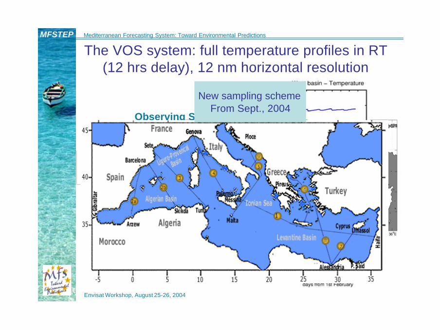
The VOS system: full temperature profiles in RT (12 hrs delay), 12 nm horizontal resolution
Positions of XBT launchesPeriod Sept 99 - Dec 00
Observing System Simulation Experiments
New sampling schemeFrom Sept., 2004

Envisat Workshop, August 25-26, 2004
MFSTEP Mediterranean Forecasting System: Toward Environmental Predictions
The fixed buoy array: Mediterranean Multisensor Moored Array-M3A
CTD
CTD
CTD
CTD
-150m
-250m
-350m
-500m
Nitrate Analyzer
MOORING 1MOORING 3 MOORING 2
ADCP
-500m
SEACAT:•CTD•Dissolved Oxygen•Transmissometer•Fluorimeter•PAR-sensor
1500m
WIND SPEED & DIRECTIONAIR PRESSURE & TEMPERATUREHUMIDITYWAVE HEIGHT & DIRECTION
ARGOS
-1,5m-30m
-25m~~~~~~~~~~~~~~~~~~~~~~~~~~~~~~~~~~~~~~~~~~
- 30m-50m-75m
-100m
10m
• An upper thermocline measurements network for cal/val of hydrodynamics and ecosystem models, 1 day data delivery delay

Envisat Workshop, August 25-26, 2004
MFSTEP Mediterranean Forecasting System: Toward Environmental Predictions
Descent to 700 m
For the Mediterraneandrifting depth
350 metersand five days
cycle
The MedARGO experiment: 25 floats unevenly launched from VOS, 1 day data delivery delay

Envisat Workshop, August 25-26, 2004
MFSTEP Mediterranean Forecasting System: Toward Environmental Predictions
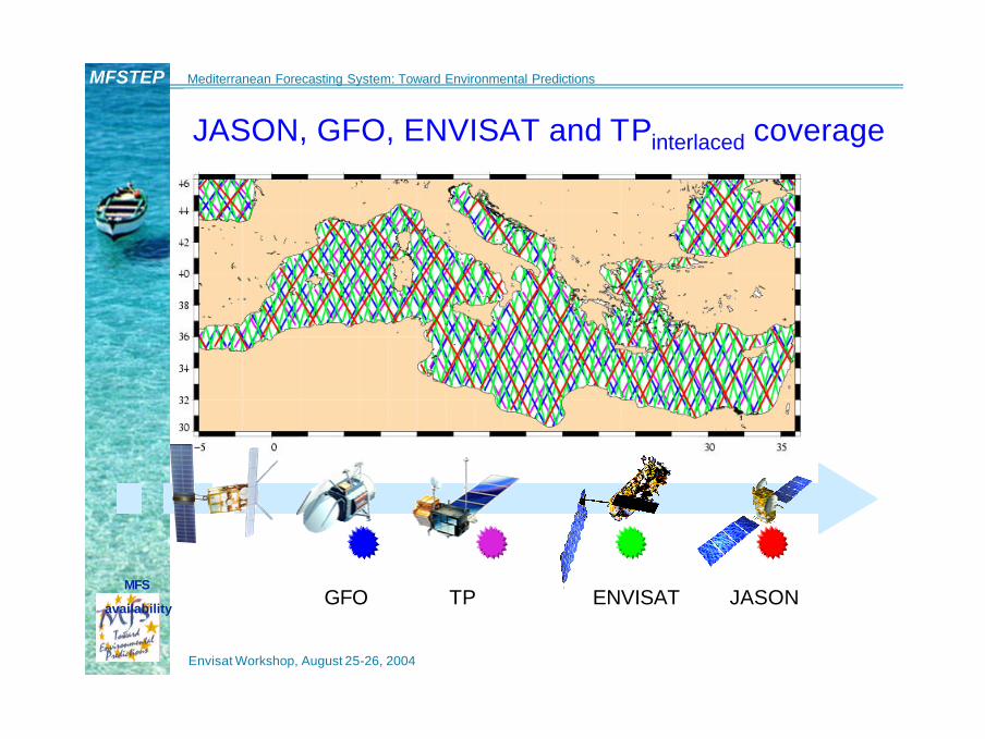
RT Altimeter Data Acquisition (CLS, Toulouse)
Jason IGDR: delay=24/48h, Oper.
TP : delay=?, Best Effort
ENVISAT : delay=48h, Operational
GFO: delay>72h, Best Effort
Envisat Workshop, August 25-26, 2004
MFSTEP Mediterranean Forecasting System: Toward Environmental Predictions
ENVISAT JASONTPGFOMFS
availability
JASON, GFO, ENVISAT and TPinterlaced coverage

Envisat Workshop, August 25-26, 2004
MFSTEP Mediterranean Forecasting System: Toward Environmental Predictions
Jason-1/GFO / ENVISAT / TPinterlaced integration
Objective Analysis error mapdone with different number
of satellites

Envisat Workshop, August 25-26, 2004
MFSTEP Mediterranean Forecasting System: Toward Environmental Predictions
Scatterometer data analysis in RT: blended product with NCEP analyses
Even the latestECMWF forecast modelcannot reproduce the
power in the high wavenumber range:
Scatterometer winds needed
to quantify uncertaintyin wind forcing
100 km 10 km50 km

Envisat Workshop, August 25-26, 2004
MFSTEP Mediterranean Forecasting System: Toward Environmental Predictions
The MFS operational system
MFS OGCM and atmospheric forcing
RT data, quality control and pre-processing
Intermittent data assimilation cycle
Initial condition for the forecast
Weekly 10 days forecasts
Envisat Workshop, August 25-26, 2004
MFSTEP Mediterranean Forecasting System: Toward Environmental Predictions
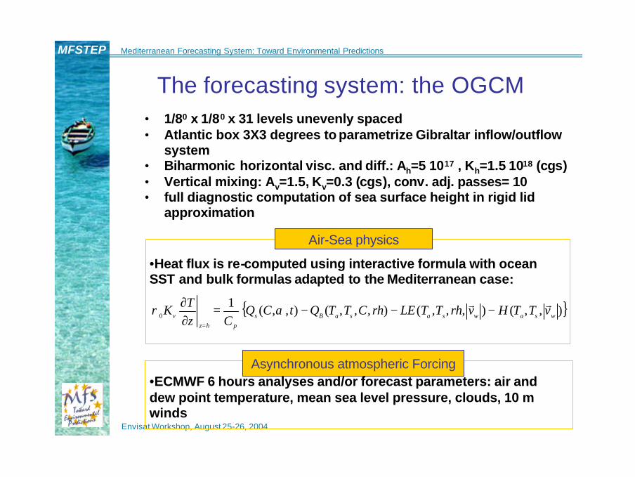
The forecasting system: the OGCM• 1/80 x 1/80 x 31 levels unevenly spaced• Atlantic box 3X3 degrees to parametrize Gibraltar inflow/outflow
system• Biharmonic horizontal visc. and diff.: Ah=5 1017 , Kh=1.5 1018 (cgs)• Vertical mixing: Av=1.5, Kv=0.3 (cgs), conv. adj. passes= 10• full diagnostic computation of sea surface height in rigid lid
approximation
Air-Sea physics
•Heat flux is re-computed using interactive formula with ocean SST and bulk formulas adapted to the Mediterranean case:
Asynchronous atmospheric Forcing•ECMWF 6 hours analyses and/or forecast parameters: air and dew point temperature, mean sea level pressure, clouds, 10 m winds
{ }),,(),,,(),,,(),,(10 wsawsasaBs
phzv vTTHvrhTTLErhCTTQtCQ
CzTK rr −−−=
∂∂
=
αρ
Envisat Workshop, August 25-26, 2004
MFSTEP Mediterranean Forecasting System: Toward Environmental Predictions
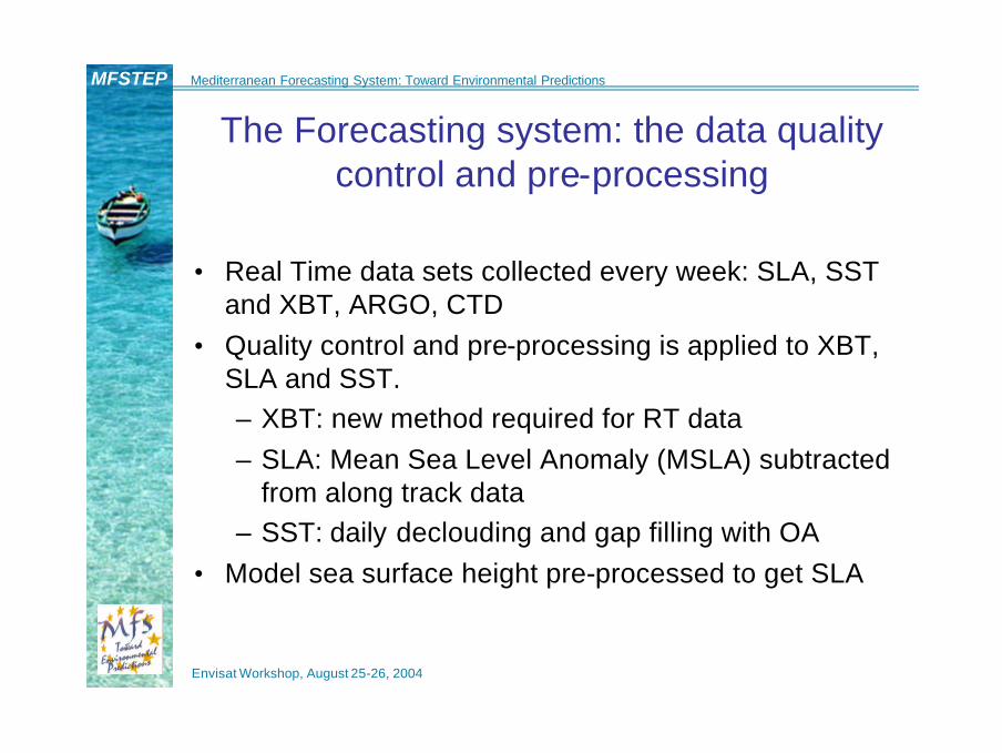
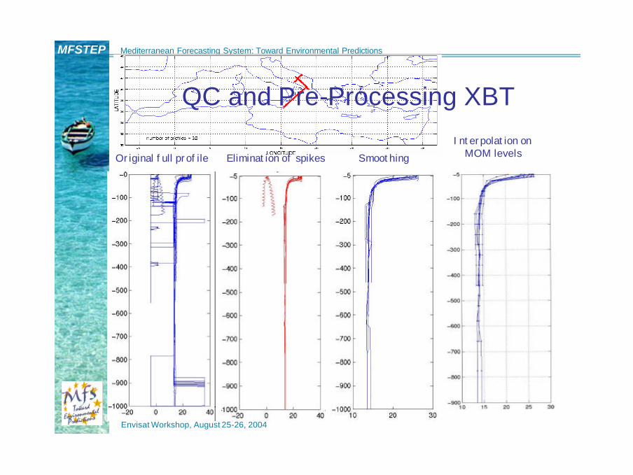
The Forecasting system: the data quality control and pre-processing
• Real Time data sets collected every week: SLA, SST and XBT, ARGO, CTD
• Quality control and pre-processing is applied to XBT, SLA and SST. – XBT: new method required for RT data– SLA: Mean Sea Level Anomaly (MSLA) subtracted
from along track data– SST: daily declouding and gap filling with OA
• Model sea surface height pre-processed to get SLA
Envisat Workshop, August 25-26, 2004
MFSTEP Mediterranean Forecasting System: Toward Environmental Predictions
Original full profile Elimination of spikes SmoothingInterpolation on
MOM levels
QC and Pre-Processing XBT

Envisat Workshop, August 25-26, 2004
MFSTEP Mediterranean Forecasting System: Toward Environmental Predictions
Pre-processing of SLA: de-biasing for volume changes
• A regression curve was found to fit the volume changes in the Mediterranean from T/P data (MSLA)
MSLA (cm)
Month
The MSLA is subtracted from along track data before assimilationsince model is rigid lid

Envisat Workshop, August 25-26, 2004
MFSTEP Mediterranean Forecasting System: Toward Environmental Predictions
Satellite daily SST is produced in RT fromnightime images with cloud detection:
field is interpolated on model gridwith objective analysis scheme
)( *
*
TTTQ
QQTT
corr −∂∂
−==
SST is inserted in the model as a heat flux correctionBefore declouding After declouding

Envisat Workshop, August 25-26, 2004
MFSTEP Mediterranean Forecasting System: Toward Environmental Predictions
The model data pre-processing: mean sea surface height from simulation
Envisat Workshop, August 25-26, 2004
MFSTEP Mediterranean Forecasting System: Toward Environmental Predictions
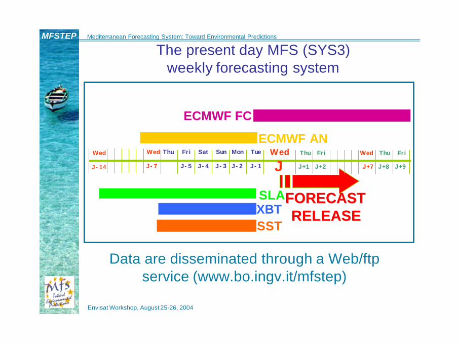
FORECASTFORECASTRELEASERELEASE
SLAXBTSST
ECMWF AN
ECMWF FC
J-7J-14 J-5 J-4 J-3 J-2 J-1
WedWed Thu Fri Sat Sun Mon Tue Thu Fri Wed Thu Fri
J+1 J+2 J+7 J+8 J+9JWed
Data are disseminated through a Web/ftp service (www.bo.ingv.it/mfstep)
The present day MFS (SYS3) weekly forecasting system
Envisat Workshop, August 25-26, 2004
MFSTEP Mediterranean Forecasting System: Toward Environmental Predictions
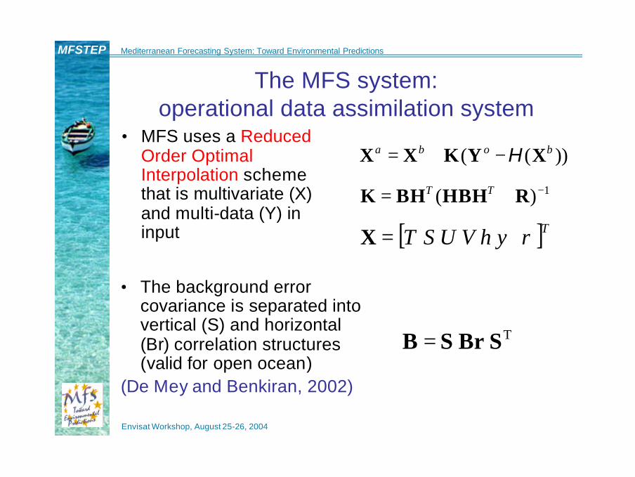
The MFS system: operational data assimilation system
• MFS uses a ReducedOrder OptimalInterpolation schemethat is multivariate (X) and multi-data (Y) in input
TSBrSB =
))(( boba XYKXX H−+=
1)( −+= RHBHBHK TT
[ ]TVUST ρψη=X
• The background error covariance is separated intovertical (S) and horizontal(Br) correlation structures(valid for open ocean)
(De Mey and Benkiran, 2002)

Envisat Workshop, August 25-26, 2004
MFSTEP Mediterranean Forecasting System: Toward Environmental Predictions
1*
ROOI
)~~
(~
~
−+=
=
RHSBrSHHSBrKr
KrSKTTTT
The order reduction is achieved because only a limitednumber of vertical modes are required in the ocean, thus:
Order reduction procedure for the B matrix
where contains a limited number of multivariate vertical EOFs. For the Mediterranean, the EOFs are calculated for 13 different regions
S~

Envisat Workshop, August 25-26, 2004
MFSTEP Mediterranean Forecasting System: Toward Environmental Predictions
The multivariate background error covariance matrix
• How is B defined?Tbb XXXXB ))(( −−=
Water mass properties
??S?T?TU
?SUSSSTS?TSTTT
B
′′′′′′′′
′′′′′′′′′′′′′′
=.......
..
Correlates SLAwith thermocline
and halocline
But practically TT XXXXXXB ′′=−−= ))(( ,,,, bobobobo
Important for T,S profiles
assimilation
Important for SLA Assimilation:
extrapolation to T,S corrections

Envisat Workshop, August 25-26, 2004
MFSTEP Mediterranean Forecasting System: Toward Environmental Predictions
What does it mean to assimilate SLA ?
Haines, 2002
In other words,SLA should induce
changes in T,S profiles
Envisat Workshop, August 25-26, 2004
MFSTEP Mediterranean Forecasting System: Toward Environmental Predictions
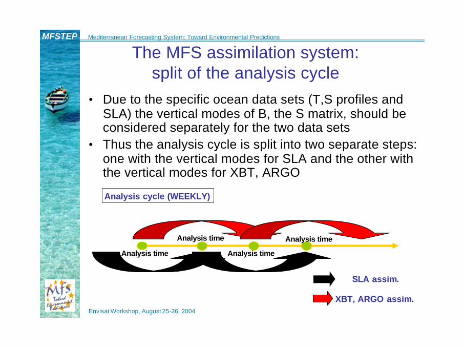
The MFS assimilation system: split of the analysis cycle
• Due to the specific ocean data sets (T,S profiles and SLA) the vertical modes of B, the S matrix, should be considered separately for the two data sets
• Thus the analysis cycle is split into two separate steps: one with the vertical modes for SLA and the other with the vertical modes for XBT, ARGO
SLA assim.
XBT, ARGO assim.
Analysis cycle (WEEKLY)
Analysis time
Analysis time
Analysis time
Analysis time
Envisat Workshop, August 25-26, 2004
MFSTEP Mediterranean Forecasting System: Toward Environmental Predictions
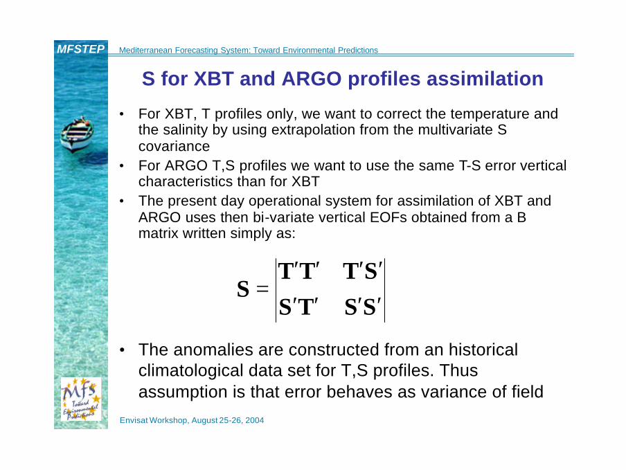
S for XBT and ARGO profiles assimilation
• For XBT, T profiles only, we want to correct the temperature andthe salinity by using extrapolation from the multivariate S covariance
• For ARGO T,S profiles we want to use the same T-S error vertical characteristics than for XBT
• The present day operational system for assimilation of XBT and ARGO uses then bi-variate vertical EOFs obtained from a B matrix written simply as:
SSTSSTTT
S′′′′′′′′
=
• The anomalies are constructed from an historical climatological data set for T,S profiles. Thus assumption is that error behaves as variance of field
Envisat Workshop, August 25-26, 2004
MFSTEP Mediterranean Forecasting System: Toward Environmental Predictions
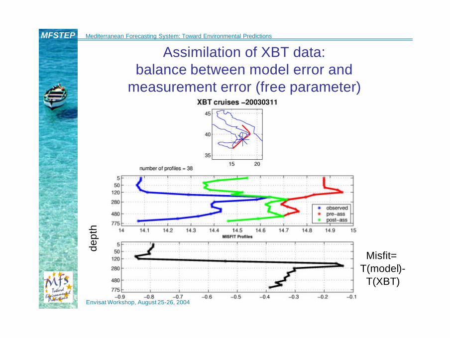
Assimilation of XBT data: balance between model error and
measurement error (free parameter)de
pth
Misfit= T(model)-
T(XBT)

Envisat Workshop, August 25-26, 2004
MFSTEP Mediterranean Forecasting System: Toward Environmental Predictions
B for SLA assimilation• On the basis of the a priori knowledge of the relevant
physical processes we know that the geostrophic sea level is written as (Pinardi et al., 1995):
−−= ∫ ∫− −
0 0
0
0
00 0 0
11
H H
dzH
zdzg
fH
ρρ
ρρ
ψη
Thus B should be:
?'?'?'? 'S'?'T'?'?'? '??S?T??'S'?SSSTS?'T'?TSTTT
B′′′′′′′′′′′′′′′′′′
=
• In this case we need to use the model data
Envisat Workshop, August 25-26, 2004
MFSTEP Mediterranean Forecasting System: Toward Environmental Predictions
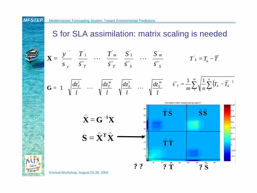
=
S
m
ST
m
T
SSTTσσσσσ
ψ
ψ
'1''
1''
LLX TTT kk −='
( )∑ ∑ −=m n
kkT TTnm 1 1
211σ
=
lz
lz
lz
lz m
SSmTT δδδδ LL
11
1G
XGX 1−=)
XXS T ))=
S for SLA assimilation: matrix scaling is needed
TT))
SS))
ST))
?? ))T?))
S?))

Envisat Workshop, August 25-26, 2004
MFSTEP Mediterranean Forecasting System: Toward Environmental Predictions
Eigenvalues and Percentage of Variance Explained-PVE
;*100
;; 2
1∑
=
==Λ= m
kk
iiji
T PVEEEλ
λδλ?S

Envisat Workshop, August 25-26, 2004
MFSTEP Mediterranean Forecasting System: Toward Environmental Predictions
The truncation error with 20 vertical multivariate EOF (over a maximum of 45):
root mean square error for temperature and salinity
Dep
th (
m)
temp [°C] sal [psu]
Envisat Workshop, August 25-26, 2004
MFSTEP Mediterranean Forecasting System: Toward Environmental Predictions
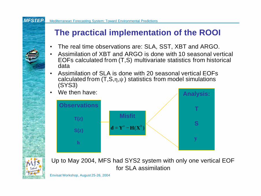
The practical implementation of the ROOI
• The real time observations are: SLA, SST, XBT and ARGO.• Assimilation of XBT and ARGO is done with 10 seasonal vertical
EOFs calculated from (T,S) multivariate statistics from historicaldata
• Assimilation of SLA is done with 20 seasonal vertical EOFscalculated from (T,S,η,ψ) statistics from model simulations(SYS3)
• We then have:
Observations
T(z)
S(z)
η
Analysis:
T
S
ψ
Misfit
)( bo XHYd −=
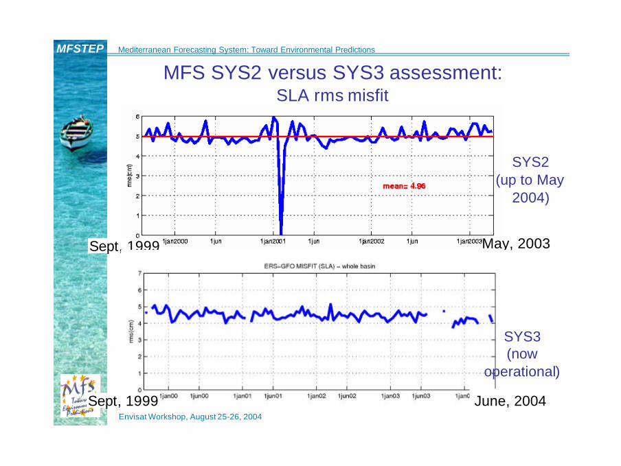
Up to May 2004, MFS had SYS2 system with only one vertical EOF for SLA assimilation
Envisat Workshop, August 25-26, 2004
MFSTEP Mediterranean Forecasting System: Toward Environmental Predictions
MFS SYS2 versus SYS3 assessment: SLA rms misfit
Sept, 1999 May, 2003
SYS2(up to May
2004)
June, 2004Sept, 1999
SYS3(now
operational)

Envisat Workshop, August 25-26, 2004
MFSTEP Mediterranean Forecasting System: Toward Environmental Predictions
Comparison between MFS SYS2 and SYS3: 1 vs 20 multivariate EOFs in SLA assimilation
Barotropicstream function on 22.08.2000.
SYS2
SYS3
Envisat Workshop, August 25-26, 2004
MFSTEP Mediterranean Forecasting System: Toward Environmental Predictions
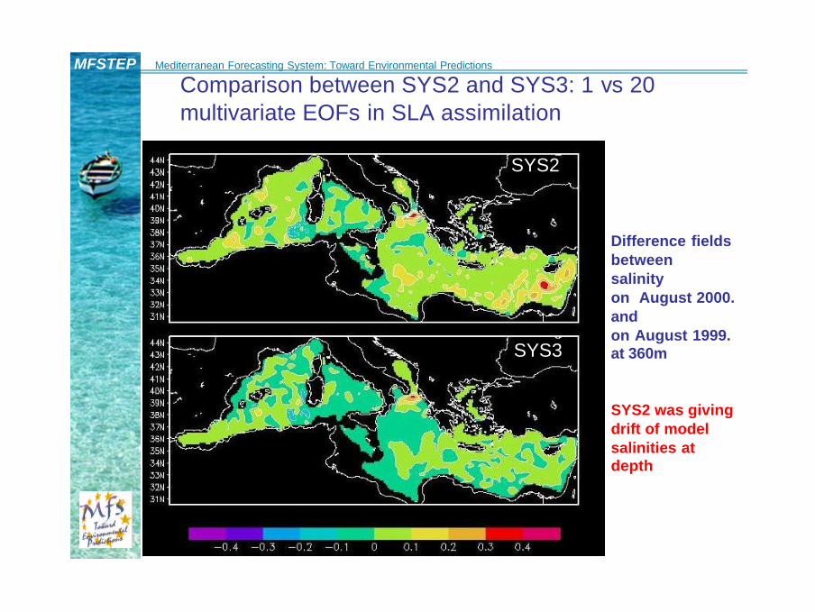
Comparison between SYS2 and SYS3: 1 vs 20 multivariate EOFs in SLA assimilation
Difference fieldsbetween salinity on August 2000. and on August 1999. at 360m
SYS2 was giving drift of model salinities at depth
SYS2
SYS3

Envisat Workshop, August 25-26, 2004
MFSTEP Mediterranean Forecasting System: Toward Environmental Predictions
SYS3 vsSYS2 :
RMS errorbetween ARGO and analyses
jan feb
mar apr
may
jun
dept
h
No salinity data has ever been
assimilated at this point,only extrapolation from
satellite altimetry
Envisat Workshop, August 25-26, 2004
MFSTEP Mediterranean Forecasting System: Toward Environmental Predictions
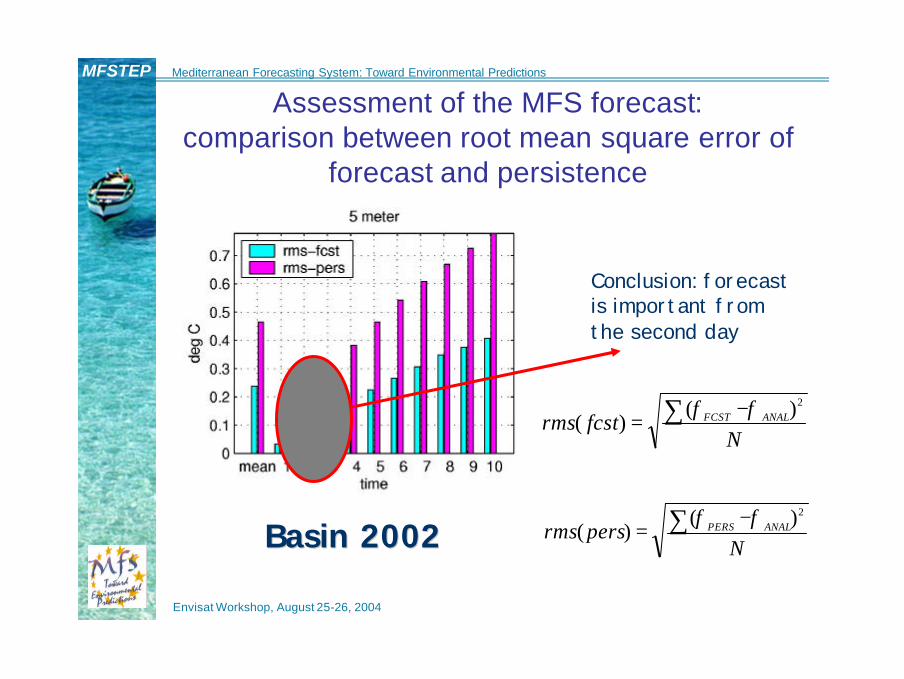
Conclusion: forecastis important fromthe second day
BasinBasin 20022002
Assessment of the MFS forecast: comparison between root mean square error of
forecast and persistence
Nfcstrms ANALFCST∑ −
=2)(
)(φφ
Npersrms ANALPERS∑ −
=2)(
)(φφ

Envisat Workshop, August 25-26, 2004
MFSTEP Mediterranean Forecasting System: Toward Environmental Predictions
Quality assessment: SLA misfit on a single track
forecastObserv.

Envisat Workshop, August 25-26, 2004
MFSTEP Mediterranean Forecasting System: Toward Environmental Predictions
MFSTEP OGCMOPA 8.1, implicit free surface1/16º x 1/16º horizontal grid71 vertical levels (1.5-
5000m)49 islands
MFS1671
BATHYMETRY (m)
MFSPP OGCMMOM 1.1, rigid lid1/8º x 1/8º horizontal grid31 vertical levels (5-
3850m)9 islands
MFS831
BATHYMETRY (m)
MFSTEP UPGRADE: new basin scale model

Envisat Workshop, August 25-26, 2004
MFSTEP Mediterranean Forecasting System: Toward Environmental Predictions
Conclusions and future outlook• Ten days basin scale forecasting activities are possible with
assimilation of combined in situ and satellite data: forecast is quite accurate and RT data delivery is sufficient for weekly assimilation cycle
• Future developments foreseen:– Increase the model resolution and the quality of physical
parameterizations. In particular: vertical mixing, air-sea interaction physics, etc.
– Add physical processes to have more realistic hydrodynamics: free surface (water budget), tides, atmospheric pressure forcing, non-Boussinesq effects, etc.
– Increase temporal and horizontal resolution of meteorological forcing: 10 km, hourly meteorological parameters, use of scatterometer data in assimilation cycle
– Increase frequency of assimilation cycle: one-two days cycle with plus or minus two days window for repeated data insertion
– Need to improve satellite data pre-processing algorithms (declouding, MSLA correction, geoid, long wavelength error on the track, etc.)
– Insert SST in the smoother and filter assimilation cycle controlling the effects of subsurface extrapolation