The marine cadastre’s boundary issues › resources › proceedings › fig_proceedings ›...
22
Accurate Low-Water Line Determination: The Influence of Malaysia’s Legislation and Coastal Policies on Maritime Baseline Integrity Robin Seet, Department of Survey & Mapping Malaysia (JUPEM) David Forrest, Jim Hansom, University of Glasgow “Come gather ‘round people wherever you roam and admit that the waters around you have grown and accept it that soon you'll be drenched to the bone If your time to you is worth saving” [email protected] FIG 2014 • No physical evidence (Carrera, 1999) • Migratory baseline over time. • Two types of spatial concerns on the sea: – 3D location of a marine parcel – Maritime rights of a designated target group • Malaysia’s scenario: – Normal Baseline has not been survey to meet marine cadastre requirement. – Different low-water datum adopted for cadastre and international maritime boundary. The marine cadastre’s boundary issues. XXV International Federation of Surveyors Congress, Kuala Lumpur, Malaysia, 16 –21 June 2014
Transcript of The marine cadastre’s boundary issues › resources › proceedings › fig_proceedings ›...

Accurate Low-Water Line Determination: The Influence of
Malaysia’s Legislation and Coastal Policies on Maritime Baseline Integrity
Robin Seet, Department of Survey & Mapping Malaysia (JUPEM)
David Forrest, Jim Hansom, University of Glasgow
“Come gather ‘round people wherever you roam and ad mit that the waters around you have grownand accept it that soon you'll be drenched to the b one If your time to you is worth saving”
FIG 2014
• No physical evidence (Carrera, 1999)
• Migratory baseline over time.
• Two types of spatial concerns on the sea:
– 3D location of a marine parcel
– Maritime rights of a designated target group
• Malaysia’s scenario:
– Normal Baseline has not been survey to meet
marine cadastre requirement.
– Different low-water datum adopted for cadastre
and international maritime boundary.
The marine cadastre’s boundary issues.
XXV International Federation of Surveyors
Congress, Kuala Lumpur, Malaysia, 16 – 21
June 2014

• Part 1:
– Developing a methodology to determine the low-
water line
– Case study results
• Part 2:
– Policy proposed to sustain the low-water line
Presentation Outline
XXV International Federation of Surveyors
Congress, Kuala Lumpur, Malaysia, 16 – 21
June 2014
Research methodology
XXV International Federation of Surveyors
Congress, Kuala Lumpur, Malaysia, 16 – 21
June 2014

rocky, clear, steep , sandy, flat
Case Study Area: Kames Bay, Milllport, Scotland.
XXV International Federation of Surveyors
Congress, Kuala Lumpur, Malaysia, 16 – 21
June 2014
4930 Bathymetric survey points
collected
5606 DGPS survey points
collected
DGPS & bathymetry survey at Kames Bay
Overlapping area
XXV International Federation of Surveyors
Congress, Kuala Lumpur, Malaysia, 16 – 21
June 2014

Generation of DGPS DTM
1
2
3
XXV International Federation of Surveyors
Congress, Kuala Lumpur, Malaysia, 16 – 21
June 2014
1
2
3
Generation of Bathymetric DTM
XXV International Federation of Surveyors
Congress, Kuala Lumpur, Malaysia, 16 – 21
June 2014
DTM Vertical DATUM
Quoted Vertical Accuracies
Elevation Range
(H: High, L: Low)
No Data value in DTM represented by:
% of No Data Value in Kames Bay
DGPS
(0.5 m resolution)
ODN (OSGM91)
0.020 m + 1 ppm, kinematic (Leica
Geosystems, 2006)
H: 5.45,
L: -1.98
N/A N/A
NEXTMap
(5m resolution)
ODN (OSGM91)
~1m (Hall & Tragheim, 2010,
INTERMAP, 2004)
H: 149.4,
L: -10
0 63%
Bathymetric
(0.5 m resolution)
ODN (OSGM91)
0.025m (Euronet, n.d.)
H: 1.13,
L: -8.31
N/A 64%
DTM Comparison.
XXV International Federation of Surveyors
Congress, Kuala Lumpur, Malaysia, 16 – 21
June 2014
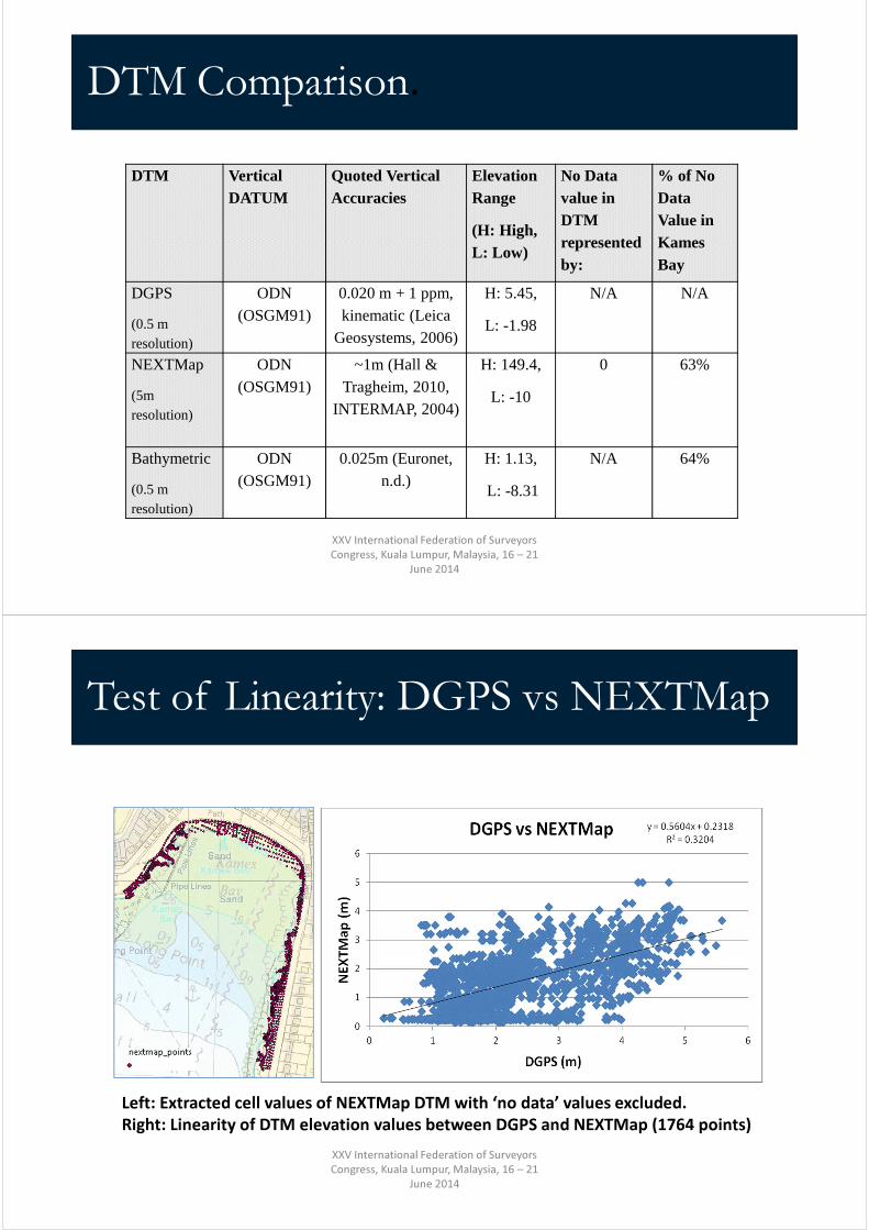
Test of Linearity: DGPS vs NEXTMap
Left: Extracted cell values of NEXTMap DTM with ‘no data’ values excluded.
Right: Linearity of DTM elevation values between DGPS and NEXTMap (1764 points)
XXV International Federation of Surveyors
Congress, Kuala Lumpur, Malaysia, 16 – 21
June 2014

Test of Linearity: DGPS vs Bathymetry
Left: Extracted cell values of bathymetric DTM with ‘no data’ values excluded.
Right: Linearity of DTM elevation values between DGPS and bathymetric DTM (1704
points) XXV International Federation of Surveyors
Congress, Kuala Lumpur, Malaysia, 16 – 21
June 2014
DTM Comparison.
Statistics of the difference between DGPS points and other DTMs
(DGPS points subtracting other DTM points)
DTM ∆ Min ∆ Max Mean RMSE Correlation*
NEXTMap -2.6784 3.7714 0.8319 1.2910 0.5660
Bathymetric -1.8032 3.1258 0.1461 0.3918 0.8732
*Note: the correlation is between the original data values rather than the ‘difference’.
XXV International Federation of Surveyors
Congress, Kuala Lumpur, Malaysia, 16 – 21
June 2014
-4
-2
0
2
4
6
8
10
12
0 100 200 300 400 500 600 700
Elevation
Distance
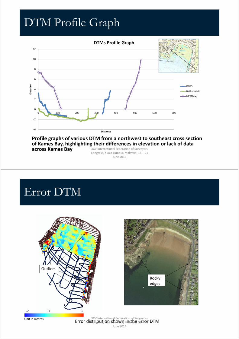
DTMs Profile Graph
DGPS
Bathymetric
NEXTMap
DTM Profile Graph
Profile graphs of various DTM from a northwest to southeast cross section of Kames Bay, highlighting their differences in elevation or lack of data across Kames Bay XXV International Federation of Surveyors
Congress, Kuala Lumpur, Malaysia, 16 – 21
June 2014
Error DTM
Outliers
Rocky
edges
Error distribution shown in the Error DTM Unit in metres
-2 30
XXV International Federation of Surveyors
Congress, Kuala Lumpur, Malaysia, 16 – 21
June 2014
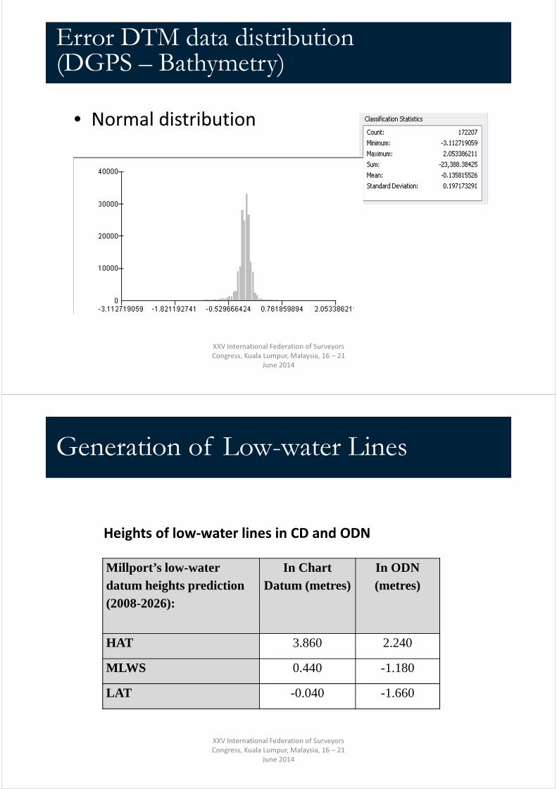
• Normal distribution
Error DTM data distribution (DGPS – Bathymetry)
XXV International Federation of Surveyors
Congress, Kuala Lumpur, Malaysia, 16 – 21
June 2014
Millport’s low-water datum heights prediction (2008-2026):
In Chart Datum (metres)
In ODN (metres)
HAT 3.860 2.240
MLWS 0.440 -1.180
LAT -0.040 -1.660
Generation of Low-water Lines
Heights of low-water lines in CD and ODN
XXV International Federation of Surveyors
Congress, Kuala Lumpur, Malaysia, 16 – 21
June 2014

Highest Astronomical Tide (HAT)
NEXTMapDGPS
OS MAP
XXV International Federation of Surveyors
Congress, Kuala Lumpur, Malaysia, 16 – 21
June 2014
Highest Astronomical Tide (HAT)
NEXTMap
HAT
SEPA flood warning target areaXXV International Federation of Surveyors
Congress, Kuala Lumpur, Malaysia, 16 – 21
June 2014

Mean Low Water Spring (MLWS)
Integrated DTM of DGPS & Bathymetric Data
XXV International Federation of Surveyors
Congress, Kuala Lumpur, Malaysia, 16 – 21
June 2014
Mean Low Water Spring (MLWS)
(a) (b) (c)
(a) MLWS from the bathymetric DTM.
(b) MLWS from the DGPS DTM.
(c) MLWS from the integrated DTM
OS Map’s
MLWS
XXV International Federation of Surveyors
Congress, Kuala Lumpur, Malaysia, 16 – 21
June 2014

Mean Low Water Spring (MLWS)
Comparison of the generated MLWS with the current MLWS shown on OS map
MLWS shifted
landward ~12m
between 1962-
2012
OS
MLWS
since
19622012 MLWS
from DGPS
DTM
XXV International Federation of Surveyors
Congress, Kuala Lumpur, Malaysia, 16 – 21
June 2014
Mean Low Water Spring (MLWS)
Before 1962:
The same
LWMOST
indicated in
OS map since
1890s
After 1962: OS Map
adopted MLWS
shifted
seaward ~
35m in
approximately
70 years
Historical position of LWMOST and MLWS at Kames Bay
XXV International Federation of Surveyors
Congress, Kuala Lumpur, Malaysia, 16 – 21
June 2014

Shift noticed in LAT location when compared to admiralty chart
Lowest Astronomical Tide (LAT)
~72m~94m
OS MAP
Admiralty Chart 5610.1
Charts
LAT since
1940
Surveyed
LAT 2012
XXV International Federation of Surveyors
Congress, Kuala Lumpur, Malaysia, 16 – 21
June 2014
HAT, MLWS & LAT
HAT
2012
OS’
MHWS
surveyed
in 1965
MLWS
2012
Charts LAT
surveyed in
1940
OS Map
Admiralty Chart 5610.1
LAT
2012OS’ MLWS
surveyed
in 1962
XXV International Federation of Surveyors
Congress, Kuala Lumpur, Malaysia, 16 – 21
June 2014

• 85% of high and low water predicted were
accurate within ten minutes and within one
foot (~0.3 m) (Baily, 2009).
Different between observed and predicted tide value
Date Time
Observed
Sea Level
Predicted
Sea LevelResidual
02/02/2010 02:30:00 3.401 3.371 0.03
02/02/2010 14:30:00 3.849 3.871 -0.022
03/02/2010 03:15:00 3.186 3.363 -0.177
03/02/2010 15:00:00 3.87 3.86 0.01XXV International Federation of Surveyors
Congress, Kuala Lumpur, Malaysia, 16 – 21
June 2014
• Low RMSE values indicate that the difference
between the observed tide and prediction is
rather small, and so the prediction is very
accurate.
Statistics of comparisons showing the differences between observed high tide and the predicted tide (Observed subtracting prediction)
Different between observed and predicted tide value
Day ∆ Min ∆ Max Mean RMSE
2/2/10 -0.102 0.13 0.0076 0.0643
3/2/10 -0.177 0.251 -0.0127 0.1026
Month ∆ Min ∆ Max Mean RMSE
February --0.0009 0.369 -0.391 0.1603
XXV International Federation of Surveyors
Congress, Kuala Lumpur, Malaysia, 16 – 21
June 2014

UKCP09 projection by DEFRA for a 95% high estimate emissions scenario for Millport.
Sea-level change rates and future estimates
XXV International Federation of Surveyors
Congress, Kuala Lumpur, Malaysia, 16 – 21
June 2014
• A government funded marine LiDAR
campaign to survey the whole
coastline.
• Enhancing tide gauge station density
Recommendations for applying the maritime baseline determination method
XXV International Federation of Surveyors
Congress, Kuala Lumpur, Malaysia, 16 – 21
June 2014
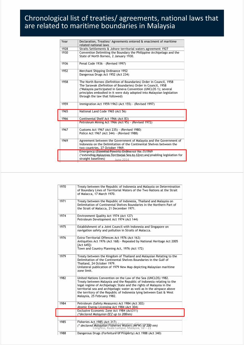
Chronological list of treaties/ agreements, national laws that are related to maritime boundaries in Malaysia
Year Declaration, Treaties/ Agreements entered & enactment of maritime related national laws
1928 Straits Settlements & Johore territorial waters agreement 1927
1930 Convention Delimiting the Boundary the Philippine Archipelago and the State of North Borneo, 2 January 1930.
1936 Penal Code 1936 – (Revised 1997)
1952 Merchant Shipping Ordinance 1952 Dangerous Drugs Act 1952 (Act 234)
1958 The North Borneo (Definition of Boundaries) Order in Council, 1958 The Sarawak (Definition of Boundaries) Order in Council, 1958 (*Malaysia participated in Geneva Convention (UNCLOS 1); several principles embodied in it were duly adopted into Malaysian legislation through the law that followed)
1959 Immigration Act 1959/1963 (Act 155) - (Revised 1997)
1965 National Land Code 1965 (Act 56)
1966 Continental Shelf Act 1966 (Act 83) Petroleum Mining Act 1966 (Act 95) - (Revised 1972)
1967 Customs Act 1967 (Act 235) - (Revised 1980) Police Act 1967 (Act 344) - (Revised 1988)
1969 Agreement between the Government of Malaysia and the Government of Indonesia on the Delimitation of the Continental Shelves between the two countries, 27 October 1969. Emergency (Essential Powers) Ordinance No. 7/1969 (*extending Malaysian Territorial Sea to 12nm and enabling legislation for straight baselines)
XXV International Federation of Surveyors
Congress, Kuala Lumpur, Malaysia, 16 – 21
June 2014
1970 Treaty between the Republic of Indonesia and Malaysia on Determination of Boundary Lines of Territorial Waters of the Two Nations at the Strait of Malacca, 17 March 1970.
1971 Treaty between the Republic of Indonesia, Thailand and Malaysia on Delimitation of Continental Shelves Boundaries in the Northern Part of the Strait of Malacca, 21 December 1971.
1974 Environment Quality Act 1974 (Act 127) Petroleum Development Act 1974 (Act 144)
1975 Establishment of a Joint Council with Indonesia and Singapore on navigation safety and pollution in Straits of Malacca.
1976 Extra-Territorial Offences Act 1976 (Act 163) Antiquities Act 1976 (Act 168) - Repealed by National Heritage Act 2005 [Act 645]) Town and Country Planning Act, 1976 (Act 172)
1979 Treaty between the Kingdom of Thailand and Malaysian Relating to the Delimitation of the Continental Shelves Boundaries in the Gulf of Thailand, 24 October 1979. Unilateral publication of 1979 New Map depicting Malaysian maritime zone limit.
1982 United Nations Convention on the Law of the Sea (UNCLOS) 1982. Treaty between Malaysia and the Republic of Indonesia relating to the legal regime of Archipelagic State and the rights of Malaysia in the territorial sea and archipelagic water as well as in the airspace above the territory of the Republic of Indonesia lying between East & West Malaysia, 25 February 1982.
1984 Petroleum (Safety Measures) Act 1984 (Act 302) Atomic Energy Licensing Act 1984 (Act 304) Exclusive Economic Zone Act 1984 (Act311) (*declared Malaysian EEZ up to 200nm)
1985 Fisheries Act 1985 (Act 317) (* declared Malaysian Fisheries Waters (MFW) of 200 nm)
1988 Dangerous Drugs (Forfeiture of Property) Act 1988 (Act 340)
XXV International Federation of Surveyors
Congress, Kuala Lumpur, Malaysia, 16 – 21
June 2014

1990 Malaysian-Thailand Joint Development Authority Act 1990 (Act 440)
1992 Tourism Industry Act, 1992 (Act 482)
1994 Merchant Shipping (Oil Pollution) Act 1994 (Act 515) Mineral Development Act 1994 (Act 525)
1995 Agreement between the Government of Malaysia and the Republic of Singapore to delimit precisely the territorial waters boundary in accordance with the Straits Settlements & Johore territorial waters agreement 1927, 7 August 1995.
1996 *Malaysia’s declaration upon ratification of UNCLOS III.
2004 Malaysian Maritime Enforcement Agency Act (Act 633)
2006 Baselines Of Maritime Zones Act 2006 (Act 660)
2010-Current
Drafting of National Geospatial Act
2012 Territorial Sea Act 2012
Source: modified from United States Department of Defence, 2005 and MKN, 2010. *This list is
not exhaustive.
XXV International Federation of Surveyors
Congress, Kuala Lumpur, Malaysia, 16 – 21
June 2014
Maritime related national laws’ interaction with the maritime boundary
Act How is it related to/rely on maritime baseline/ boundary?
Are there any provisions inside these Acts that might possibly alter/affect the maritime baseline/ boundary position?
Penal Code 1936 This Act relies on knowledge of maritime boundary to determine whether a crime is committed within Malaysia’s boundary (Sec.3, Sec.4), etc.
No provision that will affect the maritime boundary.
Merchant Shipping Ordinance 1952
This Act relies on knowledge of maritime baseline to determine territory limits prescribed for ships, limits of Federations waters, etc.
No provision that will affect the maritime boundary.
Dangerous Drugs Act 1952 (Act 234)
This Act relies on knowledge of maritime boundary to determine whether possession of dangerous drug is in or abroad of the waters of Malaysia; to inspect and seize by boarding any ship or aircraft remains in Malaysia (Sec.27); to demand reporting of concealing dangerous drug at the earliest opportunity while entering Malaysia territorial waters (Sec. 38(3)); etc.
No provision that will affect the maritime boundary.
Immigration Act 1959/1963 (Act 155)
This Act relies on knowledge of maritime boundary to determine the instance of entering or departing from Malaysia; power to seize, detain & forfeit vessels, vehicles or aircraft in the territorial waters of Malaysia (Sec.49A); etc.
No provision that will affect the maritime boundary.
National Land Code 1965 (Act 56)
This Act does not rely on knowledge of maritime boundary; instead it defines the limit of land cadastre, foreshore, shoreline, state land etc., which are crucial to the definition of maritime boundary.
Sec.5 definition of foreshore, shoreline determines states maritime limit.
Continental Shelf Act 1966 (Act 83)
This Act relies on knowledge of maritime baseline to determine continental shelf limit from the baseline.
No provision that will affect the maritime boundary.
XXV International Federation of Surveyors
Congress, Kuala Lumpur, Malaysia, 16 – 21
June 2014
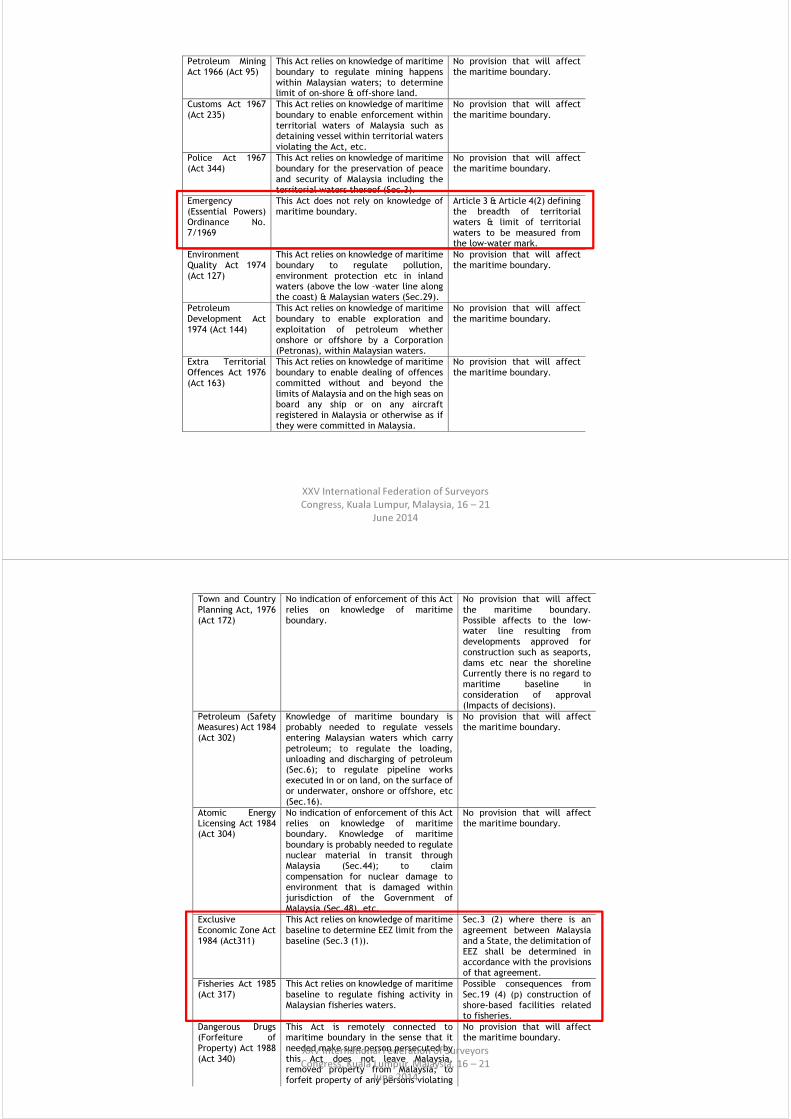
Petroleum Mining Act 1966 (Act 95)
This Act relies on knowledge of maritime boundary to regulate mining happens within Malaysian waters; to determine limit of on-shore & off-shore land.
No provision that will affect the maritime boundary.
Customs Act 1967 (Act 235)
This Act relies on knowledge of maritime boundary to enable enforcement within territorial waters of Malaysia such as detaining vessel within territorial waters violating the Act, etc.
No provision that will affect the maritime boundary.
Police Act 1967 (Act 344)
This Act relies on knowledge of maritime boundary for the preservation of peace and security of Malaysia including the territorial waters thereof (Sec.3).
No provision that will affect the maritime boundary.
Emergency (Essential Powers) Ordinance No. 7/1969
This Act does not rely on knowledge of maritime boundary.
Article 3 & Article 4(2) defining the breadth of territorial waters & limit of territorial waters to be measured from the low-water mark.
Environment Quality Act 1974 (Act 127)
This Act relies on knowledge of maritime boundary to regulate pollution, environment protection etc in inland waters (above the low –water line along the coast) & Malaysian waters (Sec.29).
No provision that will affect the maritime boundary.
Petroleum Development Act 1974 (Act 144)
This Act relies on knowledge of maritime boundary to enable exploration and exploitation of petroleum whether onshore or offshore by a Corporation (Petronas), within Malaysian waters.
No provision that will affect the maritime boundary.
Extra Territorial Offences Act 1976 (Act 163)
This Act relies on knowledge of maritime boundary to enable dealing of offences committed without and beyond the limits of Malaysia and on the high seas on board any ship or on any aircraft registered in Malaysia or otherwise as if they were committed in Malaysia.
No provision that will affect the maritime boundary.
XXV International Federation of Surveyors
Congress, Kuala Lumpur, Malaysia, 16 – 21
June 2014
Town and Country Planning Act, 1976 (Act 172)
No indication of enforcement of this Act relies on knowledge of maritime boundary.
No provision that will affect the maritime boundary. Possible affects to the low-water line resulting from developments approved for construction such as seaports, dams etc near the shoreline Currently there is no regard to maritime baseline in consideration of approval (Impacts of decisions).
Petroleum (Safety Measures) Act 1984 (Act 302)
Knowledge of maritime boundary is probably needed to regulate vessels entering Malaysian waters which carry petroleum; to regulate the loading, unloading and discharging of petroleum (Sec.6); to regulate pipeline works executed in or on land, on the surface of or underwater, onshore or offshore, etc (Sec.16).
No provision that will affect the maritime boundary.
Atomic Energy Licensing Act 1984 (Act 304)
No indication of enforcement of this Act relies on knowledge of maritime boundary. Knowledge of maritime boundary is probably needed to regulate nuclear material in transit through Malaysia (Sec.44); to claim compensation for nuclear damage to environment that is damaged within jurisdiction of the Government of Malaysia (Sec.48), etc.
No provision that will affect the maritime boundary.
Exclusive Economic Zone Act 1984 (Act311)
This Act relies on knowledge of maritime baseline to determine EEZ limit from the baseline (Sec.3 (1)).
Sec.3 (2) where there is an agreement between Malaysia and a State, the delimitation of EEZ shall be determined in accordance with the provisions of that agreement.
Fisheries Act 1985 (Act 317)
This Act relies on knowledge of maritime baseline to regulate fishing activity in Malaysian fisheries waters.
Possible consequences from Sec.19 (4) (p) construction of shore-based facilities related to fisheries.
Dangerous Drugs (Forfeiture of Property) Act 1988 (Act 340)
This Act is remotely connected to maritime boundary in the sense that it needed make sure person persecuted by this Act does not leave Malaysia, removed property from Malaysia; to forfeit property of any persons violating this Act in Malaysia; to give assistance to
No provision that will affect the maritime boundary.
XXV International Federation of Surveyors
Congress, Kuala Lumpur, Malaysia, 16 – 21
June 2014

Mineral Development Act 1994 (Act 525)
No indication of enforcement of this Act relies on knowledge of maritime boundary. Knowledge of maritime boundary is probably needed to regulate mining in or under the sea or sea-bed within Malaysian waters.
No provision that will affect the maritime boundary. Possible affects to the low-water line come from mining activities changing the bathymetry of the sea bed , altering beach dynamics causing erosion, etc.
Malaysian Maritime Enforcement Agency Act (Act 633)
This Act relies on knowledge of maritime boundary for ensuring the safety and security of the Malaysian Maritime Zone with a view to the protection of maritime and other national interests in such zone and for matters necessary thereto or connected therewith.
No provision that will affect the maritime boundary.
National Heritage Act 2005 [Act 645])
This Act relies on knowledge of maritime boundary to determine whether an underwater cultural heritage is situated in Malaysian waters.
No provision that will affect the maritime boundary.
Baselines Of Maritime Zones Act 2006 (Act 660)
This Act does not rely on knowledge of maritime boundary. It is an Act that defines the characteristic of Malaysian maritime baseline and all maritime zones shall be measure from it.
Sec. 4, 6 & 9: The Yang di-Pertuan Agong, on the recommendation of the Minister may declare the geographical coordinates of base points; declare the outer limit lines or the lines of delimitation of the whole or any part of any of the maritime zones of Malaysia; cause to be prepared and issued any map or large-scale chart showing the above. In addition, the Minister may make regulations as may be necessary or expedient for giving full effect to the provisions of this Act.
XXV International Federation of Surveyors
Congress, Kuala Lumpur, Malaysia, 16 – 21
June 2014
Activities and authorities involved in coastal area and their potential impacts on maritime baseline
Activities Administration and enforcement
Legislation/ Policies/ Guidelines Activities’ impacts on the maritime baseline
Port MOT, MD, Federal & State PA, etc.
Merchant Shipping Act 1952; Fisheries Act 1985 (Act 317); Port Authorities Act 1963; Port Privatisation Act 1990; Penang Port Commission Act 1955; Bintulu Port Authority Act 1981; Sabah Port Authority Enactment 1967; etc.
Likely from construction work, etc.
Fisheries & living resources
DOF, etc. Fisheries Act 1985; Fisheries (Maritime) (Licensing of Local Fishing Vessel) Regulations, 1985; Fisheries Comprehensive Licensing Policy; Fisheries (Marine Culture System) Regulations, 1990; Fisheries (Cockles Conservation and Culture) Regulations, 2002; Exclusive Economic Zone Act 1984 (Act311); etc.
Likely from construction of fisheries port, etc.
Other marine industries/ non-living resources
DDGLM, etc. Mineral Development Act 1994 (Act 525); Continental Shelf Act 1966 (Act 83); etc.
Likely from near coastal mining activities
XXV International Federation of Surveyors
Congress, Kuala Lumpur, Malaysia, 16 – 21
June 2014

Coastal zone management
DID, DOF Environment Quality Act 1974 (Act 127); Environmental Impact Assessment Order 1987; General Circular 5/1987, etc.
Likely from coastal rehabilitation action
Reclamation & dredging
MOT, DOE, DID, MD, Federal & State PA, etc.
Environment Quality Act 1974 (Act 127); Environmental Impact Assessment Order 1987; General Circular 5/1987; etc.
Likely from accretion, erosion etc.
Development/ Construction
JPBDSM, etc. Town and Country Planning Act, 1976 (Act 172); EIA Guidelines for Coastal Resort and Development Projects; etc.
Likely from coastal development projects.
Source: excerpted and modified from Saharuddin (2001)
XXV International Federation of Surveyors
Congress, Kuala Lumpur, Malaysia, 16 – 21
June 2014
Other Coastal Management InitiativesDate Initiatives 1984-1985
National Coastal Erosion Study
1986-1992
South Johore coastal resource management project with United States Agency for International Development (USAID)
1987 • Government circular on coastal development • Environment Impact Assessment Order 1987
1991-1996
National Coastal Resource Management Policy (NCRM)
1993 National Conservation Strategies prepared by WWF 1995 Study towards developing a National Integrated Ocean Policy by Maritime
Institute of Malaysia (MIMA) 1996 National Aquaculture Guidelines 1997 • Town & Country Planning Department Guidelines on Coastal
Development • Department of Irrigation and Drainage Guideline on Coastal Zone Management
• Integrated management Plan for sustainable use of Johore Mangrove Forests
• Environment Profile of the Malacca Straits under the GEF/UNDP/IMO Regional Programme
1997-2000
Pilot Integrated Coastal Zone management (ICZM) projects in Sabah, Sarawak and Penang
1998-present
Drafting of the National Wetlands Policy
1999 Department of Environment Guideline for environmental impact assessment in coastal zone development projects
1999-2004
National coastal zone policy initiative (NICZM)
2001-present
Preparation for an Integrated Shoreline Management Plan (ISMP) for beach conservation and restoration
2001-2004
Integrated Coastal Management pilot study in Klang, Selangor under the GEF/UNDP/IMO/PEMSEA Regional Programme
2010 Malaysia Ocean Policy 2011-2020 by the National Oceanography Directorate 2012 National Coastal Zone Physical Plan (NCZPP) by Federal Department of
Town & Country Planning Peninsular Malaysia
Source: excerpted and updated from
Mokhtar & Ghani Aziz (2003).
XXV International Federation of Surveyors
Congress, Kuala Lumpur, Malaysia, 16 – 21
June 2014

Contents
• Introduction
• Background
• Policy Statement
• Policy Rationale
• Policy Principles
• Policy Objectives
• Strategic Action Plan
• Glossary
XXV International Federation of Surveyors
Congress, Kuala Lumpur, Malaysia, 16 – 21
June 2014
Sustaining the integrity of the maritime baseline
by ensuring low-water line stability for effective
management of the federal – local states’
maritime boundaries.
Policy Statement
XXV International Federation of Surveyors
Congress, Kuala Lumpur, Malaysia, 16 – 21
June 2014

• Up to date low-water line
information for integrated
decision making
• Low-water line sustainability
• collaborative governance
Policy Principles
XXV International Federation of Surveyors
Congress, Kuala Lumpur, Malaysia, 16 – 21
June 2014
• Determining the federal – local states’ maritime
boundary
• Develop a comprehensive maritime baseline
information system
• Establish a comprehensive maritime baseline revision
mechanism
• Preventing loss of maritime jurisdiction
• Integrated administrative and institutional mechanism
• Facilitate the harmonisation of existing policies to
address maritime boundary concern
Strategic Action Plan
XXV International Federation of Surveyors
Congress, Kuala Lumpur, Malaysia, 16 – 21
June 2014

“Thank you”
XXV International Federation of Surveyors
Congress, Kuala Lumpur, Malaysia, 16 – 21
June 2014