The Key Remember, that the symbols are relevant only to the map you are using! Symbols change across...
16
The Key • Remember, that the symbols are relevant only to the map you are using! • Symbols change across different manufacturers maps, and may even change across different versions! • If in doubt about a symbol, check the key!
-
Upload
timothy-gibson -
Category
Documents
-
view
214 -
download
0
Transcript of The Key Remember, that the symbols are relevant only to the map you are using! Symbols change across...

The Key
• Remember, that the symbols are relevant only to the map you are using!
• Symbols change across different manufacturers maps, and may even change across different versions!
• If in doubt about a symbol, check the key!

Symbols
Ordnance Survey interpret both man made and natural features on the map, through a system of
symbols.
Every Ordnance Survey map has a key showing the definition of each symbol to help you. We will look at
a few of the more common symbols.


Map Symbols - Roads

Map Symbols - Railways

Map Symbols - Hills
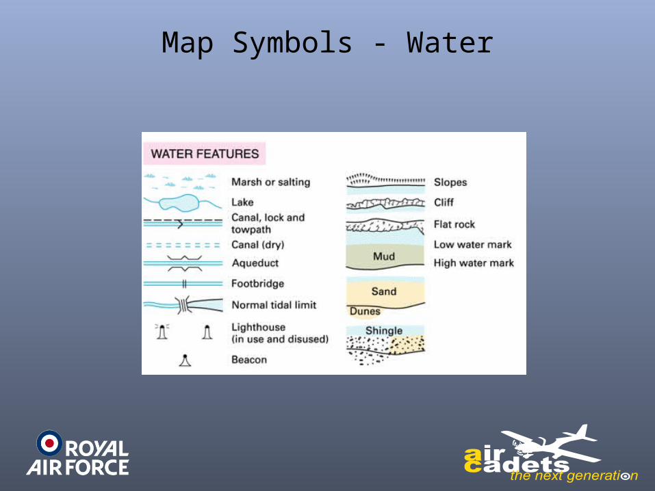
Map Symbols - Water

Map Symbols - General

Tourist Information

Map Symbols - Misc

Map Symbols - Access

Hills
• Hills are shown using contour lines
• Contour lines join areas of equal height • Marked at every 10m of height change• Rise and fall called “Vertical Interval” (VI)• Contour lines seem to disappear at cliffs

Symbol examples


![Quantifiers, Unit Symbols, Chemical Symbols and Symbols of ... · [Technical Data] Quantifiers, Unit Symbols, Chemical Symbols and Symbols of Elements Excerpts from JIS Z 8202 Calculation](https://static.fdocuments.us/doc/165x107/5f3249d403d3070d9018fe62/quantifiers-unit-symbols-chemical-symbols-and-symbols-of-technical-data.jpg)