The Impact of Landform Structure on Fog Formation
28
The Impact of Landform Structure on Fog Formation Isabel Alberts, Matthieu Masbou and Andreas Bott Meteorological Institute – University of Bonn, [email protected] LM User Seminar 2007 Langen, March 2007
Transcript of The Impact of Landform Structure on Fog Formation

LM-USER-Seminar 06.03.2007
The Impact of Landform Structureon Fog Formation
Isabel Alberts, Matthieu Masbou and Andreas BottMeteorological Institute – University of Bonn, [email protected]
LM User Seminar 2007Langen, March 2007

1. Introduction
2. Motivation
3. Background
4. Research Area
5. Results
6. Outlook

AimImprovement of fog predictionHigh resolution fog prediction
Duration and intensity of fog periodSpatio-temporal heterogeneity of fog
Topic
Importance of the the earth`ssurface on fog formation
Tools
Model LM-PAFOG
Research Training Group 437
Landform – a structured and variable boundary layer

Fog Formation What is needed?
Key Ingredients required to generate fog are
moisture
rapid cooling
calm or light winds
www.meted.ucar.edu

Local Surface Influences
Soil type
Vegetation
Surface characteristics
Soil moisture
Terrain Influences
Topography
Mountain valley breeze
Accumulation of cool air
Radiative cooling
Advection
Vertical mixing of heat andmoisture
Heat and moisture transport inthe soil
Which Parameters? Which Processes?
Impacts on Fog Formation

Fine clay soil Coarse sandy soil
Evaporation
/Latent heatFlux
Incoming and reflectedradiation
Sensible heat flux
Turbulence
Soil TypeInfluenced diurnal variation of Temperature ,Humidity and fluxes
Dry soil Moderate soil Wet soil
Soil moistureSoil moisture controls latent heatrelease at the surface
Surface fluxes influence nearsurface weather -> e.g. FOG

Research Area
Bonn
Frankfurt
Berlin
Hamburg
München
Sieg catchment
06°03‘ O 08°18‘ O120 km
51°07 N
80 km
50°34 N
Bonn
Frankfurt

Data and Model What is new?
OrographySoil typeVegetation
Surface roughnessRoot depthPlant coverLeaf area index
To take the high heterogeneity into account:
set of modified external parameters implemented into
LM-PAFOG; resolution 1 km
LM /LM-PAFOG needs
External Parameters to describe the earth´s surface

Topography1 km Resolution
Topography LM New Topography
Source: GLOBE-NOAA/NGDC (National Oceanic and Atmospheric Administration; 1km)
Source: NASA, SRTM 90 m
100 150 200 250 300 350 400 450 500 550 600 650
BonnBonn

Soil Type
Clay
Sandy Loam
Loam
Clay Loam
Sand
Source: FAO (Food and Agricultural Organization of UNO), 10 km Resolution
1 km Resolution
Source: Geologisches Landesamt NRW, 100m Resolution
Silt clay
Silty loamy sand
Silty loam
Middle silty loam
Clay silty
Weak sandy loam
Loamy sand
Loam
Sand
Soil Type LM New Soil Type

Model Simulation Conditions
Model Setup Initialization: 08.10.2005 15 UTC Duration: 48 hoursTime Step: 10sVersion: LM3.19 PAFOG
Observed fog period:
Köln/Bonn: October, 9th 2005: 02-06 UTC
Bad Marienberg: October, 9th 2005: 04-06 UTC

Resolution of LM-PAFOGHorizontal Resolution : 100 x 80 pixels Δxy = 1.0 km
25 levels in the lowest 2 000 mVertical Resolution : Atmosphere – 40 levels Δzmin = 4m
Soil - 8 levels
LM
LM-PAFOG
68 m
153 m
256 m
4m…..40m
Ksoil = 8 Ksoil = 8
ke = 40
ke = 40
k=35
k=35
k=25
ks=1 ks=1ks=8
k=34
k=33
k=18
k=16

Synoptic situation 09.10.2005 00UTZ

NOAA
Synoptic Situation 09.10.2005 10:00 UTC

DatasetDWD
New Dataset
Sensible Heat Fluxes W/m²2 UTC
Latent Heat Fluxes W/m²
Bonn
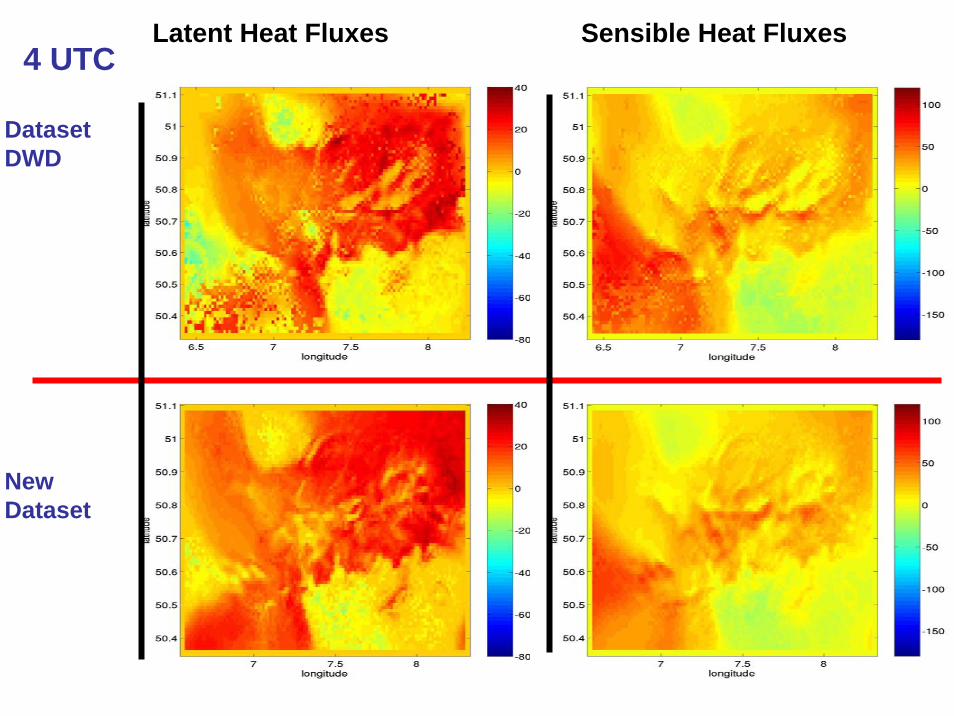
Latent Heat Fluxes Sensible Heat Fluxes4 UTC
DatasetDWD
New Dataset

DatasetDWD
6 UTC
New Dataset
Latent Heat Fluxes W/m² Sensible Heat Fluxes W/m²

DatasetDWD
New Dataset
7 UTCLatent Heat Fluxes W/m² Sensible Heat Fluxes W/m²

Soil Temperature K2 UTC
DatasetDWD
New Dataset
4 UTC

Soil Temperature K6 UTC
DatasetDWD
New Dataset
7 UTC

Bonn
Visibility in m QC g/kg2 UTC
DatasetDWD
New Dataset

Visibility in m QC g/kg3 UTC
DatasetDWD
New Dataset

Visibility in m QC g/kg4 UTC
DatasetDWD
New Dataset

Visibility in m QC g/kg5 UTC
DatasetDWD
New Dataset

Visibility in m QC g/kg6 UTC
DatasetDWD
New Dataset

Visibility in m QC g/kg7 UTC
DatasetDWD
New Dataset

Impact of the new implemented surface parameter is visible;
Characteristic patterns correspond, in detail are differences visible;
Simulation produces fog during the observed fog period, but not at thesame place;
Up to now: just new topography and a new set of soil types implemented;
In near future: Vegetation will be take into consideration;
Vegetation Scheme -> LM-PAFOG-VEGETATION
Conclusion and Outlook

THANK YOU