The Hilltop Enclosure on Cluny Hill, Forres description,...
135
The Hilltop Enclosure on Cluny Hill, Forres description, destruction, disappearance LEIF I SAKSEN Department of History, Lancaster University March 15, 2017 Summary This report addresses the documented history of a hilltop enclosure on Cluny Hill in Forres, Moray. It reviews the published evidence to date, finding it to be both limited and and sometimes unreliable. Four primary sources are established in Pococke (1760), Mcdonell (1798), Leslie (1811) and Algie (1887). Additional historical evidence is identified in 19th century press reports. These reinforce the claim of a subcircular earthwork that was visible in its entirety as late as 1811, before being heavily degraded through the construction of paths. This information is compared with the current state of the hill through LIDAR, geophysics and visual inspection. Extensive ditch-like depres- sions are found to correspond closely with the historical testimony. The process by which the enclosure was both partially destroyed and obscured by the creation of a wooded parkland is documented. The report concludes with brief reflections on interpretation and recom- mends further fieldwork. Status: Draft Page 1
Transcript of The Hilltop Enclosure on Cluny Hill, Forres description,...
The Hilltop Enclosure on Cluny Hill, Forresdescription, destruction, disappearance
LEIF ISAKSENDepartment of History,
Lancaster UniversityMarch 15, 2017
Summary
This report addresses the documented history of a hilltop enclosureon Cluny Hill in Forres, Moray. It reviews the published evidenceto date, finding it to be both limited and and sometimes unreliable.Four primary sources are established in Pococke (1760), Mcdonell(1798), Leslie (1811) and Algie (1887). Additional historical evidenceis identified in 19th century press reports. These reinforce the claimof a subcircular earthwork that was visible in its entirety as late as1811, before being heavily degraded through the construction of paths.This information is compared with the current state of the hill throughLIDAR, geophysics and visual inspection. Extensive ditch-like depres-sions are found to correspond closely with the historical testimony.The process by which the enclosure was both partially destroyed andobscured by the creation of a wooded parkland is documented. Thereport concludes with brief reflections on interpretation and recom-mends further fieldwork.
Status: Draft Page 1
Contents
1 Introduction 3
2 Cluny Hill 4
3 NMRS and Moray SMR records 8
4 Other Published References 16
5 Chalmers Archive 22
6 Current State 26
7 Destruction and Disappearance 32
8 Conclusions and Recommendations 37
Appendices 56
A Maps 56
B Excerpts 82
C Chalmers Archive 93
D Newspaper Reports 100
E Images 113
Status: Draft Page 2
1 Introduction
Local tradition has long held that a hill-fort1 existed upon the summit ofCluny Hill in Forres, Moray. It has variously been attributed to Neolithicand Middle Iron Age2 tribes, Pictish warlords, Scottish kings and Vikingraiders. A record for it exists in the Moray Sites and Monuments Record(Moray SMR)3 and National Monuments Record of Scotland (NMRS).4 Bothultimately derive from accounts summarised by the Ordnance Survey. Italso finds occasional mention in a wide range of local history books and thehill continues to exert an influence on the public imagination (Taylor, 2015;Yeadon, 2015). Yet the existence of an earthwork, let alone its nature, has re-mained a matter of debate. Cluny Hill was planted and heavily landscapedin the early 19th century, making visual confirmation extremely difficult.The SMR record, though expressing a high confidence in its existence andproposing an early medieval date for it, cites just two 19th century antiquar-ian works as evidence (Chalmers, 1807; Hibbert, 1857b) and holds almost noother documentary records about the site. Most of the literature in the morecomprehensive NMRS record is little more than series of Chinese whispers,and the earliest source cited in common – the antiquarian George Chalmers’Caledonia – is often unreliable in both its general and specific conclusions.Two mid-20th century visits by Ordnance Survey archaeologists disputedthe designation and it was consequently removed from OS maps in 1984.
The aim of this report is to offer a firmer evidence base by which todetermine its existence and nature. It commences with a discussion ofpublished literature, followed by a more extensive investigation into earlynewspaper reports, maps and plans of the hills, and documents from the
1The formal classification of ‘hill-fort’ covers an extremely broad range of archaeologicalmonuments in terms of their situation within a landscape, their level of fortification, andtheir presumed function. Given the inherently loaded nature of the term ‘fort’, sites forwhich defence of the occupants is not necessarily the primary goal are often referred to asenclosures (Ralston, 2006, p.6-7). While the site of Cluny is indisputably a hill, the above-ground remains are currently insufficient to conclusively determine either form or function,and so the term ‘hilltop enclosure’ will generally be used here.
2Use of the term ‘Iron Age’ is problematic in Scotland, due the lack of an agreed culturalhorizon to contrast it with. This can lead to confusion when comparing historical referenceswhich may or may not include within its scope the era of Roman occupation in southernBritain and/or the pre-Scottish kingdoms. A current convention is to talk of the ‘Long IronAge’ which encompasses all of these and is divided into Early, Middle and Late periods. Thebounds of these subdivisions are inevitably open to debate in a region of such heterogeneousinfluences (Hunter & Carruthers 2012). I will here follow Armit (2016, p.7) for a periodbetween c. 700 BC and c. 400 AD before returning to the topic in more detail in Section 8.
3Reference NJ05NW0004; https://online.aberdeenshire.gov.uk/smrpub/master/detail.aspx?tab=main&refno=NJ05NW0004
4Reference 15818; https://canmore.org.uk/site/15818
Status: Draft Page 3
Chalmers Archive. An additional contribution of the research is to determinethe sequence and impact of modifications to the hills in the 19th century.As many of the documents referred to are difficult to access, an extensiveappendix of key document excerpts is also provided. All references, citationsand URLs within the main text are hyperlinked for easier reading. Resultsare compared with the current state of the hill’s surface, as determinedboth through visual inspection, a geophysical survey, and LIDAR surfacescanning kindly provided by the Scottish Orienteering Association.5 GISand 3D modelling technology are used to provide a more comprehensiveview of the morphology of the hills than previously possible.
The report concludes that the presence of a large hilltop enclosure isall but certain and that it corresponds in some regards to the physicaldescription published by Chalmers. This is followed by brief reflectionson interpretation but further archaeological fieldwork is recommended inorder to establish more reliable information as to its origin, development,abandonment and post-use history.
2 Cluny Hill
Cluny Hill, also known as the Cluny, Clunie or Cloven Hills, is a clusterof four low, steep-sided hills, approximately 33 ha. in extent and largelysurrounded by the town of Forres near the southern coast of the Moray Firth(Maps A.1, 2-5).6 Their geological fabric is Pleistocene moraine till uponOld Red Sandstone bedrock (Wright et al., 2013, p.11).7 The northern hill,surmounted by a tower commemorating Admiral Lord Nelson,8 is 77 mabove Ordnance Datum and forms their highest point. This descends rapidlyto parkland at 25 m AOD. The ground to the south of the hills is slightlyhigher (32 m AOD) with a borehole reaching bedrock at 30 m AOD.9 Theyare approximately 2 km south of Findhorn Bay and 2 km east of the FindhornRiver. They are known to have been common property of the town of Forressince at least the 16th century (Douglas & Robertson, 1934, p.536), and quitepossibly since its establishment as a royal burgh. The date of this event isunknown due to the destruction or loss of its earliest Royal Charter butmay predate the reign of William I (1165-1214) (Simpson & Stevenson, 1982,p.1). The hills stand within the legal boundary of the burgh, southeast of itsurban centre which occupies a low east-west rise terminating at the Mosset
5http://www.scottish-orienteering.org/soa/page/lidar-data-available6http://portal.historic-scotland.gov.uk/hes/web/f?p=PORTAL:
DESIGNATION:::::DES:GDL002017BGS. http://mapapps.bgs.ac.uk/geologyofbritain/home.html?location=forres8https://canmore.org.uk/site/158649BGS log NJ05NW28.
Status: Draft Page 4
Burn to the west. Private estates originally occupied the land surroundingit, occasionally leading to boundary disputes which were settled with thepresence of march stones (Newspaper Reports D.11), many of which arestill in situ. The grounds of Forres House to the north were purchased byForres Town Council and converted into a park in 1922.10
Now almost entirely forested with a mixture of deciduous and ever-green woodland, in the 16th century they were wholly or partly coveredwith broom which was harvested by the town’s inhabitants (Douglas &Robertson, 1934, p.536). By the late 18th century this had been replaced bygrassy heath (Newspaper Reports D.7), which was subsequently plantedwith trees and protective gorse. Planting was initially intended as a sourceof income but later became a means of extending and enhancing the hills’beauty as a public park, which they remain today (Extracts B.5). Multiplefires and replantings throughout the park’s early years have led to distinctand varied woodland environments within it. The centrepiece is a towerdedicated to Admiral Lord Nelson which was erected on public subscrip-tion between 1806 and 1812 following his death at the Battle of Trafalgar(?). While trees now obscure much of the view at ground level, the tower’sviewing platform provides an extensive and panoramic vista of the MorayFirth and surrounding countryside which would also have been visiblelower down the hillside well into the 19th century (Images E.3, 56-63). Tothe north this extends across Findhorn Bay and the Moray Firth to the Tarbatpeninsula and mountains of Caithness and Sutherland. Ben Wyvis in EasterRoss can be seen to the west. To the east are Kinloss Abbey, the promontoryfort and village of Burghead, the plain of Spynie (formerly a loch), and theKnock of Alves hill-fort. Visibility is constrained by hills to the south, butstill encompasses an extensive part of the local countryside.
The permanent status of the hills as a public park have greatly reducedurban encroachment and there are relatively few buildings on the hills. Onthe slope of the southern hill is Cluny Hill College, originally built as aHydropathic Establishment in 1864. A number of residences run along St.Leonards Rd. (for a time known as Bullet Loan) on the southwest side. Otherstructures and man-made features include the Cluny Hill Cemetery and aflag platform on the western hill; a reservoir on the southern hill; and a sandquarry on the north side of the eastern hill. In addition to these are a greatnumber of features associated with the park, including roads, paths, walls,gates, lamp-posts, benches and raised flower beds, although two centuriesof continual use mean that not all additions to the hill may have survived.
The dual name of the hill is early, with descriptions from the late 16thcentury referring to Clowin, Clowne, Clwne and Clone Hills, apparently
10http://www.parksandgardens.org/places-and-people/site/8866/history
Status: Draft Page 5
all in the plural (Douglas & Robertson, 1934, p.536). The earliest knownreference is to ‘Clunie-Hills’, in a 1578 edict prescribing the meeting placefor settling a feud between the Dunbars and Inneses (Innes 1864, p.129;Dunbar 1866, p.1). The mention of ‘Cluny’ in a list of episcopal rents forthe adjacent Barony of Rafford in 1565 is unrelated: it refers to an estate4 four miles to the south (Leveson-Gower & Sutherland-Leveson-Gower,1837, p.445). Matheson (1905, pp.157-8) gives the name a gaelic origin11
but the obvious etymological chain between variants and use of the pluralmakes clear that the four-fold division of the hill provides their commonorigin. An anonymous 1856 correspondent to the Forres Gazette claimed thatin the middle of the 18th century each of the four summits were named:Black Hill or Blackhillock (east), Whin Hill (south), Braidhaugh Hill (west),and ‘Toe F.r.st(?)’ (north) (Newspaper Reports D.9) but that these nameshad largely fallen out of use by time of writing. The basis of this claimis unspecified but it is partially corroborated by a reference to a ‘Blackhillof the Town’ in a survey sketch map produced for the Earl of Seafield in1768.12 From the mid-19th century onward they are increasingly referredto collectively as Cluny Hill, or simply The Hill. The latter term sometimessolely indicates the northern hill. Individual summits are more commonlyreferred to in relation to the cardinal directions. The hills surround a deepcentral depression, known as Hell or Helgy’s Hole, and later as Cluny HillHollow, to which a considerable amount of local folklore is attached. Askeleton was discovered there in 1870 during levelling work. (p.28 Algie,1907; Douglas & Robertson, 1934, p.534-5)
Early maps of the region depict Forres but are at too small a scale toshow the local topography (Maps A.2). The earliest visual representationof the ‘Cloven Hills’ is in a 1728 sketch plan produced to settle a boundarydispute between the Town of Forres and Mackintosh of Blervie (Maps A.3).Unfortunately, the plan is largely schematic in nature, representing Forresas two lines of houses and the three rows of hills in profile. This depictionbears no visual relation to the hills themselves. Two years later, Avery &Wade’s Plan of the Murray Firth would also show a ‘hill’, but again onlyschematically (Maps A.4). The next occurance is in General Roy’s MilitarySurvey of Scotland produced between 1747 and 1752. This exists both as theoriginal survey (known as the ‘Original Protraction’) and the Fair Copy(Maps A.5, 9-10). While there are significant differences between the twoversions, both depict the hills as a treeless northern summit with a lowerridge circling its eastern side. To the south west (and across a road in the FairCopy), is the hill known as Breakback. No labels are given. Roy’s antiquarian
11‘Fertile piece of land.’12National Records of Scotland, Ref. RHP98278.
Status: Draft Page 6
writings, published posthumously as The Military Antiquities of the Romansin Britain (1793), also contain a map showing Forres (Maps A.5, 11). ClunyHill does not appear, merely showing an area of open heathland. A circularfeature to the south of the town is Castle Hill. Roy labels the town ‘FORRES,The Vario of R.C. [Richard of Cirencester]’. In the 1768 Seafield sketch mapmentioned previously, the northern hill is represented as a series of lighthachures and labelled as both ‘Cluny Hills’ and ‘Cloven Hills’. The easternhill is marked as ‘Blackhill of the Town’ – no label or depiction are given ofthe other summits (Maps A.6). The next representation of the Cluny Hillsis in Taylor and Skinner’s itinerary from Inverness to Banff in Survey andmaps of the roads of North Britain or Scotland published in 1776 (Maps A.7).There are two hills, collectively named ‘Cluny Hills’. The larger hill liessouth of the Forres-Elgin road between Forres and the junction leading toFindhorn. The smaller hill lies further to the east and may be DrumduanRise. Stockdale’s 1806 map of Scotland similarly represents the hills as twoseparate summits in parallel with the Elgin road (Maps A.8). Subsequentmaps depicting the hills, and in some cases a hill-fort, will be discussed ingreater detail later in the report.
Several other aspects of Forres’ historic environment are relevant to thisinquiry. The most notable is Sueno’s Stone,13 the largest known cross-slab inScotland and famous for its depiction of hunting and battle scenes which arestylistically dated to the mid-9th or 10th century. The origins and purposeof the stone are unclear but may relate to the inauguration of a Scottishking or the battle in which King Dub was killed near Forres in 966 or 967(Foster, 2014, p.154-5). It stands close to the road leading to Findhorn andBurghead, and 500 m from the summit of the north hill from which it isclearly visible (Images E.3, 64). Timothy Pont’s map of Moray and Nairn (ca.1583-1614) appears to show the presence of a second stone (Maps A.2), andRobert Gordon’s Moraviae Descriptio also suggests the presence of multipleinscribed stones (Gordon, 1654).14 The Traveller’s Guide through Scotlandalso refers to ‘several curious carved pillars on the right’ when travellingfrom Kinloss to Forres (Thomson, 1814, p.128). This may include the oneknown as the ‘Little Cross’15 before its disappearance. A basal socket forthis stone is reported at the junction of the Burghead road as late as 1868(Watson & Watson, p.269). A fragment of a Pictish symbol stone was alsofound embedded in a garden wall at 7 St. Leonards Rd, near the southwestboundary of the hills.16 Its provenance is unclear but presumably local to
13https://canmore.org.uk/site/1578514Monumenta ejus rei lapides erecti et praelorium picturis ornati ad Foressam referentur/Standing
stones, ornamented with pictures of battles, are pointed out at Forres in proof of this.15https://canmore.org.uk/site/1579616https://canmore.org.uk/site/73810
Status: Draft Page 7
the area. A stone associated with the execution of women convicted forwitchcraft is one of two or three known to lie near the Forres-Elgin roadat the foot of the Cluny Hill.17 According to tradition, this was carried outby placing them in barrels containing spikes which were rolled down thehill following which they were burned in situ. The role of the stones in thiscruel method of punishment is unclear but they are said to mark the site ofexecution or burial. Witch trials are known in Forres from at least the 10th,17th and 18th centuries, making it impossible to assign them to a specificevent (Algie, 1907, p.17-9).
3 NMRS and Moray SMR records
There has been no previous attempt to formally document the history ofCluny Hill or the existence of a hill-fort. Given the scanty nature of pub-lished documentation, it is very difficult to cleanly separate a ‘scientific’literature from that of antiquarianism, local tradition and speculation. Thusthis section of the report will restrict itself to establishing the origins ofvarious claims made about the site held by the NMRS and Moray SMR sothat they can be more clearly evaluated and the trends of ‘conventional wis-dom’ established. While neither database holds much information directly,the NMRS has a fuller listing of references, all derived from the older OSArchaeology Division Card Index (Extracts B.10, 36).18 The SMR holds abrief summary of these, along with one additional reference to Ralston et al.(1983, p.160).
3.1 Chalmers’ Caledonia
The first, and by far the most important pieces of documentary evidencecited in the NMRS record are a footnote (Extracts B.2) and map (Maps A.9)in the first volume of George Chalmers’ Caledonia (1807). At first glancethey appear to provide a clearly articulated, comprehensive, and ostensiblyevidence-based claim for the presence of a hill-fort. It describes:
a form between oval and circular. . . surrounded by a strong ram-part of earth and a fosse [ditch] which is still 12 feet wide. The
17http://canmore.org.uk/site/15807. According to the present owners of the RamneeHotel, one of the stones now lies below ground level near the entrance to its drive andanother is within a private garden nearby. Two stones are shown on the 1768 Seafield map.One in the centre of the road (near the present petrol station) and the other to the southeastof it (beneath the police station).
18For a review of the Ordnance Survey’s work and its legacy, see:http://archaeologydataservice.ac.uk/archiveDS/archiveDownload?t=arch-352-1/dissemination/pdf/vol_134/134_161_171.pdf
Status: Draft Page 8
area within the ramparts measures 6 acres, 3 roods, and 25 falls,Scottish. On the south side of the hill there is a small post of asquare form, defended by an earthen rampart and fosse, inclos-ing an area of 10 feet square, or 16 falls Scottish.
It is attributed to the Vacomagi, a Middle Iron Age tribe contemporarywith the Roman occupation of southern Britain, and the accuracy of themeasurements are ostensibly confirmed by the expertise of a land surveyor,Robert Macwilliam, who is said to have conducted the survey in 1798. Inaddition to this, Chalmers’ map shows the location and orientation of a‘British Camp’ set upon the easternmost summit of two of the Cluny Hills.
Unfortunately Chalmers’ claims must be accepted only with a greatdeal of caution, both in the specifics and more generally. In the first place,closer inspection raises much about Chalmers’ description and map whichis problematic:
• The concave southern side of the northern hill makes an oval or circu-lar shape of this size hard to situate upon its topography.
• No evidence or justification is provided for the association betweenthe circular enclosure on the summit and the ‘post’ to the south.
• It is not clear what is meant by ‘post’ but the measurements are incon-sistent. 16 Scottish falls = ~508 m2 whereas a square with 10 ft sides =~9 m2. Even the first measurement, with a side of about 22 m, is hardto reconcile with the presence of a surrounding ditch and rampart ora sufficient number of men to defend them. Even harder to explainis that to the south of the northern hill is Cluny Hill Hollow whichseems an improbable location for a defensive position.
• The land surveyor Robert Macwilliam is not otherwise known fromChalmers’ text or county records and his measurements seem remark-ably precise (to the nearest 5 m2) for an area of approx. 36,000 m2 andbounded by the kind of vaguely defined topography that is commonto most ancient earthworks.
• The map is not to scale and includes a mixture of components whichinclude a precise (if inaccurate) layout of the burgh (which is notrelevant to Chalmers’ text) but only a schematic, oval rendering of the‘British Camp’. There is no depiction of the outlying ‘post’ at all. Onlytwo of the four hills are shown and their relationship to DrumduanHouse and Sueno’s Stone seems incorrect.
• Chalmers’ association of the hill-fort with the Vacomagi is derivedsolely from the combination of two beliefs, neither with justified foun-dation:
Status: Draft Page 9
1. The claim by Roy (1793, p.132) that Forres is Varis, a Roman-erasettlement mentioned in De Situe Britanniae (‘On the situation ofBritain’, Bertram (1809)). This was a literary forgery attributedto a ‘Richard of Westminster’ (later confused with the historicalRichard of Cirencester), but in fact produced by Charles Bertramin 1748 and responsible for much error and confusion in 19thcentury antiquarianism (Barker, 1990). Neither Roy nor De SitueBritanniae make any mention of a hill-fort however.
2. A tribal name attested to by Claudius Ptolemy in the Geographikehyphegesis, (‘Manual for drawing a world map’, Stueckelberger &Grasshoff, 2006, 2.2.13), a geographic text produced in Alexandriain the 2nd century AD. While this is a genuine work, its enormousscale required the Greek-speaking Ptolemy to draw on whateversources were available, and the locations and names it lists areoften utterly confused and corrupt as a result, especially beyondthe boundaries of the Roman empire.
While clearly local tribes were present in the region during the MiddleIron Age, the existence of a settlement at Forres, let alone a hill-fort,cannot be confirmed on this evidence alone.
In addition to these specific issues, we must also bear in mind the circum-stances under which Caledonia was written. Born in Fochabers in 1742,Chalmers was educated in Scotland and spent his early adult life in theAmerican colonies before taking up a position as the Chief Clerk of theBoard of Trade in London in 1786. Chalmers’ goal was to demonstrate thatknowledge of Scotland’s history could be pushed back to classical antiquity,and that antiquarian pursuits such as the collection of artefacts and name-place analysis could help unearth it. Such history was greatly enhancedwhen it demonstrably featured monuments akin to the hillforts, henges andRoman camps of England. While the scale of his endeavour was impressive– he published three large volumes in his lifetime and accumulated materialfor a further four – it was neither a full-time occupation, nor was he ableto visit many of the places he describes. The bulk of his research was con-ducted through networks of written correspondence, a practice typical ofthe day (Withers, 2008), and Chalmers himself describes it as ‘the agreeableamusement of many evenings’ (Chalmers, 1807, preface). Caledonia remainsa magisterial work but it is one in which the limited and often erroneousevidence in Chalmers’ possession is sometimes unable to carry the weightof his assertions.
Consequently, and despite the apparent certainty that Chalmers’ descrip-tion provides, there is very little here we can be confident of. There is no
Status: Draft Page 10
concrete evidence that he visited Forres, and his language intimates thathe did not inspect Cluny Hill personally. It is unclear from the text how hebecame aware of the site prior to commissioning the survey. It appears likelythat a surveyor did record a large sub-circular feature, probably on the northhill, and an additional smaller feature to the south. Their nature is difficult todetermine based solely on his description and map. It is therefore prematureto confirm the presence of a hill-fort solely on Chalmers’ testimony.
3.2 ‘Vitrified Sites’
The next piece of evidence cited by the NMRS is ‘Observations on the the-ories which have been proposed to explain the vitrified forts of Scotland’,a paper by Samuel Hibbert (1857b) first presented to the Society of An-tiquaries of Scotland on 28 March 1825. ‘Vitrification’ is a phenomenon,first noted in the 18th century (Williams, 1777), that the masonry of manyhill-forts in Scotland has been exposed to fire, thereby fusing some of thestonework. Hibbert’s paper evaluates a number of competing theories, ul-timately concluding that a variety of causes may have led to this effect –including warning beacons, celebratory bonfires and warfare – and that itmay not be limited to fortifications in the strict sense.19 ‘Clunie Hill, nearForres’ is included in a list of ‘Vitrified Sites’ forming an appendix to thepaper. Unfortunately, evidence either for Hibbert visiting the site himself,or for the presence of vitrified stone is ambiguous. In a preamble to the listhe states that he has undertaken ‘a laborious examination of most of thevitrified sites of Scotland’, but continues:
Most of the examples of vitrification which have fallen under mypersonal inspection appear to me to have been so hypotheticallydescribed, as to well merit being resurveyed by individuals whohave yet a theory to support [i.e. who are unbeholden to one].For the information of this class of observers, I subjoin the namesof all the known vitrified sites of which I have been able tocollect information, with the persuasion, at the same time, thatconsiderable additions might be made to the catalogue. I willnot, however, answer for its perfect accuracy, although it is givenon apparently authentic information.
In fact the reference to Cluny Hill appears to derive from a letter toHibbert by George Anderson and published in the same proceedings (Hib-bert, 1857a). It promotes the theory that vitrification is caused by the use ofwarning beacons and describes the nature and intervisibility of a number of
19The cause or causes of vitrification remain a matter of debate. For a recent discussionsee (Ralston, 2006, Ch.7).
Status: Draft Page 11
hill-forts along the coast of the Moray Firth and in the Great Glen. He doesnot describe Cluny Hill, but in reference to Bein Hill (Cullen), states ‘It is. . . distinctly visible from the Ord of Kessock, from which also a station morecelebrated (see Chalmers), that on the Clunie Hill at Forres, is discerniblewith greater ease, lying almost due east.’ (p.196). It is referred to again inrelation to Castle Finlay (Nairn), although this time because of the lack of in-tervisibility. The letter is undated but Anderson visited Ord of Kessock withSir George Mackenzie on 21 December 1824, as described in another letterin the same collection in which intervisibility with Forres is also mentioned(Hibbert, 1857a, p.194). There is no suggestion in the correspondence thateither Anderson or Mackenzie had visited Cluny Hill by this date, althoughAnderson must have done so by 1842.20 Earlier publications describing‘vitrified’ sites, including Williams (1777) and Anderson (1779, 1782) do notmention Cluny Hill. We must therefore conclude that Hibbert’s testimonyin all likelihood derives from Chalmers via Anderson.
In a later discussion of vitrified forts cited in the NMRS, David Christisonbuilds on Hibbert’s work with a list providing more detail (1898, p.193-6).Unfortunately the entry for Cluny Hill reads only, ‘Authorities: Hibbert.Remarks on amounts &c. of vitrification: Not marked “vitrified” on O.M.[Ordnance Map]. No information.’ Christison (p.188) also makes clearthe very unsatisfactory state of investigation, even of those sites of whichsomething is known, and a tendency of the Ordnance Survey to mark asite as ‘vitrified’ without sufficient evidence. A similar list of ‘Gallic andVitrified Forts’ is given by V. Gordon Childe (1946, p.134). It merely reads‘Clunie Hill, Forres, ? Hibbert, Arch. Scot., 160’. The NMRS record alsocites M. A. Cotton’s description of ‘Clunie Hill, Forres, Morayshire’ whichreferences Hibbert, Christison and Childe, and notes that ‘this site on thesouth coast of the Moray Firth is included in lists of vitrified forts, but nodescription or plan has been traced’ (Cotton, 1954, p.81). In summary, allthe sources listed by the NMRS ultimately derive from Chalmers.
The single additional document held by the Moray SMR is a reference toCluny Hill in ‘Later Prehistoric Settlements in North-East Scotland’ (Ralstonet al., 1983, p.160, p.169). The report distinguishes between larger hill-fortsgenerally found at higher altitude (Class 1) and smaller ones (Class 2),assigning the ‘altogether less certain’ site at Cluny Hill an intermediatestatus. It is described as being ‘now unrecognisable in a public park, butestimated originally to have enclosed rather more than 2h [20,000 m2].’ Whythis figure differs substantively from Chalmers’ (which equates to approx.36,000 m2) is unclear and no further information or source is provided. Rivet(1966, see below) is cited in their bibliography however.
20See Section 4, and Extracts B.6.
Status: Draft Page 12
In addition to these reports, Cluny Hill is referenced by name or symbolin a number of maps and gazetteers, although without any substantiveinformation attached, and sometimes with caution. These include: the mapof Scottish Brochs, Galleried Duns and Gallic Forts in O’Dell & Walton (1962,p.59) where it is identified as a Gallic or Vitrified Fort (likely drawing onHibbert); the supplementary map included with Rivet’s The Iron Age inNorthern Britain (1966), drawn by I. G. Scott. The source is unclear, but thebibliography includes Childe, Hibbert and Christison; the map of minor forts(under 3 acres) in Avery (1976, p.362), derived from Rivet; the gazetteer andmap of vitrified/timber-framed forts in MacKie (1976, p.235, p.444) derivedfrom Cotton and Childe, where it is classified as without measurements, ofuncertain vitrification, and is erroneously placed in Banff; the gazetteer ofhill-forts in Hogg (1979, p.60) where it is classified as uncertain and has noreferences assigned to it. The introduction (p.3) suggests a probable sourcein Christison; and the derived map of Scottish hillforts in Hogg (1984, p.117)where it is symbolised as being less than 0.24 ha. in extent.
Relevant archaeological works which do not mention the site include theUK List of Monuments (Commissioners of Works, 1937, pp.85-6); Feachem(1955); Feachem (1971); the archaeological survey of Forres by Simpson &Stevenson (1982) and the gazetteer of early historic sites in Scotland (450-850AD) in Alcock & Alcock (1990, pp.130-7).
There is no explicit indication from any of the authors mentioned abovethat they attempted to confirm the presence or otherwise of stonework,vitrification, or other signs of a hill-fort. In all these publications such adesignation thus ultimately appears to stem from Caledonia. As sources ofcorroborating evidence for the presence of a hilltop enclosure they musttherefore be discarded. No pre-Eighteenth Century masonry, stoneworkor rubble are known on Cluny Hill at all. Two large boulders can be seennear the summit of the north hill, one embedded in a pathway, but theirprovenance is unclear and may be geological (Images E.4). Neither showsany signs of vitrification.
3.3 Ordnance Survey
The only active attempt to ascertain the existence of a hill-fort by archaeolo-gists or antiquarians other than Chalmers was by the Ordnance Survey aspart of its national mapping survey programme. This was a result of theOS’s need to justify the inclusion of individual features on its large scale6-inch-to-1-mile (1:10,560), 1:10,000 and 1:2,500 maps (Maps A.15, 21-23).The original survey was carried out in 1870, with additional visits in 1943and 1963, each offering a brief description (Extracts B.10, 36).
The first is the entry for a ‘British Camp (site of)’ in the Object Name
Status: Draft Page 13
Book associated with the publication in 1874 of the First Edition 6-inch-to-1-mile map (Maps A.15, 21). It notes confidently that ‘the site of this Camp issituated on an eminence at the north eastern extremity of the Cluny Hills.Part of the works at its north and north eastern extremities can still be traced,all other signs of it are obliterated’ (Extracts B.10, 35). On the map itself, thehill-fort is marked in gothic script in the vicinity of Nelson’s Monumentbut without a boundary and within a series of looping paths. Scarping isdepicted to the north of one of the paths.
The second report was produced in 1943 by the first OS ArchaeologyOfficer, O. G. S. Crawford, and quoted in the NMRS record. It states un-equivocally that, ‘the very slight scarping of the natural slope (NJ 0445 5912)is not enough, by itself, to presume a hill-fort.’ This refers to the samescarping depicted on the OS map. The last visit, carried out in 1963 and alsoquoted in the NMRS, largely supports Crawford’s conclusions. It reads,
Crawford confirmed. The only other possible indication of a fortis the fragmentary remains of what may have been a rampartat NJ 0447 5894 [the southwest side of the north hill]. However,the entire hill covered by trees, is a public park and has been sogreatly mutilated by landscaping and the construction of walks,that it is impossible to recognise any remains of a fort. No traceof any vitrification was seen.
The site is marked as ‘fort (site of)’ on the 1:2,500 and 1:10,000 scale OSmaps as late as 1972 (Maps A.15, 22-23). The OS 210 card index whichdocuments revision history for antiquities on OS maps notes that an in-struction to delete the annotation and citing symbol for the fort from theOS 1:2,500 map was issued in July 1976, and from the 1:10,000 map inMarch 1983 (Extracts B.10, 37). By 1984 it had been removed from bothmaps (Maps A.15, 24-25).
3.4 Summary
Having evaluated all the evidence provided by the NMRS and Moray SMR,both for and against the presence of hill-fort, the argument in favour looksweak. The entire case rests on the account of Chalmers, who never inspectedthe site personally. Later references are merely a series of chinese whispersbased on Chalmers’ footnote and the ‘beacon’ theory of vitrification – aphenomenon never observed at Cluny Hill. Three visits by the OrdnanceSurvey cast increasing doubt upon its designation. While none of this dis-proves the existence of a hilltop enclosure, the burden of proof must fall onestablishing its presence. In addition to the sources we have just discussed,are a number of other publications and reports that make reference to a
Status: Draft Page 14

hill-fort on Cluny Hill. In the next section we will consider their value asadditional independent evidence.
Status: Draft Page 15
4 Other Published References
What may be the earliest concrete reference to archaeological remains onCluny Hill is not recorded by an archaeologist. On 26 July 1760 the Bishopof Ossory, Richard Pococke, passed through Forres and noted in a letter tohis sister that ‘a little to the East of the town is Clover [sic] hill, round whichabout halfway up is an old entrenchment probably of the Danes’ (Pococke& Kemp, 1887) (Extracts B.1). Referencing Alexander Gordon’s ItinerariumSeptentrionale (1726), he relates it to Sueno’s Stone which he understands tobe a monument to celebrate a battle between Vikings and the Men of Moray.Gordon’s text makes no reference to Cluny Hill or a hill-fort. This is anextremely important piece of evidence: not only does it predate Caledonia byalmost 50 years, but as Pococke’s correspondence was not published until1887, neither could it be one Chalmers’ own sources. Though brief, it acts asthe first piece of corroborating evidence for Chalmers’ claim, even thoughthe interpretation differs radically. As Pococke was en route to Elgin andpassing through Forres on other business, it also suggests that the featurewas clearly visible from the Forres-Elgin road at that time.
A second possible reference to the hill-fort is its apparent depiction inAaron Arrowsmith’s Map of Scotland Constructed from Original Materials (Ar-rowsmith, 1807). The map shows the hills as a single extended summit,surmounted by two concentric rings of dots to the east (Maps A.10). Frus-tratingly, there is almost no other information to go on. The symbol doesnot appear elsewhere on the map, and despite Arrowsmith’s 1809 Memoir ofits production – one of the first of its kind and which comprehensively listshis sources – none of the materials he cites appear to reference a hill-fort.As the first volume of Caledonia was also published in 1807, and the Mapof Scotland was published in June, it seems an unlikely provenance. Fur-thermore, Chalmers does not reference Arrowsmith’s work directly untilthe second volume of Caledonia (1810, p.65) and Arrowsmith does not men-tion Chalmers at all. Nonetheless, Chalmers and Arrowsmith both livedin London and within a social environment where the informal sharing ofinformation through conversation and correspondence formed an essentialcomponent of intellectual endeavour (Withers, 2002). Whatever the truth,as Arrowsmith’s map is known to be based entirely on third party sources –principally Roy’s Original Protraction – it cannot be used as independentevidence. Failing any decisive link to an earlier source, notification byChalmers seems as plausible an explanation as any. The later Geological Mapof Scotland by MacCulloch (MacCulloch, 1840) also shows the concentriccircles on Cluny Hill but is entirely derived from Arrowsmith.
A third crucial reference to archaeological remains unreported in thepublic record is found in an appendix to William Leslie’s General View of the
Status: Draft Page 16
Agriculture of the Counties of Nairn and Moray (1811, p.522-4) (Extracts B.3).Compiled as an updated report on the contemporary and potential stateof rural industry in the region, it reports ‘the track of a ditch and earthernrampart carried around a little below the summit’, and surmises it to bethe remains of a ‘fortified military station’. Significantly, Leslie declaresthat ‘no kind of tradition suggests even a conjecture of such remote occupa-tion’ which, in addition to the very detailed description of Nelson’s Tower(then approaching completion), indicates that Leslie’s account is both frompersonal observation and uninfluenced by Chalmers. Notably, while theaccompanying map of Moray and Nairnshire is based on Arrowsmith’s(Brown, 1810), it replaces the hill-fort iconography with a representationof Nelson’s Monument (Maps A.10). Nonetheless, it may well have beenthe symbol on Arrowsmith’s map which led Leslie to visit the site. Another1811 publication, Neele’s Map of Scotland, depicts the hills in an entirely orig-inal form of three summits, and show neither a hill-fort or the tower. Theprevious Board of Agriculture report (Donaldson, 1794) omits any mentionof Cluny Hill.
In 1813, the entry for Forres in Nicholas Carlisle’s Topographical Dictionaryof Scotland (1813, ‘FORRES’) reports that ‘On. . . Clunie Hill, are the vestigesof a British Camp: the area, within the ramparts, being nearly 7 Scottishacres.’ However the phrasing seems so close to that of Chalmers’ report thatit is hard not conclude that Caledonia provides his source.
A Guide to the Highlands and Islands of Scotland (Anderson & Anderson,1842, p.104) contains a brief description of the ‘Clunie Hills’ (Extracts B.6).One of its authors is George Anderson, the man who brought Chalmers’description of Cluny Hill to the attention of Hibbert in 1825. As might beexpected of a tourist guide, it is principally concerned with its beauty andviews, along with the existence of pine woods and encircling walks. It alsonotes the presence of ‘an ancient hill-fort’, reiterating Anderson’s belief thatit was one of a chain of beacons for signalling maritime invasions to theresidents of the interior.
Robert Stuart’s Caledonia Romana (1845, p.210) makes a brief reference tothe hill-fort while equating Forres with Varis (following Roy and Chalmers):‘On Clunie-hill, to the eastward of the town [of Forres], are the vestiges of acircular British stronghold’. Stuart directly cites Chalmers as his source andno further information is provided.
On 13 February 1851, a public paper on ‘The Archaeology of Moray’ waspresented to the Elgin and Morayshire Literary and Scientific Associationby Dr William Geddes, its Deputy Chairman. A version of the text wasreported in the Elgin Courant the following day.21 It is mostly a summary of
21http://www.britishnewspaperarchive.co.uk/viewer/bl/0000454/18510214/017/0003
Status: Draft Page 17
archaeological sites and finds known at the time, and includes the followingstatement: ‘On the Cluny Hill, also at Forres, which is now the site of theNelson Monument, The Vacomaji [sic] had a large hill-fort, the remains ofwhich, until a late period, showed that it had been of a form between an ovalor a circular shape, surrounded by a strong rampart of earth, and a fosse of 12feet wide.’ The description is drawn entirely from Chalmers (who is explictlyacknowledged later in the text) and adds almost no additional informationbeyond the implication that the remains are no longer sufficiently visible todetermine its nature and extent.
On 5 June 1860 the same association was addressed by James Macdonaldwith a paper entitled ‘A Sketch of the History and Antiquities of Burghead’(Newspaper Reports D.10). Much of the text is reported in the Elgin Courierof 8 June 1860.22 Its aim was to challenge the prevailing belief, introducedby Roy and developed by Chalmers, that Burghead was the ‘Winged Camp’[Ptoroton Stratopedon] of Ptolemy. Much of his argument can be seen as areaction to the recent revelation that De Situ Britanniae was a forgery, alongwith an increasing availability of archaeological evidence. Without specificjustification, MacDonald appears to shift its presumptive location to Forres:
The remains of a native encampment which can still be tracedin the Cluny Hills, near Forres, points out the site of ancientBritish strength, near which were, doubtless, planted the huts ofa primitive village, such as Caesar has described the capital ofCassivelan. Forres, indeed, seems to me to have far better claimsto be considered the ‘Winged Camp’ of Ptolemy than any otherplace with which it has hitherto been thought to be identical.
However, the line of argument is not pursued further. While the proximityof Forres to Elgin suggests that Geddes and Macdonald may have visitedCluny Hill, the lack of any new or significant details in their papers greatlyreduces their value as independent testimony.
In 1887 Matthew J. Algie, an employee of the Cluny Hill Hydropathic Es-tablishment, produced a Guide to Forres and Objects of Interest in the Neighbour-hood (Algie, 1887). A ‘new and revised’ but undated edition was publishedsometime shortly after his death in 1906 (Algie, 1907, Preface). Catering toa thriving tourist trade brought about by the Hydro and Forres’ importantlocation on the Inverness-Perth railway line, it is the earliest book to focus onall aspects of historical and cultural interest in Forres and the surroundingarea. It contains a description of Cluny Hill and offers new and substantiveinformation about the presence of an enclosure (Extracts B.7). Described as
22http://www.britishnewspaperarchive.co.uk/viewer/bl/0000457/18600608/021/0006
Status: Draft Page 18
an ‘Ancient British Camp’, Algie notes that little of it survives because itis at the same level as the ‘Circular Walk’. He adds that to the north it hassurvived where it is 20 feet lower than the path, and to the west where it ishigher. He also adds that the late John Miller [d. 1872], founder and editor ofthe Forres, Elgin & Nairn Gazette, had instigated the planting of trees aroundits circuit. The original text states that ‘these trees are now of great use intracing it’, a claim which is subsequently removed from the second edition.Whether this is because the feature was no longer possible to trace, becausethe trees had been removed, or for some other reason, remains unclear. Theremainder of the description is heavily based on Chalmers, with a roughconversion from Scottish to English acres.
Despite the brevity of Algie’s report, its partial dependence on Chalmers,and the fact that in 1887 only faint and partial features could be seen, thisis an exceptionally important source. It provides the earliest publishedtestimony from someone who was deeply familiar with the hills – Algieworked at the Hydropathic Establishment – confirms the location of bothextant remains, and suggests new sources of possible evidence in the formof the local newspaper proprietor and the trees he planted to memorialiseit. Its correlation with the ‘Circular Walk’ offers a concrete description ofthe remains which helpfully complements those provided by the OrdnanceSurvey, allowing for direct comparison with the modern topography.
1934 saw the publication of the Annals of the Royal Burgh of Forres (Dou-glas & Robertson, 1934). It contains an extensive description of Cluny Hill,along with a great deal of other helpful circumstantial evidence about Forresand its residents. Unfortunately the description of the ‘hill-fort’ (p.536) isderived almost exclusively from Chalmers and Algie (Extracts B.8). Theonly additional comment is that ‘there is now practically nothing to be seenof the remains’.
A local history entitled Forres: A Royal Burgh 1150-1975 offers a briefdescription (Forbes, 1975, p.13) (Extracts B.9). Most of the informationprovided simply repeats Chalmers, but it curiously asserts a ‘Stone Age’origin and adds that a class from Forres Academy traced its outline in 1972.A 1976 history of Moray states that ‘Clunie Hill, Forres, and the Douneof Relugas, both show signs of vitrification but neither has been closelyinvestigated’ (Omand, 1976, p.117). As has been noted, there is no sign ofvitrification at Cluny Hill.
A 2008 history of Mac Bethad mac Findlaech (Macbeth) by Taylor andMurray, with an accompanying website and documentary (Taylor & Murray,2008; Taylor, 2015), describes Cluny Hill as the ‘probable site of one ofMacbeth’s fortified residences’ (pp.8,63) but no specific evidence is givenfor this claim.
Status: Draft Page 19
Finally, a recent conservation report (Wright et al., 2013, pp.15-17) alsohighlights the presence of a hill-fort, drawing on Chalmers, Algie, the FirstEdition OS Map and Taylor. It draws a possible relationship with Sueno’sStone, and suggests that the earliest references to a royal castle or residencecould conceivably relate to Cluny Hill, rather than Forres Castle (now the siteof the Thomson Monument), which is unlikely to pre-date the establishmentof the burgh.
These are the only published sources not already listed by the NMRS andSMR it has been possible to identify which make direct reference to a hill-fort or enclosure. A considerable number of historical, antiquarian, surveyand tourist publications which describe Forres before the 20th century, orotherwise might be expected to note any visible remains on Cluny Hill makeno mention of them. These include: Gordon (1654, pp.306-9), Gordon (1661,pp.432), Rutgers (1661, pp.457), Gordon (1726, pp.158-9), Beverell (1727,p.1252), Burrell (2016, p.62), Defoe (1761, .p.220-2), Pennant (1776, pp.136-40,pp.287-308), Johnson (1775, p.51), Boswell (1791, pp.103-4), Hanway (1777,pp.127-9), McNicol (1779, pp.52-4), Cordiner (1780, pp.54-6), Volkmann(1784, pp.204-5), Walpoole (1784, p.505), Rochefoucauld & Lazowski (2001,pp.158-9), Thomson (1788, pp.154-7), Heron (1791, p.116), Thomson (1791,pp.151-4) Lettice (1794, pp.378-87), Cordiner (1795), the ‘old’ Statistical Ac-count of Forres (McDonnel, 1796), Grose (1797, pp.273-281), Heron (1797,p.259), Grant & Leslie (1798, pp.50-72), Stoddart (1801, p.113-5), Chalmers(1803, p.175-6), Thornton (1804, p.184), Forsyth (1806, pp.497-505), Hall(1806, pp.459-60), Carr (1809, pp.326-8), Smith (1911, pp.95-9), Forsyth (1813,p.37-8), Thomson (1814, p.128, p.154-5), Walford (1818, ‘MURRAY’), Playfair(1819, pp.120-1), Southey (1929, pp.103-5), Webster (1819, p.269), Duncan& Duncan (1820, p.71), Leslie (1823), MacCulloch (1824, pp.426-7), Botfield(1830, pp.86-9), Anderson (1837, p.172), Rhind (1839, pp.127-41), Cockburn(1889, pp.42,138-9,156-7,219,320,336-7), the ‘new’ Statistical Account of For-res (Grant, 1839), Sinclair (1840, p.178), Scotland (1842, pp.573-6), Lewis(1846, p.444-6), Wilson (1851), Black (1852, p.31), Worsaae (1852, pp.214-8),Watson & Watson (1868, pp.233-279), Marion (1872, pp.45-55), Murray (1875,pp.365-6), Anderson (1881), Shaw & Gordon (1882, pp.163-176), Wilson(1882, p.91, p.184-5), Carruthers (1887, p.93-97), Green & Faulkner (1891,p.157-8), Rampini (1897) and Groome (1895, pp.46-9).
In addition, no hill-fort is shown on John Wood’s 1823 Plan of the Townof Forres from actual survey (Maps A.13) or mentioned in the accompanyingreport (Extracts B.4). It is also absent from the 1832 Great Reform Act Mapand Report of Forres (Maps A.14). The 1868 Ordnance Survey 25 inch andLarge Scale Town Plans of Forres do not include Cluny Hill.23
23http://maps.nls.uk/view/74478415,
Status: Draft Page 20
4.1 Summary
While this review has demonstrated that the great majority of literatureabout Cluny Hill is either derivative of Chalmers or silent about an enclosure,it has also established four apparently independent sources supporting theclaim for its existence:
1. A very brief reference from personal observation by Bishop Pococke,in a correspondence of 1760;
2. Caledonia, which offers an extensive description of the site in 1798albeit at second hand;
3. Leslie’s Agriculture of the Counties of Nairn and Moray, which confirmsthe presence of a complete ditch and rampart as late as 1811.
4. The 1887 Guide to Forres, which partially corroborates Chalmers, ref-erences its partial destruction and adds important details about thelocation of the ditch and rampart and the possible presence of yewtrees planted alongside it.
If an enclosure did exist, much of its circuit was intact in 1811 but removedfrom the landscape by 1851, as the address by Geddes makes clear. We havealso seen that its attribution to a Roman-era tribe derives from Chalmers onscant and long discredited evidence. While not offering conclusive proofeither way, the foregoing discussion has enabled us to clear away much ofthe confusion and redundancy in the literature so that the small amountof direct testimony available in the published literature can be comparedwith unpublished and archaeological evidence. As Caledonia remains themost descriptive of all our sources, we will begin with an investigation ofthe Chalmers Archive.
http://maps.nls.uk/townplans/forres.html
Status: Draft Page 21
5 Chalmers Archive
Following Chalmer’s death in 1825, his library and correspondence wereinherited by his nephew, James Chalmers (son of his brother, Alexander),and kept together until his own death in 1841. It was then sold to a dealer inLondon, where it was divided and sold on. Much of the archive relating toCaledonia was purchased by the National Library of Scotland (NLS) and othersignificant archives of notes and correspondence are held by the Universityof Glasgow24 and the University of Edinburgh.25 The NLS archive is itselfextensive and divided into 20 separate collections. Four were consultedfor this research.26 This identified three documents pertaining to Chalmers’description of a hill-fort on Cluny Hill.
5.1 Letter from Rev. John Macdonell (Adv.MS.21.1.7, f.111)
The first is a letter from the Rev. John Macdonell, to a Mr James McWilliam,Writer [solicitor] in Elgin, dated 27 January 1798 (Archive C.1, 38-40). Mac-donnell, who moved to Forres from Edinkillie in 1792, was Minister of St.Leonard’s Church in Forres (Douglas & Robertson, 1934, p.252), and au-thor of the report for Forres in the ‘old’ Statistical Account of Scotland (1796).McWilliam had connections to Fochabers, was married to a Helen Chalmers,and frequently mentions family matters in his correspondence, so may havebeen an in-law of George Chalmers. Other letters in the archive make clearthat he acted as an occasional intermediary with other correspondents inMoray, especially with regard to place-name analysis, a common practicewith Chalmers (Withers, 2008). The letter from Macdonell is in response to acommunication from McWilliam on 19 December 1797 concerning a meetingbetween Chalmers and an unidentified Mr. Dunbar (possibly William Dun-bar, the Town Clerk) regarding Sueno’s Stone. Macdonell touches briefly onthis point, then continues:
There is known to be clearly traced at this day upon the Clunyhills south east of Forres the appearance of a fortified encamp-ment. The fossa [ditch] upon the shoulder of the hill is prettyentire and lines of circumvolution are visible round a great part(?)of the Hill. As we have no account of the Romans having pene-trated this far into the north of Scotland I am disposed to thinkthat this was a stronghold fortified by the Danes during their
24http://special.lib.gla.ac.uk/manuscripts/search/detail_c.cfm?ID=517825Item nos. 183, 448-455 in the Laing Bequest were consulted but no relevant documents
were identified. For the catalogue see:http://www.ed.ac.uk/polopoly_fs/1.123948!/fileManager/0029854e.pdf
26Adv.MS.16.2.17; Adv.MS.21.1.7; Adv.MS.8.1.9; Adv.MS.81.9.2
Status: Draft Page 22
inroads into this country, at the time they had possession ofBurghead.
The letter introduces several new and important pieces of evidence. Firstand foremost, it establishes Chalmers’ source, a resident of Forres who hadrecently conducted a statistical and cultural survey of the town. Second, itimplies heavily that knowledge of features encircling Cluny Hill is common-place among local residents. Third, the prevailing interpretation of a vikingstronghold is the same as that of Pococke (1887), probably following Gor-don (1726), whose book Macdonell cites. Fourth, it makes clear that at thisdate the earthwork surrounded almost the entire summit of one of the hills.Fifth, his description of ‘lines of circumvolution’ could imply that more thanone line of ramparts was visible. It is also helpful that Macdonell remainscircumspect, pointing out only that it is the ‘appearance’ of an encampmentand that he is ‘disposed to believe’ it was fortified by the Danes.
The archive includes the original envelope (addressed to McWilliam),upon which Chalmers has noted both the sender (‘Rev’d Mr. MacDonald[sic]’) and subject, and that on the 7th of March he wrote to Macdonell.
5.2 Chalmers’ To-do List (Adv.MS.16.2.17, f. 89)
The next piece of evidence is a short to-do list, presumably from early 1798,entitled ‘Enquirys to be made’ (Archive C.2, 41). The top entry reads ‘1st.The situation & measurement of the works on the Cluny Hills at Forres.’ Tothis has been added a marginal note in pencil (probably by an archivist),reading ‘wrote to Mr. MacDonell’.
5.3 Description of ‘encampment on the Cluny hill’(Adv.MS.16.2.17, f.49)
The final record is a complex document in three hands – apparently thoseof Macdonell, McWilliam and Chalmers – describing one or more surveysof the feature identified by Macdonell (Archive C.3, 42). The main textclearly forms the basis for Chalmers’ published description in Caledonia andcomparison of the capitalised ‘F’ and ‘E’ with the earlier letter and envelopeshow this to have been written by Macdonell:
The encampment on the Cluny hill near Forres appears to havebeen of a circular form, and has occupied nearly three acres ofground –Has been defended by an embankment of earth, and a Moat ofabout twelve feet broad each –It commands an extensive view of the Moray Firth – In a hollow
Status: Draft Page 23
on the south side of the hill there appears to have been a smallcamp of about ten yards square –
There are both similarities and important difference with Chalmers’ pub-lished footnote (Extracts B.2). The encampment is described as circular andoccupies a far smaller area: slightly less than three acres (~15,000 m2, as-suming Scottish acres). It describes both the ditch and bank as being 12 feetwide (not only the ditch). It notes the view of the Moray Firth, absent fromChalmers text but obvious from the hill itself. Finally it records the presenceof a ‘camp’ rather than a ‘post’ that is ten yards (not feet) square in a hollowto the south (presumably Cluny Hill Hollow). There is no mention of thiscamp being defended by a ditch and rampart as in Chalmers’ text.
Macdonell’s description cannot be taken at face value either. Macdonellwas not himself a surveyor and an addendum in the hand of MacWilliam,who presumably must have received the note for forwarding to Chalmers,reads: ‘The whole hills have been planted for some years the whins [gorse]hained [enclosed] so that the particulars could not be well ascertained.’ Tocomplicate matters even further are three brief additions by Chalmers. Thefirst is a heading: ‘From Rob’t McWilliam Land Surveyor 1798.’ The secondamends the description to read ‘nearly of a circular form’. Third, above‘nearly three acres’ Chalmers has written ‘6 acres, 3 roods and 25 falls’, thesame measurements which appear in his publication.
There is much which remains unclear. No plan was found in the fourarchives consulted although one is mentioned in Caledonia. Presumablysomething of that nature must have existed in order to produce Chalmers’map of Forres and further investigations in the archive may yet bring it tolight. No Robert McWilliam is known from county records and its similaritywith James McWilliam may not be coincidental. It is not clear how JamesMcWilliam came to know the state of the hill unless he visited it himself.It is also striking that Chalmers’ note appears to directly attribute corre-spondence written by James to Robert. There may have been a confusion innames and professions by Chalmers, although this seems less likely in thecase of a regular correspondent with possible family ties. Although countyrecords state no middle name, McWilliam’s signature appears to read ‘Ja R[.]McWilliam’ (Archive C.3, 43), which may offer an alternative explanation.
However they were conducted, at least two surveys seem to have takenplace: an earlier, less precise one by Macdonell and a later one by Robert (orJames) McWilliam. The difference between ‘nearly three acres’ and almostseven acres seems hard to explain away, even accounting for the gorseand Macdonell’s lack of surveying expertise. The wording of Chalmers’and Macdonell’s text are slightly different however. Macdonell speaks ofa circular ‘encampment’ of three acres, describing the ditch and rampart
Status: Draft Page 24
separately. In contrast, Chalmers text describes the shape of a ‘hill-fort’ or‘strength’ as being between oval and circular, and then gives the area withinthe ramparts as being over 6 acres in extent. A possible interpretation thatwould reconcile these two descriptions is of a circular feature of three acresin size sat within a much larger ovoid ring of bank and ditch. This beingsaid, Chalmers description of the feature to the south seems both muchharder to square with Macdonell’s and the landscape, so looking for a neatsolution may be unjustified. All things considered, Macdonell’s account ofthe camp to the south seems both more coherent and in keeping with thetopography.
5.4 Summary
The documents in the Chalmers Archive offer a new perspective on the fea-tures described in Caledonia. They demonstrate that Chalmers never visitedthe site but offer a more reliable witness, a local Minister well-acquaintedwith the area who provides a more coherent description, and whose inter-pretation as a Viking fortification was apparently accepted wisdom at thetime. Questions remain, and some may be resolved by further examinationof the archive, but for now it provides a substantial body of evidence thata large bank and ditch enclosure, with a potentially related feature to thesouth, was clearly visible at the end of the 18th century. We now considerthe extent to which this testimony is reflected in the contemporary state ofCluny Hill.
Status: Draft Page 25
6 Current State
The historical evidence now offers clear if unsubstantiated testimony forthe presence of a significant earthwork on Cluny Hill in the late 18th andearly 19th centuries. We will now investigate the contemporary state ofthe hill to ascertain the extent to which it resembles these accounts. First,we look at the current topography of the hills, made possible by LIDAR.Second we investigate the planting of yew trees described in Algie’s Guideto Forres. Third we inspect a number of distinct features on the hill relatedto the enclosure, including the scarping identified by the Ordnance Survey.Finally, we will consider the evidence from a geophysical survey conductedin 2016.
6.1 LIDAR
One of the most significant advances in modern archaeological survey hasbeen the introduction of LIDAR, a laser-based remote sensing technique,usually undertaken from an airborne vehicle. LIDAR not only allows forprecise measurement of terrain elevation (often with sub-metre precision)but is also capable of penetrating tree cover, thereby revealing features inthe land surface which are not easily visible even by direct inspection oraerial photography. The Scottish Orienteering Association commissioned aLIDAR survey of Cluny Hill in 2015 in order to assist event planning andhave kindly made it available for this research.27
Generated directly from the LIDAR survey, Maps A.16 shows the relativeheight of each of the hills. 1 m contour lines have been generated whichgive a better approximation of their shape and show up many of the pathscut into them but the remnants of any earthworks are hard to determine.A much clearer impression can be achieved by calculating a ‘slope’ valuefor each cell (the maximum degree of inclination between two oppositeneighbouring measurements). With false colour this allows us to see moreclearly any significant deviations from the natural curvature of the hills(Maps A.17). The paths now stand out more clearly, but it is also possible tomake out a distinct, ditch-like depression to the north of the path encirclingthe northern hill, as well as a shallower linear depression running parallelto the southwest section of the path, but higher up the slope. These featuresmatch the description of the Guide to Forres (Extracts B.7), the grid referencesin the OS reports (Extracts B.10), and the northern scarp in the OS maps(Maps A.15).
27Information about LIDAR coverage made available by the SOA can be found at:http://www.scottish-orienteering.org/soa/page/lidar-data-available
Status: Draft Page 26
An additional benefit of LIDAR is the ability to convert it into a 3-dimensional digital elevation model. When this is done in conjunction withthe false colour slope, the line of these depressions not only become clearer,but it is possible to see how they intersect with the present ‘Circular Path’described by Algie. They are not simply stand alone features, but a com-plete circuit can be delineated. A 2D profile of such a model with verticalexaggeration is a shown in Images E.2, 52. By isolating this feature within aGeographic Information System (GIS) the internal area can be calculated,which comes to ~35,200 m2, extremely close to the measurement of 35,084m2 surveyed by McWilliam (Maps A.18). At the time the 1798 survey wasundertaken the Circular Path did not yet exist, as can be seen from the 1823Wood Map (Maps A.13) and McWilliam’s addendum (Archive C.3). Conse-quently, some other than the path must have been the basis for recording.
6.2 Yew Trees
While the Guide to Forres (Extracts B.7) offers important second-hand testi-mony about the planting of yew trees, it doesn’t provide much detail otherthan that it was carried out at John Miller’s instigation. Miller moved toForres in early 1837 and founded the Forres, Elgin & Nairn Gazette the sameyear. He is described by Watson & Watson as ‘an indefatigable antiquarianexplorer’ (1868, p.249, footnote). A search of the Gazette archives reveals agreat deal more information about the event. On September 5th, 1845 thepaper reported:
It is in contemplation to mark the site of the old British camp—part of which was demolished when the walks were formedsome years ago—by planting English yews at certain distancesin the fosse or trench all round the camp, which is in the formof an ellipse and measures eight hundred yards in circuit. Thisis a monument of antiquity well worth preserving, for fromthis spot, without doubt, did the courageous Vacomagi, theaborigines of the province, hurl defiance on the ninth Romanlegion as they passed en route from Cromdale to Phtoroton.(Newspaper Reports D.5)
The following summer, on June 6th, 1846, a reply to a letter from Indiaconcerning the ‘British Camp’ reports that:
. . . the area within the ramparts of the British Camp on the ClunyHills, is stated by Chalmers (Caledonia) to be 6 acres, 3 roods,25 falls. It measures in circuit about 300 yards. On the northand south-west sides of the hill it is still distinctly visible but
Status: Draft Page 27
other parts of it have been destroyed by the encroachments of thelately constructed public walks. Irish and English yew trees havebeen planted last spring, alternately 50 or 60 yards equidistant,along the line of the camp, interspersed with a few walnuts, all ofwhich, we are glad to say, are thriving.; and if protected for a fewyears, will hand down to posterity the land-marks of the venera-ble site—on which our forefathers fought for independence withthe ‘Conquerors of the world’. (Newspaper Reports D.6)
The enthusiasm with which both the camp and planting are describedsuggests that Miller himself may have authored both pieces. They provide ahost of additional information: the fact that much of the earthwork had beendestroyed several years previously, the species of yews (interspersed withwalnut trees), the distance between them, the fact that they were plantedwithin the ditch, the year and season of planting (spring 1846) and even thelength and approximate shape of the circuit, which suggests that it was, atleast until its destruction, still fairly complete. The enormous discrepancy incircumference seems likely to be a typo, replacing an ‘8’ with a ‘3’. The areaidentified by LIDAR has a circuit of 760 m = 830 yards. As the trees couldoffer secondary evidence for the circuit of the ramparts as understood byMiller and his contemporaries, can they still be identified?
A number of mature yew trees can indeed be found on Cluny Hill(Images E.5, 67-69). Many of these are found very close to the ditch andpath circuit identified by the LIDAR, although one is within the circuitbesides the path to the tower, and there appear to be two linear series oneither side of Cluny Hill Hollow (Maps A.19). Although there are fewer ofthese trees than the number described by the Gazette, rotten stumps whichmay have been yew or walnut trees can sometimes be seen between themalong the same line. An analysis of the wood should be able to identifythe species and the better preserved stumps may even be susceptible todendrochronology which would establish whether they were planted in1846.
6.3 Additional Evidence
Despite the presence of autumn leaf-cover, a visual inspection of the northand south linear features shows clear, extended depressions in the groundsurface that do not appear to have been caused by the construction of a pathand show a clear disjuncture with the modern path network (Images E.6, 70-75).These areas are in places overgrown with mature bushes and trees. Measure-ments were taken at a series of points on both a) the linear features, and b)the circular path where it may have supplanted the course of an enclosure.
Status: Draft Page 28
It approximated twelve feet in all cases where the boundary was sufficientlywell delineated for a measurement to be made. This fits closely with thedimensions of the ‘fossa’ given by Macdonell and Chalmers, although noraised bank or rampart of the dimensions described by Macdonell is visible.
Part of the presumed circuit intersects with the path leading down fromthe northeast corner of the Circular Path path before breaking away tothe west (Images E.6, 70). Where the path coincides with the assumed lineof the ditch there is a prominent raised bank on the outward side whichalso contains the stumps of trees (Images E.7, Figs. 76-77). Both bank andstumps end abruptly at the point where the ditch feature feature breakswest. The path itself is also approximately twelve feet wide.
In addition to the ditches and trees are two large boulders on the summitof the north hill (Images E.4). One lies embedded within the pathwayleading to the tower, the other sits upon the ground surface. Given thatthe natural geology of the hills is of morain till, they may simply be largeinclusions. Nevertheless, the lack of other large boulders at surface level andtheir proximity to what seems like a natural break in the rampart hints leavesopen the possibility that they are the remnants of construction material.
6.4 Geophysical Survey
In August 2016, a short magnetometry survey was carried out by the au-thor and Christine Markussen (University of Vienna). This took magneticreadings in four areas of interest at 0.125/0.5 m spacings using a fluxgategradiometer. The absolute value of the magnetic field in a given locationcan vary considerably due to the nature of nearby materials (including theirwater content), temperature and variety of other environmental variables.This means that they are aways open to multiple possible interpretations.Nonetheless, the tendency of particular soil types or subsurface featuresto affect the field differently, makes it a useful technique for identify theinterfaces between them. The four areas surveyed can be seen in Maps A.20.
Area A This area is composed of 4 full 20x20m grids and one partial grid, cap-turing parts of the southeast and southwest linear depressions wherethey meet the main path to Nelson’s tower. The southwest depressionappears as a contiguous region of negative magnetic values, boundedby a region of positive magnetic values to the south indicating thebank. The southeast linear depression is less clear, as trees and bushesgreatly restricted access, but here a similar band of negative valuesappears to show the depression, with the ground to the south showingup as positive values. Both LIDAR and magnetometry suggest aninward curve of both features at this location. All these measurements
Status: Draft Page 29
are consistent with the former presence of a ditch. The inward curve,which presumably predates the modern path, may indicate the po-sition of a break or entrance. There is significant magnetic variationthroughout the rest of the area. This may be caused by large stoneinclusions. As the geology is morain till, it cannot be the presence ofbedrock. There are also a number of dipolar anomolies, especially inthe northwestern grid.
In the process of conducting the survey we located three previouslyexcavated holes which were cleared of leaves for inspection. Two ofthese are in the southwest linear depression (and can be seen as areasof high negative values). Both are square in form with sides of exactly1 meter. The third is further up the slope to the north and about 1x 1.5m. The original depth of all of these holes is unknown due tobackfilling. The size and shape of the holes suggest that they may betest-pits, possibly dug by Forres Academy students in an attempt tolocate the ditch in 1972 (Forbes, 1975, p.13).
Area B Composed of 5 full 20x20m grids along the crest and northern slope,east of Nelson’s Tower. It is a relatively large area of gentle slopingterrain, with moderate tree cover and few ground plants. No clearpattern was identified in the magenetic distribution, other than a verylarge dipolar anomoly in the north central grid, where the hill slopesaway steeply. Time constraints prevented a survey of the northeastgrid, so it is not clear whether this connects with the dipolar anomolyon the northern edge of the southeast grid. A number of other dipolaranomolies can be seen throughout the survey area, and seem to formlinear series. No surface features appear to correspond with thesereadings. Over 10 small pits were identified in the vicinity of this area,although very few fell directly within the survey area itself. The causeof these is unclear.
Area C One partial 15x15m grid capturing part of the northern linear depres-sion. This is flanked by steep slopes on either side, with thick leafdeposits and significant vegetation at ground level. For this reasonthe survey was limited to the smallest practicable area that mightidentify a magnetic signature. Despite the comparatively small area,the feature stands out clearly as an area of positive magnetic values,bounded by negative values on either side. The areas of highest posi-tive and negative values are on the south side of the linear depression.They could conceivably be caused by objects rolling downhill fromthe public path immediately above it and coming to rest at this point.
Area D One 3x10m grid following the main path to Nelson’s tower where
Status: Draft Page 30
a large stone is embedded in the path. This was surveyed to get anapproximate idea of whether there was a visible magnetic signaturefor similar stone inclusions. The results appear to show a strip ofhigher magnetic values crossing the path in the area of the stone.
Interpreted in combination with the LIDAR and visual inspection, the sur-vey results offer additional evidence for the presence of a significant ditchand possible bank in those locations identified by historical testimony. It hasadditionally shown the presence of significant anomalies in the magneticfield, including a large strong dipolar field near the summit, but at presentnone of these can be easily interpreted or associated with surface structures.Finally, the presence of numerous holes around the site indicates that inva-sive activity has taken place in recent years. It is not clear whether this is aresult of earlier attempts to confirm the presence of a ditch, nighthawking,tree planting, or some other cause.
6.5 Summary
Taking into account the fact that the hills have been significantly landscaped,enough of the hill’s surface features remain intact to support the 18th and19th century reports of a ditch, bank and yew trees. Well-defined extendeddepressions exist and intersect with the current path network in a waywhich is consistent with the description and dimensions of a ditch, (andpossible bank or rampart) described by Macdonell, Chalmers and Miller.The planting of yew trees can also be confirmed, and hints at a traditionalassociation between the enclosure and Cluny Hill Hollow. The presence ofboulders near the intersection of these features and the path to the toweroffers only circumstantial evidence for stonework. The geophysical sur-vey indicates that subsurface features reflect above-ground observations.Overall, the weight of evidence now points strongly to the existence of asignificant earthwork enclosing the summit of the northern hill at the startof the 19th century. It appears to have suffered severe damage some timebefore 1840, and all but faded from view in the following decades. The nextsection will attempt to document the process by which such a large andconspicuous feature of the Forres landscape could effectively ‘disappear’.
Status: Draft Page 31
7 Destruction and Disappearance
A tremendous change took place on the Cluny Hills throughout the 19th cen-tury. This was in the form of both forestation and the physical constructionof roads, paths, buildings and other infrastructure. The trend for ‘improve-ments’ was driven by a variety factors: income for the town, popular policiesfollowing the Great Reform Act of 1832, and private initiative. Fortunatelymany of these developments can be traced in local press reports.
7.1 Landscaping
Of principal concern to this report is identifying how and when the earth-work itself was affected. From both the LIDAR data and Miller’s reports, itis clear that the damage was overwhelmingly caused by the construction ofpaths. Most significant is the track referred to as the ’Circular Path’, whichforms a loop around the summit of the north hill and appears to coincidewith the line of the earthwork on the western and eastern sides. A secondpath corresponding with the earthwork to the north branches off from theCircular Path on the northeast corner and leads downhill.
A terminus post quem and terminus ante quem can easily be establishedfor these paths from the Great Reform Act Map of 1832 (Maps A.14) andthe first edition OS Map of 1870, surveyed over the previous two years(Maps A.15). The topography of the hills in the earlier map seems partlybased on Wood’s map of 1823 (Maps A.13), but includes a number of otherimportant differences. These include the newly constructed ClovensideRoad to the northeast and the apparent disappearance of the paths leadingtowards Nelson’s tower. In both of these maps there are very few establishedpaths in the hills, with two of them leading to Cluny Hill Hollow from BulletLoan (now St. Leonard’s Road). From the principal path, two further pathsbranch off up the side of the north hill in the map of 1823. Both seem to endnear the approximate boundary of the ditch and rampart, one on the northside, one on the south side. No ditch or rampart is marked although thebreak in slope, also seen in Wood’s map, might be interpreted as a terrace.From one of these a further path branches off and leads to Nelson’s Tower.This can probably be dated to 1806 when the foundations for the tower werelaid. The more westerly path could be earlier but no paths are mentioned insources before this date. In the map of 1832 only the western path is marked,perhaps because it had been improved or was more substantial.
The 1845 article which describes the planting of yew trees (NewspaperReports D.5) states that ‘part of [the hill-fort] was demolished when thewalks were formed some years ago’. This could presumably be no laterthan 1840, leaving an intervening period from the survey of the 1832 map of
Status: Draft Page 32

about a decade. The Gazette was founded in June 1837 and so cannot offerevidence for much of the period. A fascinating episode is reported in June1839 that sheds light on the manner in which many of the tracks was con-structed (Newspaper Reports D.2). A petition was presented by the townTreasurer on behalf of a large number of private individuals advocating theconstruction of a new road on the hills, apparently at their own expense and,according to a later story, with their own labour (Newspaper Reports D.7).The new road was intended to ‘[open] up some new and interesting viewsof the surrounding country’ and had been planned by a Mr Logie of Black-hillock. County records and an 1854 Gazette article (Newspaper Article D.8)show Logie’s residence to have been View Bank, Bullet Loan, directly ad-jacent to the path leading to the north hill.28 The petition was acceptedby the council but it is notable that a similar motion had faced oppositionfrom unnamed council members at the previous meeting who were not thenpresent. Council records may help to clarify the nature of the debate, oreven provide a plan of the road itself, which may be the now paved roadrunning from View Bank, around the western hill, and back to St Leonard’sRoad.
Failing explicit testimony, can the construction of the paths in the line ofthe earthwork be clarified any further at the present time? The First EditionOS 6-inch-to-the-mile map (Maps A.15) shows the radical transformationof the hills in the four decades from 1832. It presents a complex circuit ofbranching and intersecting walks in addition to a cemetery, a gravel pit,a flagstaff and the building and grounds of the new Hydropathic Estab-lishment. The majority of these can be tied to developments after 1845(Maps A.21):
• Most of the lower paths on the western hill seem related to the ceme-tery, first established in 1849;29
• The path on the summit of the western hill was constructed in 1855(reported Inverness Courier, 19 July 1855);30
• The paths on the summits of the eastern and southern hills wereconstructed in 1867 (reported Elgin Courier, 7 June 1867).31 It seemsprobable that the path connecting them is related to the HydropathicEstablishment, constructed in 1863/4.
28Oddly, a later article names the eastern hill as ‘Black Hill’ (Newspaper Article D.9).29http://www.cwgc.org/find-a-cemetery/cemetery/74548/FORRES%20(CLUNY%
20HILL)%20CEMETERY30http://www.britishnewspaperarchive.co.uk/viewer/bl/0000446/18550719/037/
000631http://www.britishnewspaperarchive.co.uk/viewer/bl/0000457/18670607/012/
0005
Status: Draft Page 33
A Commissioner’s Report for the British parliament in 1835 makes clear thatsome of the walks were produced through private subscription althoughthis could refer to the walks leading to Nelson’s tower (Extracts B.5). On 9November 1838 the poet Evan MacColl visited Cluny Hill but makes no noteof a hill-fort (MacColl & Mackenzie, 1887, p.331). This contrasts with hismention of the vitrified fort at Relugas the following week and an evidentinterest in local antiquities expressed within his journal.
7.2 Planting
An 1848 Nairnshire Mirror article suggests that in the mid-18th century all ofthe broom had been removed from the hills and they were covered in grass(Newspaper Reports D.7). It reports that in the earliest recollection of the‘oldest inhabitant’ none of the hills had trees or bushes on them at all. Insuch an environment the line of any enclosure would have stood out clearlyagainst the hillside. This was presumably the scene presented to RichardPococke as he passed by on the road to Elgin in July 1760 (Extracts B.1).
It did not last much longer. The Annals of Forres reports that in 1789 ‘aplan was made of the Town’s property and a decision made to plant theCloven Hills’ (Douglas & Robertson, 1934, p.104). This is almost certainlythe ‘Plan of the Califer Lands’ produced by George Brown32 that is referredto in an inventory of the Forres Tolbooth Record Room conducted in 1857(Douglas & Robertson, 1934, p.303) but seemingly since lost. The plantingitself may have actually begun a couple of years later. An advertisementin the Aberdeen Journal in October 1791 calls for someone to undertake thework of planting Scots Pine, ideally within the same year, and to maintainthem for 7 years (Newspaper Extract D.1).
The lack of a local paper until 1837 means that evidence for the level oftree cover in the interim is thin, but helpful documents exist. Macdonnell’sdescription in the ‘old’ Statistical Account of Scotland states that ‘the Southand South-east parts of this parish are hilly, covered with short heath andfurze’ (McDonnel, 1796, p.448). McWilliam’s addendum of 1798 also makesclear that the gorse cover at that time was sufficiently dense to impedesurveying (Archives C.3). In 1815 a fire destroyed many of the trees whichwere subsequently replanted (Douglas & Robertson, 1934, p.536). The 1821engraving of Nelson’s tower shows a large number of young trees which arestarting to obscure the view to the east (Images E.3, 53). A view from Break-back, purportedly produced in 1823, shows light tree cover (Images E.1, 44),but is potentially derived from Wood’s map of the same year (Maps A.13).
32http://libindx.moray.gov.uk/people/people_details_mainframe.asp?REF_ID=NM014508. Brown would go on to produce the map in Leslie’s General View of Agriculture in1810 (Maps A.11)
Status: Draft Page 34
A plate in Lauder’s account of the great flood of 1829 appears to show arow of tall but individuated trees along the crest of the hill (Images E.1, 45).The 1832 Great Reform Map also shows tree cover, apparently much denseron the slopes facing Grant Park (Maps A.14) and an 1835 ParliamentaryReport noted that the ‘the wood upon [the Cluny Hills] is rising into value’(Extracts B.5).
In 1841 the Gazette published a detailed report of a special meeting ofthe town council, in which a subcommittee toured the hills and identifiedadditional planting to be done (Newspaper Reports D.4). It notes that onthe north side of the northern hill the oak trees were starting to mature,whereas on the south side it remained predominantly gorse interspersedwith occasional young trees. The council resolved to remove the gorse andplant additional trees. Some indication of the sparse nature of tree coverto the south can be seen in Charles Cranmer’s painting The Riding of theMarches which depicts this major town event which took place on October1st, 1840 (Images E.1, 47).
Miller’s 1845 report of the council’s plan to plant yew trees also mentionsearlier additions of birches, firs and rantrees(?) to the oak and scots pine(Newspaper Reports D.5). The more detailed description in 1846 mentionsboth English and Irish yews along with walnut trees, but also mentions thatthe enclosure is ‘still distinctly visible’ (Newspaper Reports D.6). An 1848report by the Nairnshire Mirror states that many of the firs had recently beencut down for sale, but that they were rapidly being supplanted by ‘thicklyplanted’ young trees of varying kinds (Newspaper Reports D.7). In 1854another report by the Gazette declares that ‘the Oak, Maple, Chestnut, Beech,and other hardwood trees are well up, and thrown their umbrageous shadeover the most frequented portion of the walks’. The view of Cluny Hillfrom Balnaferry printed in Morayshire Described c. 1868 may be potentiallymisleading (Images E.1, 48). Although there appears to be a clear view tothe base of the tower and ridges along the side of the hill, the text reportsthat the hills ‘present one unbroken plantation’ and that the ‘greater part[of the walks] are agreeably shaded with trees’ (Watson & Watson, 1868,p.273). It additionally notes that ‘sixty years ago these hills were coveredwith whins and heather’.
By the 1870s the woodland had fully matured. This can be seen inanother view from Breakback, possibly dating from 1874 (Images E.1,49). Adescription of the woods from 1881 complains of much thicker vegetationwhich now obstructed the view from the hill and thus presumably also ofthe hill itself (Newspaper Reports D.12). A photograph from the south sideof Forres dated 1898 shows the entire hillside wooded up to the height ofthe first floor of Nelson’s Tower (Images E.1, 50). While the trees have since
Status: Draft Page 35
grown taller, it presents very much the same view familiar to Forresianstoday (Images E.1, 51).
7.3 Summary
The enclosure appears to have been damaged by three separate sections ofpathway. The first, on the west side, appears on Wood’s map of 1823 andmay have been laid in association with the construction of Nelson’s tower(1806-12) or even earlier. The second, on the east side, is part of the CircularPath around the summit and seems to have been constructed between 1832and 1840. The third, on the north side, is the path leading downhill fromthe northeast corner of the Circular Path towards a gate on Clovenside Rd.This may have been constructed in conjunction with the Circular Path asa means for access, but could conceivably have a later date. The concernexpressed about the destruction and future preservation of the enclosurein 1845 provides a likely terminus ante quem. The majority of damage tothe enclosure can therefore be constrained to a narrow period of about 13years or so, but may have occurred in stages. Not everything was destroyedhowever, and around 50% of the total circuit remains untouched by thenetwork of paths.
The diminishing visual impact of the enclosure was not only a productof landscaping but also the growth of vegetation: from grass (pre-1789), tolow scrub and gorse(1789-1806), to light tree cover (1806-1850s), and finallythe heavy tree cover which persists today. Even in 1887, Algie could writethat the yew trees were a helpful aid in tracing its outline. By the time ofhis death (c. 1907) this was apparently no longer practical. The Annals ofthe Royal Burgh of Forres remarked in 1934 that there is ‘practically nothingto be seen’ and that the enclosure ‘is not now visible’ (Extracts B.8). It istherefore hardly surprising that the visits by the Ordnance Survey in 1943and 1963 should have reached such sceptical conclusions – by then it hadalmost entirely disappeared from view.
Status: Draft Page 36
8 Conclusions and Recommendations
The final section of this report acts as a summary of the evidence collectedto date and the conclusions which can be drawn from them. It then turnsbriefly to the thornier issue of interpretation. It recommends that furtherinvestigation be undertaken in order to better establish the nature andhistory of the site.
8.1 Review of the available evidence
After a short overview describing Cluny Hill itself, we surveyed the pub-lished evidence for and against the presence of a hilltop enclosure, con-cluding that it was overwhelmingly derivative of Caledonia and/or of dubi-ous validity. A small number of key sources – specifically Pococke (1887),Chalmers (1807) Leslie (1811) and Algie (1887) – though individually weak,collectively offered a basis for further investigation. This was followed bya look at alternative sources, in particular the Chalmers Archive and earlynewspaper reports. These offered substantive new evidence which stronglysupports the case for a major archaeological feature still visible in the early19th century.
Section 6 considered the current physical surface of the hills, throughLIDAR, geophysical survey and direct inspection. It made a number ofobservations, including the presence of extensive linear depressions andmagnetic anomalies which intersect with the path system in ways thatclosely correspond with the dimensions cited by Chalmers. Importantly,Chalmers testimony predates the presence of the Circular Path. The widthof the depression, presence of yew trees and boulders, and a number ofwhat may be yew and walnut tree stumps, provide additional circumstantialevidence and may suggest the inclusion of Cluny Hill Hollow within thenotional footprint of the site as it was understood in the 18th century. Itshould not be inferred from this that any archaeological features present inthese locations are related. The final section considered the process by whichthe earthwork was both partially destroyed and obscured by landscapingand the planting of woodland. The impact on its visibility can clearlybe traced through maps, illustrations and press reports, and explains theunderstandable scepticism of OS surveyors in the mid-20th century.
Taking all this evidence into account, we can conclude to a high degreeof probability that a large enclosure encompassing some 36,000 m2 wasvisible on the summit of Cluny Hill at the beginning of the 19th century.The preservation of this evidence is in some ways remarkably fortuitous.Macdonell moved to Forres only after planting had begun, and Miller mayhave arrived after its partial erasure from the landscape by the construction
Status: Draft Page 37
of paths. Were it not for their antiquarian interests, as well as those ofChalmers – who almost certainly never visited the hills himself – knowledgeof the site might have been lost altogether. Despite their actions the obscurityof the site has only increased over time, leading to a persistent lack ofarchaeological and historical attention. We must therefore consider itspotential significance, and what actions might be taken to preserve andbetter understand it.
8.2 Possible interpretations
The inconspicuous nature of the site means that it has rarely been consid-ered in relation to our changing picture of Scotland’s past, and only ever inpassing. Major changes have occurred in our understanding of Iron Age,Pictish and early Scottish periods in recent years, as well as thinking abouthill-forts and other hill-top enclosures in the North (Foster, 2014, xv-xxiii).As noted previously, earlier authors have assigned the earthwork to mul-tiple different historical eras and cultures, including the Neolithic, MiddleIron Age, Pictish, early Scottish and Viking periods. None of these claimshave been anchored in evidence that would be considered acceptable tomodern scholarship. Given how little we still know about the site, there is asignificant danger of perpetuating this confusion so the following commentsremain speculative until more data becomes available.
Some theories seem capable of being ruled out, at least provisionally.There seems little reason to suspect (nor has it ever been proposed) that theenclosure post-dates the establishment of the burgh of Forres in or aroundthe 12th century. Furthermore, Pococke and Macdonell’s ‘Danish Camp’theory is solely a product of its proximity to Sueno’s Stone and Burghead.While these are potentially significant relationships, later archaeology andart historical analysis make clear that the Viking presence at Burgheadwas temporary, set within a pre-exiting fortification, and did not produceSueno’s stone which is Early Scottish in character (Foster, 2014, p.154-5).Consequently, the case for a Viking fortification seems unfounded. Theclaim for a neolithic origin by Forbes (1975, p.13) has no evidence to supportit at all and may simply by a mis-interpretation of earlier claims. Thusby process of elimination, an Early or Middle Iron Age, Pictish or EarlyScottish origin seems most likely, although none of these possibilities areunproblematic on the basis of the very limited evidence available.
A Pictish or early Scottish origin is obviously tempting as an interpreta-tion for a hilltop enclosure in Moray, especially given the recent relocation ofthe kingdom of Fortriu to north of the Mounth (Woolf, 2006). The presenceand demise of two early Scottish kings at Forres – Domnall mac Causantín(Donald II, 889-900) and Dub mac Maíl Coluim (Duff, 962-967) – are docu-
Status: Draft Page 38
mented by early chronicles. Malcolm II was also defeated by the Mormaer ofMoray at Forres in 1008. The proximity of Sueno’s Stone, dated to betweenthe late 9th and mid-10th centuries, may also be relevant. However, Pictishand Early Scottish hill-forts are often (if not always) defended by timber-laced ramparts. The lack of any apparent rubble or scree from such defencesdoes not help to promote such a theory. They are also usually smaller thanEarly and Middle Iron Age forts and so the scale of the enclosure (see below)seems unusually large for the residence or redoubt of a regional chief in thisperiod.
The paucity of evidence available for Cluny reflects a much wider lackof information about Scottish hill-forts in general and those in the North-east in particular, though the recent ScARF report on Iron-Age Scotlanddoes much to synthesize the available material (Hunter & Carruthers 2012,pp.68-94). While hill-forts are less common north of the Forth-Clyde line,this is only relative to the very large number of them in the south. Over100 archaeological sites are identified as such between Inverness and Stone-haven. Theoretically this offers a large number of sites for comparison, butthe the challenges faced in doing so are significant. The term ‘hill-fort’ ispoorly defined, including sites which are both extremely large (> 20,000 m2)and very small (< 250 m2). A broad classification scheme was developed byRCAHMS (now Historic Environment Scotland) but very few locations arehave been assigned to this scheme. No unambiguously diagnostic featureshave been identified, with examples of differing sizes and fortification tech-niques known from all periods. Radiocarbon dating has been performedon only a very small number, and mostly on defensives structures, ratherthan internal features which would give a better indication of day-to-dayuse. Even in these cases, projecting what little we know of individual sitesto those which seem superficially similar is a task fraught with difficultyand the potential to mislead.
Nonetheless, it makes sense to compare what is known about Clunywith other hill-forts north of the Mounth, if only to let future research focuson similarities and dissimilarities between them. In this we are aided bythe excellent CANMORE service33 which summarises details of all knownarchaeological sites and findspots in Scotland. A search for sites classifiedas ‘FORT’ or ‘PROMONTORY FORT’ and east of OSGB36 Easting 25000was undertaken for the counties of Aberdeenshire, Morayshire, Banffshire,Inverness-shire, Nairn, Ross and Cromarty, Kincardineshire, returning 99entries. Dimensions of each were gleaned from the record where available(typically as maximum length and breadth) in order to derive a maximumarea for each. The dimensions of Bi- and multivallate forts were treated in-
33http://canmore.org.uk/
Status: Draft Page 39
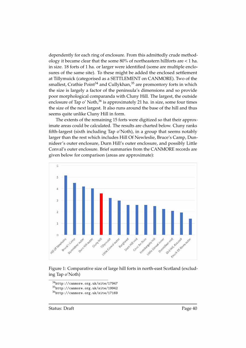
dependently for each ring of enclosure. From this admittedly crude method-ology it became clear that the some 80% of northeastern hillforts are < 1 ha.in size. 18 forts of 1 ha. or larger were identified (some are multiple enclo-sures of the same site). To these might be added the enclosed settlementat Tillymuick (categorised as a SETTLEMENT on CANMORE). Two of thesmallest, Crathie Point34 and Cullykhan,35 are promontory forts in whichthe size is largely a factor of the peninsula’s dimensions and so providepoor morphological comparanda with Cluny Hill. The largest, the outsideenclosure of Tap o’ Noth,36 is approximately 21 ha. in size, some four timesthe size of the next largest. It also runs around the base of the hill and thusseems quite unlike Cluny Hill in form.
The extents of the remaining 15 forts were digitized so that their approx-imate areas could be calculated. The results are charted below. Cluny ranksfifth-largest (sixth including Tap o’Noth), in a group that seems notablylarger than the rest which includes Hill Of Newleslie, Bruce’s Camp, Dun-nideer’s outer enclosure, Durn Hill’s outer enclosure, and possibly LittleConval’s outer enclosure. Brief summaries from the CANMORE records aregiven below for comparison (areas are approximate):
Figure 1: Comparative size of large hill forts in north-east Scotland (exclud-ing Tap o’Noth)
34http://canmore.org.uk/site/1794735http://canmore.org.uk/site/1994236http://canmore.org.uk/site/17169
Status: Draft Page 40
Hill of Newleslie 5.2 ha. ‘Consists today of a bank and internal quarry ditch surroundingthe hilltop (altitude 285 m) on three sides. On the S side no trace nowremains due to ploughing associated with reseeding. The earthen bankmeasures between 4 m and 5 m wide, and is 0.5 m high. It may berock cut at the E end. The internal quarry ditch is between 3 m and 4m wide and 0.4 m deep. No entrance was detected. The fort measures359 m E-W by 175 m transversely, making it one of the largest in theregion, at over 4 hectares. (Watt 1983)’37
Bruce’s Camp 4.5 ha. ‘The remains of this fort are situated on a rounded hill over-looking Inverurie from the SW. . . The fort measures 225 m from ESE toWNW by 135 m transversely internally and encloses an area of about2.5 ha. The rampart, which is spread about 5 m in thickness and from0.7 m to 1.5 m in height, is heavily disturbed around most of the circuit,and in several places, particularly on the SE, there are traces of a laterenclosure wall of relatively recent date extending along its crest. Anouter rampart extending along the SSW side of the fort and around theWNW end, is probably the remains of an earlier perimeter. . . At onepoint on the WNW this rampart is accompanied by a shallow externalditch (RCAHMS 2002).’38
Dunnideer 4.2 ha. ‘Situated in an area of rough grazing on a prominent conicalhill at an altitude of 265 m OD, this vitrified fort and its outer worksare in turn surrounded by an incomplete trivallate system of defences.Slight traces of outer works appear as a ruinous stony bank whichis seen best on the N and E but absent on the steep SW flank. Theoutermost line (E) of the trivallate defences is represented only by theremains of a marker trench seen as a slight terrace and situated welldown the hill to enclose an area measuring about 290 m by 183 m;gaps for entrances have been left in the E and W. Line (D) is similarlymarked-out and lies between 15.2 m and 45.7 m inside line (E); in thiscase, work on the construction of a rampart has begun on either sideof each entrance-gap. The third line (C) cannot be followed across thesteep SW flank of the hill but is otherwise similar to the outer pair.The fourth line (B) is a ruinous stony bank which is feeble at best andabsent on the steep SW flank of the hill, but otherwise similar to theouter pair (D and E); it probably represents an outwork. The highly-vitrified innermost defence (A) encloses an area measuring 67 m by27.4 m internally and is oblong on plan with a contemporary cisternnear the W end; there is also a medieval tower within the interior.These remains must represent at least two main structural phases, but
37http://canmore.org.uk/site/1763838http://canmore.org.uk/site/18586
Status: Draft Page 41
no evidence exists to indicate whether the vitrified fort preceded theunfinished outworks or vice versa. (NMRS 1977)’39
Durn Hill 4.0 ha.‘The fort on Durn Hill appears to have been uncompleted. Theinner line is a shallow marker trench c. 0.5 m wide by 0.1 m deep whichcan be traced throughout its entire circuit. The outer line is a similartrench which can also be traced without much difficulty throughoutits circuit. In the SW angle of this trench is an entrance c. 4.0 m wide.The medial line of defence, obviously unfinished, consists of a ditchwith upcast bank on its outer lip, covering the SW angle for a distanceof c. 140m. The ditch is c. 3.0 m wide by 0.8 m deep, and the bank is c.4.0 m broad by 0.6 m high. In the centre of this stretch is a causewayc. 4.5 m wide. The remainder of this line can be traced round thesummit of the hill as a slight scarp except on the NW segment whereonly a slight discolouration of the heather marks its course. A breakin the SW angle of the inner trench can be faintly discerned, and isprobably the entrance. Within the SW angle of the fort, where themedial rampart has been constructed, are the vague footings of twosimilar circular structures. The more southerly is contiguous with theditch of the medial rampart and is 8.5 m in diameter and 0.1 m high;the other is 5.4 m in diameter and 0.1 m high - possibly hut circles. (OS1961)
2014 work targeted the ’marker’ ditches. The trenches quickly estab-lished that the ditches are in fact palisade slots encircling the summitof Durn Hill. A slot in the inner line of defence identified charredmaterial within the foundation trench. Charred material was subse-quently radiocarbon dated to the Early Iron Age (Beta- 381815 2450+/- 30 BP; 760–410 cal BC 95.4%). The 2014 work suggests that DurnHill is an exceptionally well preserved fort in NE Scotland with muchof both inner and outer palisades traceable on the surface encirclingthe hill with the SW area further marked by a short section of rampartand ditch. (Noble & Sveinbjarnarson 2014)’40
Tillymuick 3.2 ha. ‘A settlement comprised of an ill-defined, overgrown earth andstone bank (0.6 m maximum height and spread to 4.5 m maximumwidth) enclosing a sub-circular area (200 m NE- SW by 170 m NW-SE) containing traces of eight probable hut circles. In the WNW is adistinct ’bend’ in the bank resembling an offset entrance but there isno apparent break in the debris, and the purpose of this change ofalignment is uncertain. In the SSW a break of c. 10 m in the bank may
39http://canmore.org.uk/site/1812840http://canmore.org.uk/site/17973
Status: Draft Page 42
be the main entrance. Another break of 3 m in the N where an oldtrack cuts though is presumably later. Yet another break some 30 m Eof this track may be due to erosion. Inside the enclosure is a curvingbank (about 18 m long, 4 m wide and 0.5 m high) about 40 m to the Eof the entrance; this appears to be contemporary with the settlementbut its purpose is obscure. (OS 1973)’41
Little Conval 3.0 ha. ‘A hill fort with internal measurements of 680ft [207 m] by 400ft[122 m]. The innermost defences, which were incompleted, comprise aspread wall and marker trench. Outside this is a second marker trench,and a third line starts off 75ft [23 m] outside the second which becomesa wall 6ft [1.8 m] thick faced with large slabs. This ends among a groupof shapeless enclosures which may be contemporary with the fort. Afourth line comprises a bank 110 yards [100 m] long covering the Napproach. (Feachem 1963)’42
In addition to Durn Hill’s Early Iron Age radiocarbon dates (760-410BCE), burnt wood from the collapsed inner rampart at Dunnideer has givencalibrated 2-sigma (95% probability) date ranges of 390-160 BCE (Cook,2010). As it is now believed that multivallation generally indicates multi-phase occupation (Hunter & Carruthers 2012, p.80), an Early Iron Age datefor the external defences is quire possible. The presence of a ’marker trench’at Little Conval, may also indicate the presence of a palisade, as was thecase at Durn hill. However, no ’marker trench’ has yet been found at ClunyHill and could only be identified, if at all, through excavation.
Of course, use of the enclosure may well have extended over multiplecenturies. For example, the apparent onomastic continuity between theVerturiones (3rd century), Waerteras (7th century) and Fortriu (Foster, 2014,2-4) hints at a continuous sense of regional identity within that period. Itis only applicable to the general region, however, and tells us little aboutsocial, economic, political or architectural practices, which may have var-ied dramatically. While reflecting on the enclosure’s dating and nature weshould also bear in mind that no significant archaeological finds have beenreported from the enclosure itself or the surrounding hills. This is despitemajor landscaping, large building projects, the establishment of a cemeteryand reservoir, and untold numbers of locals, tourists and Hydropathic pa-tients wandering the hills. Absence of evidence may not equate to evidenceof absence but many hilltop enclosures within the British Isles were neveroccupied as a place of residence or defence and Cluny Hill may be amongthem.
41http://canmore.org.uk/site/1821242http://canmore.org.uk/site/16307
Status: Draft Page 43
8.3 Need for further investigation
At this stage then, we should accept that any serious attempt to interpretthe site must wait for further evidence to be produced. There may well bemore 18th and 19th century documentation to be found in council archives,and perhaps in the Chalmers Archive as well. Such evidence is unlikely toradically alter the narrative described above, even if it helps to fill in muchdetail.
Yet desk-based assessment can only ever show that the existence of anenclosure is highly probable. To fully confirm it we must turn to archaeo-logical survey. The site has suffered enormous disturbance already so thismust be conducted with the least impact on the site that is possible. Muchcan be learned through remote sensing techniques such as magnetometry,Ground Penetrating Radar, and Electro-Resistivity surveys. Auguring couldhelp establish the depth and composition of the linear depressions, as wellas the extent to which a ditch could still be preserved beneath the modernpaths. A survey of the tree stumps identified in Section 6.2 would helpestablish the footprint of the site as it was understood in 1846. Any surveyshould also include Cluny Hill Hollow, in addition to the enclosure and itsimmediate surroundings. The resulting information would provide vitaldata that could narrow down the range of possible interpretations and guideany future excavation. Excavation itself would allow us to establish theprofile of the ditch, the foundations of any rampart or palisade, and producea host of environmental, and potentially artefact material, which could helpestablish the date of its construction or demise.
Given the cultural and historical association between Forres and suchimportant figures in early Scottish History as Macbeth, Malcolm II and KingDub, remarkably little is known about its history before the establishmentof the burgh. Confirming the presence of a major hilltop enclosure withinthe historic boundary of the town has the potential to offer a tremendoussource of information about its origins—which may be much earlier thansuspected—and of Moray more generally. Indeed, an enclosure may onlybe the most prominent archaeological feature on the site. Modern archae-ological methods will be able to tell us much more about Cluny Hill’s useand transformation by the people of Forres and their predecessors.
Status: Draft Page 44
Acknowledgements
This research was assisted by a large number of people. Grateful acknowl-edgement is expressed to Rhona McQueen, James Nock & Emma Rob-bie (Moray Heritage Centre), George Alexander, Billy Laing & HeatherShaw (Forres Heritage Trust), Olive Geddes & Hilary White (National Li-brary of Scotland), Claire Herbert (Aberdeenshire Council ArchaeologyService), Janet Trythall, Dave Anderson, Leanne Demay, Mary Saunders,Gary Lock, Andrew Wright, Colin Matheson (Scottish Orienteering Associa-tion), Kirsteen Mulhern (National Records of Scotland), and India Brown.Special thanks are due to Christopher Fleet (National Library of Scotland),Peter McKeague (RCAHMS), Jessica Ogden, Zoe Pollock, John Pouncett(University of Oxford), Michael Sharpe and Holly Willmott, all of whomwent out of their way in providing important evidence, comment and equip-ment. The greatest thank you is reserved for Christine Markussen and hertireless work conducting the geophysical survey.
Status: Draft Page 45
References
Alcock, Leslie, & Alcock, Elizabeth A. 1990. Reconnaissance excavations onEarly Historic fortifications and other royal sites in Scotland, 1974-84: 4,Excavations at Alt Clut, Clyde Rock, Strathclyde, 1974-75. Proceedings ofthe Society of Antiquaries of Scotland, 120, 95–149.
Algie, Matthew James. 1887. Guide to Forres and Objects of Interest in theNeighbourhood. 1st edn. Paisley: J. & R. Parlane.
Algie, Matthew James. 1907. Guide to Forres and Objects of Interest In theNeighbourhood. 2nd edn. Paisley: J. & R. Parlane.
Anderson, George, & Anderson, Peter. 1842. Guide to the Highlands andIslands of Scotland, Including Orkney and Zetland. Edinburgh: William Tait.
Anderson, James. 1779. An Account of the Ancient Monuments and Fortifi-cations in the Highlands of Scotland, In a Letter from Mr. James Anderson,to George Wilson, Esq; of Lincoln’s Inn. Read Nov. 27, 1777. Archaeologia,or Miscellaneous Tracts Relating to Antiquity, 5, 241–266.
Anderson, James. 1782. A Further Description of Ancient Fortificationsin the North of Scotland. Archaeologia, or Miscellaneous Tracts Relating toAntiquity, 6, 87–99.
Anderson, John. 1837. Anderson’s Tourist’s Guide Through Scotland. Edinburgh:John Anderson.
Anderson, Joseph. 1881. Scotland in Early Christian Times. The Rhind Lecturesin Archaeology for 1880. Edinburgh: David Douglas.
Anonymous surveyor. 1768 (Nov.). Part of estate of Westfield lying south-eastand north-west of Forres.
Armit, Ian. 2016. Celtic Scotland. 3rd edn. Edinburgh: Birlinn.
Arrowsmith, Aaron. 1807. Map of Scotland Constructed from Original Materials.
Arrowsmith, Aaron. 1809. Memoir Relative to the Construction of the Map ofScotland Published by Aaron Arrowsmith in the Year 1807 : with Two Maps.London: Arrowsmith.
Avery, Joseph, & Wade, George. 1730. Plan of the Murray Firth and CromartyFirth, with parts of the Shires of Inverness, Sutherland, Ross, Nairn, and Elgin.Showing roads.
Status: Draft Page 46
Avery, Michael. 1976. Hillforts of the British Isles: A Student’s Introduction.Pages 1–58 of: Harding, D. W. (ed), Hillforts: Later Prehistoric Earthworks inBritain and Ireland. London: Academic Press.
Barker, Nicolas. 1990. Rewriting History: 44. Charles Bertram and ’Richardof Cirencester’s’ map of Roman Britain. Page 66 of: Jones, Mark, Craddock,Paul T., & Barker, Nicolas (eds), Fake? The Art of Deception. Berkeley:University of California Press.
Bertram, Charles. 1809. The description of Britain. Printed for J. White.
Beverell, J. 1727. Delices de la Grande Bretagne, et dâAZIrlande. Vol. 6. Leyden:Pierre Vander.
Black, Adam. 1852. Black’s Economical Tourist of Scotland. 7th edn. Edinburgh:Adam & Charles Black.
Boswell, James. 1791. The journal of a tour to the Hebrides, with Samuel Johnson.London: Charles Dilly.
Botfield, Beriah. 1830. Journal of a tour through the Highlands of Scotland duringthe summer of 1829. Edinburgh: Norton Hall.
Brown, George. 1810. Map of Moray and Nairn Shires; Enlarged from MrArrowsmith’s Map of Scotland.
Burrell, William. 2016. Sir William Burrell’s Northern Tour, 1758. 2nd edn.Sources in Local History. Edinburgh: The European Ethnological ResearchCentre.
Carlisle, Nicholas. 1813. A Topographical Dictionary of Scotland, and of theIslands in the British Seas; exhibiting the names of the several cities, royal burghs,parishes, villages, and the islands, with the shire, and division of the shire, inwhich they are situated. London: G. & W. Nicol and Bell and Bradfute.
Carr, John. 1809. Caledonian sketches, or a tour through Scotland in 1807. Lon-don: Mathews & Leigh.
Carruthers, LL. D. 1887. The Highland Note-book, or Sketches and Anecdotes.Inverness: The Courier Office.
Chalmers, George. 1807. Caledonia : or, a historical and topographical account ofNorth Britain, from the most ancient to the present times with a dictionary ofplaces chorographical & philological. Vol. 1. Paisley: Alexander Gardner.
Chalmers, George. 1810. Caledonia: or an Account, Historical and Topographicof North Britain, from the Most Ancient to the Present Times. Vol. 2. London:T. Cadell & W. Davies.
Status: Draft Page 47
Chalmers, W. (ed). 1803. The Gazetteer of Scotland. Dundee: W. Chalmers.
Childe, V. Gordon. 1946. Scotland Before the Scots Being the Rhind Lectures for1944. 1st edition edn. London: Methuen.
Christison, David. 1898. Early Fortifications in Scotland: Motes, Camps, andForts: The Rhind Lectures in Archaeology for 1894. Edinburgh: W. Blackwoodand sons.
Cockburn, Henry. 1889. Circuit Journeys. Edinburgh: David Douglas.
Commissioners of Works. 1937. Ancient Monuments of Great Britain: List ofmonuments (to 31st December 1936). London: H. M. Stationery Office.
Cook, Murray. 2010. New Light on Oblong Forts: excavations at Dunnideer,Aberdeenshire. Proceedings of the Society of Antiquaries of Scotland, 140,79–91.
Cordiner, Charles. 1780. Antiquities & Scenery of the North of Scotland, in aSeries of Letters, to Thomas Pennant, Esq. London: s.n.
Cordiner, Charles. 1795. Remarkable ruins, and romantic prospects, of NorthBritain. with [sic] ancient monuments, and singular subjects of natural history.London: I & J Taylor.
Cotton, M. Alywin. 1954. British camps with timbered-laced ramparts. TheArchaeological Journal, 111, 26–105.
Defoe, Daniel. 1761. A Tour Thro’ the Whole Island of Great Britain, Divided intoCircuits or Journies. 6th edn. Vol. 4. London: Browne, &c.
Donaldson, James. 1794. General View of the Agriculture of the County ofElgin or Moray, Lying Between the Spey and the Findhorn; including part ofStrathspey, in the County of Inverness. London: Board of Agriculture.
Douglas, Robert, & Robertson, Andrew Beaumont. 1934. Annals of the RoyalBurgh of Forres. Elgin: Elgin Courant & Courier.
Dunbar, Edward Dunbar. 1866. Social life in former days, chiefly in the provinceof Moray: Illus. by letters and family papers. Vol. 2. Edinburgh: Edmonston& Douglas.
Duncan, Andrew, & Duncan, John. 1820. Duncan’s Itinerary of Scotland. 4thedn. Glasgow: James Lumsden & Son.
Feachem, R. W. 1955. Fortifications. Pages 66–86 of: Wainwright, F. T. (ed),The Problem of the Picts. New York: Greenwood.
Status: Draft Page 48
Feachem, R. W. 1971. Unfinished Hill-forts. Pages 19–40 of: Jesson, Margaret,& Hill, David (eds), The Iron Age and its Hill-Forts: Papers prsented to SirMortimer Wheeler. Southampton: Southampton University ArchaeologicalSociety.
Forbes, Alfred Houghton. 1975. Forres, A Royal Burgh 1150-1975. Elgin:Moray and Nairn County Library.
Forsyth, Isaac. 1813. An Account of the Antiquities, Modern Buildings, andNatural Curiosities, in the Province of Moray, Worthy of the Attention of theTourist; With an Itinerary of the Province. Edinburgh: I. Forsyth.
Forsyth, Robert. 1806. The Beauties of Scotland: containing a clear and fullaccount of the agriculture, commerce, mines, and manufactures; of the population,cities, towns, villages, &c. of each county. Vol. 4. Edinburgh: Constable &Brown.
Foster, Sally M. 2014. Picts, Gaels and Scots: early historic Scotland. Edinburgh:Birlinn.
Fraser, Alex. 1989. A Glimpse of Forres of Yesteryear. Elgin: Moravian.
Gordon, Alexander. 1726. Itinerarium Septentrionale: Or, A Journey Thro’ Mostof the Counties of Scotland, and Those in the North of England. London: authorand sold.
Gordon, Robert. 1654. Moraviae Descriptio. Pages 306–311 of: Geographicalcollections relating to Scotland made by Walter Macfarlane, vol. 2. Edinburgh:Scottish History Society.
Gordon, Robert. 1661. Moravia. Pages 427–436 of: Geographical collectionsrelating to Scotland made by Walter Macfarlane, vol. 2. Edinburgh: ScottishHistory Society.
Grant, Duncan. 1839. Parish of Forres. Presbytery of Forres, Synod of Moray.Pages 159–178 of: Committee of the Society for the Sons and Daughters ofthe Clergy (ed), The New Statistical Account of Scotland, vol. 13. Edinburgh:William Blackwood and Sons.
Grant, John, & Leslie, William. 1798. A survey of the province of Moray:historical, geographical, and political. Aberdeen: Isaac Forsyth.
Green, Samuel G., & Faulkner, Thomas. 1891. Scotland Illustrated: with penand pencil. New York: Hurst & Co.
Status: Draft Page 49
Groome, Francis Hindes. 1895. Ordnance Gazetteer of Scotland : a survey ofScottish topography, statistical, biographical and historical. Vol. 3. London: W.Mackenzie.
Grose, Francis. 1797. The Antiquities of Scotland. London: Hooper & Wigstead.
Hall, James. 1806. Travels in Scotland by an Unusual Route: with a trip to theOrkneys and Hebrides. Vol. 2. London: J. Johnson.
Hanway, Mary Anne. 1777. A Journey to the Highlands of Scotland; withoccasional remarks on Dr. Johnson’s Tour. London: Fielding & Walker.
Heron, Robert. 1791. Scotland Delineated, or a Geographical Decription of everyShire in Scotland, including the Northern and Western Isles. With Some Accountof the Curiosities, Antiquities, and present State of the Country. For the Use ofYoung Persons. Edinburgh: James Neill.
Heron, Robert. 1797. Scotland Described: Or, a Topographical Description of allthe Counties of Scotland. Edinburgh: T. Brown.
Hibbert, Samuel. 1857a. Collections Relative to Vitrified Sites. Pages 183–201 of: Archaeologica Scotica: or, Transactions of the Society of Antiquaries ofScotland, vol. 4. Edinburgh: Society of Antiquaries of Scotland.
Hibbert, Samuel. 1857b. Observations on the theories which have beenproposed to explain the vitrified forts of Scotland. Pages 160–182 of:Archaeologica Scotica: or, Transactions of the Society of Antiquaries of Scotland,vol. 4. Edinburgh: Society of Antiquaries of Scotland.
Hogg, A. H. A. 1979. British Hill-Forts: An Index. BAR British Series, no. 62.Oxford: British Archaeological Reports.
Hogg, A. H. A. 1984. Guide to the Hill-forts of Britain. London: Paladin.
House of Commons. 1832. Forres. Elginshire. Report on the Burgh. Tech. rept.House of Commons, London.
Hunter, Fraser, & Carruthers, Martin (eds). 2012. Iron Age Scotland: ScARFPanel Report. Scottish Archaeological Research Framework (ScARF).
Innes, Cosmo (ed). 1864. Ane Account of the Familie of Innes Compiled byDuncan Forbes of Culloden. 1698. Aberdeen: The Spalding Club.
Johnson, Samuel. 1775. A Journey to the Western Islands of Scotland. Dublin:Thomas Walker.
Lauder, Thomas Dick. 1873. The Great Floods of August 1829 in the Province ofMoray and Adjoining Districts. Elgin: R. Stewart.
Status: Draft Page 50
Leslie, William. 1811. General View of the Agriculture of the Counties of Nairnand Moray; with Observations on the Means of their Improvement. London:Board of Agriculture.
Leslie, William. 1823. A Manual of the Antiquities, Distinguished Buildings andNatural Curiosities of Moray: In its Ancient Prelatic Extent. Edinburgh: IsaacForsyth.
Lettice, John. 1794. Letters on a Tour Through Various Parts of Scotland, in theYear 1792. London: T. Cadell.
Leveson-Gower, George, & Sutherland-Leveson-Gower, George (eds). 1837.Registrum Episcopatus Moraviensis, e pluribus codicibus consarcinatum circaA.D. MCCCC. Cum continuatione diplomatum recentiorum usque ad A.D.MDCXXIII. Edinburgh: The Bannatyne Club.
Lewis, Samuel. 1846. A Topographical Dictionary of Scotland. London: S. Lewis& Co.
MacColl, Evan, & Mackenzie, Alexander. 1887. The English Poetical Works ofEvan MacColl: With a Biographical Sketch of the Author. Kingston: BritishWhig.
MacCulloch, John. 1824. The Highlands and Western Isles of Scotland, containingdescriptions of their scenery and antiquities, with an account of the politicalhistory and ancient manners, and of the origin, language, agriculture, economy,music, present condition of the people, &c. Vol. 4. London: Longman, Hurst,Rees, Orme, Brown & Green.
MacCulloch, John. 1840. A Geological Map of Scotland by Dr MacCulloch.
MacKie, Euan. 1976. The Vitrified Forts of Scotland. Pages 205–235 of:Harding, D. W. (ed), Hillforts: Later Prehistoric Earthworks in Britain andIreland. London: Academic Press.
Marion, Jules. 1872. Les Monuments Cenltiques et Scandinaves des Environsd’Inverness. Pages 1–70 of: MÃl’moires de la SociÃl’tÃl’ Nationale des Antiquesde France. 4, vol. 33, no. 3. Paris: SociÃl’tÃl’ Nationale des Antiques deFrance.
Matheson, Donald. 1905. The Place Names of Elginshire. Stirling: E. MacKay.
McDonnel, John. 1796. Parish of Forres (County of Banff.—Presbytery ofForres.—Synod of Moray.). Pages 447–455 of: Sinclair, Sir John Archibald(ed), The Statistical Accounts of Scotland. Drawn up from the Communicationsof the Ministers of the Different Parishes, vol. 17. Edinburgh: William Creech.
Status: Draft Page 51
McNicol, Donald. 1779. Remarks on Dr Samuel Johnson’s Journey to the Hebrides;in which are given Observations on the antiquities, Language, Genius andManners of the Highlanders of Scotland. London: T. Cadell.
Murray, John. 1875. Handbook for travellers in Scotland. 4th edn. London: JohnMurray.
Neele, S. J. 1811. Scotland.
O’Dell, A. C., & Walton, Kenneth. 1962. The Highlands & Islands of the Scotland.Regions of the British Isles. Edinburgh: Thomas Nelson & Sons.
Omand, Donald. 1976. The Moray Book. Edinburgh: P. Harris.
Parliamentary Commission on Municipal Corporations in Scotland. 1835.Report on the Burgh of Forres (Morayshire). Pages 447–451 of: MunicipalCorporations. (Scotland.) Local Reports of the Commissioners. Part I. FromAberbrothwick to Fortrose. London: William Clowes and Sons.
Pennant, Thomas. 1776. A Tour in Scotland; 1769. 4th edn. London: BenjaminWhite.
Playfair, James. 1819. A Geographical and Statistical Description of Scotland.Vol. 2. Edinburgh: Archibald Constable & Co.
Pococke, Richard, & Kemp, Daniel William. 1887. Tours in Scotland 1747,1750, 1760. Edinburgh : Printed at the University Press by T. and A.Constable for the Scottish History Society.
Ralston, Ian. 2006. Celtic Fortifications. Stroud: Tempus.
Ralston, Ian, Sabine, K., & Watt, W. 1983. Later Prehistoric Settlements inNorth-East Scotland: A preliminary assessment. Pages 149–73 of: Mytum,H. C., & Chapman, John (eds), Settlement in North Britain 1000 BC - AD1000. Papers presented to George Jobey, Newcastle upon Tyne, December 1982.BAR International Series, no. 118. Oxford: British Archaeological Reports.
Rampini, Charles. 1897. A History of Moray and Nairn. County Histories ofScotland. Edinburgh: William Blackwood and Sons.
Rhind, William. 1839. Sketches of the past and present state of Moray. Elgin:George Wilson.
Rivet, A. L. F. (ed). 1966. The Iron Age in Northern Britain. Edinburgh:Edinburgh University Press.
Status: Draft Page 52
Rochefoucauld, Alexandre de La, & Lazowski, Maximilien de. 2001. Tothe Highlands in 1786: The Inquisitive Journey of a Young French Aristocrat.Martlesham: Boydell & Brewer.
Roy, William. 1752a. The Roy Military Survey of Scotland: Highlands. Fair Copy.
Roy, William. 1752b. The Roy Military Survey of Scotland: Highlands. OriginalProtraction.
Roy, William. 1793. Plate 34: Plan shewing the entrances into the friths ofDornoch and Murray together with the relative situations of Tarbat-ness,Burgh-head, and Forres; supposed to be places mentioned by Richard ofCirencester. In: The Military Antiquities of the Romans in Britain. London:Society of Antiquaries of London.
Rutgers, Hermanus. 1661. Britannia Magna Sive Angliae, Scotiae, Hiberniae& adjacentium Insularum Geographico-Historico Descriptio. Amsterdam:Valckenier.
Scotland. 1842. The Topographical, Statistical, and Historical gazetteer of Scotland.Vol. 1. Glasgow: A. Fullarton & Co.
Shaw, Lachlan, & Gordon, James Frederick Skinner. 1882. The history of theProvince of Moray : comprising the counties of Elgin and Nairn, the greater partof the County of Inverness and a portion of the County of Banff, all called theProvince of Moray before there was a division into counties. London : Hamilton,Adams.
Simpson, Anne Turner, & Stevenson, Sylvia. 1982. Historic Forres: Thearchaeological implications of development. Tech. rept. University of Glasgow,Glasgow.
Sinclair, Catherine. 1840. Shetland and the Shetlanders; or, The Northern Circuit.Edinburgh: William Whyte & Co.
Smith, Elizabeth Grant. 1911. Memoirs of a Highland lady; the autobiography ofElizabeth Grant of Rothiemurchus, afterwards Mrs. Smith of Baltiboys, 1797-1830. London: John Murray.
Southey, Robert. 1929. Journal of a Tour in Scotland in 1819. London: J. Murray.
Stockdale, John. 1806. Map of Scotland from the Latest Surveys.
Stoddart, John. 1801. Remarks on Local Scenery & Manners in Scotland Duringthe Years 1799 and 1800. Vol. 2. London: William Miller.
Status: Draft Page 53
Stuart, Robert. 1845. Caledonia Romana: A Descriptive Account of the RomanAntiquities of Scotland. Edinburgh: Bell and Bradfute.
Stueckelberger, Alfred, & Grasshoff, Gerd. 2006. Ptolemaios. Handbuch derGeographie. (2 vols.). Basel: Schwabe.
Taylor, Cameron. 2015. Macbeth’s World.
Taylor, Cameron, & Murray, Alistair. 2008. On the Trail of the Real Macbeth,King of Alba. 1st edn. Edinburgh: Luath Press.
Taylor, George, & Skinner, Andrew. 1776. Plate 32: The Road from Banff toInverness. Page Plate 32 of: Survey and maps of the roads of North Britain orScotland.
Thomson, John. 1814. A Traveller’s Guide though Scotland, and its Islands. Vol.2. Edinburgh: John Thomson & Co.
Thomson, William. 1788. A tour in England and Scotland, in 1785. London: G.G. J. & J. Robinson.
Thomson, William. 1791. Prospects and observations; on a tour in England andScotland: natural, oeconomical, and literary. By Thomas Newte, Esq. London:G. G. J. & J. Robinson.
Thornton, T. 1804. A Sporting Tour through the the northern Parts of Engand,and the Great Part of the Highlands of Scotland. London: Vernor & Hood.
Volkmann, J. J. 1784. Neueste Reisen durch Schottland and Irland, vorzÃijglichin Absicht auf die Naturgeschichte, Oekonomie, Manufacturen und Landsitzeder Grossen. Leipzig: Caspar Fritsch.
Walford, Thomas. 1818. The Scientific Tourist through England, Wales & Scot-land. Vol. 2. London: John Booth.
Walpoole, Augustus. 1784. The New British Traveller; or, a Complete ModernUniversal Display of Great-Britain and Ireland. London: Alex Hogg.
Watson, J., & Watson, W. 1868. Morayshire Described : Being a Guide to Visitors,Containing Notices of Ecclesiastical and Military Antiquities; TopographicalDescriptions of the Principal Country Residences, Towns, and Villages, andGenealogical Notes of the Leading Families in the Country. Elgin: Russell &Watson.
Webster, David. 1819. A topographical dictionary of Scotland. Edinburgh: PeterHill & Co.
Status: Draft Page 54
Williams, John. 1777. An Account of Some Remarkable Ancient Ruins, LatelyDiscovered in the Highlands and Northern Parts of Scotland. Edinburgh:William Creech.
Wilson, Daniel. 1851. The Archaeology and Prehistoric Annals of Scotland. 2edn.
Wilson, John Marius. 1882. The Gazetteer of Scotland. Edinburgh: W. & A. K.Johnston.
Withers, Charles W. J. 2002. The social nature of map making in the ScottishEnlightenment, c.1682-c.1832. Imago Mundi, 54, 46–66.
Withers, Charles W. J. 2008. Writing in Geography’s History: Caledonia,Networks of correspondence and geographical knowledge in the lateenlightenment. Scottish Geographical Journal, 120, 33–45.
Wood, John. 1823. Plan of the Town of Forres from actual survey.
Wood, John. 1828. Descriptive account of the principal towns in Scotland: toaccompany Wood’s town atlas. Edinburgh: W. & A. K. Johnston.
Woolf, Alex. 2006. Dun Nechtain, Fortriu and the Geography of the Picts.Scottish Historical Review, 85(2), 182–201.
Worsaae, J.Jens Jakob Asmussen. 1852. An account of the Danes and Norwegiansin England, Scotland, and Ireland. London: John Murray.
Wright, P. K., Andrew, The Scottish Civic Trust, Horner Maclennan, McLeod& Aitken, & Duncan Bryden Associates. 2013 (Nov.). Forres ConservationArea. Part 1: Conservation Area Appraisal. Tech. rept.
Yeadon, Jane. 2015. The Ancient Secret of Cloven hill. Peterborough: PODWorldwide.
Status: Draft Page 55
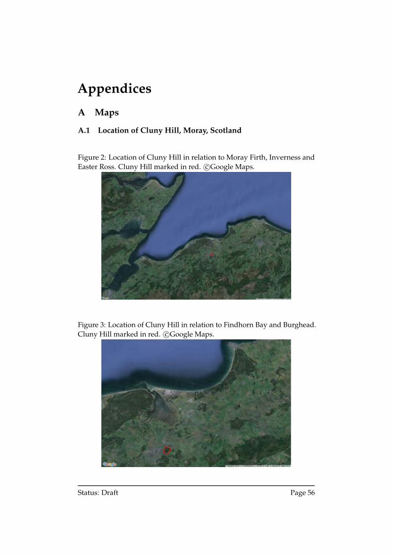
Appendices
A Maps
A.1 Location of Cluny Hill, Moray, Scotland
Figure 2: Location of Cluny Hill in relation to Moray Firth, Inverness andEaster Ross. Cluny Hill marked in red. c©Google Maps.
Figure 3: Location of Cluny Hill in relation to Findhorn Bay and Burghead.Cluny Hill marked in red. c©Google Maps.
Status: Draft Page 56
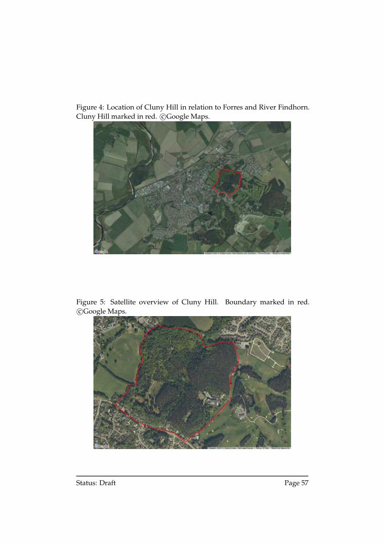
Figure 4: Location of Cluny Hill in relation to Forres and River Findhorn.Cluny Hill marked in red. c©Google Maps.
Figure 5: Satellite overview of Cluny Hill. Boundary marked in red.c©Google Maps.
Status: Draft Page 57
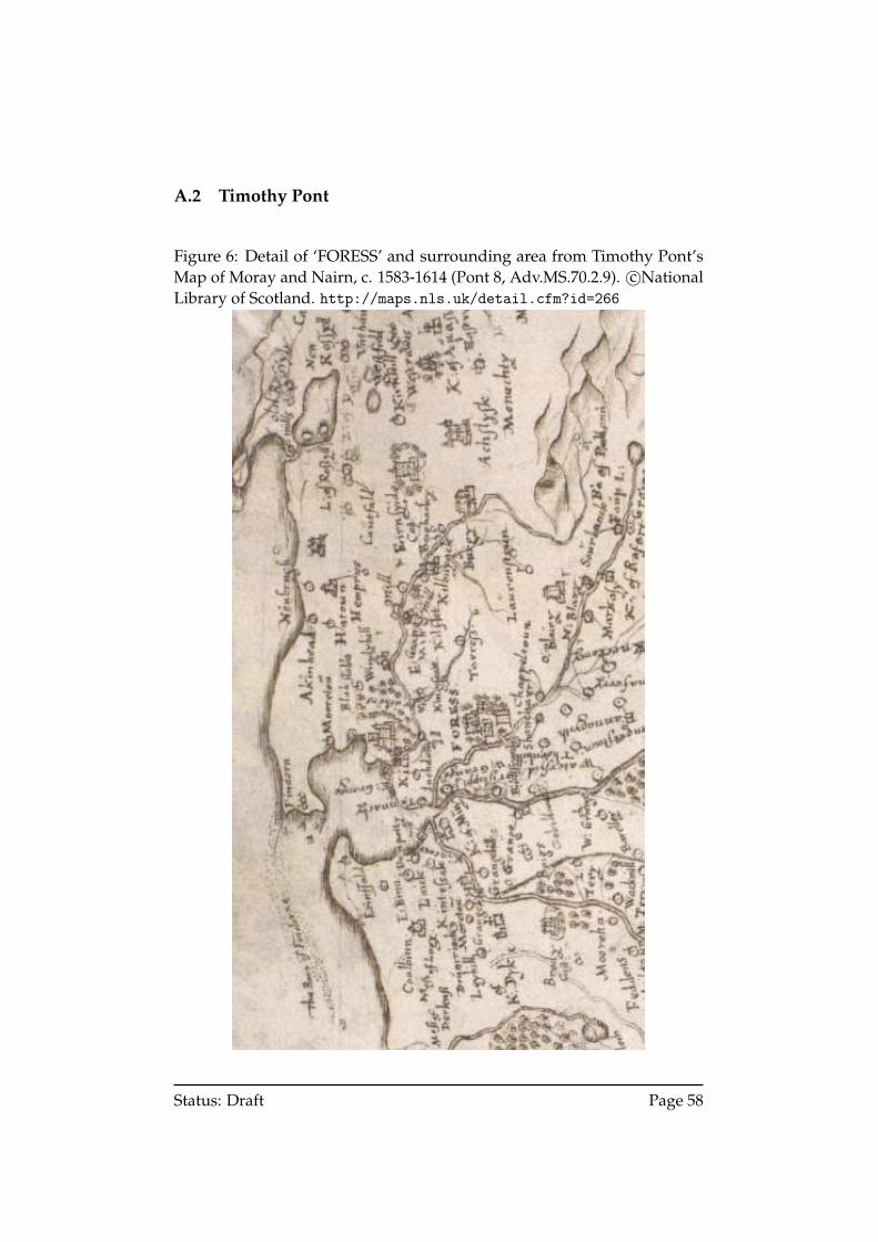
A.2 Timothy Pont
Figure 6: Detail of ‘FORESS’ and surrounding area from Timothy Pont’sMap of Moray and Nairn, c. 1583-1614 (Pont 8, Adv.MS.70.2.9). c©NationalLibrary of Scotland. http://maps.nls.uk/detail.cfm?id=266
Status: Draft Page 58
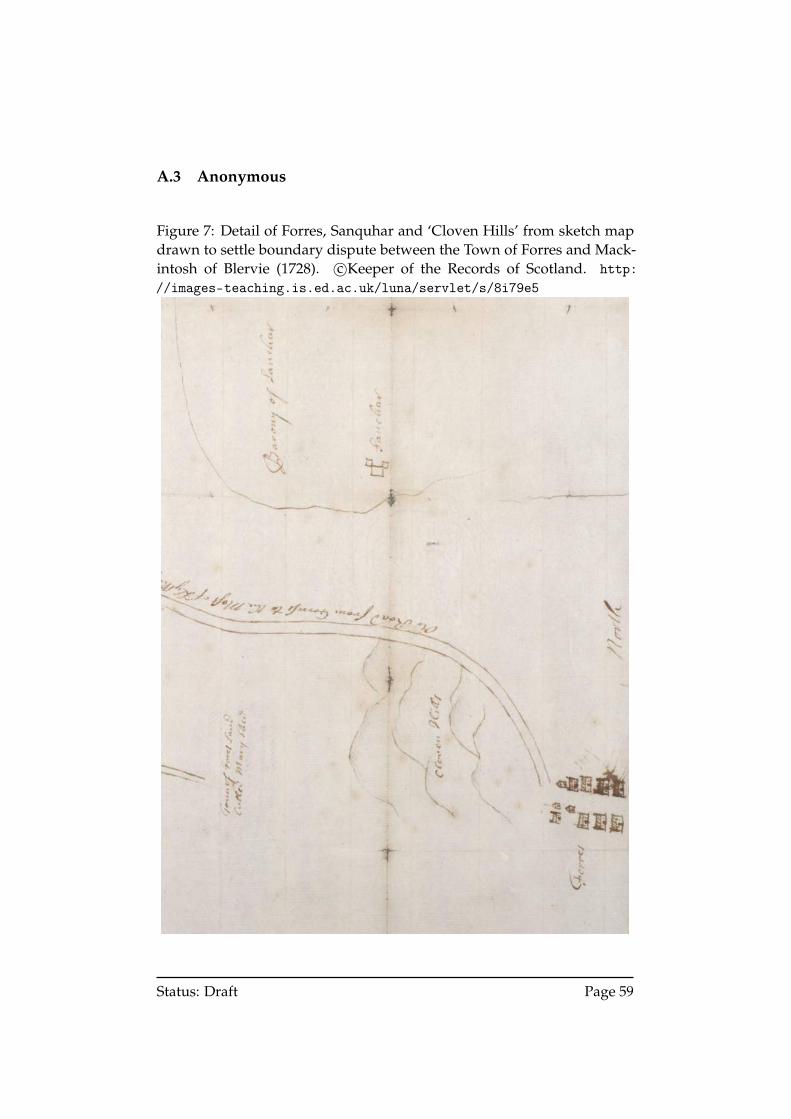
A.3 Anonymous
Figure 7: Detail of Forres, Sanquhar and ‘Cloven Hills’ from sketch mapdrawn to settle boundary dispute between the Town of Forres and Mack-intosh of Blervie (1728). c©Keeper of the Records of Scotland. http://images-teaching.is.ed.ac.uk/luna/servlet/s/8i79e5
Status: Draft Page 59
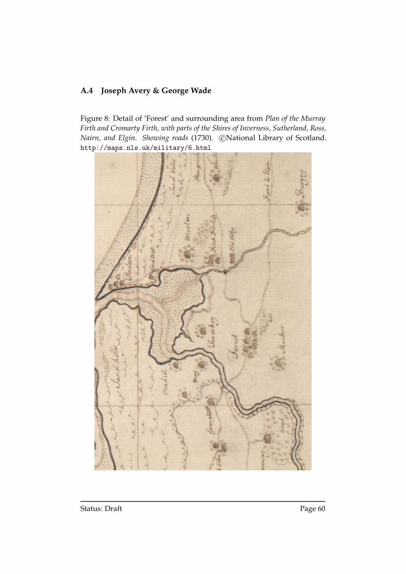
A.4 Joseph Avery & George Wade
Figure 8: Detail of ‘Forest’ and surrounding area from Plan of the MurrayFirth and Cromarty Firth, with parts of the Shires of Inverness, Sutherland, Ross,Nairn, and Elgin. Showing roads (1730). c©National Library of Scotland.http://maps.nls.uk/military/6.html
Status: Draft Page 60
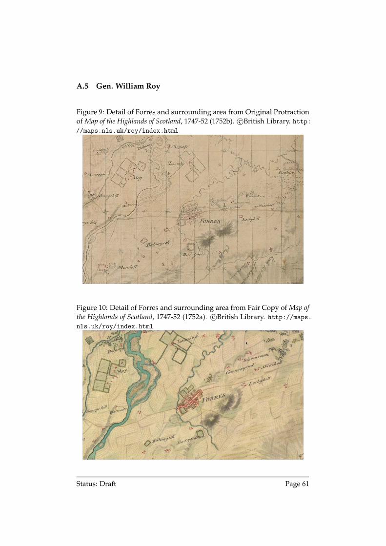
A.5 Gen. William Roy
Figure 9: Detail of Forres and surrounding area from Original Protractionof Map of the Highlands of Scotland, 1747-52 (1752b). c©British Library. http://maps.nls.uk/roy/index.html
Figure 10: Detail of Forres and surrounding area from Fair Copy of Map ofthe Highlands of Scotland, 1747-52 (1752a). c©British Library. http://maps.nls.uk/roy/index.html
Status: Draft Page 61
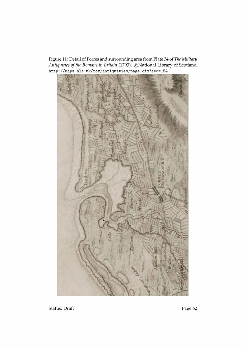
Figure 11: Detail of Forres and surrounding area from Plate 34 of The MilitaryAntiquities of the Romans in Britain (1793). c©National Library of Scotland.http://maps.nls.uk/roy/antiquities/page.cfm?seq=154
Status: Draft Page 62
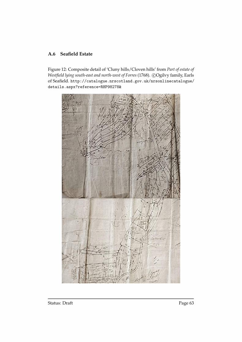
A.6 Seafield Estate
Figure 12: Composite detail of ‘Cluny hills/Cloven hills’ from Part of estate ofWestfield lying south-east and north-west of Forres (1768). c©Ogilvy family, Earlsof Seafield. http://catalogue.nrscotland.gov.uk/nrsonlinecatalogue/details.aspx?reference=RHP98278&
Status: Draft Page 63
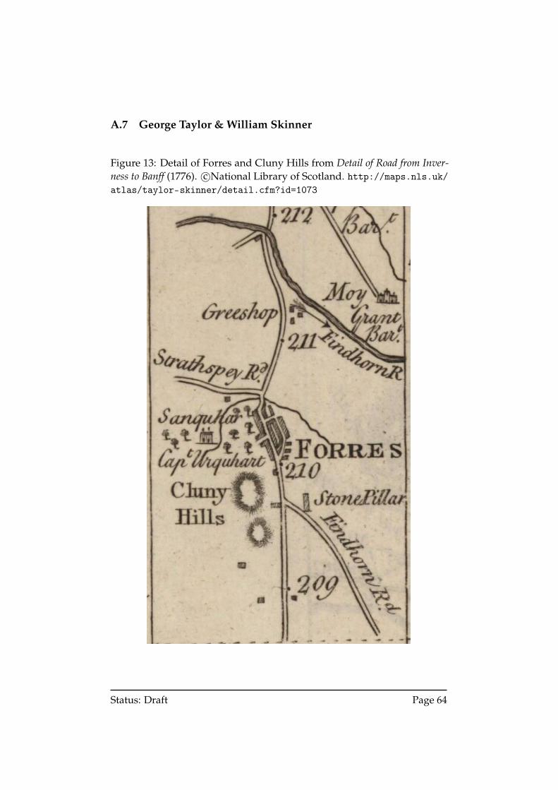
A.7 George Taylor & William Skinner
Figure 13: Detail of Forres and Cluny Hills from Detail of Road from Inver-ness to Banff (1776). c©National Library of Scotland. http://maps.nls.uk/atlas/taylor-skinner/detail.cfm?id=1073
Status: Draft Page 64
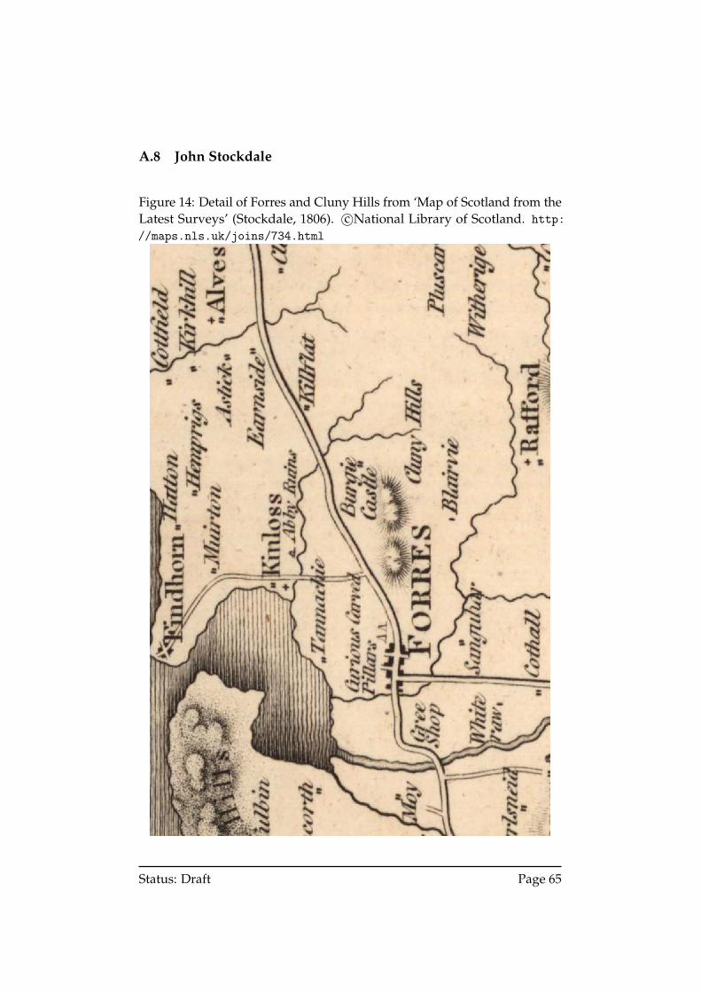
A.8 John Stockdale
Figure 14: Detail of Forres and Cluny Hills from ‘Map of Scotland from theLatest Surveys’ (Stockdale, 1806). c©National Library of Scotland. http://maps.nls.uk/joins/734.html
Status: Draft Page 65
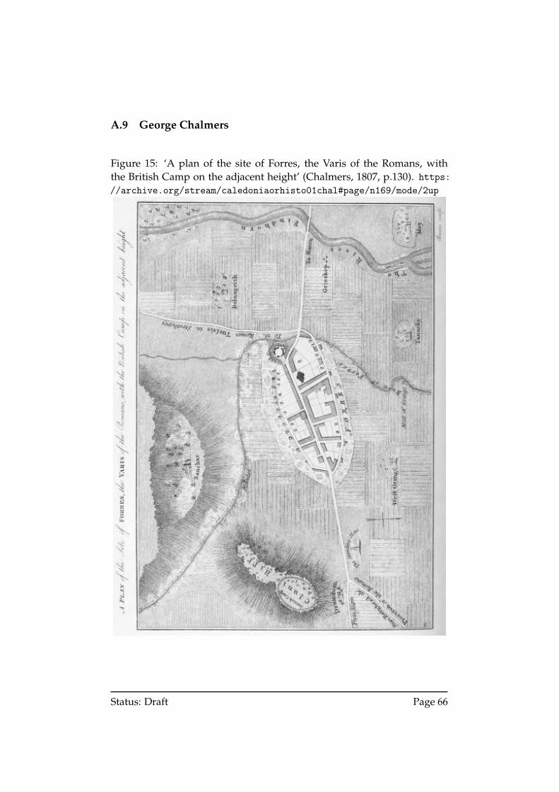
A.9 George Chalmers
Figure 15: ‘A plan of the site of Forres, the Varis of the Romans, withthe British Camp on the adjacent height’ (Chalmers, 1807, p.130). https://archive.org/stream/caledoniaorhisto01chal#page/n169/mode/2up
Status: Draft Page 66
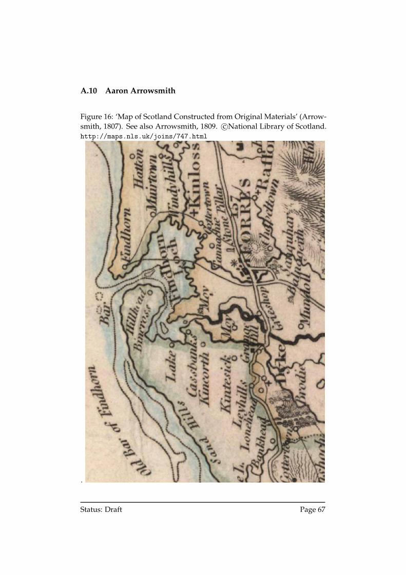
A.10 Aaron Arrowsmith
Figure 16: ‘Map of Scotland Constructed from Original Materials’ (Arrow-smith, 1807). See also Arrowsmith, 1809. c©National Library of Scotland.http://maps.nls.uk/joins/747.html
.
Status: Draft Page 67
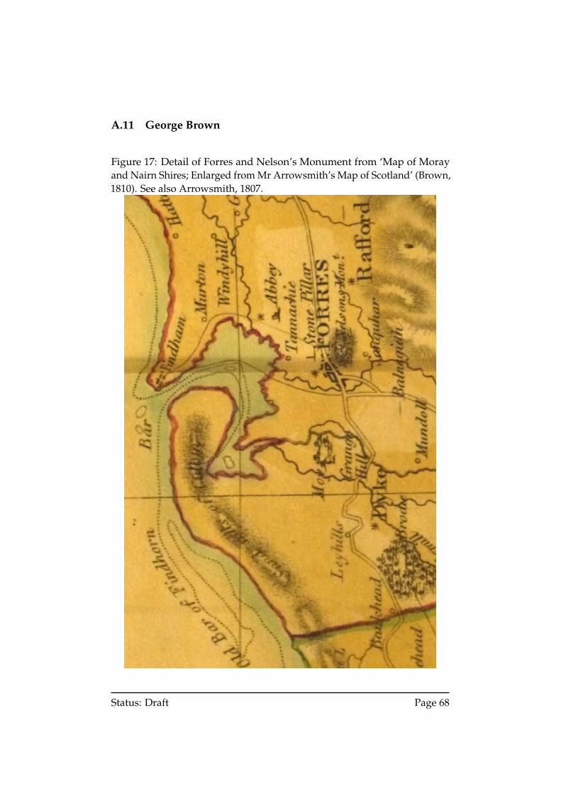
A.11 George Brown
Figure 17: Detail of Forres and Nelson’s Monument from ‘Map of Morayand Nairn Shires; Enlarged from Mr Arrowsmith’s Map of Scotland’ (Brown,1810). See also Arrowsmith, 1807.
Status: Draft Page 68
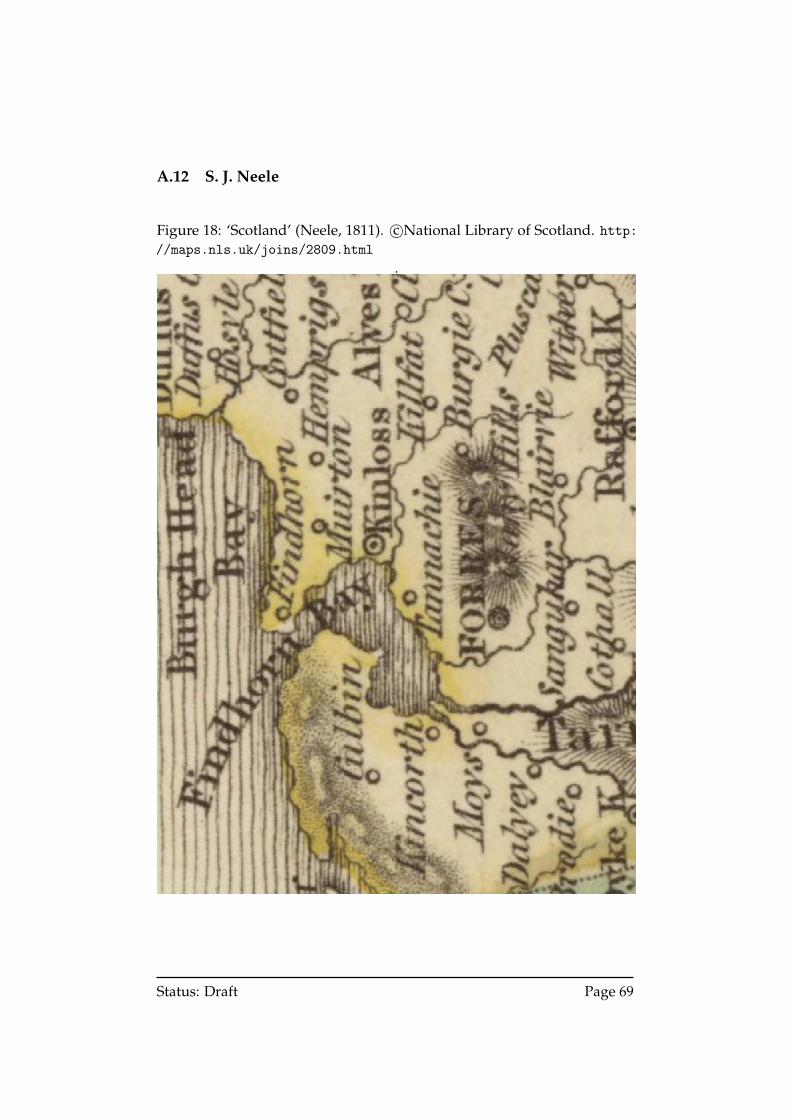
A.12 S. J. Neele
Figure 18: ‘Scotland’ (Neele, 1811). c©National Library of Scotland. http://maps.nls.uk/joins/2809.html
.
Status: Draft Page 69
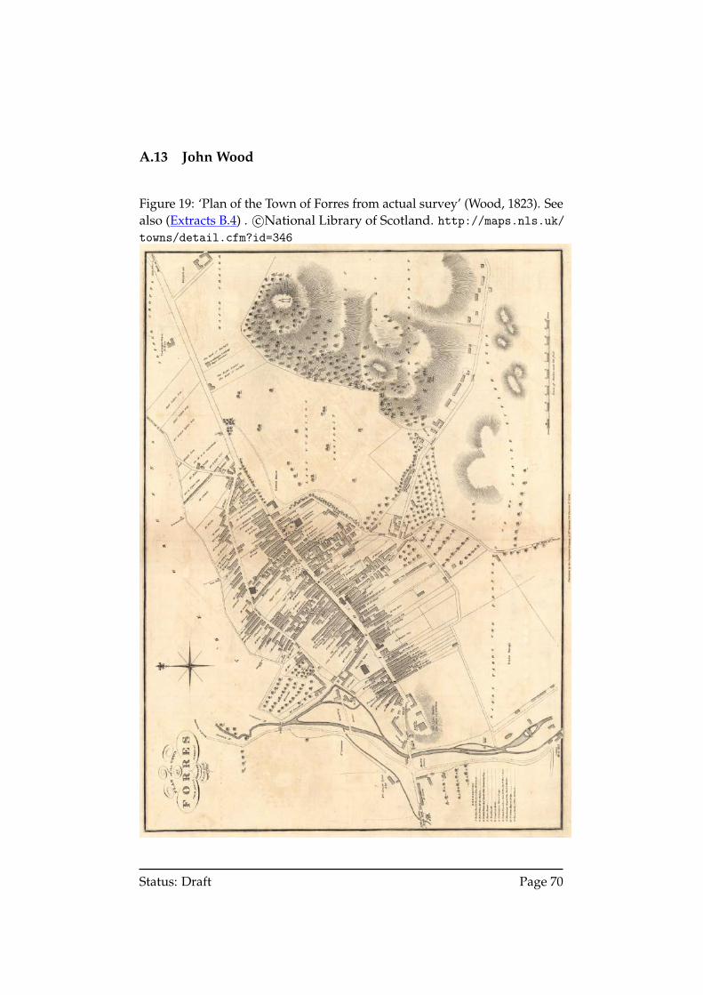
A.13 John Wood
Figure 19: ‘Plan of the Town of Forres from actual survey’ (Wood, 1823). Seealso (Extracts B.4) . c©National Library of Scotland. http://maps.nls.uk/towns/detail.cfm?id=346
Status: Draft Page 70
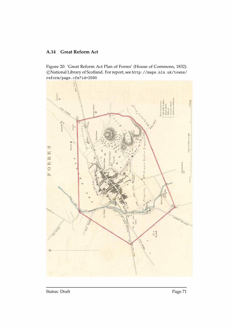
A.14 Great Reform Act
Figure 20: ‘Great Reform Act Plan of Forres’ (House of Commons, 1832).c©National Library of Scotland. For report, see http://maps.nls.uk/towns/reform/page.cfm?id=2590
Status: Draft Page 71
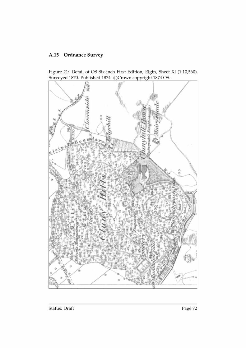
A.15 Ordnance Survey
Figure 21: Detail of OS Six-inch First Edition, Elgin, Sheet XI (1:10,560).Surveyed 1870. Published 1874. c©Crown copyright 1874 OS.
Status: Draft Page 72
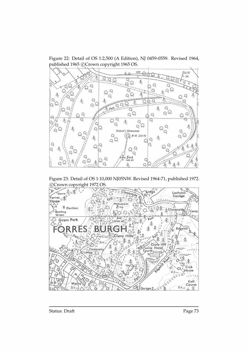
Figure 22: Detail of OS 1:2,500 (A Edition), NJ 0459-0559. Revised 1964,published 1965 c©Crown copyright 1965 OS.
Figure 23: Detail of OS 1:10,000 NJ05NW. Revised 1964-71, published 1972.c©Crown copyright 1972 OS.
Status: Draft Page 73
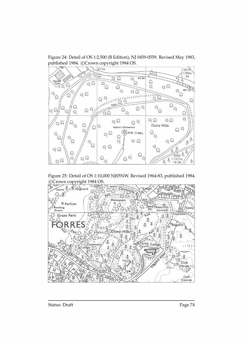
Figure 24: Detail of OS 1:2,500 (B Edition), NJ 0459-0559. Revised May 1983,published 1984. c©Crown copyright 1984 OS.
Figure 25: Detail of OS 1:10,000 NJ05NW. Revised 1964-83, published 1984.c©Crown copyright 1984 OS.
Status: Draft Page 74
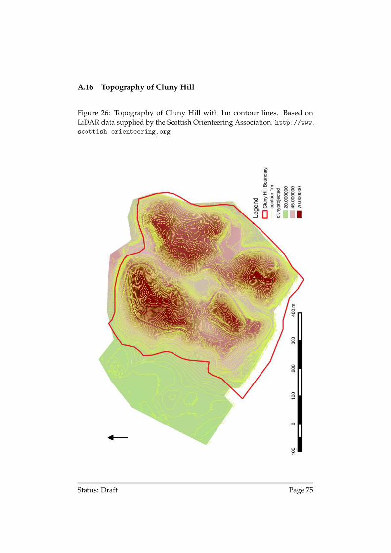
A.16 Topography of Cluny Hill
Figure 26: Topography of Cluny Hill with 1m contour lines. Based onLiDAR data supplied by the Scottish Orienteering Association. http://www.scottish-orienteering.org
Status: Draft Page 75
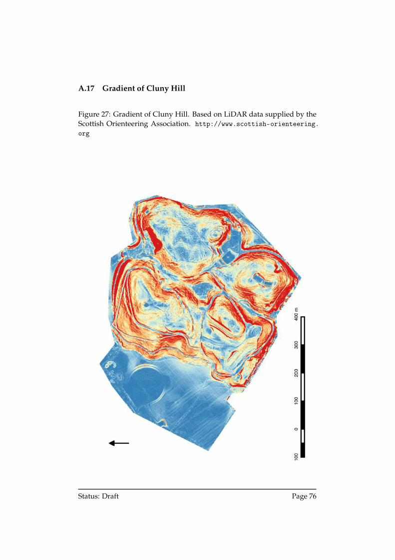
A.17 Gradient of Cluny Hill
Figure 27: Gradient of Cluny Hill. Based on LiDAR data supplied by theScottish Orienteering Association. http://www.scottish-orienteering.org
Status: Draft Page 76
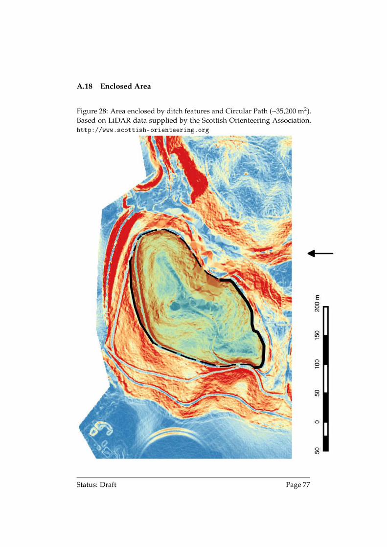
A.18 Enclosed Area
Figure 28: Area enclosed by ditch features and Circular Path (~35,200 m2).Based on LiDAR data supplied by the Scottish Orienteering Association.http://www.scottish-orienteering.org
Status: Draft Page 77
A.19 Yew Trees and Boulders
Figure 29: Known yew trees (blue) and boulders (orange) on Cluny Hill. Alllocations are approximate. Based on LiDAR data supplied by the ScottishOrienteering Association. http://www.scottish-orienteering.org
Status: Draft Page 78
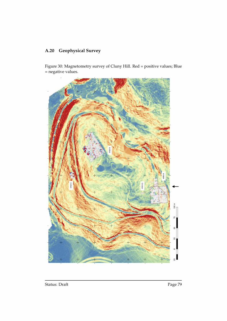
A.20 Geophysical Survey
Figure 30: Magnetometry survey of Cluny Hill. Red = positive values; Blue= negative values.
Status: Draft Page 79
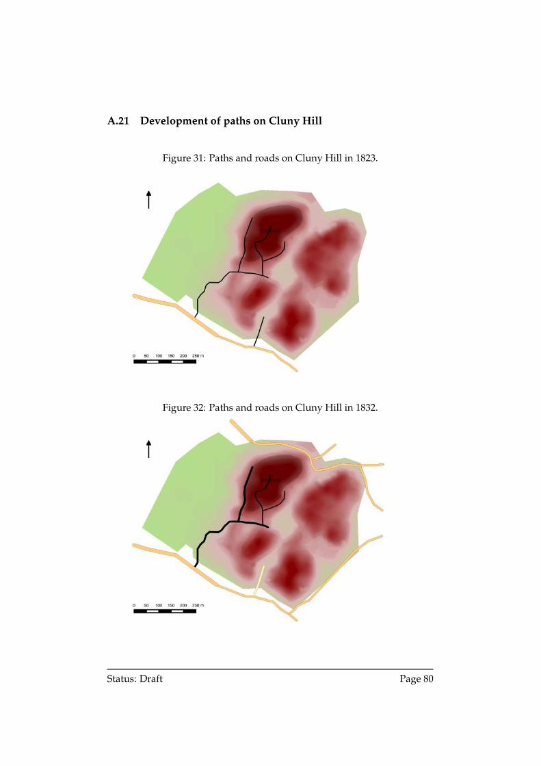
A.21 Development of paths on Cluny Hill
Figure 31: Paths and roads on Cluny Hill in 1823.
Figure 32: Paths and roads on Cluny Hill in 1832.
Status: Draft Page 80
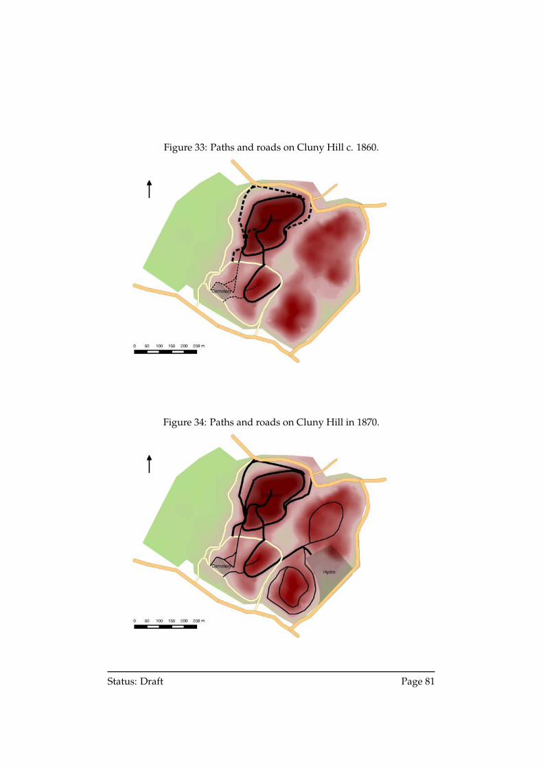
Figure 33: Paths and roads on Cluny Hill c. 1860.
Figure 34: Paths and roads on Cluny Hill in 1870.
Status: Draft Page 81

B Excerpts
B.1 Description of ‘Danish Camp’
Richard Pococke,Letter 36, Tours in Scotland, 1747, 1750, 1760,
(1887, p.183)
ELGIN, July 26th 1760
DEAR SISTER,—
. . .
It is situated over a rivulet, which falls into the Findhorn a terribletorrent after rains, across it we forded, and in about two miles came toForres another small town consisting of a handsome broad street, and about150 houses; it is well built and most delightfully situated in view of theriver, the sea, and very fine country; A beautiful situation at the West end ofthe town belongs to Sir William Dunbar; it was the site of an old castle, onwhich a modern house was begun to be built.
This is the Royal borough & the Provost Mr. Cummin the head of thatvery ancient family came to town on purpose to give me my freedom, butthe town Clerk was absent, and it was sent after me.
A little to the East of the town is Clover [sic] hill, round which abouthalfway up is an old entrenchment probably of the Danes who gained agreat victory over the Scotch near this place where a pillar is set up about 20feet high: on one side is a long cross, and a compartment below it somethinglike a Coat of Arms; on the other side are about ten compartments of figuressome of men, others of horsemen, and some of beasts; this is the East side,which being the rainy quarter is much defaced.
. . .
The Danes fought a second time at Motlick—ten miles South of Elgenand were defeated; Gordon [(1726, p.159)] thinks the stone at Forres was setup on that Victory.
. . .
I am &c.
Status: Draft Page 82
B.2 Description of ‘hillfort’ of the Vacomagi at Forres
George Chalmers,Caledonia, vol. 1,
(1807, p.131 f. (a))
Roy’s Milit. Antiq. p. 132. In November 1797, J. Brodie of Brodie, F.R.S.assured me ‘that when the streets of Forres were lately dug up in orderto repair the pavement, there were discovered several roman coins and aroman medallion in soft metal, which resembled a mixture of lead and tin:this medallion he presented to the antiquarian society of Edinburgh.’ The vand f were often changed in the name of places, as Muref to Murev; and theVarar of Richard is now called Farar: so Varis is now called Faris, which isthe Gaelic name of the place even to this day, as I am assured by the Gaelicminister of the town. The vacomagi had probably a village at Varis or Faris.They certainly had a large hill-fort, the remains whereof are still extant onthe summit of the Clunie Hills at Forres. This strength is of a form betweenoval and circular, is surrounded by a strong rampart of earth and a fossewhich is still 12 feet wide. The area within the ramparts measures 6 acres,3 roods, and 25 falls, Scottish. On the south side of the hill there is a smallpost of a square form, defended by an earthen rampart and fosse, inclosingan area of 10 feet square, or 16 falls Scottish. This description is given froman accurate survey and plan which were made for me in 1798 by RobertMacwilliam, a land-surveyor.
Status: Draft Page 83
B.3 Description of ‘ditch and earthern rampart’ by Forres
William Leslie,General View of the Agriculture of the Counties of Nairn and Moray,
(?, p.523)
A broken range of low hills, stretches down for several miles from the west,and terminates in a mount somewhat higher than the general elevation, ata little distance behind the town on the south. From the track of a ditchand earthern rampart carried around a little below the summit, this mountappears to have been in ancient times a fortified military station, but no kindof tradition suggests even a conjecture of such remote occupation. Wereit ascertained that the noted obelisk near its base had been set up as thememorial of the expulsion of the Danes from Scotland, with justice of thepeople of Forres, it might be said, that by their attentions to the objects ofnational glory they had been in every age distinguished. For on the summitof this mount, they have erected a lofty tower, as a memorial of Lord Nelsonand the victory of Trafalgar. The tower is an octagonal fabric, on a diameterof 24 feet including the walls at the base, raised to the height of 70 feet, andcompleted by a battlement and a flagstaff, with ropes resembling a mast;but similar to the monument of London it is constructed only for being seen,not being convertible to any purpose. It will doubtless carry down to manygenerations, the patriotic object of its builders.
Status: Draft Page 84
B.4 Description of the ‘Cloven, or Cluny Hills’
John Wood,Descriptive account of the principal towns in Scotland,
(1828, p.143)
The environs of Forres, even within the Parish, afford many beautiful ridesand walks, and if extended beyond its bounds, the banks of the Findhorn,towards its source, offers some of the finest river scenery of Scotland. Butthe chief attraction as a promenade, are the Cloven, or Cluny Hills, whicharise to some considerable height, immediately behind the town to thesouth. The highest of these Hills, which, as their name imports, rise inan isolated cluster, is crowned by an octagonal Tower, dedicated to thememory of Admiral Lord Nelson. To this, by personal labour, and pecuniarycontribution, the Inhabitants of Forres have carried roads, which, sometimeswinding around a shoulder, at others, forming Terraces, by embracing awhole hill, finally meet near the Tower, amidst thriving plantations, whichcover the greater part of them. It is almost impossible to describe with effect,the splendid view from the summit; it comprises all the elements of grandand picturesque scenery, plain and wood, sea and mountain. It must sufficeto say, that part of nine Counties are distinctly visible, as the more distantprospect; whilst a home view of twelve gentleman’s seats, circle within asmall radius round its base.
Status: Draft Page 85
B.5 Description of ‘Cluny Hills’
Parliamentary Commission on Municipal Corporations in Scotland,Report on the Burgh of Forres (Morayshire),
(1835, p.450)
Cluny Hills—It may not be improper to mention one valuable part of theburgh property which yields no rent strictly speaking, although the woodupon it is now rising into value. The Cluny Hills, in the immediate neigh-bourhood of the town, have been judiciously planted by the burgh, andwalks formed through them by private subscription, open to all the inhabi-tants; an appropriation of burgh property which might with advantage bemore generally imitated.
B.6 Description of ‘Clunie Hills’
George Anderson & Peter Anderson,Guide to the Highlands and Islands of Scotland,
(1842, p.104)
The very beautiful undulating range of the Clunie Hills, which are crownedwith pine woods, and encircled with numerous walks, press in upon thetown towards the south. On the nearest of them an ancient hill-fort stood, -the first link, also, it is probable, of the chain of signal posts which extendedfrom the sea to the interior of the country, and by means of which theapproach of hostile fleets was announced in ancient times to the inhabitantsof the glens. In its room a high tower has been erected, to commemorate thevictory of Trafalgar under Lord Nelson; from the summit of which a mostextensive view is obtained of all the very varied lands and mountain screensbordering the Moray Firth.
Status: Draft Page 86
B.7 Description of ‘Ancient British Camp’
Matthew J. Algie,Guide to Forres,
(1887; 1907, p.26).
An Ancient British Camp is believed to have occupied a considerable partof the hill on which the tower stands, but the only vestige of it which isnow visible, is a faint trace of an artificially levelled belt or circle which isprobably the remains of the rampart. The belt encircles the hill about thelevel of the path known as the ‘Circular Walk.’ It is a little higher than theCircular Walk on the west side of the hill, and about twenty feet lower thanit on the north side. Some years ago, through the influence of the late Mr[John] Miller [d. 1872], editor and proprietor of the Forres Gazette, a row ofyew trees was planted along the line of the rampart [1887:, and these treesare now of great use in tracing it].
Mr George Chalmers, in his famous book called Caledonia, attributes thehill-fort to the Vacomagi,—one of the native tribes who inhabited Britain atthe time of the Roman invasion. They are stated to have occupied a strip ofcountry extending from Burghead on the Moray Firth, to the River Tay. Thecamp is supposed to have occupied the top of the hill, and to have extendeddown its sides as far as the rampart which encloses an area of about eightEnglish acres.
Status: Draft Page 87
B.8 Description of the ‘Cluny Hills’
Robert Douglas & Andrew B. Robertson,Annals of the Royal Burgh of Forres, (1934, p.535-6)
The position and structure of the Cloven Hills, so far have been underreview, but it is necessary to describe the external appearance of the hills.The present beautiful covering of trees was not always there, in fact for along time they would be bare and unsightly eminences to the south andsouth-east of the town. Broom would probably make its appearance at anearly date. References are frequent such as:—23rd October, 1585—‘The sameday James Wawss appointed to keipe the townis and ye browme on ye CloneHyllis.’ 9th December, 1588—‘William Hasbine, servitor to Alex. Urquhartof Drumroicht, compears—complaint of cutting broom on Clowin Hylls andalso Alexander Hay.’ 16th December, 1588—‘Archibald Glass and John Mill,servitors to Andrew Mill, cut ’haint browm of the ye Clowne Hylls.’
The broom in its season would no doubt be very pleasing to the inhabi-tants of Forres, but at the beginning of the last century the Town Councildetermined that the hills should be planted with trees, which would even-tually be much more profitable than the broom. In the Burgh Records of1806 the name ‘Cloven’ for ‘Cluny’ appears. The Cloven Hills, in 1806, wereplanted with trees and destroyed by fire in 1815 and again planted. Thedestruction of the trees by fire may have occured at frequent intervals if onemay judge from the bellman’s warning on such occasions (Perter Spurtles)—
‘ Tammie wi’ the red coat, Tammie wi’ the gun,Fire in the mountains, run, boys, run.’
A destructive fire occured in the Cluny Hills on 6th May, 1848.The oldest institution connected with Cloven Hills is, without doubt,
the hill-fort situated on the highest and largest hill. There is now practi-cally nothing to be seen of the remains of this Fort, but Chalmers in his‘Caledonia’ specially describes this interesting relic of the past. He thinksthat the Vacomagi, the ancient inhabitants of this district, prior to the timeof the Romans, had a village or colony at Forres with defence works or ahill-fort on the Cloven Hills. Chalmers describes and illustrates this fort inhis book. Its form is between oval and circular and surrounded by a strongrampart of earth and a fosse which in Chalmers’ time was still still twelvefeet wide. Robert McWilliam, a land surveyor, in 1798, made an accuratesurvey and plan of this fort for Chalmers. McWilliam measured the areawithin the ramparts and found it to be 6 acres 3 roods 25 falls (Scottish) inextent. On the south side of the hill there is a small fort of a square formdefended by an earthen rampart and fosse. The area included in this fort is
Status: Draft Page 88
one of 10 feet square or 16 falls (Scottish). The rampart of this ancient Britishcamp which, as I have said, is not now visible is thought to correspond withthe present position of the Circular Walk. The late Mr Miller of the ‘ForresGazette’ planted some yew trees as near as possible along the rampart line.
B.9 Description of ‘the fort on Cluny Hill’
Alfred H. Forbes,Forres: A Royal Burgh 1150-1975,
(1975, p.13)
The Califer Hill is taken to be the first site of a permanent settlement. The seamay have been higher and nearer, or the lower ground too wet to producecrops. The graves at Templestones, south-west of Blervie Castle, date fromthe Stone Age, as does the fort on Cluny Hill. This fort was clearly visibletwo centuries ago when George Chalmers, the historian, commissionedRobert McWilliam, surveyor, to send him a report on it. The shape wasbetween round and oval, enclosing an area of 6 acres, 3 roods and 25 fallsScots. On the southern side there is a small fort 12 feet square. These outlineswere retraced in 1972 by a class from Forres Academy with their teacher, MrRon Philp.
Status: Draft Page 89
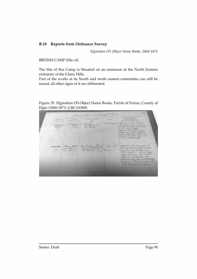
B.10 Reports from Ordnance Survey
Elginshire OS Object Name Books, 1868-1871
BRITISH CAMP (Site of).
The Site of this Camp is Situated on an eminence at the North Easternextremity of the Cluny Hills.Part of the works at its North and north eastern extremities can still betraced, all other signs of it are obliterated.
Figure 35: Elginshire OS Object Name Books, Parish of Forres, County ofElgin (1868-1871) c©RCAHMS.
Status: Draft Page 90
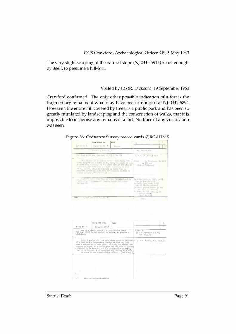
OGS Crawford, Archaeological Officer, OS, 5 May 1943
The very slight scarping of the natural slope (NJ 0445 5912) is not enough,by itself, to presume a hill-fort.
Visited by OS (R. Dickson), 19 September 1963
Crawford confirmed. The only other possible indication of a fort is thefragmentary remains of what may have been a rampart at NJ 0447 5894.However, the entire hill covered by trees, is a public park and has been sogreatly mutilated by landscaping and the construction of walks, that it isimpossible to recognise any remains of a fort. No trace of any vitrificationwas seen.
Figure 36: Ordnance Survey record cards c©RCAHMS.
Status: Draft Page 91
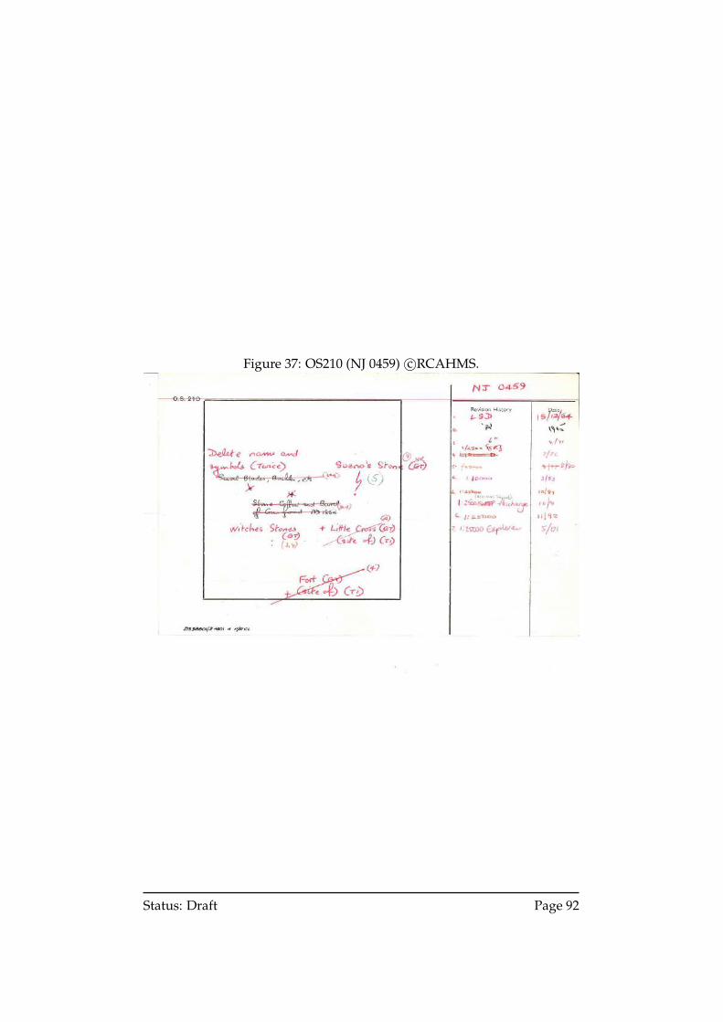
Figure 37: OS210 (NJ 0459) c©RCAHMS.
Status: Draft Page 92
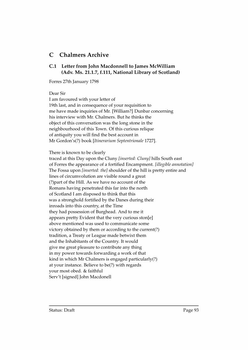
C Chalmers Archive
C.1 Letter from John Macdonnell to James McWilliam(Adv. Ms. 21.1.7, f.111, National Library of Scotland)
Forres 27th January 1798
Dear SirI am favoured with your letter of19th last, and in consequence of your requisition tome have made inquiries of Mr. [William?] Dunbar concerninghis interview with Mr. Chalmers. But he thinks theobject of this conversation was the long stone in theneighbourhood of this Town. Of this curious reliqueof antiquity you will find the best account inMr Gordon’s(?) book [Itinerarium Septentrionale 1727].
There is known to be clearlytraced at this Day upon the Cluny [inserted: Cluny] hills South eastof Forres the appearance of a fortified Encampment. [illegible annotation]The Fossa upon [inserted: the] shoulder of the hill is pretty entire andlines of circumvolution are visible round a great(?)part of the Hill. As we have no account of theRomans having penetrated this far into the northof Scotland I am disposed to think that thiswas a stronghold fortified by the Danes during theirinroads into this country, at the Timethey had possession of Burghead. And to me itappears pretty Evident that the very curious ston[e]above mentioned was used to communicate somevictory obtained by them or according to the current(?)tradition, a Treaty or League made betwixt themand the Inhabitants of the Country. It wouldgive me great pleasure to contribute any thingin my power towards forwarding a work of thatkind in which Mr Chalmers is engaged particularly(?)at your instance. Believe to be(?) with regardsyour most obed. & faithfulServ’t [signed] John Macdonell
Status: Draft Page 93
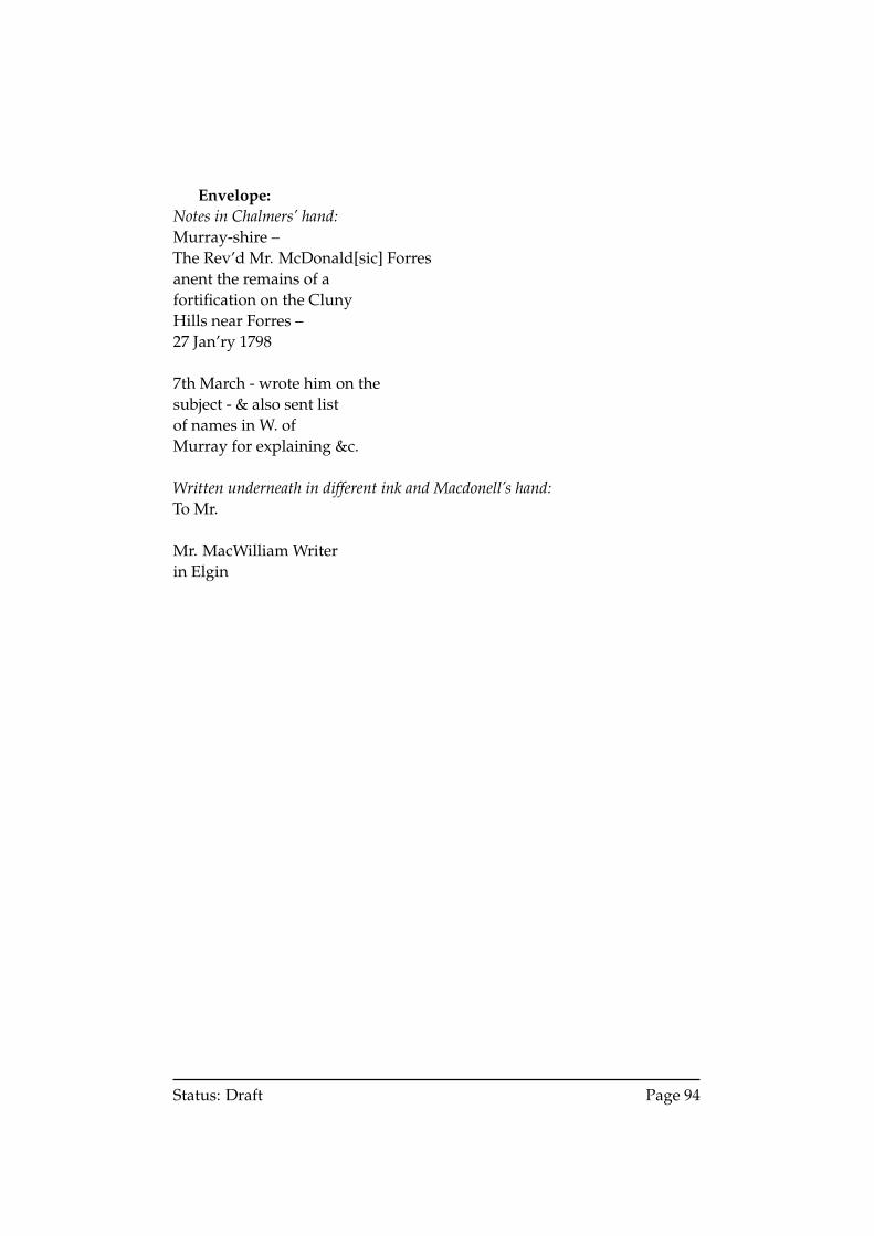
Envelope:Notes in Chalmers’ hand:Murray-shire –The Rev’d Mr. McDonald[sic] Forresanent the remains of afortification on the ClunyHills near Forres –27 Jan’ry 1798
7th March - wrote him on thesubject - & also sent listof names in W. ofMurray for explaining &c.
Written underneath in different ink and Macdonell’s hand:To Mr.
Mr. MacWilliam Writerin Elgin
Status: Draft Page 94
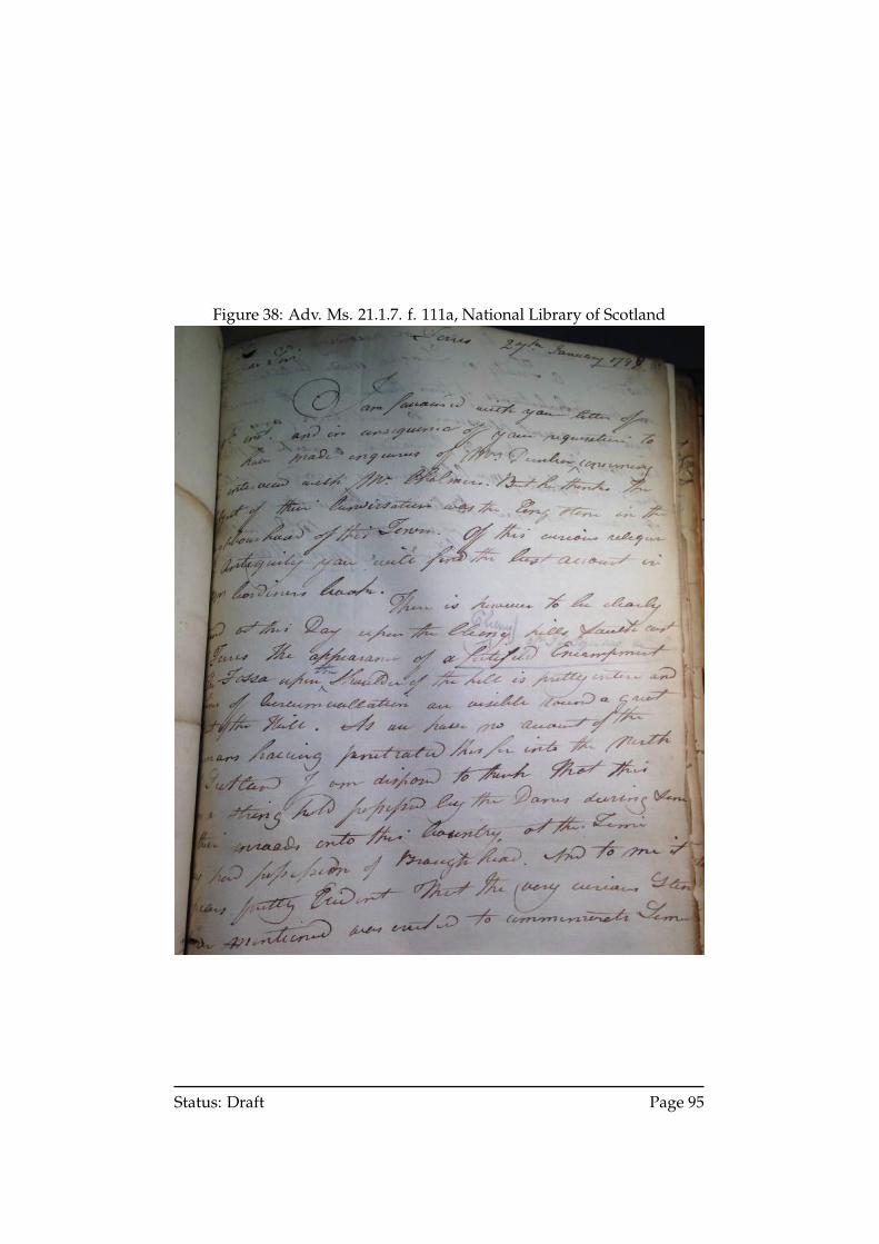
Figure 38: Adv. Ms. 21.1.7. f. 111a, National Library of Scotland
Status: Draft Page 95
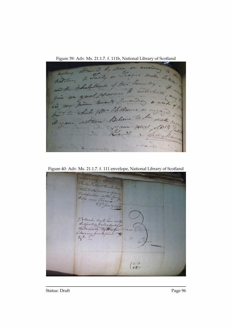
Figure 39: Adv. Ms. 21.1.7. f. 111b, National Library of Scotland
Figure 40: Adv. Ms. 21.1.7. f. 111 envelope, National Library of Scotland
Status: Draft Page 96
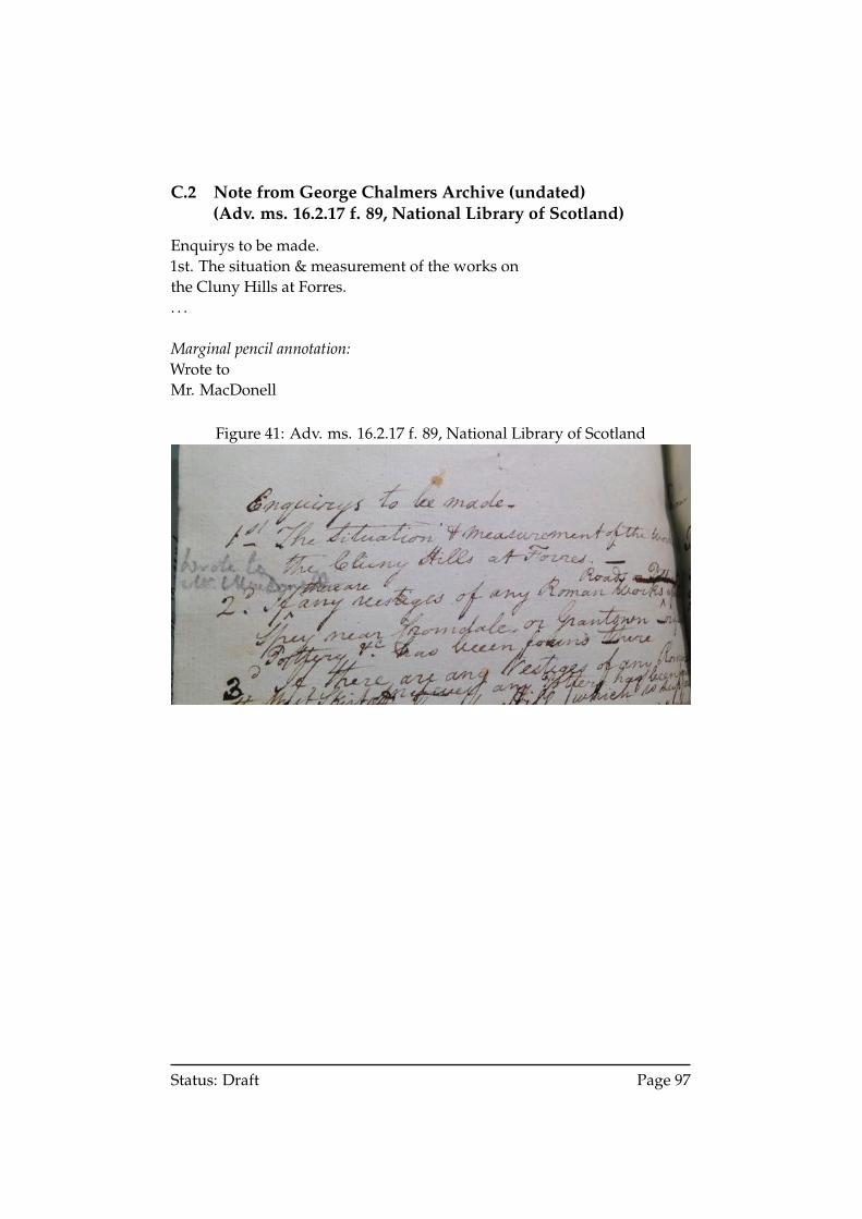
C.2 Note from George Chalmers Archive (undated)(Adv. ms. 16.2.17 f. 89, National Library of Scotland)
Enquirys to be made.1st. The situation & measurement of the works onthe Cluny Hills at Forres.. . .
Marginal pencil annotation:Wrote toMr. MacDonell
Figure 41: Adv. ms. 16.2.17 f. 89, National Library of Scotland
Status: Draft Page 97
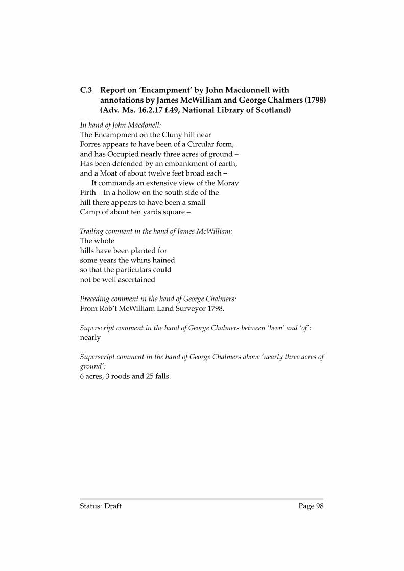
C.3 Report on ‘Encampment’ by John Macdonnell withannotations by James McWilliam and George Chalmers (1798)(Adv. Ms. 16.2.17 f.49, National Library of Scotland)
In hand of John Macdonell:The Encampment on the Cluny hill nearForres appears to have been of a Circular form,and has Occupied nearly three acres of ground –Has been defended by an embankment of earth,and a Moat of about twelve feet broad each –
It commands an extensive view of the MorayFirth – In a hollow on the south side of thehill there appears to have been a smallCamp of about ten yards square –
Trailing comment in the hand of James McWilliam:The wholehills have been planted forsome years the whins hainedso that the particulars couldnot be well ascertained
Preceding comment in the hand of George Chalmers:From Rob’t McWilliam Land Surveyor 1798.
Superscript comment in the hand of George Chalmers between ‘been’ and ‘of’:nearly
Superscript comment in the hand of George Chalmers above ‘nearly three acres ofground’:6 acres, 3 roods and 25 falls.
Status: Draft Page 98
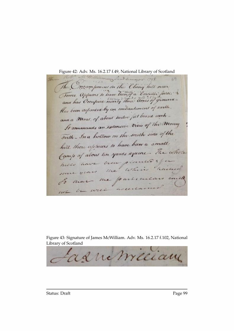
Figure 42: Adv. Ms. 16.2.17 f.49, National Library of Scotland
Figure 43: Signature of James McWilliam. Adv. Ms. 16.2.17 f.102, NationalLibrary of Scotland
Status: Draft Page 99
D Newspaper Reports
D.1 Notice for planter
Aberdeen Journal,24 October 1791
CLOVEN HILLS near FORRES to be planted.These Hills, consisting of about 60 acres, are already inclosed. An UNDER-TAKER to plant them with Scots Pins, and to support them for seven yearsafter being so planted, is immediately wanted. Proposals in writing may beaddressed to William Dunbar, Town Clerk of Forres, on or before the 20thof November next, immediately after which time, if the season permits, theplanting is to begin and carried on with all convenient speed.Not to be repeated.
Status: Draft Page 100
D.2 Petition to build paths upon Cluny Hills
Forres, Elgin and Nairn Gazette,4 June 1839
TOWN COUNCIL PROCEEDINGSSPECIAL MEETING.May 6.. . .CLUNY HILLS. Treasurer Forsyth presented the following petition to theTown council, praying for allowance to make several new roads on the hill.The Clerk read the petition as follows:–
‘Unto the Magistrates and Town Council of the Burgh of Forres,the petition of the undersigned inhabitants thereof,HUMBLY SHEWETH,that your petitioners value as an inestimable privilege their rightof enjoying the walks on the Cluny hills of Forres, and havealways regarded with satisfaction the great care and attentionbestowed by the Council on the improvement of this part ofthe public property. That although the public have already thebenefit of many excellent roads, a line of road has recently beenplanned out by Mr. Logie, Blackhillock, opening up some newand interesting views of the surrounding country; and yourpetitioners think that, while the formation of this road can beattended with no expense to the Council, and no encroachmentupon private resorts,—(great laughter)—it may conduce to theimprovement of the hill, and the gratification of the inhabitants.that your petitioners therefore humbly pray that the Magistratesand Council will grant their consent to its being now completed,and that, if considered necessary, they will appoint a committeeto examine and report thereon,’
Treasurer Forsyth said was most respectably signed, and might have re-ceived 300 signatures had there been time.Councillor Bell said it was a pity that the members of the Council who op-posed Mr Logie’s communication at last meeting were not present. (Laugh-ter.)After a short discussion, in which several members of Council expressedthemselves in favour of the object,Treasurer Forsyth, moved that a small committee be appointed to carry intoeffect the wishes of the petitioners.The Council then appointed the office bearers, along with Councillors R.Urquhart and Kay, to the said effect.
Status: Draft Page 101
D.3 Gates set up
Forres, Elgin and Nairn Gazette,7 April 1841
IMPROVEMENTS AT CLUNY HILLS—Our local readers are aware the Dean of Guild Seal carried, at last meeting ofthe Town Council, a motion for enclosing the plantations, and placing gates,on the various public approaches to the Cluny-hills, and with his wontedenergy these improvements were immediately afterwards commenced andare now in progress of being completed. We know of no community inScotland who can boast of a privilege such as the inhabitants of Forres enjoy,of having access to a plantation of nearly 200 acres in extent, intersected bywell laid out out, spacious walks, embracing the most magnificent viewsin the country. Any inhabitant of the town may, in less than 10 minutesafter leaving his own domicile, ascend to Nelson’s Tower, along a pathwaywhich would grace the approach to a Royal Demesne. The whole of thewalks have been thoroughly cleaned and trimmed, and it only remains forMr Seal, who to his praise he is spoken, always takes the lead in every reallyuseful public measure, to get a keeper appointed to take charge of the hill,to prevent those depredations on the wood and soil, which are constantlyoccurring, and to keep the alleys in their present neat and tidy condition.
Status: Draft Page 102
D.4 Additional Planting
Forres, Elgin and Nairn Gazette,2 December 1841
Special meeting,Nov. 16 1841Sederunt—Provost Urquhart; Bailies, Kynoch, Gill and Russell; Dean ofGuild Seal—Councillors Riach, Sclanders, white, Milne, McKenzie, Man-ford, Brands and Ross.Provost Urquhart brought up the report of the planting committee, whichwas read by the Clerk at the table. It being a document of some importancewe give it entire –
The committee having this day met at Cluny Hills, on the groundof those parts embraced in the remit, and John Grigor, nursery-man who attended the committee, and having given their bestattention and most anxious consideration to the whole matter,have to report and recommend as under, viz :–
1st. That part of the South East Hill which was planted last yearis greatly too thin in the number of plants, owing, in the firstplace, to a sufficient number of plants from scarcity, not havingbeen originally put in, and in the second place, from failures,owing to their being planted at a very late period of the season.In these circumstances, it is Mr Grigor’s opinion, and also thatof the committee from personal observation, that in each acreof this Hill, already planted, a thousand additional larches willrequire to be put in at the present time, in order to make thesame complete, with the prospect of future success.
2nd. The section of the south east Hill, where the whins hadbeen rooted out and still unplanted, the committee understandconsists of from seven to eight acres. In that section larch shouldprincipally be employed with a mixture of a large firs, and a fewoaks three thousand plants, they understand, from Mr Grigor,should be placed in each acre, which will costfor plants £1 10 0Planting, pitting apart, &c. £0 12 0Per acre £2 2 0At this rate the cost of planting, say eight acres, at 42s. is £16
Status: Draft Page 103
16s. the plants to be chiefly put into this section, are larch inter-spersed with a few oaks. The measurement not being exactlyascertained, of course the expense must vary more or less ac-cording to the precise extent of the ground.
3rd. The committee recommended that the whins on the smallsection of the Hill, lying to the East of McAuley’s ground, shouldbe carefully grubbed out, so as not to damage the plants alreadythriving in this spot, and the whins being thus removed, thatthe additional number of plants required should be immediatelyput in. This section of the Hill is small in extent, and the expenseof the proposed improvement will be very trifling.
4th. After visiting the section of the hill already referred to, thecommittee perambulated to the South and South-east divisionsof the principal Hill, or that on which the Tower stands. Herethey would recommend that all the whins on the South and Eastshould immediately be cut down and removed, as these mightpossibly endanger some very thriving and beautiful young treespresently growing in those places, and in reference to the largeBank or Brae, facing the property of Drumduan, the committeerecommend that the additional number of plants required tomake that section complete should immediately be put in.
5th. In reference to the complaints regarding the entrance to theHill to the Bulletloan [St. Leonard’s Rd.] and opposite Drum-duan, the committee would recommend that feal [turf] dykesand ditches in continuance of those already erected, leaving anopening for foot passengers should immediately be completed,so as prevent all intercourse by horses and carts in those parts ofthe Hill.This can be done at a very trifling expense, and will, in the opin-ion of the committee, be quite sufficient to put a stop to the evilcomplained of.
6th. The committee afterwards perambulated and carefully in-spected the the oak plantation on the north side of the principalHill are clearly of opinion that while any interference with theface of the hill on this section, would destroy its beauty, anddetract from the general comfort, utility and interest, as a resort
Status: Draft Page 104
for the inhabitants; in a pecuniary point of view the few treeswhich might, in any case, be cut down, so far as the judgement ofmen of skill extend, would be very inconsiderable, and add littleto the present finances of the Burgh; whereas by allowing themto remain, they may, at a future period, be of infinitely greatervalue. The committee for these reasons, humbly recommend,that the planting on this section of the Hill, should not at presentbe disturbed.
7th. Not being aware of the precise extent of the ground thecommittee cannot condescend particularly on the exact amountrequired to carry through the improvements now recommended,but they confidently expect that the whole may be done at from£30 to £40, and, in any case, it cannot possibly exceed £50. Theprospective advantages to the laws are very great, and the plant-ing, as proposed, should, in the opinion of the Committee, beforthwith completed.
(signed) ROBERT URQUHART
Status: Draft Page 105
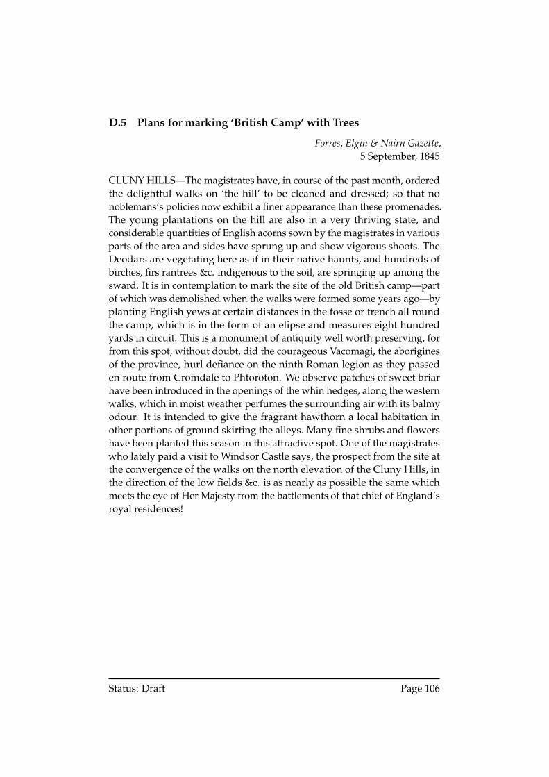
D.5 Plans for marking ‘British Camp’ with Trees
Forres, Elgin & Nairn Gazette,5 September, 1845
CLUNY HILLS—The magistrates have, in course of the past month, orderedthe delightful walks on ‘the hill’ to be cleaned and dressed; so that nonoblemans’s policies now exhibit a finer appearance than these promenades.The young plantations on the hill are also in a very thriving state, andconsiderable quantities of English acorns sown by the magistrates in variousparts of the area and sides have sprung up and show vigorous shoots. TheDeodars are vegetating here as if in their native haunts, and hundreds ofbirches, firs rantrees &c. indigenous to the soil, are springing up among thesward. It is in contemplation to mark the site of the old British camp—partof which was demolished when the walks were formed some years ago—byplanting English yews at certain distances in the fosse or trench all roundthe camp, which is in the form of an elipse and measures eight hundredyards in circuit. This is a monument of antiquity well worth preserving, forfrom this spot, without doubt, did the courageous Vacomagi, the aboriginesof the province, hurl defiance on the ninth Roman legion as they passeden route from Cromdale to Phtoroton. We observe patches of sweet briarhave been introduced in the openings of the whin hedges, along the westernwalks, which in moist weather perfumes the surrounding air with its balmyodour. It is intended to give the fragrant hawthorn a local habitation inother portions of ground skirting the alleys. Many fine shrubs and flowershave been planted this season in this attractive spot. One of the magistrateswho lately paid a visit to Windsor Castle says, the prospect from the site atthe convergence of the walks on the north elevation of the Cluny Hills, inthe direction of the low fields &c. is as nearly as possible the same whichmeets the eye of Her Majesty from the battlements of that chief of England’sroyal residences!
Status: Draft Page 106
D.6 Description of ‘British Camp’
Forres, Elgin & Nairn Gazette,6 June, 1846
Notices To Correspondents, &c. BRITISH CAMP ON THE CLUNY HILLS—[A-E]. N. India, is informed that the area within the ramparts of the BritishCamp on the Cluny Hills, is stated by Chalmers (Caledonia) to be 6 acres,3 roods, 25 falls. It measures in circuit about 300 yards. On the north andsouth-west sides of the hill it is still distinctly visible but other parts of it havebeen destroyed by the encroachments of the lately constructed public walks.Irish and English yew trees have been planted last spring, alternately 50 or60 yards equidistant, along the line of the camp, interspersed with a fewwalnuts, all of which, we are glad to say, are thriving.; and if protected for afew years, will hand down to posterity the land-marks of the venerable site—on which our forefathers fought for independence with the ‘Conquerors ofthe world.’
Status: Draft Page 107
D.7 Description of ‘the hill’
Nairnshire Mirror,2 May, 1848
But we hasten, in the meantime, to notice what we consider as par excellencethe beauty of the burgh - the beautifully laid out grounds and walks aboutthe Cluny Hills. The group of small eminences known by this designationconsists of four rounded knolls, with a depression in the centre termed Hell’sor Helg’s Hole. They are evidently the result of some geographical upheave-ment of the olden time, their mass consisting chiefly of sand and gravel,deposited by water a long time previous to that upheavement. The emi-nence fronting the North, usually denominated ‘the hill,’ and surmountedby the well know ‘Nelson’s monument’, was at one time the site of a Britishfort, of which hardly a vestige now remains. It is therefore partly artificial,but independently of that is the largest and most conspicuous of the group.The fort by which it was occupied stood in the line of march pursued bythe Romans during the invasion of Britain. Within the recollection of the‘oldest inhabitant’, the whole group was clothed with a natural covering ofgrass, without a tree or shrub to adorn it. Subsequently it was graduallyovergrown with furze or whin (vernacularly funns) and within the last fiftyyears, numbers of fir and other trees began to be planted. The firs especiallyhave yielded a handsome return to the burgh, lots of them having beenat various periods sold at from £300 to £600. They have recently been cutdown to a considerable extent, but their place is fully supplied by saplingof some year’s growth, and the whole of the hills are thickly planted withyoung trees of various kind, which are rapidly rising into what not manyyears hence will be a large and valuable forest. The eminence known as theHill has long been a favourite resort of the inhabitants. The old walks thatwound around its sides were some years ago partly improved and partlysuperseded by the exertions of a number of gentlemen of Forres, who in trueworkman style turned out with picks and spades, and formed the spaciousroads and avenues that now encircle it. These again have been recentlyre-dressed, and along their sides are in many parts formed wide bordersplanted with shrubs and flowers...
Status: Draft Page 108
D.8 Description of improvements to Cluny Hill
Forres, Elgin & Nairn Gazette,28 June, 1854
CLUNY HILL IMPROVEMENTS.—The western approach to the ClunyHills has been completed. The road-way, now some fourteen feet wide,is laid off with a border of 5 or 6 feet along the north side, of Mr Logie’sproperty, in which birches, interspersed with Azaleas, Rhododendrons, andother flowering shrubs are to be planted. A strong wooden paling separatesthe road from the adjoining property, and the border is protected by a rusticfence of larch thinnings. The walks along the whole circuit of the Hill havebeen recently cleaned, repaired, and the sides and embankments turfed. TheOak, Maple, Chestnut, Beech, and other hardwood trees are well up, andthrown their umbrageous shade over the most frequented portion of thewalks, thus screening the pedestrian from the solar heat; while the seatsand grassy banks here and there by the way-side invite to refreshing rest inpositions commanding the most extensive views of the loveliest scenery anywhere to be met with. At the north the rich and luxuriant fields of Invererne,Lingiestown, Greeshop, and Grange, with their dividing hedgerows andbeltings, attract the eye. Farther off the sinnosities of the River Findhorn,like a silver fringe along the dun-wooded skirts of Kincorth and Moy. Stillfarther away the sand hills of Culbin, the type of barrenness and desolation,bounds the sea margin; beyond which is the firth studded with the fishingboats of the industrious sea-faring people of Findhorn and Burghead, withan occasional steamer or merchant vessel in the offing. On the edge of thehorizon, the well defined summits of the blue hills of Ross, Sutherland, andCaithness, with distance lent enchantment—present a succession of sceneryof almost unparalleled beauty. On the South side of the hill the view is morecircumscribed, but the authorities deserve the highest praise for the tasteand judgement with which the planting and other operations for the publicgratification and convenience have been here carried out.
Status: Draft Page 109
D.9 Names of Hills
Forres, Elgin & Nairn Gazette,September 17, 1856
Notices to Correspondents.. . .‘THE CLUNY HILLS.’—We have received the following from ‘A ConstantReader’—‘I am much gratified in hearing of the recent improvements onthe Cluny Hills; but regret that the very names of the various hills havebeen suffered to fall into oblivion. The people of Forres, about the middleof the 18th century named these hills as under. Beginning at the TowerHill—before the tower was built, however, it was called ‘Toe F.r.st;’ thenext hill to the south (above the sand-pit) was called the ‘Black Hill;’ thethird, following the course of the sun, the ‘Whin Hill;’ and the fourth, the‘Braidhaugh Hill’—I hope the community, through the press, will now be atno loss when referring to the different hills, how to distinguish them.’
D.10 Report of paper presented to Elgin Literary and ScientificAssociation by James MacDonald
Elgin Courier,8 June 1860
‘A Sketch of the History and Antiquities of Burghead’
. . .
The remains of a native encampment which can still be traced in the ClunyHills, near Forres, points out the site of an ancient British strength, nearwhich were, doubtless, planted the huts of a primitive village, such as Caesarhas described the capital of Cassivelaun. Forres indeed, seems to me to havefar better claims to be considered the ‘winged Camp’ of Ptolemy than anyother place with which it has hitherto been thought to be identical.
. . .
Status: Draft Page 110
D.11 Boundary markers and dispute in 1654
Forres Elgin and Nairn Gazette,17 June 1862
EXTRACTS FROM BOOK OF BURGH RECORDS—1654.THE CLUNY HILLS OF FORRES.In the older records of the Town the Boundaries of the Parks of the beau-tiful domains of Forres House, now the property of Robert Grant, Esq. ofKincorth, are very generally defined. ‘The Great Lodging’ as it was called,and the parks to the south of the Mansion, belonged in the early part of theseventeenth century to Tulloch of Taonachie, and the property was boundedat the north by the ‘Clownie hillis.’ In 1653 encroachments had been madeon the Town’s Commontie on the north side or rise of the hill—by ThomasTulloch of Bogton—then the proprietor. Reference to this occurs in the TownCourt Book of date 14th March, 1653, as follows :–
The qlk day the provest Baillies, and Counsell went up to thesyd of the ye clounie hills, accompand with nuian dunbar ofgrangehill; Thom. Tulloch of tanachie; Robt. Dunbar of bogs;Francis fforbes of Thornhill; Pa. Campbell of boathe to visit &remarke the wronge done be Tho. Tulloch of boigtoune, in earingand tylling out land on the north syd of the clouniehills, qlk vasthe toun’s commontie; qlk being scin, & greatt fault found yrwith,the sd Tho. Tulloch, wt consent of Patrick Tulloch, his eldestlaull son, both being yr pnt., referred the potting, marching andmeathing of the debatabl Land, to the decision of the provost,baillies & counsell, be virtue of ane act subscryvet wt yr hands,of the date of yr puts, to the effect the Provt, baillies, & consillmight meit ypon the morrow, be ten hors, being the fyftein ofthe sd month, qho sit the tym apoyntit did met & set in sexseverall merch stoins, betwixt the sd Tho. Tulloch, his propertie& the comontie, on the syd of the clouniehills, qr the sd Thos.incroached; qrupon the sd Mr John Dunbar, provest, for himself& in name & behalf of the conseil & comontie (communitie?)required and took act. This was done betwixt thrie and fourhors in the eftir noune, before yr witnesses—Wa. Kynand Incalsayford; John Cumming, Indweller in Forres; James Sinclairand Andrew Christie indwellers there.
Such was the settlement of the encroachment two hundred years ago, andso doubtless matters remained till within the last fifty years, when theold march stones had disappeared, and, we apprehend, the ancient en-croachments were full renewed. About 12 or 15 years ago [1850-1847], the
Status: Draft Page 111
Magistrates and the agent of the coterminous Proprietor—then the Laird ofAltyre—met on the ground, when the marches were settled, and new marchstones fixed as present.
D.12 Overgrown woods on north side of hill
Forres, Elgin & Nairn Gazette,5 October 5, 1881
PROFESSOR BLACKIE ON CLUNY HILL AND THE FINDHORN(From the Scotsman).. . .The Hill of Cluny, on the southeast corner of which the Hydropathic Es-tablishment is situated, affords an efficient shelter from the cold north-eastwinds that, at certain seasons, can be no stranger to this quarter. The onlyobjection indeed, that I know to Cluny Hill Establishment as a summerresidence is this very shelter, not so much of the hill as of the wood withwhich it is thickly overgrown. In the summer season, a fresh breeze and abright outlook are amongst the amongst the luxuries which hydropathicvisitors naturally look for; and as the view to the south, the only one opento the establishment, is deficient both in point of picturesque effect and ofpanoramic range, I venture to submit to those interested in the prosperityof the good old town, famous for witches and pine forests, with which theprosperity of the Hydropathic Hall is closely bound up, that the north sideof the beautiful Cluny Hill, already so richly provided with shady walks,should be largely opened up to the breeze, and the magnificent panoramicprospect of the Moray Firth and the Ross-shire and Caithness mountainsspread before the eye in that direction.. . .JOHN S. BLACKIEForres, September 1881
Status: Draft Page 112
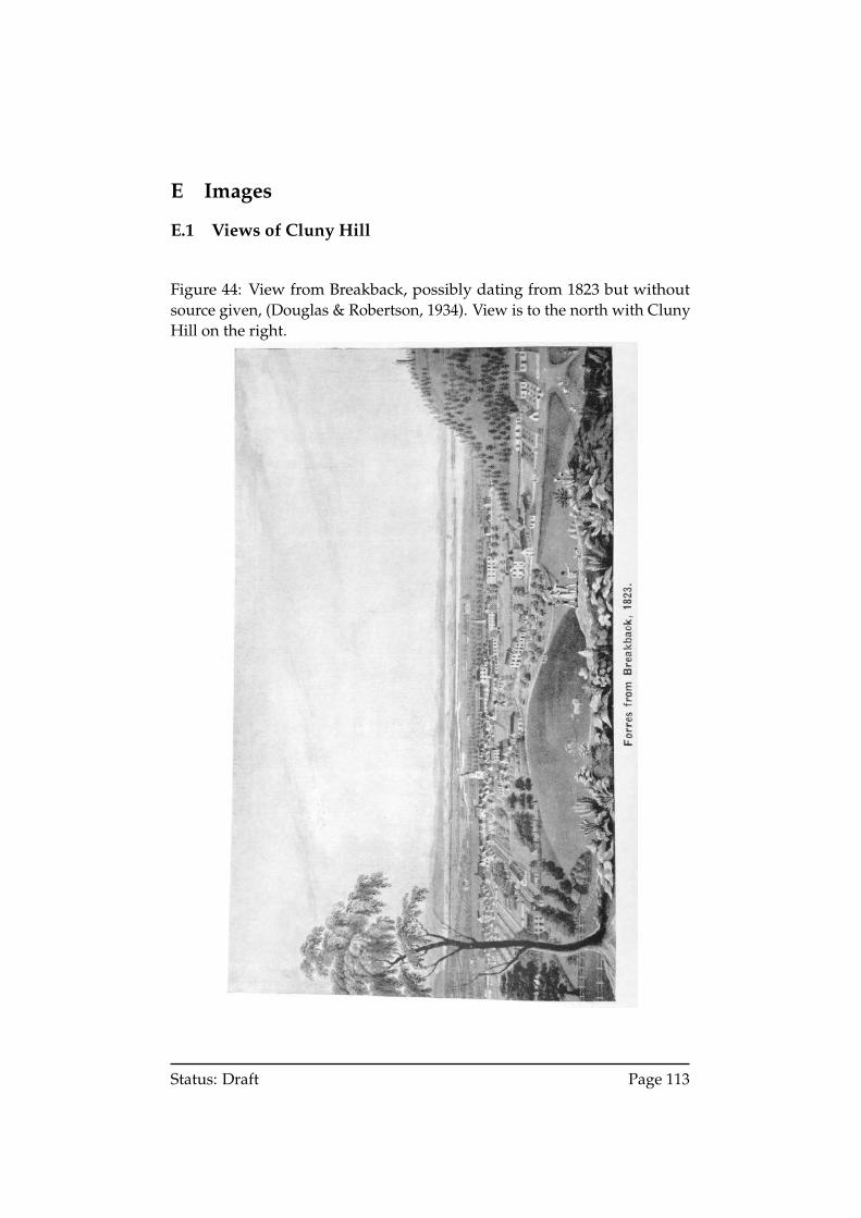
E Images
E.1 Views of Cluny Hill
Figure 44: View from Breakback, possibly dating from 1823 but withoutsource given, (Douglas & Robertson, 1934). View is to the north with ClunyHill on the right.
Status: Draft Page 113
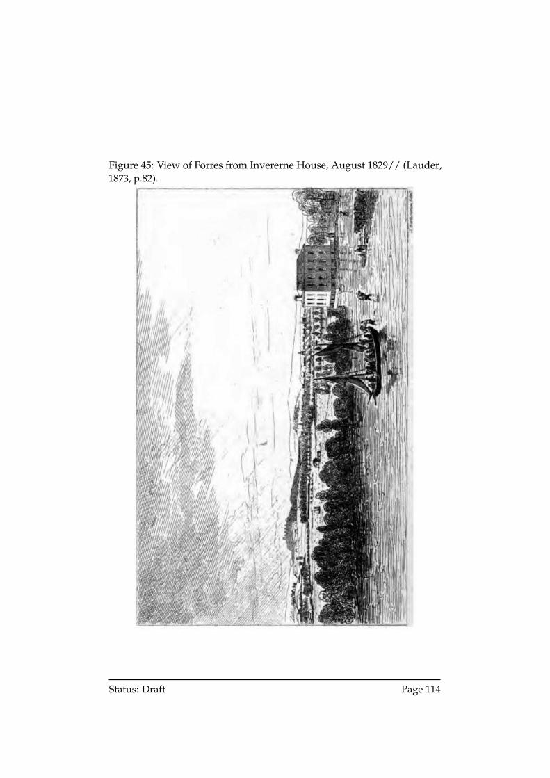
Figure 45: View of Forres from Invererne House, August 1829// (Lauder,1873, p.82).
Status: Draft Page 114
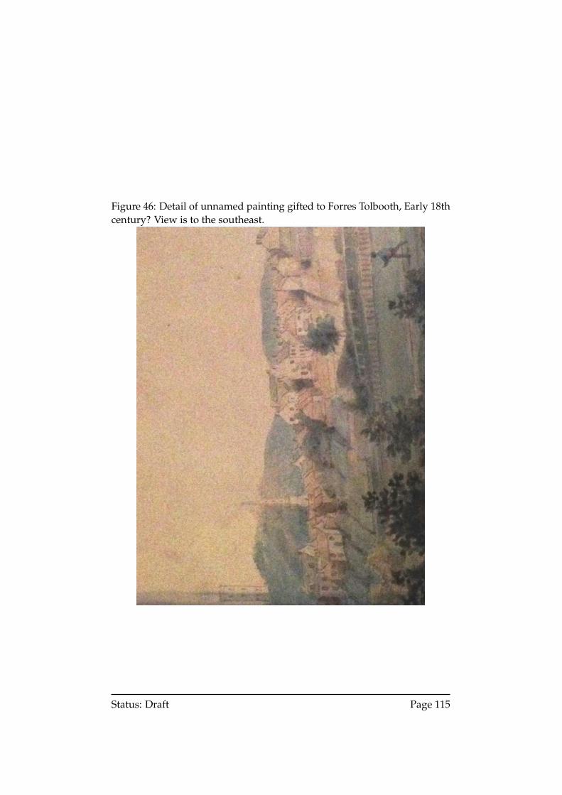
Figure 46: Detail of unnamed painting gifted to Forres Tolbooth, Early 18thcentury? View is to the southeast.
Status: Draft Page 115
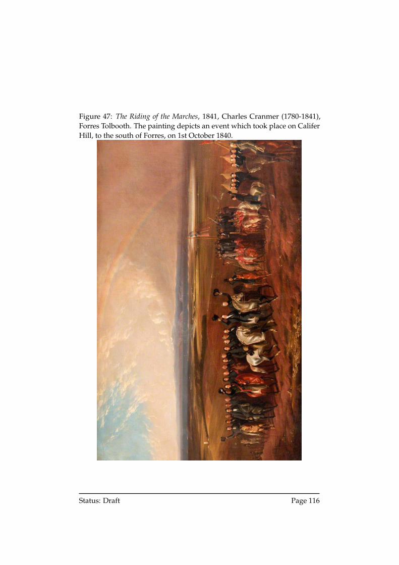
Figure 47: The Riding of the Marches, 1841, Charles Cranmer (1780-1841),Forres Tolbooth. The painting depicts an event which took place on CaliferHill, to the south of Forres, on 1st October 1840.
Status: Draft Page 116
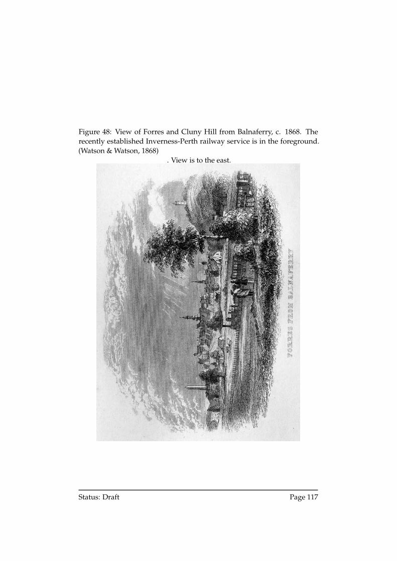
Figure 48: View of Forres and Cluny Hill from Balnaferry, c. 1868. Therecently established Inverness-Perth railway service is in the foreground.(Watson & Watson, 1868)
. View is to the east.
Status: Draft Page 117
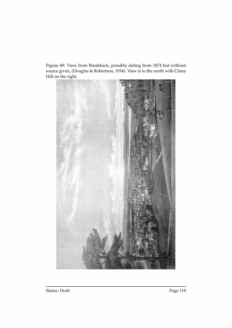
Figure 49: View from Breakback, possibly dating from 1874 but withoutsource given, (Douglas & Robertson, 1934). View is to the north with ClunyHill on the right.
Status: Draft Page 118
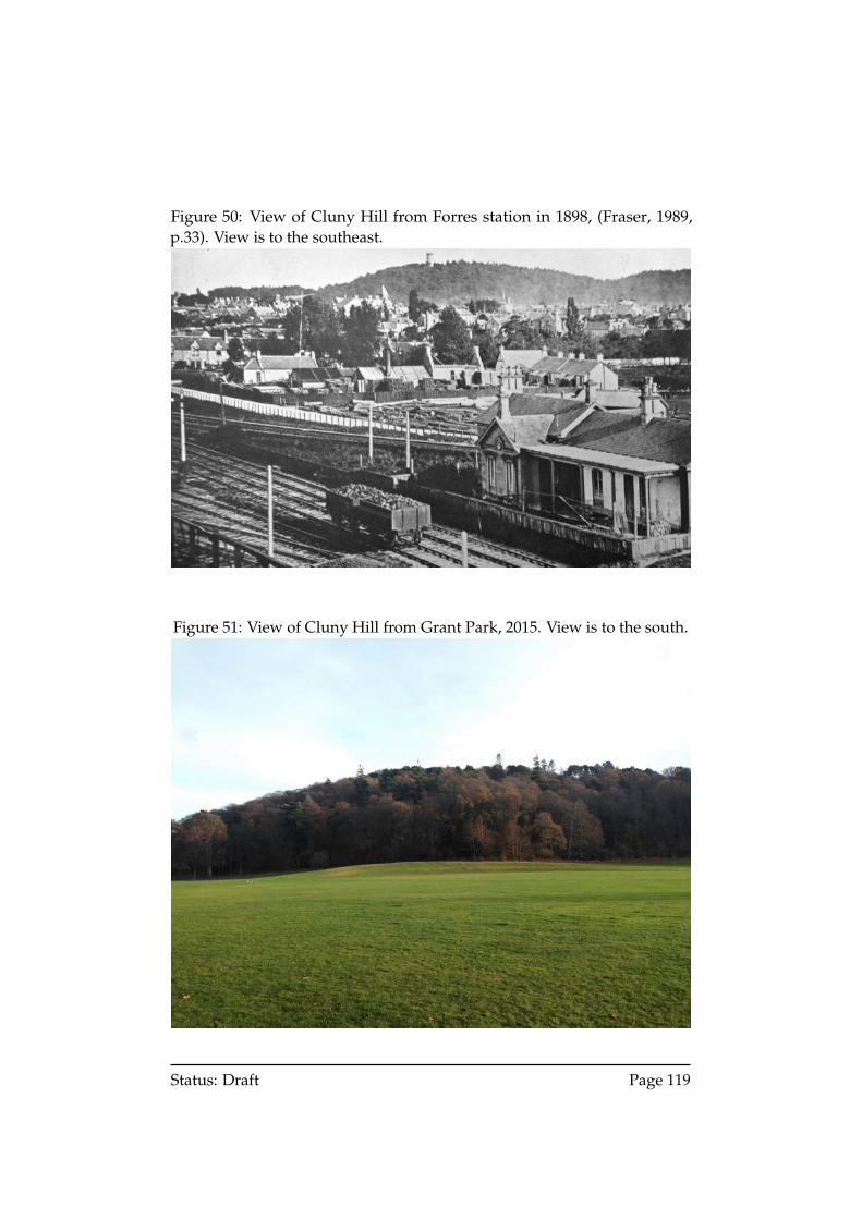
Figure 50: View of Cluny Hill from Forres station in 1898, (Fraser, 1989,p.33). View is to the southeast.
Figure 51: View of Cluny Hill from Grant Park, 2015. View is to the south.
Status: Draft Page 119
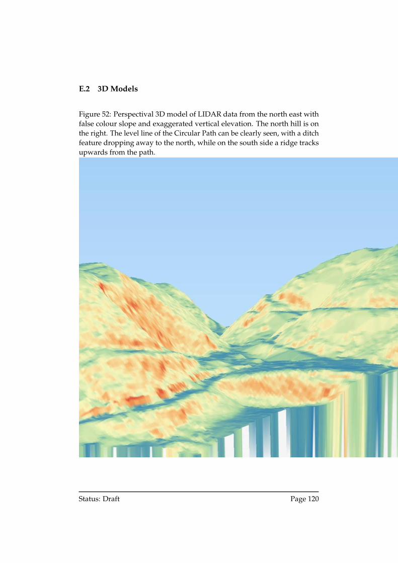
E.2 3D Models
Figure 52: Perspectival 3D model of LIDAR data from the north east withfalse colour slope and exaggerated vertical elevation. The north hill is onthe right. The level line of the Circular Path can be clearly seen, with a ditchfeature dropping away to the north, while on the south side a ridge tracksupwards from the path.
Status: Draft Page 120
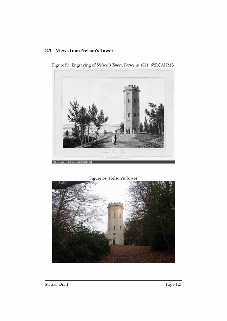
E.3 Views from Nelson’s Tower
Figure 53: Engraving of Nelson’s Tower, Forres in 1821. c©RCAHMS.
Figure 54: Nelson’s Tower
Status: Draft Page 121
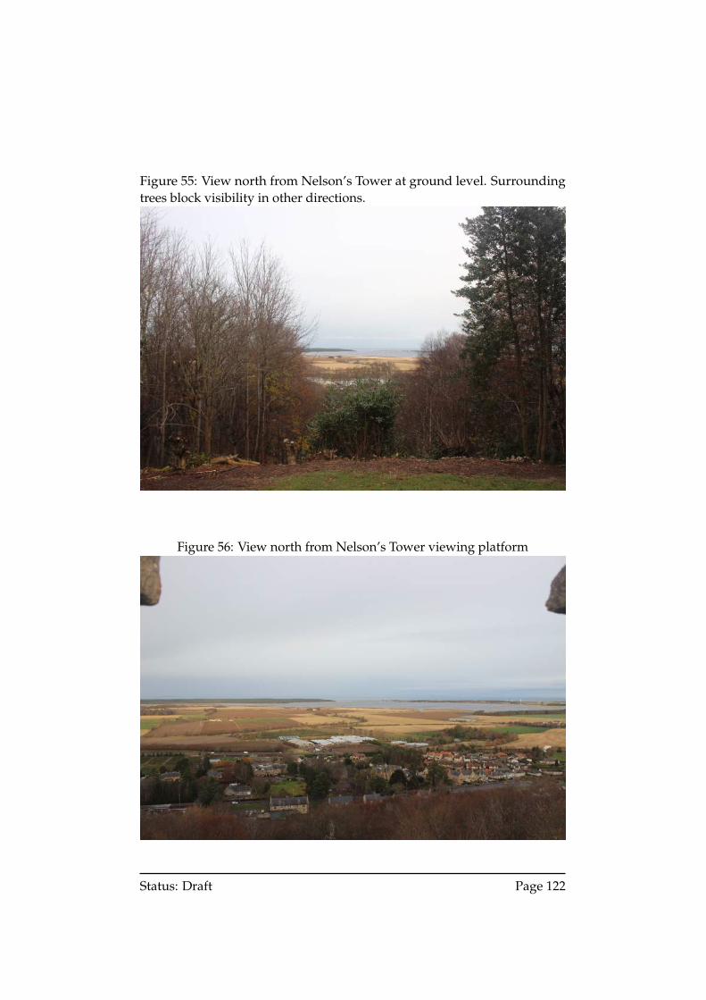
Figure 55: View north from Nelson’s Tower at ground level. Surroundingtrees block visibility in other directions.
Figure 56: View north from Nelson’s Tower viewing platform
Status: Draft Page 122
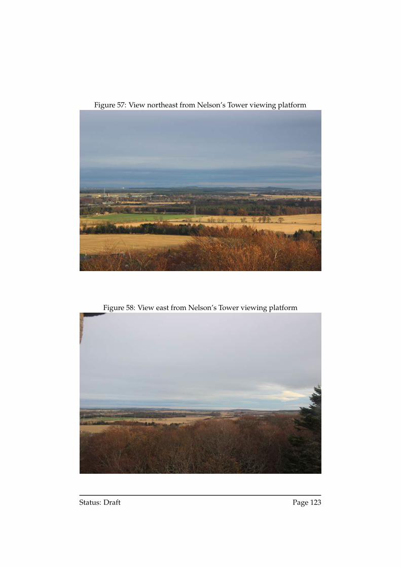
Figure 57: View northeast from Nelson’s Tower viewing platform
Figure 58: View east from Nelson’s Tower viewing platform
Status: Draft Page 123
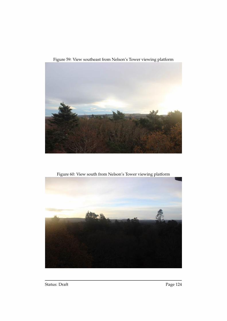
Figure 59: View southeast from Nelson’s Tower viewing platform
Figure 60: View south from Nelson’s Tower viewing platform
Status: Draft Page 124
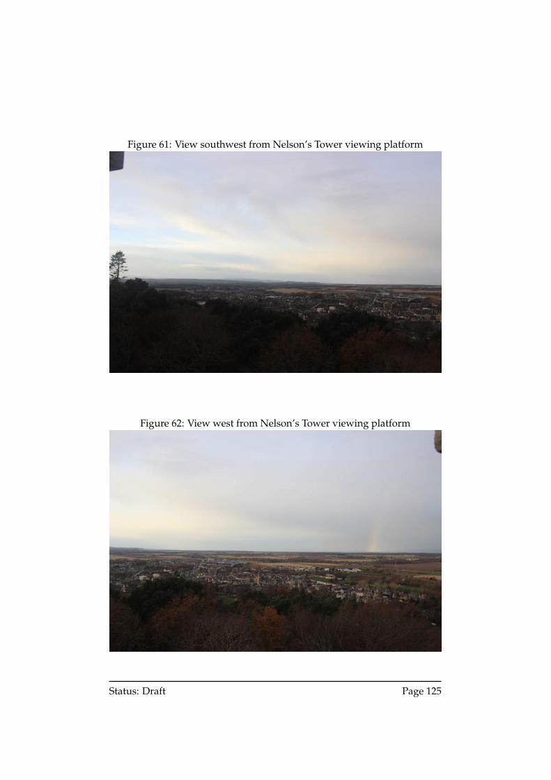
Figure 61: View southwest from Nelson’s Tower viewing platform
Figure 62: View west from Nelson’s Tower viewing platform
Status: Draft Page 125
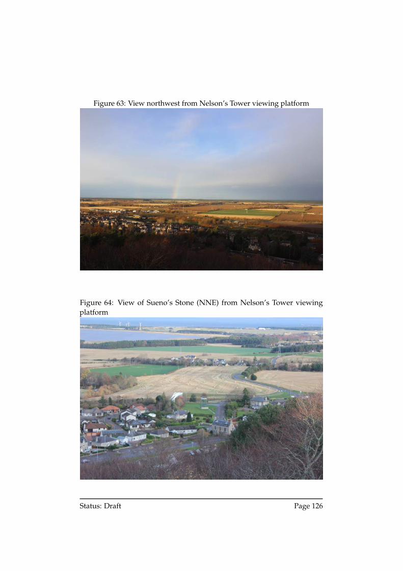
Figure 63: View northwest from Nelson’s Tower viewing platform
Figure 64: View of Sueno’s Stone (NNE) from Nelson’s Tower viewingplatform
Status: Draft Page 126
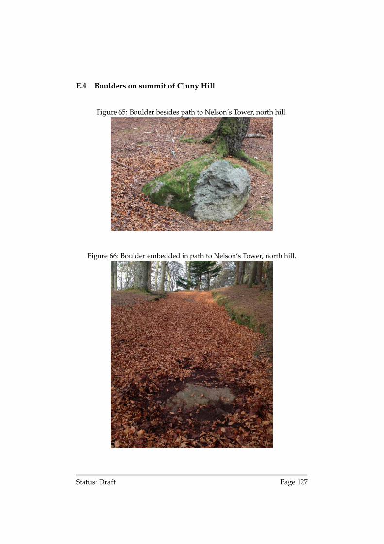
E.4 Boulders on summit of Cluny Hill
Figure 65: Boulder besides path to Nelson’s Tower, north hill.
Figure 66: Boulder embedded in path to Nelson’s Tower, north hill.
Status: Draft Page 127
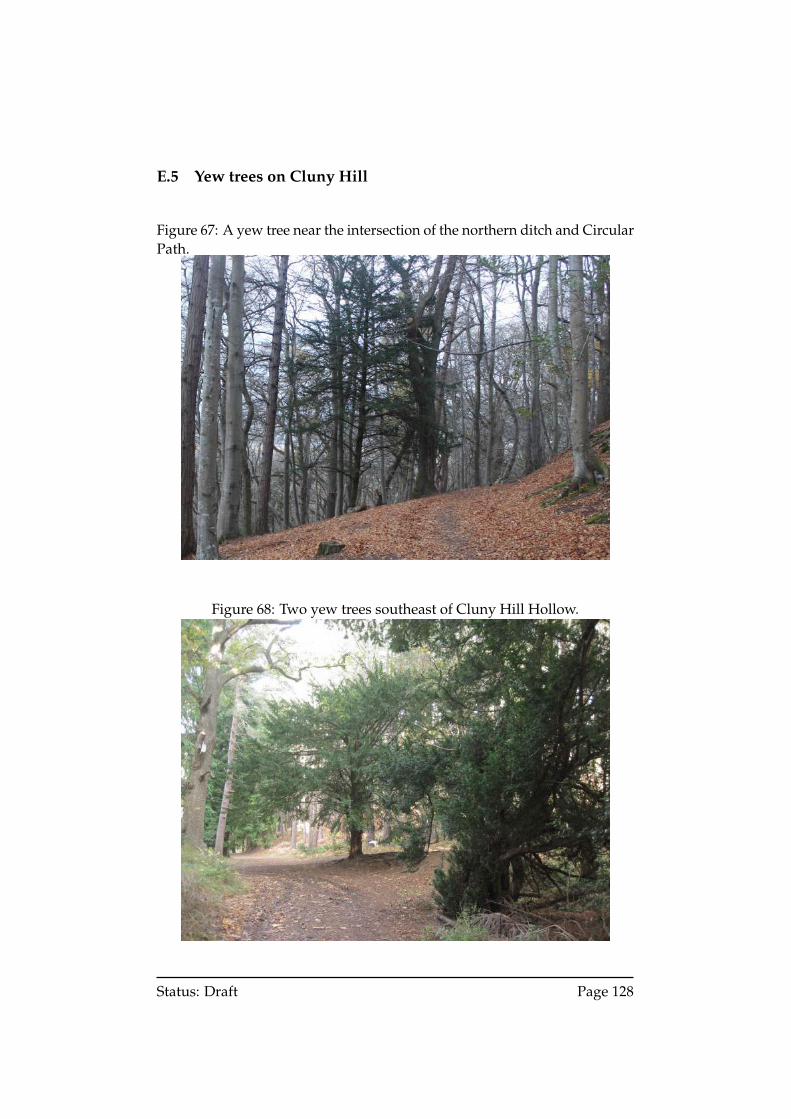
E.5 Yew trees on Cluny Hill
Figure 67: A yew tree near the intersection of the northern ditch and CircularPath.
Figure 68: Two yew trees southeast of Cluny Hill Hollow.
Status: Draft Page 128
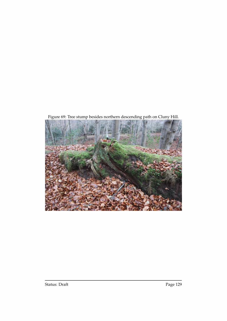
Figure 69: Tree stump besides northern descending path on Cluny Hill.
Status: Draft Page 129
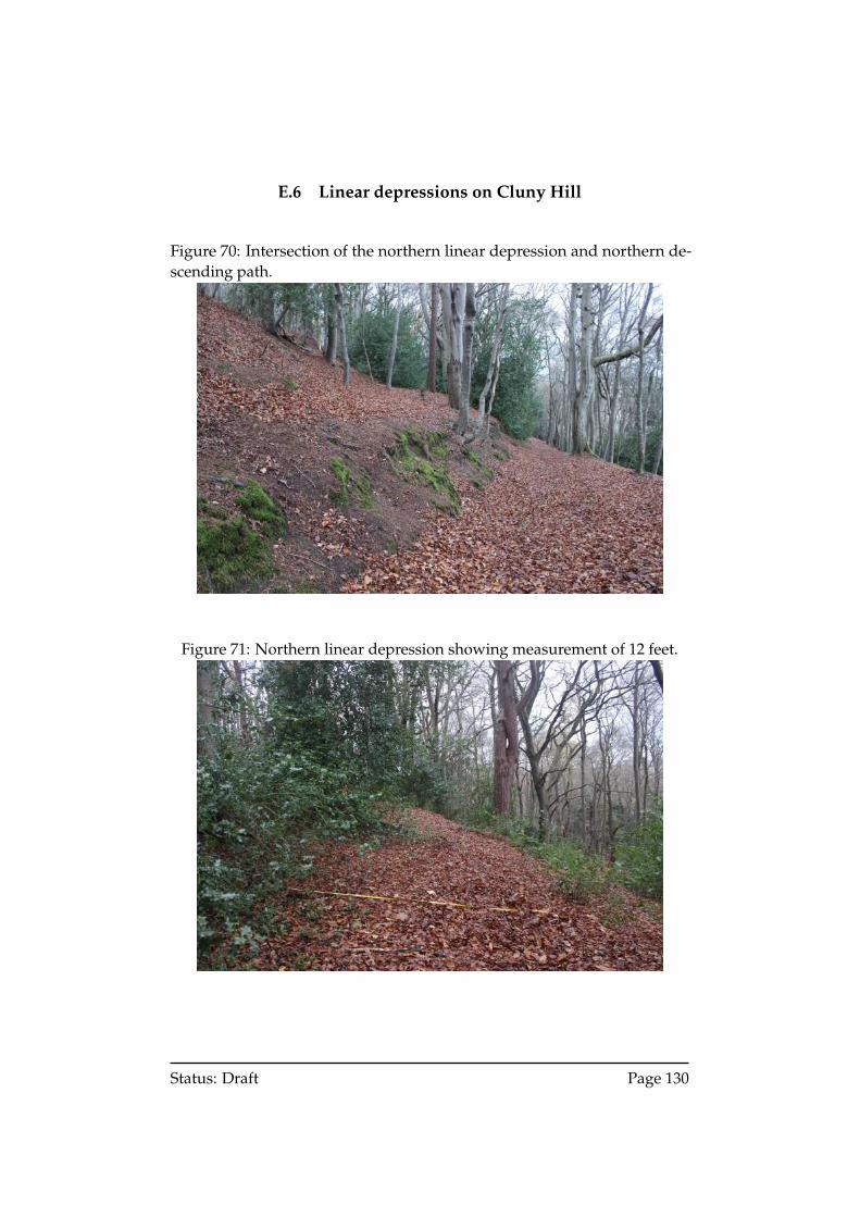
E.6 Linear depressions on Cluny Hill
Figure 70: Intersection of the northern linear depression and northern de-scending path.
Figure 71: Northern linear depression showing measurement of 12 feet.
Status: Draft Page 130
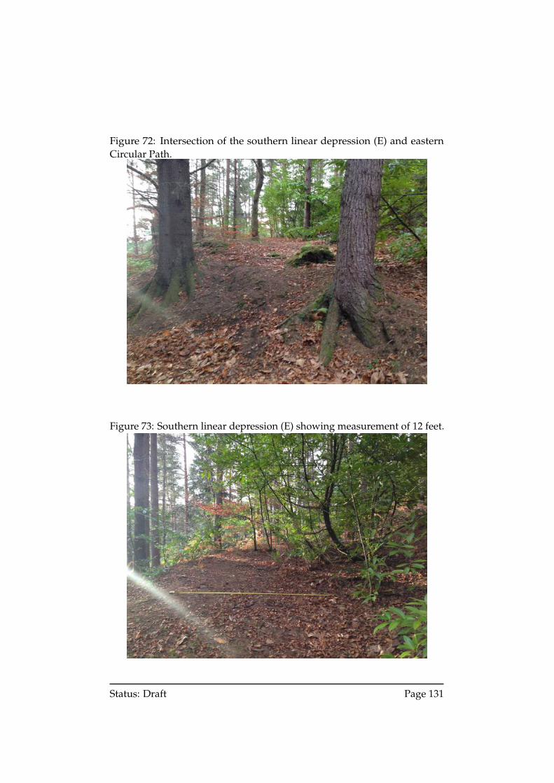
Figure 72: Intersection of the southern linear depression (E) and easternCircular Path.
Figure 73: Southern linear depression (E) showing measurement of 12 feet.
Status: Draft Page 131
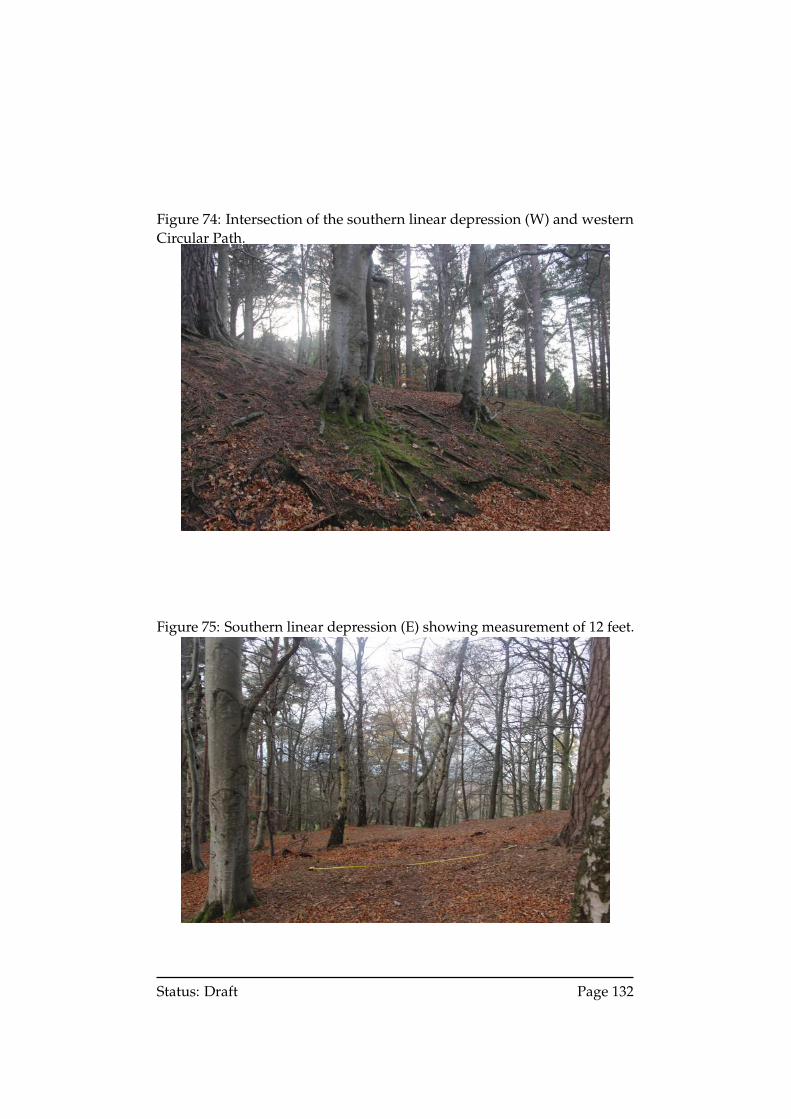
Figure 74: Intersection of the southern linear depression (W) and westernCircular Path.
Figure 75: Southern linear depression (E) showing measurement of 12 feet.
Status: Draft Page 132
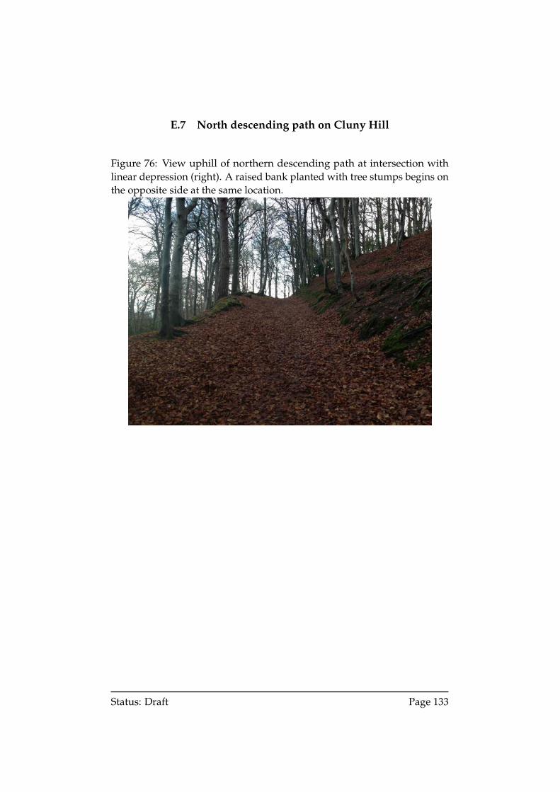
E.7 North descending path on Cluny Hill
Figure 76: View uphill of northern descending path at intersection withlinear depression (right). A raised bank planted with tree stumps begins onthe opposite side at the same location.
Status: Draft Page 133
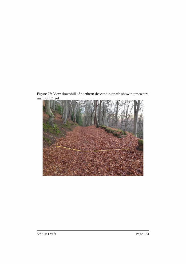
Figure 77: View downhill of northern descending path showing measure-ment of 12 feet.
Status: Draft Page 134
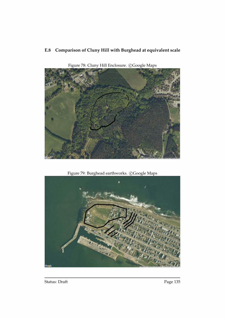
E.8 Comparison of Cluny Hill with Burghead at equivalent scale
Figure 78: Cluny Hill Enclosure. c©Google Maps
Figure 79: Burghead earthworks. c©Google Maps
Status: Draft Page 135