
The Future of Food Security in India: Can Farmers...
47
The Future of Food Security in India: Can Farmers Adapt to Environmental Change? Meha Jain Assistant Professor School for Environment and Sustainability University of Michigan
Transcript of The Future of Food Security in India: Can Farmers...

The Future of Food Security in India: Can Farmers Adapt to Environmental Change?
Meha JainAssistant Professor
School for Environment and SustainabilityUniversity of Michigan

Co-PIs David Lobell, Ram Fishman. Collaborators: Balwinder Singh, Ashwini Chhatre
Postdocs: Nishan Bhattarai, Sukhwinder Singh. Associate: Preeti Rao, Undergraduate: Adrienne Pollack
Cropped Area LCLUC team: Ruth DeFries, Pinki Mondal, Gillian Galford


Chaturvedi et al. 2012
Temperatures are warming

Modified from Singh et al. 2014
Monsoon rainfall has increasing break periods & intense events

Water tables are falling

Main Research Questions
• How are farmers adapting to multiple environmental changes?

Main Research Questions
• How are farmers adapting to multiple environmental changes?
• How effective are these adaptation strategies in reducing long-term negative impacts?

Main Research Questions
• How are farmers adapting to multiple environmental changes?
• How effective are these adaptation strategies in reducing long-term negative impacts?
• Which socio-economic & biophysical factors constrain or enhance adaptation?

Main Research Questions
• How are farmers adapting to multiple environmental changes?
• How effective are these adaptation strategies in reducing long-term negative impacts?
• Which socio-economic & biophysical factors constrain or enhance adaptation?
• Can satellite data be used to prioritize adaptation interventions?

Approach 1. Examine adaptation at large spatio-temporal scales using coarse scale census data

Approach 1. Examine adaptation at large spatio-temporal scales using coarse scale census data
Adaptation

Approach 1. Examine adaptation at large spatio-temporal scales using coarse scale census data+ empirical estimates of adaptation+ examine adaptation at large spatiotemporal scales
Adaptation

Approach 1. Examine adaptation at large spatio-temporal scales using coarse scale census data+ empirical estimates of adaptation+ examine adaptation at large spatiotemporal scales- actual adaptation decisions and drivers of decision-making are unclear
Adaptation

Approach 2. Examine adaptation using household surveys and ask farmers how they have adapted

Approach 2. Examine adaptation using household surveys and ask farmers how they have adapted+ identify adaptation decisions and drivers of decision-making

Approach 2. Examine adaptation using household surveys and ask farmers how they have adapted+ identify adaptation decisions and drivers of decision-making- challenging to do across large spatio-temporal scales- challenging to quantify adaptation


+ empirical estimates of adaptation+ examine adaptation at large spatiotemporal scales+ identify adaptation decisions and drivers of decision-making


Wheat Yield (Landsat & MODIS)
Winter cropped area (MODIS)Wheat sow date (MODIS)Growing season length (MODIS)Evapotranspiration (MODIS)
*
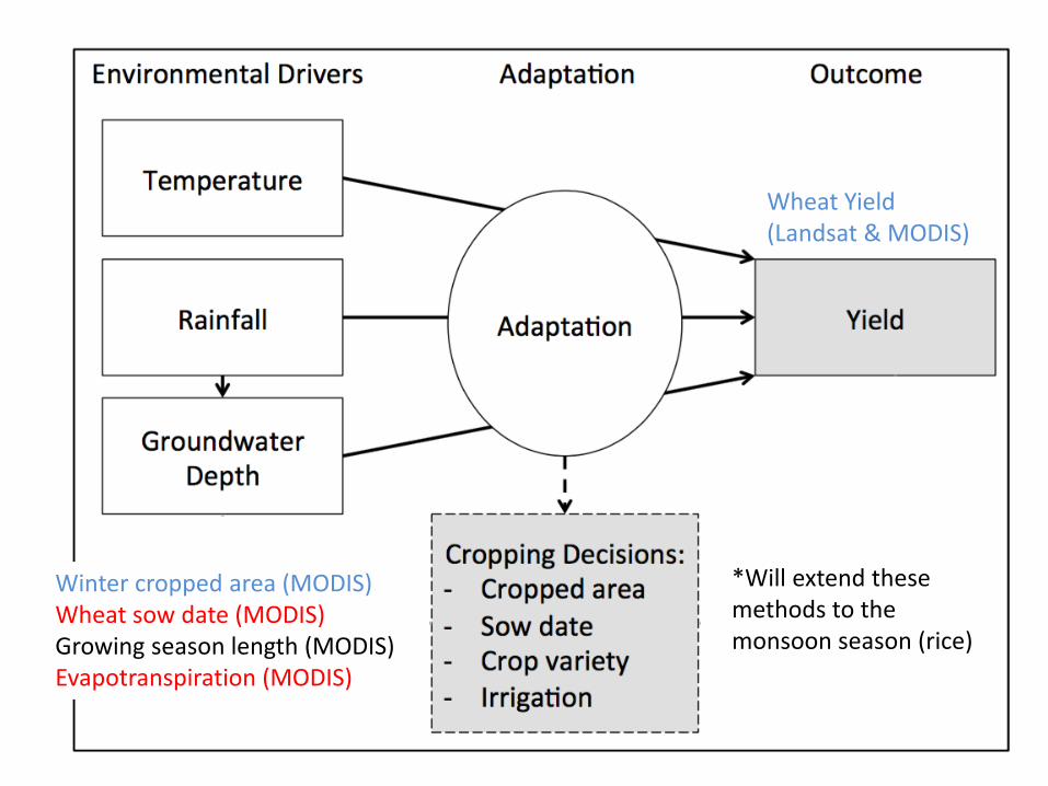
Wheat Yield (Landsat & MODIS)
Winter cropped area (MODIS)Wheat sow date (MODIS)Growing season length (MODIS)Evapotranspiration (MODIS)
*
*Will extend these methods to the monsoon season (rice)

Jain et al. 2017 using methods from Lobellet al. 2015

0 % 100%
Punjab
Bihar
Jain et al. 2017

Jain et al. 2017

Mean annual Evapotranspiration (2001-2016)
Bhattarai et al. in prep.

Bhattarai et al. in prep.

Jain et al. in prep

Water tables are falling

Main Research Questions
• Is groundwater depletion leading to decreased irrigation use or are farmers able to ‘chase’ the water table?

Main Research Questions
• Is groundwater depletion leading to decreased irrigation use or are farmers able to ‘chase’ the water table?
• Is current groundwater depletion associated with yield declines or have farmers been able to adapt?

Main Research Questions
• Is groundwater depletion leading to decreased irrigation use or are farmers able to ‘chase’ the water table?
• Is current groundwater depletion associated with yield declines or have farmers been able to adapt?
• Is switching to canal irrigation a viable long-term adaptation strategy?

Main Research Questions
• Is groundwater depletion leading to decreased irrigation use or are farmers able to ‘chase’ the water table?

Ensem ET
Ground water Level (m) -9.134***
(0.858)
Precipitation (mm) 0.007*
(0.004)
District FEYear FE
YesYes
Observations 3024
R2 0.05
Note: *p<0.1; **p<0.05; ***p<0.01
Bhattarai et al. in prep.

Main Research Questions
• Is current groundwater depletion associated with yield declines or have farmers been able to adapt?

Pollack et al. in prep.

Main Research Questions
• Is switching to canal irrigation a viable long-term adaptation strategy?

Jain et al. in prep


Conclusions• Groundwater depletion is already reducing
irrigation capacity and the yields of some crops (e.g., wheat)
• Switching to canal irrigation when wells run dry will only be able to ameliorate production losses by ~ 50%
• This suggests that additional adaptation strategies that more efficiently use groundwater are needed (e.g., drip irrigation)

Conclusions
• Satellite data allow us to – map decision making in response to
environmental change at fine spatial resolutions– link adaptation with drivers and outcomes at large
spatio-temporal scales– examine heterogeneity in adaptation efficacy at
fine spatial resolution

Informing Interventions & Capacity Building
• Partnering with CIMMYT and IWMI to identify ways our results and satellite data products can be used to target appropriate interventions regionally
• Conducting remote sensing trainings with scientists from CIMMYT and the MahalanobisNational Crop Forecast Centre on using Google Earth Engine

Co-PIs David Lobell, Ram Fishman. Collaborators: Balwinder Singh, Ashwini Chhatre
Postdocs: Nishan Bhattarai, Sukhwinder Singh. Associate: Preeti Rao, Undergraduate: Adrienne Pollack
Cropped Area LCLUC team: Ruth DeFries, Pinki Mondal, Gillian Galford

New Investigator Program (NIP)
Land Cover/Land-Use Change Program


