
The Cruise of the Pegasus and GSGS 3868 · M.A. Nolan: The Cruise of the Pegasus and GSGS 3868 Page...
17
M.A. Nolan: The Cruise of the Pegasus and GSGS 3868 Page 1 of 17 Symposium on “Shifting Boundaries”: Cartography of the 19 th and 20 th Centuries. ICA Commission on the History of Cartography Symposium on “Shifting Boundaries: Cartography in the 19 th and 20 th centuries” Portsmouth University, Portsmouth, United Kingdom, 10-12 September 2008-08-03 ICA Commission on the History of Cartography International Cartographic Association (ICA-ACI) The Cruise of the Pegasus and GSGS 3868 M.A. Nolan Late R.E. Survey. [email protected] ABSTRACT The British colony of Hong Kong existed from 1841 to 1997. In the Second World War Hong Kong was occupied by the Japanese. The Japanese invaded Hong Kong on the 8 th December 1941 and the British garrison surrendered on the 25 th December 1941. The British operational map series in use during the campaign was Series GSGS 3868 at 1:20,000 scale. The field work for this series was carried out by the 2nd Colonial Survey Section under Captain H. Wace R.E. from 1924-1927. The survey was materially assisted by the acquisition of aerial photography by seaplanes of H.M.S. Pegasus in 1924 prints of much of which survive to this day in both Hong Kong and the U.K. This paper briefly traces the history of British military mapping of Hong Kong from 1841 to 1941, with passing reference to early cadastral mapping, and then concentrates on the production of Series GSGS 3868 one of the first post-Great War British military topographical series to utilise aerial photography taken by an aerial camera using film rather than glass plates. It is illustrated by photographs taken by the seaplanes of H.M.S. Pegasus. 1. BACKGROUND The author has been compiling a carto-bibliography of maps of Hong Kong that may be found in the National Archives, the British Library, the Bodleian Library and the Hong Kong Lands department, dating from the British occupation to the present day and is thus a little familiar with the maps of Hong Kong produced since the 1840’s, albeit this knowledge is based on cursory examinations sufficient for carto-bibliographic note-making. A written history of the story of the mapping of Hong Kong both military and civil, including cadastral, is a different matter and this story has already been well documented by others. This present brief historical description leans heavily on the earlier work of Cooper and the lavishly illustrated atlas by Empson, both of the Hong Kong Lands Department. It is believed that that some aspects of the aerial survey and the Colonial Survey Section’s work are less well documented, hence this attempt to describe those aspects. Although no comprehensive report of the field work and production of Series GSGS 38368 has been found, enough miscellaneous material survives to enable some light to be thrown on the compilation of the series which perhaps laid the foundations of British military colonial topographic mapping in the years following the First World War. 2. MILITARY MAPPING OF HONG KONG UP TO 1924. In 1841 on the signing of the Treaty of Chuen-pi, the British secured the island of Hong Kong. In 1860 the southern 2.5 miles of the Kowloon peninsula was ceded to the U.K. On the 1 July 1898,
Transcript of The Cruise of the Pegasus and GSGS 3868 · M.A. Nolan: The Cruise of the Pegasus and GSGS 3868 Page...

M.A. Nolan: The Cruise of the Pegasus and GSGS 3868 Page 1 of 17
Symposium on “Shifting Boundaries”: Cartography of the 19th and 20th Centuries. ICA Commission on the History of Cartography
Symposium on “Shifting Boundaries: Cartography in the 19th and 20th centuries” Portsmouth University, Portsmouth, United Kingdom, 10-12 September 2008-08-03 ICA Commission on the History of Cartography International Cartographic Association (ICA-ACI)
The Cruise of the Pegasus and GSGS 3868
M.A. Nolan
Late R.E. Survey. [email protected]
ABSTRACT
The British colony of Hong Kong existed from 1841 to 1997. In the Second World War Hong Kong was occupied by the Japanese. The Japanese invaded Hong Kong on the 8th December 1941 and the British garrison surrendered on the 25th December 1941. The British operational map series in use during the campaign was Series GSGS 3868 at 1:20,000 scale. The field work for this series was carried out by the 2nd Colonial Survey Section under Captain H. Wace R.E. from 1924-1927. The survey was materially assisted by the acquisition of aerial photography by seaplanes of H.M.S. Pegasus in 1924 prints of much of which survive to this day in both Hong Kong and the U.K. This paper briefly traces the history of British military mapping of Hong Kong from 1841 to 1941, with passing reference to early cadastral mapping, and then concentrates on the production of Series GSGS 3868 one of the first post-Great War British military topographical series to utilise aerial photography taken by an aerial camera using film rather than glass plates. It is illustrated by photographs taken by the seaplanes of H.M.S. Pegasus.
1. BACKGROUND The author has been compiling a carto-bibliography of maps of Hong Kong that may be found in the National Archives, the British Library, the Bodleian Library and the Hong Kong Lands department, dating from the British occupation to the present day and is thus a little familiar with the maps of Hong Kong produced since the 1840’s, albeit this knowledge is based on cursory examinations sufficient for carto-bibliographic note-making. A written history of the story of the mapping of Hong Kong both military and civil, including cadastral, is a different matter and this story has already been well documented by others. This present brief historical description leans heavily on the earlier work of Cooper and the lavishly illustrated atlas by Empson, both of the Hong Kong Lands Department. It is believed that that some aspects of the aerial survey and the Colonial Survey Section’s work are less well documented, hence this attempt to describe those aspects. Although no comprehensive report of the field work and production of Series GSGS 38368 has been found, enough miscellaneous material survives to enable some light to be thrown on the compilation of the series which perhaps laid the foundations of British military colonial topographic mapping in the years following the First World War. 2. MILITARY MAPPING OF HONG KONG UP TO 1924. In 1841 on the signing of the Treaty of Chuen-pi, the British secured the island of Hong Kong. In 1860 the southern 2.5 miles of the Kowloon peninsula was ceded to the U.K. On the 1 July 1898,

M.A. Nolan: The Cruise of the Pegasus and GSGS 3868 Page 2 of 17
Symposium on “Shifting Boundaries”: Cartography of the 19th and 20th Centuries. ICA Commission on the History of Cartography
under the Convention of Peking the New Territory was leased from China for 99 years, and this included Lantau and Lamma and other islands.
Figure 1: Collinson’s map of Hong Kong.
Belcher’s Chart & Collinson’s Map (Figure 1). The first British survey of Hong Kong was the hydrographic survey by Captain Sir Edward Belcher of HMS Sulphur in 1841. Unlike many charts, the limited size of Hong Kong Island meant that the interior of the island and its peaks was fully depicted topographically rather than just the coastal area. Almost immediately after, a military survey of the island of Hong Kong was commenced under the direction of the Commanding Royal Engineer Office, Major Aldrich R.E., the work being entrusted to Lt T.B. Collinson R.E. His four-inch scale map in four sheets with 100 foot contours was printed at the Ordnance Survey in 1846. Collinson’s map is notable in that it was one of the first British military maps to employ contours for the depiction of relief. It shows the island and southern Kowloon only but includes part of Lamma Island although this was only acquired as part of the New Territories in 1898. Hong Kong Extension Map In 1860 under the Treaty of Tientsin, Britain acquired a lease of the land extending as far north as what was to become Boundary Road on the Kowloon peninsula, the boundary running west-east from the northern tip of Stonecutters Island, which was also acquired. On the 9 June 1898 a Convention was signed in Peking under which Britain was to lease for 99 years what were termed the New Territory/ies.
M.A. Nolan: The Cruise of the Pegasus and GSGS 3868 Page 3 of 17
Symposium on “Shifting Boundaries”: Cartography of the 19th and 20th Centuries. ICA Commission on the History of Cartography
IGF Plans (Figure 2) Throughout the nineteenth century continuous effort was devoted by the Inspector General of Fortifications in producing large scale plans for and of the various batteries of the fixed defences of Hong Kong which were mainly on the north shore of the island, Stonecutters Island and southern Kowloon and Collinson’s map and Belcher’s chart probably still sufficed to display the overall situation of the defences and the positions and arcs of fire of the coast defence batteries. Only later, in the inter-war years, with unrest in China, did the need really arise to consider the landward, forward, defences of the New Territories in more detail.
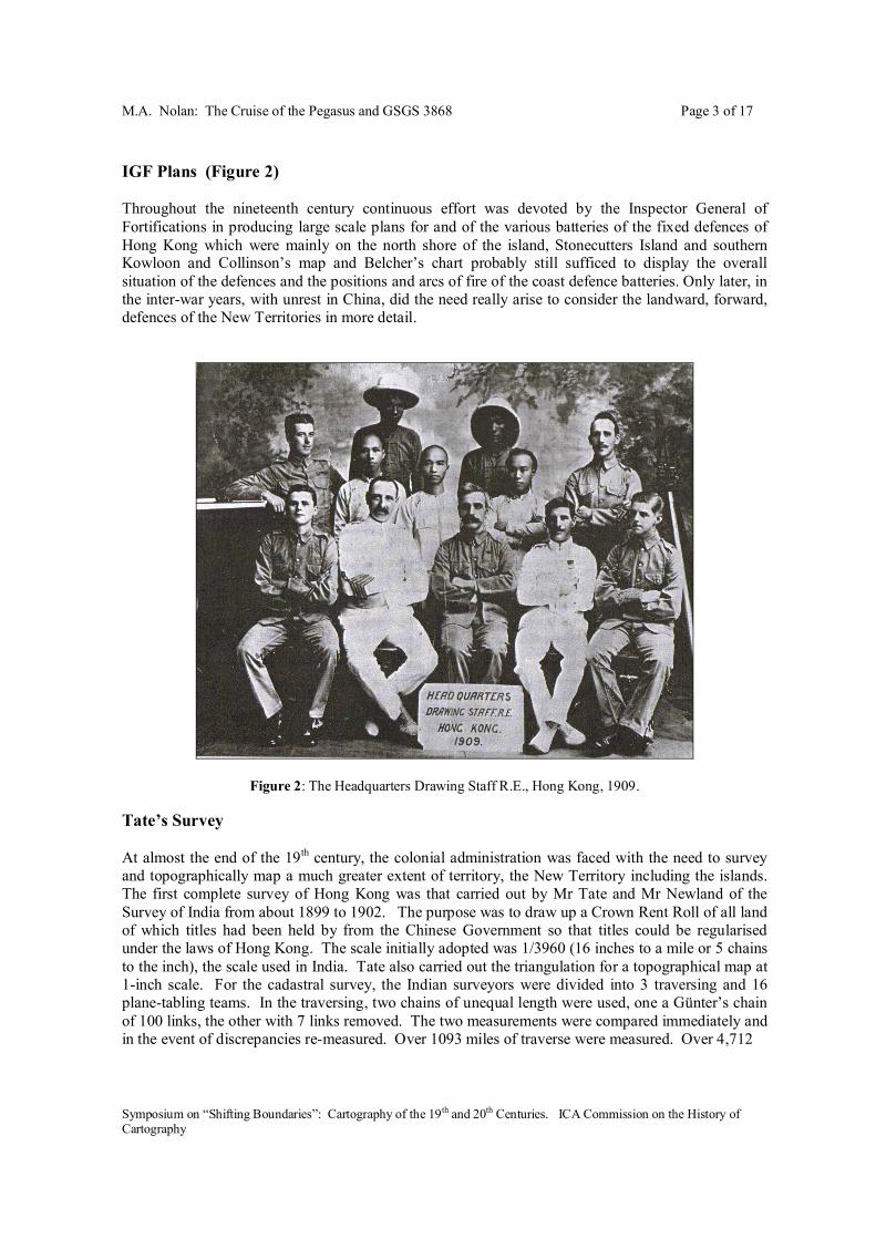
Figure 2: The Headquarters Drawing Staff R.E., Hong Kong, 1909. Tate’s Survey At almost the end of the 19th century, the colonial administration was faced with the need to survey and topographically map a much greater extent of territory, the New Territory including the islands. The first complete survey of Hong Kong was that carried out by Mr Tate and Mr Newland of the Survey of India from about 1899 to 1902. The purpose was to draw up a Crown Rent Roll of all land of which titles had been held by from the Chinese Government so that titles could be regularised under the laws of Hong Kong. The scale initially adopted was 1/3960 (16 inches to a mile or 5 chains to the inch), the scale used in India. Tate also carried out the triangulation for a topographical map at 1-inch scale. For the cadastral survey, the Indian surveyors were divided into 3 traversing and 16 plane-tabling teams. In the traversing, two chains of unequal length were used, one a Günter’s chain of 100 links, the other with 7 links removed. The two measurements were compared immediately and in the event of discrepancies re-measured. Over 1093 miles of traverse were measured. Over 4,712
M.A. Nolan: The Cruise of the Pegasus and GSGS 3868 Page 4 of 17
Symposium on “Shifting Boundaries”: Cartography of the 19th and 20th Centuries. ICA Commission on the History of Cartography
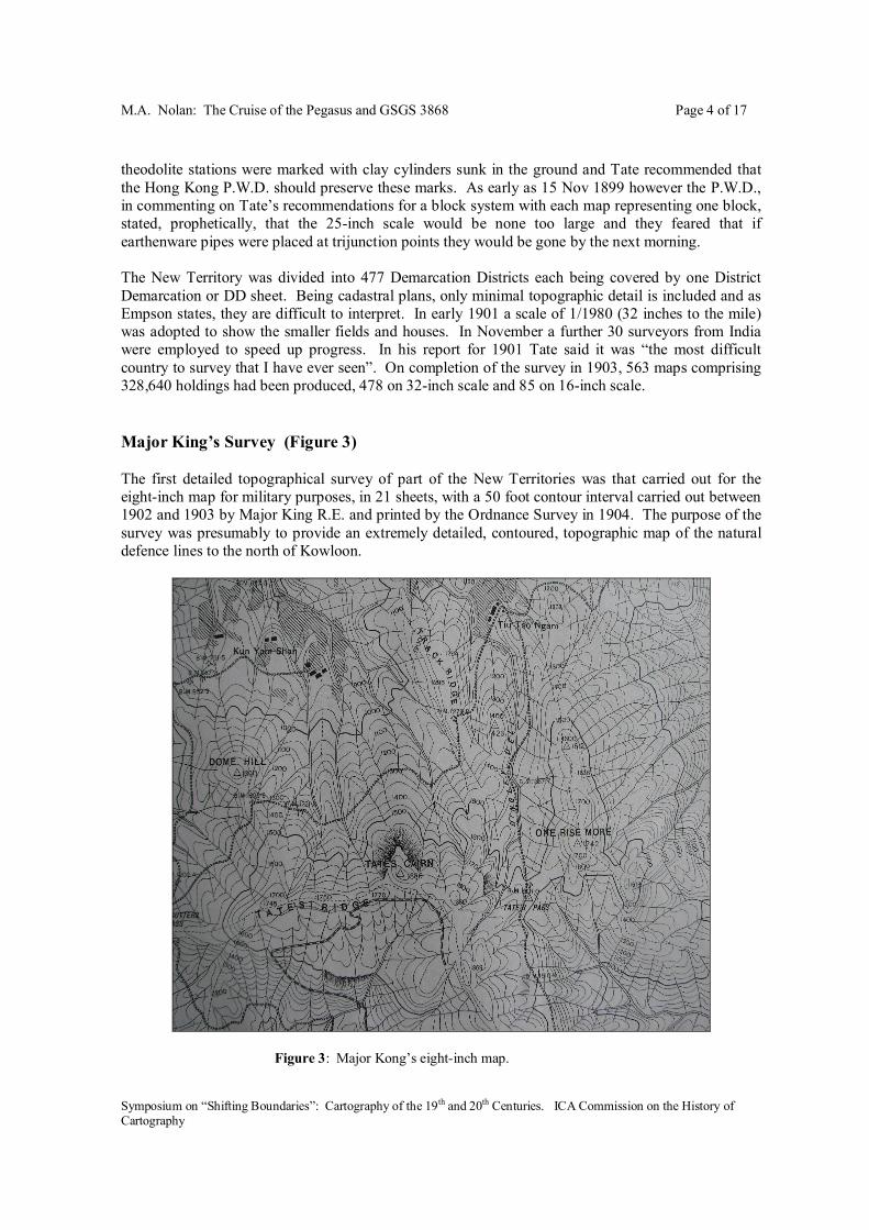
theodolite stations were marked with clay cylinders sunk in the ground and Tate recommended that the Hong Kong P.W.D. should preserve these marks. As early as 15 Nov 1899 however the P.W.D., in commenting on Tate’s recommendations for a block system with each map representing one block, stated, prophetically, that the 25-inch scale would be none too large and they feared that if earthenware pipes were placed at trijunction points they would be gone by the next morning. The New Territory was divided into 477 Demarcation Districts each being covered by one District Demarcation or DD sheet. Being cadastral plans, only minimal topographic detail is included and as Empson states, they are difficult to interpret. In early 1901 a scale of 1/1980 (32 inches to the mile) was adopted to show the smaller fields and houses. In November a further 30 surveyors from India were employed to speed up progress. In his report for 1901 Tate said it was “the most difficult country to survey that I have ever seen”. On completion of the survey in 1903, 563 maps comprising 328,640 holdings had been produced, 478 on 32-inch scale and 85 on 16-inch scale. Major King’s Survey (Figure 3) The first detailed topographical survey of part of the New Territories was that carried out for the eight-inch map for military purposes, in 21 sheets, with a 50 foot contour interval carried out between 1902 and 1903 by Major King R.E. and printed by the Ordnance Survey in 1904. The purpose of the survey was presumably to provide an extremely detailed, contoured, topographic map of the natural defence lines to the north of Kowloon.
Figure 3: Major Kong’s eight-inch map.

M.A. Nolan: The Cruise of the Pegasus and GSGS 3868 Page 5 of 17
Symposium on “Shifting Boundaries”: Cartography of the 19th and 20th Centuries. ICA Commission on the History of Cartography
Newland’s Survey (Figure 4) Tate’s work was continued and in effect superseded by another survey by Mr Newland of the Survey of India, who produced a two-inch survey in eleven sheets between 1902 and 1904. This series was printed at the Ordnance Survey in 1904 and remained in use for many years. Newland’s map reportedly incorporated detail from the 8-inch survey by Major King and the sheet index shows the extent of King’s 8-inch survey.
Figure 4: Newland’s two-inch map. Series GSGS 1393 In 1905 the single-sheet ¾ -inch (1:84,480) Series, GSGS 1393 “Map of Hong Kong and the Territory leased to Great Britain etc.”, was compiled from the Tate/Newland & King material. Illuminated contours give a hill-shaded effect. The whereabouts of the original of Tate’s one-inch survey and map are not known but, according to Empson, its style may be inferred from the War Office map GSGS 1393 at 1:84,480 which was compiled from Tate’s material and produced in 1905. Series GSGS 3749 Major King’s 8-inch series in 21 sheets was, with some difficulty, revised or corrected and reprinted in 1924 as GSGS 3749. Series GSGS 2994 In 1922, only two years before Wace’s survey the War Office produced GSGS 2994, a two-inch (1:31,680) map of Hong Kong, including the Chinese coastline of Deep Bay and Mirs Bay, in nine
M.A. Nolan: The Cruise of the Pegasus and GSGS 3868 Page 6 of 17
Symposium on “Shifting Boundaries”: Cartography of the 19th and 20th Centuries. ICA Commission on the History of Cartography
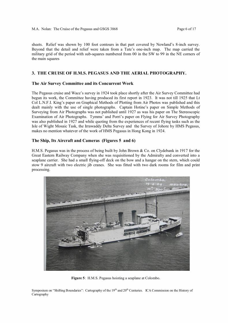
sheets. Relief was shown by 100 foot contours in that part covered by Newland’s 8-inch survey. Beyond that the detail and relief were taken from a Tate’s one-inch map. The map carried the military grid of the period with sub-squares numbered from 00 in the SW to 99 in the NE corners of the main squares 3. THE CRUISE OF H.M.S. PEGASUS AND THE AERIAL PHOTOGRAPHY. The Air Survey Committee and its Concurrent Work The Pegasus cruise and Wace’s survey in 1924 took place shortly after the Air Survey Committee had begun its work, the Committee having produced its first report in 1923. It was not till 1925 that Lt Col L.N.F.I. King’s paper on Graphical Methods of Plotting from Air Photos was published and this dealt mainly with the use of single photographs. Captain Hotine’s paper on Simple Methods of Surveying from Air Photographs was not published until 1927 as was his paper on The Stereoscopic Examination of Air Photographs. Tymms’ and Porri’s paper on Flying for Air Survey Photography was also published in 1927 and while quoting from the experiences of recent flying tasks such as the Isle of Wight Mosaic Task, the Irrawaddy Delta Survey and the Survey of Johore by HMS Pegasus, makes no mention whatever of the work of HMS Pegasus in Hong Kong in 1924. The Ship, Its Aircraft and Cameras (Figures 5 and 6) H.M.S. Pegasus was in the process of being built by John Brown & Co. on Clydebank in 1917 for the Great Eastern Railway Company when she was requisitioned by the Admiralty and converted into a seaplane carrier. She had a small flying-off deck on the bow and a hangar on the stern, which could stow 9 aircraft with two electric jib cranes. She was fitted with two dark rooms for film and print processing.
Figure 5: H.M.S. Pegasus hoisting a seaplane at Colombo.
M.A. Nolan: The Cruise of the Pegasus and GSGS 3868 Page 7 of 17
Symposium on “Shifting Boundaries”: Cartography of the 19th and 20th Centuries. ICA Commission on the History of Cartography
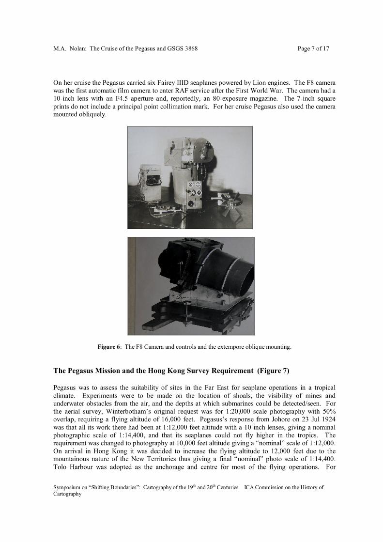
On her cruise the Pegasus carried six Fairey IIID seaplanes powered by Lion engines. The F8 camera was the first automatic film camera to enter RAF service after the First World War. The camera had a 10-inch lens with an F4.5 aperture and, reportedly, an 80-exposure magazine. The 7-inch square prints do not include a principal point collimation mark. For her cruise Pegasus also used the camera mounted obliquely.
Figure 6: The F8 Camera and controls and the extempore oblique mounting.
The Pegasus Mission and the Hong Kong Survey Requirement (Figure 7) Pegasus was to assess the suitability of sites in the Far East for seaplane operations in a tropical climate. Experiments were to be made on the location of shoals, the visibility of mines and underwater obstacles from the air, and the depths at which submarines could be detected/seen. For the aerial survey, Winterbotham’s original request was for 1:20,000 scale photography with 50% overlap, requiring a flying altitude of 16,000 feet. Pegasus’s response from Johore on 23 Jul 1924 was that all its work there had been at 1:12,000 feet altitude with a 10 inch lenses, giving a nominal photographic scale of 1:14,400, and that its seaplanes could not fly higher in the tropics. The requirement was changed to photography at 10,000 feet altitude giving a “nominal” scale of 1:12,000. On arrival in Hong Kong it was decided to increase the flying altitude to 12,000 feet due to the mountainous nature of the New Territories thus giving a final “nominal” photo scale of 1:14,400. Tolo Harbour was adopted as the anchorage and centre for most of the flying operations. For
M.A. Nolan: The Cruise of the Pegasus and GSGS 3868 Page 8 of 17
Symposium on “Shifting Boundaries”: Cartography of the 19th and 20th Centuries. ICA Commission on the History of Cartography
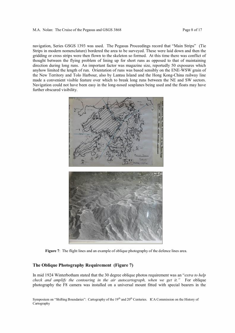
navigation, Series GSGS 1393 was used. The Pegasus Proceedings record that “Main Strips” (Tie Strips in modern nomenclature) bordered the area to be surveyed. These were laid down and then the gridding or cross strips were then flown to the skeleton so formed. At this time there was conflict of thought between the flying problem of lining up for short runs as opposed to that of maintaining direction during long runs. An important factor was magazine size, reportedly 50 exposures which anyhow limited the length of run. Orientation of runs was based sensibly on the ENE-WSW grain of the New Territory and Tolo Harbour, also by Lantau Island and the Hong Kong-China railway line made a convenient visible feature over which to break long runs between the NE and SW sectors. Navigation could not have been easy in the long-nosed seaplanes being used and the floats may have further obscured visibility.
Figure 7: The flight lines and an example of oblique photography of the defence lines area. The Oblique Photography Requirement (Figure 7) In mid 1924 Winterbotham stated that the 30 degree oblique photos requirement was an “extra to help check and amplify the contouring in the air autocartograph, when we get it.” For oblique photography the F8 camera was installed on a universal mount fitted with special bearers in the

M.A. Nolan: The Cruise of the Pegasus and GSGS 3868 Page 9 of 17
Symposium on “Shifting Boundaries”: Cartography of the 19th and 20th Centuries. ICA Commission on the History of Cartography
observer’s cockpit at 90 degrees to the line of flight with a view cut through the starboard fuselage covering-fabric allowing a 30 degree depression angle. The Hong Kong Aerial Survey Pegasus completed the aerial survey of Johore in April and by the 3rd November 1924, she arrived in Hong Kong, via Sarawak, having gained much experience of Far East conditions on the survey of Johore. She completed all her photographic tasks by the 9th December 1924 and then departed for Aden. Prior to the survey, the War Office had asked the P.W.D. in Hong Kong to pre-mark the 100 or so trigonometrical points in the colony so that they might be identified on the photographs. For the marking of trig points, four white strips of muslin material, each 12 x 6 feet, each positioned about 7 feet from the base of the trig cairn were recommended. However when Lt. Wace arrived in Hong Kong in December 1924 nothing had been done by the P.W.D. Wace requested eight copies of every print, an estimated total of 16,000 prints. On the Hong Kong survey, 108 films were exposed, with as many as 12 films in one day. After the construction of an extra printing box and with the help of 3 extra men, a total of 10 in all, the daily output of prints averaged 1100, in one instance 1400 were produced. In addition to the topographic survey, for defence planning purposes the army requested mosaics of the Lai Chi Kok area with photos flown at 5,000 and 10,000 feet and verticals and obliques of three defence lines in the New Territories. These defence lines pre-dated the concrete bunkers of the infamous “Gin Drinkers Line” breached so easily by the Japanese in December 1941. 4. MAPPING FOR THE DEFENCE OF HONG KONG - SERIES GSGS 3868 Military Situation Post World War I Japan’s rise as an economic, military and naval power resulted in the UK’s need for a modern naval base in the Far East to protect its colonial interests in the Far East and Singapore was selected as the site of a new dockyard capable of handling and maintaining capital ships. This prompted a timely statement of requirement for large scale up-to-date mapping of the landward approaches to the Singapore Naval Base area which resulted in the Survey of Johore by a Colonial Survey Section under Captains Kirby, Willis, etc. The requirement for up-to-date topographic mapping of Hong Kong and Canton was raised by the G.O.C. Hong Kong as early as 1919 who stated that only the 8-inch survey which covered only part of the New Territories was considered adequate for military purposes. In 1919, the War Office was unable to find a field survey party to survey on the ground but was prepared to grid existing map series and to incorporate any corrections which were sent home. By 1921 the Director of Military Operations rated the requirement as important, including the need for cover of part of “Kuang Tung”. At this time Colonel Jack in MI4 confirmed that a map of Kuang Tung at 1:25,000 scale in 280 sheets, produced in 1914 or even 1910, whose quality was believed to be good, was held by the War Office. Transliteration of names, which must be Cantonese, not Mandarin, was needed as a first step before its use for compilation. Series Planning and Preparatory Field Work In July 1922 the G.O.C. Hong Kong reported that enquiries to resolve the control situation and the projection data for the 8-inch series had been fruitless. In January 1924, in the course of investigating the gridding of the 2 ½-inch, the ¾-inch and the 8-inch series it was found impossible to grid them accurately using the trigonometrical control provided. The War Office did grid the 2-inch, ¾-inch and 8-inch series in 1923 but due to inaccuracies in the maps and lack of trigonometrical data the

M.A. Nolan: The Cruise of the Pegasus and GSGS 3868 Page 10 of 17
Symposium on “Shifting Boundaries”: Cartography of the 19th and 20th Centuries. ICA Commission on the History of Cartography
relation between the grid and the detail on the different series was poor. In the meantime, some field work was being done by Royal Engineers based in the colony. In the winter of 1922-23 Lt. Taylor, QMS Longbottom assisted by Sgt Holbrook and 3 Sappers detached from the O.S. to Hong Kong did some work in the north of the colony. A trace of their 1:20,000 scale plane table work north of Fanling was sent to the War Office. Their appreciation at the time was that the 8-inch map was good and the 2-inch good for detail but hopeless as regards hill features which must have been done by someone with little or no idea of the country. In the 1923-24 observing season “owing to fieldworks, musketry and the typhoons” Lt Taylor was only able to start in February 1924 and then fog occurred rendering field work impossible. In late 1923 Winterbotham’s idea was for a survey at 1:20,000 with a derived map at 1:63,360 scale. There was a need for new triangulation between the old 8-inch survey and the border in particular to tie in the block of maps of China. However in late November 1923 it was appreciated that the deployment of HMS Pegasus to the Far East might afford the opportunity of obtaining aerial photography. In June the GSGS sought financial approval for aerial photography by HMS Pegasus during her Hong Kong refit after the Johore task. Control In 1924 the control information available to the War Office was as follows :- a. Major King’s triangulation of the 8-inch map, thought to be good. b. Tate’s triangulation of the rest of the New Territories, not properly monumented and most of the points lost. c. The P.W.D. triangulation which replaced Tate’s work, properly monumented but from reports of doubtful accuracy. No vertical angles had been observed in this triangulation. The War Office asked the G.O.C. Hong Kong to get the P.W.D. to check the triangulation, to extend it, and to mark points so that they would be visible from the air and on aerial photographs. In September 1924, the P.W.D. provided a triangulation diagram and trig list but reported triangulation errors of from 2 to 9 minutes. On the arrival of the Colonial Survey Section it was found that the P.W.D. had marked some of the trig stations but had had no resources to have checked or extended the control, also that Major King’s stations had been lost. The Colonial Survey Section subsequently extended the P.W.D. triangulation to cover the whole Colony but points were still only temporarily marked on the ground and the order of accuracy was only that required for 1/20,000 scale mapping. Like Tate before them , they “arranged” that the P.W.D. should subsequently erect permanent points. Scale & Contour Interval In 2 November 1924 the G.O.C. in Hong Kong notified the War Office that after consultation with his Commanding Gunner and the P.W.D., he had decided the scale of map should be 1:31,680 with a 50 foot V.I., but that field work should be done at 1:20,000 scale. On 8 January 1925, the War Office response was that field work should provide for contouring at 25 foot VI. On 19 February 1925 the new G.O.C. Hong Kong reiterated the desirability of a 2-inch map despite field work at 1:20,000 scale. In his view, the “hilly” nature of the ground warranted a 50 foot vertical interval since a 25 foot interval would clutter the map. In Jan 1927, Winterbotham while submitting a proof of a 1:250,000 map connecting Hong Kong to Canton, recommended to the Garrison that either metric scales of 1:20,000 or 1:25,000, with a derived 1:50,000, be the resulting production scales. 1:25,000 was preferred as twice that of the 1:50,000, rather than inch-scales since adjacent Chinese material was also metric. Further debate has not been found but, in the event, the series was finally produced at 1:20,000 scale with 10 metre contours. Its adoption probably arose from the adoption of that scale on the Western Front in the First World War to meet the needs of trench warfare and the extension of the use of that scale for training map series in U.K. during and after the war. The adoption of a

M.A. Nolan: The Cruise of the Pegasus and GSGS 3868 Page 11 of 17
Symposium on “Shifting Boundaries”: Cartography of the 19th and 20th Centuries. ICA Commission on the History of Cartography
metric interval displayed forward thinking but the Lands Department later reverted to imperial unit contours during the post- World War 2 resurveys. 5. THE COLONIAL SURVEY SECTION Field Survey Work During planning for the task the local advice was that a plane table party of four was inadequate. Because of the weather conditions prevailing in Hong Kong, observing and plane tabling were limited to half of the year, October to January. Much of the New Territory was swampy and getting about was slow and laborious except in the good months. Shortly after his arrival in December 1924 Wace reported two immediate problems, first, that since the PWD had no reliable heights for their trigonometrical points he would have to height about 70 stations. Second, that P.W.D. had done nothing about pre-marking the existing trig points. In his report of 15 February 1925 Wace confirmed ¾ of Hong Kong island contoured with triangulation being extended to Lamma Island. By 26 February 1925, Wace reported completion of the trig N.E. of Tai Po. Since his 5-inch micrometer theodolite was giving trouble he reverted to a 5-inch Watts vernier, getting 15 second closures. He found heights N.E. of Tai Po in error by as much as 45 feet. His original idea of throwing heights forward with distances scaled off aerial photographs was changed to frequent resections at points identifiable on photos. The use of a field stereoscope and aerial photographs was invaluable in interpreting the topography. By the 6 April 1925 he reports 20% progress, but was about to go to Shan Hai Kuan to do work there in the bad Hong Kong summer period. By November he was confident of finishing the area not covered by the 1:20,000 plane-tabling and the old 8-inch survey by Christmas, leaving the islands for later. By January 1926 Lantau Island and Sharp Peak areas were completed though penning-in of contours was in arrears, the Castle Peak area was 80% complete and he was doing the small islands. By now, all surveyors were using the locally made aluminium plane table boards. In February 1926, in his report on the 8-inch area it was concluded that due to its inaccuracy, control points scaled off the map were of no value for rectifying aerial photos and he proposed surveying that area also in the following winter. In March 1926 Wace discovered that the plane tabling of one of his senior NCO’s was hopelessly inadequate. He abandoned the idea of working in North China that summer season and all set to work to remedy the situation. In May 1926 the 2nd Colonial Survey Section was disbanded and the NCOs returned to U.K. Wace was then sent to Singapore to survey coastal defence sites. In September 1926 the War Office proposed that Wace be extended in Hong Kong to complete the 8-inch area and other small areas. In October 1926 Wace, was reporting that the frontier area in the 1:20,000 area was also bad and needing further work. In November 1926 Wace informed GSGS that Commanding Engineer had prioritized outstanding work as a complete re-survey of the 1:20,000 area followed by skeleton control and some spot heights in the 8-inch area, followed by a re-survey of the inadequate NCO’s work and that he had completed the first. He recommended purchasing a set of cadastral plans of the larger cultivated area to assist in interpretation of the aerial photos. He also reported difficulties in names collection. By February 1927 Wace was able to confirm that the whole colony was adequately covered by triangulation points, and that trig heighting was also satisfactory. Equipment The use of aluminium plane table boards had already been adopted on the Johore Survey. In April 1925, Wace also was experimenting with the use of aluminium plane table boards. At his own expense, he had ordered a cast aluminium table with a little zinc added that would machine smooth. In October this table with several coats of paint was reported to be a great success and by January

M.A. Nolan: The Cruise of the Pegasus and GSGS 3868 Page 12 of 17
Symposium on “Shifting Boundaries”: Cartography of the 19th and 20th Centuries. ICA Commission on the History of Cartography
1926 all of his team were using this kind of plane table. In mid 1925 the GSGS informed Wace of novel methods of heighting by aneroid barometers being used in Canada and of the intention of borrowing such equipment for his use. The aneroids were used initially in the U.K., possibly for the Arundel survey, but arrived in Hong Kong by early November 1925. Wace proposed using two aneroids on known height stations and fixing heights between them along ridges with no corrections being applied due to the short time interval he expected to be involved, the plan positions to be obtained subsequently by resections presumably. Annotation & Names Collection The Hong Kong Survey may be one of the earliest examples of the use of field annotation of photos to assist the later compilation. Some of the surviving photos have evidently been annotated in the field using blue ink for drainage and red or black ink for detail. Numerous photos survive with settlement names in both Chinese characters and English script on their reverses and these must have been names collected by Wace in the field. On 13 May 1926, Wace estimated it would take another six months for local District Officers to check the names on existing maps and the names he had collected and that name checks might await supply of skeleton proofs of the 1:20,000 sheets. He also suggested that purchase of a set of the Hong Kong cadastral plans might be helpful in interpreting aerial photographs. In January 1928 he confirmed that the Hong Kong government would supply a set and District Offices would correct names collected on his survey. Wace’s Ideas/Methods As early as December 1924 Wace submitted a report on his ideas and method of contouring from aerial photos. In spring 1925 Wace submitted notes on his method of using photos for contouring. In May 1926 Wace submitted ideas to GSGS on the use of graded scales on vertical air photographs in mountainous country. He also submitted notes on the field work required for producing a contoured map of mountainous country from vertical aeroplane photographs. 6. COMPILATION AND PRODUCTION IN U.K. The UK Production Just as the field work was completed, the War Office had to turn its attention to compiling maps of China at medium scales from whatever materials were available in case the U.K. became involved, in any military sense, in the events unfolding there. Thus, the plotting of the maps did not commence till about February 1928. The first two sheets were completed in the War Office by June 1928, and these were to serve as pilot sheets or guides for further drawing work to be done by the Ordnance Survey. At this time, the War Office considered that the series would be one of the finest medium scale series as yet produced and that there would be no difficulty, and little expense, in deriving from it a smaller scale map at 1:50,000 scale perhaps. On commencement of compilation in U.K. discrepancies in the data were still found. There was doubt about the geographical values adopted for the origin. There were discrepancies between given values of geographical and rectangular coordinates. There was a false value for the zero at Victoria Peak. Subsequently the values for the Kowloon Observatory were obtained from Hong Kong but without any information as to figure of the earth, projection or computation. As a result, it was considered that the data available was barely sufficient for the compilation of a 1/20,000 scale map and that maps at a larger scale could not be contemplated. It appeared that the Hong Kong P.W.D. Survey Branch was so much occupied with settlement surveys that it had been unable to put its trigonometrical network on a sound basis.
M.A. Nolan: The Cruise of the Pegasus and GSGS 3868 Page 13 of 17
Symposium on “Shifting Boundaries”: Cartography of the 19th and 20th Centuries. ICA Commission on the History of Cartography
Method of compilation The method of compilation is not documented. Apart from the available earlier mapping, King’s 8-inch in particular, there was some the doubtful plane table work that had been done by the R.E. staff in Hong Kong. The Colonial Survey Section had, in addition to the triangulation, carried out extensive plane table surveys. None of their field sheets have been found. Many of the surviving aerial photographs are scribed with radial line data. By the time work on this series started in U.K. in about 1928, Captain Hotine R.E. had published his work on the Arundel method of plotting from aerial photographs for the Air Survey Committee of the War Office and radial line plotting, using office identifications of the “Primary Triangulation” as control, was used in preference to the Colonial Survey Section’s plane tabling. Many of the surviving aerial photos are annotated with contours, or form lines, in ink. In some cases, commonly photos with contours in red ink, the contouring is relatively crude. In other cases intricate contours have been drawn in white ink and these are identical to the contours on Series GSGS 3868. Odd Points on the Specification The series title fluctuated from New Territory to New territories. Unusually, the series was constructed on grid sheet lines on the new “China Grid” During World War 2 the series was gridded with the U.S. Polyconic Grid. In addition to the contoured sheets, one or two sheets additionally have hill-shading. Although these display the relief well, hill-shading was not adopted as a standard specification probably due to the expense involved. The boundary of Hong Kong and the New Territories was initially delimited in the “Convention of June 1898. There is no standard Boundary Note. Each sheet bears a note applicable to that part of the boundary which is shown. Resulting Triangulation List It was necessary to pull together all the trig data and adjust the control before a list of both geographical and rectangular coordinates could be produced. This was probably the work of McCaw in the War Office. The adjustment was done by November 1928 and eleven copies of the new trig list for Hong Kong were sent to Hong Kong on 4 Dec 1928.
“The 550 square miles of Hong Kong is covered by a “primary” triangulation of 73 stations with average side length of 5 miles. The stations of the 128 triangles in the scheme were marked with opaque beacons and observations were made with 5 or 6-inch theodolites with an average misclosure of 4 seconds. Though not of primary order, it is so classed in Hong Kong.”
7. LATER AERIAL SURVEYS Aerial Photography by H.M.S. Hermes in 1931? The surviving collection of Pegasus photographs in U.K. includes a loose note that several runs over Chinese Territory behind Mirs Bay were used for Sheet 4 of the Hong Kong 1/20,000. This note is assumed to relate to the 1931 survey referred to in the report of the Hong Kong Lands and Survey office :
“Air photographs, taken in conjunction with H.M.S. Hermes, are being used for the revision of certain sheets of the 1/20,000 topographical map. The publication of which is now complete except for Sheet No. 4.”

M.A. Nolan: The Cruise of the Pegasus and GSGS 3868 Page 14 of 17
Symposium on “Shifting Boundaries”: Cartography of the 19th and 20th Centuries. ICA Commission on the History of Cartography
Sheet 4 was the last of the series to be produced, not being printed till 1934. Aerial Photography by H.M.S. Eagle in 1934 In 1934 the GSGS reviewed the survey situation in Hong Kong with the aims of ensuring that, in the event of conflict, Hong Kong had, a. A map printing capability. b. Appropriate documented survey control. c. Appropriate maps. d. Appropriate artillery surveys. It noted that: a. The need for an in-colony print-capability to do operational overprints etc. had been negated by Hong Kong in 1932 due to the expense. b. In 1928 the PWD had finally provided details of their field observations and the GSGS had carried out an adjustment of all the control, and produced a trig diagram and a list in geographicals and in China Grid with metre values. From then on this was referred to as the Primary Trig, albeit some positions were up to 4 or even 7 metres in doubt, and one, Castle Peak, of 12 metres. It was believed that the P.W.D. were still apparently using their own trig list, with many more stations than in the adjustment, with unadjusted trig values, using plane rectangular co-ordinates based on the Victoria Peak datum which might be different from that re-established by Wace! c. The 1:20,000 scale map GSGS 3868 was probably adequate for artillery and defence purposes. d. There was a need for beacons, pickets, Observation Posts, the marking of conspicuous points, the marking of potential targets, Flash-spotting stations, Sound-ranging stations etc., all to be co-ordinated and marked and for appropriate trig lists to be available. It concluded that yet another survey might be required to meet the military requirement. In 1935, a detachment of Captain Newman R.E and five surveyors worked in Hong Kong on “defence requirements”, including revision of the 1:20,000 series. Also, new aerial photography was flown in 1934 and this photography is included in the surviving photo archive: a. Hong Kong Island Mosaic. A letter from H.M.S. Eagle dated 15 Feb 1934 describes the two sets of photographs that have
survived in the U.K. collection: “Eight runs of photos taken by aircraft from H.M.S. Eagle, A to H, of varying length were flown on a West-East track over Hong Kong Island between 1000 and 1200 hrs to give consistent shadow conditions at an altitude of 13,000 feet giving an approximate mean scale of 1:15,000.”
b. North Kowloon (The Gin Drinkers Line) Two sets of photography have survived of an area 9 x 3 miles in extent of the hills north of
Kowloon between Gin Drinkers Bay and Port Shelter. Six runs of photos, taken by aircraft of H.M.S. Eagle, runs A-E and X, were flown on a West-East track.
c. Shing Mun Reservoir Area. Five runs of about 10 photos were flown on a North-South track over the Shing Mun reservoir
area, reportedly with a 10 ¼ inch focal length camera by aircraft from H.M.S. Eagle. The contact photos are 5 x 5 ins format, hence probably taken with an F24 camera.

M.A. Nolan: The Cruise of the Pegasus and GSGS 3868 Page 15 of 17
Symposium on “Shifting Boundaries”: Cartography of the 19th and 20th Centuries. ICA Commission on the History of Cartography
8. WORLD WAR 2 AND AFTER World War 2 Thus, at the time of the Japanese invasion in December 1941 Series GSGS 3868 was the operational topographic map. Its production in the 1920’s and its later revision were thus very timely not that the pace of change in Hong Kong was great at that time. From the Series GSGS 3868 series, was compiled the 1:80,000 Series GSGS 3961, in two sheets. Unlike many other campaigns, it is believed that the official history of this campaign does not contain any criticisms of the maps then in use. The GSGS 3868 1:20,000 scale maps were probably more than adequate for what was a mainly infantry campaign or battle. It would appear that the Japanese were almost as well provided with maps. A Japanese map at 1:25,000 scale, similar to, but not identical with British maps exists copiously annotated with notes on the pre-war defences of Hong Kong. Post War Series In the immediate post-war years the only topographic maps available were Series L8811 at 1/25,000 scale and L681 at 1/100,000 scale. These were in effect reductions based on the pre-war GSGS 3868. In 1965 a new mapping programme was initiated when the Directorate of Overseas Surveys agreed to produce a new 1/25,000 series from high level photography taken in 1964. Ironically, the specification called for contours at 50 foot V.I. in place of those at 10 metres on Series GSGS 3868. The Photo Archive An almost complete set of the original photographs, in remarkably good condition, has survived the majority of which is in U.K. with a small portion in Hong Kong. This set of photographs is an extremely detailed record of the Hong Kong as it was in 1924. It is to be hoped that the component parts of the collection can somehow be combined and preserved, in scanned form perhaps, for the future benefit of all who could make good use of them. 9. CONCLUSIONS The production of the maps of Johore and Hong Kong under Winterbotham’s personal guidance was probably conceived by him as a very timely response to the need for up-to-date large scale military topographic mapping for the defence of Singapore and Hong Kong in the face of a growing threat from Japan. Winterbotham probably saw these tasks as pilot schemes for a new generation of maps based on excellent trigonometrical control and utilizing the new technique of aerial survey from up-to-date photography. His scheme of meeting the requirements by the use of small Colonial Survey Sections working over several field seasons was doubtless influenced by his own experience on the Orange Free State survey. The Colonial Survey Sections benefited from the ability to gain from increasing experience and familiarity throughout the posting and the ability to get the work done despite occasional adverse weather. In the case of both surveys the allied armed forces were provided with perfectly acceptable up-to-date gridded maps when the Japanese invasions occurred. Additionally, it seems evident that the latter Newman detachment resulted in the provision of additional special-to-purpose fixed points and bearings for field artillery. The shame is that allied field artillery was so lacking in 1941 and the heavy coast defence artillery, provided and maintained at such expense over the years, was not called upon in its primary role.

M.A. Nolan: The Cruise of the Pegasus and GSGS 3868 Page 16 of 17
Symposium on “Shifting Boundaries”: Cartography of the 19th and 20th Centuries. ICA Commission on the History of Cartography
This study has perhaps thrown up more questions than answers due to paucity of records. In the case of the Hong Kong survey, the high ideals were perhaps not fully realized. It is not clear how much of the Primary Trig published in the trig list was observed by Wace and how much was existing P.W.D. data. The aim of imaging pre-marked control on the aerial photography was not realized. The network observed and adjusted while adequate for 1:20,000 scale mapping, was probably only of third order accuracy. There were novel aspects of this survey. This was probably the first survey on which photographs were used in the field. It was probably the first survey on which modern altimeters were used for heighting. Metal plane table boards were used successfully. Another first was in the use of aerial photos for names collection in the field and for annotation to assist in later compilation. This was probably the first British military topographic survey to use the radial line method of plotting and contouring. Much was learned about flying for survey photography, and this in the tropical environment. The quality of film processing and printing was excellent for the era. By happy chance, an archive of period vertical aerial photos of Hong Kong has survived which might be of value to academics and researchers in the territory. SOURCES The New Territory Survey. Hong Kong P.W.D. letter 15 Nov 1899. Reports on Survey Operations in the New Territory. Geo. P. Tate. Not yet obtained. PRO AIR 5/242 W.O. letter 80/1355(M.I.4), 14 Jun 1924, In, Provision of Aircraft Carrier for Aerial Survey of Singapore & Hong Kong.) PRO ADM116/2231 Pegasus Proceedings 1923-1924. PRO ADM116/2232 Pegasus Proceedings of Singapore and Hong Kong Aerial Photography, 1924-1925. PRO AIR 1/2103/207/31 Aircraft Carriers Part I 1914-1918. PRO WO 181/519 Air Survey Committee Report No. 1 1923. ADL Ob. 121 Graphical Methods of Plotting from Air Photos by Lt Col L.N.F.I. King R.E. 192? PRO WO 181/502 Simple Methods of Surveying from Air Photographs, Captain M. Hotine R.E., HMSO, 1927. PRO WO 181/503 The Stereoscopic Examination of Air Photographs, Capt. M. Hotine R.E., HMSO 1927. RSMS Ref. No. 528.715 Flying for Air Survey Photography by Tymms and Porri, HMSO 1927. PRO FO 925/25307 Triangulation of Hong Kong & New Territories, November 1927. No. 1325 – Report of Colonial Survey Committee 1926, HMSO 1927.
M.A. Nolan: The Cruise of the Pegasus and GSGS 3868 Page 17 of 17
Symposium on “Shifting Boundaries”: Cartography of the 19th and 20th Centuries. ICA Commission on the History of Cartography
PRO WO 181/79 Hong Kong General & Material Part 2 1924 to 1930. PRO WO 181/80 Hong Kong General & Material Part 3 1930 to 1941. PRO WO 181/81 Hong Kong Survey Part 1, 1921 to Feb 1925. PRO WO 181/82 Hong Kong Survey Part 2, March 1925 to June 1925. PRO WO 181/83 Hong Kong Survey Part 3, July 1925 to Dec 1925. PRO WO 181/84 Hong Kong Survey Part 4, Jan 1926 to June 1928. ??????? Report of Survey Section of Crown Lands and Survey Office, 1931-32. BOD Ind. Pc. 32/1 Air Surveys - Provisional Edition , Survey of India, Dehra Dun 1933. PRO WO 181/85 Hong Kong Survey Part 5, 1935. RSMS Library Report upon the Survey Department of Hong Kong. Brigadier H. St. J. Winterbotham, C.M.G., D.S.O., 25 April 1930. DGC Letter from H.M.S. Eagle to GSGS, 15 Feb 1934. Hong Kong Lands HB21/1, Copy of Japanese map of Hong Kong. Colony of Hong, Kong Main Triangulation 1963. Crown Lands and Survey Office. The Survey and Registration of Land in the New Territories of Hong Kong. J.T. Cooper. CCSO 1963. Cooper, J.T. The Mapping of Hong Kong. Post 1972. Endacott, G.B. 1973. A History of Hong Kong. Empsonn H. 1992. Mapping Hong Kong - A Historical Atlas. BIOGRAPHY Mike Nolan graduated from Bristol University in 1959 and, faced with National Service, opted for a three-year Short Service Commission which took him to Brampton, Hunts, and Singapore in the Joint Air Reconnaissance Intelligence Centres at those locations. Conversion to a Regular Commission followed and he finally retired from the army in 1992 after a career mostly spent in the R.E. Survey Service.