TGS GPS US Digital Petrodata GIS data solution
2
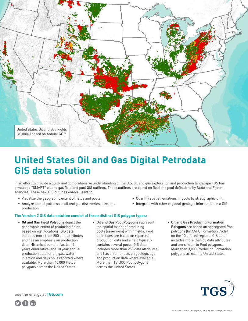
See the energy at TGS.com © 2016 TGS-NOPEC Geophysical Company ASA. All rights reserved. United States Oil and Gas Digital Petrodata GIS data solution In an effort to provide a quick and comprehensive understanding of the U.S. oil and gas exploration and production landscape TGS has developed “SMART” oil and gas field and pool GIS outlines. These outlines are based on field and pool definitions by State and Federal agencies. These new GIS outlines enable users to: Visualize the geographic extent of fields and pools Analyze spatial patterns in oil and gas discoveries, size, and production Quantify spatial variations in pools by stratigraphic unit Integrate with other regional geologic information in a GIS The Version 2 GIS data solution consist of three distinct GIS polygon types: Oil and Gas Field Polygons depict the geographic extent of producing fields, based on well locations. GIS data includes more than 200 data attributes and has an emphasis on production data. Historical cumulative, last 5 years cumulative, and 10 year annual production data for oil, gas, water, injection and days on is reported where available. More than 40,000 Fields polygons across the United States. Oil and Gas Pool Polygons represent the spatial extent of producing pools (reservoirs) within fields. Pool definitions are based on reported production data and a field typically contains several pools. GIS data includes more than 250 data attributes and has an emphasis on geologic age and production data where available. More than 151,000 Pool polygons across the United States. Oil and Gas Producing Formation Polygons are based on aggregated Pool polygons (by AAPG Formation Code) on the 10 offered regions. GIS data includes more than 60 data attributes and are similar to Pool polygons. More than 3,000 Producing Formation polygons across the United States. United States Oil and Gas Fields (40,000+) based on Annual GOR
-
Upload
tgs -
Category
Data & Analytics
-
view
36 -
download
0
Transcript of TGS GPS US Digital Petrodata GIS data solution
See the energy at TGS.com
© 2016 TGS-NOPEC Geophysical Company ASA. All rights reserved.
United States Oil and Gas Digital Petrodata GIS data solutionIn an effort to provide a quick and comprehensive understanding of the U.S. oil and gas exploration and production landscape TGS has developed “SMART” oil and gas field and pool GIS outlines. These outlines are based on field and pool definitions by State and Federal agencies. These new GIS outlines enable users to:
� Visualize the geographic extent of fields and pools � Analyze spatial patterns in oil and gas discoveries, size, and
production
� Quantify spatial variations in pools by stratigraphic unit � Integrate with other regional geologic information in a GIS
The Version 2 GIS data solution consist of three distinct GIS polygon types:
� Oil and Gas Field Polygons depict the geographic extent of producing fields, based on well locations. GIS data includes more than 200 data attributes and has an emphasis on production data. Historical cumulative, last 5 years cumulative, and 10 year annual production data for oil, gas, water, injection and days on is reported where available. More than 40,000 Fields polygons across the United States.
� Oil and Gas Pool Polygons represent the spatial extent of producing pools (reservoirs) within fields. Pool definitions are based on reported production data and a field typically contains several pools. GIS data includes more than 250 data attributes and has an emphasis on geologic age and production data where available. More than 151,000 Pool polygons across the United States.
� Oil and Gas Producing Formation Polygons are based on aggregated Pool polygons (by AAPG Formation Code) on the 10 offered regions. GIS data includes more than 60 data attributes and are similar to Pool polygons. More than 3,000 Producing Formation polygons across the United States.
United States Oil and Gas Fields (40,000+) based on Annual GOR
See the energy at TGS.com
© 2016 TGS-NOPEC Geophysical Company ASA. All rights reserved.
US Tel: +1 713 860 2100Email: [email protected]
For more information, contact TGS at:
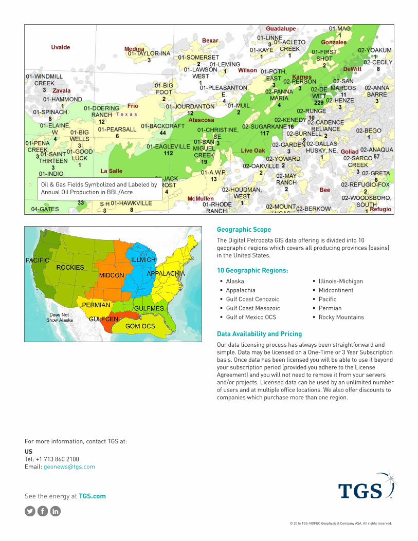
Geographic ScopeThe Digital Petrodata GIS data offering is divided into 10 geographic regions which covers all producing provinces (basins) in the United States.
10 Geographic Regions: � Alaska � Appalachia � Gulf Coast Cenozoic � Gulf Coast Mesozoic � Gulf of Mexico OCS
� Illinois-Michigan � Midcontinent � Pacific � Permian � Rocky Mountains
Data Availability and PricingOur data licensing process has always been straightforward and simple. Data may be licensed on a One-Time or 3 Year Subscription basis. Once data has been licensed you will be able to use it beyond your subscription period (provided you adhere to the License Agreement) and you will not need to remove it from your servers and/or projects. Licensed data can be used by an unlimited number of users and at multiple office locations. We also offer discounts to companies which purchase more than one region.
Oil & Gas Fields Symbolized and Labeled by Annual Oil Production in BBL/Acre