Tectonic and climatic controls on the Chuquibamba...
9
Earth Surf. Dynam., 3, 281–289, 2015 www.earth-surf-dynam.net/3/281/2015/ doi:10.5194/esurf-3-281-2015 © Author(s) 2015. CC Attribution 3.0 License. Tectonic and climatic controls on the Chuquibamba landslide (western Andes, southern Peru) A. Margirier 1 , L. Audin 1,2 , J. Carcaillet 1 , S. Schwartz 1 , and C. Benavente 3 1 Institut des Sciences de la Terre, Université Grenoble I, CNRS, 1381 rue de la Piscine, 38400 Grenoble CEDEX 09, France 2 Institut de recherche pour le développement, Institut des Sciences de la Terre, 1381 rue de la Piscine, 38400 Grenoble CEDEX 09, France 3 Instituto Geológico Minero y Metalúrgico, A. Canadà 1470, San Borja, Lima, Peru Correspondence to: A. Margirier ([email protected]) Received: 23 October 2014 – Published in Earth Surf. Dynam. Discuss.: 15 December 2014 Revised: 11 May 2015 – Accepted: 01 June 2015 – Published: 25 June 2015 Abstract. The contribution of landslides to the Quaternary evolution of relief is poorly documented in arid contexts. In southern Peru and northern Chile, several massive landslides disrupt the arid western Andean front. The Chuquibamba landslide, located in southern Peru, belongs to this set of large landslides. In this area, the Incapuquio fault system captures the intermittent drainage network and localizes rotational landslides. Seismic activity is significant in this region with recurrent M w 9 subduction earthquakes; however, none of the latest seismic events have triggered a major landslide. New terrestrial cosmogenic dating of the Chuquibamba landslide provides evidence that the last major gravitational mobilization of these rotational landslide deposits occurred at ∼ 102 ka, during the Ouki wet climatic event identified on the Altiplano between 120 and 98 ka. Our results suggest that wet events in the arid and fractured context of the Andean forearc induced these giant debris flows. Finally, our study highlights the role of tectonics and climate on (i) the localization of large Andean landslides in the Western Cordillera and on (ii) the long-term mass transfer to the trench along the arid Andean front. 1 Introduction In active mountain ranges, landslides are an important pro- cess in long-term erosion and thus contribute to the geo- morphologic evolution of relief (Korup et al., 2007). De- spite their importance in terms of hazards, landslide maps remain rare (Guzzetti et al., 2012) and information on the type, age or distribution of individual landslides is often lack- ing. Only a few publications deal with landslide triggering and/or evolution in arid contexts such as the western Andean flank, where several gigantic scarps disrupt the forearc pied- mont (Audin and Bechir, 2006; Pinto et al., 2008; Strasser and Schlunegger, 2005; Wörner et al., 2002; Mather et al., 2014; Crosta et al., 2015). In contrast, because of the poten- tial seismotectonic trigger (Keefer, 1984, 2002; McPhillips et al., 2014), landslide triggering along subduction active mar- gins has been studied for a number of years, but most previ- ous studies focused on humid climatic settings (Taiwan, New Zealand, Papua New Guinea, Japan; Meunier et al., 2008; Hovius et al., 2011). In southern Peru, the topographic gradi- ent (average slope of 4% between the coast and the Western Cordillera), the crustal seismotectonic activity and the aridity of the forearc region has been directly linked to Andean up- lift and subduction of the Nazca Plate for the last 25 Myr at least (Devlin et al., 2012; Alpers and Brimhall, 1988; Dunai et al., 2005). However, Quaternary tectonic crustal activity and its role in the localization of landslides along the West- ern Andean Escarpment has never been explored in southern Peru and northern Chile. As a consequence, numerous ques- tions remain concerning the importance of giant landslides in slope erosion relative to other nonseismic agents of erosion such as climatic forcing. The “Chuquibamba landslide” is a large complex zone of imbricated landslides (about 80 km 2 ) affecting the western Andean Cordillera in southern Peru. It belongs to the Andean Published by Copernicus Publications on behalf of the European Geosciences Union.
Transcript of Tectonic and climatic controls on the Chuquibamba...

Earth Surf. Dynam., 3, 281–289, 2015
www.earth-surf-dynam.net/3/281/2015/
doi:10.5194/esurf-3-281-2015
© Author(s) 2015. CC Attribution 3.0 License.
Tectonic and climatic controls on the Chuquibamba
landslide (western Andes, southern Peru)
A. Margirier1, L. Audin1,2, J. Carcaillet1, S. Schwartz1, and C. Benavente3
1Institut des Sciences de la Terre, Université Grenoble I, CNRS, 1381 rue de la Piscine,
38400 Grenoble CEDEX 09, France2Institut de recherche pour le développement, Institut des Sciences de la Terre, 1381 rue de la Piscine,
38400 Grenoble CEDEX 09, France3Instituto Geológico Minero y Metalúrgico, A. Canadà 1470, San Borja, Lima, Peru
Correspondence to: A. Margirier ([email protected])
Received: 23 October 2014 – Published in Earth Surf. Dynam. Discuss.: 15 December 2014
Revised: 11 May 2015 – Accepted: 01 June 2015 – Published: 25 June 2015
Abstract. The contribution of landslides to the Quaternary evolution of relief is poorly documented in arid
contexts. In southern Peru and northern Chile, several massive landslides disrupt the arid western Andean front.
The Chuquibamba landslide, located in southern Peru, belongs to this set of large landslides. In this area, the
Incapuquio fault system captures the intermittent drainage network and localizes rotational landslides. Seismic
activity is significant in this region with recurrent Mw 9 subduction earthquakes; however, none of the latest
seismic events have triggered a major landslide. New terrestrial cosmogenic dating of the Chuquibamba landslide
provides evidence that the last major gravitational mobilization of these rotational landslide deposits occurred
at ∼ 102 ka, during the Ouki wet climatic event identified on the Altiplano between 120 and 98 ka. Our results
suggest that wet events in the arid and fractured context of the Andean forearc induced these giant debris flows.
Finally, our study highlights the role of tectonics and climate on (i) the localization of large Andean landslides
in the Western Cordillera and on (ii) the long-term mass transfer to the trench along the arid Andean front.
1 Introduction
In active mountain ranges, landslides are an important pro-
cess in long-term erosion and thus contribute to the geo-
morphologic evolution of relief (Korup et al., 2007). De-
spite their importance in terms of hazards, landslide maps
remain rare (Guzzetti et al., 2012) and information on the
type, age or distribution of individual landslides is often lack-
ing. Only a few publications deal with landslide triggering
and/or evolution in arid contexts such as the western Andean
flank, where several gigantic scarps disrupt the forearc pied-
mont (Audin and Bechir, 2006; Pinto et al., 2008; Strasser
and Schlunegger, 2005; Wörner et al., 2002; Mather et al.,
2014; Crosta et al., 2015). In contrast, because of the poten-
tial seismotectonic trigger (Keefer, 1984, 2002; McPhillips et
al., 2014), landslide triggering along subduction active mar-
gins has been studied for a number of years, but most previ-
ous studies focused on humid climatic settings (Taiwan, New
Zealand, Papua New Guinea, Japan; Meunier et al., 2008;
Hovius et al., 2011). In southern Peru, the topographic gradi-
ent (average slope of 4 % between the coast and the Western
Cordillera), the crustal seismotectonic activity and the aridity
of the forearc region has been directly linked to Andean up-
lift and subduction of the Nazca Plate for the last 25 Myr at
least (Devlin et al., 2012; Alpers and Brimhall, 1988; Dunai
et al., 2005). However, Quaternary tectonic crustal activity
and its role in the localization of landslides along the West-
ern Andean Escarpment has never been explored in southern
Peru and northern Chile. As a consequence, numerous ques-
tions remain concerning the importance of giant landslides in
slope erosion relative to other nonseismic agents of erosion
such as climatic forcing.
The “Chuquibamba landslide” is a large complex zone of
imbricated landslides (about 80 km2) affecting the western
Andean Cordillera in southern Peru. It belongs to the Andean
Published by Copernicus Publications on behalf of the European Geosciences Union.
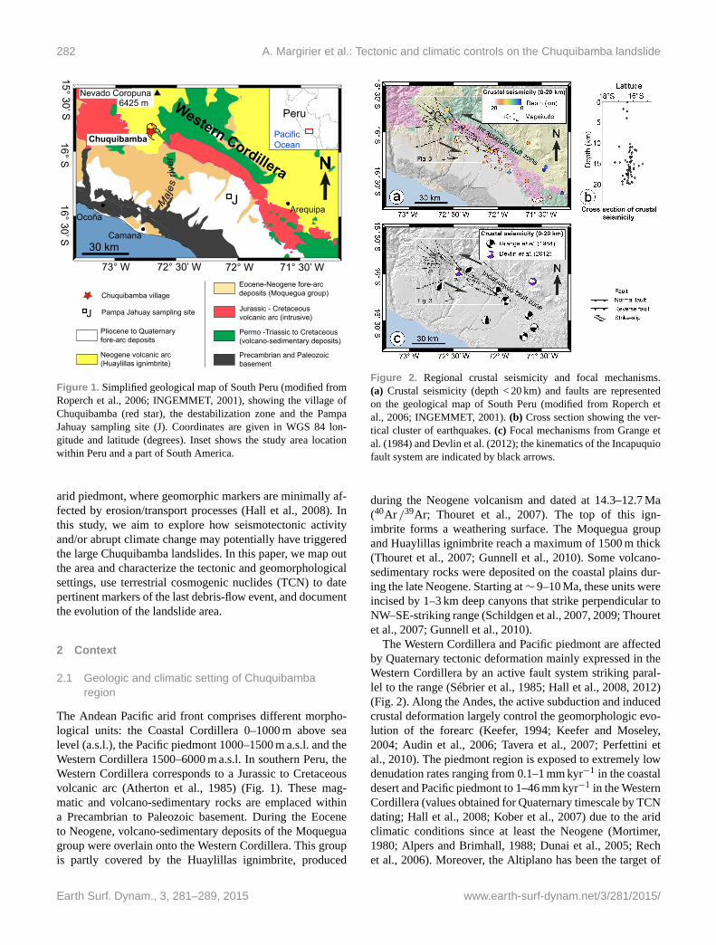
282 A. Margirier et al.: Tectonic and climatic controls on the Chuquibamba landslide
Western Cordillera
Chuquibamba
JArequipa
Camana
Ocoña
6425 mNevado Coropuna
Maj
es r
iver
Peru
PacificOcean
73° W 72° 30’ W 72° W 71° 30’ W
16° S16° 30’ S
N
30 km
15° 30’ S
J
Chuquibamba village
Pampa Jahuay sampling site
Pliocene to Quaternary fore-arc deposits
Neogene volcanic arc(Huaylillas ignimbrite)
Permo -Triassic to Cretaceous (volcano-sedimentary deposits)
Eocene-Neogene fore-arc deposits (Moquegua group)
Precambrian and Paleozoic basement
Jurassic - Cretaceous volcanic arc (intrusive)
Figure 1. Simplified geological map of South Peru (modified from
Roperch et al., 2006; INGEMMET, 2001), showing the village of
Chuquibamba (red star), the destabilization zone and the Pampa
Jahuay sampling site (J). Coordinates are given in WGS 84 lon-
gitude and latitude (degrees). Inset shows the study area location
within Peru and a part of South America.
arid piedmont, where geomorphic markers are minimally af-
fected by erosion/transport processes (Hall et al., 2008). In
this study, we aim to explore how seismotectonic activity
and/or abrupt climate change may potentially have triggered
the large Chuquibamba landslides. In this paper, we map out
the area and characterize the tectonic and geomorphological
settings, use terrestrial cosmogenic nuclides (TCN) to date
pertinent markers of the last debris-flow event, and document
the evolution of the landslide area.
2 Context
2.1 Geologic and climatic setting of Chuquibamba
region
The Andean Pacific arid front comprises different morpho-
logical units: the Coastal Cordillera 0–1000 m above sea
level (a.s.l.), the Pacific piedmont 1000–1500 m a.s.l. and the
Western Cordillera 1500–6000 m a.s.l. In southern Peru, the
Western Cordillera corresponds to a Jurassic to Cretaceous
volcanic arc (Atherton et al., 1985) (Fig. 1). These mag-
matic and volcano-sedimentary rocks are emplaced within
a Precambrian to Paleozoic basement. During the Eocene
to Neogene, volcano-sedimentary deposits of the Moquegua
group were overlain onto the Western Cordillera. This group
is partly covered by the Huaylillas ignimbrite, produced
Figure 2. Regional crustal seismicity and focal mechanisms.
(a) Crustal seismicity (depth < 20 km) and faults are represented
on the geological map of South Peru (modified from Roperch et
al., 2006; INGEMMET, 2001). (b) Cross section showing the ver-
tical cluster of earthquakes. (c) Focal mechanisms from Grange et
al. (1984) and Devlin et al. (2012); the kinematics of the Incapuquio
fault system are indicated by black arrows.
during the Neogene volcanism and dated at 14.3–12.7 Ma
(40Ar /39Ar; Thouret et al., 2007). The top of this ign-
imbrite forms a weathering surface. The Moquegua group
and Huaylillas ignimbrite reach a maximum of 1500 m thick
(Thouret et al., 2007; Gunnell et al., 2010). Some volcano-
sedimentary rocks were deposited on the coastal plains dur-
ing the late Neogene. Starting at∼ 9–10 Ma, these units were
incised by 1–3 km deep canyons that strike perpendicular to
NW–SE-striking range (Schildgen et al., 2007, 2009; Thouret
et al., 2007; Gunnell et al., 2010).
The Western Cordillera and Pacific piedmont are affected
by Quaternary tectonic deformation mainly expressed in the
Western Cordillera by an active fault system striking paral-
lel to the range (Sébrier et al., 1985; Hall et al., 2008, 2012)
(Fig. 2). Along the Andes, the active subduction and induced
crustal deformation largely control the geomorphologic evo-
lution of the forearc (Keefer, 1994; Keefer and Moseley,
2004; Audin et al., 2006; Tavera et al., 2007; Perfettini et
al., 2010). The piedmont region is exposed to extremely low
denudation rates ranging from 0.1–1 mm kyr−1 in the coastal
desert and Pacific piedmont to 1–46 mm kyr−1 in the Western
Cordillera (values obtained for Quaternary timescale by TCN
dating; Hall et al., 2008; Kober et al., 2007) due to the arid
climatic conditions since at least the Neogene (Mortimer,
1980; Alpers and Brimhall, 1988; Dunai et al., 2005; Rech
et al., 2006). Moreover, the Altiplano has been the target of
Earth Surf. Dynam., 3, 281–289, 2015 www.earth-surf-dynam.net/3/281/2015/

A. Margirier et al.: Tectonic and climatic controls on the Chuquibamba landslide 283
many paleoclimatic investigations (Thompson et al., 1998,
2000; Cross et al., 2001; Baker et al., 2001; Placzek et al.,
2006, 2013) that highlighted climate fluctuations for the last
130 kyr. Steffen et al. (2009, 2010), Carretier et al. (2013) and
Bekaddour et al. (2014) highlighted the contribution of these
wet climatic events to mass transport in major canyons from
the Altiplano to the Pacific coast. In contrast, McPhillips et
al. (2014) observed that the landslide frequency appears to
have not changed during the Quaternary and thus questioned
the impact of the climatic fluctuations on landsliding and ero-
sion rate.
2.2 Fault geometry and kinematics
In southern Peru, the Incapuquio fault zone has a strong
geomorphic imprint on the Andean range (Huaman, 1985;
Sébrier et al., 1985). Based on microtectonic studies, Sébrier
et al. (1985, 1988) and Schildgen et al. (2009) identified dif-
ferent kinematic episodes. Sébrier et al. (1985, 1988) de-
fined major Tertiary and early Quaternary compressional
phases and a minor late Quaternary episode of normal fault-
ing. Schildgen et al. (2009) proposed that a Tertiary episode
of strike-slip and normal faulting occurred between 14 and
2.2 Ma. However, relocated microseismicity (Grange et al.,
1984) and teleseismic data (Devlin et al., 2012) demonstrate
present-day reverse and strike-slip components on the Lluta
fault segment and more regionally for the Incapuquio fault
system in the Arequipa region (Fig. 2). The Neogene sur-
face and Quaternary drainage network are also affected by
these fault segments (Fig. 3). Channel orientations and cap-
tures evidence a sinistral strike-slip component along an ex-
trado graben (Fig. 3c). These Quaternary offsets and inferred
kinematics are consistent with the vertical geometry of the
fault plane imaged at depth (20 km) by the distribution of
crustal earthquakes (Fig. 2b) and focal mechanisms (Fig. 2c)
(Mw < 5; < 20 km, Grange et al., 1984; Devlin et al., 2012).
Local reverse and normal apparent surface movements are
known to occur along major strike-slip faults in the fore-
arcs of northern Chile (Victor et al., 2004) and southern Peru
(Hall et al., 2012). The present-day main sinistral strike-slip
kinematics of the Incapuquio fault system demonstrated by
the seismicity is compatible with normal apparent displace-
ments as observed by Schildgen et al. (2009) and Sébrier et
al. (1985, 1988).
2.3 Geomorphological setting
The Chuquibamba landslide is located in the Majes River
catchment, along the western flank of the Central Andes,
between 1000 and 4000 m a.s.l. (Fig. 1). The Chuquibamba
landslide comprises an imbricated set of rotational land-
slides, a debris-flow deposit and, in the lower area, a megafan
and alluvial terraces (Fig. 3a). Upstream, the rotational land-
slides remobilize the thick Huaylillas ignimbrite formation
fractured by the activity along the Incapuquio fault system.
Chuquibamba
b c
N
Incapuquio fault zone
Maj
es Riv er
Rio Grande
AcoyMF
T2
T1b
a
cChuquibamba
Rotational landslides
Debris-flow deposit
Debris-flowdeposit
Rotational landslides
15° 40' S15° 50' S
16° S
72° 40' W72° 50' W 72° 20' W72° 30' W
10 km
Alluvial deposits:
Faults:
Acoy megafan
Debris-flow deposit
Normal faultReverse faultStrike-slip fault
Major rotational landslides scarps
Elevation (m)
1400 3900
Fault
T1, T2
Figure 3. SRTM numerical elevation model overlay by Landsat im-
age of the Chuquibamba destabilization zone. Coordinates are given
in WGS 84 longitude and latitude (degrees). (a) Global view of the
Chuquibamba area pointing major detachment scarps, debris-flow
deposits, Acoy megafan, alluvial terraces and faults. (b) Close-up
of the amphitheater-shaped scar of the rotational landslides show-
ing the different head scarps. (c) Drainage network and faults.
We estimate the total volume mobilized for Chuquibamba
landslide reaches ∼ 40 km3. These imbricated rotational
landslides correspond to a succession of three head scarps
(Fig. 3b). The scar of the rotational landslides, cutting the
Huaylillas weathering surface, delimits the landslide area
(Fig. 3b) and forms an elongated amphitheater trending in the
NW–SE direction. This direction does not fit with the overall
southwest-dipping topographic slope but rather corresponds
to the structural trend of active faults (Fig. 3a). Moreover,
several fault planes appear to control the shape of the poly-
lobed rotational landslides (Fig. 3b).
The base of the cirque (2900 m a.s.l.) is formed by smooth,
sub-horizontal surfaces (Fig. 3b). These surfaces likely cor-
respond to former lateral landslide deposits re-incised by the
river after the initiation of the Chuquibamba landslide.
The debris flow remobilizes the rotational landslide de-
posits. It consists of mixed angular clasts, breccias and nu-
merous meter-size boulders embedded in a thin volcanic ma-
trix (Fig. 4a), reworked from the Huaylillas ignimbrite. The
debris-flow deposit displays a smooth and 100 m scale un-
dulated surface (Fig. 4a). In its upper part, the debris flow
www.earth-surf-dynam.net/3/281/2015/ Earth Surf. Dynam., 3, 281–289, 2015
284 A. Margirier et al.: Tectonic and climatic controls on the Chuquibamba landslide
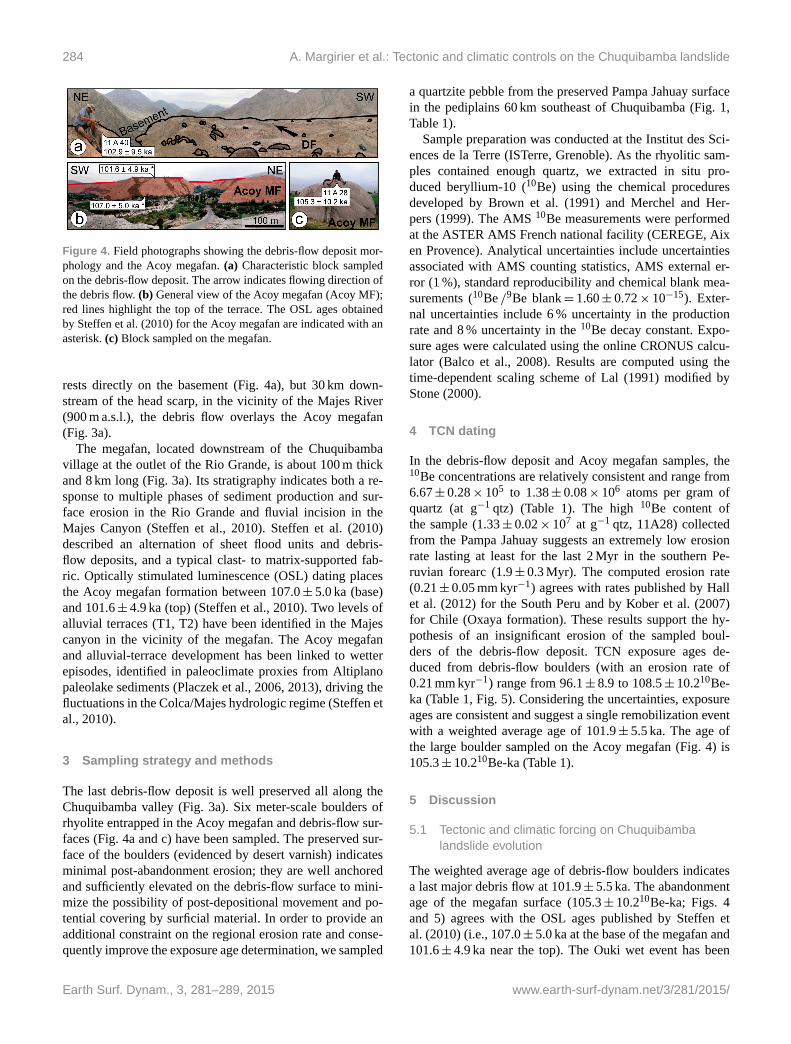
Figure 4. Field photographs showing the debris-flow deposit mor-
phology and the Acoy megafan. (a) Characteristic block sampled
on the debris-flow deposit. The arrow indicates flowing direction of
the debris flow. (b) General view of the Acoy megafan (Acoy MF);
red lines highlight the top of the terrace. The OSL ages obtained
by Steffen et al. (2010) for the Acoy megafan are indicated with an
asterisk. (c) Block sampled on the megafan.
rests directly on the basement (Fig. 4a), but 30 km down-
stream of the head scarp, in the vicinity of the Majes River
(900 m a.s.l.), the debris flow overlays the Acoy megafan
(Fig. 3a).
The megafan, located downstream of the Chuquibamba
village at the outlet of the Rio Grande, is about 100 m thick
and 8 km long (Fig. 3a). Its stratigraphy indicates both a re-
sponse to multiple phases of sediment production and sur-
face erosion in the Rio Grande and fluvial incision in the
Majes Canyon (Steffen et al., 2010). Steffen et al. (2010)
described an alternation of sheet flood units and debris-
flow deposits, and a typical clast- to matrix-supported fab-
ric. Optically stimulated luminescence (OSL) dating places
the Acoy megafan formation between 107.0± 5.0 ka (base)
and 101.6± 4.9 ka (top) (Steffen et al., 2010). Two levels of
alluvial terraces (T1, T2) have been identified in the Majes
canyon in the vicinity of the megafan. The Acoy megafan
and alluvial-terrace development has been linked to wetter
episodes, identified in paleoclimate proxies from Altiplano
paleolake sediments (Placzek et al., 2006, 2013), driving the
fluctuations in the Colca/Majes hydrologic regime (Steffen et
al., 2010).
3 Sampling strategy and methods
The last debris-flow deposit is well preserved all along the
Chuquibamba valley (Fig. 3a). Six meter-scale boulders of
rhyolite entrapped in the Acoy megafan and debris-flow sur-
faces (Fig. 4a and c) have been sampled. The preserved sur-
face of the boulders (evidenced by desert varnish) indicates
minimal post-abandonment erosion; they are well anchored
and sufficiently elevated on the debris-flow surface to mini-
mize the possibility of post-depositional movement and po-
tential covering by surficial material. In order to provide an
additional constraint on the regional erosion rate and conse-
quently improve the exposure age determination, we sampled
a quartzite pebble from the preserved Pampa Jahuay surface
in the pediplains 60 km southeast of Chuquibamba (Fig. 1,
Table 1).
Sample preparation was conducted at the Institut des Sci-
ences de la Terre (ISTerre, Grenoble). As the rhyolitic sam-
ples contained enough quartz, we extracted in situ pro-
duced beryllium-10 (10Be) using the chemical procedures
developed by Brown et al. (1991) and Merchel and Her-
pers (1999). The AMS 10Be measurements were performed
at the ASTER AMS French national facility (CEREGE, Aix
en Provence). Analytical uncertainties include uncertainties
associated with AMS counting statistics, AMS external er-
ror (1 %), standard reproducibility and chemical blank mea-
surements (10Be /9Be blank= 1.60± 0.72× 10⁻¹⁵). Exter-
nal uncertainties include 6 % uncertainty in the production
rate and 8 % uncertainty in the 10Be decay constant. Expo-
sure ages were calculated using the online CRONUS calcu-
lator (Balco et al., 2008). Results are computed using the
time-dependent scaling scheme of Lal (1991) modified by
Stone (2000).
4 TCN dating
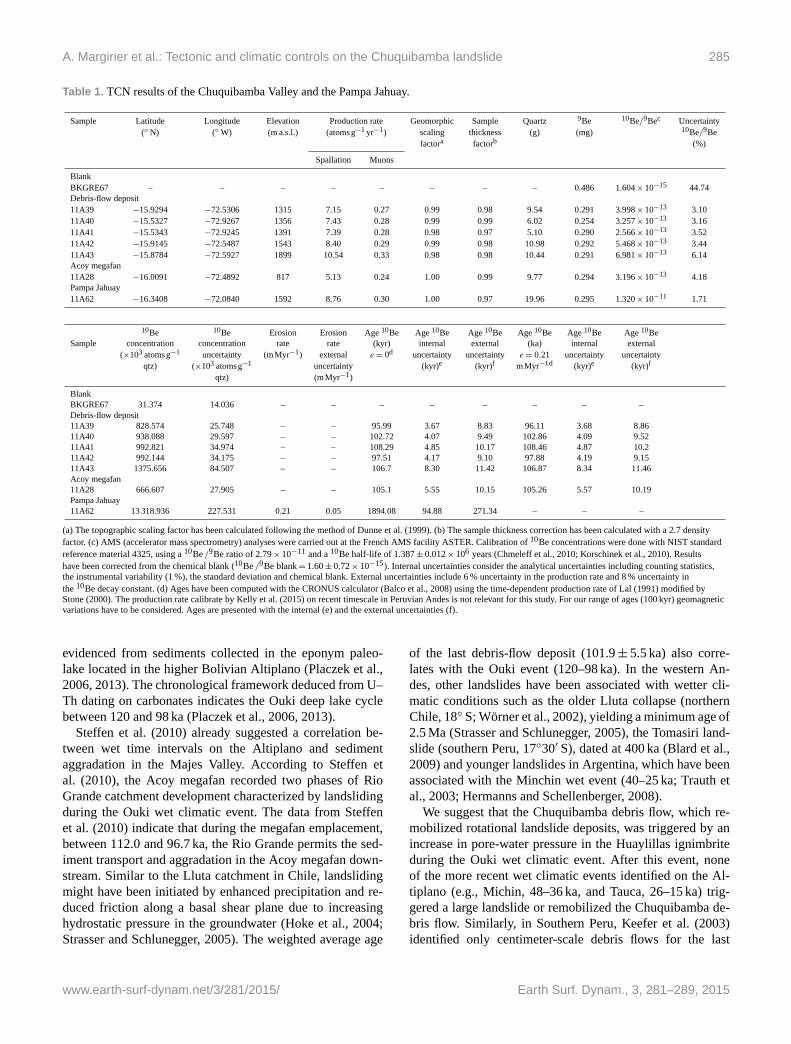
In the debris-flow deposit and Acoy megafan samples, the10Be concentrations are relatively consistent and range from
6.67± 0.28× 10⁵ to 1.38± 0.08× 10⁶ atoms per gram of
quartz (at g−1 qtz) (Table 1). The high 10Be content of
the sample (1.33± 0.02× 10⁷ at g−1 qtz, 11A28) collected
from the Pampa Jahuay suggests an extremely low erosion
rate lasting at least for the last 2 Myr in the southern Pe-
ruvian forearc (1.9± 0.3 Myr). The computed erosion rate
(0.21± 0.05 mm kyr−1) agrees with rates published by Hall
et al. (2012) for the South Peru and by Kober et al. (2007)
for Chile (Oxaya formation). These results support the hy-
pothesis of an insignificant erosion of the sampled boul-
ders of the debris-flow deposit. TCN exposure ages de-
duced from debris-flow boulders (with an erosion rate of
0.21 mm kyr−1) range from 96.1± 8.9 to 108.5± 10.210Be-
ka (Table 1, Fig. 5). Considering the uncertainties, exposure
ages are consistent and suggest a single remobilization event
with a weighted average age of 101.9± 5.5 ka. The age of
the large boulder sampled on the Acoy megafan (Fig. 4) is
105.3± 10.210Be-ka (Table 1).
5 Discussion
5.1 Tectonic and climatic forcing on Chuquibamba
landslide evolution
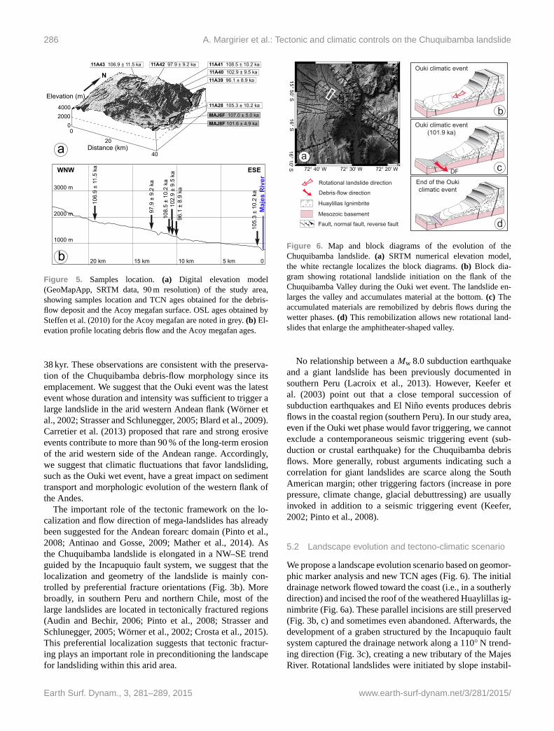
The weighted average age of debris-flow boulders indicates
a last major debris flow at 101.9± 5.5 ka. The abandonment
age of the megafan surface (105.3± 10.210Be-ka; Figs. 4
and 5) agrees with the OSL ages published by Steffen et
al. (2010) (i.e., 107.0± 5.0 ka at the base of the megafan and
101.6± 4.9 ka near the top). The Ouki wet event has been
Earth Surf. Dynam., 3, 281–289, 2015 www.earth-surf-dynam.net/3/281/2015/
A. Margirier et al.: Tectonic and climatic controls on the Chuquibamba landslide 285
Table 1. TCN results of the Chuquibamba Valley and the Pampa Jahuay.
Sample Latitude Longitude Elevation Production rate Geomorphic Sample Quartz 9Be 10Be/9Bec Uncertainty
(◦ N) (◦W) (m a.s.l.) (atomsg−1 yr−1) scaling thickness (g) (mg) 10Be/9Be
factora factorb (%)
Spallation Muons
Blank
BKGRE67 – – – – – – – – 0.486 1.604× 10⁻¹⁵ 44.74
Debris-flow deposit
11A39 −15.9294 −72.5306 1315 7.15 0.27 0.99 0.98 9.54 0.291 3.998× 10⁻¹³ 3.10
11A40 −15.5327 −72.9267 1356 7.43 0.28 0.99 0.99 6.02 0.254 3.257× 10⁻¹³ 3.16
11A41 −15.5343 −72.9245 1391 7.39 0.28 0.98 0.97 5.10 0.290 2.566× 10⁻¹³ 3.52
11A42 −15.9145 −72.5487 1543 8.40 0.29 0.99 0.98 10.98 0.292 5.468× 10⁻¹³ 3.44
11A43 −15.8784 −72.5927 1899 10.54 0.33 0.98 0.98 10.44 0.291 6.981× 10⁻¹³ 6.14
Acoy megafan
11A28 −16.0091 −72.4892 817 5.13 0.24 1.00 0.99 9.77 0.294 3.196× 10⁻¹³ 4.18
Pampa Jahuay
11A62 −16.3408 −72.0840 1592 8.76 0.30 1.00 0.97 19.96 0.295 1.320× 10⁻¹¹ 1.71
10Be 10Be Erosion Erosion Age 10Be Age 10Be Age 10Be Age 10Be Age 10Be Age 10Be
Sample concentration concentration rate rate (kyr) internal external (ka) internal external
(×103 atoms g−1 uncertainty (mMyr−1) external e = 0d uncertainty uncertainty e = 0.21 uncertainty uncertainty
qtz) (×103 atoms g−1 uncertainty (kyr)e (kyr)f mMyr−1d (kyr)e (kyr)f
qtz) (mMyr−1)
Blank
BKGRE67 31.374 14.036 – – – – – – – –
Debris-flow deposit
11A39 828.574 25.748 – – 95.99 3.67 8.83 96.11 3.68 8.86
11A40 938.088 29.597 – – 102.72 4.07 9.49 102.86 4.09 9.52
11A41 992.821 34.974 – – 108.29 4.85 10.17 108.46 4.87 10.2
11A42 992.144 34.175 – – 97.51 4.17 9.10 97.88 4.19 9.15
11A43 1375.656 84.507 – – 106.7 8.30 11.42 106.87 8.34 11.46
Acoy megafan
11A28 666.607 27.905 – – 105.1 5.55 10.15 105.26 5.57 10.19
Pampa Jahuay
11A62 13 318.936 227.531 0.21 0.05 1894.08 94.88 271.34 – – –
(a) The topographic scaling factor has been calculated following the method of Dunne et al. (1999). (b) The sample thickness correction has been calculated with a 2.7 density
factor. (c) AMS (accelerator mass spectrometry) analyses were carried out at the French AMS facility ASTER. Calibration of 10Be concentrations were done with NIST standard
reference material 4325, using a 10Be /9Be ratio of 2.79× 10⁻¹¹ and a 10Be half-life of 1.387± 0.012× 10⁶ years (Chmeleff et al., 2010; Korschinek et al., 2010). Results
have been corrected from the chemical blank (10Be /9Be blank= 1.60± 0.72× 10⁻¹⁵). Internal uncertainties consider the analytical uncertainties including counting statistics,
the instrumental variability (1 %), the standard deviation and chemical blank. External uncertainties include 6 % uncertainty in the production rate and 8 % uncertainty in
the 10Be decay constant. (d) Ages have been computed with the CRONUS calculator (Balco et al., 2008) using the time-dependent production rate of Lal (1991) modified by
Stone (2000). The production rate calibrate by Kelly et al. (2015) on recent timescale in Peruvian Andes is not relevant for this study. For our range of ages (100 kyr) geomagnetic
variations have to be considered. Ages are presented with the internal (e) and the external uncertainties (f).
evidenced from sediments collected in the eponym paleo-
lake located in the higher Bolivian Altiplano (Placzek et al.,
2006, 2013). The chronological framework deduced from U–
Th dating on carbonates indicates the Ouki deep lake cycle
between 120 and 98 ka (Placzek et al., 2006, 2013).
Steffen et al. (2010) already suggested a correlation be-
tween wet time intervals on the Altiplano and sediment
aggradation in the Majes Valley. According to Steffen et
al. (2010), the Acoy megafan recorded two phases of Rio
Grande catchment development characterized by landsliding
during the Ouki wet climatic event. The data from Steffen
et al. (2010) indicate that during the megafan emplacement,
between 112.0 and 96.7 ka, the Rio Grande permits the sed-
iment transport and aggradation in the Acoy megafan down-
stream. Similar to the Lluta catchment in Chile, landsliding
might have been initiated by enhanced precipitation and re-
duced friction along a basal shear plane due to increasing
hydrostatic pressure in the groundwater (Hoke et al., 2004;
Strasser and Schlunegger, 2005). The weighted average age
of the last debris-flow deposit (101.9± 5.5 ka) also corre-
lates with the Ouki event (120–98 ka). In the western An-
des, other landslides have been associated with wetter cli-
matic conditions such as the older Lluta collapse (northern
Chile, 18◦ S; Wörner et al., 2002), yielding a minimum age of
2.5 Ma (Strasser and Schlunegger, 2005), the Tomasiri land-
slide (southern Peru, 17◦30′ S), dated at 400 ka (Blard et al.,
2009) and younger landslides in Argentina, which have been
associated with the Minchin wet event (40–25 ka; Trauth et
al., 2003; Hermanns and Schellenberger, 2008).
We suggest that the Chuquibamba debris flow, which re-
mobilized rotational landslide deposits, was triggered by an
increase in pore-water pressure in the Huaylillas ignimbrite
during the Ouki wet climatic event. After this event, none
of the more recent wet climatic events identified on the Al-
tiplano (e.g., Michin, 48–36 ka, and Tauca, 26–15 ka) trig-
gered a large landslide or remobilized the Chuquibamba de-
bris flow. Similarly, in Southern Peru, Keefer et al. (2003)
identified only centimeter-scale debris flows for the last
www.earth-surf-dynam.net/3/281/2015/ Earth Surf. Dynam., 3, 281–289, 2015
286 A. Margirier et al.: Tectonic and climatic controls on the Chuquibamba landslide
020004000
0
20
40Distance (km)
Elevation (m)
a
11A43 106.9 ± 11.5 ka 11A42 97.9 ± 9.2 ka 11A41 108.5 ± 10.2 ka11A40 102.9 ± 9.5 ka11A39 96.1 ± 8.9 ka
11A28 105.3 ± 10.2 ka
MAJ6F 107.0 ± 5.0 ka
MAJ8F 101.6 ± 4.9 ka
N
1000 m
2000 m
3000 m
Maj
es R
iver
5 km10 km15 km20 km 0
106.
9 ±
11.5
ka
97.9
± 9
.2 k
a
108.
5 ±
10.2
ka
105.
3 ±
10.2
ka
96.1
± 8
.9 k
a10
2.9
± 9.
5 ka
ESEWNW
bFigure 5. Samples location. (a) Digital elevation model
(GeoMapApp, SRTM data, 90 m resolution) of the study area,
showing samples location and TCN ages obtained for the debris-
flow deposit and the Acoy megafan surface. OSL ages obtained by
Steffen et al. (2010) for the Acoy megafan are noted in grey. (b) El-
evation profile locating debris flow and the Acoy megafan ages.
38 kyr. These observations are consistent with the preserva-
tion of the Chuquibamba debris-flow morphology since its
emplacement. We suggest that the Ouki event was the latest
event whose duration and intensity was sufficient to trigger a
large landslide in the arid western Andean flank (Wörner et
al., 2002; Strasser and Schlunegger, 2005; Blard et al., 2009).
Carretier et al. (2013) proposed that rare and strong erosive
events contribute to more than 90 % of the long-term erosion
of the arid western side of the Andean range. Accordingly,
we suggest that climatic fluctuations that favor landsliding,
such as the Ouki wet event, have a great impact on sediment
transport and morphologic evolution of the western flank of
the Andes.
The important role of the tectonic framework on the lo-
calization and flow direction of mega-landslides has already
been suggested for the Andean forearc domain (Pinto et al.,
2008; Antinao and Gosse, 2009; Mather et al., 2014). As
the Chuquibamba landslide is elongated in a NW–SE trend
guided by the Incapuquio fault system, we suggest that the
localization and geometry of the landslide is mainly con-
trolled by preferential fracture orientations (Fig. 3b). More
broadly, in southern Peru and northern Chile, most of the
large landslides are located in tectonically fractured regions
(Audin and Bechir, 2006; Pinto et al., 2008; Strasser and
Schlunegger, 2005; Wörner et al., 2002; Crosta et al., 2015).
This preferential localization suggests that tectonic fractur-
ing plays an important role in preconditioning the landscape
for landsliding within this arid area.
a
15° 50' S16° S
72° 40' W 72° 20' W72° 30' W
16° 10' S
Ouki climatic event
bOuki climatic event
(101.9 ka)
DF cEnd of the Oukiclimatic event
dMesozoic basement
Huaylillas Ignimbrite
Rotational landslide direction
Debris-flow direction
Fault, normal fault, reverse fault
Figure 6. Map and block diagrams of the evolution of the
Chuquibamba landslide. (a) SRTM numerical elevation model,
the white rectangle localizes the block diagrams. (b) Block dia-
gram showing rotational landslide initiation on the flank of the
Chuquibamba Valley during the Ouki wet event. The landslide en-
larges the valley and accumulates material at the bottom. (c) The
accumulated materials are remobilized by debris flows during the
wetter phases. (d) This remobilization allows new rotational land-
slides that enlarge the amphitheater-shaped valley.
No relationship between a Mw 8.0 subduction earthquake
and a giant landslide has been previously documented in
southern Peru (Lacroix et al., 2013). However, Keefer et
al. (2003) point out that a close temporal succession of
subduction earthquakes and El Niño events produces debris
flows in the coastal region (southern Peru). In our study area,
even if the Ouki wet phase would favor triggering, we cannot
exclude a contemporaneous seismic triggering event (sub-
duction or crustal earthquake) for the Chuquibamba debris
flows. More generally, robust arguments indicating such a
correlation for giant landslides are scarce along the South
American margin; other triggering factors (increase in pore
pressure, climate change, glacial debuttressing) are usually
invoked in addition to a seismic triggering event (Keefer,
2002; Pinto et al., 2008).
5.2 Landscape evolution and tectono-climatic scenario
We propose a landscape evolution scenario based on geomor-
phic marker analysis and new TCN ages (Fig. 6). The initial
drainage network flowed toward the coast (i.e., in a southerly
direction) and incised the roof of the weathered Huaylillas ig-
nimbrite (Fig. 6a). These parallel incisions are still preserved
(Fig. 3b, c) and sometimes even abandoned. Afterwards, the
development of a graben structured by the Incapuquio fault
system captured the drainage network along a 110◦ N trend-
ing direction (Fig. 3c), creating a new tributary of the Majes
River. Rotational landslides were initiated by slope instabil-
Earth Surf. Dynam., 3, 281–289, 2015 www.earth-surf-dynam.net/3/281/2015/
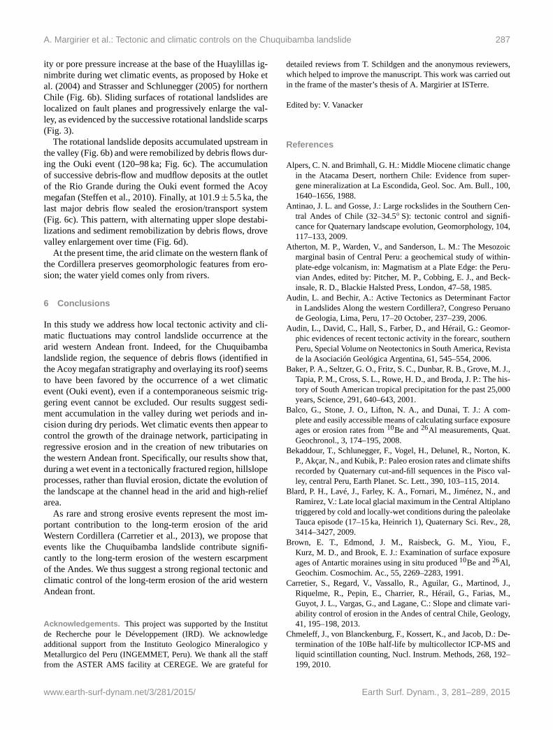
A. Margirier et al.: Tectonic and climatic controls on the Chuquibamba landslide 287
ity or pore pressure increase at the base of the Huaylillas ig-
nimbrite during wet climatic events, as proposed by Hoke et
al. (2004) and Strasser and Schlunegger (2005) for northern
Chile (Fig. 6b). Sliding surfaces of rotational landslides are
localized on fault planes and progressively enlarge the val-
ley, as evidenced by the successive rotational landslide scarps
(Fig. 3).
The rotational landslide deposits accumulated upstream in
the valley (Fig. 6b) and were remobilized by debris flows dur-
ing the Ouki event (120–98 ka; Fig. 6c). The accumulation
of successive debris-flow and mudflow deposits at the outlet
of the Rio Grande during the Ouki event formed the Acoy
megafan (Steffen et al., 2010). Finally, at 101.9± 5.5 ka, the
last major debris flow sealed the erosion/transport system
(Fig. 6c). This pattern, with alternating upper slope destabi-
lizations and sediment remobilization by debris flows, drove
valley enlargement over time (Fig. 6d).
At the present time, the arid climate on the western flank of
the Cordillera preserves geomorphologic features from ero-
sion; the water yield comes only from rivers.
6 Conclusions
In this study we address how local tectonic activity and cli-
matic fluctuations may control landslide occurrence at the
arid western Andean front. Indeed, for the Chuquibamba
landslide region, the sequence of debris flows (identified in
the Acoy megafan stratigraphy and overlaying its roof) seems
to have been favored by the occurrence of a wet climatic
event (Ouki event), even if a contemporaneous seismic trig-
gering event cannot be excluded. Our results suggest sedi-
ment accumulation in the valley during wet periods and in-
cision during dry periods. Wet climatic events then appear to
control the growth of the drainage network, participating in
regressive erosion and in the creation of new tributaries on
the western Andean front. Specifically, our results show that,
during a wet event in a tectonically fractured region, hillslope
processes, rather than fluvial erosion, dictate the evolution of
the landscape at the channel head in the arid and high-relief
area.
As rare and strong erosive events represent the most im-
portant contribution to the long-term erosion of the arid
Western Cordillera (Carretier et al., 2013), we propose that
events like the Chuquibamba landslide contribute signifi-
cantly to the long-term erosion of the western escarpment
of the Andes. We thus suggest a strong regional tectonic and
climatic control of the long-term erosion of the arid western
Andean front.
Acknowledgements. This project was supported by the Institut
de Recherche pour le Développement (IRD). We acknowledge
additional support from the Instituto Geologico Mineralogico y
Metallurgico del Peru (INGEMMET, Peru). We thank all the staff
from the ASTER AMS facility at CEREGE. We are grateful for
detailed reviews from T. Schildgen and the anonymous reviewers,
which helped to improve the manuscript. This work was carried out
in the frame of the master’s thesis of A. Margirier at ISTerre.
Edited by: V. Vanacker
References
Alpers, C. N. and Brimhall, G. H.: Middle Miocene climatic change
in the Atacama Desert, northern Chile: Evidence from super-
gene mineralization at La Escondida, Geol. Soc. Am. Bull., 100,
1640–1656, 1988.
Antinao, J. L. and Gosse, J.: Large rockslides in the Southern Cen-
tral Andes of Chile (32–34.5◦ S): tectonic control and signifi-
cance for Quaternary landscape evolution, Geomorphology, 104,
117–133, 2009.
Atherton, M. P., Warden, V., and Sanderson, L. M.: The Mesozoic
marginal basin of Central Peru: a geochemical study of within-
plate-edge volcanism, in: Magmatism at a Plate Edge: the Peru-
vian Andes, edited by: Pitcher, M. P., Cobbing, E. J., and Beck-
insale, R. D., Blackie Halsted Press, London, 47–58, 1985.
Audin, L. and Bechir, A.: Active Tectonics as Determinant Factor
in Landslides Along the western Cordillera?, Congreso Peruano
de Geologia, Lima, Peru, 17–20 October, 237–239, 2006.
Audin, L., David, C., Hall, S., Farber, D., and Hérail, G.: Geomor-
phic evidences of recent tectonic activity in the forearc, southern
Peru, Special Volume on Neotectonics in South America, Revista
de la Asociación Geológica Argentina, 61, 545–554, 2006.
Baker, P. A., Seltzer, G. O., Fritz, S. C., Dunbar, R. B., Grove, M. J.,
Tapia, P. M., Cross, S. L., Rowe, H. D., and Broda, J. P.: The his-
tory of South American tropical precipitation for the past 25,000
years, Science, 291, 640–643, 2001.
Balco, G., Stone, J. O., Lifton, N. A., and Dunai, T. J.: A com-
plete and easily accessible means of calculating surface exposure
ages or erosion rates from 10Be and 26Al measurements, Quat.
Geochronol., 3, 174–195, 2008.
Bekaddour, T., Schlunegger, F., Vogel, H., Delunel, R., Norton, K.
P., Akçar, N., and Kubik, P.: Paleo erosion rates and climate shifts
recorded by Quaternary cut-and-fill sequences in the Pisco val-
ley, central Peru, Earth Planet. Sc. Lett., 390, 103–115, 2014.
Blard, P. H., Lavé, J., Farley, K. A., Fornari, M., Jiménez, N., and
Ramirez, V.: Late local glacial maximum in the Central Altiplano
triggered by cold and locally-wet conditions during the paleolake
Tauca episode (17–15 ka, Heinrich 1), Quaternary Sci. Rev., 28,
3414–3427, 2009.
Brown, E. T., Edmond, J. M., Raisbeck, G. M., Yiou, F.,
Kurz, M. D., and Brook, E. J.: Examination of surface exposure
ages of Antartic moraines using in situ produced 10Be and 26Al,
Geochim. Cosmochim. Ac., 55, 2269–2283, 1991.
Carretier, S., Regard, V., Vassallo, R., Aguilar, G., Martinod, J.,
Riquelme, R., Pepin, E., Charrier, R., Hérail, G., Farias, M.,
Guyot, J. L., Vargas, G., and Lagane, C.: Slope and climate vari-
ability control of erosion in the Andes of central Chile, Geology,
41, 195–198, 2013.
Chmeleff, J., von Blanckenburg, F., Kossert, K., and Jacob, D.: De-
termination of the 10Be half-life by multicollector ICP-MS and
liquid scintillation counting, Nucl. Instrum. Methods, 268, 192–
199, 2010.
www.earth-surf-dynam.net/3/281/2015/ Earth Surf. Dynam., 3, 281–289, 2015
288 A. Margirier et al.: Tectonic and climatic controls on the Chuquibamba landslide
Cross, S. L., Baker, P. A., Seltzer, G. O., Fritz, S. C., and Dunbar,
R. B.: Late Quaternary Climate and Hydrology of Tropical South
America Inferred from an Isotopic and Chemical Model of Lake
Titicaca, Bolivia and Peru, Quat. Res., 56, 1–9, 2001.
Devlin, S., Isacks, B. L., Pritchard, M. E., Barnhart, W. D.,
and Lohman, R. B.: Depths and focal mechanisms of crustal
earthquakes in the central Andes determined from teleseis-
mic waveform analysis and InSAR, Tectonics, 31, TC2002,
doi:10.1029/2011TC002914, 2012.
Crosta, G. B., Paolo, F., Elena, V., and Hermanns, R. L.: The Cerro
Caquilluco–Cerrillos Negros Giant Rock Avalanches (Tacna,
Peru), Engineering Geology for Society and Territory, 2, 921–
924, doi:10.1007/978-3-319-09057-3_159, 2015.
Dunai, T. J., González López, G. A., and Juez-Larré, J.: Oligocene-
Miocene age of aridity in the Atacama Desert revealed by ex-
posure dating of erosion-sensitive landforms, Geology, 33, 321–
324, 2005.
Grange, F., Hatzfeld, D., Cunningham, P., Molnar, P.,
Roecker, S. W., Suarez, G., Rodrigues, A., and Ocola, L.:
Tectonic implications of the microearthquake seismicity and
fault plane solutions in southern Peru, J. Geophys. Res., 89,
6139–6152, 1984.
Gunnell, Y., Thouret, J. C., Brichau, S., Carter, A., and Gal-
lagher, K.: Low-temperature thermochronology in the Peruvian
Central Andes: implications for long-term continental denuda-
tion, timing of plateau uplift, canyon incision and lithosphere
dynamics, J. Geol. Soc. London, 167, 803–815, 2010.
Guzzetti, F., Mondini, A. C., Cardinali, M., Fiorucci, F., Santan-
gelo, M., and Chang, K.-T.: Landslide inventory maps: new tools
for an old problem, Earth-Sci. Rev., 112, 1–25, 2012.
Hall, S. R., Farber, D. L., Audin, L., Finkel, R. C., and Méri-
aux, A. S.: Geochronology of pediment surfaces in southern
Peru: implications for Quaternary deformation of the Andean
forearc, Tectonophysics, 459, 186–205, 2008.
Hall, S. R., Farber, D. L., Audin, L., and Finkel, R. C.: Recently
active contractile deformation in the forearc of southern Peru,
Earth Planet. Sc. Lett., 337–338, 85–92, 2012.
Hermanns, R. L. and Schellenberger, A.: Quaternary tephrochronol-
ogy helps define conditioning factors and triggering mechanisms
of rock avalanches in NW Argentina, Quatern. Int., 178, 261–
275, 2008.
Hoke, G. D., Isacks, B. L., Jordan, T. E., and Yu, J. S.: Groundwater-
sapping origin for the giant quebradas of northern Chile, Geol-
ogy, 32, 605–608, 2004.
Hovius, N., Meunier, P., Ching-Weei, L., Hongey, C., Yue-Gau, C.,
Dadson, S., Ming-Jame, H., and Lines, M.: Prolonged seismi-
cally induced erosion and the mass balance of a large earthquake,
Earth Planet. Sc. Lett., 304, 347–355, 2011.
Huaman, R.: Evolution tectonique Cenozoïque et néotectonique du
piémont Pacifique dans la région d’Arequipa (Andes du Sud
Pérou), PhD thesis, Université Paris Sud, Centre d’Orsay, 220
pp., 1985.
INGEMMET: Mapa Geológico del cuadrángulo de Caravelí,
Ocoña, La Yesera, y Chuquibamba, scale 1 : 100 000, Lima,
2001.
Keefer, D. K.: Landslides caused by earthquakes, Geol. Soc. Am.
Bull., 95, 406–421, 1984.
Keefer, D. K.: The importance of earthquake-induced landslides to
long-term slope erosion and slope-failure hazards in seismically
active regions, Geomorphology, 10, 265–284, 1994.
Keefer, D. K.: Investigating landslides caused by earthquakes – a
historical review, Surv. Geophys., 23, 473–510, 2002.
Keefer, D. K. and Moseley, M. E.: Southern Peru desert shattered
by the great 2001 earthquake: implications for paleoseismic and
paleo-El Niño-Southern Oscillation records, P. Natl. Acad. Sci.
USA, 101, 10878–10883, 2004.
Keefer, D. K., Moseley, M. E., and deFrance, S. D.: A 38 000 year
record of floods and debris flows in the Ilo region of southern
Peru and its relation to El Niño events and great earthquakes,
Palaeogeogr. Palaeocl., 194, 41–77, 2003.
Kelly, M. A., Lowell, T. V., Applegate, P. J., Phillips, F. M., Schae-
fer, J. M., Smith, C. A., Kim, H., Leonard, K. C., and Hud-
son, A. M.: A locally calibrated, late glacial 10Be production
rate from a low-latitude, high-altitude site in the Peruvian An-
des, Quat. Geochronol., 26, 70–85, 2015.
Kober, F., Ivy-Ochs, S., Schlunegger, F., Baur, H., Kubik, P. W., and
Wieler, R.: Denudation rates and a topography-driven rainfall
threshold in northern Chile: multiple cosmogenic nuclide data
and sediment yield budgets, Geomorphology, 83, 97–120, 2007.
Korschinek, G., Bergmaier, A., Faestermann, T., Gerstmann, U. C.,
Knie, K., Rugel, G., Wallner, A., Dillmann, I., Dollinger, G.,
Gostomski von C. L., Kossert, K., Maiti, M., Poutivtsev, M., and
Remmert, A.: A new value for the half-life of 10Be by heavy-ion
elastic recoil detection and liquid scintillation counting, Nuclear
Instum. Methods, 268, 187–191, 2010.
Korup, O., Clague, J. J., Hermanns, R. L., Hewitt, K., Strom, A. L.,
and Weidinger, J. T.: Giant landslides, topography, and erosion,
Earth Planet. Sc. Lett., 261, 578–589, 2007.
Lacroix, P., Zavala, B., Berthier, E., and Audin, L.: Supervised
method of landslide inventory using panchromatic SPOT5 im-
ages and application to the earthquake-triggered landslides of
Pisco (Peru, 2007, Mw8.0), Remote Sensing, 5, 2590–2616,
2013.
Lal, D.: Cosmic ray labeling of erosion surfaces: in situ nuclide
production rates and erosion models, Earth Planet. Sc. Lett., 104,
24–439, 1991.
Mather, A. E., Hartley, A. J., and Griffiths, J. S.: The giant landslides
of northern Chile: tectonic and climate interactions on a classic
convergent plate margin, Earth Planet. Sc. Lett., 388, 249–256,
2014.
McPhillips, D., Bierman, P. R., and Rood, D. H.: Millennial-scale
record of landslides in the Andes consistent with earthquake trig-
ger, Nat. Geosci., 7, 925–930, 2014.
Meunier, P., Hovius, N., and Haines, J. A.: Topographic site effects
on the location of earthquake induced landslides, Earth Planet.
Sc. Lett., 275, 221–232, 2008.
Merchel, S. and Herpers, U.: An update on radiochemical separation
techniques for the determination of long-lived radionuclides via
accelerator mass spectrometry, Radiochim. Acta, 84, 215–219,
1999.
Mortimer, C.: Drainage evolution of the Atacama Desert of north-
ernmost Chile, Rev. Geol. Chile, 11, 3–28, 1980.
Perfettini, H., Avouac, J.-P., Tavera, H., Kositsky, A., Nocquet, J.-
M., Bondoux, F., Chlieh, M., Sladen, A., Audin, L., and Far-
ber, D. L.: Seismic and aseismic slip on the central Peru megath-
rust, Nature, 465, 78–81, 2010.
Earth Surf. Dynam., 3, 281–289, 2015 www.earth-surf-dynam.net/3/281/2015/
A. Margirier et al.: Tectonic and climatic controls on the Chuquibamba landslide 289
Pinto, L., Hérail, G., Sepúlveda, S. A., and Krop, P.: A neogene gi-
ant landslide in Tarapacá, northern Chile: a signal of instability
of the westernmost Altiplano and palaeoseismicity effects, Geo-
morphology, 102, 532–541, 2008.
Placzek, C., Quade, J., and Patchett, P. J.: Geochronology and
stratigraphy of late Pleistocene lake cycles on the southern
Bolivian Altiplano: implications for causes of tropical climate
change, Geol. Soc. Am. Bull., 118, 515–532, 2006.
Placzek, C. J., Quade, J., and Patchett, P. J.: A 130 ka reconstruction
of rainfall on the Bolivian Altiplano: implications for the causes
of tropical climate change, Earth Planet. Sc. Lett., 363, 97–108,
2013.
Rech, J. A., Currie, B. S., Michalski, G., and Cowan, A. M.: Neo-
gene climate change and uplift in the Atacama Desert, Chile, Ge-
ology, 34, 761–764, 2006.
Roperch, P., Sempere, T., Macedo, O., Arriagada, C., Fornari, M.,
Tapia, C., Garcia, M., and Laj, C.: Counterclockwise rotation of
late Eocene–Oligocene fore-arc deposits in southern Peru and its
significance for oroclinal bending in the central Andes, Tecton-
ics, 25, TC3010, doi:10.1029/2005TC001882, 2006.
Schildgen, T. F., Hodges, K. V., Whipple, K. X., Reiners, P. W.,
and Pringle, M. S.: Uplift of the western margin of the Andean
plateau revealed from canyon incision history, southern Peru, Ge-
ology, 35, 523–526, 2007.
Schildgen, T. F., Hodges, K. V., Whipple, K. X., Pringle, M. S.,
van Soest, M., and Cornell, K.: Late Cenozoic structural and
tectonic development of the western margin of the central
Andean Plateau in southwest Peru, Tectonics, 28, TC4007,
doi:10.1029/2008TC002403, 2009.
Sébrier, M., Mercier, J. L., Mégard, F., Laubacher, G., and Carey-
Gailhardis, E.: Quaternary normal and reverse faulting and the
state of stress in the central Andes of south Peru, Tectonics, 4,
739–780, 1985.
Sébrier M., Lavenu, A., Fornari, M., and Soulas, J. P.: Tectonics and
uplift in Central Andes (Peru, Bolivia and Northern Chile) from
Eocene to present, Géodynamique, 3, 85–106, 1988.
Steffen, D., Schlunegger, F., and Preusser, F.: Drainage basin re-
sponse to climate change in the Pisco valley, Peru, Geology, 37,
491–494, 2009.
Steffen, D., Schlunegger, F., and Preusser, F.: Late Pleistocene fans
and terraces in the Majes valley (southern Peru) and their relation
to climatic variations, Int. J. Earth Sci., 99, 1975–1989, 2010.
Stone, J. O.: Air pressure and cosmogenic isotope production, J.
Geophys. Res., 105, 23753–23759, 2000.
Strasser, M. and Schlunegger, F.: Erosional processes, topographic
length-scales and geomorphic evolution in arid climatic environ-
ments: the “Lluta collapse,” northern Chile, Int. J. Earth Sci., 94,
433–446, 2005.
Tavera, H., Audin, L., and Bernal, I.: Source parameters of Sama
(Tacna) earthquake (5.4 Mw) of 20 November 2006, Bol. Soc.
geol. Perù, 102, 109–115, 2007.
Thompson, L. G., Davis, M. E., Mosley-Thompson, E., Sowers, T.
A., Henderson, K. A., Zagorodnov, V. S., Lin P. N., Mikhalenko
V. N., Campen R. K., and Bolzan J. F.: A 25,000-year tropical cli-
mate history from Bolivian ice cores, Science, 282, 1858–1864,
1998.
Thompson, L. G., Mosley-Thompson, E., and Henderson, K. A.:
Ice-core palaeoclimate records in tropical South America since
the Last Glacial Maximum, J. Quat. Sci., 15, 377–394, 2000.
Thouret, J. C., Wörner, G., Gunnell, Y., Singer, B., Zhang, X.,
and Souriot, T.: Geochronologic and stratigraphic constraints on
canyon incision and Miocene uplift of the Central Andes in Peru,
Earth Planet. Sc. Lett., 263, 151–166, 2007.
Trauth, M. H., Bookhagen, B., Marwan, N., and Strecker, M. R.:
Multiple landslide clusters record Quaternary climate changes in
the northwestern Argentine Andes, Palaeogeogr. Palaeocl., 194,
109–121, 2003.
Victor, P., Oncken, O., and Glodny, J.: Uplift of the west-
ern Altiplano plateau: evidence from the Precordillera be-
tween 20 and 21◦ S (northern Chile), Tectonics, 23, TC4004,
doi:10.1029/2003TC001519, 2004.
Wörner, G., Uhlig, D., Kohler, I., and Seyfried, H.: Evolution of
the West Andean Escarpment at 18◦ S (N. Chile) during the
last 25 Ma: uplift, erosion and collapse through time, Tectono-
physics, 345, 183–198, 2002.
www.earth-surf-dynam.net/3/281/2015/ Earth Surf. Dynam., 3, 281–289, 2015