T2.1 INTRODUCTION TO THE GEOLOGICAL HISTORY OF NOVA SCOTIA
36
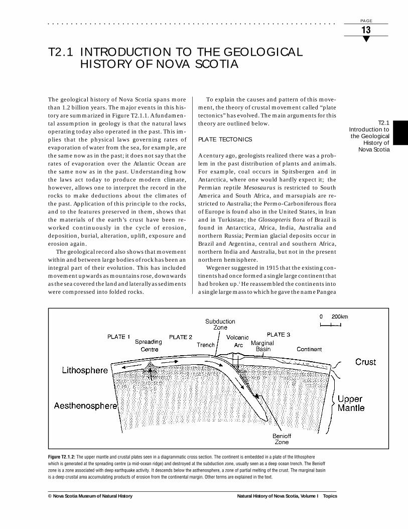
.............................................................. Natural History of Nova Scotia, Volume I Topics PAGE 13 ▼ © Nova Scotia Museum of Natural History T2.1 INTRODUCTION TO THE GEOLOGICAL HISTORY OF NOVA SCOTIA The geological history of Nova Scotia spans more than 1.2 billion years. The major events in this his- tory are summarized in Figure T2.1.1. A fundamen- tal assumption in geology is that the natural laws operating today also operated in the past. This im- plies that the physical laws governing rates of evaporation of water from the sea, for example, are the same now as in the past; it does not say that the rates of evaporation over the Atlantic Ocean are the same now as in the past. Understanding how the laws act today to produce modern climate, however, allows one to interpret the record in the rocks to make deductions about the climates of the past. Application of this principle to the rocks, and to the features preserved in them, shows that the materials of the earth’s crust have been re- worked continuously in the cycle of erosion, deposition, burial, alteration, uplift, exposure and erosion again. The geological record also shows that movement within and between large bodies of rock has been an integral part of their evolution. This has included movement upwards as mountains rose, downwards as the sea covered the land and laterally as sediments were compressed into folded rocks. To explain the causes and pattern of this move- ment, the theory of crustal movement called “plate tectonics” has evolved. The main arguments for this theory are outlined below. PLATE TECTONICS A century ago, geologists realized there was a prob- lem in the past distribution of plants and animals. For example, coal occurs in Spitsbergen and in Antarctica, where one would hardly expect it; the Permian reptile Mesosaurus is restricted to South America and South Africa, and marsupials are re- stricted to Australia; the Permo-Carboniferous flora of Europe is found also in the United States, in Iran and in Turkistan; the Glossopteris flora of Brazil is found in Antarctica, Africa, India, Australia and northern Russia; Permian glacial deposits occur in Brazil and Argentina, central and southern Africa, northern India and Australia, but not in the present northern hemisphere. Wegener suggested in 1915 that the existing con- tinents had once formed a single large continent that had broken up. 1 He reassembled the continents into a single large mass to which he gave the name Pangea Figure T2.1.2: The upper mantle and crustal plates seen in a diagrammatic cross section. The continent is embedded in a plate of the lithosphere which is generated at the spreading centre (a mid-ocean ridge) and destroyed at the subduction zone, usually seen as a deep ocean trench. The Benioff zone is a zone associated with deep earthquake activity. It descends below the asthenosphere, a zone of partial melting of the crust. The marginal basin is a deep crustal area accumulating products of erosion from the continental margin. Other terms are explained in the text. T2.1 Introduction to the Geological History of Nova Scotia
Transcript of T2.1 INTRODUCTION TO THE GEOLOGICAL HISTORY OF NOVA SCOTIA
. . . . . . . . . . . . . . . . . . . . . . . . . . . . . . . . . . . . . . . . . . . . . . . . . . . . . . . . . . . . . .
Natural History of Nova Scotia, Volume I Topics
P A G E
13▼
© Nova Scotia Museum of Natural History
T2.1 INTRODUCTION TO THE GEOLOGICALHISTORY OF NOVA SCOTIA
The geological history of Nova Scotia spans morethan 1.2 billion years. The major events in this his-tory are summarized in Figure T2.1.1. A fundamen-tal assumption in geology is that the natural lawsoperating today also operated in the past. This im-plies that the physical laws governing rates ofevaporation of water from the sea, for example, arethe same now as in the past; it does not say that therates of evaporation over the Atlantic Ocean arethe same now as in the past. Understanding howthe laws act today to produce modern climate,however, allows one to interpret the record in therocks to make deductions about the climates ofthe past. Application of this principle to the rocks,and to the features preserved in them, shows thatthe materials of the earth’s crust have been re-worked continuously in the cycle of erosion,deposition, burial, alteration, uplift, exposure anderosion again.
The geological record also shows that movementwithin and between large bodies of rock has been anintegral part of their evolution. This has includedmovement upwards as mountains rose, downwardsas the sea covered the land and laterally as sedimentswere compressed into folded rocks.
To explain the causes and pattern of this move-ment, the theory of crustal movement called “platetectonics” has evolved. The main arguments for thistheory are outlined below.
PLATE TECTONICS
A century ago, geologists realized there was a prob-lem in the past distribution of plants and animals.For example, coal occurs in Spitsbergen and inAntarctica, where one would hardly expect it; thePermian reptile Mesosaurus is restricted to SouthAmerica and South Africa, and marsupials are re-stricted to Australia; the Permo-Carboniferous floraof Europe is found also in the United States, in Iranand in Turkistan; the Glossopteris flora of Brazil isfound in Antarctica, Africa, India, Australia andnorthern Russia; Permian glacial deposits occur inBrazil and Argentina, central and southern Africa,northern India and Australia, but not in the presentnorthern hemisphere.
Wegener suggested in 1915 that the existing con-tinents had once formed a single large continent thathad broken up.1 He reassembled the continents intoa single large mass to which he gave the name Pangea
Figure T2.1.2: The upper mantle and crustal plates seen in a diagrammatic cross section. The continent is embedded in a plate of the lithospherewhich is generated at the spreading centre (a mid-ocean ridge) and destroyed at the subduction zone, usually seen as a deep ocean trench. The Benioffzone is a zone associated with deep earthquake activity. It descends below the asthenosphere, a zone of partial melting of the crust. The marginal basinis a deep crustal area accumulating products of erosion from the continental margin. Other terms are explained in the text.
T2.1Introduction tothe Geological
History ofNova Scotia

. . . . . . . . . . . . . . . . . . . . . . . . . . . . . . . . . . . . . . . . . . . . . . . . . . . . . . . . . . . . . .
Topics Natural History of Nova Scotia, Volume I
P A G E
14▼
© Nova Scotia Museum of Natural History
German and translation into English, French, Span-ish and Russian, he was not able to convince most ofhis contemporaries.
Archaeologists have long known that tiles, pot-tery and other items that have been strongly heatedhave acquired a weak magnetism as they cooled inthe earth’s magnetic field. About forty years ago,geologists discovered that cooling lavas do the samething and that sedimentary rocks also acquire a“depositional magnetism” induced by the field ofthe earth at the time of deposition, and thereforeparallel to it. Here was a locked-in record ofpaleomagnetic directions, and a method of locatingthe magnetic poles at the time the rocks were formed.Comparison of the paleomagnetism of rocks of thesame age from North America indicated that, inPermian time, for example, the North Pole was insouthern Mongolia, while the paleomagnetism ofPermian rocks from Europe insisted it was in thePacific Ocean, southwest of the Aleutian Islands. Ifthe earth’s magnetic field has always had two poles,one north and one south, then the continents musthave moved relative to one another. Paleomagnetismis the prime direct and objective evidence for thereality of continental drift.
At about the same time, oceanographers discov-ered that the intensity of the magnetic field over theoceans shows a pattern of crude “stripes” that aresymmetrical about the mid-ocean ridges. Thoseridges are volcanic, and the cooling lavas, of course,become magnetized. If the volcanoes are fed bymagma injected from below, and so spreading theridge apart, the sea floor must be spreading outwardon both sides of the ridge and would form a sym-metrical magnetic record of changes in the earth’sfield. This concept of sea-floor spreading requiresthat the sea floor be consumed elsewhere, if theearth is not enlarging. Circulation of the oceanicfloor back into the earth (subduction) at the oceanictrenches is a reasonable explanation. The descend-ing cold slab of oceanic rock would explain the deep-focus earthquakes (to depths of 400 km) of the Benioffzone associated with the trenches (see Figure T2.1.2).Each mid-ocean ridge, of course, must have a corre-sponding subduction zone. Analysis of the distribu-tion of ridges, troughs and earthquakes generated bythe movement of the crust indicates that, at present,the earth’s crust consists of about a dozen majorparts (oceanic plates) moving at rates of a few centi-
(Gk: the whole Earth). In that reassembly, for exam-ple, coalfields fell into place in equatorial regions,salt and gypsum (formed by the evaporation ofseawater) and desert sandstones fell in the tropics,and the continental glaciers in the polar regions. Heexplained many things, such as the present distribu-tion of coal, of salt and gypsum and of glacial depos-its, as due to the break-up of Pangea to form thepresent continents, which had then drifted apart—hence “continental drift.” Similar floras and faunason opposite sides of modern oceans are then theresult of the opening of the oceans. So, too, are suchsimilarities of shape as that of the east coast of SouthAmerica and the west coast of Africa.
Wegener also used this drift of the continentsthrough the floor of the ocean to explain orogeny asthe formation of mountain systems on the leadingedge of the drifting continents—the westerncordillera of the Americas, for example—and thus tosolve another problem, the genesis of the enormousand long-continued forces necessary to produce foldmountains. This was an impossible mechanism fororogeny, and Wegener had difficulty in finding forcesadequate to cause the drift. He marshalled a consid-erable array of geodetic, geological, geophysical,paleobiological and paleoclimatic arguments. Al-though the idea generated major symposia, and hisbook on the subject went through four editions in
Figure T2.1.3: Cambrian Paleography. Maximum extent of the EarlyCambrian seas. Hills remain where the late Precambrian ranges stood onthe Canadian Shield; marginal highlands existed along both east and westmargins of the continent.2 (Reprinted by permission of John Wiley & Sons).
Acadian geosyncline
Appalachian geosyncline
T2.1Introduction tothe GeologicalHistory ofNova Scotia

. . . . . . . . . . . . . . . . . . . . . . . . . . . . . . . . . . . . . . . . . . . . . . . . . . . . . . . . . . . . . .
Natural History of Nova Scotia, Volume I Topics
P A G E
15▼
© Nova Scotia Museum of Natural History
metres per year. The driving mechanism is the earth’smantle. The crustal plates are carried upon the hori-zontally moving upper part of a convective circula-tion in the mantle material. Continents are embed-ded in the plates and carried along as passengerstherein, so continental drift is implicit in plate tec-tonics, but not drift through the crustal plate, asWegener would have had it. Applied to the presentplate distributions, the theory proposes thatWegener’s single continent was broken up duringJurassic and Cretaceous time, with the Atlantic Oceanopening to separate the Americas from Europe andAfrica, that Australia and New Zealand were carriedeastward and that India drifted into collision withsouthern Asia.
Orogeny is the result when continents collide, orwhen a continent at the edge of a plate overrides asubduction zone. The sediments previously accu-mulated on the continental margins, shelves andslopes will, of course, be involved in such an eventand reappear as fold mountains.
APPLICATION TO ATLANTIC CANADA
General acceptance of the idea of plate tectonicsnaturally led to efforts to reconstruct the past distri-butions of continents and oceans.The primary evi-dence used for such reconstruction is1. the paleomagnetic data from rocks of the
appropriate ages (which gives paleolatitudesand the geographical orientation, but notlongitude)
2. the character of the preserved fossils (which givesinformation about the environment in which theylived, about biological similarities and differencesand, indirectly, about climate)
3. the character of the rocks themselves (whichcontain information about sources ofsediments, the conditions of their depositionand the distribution of volcanic and othermagmatic activity).
Figure T2.1.4: Position of Avalonia during the Early Ordovician. (Reprinted from McKerrow and Scotese,3 with permission from Geological SocietyPublishing House).
T2.1Introduction tothe Geological
History ofNova Scotia

. . . . . . . . . . . . . . . . . . . . . . . . . . . . . . . . . . . . . . . . . . . . . . . . . . . . . . . . . . . . . .
Topics Natural History of Nova Scotia, Volume I
P A G E
16▼
© Nova Scotia Museum of Natural History
Figure T2.1.5: A simplified map of the geology of Nova Scotia; compiled by the Department of Natural Resources (Mines and Minerals Branch).

. . . . . . . . . . . . . . . . . . . . . . . . . . . . . . . . . . . . . . . . . . . . . . . . . . . . . . . . . . . . . .
Natural History of Nova Scotia, Volume I Topics
P A G E
17▼
© Nova Scotia Museum of Natural History
One such was prepared by the Geological Society ofLondon, which held a symposium at Oxford in 1988 todiscuss such reconstruction on a worldwide scale.The contributions of the participants were publishedin 1990, and the editors summarized the results in aseries of maps which attempt to reconcile the dataand the differences of opinion of the participants.Several of the maps are used in this document toillustrate the general distribution of the continents atvarious times. There is general agreement that NorthAmerica (Laurentia), northern Europe (Baltica andAvalonia) and Siberia gradually aggregated into a sin-gle mass (Laurasia), while South America, Africa, Aus-tralia, India and Antarctica formed another huge mass(Gondwana). The two combined during Devoniantime to form Pangea, which broke up again in Jurassicand Cretaceous time, as Wegener had argued.
We may use one of the maps to illustrate thechanges wrought by plate tectonics. The Cambrianfossils of Nova Scotia are distinctly different fromthose farther northwest. To explain this, in apaleogeographic map published in 1960 (before the“rebirth” of the continental-drift theory about 1965),Dunbar inserted a land barrier to separate theCambrian sea of Nova Scotia from that of New Bruns-wick (Figure T2.1.3).2 Of the five tectonostratigraphiczones into which Williams divided the Appalachiansin 1978, the Avalon Zone corresponds approximatelywith the Acadian geosyncline of Dunbar’s map, andthat zone is shown in Figure T2.1.4 as Avalonia. Thedifferences in the faunas are now explained, becausethey were originally separated by more than 30 de-grees of latitude.
The simplified geological map (Figure T2.1.5)shows the distribution of various rock types through-out the province and can be compared with a surficialmap (Figure T3.4.3) to explain some surficial fea-tures. For example, the highland regions in CapeBreton and northern Nova Scotia are underlain byvery old, highly resistant rocks. As a result, topo-graphic highlands form and are often exposed orcovered by a thin veneer of till. In contrast, softerrocks in the Annapolis Valley region were extensivelyeroded, formed catchment basins and were subse-quently partially filled with thick sequences of glacio-fluvial and alluvial deposits.
○ ○ ○ ○ ○ ○ ○ ○
Associated TopicsT2.2 – T2.7 Geology, T3.1 – T3.5 Landscape Develop-ment, T4.1 Post-glacial Climatic Change
References1 Wegener, A. (1966) The Origin of Continents and
Oceans, translated from the fourth (revised)German edition of 1929, by J. Biram. Methuen,London (New York: reprinted by DoverPublications).
2 Dunbar, C.O. (1960) Historical Geology, 2nd ed.Wiley, New York.
3 McKerrow, W.S., and C.R. Scotese, eds. (1990)Palaeozoic Palaeogeography and Biogeography.Geological Society (London), Memoir 12.
4 Keppie, J.D. (1979) Geological Map of theProvince of Nova Scotia, 1:500,000. Nova ScotiaDepartment of Mines and Energy.
Additional Readings• Dewey, J.F. (1972) Plate Tectonics. Scientific
American, Inc.• Keppie, J.D. (1989) Northern Appalachian
Terranes and Their Accretionary History.Geological Society of America, Special Paper 230.
T2.1Introduction tothe Geological
History ofNova Scotia

. . . . . . . . . . . . . . . . . . . . . . . . . . . . . . . . . . . . . . . . . . . . . . . . . . . . . . . . . . . . . .
Topics Natural History of Nova Scotia, Volume I
P A G E
18▼
© Nova Scotia Museum of Natural History
T2.2 THE AVALON AND MEGUMA ZONES
the Avalon Zone. It appears as part of “Avalonia,”(see Figures T2.1.4 and T2.2.2a) which also includedsouthern Britain and northern France.2 Prior to theDevonian Period, the Avalon and Meguma zonesdeveloped in different areas and later came intocontact along the Cobequid-Chedabucto Fault. (Thefault system also has other names: Glooscap Fault;Minas Geofracture.)
In the last fifteen years, Barr, Jamieson, Raesideand others have accumulated evidence to show that,in Cape Breton, the Avalon Zone is limited to thesouthern part of the island (see Figure T2.2.1). In theinterim, also, the term “terrane” has come into use todescribe the zones. A terrane is a distinct region or
A fault across Nova Scotia, from Cobequid Bay toChedabucto Bay, neatly divides the province intotwo geological zones which are fundamentally dif-ferent from one another. In 1978, Williams dividedthe Appalachians into five tectonostratigraphiczones, named for their distribution in Newfound-land.1 From north to south across Newfoundlandand Nova Scotia, they are Humber, Dunnage, Gan-der, Avalon and Meguma. He placed the northernboundary of the Avalon Zone through Fortune Bay,Newfoundland, and north of the Caledonian High-lands in southern New Brunswick. The south bound-ary is the Cobequid-Chedabucto Fault, so the wholeof Cape Breton and northern Nova Scotia fell within
Figure T2.2.1: Tectonostratigraphic divisions in Cape Breton Islandand adjacent parts of northern Appalachian orogen (modified afterBarr and Raeside3). BRC = Blair River Complex;PEI = Prince Edward Island.
T2.2The Avalon andMeguma Zones

. . . . . . . . . . . . . . . . . . . . . . . . . . . . . . . . . . . . . . . . . . . . . . . . . . . . . . . . . . . . . .
Natural History of Nova Scotia, Volume I Topics
P A G E
19▼
© Nova Scotia Museum of Natural History
group of rocks with common stratigraphic units andorigin. The northwestern areas of Cape Breton Is-land are composed of two other terranes — the Aspyand Bras d’Or—and a small fragment of thePrecambrian Shield (the Blair River Complex).
AVALON ZONE
Distribution of StrataRocks of the Avalon Zone outcrop north of theCobequid-Chedabucto Fault. They range in age fromPrecambrian to Devonian and are found in threeareas: the Cobequid Highlands, the Pictou-AntigonishHighlands (Districts 310, 320) and in Cape Breton(Regions 100, 200 and Districts 310, 330). They occurin fault-bounded blocks which stand out in the land-scape as prominent ridges because the rocks are re-sistant to weathering and because they have beenpushed up relative to their surroundings.
Earliest RecordPrecambrian rocks are found in all three areas and,with the exception of volcanic deposits in southernCape Breton, are severely altered. Granites were in-truded late in the Precambrian and again in Devoniantime. Some of the rocks have been metamorphosedto high grade.
Northern Cape Breton consists of three parts,which have different metamorphic histories and ages.They are the Blair River Complex (at the northern tipof Cape Breton), the Bras d’Or terrane (Ingonish toEast Bay) and the Aspy terrane (between the two).
The Blair River Complex consists of quartzo-feld-spathic and amphibolite gneisses and minoramounts of calcareous rocks; these have been in-truded by anorthosite, syenite and granite. The Pb/U (zircon) radiometric age of the syenite is about1,000 million years. The Complex has a late-Grenvillian metamorphic age and resemblesGrenville rocks of the Canadian Shield.
The Aspy terrane consists of volcanic and sedi-mentary rocks now metamorphosed to greenschistand amphibolite facies (i.e., low- to high-grade phyllitesand schists). The Pb/U age is 430–440 million years,i.e., Ordovician-Silurian. It is separated from the Brasd’Or terrane by a shear zone up to 800 m wide.
The Bras d’Or terrane consists of sedimentaryand volcanic rocks, generally metamorphosed onlyto relatively low grade, that were intruded by dioriteand granite. The granites have Pb/U (zircon) ages of555–565 million years, and so are Early Cambrian.
On the basis of age, of composition, and of mag-netic and seismic continuity across Cabot Strait, theBlair River Complex is correlated with the HumberZone in Newfoundland. This means the edge of thePrecambrian part of the continent (Laurentia) ex-tends as far south as northern Cape Breton. The Aspyand Bras d’Or terranes are correlated with the rocksof central Newfoundland; the Dunnage Zone doesnot appear in Cape Breton. These correlations re-move northern Cape Breton from the Avalon Zoneand redefine that zone to include only the Miraterrane, which is the part of Cape Breton south of theBoisdale Hills and Bras d’Or Lake (Figure T2.2.1).The northern mainland remains in the Avalon.
The Avalon Zone in southern Cape Breton con-tains late Precambrian volcanic rocks that were in-truded by diorite and granite. Following an intervalwhen those rocks were being eroded, red sandstonesand conglomerates were deposited upon them, andfollowed by grey shales and siltstones of EarlyCambrian age. During the remainder of Cambriantime, shales and siltstones were deposited in a ma-rine basin that gradually deepened and then shoaledagain, as is indicated by a disconformity (indicatinga period of non-deposition) beneath the LateCambrian shales and limestones. The fossils includebrachiopods, crinoids, trilobites and graptolites.Comparison of this assemblage with those foundelsewhere indicates that the Avalon Zone was asso-ciated with Europe and Africa (i.e., Gondwana) dur-ing the Cambrian period.
In the Pictou–Antigonish area, Cambrian rockswere deposited as lavas and volcanic ash interbed-ded with sands and muds. They include beds ofoolitic hematite. Late Ordovician volcanism is indi-cated by the Bear Brook Formation, and ash bedsshow that the activity continued into Silurian time.The oldest sediments of the classic exposures nearArisaig are Silurian. The Arisaig Group has abundantfossils of great variety and is composed mainly ofshales and fine-grained sandstones, deposited in asea that gradually became shallower. In the upperpart of the group there are Middle Silurian red beds(Moydart Formation) that indicate fluvial or estua-rine deposition. Similar conditions returned in EarlyDevonian time (Knoydart Formation), and both for-mations contain abundant fossil fish spines andplates. The similarity of the fossil faunas to those ofnorthern Europe is one of the reasons for believingthat Avalonia and Baltica were close together inSilurian time (see Figure T2.2.2. a & b).
T2.2The Avalon andMeguma Zones

. . . . . . . . . . . . . . . . . . . . . . . . . . . . . . . . . . . . . . . . . . . . . . . . . . . . . . . . . . . . . .
Topics Natural History of Nova Scotia, Volume I
P A G E
20▼
© Nova Scotia Museum of Natural History
In the Cobequids, the Silurian rocks are domi-nantly volcanic, and the interbedded sedimentaryrocks are similar to those of the upper part of theArisaig Group. The Devonian rocks are also similarto those of the Antigonish area.
The overlying Carboniferous rocks are discussedin T2.4. The Avalonian rocks were metamorphosedat different times, as shown in Figure T2.2.3.
MEGUMA ZONE
Regional Geologic SettingThe Meguma Zone occupies the southern mainlandof Nova Scotia and extends seaward beneath youngersedimentary rocks. To the south and southeast itunderlies the Scotian Shelf (Districts 910, 920, 930)and the continental shelf southeast of Cape Breton;to the east it underlies the tail of the Grand Banks ofNewfoundland; and to the northwest it underlies theBay of Fundy (Unit 912). Its total area is approxi-mately 200 000 km2. The base of the succession isunknown because of intrusive granites; the top is anerosional and angular unconformity representingthe Acadian Orogeny. Geochemical and geophysicaldata suggest that the Meguma Zone in toto has beenthrust over a southward extension of the AvalonZone. Composite thickness of the stratigraphic suc-cession exceeds 23 km; however, nowhere do all ofthe units occur at one locality, nor are their thick-nesses constant.
StratigraphyThe sedimentary rocks of the Meguma Zone consistalmost entirely of fine-grained sandstones andshales. Minor amounts of volcaniclastic, con-glomeratic and carbonate rocks are significantlocally. The Meguma stratigraphic succession con-
Figure T2.2.2a: Location of continents during the Middle Silurian. Nova Scotia was part of the subcontinent Avalonia attached with parts of Europe (Baltica)to the continent Laurentia. (Reprinted from McKerrow and Scotese2, with permission of the Geology Society Publishing House.)
Figure T2.2.2b: Relative position of Avalonia and Baltica to the continentof Gondwana (South American and Africa) during the Middle Silurian.(Modified after J.P. Lefort4)

. . . . . . . . . . . . . . . . . . . . . . . . . . . . . . . . . . . . . . . . . . . . . . . . . . . . . . . . . . . . . .
Natural History of Nova Scotia, Volume I Topics
P A G E
21▼
© Nova Scotia Museum of Natural History
sists of three major groups of sandstone that alter-nate vertically with two thick groups of shale. To-gether they form two supergroups.5 The basalMeguma Supergroup underlies most of southernNova Scotia. An erosional remnant of the overlyingAnnapolis Supergroup occurs only along the north-western margin of the Zone. The stratigraphic suc-cession is also divisible by unconformities. These are
indicated by local erosional and angular discordancesbut mainly by subaerial volcaniclastic rocks. Theintervening four stratigraphic sequences each be-gins with basal sandstone, followed by black shaleand capped by siltstone and/or sandstone. Igneousactivity ends each sequence, usually as subaerialvolcaniclastics but also as extrusive or intrusivesheets.
Sandstones of the Meguma Supergroup are dif-ferent from those of the overlying AnnapolisSupergroup. Both are metamorphic quartzites, butthe Meguma sandstones were originally mixed feld-spathic, quartz-rich sands and mud, perhaps withsome volcanic debris. They occur as thick stratashowing limited graded bedding, sole marks and, inplaces, horizontally directed burrows. Regionalanalysis of sandstone composition, texture and sedi-mentary structures shows that paleocurrents flowedfrom the present south-southeast. On the other hand,sandstones of the Annapolis Supergroup are domi-nantly quartzose, with small mud content. Sedi-mentary structures include abundant cross-stratifi-
cation and vertically directed burrows. Paleocurrentpatterns are almost random. The sandstones of thetwo supergroups record different environments.Those of the Meguma are the products of turbidityflows in deep water, channel complexes of subma-rine-fan systems.6 The source area was to the presentsouth-southeast and continental in size. Sandstonesof the Annapolis Supergroup are the result of trac-
tion currents on a shallow-water continental shelf.Random paleocurrent patterns and the nature ofbed forms in the sandstones suggest that cyclonicstorms generated currents.7
The two major slates of the supergroups are black,carbon-rich and graptolitic. The base of the lowerslate has a regionally extensive, thin, laminated, siltyslate (the Mosher’s Island Formation — see FigureT2.2.4). Significantly, it has a high metal content,including manganese, lead, copper, zinc andbarium.8 The thick remainder of the lower zone hassandstone layers that decrease in abundance andthickness upwards in the stratigraphic succession.Sedimentary structures also change from graded tocross-stratification. The upper slate is almost silt-free in its lower portion, but silt laminae increase inabundance and thickness upwards. The uppermostpart is dominantly silt, so that colour changes to greyor green. Black slates of the Meguma Supergrouprecord a prograding wedge complex that shoaledupwards from the toe of a continental slope to anouter shelf.7 In contrast, the main black slate of the
100km
Figure T2.2.3: Metamorphism and Devonian plutonism in Nova Scotia. L—low-grade metamorphism; M—medium-grade metamorphism; H—high-grademetamorphism; stippled—Devonian granite. The age of metamorphism in the Meguma and Aspy terranes is Devonian; in the Bras d’Or terrane it isCambrian; in the Avalon terrane it is late Precambrian; and in the Blair River Complex it is mid-Proterozoic.

. . . . . . . . . . . . . . . . . . . . . . . . . . . . . . . . . . . . . . . . . . . . . . . . . . . . . . . . . . . . . .
Topics Natural History of Nova Scotia, Volume I
P A G E
22▼
© Nova Scotia Museum of Natural History
T2.2The Avalon andMeguma Zones
Figu
re T
2.2.
4: S
umm
ary
and
relat
ions
hips
of e
vent
stra
tigra
phy
and
relat
ive s
ea-le
vel c
hang
es in
the
Meg
uma
Zone
. T re
fers
to g
eolo
gic
time,
and
M to
max
imum
mea
sure
d th
ickne
sses
in m
etre
s. M
ajor e
vent
s ar
e lis
ted
in th
e lit
holo
gy c
olum
n an
d co
lum
ns 1
thro
ugh
5: th
elit
holo
gy c
olum
n gi
ves
pred
omin
ant l
ithol
ogies
repr
esen
ted
by p
atte
rns
(to th
e lef
t); c
olum
n 1
indi
cate
s fo
ssil-
bear
ing
inte
rvals
; col
umn
2sh
ows
episo
des
of v
olca
nism
; col
umn
3 id
entif
ies u
ncon
form
ities
by
horiz
onta
l hea
vy li
nes
(Meg
uma
sequ
ence
s ar
e nu
mbe
red)
; col
umn
4su
mm
arize
s ge
nera
l, de
posit
iona
l env
ironm
ents
; and
col
umn
5 di
splay
s (1
) tim
es o
f glo
bal a
noxic
eve
nts
(blac
k) a
nd (2
) majo
r Pale
ozoi
cgl
acial
epi
sode
s (A
is fo
r And
ean;
S, f
or S
ahar
an; a
nd D
, for
Dev
onian
). M
ajor e
vent
s an
d re
lative
sea
-leve
l cha
nges
in th
e M
egum
a Zo
ne a
relis
ted
in th
e ne
xt tw
o co
lum
ns.7
T EMS
SIEG
GE
D PR
ID
LUD
WEN
LL
Y AS
H CR
D LO
LL
V AR
G TR
E M
ER
5 4 3 2 1 NE
W C
ANAA
N 2 1 5 4 3 2 1 5 4
FELT
ZEN
CUNA
RD
MOS
HER’
S IS
. W
EST
DUBL
IN
RIS
SER’
S BC
H.
NEW
HAR
BOUR
F F F F F F F F F F
SHOA
LING
ANOX
IC E
VENT
(LOW
OXY
GEN
COND
ITIO
NS)
WAR
MIN
G
EXPO
SURE
AND
VOL
CANI
SM
OCEA
NIC
ANOX
IC E
VENT
EXPO
SURE
AND
VOL
CANI
SM
STOR
MY
SHEL
F AN
OXIC
EVE
NT
STOR
MY
SHEL
F
EXPO
SURE
AND
VOL
CANI
SM
DIAM
ICTI
TES
GRAP
TOLI
TES
OCEA
NIC
ANOX
IC E
VENT
TRAN
SITI
ONAL
ZON
E
VOLU
MIN
OUS
DEPO
SITI
ON
OF S
ANDY
TUR
BINE
S
EMER
GENC
E
HIGH
SU
BMER
GENC
E EM
ERGE
NCES
SU
BMER
GENC
E
LOW
EM
ERGE
NCE
HIGH
RAPI
D SU
BMER
GENC
E
LOW
EMER
GENC
E HI
GH
SUBM
ERGE
NCE
LOW
EMER
GENC
E
HIGH
SU
BMER
GENC
E EM
ERGE
NCE
SUBM
ERGE
NCE
LOW
V V V V V
4 3 2 1
240 75
450 50
280
1000
88
0 20
35
37
30
82
77
32
18
50
2000
80
00
500
1000
10
00
7000
DEVONIAN SILURIAN ORDOVICIAN CAMBRIAN
TORBROOK
INNER OUTER SHELF SLOPE FAN
KENTVILLE WHITE ROCK HALIFAX GOLDENVILLEUN
ITS
MLI
TH1
23
45
EVEN
TRE
L. S
EA-L
EVEL
D S A
FLAS
ERS
LAM
INAT
ED, R
IPPL
EDGR
EY S
LATE
WAC
KE
GOLD
ENVI
LLE
FORM
ATIO
NW
ACKE
VOLC
ANIC
S
MAS
SIVE
LAM
INAT
ED
COAR
SENI
NG U
P
BLAC
K SL
ATE
QUAR
TZ
FELD
SPAT
HIC
OVER
LYIN
G FO
RMAT
IONS
AREN
ITE
. . . . . . . . . . . . . . . . . . . . . . . . . . . . . . . . . . . . . . . . . . . . . . . . . . . . . . . . . . . . . .
Natural History of Nova Scotia, Volume I Topics
P A G E
23▼
© Nova Scotia Museum of Natural History
Annapolis Supergroup represents a deepening ofwater on a shelf. Both major slates and minor ones inthe Annapolis Supergroup record global oceanic low-oxygen conditions (see Figure T2.2.4).
Volcaniclastic and conglomeratic sediments areminor but significant components in the MegumaSupergroup. The volcanic rocks can be locally thick,as along the boundary of the two supergroups. There,10–30 m of basaltic pillow lavas overlie 10–50 m ofacidic tuffs formed from airborne volcanic ash. Lat-erally, continuous layers of tuff are common. A sig-nificant volcanic event occurred in the western partof the Meguma Zone to form the base of sequencefour (see Figure T2.2.4). Quartzose sandstones, mar-bles and slates containing boulders occur with thevolcanic rocks. Most of the volcaniclastics are water-laid, but their thickness and lateral extent, and thepresence of large boulders, suggest at least nearbyexposure to the air. These rocks coincide with angu-lar and erosional unconformities.
Skeletal fossils become abundant only in the up-per groups of the Meguma Zone, although tracefossils are common throughout. The oldest faunaoccurs at one locality near the Goldenville-Halifaxcontact. There, transported, broken trilobite fossilsare Early Middle Cambrian in age.9 Elsewhere in thisZone and in the thick overlying slate, fossil graptolitesand acritarchs date sequence one (the MegumaSupergroup) as earliest Ordovician. In the AnnapolisSupergroup, sequence two (White Rock Group) con-tains shells of possible Late Ordovician age. Sequencethree is Late Silurian, as shown by graptolitic andshelly fauna. Shelly fossils are abundant in sequencefour (Torbrook Group) and give an Early Devonianage. Thus, strata of the Meguma Zone range in age
from possibly Late Middle Cambrian through EarlyDevonian. Three unconformities interrupt thisrecord in the Early Ordovician, Late Ordovician andLate Silurian.
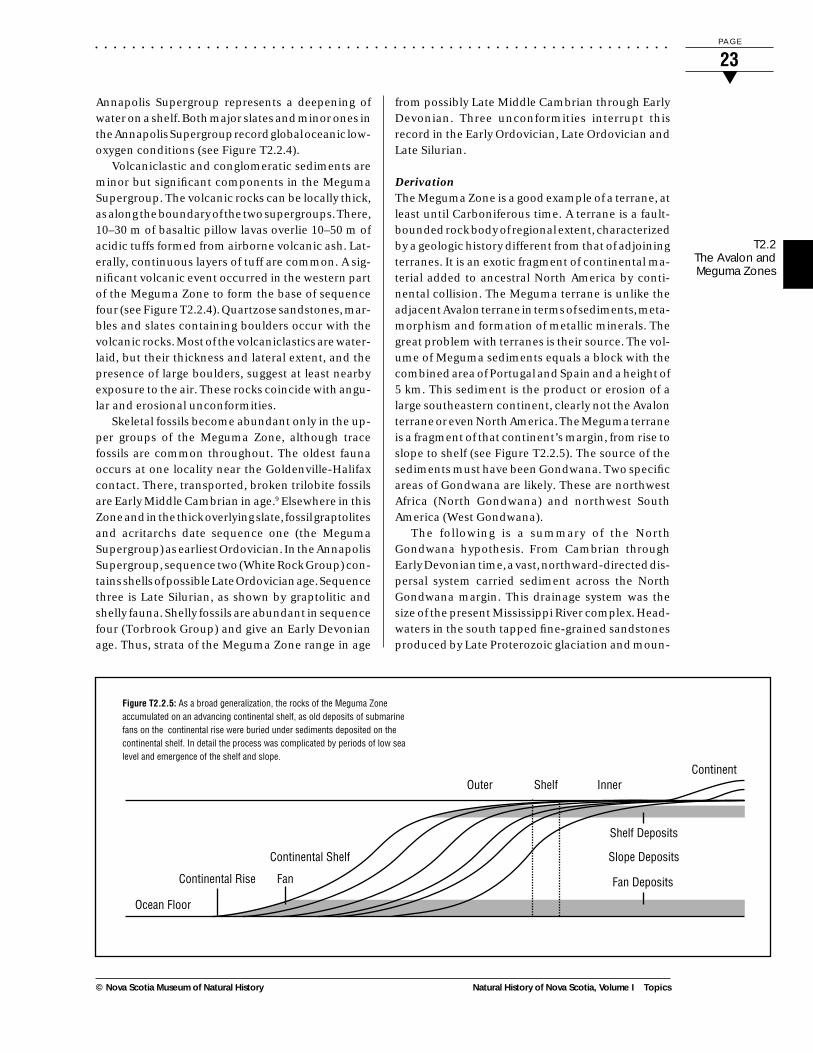
DerivationThe Meguma Zone is a good example of a terrane, atleast until Carboniferous time. A terrane is a fault-bounded rock body of regional extent, characterizedby a geologic history different from that of adjoiningterranes. It is an exotic fragment of continental ma-terial added to ancestral North America by conti-nental collision. The Meguma terrane is unlike theadjacent Avalon terrane in terms of sediments, meta-morphism and formation of metallic minerals. Thegreat problem with terranes is their source. The vol-ume of Meguma sediments equals a block with thecombined area of Portugal and Spain and a height of5 km. This sediment is the product or erosion of alarge southeastern continent, clearly not the Avalonterrane or even North America. The Meguma terraneis a fragment of that continent’s margin, from rise toslope to shelf (see Figure T2.2.5). The source of thesediments must have been Gondwana. Two specificareas of Gondwana are likely. These are northwestAfrica (North Gondwana) and northwest SouthAmerica (West Gondwana).
The following is a summary of the NorthGondwana hypothesis. From Cambrian throughEarly Devonian time, a vast, northward-directed dis-persal system carried sediment across the NorthGondwana margin. This drainage system was thesize of the present Mississippi River complex. Head-waters in the south tapped fine-grained sandstonesproduced by Late Proterozoic glaciation and moun-
Outer Shelf Inner
Shelf Deposits
Slope Deposits
Fan Deposits
Continent
Continental Shelf
FanContinental Rise
Ocean Floor
Figure T2.2.5: As a broad generalization, the rocks of the Meguma Zoneaccumulated on an advancing continental shelf, as old deposits of submarinefans on the continental rise were buried under sediments deposited on thecontinental shelf. In detail the process was complicated by periods of low sealevel and emergence of the shelf and slope.
T2.2The Avalon andMeguma Zones

. . . . . . . . . . . . . . . . . . . . . . . . . . . . . . . . . . . . . . . . . . . . . . . . . . . . . . . . . . . . . .
Topics Natural History of Nova Scotia, Volume I
P A G E
24▼
© Nova Scotia Museum of Natural History
tain building. Erosional remnants of this source rockexist now as buttes and mesas over much of south-ern Mali. Marine submergences from the north twiceinterrupted the northward transport of sands. Theresulting stratigraphic record across the West Afri-can Craton and North Gondwana consists of threethick sandstones with intervening thick, marineshales. They are identical in time and lithology tothose of the Meguma Zone. Rifting along the NorthGondwanan margin created a plethora ofmicrocontinents or microplates. Several have thesame stratigraphic record, e.g., Saudi Arabia and theWelsh Basin. In particular, first the Avalon terranecollided with ancestral Atlantic Canada. Next, part ofthe continental margin of northwest Africa thrustover the Avalon during Middle Devonian collisionbetween Africa and southeastern Atlantic Canada.
The following is a summary of the West Gondwanahypothesis. The Meguma terrane was deposited inan intramontane basin (intradeep) within or mar-ginal to northwestern South/Central America. TheMeguma fossil faunal and detrital zircon data indi-cate Gondwana affinities but are not more specific.Analysis of the distribution of distinctive AvalonianCambrian–Ordovician strata, containing a uniqueAvalonian fauna and source regions for detrital zir-cons that occur in the Georgeville Group, suggests awestern South American provenance. If the Megumaterrane was carried passively with the Avalon terrane,a South American source is also indicated. Theintradeep interpretation implies that the basal thicksandstone of the Meguma Supergroup is associatedwith a Cambrian orogen. Orogens of this age are rarebut are present in the Pampean Orogen (southwestArgentina). Transfer of the Meguma terrane fromGondwana to Laurasia about 400 million years ago iscompatible with Laurasia–South America collisionin the Silurian–Devonian rather than the Laurasia–Africa collision in the Early Carboniferous.
○ ○ ○ ○ ○ ○ ○ ○
Associated TopicsT2.1 Introduction to the Geological History of NovaScotia, T2.3 Granite in Nova Scotia
References1 Williams, H., S.P. Colman-Sadd and H.S.
Swinden (1988) “Tectonostratigraphic subdivi-sions of central Newfoundland.” In CurrentResearch, Part B. (Geological Survey of Canada,Paper 88-1B).
2 McKerrow, W.S., and C.R. Scotese, eds. (1990)Palaeozoic Palaeogeography and Biogeography.Geological Society (London) Memoir 12.
3 Barr, S.M., and R.P. Raeside (1989) “Tectono-stratigraphic terranes in Cape Breton Island,Nova Scotia: Implications for the configurationof terranes in the northern Appalachianorogen.” Geology 17: 822–5.
4 Lefort, J.P. (1989) Basement Correlation acrossthe North Atlantic. Springer-Verlag, Berlin.
5 Schenk, P. (in press) “The Meguma Zone andAnnapolis Belt.” In The Canadian Appalachi-ans, edited by H. Williams. Geol. Soc. ofAmerica and Geol. Survey of Canada.
6 Waldron, J.W.F., and L.R. Jensen (1985)Sedimentology of the Goldenville Formation,Eastern Shore, Nova Scotia. Geol. Survey ofCanada, Paper 85-15.
7 Schenk, P. (1991) “Events and sea-level changeson Gondwana’s margin: The Meguma Zone(Cambrian to Devonian) of Nova Scotia,Canada.” Bulletin of the Geological Society ofAmerica 103.
8 Zentilli, M., M.C. Graves, T. Mulja and I.MacInnis (1986) Geochemical Characterizationof the Goldenville-Halifax Transition of theMeguma Group of Nova Scotia: PreliminaryReport. Geol. Survey of Canada, Paper 86-1A.
9 Pratt, B.R., and J.W.F. Waldron (1991) “A MiddleCambrian trilobite faunule from the MegumaGroup of Nova Scotia.” Can. J. Earth Sci. 28.
T2.2The Avalon andMeguma Zones

. . . . . . . . . . . . . . . . . . . . . . . . . . . . . . . . . . . . . . . . . . . . . . . . . . . . . . . . . . . . . .
Natural History of Nova Scotia, Volume I Topics
P A G E
25▼
© Nova Scotia Museum of Natural History
Additional Reading• Donohoe, H.V., Jr., and R.G. Grantham (1989)
Geological Highway Map of Nova Scotia, 2nd ed.Atlantic Geoscience Society, Halifax. (SpecialPublication No. 1).
• Keppie, J.D. (1992) “From Whence Came theMeguma Terrane?” GAC 1992, Wolfville, N.S.
• Loncarevic, B.D., S.M. Barr, R.P. Raeside, C.E.Keen and F. Marillier (1989) “Northeasternextension and crustal expression of terranesfrom Cape Breton Island, Nova Scotia, usinggeophysical data.” Can. J. Earth Sci. 26.
• Raeside, R.P., and R.A. Jamieson (1992) Low-pressure Metamorphism of the MegumaTerrane, Nova Scotia. Field Trip Guidebook C-5,Geological Association of Canada/MineralogicalAssociation of Canada, Wolfville ’92.
• Schenk, P.E. (1992) “Upstream Search forSedimentary Source of the Meguma Zone—Nova Scotia to Morocco to Mauritania to Mali.”GAC 1992. Wolfville, N.S.
• Williams, H., and R.D. Hatcher, Jr. (1983)“Appalachian suspect terranes.” In Contribu-tions to the Tectonics and Geophysics of Moun-tain Chains, edited by R.D. Hatcher, Jr., H.Williams and I. Zietz. (Geological Society ofAmerica, Memoir 158).
T2.2The Avalon andMeguma Zones

. . . . . . . . . . . . . . . . . . . . . . . . . . . . . . . . . . . . . . . . . . . . . . . . . . . . . . . . . . . . . .
Topics Natural History of Nova Scotia, Volume I
P A G E
26▼
© Nova Scotia Museum of Natural History
T2.3 GRANITE IN NOVA SCOTIA
Granite is a hard, impermeable crystalline rock andis resistant to erosion. In consequence, in Nova Scotiait tends to form knolls and upland areas character-ized by a hummocky, boulder-strewn surface; thin,acid soils; and large areas of exposed bedrock. Watercan penetrate the body of granite only along thejoints (fractures), which may be several metres apart.Most precipitation is therefore held on the irregularsurface in numerous interconnected bogs, shallowlakes and streams.
Granite is found throughout mainland Nova Sco-tia and Cape Breton in plutons of various sizes andrepresents about 20–25 per cent of the bedrock acrossthe province. The largest pluton is the South Moun-tain Batholith, which is the dominant feature in thelandscape of southwestern Nova Scotia. It extends in
an arc from Yarmouth to Halifax and outcrops overan area of 10 000 km2 (see Figure T2.3.1).1
AGE AND GENESIS
Over the years, there has been much discussionabout the formation of granitic rocks. The theoriesgenerally are variants on two themes: (1) separationfrom a basaltic melt, and (2) extreme recrystal-lization, or even melting, of pre-existing rocks. Com-binations of these two are also possible. There isgeneral agreement that most of the Nova Scotiagranites were once molten (magma).
Age studies show that, since the Precambrian,granites have formed in Nova Scotia during at leasttwo periods of intense crustal disturbance when
Figure T2.3.1: Location of South Mountaingranite in southwest Nova Scotia.
T2.3Granite inNova Scotia

. . . . . . . . . . . . . . . . . . . . . . . . . . . . . . . . . . . . . . . . . . . . . . . . . . . . . . . . . . . . . .
Natural History of Nova Scotia, Volume I Topics
P A G E
27▼
© Nova Scotia Museum of Natural History
sediments may have been thrust deep into the earth’scrust and melted. These two major occasions wereduring the Cambrian and the Devonian periods.
The older group of granite plutons, around 550 to500 million years old, is composed of relatively smallbodies which are found exclusively north of theCobequid-Chedabucto Fault in northern mainlandNova Scotia and Cape Breton. The younger group,roughly 370 million years old, is found throughoutthe province, but predominantly south of theCobequid-Chedabucto Fault, within the sedimen-tary rocks of the Meguma Zone. These were gener-ated during the Acadian Orogeny, when the thickMeguma sedimentary pile would have been squeezedagainst, and possibly over, the Avalon Zone. TheSouth Mountain Batholith (Districts 440, 450), a verylarge body of granite which underlies about half ofwestern Nova Scotia, falls within this younger group.It has been studied extensively during the past twentyyears or so and is the best known of the granitebodies in the province. The description which fol-lows is basically that of the South Mountain Batholith,although most other Devonian/Carboniferousplutons are likely to share similar characteristics.
The South Mountain Batholith is Late Devonianin age (ca. 370 million years) and is the largest bodyof granitoid rocks in the entire Appalachian system.The margin tends to be a granodiorite phase, buttowards the centre of the batholith there are severalother phases, including monzogranite and granite.
Some of these rocks contain magmatic cordierite,andalusite or garnet. The Batholith as a whole isbroadly concordant with the regional trends in thesurrounding Meguma rocks, although locally, ofcourse, it must cut across structures within them.Near its margin, it can contain screens of metamor-phosed sedimentary rocks, or myriads of xenoliths(small fragments of the country rocks). Any foliationin the granite is due to movement in the viscousmagma itself and was not imposed upon the rock bylater tectonic stresses.
MODE OF EMPLACEMENT
Ascent of the Molten RockA hot magma which forms at a depth of 20–40 km inthe earth’s crust may rise either by forcing a pathalong lines of weakness or by breaking off and incor-porating overlying rocks. There are no signs of strainwithin the sedimentary rocks surrounding the SouthMountain Batholith, which might indicate forcedpassage, but several signs indicative of ascent byincorporation of blocks from the overlying strata(called country rock).
The contact with the surrounding Meguma coun-try rock is generally steep, and in several places,blocks of sediment, some with obvious sedimentarybanding, are incorporated into the granite mass.These blocks, or xenoliths, were gradually assimi-lated by the hot magma and can be found in variousdegrees of alteration in several localities near themargins of the granite; for example, at PortugueseCove. The process of ascent by invasion and incor-poration of country rock is called “stoping” (seeFigure T2.3.2).
COOLING OF THE MAGMA
FoliationAs the magma cools, it develops crystals, which movein response to currents within it. Some remain insuspension, whereas others settle out into densepatches. Where there was relatively rapid movementof the viscous magma, rock fragments, blocky min-erals (such as feldspars) and platy minerals (such asmicas) reveal the flow pattern by alignment to pro-duce a foliation in the granite.
Heating of the Surrounding SedimentsThe heat that is given off by the liquid as it cools heatsthe surrounding sedimentary rocks for several kilo-metres. This is the thermal aureole of the granite.The physical change that takes place in the sur-Figure T2.3.22: Magmatic stoping. Arrested stoping at the margin
of a large block of Meguma slates. Portuguese Cove (Unit 551).
T2.3Granite in
Nova Scotia
. . . . . . . . . . . . . . . . . . . . . . . . . . . . . . . . . . . . . . . . . . . . . . . . . . . . . . . . . . . . . .
Topics Natural History of Nova Scotia, Volume I
P A G E
28▼
© Nova Scotia Museum of Natural History
rounding rocks is called thermal metamorphism. Ingeneral, this takes the form of hardening andrecrystallization to form new minerals; the mineralsso formed depend upon the temperature reachedand upon the original composition of the countryrocks. If the rock was a shale, then the most distantalteration will produce chlorite as a characteristicmineral. Closer to the batholith, biotite, garnet,staurolite and sillimanite appear in that order, withthe sillimanite in a zone near the contact with thegranite. This zoning is used to measure the intensityof the metamorphism (the metamorphic grade). Forrocks of other compositions, the changes are recog-nized by comparing groups of minerals present ineach rock type (metamorphic facies).
Mineral DepositsIn granitic rocks, crystals of quartz and feldspar form80 per cent, or more, of the rock, and the balance ismainly micas and amphiboles. As the magma coolsand the crystals form in it, any water present mustcollect in the still-fluid phase, because quartz andfeldspars are anhydrous and the micas andamphiboles, which do contain some OH– ions, arepresent only in small amounts. Because heat es-capes only to the country rocks, the granite willgenerally freeze first at its margins and thence fromthe outside inward, with the still-fluid portion be-coming increasingly enriched in water and in anyelements that cannot be incorporated into the min-eral crystals as they form. When the batholith isfinally solid, the last remaining water-rich residue(the hydrothermal fluid) must be expelled. Fracturesthat developed in the solid shell due to contractionon cooling, to earlier movement of still-fluid por-tions, or to regional stresses provide channelsthrough which the hydrothermal fluid can escape.
That fluid contains silica and many other ele-ments in solution in small amounts. As it moves toregions of lower pressure on its journey through thefractures in the granite and the country rocks, thefluid will deposit its dissolved constituents in se-quence as it cools and becomes saturated with onemineral compound after another. Within the solid,but still hot, part of the batholith, the deposits arequartz, feldspar and some rare minerals, aspegmatites, aplites and quartz veins. At lower tem-peratures, minerals containing tin, tungsten andmolybdenum form, and at still lower temperatures,minerals containing copper, lead and zinc—and so
on. In some cases, the concentration of the mineralsmay be sufficient to form ore. Commonly, the depo-sition of the low-temperature minerals is in the coun-try rocks, many kilometres from the batholith. Thiswill include the rocks of its roof, which now havebeen eroded away, along with any ore bodies theymight have contained.
In Nova Scotia, the tin ore at East Kemptvilleformed in this way, and the gold ores were alsoformerly considered to have the same origin. Severaldeposits in Cape Breton, such as molybdenum atEagle Head and zinc at Meat Cove, have a similarorigin. As a different example, the copper-lead-zinc-silver-gold ore at Stirling is considered to have formedwhen the hydrothermal fluid flowed out onto thePrecambrian sea floor.
○ ○ ○ ○ ○ ○ ○ ○
Associated TopicsT2.2 The Avalon and Meguma Zones, T12.3 Geologyand Resources
References1 Charest, M.H. (1976) “Petrology, Geochemistry
and Mineralization of the New Ross Area,Lunenburg County, Nova Scotia.” M.Sc. thesis,Dalhousie University Halifax.
2 Milligan, G.C. (1977) The Changing Earth.McGraw-Hill Ryerson, Toronto.
Additional Reading• Clarke, D.B., S.M. Barr and H.V. Donohoe
(1980) “Granitoid and other plutonic rocks ofNova Scotia.” In The Caledonides in the U.S.A.,I.G.C.P. Project 27: Caledonide Orogen. Depart-ment of Geological Science, Virginia Polytech-nic Institute and State University.
• Clarke D.B. and G.K. Muecke (1980) Igneousand Metamorphic Geology of Southern NovaScotia. GAC/MAC Field Trip No. 21. Departmentof Geology, Dalhousie University, Halifax.
• Clarke, D.B. (1992) Granitoid Rocks. Chapmanand Hall, London.
T2.3Granite inNova Scotia

. . . . . . . . . . . . . . . . . . . . . . . . . . . . . . . . . . . . . . . . . . . . . . . . . . . . . . . . . . . . . .
Natural History of Nova Scotia, Volume I Topics
P A G E
29▼
© Nova Scotia Museum of Natural History
Erosion gradually reduced the topography of themountains created by the Acadian Orogeny andtransported the debris into the Carboniferous ba-sins, which continued to deepen by progressive sub-sidence related in part to fault movement. The de-posits gradually extended onto the gentle slopes ofthe eroded highland areas, which became buriedbeneath the sediments. The basins locally accumu-lated sediments up to eight kilometres deep (e.g.,Cumberland County).
The present-day highlands were not highlandsthroughout the entire Carboniferous Period. For ex-ample, the Cobequid Hills (Unit 311), in northernmainland Nova Scotia, was not a highland until LateCarboniferous time, when it was tilted and upliftedby movement on the adjacent Cobequid-Chedabucto Fault system and became a source ofcoarse sediment.
The Late Devonian, Carboniferous to EarlyPermian basin-fill material in the Maritimes Basinprobably extended over a much larger area thanthose rocks do today. Just as the older rocks wereuplifted and eroded to become the Carboniferousbasin-fill, the Carboniferous basins were upliftedand eroded to become the source of even youngerbasin-fill during the Mesozoic Era. The original sedi-mentary basins have been modified, deformed andbroken apart by subsequent tectonic processes, pro-ducing a locally highly fragmented record of theiroriginal form. Erosion of the Carboniferous rocksnot only reduced their areal extent, but their lowresistance to erosion, compared to surrounding base-ment rocks (e.g., water-soluble strata of the WindsorGroup), led to the development of lowlands andvalleys (Region 500). In short, erosion of the hard,resistant rocks of the Avalon terrane produced ourhighlands, the somewhat less resistant Meguma andgranitic rocks produced our upland areas, and theCarboniferous and Triassic rocks produced our low-lands. Today, the lowlands underlain by the softCarboniferous and Triassic rocks are our agricul-tural areas, and their development is inherited fromsedimentary basins formed between 280 and 380million years ago. The coincidence of developmentand settlement in these areas and their underlyingmineral and energy resources produces a growingchallenge for land-use planning and future resourcedevelopment.
THE LOWER CARBONIFEROUS: INTERIORMOUNTAIN VALLEY AND SEA
During late Paleozoic and early Mesozoic times, At-lantic Canada occupied an interior position in thenear-equatorial region of Pangea. The attachment ofNorth America to this supercontinent began in theEarly Devonian Period and is represented in AtlanticCanada by the Acadian Orogeny, the result of thecollision of the northeastern part of the North Ameri-can continent and the continent of Africa. The colli-sion created a large mountain belt with topographyperhaps like the present-day Rocky Mountains ofwestern Canada. The eroded roots of these Appala-chian Mountains extend from the southeasternUnited States to Newfoundland, and they occur asthe highland areas of Atlantic Canada.
PaleogeographyThe waning phase of the Acadian Orogeny was fol-lowed by the development of a complex of intercon-nected sedimentary basins during the Late DevonianPeriod. The area was still tectonically active, andvolcanic rocks, including basalts and rhyolites, wereextruded locally, especially in the earliest stages ofbasin formation (e.g., Fountain Lake Group and theMcAras Brook and Fisset Brook formations). Fromthe surrounding mountains, gravels, sands and mudwere transported in streams flowing to the northeastand deposited as the conglomerates, sandstones andmudstones that form the lower part of the filling ofthe basins (the Horton Group). There were repeatedmarine invasions into the basins in Middle Carbon-iferous time, when limestones and evaporites weredeposited, but continental deposits again overliethem and coal was deposited in extensive swampsduring the Late Carboniferous.
T2.4The
CarboniferousBasin
T2.4 THE CARBONIFEROUS BASIN

. . . . . . . . . . . . . . . . . . . . . . . . . . . . . . . . . . . . . . . . . . . . . . . . . . . . . . . . . . . . . .
Topics Natural History of Nova Scotia, Volume I
P A G E
30▼
© Nova Scotia Museum of Natural History
DistributionStrata of Early Carboniferous age are widely distrib-uted in Nova Scotia. They were deposited in valleysformed by the down-faulting of blocks of older rocksand were then preserved in those valleys after laterregional erosion. They underlie the lowland-valleyareas in parts of Antigonish, Colchester, Cumberland,Guysborough, Hants and Halifax counties of main-land Nova Scotia (north of latitude 45 degrees). Theyalso occur extensively in the lowlands of Cape BretonIsland (Units 512, 522 and District 560), where theyunderlie an area equal to that of the highlands. Note
that the Lower Carboniferous rocks do not come tothe surface everywhere, but in some areas, such as inCumberland County, are buried beneath extensiveUpper Carboniferous strata.1
The thickness of Lower Carboniferous sedimentdiffers from place to place. Typically it is greater than2000 m and may be as much as 4000 m where thesediments are preserved in their entirety.
Plate T2.4.1: The East Milford Quarry, Halifax County (Unit 511), showing the extensive evaporite deposits of the Windsor Basin. Photo: R. Merrick
T2.4TheCarboniferousBasin
. . . . . . . . . . . . . . . . . . . . . . . . . . . . . . . . . . . . . . . . . . . . . . . . . . . . . . . . . . . . . .
Natural History of Nova Scotia, Volume I Topics
P A G E
31▼
© Nova Scotia Museum of Natural History
The Interior ValleysIn the beginning of Early Carboniferous time, thesedimentation pattern was dominated by the ero-sion of the local highlands and transportation by acomplex drainage system to the lowlands. The steep-est highland slopes were marked by coarse alluvialfans comprising poorly sorted boulder to gravellysand debris. Initially the valley bottoms between thehighlands were steep enough to have braidedstreams, which permit little vegetation, and therewere a few lakes. The deposits are sandstones andmudstones, with minor conglomerate. Note thatground-stabilizing vegetation was rare, although theenvironment was suitable. These initial inter-montane flood-plain, river and lake sediments arepreserved today as the Horton Group and are 1000 to2000 m thick. The climate in the later part of Hortontime was evolving to hot, desert-like conditions (per-haps like the present-day Dead Sea). Strata typical ofthe Horton Group are exposed along the Avon Rivernear Hantsport and Cheverie (Unit 511a).2
The Interior Seas and LakesThis valley complex, which extended throughoutAtlantic Canada, was then flooded by the rapid inva-sion of seawater. This invasion is inferred to haveoccurred along a low trough area extending from theinterior of Pangea to the major world ocean calledTethys. Excess evaporation and restricted influx ofseawater from the ocean caused this basin to be-come an evaporitic marine environment. Limestone,gypsum, salt and potash salts were deposited in aprogressive sequence as the water reached satura-tion in each of these salts. The least soluble salts weredeposited first and the most soluble ones last. Later,repeated flooding produced cyclic interbedded se-quences of fossiliferous marine limestone, evaporites(mineral salts of seawater) including gypsum(CaSO
4.2H
2O) and anhydrite (CaSO
4), as well as thick
sections of red mudrocks; collectively they form theWindsor Group. It is interesting to note that therepeated flooding and drying that produced the cy-clic deposits in the Windsor Group may have beencaused by variations in worldwide sea level control-led by glacial events in the southern part of Pangea.Strata typical of the Windsor Group are exposedalong the Avon River near Avondale (Unit 511a), andnear Antigonish and Port Hawkesbury.2
From their present distribution, the inland seathat deposited the Windsor rocks must have beenabout 800 km by 300 km at least (i.e., a bit smallerthan the present Baltic Sea). Complete evaporationof seawater cannot produce gypsum or halite (NaCl)without also producing sylvite (KCl) and more com-plex salts. Individual deposits have 50 to 100 m ofpure gypsum and anhydrite, so the more concen-trated brines that would have produced sylvite andcomplex salts must have escaped. That is, the con-nection of the Windsor Basin to the ocean must havepermitted both inflow of seawater, and simultane-ous outflow of more saline water, from which thegypsum or halite had been precipitated.
The Windsor Group is approximately 1000 m thickand is a major source of industrial minerals and basemetals mined today in the province. It is the primarysource of limestone used in the manufacture of ce-ment for concrete, of gypsum for wallboard and ofsalt for the fishery and road de-icing. Nova Scotia isone of the leading gypsum-producing areas in theworld, providing 75 per cent of Canada’s total pro-duction (see Plate T2.4.1). The mineral wealth of theWindsor Group is the legacy of salts deposited froman ocean invading a desert-valley region 340 millionyears ago.
The Windsor Group is overlain by up to 2000 m ofred and grey mudrocks, sandstones and minor thinlimestones of the Mabou Group (previously known asthe Canso Group). The Mabou Group was depositedin a river-mudflat-and-lake complex which succeededthe evaporitic marine deposition in the underlyingWindsor Group. The lower part of the Mabou Groupcontains interbeds of gypsum, anhydrite and salt, likethe Windsor Group. This indicates the early lakeswere very saline, perhaps like the Great Salt Lake inthe western interior of the United States. The abun-dant red strata of the Mabou Group indicate that theprevailing climate was dry with highly seasonal pre-cipitation. The co-existing grey mudrocks were de-posited in extensive lakes that were probably sus-tained by river systems originating in distal regions.Strata typical of the Mabou Group are exposed alongthe Strait of Canso near Port Hastings (Unit 571).
The later part of the Early Carboniferous (be-tween 310 and 315 million years ago) heralded afundamental change in the depositional characterof the basins in Nova Scotia and in much of AtlanticCanada. The climate evolved to become very wetand the region was flooded by extensive depositionof grey sandstones and mudrocks with coal deposits.The coal age was born in a burst of prolific, lushvegetation and wetlands in vast floodbasins.
T2.4The
CarboniferousBasin

. . . . . . . . . . . . . . . . . . . . . . . . . . . . . . . . . . . . . . . . . . . . . . . . . . . . . . . . . . . . . .
Topics Natural History of Nova Scotia, Volume I
P A G E
32▼
© Nova Scotia Museum of Natural History
THE COAL AGE
PaleogeographyIn the Late Carboniferous, Nova Scotia had a sub-dued topography of low hills separated by broadriver valleys and freshwater lakes. Vegetationflourished in the warm climate, particularly largetrees (some 30 m high) and swamp plants. Some ofthe swamp plants had large tops and laterally spread-ing roots which were ideally suited to the topogra-phy, with its wide, flat, poorly drained surfaces. Theseplants grew densely in bogs and swamps along thefloodplains, estuaries and shorelines of lakes, andpossibly in coastal areas. As the plants died anddecayed, they became buried and compressed bynew organic material growing above. Some of theseenvironments were stable for millions of years, ex-periencing only gentle subsidence or rhythmic os-cillations in elevation. In these locations tremen-dous thicknesses of organic material accumulated,were compressed and eventually turned into coal.
In the Maritimes, coal was deposited in two typesof basins: (a) limnetic basins—lakes and adjacentplains which were regularly flooded; and (b) paralicbasins—in coastal lowlands subject to periodic, sus-tained influxes of seawater and marine sediments.On the mainland, all the coalfields, except possiblyJoggins, are of the first type, and the Pictou field istypical. The coal was deposited in a narrowintermontane-lake basin that was subsiding betweenboundary faults, i.e., a graben. The rate of subsid-ence approximated the rate of accumulation for avery long time, and thick coal seams resulted (up to13 m for the Foord seam). In the centre of the basin,clean, low-ash coal was formed. Mud accumulatedon the margin of the basin, so the seams grade out-ward from the centre through shaly coal (high ash) tocoaly shale to shale. By contrast, most of the coal-fields of Cape Breton are of the second type, andSydney is an example. Deposition occurred on thefloodplain portion of the alluvial part of a large paralicbasin. Some of the sediments were deposited bybraided streams, and brackish-water foraminiferaindicate that the sea encroached at other times. (Theswamps of the Mississippi Delta are a modern exam-ple of such a basin.) At Sydney the seams are rela-tively thin (up to 3 m) but have great lateral continu-ity. They are broken up by rock partings—the sedi-ment introduced by streams—and the seams termi-nate by such splitting and gradual pinching out ofindividual coal layers, not by lateral transition of coalinto shale, as at Pictou.
OccurrenceThe coal age began in Nova Scotia with the deposi-tion of sandstones, black shales and thin coal seamsin the Riversdale Group. Exposures of these strataare limited, and few contain economically impor-tant coal seams; the most extensive are those in thePort Hood area of Cape Breton. (The St. George’scoal seam, in Newfoundland, is also of this group.)More-productive coal measures are found in thesucceeding Cumberland and Pictou Groups (Dis-tricts 520, 580). The strata are predominantly sand-stone and contain few fossils; however, a strikingexception to this is the 1700 m of Cumberlandsandstones which are exposed along the ChignectoBay shoreline near Joggins and contain fossil trees,amphibians, the earliest reptiles, and two of theearliest land snails. In the Joggins section, there arealso 65 coal seams, 39 of which are also found atSpringhill. Other seams have also been worked atDebert. The Pictou coalfield, formed in thesandstones of the Pictou Group, occupies an area of3 by 15 km. It has numerous thick coal seams ofrelatively limited area, and some deposits of oil shales.Some oil has been collected dripping from the roof ofthe Thorburn colliery.
At Mabou and Inverness in Cape Breton, the coal-fields barely touch the land and lie mainly under thewaters of the Gulf of St. Lawrence. Similarly, only 3per cent of the huge Sydney coalfield is found on-shore. The seams run for 30 km along the coast butdip northeastwards under the Cabot Strait. The prac-tical mining limit is probably five or six kilometresoffshore, but the seams have been identified in boreholes 40 km from the land. These deposits are part ofthe Late Carboniferous Morien Group. The SydneyBasin extends almost to Newfoundland.
THE “MARITIME DISTURBANCE”
At the end of the Carboniferous Period, there was acrustal disturbance in Nova Scotia which producedfolds and faults in a narrow band between theCobequids and the Southern Uplands. This was theshadow of a much larger disturbance felt in Europeand the rest of the Appalachians, and marked thefinal readjustment in the grouping of continents inPangea. The coalfields within this band, particularlythe Pictou field, were distorted and the seams weredisrupted, thereby reducing their economic value.The coalfields of Cape Breton, however, were almostundisturbed.
○ ○ ○ ○ ○ ○ ○ ○
T2.4TheCarboniferousBasin

. . . . . . . . . . . . . . . . . . . . . . . . . . . . . . . . . . . . . . . . . . . . . . . . . . . . . . . . . . . . . .
Natural History of Nova Scotia, Volume I Topics
P A G E
33▼
© Nova Scotia Museum of Natural History
Associated TopicsT2.2 The Avalon and Meguma Zones, T12.3 Geologyand Resources
References1 Keppie, J.D. (1979) Geological Map of the
Province of Nova Scotia, 1:500,000. Nova ScotiaDepartment of Mines and Energy.
2 Donohoe, H.V., Jr., and R.G. Grantham (1989)Geological Highway Map of Nova Scotia, 2nd ed.Atlantic Geoscience Society, Halifax. (SpecialPublication No.1).
Additional Reading• Calder, J.H., K.S. Gillis, D.J. MacNeil, R.D.
Naylor and N. Watkins Campbell (1993) One ofthe Greatest Treasures: The Geology & History ofCoal in Nova Scotia. Nova Scotia Department ofNatural Resources (Information CircularNo. 25).
• Geldsetzer, H.H.J., P. Giles, R. Moore and W.Palmer (1980) Stratigraphy, Sedimentology andMineralization of the Carboniferous WindsorGroup, Nova Scotia. GAC/MAC Field TripGuidebook No. 22, Department of Geology,Dalhousie University, Halifax.
• Gibling, M.R. (1987) A Classic Carboniferoussection; Joggins, Nova Scotia. Geological Societyof America, Centennial Field Guide—Northeast-ern Section, 1987.
• Hacquebard, P.A. (l980) Geology of the Carbon-iferous Coal Deposits in Nova Scotia. GAC/MACField Trip Guidebook No. 7. Department ofGeology, Dalhousie University, Halifax.
• Hacquebard, P.A. (1970) Coal in SoutheasternCanada. Geol. Survey of Canada, EconomicGeology Report 1.
• Hacquebard, P.A., and J.R. Donaldson (1970),Carboniferous Coal Deposition Associated withFloodplain and Limnic Environments in NovaScotia. Geol. Soc. America Special Paper 114.
• Nova Scotia Department of Mines (1966)Industrial Mineral Map of the Province of NovaScotia.
• Nova Scotia Department of Mines (1976),Geology, Minerals and Mining in Nova Scotia.
• Roland, A.E. (1982) Geological Background andPhysiography of Nova Scotia. Nova ScotianInstitute of Science, Halifax.
T2.4The
CarboniferousBasin

. . . . . . . . . . . . . . . . . . . . . . . . . . . . . . . . . . . . . . . . . . . . . . . . . . . . . . . . . . . . . .
Topics Natural History of Nova Scotia, Volume I
P A G E
34▼
© Nova Scotia Museum of Natural History
T2.5 THE NOVA SCOTIAN DESERT
By the close of the Carboniferous Period, 280 millionyears ago, the shoreline of the inland sea had with-drawn to the east, and almost the entire surface areaof Nova Scotia was above sea level. Only a smallportion of Cape Breton remained under marine in-fluence. This marine regression marked the begin-
ning of the last continental phase of the province’sgeological history. Since that time, portions of NovaScotia and the other Maritime provinces have beenexposed to continuing subaerial erosion, with theproducts of this erosion being deposited into severallarge depressions.
Figure T2.5.1: A cross-sectional profile across the Bay of Fundy, illustrating the interpreted structural and stratigraphic evolution of the Fundy Rift Basin. (a)Compressive collision of the Meguma terrane with Avalon terranes in southern New Brunswick, with the former being thrust over the latter along the inclinedportion of the Minas Geofracture (décollement). (b) Reversal of motion on the décollement caused by extension, as the Meguma terrane moves down thefault plane in response to continental rifting further to the east, thus forming a deep depression. (c) The Triassic-Jurassic sedimentary section at about theend of the Early Jurassic. The position of the feeder dyke for the North Mountain Formation basalts is speculative. (d) The present-day profile of the FundyBasin, with the strata having been deformed by faulting, probably during the Late Jurassic. The Cape Spencer P-79 exploration well was drilled on a largegeologic structure in 1983, but did not encounter any hydrocarbons.2 Figure T2.6.1 indicates the location of the profile line shown here.
T2.5The NovaScotian Desert

. . . . . . . . . . . . . . . . . . . . . . . . . . . . . . . . . . . . . . . . . . . . . . . . . . . . . . . . . . . . . .
Natural History of Nova Scotia, Volume I Topics
P A G E
35▼
© Nova Scotia Museum of Natural History
Figure T2.5.2: Distribution of Newark Supergroup basins, eastern North America (slightly modified after Olsen, et al.3).The Fundy Rift is the largest of all Newark-type basins and covers an area of about 14 000 km2.
T2.5The Nova
Scotian Desert

. . . . . . . . . . . . . . . . . . . . . . . . . . . . . . . . . . . . . . . . . . . . . . . . . . . . . . . . . . . . . .
Topics Natural History of Nova Scotia, Volume I
P A G E
36▼
© Nova Scotia Museum of Natural History
PERMIAN (280–230 MILLION YEARS AGO)
At the opening of the Permian Period, Nova Scotiaoccupied a central position on the Pangeansupercontinent, at about 15 degrees northpaleolatitude. The climatic conditions at this loca-tion were dominated by persistent easterly tradewinds, which blew across the supercontinent, sothat the climate was hot and dry, though havingseasonal monsoonal rainfalls. The exposed rocks onthe land surface became oxidized, were eroded toform red sands and muds and were deposited in alow, basinal area covering the Northumberland Strait,Prince Edward Island and the Gulf of St. Lawrence.Sediments derived from older strata in Nova Scotiaand New Brunswick were redeposited within thisbasin and today form the foundation for the rollinglandscape of Prince Edward Island.
During this time, Nova Scotia, including the con-tinental shelf, was land undergoing erosion; the re-sulting sediments being deposited in the basinalarea to the north. Any Permian-age sediments thatwere deposited were subsequently eroded away andthus are largely absent from the stratigraphic recordof Nova Scotia.
TRIASSIC TO JURASSIC(230–140 MILLIONYEARS AGO)
During the Middle Triassic,the Pangean supercontinentwas subjected to extensionalforces before the start of con-tinental break-up. This proc-ess of continental rifting ex-tended from the Gulf ofMexico to Newfoundland andbeyond, and resulted involcanism and developmentof subparallel fissures andfaults along the thinned,weakened crust, as the crustalblocks of Pangea began tomove apart1 (see FigureT.2.5.1).
In the central portion ofthe rift, blocks of crustalmaterial between parallelfaults dropped down to formsteep-sided, flat-bottomedvalley- type structures calledgrabens. Further landward,away from the rift, the me-
chanics of fracturing were somewhat different and,in Middle Triassic time, when the Meguma terranewas pulled away from southern New Brunswick bysliding on the underlying Avalon terrane, the resultwas a series of half-grabens.
These half-grabens are known as the Fundy RiftSystem and can be traced through mainland NovaScotia to Chedabucto Bay (District 570), intoChignecto Bay (Unit 913b), and out on to the ScotianShelf (Region 900).1 Similar rift basins are foundextending down to the Gulf of Mexico.
The sediments which were deposited in the ba-sins during rifting and the volcanic rocks withinthese basins are genetically similar to those in theFundy Rift System, and thus are grouped togetherand collectively known as the Newark Supergroup(see Figure T2.5.2).3
In the Fundy region, three half-grabens are knownto be filled with Triassic–Jurassic sediments: FundyBasin, Chignecto Sub-basin and Minas Sub-basin.These sediments floor the similarly named bays.2
Geological and seismic data indicate that up to12 000 m of sediments fill the main Fundy Basin,about 6000 m fill the Chignecto Sub-basin and per-haps 3000 m fill the Minas Sub-basin. The strata in
Figure T2.5.3: Paleogeographic map showing depositional facies of the Early Jurassic Scots Bay/McCoyBrook formations in the Minas Basin area. The present-day distribution of Fundy Group strata is within theareas outlined by the dashed lines. The dotted pattern is the interpreted maximum extent of Jurassicsediments (slightly modified after Birney-de Wet and Hubert7).

. . . . . . . . . . . . . . . . . . . . . . . . . . . . . . . . . . . . . . . . . . . . . . . . . . . . . . . . . . . . . .
Natural History of Nova Scotia, Volume I Topics
P A G E
37▼
© Nova Scotia Museum of Natural History
these basins are generally undisturbed, except alongthe faulted margins and where the Cobequid-Chedabucto Fault crosses the Fundy Basin.
The history of these basins records a long period ofsedimentation interrupted by volcanism and ongo-ing tectonism along their faulted margins. The sedi-mentary fill in the basins records an overall filling-upwards sequence, from conglomerates to sands toshales and mudstones as the sources of the sedimentswere eroded away. These sediments and the associ-ated basalts are collectively known as the Fundy Group;they range in age from the Early Middle Triassic topossibly the Early Middle Jurassic in the area of maxi-mum deposition (depocentre) of the thick Fundy Ba-sin. The whole sequence in the Fundy Basin wasgently folded, possibly in the Middle Jurassic, andnow has the shape of a tilted saucer which plungessouthwestwards towards the mouth of the Bay ofFundy. These rocks are well exposed along the southshore of the Bay in the North Mountain–AnnapolisValley region and also all along the Minas Basin shore-line.
Rivers and braided streams flowing from theMeguma uplands formed alluvial fans along the fault-bounded margins of the basins and deposited thicksequences of poorly sorted conglomerates and lesseramounts of sandstones (the Wolfville Formation).Winds reworked some of these latter sandstones,which resulted in significant wind-blown dune de-posits; these are spectacularly exposed at Red Headnear Economy (District 710).4,5
The climate became drier and reduced the amountof water (and, hence, sediments) flowing into thebasins. Evaporitic minerals such as gypsum were pre-cipitated in temporary (ephemeral) lakes and mudflatswhich covered the basins (Blomidon Formation).6 Atthe end of the Triassic Period, further rift-relatedstresses caused the formation of fissure-type volcaniceruptions, and the basins were covered with a virtu-ally continuous sequence of lava flows of earliestJurassic age (North Mountain Formation, District 720).The Triassic-Jurassic boundary occurs in the Blomidonsediments, a few metres from the base of the lavaflows.
Following this event, slightly wetter climatic con-ditions began to develop. Fluvial sands and lacustrinemuds and limestones of the McCoy Brook and ScotsBay formations were deposited on the surface of thebasalt.7,8
Although these sediments are thick and extensivebeneath the Bay of Fundy (at least 3000 m), they arelimited to a few exposures in the Five Islands area(McCoy Brook Formation) in District 710 and severalsmall, thin outcrops near Scots Bay (Scots Bay For-
mation) in District 720. Conditions were still dryenough at the beginning of the Jurassic that aeoliansand dunes were deposited into structural lows ad-jacent to the bounding faults in the Minas Sub-basinand are well exposed at Wasson’s Bluff (see Figure2.5.3).3, 7
The continental setting results in poor preserva-tion of organic material, so fossils are rare in thesedeposits. Reptile and dinosaur remains occur inaeolian, alluvial fan and lacustrine sediments of theMcCoy Brook Formation at Wasson’s Bluff and inthe lower Wolfville Formation fluvial sandstones atCarrs Brook in District 620. Rare reptile remainsoccur in Wolfville Formation sandstone along thesouth shore of Minas Basin.9 Fish remains are presentin Early Jurassic sediments of the McCoy Brook For-mation on the west side of Five Islands ProvincialPark, and in limestones of the Scots Bay Formationat Scots Bay.9 Chertified logs are also very commonat the latter site. Dinosaur footprints can be found inWolfville Formation sandstones a few metres belowits contact with the overlying Blomidon Formationin the cliffs at Pereau, near Kingsport.
No middle or late Jurassic deposits are to be foundon land in Nova Scotia. The most recent, pre-glacialdeposits in Nova Scotia are Cretaceous sands, claysand lignite in the Musquodoboit Valley near MiddleMusquodoboit.10 Evidence of climatic changes andgeological events during the Jurassic Period musttherefore be sought from the sedimentary record onthe Scotian Shelf (see T3.5). The presence of red bedsand salt in the offshore sequence indicates that thearid equatorial climate persisted into the Late Jurassic.1
○ ○ ○ ○ ○ ○ ○ ○
T2.5The Nova
Scotian Desert
. . . . . . . . . . . . . . . . . . . . . . . . . . . . . . . . . . . . . . . . . . . . . . . . . . . . . . . . . . . . . .
Topics Natural History of Nova Scotia, Volume I
P A G E
38▼
© Nova Scotia Museum of Natural History
9 Carrol, R.L., E.S. Belt, D.L. Dineley, D. Baird andD.C. McGregor (1972) Excursion A59: Verte-brate Paleontology of Eastern Canada. XXIVInternational Geological Conference Guidebook.
10 Roland, A.E. (1982) Geological Background andPhysiography of Nova Scotia. Nova ScotianInstitute of Science, Halifax.
Additional Reading• Colwell J.A. (1980) Zeolites in the North Moun-
tain Basalt, Nova Scotia. GAC/MAC FieldtripGuidebook No. 18. Department of Geology,Dalhousie University, Halifax.
• Hubert, J.F., and M.F. Forlenza (1988)“Sedimentology of braided-river deposits inUpper Triassic Wolfville redbeds, southernshore of Cobequid Bay, Nova Scotia, Canada.”In Triassic-Jurassic Rifting: Continental Breakupand the Origin of the Atlantic Ocean and PassiveMargins, edited by W. Manspeizer. Elsevier,Amsterdam.
• Nadon, G.C., and G.V. Middleton (1985) “Thestratigraphy and sedimentology of the FundyGroup (Triassic) of the St. Martins area, NewBrunswick.” Can. J. Earth Sci. 22.
• Manspeizer, W. (1988) “Triassic-Jurassic riftingand opening of the Atlantic: An overview.” InTriassic-Jurassic Rifting: Continental Breakupand the Origin of the Atlantic Ocean and PassiveMargins, edited by W. Manspeizer. Elsevier,Amsterdam.
• Stevens, G.R. (1980) Mesozoic Vulcanism andStructure—Northern Bay of Fundy Region,Nova Scotia. GAC/MAC Field Trip GuidebookNo. 8. Department of Geology, DalhousieUniversity, Halifax.
Associated TopicsT2.2 The Avalon and Meguma Zones, T2.4 The Car-boniferous Basin, T3.5 Offshore Bottom Character-istics
References1 Wade, J.A., and B.C. MacLean (1990) “The
geology of the southeastern margin ofCanada.” In Geology of the Continental Marginof Eastern Canada, edited by M.J. Keen andG.L. Williams. Geological Survey of Canada.(Geology of Canada No. 2) (also GeologicalSociety of America, The Geology of NorthAmerica, vol. I-1).
2 Brown, D.E., and R.G. Grantham (1992) FundyBasin Rift Tectonics and Sedimentation. GAC/MAC Field Trip Guidebook A-3.
3 Olsen, P.E., R.W. Schlische and P.J.W. Crore(eds.) (1989) Tectonic, Depositional andPaleoecological History of the Early MesozoicRift Basin, Eastern North America. AmericanGeophysical Union, Washington, D.C. (FieldTrip Guide Book T-351).
4 Hubert, J.F., and K.A. Mertz (1980) “Eolian dunefield of Late Triassic age, Fundy Basin, NovaScotia.” Geology 8.
5 Hubert, J.F., and K.A. Mertz (1984) “Eoliansandstone in Upper Triassic-Lower Jurassicredbeds in the Fundy Basin, Nova Scotia.”Journal of Sedimentary Petrology 54.
6 Mertz, K.A., and J.F. Hubert (1990) “Cycles ofsand-flat sandstone and playa-mudstone in theTriassic-Jurassic Blomidon redbeds, Fundy riftbasin, Nova Scotia: Implications for tectonicand climatic controls.” Can. J. Earth Sci. 27.
7 Birney-de Wet, C.C., and Hubert, J.F. (1989)“The Scots Bay Formation, Nova Scotia,Canada: A Jurassic carbonate lake with silica-rich hydrothermal springs.” Sedimentology 36.
8 Tanner, L.H. (1990) Sedimentology andDiagenesis of the Lower Jurassic McCoyBrook Formation, Fundy Basin, Nova Scotia.Ph.D. thesis, University of Massachusetts,Amherst, Mass.
T2.5The NovaScotian Desert

. . . . . . . . . . . . . . . . . . . . . . . . . . . . . . . . . . . . . . . . . . . . . . . . . . . . . . . . . . . . . .
Natural History of Nova Scotia, Volume I Topics
P A G E
39▼
© Nova Scotia Museum of Natural History
T2.6 THE TRIASSIC BASALTS ANDCONTINENTAL RIFTING
began to form in the Devonian Period and wascompleted by Late Carboniferous times. In NovaScotia, the Permian Period was quiescenttectonically, with only erosion of pre-existing rocksoccurring. During the Triassic, however, a newphase of crustal motion began. It eventually re-sulted in the break-up of Pangea into the present-day continents, and the formation of the AtlanticOcean. But in many respects, the earliest manifes-tations of this tectonic event are the most signifi-cant for Nova Scotia, for at that time the last geo-logical component was added: the Triassic–Jurassic
In the long geological time period up to the end of theCarboniferous, almost all of Nova Scotia’s geologicalunits—the old crystalline rocks of the Avalon Zoneand the folded slates and greywackes of the MegumaZone, along with younger Devonian granites andCarboniferous limestones, salts, sandstones andcoal—were assembled. All these were subjected toerosion under a hot, dry climate during the Permianand Early Triassic periods.
During the 150 million years prior to the TriassicPeriod, Nova Scotia occupied a central position inthe interior of the supercontinent Pangea, which
Figure T2.6.1: Major fault systems in Nova Scotia. The last major motion on any of these faults probably occurred during the Middle Jurassic, with theMeguma terrane (south of the faults) moving eastwards along the Cobequid-Chedabucto Fault system. Distribution of Middle Triassic–Early Jurassic rocksin Nova Scotia. The dashed line represents the approximate line of profile for Figure T2.5.1.
T2.6The TriassicBasalts andContinental
Rifting

. . . . . . . . . . . . . . . . . . . . . . . . . . . . . . . . . . . . . . . . . . . . . . . . . . . . . . . . . . . . . .
Topics Natural History of Nova Scotia, Volume I
P A G E
40▼
© Nova Scotia Museum of Natural History
sediments and basalts. The basins into which theserocks were deposited became the precursors of thevarious important coastal features known today asthe Bay of Fundy, Chignecto Bay, the Minas Basinand Chedabucto Bay.
CRUSTAL MOVEMENT BEGINS
Faults and GrabensIn the Triassic Period, Pangea began to break upagain. The theory is that this occurred as follows.Heat loss from the mantle through the thin oceanfloor is more rapid than through the thick continen-tal crust, which acts as a blanket. Accumulation ofheat expanded the continental crust, so that its sur-face was uplifted and the relatively brittle upper partwas fractured. Upwelling currents in the mantle(mantle plumes) caused upraised blisters that brokeinto three rifts at 120 degrees to each other. (The RedSea, the Gulf of Aden and the north end of the AfricanRift in Ethiopia would be a modern example.) Two ofthe rifts continued to widen, pulled apart by themovement of mantle material beneath the crust,and to extend to link with similar rifts above othermantle plumes, so building a lengthy rift systemwhich eventually widened to become an ocean. Thethird rift permitted magma to reach the surface asvolcanoes. The rift valley filled with volcanic rocksand with sediments eroded off its flanks, but it failedto open up. The Fundy–Chignecto Basin is consid-ered to be such a “failed ocean.”
In some cases the block of crust between twoparallel faults dropped down, making a steep-sidedvalley-like depression called a graben. In Nova Sco-tia, half-grabens (downfaulted on only one side)were developed when Permian and older thrust faultsand transverse faults were reactivated, such that theoriginal compressive forces were released andextensional forces allowed the blocks to slide backdown the fault plane1 (see Figure T.2.5.1).
A series of such reactivated thrust and transverse(strike-slip) faults transected the province, and adja-cent to these faults were formed several new sedi-mentary basins. These basins—the Fundy Basin,Minas Sub-basin and Orpheus Basin—presently un-derlie the Bay of Fundy, Minas Basin and ChedabuctoBay/eastern continental shelf, respectively (Region900). Another branch of these faults may be repre-sented by the Cabot Fault system (see FigureT2.6.1).2,3
These grabens gradually filled with thick se-quences of continental-type sediments and volcanicrocks. The boundary faults remained as lines of weak-ness, however, and in the Cretaceous and Tertiaryperiods were exploited by erosion. They are nowfeatures of inland and coastal morphology.
VOLCANIC ROCKS—BASALTS
During this period of sustained tension, magmawelled up some fractures adjacent to the sedimen-tary basins and either solidified as basaltic dykes andsills within the rock strata or was extruded at thesurface as lava flows (see Figure T2.6.1). Severalclosely spaced fissure-type eruptive zones existed inthe Bay of Fundy region, pouring lava out to covereventually an area of at least 15 000 km2. The basaltsare Early Jurassic, with K–Ar ages of about 200 mil-lion years. 4,5 Onshore, the basalts of the North Moun-tain Formation have a maximum thickness of about400 m, though they are estimated from seismic datato be up to 1000 m thick in the centre of the FundyBasin.1
The volcanic rocks of the Fundy Rift system arecontinental-type basalts known as tholeiites. Theynow form, and are exposed along, the continuousridge of the North Mountain (District 720), extend-ing from Brier Island in the west to Cape Split in theeast, in fault blocks along the north shore of theMinas Basin (District 710), on Isle Haute and onGrand Manan Island (New Brunswick).
The basalt at North Mountain is an erosionalremnant. It is probable that the Great Dyke (fromPubnico to Sambro) also fed volcanoes, in whichcase basalt might have covered the entire mainlandat one time.
T2.6The TriassicBasalts andContinentalRifting

. . . . . . . . . . . . . . . . . . . . . . . . . . . . . . . . . . . . . . . . . . . . . . . . . . . . . . . . . . . . . .
Natural History of Nova Scotia, Volume I Topics
P A G E
41▼
© Nova Scotia Museum of Natural History
Basalt FlowsAt least seventeen flows have been identified in theBay of Fundy area. They range in thickness from 1 to60 m; most cover only a small area. All seventeen areexposed northeast of Digby Gut, but to the south-west along Digby Neck only two very thick ones arefound. These two are separated by a layer of moreeasily eroded rock, which forms a valley down thecentre of the Neck and out onto the islands.
When thick lava flows cool and contract, six-sidedvertical joints form, which divide the flow into col-umns (columnar jointing). If these columns are un-dercut at their base by the sea, they tend to fall likechimneys. Cliffs formed by these flows, therefore,tend to be high, vertical and with a wave-cut plat-form at the base. Coastal features related to suchcolumnar basalt are well displayed at many pointsalong the southern Fundy shore from Cape Split toBrier Island, at Five Islands Provincial Park and atPartridge Island near Parrsboro (District 710).
MineralizationAs the lavas cooled after extrusion, escaping gaseswere trapped in the rock and formed cavities intowhich various minerals were precipitated; filled cavi-ties are called amygdules. The minerals include ag-ate, amethyst, jasper, calcite and many members ofthe zeolite family. At some locations, small depositsof native copper and magnetite are found in fracturezones within the basalts. Agate and jasper can befound as pebbles and cobbles along the beach atScots Bay, and zeolites occur at various localitiesalong the Fundy shore. (For an extensive listing ofminerals found in the basalts and the location oftheir occurrences, see Sabina.6)
Sills and DykesA sill is a layer of magma which was injected inbetween two layers of strata and therefore lies paral-lel to them. In Colchester County the basalt near FiveIsland Provincial Park is very fine grained and doesnot contain amygdules. It may, therefore, not havebeen extruded as lava, but injected between theWolfville sandstone and the Blomidon shales as sills.
Dykes crosscut the sedimentary banding andstructures, occupying the tensional fissures producedduring the rifting process. In southern Nova Scotia,basalt is found in small dykes in the Yarmouth areaand in the Great Dyke of Nova Scotia—a feature thatruns from Pubnico 150 km eastwards to just offSambro near Halifax Harbour.
MORPHOLOGY OF THETRIASSIC–JURASSIC AREA
At some time during the Middle to Late JurassicPeriod, sediments within the rift basins weretectonically disturbed through the reactivation ofthe basin-bounding faults and the formation of newones. The principal strike-slip faults parallel the Col-chester/Cumberland shore south of the CobequidHighlands, but new splays from these faults devel-oped and had a northeast orientation. The blocks ofstrata between these faults were thus shifted andtilted and now form the irregular hilly topographyalong the north shore of the Minas Basin from aboutGreat Village to Five Islands. Further to the east,around the Minas Basin and into the Truro area,undisturbed and relatively flat-lying Middle Triassicdeposits of the Wolfville Formation form coastallowlands.
On the south side of the Bay of Fundy, thesandstones, shales and basalts gently sag down toform a spoon-shaped basin or syncline, with an axisthat plunges towards the west. The trough of thisgentle fold can be seen in the hook of Cape Split. Thesouth side of North Mountain is truncated by a sharpscarp slope, behind which the soft Wolfville andBlomidon formations have been eroded to form theAnnapolis–Cornwallis Valley.7
CONTINENTAL SEPARATION
When the continents finally separated in the EarlyJurassic, the split did not occur along the lines of theearly tensional features but further to the east, be-yond the edge of the present continental shelf. Thus,the Meguma rocks which had originally been a mar-gin of Gondwana were left behind on the west side ofthe Atlantic Ocean, and sutured to eastern NorthAmerica.
○ ○ ○ ○ ○ ○ ○ ○
T2.6The TriassicBasalts andContinental
Rifting

. . . . . . . . . . . . . . . . . . . . . . . . . . . . . . . . . . . . . . . . . . . . . . . . . . . . . . . . . . . . . .
Topics Natural History of Nova Scotia, Volume I
P A G E
42▼
© Nova Scotia Museum of Natural History
Associated TopicsT2.1 Introduction to the Geological History of NovaScotia, T2.2 The Avalon and Meguma Zones, T2.5The Nova Scotian Desert
References1 Wade J. and D. Brown (in prep) “The Triassic-
Jurassic Fundy rift system—A synthesis.”Bulletin of Canadian Society of PetroleumGeology.
2 Stevens, G.R. (1980) Mesozoic Vulcanism andStructure—Northern Bay of Fundy Region,Nova Scotia. GAC/MAC Field Trip GuidebookNo. 8. Department of Geology, DalhousieUniversity, Halifax.
3 Colwell, J.A. (1980) Zeolites in the NorthMountain Basalt GAC/MAC Field Trip Guide-book No. 18. Department of Geology. DalhousieUniversity, Halifax.
4 Wark, J.M., and D.B. Clarke (1980)“Geochemical discriminators and paleotectonicenvironment of the North Mountain basalts,Nova Scotia.” Can. J. Earth Sci. 17.
5 Hayatsu, A. (1979) “K-Ar ischron age of theNorth Mountain Basalt, Nova Scotia,” Can. J.Earth Sci. 16: 973.
6 Sabina, A.P. (1964) Rocks and Minerals for theCollector: Bay of Fundy Area. Geological Surveyof Canada, (Paper 64-10).
7 Roland, A.E. (1982) Geological Background andPhysiography of Nova Scotia. Nova ScotiaInstitute of Science, Halifax.
Additional Reading• Brown, D.E., and R.G. Grantham (1992) Fundy
Basin Rift Tectonics and Sedimentation. GAC/MAC Field Trip Guidebook A-3.
T2.6The TriassicBasalts andContinentalRifting

. . . . . . . . . . . . . . . . . . . . . . . . . . . . . . . . . . . . . . . . . . . . . . . . . . . . . . . . . . . . . .
Natural History of Nova Scotia, Volume I Topics
P A G E
43▼
© Nova Scotia Museum of Natural History
T2.7 OFFSHORE GEOLOGY
(AGC) support mapping programs for offshore geol-ogy, one of which produces an East Coast Basin AtlasSeries. There is now a better understanding of theoffshore geology and the relationships with marineprocesses. Topics T2.1–T2.6 discuss Nova Scotia’sgeologic story. This Topic summarizes the pieceswhich are in evidence offshore. More detailed infor-mation can be obtained from Geology of the Conti-nental Margin of Eastern Canada.1
GEOLOGICAL SUBDIVISIONOF THE OFFSHORE
The offshore is here taken to include all areas adja-cent to the province which are covered by water (seeFigure T2.7.1). Geologically, the offshore region canbe divided into three parts:1. the Gulf of St. Lawrence (Unit 914) and
Laurentian Channel (Unit 932), where Carbon-iferous sedimentary sequences, similar to thoseoccurring in the Cumberland and Sydneybasins and overlying a complex basement of
The Nova Scotia offshore covers approximately 40million hectares and includes parts of Georges Bank,the eastern Gulf of Maine, Bay of Fundy, Gulf of St.Lawrence, Laurentian Channel and the Scotian Shelfand Scotian Slope, which together form part of thecontinental margin of eastern Canada. (See Region900 on Theme Regions Map.) The margin evolvedsubsequent to the rifting of the supercontinentPangea and the ensuing sediment accumulation inthe basins has created conditions suitable for thegeneration and preservation of oil and natural gas.
The offshore areas of Nova Scotia are importantlinks in the chronology of events that comprise theprovince’s geological history. Accessibility, however,has limited the study of offshore stratigraphy anddeposits. Until recently, information was derivedfrom dredge materials from the fishing industry andscattered core samplings. During the last few dec-ades, there has been increasing interest in offshoreoil and natural-gas exploration, and more recently,marine mineral potential. The Geological Survey ofCanada (GSC) and the Atlantic Geoscience Centre
Figure T2.7.1: Structural geology of the Nova Scotia offshore.
Pre-Ch
Pre-ChCZ
JPre-Ch
K
Pre-Ch
Bay of Fundy
Pre-Ch
CChPre-Ch
C
Ch
Cobequid/ChedebuctoFault System
Orpheus Graben
La Have Platform
Hinge ZoneScotian Basin Scotian Basin
T2.7.1
Scotian Shelf
Gulf of St. Lawrence
T2.7OffshoreGeology
CENOZOICCZ
CRETACEOUSK
JURASSICJ
TRIASSIC
CARBONIFEROUS TO PERMIAN ABOVE THE HORTON GROUP
C
HORTON GROUPCh
PRE-HORTON GROUP ROCKSPre-Ch

. . . . . . . . . . . . . . . . . . . . . . . . . . . . . . . . . . . . . . . . . . . . . . . . . . . . . . . . . . . . . .
Topics Natural History of Nova Scotia, Volume I
P A G E
44▼
© Nova Scotia Museum of Natural History
blocks which marks a flexure in the crustalrocks between the platformal area and theadjacent basinal area
(ii) an outer area, consisting of a series ofinterconnected sub-basins containing verythick sedimentary rocks. This is the area ofgreatest potential for oil and gas discoveries(see Figure T2.7.2).
STRATIGRAPHY
The proto-Nova Scotian landscape has been more orless continuously exposed to erosive forces since themiddle part of the Jurassic Period 180 million yearsago. Its history from this point is essentially one ofdenudation rather than deposition, and conse-quently very little evidence of geological events hasbeen preserved on land.
There are, however, two exceptions. First, at fivelocations in Nova Scotia, fluvial sediments have been
Avalon terrane metamorphic and igneousrocks, extend offshore into the larger Magdalenand Sydney basins
2. the Bay of Fundy, where the red Triassic andJurassic sedimentary strata and basalts thatoccur in western Nova Scotia, overlying variousPaleozoic formations, thicken northwardtoward the axis of the Fundy Basin (Unit 912)
3. the Scotian Shelf (Districts 920, 930) and Slope(District 940) where the Meguma Group rocks,which extend beneath the continental shelf, areonlapped by Jurassic, Cretaceous and Tertiarysedimentary beds of the Scotian Basin.2
The Scotian Basin can be further subdivided into:(i) an inner area, where the Meguma basement
is relatively shallow. This includes the LaHavePlatform (District 930) and Canso Ridge(District 920). Its southern boundary is the“hinge zone”: a zone of faulted basement
Figure T2.7.2: Generalized facies distribution reflecting depositional environments. Abenaki and equivalent formations, Scotian Shelf.2
T2.7OffshoreGeology

. . . . . . . . . . . . . . . . . . . . . . . . . . . . . . . . . . . . . . . . . . . . . . . . . . . . . . . . . . . . . .
Natural History of Nova Scotia, Volume I Topics
P A G E
45▼
© Nova Scotia Museum of Natural History
Figure T2.7.3: Hydrocarbon zones of the northeastern Nova Scotia continental shelf.2
T2.7OffshoreGeology

. . . . . . . . . . . . . . . . . . . . . . . . . . . . . . . . . . . . . . . . . . . . . . . . . . . . . . . . . . . . . .
Topics Natural History of Nova Scotia, Volume I
P A G E
46▼
© Nova Scotia Museum of Natural History
discovered which contain assemblages of subtropi-cal terrestrial flora (spores) and freshwater algal cysts(dinoflagellates) indicating an early Cretaceous age— ~110–120 million years ago. At another location, a23-m-thick interval is dated as ~135 million yearsold. The second exception is the extensive blanket ofglacial and glaciofluvial material deposited acrossall of Nova Scotia during the Pleistocene Epoch,which ended about 12,000 years ago.
This large gap in the geological record can befilled by data from the Scotian Shelf portion of theScotian Basin. The Scotian Basin extends fromGeorges Bank in the southwest to the Grand Banks inthe east and, in its thickest parts, may contain sedi-mentary strata totalling 20 km in thickness.2, 3 Thereare a number of major structural elements withinthe Scotian Basin which, depending on their rate ofsubsidence and hence the amount of sedimentaccumulation, at present contain relatively thickeror thinner amounts of strata.
There are also several lithostratigraphic units inthe Scotian Basin (see Figure T2.7.3). Most hydro-carbon discoveries have occurred in deltaic sedimentsof the MicMac, Mississauga and Logan Canyon for-mations.
The edge of the Scotian Basin subcrops Quater-nary sediments approximately 30–50 km offshore fromthe southern coast of Nova Scotia.
This section summarizes the late Triassic, Jurassicand Cretaceous Periods, during which time the off-shore area was the focus of significant sedimentation.
Triassic/Jurassic Red Beds and SaltIn the Late Triassic and the early part of the JurassicPeriod, much of the Scotian Shelf was an emergentupland, containing a series of isolated to intercon-nected grabens and half-grabens into which werebeing deposited red sandstones and shales of thesame age as the basal formations in the Fundy Basin.At this time, Nova Scotia was part of thesupercontinent Pangea and was situated just northof the equator. Large amounts of salt were depositedinto the deeper grabens as a result of the influx ofseawater and a generally hot climate.2
Middle Jurassic Carbonate and MudTwo significant changes occurred with the the con-tinued northward movement of Pangea and the ini-tial opening of the Atlantic Ocean in the Early Jurassic.First, the climate became more temperate andevaporite deposition ceased. Second, the broad areaof the Scotian Shelf started to subside and land-derived sediments were deposited on top of the salt.These sediments were mainly sands near shore, con-taining organic matter from the continental landmass, while further offshore carbonates and muds,containing marine organic matter, were being de-posited.
Late Jurassic DeltasBy the Late Jurassic (~160 million years ago) therewere a variety of depositional environments south ofNova Scotia. South of southwestern Nova Scotia, adelta was developing at the mouth of a river systemdraining the Bay of Fundy–Gulf of Maine and adja-cent regions. East of this feature, a narrow (10 to 20km wide) carbonate shoal extended almost to whereSable Island is today, before being cut off by a seconddeltaic complex forming from a distributary of theancestral St. Lawrence River (see Figure T2.7.2).
Woody material, which was washed in and buriedwithin the deltaic sands and muds, is the principalsource for the gas reserves around Sable Island. Thewater depth increased rapidly seaward of these fea-tures, and basinal shales, siltstones and fine-grainedsandstones were deposited. These deltaic and basinalfacies are important as potential source and reser-voir rocks for crude oil and natural gas.4,5,6
Cretaceous DeltasThe southward retreat of the shoreline during a ma-rine regression in the latest Jurassic and early part ofthe Cretaceous resulted in the development of fluvialand deltaic sediments on top of the Jurassic basinalsediments in the central part of the Scotian Basin,near Sable Island. A series of lesser marine transgres-sions and regressions occurred during the middlepart of the Cretaceous, which resulted in the deposi-tion of alternating source and reservoir beds. Thewhole sedimentary sequence was covered by finemuds during the Late Cretaceous, when seawateronce more invaded the shelf and created deepwaterconditions in the basin area.
T2.7OffshoreGeology

. . . . . . . . . . . . . . . . . . . . . . . . . . . . . . . . . . . . . . . . . . . . . . . . . . . . . . . . . . . . . .
Natural History of Nova Scotia, Volume I Topics
P A G E
47▼
© Nova Scotia Museum of Natural History
Late Cretaceous/Early TertiaryThe later Cretaceous and early part of the Tertiarywas a period of generally high sea level, with shore-line occasionally close to present day. By the lateTertiary, there was a general regression and theprogradation of coarse clastics across the shelf.
Recent DepositsDuring the latest phase of geological developmenton the Scotian Shelf, sediment banks have been builtout along the edge of the continental shelf. The finalveneer of glacial deposits, including moraines, wasdeposited as the Wisconsin ice sheet retreated.
CULTURAL FACTORS
Offshore areas of Nova Scotia are considered to beviable areas for hydrocarbon exploration and devel-opment (see T12.3).
○ ○ ○ ○ ○ ○ ○ ○
Associated TopicsT2.2 The Avalon and Meguma Zones, T2.6 TheTriassic Basalts and Continental Rifting, T3.1 Devel-opment of the Ancient Landscape, T3.4 TerrestrialGlacial Deposits and Landscape Features, T3.5 Off-shore Bottom Characteristics, T12.3 Geology andResources
Associated HabitatsH1.1–H1.2 Offshore, H2.1–H2.6 Coastal
References1 Keen, M. J., G. L. Williams, eds. (1990) Geology
of the Continental Margin of Eastern Canada.Geological Survey of Canada. (Geology ofCanada No. 2) (also Geological Society ofAmerica, The Geology of North America,vol. I-1).
2 Wade, J. A., and B. C. MacLean (1990) “Thegeology of the southeastern margin of Canada,Part 2—Aspects of the geology of the ScotianBasin from recent seismic and well data.” In
Geology of the Continental Margin of EasternCanada, edited by M.J. Keen and G.L. Williams.Geological Survey of Canada. (Geology of CanadaNo. 2) (also Geological Society of America, TheGeology of North America, vol. I-1).
3 MacLean, B. C., and J. A. Wade (1992) “Petro-leum geology of the continental margin southof the Islands of St. Pierre and Miquelon,offshore Eastern Canada.” Bulletin of CanadianPetroleum Geology.
4 Mukhopadhyay, P. K. (1989) CretaceousOrganic Facies and Oil Occurrence, ScotianShelf. Geological Survey of Canada (Open File2282).
5 Mukhopadhyay, P. K. (1990a) Evaluation ofOrganic Facies of the Verrill Canyon Formation,Sable Subbasin, Scotian Shelf. GeologicalSurvey of Canada (Open File 2435).
6 Mukhopadhyay, P. K., and J. A. Wade (1990)“Organic facies and maturation of sedimentsfrom three Scotian Shelf wells.” Bulletin ofCanadian Petroleum Geology 38.
Additional Reading• Grant, A. C., K. D. McAlpine and J. A. Wade
(1986) “The continental margin of easternCanada: Geological framework and petro-leum potential.” In Future Petroleum Prov-inces of the World, edited by M.T. Halbouty.American Association of Petroleum Geolo-gists (Memoir 40).
T2.7OffshoreGeology

Figure T2.1.1: Major Events in Nova Scotia’s Geological History
900 570 505 438 408800 700 650 600 360 286 245 208 144 66 1.6 P
P R O T E R O Z O I C P A L E O Z O I C M E S O Z O I C C E N O Z O I C
LATE PROTEROZOIC CAMBRIAN ORDOVICIAN DEVONIAN CARBONIFEROUS JURASSIC CRETACEOUS TERTIARY QUATERNARYSILUR- IAN
PERM- IAN
TRI- ASSICMIDDLE PROTEROZOIC
Time Scale MILLIONS OF YEARS BEFORE PRESENT (mybp)
Global Events
Evolution of Life
Laurentia in Nova Scotia
Gondwana in Nova Scotia
Grenville Continent
Crustal Movements affecting Nova Scotia
615 Iapetus Ocean begins to open
750 Gondwana forms
570-500 Worldwide rise of sea level
1,100 Laurentia forms (southern part of the Canadian Shield)
500-415 Silurian crustal plates converge 500-400 Taconian Orogeny; ocean-plate-to-continental collision
400-300 Super continent Pangea formed
370-290 Plate positions adjusted
200-140 Breakup of Pangaea; opening of rifts; Atlantic Ocean formed
140-0 Atlantic Ocean continues to widen; rifting continues offshore sediments accumulate on continental shelf
65-0 Continents approach present position
Grenvillian Orogeny Continent-to-continent collision
1.6-P Worldwide glaciation
Avalonian Orogeny
Ocean-plate-to-continent collision
Extensive strike slip faulting
Unnamed orogeny
Acadian Orogeny
Continent-to-continent collision
Extensive strike slip faulting
Rifting
Rifting and opening of the Atlantic Ocean.
3,200 First fossil evidence of life 2,000 Photosynthetic algae begin to add oxygen to the atmosphere 1,200 First multi-celled organisms
900 First hard-shelled creatures
650 First multi-celled animals 570-540 Explosion of
divergent lifeforms; all basic animals groups represented
450-400 Silurian; first land plants
400-360 Devonian Age of Fish; first air breathing animals; scorpions, insects, lung fish.
245 Major extinction event 208 Significant exinction event
66 Major extinction event 4 Rise of Human Ancestors
(hominids)
Continental margin of ancestral North America
Meguma Zone (Terrane) possibly offshore Africa or South America
615 Laurentia splits
550-500 Fossils with North American affinities
1.6-P Ice Age
66-1.6 Uplift and tilting, planation surface renewed, considerable erosion.
420-370 Mountain building
Devonian Knoydart plant fossils correlate with those of parts of Maine and the Maritimes Avalonia
in Nova Scotia Inland Arc Volcanoes
570-550 Shallow basin deposits
Warm to hot climateArid
climate
Tropical, wet climate
Generally warm climate
Warm to hot; temperate climate
Avalon Zone pressed against continental margin of North American Plate Inland Arc Volcanoes
Volcanoes
500 Fossils with European affinity
Mountain building
Reptile footprints preserved
Rifting, opening of Atlantic Ocean
Continuous deposits of marine sediments offshore; hydrocarbon occurrences
Sea level generally the same as today
Formation of landscape and ancient drainage patterns on mainland and Scotian Shelf
N O V A
S C O T I A
Sequence 1
Sequence 2
Sequence 3
Sequence 4
380 Meguma Terrane collides with combined Avalonia and Laurentia
Few fossils; deposition of mud and sand on edge of continental Africa or South America
Initial rifting
Formation of rift valleys, Bay of Fundy, Minas Basin, Chedabucto Bay, Cobequid-Chedabucto Fault System
Lava flows in rift valley
Rise of Amphibians, first animals with backbones on land
Plants become important ground cover
Early Reptiles
Ancestors of Mammals
First Birds
Age of Dinosaurs
Flowering plants
Age of Mammals
Insects first help to pollinate flowers
Shallow water cyano-algae fossil stromatolites in Saint John, N.B.
Mountain building
Aspy Basin– volcanic deposits in shallow seas
Bras d'Or Terrane
Arisaig Basin deposits with abundant fossils correlates with Appalachian Mountains
Early Carboniferous, hot climate, evaporation of inland sea and formation of salt deposits
Later Carboniferous Basin, tropical swamp forest, thick coal deposits form
Triassic to Early Jurassic, desert conditions in rift valley; some wet periods with lakes
Development of present- day landscape begins in Cretaceous
Warm to hot climate