SYDNEY RUNNING FESTIVAL - Street... · The Sydney Running Festival comprises of 5 sub events and...
19
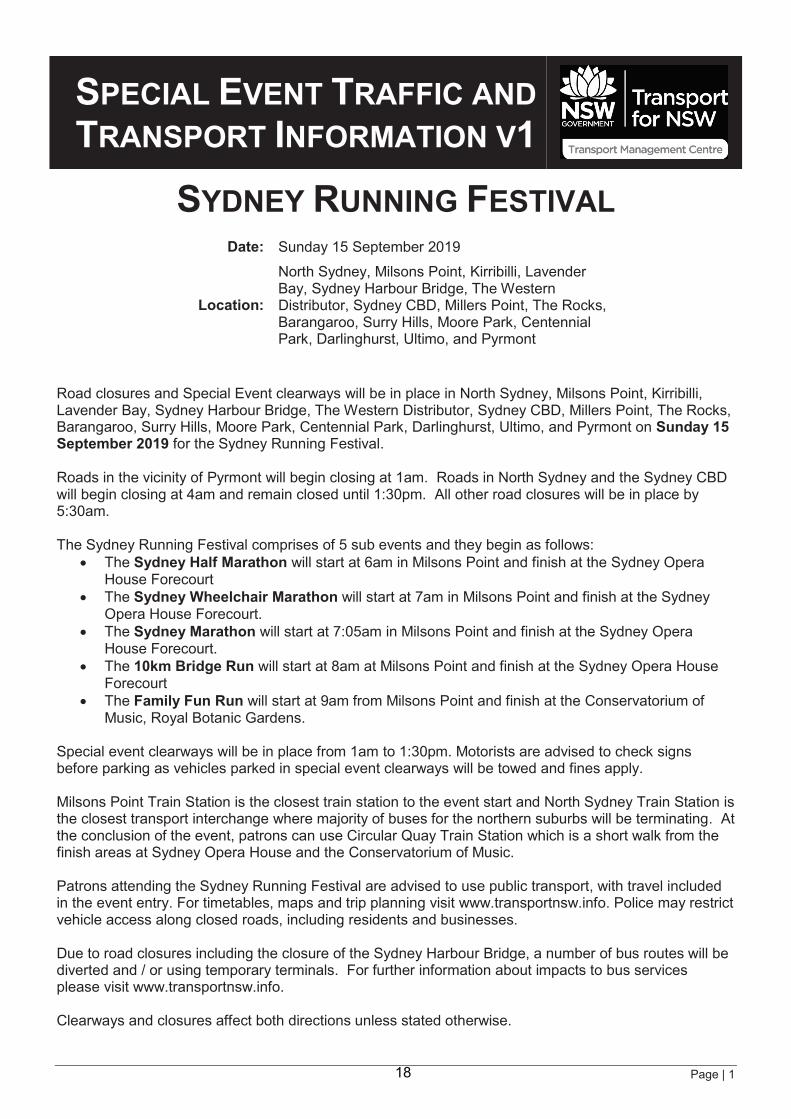
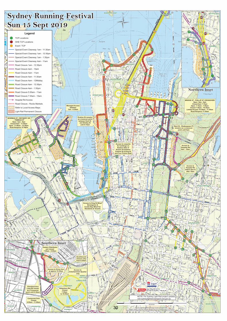
Page | 1 SPECIAL EVENT TRAFFIC AND TRANSPORT INFORMATION V1 SYDNEY RUNNING FESTIVAL Date: Sunday 15 September 2019 Location: North Sydney, Milsons Point, Kirribilli, Lavender Bay, Sydney Harbour Bridge, The Western Distributor, Sydney CBD, Millers Point, The Rocks, Barangaroo, Surry Hills, Moore Park, Centennial Park, Darlinghurst, Ultimo, and Pyrmont Road closures and Special Event clearways will be in place in North Sydney, Milsons Point, Kirribilli, Lavender Bay, Sydney Harbour Bridge, The Western Distributor, Sydney CBD, Millers Point, The Rocks, Barangaroo, Surry Hills, Moore Park, Centennial Park, Darlinghurst, Ultimo, and Pyrmont on Sunday 15 September 2019 for the Sydney Running Festival. Roads in the vicinity of Pyrmont will begin closing at 1am. Roads in North Sydney and the Sydney CBD will begin closing at 4am and remain closed until 1:30pm. All other road closures will be in place by 5:30am. The Sydney Running Festival comprises of 5 sub events and they begin as follows: x The Sydney Half Marathon will start at 6am in Milsons Point and finish at the Sydney Opera House Forecourt x The Sydney Wheelchair Marathon will start at 7am in Milsons Point and finish at the Sydney Opera House Forecourt. x The Sydney Marathon will start at 7:05am in Milsons Point and finish at the Sydney Opera House Forecourt. x The 10km Bridge Run will start at 8am at Milsons Point and finish at the Sydney Opera House Forecourt x The Family Fun Run will start at 9am from Milsons Point and finish at the Conservatorium of Music, Royal Botanic Gardens. Special event clearways will be in place from 1am to 1:30pm. Motorists are advised to check signs before parking as vehicles parked in special event clearways will be towed and fines apply. Milsons Point Train Station is the closest train station to the event start and North Sydney Train Station is the closest transport interchange where majority of buses for the northern suburbs will be terminating. At the conclusion of the event, patrons can use Circular Quay Train Station which is a short walk from the finish areas at Sydney Opera House and the Conservatorium of Music. Patrons attending the Sydney Running Festival are advised to use public transport, with travel included in the event entry. For timetables, maps and trip planning visit www.transportnsw.info. Police may restrict vehicle access along closed roads, including residents and businesses. Due to road closures including the closure of the Sydney Harbour Bridge, a number of bus routes will be diverted and / or using temporary terminals. For further information about impacts to bus services please visit www.transportnsw.info. Clearways and closures affect both directions unless stated otherwise. 18
Transcript of SYDNEY RUNNING FESTIVAL - Street... · The Sydney Running Festival comprises of 5 sub events and...
Page | 1
SPECIAL EVENT TRAFFIC AND TRANSPORT INFORMATION V1
SYDNEY RUNNING FESTIVAL
Date: Sunday 15 September 2019
Location:
North Sydney, Milsons Point, Kirribilli, Lavender Bay, Sydney Harbour Bridge, The Western Distributor, Sydney CBD, Millers Point, The Rocks, Barangaroo, Surry Hills, Moore Park, Centennial Park, Darlinghurst, Ultimo, and Pyrmont
Road closures and Special Event clearways will be in place in North Sydney, Milsons Point, Kirribilli, Lavender Bay, Sydney Harbour Bridge, The Western Distributor, Sydney CBD, Millers Point, The Rocks, Barangaroo, Surry Hills, Moore Park, Centennial Park, Darlinghurst, Ultimo, and Pyrmont on Sunday 15 September 2019 for the Sydney Running Festival. Roads in the vicinity of Pyrmont will begin closing at 1am. Roads in North Sydney and the Sydney CBD will begin closing at 4am and remain closed until 1:30pm. All other road closures will be in place by 5:30am. The Sydney Running Festival comprises of 5 sub events and they begin as follows:
The Sydney Half Marathon will start at 6am in Milsons Point and finish at the Sydney Opera House Forecourt
The Sydney Wheelchair Marathon will start at 7am in Milsons Point and finish at the Sydney Opera House Forecourt.
The Sydney Marathon will start at 7:05am in Milsons Point and finish at the Sydney Opera House Forecourt.
The 10km Bridge Run will start at 8am at Milsons Point and finish at the Sydney Opera House Forecourt
The Family Fun Run will start at 9am from Milsons Point and finish at the Conservatorium of Music, Royal Botanic Gardens.
Special event clearways will be in place from 1am to 1:30pm. Motorists are advised to check signs before parking as vehicles parked in special event clearways will be towed and fines apply. Milsons Point Train Station is the closest train station to the event start and North Sydney Train Station is the closest transport interchange where majority of buses for the northern suburbs will be terminating. At the conclusion of the event, patrons can use Circular Quay Train Station which is a short walk from the finish areas at Sydney Opera House and the Conservatorium of Music. Patrons attending the Sydney Running Festival are advised to use public transport, with travel included in the event entry. For timetables, maps and trip planning visit www.transportnsw.info. Police may restrict vehicle access along closed roads, including residents and businesses. Due to road closures including the closure of the Sydney Harbour Bridge, a number of bus routes will be diverted and / or using temporary terminals. For further information about impacts to bus services please visit www.transportnsw.info. Clearways and closures affect both directions unless stated otherwise.
18
Page | 2
EVENT CONTACTS Name: Pont3 Pty Ltd
Website: www.sydneyrunningfestival.com.au Telephone Ph: 02 9282 0414
Email: [email protected]
ROAD CLOSURES Road closures affect both directions unless stated otherwise. Roads will be progressively re-opened by the Transport Management Centre (TMC) and Police after infrastructure is removed and the roads are cleaned.
MILSONS POINT / NORTH SYDNEY / LAVENDER BAY / KIRRIBILLI
FROM 4AM TO 10AM Alfred St South between Olympic Dr and Paul St both directions Arthur St between Middlemiss St and Pacific Hwy both directions Broughton St between Burton St and Fitzroy St both directions Ennis Rd from Broughton St both directions Lavender St between Cliff St and Alfred St South both directions Lavender St*1 between Walker St and Cliff St eastbound Middlemiss St between Walker St and Pacific Hwy southbound Olympic Dr between Broughton St and Alfred St South westbound
Notes: *1 Lavender St remains open westbound to allow for residents to leave the area via Cliff St or Harbourview Cres. - Paul St, Dind St, Glen St and Cliff St all closed at Alfred St South. Residents can exit from these roads only. No access allowed.
FROM 4AM TO 11AM Alfred St South between Paul St and Lavender St both directions Burton St between Alfred St South and Broughton St both directions Fitzroy St between Alfred St South and Broughton St both directions
SYDNEY HARBOUR BRIDGE AND APPROACHES
FROM 4AM TO 11AM Bradfield Hwy / Sydney Harbour Bridge*2
all northbound and southbound lanes both directions
Cahill Expressway
between Sydney Harbour Bridge and The Domain Tunnel
both directions
Pacific Hwy between Bradfield Hwy and High St northbound Warringah Freeway
all access ramps and lanes to and from the Sydney Harbour Bridge
both directions
19
Page | 3
Western Distributor*3
all access ramps and lanes to and from the Sydney Harbour Bridge
both directions
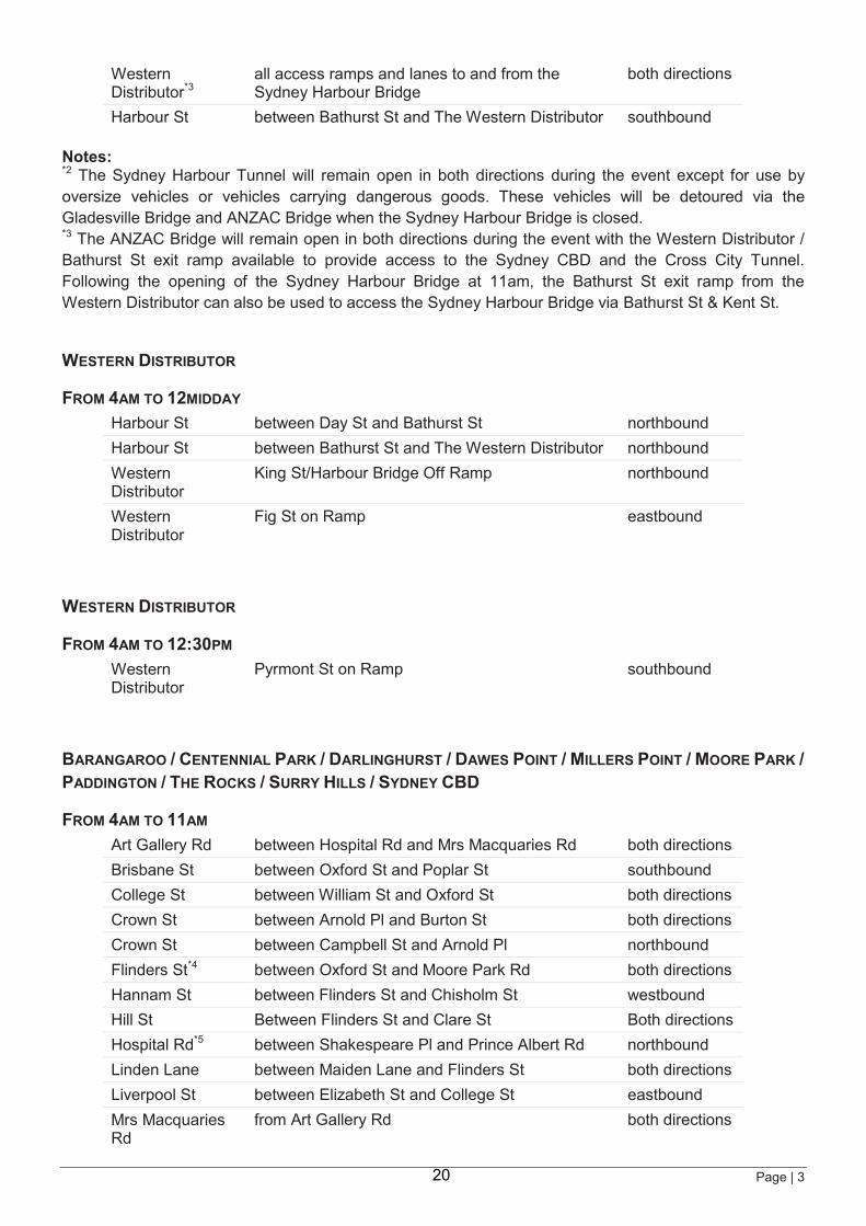
Harbour St between Bathurst St and The Western Distributor southbound Notes: *2 The Sydney Harbour Tunnel will remain open in both directions during the event except for use by oversize vehicles or vehicles carrying dangerous goods. These vehicles will be detoured via the Gladesville Bridge and ANZAC Bridge when the Sydney Harbour Bridge is closed. *3 The ANZAC Bridge will remain open in both directions during the event with the Western Distributor / Bathurst St exit ramp available to provide access to the Sydney CBD and the Cross City Tunnel. Following the opening of the Sydney Harbour Bridge at 11am, the Bathurst St exit ramp from the Western Distributor can also be used to access the Sydney Harbour Bridge via Bathurst St & Kent St.
WESTERN DISTRIBUTOR
FROM 4AM TO 12MIDDAY Harbour St between Day St and Bathurst St northbound Harbour St between Bathurst St and The Western Distributor northbound Western Distributor
King St/Harbour Bridge Off Ramp northbound
Western Distributor
Fig St on Ramp eastbound
WESTERN DISTRIBUTOR
FROM 4AM TO 12:30PM Western Distributor
Pyrmont St on Ramp southbound
BARANGAROO / CENTENNIAL PARK / DARLINGHURST / DAWES POINT / MILLERS POINT / MOORE PARK / PADDINGTON / THE ROCKS / SURRY HILLS / SYDNEY CBD
FROM 4AM TO 11AM Art Gallery Rd between Hospital Rd and Mrs Macquaries Rd both directions Brisbane St between Oxford St and Poplar St southbound College St between William St and Oxford St both directions Crown St between Arnold Pl and Burton St both directions Crown St between Campbell St and Arnold Pl northbound Flinders St*4 between Oxford St and Moore Park Rd both directions Hannam St between Flinders St and Chisholm St westbound Hill St Between Flinders St and Clare St Both directions Hospital Rd*5 between Shakespeare Pl and Prince Albert Rd northbound Linden Lane between Maiden Lane and Flinders St both directions Liverpool St between Elizabeth St and College St eastbound Mrs Macquaries Rd
from Art Gallery Rd both directions
20

Page | 4
Oxford St between College St and Darlinghurst Rd both directions Palmer St between Burton St and Oxford St both directions Patterson Ln between Bourke St and Flinders St both directions Pelican St between Poplar St and Oxford St both directions Riley St between Arnold Pl and Oxford St both directions Riley St between Campbell St and Arnold Pl northbound Short St between Bourke St and Flinders St both directions St Marys Rd between Cathedral St and Prince Albert Rd both directions Taylor St between Flinders St and Chisholm St eastbound
Notes: *4 During the closure of Flinders St, access from Albion St to South Dowling St will be maintained along Flinders St under the direction of traffic controllers. *5 Between 8am and 10am access to Hospital Rd will be via two way contra flow at Shakespeare Pl. At all other times access to Hospital Rd will be via traffic control at St Marys Rd.
FROM 4AM TO 11:30AM Albert St*6 between Phillip St and Macquarie St both directions Alfred St between Young St and Phillip St both directions Bent St between Bligh St and Macquarie St both directions Bridge St between Pitt St and Young St eastbound Bridge St*6 between Young St and Macquarie St both directions College St between Prince Albert Rd and William St both directions Conservatorium Rd
between Macquarie St and Cahill Expressway (including exit and entry ramp to Cahill Expressway)
both directions
George St*11,*12 between Essex St and Hickson Rd both directions
Hickson Rd between George Street and Park Hyatt Hotel both directions
Hunter St between Elizabeth St and Macquarie St both directions
Loftus St between Bridge St and Reiby Pl northbound
Loftus Lane Between Young St and Loftus St westbound Macquarie St between Bridge St and St James Rd both directions
Phillip Ln*6 between Phillip St and Macquarie St both directions
Phillip St between Bridge St and Hunter St both directions
Phillip St*6 between Alfred St and Bridge St both directions
Prince Albert Rd between Macquarie St and Hospital Rd both directions
Reiby Pl between Loftus St and Pitt St both directions
Shakespeare Pl*7 between Macquarie St and Hospital Rd both directions
St James Rd Between Elizabeth St and Macquarie St both directions Young St*6 between Bridge St and Alfred St both directions
Notes:
21
Page | 5
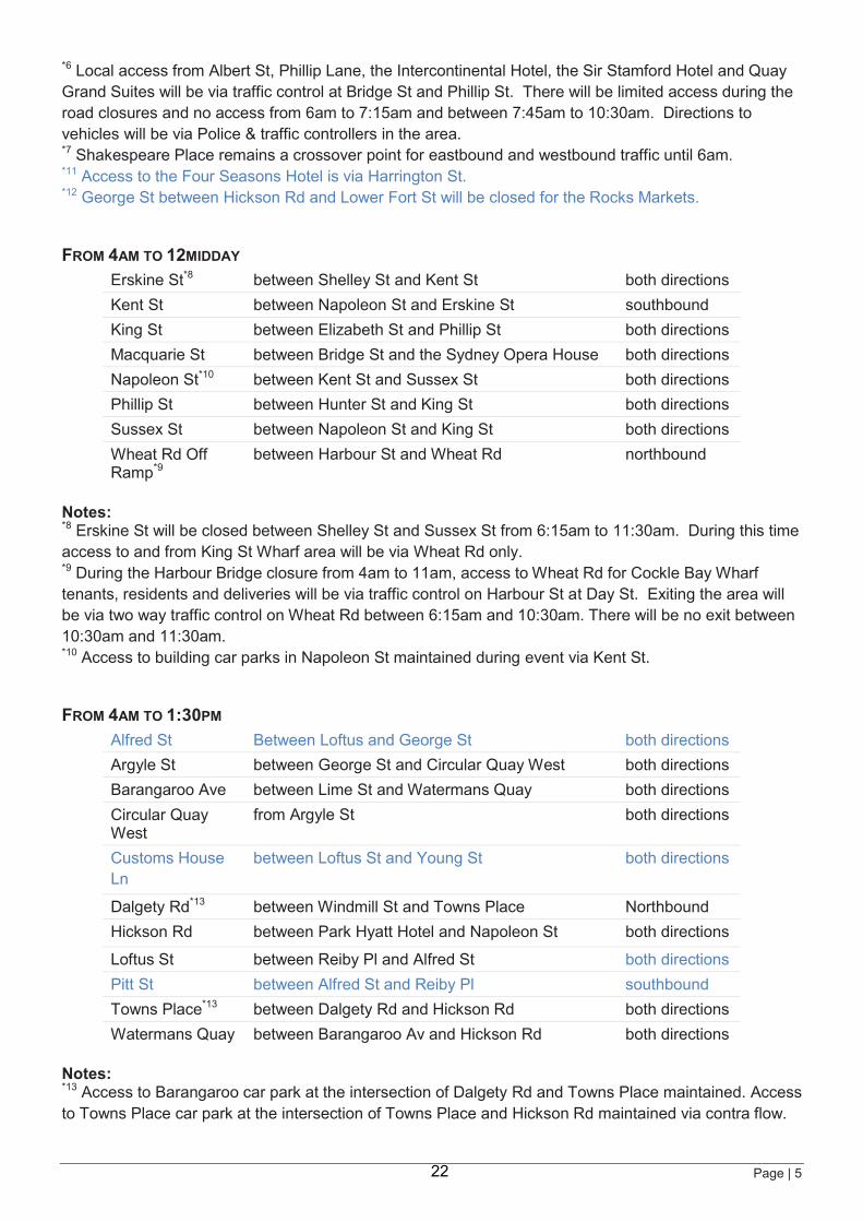
*6 Local access from Albert St, Phillip Lane, the Intercontinental Hotel, the Sir Stamford Hotel and Quay Grand Suites will be via traffic control at Bridge St and Phillip St. There will be limited access during the road closures and no access from 6am to 7:15am and between 7:45am to 10:30am. Directions to vehicles will be via Police & traffic controllers in the area. *7 Shakespeare Place remains a crossover point for eastbound and westbound traffic until 6am. *11 Access to the Four Seasons Hotel is via Harrington St. *12 George St between Hickson Rd and Lower Fort St will be closed for the Rocks Markets.
FROM 4AM TO 12MIDDAY Erskine St*8 between Shelley St and Kent St both directions Kent St between Napoleon St and Erskine St southbound King St between Elizabeth St and Phillip St both directions Macquarie St between Bridge St and the Sydney Opera House both directions Napoleon St*10 between Kent St and Sussex St both directions Phillip St between Hunter St and King St both directions Sussex St between Napoleon St and King St both directions Wheat Rd Off Ramp*9
between Harbour St and Wheat Rd northbound
Notes: *8 Erskine St will be closed between Shelley St and Sussex St from 6:15am to 11:30am. During this time access to and from King St Wharf area will be via Wheat Rd only. *9 During the Harbour Bridge closure from 4am to 11am, access to Wheat Rd for Cockle Bay Wharf tenants, residents and deliveries will be via traffic control on Harbour St at Day St. Exiting the area will be via two way traffic control on Wheat Rd between 6:15am and 10:30am. There will be no exit between 10:30am and 11:30am. *10 Access to building car parks in Napoleon St maintained during event via Kent St.
FROM 4AM TO 1:30PM Alfred St Between Loftus and George St both directions Argyle St between George St and Circular Quay West both directions Barangaroo Ave between Lime St and Watermans Quay both directions Circular Quay West
from Argyle St both directions
Customs House Ln
between Loftus St and Young St
both directions
Dalgety Rd*13 between Windmill St and Towns Place Northbound Hickson Rd between Park Hyatt Hotel and Napoleon St both directions
Loftus St between Reiby Pl and Alfred St both directions Pitt St between Alfred St and Reiby Pl southbound Towns Place*13 between Dalgety Rd and Hickson Rd both directions Watermans Quay between Barangaroo Av and Hickson Rd both directions
Notes: *13 Access to Barangaroo car park at the intersection of Dalgety Rd and Towns Place maintained. Access to Towns Place car park at the intersection of Towns Place and Hickson Rd maintained via contra flow.
22
Page | 6
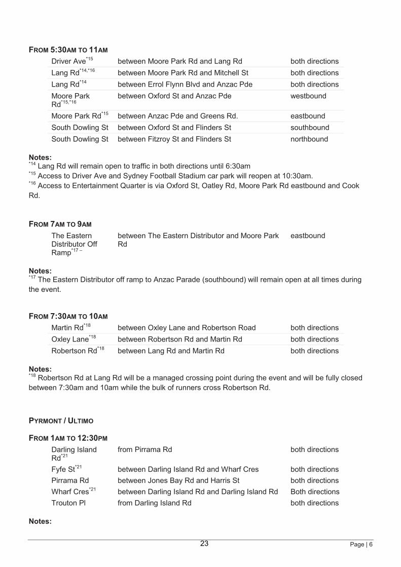
FROM 5:30AM TO 11AM Driver Ave*15 between Moore Park Rd and Lang Rd both directions Lang Rd*14,*16 between Moore Park Rd and Mitchell St both directions Lang Rd*14 between Errol Flynn Blvd and Anzac Pde both directions Moore Park Rd*15,*16
between Oxford St and Anzac Pde westbound
Moore Park Rd*15 between Anzac Pde and Greens Rd. eastbound South Dowling St between Oxford St and Flinders St southbound South Dowling St between Fitzroy St and Flinders St northbound
Notes: *14 Lang Rd will remain open to traffic in both directions until 6:30am *15 Access to Driver Ave and Sydney Football Stadium car park will reopen at 10:30am. *16 Access to Entertainment Quarter is via Oxford St, Oatley Rd, Moore Park Rd eastbound and Cook Rd.
FROM 7AM TO 9AM The Eastern Distributor Off Ramp*17 –
between The Eastern Distributor and Moore Park Rd
eastbound
Notes: *17 The Eastern Distributor off ramp to Anzac Parade (southbound) will remain open at all times during the event.
FROM 7:30AM TO 10AM Martin Rd*18 between Oxley Lane and Robertson Road both directions Oxley Lane*18 between Robertson Rd and Martin Rd both directions Robertson Rd*18 between Lang Rd and Martin Rd both directions
Notes: *18 Robertson Rd at Lang Rd will be a managed crossing point during the event and will be fully closed between 7:30am and 10am while the bulk of runners cross Robertson Rd.
PYRMONT / ULTIMO
FROM 1AM TO 12:30PM Darling Island Rd*21
from Pirrama Rd both directions
Fyfe St*21 between Darling Island Rd and Wharf Cres both directions Pirrama Rd between Jones Bay Rd and Harris St both directions Wharf Cres*21 between Darling Island Rd and Darling Island Rd Both directions Trouton Pl from Darling Island Rd both directions
Notes:
23
Page | 7
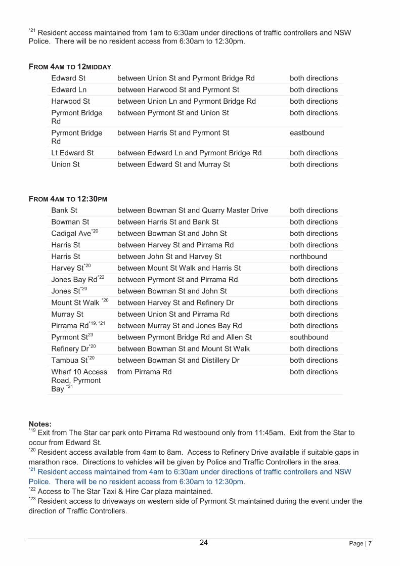
*21 Resident access maintained from 1am to 6:30am under directions of traffic controllers and NSW Police. There will be no resident access from 6:30am to 12:30pm.
FROM 4AM TO 12MIDDAY Edward St between Union St and Pyrmont Bridge Rd both directions Edward Ln between Harwood St and Pyrmont St both directions Harwood St between Union Ln and Pyrmont Bridge Rd both directions Pyrmont Bridge Rd
between Pyrmont St and Union St both directions
Pyrmont Bridge Rd
between Harris St and Pyrmont St eastbound
Lt Edward St between Edward Ln and Pyrmont Bridge Rd both directions Union St between Edward St and Murray St both directions
FROM 4AM TO 12:30PM Bank St between Bowman St and Quarry Master Drive both directions Bowman St between Harris St and Bank St both directions Cadigal Ave*20 between Bowman St and John St both directions Harris St between Harvey St and Pirrama Rd both directions Harris St between John St and Harvey St northbound Harvey St*20 between Mount St Walk and Harris St both directions Jones Bay Rd*22 between Pyrmont St and Pirrama Rd both directions Jones St*20 between Bowman St and John St both directions Mount St Walk *20 between Harvey St and Refinery Dr both directions Murray St between Union St and Pirrama Rd both directions Pirrama Rd*19, *21 between Murray St and Jones Bay Rd both directions Pyrmont St23 between Pyrmont Bridge Rd and Allen St southbound Refinery Dr*20 between Bowman St and Mount St Walk both directions Tambua St*20 between Bowman St and Distillery Dr both directions Wharf 10 Access Road, Pyrmont Bay *21
from Pirrama Rd both directions
Notes: *19 Exit from The Star car park onto Pirrama Rd westbound only from 11:45am. Exit from the Star to occur from Edward St. *20 Resident access available from 4am to 8am. Access to Refinery Drive available if suitable gaps in marathon race. Directions to vehicles will be given by Police and Traffic Controllers in the area. *21 Resident access maintained from 4am to 6:30am under directions of traffic controllers and NSW Police. There will be no resident access from 6:30am to 12:30pm. *22 Access to The Star Taxi & Hire Car plaza maintained. *23 Resident access to driveways on western side of Pyrmont St maintained during the event under the direction of Traffic Controllers.
24
Page | 8
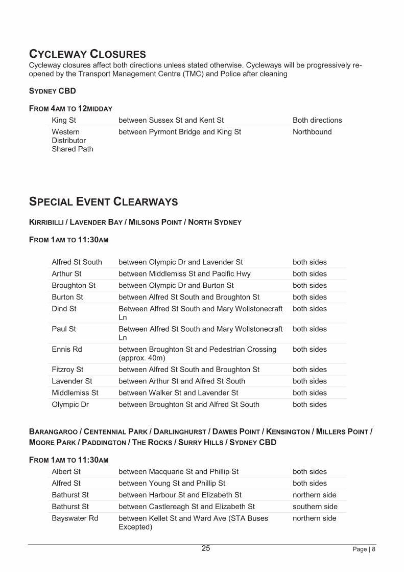
CYCLEWAY CLOSURES Cycleway closures affect both directions unless stated otherwise. Cycleways will be progressively re-opened by the Transport Management Centre (TMC) and Police after cleaning
SYDNEY CBD
FROM 4AM TO 12MIDDAY King St between Sussex St and Kent St Both directions Western Distributor Shared Path
between Pyrmont Bridge and King St Northbound
SPECIAL EVENT CLEARWAYS KIRRIBILLI / LAVENDER BAY / MILSONS POINT / NORTH SYDNEY
FROM 1AM TO 11:30AM
Alfred St South between Olympic Dr and Lavender St both sides Arthur St between Middlemiss St and Pacific Hwy both sides Broughton St between Olympic Dr and Burton St both sides Burton St between Alfred St South and Broughton St both sides Dind St Between Alfred St South and Mary Wollstonecraft
Ln both sides
Paul St Between Alfred St South and Mary Wollstonecraft Ln
both sides
Ennis Rd between Broughton St and Pedestrian Crossing (approx. 40m)
both sides
Fitzroy St between Alfred St South and Broughton St both sides Lavender St between Arthur St and Alfred St South both sides Middlemiss St between Walker St and Lavender St both sides Olympic Dr between Broughton St and Alfred St South both sides
BARANGAROO / CENTENNIAL PARK / DARLINGHURST / DAWES POINT / KENSINGTON / MILLERS POINT / MOORE PARK / PADDINGTON / THE ROCKS / SURRY HILLS / SYDNEY CBD
FROM 1AM TO 11:30AM Albert St between Macquarie St and Phillip St both sides Alfred St between Young St and Phillip St both sides Bathurst St between Harbour St and Elizabeth St northern side Bathurst St between Castlereagh St and Elizabeth St southern side Bayswater Rd between Kellet St and Ward Ave (STA Buses
Excepted) northern side
25
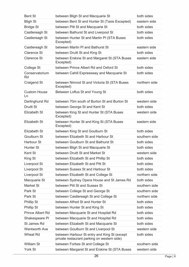
Page | 9
Bent St between Bligh St and Macquarie St both sides Bligh St between Bent St and Hunter St (Taxis Excepted) eastern side Bridge St between Pitt St and Macquarie St both sides Castlereagh St between Bathurst St and Liverpool St both sides Castlereagh St between Hunter St and Martin Pl (STA Buses
Excepted) both sides
Castlereagh St between Martin Pl and Bathurst St eastern side Clarence St between Druitt St and King St both sides Clarence St between Erskine St and Margaret St (STA Buses
Excepted) eastern side
College St between Prince Albert Rd and Oxford St both sides Conservatorium Rd
between Cahill Expressway and Macquarie St both sides
Craigend St between Nimrod St and Victoria St (STA Buses Excepted)
northern side
Custom House Ln
Between Loftus St and Young St both sides
Darlinghurst Rd between 70m south of Burton St and Burton St western side Druitt St between George St and Kent St both sides Elizabeth St between King St and Hunter St (STA Buses
Excepted) western side
Elizabeth St between Hunter St and King St (STA Buses Excepted)
eastern side
Elizabeth St between King St and Goulburn St both sides Goulburn St between Elizabeth St and Harbour St southern side Harbour St between Goulburn St and Bathurst St both sides Hunter St between Bligh St and Macquarie St both sides Kent St between Druitt St and Market St western side King St between Elizabeth St and Phillip St both sides Liverpool St between Elizabeth St and Pitt St both sides Liverpool St between Sussex St and Harbour St both sides Liverpool St between Elizabeth St and College St northern side Macquarie St between Sydney Opera House and St James Rd both sides Market St between Pitt St and Sussex St southern side Park St between College St and George St southern side Park St between Castlereagh St and College St northern side Phillip St between Alfred St and Hunter St both sides Phillip St between Hunter St and King St both sides Prince Albert Rd between Macquarie St and Hospital Rd both sides Shakespeare Pl between Macquarie St and Hospital Rd both sides St James Rd between Elizabeth St and Macquarie St both sides Wentworth Ave between Goulburn St and Liverpool St western side Wheat Rd between Harbour St entry and King St (except
private restaurant parking on western side) both sides
William St between Forbes St and College St southern side York St between Margaret St and Erskine St (STA Buses western side
26
Page | 10
Excepted) Young St between Bridge St and Alfred St both sides
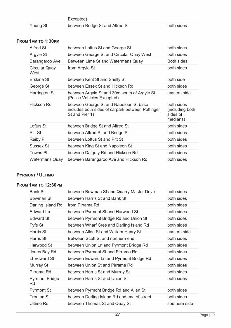
FROM 1AM TO 1:30PM Alfred St between Loftus St and George St both sides Argyle St between George St and Circular Quay West both sides Barangaroo Ave Between Lime St and Watermans Quay Both sides Circular Quay West
from Argyle St both sides
Erskine St between Kent St and Shelly St both side George St between Essex St and Hickson Rd both sides Harrington St between Argyle St and 30m south of Argyle St
(Police Vehicles Excepted) eastern side
Hickson Rd between George St and Napoleon St (also includes both sides of carpark between Pottinger St and Pier 1)
both sides (including both sides of medians)
Loftus St between Bridge St and Alfred St both sides Pitt St between Alfred St and Bridge St both sides Reiby Pl between Loftus St and Pitt St both sides Sussex St between King St and Napoleon St both sides Towns Pl between Dalgety Rd and Hickson Rd both sides Watermans Quay between Barangaroo Ave and Hickson Rd both sides
PYRMONT / ULTIMO
FROM 1AM TO 12:30PM Bank St between Bowman St and Quarry Master Drive both sides Bowman St between Harris St and Bank St both sides Darling Island Rd from Pirrama Rd both sides Edward Ln between Pyrmont St and Harwood St both sides Edward St between Pyrmont Bridge Rd and Union St both sides Fyfe St between Wharf Cres and Darling Island Rd both sides Harris St between Allen St and William Henry St eastern side Harris St Between Scott St and northern end both sides Harwood St between Union Ln and Pyrmont Bridge Rd both sides Jones Bay Rd between Pyrmont St and Pirrama Rd both sides Lt Edward St between Edward Ln and Pyrmont Bridge Rd both sides Murray St between Union St and Pirrama Rd both sides Pirrama Rd between Harris St and Murray St both sides Pyrmont Bridge Rd
between Harris St and Union St both sides
Pyrmont St between Pyrmont Bridge Rd and Allen St both sides Trouton St between Darling Island Rd and end of street both sides Ultimo Rd between Thomas St and Quay St southern side
27
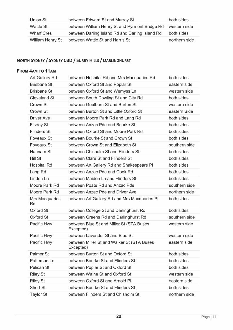
Page | 11
Union St between Edward St and Murray St both sides Wattle St between William Henry St and Pyrmont Bridge Rd western side Wharf Cres between Darling Island Rd and Darling Island Rd both sides William Henry St between Wattle St and Harris St northern side
NORTH SYDNEY / SYDNEY CBD / SURRY HILLS / DARLINGHURST
FROM 4AM TO 11AM Art Gallery Rd between Hospital Rd and Mrs Macquaries Rd both sides Brisbane St between Oxford St and Poplar St eastern side Brisbane St between Oxford St and Wemyss Ln western side Cleveland St between South Dowling St and City Rd both sides Crown St between Goulburn St and Burton St western side Crown St between Burton St and Little Oxford St eastern Side Driver Ave between Moore Park Rd and Lang Rd both sides Fitzroy St between Anzac Pde and Bourke St both sides Flinders St between Oxford St and Moore Park Rd both sides Foveaux St between Bourke St and Crown St both sides Foveaux St between Crown St and Elizabeth St southern side Hannam St between Chisholm St and Flinders St both sides Hill St between Clare St and Flinders St both sides Hospital Rd between Art Gallery Rd and Shakespeare Pl both sides Lang Rd between Anzac Pde and Cook Rd both sides Linden Ln between Maiden Ln and Flinders St both sides Moore Park Rd between Poate Rd and Anzac Pde southern side Moore Park Rd between Anzac Pde and Driver Ave northern side Mrs Macquaries Rd
between Art Gallery Rd and Mrs Macquaries Pt both sides
Oxford St between College St and Darlinghurst Rd both sides Oxford St between Greens Rd and Darlinghurst Rd southern side Pacific Hwy between Blue St and Miller St (STA Buses
Excepted) western side
Pacific Hwy between Lavender St and Blue St western side Pacific Hwy between Miller St and Walker St (STA Buses
Excepted) eastern side
Palmer St between Burton St and Oxford St both sides Patterson Ln between Bourke St and Flinders St both sides Pelican St between Poplar St and Oxford St both sides Riley St between Waine St and Oxford St western side Riley St between Oxford St and Arnold Pl eastern side Short St between Bourke St and Flinders St both sides Taylor St between Flinders St and Chisholm St northern side
28
Page | 12
SPEED ZONE REDUCTIONS SPEEDS REDUCED TO 40KM/H
SYDNEY CBD
FROM 4AM TO 12MIDDAY
Harbour St between Shelley St and Bathurst St both sides
Special Event Clearway definition You must not stop or park on a length of road where a Special Event Clearway sign applies: no exceptions. Holders of residential parking permits are not exempt. The drivers of public buses, taxis and hire cars are permitted to stop when dropping off or picking up passengers only. If your vehicle is left on a Special Event Clearway it will be towed away, usually to a nearby street, and fines will apply. Check for signage when parking.
Blue Font = Changes for TMC Communications to note
< X> AM TO <X> PM
SUN 15 SEPT
C L E A R W A Y S P E C I A L E V E N T
29
!(!(
!(!(
!(
!(
!( !(
!(
!(!(
!(
!(
!(!(
!(!(
!(
!(!(
!(!(!(
!(
!(
!(
!(
!(
!(
!(
!(
!(
!(
!(
!(
!(
!(
!(
!(
!(
!(
!(
!( !(
!(
!(
!(
!(
!(
!(
!(
!(
!(
!(
!(
!(
!(
!(
!(
!(
!(
!(
!(
!(
!(
!(
!(
!(
!(
!(
!(
!(
!(!(!(
!(
!(
!(
!(
!(
!(!(
!(!(
!(
!(
!(
!(
!(
!(
!(
!(
!(
!(
!(
!(
!(
10ABC
E172
9AB
11ABC12
13ABC
14ABC
15AB16
17
1819
20ABC
21ABC
2223
24ABCD25
26
27
28
2930
31
32
33
34
35
36
37
38
41
53
55
56
57
58
59
60
61
62
63
64AB
65ABC66
67ABC
73AB
74
68
72
89
75
76
88
79
80
81
82
156
157
158
160
161
162ABC
83ABC
70
85
39ABC
164
84AB
86AB
E 171
E 170AE 170B
E 170C
E 173
87
90ABC
91
92
94
95AB
97
98
99ABC
100AB
101
102
103
96ABC
93AB
69AB
30
40ABC
E 170D
78
107
ROZELLE
FORESTLODGE
MOORE PARK
CAMPERDOWN
REDFERN
DARLINGHURST
PADDINGTON
PYRMONT
CHIPPENDALE
DARLINGTON
SURRY HILLS
MCMAHONS POINT
BARANGAROO
DAWES POINT
MILSONS POINT
THE ROCKS
MILLERS POINT
BIRCHGROVE
GLEBE
HAYMARKET
ULTIMO
WOOLLOOMOOLOO
SYDNEY
BALMAIN
BALMAIN EAST
KIRRIBILLI
WATERMANS QUAY
!(
!(!(
!(
!(
!(
!(
!(
!(
!(
!(
!(
!(
!(
6AB
1
34
7
8AB
153
154
155
2AB
5AB
7
166
MILSONS POINT
NORTH SYDNEY
NEUTRAL BAY
KIRRIBILLI
LAVENDER BAY
!(!(
!(
!(!(
!(
!(
!(
!(
!(
!(
!(
!( !(
!(
!(
49AB
39ABC41
42AB
45AB
4748
50AB
53
54
55
46
4443
40ABC
51
CLEVELAND STREET
HARGRAVE STREET
QUEEN STREETJERSEY ROAD
DEVONSHIRE STREET
GORDON STREET
LANG
ROA
D
OXFORD STREET
PHILLIP STREET
ALBION STREET
PADDINGTON STREET
GR
EEN
SR
OAD
DARLEY ROAD
ALISON ROAD
UNDERWOOD STREET
YO
UN
GST
REE
T
OC
EAN S
TREE
T
DACEY AVENUE
GADIGAL
AVENU
E
CR
OW
N S
TREE
T
ELIZ
ABET
HST
REE
T
COOPER STREET
SUTHERLAND STREET
BAPT
IST
STR
EET
BOU
RKE
STR
EET
O'DEA AVENUE
DAN
GAR
LAN
E
SOU
TH D
OW
LIN
G S
TREE
T
FOVEAUX STREET
WALLIS STREET
BELVOIR STREET
DICKENS DRIVE
SUTHERLAND AVENUE
LEINSTER STREET
SOPHIASTREET
HARGRAVE LANE
MO
REH
EAD
STR
EET
BAPT
IST
LAN
E
GOODLET STREET
DANKS STREET
LACHLAN STREETARCHIBALD AVENUE
HUDDARTLANE
RO BERTSON
ROAD
GO
VE TTSTREET
GOODLET LANE
WINDSOR LANEPADDINGTON LANE
CENTEN
NIAL
LANE
FEDERATION WAYANZAC
PARA
DE
CO
OK
ROAD
DR
IVER AVE
NU
E
TODMAN
AVENU
E
BROM
PTON RO
AD
CARRINGTON DRIVE
PARKES
DRIVE
PAR
KE
SD
RIV
E
LOC H
AVEN
UE
EAST
ERN
DIS
TRIB
UTO
R
GRANDDRIVE
BEN
T
S TREET
OXLEY
LANE
MARTIN R
OADMOORE PARK
RANDWICK
KENSINGTON
WATERLOO
CENTENNIALPARK
REDFERN
QUEENS PARK
ZETLAND
EDGECLIFF
BONDIJUNCTION
DARLINGHURST
PADDINGTONCHIPPENDALE
SURRY HILLSWOOLLAHRA
HAYMARKET
Access to Driver Aveat approx 9:45am
Robertson RdClosed7:30am
to 10:00am
Cleveland St &Lang Rd remainas a Crossover
point until 6:30am
Southern Inset
Sydney Running FestivalSun 15 Sept 2019
Map by Transport Management Centre Eveleigh NSW. Base data © Copyright Melway Publishing 2018. Date issued: June 2019
File: \ArcGIS mxd\Marathon2019-A1P-Sydway-CBD-SECs+RoadClosures+TCPs.mxd
BRIDGE ST - PHILLIP ST CROSSOVEROpen 4am - 6am
Closed 6am 7:15amOpen 7:15am - 7:45am
Closed 7:45am - 10:30amLimited Access 10:30am - 11:30am
Road Reopens 11:30am
Access to carparksfor buildings onEastern Side of
Sussex St betweenErskine St & King St
and Four Points Hotel
Access to King St WharfBarangaroo &
Cockle Bay Wharf forResidents & Tenants
Erskine St remainsas crossover pointbetween Kent St
and Shelley Stuntil 6:15am
Access toHospital Rd8am - 10am
Access toHospital Rd
before 8am &after 10am
0 0.2 0.4 0.6 0.8 10.1
Kilometres
Northern Inset
LANG RD
Access to Entertainment Quarter
only
Access to Driver Aveat approx 10:30am
Southboundclosure onlyfrom 6:30am
WHE
AT
RD
(und
er)
PYRMONT
WESTERN
DIST
RIB
UTO
R
HARBOURST
SUSSEX
STSU
SSEX
ST
HIC
KSO
N
RO
AD
HICKSON
ROAD
HICKSON
ROAD
GEO
RGE
ST
WA
RR
ING
AH
FWY
ST
LAVENDER
ST
MIDDLEMISS STALFRED
ALFR
ED ST SO
UTH
FITZROY ST
BURTON ST
ST
BR
OU
GH
TON
CAHILL
DROLYMPIC
EXPWAY
MA
CQ
UA
RIE
ST
MA
CQ
UA
RIE
ST
MA
CQ
UA
RIE
ST
PHIL
LIP
ST
ST
PHIL
LIP
YOU
NG
STPH
ILLI
PST
Bent St - Shakespeare Plremains as a crossover
point until 6am
SHAKESPEAREPL
HO
SPIT
AL
RD
ART GALLLERY
RD
MRS M
ACQUARIES
R
DMRS
MAC
QUARI
ES
RD
ST JAMES RD PRINCEALBERT
RD
CO
LLEG
EST
CO
LLEG
EST
OXFORD
ST
OXFORDFLINDERS
ST
LIVERPOOL ST
MOORE PARK RD
FLINDERS
ST
Managed Accessbetween
1am - 6:30am
BOWMAN
ST PIRRAMA
RD
MU
RR
AY ST
PYRMONT BRIDGE RD
BRID
GE RD
BANK ST
PIR
RA
MA
RD
PIRRAMA
RD
WHARF
CR
WHARFCR
BOWMAN ST / REFINERY DR / TAMBUA ST
Open 4am - 8amClosed 8am - 11:50am
Open 11:50am - 12:30pmRoad Reopens 12:30pm
Eastern Distributorexit closed
7:00am - 9:00am
Centennial ParkClosed
4:00am - 11:00am
DARL
ING
ISLA
ND
RD
NOTE: For Sydney Light Rail project updates,visit sydneylightrail.transport.nsw.gov.au
Legend!( TCP Locations
!( SHB TCP Locations
!( Event TCP
Special Event Clearway 1am - 11:30am
Special Event Clearway 1am - 12:30pm
Special Event Clearway 1am - 1:30pm
Special Event Clearway 4am - 11am
Road Closure 1am - 12:30pm
Road Closure 4am - 10am
Road Closure 4am - 11am
Road Closure 4am - 11:30am
Road Closure 4am - 12Midday
Road Closure 4am - 12:30pm
Road Closure 4am - 1:30pm
Road Closure 5:30am - 11am
Road Closure 7:30am - 10am
Hospital Rd Access
Road Closure - Rocks Markets
Refer to Local Access Maps
Light Rail Permanent Closure
30
2019 Blackmores Sydney Running Festival - Sunday 15 September 2019Map provided by TMC Major Events, Eveleigh NSW. Base Data copyright Department of Lands NSW for TMC April 2016. Planning & Overlay of Course Ops Maps for 2019 Sydney Running Festival prepared by Julian Sanderson, Event & Sports
Projects Australia Pty Ltd on behalf of Pont3 (Organiser of the Sydney Running Festival) For Planning Purposes Only.
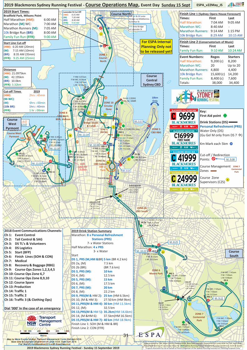
2019 Blackmores Sydney Running Festival - Course Operations Map, Event Day Sunday 15 Sept ESPA_v22May_JS
Finish 1 (SOH)HM, M, 10kBR
Finish 2 (CON) FFR Only
HM U-Turn
HM U-Turn
10km Only
M U-Turn
40
5
10
20
HW
30
15
15
10
5
20
3525
PRS 13
PRS 1
DS 2b
PRS 9
DS 10
DS 12 DS 14
DS 15
PRS 5
DS 4
DS 2a
PRS 3
DS 8
DS 6
PRS 7
PRS 11
Finish Line 1 (Sydney Opera House Forecourt)Times: First LastHalf Marathon: 7:04 AM 9:05 AMMarathon WC: 8:40 AM -Marathon Runners: 9:14 AM 1:15 PM10k Bridge Run: 8:29 AM 10:15 AM
Finish Line 2 (Conservatorium of Music)Times: First LastFamily Fun Run: 9:10 AM 10:24 AM
Event Numbers: Regos StartersHalf Marathon: 9,200 (c) 8,200Marathon WC: 20 Up to 20Marathon Runners: 4,800 4,40010k Bridge Run: 15,600 (c) 14,200Family Fun Run: 8,400 (c) 7,600Totals: 38,000 34,400
2019 Drink Station SummaryMarathon: 8 x Personal Refreshment
Stations (PRS)7- x Water Stations
Half Marathon: 4 x PRS3- x Water
StartDS 1, PRS (M,HM &BR) 5 km (BR 4.2 km)DS 2a, (M) 7.5 kmDS 2b (BR): (BR 7.6 km)DS 3, PRS (M): 10 kmDS 4, (M): 12.5 kmDS 5, PRS (M): 15 kmDS 6, (M): 17.5 kmDS 7, PRS (M): 20 kmDS 8, (M): 22.2 kmDS 9, PRS(M & HM 2): 25 km (HM 6.5km)DS 10, (M & HM 3): 27.50 km (HM 9km)DS 11,PRS(M & HM 4): 30 km (HM 11.5km)DS 12, (M): 32.5 km DS 13,PRS(M & HM 5): 35.2km(HM 14.6km)DS 14, (M &HM 6): 37.5km(HM 16.5km)DS 15,PRS(M & HM 7): 40 km (HM 18.9km)Finish Line 1: SOH (M & HM & BR)Finish Line 2: CON (FFR)
Cut-off Times 2019(HM): 2hrs : 45min(M-WC): -(M): 6hrs : 00min(10k BR): 1hrs : 40min(FFR): 1 hr : 00min
2019 Start Times: Bradfield Park, Milsons PointHalf Marathon (HM): 6:00 AMMarathon (M) WC: 7:00 AMMarathon Runners (M): 7:05 AM10k Bridge Run (BR): 8:00 AMFamily Fun Run (FFR): 9:00 AM
Distances(HM): 21.0975km(M): 42.195km(BR): 10.0km(FFR): 3.32km
HM, M & BR onto Bridge via Middlemiss & Arthur St
FFR onto Bridge at Lavender St
Key:First Aid point
Drink Stations (DS)Personal Refreshment (PRS)Water Only (DS)Gu Gel M only from DS 7
Km Mark each 5km 5
Key:First Aid point
Drink Stations (DS)Personal Refreshment (PRS)Water Only (DS)(Gu Gel M only from DS 7 )
Km Mark each 5km
Cut-off / RedirectionPoints:
Course ManagementZones
Course ZoneSupervisors (CZS)
ZONE 7 Centennial
Park
M: 9:08
4
35
ZONE 5CBD RBG
ZONE 4bCBD South
ZONE 6Moore Park
ZONE 7Centennial
Park
ZONE 9Course West
Pyrmont
ZONE 8CBD West,
BDA, Hickson
ZONE 10Circular
Quay
ZONE 1Course North
ZONE 2Bridge South
& Cahill
ZONE 4aCBD Central
ZONE 3CBD Nth
F HM: 6:15amF M-WC: 7:12amF M: 7:20amL M: 7:58amF BR: 8:12amL BR: 9:17am
F M-WC: 7:52amF M: 8:12am
L M: 10:22am
F M-WC: 7:35amF M: 7:50amL M: 9:22am
F M-WC: 7:47amF M: 8:06am
L M: 10:05am
F HM: 6:19amF M-WC: 7:59am
F M: 8:21amL M: 10:48am
F HM: 6:57amF M-WC: 8:34am
F M: 9:07amL M: 12:56pm
F HM: 6:34amF M-WC: 8:11am
F M: 8:36amL M: 11:30am
F HM: 6:44amF M-WC: 8:23amF M: 8:52amL M: 12:14pm
F M-WC: 8:16amF M: 8:44amL M: 11:51am
F M-WC: 7:41amF M: 7:59amL M: 9:46am
F HM: 6:49amF M-WC: 8:28amF M: 8:59amL M: 12:35pm
F HM: 6:27amF M-WC: 8:05amF M: 8:28amL M: 11:09am
F M-WC: 7:29amF M: 7:43amL M: 9:01am
F BR: 8:22amL BR: 9:51am
F M-WC: 7:23amF M: 7:35amL M: 8:40am
F M-WC: 7:17amF M: 7:27amL M: 8:19am
Out CPF M-WC: 7:48amF M: 8:07amL M: 10:09am
Inbound of HPF M-WC: 7:56amF M: 8:17amL M: 10:37am
Outbound of HPF M-WC: 7:15amF M: 7:24amL M: 8:10am
Into CPF M-WC: 7:25amF M: 7:38amL M: 8:48am
M: 8:25
M: 9:22
M: 10:22
M: 10:48
M: 11:14
M: 12:14
BR: 9:37
MWC Catch HM T 8:28am
M: 12:42
BR: 9:54
HM: 8:07M: 12:07
M: 11:49
M: 11:33
Start Line Cut-off(HM): 6:20 AM (20min)(M): 7:15 AM (10min)(BR): 8:35 AM (35min)(FFR): 9:25 AM (25min)
Lavender St Cut Off(HM): 6:25 AM(M): 7:20 AM(BR): 8:40 AM(FFR): 9:30 AM
4a
1
2
3
5
6
4b
7
8
9
10
Event Bridge
2018 Event Communications Channels:Ch 1: Event ControlCh 2: Tail Control & SAGCh 3: DS TL’s & VolunteersCh 4: DS LogisticsCh 5: Start (BFP)Ch 6: Finish Lines (SOH & CON)Ch 7: Medical Ch 8: Recovery & Baggage (RBG)Ch 9: Course Ops Zones 1,2,3,4,5Ch 10: Course Ops Zone 6,7Ch 11: Course Ops Zone 8,9,10Ch 12: Course SpareCh 13: ProductionCh 14: Traffic 1Ch 15: Traffic 2Ch 16: Traffic 3 (& Clothing Ops)
Dial ‘000’ In the case of an emergency
Course Central
Sydney CBD
Course South
Course North
Course West
Pyrmont
For ESPA Internal Planning Only not to be released yet!
31
32
33
34
35
36