SUR FICIAL GE OL OGIC MAP OF T HE CUL V E R S GAP … · ages of drift, distribution and types of...
24
af INTRODUCTION I ndustrial, commercial, and residential expansion in New Jersey and Pennsylvania have promoted the increased use of surficial geologic data for land-use planning, for identification, management and protection of ground water resources, siting of solid-waste-disposal sites, locating and developing sources of geologic aggregate, and delineation of geologic hazards. Surficial deposits in the Culvers Gap quadrangle are lithologically diverse, cover most of the bedrock surface, and are found in many types of landscape settings. T hey include glacial drift of late W isconsinan age, and alluvium, swamp and bog deposits, hillslope deposits, and wind-blown sediment laid down in postglacial time. C ollectively, these deposits may be as much as 340 feet (104 m) thick and they form the parent material on which soils form. T hey are defined by their lithic characteristics, stratigraphic position, location on the landscape, and further delineated by genetic and morphologic criteria. Geologic history, detailed observations on surficial materials, and a list of references are in the accompanying booklet. DESCRIPTION OF MAP UNITS M ap units denote unconsolidated deposits more than 5 feet (1.5 m) thick. C olor designations are based on M unsell Soil C olor C harts (1975), and were determined from naturally moist samples. Numbered stream-terrace deposits indicate relative ages of units based on heights of terraces in valley. L ower numbers indicate younger deposits. N umbered meltwater deposits indicate relative age of units based on morphosequence model of K oteff and Pessl (1981). L ower numbers represent older deposits. Postglacial deposits Artificial fill (Holocene) -- Rock waste, soil, gravel, sand, silt, and manufactured materials put in place by man. A s much as 25 feet (8m) thick. Not shown beneath roads and railroads where it is less than 10 feet (3m) thick. Primarily used to raise the land surface, construct earthen dams, and form a solid base for roads and railways. A lluvium (H olocene) -- Stratified, moderately- to poorly-sorted sand, gravel, silt, and minor clay and organic material deposited by the Delaware R iver and its tributaries. L ocally bouldery. A s much as 25 feet (8m) thick. I ncludes planar- to cross-bedded gravel and sand, and cross-bedded and rippled sand in channel deposits, and massive and parallel-laminated fine sand, and silt in flood-plain deposits. Alluvial-fan deposits (H olocene and late W isconsinan) -- Stratified, moderately to poorly sorted sand, gravel, and silt in fan-shaped deposits. A s much as 35 feet (11 m) thick. I ncludes massive to planar-bedded sand and gravel and minor cross-bedded channel-fill sand. B eds dip as much as 30 o toward the trunk valley. L ocally interlayered with poorly sorted, sandy-silty to sandy gravel. T ypically graded to postglacial terraces or the modern floodplain. M ore rarely graded to glacial outwash terraces. M ost fans dissected by modern streams. Str eam-ter r ace deposits (H olocene and late W isconsinan) -- Stratified, well- to moderately-sorted, massive to laminated, and minor cross-bedded fine sand and silt in terraces flanking present and late postglacial stream courses. A s much as 20 feet (6 m) thick. Overlies glacial and postglacial fluvial, planar to cross-bedded pebbly sand and gravel; as much as 10 feet (3 m) thick. In Minisink V alley (Delaware R iver valley) deposits form two distinct terraces. T he younger (Q st2) flanks recent and late postglacial stream courses and overlies early to late postglacial fluvial gravel and sand. I t lies 20 to 35 feet (6 to 11 m) above the mean annual elevation of the Delaware R iver and chiefly consists of as much as 20 feet (6 m) of fine sand and silt overlying as much as 10 feet (6 m) of pebble gravel and sand. T he older (Qst3) flanks late glacial and early postglacial stream courses and overlies glacial outwash and early postglacial fluvial sand and gravel. I t lies 40 to 50 feet above the river and consists of as much as 10 feet of fine and medium sand. Subscript "a" indicates elevation of terrace is slightly lower than similar nearby terraces. T his lower substage has not been shown to be correlative throughout M inisink V alley at map scale. T he lower elevation may be due to erosion or differences in local depositional conditions. Swamp and B og deposits (H olocene and late W isconsinan) -- Dark brown to black, partially decomposed remains of mosses, sedges, trees and other plants, and muck underlain by laminated organic-rich silt and clay. A ccumulated in kettles, shallow postglacial lakes, poorly-drained areas in uplands, and hollows in ground moraine. A s much as 25 feet (8m) thick. L ocally interbedded with alluvium and thin colluvium. T alus deposits (H olocene and late W isconsinan) -- U nsorted, nonstratified, angular boulders as much as 15 feet (4m) long; cobbles, and smaller fragments of quartzite and quartz-pebble conglomerate forming aprons over rock and till at the base of bedrock cliffs and steep hillslopes on K ittatinny M ountain. A s much as 20 feet (6m) thick. Alluvium and C olluvium undifferentiated (H olocene and late W isconsinan) -- Stratified, thinnly bedded, moderately to poorly sorted sand, silt, and minor gravel in thin sheets laid down on the floors of small upland tributaries and the lower parts of adjacent slopes. I nterlayered with and overlying silty to silty-sandy diamicton (interpreted as a mass-flow deposit). L ocally shaly. A s much as 15 feet (5 m) thick. Shale-chip colluvium (H olocene and late W isconsinan) -- T hin to thickly bedded, noncompact, poorly sorted light yellowish-brown (10Y R 6/4) to brownish-yellow (10Y R 7/6) or l i ght olive-brown (2.5Y 5/2) framework-supported, shale-chip gravel, containing as much as 80 percent unweathered to lightly weathered angular to subangular shale chips, and minor tabular pebbles and cobbles of siltstone and sandstone. I nterstitial material consists of silty sand. Forms aprons below cliffs and some steep slopes on the west side of Minisink V alley; as much as 20 feet (3 m) thick. B eds dip as much as 25 o toward valley. I n places the distal (downslope) beds are interlayered with wind-blown sand and alluvium. G raded to glacial and postglacial stream terraces in valley. Sand dunes (late W isconsinan) -- Well sorted, thinnly bedded, yellowish- brown (10Y R 5/4) and brown (10Y R 5/3) fine sand and very fine sand in low mounds and ridges on outwash deposits in M inisink V alley. A s much as 10 feet thick (3 m). Glacial Deposits Stratified Materials V alley-tr ain deposits (late W isconsinan) -- Stratified, well- to moderately- sorted sand, boulder-cobble to pebble gravel, and minor silt deposited by meltwater streams at and extending well beyond (greater than five miles ( 8 km)) the glacier's margin (fig. 1, on this plate). A s much as 100 feet (30 m) thick. T he proximal part of the deposit consists of massive to horizontally- bedded and imbricated coarse gravel and sand, and planar to tabular and trough cross-bedded, fine gravel and sand in bars, and channel-lag deposits with minor cross-bedded sand in channel-fill deposits. C lasts generally are smaller downstream, where sand is more abundant, and trough and planar cross- bedding, and graded beds are more common. B ased on well records (T able 2) overlies glacial lake deposits previously laid down in sediment-dammed proglacial lakes. I n places overlain by nonlayered, well-sorted, very fine sand and fine sand presumed to be eolian; as much as 5 feet (2 m) thick. I n M inisink V alley forms shingled sets of outwash terraces. Number after unit label indicates relative age of unit in valley. L ower numbers represent older deposits. Outwash-fan deposits (uncor r elated), Dingmans C r eek F an, A dams C reek Fan, Dry Brook Fan (late W isconsinan) -- Stratified, well- to moderately-sorted sand, cobble-pebble gravel, and minor silt deposited by meltwater streams in fan-shaped deposits at the mouth of large tributaries in Minisink V alley. A s much as 60 feet (18m) thick. Includes massive to planar-bedded sand and gravel, and minor cross-bedded and channel-fill sand. B edding generally dips towards the trunk valley by as much as 10 o . F an deposits are graded to valley-train deposits. G lacial-lake delta deposits (late W isconsinan) -- Stratified sand, gravel, and silt deposited by meltwater streams in proglacial lakes at and beyond the stagnant glacier margin. I ncludes well sorted sand and boulder-cobble to pebble gravel in planar to cross-bedded glaciofluvial topset beds that are as much as 25 feet (8m) thick. Overlies and grades into foreset beds that dip 20 o to 35 o basinward and consist of well- to moderately-sorted, rhythmically-bedded cobble-pebble and pebble gravel and sand. T hese beds grade downward and outward into ripple cross-laminated and parallel- laminated sand, silt and pebble gravel that dip less than 20 o . L ower foreset beds grade i nto gentl y inclined prodel ta bottomset beds of rhythmically-bedded, ripple cross-laminated to graded fine sand and silt with minor clay drapes. T hickness may be as much as 100 feet (30m). Number following unit label indicates relative age of unit in glacial lake basin. L ower numbers represent older deposits. Qd deposits were laid down in glacial L ake Owassa, K ittatinny V alley (fig. 1, on this plate). Numbered units refer to successively younger ice-contact deltas laid down in glacial L ake Owassa. Qod deposits were laid down in narrow sediment-dammed proglacial lakes in Paulins K ill and W allpack V alleys. Deposits are extensively kettled, and in long lake basins, topset beds are extensively aggraded in their upstream sections. N umbered units refer to successively younger valley-outwash deltas laid down in W allpack V alley. G lacial lake-bottom deposits (late W isconsinan) -- Parallel-laminated, irregularly to rhythmically-bedded silt, clay, and very fine sand; and minor cross-laminated silt, fine sand, and minor clay deposited on the floor of glacial lakes chiefly by density currents and settling of fines. A s much as 100 feet (30m) thick. I n subsurface only, form thick deposits beneath Qs deposits and modern lakes in glacial L ake Owassa basin, K ittatinny V alley. T hin deposits presumed to be in subsurface in Paulins K ill, W allpack, and Minisink V alleys. M eltwater -ter r ace deposits (late W isconsinan) -- Stratified, well- to moderately-sorted sand, cobble-pebble to pebble gravel, and minor silt deposited by meltwater streams as terraces incised in valley-train, glacial lake delta deposits, and other meltwater-terrace deposits. A s much as 20 feet (6m) thick. Sediment and bedforms similar to the downstream, distal part of valley-train deposits. I ncludes bouldery strath terraces cut in till along meltwater stream courses in uplands. M ay also include the distal part of valley-train deposits where they have cut into older valley-train deposits downvalley. K ame (late W isconsinan) -- Stratified, well- to poorly-sorted sand, boulder- to pebble-gravel, silt, and interbedded flowtill in small collapsed hills and ridges overlying till. Presumed to be ice-hole and crevasse fillings. A s much as 50 feet (15m) thick. A ttitude of bedding is highly variable. Nonstratified Materials T ill (late W isconsinan) -- Scattered patches of noncompact to slightly compact, bouldery "upper till" overlying a blanket-like compact "lower till" deposited chiefly on bedrock and locally some older pre-W isconsinan surficial deposits. Includes two varieties: 1) C ompact, unstratified, poorly sorted yellowish-brown (10Y R 5/4), light yellowish-brown (2.5Y 6/4), light olive-brown (2.5Y 5/4) to grayish-brown (2.5Y 5/2), gray (5Y 5/1) to olive-gray (5Y 5/2) noncalcareous to calcareous silt and sandy silt that typically contains 5 to 15 percent gravel. A s much as 200 feet (61 m) thick. L ocally overlain by thin, discontinuous, noncompact to slightly compact, poorly sorted, indistinctly layered yellow-brown (10Y R 5/6-8), light yellowish-brown (10Y R 6/4) sandy silt that contains as much as 30 percent gravel, and minor thin beds of well- to moderately sorted sand, gravel, and silt. C lasts chiefly consist of unweathered slate, siltstone and sandstone, dolomite, limestone, chert, minor quartzite, and quartz-pebble conglomerate. M atrix is a varied mixture of unweathered quartz, rock fragments, and silt; minor constituents include feldspar and clay. T ill derived chiefly from slate, graywacke, dolomite, and minor limestone bedrock in K ittatinny V alley, and limestone, argillaceous limestone, shale, and sandstone bedrock in M inisink V alley. 2) Slightly compact to compact, unstratified, poorly sorted yellowish-brown (10Y R 5/4), brown (10Y R 5/3, 7.5 Y R 5/4) to light olive-brown (2.5Y 5/4) and reddish-brown (5Y R 4/3) silty sand and sand containing 10 to 20 percent gravel. A s much as 50 feet (15m) thick. L ocally overlain by thin, discontinuous, noncompact, poorly sorted and layered sand and minor silty sand, similar in color to lower till, that contains as much as 35 percent gravel, and minor thin beds of well- to moderately-sorted sand and pebbly sand. C lasts chiefly consist of unweathered quartz-pebble conglomerate, quartzite, red sandstone, and red shale. M atrix is a varied mixture of quartz, rock fragments, silt, minor feldspar, and clay. T ill derived chiefly from quartzite, quartz-pebble conglomerate, and red sandstone bedrock on K ittatinny M ountain. Subscript "r" denotes areas of till generally less than 10 feet thick (3 m) with some bedrock outcrops. R ecessional mor aine (late W isconsinan) --Unstratified to poorly stratified sand, gravel, and silt deposited at the active margin of the K ittatinny and Minisink V alley ice lobes. A s much as 80 feet (24m) thick. Consists of poorly compact stony till, silty-sandy compact till, and minor lenses and layers of water-laid sand, gravel, and silt, in discontinuous, bouldery, chiefly cross-valley segmented ridges marking the former lobate glacier margin. Overlies "lower till" in uplands and locally, outwash in river valleys. L ocally named Ogdensburg-C ulvers Gap (Qom) and Dingmans Ferry (Qdfm) moraine. R ecessional M or aine (L ate W isconsinan) — Unstratified to poorly stratified sand, gravel, and silt. A s much as 30 feet (9m) thick. Consist of poorly compact, stony till, silty-sandy compact till, and minor lenses and layers of water-laid sand, gravel, and silt, in small, uncorrelated, hummocky transverse ridges. Pr e-W isconsinan glacial deposits Pr e-W isconsinan dr ift (I llinoian ?) -- Unstratified to poorly stratified sand, gravel, and silt; presumably Illinoian till. Shown only in subsurface on cross-section beneath late W isconsinan drift. B edr ock B edr ock -- E xtensive outcrops, minor regolith, and scattered erratics. B edr ock -- R egolith; chiefly rock waste on steep hillslopes and ridge crests, minor talus, scattered erratics, and a few small outcrops. Qal Qaf Qst Qst3 Qst2 Qs Qta Qac Qv Qmt Qk Qtk Qtkr Qom Qdfm Qm Qi?t r sr E xplanation of M ap Symbols 925' C ontact, dashed where inferred. Striation, measurement at tip of arrow. T he letter y denotes a younger striation based on crosscutting relationships. Drumlin, denotes long axis. Small meltwater channel. L arge meltwater channel. L arge kettle in glacial outwash or moraine. Smaller kettles on moraines are not shown. T ics on downslope side. M orainal ridge. Glacial-lake spillway with estimated elevation of its floor. Fluvial scarp, line lies at base of scarp; tics point on upslope side. A lluvial channel scroll. A ctive sand and gravel pit. I nactive sand and gravel pit. Quarry. I nactive quarry. T hin sheet of eolian sand (less than 5 feet thick). Qlb Qd Qod 1 New Jersey Geological Survey 2 U. S. Geological Survey Qed Qtq Qtqr Qsc Qfd Qfa Qfdb Catskill Mountains Highlands Hudson-Wallkill Lowland Pocono Plateau NY Pa Ma Ct NJ Piedmont Coastal Plain Kittatinny Mountain NY 0 25 miles Ice-marginal position Valley-outwash deposit Glacial lake basin Uplands Glacial lake drainage EXPLANATION 0 1 2 3 4 miles ICE-MARGINAL POSITIONS 1 Terminal moraine 6 Plymouth Ponds-Sparta 2 Minisink Hills (from Epstein, 1969) 7 Dingmans Ferry-Ogdensburg- 3 Zion Church CulversGap Moraine 4 Sand Hill Church-Franklin Grove 8 Montague-Augusta Moraine Moraine-Andover Ponds 9 Millville 5 Fairview Lake 10 Sussex Lake Millbrook Newton East Quadrangle 8 9 4 7 5 5 6 Lake Sparta Lake Stillwater Lake Newton Lake Owassa Lake Wallkill Kittatinny Valley Kittatinny Mountain Minisink Valley Wallpack Ridge N e w Jerse y Hig hla nds 4 7 6 3 3 Francis Lake Culvers Lake 2 2 Poc o n o P a l t e a u 1 1 Lake Oxford Lake Pequest Belvidere 8 9 Augusta Spillway Lake Beaver Run 10 10 D e l a w a r e R i v e r Lake Hamburg Lake North Church Lake Swartswood Lake Big Springs P e nn sylv a nia Pochuck Mountain Jenny Jump Mountain F igur e 1. Physiography of K ittatinny V alley and surrounding area. L ocation of late W isconsinan ice-margin positions of the K ittatinny and Minisink V alley ice lobes, large glacial lakes, extensive valley-outwash deposits, and Culvers Gap topographic quadrangle. M odified from C rowl (1971), E pstein (1969), M inard (1961), R idge (1983), and W itte (1997a). Kittatinny Valley 1200 1000 800 600 400 200 feet above mean sea level A bedrock Qtkr Qtk Qfa Qst2 Qst3 Qmt Qv1 Qtk Pa NJ Adams Creek fan U.S. Route 209 Delaware River Qtkr Qtk bend in section Qtkr Qtk Qs Qs Qtk Qmt Qmt Qal 48 47 Qod1 Qal Little Flat Brook Qtk Qtk 56 58 Qmt Qal Qal Qtq U.S. Route 206 Big Flat Brook Qst bend in section Qs Qtq Qtqr Qs Qtq Qtqr Qi?t Qom Qs Qlb 116 Culvers Lake proglacial outwash (may have been buried by advancing Kittatinny Valley lobe, see text) Qi?t (probable Illinoian till, see text) Qs Qom Qs Qom Lake Kemah 1200 1000 800 600 400 200 feet above mean sea level A' Qs Vertical exaggeration = 8x. Thin till (Qtkr, Qtqr), inferred to be less than 10 feet thick and rock outcrop are not differentiated on the section. Records of wells used on section are listed in Table 1 (Plate 2). Qs 6 Qal Qtq SCALE 1:24000 CONTOUR INTERVAL 20 FEET DATUM IS MEAN SEA LEVEL 1 1/2 0 1 kilometer 1 0 1 mile 1/2 1000 0 1000 2000 3000 4000 5000 6000 7000 feet SURFICIAL GEOLOGIC MAP OF THE CULVERS GAP QUADRANGLE NEW JERSEY - PENNSYLVANIA BY RON W. WITTE 1 AND JACK B. EPSTEIN 2 2005 Base from U.S. Geological Survey, 1954 Photorevised, 1971 GIS application and digital cartography by Ron W. Witte Geology mapped 1985 - 1991 Reviewed by John Peper, U.S. Geological Survey John Inners, Pennsylvania Geological Survey Karl Muessig, Richard Dalton, Dave Pasicznyk, New Jersey Geological Survey DEPARTMENT OF ENVIRONMENTAL PROTECTION LAND USE MANAGEMENT NEW JERSEY GEOLOGICAL SURVEY SURFICIAL GEOLOGIC MAP OF THE CULVERS GAP QUADRANGLE, SUSSEX COUNTY, NEW JERSEY GEOLOGIC MAP SERIES GMS 04-1, Plate 1 of 2 Prepared in cooperation with the U.S. Geological Survey National Geologic Mapping Program A' A 890' 875' 945' Qtq Qal Qf af Qs Qs Qf Qtqr Qtkr Qs Qs Qtqr Qmt Qaf Qod Qmt Qod Qod Qaf Qs Qtkr Qom Qtqr Qtkr Qs Qom Qs Qd2 Qk Qs Qom Qom Qs Qtq Qtqr Qd1 af Qtq Qs af Qal Qs Qs Qtqr Qs Qs Qk Qk Qtq Qta Qs Qtq Qk sr sr Qtq Qtqr Qtq Qk Qtq Qs sr Qs Qtqr Qta sr Qm Qs Qac Qtqr Qtqr Qtqr Qtq Qs Qs Qom Qs Qs Qtq Qaf Qv2 Qv2 Qmt Qal Qaf Qom Qdfm Qs Qaf Qst Qod2 Qmt Qdfm Qmt Qs Qod2 Qtkr Qtq Qaf Qal Qs Qal Qtk Qtkr af Qtkr Qac Qod1 Qmt Qst Qmt Qs Qal Qaf Qod1 Qaf Qst Qaf Qal Qst Qmt Qk Qk Qst Qv1 Qmt af Qal Qm Qk Qk Qmt Qv1 af Qmt Qst Qmt Qs Qal Qk Qk Qk Qod1 Qtk Qaf Qtq Qtqr Qtk Qtk Qaf Qod1 Qmt Qst Qtkr Qaf Qaf sr Qtk Qs Qtk Qaf Qaf Qod1 Qac Qod1 Qtk Qtk Qtkr Qod1 Qtk Qmt Qst3 Qst2 Qfd Qv1 Qmt Qmt Qaf Qk Qaf Qfd Qst3 Qtkr sr Qst3 Qv1 Qmt Qfa Qfa Qaf Qsc Qsc Qst2 Qs Qs Qal Qfdm Qst2 Qaf Qtk Qk Qed Qtk Qtkr Qaf Qfdb Qst3 Qv2 Qal Qal Qst2 Qk Qst3 Qaf Qst3 Qst2 Qs Qal Qtk Qs Qaf Qaf Qmt Qs Qtk Qtkr Qaf Qmt Qs Qs Qta Qs Qtqr Qk Qal Qtk Qal Qs Qs Qta Qal Qom Qs Qta Qta Qac Qs af af af Qs Qk Qk Qom Kittatinny Lake Lake Kemah Quick Qta Qs Qtqr Qs Qod1 Qtk Qtq Qs Qod1 sr sr Qod1 Qs Qmt Qs Qod2 Qmt Qal Qmt Qaf Qal Qs Qs Qv2 Qs Qs Pond LAKE OWASSA CULVERS LAKE Lake Ashroe Stony Lake r r r r r r r r r r r r r Qtkr Qaf r r r r r Minisink Valley Wallpack Valley Qal Qs Qaf Qst Qst2 Qst3 Qed Qdfm Qom Qt Qk Qfa Qfd Qv1 Qv2 Qv1 Qv2 Qod1 Qod2 Qd1 Qd2 Qod Qmt Qi?t Qta Qsc weathering and erosion C or r elation of M ap Units Paulins Kill valley Lake Owassa H olocene Pleistocene late W isconsinan pre-Wisconsinan Qlb Qt Qfdb 41 o 07'30" 74 o 45' (NEWTON WEST) 41 o 07'30" 74 o 52'30" (LAKE MASKENOZHA) 41 o 15' 74 o 52'30" (MILFORD) 41 o 15' 74 o 45' (BRANCHVILLE)
-
Upload
duongquynh -
Category
Documents
-
view
213 -
download
0
Transcript of SUR FICIAL GE OL OGIC MAP OF T HE CUL V E R S GAP … · ages of drift, distribution and types of...

af
I NT R ODUC T I ON
I ndustrial, commercial, and residential expansion in New Jersey and Pennsylvania have promoted the increased use of surficial geologic data for land-use planning, for identification, management and protection of ground water resources, siting of solid-waste-disposal sites, locating and developing sources of geologic aggregate, and delineation of geologic hazards. Surficial deposits in the Culvers Gap quadrangle are lithologically diverse, cover most of the bedrock surface, and are found in many types of landscape settings. T hey include glacial drift of late Wisconsinan age, and alluvium, swamp and bog deposits, hillslope deposits, and wind-blown sediment laid down in postglacial time. Collectively, these deposits may be as much as 340 feet (104 m) thick and they form the parent material on which soils form. T hey are defined by their lithic characteristics, stratigraphic position, location on the landscape, and further delineated by genetic and morphologic criteria. Geologic history, detailed observations on surficial materials, and a list of references are in the accompanying booklet.
DE SC R I PT I ON OF M A P UNI T S
Map units denote unconsolidated deposits more than 5 feet (1.5 m) thick. Color designations are based on Munsell Soil Color Charts (1975), and were determined from naturally moist samples. Numbered stream-terrace deposits indicate relative ages of units based on heights of terraces in valley. L ower numbers indicate younger deposits. Numbered meltwater deposits indicate relative age of units based on morphosequence model of K oteff and Pessl (1981). L ower numbers represent older deposits.
Postglacial deposits
A r tificial fill (H olocene) -- R ock waste, soil, gravel, sand, silt, and manufactured materials put in place by man. A s much as 25 feet (8m) thick. Not shown beneath roads and railroads where it is less than 10 feet (3m) thick. Primarily used to raise the land surface, construct earthen dams, and form a solid base for roads and railways.
A lluvium (H olocene) -- Stratified, moderately- to poorly-sorted sand, gravel, silt, and minor clay and organic material deposited by the Delaware R iver and its tributaries. L ocally bouldery. A s much as 25 feet (8m) thick. Includes planar- to cross-bedded gravel and sand, and cross-bedded and rippled sand in channel deposits, and massive and parallel-laminated fine sand, and silt in flood-plain deposits.
A lluvial-fan deposits (H olocene and late W isconsinan) -- Stratified, moderately to poorly sorted sand, gravel, and silt in fan-shaped deposits. A s much as 35 feet (11 m) thick. Includes massive to planar-bedded sand and gravel and minor cross-bedded channel-fill sand. B eds dip as much as 30o toward the trunk valley. L ocally interlayered with poorly sorted, sandy-silty to sandy gravel. T ypically graded to postglacial terraces or the modern floodplain. More rarely graded to glacial outwash terraces. Most fans dissected by modern streams.
Str eam-ter r ace deposits (H olocene and late W isconsinan) -- Stratified, well- to moderately-sorted, massive to laminated, and minor cross-bedded fine sand and silt in terraces flanking present and late postglacial stream courses. A s much as 20 feet (6 m) thick. Overlies glacial and postglacial fluvial, planar to cross-bedded pebbly sand and gravel; as much as 10 feet (3 m) thick. In Minisink V alley (Delaware R iver valley) deposits form two distinct terraces. T he younger (Qst2) flanks recent and late postglacial stream courses and overlies early to late postglacial fluvial gravel and sand. I t lies 20 to 35 feet (6 to 11 m) above the mean annual elevation of the Delaware R iver and chiefly consists of as much as 20 feet (6 m) of fine sand and silt overlying as much as 10 feet (6 m) of pebble gravel and sand. T he older (Qst3) flanks late glacial and early postglacial stream courses and overlies glacial outwash and early postglacial fluvial sand and gravel. I t lies 40 to 50 feet above the river and consists of as much as 10 feet of fine and medium sand. Subscript "a" indicates elevation of terrace is slightly lower than similar nearby terraces. T his lower substage has not been shown to be correlative throughout Minisink V alley at map scale. T he lower elevation may be due to erosion or differences in local depositional conditions.
Swamp and B og deposits (H olocene and late W isconsinan) -- Dark brown to black, partially decomposed remains of mosses, sedges, trees and other plants, and muck underlain by laminated organic-rich silt and clay. A ccumulated in kettles, shallow postglacial lakes, poorly-drained areas in uplands, and hollows in ground moraine. A s much as 25 feet (8m) thick. L ocally interbedded with alluvium and thin colluvium.
T alus deposits (H olocene and late W isconsinan) -- Unsorted, nonstratified, angular boulders as much as 15 feet (4m) long; cobbles, and smaller fragments of quartzite and quartz-pebble conglomerate forming aprons over rock and till at the base of bedrock cliffs and steep hillslopes on K ittatinny Mountain. A s much as 20 feet (6m) thick.
A lluvium and C olluvium undiffer entiated (H olocene and late W isconsinan) -- Stratified, thinnly bedded, moderately to poorly sorted sand, silt, and minor gravel in thin sheets laid down on the floors of small upland tributaries and the lower parts of adjacent slopes. I nterlayered with and overlying silty to silty-sandy diamicton (interpreted as a mass-flow deposit). L ocally shaly. A s much as 15 feet (5 m) thick.
Shale-chip colluvium (H olocene and late W isconsinan) -- T hin to thickly bedded, noncompact, poorly sorted light yellowish-brown (10Y R 6/4) to brownish-yellow (10Y R 7/6) or light olive-brown (2.5Y 5/2) framework-supported, shale-chip gravel, containing as much as 80 percent unweathered to lightly weathered angular to subangular shale chips, and minor tabular pebbles and cobbles of siltstone and sandstone. Interstitial material consists of silty sand. Forms aprons below cliffs and some steep slopes on the west side of Minisink V alley; as much as 20 feet (3 m) thick. B eds dip as much as 25o toward valley. In places the distal (downslope) beds are interlayered with wind-blown sand and alluvium. Graded to glacial and postglacial stream terraces in valley.
Sand dunes (late W isconsinan) -- Well sorted, thinnly bedded, yellowish-brown (10Y R 5/4) and brown (10Y R 5/3) fine sand and very fine sand in low mounds and ridges on outwash deposits in Minisink V alley. A s much as 10 feet thick (3 m).
G lacial Deposits
Stratified Materials
V alley-train deposits (late W isconsinan) -- Stratified, well- to moderately-sorted sand, boulder-cobble to pebble gravel, and minor silt deposited by meltwater streams at and extending well beyond (greater than five miles ( 8 km)) the glacier's margin (fig. 1, on this plate). As much as 100 feet (30 m) thick. The proximal part of the deposit consists of massive to horizontally-bedded and imbricated coarse gravel and sand, and planar to tabular and trough cross-bedded, fine gravel and sand in bars, and channel-lag deposits with minor cross-bedded sand in channel-fill deposits. Clasts generally are smaller downstream, where sand is more abundant, and trough and planar cross-bedding, and graded beds are more common. Based on well records (Table 2) overlies glacial lake deposits previously laid down in sediment-dammed proglacial lakes. In places overlain by nonlayered, well-sorted, very fine sand and fine sand presumed to be eolian; as much as 5 feet (2 m) thick. In Minisink V alley forms shingled sets of outwash terraces. Number after unit label indicates relative age of unit in valley. L ower numbers represent older deposits.
Outwash-fan deposits (uncor r elated), Dingmans C r eek F an, A dams C r eek F an, Dr y B r ook F an (late W isconsinan) -- Stratified, well- to moderately-sorted sand, cobble-pebble gravel, and minor silt deposited by meltwater streams in fan-shaped deposits at the mouth of large tributaries in Minisink V alley. A s much as 60 feet (18m) thick. Includes massive to planar-bedded sand and gravel, and minor cross-bedded and channel-fill sand. B edding generally dips towards the trunk valley by as much as 10o. Fan deposits are graded to valley-train deposits.
G lacial-lake delta deposits (late W isconsinan) -- Stratified sand, gravel, and silt deposited by meltwater streams in proglacial lakes at and beyond the stagnant glacier margin. Includes well sorted sand and boulder-cobble to pebble gravel in planar to cross-bedded glaciofluvial topset beds that are as much as 25 feet (8m) thick. Overlies and grades into foreset beds that dip 20o to 35o basinward and consist of well- to moderately-sorted, rhythmically-bedded cobble-pebble and pebble gravel and sand. T hese beds grade downward and outward into ripple cross-laminated and parallel-laminated sand, silt and pebble gravel that dip less than 20o. L ower foreset beds grade into gently inclined prodelta bottomset beds of rhythmically-bedded, ripple cross-laminated to graded fine sand and silt with minor clay drapes. T hickness may be as much as 100 feet (30m). Number following unit label indicates relative age of unit in glacial lake basin. L ower numbers represent older deposits.
Qd deposits were laid down in glacial L ake Owassa, K ittatinny V alley (fig. 1, on this plate). Numbered units refer to successively younger ice-contact deltas laid down in glacial L ake Owassa. Qod deposits were laid down in narrow sediment-dammed proglacial lakes in Paulins K ill and Wallpack V alleys. Deposits are extensively kettled, and in long lake basins, topset beds are extensively aggraded in their upstream sections. Numbered units refer to successively younger valley-outwash deltas laid down in Wallpack V alley.
G lacial lake-bottom deposits (late W isconsinan) -- Parallel-laminated, irregularly to rhythmically-bedded silt, clay, and very fine sand; and minor cross-laminated silt, fine sand, and minor clay deposited on the floor of glacial lakes chiefly by density currents and settling of fines. A s much as 100 feet (30m) thick. In subsurface only, form thick deposits beneath Qs deposits and modern lakes in glacial L ake Owassa basin, K ittatinny V alley. T hin deposits presumed to be in subsurface in Paulins K ill, Wallpack, and Minisink V alleys.
M eltwater -ter r ace deposits (late W isconsinan) -- Stratified, well- to moderately-sorted sand, cobble-pebble to pebble gravel, and minor silt deposited by meltwater streams as terraces incised in valley-train, glacial lake delta deposits, and other meltwater-terrace deposits. A s much as 20 feet (6m) thick. Sediment and bedforms similar to the downstream, distal part of valley-train deposits. Includes bouldery strath terraces cut in till along meltwater stream courses in uplands. May also include the distal part of valley-train deposits where they have cut into older valley-train deposits downvalley.
K ame (late W isconsinan) -- Stratified, well- to poorly-sorted sand, boulder- to pebble-gravel, silt, and interbedded flowtill in small collapsed hills and ridges overlying till. Presumed to be ice-hole and crevasse fillings. A s much as 50 feet (15m) thick. A ttitude of bedding is highly variable.
Nonstratified Materials
T ill (late W isconsinan) -- Scattered patches of noncompact to slightly compact, bouldery "upper till" overlying a blanket-like compact "lower till" deposited chiefly on bedrock and locally some older pre-W isconsinan surficial deposits. Includes two varieties:
1) Compact, unstratified, poorly sorted yellowish-brown (10Y R 5/4), light yellowish-brown (2.5Y 6/4), light olive-brown (2.5Y 5/4) to grayish-brown (2.5Y 5/2), gray (5Y 5/1) to olive-gray (5Y 5/2) noncalcareous to calcareous silt and sandy silt that typically contains 5 to 15 percent gravel. A s much as 200 feet (61 m) thick. L ocally overlain by thin, discontinuous, noncompact to slightly compact, poorly sorted, indistinctly layered yellow-brown (10Y R 5/6-8), light yellowish-brown (10Y R 6/4) sandy silt that contains as much as 30 percent gravel, and minor thin beds of well- to moderately sorted sand, gravel, and silt. Clasts chiefly consist of unweathered slate, siltstone and sandstone, dolomite, limestone, chert, minor quartzite, and quartz-pebble conglomerate. Matrix is a varied mixture of unweathered quartz, rock fragments, and silt; minor constituents include feldspar and clay. T ill derived chiefly from slate, graywacke, dolomite, and minor limestone bedrock in K ittatinny V alley, and limestone, argillaceous limestone, shale, and sandstone bedrock in Minisink V alley.
2) Slightly compact to compact, unstratified, poorly sorted yellowish-brown (10Y R 5/4), brown (10Y R 5/3, 7.5 Y R 5/4) to light olive-brown (2.5Y 5/4) and reddish-brown (5Y R 4/3) silty sand and sand containing 10 to 20 percent gravel. A s much as 50 feet (15m) thick. L ocally overlain by thin, discontinuous, noncompact, poorly sorted and layered sand and minor silty sand, similar in color to lower till, that contains as much as 35 percent gravel, and minor thin beds of well- to moderately-sorted sand and pebbly sand. Clasts chiefly consist of unweathered quartz-pebble conglomerate, quartzite, red sandstone, and red shale. Matrix is a varied mixture of quartz, rock fragments, silt, minor feldspar, and clay. T ill derived chiefly from quartzite, quartz-pebble conglomerate, and red sandstone bedrock on K ittatinny Mountain.
Subscript "r" denotes areas of till generally less than 10 feet thick (3 m) with some bedrock outcrops.
R ecessional mor aine (late W isconsinan) --Unstratified to poorly stratified sand, gravel, and silt deposited at the active margin of the K ittatinny and Minisink V alley ice lobes. A s much as 80 feet (24m) thick. Consists of poorly compact stony till, silty-sandy compact till, and minor lenses and layers of water-laid sand, gravel, and silt, in discontinuous, bouldery, chiefly cross-valley segmented ridges marking the former lobate glacier margin. Overlies " lower till" in uplands and locally, outwash in river valleys. L ocally named Ogdensburg-Culvers Gap (Qom) and Dingmans Ferry (Qdfm) moraine.
R ecessional M or aine (L ate W isconsinan) — Unstratified to poorly stratified sand, gravel, and silt. A s much as 30 feet (9m) thick. Consist of poorly compact, stony till, silty-sandy compact till, and minor lenses and layers of water-laid sand, gravel, and silt, in small, uncorrelated, hummocky transverse ridges.
Pr e-W isconsinan glacial deposits
Pr e-W isconsinan dr ift (I llinoian ?) -- Unstratified to poorly stratified sand, gravel, and silt; presumably I llinoian till. Shown only in subsurface on cross-section beneath late Wisconsinan drift.
B edr ock
B edr ock -- E xtensive outcrops, minor regolith, and scattered erratics.
B edr ock -- R egolith; chiefly rock waste on steep hillslopes and ridge crests, minor talus, scattered erratics, and a few small outcrops.
Qal
Qaf
Qs tQs t3
Qs t2
Qs
Qta
Qac
Qv
Qmt
Qk
Qtk Qtkr
Qom Qdfm
Qm
Qi? t
r
s r
E xplanation of M ap Symbols
925'
Contact, dashed where inferred.
Striation, measurement at tip of arrow. T he letter y denotes a younger striation based on crosscutting relationships.
Drumlin, denotes long axis.
Small meltwater channel.
L arge meltwater channel.
L arge kettle in glacial outwash or moraine. Smaller kettles on moraines are not shown. T ics on downslope side.
Morainal ridge.
Glacial-lake spillway with estimated elevation of its floor.
Fluvial scarp, line lies at base of scarp; tics point on upslope side.
A lluvial channel scroll.
A ctive sand and gravel pit.
Inactive sand and gravel pit.
Quarry.
Inactive quarry.
T hin sheet of eolian sand (less than 5 feet thick).
Qlb
Qd Qod
1 New Jersey Geological Survey2 U. S. Geological Survey
Qed
Qtq Qtqr
Qsc
Qfd Qfa Qfdb
Catskill Mountains
Highlan
ds
Huds
on-W
allkil
lLo
wla
nd
Pocon
o Plat
eau
NYPa
Ma
Ct
NJ
Piedmont
Coastal P
lain
Kittatinny
Mountain
NY
0 25 miles
Ice-marginal position
Valley-outwash deposit
Glacial lake basin
Uplands
Glacial lake drainage
EXPLANATION
0 1 2 3 4miles
ICE-MARGINAL POSITIONS
1 Terminal moraine 6 Plymouth Ponds-Sparta2 Minisink Hills (from Epstein, 1969) 7 Dingmans Ferry-Ogdensburg-3 Zion Church CulversGap Moraine4 Sand Hill Church-Franklin Grove 8 Montague-Augusta Moraine Moraine-Andover Ponds 9 Millville5 Fairview Lake 10 Sussex
LakeMillbrook
Newton EastQuadrangle
8
9
4
75
56
Lake Sparta
LakeStillwater
LakeNewton
LakeOwassa
Lake Wallkill
Kittatinny
Valley
Kittatinny
Mountain
Minisink Valley
Wal
lpac
kRi
dge
New Jerse y H
ighland
s
4
7
6
33
FrancisLake
Culvers Lake
2
2
Pocono
Palte
au
1
1
Lake Oxford
Lake Pequest
Belvidere
8
9
AugustaSpillway
LakeBeaverRun
10
10
De l
aware
R
i v er
LakeHamburg
LakeNorthChurch
LakeSwartswood
Lake BigSprings
Pennsylva
nia
Poch
uck
M
ount
ain
Jenn
y Jum
p Mou
ntain
F igur e 1. Physiography of K ittatinny V alley and surrounding area. L ocation of late Wisconsinan ice-margin positions of the K ittatinny and Minisink V alley ice lobes, large glacial lakes, extensive valley-outwash deposits, and Culvers Gap topographic quadrangle. Modified from Crowl (1971), E pstein (1969), Minard (1961), R idge (1983), and Witte (1997a).
Kittatinny Valley
1200
1000
800
600
400
200
feet
abo
ve m
ean
sea
leve
l
A
bedrock
Qtkr
Qtk
Qfa
Qst2Qst3
Qmt Qv1
Qtk
Pa NJ
Ada
ms
Cre
ek fa
n
U.S
. Rou
te 2
09
Del
awar
e R
iver
Qtkr
Qtk
bend
inse
ctio
n
Qtkr
Qtk
Qs Qs
Qtk
Qmt
QmtQal
4847 Qod1 Qal
Littl
e Fl
at B
rook
Qtk
Qtk
56
58
Qmt
QalQal
Qtq
U.S
. Rou
te 2
06 Big
Flat
Bro
ok
Qst
bend
inse
ctio
n
Qs
Qtq
Qtqr Qs
Qtq
Qtqr
Qi?t
Qom
Qs
Qlb
116Cul
vers
Lak
e
proglacial outwash(may have been buried by advancing Kittatinny Valley lobe, see text)
Qi?t (probable Illinoian till, see text)
Qs QomQs
Qom
Lake
Kem
ah
1200
1000
800
600
400
200
feet
abo
ve m
ean
sea
leve
l
A'
Qs
Vertical exaggeration = 8x. Thin till (Qtkr, Qtqr), inferred to be less than 10 feet thick and rock outcrop are not differentiated on the section. Records of wells used on section are listed in Table 1 (Plate 2).
Qs
6Qal
Qtq
SCALE 1:24000
CONTOUR INTERVAL 20 FEETDATUM IS MEAN SEA LEVEL
1 1/2 0 1 kilometer
1 0 1 mile1/2
1000 0 1000 2000 3000 4000 5000 6000 7000 feet
SUR F I C I A L G E OL OG I C M A P OF T H E C UL V E R S G A P QUA DR A NG L ENE W J E R SE Y - PE NNSY L V A NI A
B Y
R ON W . W I T T E 1
A ND J A C K B . E PST E I N 2
2005
Base from U.S. Geological Survey, 1954Photorevised, 1971GIS application and digital cartography by Ron W. Witte
Geology mapped 1985 - 1991Reviewed by John Peper, U.S. Geological Survey
John Inners, Pennsylvania Geological SurveyKarl Muessig, Richard Dalton, Dave Pasicznyk,
New Jersey Geological Survey
DEPARTMENT OF ENVIRONMENTAL PROTECTIONLAND USE MANAGEMENTNEW JERSEY GEOLOGICAL SURVEY
SURFICIAL GEOLOGIC MAP OF THE CULVERS GAPQUADRANGLE, SUSSEX COUNTY, NEW JERSEYGEOLOGIC MAP SERIES GMS 04-1, Plate 1 of 2
Prepared in cooperation with theU.S. Geological Survey
National Geologic Mapping Program
A '
A
890'
875'
945'
Qtq
Qal
Qf
af
Qs
Qs
Qf
Qtqr
Qtkr
Qs
Qs
Qtqr
Qmt
Qaf
Qod
Qmt
QodQod
QafQs
Qtkr
Qom
Qtqr
Qtkr
Qs
Qom
Qs
Qd2
QkQs
Qom
Qom
Qs
Qtq
Qtqr
Qd1
af
Qtq
Qs
af
Qal
Qs
Qs
Qtqr
Qs
Qs
Qk
Qk
Qtq
Qta
Qs
Qtq
Qksr
sr
QtqQtqr
Qtq
Qk
QtqQs
sr
Qs
Qtqr
Qta
sr
Qm
Qs
Qac
QtqrQtqr
QtqrQtq
Qs
Qs
Qom
Qs
Qs
Qtq
Qaf
Qv2
Qv2
Qmt
Qal
Qaf
Qom
Qdfm
Qs
Qaf
Qst
Qod2
Qmt
Qdfm
Qmt
Qs
Qod2
QtkrQtq
Qaf
Qal
Qs
Qal
Qtk
Qtkr
af
Qtkr
Qac
Qod1
Qmt
Qst
Qmt
Qs
Qal
QafQod1
Qaf
Qst
Qaf
QalQst
Qmt
Qk
QkQst
Qv1
Qmt
af
Qal
Qm
Qk
Qk
Qmt
Qv1
af
Qmt
Qst
Qmt
Qs
Qal
Qk
Qk
Qk
Qod1
Qtk
Qaf
Qtq
Qtqr
Qtk
Qtk
Qaf
Qod1
Qmt
Qst
Qtkr
Qaf
Qaf
sr
Qtk
QsQtk
Qaf
Qaf
Qod1
Qac
Qod1 Qtk
Qtk
Qtkr
Qod1
Qtk
Qmt
Qst3
Qst2
Qfd
Qv1
Qmt
Qmt
Qaf
Qk
Qaf
Qfd
Qst3
Qtkr
srQst3
Qv1
Qmt
Qfa
QfaQaf
Qsc
Qsc
Qst2
Qs
Qs
Qal
QfdmQst2
QafQtk
Qk
Qed
Qtk
Qtkr Qaf
Qfdb
Qst3
Qv2
Qal
Qal
Qst2
Qk
Qst3
Qaf
Qst3
Qst2
Qs
Qal
Qtk
QsQaf
Qaf
Qmt
Qs
Qtk
Qtkr
Qaf
Qmt
Qs
Qs
QtaQs
Qtqr
Qk
Qal
Qtk
Qal
Qs
Qs
Qta
Qal
Qom
QsQta
QtaQac
Qs
af
af
af
Qs
Qk
Qk
Qom
Kittatinny
Lake
LakeKemah
Qui
ck
Qta
Qs
QtqrQs
Qod1
Qtk
Qtq
Qs
Qod1
sr
sr
Qod1
Qs
Qmt
QsQod2
Qmt
Qal
QmtQaf
Qal
Qs
Qs
Qv2
Qs
Qs
Pond
LAKE
OWASSA
CULVERS LAKE
Lake
Ashr
oe
Ston
y Lake
r
r
r
rr
r
r
r
r
r
r
r
r
Qtkr
Qaf
r
r
r
r
r
MinisinkValley
WallpackValley
QalQs
QafQstQst2
Qst3
Qed
Qdfm Qom
Qt
QkQfa
Qfd
Qv1
Qv2
Qv1
Qv2
Qod1
Qod2
Qd1
Qd2
Qod
Qmt
Qi?t
QtaQsc
weathering and erosion
C or r elation of M ap Units
PaulinsKill valley
LakeOwassa
Hol
ocen
eP
leis
toce
ne
late
Wis
con
sin
anpr
e-W
isco
nsin
an
Qlb
Qt
Qfdb
41o07'30"74o45'(NEWTON WEST)
41o07'30"74o52'30"
(LAK
E M
ASKE
NO
ZHA)
41o15'74o52'30" (MILFORD) 41o15'
74o45'
(BR
ANC
HVI
LLE)

Explanation of Map Symbols
B edrock surface contour - Shown where rock surface is buried beneath thick glacial sediment. A pproximately located, shows altitude of rock surface in feet above sea level. Contour interval is 50 feet. Hachures indicate closed depression. Contours terminate where bedrock is less than 20 feet from surface.
L ocation of well or boring listed in T able 1.12
550
700
800
800
750
700
500
550
600
650600
750
70
065
0
800
700
750
650
800
700
750
700
550
550
600
600600
450
400
500
550
600
600
600
250
300
350
350
300
25
0
3
1
2
4
5
6
7
8
9
10
1112
14
13
20
18
19
20
20
20
15
16
17
44
45
46
63
6564
146
144
141
143
145
142
137
140
139
138
134135
136
133132
87
94
115
116
86
88
95
9392
81
91
20
82
83
84 89
90
60 61
62
58
59
53
54
55
56
57
52
51
50
4948
47
43
74
75
78
77 76
72
73
71
42
37
36
38
4041
39
35
31
34
33
32
30
29
20
25
26
27
28
66
67
68
69
70
79
80
104103
102
96
101 100
20
9798
99 105106
107
108
109
110
111112 113
114
20
20
20
20
120
128
121
122
123
124 125
126
127
131
130
550
T able 1. R ecords of selected wells in the C ulvers G ap quadrangle, S ussex C ounty, New J ersey, and P ike C ounty, P ennsylvania. T he d wells were drilled for private and public water supply, and exploration. Wells with a NJ DE P permit number are from the files of the B ureau of Water Allocation, Divis ion of Water R esources , New J ersey Department of E nvironmental P rotection. Well records from Davis (1989) are noted in the table as "P ike" followed by an identification number that was used in that report. T he location of wells lis ted with NJ DE P are based on property maps , and they are generally accurate to 500 feet of their actual location. A few geologic records were compiled from New J ersey G eological S urvey P ermanent Notes , which are on file at the New J ersey G eological S urvey, P O B ox 427, T renton, New J ersey. "? " indicates incomplete geologic log.
1 21-915 15 0-241 sand and s ilts tone 241-285 bluestone 2 21-90 20 0-80 depth of cas ing 3 21-155 20 0-60 depth of cas ing 4 21-611 30 0-179 depth of cas ing 5 P ike 163 -- 0-40 depth of cas ing 6 21-1016 30 0-180 depth of cas ing 7 21-2071 30 0-171 depth of cas ing 8 21-6539 100 0-185 sand, clay, and gravel 185-205 sand and gravel 9 21-627 8 0-22 depth of cas ing 22-80 rock 10 21-1292 20 0-37 depth of cas ing 37-141 rock 11 P ike 165 -- 0-130 depth of cas ing 12 P ike 170 -- 0-170 depth of cas ing 13 P ike 167 15 0-95 depth of cas ing 14 P ike 234 15 0-40 depth of cas ing 15 P ike 235 50 0-180 depth of cas ing 16 P ike 419 20 0-80 depth of cas ing 17 P ike 236 20 0-165 depth of cas ing 18 21-1203 13 0-131 depth of cas ing 131-258 rock 19 21-586 40 0-60 depth of cas ing 60-420 rock 20 21-3343 21 0-25 hardpan and boulders 25-35 sand, gravel, and water 35-47 broken rock, limestone 47-124 lime rock 124-137 sandstone 21 21-6071 6 0-18 gravel 18-145 limestone 22 21-5176 1 0-60 clay, gravel, and boulders 60-105 clay 105-120 clay and gravel 120-395 shale 395-415 hard red sandstone 415-450 blue shale 23 21-65 9 0-45 glacial drift 45-70 limestone 70-110 limestone and limey shale 110-155 limestone 24 21-5283 60 0-30 bouldery overburden 30-105 limestone 25 21-5152 20 0-58 overburden with big boulders 58-123 red rock 26 21-5113 20 0-50 overburden with clay, gravel, and boulders 50-123 red, blue, and yellow shale 27 22-5569 5 0-20 overburden 20-175 red rock 28 21-5282 35 0-15 overburden 15-250 red rock 29 21-52 15 0-23 hardpan 23-131 pink rock 30 21-5653 20 0-30 boulders and gravel 30-105 red rock 31 21-2486 5 0-45 overburden 45-106 red shale 32 21-5976 20 0-40 overburden 40-125 red rock 33 21-4932 25 0-35 clay and gravel 35-180 s late rock 34 21-6323 20 0-50 sand and gravel 50-188 limestone 35 21-6510 3 0-8 large gravel 8- 301 red rock 36 21-503 20 0-25 hardpan and boulders 25-50 sand, gravel, and water 50-60 quicksand 60-94 red rock 37 21-5569 5 0-20 overburden 20-175 red rock 38 21-4637 10 0-30 large gravel and loam 30-208 red rock 39 21-249 25 0-16 depth of cas ing 16-211 rock 40 21-600 45 0-35 hardpan, boulders , and gravel 35-100 red sandstone 100-120 blue rock 120-125 red sandstone 41 21-1934 12 0-123 clay and sand 123-132 clay 132-238 s late 42 21-6330 50 0-10 gravel and sand 10-270 red rock 43 21-2380 4 0-25 hardpan and boulders 25-50 hardpan 50-75 large boulders and hardpan 75-100 clay, sand, gravel, and water 100-110 sand and water 110-225 red shale 225-233 green shale 44 21-3364 18 0-20 hardpan and boulders 20-30 boulders , clay, and gravel 30-40 gravel and water 40-50 sand, water, and clay 50-60 blue clay 60-70 blue shale 70-80 shale with clay pockets 80-129 hard gray rock 129-162 blue shale 162-175 soft black shale 45 21-6142 8 0-78 overburden 78-208 shale 46 21-6491 20 0-18 sand and gravel 18-145 red rock 47 21-5628 -- 0-74 sand and gravel 74-? red shale 48 21-6154 30 0-75 gravel and sand 75-125 limestone 49 21-6298 15 0-52 sand, clay, and gravel overburden 52-150 shale 50 21-4625 30 0-57 sand, clay, and gravel overburden 57-75 shale 51 21-5975 20 0-40 overburden 40-125 red rock 52 21-6643 10 0-60 gravel and sand (artes ian) 60-75 shale and limestone 53 22-18407 2 0-20 gravel, hardpan, and boulders 20-349 red s late 54 21-4233 4 0-53 sand, clay, and gravel overburden 53-280 red s late 55 21-6999 9 0-20 sand, clay, and gravel overburden 20-125 red shale 56 21-5471 3 0-11 clay overburden 11-300 red s late 57 21-5314 4 0-14 clay overburden 14-225 red s late 58 21-6262 15 0-40 sand, clay, and gravel overburden 40-150 red s late 59 21-927 35 0-50 hardpan and boulders 50-89 red sandstone 60 21-814 20 0-25 red hardpan 25-75 red sand, gravel, and boulders 75-96 quicksand 96-200 red sandstone 61 21-822 20 0-25 hardpan 25-52 hardpan, gravel, and sand 52-130 red sandstone 62 21-1314 16 0-25 boulders and hardpan 25-50 boulders , hardpan, and gravel 50-63 gravel, sand, and water 63-120 red shale 63 21-545 25 0-60 depth of cas ing 60-144 rock
64 21-3444 20 0-30 gravel and gray clay 30-50 sand and gravel 50-85 gray clay and gravel 85-95 layer of limestone 95-102 gray clay 102-110 sand, clay, and gravel 110-115 gravel and water 65 21-1371 -- 0-25 hardpan and boulders 25-32 gravel and sand 32-45 blue clay 45-? rock 66 21-7170 2 0-15 sand, clay, and gravel overburden 15-500 s late 67 21-6982 80 0-65 red loam, boulders , and gravel 65-535 red rock 68 21-478 -- 0-10 gravel and sand 10-20 sand and pea gravel 20-60 sand 60-? rock 69 21-1592 42 0-25 boulders and hardpan 25-40 boulder 40-60 large boulders and sand 60-75 boulders , gravel, and sand 75-83 red clay 83-90 gravel with water 70 21-5037 30 0-120 boulders and gravel 120-205 shale 71 21-7082 11 0-212 sand, clay, and gravel overburden 212-600 red s late 72 21-4927 25 0-2 overburden 2-125 clay, heavy gravel, and boulders 125-135 rotten red rock 135-173 soft red rock 73 21-5886 20 0-127 sand, gravel, and boulders 127-175 shale 74 21-760 25 0-25 hardpan and boulders 25-50 sand, red gravel, and water 50-82 red quicksand 82-115 red sandstone 75 21-6686 20 0-52 sand, clay, and gravel overburden 52-174 red s late 76 21-5429 15 0-121 clay overburden 121-233 s late 77 21-274 20 0-50 boulders , gravel, and sand 50-75 hardpan and gravel 75-100 hardpan and clay 100-125 gravel and boulders 125-155 quicksand 155-175 red sandstone 78 21-2335 6 0-108 sand and gravel (depth of cas ing) 108-122 red rock 79 21-4887 32 0-2 overburden 2-10 heavy gravel and boulders 10-100 heavy gravel, sand, and some clay 100-180 clay and gravel 180-190 soft red rock 190-295 hard red rock 295-300 soft red rock 80 21-3201 32 0-42 sand and gravel (depth of cas ing) 42-299 quartzite 81 21-2379 25 0-160 gravel and boulders 160-179 gravel, boulders , and water 82 permanent -- 0-82 glacial drift notes 83 21-4711 30 0-160 sand, gravel, clay, and hardpan on red shale 84 21-4328 15 0-180 clay, gravel, and hardpan 180-200 red s late 85 21-3798 15 0-70 sand and gravel (depth of cas ing) 70-185 red s late 86 21-4570 10 0-25 clay and gravel overburden 25-80 soft red s late 80-125 red s late 87 21-4931 10 0-55 clay and gravel overburden 55-130 red s late 88 21-5368 20 0-14 overburden 14-58 boulders and rock 58-126 granite (quartzite) 89 permanent 0-163 sand, gravel, and notes hardpan on red shale 90 21-4537 20 0-20 muck and boulders 20-45 gravel, sand, and small boulders 45-50 clay and gravel 50-222 red shale 91 21-4588 3 0-8 overburden with boulders 8-23 clay and gravel 23-43 sand and gravel 43-51 clay, and gravel 51-298 granite (quartzite) 92 21-5315 4 0-51 clay and gravel 51-? red s late 93 21-4345 7 0-65 gravel and hardpan 65-174 red s late 94 21-5680 3 0-27 clay and gravel 27-275 red s late 95 21-3554 2 0-32 sand and gravel (depth of cas ing) 32-272 red s late 96 21-4763 50 0-100 sand, gravel, and hardpan 100-199 s late 97 21-5049 3 0-54 clay and gravel 54-250 s late 98 21-5141 2 0-46 clay, gravel, and boulders 46-273 blue shale 99 21-5038 20 0-25 gravel and sand 25-? shale 100 21-5039 8 0-43 sand and gravel 43-198 shale 101 21-799 25 0-50 hardpan and boulders 50-75 boulders 75-100 blue clay and boulders 100-140 blue clay, boulders , and gravel 140-163 gravel, sand, and water 163-220 blue shale 102 21-4618 25 0-85 sand and gravel 85-175 s late 103 21-4807 30 0-180 sand, gravel, and hardpan 180-300 s late 104 21-431 15 0-140 yellowish-gray s ilt and minor clay 140-180 medium-gray clay, angular shale fragments 105 21-5454 30 0-61 clay and gravel 61-250 s late 106 21-2964 38 0-25 hardpan and boulders 25-50 hardpan, boulders , and gravel 50-75 gravel, clay, and water 75-100 clay and water 100-111 blue clay and broken rock 111-175 blue shale 175-253 hard gray rock 253-275 brown sandstone 107 21-6861 3 0-25 hardpan and boulders 25-50 gravel, sand, and water 50-100 black shale 100-112 hard gray rock 112-135 soft brown sandstone 108 22-19221 6 0-32 sand and boulders 32-152 shale 109 22-18217 10 0-105 sand and gravel 105-199 s late 110 22-22617 10 0-118 clay and gravel 111 22-21462 1 0-25 clay (artes ian) 25-75 hardpan and gravel 75-125 hardpan, boulders , and gravel 125-144 brown s ilt 144-477 shale 112 22-8491 1 0-166 boulders and gravel 166-446 gray shale 113 22-21248 5 0-42 clay and boulders 42-120 shale 114 22-20195 45 0-2 overburden 2-30 clay and gravel 30-35 boulder 35-70 clay and gravel 70-76 brown shale 76-231 blue shale
115 21-5032 11 0-118 clay and gravel 118-225 s late 116 21-1027 32 0-50 hardpan and boulders 50-75 gravel, sand, and cobbles 75-100 boulder 100-125 large boulders and clay 125-150 gravel, sand , and clay 150-175 gravel, sand, and water 175-200 sand and water 200-225 sand and clay 225-300 quicksand 300-325 quicksand, red clay, and blue shale 325-412 blue shale 117 22-18925 10 0-180 clay, gravel, boulders , and sand 180-273 shale 118 22-18652 20 0-26 hardpan and boulders 26-116 sand, gravel, and clay 116-210 quicksand 210-238 gravel 238-262 sand 262-294 clay 294-333 gravel (tight) 119 21-5122 -- 0-2 overburden 2-30 clay and gravel 30-35 boulder 35-115 clay and gravel 115-118 boulder 118-220 clay and gravel 220-235 red sand 235-242 red gravel 120 21-4912 10 0-2 overburden 2-20 sand, clay, and gravel 20-23 boulder 23-50 sand, clay, and gravel 50-52 boulder 52-60 sand, clay, and gravel 60-63 boulder 63-100 sand, clay, and gravel 100-120 sand and water 120-138 sand and clay 138-150 sand and gravel 121 22-8909 2 0-25 hardpan and boulders 25-50 hardpan, gravel, and water 50-61 blue clay 61-148 blue shale 148-193 hard gray rock 193-267 blue shale 267-299 hard gray rock 299-328 blue shale 122 22-21777 3 0-46 clay and gravel 46-225 s late 123 22-20886 8 0-40 clay and hardpan 40-75 clay and sand 75-150 clay and gravel 150-235 s late 124 22-6026 6 0-50 hardpan and boulders 50-75 hardpan 75-125 hardpan and boulders 125-140 blue clay 140-150 blue clay, sand, and water 150-155 blue clay 155-200 blue shale 200-237 hard gray rock 237-248 brown sandstone 248-279 blue shale 279-300 brown sandstone 125 22-22350 3 0-140 clay and gravel 140-650 s late 126 22-18051 15 0-100 clay and gravel 100-160 gravel 160-197 red clay and gravel 127 22-18451 1 0-20 gravel 20-50 sand 50-155 clay and gravel 155-180 red clay 180-400 gray s late 128 22-22578 2 0-60 clay and gravel 60-450 s late 129 21-2102 10 0-25 hardpan and boulders 25-50 boulders , gravel, and sand 50-75 gravel, sand, and water 75-103 blue shale 130 21-5207 30 0-30 clay and hardpan 30-45 gravel and clay 45-100 s late 131 22-17861 5 0-14 clay and gravel 14-224 s late 132 21-3263 10 0-20 overburden 20-25 boulder 25-95 clay and gravel 95-115 sand and gravel 115-150 clay and gravel 150-175 sand and gravel 175-182 gravel 182-183 boulder 183-206 sand and gravel 206-225 blue shale 133 21-2973 25 0-160 gravel and boulders 160-179 gravel, boulders , and water 134 21-1434 45 0-25 hardpan and boulders 25-50 boulders , gravel, and water 50-75 blue clay and gravel 75-100 blue clay 100-125 blue clay, sand, and water 125-130 blue clay and shale 130-176 shale 135 21-1260 22 0-50 hardpan and boulders 50-75 hardpan, gravel, sand, and water 75-100 gravel, sand, and water 100-115 blue clay 115-120 broken shale 120-195 shale 136 21-5011 5 0-2 overburden 2-15 sand, gravel, and boulders 15-52 sand, gravel, clay and boulders 52-53 boulder 53-80 clay, sand, and gravel 80-81 boulder 81-88 clay, sand, and gravel 88-190 clay, sand, and big gravel 190-208 clay and sand 208-280 clay, sand, and gravel 280-423 blue shale 137 21-2133 3 0-25 sand 25-75 sand, gravel, and clay 75-100 sand and gravel 100-140 clay seams 140-275 shale 138 21-4673 10 0-25 sand and gravel 25-248 blue shale 139 21-1966 3 0-45 clay and hardpan 45-80 clay 80-146 shale 140 21-1131 12 0-25 hardpan, gravel, and boulders 25-50 hardpan and sandy loam 50-75 blue clay and gravel 75-100 blue clay, gravel, and water 100-125 gravel 125-220 blue shale 141 21-925 10 0-20 clay and hardpan 20-45 hardpan 45-65 clay and sand 65-81 clay 81-148 s late 142 21-599 10 0-100 hardpan and gravel 100-150 hardpan and red clay 150-200 red clay and sand 200-215 very fine sand and water 215-230 blue shale 143 21-1821 9 0-50 clay and gravel 50-90 clay and hardpan 90-116 clay 116-160 s late 144 21-5521 -- 0-61 overburden 61-400 shale 145 21-5220 2 0-100 overburden 100-175 black shale 175-350 blue shale 146 21-5466 50 0-20 gravel and boulders 20-125 shale
wellnumber
NJ DE Ppermit
number
Discharge in gallons per
minute
Depth in feet below
land surfaceDriller's log
wellnumber
NJ DE Ppermit
number
Discharge in gallons per
minute
Depth in feet below
land surfaceDriller's log
wellnumber
NJ DE Ppermit
number
Discharge in gallons per
minute
Depth in feet below
land surfaceDriller's log
L OC A T I ON A ND G E OL OG I C R E C OR DS OF SE L E C T E D W E L L S A ND B OR I NG S,A ND E L E V A T I ON OF T H E B UR I E D-B E DR OC K SUR F A C E B E NE A T H T H I C K G L A C I A L DR I F T
I N C UL V E R S G A P QUA DR A NG L E , NE W J E R SE Y - PE NNSY L V A NI A
B Y
R ON W . W I T T E 1 A ND J A C K B . E PST E I N
2
20051 New Jersey Geological Survey
2 U. S. Geological Survey
SCALE 1:24000
CONTOUR INTERVAL 20 FEETDATUM IS MEAN SEA LEVEL
1 1/2 0 1 kilometer
1 0 1 mile1/2
1000 0 1000 2000 3000 4000 5000 6000 7000 feet
DEPARTMENT OF ENVIRONMENTAL PROTECTIONLAND USE MANAGEMENTNEW JERSEY GEOLOGICAL SURVEY
SURFICIAL GEOLOGIC MAP OF THE CULVERS GAPQUADRANGLE, SUSSEX COUNTY, NEW JERSEY
GEOLOGIC MAP SERIES GMS 04-1, Plate 2 of 2
Prepared in cooperation with theU.S. Geological SurveyNational Geologic Mapping Program
Base from U.S. Geological Survey, 1954Photorevised, 1971GIS application and digital cartography by Ron W. Witte
Reviewed by John Peper, U.S. Geological SurveyJohn Inners, Pennsylvania Geological Survey
Karl Muessig, Richard Dalton, Dave Pasicznyk,New Jersey Geological Survey
41o07'30"74o45'(NEWTON WEST)
41o07'30"74o52'30"
(LAK
E M
ASKE
NO
ZHA)
41o15'74o52'30" (MILFORD)
41o15'74o45'
(BR
ANC
HVI
LLE)

NEW JERSEY GEOLOGICAL SURVEYGEOLOGIC MAP SERIES GMS 04-1
Surficial Geology of the Culvers Gap Quadrangle,Sussex County, New Jersey
Ron W. Witte - New Jersey Geological SurveyJack B. Epstein - U.S. Geological Survey
New Jersey Geological Survey2005
Nephelene syenite erratics along the glacial geology trail in Stokes State Forest, Sussex County, New Jersey. Photograph by Ron Witte, 2001.

Contents
Introduction .......................................................................................................................................1Previous Investigations .......................................................................................................................1Physiography And Bedrock Geology ....................................................................................................1Preglacial Drainage .............................................................................................................................6Glacial Deposits ..................................................................................................................................6
Till .........................................................................................................................................6Drumlins .................................................................................................................................9Moraines .................................................................................................................................9Deposits of glacial meltwater streams ....................................................................................10
Postglacial Deposits ..........................................................................................................................11Wind-blown sediment ............................................................................................................11Hillslope-sediment .................................................................................................................11Organic deposits ....................................................................................................................11Stream deposits (modern alluvium, stream-terrace deposits, and alluvial-fan deposits) ..........11
Glacial History ..................................................................................................................................13Glacial Erosion ......................................................................................................................13Glacial Advance and Changes in the Direction of Regional Ice Flow ........................................13Kittatinny Valley ....................................................................................................................14Kittatinny Mountain ..............................................................................................................15Wallpack Valley and Big Flat Brook valley ..............................................................................15Minisink Valley ...................................................................................................................16Summary of deglaciation ......................................................................................................17
Postglacial History ............................................................................................................................17Surficial Economic Resources ...........................................................................................................18References .......................................................................................................................................18
Figures
Figure 1. Physiography of the study area ...........................................................................................2 2. Ice-retreat positions and glacial lakes .................................................................................3 3. Shaded relief map of the Culvers Gap quadrangle ...............................................................4 4. Bedrock geology of the Culvers Gap quadrangle ..................................................................5 5. Topography of Culvers Gap, Sussex County, New Jersey .....................................................7 6. Late course of the Culvers Gap River ...................................................................................8 7. Longitudinal profiles of glacial outwash and postglacial stream deposits in Minisink Valley ...................................................................................................12 8. Generalized direction of ice movement in northern New Jersey during the late Wisconsinan glaciation .............................................................................................13 9. Longitudinal profiles of glacial outwash and postglacial stream deposits in Wallpack Valley ...................................................................................................16
Plates (in pocket)
Plate 1. Surficial geologic map of the Culvers Gap quadrangle, New Jersey-Pennsylvania. 2. Location and geologic records of selected wells and borings, and elevation of the buried -bedrock surface beneath thick glacial drift in Culvers Gap quadrangle, New Jersey-Pennsylvania.

1
SURFICIAL GEOLOGY OF THE CULVERS GAP QUADRANGLE,SUSSEX COUNTY, NEW JERSEYRon W. Witte, New Jersey Geological Survey
Jack B. Epstein, U.S. Geological Survey
Introduction
The Culvers Gap quadrangle (fig. 1) lies in a glaciated part of the Appalachian Valley and Ridge physiographic province in Sussex County, New Jersey, and Pike County, Pennsylvania. The land is rugged, dominated by the rocky summit of Kittatinny Mountain that rises as much as 1200 feet above the floors of Minisink, Wallpack, and Kittatinny Valleys. Culvers Gap, a wind gap cut by the Culvers Gap River, forms a prominent pass through the mountain. The rural countryside is covered by large tracts of forested land in the Delaware Water Gap National Recreation Area and Stokes State Forest, and by patchwork woodlands and cultivated land in the valleys. The Delaware River, which separates New Jersey and Pennsylvania, flows southwestward through Minisink Valley in the Delaware Water Gap National Recreation Area.
Surficial materials include glacial deposits of till and outwash, and postglacial deposits of alluvium, colluvium, talus, organic-rich soil, and wind-blown sand. Collectively, these materials may be as much as 340 feet (104 m) thick. They lie on bedrock, and form the parent material on which soils form. The glacial deposits are of late Wisconsinan age and are correlative with the Olean Drift (Crowl and Sevon, 1980) in northeastern Pennsylvania. Till is generally less than 20 feet (6 m) thick and covers the bedrock surface in most places. However, in places bedrock exposures are abundant. Thicker till subdues bedrock topography, and in places masks the uneven bedrock surface. Very thick till forms ground moraine, drumlins, and aprons on some north-facing hillslopes. Where the margin of the ice sheet remained in a constant position, end moraines were deposited. Outwash, laid down at and beyond the glacier margin, lies in river valleys through which Paulins Kill, Flat Brook, and the Delaware River now flow. The ice-contact heads of these deposits mark ice-recessional positions.
Previous Investigations
The geology of surficial deposits in Sussex County, New Jersey was discussed by Cook (1877, 1878, and 1880) in a series of Annual Reports. He included detailed observations on recessional moraines, ages of drift, distribution and types of drift, and
evidence of glacial lakes. Shortly thereafter, White (1882) described the glacial geology of Pike County, Pennsylvania. A voluminous report by Salisbury (1902) detailed the glacial geology of New Jersey, region by region. The Terminal Moraine (fig. 2) and glacial deposits north of it were interpreted to be products of a single glaciation of Wisconsinan age. Salisbury also commented that “in the northwestern part of the state, several halting places of ice can be distinguished by the study of successive aggradation plains in the valleys.” In Pennsylvania, Leverett (1934) also assigned a Wisconsinan age to the Terminal Moraine and the glacial drift north of it, and Crowl and Sevon (1980), and Cotter and others (1986) showed the youngest glacial deposits in Pennsylvania and New Jersey to be late Wisconsinan. Crowl (1971), and Sevon and others (1989) produced surficial geologic maps of part of the quadrangle, and included detailed observations on the character of glacial drift, and the late Wisconsinan history of Minisink Valley, and Witte (1997a) described the glacial history of the upper Part of Kittatinny Valley.
Recessional moraines in Kittatinny Valley (fig. 2) were first identified by Salisbury (1902), and later remapped by Herpers (1961), Ridge (1983), and Witte (1988). Both the Ogdensburg-Culvers Gap and Augusta moraines (fig. 2) were traced on Kittatinny Mountain by Herpers (1961), Minard (1961), Stone and others (2002), and Witte (1991 and 1997a).
Physiography and Bedrock Geology
The Culvers Gap quadrangle (base map, Plate1) lies entirely within the Delaware River drainage basin, except for a very small area northeast of Culvers Lake that lies in the Wallkill River drainage basin. The Delaware River is the master stream in this area, flowing southwestward through Minisink Valley. Flat Brook flows southwestward through Wallpack Valley (informal name for the Flat Brook valley that lies between the village of Hainesville and Wallpack Bend) and joins the Delaware at Wallpack Bend. In Kittatinny Valley, the Paulins Kill flows southwestward to the Delaware River following a course that largely overlies dolomite. The southwest course of these streams appears to be chiefly controlled by the location of less resistant

2
740 30'
740 30'
400 52' 30"
750 00'
410 15'410 15'
400 52' 30"
0 1 2 3 4miles
Newton
Sussex
Belvidere Jenny Jump M
ountain
CulversLake
Kittatinny
Valley
Kittatin
ny
Mountain
Wallpack
Ridge
Del a
wa r e
Ri v e r
Pocono
Plateau
NewJersey Highlands
Terminal Moraine
PochuckMountain
New YorkNew Jersey
WallkillRiver
Paulin
sKill
Pequest
River
Pa
NJ
Dingmans Ferry-Ogdensburg-Culvers Gapmoraine
Catskill Mountains
Highlands
Hudson-Wallkill
Lowland
PoconoPlateau
NYPA
MA
CT
NJ
Area of
detail
Piedmont
Coastal P
lain
Kittatin
ny
Mount
ain
NY
0 25 miles
Uplands
Land of intermediate elevation
Valleys
Foul R ift
Figure 1. Physiography of northwestern New Jersey, and part of northeastern Pennsylvania andlocation of the Culvers Gap quadrangle. Kittatinny Valley is a local name for the southwestcontinuation of the Hudson-Wallkill lowland.
Pennsylvania
Minis ink Valley
WallpackValley
Culvers Gapquadrangle

3
Catskill Mountains
Highlands
Hudson-Wallkill
Lowland
PoconoPlateau
NYPa
Ma
Ct
NJ
Piedmont
Coastal P
lain
Kittatin
ny
Mount
ain
NY
0 25 miles
Ice-marginal pos ition
Valley-outwash deposit
G lacial lake bas in
Uplands
G lacial lake drainage
E XPLANATION
0 1 2 3 4miles
IC E -MAR G INAL POS IT IONS and R E CE S S IONAL MOR AINE S
1 Terminal moraine 6 P lymouth Ponds-S parta2 Minis ink Hills (from E pstein, 1969) 7 Dingmans Ferry-Ogdensburg-3 Zion Church CulversGap Moraine4 S and Hill Church-F ranklin G rove 8 Montague-Augusta Moraine
Moraine-Andover Ponds 9 Millville5 Fairview Lake 10 S ussex
LakeMillbrookCulvers Gap
Quadrangle
8
9
4
75
56
LakeS parta
LakeS tillwater
LakeNewton
LakeOwassa
Lake Wallkill
K ittatinny
Valley
K ittatinny
Mountain
Minis ink Va
lley
Wallpack
Ridge
New Jerse yHigh
lands
4
7
6
33
FrancisLake
CulversLake
2
2
Pocono
Palteau
1
1
LakeOxford
LakePequest
Belvidere
8
9
AugustaS pillway
LakeBeaverR un
10
10
Delaw
are
R
i v e r
LakeHamburg
LakeNorthChurch
LakeSwartswood
LakeB igS prings
Pe nnsylvania
Pochuck
Mountain
J enny JumpMountain
Figure 2. Late Wisconsinan ice margins of the Kittatinny and Minisink Valley ice lobes, location oflarge glacial lakes, and extensive valley-outwash deposits. Modified from Crowl (1971), Epstein (1969),Minard (1961), Ridge (1983), and Witte (1997).
Kittatin
nyVal
ley
Pennsylvania
NewYorkNew Jersey

4
F lat
Bro
ok
Littl
eF
lat B
rook
B igF lat B ro
ok
C ulvers Lake
LakeO
wass
a
Layton
Tuttles C orner
B ranchville
Bear S wamp
LakeK emah
Min
isin
kV
alle
yW
allp
ack
Rid
ge
Wallp
ackValle
y
K ittatin
nyM
ountain
K ittatin
nyValle
y
C ulversC reek
Hainesville
R t. 521
R t. 206
Del
awar
eR
iver
Figure 3. Shaded-relief map and lithotypes of the Culvers Gap quadrangle. Base mapconstructed from USGS 10-meter DEM, and Culvers Gap quadrangle. Lithotypes moreresistant to weathering and erosion typically form higher areas.
quartzite and quartz-pebbleconglomerate sandstone shale and silts tone dolomite and limestone
boxes aligned to show decreas ing res istance to weathering and eros ion
S cale1 0 1 mile1/2

5
De
Ds
Db
Dm
Dmh Mahantango Formation
Marcellus Shale
Buttermilk Falls Limestone
Schoharie Formation
Esopus Formation DSrd
Dkc
Dmn
Dp
Do Oriskany Group
Port Ewen Shale
Minisink Limestone -New Scotland FormationKalkberg Limestone -Coeymans Formation
Decker-Rondout Formations Om
Ss
Sb
Sp
Sbv Bossardville Limestone
Poxono Island Formation
Bloomsburg Red Beds
Shawangunk Conglomerate
Martinsburg Formation
OCa
Obu
Ojb Jacksonburg Limestone
Beekmantown Group(upper part)
Allentown Dolomite
DmhDm
Db
Ds
De
Sbv
Sp
Sb
Ss
Ss
Om
Obu
Ojb
OCa
DSrd
DkcDmn
Dp
Do
Figure 4. Bedrock geologic map of Culvers Gap Quadrangle. Modified from Monteverde(1992). Age of units: D - Devonian, S - Silurian, O - Ordovician, and C - Cambrian
CONTOUR INTERVAL 20 FEETDATUM IS MEAN SEA LEVEL
1 0 1 mile1/2
C ulvers Lake
Del
awar
eR
iver
LakeO
wassa
K ittatin
ny Lake

6
bedrock (fig. 3) along monoclinal and synclinal fold axes. In places, smaller tributaries follow the trend of oblique joints and form a modified trellis drainage pattern. Where there is thick till, a dendritic drainage pattern has formed.
Kittatinny Mountain forms a prominent ridge (inset map, fig. 1) from the Shawangunk Mountains in New York southwestward through New Jersey into Pennsylvania. In places, its continuity is broken by gaps, such as Culvers Gap, and Delaware Water Gap. The mountain is divided into two distinctive physiographic areas. The first is the “high ridge” area that forms the eastern part of the mountain. It is held up by the Shawangunk Formation, a quartz-pebble conglomerate, and quartzite of Silurian age that is very resistant to erosion (fig. 4). Outcrops, most of them smoothed by glacial erosion, are abundant. Topography is rugged, consisting of steep-sided, parallel, narrow to broad-crested ridges that trend southwestward following the main trend of the mountain. The mountain’s steep southeast face also forms a nearly continuous escarpment in New Jersey. The second area, which lies on the western part of the mountain, is underlain by the Bloomsburg Red Beds (fig. 4), an interlayered red shale and red sandstone. Bedrock outcrops are scarce because the rock surface is covered in many places by thick till. Topography is moderate, chiefly formed by drumlins, ground moraine, and a few rock ridges held up by anticlinal folds.
Kittatinny Valley is a broad northeast-to-southwest-trending lowland underlain by the Allentown Formation (dolomite), Beekmantown Formation (dolomite), Jacksonburg Formation (limestone), and the Martinsburg Formation (slate, siltstone, and sandstone) (fig. 4). Dolomite underlies Paulins Kill valley and relief there is as much as 200 feet (61 m). Rock outcrops are very abundant and karst topography is common. Slate, siltstone, and sandstone underlie the area between Paulins Kill valley and Kittatinny Mountain. Overall, the average elevation here is about 300 feet (91 m) higher than in the carbonate-floored valleys, and relief may be as much as 400 feet (122 m). Topography consists of rolling hills of moderate to steep slopes, and many strike-parallel ridges streamlined by glacial erosion. In most places, bedrock is deeply buried beneath drumlins and thick ground moraine.
Wallpack Valley, Minisink Valley, and Wallpack Ridge lie northwest of Kittatinny Mountain (fig. 1). Bedrock in this area (figs. 3 and 4) consists of Silurian and Devonian strata that dip northwest and form a southwest-trending homocline (Drake and others, 1996; Sevon and others, 1989).
Minisink and Wallpack Valleys are narrow, deep, and trend southwest, following belts of weaker rock. The western side of Minisink Valley is bordered by high cliffs formed on the Mahantango Shale. The valleys were the sites of a planned hydroelectric and water-storage project by the Army Corps of Engineers. A dam constructed at Tocks Island would have flooded Minisink Valley upstream to Port Jervis, New York, and Wallpack Valley upstream to Layton. The reservoir would have provided a storage capacity of 130 billion gallons. This project has since been de authorized by the U.S. Congress. Wallpack Ridge separates Minisink and Wallpack Valleys. It is largely held up by sandstone (Esopus Formation) and rises as much as 300 feet (91 m) above the adjacent valley floors.
Preglacial Drainage
Culvers Gap (fig. 5) is a relict feature of a much earlier drainage system that had its beginnings in early Tertiary time. The Culvers Gap River was part of the ancient Raritan River drainage basin during the late stages of its history (fig. 6). Before its abandonment of Culvers Gap, the river followed a course through Kittatinny Valley and crossed the New Jersey Highlands into the Raritan lowland (Witte, 1997b). The demise of the Culvers Gap River appears to have resulted from a series of stream captures by tributaries of the Delaware River. At some point during the Late Miocene or Early Pliocene, and possibly driven by base-level lowering and incision during the growth of the Antarctic ice sheet, a tributary of the Delaware River captured the Culvers Gap River in Minisink Valley. Apparently, the narrow width and structural weakness of resistant rocks along the Delaware River where it crossed the New Jersey Highlands, gave it an advantage over the Culvers Gap River and its course through similar terrane (Witte, 1997b). The previous capture of Wind Gap River by the Delaware (Mackin, 1933) may have also hastened the end of the Culvers Gap River.
Glacial Deposits
Till
Till is typically a compact silty sand containing volumetrically as much as 20 percent pebbles, cobbles, and boulders. Clasts are subangular to subrounded, faceted, and striated, and clast fabrics show a preferred long axis orientation that generally parallels the regional direction of glacier flow. Presumably, this material is lodgement

7
0.5 mi.
0 0.5 km
0 0.5 mi.
0 0.5 km.
Qs
Qs
Qs
Qs
Qs
Qs
Qs
Qs
Qs
Qal
Qal
Qal
Qal
af
af
af
af
af af
Qkm
Qkm
Qkm
QkmQkm
Qkm
Qkm
Qkm
Qkm
Qkmr
Qkmr
Qkmr
Qkmr
Qkmr
Qkmr
Qkmr
Qmu
Qmu
Qom
Qom
Qom
Qta
Qta
sr
sr
500
1000
500
1000
A B
Ogdensburg-Culvers Gapmoraine
late Wisconsinantill
Culvers Gap Kittatinny Mountain
Elevation of the Delaware Rivermeasured at Dingmans Ferry
Elevation of the Hudson - Delaware drainagedivide (lowest point in Kittatinny Valley)
Elevation of the Delaware Rivermeasured at Delaware Water Gap
Bedrock
(talus and thin till are not shown)
vertical exaggeration = 4 x
feetabovesealevel
horizontal scale
0 2000 feet
Figure 5. Surficial geology and longitudinal profile of Culvers Gap, Sussex County, New Jersey. Mapunits: af - artificial fill, Qs - swamp and bog deposits, Qal - alluvium, Qta - talus, Qkm - thick till, Qkmr -thin till, Qom - Ogdensburg-Culvers Gap moraine, Qmu - small undifferentiated meltwater deposits, Qft -meltwater-terrace deposits, sr - regolith, chiefly rock waste on steep hillslopes and ridge crests with minortalus, scattered erratics, and a few rock outcrops. Shaded areas represent extensive rock outcrop. OnQom, lines show the crest of large morainal ridges, and small polygons represent kettles. Modified fromWitte 1997b.
A
B

8
Pensauken- 160 feet(P liocene)
Beacon Hill - 330 feet(Late Miocene)
Figure 6. Reconstruction of the late course of the Culvers Gap River, and severalscenarios for its capture by the ancient Delaware River. Key to gap names abbreviated infigure: PG - Pequest Gap, OG - Oxford Gap, GG - Glen Gardner Gap, MG - MarbleMountain Gap, RG - Riegelsville Gaps, CLG - Cranberry Lake Gap. Pre-capture course ofthe Culvers Gap River: A-B Andover-Ledgewood course, A-C Andover-MusconetcongValley Course, E-F Pequest Valley course. Location of capture: V - Pequest Valley capture,W - Wind Gap capture, X - Pequest Gap capture, Y - Paulins Kill valley capture, Z -Minisink Valley capture. Modified from Witte (1997b).
CLG
PGOG
GG
A
BC
E
FX
Y
Z
R G
Ancient R aritan R iver
Ancient Delaware R iver
R aritanLowland
VW
Quartzite, quartz-pebbleconglomerate and s ands tone.
Gneis s and granite.
B as alt and diabas e.
Passaic R iverWindGap
DelawareWaterGap
CulversGap
Pocono P lateau and s econdaryridges northwes t of K ittatinny Mtn.
(750 feet)
(910 feet)
MG
5 0 5 miles
Areas of res is tant rock
Culvers GapRiver
Kittatinny Valley

9
till. Overlying this lower compact till is a thin, discontinuous, noncompact, poorly sorted silty sand or sand containing as much as 35 percent pebbles, cobbles, boulders; interlayered with lenses of sorted sand, gravel, and silt. Overall, clasts are more angular, and they lack a preferred orientation, or have a weak orientation that is oblique to the regional direction of glacier flow. This material may be ablation till and flowtill, but it has not been mapped separately owing to its scant distribution and poor exposure. Also, cryoturbation and bioturbation have altered the upper few feet of till, masking its original character by making it less compact, reorienting stone fabrics, and sorting clasts.
Till composition was dependent on the south-to-southwest direction of ice flow over narrow, southwest-trending belts of local sedimentary source rocks. Till in Kittatinny Valley near the Paulins Kill was chiefly derived from slate, graywacke, dolostone, and limestone. In Minisink Valley and atop Wallpack Ridge, till consists of limestone, shale, limey shale, and sandstone clasts and their weathering products. On Kittatinny Mountain till was chiefly derived from quartzite, quartz-pebble conglomerate, and red sandstone and shale that underlie Kittatinny Mountain. Owing to the southward movement of the ice sheet across the mountain, this material also lies in a narrow belt in Kittatinny Valley along the eastern base of Kittatinny Mountain.
Drumlins
Drumlins are found throughout the quadrangle in two different settings. The first consists of multiple drumlins in areas of very thick and widespread till. This includes a 1-to-2 mile wide belt in Kittatinny Valley that extends southwestward along the base of Kittatinny Mountain from Culvers Lake, and an area on Kittatinny Mountain north of Culvers Gap. Well records (Plate 2, table 1) and seismic refraction data (unpublished data on file at the New Jersey Geological Survey, Trenton New Jersey) show the overburden in this setting is typically greater than 100 feet (30m) thick, and most of the drumlins lack a bedrock core. The second setting consists of solitary to few drumlins found among areas of thin till. These drumlins are scattered throughout the quadrangle, and well records and rock outcrops near them suggest that many of these have a bedrock core. Pre-Wisconsinan glacial deposits have not been observed in the study area. However, Stanford and Harper (1985) have shown that some drumlins in Kittatinny Valley have cores that consist of weathered, older till. Based on their observation, some of the Culvers Gap drumlins may also have a core of pre-Wisconsinan till.
Moraines
Morainal deposits include the Ogdensburg-Culvers Gap (Qom) and Dingmans Ferry (Qdfm) moraines, and a few small, uncorrelated patches. Both the larger moraines delineate a major recessional position of the Kittatinny Valley and Minisink Valley lobes called the Culvers Gap margin (fig. 2). In the quadrangle, the Ogdensburg-Culvers Gap moraine forms a nearly continuous, cross-valley ridge that extends northwestward from Lake Kemah to the base of Kittatinny Mountain. From there it swings into Culvers Gap and then continues along the eastern side of Kittatinny Mountain to where it crosses the mountain’s crest, approximately 4 miles northeast of Culvers Gap. After crossing the main ridge of the mountain, the moraine follows a looping course through the Big Flat Brook valley and joins the Dingmans Ferry moraine. From there the Dingmans Ferry moraine traces a lobate and segmented course across Wallpack Valley and Wallpack Ridge into Minisink Valley where it ends.
The recessional moraines are as much as 65 feet thick and 2500 feet wide, although most are less than 1000 feet wide. Their surfaces are bouldery, and they are made of poorly compacted, stony till with minor beds of stratified sand, gravel, and silt. Cross-sectional profiles are typically asymmetrical with the distal (southern) slopes the steepest. Their distal limits are also topographically distinct, whereas their innermost limits are indistinct. The outermost parts of the moraines are generally marked by single or parallel sets of ridges that are as much as 25 feet (8 m) high, 150 feet (46 m) wide, and 2000 feet (610 m) long. However, most are less than 500 feet (152 m) long. Many ridges appear to have been continuous, but may have been disconnected by collapse during melting of buried ice. Sets of ridges are separated by elongated depressions that are as much as 20 feet (6 m) deep below their rim, 100 feet (30 m) wide and 300 feet (91 m) long. These depressions parallel the ridges. Irregularly shaped depressions also occur. They are as much as 40 feet (12 m) deep, 500 feet (152 m) wide, and they represent the former location of buried or partly buried ice blocks. Both types of depressions may contain bogs. The innermost parts of the moraines have fewer ridges, fewer elongated depressions, and are marked by knob-and-kettle rather than ridge-and-kettle topography. In places where moraines lie amongst or south of thick and widespread till, they are generally larger, more continuous, and have more fully developed moraine-parallel ridges than those abutting thin patchy drift.

10
The trend of the recessional moraines shows the extent of both regional and local lobation of the Kittatinny and Minisink Valley ice lobes (fig. 2). Nearby striations are perpendicular to their courses and this suggests ice was active at the glacier’s margin. Also, well logs show the Ogdensburg-Culvers Gap moraine overlies late Wisconsinan ice-contact deltaic outwash, where it crosses the Paulins Kill and Wallkill River valleys (Witte, 1991). This shows the moraine was laid down following a readvance.
The lobate course of the end moraines, their morphology, and evidence of readvance shows they were formed by 1) the pushing and glacial transport of debris and debris-rich ice at the glacier margin, and 2) penecontemporaneous and postdepositional sorting and mixing of material by mass movement, chiefly resulting from slope failure caused by melting ice, and saturation and collapse of sediment. The source and mechanism of sediment transport are unclear. Most of the morainal material is of local origin, but it is not known whether the glacier was simply reworking drift at its margin or was carrying the sediment to the margin by some kind of “conveyor-belt” process. Inwash is not a viable mechanism because the larger morainal deposits lie on mountains and ridges.
Deposits of glacial meltwater streams
Sediment carried by glacial meltwater streams was chiefly laid down at and beyond the glacier margin in valley-train deposits (Qv), outwash-fan deposits (Qf), and ice-contact deltas (Qd, Qod). Smaller quantities of sediment were deposited in meltwater-terrace deposits (Qmt), and a few kames (Qk). Most of this material was transported by meltwater through ice tunnels to the glacier margin, and by meltwater streams draining deglaciated upland areas beside the valley (Witte, 1988; Witte and Evenson, 1989). Sources of sediment were till beneath the glacier, debris in the glacier’s basal dirty-ice zone, and till and reworked outwash in deglaciated uplands. Based on the provenance of glacial outwash (Witte, 1988), debris carried to the margin of the ice sheet by direct glacial action is only a minor component.
Glaciofluvial sediments were laid down by meltwater streams in valley-train (Qv), outwash-fan (Qf), meltwater-terrace deposits (Qmt), and delta topset beds (Qd, Qod). These sediments include cobbles, pebbles, sand, and some boulders laid down in channel bars, and sand, silt, and pebbly sand in minor overbank and channel-fill deposits. Sediments laid down near the glacier margin in valley-train deposits,
and delta-topset beds typically includes thick, planar-bedded, and imbricated coarse gravel and sand, and minor channel-fill deposits that consist largely of cross-stratified pebbly sand and sand. Downstream, the overall grain size typically decreases, sand is more abundant, and crossbedded and graded beds are more common. Outwash-fan deposits consist of gently inclined beds of planar to cross-bedded sand and gravel that form large fan-shaped deposits (similar to alluvial fans), at the mouth of tributaries where they enter trunk valleys. These deposits were laid down beyond the glacier margin, and are graded to the surface of the valley-train deposits that lie in the trunk valley.
Glaciolacustrine sediments were laid down by meltwater streams in glacial lake deltas (Qd, Qod), lake-bottom deposits (Qlb), and in ice-hole fillings mapped as kames (Qk). Deltas consist of topset beds of coarse gravel and sand overlying foreset beds of fine gravel and sand. Near the meltwater feeder stream, foreset beds are generally steeply inclined (25o to 35o) and consist of thick to thin, rhythmically-bedded fine gravel and sand. Farther out in the lake basin these sediments grade into less steeply dipping foreset beds of graded, ripple cross-laminated and parallel-laminated sand with minor silt drapes. These in turn grade into gently dipping bottomset beds of ripple cross-laminated, parallel-laminated sand and silt with clay drapes.
Typically, deltas consist of many individual lobes that prograde outward from the delta front across the lake floor, thinning and widening with distance (Gustavson, and others, 1975). Because proglacial lake basins in the Minisink, Wallpack, and Paulins Kill Valleys were very narrow, they were filled with glaciolacustrine sediment and covered by a thick wedge of glaciofluvial sand and gravel from valley wall to valley wall. In a few places, outwash was laid down over and around stagnant ice.
Lake-bottom deposits include 1) glacial varves and 2) subaqueous-flow deposits. Glacial varves consist of stacked annual layers that consist of a lower “summer” layer, chiefly silt, that grades upward into a thinner “winter” layer of very fine silt and clay. Most of these materials were deposited from suspension. However, the summer layer may contain sand and silt carried by density currents. Each summer and winter couplet represents one year. Subaqueous-flow deposits consist of graded beds of sand and silt that originated from higher areas in the lake basin; such as the prodelta front, and were carried down slope into deeper parts of the lake basin by gravity flows. Lake-bottom deposits grade laterally into bottomset beds of deltas.

11
Kames (Qk) consist of a varied mixture of stratified sand, gravel, and silt interlayered with flowtill. In many places they lie above local glacial lake, base-level controls. However, exposures reveal collapsed deltaic foreset bedding. Presumably, the kame was laid down in a meltwater pond that formerly occupied an ice-crevasse, ice-walled sink, or moulin near the edge of the glacier.
Postglacial Deposits
Wind-blown sediment
In Minisink Valley, thin deposits of well sorted, very fine sand and fine sand lie along its eastern side, extending up the valley slope as much as 180 feet (55 m). An extensive sheet of eolian sand also covers the valley-train terrace north of Dingmans Ferry. This material is generally less than three feet thick. However, in a few places, a five-foot-long hand auger did not penetrate the base of the sand sheet. Low ridges and knolls are found across the sand’s surface. These are presumably dunes. No other areas of wind-blown materials have been recognized in the quadrangle.
Hillslope-sediment
Thin deposits of shale-chip colluvium (Qsc) lie at the base of cliffs formed by the Mahantango Formation in Minisink Valley. The rubble, well described in Sevon and others (1989), consists of angular, elongated, platy, prismatic and bladed clasts of the Mahantango Formation. Clast length typically ranges from one to six inches. Larger clasts, up to boulder size, may be interspersed throughout the deposit. Typically, the rubble has very little matrix, although many of the clasts exhibit a thin coating of clay. The few beds that did have a substantial matrix component displayed a coarsening upwards of shale clasts, suggesting they were deposited as a slurry flow. Bedding is slope parallel, and averages between one to four inches thick. However, in many places the homogeneity of the rubble makes it difficult to discern bedding. Most of the elongated fragments are oriented downslope. Bedding, sorting, and clast orientation of the rubble suggest that most of this material, after it has fallen off the outcrop and accumulated at the top of the apron, moves downslope as a massive sheetflow. Bedding and grading show that this downslope transport is episodic and in some cases may have involved water.
Glacial erosion and the lithology and structural elements of the Mahantango Formation have
created a geologic setting that is conducive to the formation of very large volumes of shale-chip rubble over a short time. Glacial erosion during at least three glaciations has cut back the west side of Minisink Valley and formed a very steep rock face that is as much as 500 feet high. Mechanical weathering of the rock by frost shattering has formed an extensive apron of shale-chip rubble that has accumulated since Minisink Valley was deglaciated about 18,000 years ago. The steep southeast-dipping cleavage of the Mahantango Formation, its thin, northwest-dipping beds of shale and siltstone, and its vertical joints form weak zones with extensive surface area subject to rapid fragmentation. The size of the rubble clasts is directly related to cleavage spacing, bedding thickness, and joint depth.
Other hillslope deposits include thick talus (Qta), which is chiefly made up of blocks of conglomerate and quartzite. This material forms an extensive apron of rock debris on the southeast face of Kittatinny Mountain and at the base of a few cliffs higher on the mountain.
Organic deposits
Many swamp and bog deposits (Qs) are in the quadrangle. They formed in kettles and glacially scoured bedrock basins, in glacial lakes that persisted into the Holocene, in abandoned stream channels on alluvial plains, and in poorly-drained areas on ground moraine. These deposits principally consist of peat, muck, marl, and minor detritus. Peat in Kittatinny Valley is largely of the reed-and-sedge type. Where limestone and dolomite crop out, peat is commonly underlain by calcareous marl (Waksman and others, 1943). Peat deposits on Kittatinny Mountain, in Minisink Valley, and those northwest of the Paulins Kill Valley are typically of woody origin, or consist of mixed wood and sedge peat (Waksman and others, 1943).
Stream deposits (modern alluvium, stream-terrace deposits, and alluvial-fan deposits)
Alluvium (Qal) is chiefly late Holocene in age and includes both channel (sand and gravel), and overbank (sand and silt) deposits laid down by streams. It forms narrow, sheet-like deposits on the floors of modern valleys. Channels, channel scarps and levees are preserved on flood plains along the larger rivers. In Minisink Valley, the modern flood plain lies as much as 12 feet (4 m) above the mean annual elevation of the Delaware River. This terrace forms all or parts of the lower islands in the river and it also forms a narrow strip of land that flanks the river’s channel.
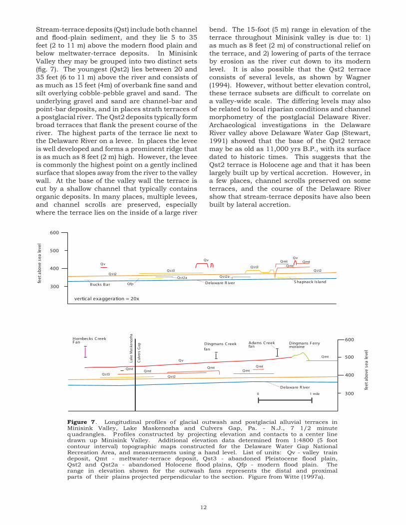
12
Stream-terrace deposits (Qst) include both channel and flood-plain sediment, and they lie 5 to 35 feet (2 to 11 m) above the modern flood plain and below meltwater-terrace deposits. In Minisink Valley they may be grouped into two distinct sets (fig. 7). The youngest (Qst2) lies between 20 and 35 feet (6 to 11 m) above the river and consists of as much as 15 feet (4m) of overbank fine sand and silt overlying cobble-pebble gravel and sand. The underlying gravel and sand are channel-bar and point-bar deposits, and in places strath terraces of a postglacial river. The Qst2 deposits typically form broad terraces that flank the present course of the river. The highest parts of the terrace lie next to the Delaware River on a levee. In places the levee is well developed and forms a prominent ridge that is as much as 8 feet (2 m) high. However, the levee is commonly the highest point on a gently inclined surface that slopes away from the river to the valley wall. At the base of the valley wall the terrace is cut by a shallow channel that typically contains organic deposits. In many places, multiple levees, and channel scrolls are preserved, especially where the terrace lies on the inside of a large river
bend. The 15-foot (5 m) range in elevation of the terrace throughout Minisink valley is due to: 1) as much as 8 feet (2 m) of constructional relief on the terrace, and 2) lowering of parts of the terrace by erosion as the river cut down to its modern level. It is also possible that the Qst2 terrace consists of several levels, as shown by Wagner (1994). However, without better elevation control, these terrace subsets are difficult to correlate on a valley-wide scale. The differing levels may also be related to local riparian conditions and channel morphometry of the postglacial Delaware River. Archaeological investigations in the Delaware River valley above Delaware Water Gap (Stewart, 1991) showed that the base of the Qst2 terrace may be as old as 11,000 yrs B.P., with its surface dated to historic times. This suggests that the Qst2 terrace is Holocene age and that it has been largely built up by vertical accretion. However, in a few places, channel scrolls preserved on some terraces, and the course of the Delaware River show that stream-terrace deposits have also been built by lateral accretion.
300
300
400
400
500
500
600
600
feet
abov
ese
aleve
l
feet
abov
ese
aleve
l
Adams C reekfan
Dingmans Ferrymoraine
Qmt
QmtQmtQmtQmt
Qmt
Qv
Hornbecks C reekFan
Delaware R iver
Delaware R iver
Dingmans C reekfan
Qst3Qst2
S hapnack Is land
QvQmt Qmt
QmtQst3Qst2
Qst2a
Qv
Qst3
Qv
Qst2Qst2a
Bucks Bar Qfp
0 1 mile
vertical exaggeration = 20x
Figure 7. Longitudinal profiles of glacial outwash and postglacial alluvial terraces inMinisink Valley, Lake Maskenozha and Culvers Gap, Pa. - N.J., 7 1/2 minutequadrangles. Profiles constructed by projecting elevation and contacts to a center linedrawn up Minisink Valley. Additional elevation data determined from 1:4800 (5 footcontour interval) topographic maps constructed for the Delaware Water Gap NationalRecreation Area, and measurements using a hand level. List of units: Qv - valley traindeposit, Qmt - meltwater-terrace deposit, Qst3 - abandoned Pleistocene flood plain,Qst2 and Qst2a - abandoned Holocene flood plains, Qfp - modern flood plain. Therange in elevation shown for the outwash fans represents the distal and proximalparts of their plains projected perpendicular to the section. Figure from Witte (1997a).
Lake
Mas
keno
zha
Culve
rsGap

13
The oldest stream-terrace deposits in Minisink Valley (Qst3) lie 40 to 48 feet (12 to 15 m) above the modern river and typically consist of as much as 10 feet (3 m) of overbank fine sand and medium sand overlying glacial outwash. In places, this material has been eroded, revealing the underlying outwash. The Qst3 terraces are typically small and flank the younger Qst2 deposits. In some places they lie surrounded by Qst2 deposits. No dates are available for the Qst3 terrace, but based on the age of the Qst2 terrace, it is late Wisconsinan age and it may represent a transition between glaciofluvial and postglacial fluvial environments.
Alluvial-fan deposits (Qaf) are fan-shaped deposits that lie at the base of hillslopes at the mouths of gullies, ravines, and tributary valleys. Their sediment is highly variable and is derived chiefly from local surficial materials eroded and laid down by streams draining adjacent uplands. Most alluvial fans are entrenched by modern streams, which suggests that they are probably of late Wisconsinan and early Holocene age when climate, sediment supply, and amount and type of hillslope vegetation were more favorable for their deposition.
Glacial History
Glacial Erosion
The distribution and differences in weathering characteristics of glacial drift in northwestern, New Jersey (Salisbury, 1902; Witte and Stanford, 1995) show that continental ice sheets covered the study area at least three times during the Pleistocene epoch. The action of each ice sheet modified the landscape by deeply scouring valleys, and also wearing down and streamlining bedrock ridges, hills, and slopes. Both the floor of the Minisink and Wallpack Valleys, and part of Kittatinny Valley beneath Culvers Lake were deeply scoured by glacial erosion (Plate 2). Only erosional features of the late Wisconsinan glaciation have been preserved because older features have been eroded. These include polished and plucked bedrock, striations, and streamlined bedrock forms called whale backs. The many unweathered and lightly weathered bedrock outcrops also show that preglacial saprolite and soil were removed by glacial erosion. However, an outcrop of saprolite observed by the authors on the Poxono Island Formation downvalley in the Bushkill quadrangle shows that at least some preglacial materials were not completely eroded.
Glacial Advance and Changes in the Direction of Regional Ice Flow
The late Wisconsinan advance of ice into the upper part of Kittatinny Valley is obscure because glacial drift and striae that record this history were eroded or buried. If the ice sheet advanced in lobes, as suggested by the lobate course of the Terminal Moraine (fig. 8), then its initial advance was marked by lobes of ice moving southwestward down the
S outh Amboy
Belvidere
Belvidere
S outh Amboy
A
B
0 5 10 15 miles
TerminalMoraine
Culvers Gap margin
Kitta
tinny
Valley
K itta
tinny
Mou
ntain
Newa
rkBa
s in
N.J. H
ighlan
ds
Figure 8. Generalized direction of ice movement innorthern New Jersey during the late Wisconsinan.Lines represent regional ice-flow movement at thebase of the ice sheet. Flow directions are basedon striae, drumlins, dispersal of erratics, and tillprovenance. Shaded areas represent majoruplands. Figure 8a shows direction of ice flowwhen the glacier margin was at the TerminalMoraine. Field data in the Kittatinny Valleyarea indicate ice flowed southward across thevalley's southwest-trending regional topographicgrain. Figure 8b shows direction of ice flowduring deglaciation. Flow lines in Kittatinny andMinisink Valleys and surrounding uplands areoriented in a southwest direction with welldeveloped lobate ice flow at the glacier's margin.The change in regional ice flow to a southwestdirection appears to be related to thinning of theice sheet at its margin, and reorganization of iceflow around the Catskill Mountains, and in theHudson-Wallkill Valley. Data from Ridge (1983),Stanford and Harper (1985), Witte (1988), Sevonand others (1989), Stone and others (2002), andunpublished field maps on file at the New JerseyGeological Survey, Trenton, New Jersey.

14
Kittatinny and Minisink Valleys. Sevon and others (1975) speculated that ice from the Ontario basin first advanced southward into northeastern Pennsylvania and northwestern New Jersey. Later, ice from the Hudson-Wallkill lowland, which initially had lagged behind, overrode Ontario ice, and ice flow turned to the southwest. In this scenario, the course of the Terminal Moraine in Minisink and Kittatinny Valleys was controlled by ice flowing from the Hudson-Wallkill lowland. Connally and Sirkin (1986) suggested that the Ogdensburg-Culvers Gap moraine represents or nearly represents the terminal late Wisconsinan position of the Hudson-Champlain lobe based on changes in ice flow noted by Salisbury (1902) near the moraine. Ridge (1983) proposed that a sublobe of ice from the Ontario basin overrode Kittatinny Mountain and flowed southward into Kittatinny Valley. Southwestward flow occurred only near the glacier margin where ice was thinner, and its flow was constrained by the southwesterly trend of the valley. Analysis of striae, drumlins, and the distribution of erratics in the upper part of Kittatinny Valley and adjacent Kittatinny Mountain support Ridge’s view. These data further show that by the time the Ogdensburg-Culvers Gap moraine was formed, ice flow in Kittatinny Valley had turned to the southwest with extensive lobation at the margin (fig. 8).
History of Deglaciation
The recessional history of the Laurentide ice sheet is well documented for northwestern New Jersey and parts of eastern Pennsylvania. Epstein (1969), Ridge (1983), Cotter and others (1986), and Witte (1988, 1991, and 1997a) showed that the margin of the Kittatinny and Minisink Valley lobes retreated systematically with minimal stagnation. However, the age of the Terminal Moraine, timing of the late Wisconsinan maximum, and precise chronology of deglaciation are very uncertain. This is due to scant radiocarbon dates because of a lack of organic material that can be used to date deglaciation, inadequacies of dating bog-bottom organic material and concretions, and use of sedimentation rates to extrapolate bog-bottom radiocarbon dates. Also, varved lake-bottom exposures that can be used for chronology are scarce.
The few radiocarbon dates available bracket the age of the Terminal Moraine and retreat of ice from New Jersey. Radiocarbon dating of basal organic material cored from Budd Lake by Harmon (1960) yielded a date of 22,890 ± 720 yr B.P. (I-2845), and a concretion sampled from sediments of Lake Passaic
by Reimer (1984) that yielded a date of 20,180 ± 500 yr B.P. (QC-1304) suggest that the age of the Terminal Moraine is about 22,000 to 20,000 yr B.P. Basal organic materials cored from a bog on the side of Jenny Jump Mountain approximately 3 miles (4.8 km) north of the Terminal Moraine by D. H. Cadwell (written commun., 1997) indi-cates a minimum age of deglaciation at 19,340 ± 695 yr B.P. (GX-4279). Similarly, basal-organic material from Francis Lake in Kittatinny Valley, which lies approximately 8 miles (12.9 km) north of the Terminal Moraine indicates a minimum age of deglaciation at 18,570 ± 250 yr B.P. (SI-5273) (Cotter, 1983). Because the lake lies approximately 3 miles southeast of the Franklin Grove moraine, this age is also probably a minimum date for that feature. Exactly when the ice margin retreated out of the New Jersey part of Kittatinny Valley is also uncertain. A concretion date of 17,950 ± 620 yr B.P. (I-4935) from sediments of Lake Hudson (cited in Stone and Borns, 1986) and an estimated age of 17,210 yr B.P. for the Wallkill moraine by Connally and Sirkin (1973) suggest ice had re-treated from New Jersey by 18,000 yr B.P.
Based on the morphosequence concept of Koteff and Pessl (1981), many ice-recessional positions have been delineated in Kittatinny Valley (Ridge 1983: Witte 1988; 1997a). In addition, moraines, and interpretation of glacial lake histories, based on correlative relationships between elevations of delta topset-foreset contacts, former glacial-lake-water plains, and lake spillways, provide a firm basis for reconstruction of the ice-recessional history of the Kittatinny and Minisink Valley ice lobes. Recessional deposits are discussed in reference to deposition at the margin of the Kittatinny Valley lobe or the Minisink Valley lobe. Locally, the two lobes wasted back synchronously. Regionally however, the Minisink lobe retreated more rapidly (Witte, 1991).
Kittatinny Valley
The Ogdensburg-Culvers Gap moraine (Plate 1, geologic map) follows a lobate course from the north shore of Lake Kemah into Culvers Gap, where it forms a plug of thick till. From there it ascends the southeast face of Kittatinny Mountain at 200 feet per mile, crossing the Mountain’s crest about two miles northeast of Culvers Gap. Based on the moraine’s size, continuity, lobate course, and correlation to the Dingmans Ferry moraine further west, it marks a major recessional position of the Kittatinny Valley ice lobe (fig. 2). South of the moraine (Plate 1, geologic map) a few kame deposits are found in small valleys near

15
Quick Pond. Most of these appear to have been laid down in ice crevasses or ice-walled ponds in the stagnant glacier margin. Because of their small size and unclear history, they are not used to delineate ice-retreatal positions.
Ice retreat from the Quick Pond area resulted in the formation of glacial Lake Owassa (fig. 2) in the north-draining Culvers Creek drainage basin. The lake initially drained out over a spillway at the south end of Bear Swamp, elevation 890 feet (271 m). The small sand and gravel deposit just south of Lake Owassa (Qd1) has been mapped as an ice-contact delta on the basis of its similar elevation. During ice retreat, a lower spillway, elevation 875 feet (267 m), was uncovered on the west side of the lake basin. The ice-contact delta at the north end of Bear Swamp (Qd2) was laid down in this lower lake stage. At the same time the delta was built, or shortly afterwards the Ogdensburg-Culvers Gap moraine was deposited. Farther retreat of the margin northward resulted in the glacial lake draining out to the Paulins Kill valley along a course now drained by Culvers Creek. The large meltwater channel west of Mt. Pisgah suggests that drainage may have been catastrophic. However, the lake did not drain completely, persisting into modern time as Culvers Lake and Lake Owassa (Plate 1, geologic map).
Outwash in Paulins Kill valley (Qod) are remnants of an ice-contact delta that had filled a small unnamed glacial lake (Witte, 1988). These deposits reach an elevation of 530 feet (162 m) and they show that the Ogdensburg-Culvers Gap moraine and older outwash had dammed the valley downstream. A decrease in the elevation of younger outwash sequences up valley (northeast of the Culvers Gap quadrangle) and the presence of meltwater-terrace deposits cut in the delta plain are evidence of an eroding sediment dam downstream.
Kittatinny Mountain
Except for a few small kame deposits near Lake Ashroe, Kittatinny Lake and Tuttles Corners, outwash deposits are absent in this area. This is largely because the floors of most valleys have steep gradients that prohibit the deposition of sediment by meltwater streams. Valley floors are typically covered by a lag of boulders and cobbles chiefly derived from meltwater-washed till. In many places meltwater channels are deeply cut in thick till, and a few, such as part of Tillmans Ravine, may mark the former lobate edge of the glacier margin. Others are found in front of the Ogdensburg-Culvers Gap and Dingmans Ferry moraines.
The Ogdensburg-Culvers Gap moraine follows a nearly continuous course westward from Kittatinny Mountain toward Wallpack Valley. The moraine’s reentrant north of Lake Ocquitunk marks the boundary with the Dingmans Ferry moraine. Although, the two moraines are the same age, they have different names because they were laid down at the margins of different ice lobes.
Wallpack Valley and Big Flat Brook valley
Meltwater deposits in Wallpack Valley (Plate 1, geologic map, and fig. 9) consist of kames, valley-train deposits, ice-contact deltas, and meltwater-terrace deposits. Kames are small collapsed deposits of coarse gravel and sand that lie higher than valley-train deposits and ice-contact deltas. Their collapsed form and higher position show they were laid down on and against stagnant ice and the nearby hillslope. Topographically below the kames and covering large parts of the valley floor lie kettled, noncontinuous terraces of sand and gravel (Qod1). Exposures in the lower part of Wallpack Valley revealed deltaic foreset bedding, showing that these deposits were laid down in a small proglacial lake dammed by older outwash down valley. In places, outwash was laid down against stagnant ice, whereas in other areas it filled the narrow lake basin from valley wall to valley wall. This material was later eroded by meltwater and postglacial streams. In the lower part of Wallpack Valley the noncollapsed part of the delta plain is at an elevation of 465 feet (142 m) near the quadrangle boundary and it rises to 625 feet (191 m) upstream at its head near the Dingmans Ferry moraine north of Layton. In Big Flat Brook valley outwash also extends downstream from the moraine. Both the moraine and extensive outwash built off its distal slope mark a major ice recessional position of the Minisink Valley ice lobe. Taken together with the OgdensburgCulvers Gap moraine they delineate the Culvers Gap ice margin (fig. 2).
In Wallpack Valley meltwater deposits north of the moraine near Hainesville consist of collapsed ice-contact deltaic outwash (Qod2). They are at an elevation of 645 feet (197 m) and their reconstructed profile (fig. 7) suggests they were laid down in a short-lived proglacial lake dammed in the valley by the Dingmans Ferry moraine. In Big Flat Brook valley, retreat from the Dingmans Ferry moraine may have also resulted in the formation of a proglacial lake. However, there are no deltaic deposits in the valley that record the lake’s existence. Immediately upstream from the moraine is an outwash terrace that reaches an elevation of 700 feet (213 m), about 25 feet (8 m) above the modern valley floor. Its low position

16
in the valley suggests that it was deposited after the moraine dam had been breached. Meltwater drainage off Kittatinny Mountain may have hastened erosion of the moraine. The few meltwater-terrace deposits in the valleys record a period of incision and a decline in local base level as meltwater streams adjusted to their longer courses. Meltwater continued to flow down the Wallpack Valley until the time the Minisink Valley lobe had retreated from the Augusta margin (fig. 2).
Minisink Valley
Meltwater deposits in Minisink Valley consist of a few kames, valley-train deposits, outwash-fan deposits, and meltwater-terrace deposits (Plate 1, geologic map, and fig. 7). The valley-train deposit (Qv1) south of the Dingmans Ferry moraine is a remnant of an extensive outwash plain that ranges in elevation from approximately 420 feet (128 m) downstream near the quadrangle boundary to 490 feet (149 m) upstream near the moraine. Based
on the reconstructed longitudinal profiles of the valley train (fig. 7), and an increase in grain size upstream, the outwash appears to have been laid down from an ice-recessional position located at the position of the Dingmans Ferry moraine (fig. 2). The valley train (Qv2) north of the moraine is about 20 feet (6 m) lower and appears to have been laid down from a position marked by the Montague moraine (fig. 2).
On the Pennsylvania side of Minisink Valley are large fan-shaped deposits of sand and gravel (Qfd, Qfa, and Qfdb) that lie at the mouths of Dingmans Creek, Adams Creek, and Dry Brook. These deposits reach an elevation of as much as 520 feet (158 m). They are non-ice-contact deposits laid down by meltwater streams draining the upper reaches of these tributaries, and they are graded to the surface of the valley-outwash deposits.
Meltwater-terraces in Minisink Valley (Fig. 7) are chiefly strath terraces that were cut down
feetabovesealevel
800
600
400
Lake
Maskenozha
CulversGap
F lat B rook
F lat B rook
feetabovesealevel
800
600
400
QkQod Qod
Qmt
Qst
Qmt
Qk
Qst
Qod
Qmt
Qst
Qod QodQk
Qst
Qod
Qmt
Qk
Qod
Qmt
Qod
Qmt
Qmt
Qst
Dingmans FerryMoraine
Figure 9. Longitudinal profiles of glacial outwash, recessional moraine, and postglacialalluvial terraces in Wallpack Valley, Lake Maskenozha and Culvers Gap, Pa - NJ, 1 1/2minute quadrangles. Profiles constructed by projecting elevation and geologic contacts to acenter line drawn up Wallpack Valley. Geologic units; Qod - glacial lake delta, Qft - meltwaterterrace, Qk - Kame, and Qst - postglacial stream terrace. From Witte (1997a).
Qod
vertical exaggeration = 20x
0 1 mile
Qmt
500
700

17
in valley-train deposits by meltwater streams emanating from the glacier margin up valley from the Dingmans Ferry moraine. These deposits are as much as 15 feet (5 m) thick and largely consist of material eroded from nearby valley-outwash deposits, and from till that covers the lower part of valley slopes. They generally have flat surfaces, which in places are cut by later meltwater channels, and they range in elevation from 450 feet (137 m) near the moraine to 400 feet (122 m) down valley.
Summary of deglaciation
The ice-retreatal positions marked by recessional moraines and the heads-of-outwash of ice-contact deltas and valley-train deposits show that the margins of the Kittatinny Valley and Minisink Valley ice lobes retreated in a systematic manner, chiefly by stagnation-zone retreat, to the northeast. In places proglacial lakes, dammed by till, moraine, and outwash downvalley, formed at the glacier’s margin. A major ice-retreatal position, the Culvers Gap margin, is marked by the Ogdensburg-Culvers Gap and Dingmans Ferry moraines. These cross-valley till ridges were laid down at an active glacier margin.
Postglacial History
The Culvers Gap quadrangle is estimated to have been deglaciated by 18,000 yr B.P. based on the oldest Francis Lake date (Cotter, 1983). Meltwater continued to flow down Minisink Valley until the glacier margin retreated out of the Delaware River drainage basin and into the Susquehanna drainage basin about 14,000 yr B.P. (estimated from Ozvath and Coates, 1986). Meltwater from Augusta stage of Lake Wallkill (fig. 2) continued to flow down Paulins Kill valley until a lower spillway, located on a divide between Moodna Creek and presently at about 400 feet (122 m) above sea level, was uncovered in the mid-Wallkill Valley and the lake’s drainage flowed to the Hudson Valley. This occurred around 17,000 yr B.P., based on the estimated age of the Pellets Island moraine in Wallkill Valley by Connally and Sirkin (1986).
The postglacial landscape immediately after the late Wisconsinan glacier retreated from Kittatinny and Minisink Valleys was a cold, wet, and windswept wilderness. This climate and sparse vegetation enhanced erosion of the land by streams, and by mass wasting of material on slopes. Mechanical disintegration of exposed bedrock by frost shattering was extensive. On Kittatinny Mountain, small to large, frost-rived
blocks of conglomerate and quartzite form aprons of thick talus at the foot of cliffs. In Minisink Valley, deposits of shale-chip colluvium mantle the foot of cliffs and the lower part of steep slopes near Dingmans Creek. In areas of lower relief, boulder fields formed at the base of slopes where rocks were transported by soil creep. Other fields were formed where meltwater left a lag deposit consisting of the heavier stones, and a few others may have been concentrated and deposited by the glacier.
The many swamps and poorly drained areas in the Culvers Gap quadrangle are typical of glaciated landscapes. Upon deglaciation, surface water, which had in preglacial time flowed in a well-defined network of streams, became trapped in the many depressions, glacial lakes and ponds, and other poorly drained areas created during the last glaciation. Swamps and bogs contain sedimentary and organic records that record past climatic conditions. Because these materials were laid down layer upon layer, they may preserve a climatic record from the time of deglaciation to the present. The identification of pollen and radiocarbon dating of plant material retrieved from swamps has provided information on regional and local changes in vegetation, which have been used to interpret past climates. Several studies on bogs and swamps in northwestern New Jersey and northeastern Pennsylvania have established a dated pollen stratigraphy that nearly goes back to the onset of deglaciation (Cotter, 1983). Paleoenvironments, interpreted from pollen analysis, show a transition from tundra with sparse vegetal cover, to an open parkland of sedge and grass with scattered arboreal stands that largely consisted of spruce. From about 14,000 to 11,000 yrs. B.P. the regional pollen sequence records the transition to a dense closed boreal forest that largely consisted of spruce and fir blanketing the uplands. This was followed by a period (11, 000 to 9,700 yrs. B.P.) in which pine became the dominant forest component. These changes in pollen spectra and percentages, record the continued warming during the latter part of the Pleistocene and transition from the ice age to a temperate climate. About 9,400 yrs. B.P., oak and other hardwoods began to populate the landscape, eventually displacing the conifers and marking the transition from a boreal forest to a mixed-hardwoods temperate forest. Throughout the Holocene the many shallow lakes and ponds remaining from the ice age slowly filled with de-cayed vegetation eventually forming bogs and swamps. These organic-rich deposits principally consist of peat, muck, and minor rock and mineral fragments. Calcareous ponds also filled with marl, which is calcium carbonate precipitated by aquatic

18
plants, chiefly chara (Waksman and others, 1943). In most ponds marl underlies peat. However, along the pond edges and where sedimentary peat has slumped into the deeper parts of the pond, they are interlayered.
Mastodon remains, excavated from Shotwell Pond in Stokes State Forest (Jepsen, 1959) show that large mammals roamed Kittatinny Mountain during the close of ice age.
A thin sheet of wind-blown sand in Minisink Valley records a period of intense eolian activity. The precise age of these deposits is unclear. However, their location on the east side of the valley and on valley-train deposits, and presumption of sparse floral cover suggests these materials were laid down in late glacial to early postglacial time (18,000 to 14,000 yrs. B.P.).
The glacial and postglacial fluvial history of the study area is well preserved in the Minisink Valley where events can be divided into 4 phases. Phase 1 is a period of valley filling when glacial stream deposits were laid down at the margin of the Minisink Valley lobe during deglaciation. Based on a few bog-bottom dates by Cotter and others (1986), and Connally and Sirkin (1973) it is estimated here that this phase lasted to about 17,500 to 18,000 years ago. At times, the margin of the glacier remained stationary and outwash built up in front of the glacier and extended many miles downstream. One such retreatal position is marked by the Dingmans Ferry moraine (fig. 7) where the outwash deposits now lie as much as 130 feet (40 m) above the modern river. Down valley, meltwater-terrace deposits were cut by meltwater in slightly older valley outwash deposits, as the proglacial river adjusted to its longer course.
Phase 2 marks a period of erosion in the valley and further development of meltwater-terrace deposits as the meltwater stream cut into the valley fill. Initially, meltwater from a distant ice margin may have cut a deep narrow channel in the glacial valley fill. In a few places, this straight channel is preserved. However, meltwater-terrace deposits in most parts of the valley show that meltwater streams also shifted laterally across the valley floor. These terraces are erosional and meltwater sediment, at least its gravel fraction, was derived from eroded local valley fill, rather than outwash laid down from a distant ice margin up valley. This phase lasted to about 14,000 years ago, based on an estimated age of deglaciation for the Delaware River drainage basin determined from Ozvath and Coates (1986).
Phase 3 marks the onset of stream-terrace deposition and presumably starts when the ice sheet retreated from the Delaware River drainage basin, and stream discharge diminished substantially. This faciliteted an interval of extensive lateral erosion and deposition on the valley floor as the main channel of the river began to meander. The Qst3 terrace (fig. 4) is a relict deposit of this phase and represents the oldest flood-plain deposits preserved in the valley. It lies as much as 48 feet above the modern river. Phase 4 marks renewed downcutting and extensive vertical accretion of overbank deposits. During the Holocene these flood-plain materials built up to heights as much as 35 feet (11 m) (fig. 4) above the modern river. This interval appears to have been initiated by 1) rebound of the Earth’s crust which commenced around 14,000 yr B.P. (Koteff and Larsen, 1989), and 2) the onset of a warmer climate and the growth of deeper rooted and more extensive vegetation, which reduced sediment load in the drainage basin.
Surficial Economic Resources
The most important natural resource in the quadrangle, other than ground water, is stratified sand and gravel. Most of it lies in valley-train deposits (Qv), and ice-contact deltas (Qod). Sediment is used as aggregate, subgrade fill, select fill, surface coverings, and decorative stone. Shale-chip colluvium (Qsc) and weathered slate make excellent subgrade material. The locations of sand and gravel pits and quarries are shown on Plate 1. All are currently inactive except for occasional use by the landowner. Till may be screened and used for fill and subgrade material, and large cobbles and small boulders have been used for building stone. Peat and muck from swamp deposits may be used as a soil conditioner.
References
Connally, G. G., and Sirkin, L. A., 1973, Wisconsinan history of the Hudson-Champlain lobe, in Black, R. F., Goldthwait, R. P. and William, H. B. (eds.), The Wisconsinan stage: Geol. Soc. Amer. Memoir 136, p. 47-69.
_____, 1986, Woodfordian ice margins, recessional events, and pollen stratigraphy of the mid-Hudson Valley, in Cadwell, D.H., (ed.), The Wisconsinan Stage of the First Geological District, Eastern New York: New York State Museum, Bull. no. 455, p. 50-69.

19
Cook, G.H., 1877, Exploration of the portion of New Jersey which is covered by the glacial drift: N.J. Geological Survey Ann. Rept. of 1877, p. 9-22.
____, 1878, On the glacial and modified drift: N.J, Geological Survey Ann. Rept. of 1878, p. 8-23.
____, 1880, Glacial drift: N.J. Geological Survey Ann. Rept. of 1880, p. 16-97.
Cotter, J. F. P., 1983, The timing of the deglaciation of northeastern Pennsylvania and northwestern New Jersey: Doctoral Dissertation, Lehigh University, Bethlehem, Pa., 159 p.
Cotter, J. F. P., Ridge, J. C., Evenson, E. B., Sevon, W. D., Sirkin, Les,and Stuckenrath, Robert, 1986, The Wisconsinan history of the Great Valley, Pennsylvania and New Jersey, and the age of the “Terminal Moraine”: in Cadwell, D. H.(ed.), The Wisconsinan stage of the First Geological District, eastern New York: N.Y. State Museum Bulletin 455, p. 22-50.
Crowl, G.H., 1971, Pleistocene geology and unconsolidated deposits of the Delaware Valley, Matamoras to Shawnee on Delaware, Pennsylvania, Pennsylvania Geological Survey, 4th., ser., General Geology Report 71, 68 p.
Crowl, G.H., and Sevon, W.D., 1980, Glacial border deposits of late Wisconsinan age in northeastern Pennsylvania, Pennsylvania Geological Survey, 4th ser., General Geology Report 71, 68 p.
Drake, A. A., Jr., Volkert. R. A., Monteverde, D. H., Herman, G. C., Houghton, H. H., Parker, R. A., and Dalton, R. F., 1996, Bedrock geologic map of northern New Jersey: U.S. Geological Survey Misc. Geol. Inv. Map I-2540-A.
Epstein, J. B., 1969, Surficial Geology of the Stroudsburg Quadrangle, Pennsylvania-New Jersey: Pennsylvania Geological Survey, 4th series, Bulletin G57, 67p., scale 1:24,000
Gustavson, T.C., Ashley, G. M., and Boothroyd, J. C., 1975, Depositional sequences in glaciolacustrine deltas: in Jopling, A.V., and McDonald, B.C., eds., Glaciofluvial and Glaciolacustrine Sedimentation, Society of Economic Paleontologists and Mineralogists, Special Publication no. 23, p. 264-280.
Harmon, K. P., 1968, Late Pleistocene forest succession in northern New Jersey: unpublished M.S. thesis, Rutgers Univ., 164 p.
Herpers, Henry, 1961, The Ogdensburg-Culvers Gap recessional moraine and glacial stagnation in New Jersey: New Jersey Geological Survey Report Series no. 6, 15 p.
Jepsen, Glenn, 1959, A New Jersey Mastodon: New Jersey State Museum Bulletin, no. 6, 20 p.
Koteff, Carl, and Larsen, F. D., 1989, Postglacial uplift in western New England: Geologic evidence for delayed rebound in Gregersen, S., and Basham, P. W., (eds.), Earthquakes at North Atlantic passive margins: Neotectonics and Postglacial Rebound, p. 105-123.
Koteff, Carl, and Pessl, Fred, Jr., 1981, Systematic ice retreat in New England: U.S. Geological Survey Professional Paper 1179, 20 p.
Leverett, Frank, 1934, Glacial deposits outside the Wisconsin terminal moraine in Pennsylvania: Pennsylvania Geol. Survey, 4th ser., Bulletin G 7.
Mackin, J. H., 1933, The evolution of the Hudson-Delaware-Susquehanna Drainage: Amer. Jour. Sci., v. 26, pp. 319-331.
McNett, C. W. Jr., and McMillian, B. W., 1977, The Shawnee-Minisink site in Newman, W. S., and Salwen, Bert (eds.) Amerinds and Their Paleoenvironments in Northeastern North America, Annals of the New York Academy of Sciences, v. 288, p. 282-298.
Minard, J. P., 1961, End moraines on Kittatinny Mountain, Sussex County, New Jersey: U.S. Geological Survey Prof. Paper 424-C, p. C61-C64.
Monteverde, D. H., 1992, Bedrock Geologic Map of the Sussex County, New Jersey Portions of the Culvers Gap and Lake Maskenozha Quadrangles, New Jersey Geological Survey, GMS 92-1.
Munsell Color Company, 1975, Munsell soil color charts: a division of Kollmorgan Corp., (unnumbered text and illustrations).
Ozvath, D.L., and Coates, D.R., 1986, Woodfordian stratigraphy in the western Catskill Mountains, in Cadwell, D.H., (ed.), The Wisconsinan Stage of the First Geological District, Eastern New York: New York State Museum, Bull. no. 455, p. 109-120.
Reimer, G. E., 1984, The sedimentology and stratigraphy of the southern basin of glacial Lake Passaic, New Jersey: unpublished M.S. thesis, Rutgers University, New Brunswick, New Jersey, 205 p.

20
Ridge, J.C., 1983, The surficial geology of the Great Valley section of the Valley and Ridge province in eastern Northampton County, Pennsylvania, and Warren County., New Jersey: Unpublished M.S. thesis, Lehigh University, Bethlehem, Pa., 234 p.
Salisbury, R. D., 1902, The glacial geology of New Jersey: N.J. Geological Survey Final Report, v. 5, 802 p.
Sevon, W.D., Berg, T.M., Schultz, L.D., and Crowl, G.H., 1989, Geology and mineral resources of Pike County, Pennsylvania: Pennsylvania Geological Survey, County Report 52, 141 p., 2 pls., scale, 1:50,000.
Sevon, W.D. Crowl, G.H., and Berg, T.M., 1975, The Late Wisconsinan drift border in northeastern Pennsylvania: Guidebook for the 40th Annual Field Conference of Pennsylvania Geologists, 108 p.
Stanford, S. D., and Harper, D. P., 1985, Reconnaissance map of the glacial geology of the Hamburg quadrangle, New Jersey: New Jersey Geological Survey, Geol. Map Series 85-1, scale 1:24,000.
Stewart, Michael, 1991, Archaeology and environment in the upper Delaware: in Orr, D. G., and Campana, D. V. (Eds.) The People of Minisink, Papers from the 1989 Delaware Water Gap Symposium: National Park Service, U.S. Department of the Interior, p. 79-115.
Stone, B. D., and Borns, H. W., 1986, Pleistocene glacial and interglacial stratigraphy of New England, Long Island, and adjacent Georges Bank and Gulf of Maine: in Sibrava, V., Bowen, D. Q., and Richmond, G. M. (eds.), Quaternary glaciations in the northern hemisphere: Quaternary Science Reviews, v. 5, p. 39-53.
Stone, B. D., Stanford, S. D., and Witte, R. W., 2002, Surficial geologic map of northern New Jersey: U.S. Geological Survey Misc. Geol. Inv. Map I-2540-C, scale 1:100,000.
Wagner, D. P., 1994, Pedology and geomorphology of the Depew Recreation Area, in Inashima, P. Y.,Gemorphology, Remote Sensing, and Archealogical Monitoring at Depew Recreation Area, Dept of the Interior, National Park Service, p. 1-36.
Waksman, S. A., Schulhoff, H., Hickman, C. A., Cordon, T. C., and Stevens, S. C., 1943, The peats of New Jersey and their utilization: N.J. Department of Conservation and Development
Geologic Series Bulletin 55, Part B, 278 p.
White, I.C., 1882, The geology of Pike and Monroe Counties: Pennsylvania Geological Survey, 2d, Report G-6, 333 p.
Witte, R.W., 1988, The surficial geology and Woodfordian glaciation of a portion of the Kittatinny Valley and the New Jersey Highlands in Sussex County, New Jersey: Unpublished M.S. thesis, Lehigh University, Bethlehem, Pa., 276 p.
______, 1991, Deglaciation of the Kittatinny and Minisink Valley area of northwestern New Jersey: Stagnant and active ice at the margin of the Kittatinny and Minisink Valley lobes: in Geological Society of America Abstracts with Programs, v. 23, p. 151.
______, 1997a, Late Wisconsinan glacial history of the upper part of Kittatinny Valley, Sussex and Warren Counties, New Jersey: Northeastern Geology and Environmental Sciences, v. 19, no. 3, p. 155-169.
______, 1997b, Late history of the Culvers Gap River: A study of stream capture in the Valley and Ridge, Great Valley, and Highland Physiographic Provinces, northern New Jersey: in Pliocene-Quaternary Geology of Northern New Jersey, 60th Annual Reunion of the Northeastern Friends of the Pleistocene, May 30th to June 1st , 1997, Ledgewood,New Jersey, chap. 3, p. 3.1-3.16.
Witte, R. W., and Evenson, E.B., 1989, Debris sources of morphosequences deposited at the margin of the Kittatinny Valley lobe during the Woodfordian deglaciation of Sussex County, New Jersey, in Geological Society of America Abstracts with Programs, v. 21, p. 76.
Witte, R. W., and Stanford, S. D., 1995, Surficial geology and earth-material resources of Warren County, New Jersey: N.J. Geological Survey Open-file Map no. 15c, scale 1:48,000, 3 pl.