SUBSURFACE INVESTIGATION & FOUNDATION ... - in.gov · The elevation of the ground surface shown on...
85
SUBSURFACE INVESTIGATION & FOUNDATION RECOMMENDATIONS NEW NORTH HIGH SCHOOL AND MIDDLE SCHOOL EVANSVILLE, INDIANA Prepared for: EVANSVILLE VANDERBURGH SCHOOL CORPORATION EVANSVILLE, INDIANA Prepared by: ALT & WITZIG ENGINEERING, INC. EVANSVILLE, INDIANA AUGUST 6, 2009 PROJECT NO. : 09EV0016
-
Upload
vuongkhanh -
Category
Documents
-
view
217 -
download
0
Transcript of SUBSURFACE INVESTIGATION & FOUNDATION ... - in.gov · The elevation of the ground surface shown on...

SUBSURFACE INVESTIGATION & FOUNDATION RECOMMENDATIONS
NEW NORTH HIGH SCHOOL AND MIDDLE SCHOOL EVANSVILLE, INDIANA
Prepared for:
EVANSVILLE VANDERBURGH SCHOOL CORPORATION EVANSVILLE, INDIANA
Prepared by:
ALT & WITZIG ENGINEERING, INC. EVANSVILLE, INDIANA
AUGUST 6, 2009 PROJECT NO. : 09EV0016

August 6, 2009 Evansville Vanderburgh School Corporation. One SE Ninth Street Evansville, Indiana 47708 ATTN: Mr. Pat Tuley, Chief Facilities Officer RE: Subsurface Investigation & Foundation Recommendations New North High School
and Middle School Evansville, Indiana Alt & Witzig File: 09EV0016 Gentlemen: In compliance with your request, we have conducted a foundation investigation and evaluation for the above referenced project. It is our pleasure to transmit herewith four (4) copies of our report. The results of our investigation and evaluation are discussed in detail in the Foundation Discussion and Recommendations Section of this report. Parameters have been given that can be used in the design of the project. If we can give further service in these matters, please contact us at your convenience. Respectfully Submitted, ALT & WITZIG ENGINEERING, INC. Robert Smith, P.E. Project Engineer RS:PAK Patrick A. Knoll, P.E.
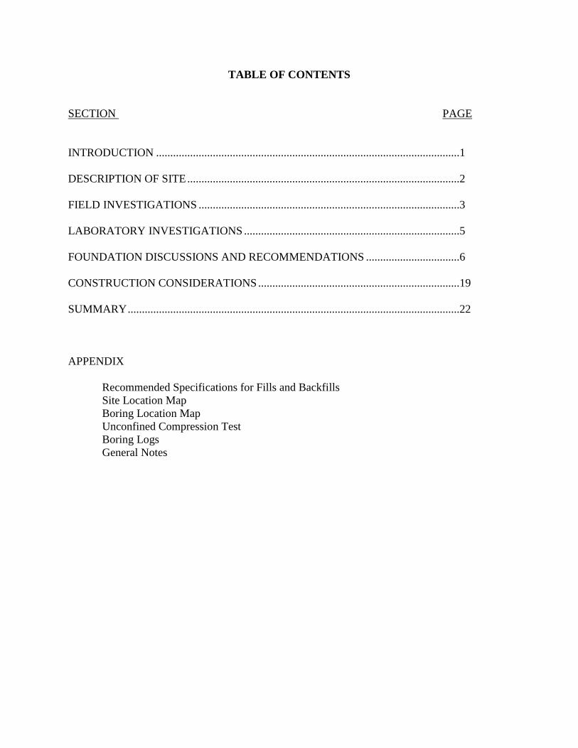
TABLE OF CONTENTS
SECTION PAGE INTRODUCTION ...........................................................................................................1 DESCRIPTION OF SITE ................................................................................................2 FIELD INVESTIGATIONS ............................................................................................3 LABORATORY INVESTIGATIONS ............................................................................5 FOUNDATION DISCUSSIONS AND RECOMMENDATIONS .................................6 CONSTRUCTION CONSIDERATIONS .......................................................................19 SUMMARY .....................................................................................................................22 APPENDIX Recommended Specifications for Fills and Backfills
Site Location Map Boring Location Map Unconfined Compression Test Boring Logs General Notes
SUBSURFACE INVESTIGATION
AND
FOUNDATION RECOMMENDATIONS
INTRODUCTION
General
This report presents the results of a foundation investigation for the proposed new school to
be constructed in Evansville, Indiana. Our investigation was conducted for Evansville Vanderburgh
School Corporation.
Authorization to perform this investigation was in the form of an accepted proposal prepared
by Alt and Witzig Engineering Inc. and a notice to proceed from the Evansville Vanderburgh
School Corporation.
The scope of this investigation included a review of geological maps of the area, a review of
geologic and related literature; a reconnaissance of the immediate site, subsurface exploration; field
and laboratory testing; engineering analysis and evaluation of the materials.
The purpose of this foundation investigation was to determine the various soils profile
components, the engineering characteristics of the subsurface materials and to provide criteria for
use by the design engineers and architects in preparing the foundation design for the School.

DESCRIPTION OF SITE
Site Location
The site of the new North High School and Middle School is located on the north side of
Evansville, Indiana. The new school will be located on the east side of U.S. 41 and is bound by
Peck Road to the east. Specifically the site consists of 14901 U.S. Highway 41 N, 15325 U.S.
Highway 41 N, and 15150 Peck Road. The approximate location of the site is shown on the
enclosed Site Location Map presented in the Appendix.
Site Topography and Drainage
The surface of the immediate site is relatively flat to rolling with an approximate relief of ten
(10) to twenty-five (25) feet across the site. Several drainage swales of varying size were noted
across the site. Predominately drainage is directed to these swales.
Ground cover across the site at the time of boring operations consisted of open grass
covered fields with some trees along the property lines. Three houses and associated structures
exists on the site. A large mound of fill exists at the 14901 US. 41 N property. It is our
understanding that the fill was placed for use in construction at the site. It appears that the site has
predominantly been used for agricultural purposes. The existing structures will be demolished with
the proposed construction.

FIELD INVESTIGATION
Scope
Field investigations to determine the engineering characteristics of the foundation materials
included a reconnaissance of the project site, and drilling fifty-four (54) borings. Borings are
located as shown on the enclosed boring location plan. Standard penetration tests with split-spoon
sampling were performed during drilling operations. The apparent groundwater level at each boring
location was also determined.
Drilling and Sampling Procedures
The soil borings were performed with a drilling rig equipped with a rotary head.
Conventional hollow-stem augers were used to advance the holes. Representative samples were
obtained employing split-spoon sampling procedures in accordance with ASTM Procedure D-1586.
Field Tests and Measurements
Penetration tests. During the sampling procedure, standard penetration tests were performed
at regular intervals to obtain the standard penetration value of the soil. The standard penetration
value is defined as the number of blows a 140-pound hammer, falling 30 inches, is required to
advance the split-spoon sampler one (1) foot into the soil. The results of the standard penetration
tests indicate the relative density and comparative consistency of the soils, and thereby provide a
basis for estimating the relative strength and compressibility of the soil profile components.
Water Level Measurements
In relatively impervious soils, such as those on this site, the groundwater elevation is
difficult and often impossible to accurately determine. The exact location of the water table
should be anticipated to fluctuate somewhat depending upon normal seasonal variations in
precipitation and surface runoff.
Ground Surface Elevation

The elevation of the ground surface shown on the boring logs was determined using
conventional leveling techniques and are presumably accurate to within + 1.0 foot. All depths
and elevations referred to in this report are referenced from the existing ground surface at each
boring location. However, it is suggested that the borings be field located by the survey/site
engineer and shown on the proposed site layout and grading plan. Borings were field staked
using a hand-held GPS unit based on the proposed boring locations shown on the drawing titled
“soil borings” provided by VPS architecture. Our locations were established by scaling from the
drawing and are only as accurate as these methods permit.
LABORATORY INVESTIGATIONS
In addition to the field investigations, a supplemental laboratory investigation was
conducted to ascertain additional pertinent engineering characteristics of the foundation materials
necessary in analyzing the behavior of the proposed new school in Evansville, Indiana.
All phases of the laboratory investigation were conducted in general accordance with
applicable ASTM Specifications.
The laboratory-testing program included supplementary visual classification and water
content tests on several cohesive samples. The results of our testing is presented in the Appendix
of this report.
Samples of the cohesive soil from the split-spoon-sampling device were frequently tested in
unconfined compression by use of a calibrated spring testing machine. In addition, a calibrated soil
penetrometer was used as an aid in determining the strength of the soil. The values of the
unconfined compressive strength as determined on soil samples from the split-spoon sampling must
be considered, recognizing the manner in which they were obtained since the split-spoon sampling
techniques provide a representative but somewhat disturbed soil sample.
FOUNDATION DISCUSSION AND RECOMMENDATIONS
Project Description
The proposed North Campus will consist of a new High School and Middle School. The
facility will be a one (1) to two (2) story building with exterior load bearing masonry walls and
uniformly spaced interior columns. The development will include a basketball arena and a
performing arts auditorium along with classrooms. In addition, a new football stadium and several
new athletic fields will be constructed across the site.
The ground floor elevation for the structure has been set at 460. Based on existing grades
approximately four (4) feet of cut to eleven (11) feet of fill will be required to establish finished
floor elevation. Extensive cuts and fill are anticipated across the site.
It is assumed that the structure will be moderately loaded with the structural loads
transferred to the soils by conventional spread footings and continuous wall footings, if possible.
Maximum column loads within this structure are assumed to be on the order of fifty (50) to one-
hundred and fifty (150) kips with wall loads of two (2) to four (4) kips per foot and 10 kips/foot at
the gymnasium.
Included with the construction of this facility will be a large light-duty parking area and light
to heavy duty roadway areas will be necessary for bus staging.
Subsurface Conditions
Predominately, our borings encountered relatively soft and medium stiff to stiff silty clay
and clay at a shallow depth below grade across the site. Very soft soils were noted at borings B-13,
B-14, B-15, B-16, B-17, B-18, B-19. B-20, B-21, B-23, B-50, B-51, and B-52 (this appears to
consist of all areas below natural surface elevation 452). Isolated areas of silt were noted at various
locations across the site. Beneath the clay, bedrock consisting of clayey shale to very weathered

shale was encountered at depths ranging from approximately fourteen (14) to twenty-seven (27) feet
below grade across the site.
Groundwater readings taken during and upon completion of boring operations indicated a
water level of eight and one-half (8½) to twenty-four and one-half (24½) feet below grade. Several
to twenty-four hours after completion a water level of one and one-half (1½) to seventeen (17) feet
below grade was noted.
The following table illustrates the noted depth and elevation of bedrock across the site:
Boring Depth to Bedrock (ft) Elevation of Bedrock (ft) Depth to Auger Refusal (ft)
B-1 24 74 31 B-2 18 77.2 27 B-3 24 71 28.5 B-4 14 76.8 23 B-5 19 74.4 26 B-6 14 76.5 21 B-7 17 75.8 23 B-8 20 72.6 20 B-9 18 74.1 18 B-10 17.5 74 17.5 B-11 14.5 77 14.5 B-12 26.5 65.5 26.5 B-13 15 76.6 15 B-14 23.5 68.8 23.5 B-15 21 --- 21 B-16 21 72.3 21 B-17 21 71.5 21 B-18 21 73.5 21 B-19 23 71.7 31 B-20 23 70.2 26 B-21 21.5 73 21.5 B-22 26 67.3 26 B-23 22 71 22 B-24 20.5 72.7 20.5 B-25 27 66.2 27 B-26 24 69.2 24 B-27 25.5 66.9 25.5 B-28 17 75 17 B-29 21 76.7 21 B-30 21 72 21 B-31 20 72.9 20
Boring Depth to Bedrock (ft) Elevation of Bedrock (ft) Depth to Auger Refusal (ft)

Construction of Fills
It is anticipated that up to eleven (11) feet of fill will be necessary to raise and level the site
to the proposed grade. Most on-site soils, with the exception of the topsoil, can be used as structural
fills in elevating the building areas and/or roadway and parking areas.
The predominate soil types encountered at a shallow depth are clays and silty clays. The
laboratory tests indicated natural moisture contents of the shallow cohesive soils ranged from 19.5%
to 29.1% at the time of our boring operations. Optimum moisture content for the natural soils is
anticipated to range from 14% to 20%. Because of the engineering characteristics of these cohesive
soils, difficulty can be anticipated if wet soils are used as fill. Thus, aerating and drying of the
shallow soils will be necessary prior to compaction. For proper compaction of the soils, moisture
conditioning to within approximately –2% to +2% of optimum moisture content should be achieved
with soils.
Due to the quantity of the fill material to be placed, it is anticipated that settlement will be
induced in the natural very soft soils that exist on the northern half of the school. Estimated
settlements vary from approximately one (1) to three (3) inches at the deepest fills and could take
several months to a year to complete. The amount of settlement will vary across the site due to the
variability of the natural soils at this site. Additionally, some additional settlement would be
expected once the structure is constructed.
In order to minimize the amount of fill induced settlement several options may be
considered. The option include constructing and monitoring the fills, accelerating settlement by
pre-loading critical areas, or some form of ground modification.
Monitoring. This option would include construction and monitoring of the fills until the magnitude
and rate of settlement indicate that the remaining settlement is anticipated to be within tolerable
limits. Construction of fill would be performed consistent with the current industry standards and
project specifications except settlement plates would be installed prior to placing the fill.
As mentioned above settlement may take several months to a year to be within tolerable
range and allowing construction to continue. Placing a layer of structural “B” Borrow eighteen (18)
inches in thickness at the base of the fill and sloping this layer to drain would help to accelerate
settlement.
Preloading. To further accelerate settlement, after placing the settlement plates, structural “B”
Borrow and constructing the fill, a layer of additional fill may be placed to pre-load the site. If this
method is selected, it is recommended that an additional five (5) feet of fill be placed on this portion
of the school. The fill can consist of topsoil or other fill that will or will not be used on the site. By
placing this additional load it will increase the total settlement of the natural soils and will decrease
the time for the settlement to reach an acceptable level. Again, to monitor the rate of settlement it is
recommended that several settlement plates be placed on the natural soils at the commencement of
fill operations.
For either method mentioned above the settlement plates should be placed in any fill that
exceeds eight (8) feet. The elevations and locations of the plates should be recorded by the site
design engineer and re-checked on a bi-weekly basis. The log of these elevation shots should be
provided to the geotechnical engineer for evaluation.
Construction of the building should not follow placement of the fill until the settlement rate
of this material has subsided as follows. Elevation readings should be taken on a bi-weekly basis
for at least ninety (90) days prior to placement of the masonry walls and glass. The settlement
recorded over a minimum of four (4) consecutive readings should be 0.01 feet or less. Tolerable
settlement ranges for the building are assumed to be one-half (½) to three-quarters (¾) inches for
differential settlement and one (1) to one and one-quarter (1¼) inches for total settlement.
Rammed-Aggregate Pier Foundation System. A soil modification system such as Rammed-
Aggregate piers can be considered at this site. Given the amount of fill and the very soft soils noted
on the northern portion of the site this ground modification system offers a suitable alternative for
the school. Such a foundation system utilizes drilled holes filled with compacted aggregate to
stabilize the subsurface soils. The aggregate is compacted in twelve (12) inch lifts using a beveled
tamper. This beveled tamper also provides lateral compaction to the adjacent soil. The result of this
process is the creation of an aggregate pier, as well as a significant stiffening of the adjacent soils.
Rammed-aggregate pier construction typically reduces time for foundation placement as compared
to other deep foundation systems since spread foundations are placed directly on the reinforced soil
mass and there is no set up time for the aggregate elements. However, if this system is chosen it is
recommended that the entire northern half of the school, where existing surface elevations are below
452, be placed on rammed aggregate piers, including floor slab areas. The most desirable method
would be to place the piers prior to construction of the fills, thereby, reducing the amount of
settlement that the fills would induce in the natural soils and eliminate the delay with building
construction required to allow for settlement to occur with the natural soils if ground modification is
not performed. As mentioned above, a layer of structural “B” Borrow, outleted to drain, should be
placed at the top of the piers.
It is estimated that piers would be extended approximately twelve (12) to sixteen (16) feet
below existing grade. However, if this foundation system is considered, it is recommended that
the specific design and placement of the elements be determined by a representative of the
specialty foundation company.
For any of the methods given above the following foundation recommendations should be
used for the foundations of the school.
Foundation Recommendations
The following recommendations should be used in the design of all foundations across the
site. If the desired foundations for the football stadium grandstand differ from those given below
the geotechnical engineer should be consulted for additional recommendations.

Shallow Spread Footings
Spread footings and continuous wall footings are generally most economical when the
existing soil conditions allow them to be founded at a shallow depth. However, given the soft soils
below elevation 452 across the site and the amount of fill to be added over these soft soils special
consideration will be necessary for construction of the building. These include either surcharging
(preloading) as outlined in the previous section or ground modification using rammed aggregate
piers.
Net allowable soil bearing pressures of 2500 and 2000 psf are recommended to design
conventional spread footings and continuous wall footings, respectively. The above-recommended
bearing pressures are assuming the footings will be founded on the medium stiff natural soils or
compacted fills.
The above recommended bearing pressures are "net allowable soil pressures". In utilizing
these net allowable pressures for dimensioning footings, it is necessary to consider only those loads
applied above the finished floor elevations. In order to alleviate the effects of seasonal variation in
moisture content on the behavior of the footings and eliminate the effects of frost action, all exterior
foundations should be founded a minimum of thirty (30) inches or greater below the final grade.
Wherever soft or loose soils are encountered, these footing areas must be undercut. After
excavation to an adequate bearing material, the footing areas can then be re-established to the
proposed footing elevation by placing lean concrete.
Floor Slab Recommendations
The ground floor for the proposed building can be constructed as a slab-on-grade
supported by existing soils and/or well-compacted fill materials. After the building area has
been cut or raised to the proper elevation, a four (4) to six (6) inch compacted granular fill should
be placed immediately beneath the floor slab. This compacted granular fill will provide a
uniform surface for construction of the slab and minimize capillary rise of groundwater from the

subgrade into the slab. A vapor barrier should be placed immediately below the floor slab in any
areas of the building where floor coverings such as carpet, vinyl tile, ceramic tile, etc. will be
placed.
Before any fill is placed, it is recommended that the exposed subgrade be proofrolled
with equipment approved by the soil engineer. This proofrolling will expose any soft,
compressible soil. Soft areas should be undercut to a depth determined at the time of the
proofroll inspection and replaced with a well-compacted fill. Depending on the final grade and
the time of year of the site is prepared, chemical stabilization could be necessary due to the
susceptible nature of the cohesive soils to moisture. It appears that lime would react favorably
with the soils at this site. However, isolated areas of silt exist across the site and some cement
could be required for successful stabilization.
Seismic Requirements
Seismic design consideration based on the information obtained in our subsurface
investigation and the Indiana Building Code guidelines indicates that the site will be classified
with a site class C.
Parking Area Construction and Pavement Design
Proposed Parking Area
Borings performed for the parking and drive areas primarily encountered soft and
medium stiff clays and silty clays at a shallow depth below grade.
These soils should provide an adequate subgrade if compacted and properly drained. The
strength of the subgrade soils at this site depends upon several variables including compaction
and groundwater level. It is important that all paved areas be designed to prevent water from
collecting or ponding immediately beneath the pavement. It is suggested that underdrains be
placed in the pavement areas from each catch basin. These drains should be at least 18 inches
below subgrade elevation with a 4” diameter perforated “socked” pipe and backfilled with clean
No. 8 stone. The actual number, location, and length of these drains will be dependent on the
final grading plans and should be determined by the owner, site design engineer, and soil
engineer prior to completion of construction plans.
For these soils to provide adequate support for pavements, it will also be necessary that
proper site work techniques are followed by the earthmoving contractor. It is recommended that
after stripping has been performed, the exposed subgrade should be proofrolled with approved
equipment. This proofrolling will determine if any pockets of soft unsuitable materials exist
beneath this exposed subgrade. If pockets of unsuitable materials are encountered, stabilization
or removal and replacement with a well-compacted material would be required. It is
recommended that a representative of the soils engineer be present for inspection during the
stripping and proofrolling phases of this project to determine where stabilization would be
required and evaluate the most feasible methods available. As with the floor slab area, it appears
that lime stabilization would be effective at this site and should be considered if operations occur
during the wetter months of the year, typically November through May.
Pavement Design Recommendations
Information for design of the pavement was estimated from similar facilities which Alt &
Witzig Engineering, Inc. has designed. It is estimated that the pavement will be subjected to several
cars, some two (2) and three (3) axle delivery trucks per week and two (2) trash trucks per week. In
addition, it is assumed that up to 60 buses per day could exist on sections of the pavement. The
following pavement sections were determined based on these assumed traffic conditions, utilizing a
twenty (20) year design life and a CBR value in the range of 3.0 and the American Association of
State Highway Officials (AASHTO) design method. If actual traffic conditions differ greatly than
mentioned above we should be contacted so that appropriate changes in the design can be made.

In light duty areas were buses will not be present a pavement section of : 6" of crushed stone, 3" of asphalt base, and 1½" of asphalt surface course should be sufficient.
In heavy duty areas with buses a pavement section of : 8" of crushed stone, 5" of asphalt base, and 1½" of asphalt surface course should be sufficient.
Alternately, a concrete pavement may be selected. It is recommended that the concrete
be air entrained and have a minimum modulus of rupture of 700 psi. A minimum of six (6)
inches of concrete is recommended for standard duty areas, and eight (8) inches for heavy-duty
areas such as the concrete apron for the truck dock areas and in areas that will be subject to bus
traffic. This concrete should be placed over a well prepared subgrade compacted to 98% of
maximum dry density in accordance with ASTM D-698. Drainage beneath the pavement is
critical to performance as mentioned above. Furthermore, it is recommended that eight (8)
inches of No. 53 stone be placed beneath the concrete.
Maximum joint spacing within the concrete pavement on the order of thirty (30) times the
concrete thickness is recommended. Control joints must be sawed a minimum of one-fourth of
the thickness of the slab and must be cut at such a time that random cracking does not occur.
It is recommended that the area designed for placement of the trash container be constructed
with a concrete pad. These concrete aprons will support the heavy twisting loads often imparted to
the pavement section during pick-up of these containers. It is suggested that eight (8) inches of
compacted No. 53 stone and eight (8) inches of unreinforced concrete be used to construct the
dumpster pad. The concrete pad should be of sufficient size to accommodate the entire truck during
loading and unloading conditions.

Alternate Heavy Duty Pavement Section
Given the anticipated pavement loading conditions and the thickness of the sections given
above a more practical solution could be roller compacted concrete (RCC) for the heavy duty
areas such as in the bus loading/unloading zones. Roller Compacted Concrete is typically placed
in a similar manner as asphalt; however, consists of a concrete mix that is then compacted to
increase its overall strength. The concrete is placed drier than normal concrete mixes and can be
placed quickly and typically does not require joints unless appearance is critical to the final
product. Although, RCC creates a smooth surface, it is not typically recommended for high
speed traffic since some imperfections do exist in the finished product. However, given the use
of this site, it is recommended that this type of pavement be considered for this area. The final
design and costs for RCC should be determined by a specialty contractor who regularly deals
with the design and placement of RCC. A list of contractors can be provided if requested.
Athletic Field
Borings B-32, B-35, and B-38 were performed in the southern most athletic fields. Medium
stiff silty clay was predominately encountered beneath the topsoil in this area. Water was noted
within our borings at a depth of five (5) to nine (9) feet below grade.
Borings B-42, B-43, and B-44 were performed in the tennis courts and softball/baseball
fields located on the west side of the property. These borings encountered medium stiff silty clay in
this area. Water was noted at nine (9) feet below grade.
Borings B-45, B-46, and B-49 were performed in the area of the football and practice fields.
These borings encountered soft and medium stiff silty clay, clay, and silt in this area. Water was
noted at a depth of eight (8) to eighteen (18) feet below grade.
These shallow cohesive soils will provide an adequate subgrade if proper site and
compaction procedures are maintained. Because of the anticipated perched groundwater levels, it is
suggested that the fields should be elevated slightly above existing grade in order to provide positive

drainage from the field. Alternately, an underdrain system could be installed in the field to maintain
the groundwater level sufficiently below the surface of the field to prevent damage from foot or
equipment traffic. Final grading of this area should be reviewed before construction to verify that
adequate drainage will be provided to this area.
Proposed Retention Pond
Plans indicate that two (2) retention ponds are to be constructed in conjunction with this
project.
Borings were not performed in these areas, however, soils are anticipated to consist of
silty clays with areas or layers of silt. The results of our evaluations indicate that soils at this site
have moderate to high silt and clay contents with some sand and a trace of gravel. From past
experience, it is anticipated that the silty clays have permeabilities (k values) in the range of 10-4
and 10-5 cm/sec. From past experience, it is anticipated that the clayey silts have permeabilities
(k values) in the range of 10-5 and 10-6 cm/sec. In addition, water elevation is anticipated to be
around four (4) to nine (9) feet for this area.
It is anticipated that pond excavations will be constructed within the underlying silty clay
soils. However, if sand or silt seams are exposed on the slope or bottom of the excavation, this
retention facility will not function as a sealed system. Without a liner covering the side slopes,
the water elevation within the pond will fluctuate with a rise and fall of the natural groundwater
level.
If isolated pockets of sand or sandy silts are encountered during excavation operations,
then a liner or covering will be necessary to maintain the sealed pond system. Various types of
liners are available including a clay-bentonite sealer, natural clay liners, and various synthetic
liners to create a sealed retention pond system. It appears that the most economically feasible
liners could be either a natural clay or bentonite liner.
CONSTRUCTION CONSIDERATIONS
Site Preparation
Excessively organic topsoil and loose dumped fill materials will generally undergo high
volume changes which are detrimental to the behavior of pavements, floor slabs, structural fills,
and shallow foundations placed upon them. Therefore, it is recommended that excessively
organic topsoils and loose materials be stripped from the construction areas and wasted or
stockpiled for later use. Our test borings indicate that stripping on the order of eight (8) to
eighteen (18) inches will be necessary across the site. However, because the existing subgrade
soils are relatively soft, the equipment used to strip the topsoil will have a tendency to push
organics further below grade. Thus, the depth of stripping required will vary somewhat with
weather conditions and the type of equipment used. Also, some additional stripping to remove
large roots may be anticipated across wooded areas and the wet low lying areas. The exact depth
of stripping should be determined by a representative of the soils engineer in the field at the time
of the stripping operations.
It is recommended that after the above mentioned stripping has been performed, the exposed
subgrade should be proofrolled with approved equipment. This proofrolling will determine if any
pockets of soft unsuitable materials are encountered. Should soft unsuitable materials be
encountered, the material should be removed and replaced with a well-compacted material. It is
recommended that a representative of the soil engineer be present for this phase of this project.
After the existing subgrade soils are excavated to design grade, proper control of subgrade
compaction and fill, and structural fill replacement should be maintained by a representative of the
soils engineer as per the "Recommended Specifications for Compacted Fills and Backfills",
presented in the Appendix of this report; thus minimizing volume changes and differential
settlements which are detrimental to behavior of shallow foundations, floor slabs and pavements.

Groundwater
The borings indicated water could be encountered as shallow as one (1) to five (5) feet
below existing grade. The soil survey produced by the U.S. Dept. of Agriculture indicates that a
seasonal groundwater level of one (1) to three (3) feet below grade could be encountered for the
soil types that exist on this site. Therefore, it appears that if operations occur during the wetter
portions of the year, typically November through May, difficulty could be encountered due to the
groundwater elevation at this site. Additionally, depending upon the weather conditions during
construction, seepage from surface runoff may occur. Since these foundation materials tend to
soften when exposed to free water, every effort should be made to keep the excavations dry
should groundwater be encountered. A gravity drainage system, sump pumps, or other
conventional dewatering procedures should be sufficient for this purpose. If significant
groundwater is encountered during foundation excavations a lean concrete mud mat could be
required. Further evaluation for the requirement of undercutting or replacement with lean
concrete should be performed during foundation inspections. To minimize these difficulties it is
also recommended that all concrete for footings be placed the same day that the individual
foundation excavations are made.
On-Site Borrow Material
Most on-site soils, with the exception of the topsoil, can be used as structural fills in
elevating the building areas and/or roadway and parking areas.
The predominate soil types encountered at a shallow depth are clays and silty clays with
isolated areas of silt. The laboratory tests indicated natural moisture contents of the shallow
cohesive soils range from 19.5% to 29.1% at the time of our boring operations. Optimum moisture
content for the silty clays and clays is anticipated to be in the range of 14% to 20%. Because of the
engineering characteristics of these cohesive soils, difficulty can be anticipated if wet soils are used
as fill. Thus, aerating and drying of the shallow soils would be necessary prior to compaction. For
proper compaction of the soils, moisture conditioning to within approximately –2% to +2% of
optimum moisture content should be achieved with soils.
If the underlying shale and limestone is to be used as structural fill, it is critical that the
material be sufficiently pulverized during placement. The shale material will break down when
subjected to moisture. Thus, it could be necessary to moisturize the material in order to achieve
adequate compaction of the material. A water truck could be required in order to facilitate
proper moisture conditioning of the shale. The weathered shales should be placed at or slightly
above optimum moisture content. Shale that is not properly treated during placement could
result in future slaking of the soft rock material when exposed to groundwater that would result
in consolidation of the material (i.e. settlement).

20
SUMMARY
An exploration and evaluation of the foundation conditions has been conducted at the
proposed new North High/Middle School to be constructed in Evansville, Indiana. Foundation
design criteria have been suggested and possible design and construction problems have been
discussed.
The exploration and analysis of the foundation conditions reported herein is considered in
sufficient detail and scope to form a reasonable basis for design. The recommendations submitted
are based on the available soil information and the preliminary design details furnished by the
architects for the proposed structure.

APPENDIX
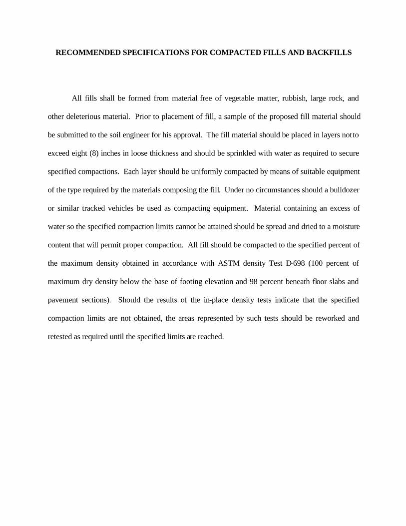
RECOMMENDED SPECIFICATIONS FOR COMPACTED FILLS AND BACKFILLS
All fills shall be formed from material free of vegetable matter, rubbish, large rock, and
other deleterious material. Prior to placement of fill, a sample of the proposed fill material should
be submitted to the soil engineer for his approval. The fill material should be placed in layers not to
exceed eight (8) inches in loose thickness and should be sprinkled with water as required to secure
specified compactions. Each layer should be uniformly compacted by means of suitable equipment
of the type required by the materials composing the fill. Under no circumstances should a bulldozer
or similar tracked vehicles be used as compacting equipment. Material containing an excess of
water so the specified compaction limits cannot be attained should be spread and dried to a moisture
content that will permit proper compaction. All fill should be compacted to the specified percent of
the maximum density obtained in accordance with ASTM density Test D-698 (100 percent of
maximum dry density below the base of footing elevation and 98 percent beneath floor slabs and
pavement sections). Should the results of the in-place density tests indicate that the specified
compaction limits are not obtained, the areas represented by such tests should be reworked and
retested as required until the specified limits are reached.
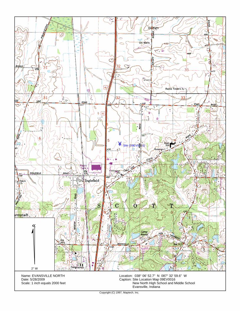
Copyright (C) 1997, Maptech, Inc.
Name: EVANSVILLE NORTHDate: 5/28/2009Scale: 1 inch equals 2000 feet
Location: 038° 06' 52.7" N 087° 32' 59.6" WCaption: Site Location Map 09EV0016
New North High School and Middle SchoolEvansville, Indiana
¥Site (09EV0016)
2° W
«

0
500
1000
1500
2000
2500
3000
3500
4000
0 2 4 6 8 10 12 14 16
Qu
(psf
)
Strain (%)
Unconfined Compression Test
Sample Location_________________________________B-1
PROJECT NAME: PROJECT NO.: DATE:A&W
PREPARED FOR: PREPARED BY: Alt & Witzig Engineering, Inc.Indianapolis, IndianaAlt & Witzig Engineering, Inc.Evansville, Indiana
Evansville Vanderburgh SchoolsEvasnville, Indiana
New North SchoolEvansville, Indiana
09EV0016 6/09
Depth______________________
Strain Rate__________________
Moisture Content:_______(%)
Dry Unit Weight:_______(pcf)
FAILURESKETCH
Soil Description__________________________
Unconfined Compressive Strength (psf)________
Failure Strain (%)__________________________
2 - 4 feet 23.6
2% min. 97.4
Brown Mottled Gray Silty Clay
3650
12
2.8"
5.5"

0
200
400
600
800
1000
1200
1400
1600
0 2 4 6 8 10 12 14 16 18
Qu
(psf
)
Strain (%)
Unconfined Compression Test
Sample Location_________________________________B-20
PROJECT NAME: PROJECT NO.: DATE:A&W
PREPARED FOR: PREPARED BY: Alt & Witzig Engineering, Inc.Indianapolis, IndianaAlt & Witzig Engineering, Inc.Evansville, Indiana
Evansville Vanderburgh SchoolsEvasnville, Indiana
New North SchoolEvansville, Indiana
09EV0016 6/09
Depth______________________
Strain Rate__________________
Moisture Content:_______(%)
Dry Unit Weight:_______(pcf)
FAILURESKETCH
Soil Description__________________________
Unconfined Compressive Strength (psf)________
Failure Strain (%)__________________________
7 - 9 feet 25.1
2% min. 97.8
Brown Mottled Gray Silty Clay
1407.6
13.9
2.8"
5.5"
0
500
1000
1500
2000
2500
3000
0 2 4 6 8 10 12 14 16 18
Qu
(psf
)
Strain (%)
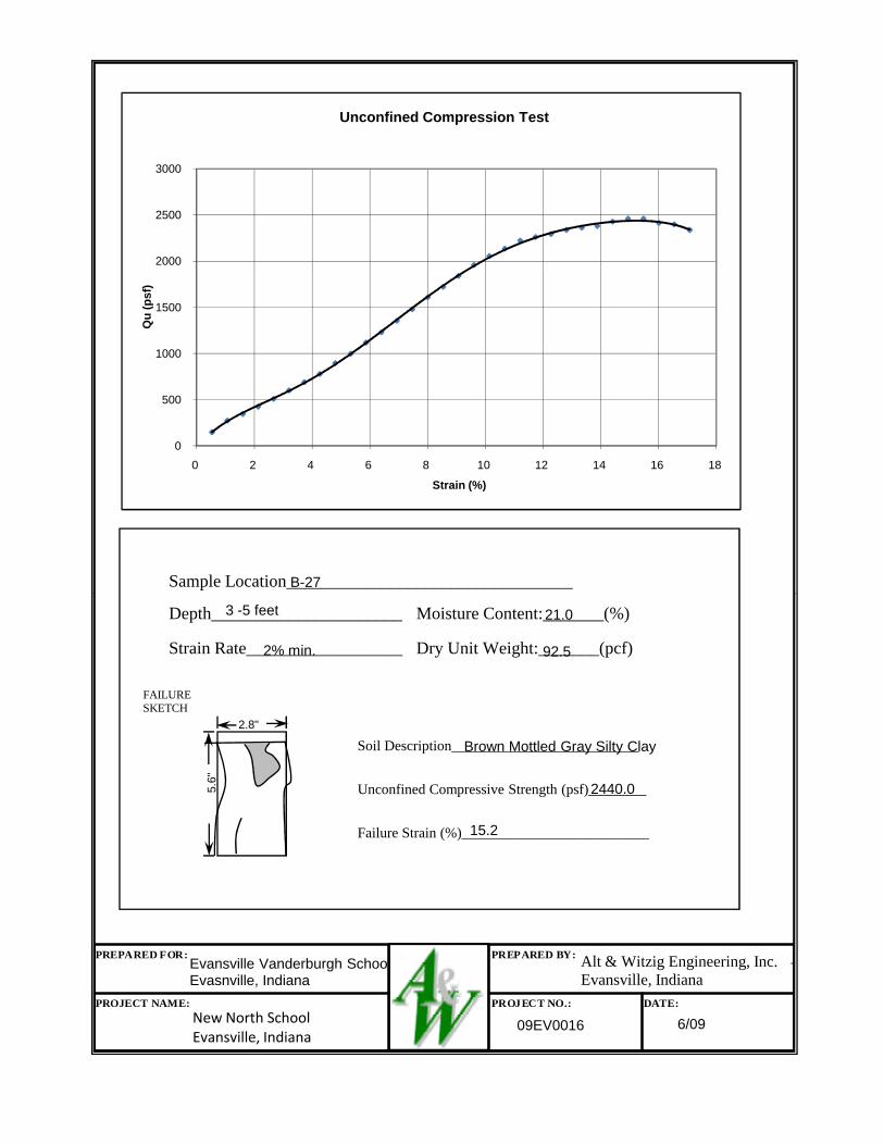
Unconfined Compression Test
Sample Location_________________________________B-27
PROJECT NAME: PROJECT NO.: DATE:A&W
PREPARED FOR: PREPARED BY: Alt & Witzig Engineering, Inc.Indianapolis, IndianaAlt & Witzig Engineering, Inc.Evansville, Indiana
Evansville Vanderburgh SchoolsEvasnville, Indiana
New North SchoolEvansville, Indiana
09EV0016 6/09
Depth______________________
Strain Rate__________________
Moisture Content:_______(%)
Dry Unit Weight:_______(pcf)
FAILURESKETCH
Soil Description__________________________
Unconfined Compressive Strength (psf)________
Failure Strain (%)__________________________
3 -5 feet 21.0
2% min. 92.5
Brown Mottled Gray Silty Clay
2440.0
15.2
2.8"
5.6"
RECORD OF SUBSURFACE EXPLORATION
Alt & Witzig Engineering, Inc.
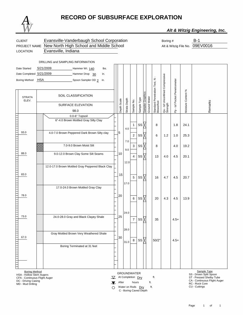
CLIENT Evansville-Vanderbaugh School Corporation Boring # B-1PROJECT NAME New North High School and Middle School Alt & Witzig File No. 09EV0016LOCATION Evansville, Indiana
Date Started Hammer Wt. lbs.
Date Completed Hammer Drop in.
Boring Method Spoon Sampler OD in.
98.0
SOIL CLASSIFICATION
5/21/2009
5/21/2009
HSA
Stan
dard
Pen
etra
tion
Test
, N -
Blow
s/fo
ot
Sam
ple
No.
Pp -
tsf P
ocke
t Pen
etro
met
er
5
1088.0
DRILLING and SAMPLING INFORMATION
STRATA ELEV.
93.0
Moi
stur
e C
onte
nt %
Rem
arks
Dep
th S
cale
Stra
ta D
epth
Gro
und
Wat
er
Qu
- tsf
Unc
onfin
ed C
ompr
essi
ve
Stre
ngth
Sam
pler
Gra
phic
s
SURFACE ELEVATION
Sam
ple
Type
0.0-6" Topsoil
4
8 1.81 SS 24.1
2 SS 6 1.2 1.0 25.3
4.0 19.2
13 4.0 4.5 20.1SS
83 SS
4.0
6"-4.0 Brown Mottled Gray Silty Clay
7.0
4.0-7.0 Brown Peppered Dark Brown Silty clay
9.07.0-9.0 Brown Moist Silt
12.0
9.0-12.0 Brown Clay Some Silt Seams
W&A
140
30
2
At Completion ft.
After hours ft.
Water on Rods ft.C - Boring Caved Depth
GROUNDWATER
30
Boring Terminated at 31 feet
67.0Gray Mottled Brown Very Weathered Shale
2573.0
83.0
78.0
12.0-17.0 Brown Mottled Gray Peppered Black Clay
15
20
16 4.7 4.5 20.75 SS
20 4.3 4.5 13.96 SS
35 4.5+7 SS
50/2" 4.5+8 SS31.0
12.0
17.0
24.0
17.0-24.0 Brown Mottled Gray Clay
28.0
24.0-28.0 Gray and Black Clayey Shale
Boring MethodHSA - Hollow Stem AugersCFA - Continuous Flight AugerDC - Driving CasingMD - Mud Drilling
Sample TypeSS - Driven Split SpoonST - Pressed Shelby TubeCA - Continuous Flight AugerRC - Rock CoreCU - CuttingsDry
Dry
Page 1 of 1

RECORD OF SUBSURFACE EXPLORATION
Alt & Witzig Engineering, Inc.
CLIENT Evansville-Vanderbaugh School Corporation Boring # B-2PROJECT NAME New North High School and Middle School Alt & Witzig File No. 09EV0016LOCATION Evansville, Indiana
Date Started Hammer Wt. lbs.
Date Completed Hammer Drop in.
Boring Method Spoon Sampler OD in.
STRATA ELEV.
95.2
SOIL CLASSIFICATION
5/21/2009
5/21/2009
HSA
1085.2
DRILLING and SAMPLING INFORMATION
90.2
0.0-9" TopsoilD
epth
Sca
le
Stra
ta D
epth
Gro
und
Wat
er
Sam
ple
No.
Moi
stur
e C
onte
nt %
Rem
arks
Stan
dard
Pen
etra
tion
Test
, N -
Blow
s/fo
ot5 SS
1 SS
Pp -
tsf P
ocke
t Pen
etro
met
er
Sam
pler
Gra
phic
s
Qu
- tsf
Unc
onfin
ed C
ompr
essi
ve
Stre
ngth
1.6 1.0
3.0
SS
SURFACE ELEVATION
Sam
ple
Type
2 SS2.09"-2.0 Brown Silty Clay Trace Roots
3.5
25.9
10 1.3 23.0
10
20.518 2.8
7.0-9.0 Brown Mottled Light Brown Peppered
9.0-13.0 Brown Clay
5
Black Silty Clay Some Silt Seams 9.0
6
7.0
2.0-7.0 Brown and Dark Brown Silty Clay
25.1
4 SS 15 2.8 3.0 20.3
3
W&A
140
30
2
C - Boring Caved Depth
13.0-18.0 Gray Mottled Dark Gray Clay
GROUNDWATERAt Completion ft.
After hours ft.
Water on Rods ft.
2568.2
80.2
75.2 207 SS
3.06 SS
42
15 3.5
4.5
8 SS 57 4.5
13.0
18.0
15
Auger Refusal at 27 feet27.0
18.0-27.0 Gray Clayey to Weathered Shale
Boring MethodHSA - Hollow Stem AugersCFA - Continuous Flight AugerDC - Driving CasingMD - Mud Drilling
Sample TypeSS - Driven Split SpoonST - Pressed Shelby TubeCA - Continuous Flight AugerRC - Rock CoreCU - CuttingsDry
Dry
Page 1 of 1

RECORD OF SUBSURFACE EXPLORATION
Alt & Witzig Engineering, Inc.
CLIENT Evansville-Vanderbaugh School Corporation Boring # B-3PROJECT NAME New North High School and Middle School Alt & Witzig File No. 09EV0016LOCATION Evansville, Indiana
Date Started Hammer Wt. lbs.
Date Completed Hammer Drop in.
Boring Method Spoon Sampler OD in.
STRATA ELEV.
95.0 Moi
stur
e C
onte
nt %
Rem
arks
Dep
th S
cale
Stra
ta D
epth
DRILLING and SAMPLING INFORMATION
1085.0
SURFACE ELEVATION
SOIL CLASSIFICATION
5/21/2009
5/21/2009
HSA
90.0
0.0-7" Topsoil
5
Gro
und
Wat
er
Stan
dard
Pen
etra
tion
Test
, N -
Blow
s/fo
ot
Sam
ple
No.
Sam
ple
Type
Pp -
tsf P
ocke
t Pen
etro
met
er
Sam
pler
Gra
phic
s
Qu
- tsf
Unc
onfin
ed C
ompr
essi
ve
Stre
ngth
3.0
3
1 SS 23.9
2 SS 10 2.0 3.3 20.7
10
21.1
18 3.5 23.0SS
214 SS 6.3 4.5
4.0
7"-4.0 Brown Mottled Gray and Black Silty Clay
7.0
4.0-7.0 Brown Silty Clay
7.0-14.0 Brown Clay
W&A
140
30
2
C - Boring Caved Depth
24.0-28.5 Gray Clayey Shale
At Completion ft.
After hours ft.
Water on Rods ft.
GROUNDWATER
Auger Refusal at 28.5 feet
2566.0
80.0
75.018.0-24.0 Grayish Brown Shaley Clay
20
1516 3.0 32.75 SS
27 4.06 SS
50 4.5+7 SS
28.5
14.0
18.0
14.0-18.0 Gray Clay with Coal Seams
24.0
Boring MethodHSA - Hollow Stem AugersCFA - Continuous Flight AugerDC - Driving CasingMD - Mud Drilling
Sample TypeSS - Driven Split SpoonST - Pressed Shelby TubeCA - Continuous Flight AugerRC - Rock CoreCU - CuttingsDry
17.024Dry
Page 1 of 1

RECORD OF SUBSURFACE EXPLORATION
Alt & Witzig Engineering, Inc.
CLIENT Evansville-Vanderbaugh School Corporation Boring # B-4PROJECT NAME New North High School and Middle School Alt & Witzig File No. 09EV0016LOCATION Evansville, Indiana
Date Started Hammer Wt. lbs.
Date Completed Hammer Drop in.
Boring Method Spoon Sampler OD in.
STRATA ELEV.
90.8
SOIL CLASSIFICATION
5/21/2009
5/21/2009
HSA
SURFACE ELEVATION
5
80.8
DRILLING and SAMPLING INFORMATION
85.8
0.0-7" Topsoil7"-9.0 Brown Mottled Gray Silty Clay
Moi
stur
e C
onte
nt %
Rem
arks
Dep
th S
cale
Stra
ta D
epth
Gro
und
Wat
er
Stan
dard
Pen
etra
tion
Test
, N -
Blow
s/fo
ot
Sam
ple
No.
Pp -
tsf P
ocke
t Pen
etro
met
er
Sam
pler
Gra
phic
s
Sam
ple
Type
9.0
1 SS 7
12
Qu
- tsf
Unc
onfin
ed C
ompr
essi
ve
Stre
ngth
1.5
2 SS 7 2.0
3.0
3 SS
4 SS
2.7 2.5
9
12.0
9.0-12.0 Brown Mottled Gray Peppered Black Clay 10
23.8
24.5
20.9
22.3
W&A
140
30
2
Auger Refusal at 23 feet
At Completion ft.
After hours ft.
Water on Rods ft.C - Boring Caved Depth
GROUNDWATER
75.8
67.8
17.0-23.0 Gray Very Weathered Shale
20
15
23.0
12 3.0 3.05 SS
30 4.5+6 SS
36 4.5+7 SS
40 4.5+8 SS
50/1"9 SS
12.0
14.012.0-14.0 Brown Mottled Gray Clay
17.0
14.0-17.0 Gray and Brown Clayey Shale
22.2
Boring MethodHSA - Hollow Stem AugersCFA - Continuous Flight AugerDC - Driving CasingMD - Mud Drilling
Sample TypeSS - Driven Split SpoonST - Pressed Shelby TubeCA - Continuous Flight AugerRC - Rock CoreCU - CuttingsDry
4.524Dry
Page 1 of 1

RECORD OF SUBSURFACE EXPLORATION
Alt & Witzig Engineering, Inc.
CLIENT Evansville-Vanderbaugh School Corporation Boring # B-5PROJECT NAME New North High School and Middle School Alt & Witzig File No. 09EV0016LOCATION Evansville, Indiana
Date Started Hammer Wt. lbs.
Date Completed Hammer Drop in.
Boring Method Spoon Sampler OD in.
STRATA ELEV.
93.4
DRILLING and SAMPLING INFORMATION
SOIL CLASSIFICATION
5/21/2009
5/21/2009
HSA
5
1083.4
Silt Seams
0.0-6" Topsoil
88.4
Moi
stur
e C
onte
nt %
Rem
arks
Dep
th S
cale
Stra
ta D
epth
Gro
und
Wat
er
Stan
dard
Pen
etra
tion
Test
, N -
Blow
s/fo
ot
Sam
ple
No.
Pp -
tsf P
ocke
t Pen
etro
met
er
Sam
pler
Gra
phic
s
Qu
- tsf
Unc
onfin
ed C
ompr
essi
ve
Stre
ngth
2.3 2.0
4 SS
SURFACE ELEVATION
Sam
ple
Type
162 SS
1 SS
22.1
3 SS 11 2.3 2.0 22.2
15 4.1 3.8 18.8
18 3.6 3.05 SS 23.6
3.06"-3.0 Brown Silty Clay
5.03.0-5.0 Brown Silty Clay with Light Brown
9.0
5.0-9.0 Brown Silty Clay
9.0-13.0 Brown Clay
1.5 26.15
W&A
140
30
2
C - Boring Caved Depth
Auger Refusal at 26 feet
19.0-26.0 Brownish Gray Clayey Shale
At Completion ft.
After hours ft.
Water on Rods ft.
GROUNDWATER
2567.4
73.4
13.0-19.0 Brown Mottled Gray, Black, and Red Clay78.4 15
20
6 SS 24 4.5
39 4.5+7 SS
50/1"8 SS26.0
13.0
19.0
Boring MethodHSA - Hollow Stem AugersCFA - Continuous Flight AugerDC - Driving CasingMD - Mud Drilling
Sample TypeSS - Driven Split SpoonST - Pressed Shelby TubeCA - Continuous Flight AugerRC - Rock CoreCU - CuttingsDry
Dry
Page 1 of 1
RECORD OF SUBSURFACE EXPLORATION
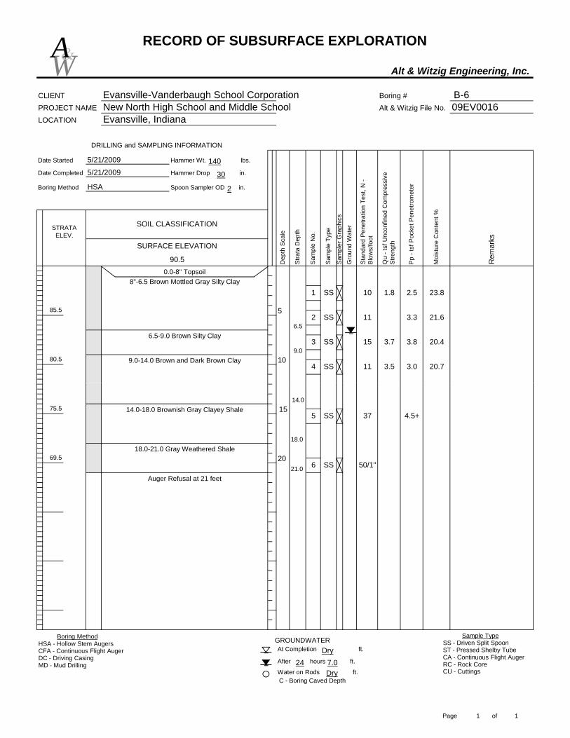
Alt & Witzig Engineering, Inc.
CLIENT Evansville-Vanderbaugh School Corporation Boring # B-6PROJECT NAME New North High School and Middle School Alt & Witzig File No. 09EV0016LOCATION Evansville, Indiana
Date Started Hammer Wt. lbs.
Date Completed Hammer Drop in.
Boring Method Spoon Sampler OD in.
STRATA ELEV.
90.5
SOIL CLASSIFICATION
5/21/2009
5/21/2009
HSA
Pp -
tsf P
ocke
t Pen
etro
met
er
Moi
stur
e C
onte
nt %
Rem
arks
1080.5
DRILLING and SAMPLING INFORMATION
85.5 5
Stan
dard
Pen
etra
tion
Test
, N -
Blow
s/fo
ot
Sam
ple
No.
Sam
pler
Gra
phic
s
Dep
th S
cale
Stra
ta D
epth
Gro
und
Wat
er
Qu
- tsf
Unc
onfin
ed C
ompr
essi
ve
Stre
ngthSURFACE ELEVATION
Sam
ple
Type
0.0-8" Topsoil
10 1.8 2.51 SS 23.8
2 SS 11 3.3 21.6
3.8 20.4
11 3.5 3.0 20.74 SS
15 3.73 SS
6.5
8"-6.5 Brown Mottled Gray Silty Clay
9.0
6.5-9.0 Brown Silty Clay
9.0-14.0 Brown and Dark Brown Clay
W&A
140
30
2
Auger Refusal at 21 feet
At Completion ft.
After hours ft.
Water on Rods ft.C - Boring Caved Depth
GROUNDWATER
69.5
75.5
20
1537 4.5+5 SS
50/1"6 SS21.0
14.0
18.0
14.0-18.0 Brownish Gray Clayey Shale
18.0-21.0 Gray Weathered Shale
Boring MethodHSA - Hollow Stem AugersCFA - Continuous Flight AugerDC - Driving CasingMD - Mud Drilling
Sample TypeSS - Driven Split SpoonST - Pressed Shelby TubeCA - Continuous Flight AugerRC - Rock CoreCU - CuttingsDry
7.024Dry
Page 1 of 1
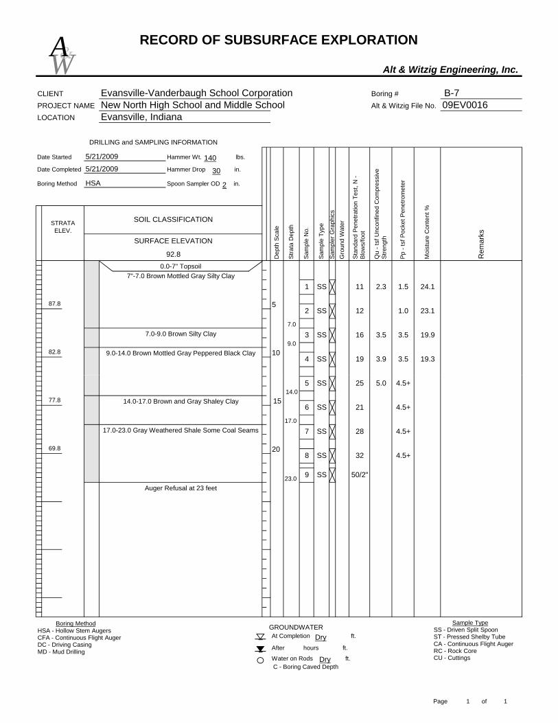
RECORD OF SUBSURFACE EXPLORATION
Alt & Witzig Engineering, Inc.
CLIENT Evansville-Vanderbaugh School Corporation Boring # B-7PROJECT NAME New North High School and Middle School Alt & Witzig File No. 09EV0016LOCATION Evansville, Indiana
Date Started Hammer Wt. lbs.
Date Completed Hammer Drop in.
Boring Method Spoon Sampler OD in.
STRATA ELEV.
92.8
SOIL CLASSIFICATION
5/21/2009
5/21/2009
HSA
1082.8
DRILLING and SAMPLING INFORMATION
87.8 5
Stan
dard
Pen
etra
tion
Test
, N -
Blow
s/fo
ot
Sam
ple
No.
Pp -
tsf P
ocke
t Pen
etro
met
er
Sam
pler
Gra
phic
s
Moi
stur
e C
onte
nt %
Rem
arks
Dep
th S
cale
Stra
ta D
epth
Gro
und
Wat
er
Qu
- tsf
Unc
onfin
ed C
ompr
essi
ve
Stre
ngthSURFACE ELEVATION
Sam
ple
Type
0.0-7" Topsoil
11 2.3 1.51 SS 24.1
2 SS 12 1.0 23.1
3.5 19.9
19 3.9 3.5 19.34 SS
16 3.53 SS7.0
7"-7.0 Brown Mottled Gray Silty Clay
9.07.0-9.0 Brown Silty Clay
9.0-14.0 Brown Mottled Gray Peppered Black Clay
W&A
140
30
2
C - Boring Caved Depth
At Completion ft.
After hours ft.
Water on Rods ft.
GROUNDWATER
77.8
69.8
Auger Refusal at 23 feet
20
15
25 5.0 4.5+5 SS
21 4.5+6 SS
28 4.5+7 SS
32 4.5+8 SS
50/2"9 SS23.0
14.0
17.0
14.0-17.0 Brown and Gray Shaley Clay
17.0-23.0 Gray Weathered Shale Some Coal Seams
Boring MethodHSA - Hollow Stem AugersCFA - Continuous Flight AugerDC - Driving CasingMD - Mud Drilling
Sample TypeSS - Driven Split SpoonST - Pressed Shelby TubeCA - Continuous Flight AugerRC - Rock CoreCU - CuttingsDry
Dry
Page 1 of 1

RECORD OF SUBSURFACE EXPLORATION
Alt & Witzig Engineering, Inc.
CLIENT Evansville-Vanderbaugh School Corporation Boring # B-8PROJECT NAME New North High School and Middle School Alt & Witzig File No. 09EV0016LOCATION Evansville, Indiana
Date Started Hammer Wt. lbs.
Date Completed Hammer Drop in.
Boring Method Spoon Sampler OD in.
STRATA ELEV.
92.6
SOIL CLASSIFICATION
5/21/2009
5/21/2009
HSA
SURFACE ELEVATION
Sam
pler
Gra
phic
s
Qu
- tsf
Unc
onfin
ed C
ompr
essi
ve
Stre
ngth
Sam
ple
Type
5
DRILLING and SAMPLING INFORMATION
1082.6
0.0-7" Topsoil
87.6
Moi
stur
e C
onte
nt %
Rem
arks
Dep
th S
cale
Stra
ta D
epth
Gro
und
Wat
er
Stan
dard
Pen
etra
tion
Test
, N -
Blow
s/fo
ot
Sam
ple
No.
Pp -
tsf P
ocke
t Pen
etro
met
er
7 1.6 1.01 SS 24.0
2 SS 8 3.0 22.6
2.3 20.4
14 2.1 3.0 21.74 SS
14 2.33 SS
4.0
7"-4.0 Brown Mottled Gray Silty Clay
7.0
4.0-7.0 Brown Silty Clay
9.07.0-9.0 Brown Clay with Silt Seams
9.0-20.0 Brown Mottled Gray Peppered Black Clay
W&A
140
30
2
At Completion ft.
After hours ft.
Water on Rods ft.C - Boring Caved Depth
GROUNDWATER
77.6
72.6
Auger Refusal at 20.0 feet20
1521 4.1 3.55 SS
50/2"6 SS20.0
Boring MethodHSA - Hollow Stem AugersCFA - Continuous Flight AugerDC - Driving CasingMD - Mud Drilling
Sample TypeSS - Driven Split SpoonST - Pressed Shelby TubeCA - Continuous Flight AugerRC - Rock CoreCU - CuttingsDry
Dry
Page 1 of 1
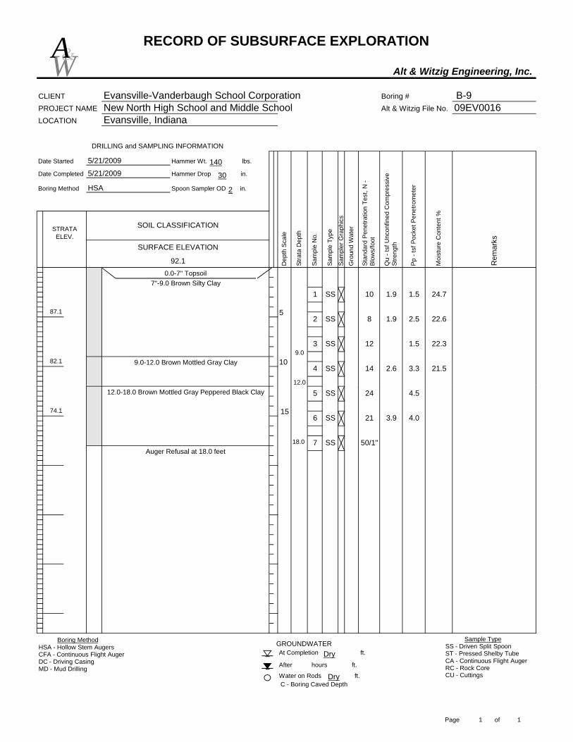
RECORD OF SUBSURFACE EXPLORATION
Alt & Witzig Engineering, Inc.
CLIENT Evansville-Vanderbaugh School Corporation Boring # B-9PROJECT NAME New North High School and Middle School Alt & Witzig File No. 09EV0016LOCATION Evansville, Indiana
Date Started Hammer Wt. lbs.
Date Completed Hammer Drop in.
Boring Method Spoon Sampler OD in.
STRATA ELEV.
92.1 Rem
arks
5/21/2009
HSA
Dep
th S
cale
Stra
ta D
epth
Gro
und
Wat
er
Stan
dard
Pen
etra
tion
Test
, N -
Blow
s/fo
ot
5
Moi
stur
e C
onte
nt %
1082.1
DRILLING and SAMPLING INFORMATION
SURFACE ELEVATION
0.0-7" Topsoil
87.1
Pp -
tsf P
ocke
t Pen
etro
met
er
Sam
pler
Gra
phic
s
Qu
- tsf
Unc
onfin
ed C
ompr
essi
ve
Stre
ngth
1.9 1.5
3
Sam
ple
Type
2.5
101 SS
Sam
ple
No.
22.3
SOIL CLASSIFICATION
5/21/2009
24.7
2 SS 8 1.9
3.3 21.5
22.6
SS 12 1.5
4 SS 14 2.6
9.0
7"-9.0 Brown Silty Clay
12.0
9.0-12.0 Brown Mottled Gray Clay
W&A
140
30
2
C - Boring Caved Depth
GROUNDWATERAt Completion ft.
After hours ft.
Water on Rods ft.
74.1
Auger Refusal at 18.0 feet
15
24 4.55 SS
21 3.9 4.06 SS
50/1"7 SS18.0
12.012.0-18.0 Brown Mottled Gray Peppered Black Clay
Boring MethodHSA - Hollow Stem AugersCFA - Continuous Flight AugerDC - Driving CasingMD - Mud Drilling
Sample TypeSS - Driven Split SpoonST - Pressed Shelby TubeCA - Continuous Flight AugerRC - Rock CoreCU - CuttingsDry
Dry
Page 1 of 1
RECORD OF SUBSURFACE EXPLORATION
Alt & Witzig Engineering, Inc.
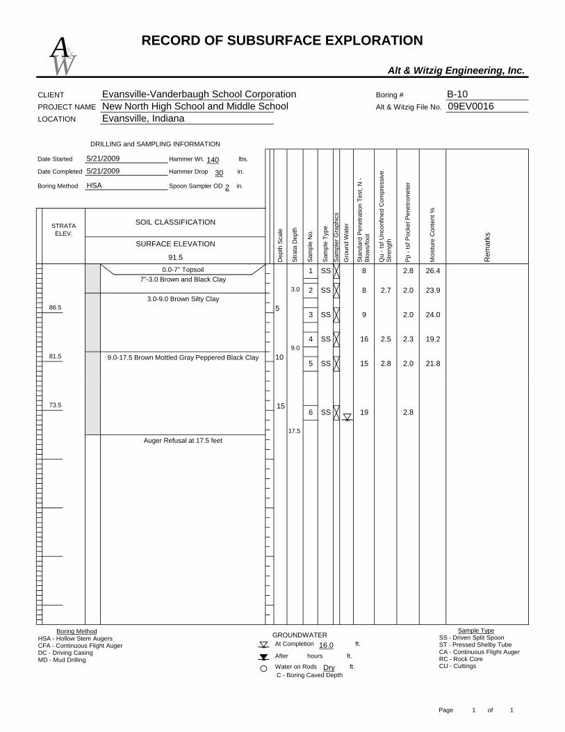
CLIENT Evansville-Vanderbaugh School Corporation Boring # B-10PROJECT NAME New North High School and Middle School Alt & Witzig File No. 09EV0016LOCATION Evansville, Indiana
Date Started Hammer Wt. lbs.
Date Completed Hammer Drop in.
Boring Method Spoon Sampler OD in.
STRATA ELEV.
91.5
5/21/2009
5/21/2009
HSA
0.0-7" Topsoil 1 SS
2
5Sa
mpl
e N
o.
1081.5
DRILLING and SAMPLING INFORMATION
SURFACE ELEVATION
SOIL CLASSIFICATION
86.5
Moi
stur
e C
onte
nt %
Rem
arks
Dep
th S
cale
Stra
ta D
epth
Gro
und
Wat
er
Stan
dard
Pen
etra
tion
Test
, N -
Blow
s/fo
ot
SS
Pp -
tsf P
ocke
t Pen
etro
met
er
Sam
pler
Gra
phic
s
Qu
- tsf
Unc
onfin
ed C
ompr
essi
ve
Stre
ngth
Sam
ple
Type
8 2.7 2.0 23.9
3 SS 9 2.0 24.0
15 2.8 2.0
4 SS
5 SS 21.8
16 2.5 2.3 19.2
3.07"-3.0 Brown and Black Clay
9.0
3.0-9.0 Brown Silty Clay
9.0-17.5 Brown Mottled Gray Peppered Black Clay
2.8 26.48
W&A
140
30
2
C - Boring Caved Depth
At Completion ft.
After hours ft.
Water on Rods ft.
GROUNDWATER
73.5
Auger Refusal at 17.5 feet
1519 2.86 SS
17.5
Boring MethodHSA - Hollow Stem AugersCFA - Continuous Flight AugerDC - Driving CasingMD - Mud Drilling
Sample TypeSS - Driven Split SpoonST - Pressed Shelby TubeCA - Continuous Flight AugerRC - Rock CoreCU - CuttingsDry
16.0
Page 1 of 1

RECORD OF SUBSURFACE EXPLORATION
Alt & Witzig Engineering, Inc.
CLIENT Evansville-Vanderbaugh School Corporation Boring # B-11PROJECT NAME New North High School and Middle School Alt & Witzig File No. 09EV0016LOCATION Evansville, Indiana
Date Started Hammer Wt. lbs.
Date Completed Hammer Drop in.
Boring Method Spoon Sampler OD in.
STRATA ELEV.
91.4
5/21/2009
HSA
5
DRILLING and SAMPLING INFORMATION
81.4
86.4
0.0-7" Topsoil
10
Moi
stur
e C
onte
nt %
Rem
arks
Dep
th S
cale
Stra
ta D
epth
Gro
und
Wat
er
Stan
dard
Pen
etra
tion
Test
, N -
Blow
s/fo
ot
Sam
ple
No.
Pp -
tsf P
ocke
t Pen
etro
met
er
Sam
pler
Gra
phic
s
Qu
- tsf
Unc
onfin
ed C
ompr
essi
ve
Stre
ngth
9
3
SURFACE ELEVATION
Sam
ple
Type
1 SS
SOIL CLASSIFICATION
5/21/2009
SS
2 SS 8 0.5 25.0
9 3.5 19.0
4 SS 2.0 19.910 2.5
3.07"-3.0 Brown Silty Clay
9.0
3.0-9.0 Brown Mottled Gray Silty Clay Trace Silt Seams
9.0-14.5 Brown Mottled Peppered Black Clay
W&A
140
30
2
15
At Completion ft.
After hours ft.
Water on Rods ft.
GROUNDWATER
C - Boring Caved Depth
76.4Auger Refusal at 14.5 feet
14.5
Boring MethodHSA - Hollow Stem AugersCFA - Continuous Flight AugerDC - Driving CasingMD - Mud Drilling
Sample TypeSS - Driven Split SpoonST - Pressed Shelby TubeCA - Continuous Flight AugerRC - Rock CoreCU - Cuttings8.5
11.0
Page 1 of 1
RECORD OF SUBSURFACE EXPLORATION
Alt & Witzig Engineering, Inc.
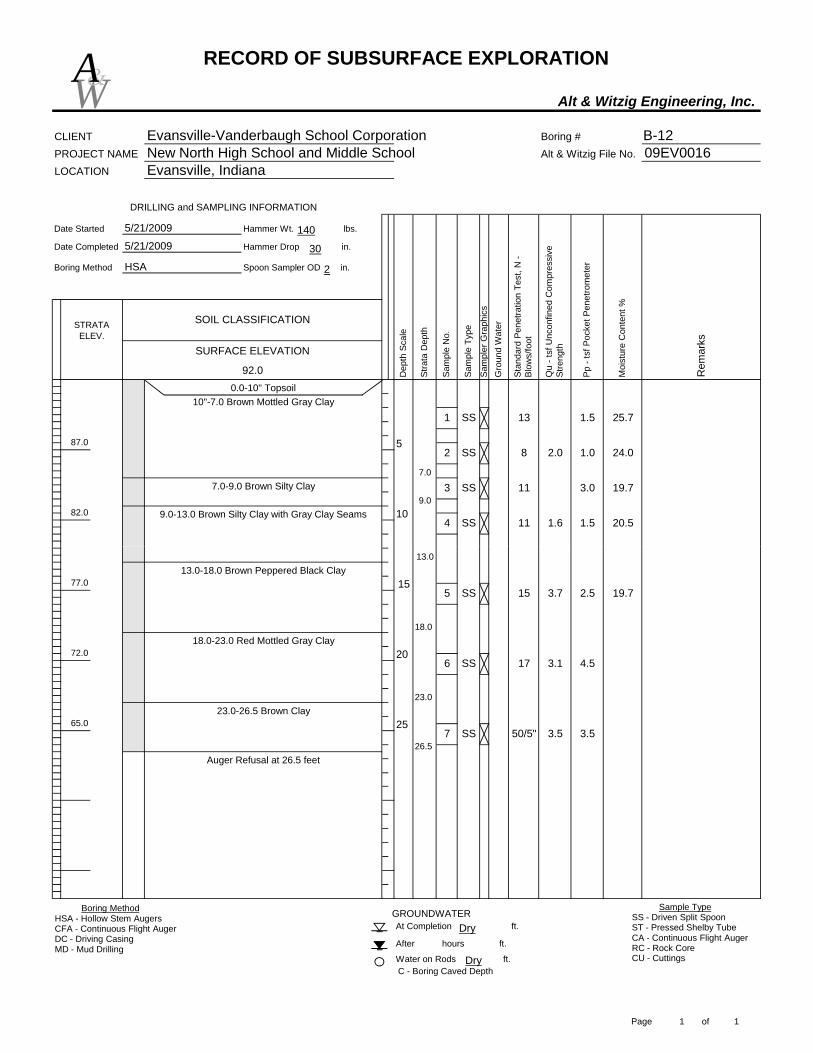
CLIENT Evansville-Vanderbaugh School Corporation Boring # B-12PROJECT NAME New North High School and Middle School Alt & Witzig File No. 09EV0016LOCATION Evansville, Indiana
Date Started Hammer Wt. lbs.
Date Completed Hammer Drop in.
Boring Method Spoon Sampler OD in.
STRATA ELEV.
92.0
SOIL CLASSIFICATION
5/21/2009
5/21/2009
HSA
0.0-10" Topsoil
8 2.05
1082.0
DRILLING and SAMPLING INFORMATION
SURFACE ELEVATION
87.0
Moi
stur
e C
onte
nt %
1.5 25.7
2 SSSa
mpl
e Ty
pe1.0 24.0
Rem
arks
Dep
th S
cale
Stra
ta D
epth
Gro
und
Wat
er
Stan
dard
Pen
etra
tion
Test
, N -
Blow
s/fo
ot
Sam
ple
No.
Pp -
tsf P
ocke
t Pen
etro
met
er
Sam
pler
Gra
phic
s
Qu
- tsf
Unc
onfin
ed C
ompr
essi
ve
Stre
ngth
131 SS
11 3.0 19.73 SS
11 1.6 1.5 20.54 SS
7.0
10"-7.0 Brown Mottled Gray Clay
9.07.0-9.0 Brown Silty Clay
9.0-13.0 Brown Silty Clay with Gray Clay Seams
W&A
140
30
2
C - Boring Caved Depth
23.0-26.5 Brown Clay
18.0-23.0 Red Mottled Gray Clay
At Completion ft.
After hours ft.
Water on Rods ft.
GROUNDWATER
Auger Refusal at 26.5 feet
2565.0
77.0
72.0 20
1515 3.7 2.5 19.75 SS
17 3.1 4.56 SS
50/5" 3.5 3.57 SS26.5
13.0
18.0
13.0-18.0 Brown Peppered Black Clay
23.0
Boring MethodHSA - Hollow Stem AugersCFA - Continuous Flight AugerDC - Driving CasingMD - Mud Drilling
Sample TypeSS - Driven Split SpoonST - Pressed Shelby TubeCA - Continuous Flight AugerRC - Rock CoreCU - CuttingsDry
Dry
Page 1 of 1

RECORD OF SUBSURFACE EXPLORATION
Alt & Witzig Engineering, Inc.
CLIENT Evansville-Vanderbaugh School Corporation Boring # B-13PROJECT NAME New North High School and Middle School Alt & Witzig File No. 09EV0016LOCATION Evansville, Indiana
Date Started Hammer Wt. lbs.
Date Completed Hammer Drop in.
Boring Method Spoon Sampler OD in.
9.0-15.0 Brown Mottled Gray Peppered Black ClaySt
anda
rd P
enet
ratio
n Te
st, N
- Bl
ows/
foot
Moi
stur
e C
onte
nt %
5/21/2009
HSA
Rem
arks
Dep
th S
cale
Stra
ta D
epth
Gro
und
Wat
er
5
81.6
DRILLING and SAMPLING INFORMATION
STRATA ELEV.
91.60.0-10" Topsoil
10"-9.0 Brown Mottled Gray Silty Clay
86.6
10
Sam
ple
No.
4
9.0
Pp -
tsf P
ocke
t Pen
etro
met
er
Sam
pler
Gra
phic
s
Qu
- tsf
Unc
onfin
ed C
ompr
essi
ve
Stre
ngth
2.4 2.0
SS
SURFACE ELEVATION
Sam
ple
Type
81 SS
SOIL CLASSIFICATION
5/21/2009
23.6
2 SS 5 0.5 24.8
12 1.5 21.6
SS
3
3.0 20.516 3.9
W&A
140
30
2
Auger Refusal at 15.0 feet15
At Completion ft.
After hours ft.
Water on Rods ft.C - Boring Caved Depth
GROUNDWATER
76.6 15.05 SS 50/1"
Boring MethodHSA - Hollow Stem AugersCFA - Continuous Flight AugerDC - Driving CasingMD - Mud Drilling
Sample TypeSS - Driven Split SpoonST - Pressed Shelby TubeCA - Continuous Flight AugerRC - Rock CoreCU - Cuttings12.5
11.0
Page 1 of 1

RECORD OF SUBSURFACE EXPLORATION
Alt & Witzig Engineering, Inc.
CLIENT Evansville-Vanderbaugh School Corporation Boring # B-14PROJECT NAME New North High School and Middle School Alt & Witzig File No. 09EV0016LOCATION Evansville, Indiana
Date Started Hammer Wt. lbs.
Date Completed Hammer Drop in.
Boring Method Spoon Sampler OD in.
STRATA ELEV.
92.3
SOIL CLASSIFICATION
5/21/2009
5/21/2009
HSA
Moi
stur
e C
onte
nt %
Rem
arks
Dep
th S
cale
Stra
ta D
epth
5
1082.3
0.0-6"-Topsoil
DRILLING and SAMPLING INFORMATION
87.3
Gro
und
Wat
er
Stan
dard
Pen
etra
tion
Test
, N -
Blow
s/fo
ot
Sam
ple
No.
4
Pp -
tsf P
ocke
t Pen
etro
met
er
Sam
pler
Gra
phic
s
Qu
- tsf
Unc
onfin
ed C
ompr
essi
ve
Stre
ngth
3.5
3
SURFACE ELEVATION
Sam
ple
Type
71 SS 24.2
2 SS 5 1.0 24.8
6 3.3 1.8 18.0SS
7SS 3.0
4.0
6"-4.0 Brown Mottled Gray Peppered Black Clay
4.0-13.0 Brown Mottled Gray Silty Clay
W&A
140
30
2
C - Boring Caved Depth
Boring Terminated at 21 feet
At Completion ft.
After hours ft.
Water on Rods ft.
GROUNDWATER
71.3
77.3
20
157 1.8 2.05 SS
16 4.3 4.56 SS
23.5
13.013.0-21.0 Gray Mottled Brown Clay
Boring MethodHSA - Hollow Stem AugersCFA - Continuous Flight AugerDC - Driving CasingMD - Mud Drilling
Sample TypeSS - Driven Split SpoonST - Pressed Shelby TubeCA - Continuous Flight AugerRC - Rock CoreCU - CuttingsDry
17.0222.0
Page 1 of 1

RECORD OF SUBSURFACE EXPLORATION
Alt & Witzig Engineering, Inc.
CLIENT Evansville-Vanderbaugh School Corporation Boring # B-15PROJECT NAME New North High School and Middle School Alt & Witzig File No. 09EV0016LOCATION Evansville, Indiana
Date Started Hammer Wt. lbs.
Date Completed Hammer Drop in.
Boring Method Spoon Sampler OD in.
STRATA ELEV.
SOIL CLASSIFICATION
5/21/2009
5/21/2009
HSA
Moi
stur
e C
onte
nt %
Rem
arks
Dep
th S
cale
Stra
ta D
epth
5
10
0.0-8" Topsoil
DRILLING and SAMPLING INFORMATION
Gro
und
Wat
er
Stan
dard
Pen
etra
tion
Test
, N -
Blow
s/fo
ot
Sam
ple
No.
4
Pp -
tsf P
ocke
t Pen
etro
met
er
Sam
pler
Gra
phic
s
Qu
- tsf
Unc
onfin
ed C
ompr
essi
ve
Stre
ngth
1.3 1.0
3
SURFACE ELEVATION
Sam
ple
Type
31 SS 26.7
2 SS 5 1.3 22.1
18.2
7 2.5 2.5 19.0SS
7SS 2.2 2.0
4.0
8"-4.0 Brown Mottled Black Clay
12.0
4.0-12.0 Brown Mottled Gray Silty Clay
W&A
140
30
2
C - Boring Caved Depth
Auger Refusal at 21 feet
At Completion ft.
After hours ft.
Water on Rods ft.
GROUNDWATER
2018.0-21.0 Brown Mottled Light Gray Clay
158 2.6 2.55 SS
33 4.06 SS21.0
12.0
18.0
12.0-18.0 Brown Mottled Gray Peppered Black Clay
Boring MethodHSA - Hollow Stem AugersCFA - Continuous Flight AugerDC - Driving CasingMD - Mud Drilling
Sample TypeSS - Driven Split SpoonST - Pressed Shelby TubeCA - Continuous Flight AugerRC - Rock CoreCU - CuttingsDry
17.07Dry
Page 1 of 1

RECORD OF SUBSURFACE EXPLORATION
Alt & Witzig Engineering, Inc.
CLIENT Evansville-Vanderbaugh School Corporation Boring # B-16PROJECT NAME New North High School and Middle School Alt & Witzig File No. 09EV0016LOCATION Evansville, Indiana
Date Started Hammer Wt. lbs.
Date Completed Hammer Drop in.
Boring Method Spoon Sampler OD in.
STRATA ELEV.
93.3
5
1083.3
DRILLING and SAMPLING INFORMATION
88.3
Moi
stur
e C
onte
nt %
Rem
arks
Dep
th S
cale
Stra
ta D
epth
Gro
und
Wat
er
Stan
dard
Pen
etra
tion
Test
, N -
Blow
s/fo
ot
Sam
ple
No.
0.0-7" Topsoil 1 SS
Pp -
tsf P
ocke
t Pen
etro
met
er
Sam
pler
Gra
phic
s
Qu
- tsf
Unc
onfin
ed C
ompr
essi
ve
Stre
ngthSURFACE ELEVATION
Sam
ple
Type
SOIL CLASSIFICATION
5/21/2009
5/21/2009
HSA
7 2.02 SS 21.4
3 SS 6 2.1 3.0 23.3
1.3 21.7
10 3.1 2.5 18.65 SS
5 1.64 SS
7"-2.0 Brownish Gray Moist Silt2.0-13.0 Brown Mottled Gray Silty Clay
4 2.9 3.0 19.52.0
W&A
140
30
2
C - Boring Caved Depth
Auger Refusal at 21 feet
At Completion ft.
After hours ft.
Water on Rods ft.
GROUNDWATER
78.3
72.3 20
152.3 18.86 SS
7 SS
8
13.0
19.0
13.0-19.0 Brown Mottled Gray Clay
19.0-21.0 Brown and Gray Shaley Clay21.0 50/4"
Boring MethodHSA - Hollow Stem AugersCFA - Continuous Flight AugerDC - Driving CasingMD - Mud Drilling
Sample TypeSS - Driven Split SpoonST - Pressed Shelby TubeCA - Continuous Flight AugerRC - Rock CoreCU - Cuttings9.0
20.0
Page 1 of 1

RECORD OF SUBSURFACE EXPLORATION
Alt & Witzig Engineering, Inc.
CLIENT Evansville-Vanderbaugh School Corporation Boring # B-17PROJECT NAME New North High School and Middle School Alt & Witzig File No. 09EV0016LOCATION Evansville, Indiana
Date Started Hammer Wt. lbs.
Date Completed Hammer Drop in.
Boring Method Spoon Sampler OD in.
STRATA ELEV.
92.5 Stra
ta D
epth
SOIL CLASSIFICATION
5/21/2009
5/21/2009
HSA
Moi
stur
e C
onte
nt %
Rem
arks
Dep
th S
cale
5
1082.5
0.0-8" Topsoil
DRILLING and SAMPLING INFORMATION
87.5
Gro
und
Wat
er
Stan
dard
Pen
etra
tion
Test
, N -
Blow
s/fo
ot
Sam
ple
No.
Pp -
tsf P
ocke
t Pen
etro
met
er
Sam
pler
Gra
phic
s
Qu
- tsf
Unc
onfin
ed C
ompr
essi
ve
Stre
ngth
1.5
3
4
SURFACE ELEVATION
Sam
ple
Type
61 SS
SS
24.8
2 SS 5 1.5 22.0
7 2.1 1.5 18.3SS
2.9 2.0 17.96
4.0
8"-4.0 Brown Mottled Gray Clay
4.0-14.0 Brown Mottled Gray Silty Clay with Silt Seams
W&A
140
30
2
C - Boring Caved Depth
Auger Refusal at 21 feet
After hours ft.
At Completion ft.
Water on Rods ft.
GROUNDWATER
71.5
77.5
20
155 2.35 SS
50/3" 2.36 SS21.0
14.0
19.0
14.0-19.0 Brown Mottled Gray Peppered Black Clay
19.0-21.0 Brown Mottled Light Gray Clay
Boring MethodHSA - Hollow Stem AugersCFA - Continuous Flight AugerDC - Driving CasingMD - Mud Drilling
Sample TypeSS - Driven Split SpoonST - Pressed Shelby TubeCA - Continuous Flight AugerRC - Rock CoreCU - CuttingsDry
15.0319.5
Page 1 of 1

RECORD OF SUBSURFACE EXPLORATION
Alt & Witzig Engineering, Inc.
CLIENT Evansville-Vanderbaugh School Corporation Boring # B-18PROJECT NAME New North High School and Middle School Alt & Witzig File No. 09EV0016LOCATION Evansville, Indiana
Date Started Hammer Wt. lbs.
Date Completed Hammer Drop in.
Boring Method Spoon Sampler OD in.
STRATA ELEV.
94.5
SOIL CLASSIFICATION
5/21/2009
5/21/2009
HSA
Moi
stur
e C
onte
nt %
Rem
arks
Dep
th S
cale
Stra
ta D
epth
5
1084.5
0.0-1.0 Topsoil
DRILLING and SAMPLING INFORMATION
89.5
Gro
und
Wat
er
Stan
dard
Pen
etra
tion
Test
, N -
Blow
s/fo
ot
Sam
ple
No.
4
Pp -
tsf P
ocke
t Pen
etro
met
er
Sam
pler
Gra
phic
s
Qu
- tsf
Unc
onfin
ed C
ompr
essi
ve
Stre
ngth
1.5
3
SURFACE ELEVATION
Sam
ple
Type
61 SS 22.7
2 SS 5 1.9 1.5 22.1
18.1
6 2.1 1.5 19.0SS
6SS 2.1 2.3
9.0
1.0-9.0 Brown Mottled Gray Clay
9.0-21.0 Brown Mottled Gray Peppered Black Clay
W&A
140
30
2
C - Boring Caved Depth
Auger Refusal at 21 feet
At Completion ft.
After hours ft.
Water on Rods ft.
GROUNDWATER
79.5
73.5 20
156 3.05 SS
50/4" 1.06 SS21.0
Boring MethodHSA - Hollow Stem AugersCFA - Continuous Flight AugerDC - Driving CasingMD - Mud Drilling
Sample TypeSS - Driven Split SpoonST - Pressed Shelby TubeCA - Continuous Flight AugerRC - Rock CoreCU - Cuttings9.0
1.5419.0
Page 1 of 1
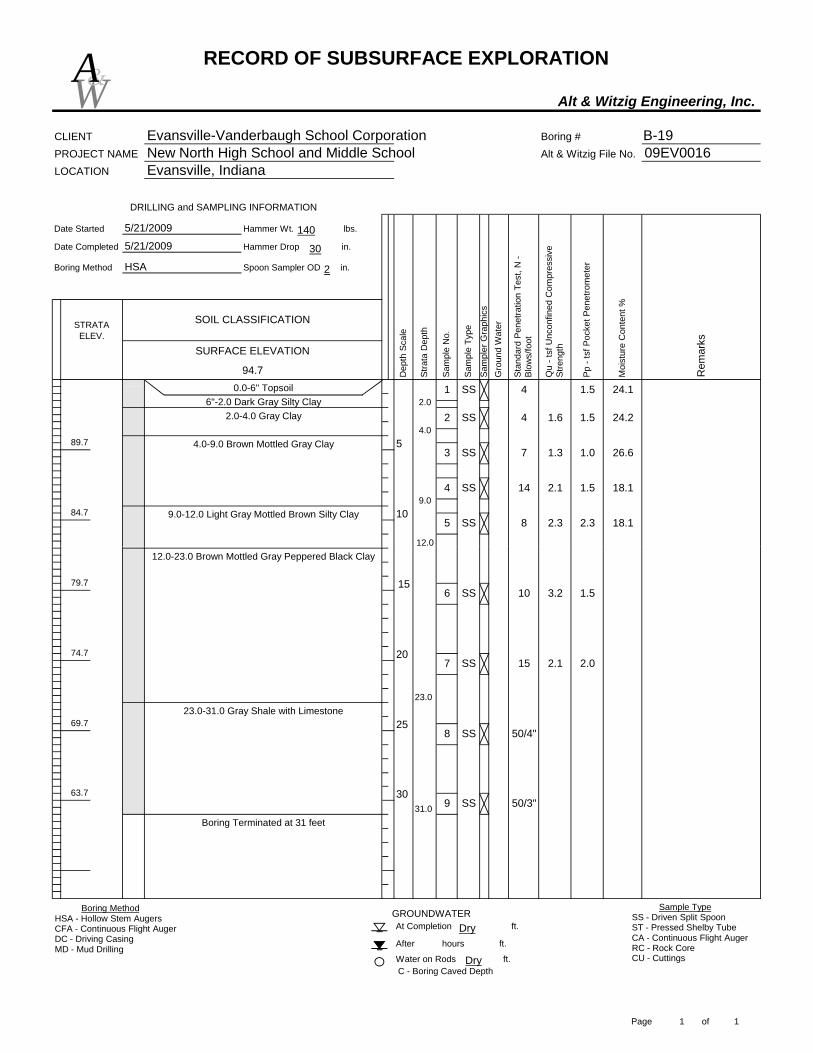
RECORD OF SUBSURFACE EXPLORATION
Alt & Witzig Engineering, Inc.
CLIENT Evansville-Vanderbaugh School Corporation Boring # B-19PROJECT NAME New North High School and Middle School Alt & Witzig File No. 09EV0016LOCATION Evansville, Indiana
Date Started Hammer Wt. lbs.
Date Completed Hammer Drop in.
Boring Method Spoon Sampler OD in.
STRATA ELEV.
94.7
SOIL CLASSIFICATION
5/21/2009
5/21/2009
HSA
0.0-6" Topsoil
Moi
stur
e C
onte
nt %
Rem
arks
1084.7
DRILLING and SAMPLING INFORMATION
89.7
Dep
th S
cale
Stra
ta D
epth
Gro
und
Wat
er
Stan
dard
Pen
etra
tion
Test
, N -
Blow
s/fo
ot
Sam
ple
No.
Pp -
tsf P
ocke
t Pen
etro
met
er
SURFACE ELEVATION
Sam
ple
Type
1 SS
4
Sam
pler
Gra
phic
s
Qu
- tsf
Unc
onfin
ed C
ompr
essi
ve
Stre
ngth
1.62 SS 24.2
3 SS 7 1.3 1.0 26.6
1.5 18.114 2.1
1.5
2.3 18.15 SS
4 SS
8 2.3
6"-2.0 Dark Gray Silty Clay
4.02.0-4.0 Gray Clay
9.0
4.0-9.0 Brown Mottled Gray Clay
12.0
9.0-12.0 Light Gray Mottled Brown Silty Clay
5
24.14 1.52.0
W&A
140
30
2
At Completion ft.
After hours ft.
Water on Rods ft.
GROUNDWATER
C - Boring Caved Depth
30
23.0-31.0 Gray Shale with Limestone
Boring Terminated at 31 feet
63.7
2569.7
79.7
74.7
12.0-23.0 Brown Mottled Gray Peppered Black Clay
15
20
10 3.2 1.56 SS
15 2.1 2.07 SS
50/4"8 SS
9 SS
12.0
31.0
23.0
50/3"
Boring MethodHSA - Hollow Stem AugersCFA - Continuous Flight AugerDC - Driving CasingMD - Mud Drilling
Sample TypeSS - Driven Split SpoonST - Pressed Shelby TubeCA - Continuous Flight AugerRC - Rock CoreCU - CuttingsDry
Dry
Page 1 of 1

RECORD OF SUBSURFACE EXPLORATION
Alt & Witzig Engineering, Inc.
CLIENT Evansville-Vanderbaugh School Corporation Boring # B-20PROJECT NAME New North High School and Middle School Alt & Witzig File No. 09EV0016LOCATION Evansville, Indiana
Date Started Hammer Wt. lbs.
Date Completed Hammer Drop in.
Boring Method Spoon Sampler OD in.
3 ST
SS
STRATA ELEV.
93.2
SOIL CLASSIFICATION
5/21/2009
5/21/2009
HSA
5
1083.2
DRILLING and SAMPLING INFORMATION
88.2
Moi
stur
e C
onte
nt %
1.0 0.5 28.4
2
Rem
arks
Dep
th S
cale
Stra
ta D
epth
Gro
und
Wat
er
Stan
dard
Pen
etra
tion
Test
, N -
Blow
s/fo
ot
Sam
ple
No.
Pp -
tsf P
ocke
t Pen
etro
met
er
Sam
pler
Gra
phic
s
Qu
- tsf
Unc
onfin
ed C
ompr
essi
ve
Stre
ngth
0.0-8" Topsoil
6 1.6
SURFACE ELEVATION
Sam
ple
Type
31 SS
1.0 27.4
4 SS 6 1.7 1.5 18.4
4.0
8"-4.0 Brown Mottled Gray Clay
7.0
4.0-7.0 Gray Clay
7.0-14.0 Brown Mottled Gray Silty Clay
W&A
140
30
2
C - Boring Caved Depth
At Completion ft.
After hours ft.
Water on Rods ft.
GROUNDWATER
Auger Refusal at 26 feet
73.2
2567.2
78.2 15
20
5 SS 8 2.1 2.0 20.5
8 4.0 20.76 SS
50/2"7 SS26.0
14.0
23.0
14.0-23.0 Brown Mottled Gray Peppered Black Clay
23.0-26.0 Gray Shale
Boring MethodHSA - Hollow Stem AugersCFA - Continuous Flight AugerDC - Driving CasingMD - Mud Drilling
Sample TypeSS - Driven Split SpoonST - Pressed Shelby TubeCA - Continuous Flight AugerRC - Rock CoreCU - Cuttings24.0
Page 1 of 1
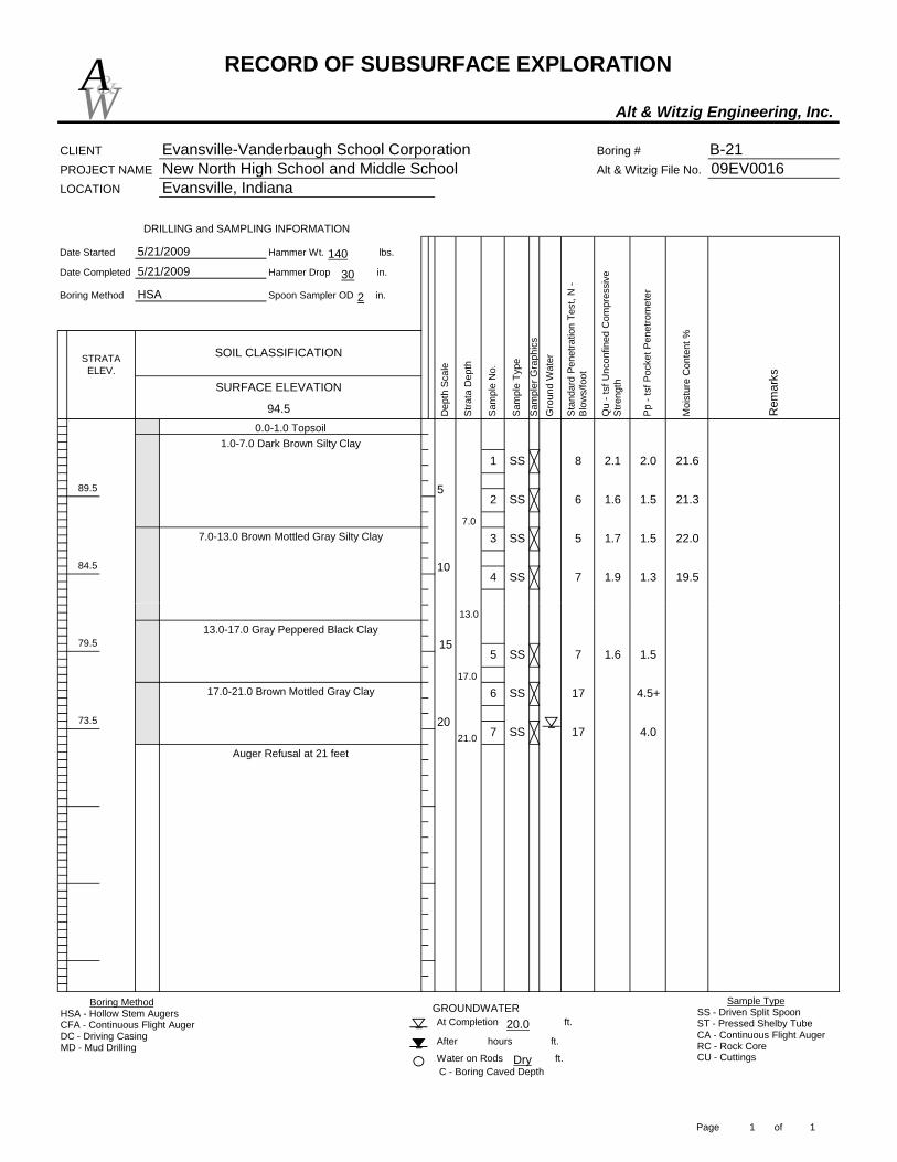
RECORD OF SUBSURFACE EXPLORATION
Alt & Witzig Engineering, Inc.
CLIENT Evansville-Vanderbaugh School Corporation Boring # B-21PROJECT NAME New North High School and Middle School Alt & Witzig File No. 09EV0016LOCATION Evansville, Indiana
Date Started Hammer Wt. lbs.
Date Completed Hammer Drop in.
Boring Method Spoon Sampler OD in.
STRATA ELEV.
94.5
SOIL CLASSIFICATION
5/21/2009
5/21/2009
HSA
Stan
dard
Pen
etra
tion
Test
, N -
Blow
s/fo
ot
Sam
ple
No.
5
Pp -
tsf P
ocke
t Pen
etro
met
er
1084.5
DRILLING and SAMPLING INFORMATION
89.5
Sam
pler
Gra
phic
s
Moi
stur
e C
onte
nt %
Rem
arks
Dep
th S
cale
Stra
ta D
epth
Gro
und
Wat
er
Qu
- tsf
Unc
onfin
ed C
ompr
essi
ve
Stre
ngth
8 2.1
SURFACE ELEVATION
Sam
ple
Type
0.0-1.0 Topsoil
3
1 SS 21.6
2 SS
1.5 22.05 1.7
2.0
19.54 SS
6 1.6 1.5 21.3
SS
7 1.9 1.3
7.0
1.0-7.0 Dark Brown Silty Clay
7.0-13.0 Brown Mottled Gray Silty Clay
W&A
140
30
2
C - Boring Caved Depth
Auger Refusal at 21 feet
At Completion ft.
After hours ft.
Water on Rods ft.
GROUNDWATER
79.5
73.5
17.0-21.0 Brown Mottled Gray Clay
20
157 1.6 1.55 SS
17 4.5+6 SS
17 4.07 SS21.0
13.0
17.0
13.0-17.0 Gray Peppered Black Clay
Boring MethodHSA - Hollow Stem AugersCFA - Continuous Flight AugerDC - Driving CasingMD - Mud Drilling
Sample TypeSS - Driven Split SpoonST - Pressed Shelby TubeCA - Continuous Flight AugerRC - Rock CoreCU - CuttingsDry
20.0
Page 1 of 1
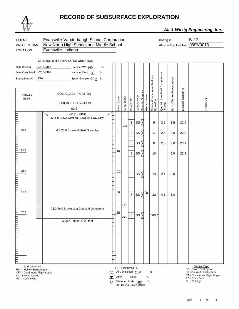
RECORD OF SUBSURFACE EXPLORATION
Alt & Witzig Engineering, Inc.
CLIENT Evansville-Vanderbaugh School Corporation Boring # B-22PROJECT NAME New North High School and Middle School Alt & Witzig File No. 09EV0016LOCATION Evansville, Indiana
Date Started Hammer Wt. lbs.
Date Completed Hammer Drop in.
Boring Method Spoon Sampler OD in.
STRATA ELEV.
93.3
SOIL CLASSIFICATION
5/21/2009
5/21/2009
5
1083.3
DRILLING and SAMPLING INFORMATION
SURFACE ELEVATION
88.3
0.0-6" Topsoil
Moi
stur
e C
onte
nt %
Rem
arks
Dep
th S
cale
Stra
ta D
epth
Gro
und
Wat
er
Stan
dard
Pen
etra
tion
Test
, N -
Blow
s/fo
ot
Sam
ple
No.
Pp -
tsf P
ocke
t Pen
etro
met
er
Sam
pler
Gra
phic
s
Qu
- tsf
Unc
onfin
ed C
ompr
essi
ve
Stre
ngth
2.7 1.5
3 SS
Sam
ple
Type
91 SS
HSA
21.6
2 SS 11 2.5 2.0 20.8
8 2.5 2.0 20.1
5 SS 0.8 22.210
4.0
6"-4.0 Brown Mottled Brownish Gray Clay
4.0-23.0 Brown Mottled Gray clay
W&A
140
30
2
C - Boring Caved Depth
At Completion ft.
After hours ft.
Water on Rods ft.
GROUNDWATER
2567.3
73.3
Auger Refusal at 26 feet
78.3
2022 4.5 3.0
13 2.1
7 SS
50/2"8 SS26.0
23.023.0-26.0 Brown Wet Clay and Limestone
152.06 SS
Boring MethodHSA - Hollow Stem AugersCFA - Continuous Flight AugerDC - Driving CasingMD - Mud Drilling
Sample TypeSS - Driven Split SpoonST - Pressed Shelby TubeCA - Continuous Flight AugerRC - Rock CoreCU - CuttingsDry
20.0
Page 1 of 1

RECORD OF SUBSURFACE EXPLORATION
Alt & Witzig Engineering, Inc.
CLIENT Evansville-Vanderbaugh School Corporation Boring # B-23PROJECT NAME New North High School and Middle School Alt & Witzig File No. 09EV0016LOCATION Evansville, Indiana
Date Started Hammer Wt. lbs.
Date Completed Hammer Drop in.
Boring Method Spoon Sampler OD in.
STRATA ELEV.
93.0
SOIL CLASSIFICATION
5/21/2009
5/21/2009
HSA
Stan
dard
Pen
etra
tion
Test
, N -
Blow
s/fo
ot
Sam
ple
No.
Pp -
tsf P
ocke
t Pen
etro
met
er
5
1083.0
DRILLING and SAMPLING INFORMATION
88.0
Sam
pler
Gra
phic
s
Moi
stur
e C
onte
nt %
Rem
arks
Dep
th S
cale
Stra
ta D
epth
Gro
und
Wat
er
Qu
- tsf
Unc
onfin
ed C
ompr
essi
ve
Stre
ngth
6 2.2
SURFACE ELEVATION
Sam
ple
Type
0.0-6" Tosoil
3
1 SS 25.8
2 SS
0.5 21.65 1.2
2.5
18.14 SS
7 1.6 1.5 25.0
SS
8 2.9 1.5
7.0
6"-7.0 Brown Mottled Gray Clay
7.0-13.0 Brown Mottled Brownish Gray Silty Clay
W&A
140
30
2
C - Boring Caved Depth
Auger Refusal at 21 feet
At Completion ft.
After hours ft.
Water on Rods ft.
GROUNDWATER
78.0
72.018.0-21.0 Brown Mottled Gray Clay with Siltstone
20
159 2.0 1.55 SS
586 SS21.0
13.0
18.0
13.0-18.0 Brown Mottled Gray Peppered Black Clay
Boring MethodHSA - Hollow Stem AugersCFA - Continuous Flight AugerDC - Driving CasingMD - Mud Drilling
Sample TypeSS - Driven Split SpoonST - Pressed Shelby TubeCA - Continuous Flight AugerRC - Rock CoreCU - CuttingsDry
16.0
Page 1 of 1
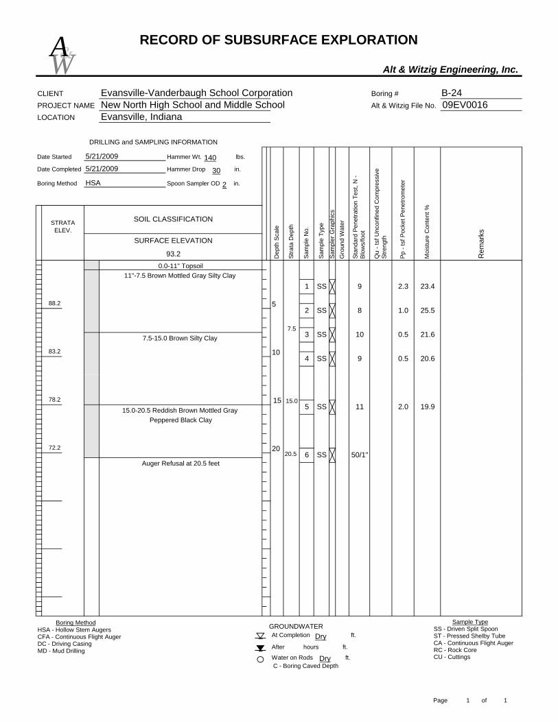
RECORD OF SUBSURFACE EXPLORATION
Alt & Witzig Engineering, Inc.
CLIENT Evansville-Vanderbaugh School Corporation Boring # B-24PROJECT NAME New North High School and Middle School Alt & Witzig File No. 09EV0016LOCATION Evansville, Indiana
Date Started Hammer Wt. lbs.
Date Completed Hammer Drop in.
Boring Method Spoon Sampler OD in.
STRATA ELEV.
93.2
SOIL CLASSIFICATION
5/21/2009
5/21/2009
HSA
SURFACE ELEVATION
83.2
DRILLING and SAMPLING INFORMATION
88.2
0.0-11" Topsoil
5
10
Moi
stur
e C
onte
nt %
Rem
arks
Dep
th S
cale
Stra
ta D
epth
Gro
und
Wat
er
Stan
dard
Pen
etra
tion
Test
, N -
Blow
s/fo
ot
Sam
ple
No.
Pp -
tsf P
ocke
t Pen
etro
met
er
Sam
pler
Gra
phic
s
Qu
- tsf
Unc
onfin
ed C
ompr
essi
ve
Stre
ngth
Sam
ple
Type
9
3 SS
2.31 SS 23.4
2 SS 8 1.0 25.5
10 0.5 21.6
4 SS 0.5 20.69
7.5
11"-7.5 Brown Mottled Gray Silty Clay
7.5-15.0 Brown Silty Clay
W&A
140
30
2
C - Boring Caved Depth
At Completion ft.
After hours ft.
Water on Rods ft.
GROUNDWATER
Auger Refusal at 20.5 feet
72.2
78.2
20
1511 2.0 19.95 SS
50/1"6 SS20.5
15.015.0-20.5 Reddish Brown Mottled Gray
Peppered Black Clay
Boring MethodHSA - Hollow Stem AugersCFA - Continuous Flight AugerDC - Driving CasingMD - Mud Drilling
Sample TypeSS - Driven Split SpoonST - Pressed Shelby TubeCA - Continuous Flight AugerRC - Rock CoreCU - CuttingsDry
Dry
Page 1 of 1

RECORD OF SUBSURFACE EXPLORATION
Alt & Witzig Engineering, Inc.
CLIENT Evansville-Vanderbaugh School Corporation Boring # B-25PROJECT NAME New North High School and Middle School Alt & Witzig File No. 09EV0016LOCATION Evansville, Indiana
Date Started Hammer Wt. lbs.
Date Completed Hammer Drop in.
Boring Method Spoon Sampler OD in.
SOIL CLASSIFICATION
5/21/2009
5/21/2009
HSA
5
1083.2
DRILLING and SAMPLING INFORMATION
STRATA ELEV.
93.2
88.2
Stan
dard
Pen
etra
tion
Test
, N -
Blow
s/fo
ot
Sam
ple
No.
Pp -
tsf P
ocke
t Pen
etro
met
er
Sam
pler
Gra
phic
s
Qu
- tsf
Unc
onfin
ed C
ompr
essi
ve
Stre
ngth
8
Moi
stur
e C
onte
nt %
Rem
arks
Dep
th S
cale
Stra
ta D
epth
Gro
und
Wat
er
SURFACE ELEVATION
Sam
ple
Type
0.0-8" Topsoil
4
1.81 SS 22.9
2 SS 7 2.6 2.5 23.7
1.0 24.4
10 2.2 1.5SS
113 SS9.0
8"-9.0 Brown Mottled Gray Silty Clay
9.0-13.0 Brown Silty Clay
W&A
140
30
2
Water on Rods ft.C - Boring Caved Depth
At Completion ft.
After hours ft.
GROUNDWATER
Auger Refusal at 27 feet
2566.2
78.2
73.2 20
11 2.05 SS
18 3.9 4.56 SS
50/2"7 SS
27.0
13.0
19.0
13.0-19.0 Brown Mottled Gray Peppered Black Clay
19.0-27.0 Brown Mottled Gray Clay
15
Boring MethodHSA - Hollow Stem AugersCFA - Continuous Flight AugerDC - Driving CasingMD - Mud Drilling
Sample TypeSS - Driven Split SpoonST - Pressed Shelby TubeCA - Continuous Flight AugerRC - Rock CoreCU - CuttingsDry
24.5
Page 1 of 1
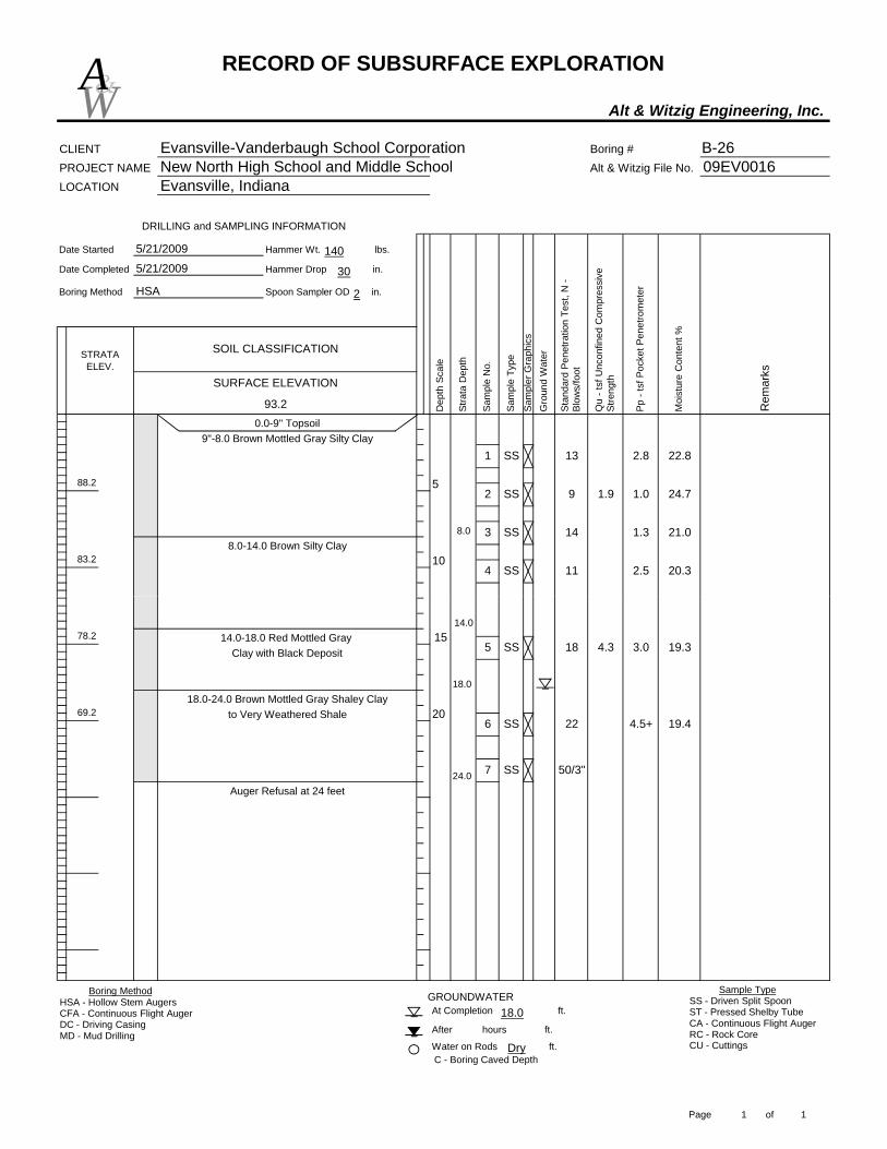
RECORD OF SUBSURFACE EXPLORATION
Alt & Witzig Engineering, Inc.
CLIENT Evansville-Vanderbaugh School Corporation Boring # B-26PROJECT NAME New North High School and Middle School Alt & Witzig File No. 09EV0016LOCATION Evansville, Indiana
Date Started Hammer Wt. lbs.
Date Completed Hammer Drop in.
Boring Method Spoon Sampler OD in.
STRATA ELEV.
93.2
88.2
0.0-9" Topsoil
5/21/2009
HSA
Qu
- tsf
Unc
onfin
ed C
ompr
essi
ve
Stre
ngth
Sam
ple
Type
1083.2
DRILLING and SAMPLING INFORMATION
SURFACE ELEVATION
5
Moi
stur
e C
onte
nt %
Rem
arks
Dep
th S
cale
Stra
ta D
epth
Gro
und
Wat
er
Stan
dard
Pen
etra
tion
Test
, N -
Blow
s/fo
ot
Sam
ple
No.
Pp -
tsf P
ocke
t Pen
etro
met
er
2.8
3 SS
4 SS
131 SS9"-8.0 Brown Mottled Gray Silty Clay
Sam
pler
Gra
phic
s
SOIL CLASSIFICATION
5/21/2009
22.8
2 SS 9 1.9 1.0 24.7
11 2.5 20.3
14 1.3 21.08.08.0-14.0 Brown Silty Clay
W&A
140
30
2
to Very Weathered Shale
C - Boring Caved Depth
At Completion ft.
After hours ft.
Water on Rods ft.
GROUNDWATER
69.2
Auger Refusal at 24 feet
78.2
20
155 SS
7 SS
6
19.3
14.0
50/3"
SS 22 19.4
24.0
4.5+
18 4.3 3.0
18.0
14.0-18.0 Red Mottled Gray
18.0-24.0 Brown Mottled Gray Shaley Clay
Clay with Black Deposit
Boring MethodHSA - Hollow Stem AugersCFA - Continuous Flight AugerDC - Driving CasingMD - Mud Drilling
Sample TypeSS - Driven Split SpoonST - Pressed Shelby TubeCA - Continuous Flight AugerRC - Rock CoreCU - CuttingsDry
18.0
Page 1 of 1

RECORD OF SUBSURFACE EXPLORATION
Alt & Witzig Engineering, Inc.
CLIENT Evansville-Vanderbaugh School Corporation Boring # B-27PROJECT NAME New North High School and Middle School Alt & Witzig File No. 09EV0016LOCATION Evansville, Indiana
Date Started Hammer Wt. lbs.
Date Completed Hammer Drop in.
Boring Method Spoon Sampler OD in.
STRATA ELEV.
92.4
5/21/2009
HSA
Stra
ta D
epth
Gro
und
Wat
er
Stan
dard
Pen
etra
tion
Test
, N -
Blow
s/fo
ot
Sam
ple
No.
SURFACE ELEVATION
Sam
ple
Type
5
Moi
stur
e C
onte
nt %
Rem
arks
1082.4
DRILLING and SAMPLING INFORMATION
87.4
0.0-7" Topsoil
Pp -
tsf P
ocke
t Pen
etro
met
er
Sam
pler
Gra
phic
s
Qu
- tsf
Unc
onfin
ed C
ompr
essi
ve
Stre
ngth
2.0
3
1.3
111 SSD
epth
Sca
le
21.9
SOIL CLASSIFICATION
5/21/2009
23.0
2 SS 10 1.8
2.5 19.1
24.4
SS 12 3.4 2.3
4 SS 1210.0
7"-10.0 Brown Mottled Gray Silty Clay
10.0-20.0 Gray Silty Sandy Clay
W&A
140
30
2
25.5
C - Boring Caved Depth
At Completion ft.
After hours ft.
Water on Rods ft.
GROUNDWATER
25
Auger Refusal at 25.5 feet
66.4
20.0-21.0 Brown Mottled Gray Shaley Clay
77.4
72.4 20
1511 4.0 20.05 SS
26 4.5+ 17.66 SS20.0
Boring MethodHSA - Hollow Stem AugersCFA - Continuous Flight AugerDC - Driving CasingMD - Mud Drilling
Sample TypeSS - Driven Split SpoonST - Pressed Shelby TubeCA - Continuous Flight AugerRC - Rock CoreCU - CuttingsDry
22.5
Page 1 of 1
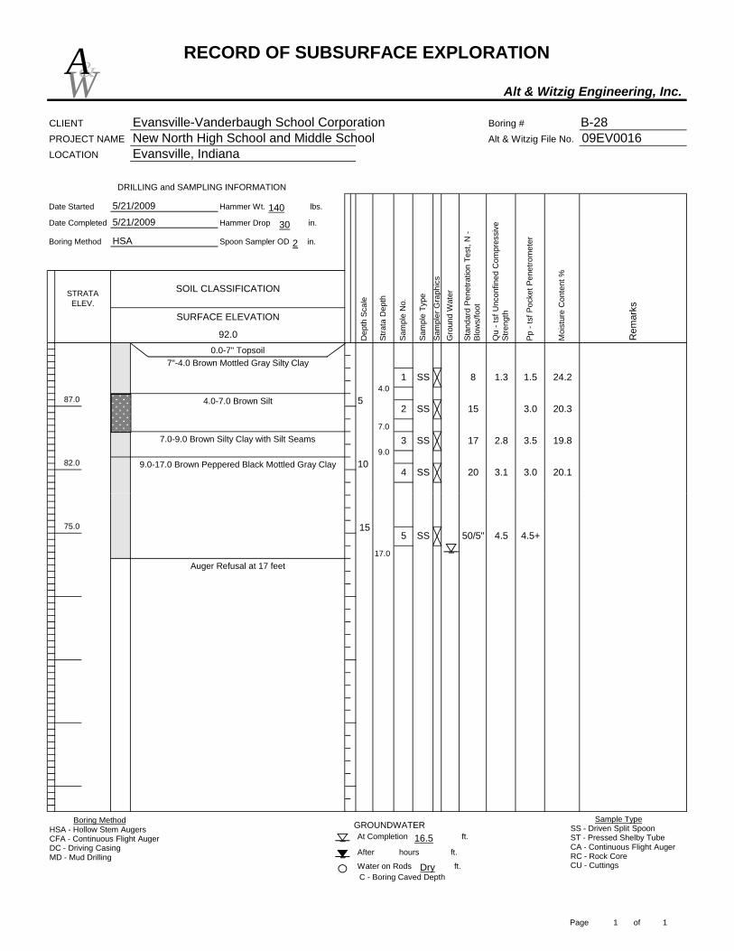
RECORD OF SUBSURFACE EXPLORATION
Alt & Witzig Engineering, Inc.
CLIENT Evansville-Vanderbaugh School Corporation Boring # B-28PROJECT NAME New North High School and Middle School Alt & Witzig File No. 09EV0016LOCATION Evansville, Indiana
Date Started Hammer Wt. lbs.
Date Completed Hammer Drop in.
Boring Method Spoon Sampler OD in.
STRATA ELEV.
92.0
SOIL CLASSIFICATION
5/21/2009
5/21/2009
HSA
SURFACE ELEVATION
Sam
pler
Gra
phic
s
Qu
- tsf
Unc
onfin
ed C
ompr
essi
ve
Stre
ngth
Sam
ple
Type
5
DRILLING and SAMPLING INFORMATION
1082.0
0.0-7" Topsoil
87.0
Moi
stur
e C
onte
nt %
Rem
arks
Dep
th S
cale
Stra
ta D
epth
Gro
und
Wat
er
Stan
dard
Pen
etra
tion
Test
, N -
Blow
s/fo
ot
Sam
ple
No.
Pp -
tsf P
ocke
t Pen
etro
met
er
8 1.3 1.51 SS 24.2
2 SS 15 3.0 20.3
3.5 19.8
20 3.1 3.0 20.14 SS
17 2.83 SS
4.0
7"-4.0 Brown Mottled Gray Silty Clay
7.0
4.0-7.0 Brown Silt
9.07.0-9.0 Brown Silty Clay with Silt Seams
9.0-17.0 Brown Peppered Black Mottled Gray Clay
W&A
140
30
2
At Completion ft.
After hours ft.
Water on Rods ft.C - Boring Caved Depth
GROUNDWATER
75.0
Auger Refusal at 17 feet
1550/5" 4.5 4.5+5 SS
17.0
Boring MethodHSA - Hollow Stem AugersCFA - Continuous Flight AugerDC - Driving CasingMD - Mud Drilling
Sample TypeSS - Driven Split SpoonST - Pressed Shelby TubeCA - Continuous Flight AugerRC - Rock CoreCU - CuttingsDry
16.5
Page 1 of 1

RECORD OF SUBSURFACE EXPLORATION
Alt & Witzig Engineering, Inc.
CLIENT Evansville-Vanderbaugh School Corporation Boring # B-29PROJECT NAME New North High School and Middle School Alt & Witzig File No. 09EV0016LOCATION Evansville, Indiana
Date Started Hammer Wt. lbs.
Date Completed Hammer Drop in.
Boring Method Spoon Sampler OD in.
93.7
SOIL CLASSIFICATION
5/21/2009
5/21/2009
HSA
SURFACE ELEVATION
Rem
arks
Dep
th S
cale
5
DRILLING and SAMPLING INFORMATION
1083.7
0.0-7" Topsoil7"-7.0 Brown Mottled Gray Silty Clay
STRATA ELEV.
88.7
Moi
stur
e C
onte
nt %
1 SS
2 SS
Sam
ple
Type
Stra
ta D
epth
Gro
und
Wat
er
Stan
dard
Pen
etra
tion
Test
, N -
Blow
s/fo
ot
Sam
ple
No.
Pp -
tsf P
ocke
t Pen
etro
met
er
Sam
pler
Gra
phic
s
Qu
- tsf
Unc
onfin
ed C
ompr
essi
ve
Stre
ngth
4.3
17 2.0 21.9
12 2.8
4 SS
24.4
3 SS
20 3.1 3.5 25.7
29 4.7 4.5+ 18.85 SS9.0-14.0 Brown Mottled Gray Peppered Black clay
9.07.0-9.0 Brown Clay
with Silt Seams
23.27 1.7
7.0
W&A
140
30
2
Auger Refusal at 21 feet
At Completion ft.
After hours ft.
Water on Rods ft.C - Boring Caved Depth
GROUNDWATER
78.7
72.7 20
156 SS
50/2"7 SS
14.014.0-21.0 Gray Clay
21.0
24 4.3 4.5+
Boring MethodHSA - Hollow Stem AugersCFA - Continuous Flight AugerDC - Driving CasingMD - Mud Drilling
Sample TypeSS - Driven Split SpoonST - Pressed Shelby TubeCA - Continuous Flight AugerRC - Rock CoreCU - CuttingsDry
Dry
Page 1 of 1

RECORD OF SUBSURFACE EXPLORATION
Alt & Witzig Engineering, Inc.
CLIENT Evansville-Vanderbaugh School Corporation Boring # B-30PROJECT NAME New North High School and Middle School Alt & Witzig File No. 09EV0016LOCATION Evansville, Indiana
Date Started Hammer Wt. lbs.
Date Completed Hammer Drop in.
Boring Method Spoon Sampler OD in.
STRATA ELEV.
93.0 Pp -
tsf P
ocke
t Pen
etro
met
er
SOIL CLASSIFICATION
5/21/2009
5/21/2009
HSA
Stan
dard
Pen
etra
tion
Test
, N -
Blow
s/fo
ot
Sam
ple
No.
5
1083.0
DRILLING and SAMPLING INFORMATION
88.0
Sam
pler
Gra
phic
s
Moi
stur
e C
onte
nt %
Rem
arks
Dep
th S
cale
Stra
ta D
epth
Gro
und
Wat
er
Qu
- tsf
Unc
onfin
ed C
ompr
essi
ve
Stre
ngth
12 1.9
SURFACE ELEVATION
Sam
ple
Type
0.0-6" Topsoil
3
1 SS 25.7
2 SS
3.0 20.314 2.7
1.5
22.24 SS
11 2.5 29.1
SS
17 2.7 2.0
7.0
6"-7.0 Brown Mottled Gray Silty Clay
9.07.0-9.0 Brown Silty Clay
9.0-13.0 Brown Clay with Silt Seams
W&A
140
30
2
C - Boring Caved Depth
Auger Refusal at 21 feet
13.0-21.0 Brown Mottled Gray Peppered Black Clay
After hours ft.
Water on Rods ft.
At Completion ft. GROUNDWATER
72.0
78.0
20
1517 3.7 2.05 SS
50/2" 4.56
13.0
SS21.0
Boring MethodHSA - Hollow Stem AugersCFA - Continuous Flight AugerDC - Driving CasingMD - Mud Drilling
Sample TypeSS - Driven Split SpoonST - Pressed Shelby TubeCA - Continuous Flight AugerRC - Rock CoreCU - CuttingsDry
10.0
Page 1 of 1
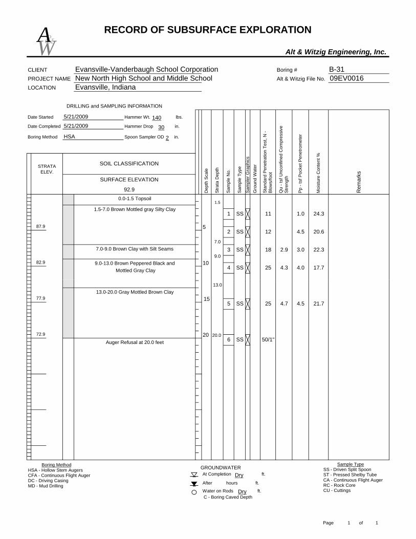
RECORD OF SUBSURFACE EXPLORATION
Alt & Witzig Engineering, Inc.
CLIENT Evansville-Vanderbaugh School Corporation Boring # B-31PROJECT NAME New North High School and Middle School Alt & Witzig File No. 09EV0016LOCATION Evansville, Indiana
Date Started Hammer Wt. lbs.
Date Completed Hammer Drop in.
Boring Method Spoon Sampler OD in.
STRATA ELEV.
92.9
9.0-13.0 Brown Peppered Black and Mottled Gray Clay
SOIL CLASSIFICATION
5/21/2009
1082.9
DRILLING and SAMPLING INFORMATION
87.9
Rem
arks
Dep
th S
cale
Stra
ta D
epth
Gro
und
Wat
er
Stan
dard
Pen
etra
tion
Test
, N -
Blow
s/fo
ot
Pp -
tsf P
ocke
t Pen
etro
met
er
Sam
pler
Gra
phic
s
Moi
stur
e C
onte
nt %
Qu
- tsf
Unc
onfin
ed C
ompr
essi
ve
Stre
ngthSURFACE ELEVATION
Sam
ple
Type
1.50.0-1.5 Topsoil
Sam
ple
No.
5/21/2009
HSA
11 1.01 SS 24.3
2 SS 12 4.5 20.6
3.0 22.3
25 4.3 4.0 17.7SS
18 2.93 SS
4
1.5-7.0 Brown Mottled gray Silty Clay
7.0
9.07.0-9.0 Brown Clay with Silt Seams
5
W&A
140
30
2
Auger Refusal at 20.0 feet
At Completion ft.
After hours ft.
Water on Rods ft.
GROUNDWATER
C - Boring Caved Depth
77.9
72.9
13.0-20.0 Gray Mottled Brown Clay
20
15
20.0
13.0
4.5 21.75 SS 25 4.7
6 SS 50/1"
Boring MethodHSA - Hollow Stem AugersCFA - Continuous Flight AugerDC - Driving CasingMD - Mud Drilling
Sample TypeSS - Driven Split SpoonST - Pressed Shelby TubeCA - Continuous Flight AugerRC - Rock CoreCU - CuttingsDry
Dry
Page 1 of 1

RECORD OF SUBSURFACE EXPLORATION
Alt & Witzig Engineering, Inc.
CLIENT Evansville-Vanderbaugh School Corporation Boring # B-32PROJECT NAME New North High School and Middle School Alt & Witzig File No. 09EV0016LOCATION Evansville, Indiana
Date Started Hammer Wt. lbs.
Date Completed Hammer Drop in.
Boring Method Spoon Sampler OD in.
SOIL CLASSIFICATION
5/21/2009
5/21/2009
HSA
13
1080.1
Boring Terminated at 11.0 feet
DRILLING and SAMPLING INFORMATION
STRATA ELEV.
91.10.0-8" Topsoil
86.1
Moi
stur
e C
onte
nt %
Rem
arks
Dep
th S
cale
Stra
ta D
epth
Gro
und
Wat
er
Stan
dard
Pen
etra
tion
Test
, N -
Blow
s/fo
ot
Sam
ple
No.
Pp -
tsf P
ocke
t Pen
etro
met
er
Sam
pler
Gra
phic
s
Qu
- tsf
Unc
onfin
ed C
ompr
essi
ve
Stre
ngthSURFACE ELEVATION
Sam
ple
Type
2.0 2.01 SS 25.1
2 SS 13 3.5 19.0
3.5 17.2
15 3.0 4.0 18.14 SS
153 SS
11.0
8"-10 Brown Silty Clay
10.010.0-11.0 Brown Mottled Gray Clay
5
W&A
140
30
2
At Completion ft.
After hours ft.
Water on Rods ft.C - Boring Caved Depth
GROUNDWATER
Boring Terminated at 11.0 feet
Boring MethodHSA - Hollow Stem AugersCFA - Continuous Flight AugerDC - Driving CasingMD - Mud Drilling
Sample TypeSS - Driven Split SpoonST - Pressed Shelby TubeCA - Continuous Flight AugerRC - Rock CoreCU - CuttingsDry
5.024Dry
Page 1 of 1
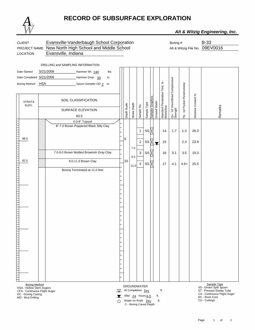
RECORD OF SUBSURFACE EXPLORATION
Alt & Witzig Engineering, Inc.
CLIENT Evansville-Vanderbaugh School Corporation Boring # B-33PROJECT NAME New North High School and Middle School Alt & Witzig File No. 09EV0016LOCATION Evansville, Indiana
Date Started Hammer Wt. lbs.
Date Completed Hammer Drop in.
Boring Method Spoon Sampler OD in.
STRATA ELEV.
93.5
5/21/2009
5/21/2009
HSA
SOIL CLASSIFICATION
Moi
stur
e C
onte
nt %
Rem
arks
DRILLING and SAMPLING INFORMATION
10
Boring Terminated at 11.0 feet
82.5
0.0-8" Topsoil
88.5
Stan
dard
Pen
etra
tion
Test
, N -
Blow
s/fo
ot
Sam
ple
No.
Pp -
tsf P
ocke
t Pen
etro
met
er
Sam
pler
Gra
phic
s
Qu
- tsf
Unc
onfin
ed C
ompr
essi
ve
Stre
ngthSURFACE ELEVATION
Sam
ple
Type
Dep
th S
cale
Stra
ta D
epth
Gro
und
Wat
er
14 1.7 1.31 SS 26.3
2 SS 15 2.3 23.9
3.5 19.3
17 4.1 4.5+ 25.54 SS
16 3.13 SS
11.0
7.0
8"-7.0 Brown Peppered Black Silty Clay
9.07.0-9.0 Brown Mottled Brownish Gray Clay
9.0-11.0 Brown Clay
5
W&A
140
30
2
C - Boring Caved Depth
At Completion ft.
After hours ft.
Water on Rods ft.
GROUNDWATER
Boring Terminated at 11.0 feet
Boring MethodHSA - Hollow Stem AugersCFA - Continuous Flight AugerDC - Driving CasingMD - Mud Drilling
Sample TypeSS - Driven Split SpoonST - Pressed Shelby TubeCA - Continuous Flight AugerRC - Rock CoreCU - CuttingsDry
6.024Dry
Page 1 of 1

RECORD OF SUBSURFACE EXPLORATION
Alt & Witzig Engineering, Inc.
CLIENT Evansville-Vanderbaugh School Corporation Boring # B-34PROJECT NAME New North High School and Middle School Alt & Witzig File No. 09EV0016LOCATION Evansville, Indiana
Date Started Hammer Wt. lbs.
Date Completed Hammer Drop in.
Boring Method Spoon Sampler OD in.
STRATA ELEV.
89.7
5
Moi
stur
e C
onte
nt %
10
Boring Terminated at 11.0 feet
78.7
DRILLING and SAMPLING INFORMATION
84.7
11 2.01 SS
Rem
arks
Dep
th S
cale
Stra
ta D
epth
Gro
und
Wat
er
Stan
dard
Pen
etra
tion
Test
, N -
Blow
s/fo
ot
Sam
ple
No.
Pp -
tsf P
ocke
t Pen
etro
met
er
Sam
pler
Gra
phic
s
Qu
- tsf
Unc
onfin
ed C
ompr
essi
ve
Stre
ngth
0.0-8" Topsoil
SURFACE ELEVATION
Sam
ple
Type
SOIL CLASSIFICATION
5/21/2009
5/21/2009
HSA
22.4
2 SS 8 1.5 23.7
3.3 20.3
13 3.5 3.0 20.64 SS
15 3.33 SS
11.0
4.0
8"-4.0 Brown Mottled Gray Silty Clay
7.0
4.0-7.0 Brown Mottled Gray Peppered Black
7.0-11.0 Brown Silty Clay
Silty Clay
W&A
140
30
2
C - Boring Caved Depth
At Completion ft.
After hours ft.
Water on Rods ft.
GROUNDWATER
Boring Terminated at 11.0 feet
Boring MethodHSA - Hollow Stem AugersCFA - Continuous Flight AugerDC - Driving CasingMD - Mud Drilling
Sample TypeSS - Driven Split SpoonST - Pressed Shelby TubeCA - Continuous Flight AugerRC - Rock CoreCU - CuttingsDry
5.024Dry
Page 1 of 1

RECORD OF SUBSURFACE EXPLORATION
Alt & Witzig Engineering, Inc.
CLIENT Evansville-Vanderbaugh School Corporation Boring # B-35PROJECT NAME New North High School and Middle School Alt & Witzig File No. 09EV0016LOCATION Evansville, Indiana
Date Started Hammer Wt. lbs.
Date Completed Hammer Drop in.
Boring Method Spoon Sampler OD in.
STRATA ELEV.
99.5
94.5
DRILLING and SAMPLING INFORMATION
Boring Terminated at 11.0 feet
88.5
SOIL CLASSIFICATION
5/21/2009
5/21/2009
HSA
0.0-9" Topsoil
10
Moi
stur
e C
onte
nt %
Rem
arks
Dep
th S
cale
Stra
ta D
epth
Gro
und
Wat
er
Stan
dard
Pen
etra
tion
Test
, N -
Blow
s/fo
ot
Sam
ple
No.
Pp -
tsf P
ocke
t Pen
etro
met
er
Sam
pler
Gra
phic
s
Qu
- tsf
Unc
onfin
ed C
ompr
essi
ve
Stre
ngthSURFACE ELEVATION
Sam
ple
Type
10 1.81 SS 23.5
2 SS 11 3.5 16.6
4.5+ 24.7
19 5.1 4.5+ 18.24 SS
18 4.63 SS
11.0
8.0
9"-8.0 Brown Peppered Black Silty Clay
10.08.0-10.0 Reddish Brown Clay
10.0-11.0 Reddish Brown Mottled Gray Clay
5
W&A
140
30
2
At Completion ft.
After hours ft.
Water on Rods ft.C - Boring Caved Depth
GROUNDWATER
Boring Terminated at 11.0 feet
Boring MethodHSA - Hollow Stem AugersCFA - Continuous Flight AugerDC - Driving CasingMD - Mud Drilling
Sample TypeSS - Driven Split SpoonST - Pressed Shelby TubeCA - Continuous Flight AugerRC - Rock CoreCU - CuttingsDry
6.024Dry
Page 1 of 1

RECORD OF SUBSURFACE EXPLORATION
Alt & Witzig Engineering, Inc.
CLIENT Evansville-Vanderbaugh School Corporation Boring # B-36PROJECT NAME New North High School and Middle School Alt & Witzig File No. 09EV0016LOCATION Evansville, Indiana
Date Started Hammer Wt. lbs.
Date Completed Hammer Drop in.
Boring Method Spoon Sampler OD in.
SOIL CLASSIFICATION
5/21/2009
5/21/2009
HSA
10
Boring Terminated at 11.0 feet
85.2
DRILLING and SAMPLING INFORMATION
STRATA ELEV.
91.2
Moi
stur
e C
onte
nt %
Rem
arks
Dep
th S
cale
Stra
ta D
epth
Gro
und
Wat
er
Stan
dard
Pen
etra
tion
Test
, N -
Blow
s/fo
ot
Sam
ple
No.
Pp -
tsf P
ocke
t Pen
etro
met
er
Sam
pler
Gra
phic
s
Qu
- tsf
Unc
onfin
ed C
ompr
essi
ve
Stre
ngthSURFACE ELEVATION
Sam
ple
Type
96.2
8 2.51 SS 21.8
2 SS 8 1.5 21.3
0.8 24.0
14 3.1 2.5 19.34 SS
113 SS
11.0
1.1-11.0 Brown Mottled Gray Silty Clay0.0-1.1 Topsoil 1.0
5
W&A
140
30
2
At Completion ft.
After hours ft.
Water on Rods ft.
GROUNDWATER
C - Boring Caved Depth
Boring Terminated at 11.0 feet
Boring MethodHSA - Hollow Stem AugersCFA - Continuous Flight AugerDC - Driving CasingMD - Mud Drilling
Sample TypeSS - Driven Split SpoonST - Pressed Shelby TubeCA - Continuous Flight AugerRC - Rock CoreCU - CuttingsDry
4.024Dry
Page 1 of 1

RECORD OF SUBSURFACE EXPLORATION
Alt & Witzig Engineering, Inc.
CLIENT Evansville-Vanderbaugh School Corporation Boring # B-37PROJECT NAME New North High School and Middle School Alt & Witzig File No. 09EV0016LOCATION Evansville, Indiana
Date Started Hammer Wt. lbs.
Date Completed Hammer Drop in.
Boring Method Spoon Sampler OD in.
SURFACE ELEVATION
STRATA ELEV.
97.3
SOIL CLASSIFICATION
5/21/2009
5/21/2009
HSA
DRILLING and SAMPLING INFORMATION
86.3
Boring Terminated at 11.0 feet
92.3
0.0-8" Topsoil
Moi
stur
e C
onte
nt %
Rem
arks
Dep
th S
cale
Stra
ta D
epth
Gro
und
Wat
er
Stan
dard
Pen
etra
tion
Test
, N -
Blow
s/fo
ot
Sam
ple
No.
Pp -
tsf P
ocke
t Pen
etro
met
er
Sam
pler
Gra
phic
s
Qu
- tsf
Unc
onfin
ed C
ompr
essi
ve
Stre
ngth
Sam
ple
Type
7
3 SS
0.81 SS
10
24.0
2 SS 9 2.8 22.5
12 4.0 21.0
4 SS 2.0 20.31111.010.0
8"-10.0 Brown Mottled Gray Peppered
10.0-11.0 Reddish Brown Mottled Gray Clay
Black Silty Clay
5
W&A
140
30
2
At Completion ft.
After hours ft.
Water on Rods ft.C - Boring Caved Depth
GROUNDWATER
Boring Terminated at 11.0 feet
Boring MethodHSA - Hollow Stem AugersCFA - Continuous Flight AugerDC - Driving CasingMD - Mud Drilling
Sample TypeSS - Driven Split SpoonST - Pressed Shelby TubeCA - Continuous Flight AugerRC - Rock CoreCU - CuttingsDry
5.024Dry
Page 1 of 1

RECORD OF SUBSURFACE EXPLORATION
Alt & Witzig Engineering, Inc.
CLIENT Evansville-Vanderbaugh School Corporation Boring # B-38PROJECT NAME New North High School and Middle School Alt & Witzig File No. 09EV0016LOCATION Evansville, Indiana
Date Started Hammer Wt. lbs.
Date Completed Hammer Drop in.
Boring Method Spoon Sampler OD in.
STRATA ELEV.
104.0
DRILLING and SAMPLING INFORMATION
1093.0
Boring Terminated at 11.0 feet
SOIL CLASSIFICATION
5/21/2009
0.0-8" Topsoil
5/21/2009
HSA
99.0
Moi
stur
e C
onte
nt %
Rem
arks
Dep
th S
cale
Stra
ta D
epth
Gro
und
Wat
er
Stan
dard
Pen
etra
tion
Test
, N -
Blow
s/fo
ot
Sam
ple
No.
Pp -
tsf P
ocke
t Pen
etro
met
er
Sam
pler
Gra
phic
s
Qu
- tsf
Unc
onfin
ed C
ompr
essi
ve
Stre
ngthSURFACE ELEVATION
Sam
ple
Type
5 3.51 SS 23.4
3 SS 13 2.3 22.0
2
2.3 18.6
37 6.0 4.5+ 14.75 SS
15 2.14 SS
11.0
2.58"-2.5 Light Brown Silty Clay Trace Roots
10.0
2.5-10.0 Black Peppered Brown Mottled
10.0-11.0 Black Peppered Brown Mottled Gray Shaley Clay
23.2
Gray Silty Clay
11 3.0 2.3
5
SS
W&A
140
30
2
At Completion ft.
After hours ft.
Water on Rods ft.C - Boring Caved Depth
GROUNDWATER
Boring Terminated at 11.0 feet
Boring MethodHSA - Hollow Stem AugersCFA - Continuous Flight AugerDC - Driving CasingMD - Mud Drilling
Sample TypeSS - Driven Split SpoonST - Pressed Shelby TubeCA - Continuous Flight AugerRC - Rock CoreCU - CuttingsDry
9.024Dry
Page 1 of 1

RECORD OF SUBSURFACE EXPLORATION
Alt & Witzig Engineering, Inc.
CLIENT Evansville-Vanderbaugh School Corporation Boring # B-39PROJECT NAME New North High School and Middle School Alt & Witzig File No. 09EV0016LOCATION Evansville, Indiana
Date Started Hammer Wt. lbs.
Date Completed Hammer Drop in.
Boring Method Spoon Sampler OD in.
11.0
7.0
6"-7.0 Brown Mottled Gray Silty Clay
7.0-11.0 Brown Mottled Gray Clay
4.0 21.5
10 2.2 2.0 24.03 SS
104 SS
24.2
2 SS 9 3.5 19.2
1.6 1.01 SS
STRATA ELEV.
93.0
Boring Terminated at 11.0 feet
7
5
1082.0
0.0-6" Topsoil
DRILLING and SAMPLING INFORMATION
88.0
Moi
stur
e C
onte
nt %
Rem
arks
Dep
th S
cale
Stra
ta D
epth
Gro
und
Wat
er
Stan
dard
Pen
etra
tion
Test
, N -
Blow
s/fo
ot
Sam
ple
No.
Pp -
tsf P
ocke
t Pen
etro
met
er
Sam
pler
Gra
phic
s
Qu
- tsf
Unc
onfin
ed C
ompr
essi
ve
Stre
ngthSURFACE ELEVATION
Sam
ple
Type
SOIL CLASSIFICATION
5/21/2009
5/21/2009
HSA
W&A
140
30
2
C - Boring Caved Depth
Boring Terminated at 11.0 feet
At Completion ft.
After hours ft.
Water on Rods ft.
GROUNDWATERBoring MethodHSA - Hollow Stem AugersCFA - Continuous Flight AugerDC - Driving CasingMD - Mud Drilling
Sample TypeSS - Driven Split SpoonST - Pressed Shelby TubeCA - Continuous Flight AugerRC - Rock CoreCU - CuttingsDry
Dry
Page 1 of 1

RECORD OF SUBSURFACE EXPLORATION
Alt & Witzig Engineering, Inc.
CLIENT Evansville-Vanderbaugh School Corporation Boring # B-40PROJECT NAME New North High School and Middle School Alt & Witzig File No. 09EV0016LOCATION Evansville, Indiana
Date Started Hammer Wt. lbs.
Date Completed Hammer Drop in.
Boring Method Spoon Sampler OD in.
STRATA ELEV.
10
Boring Terminated at 11.0 feet
DRILLING and SAMPLING INFORMATION
Moi
stur
e C
onte
nt %
Rem
arks
Dep
th S
cale
Stra
ta D
epth
Gro
und
Wat
er
Stan
dard
Pen
etra
tion
Test
, N -
Blow
s/fo
ot
Sam
ple
No.
Pp -
tsf P
ocke
t Pen
etro
met
er
Sam
pler
Gra
phic
s
0.0-1.0 Topsoil
Qu
- tsf
Unc
onfin
ed C
ompr
essi
ve
Stre
ngthSURFACE ELEVATION
Sam
ple
Type
SOIL CLASSIFICATION
5/21/2009
5/21/2009
HSA
22.9
6 1.7 1.51 SS 27.4
2 SS 6 2.0
8 2.3 2.0
10 3.011.0
9.0
1.0-9.0 Brown Mottled Gray Clay
9.0-11.0 Brown Silty Clay4 SS
3 SS
5
W&A
140
30
2
At Completion ft.
After hours ft.
Water on Rods ft.C - Boring Caved Depth
GROUNDWATER
Boring Terminated at 11.0 feet
Boring MethodHSA - Hollow Stem AugersCFA - Continuous Flight AugerDC - Driving CasingMD - Mud Drilling
Sample TypeSS - Driven Split SpoonST - Pressed Shelby TubeCA - Continuous Flight AugerRC - Rock CoreCU - CuttingsDry
9.0
Page 1 of 1
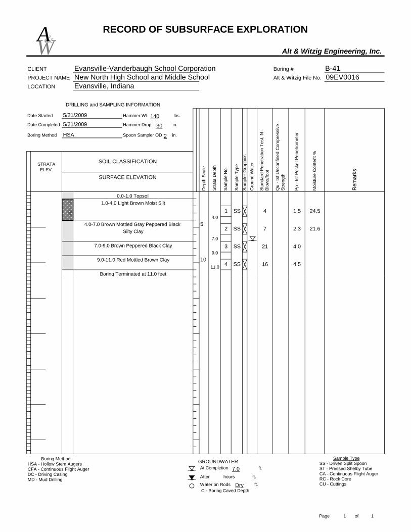
RECORD OF SUBSURFACE EXPLORATION
Alt & Witzig Engineering, Inc.
CLIENT Evansville-Vanderbaugh School Corporation Boring # B-41PROJECT NAME New North High School and Middle School Alt & Witzig File No. 09EV0016LOCATION Evansville, Indiana
Date Started Hammer Wt. lbs.
Date Completed Hammer Drop in.
Boring Method Spoon Sampler OD in.
STRATA ELEV.
5
10
Boring Terminated at 11.0 feet
DRILLING and SAMPLING INFORMATION
Moi
stur
e C
onte
nt %
Rem
arks
Dep
th S
cale
Stra
ta D
epth
Gro
und
Wat
er
Stan
dard
Pen
etra
tion
Test
, N -
Blow
s/fo
ot
Sam
ple
No.
Pp -
tsf P
ocke
t Pen
etro
met
er
Sam
pler
Gra
phic
s
0.0-1.0 Topsoil
Qu
- tsf
Unc
onfin
ed C
ompr
essi
ve
Stre
ngthSURFACE ELEVATION
Sam
ple
Type
SOIL CLASSIFICATION
5/21/2009
5/21/2009
HSA
4 1.51 SS 24.5
2 SS 7 2.3 21.6
4.0
16 4.54 SS
213 SS
11.0
4.0
1.0-4.0 Light Brown Moist Silt
7.0
4.0-7.0 Brown Mottled Gray Peppered Black
9.07.0-9.0 Brown Peppered Black Clay
9.0-11.0 Red Mottled Brown Clay
Silty Clay
W&A
140
30
2
C - Boring Caved Depth
At Completion ft.
After hours ft.
Water on Rods ft.
GROUNDWATER
Boring Terminated at 11.0 feet
Boring MethodHSA - Hollow Stem AugersCFA - Continuous Flight AugerDC - Driving CasingMD - Mud Drilling
Sample TypeSS - Driven Split SpoonST - Pressed Shelby TubeCA - Continuous Flight AugerRC - Rock CoreCU - CuttingsDry
7.0
Page 1 of 1

RECORD OF SUBSURFACE EXPLORATION
Alt & Witzig Engineering, Inc.
CLIENT Evansville-Vanderbaugh School Corporation Boring # B-42PROJECT NAME New North High School and Middle School Alt & Witzig File No. 09EV0016LOCATION Evansville, Indiana
Date Started Hammer Wt. lbs.
Date Completed Hammer Drop in.
Boring Method Spoon Sampler OD in.
11.0
7.0
2'-7.0 Brown Mottled Brownish Gray Clay
9.07.0-9.0 Brown Silty Clay
9.0-11.0 Reddish Brown Clay2.5 22.8
14 2.0 15.93 SS
15 3.64 SS
23.6
2 SS 8 1.2 1.0 22.8
2.51 SS
STRATA ELEV.
115.0
Boring Terminated at 11.0 feet
10
5
10104.0
0.0-2" Topsoil
DRILLING and SAMPLING INFORMATION
110.0
Moi
stur
e C
onte
nt %
Rem
arks
Dep
th S
cale
Stra
ta D
epth
Gro
und
Wat
er
Stan
dard
Pen
etra
tion
Test
, N -
Blow
s/fo
ot
Sam
ple
No.
Pp -
tsf P
ocke
t Pen
etro
met
er
Sam
pler
Gra
phic
s
Qu
- tsf
Unc
onfin
ed C
ompr
essi
ve
Stre
ngthSURFACE ELEVATION
Sam
ple
Type
SOIL CLASSIFICATION
5/21/2009
5/21/2009
HSA
W&A
140
30
2
C - Boring Caved Depth
Boring Terminated at 11.0 feet
At Completion ft.
After hours ft.
Water on Rods ft.
GROUNDWATERBoring MethodHSA - Hollow Stem AugersCFA - Continuous Flight AugerDC - Driving CasingMD - Mud Drilling
Sample TypeSS - Driven Split SpoonST - Pressed Shelby TubeCA - Continuous Flight AugerRC - Rock CoreCU - CuttingsDry
9.0
Page 1 of 1

RECORD OF SUBSURFACE EXPLORATION
Alt & Witzig Engineering, Inc.
CLIENT Evansville-Vanderbaugh School Corporation Boring # B-43PROJECT NAME New North High School and Middle School Alt & Witzig File No. 09EV0016LOCATION Evansville, Indiana
Date Started Hammer Wt. lbs.
Date Completed Hammer Drop in.
Boring Method Spoon Sampler OD in.
11.0
9.0
1.0-9.0 Brown Silty Clay
9.0-11.0 Brown Mottled Gray Clay4.3 18.2
13 3.9 3.5 18.6
104 SS
26.4
2 SS 12 1.9 3.5 21.9
STRATA ELEV.
106.8
Boring Terminated at 11.0 feet
HSA
7 1.3 1.0
3 SS
1 SS
5
1095.8
0.0-1.0 Topsoil
DRILLING and SAMPLING INFORMATION
101.8
Moi
stur
e C
onte
nt %
Rem
arks
Dep
th S
cale
Stra
ta D
epth
Gro
und
Wat
er
Stan
dard
Pen
etra
tion
Test
, N -
Blow
s/fo
ot
Sam
ple
No.
1.0
Pp -
tsf P
ocke
t Pen
etro
met
er
Sam
pler
Gra
phic
s
Qu
- tsf
Unc
onfin
ed C
ompr
essi
ve
Stre
ngthSURFACE ELEVATION
Sam
ple
Type
SOIL CLASSIFICATION
5/21/2009
5/21/2009
W&A
140
30
2
C - Boring Caved Depth
Boring Terminated at 11.0 feet
At Completion ft.
After hours ft.
Water on Rods ft.
GROUNDWATERBoring MethodHSA - Hollow Stem AugersCFA - Continuous Flight AugerDC - Driving CasingMD - Mud Drilling
Sample TypeSS - Driven Split SpoonST - Pressed Shelby TubeCA - Continuous Flight AugerRC - Rock CoreCU - CuttingsDry
9.0
Page 1 of 1
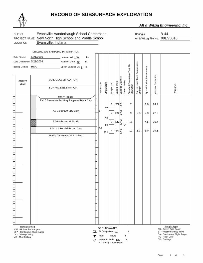
RECORD OF SUBSURFACE EXPLORATION
Alt & Witzig Engineering, Inc.
CLIENT Evansville-Vanderbaugh School Corporation Boring # B-44PROJECT NAME New North High School and Middle School Alt & Witzig File No. 09EV0016LOCATION Evansville, Indiana
Date Started Hammer Wt. lbs.
Date Completed Hammer Drop in.
Boring Method Spoon Sampler OD in.
10
Boring Terminated at 11.0 feet
DRILLING and SAMPLING INFORMATION
STRATA ELEV.
Moi
stur
e C
onte
nt %
Rem
arks
Dep
th S
cale
Stra
ta D
epth
Gro
und
Wat
er
Stan
dard
Pen
etra
tion
Test
, N -
Blow
s/fo
ot
Sam
ple
No.
Pp -
tsf P
ocke
t Pen
etro
met
er
Sam
pler
Gra
phic
s
0.0-7" Topsoil
Qu
- tsf
Unc
onfin
ed C
ompr
essi
ve
Stre
ngthSURFACE ELEVATION
Sam
ple
Type
SOIL CLASSIFICATION
5/21/2009
5/21/2009
HSA
7 1.01 SS 24.9
2 SS 9 2.3 2.3 22.9
4.5 20.4
10 3.3 3.0 19.84 SS
113 SS
11.0
4.0
7"-4.0 Brown Mottled Gray Peppered Black Clay
7.0
4.0-7.0 Brown Silty Clay
9.07.0-9.0 Brown Moist Silt
9.0-11.0 Reddish Brown Clay
5
W&A
140
30
2
At Completion ft.
After hours ft.
Water on Rods ft.
GROUNDWATER
C - Boring Caved Depth
Boring Terminated at 11.0 feet
Boring MethodHSA - Hollow Stem AugersCFA - Continuous Flight AugerDC - Driving CasingMD - Mud Drilling
Sample TypeSS - Driven Split SpoonST - Pressed Shelby TubeCA - Continuous Flight AugerRC - Rock CoreCU - CuttingsDry
9.0
Page 1 of 1
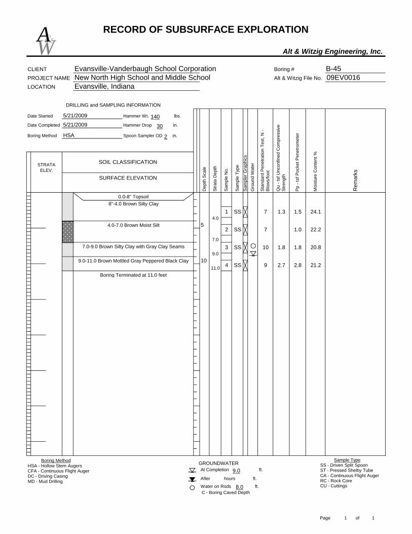
RECORD OF SUBSURFACE EXPLORATION
Alt & Witzig Engineering, Inc.
CLIENT Evansville-Vanderbaugh School Corporation Boring # B-45PROJECT NAME New North High School and Middle School Alt & Witzig File No. 09EV0016LOCATION Evansville, Indiana
Date Started Hammer Wt. lbs.
Date Completed Hammer Drop in.
Boring Method Spoon Sampler OD in.
0.0-8" Topsoil
STRATA ELEV.
5
10
Boring Terminated at 11.0 feet
DRILLING and SAMPLING INFORMATION
Moi
stur
e C
onte
nt %
Rem
arks
Dep
th S
cale
Stra
ta D
epth
Gro
und
Wat
er
Stan
dard
Pen
etra
tion
Test
, N -
Blow
s/fo
ot
Sam
ple
No.
Pp -
tsf P
ocke
t Pen
etro
met
er
Sam
pler
Gra
phic
s
Qu
- tsf
Unc
onfin
ed C
ompr
essi
ve
Stre
ngthSURFACE ELEVATION
Sam
ple
Type
SOIL CLASSIFICATION
5/21/2009
5/21/2009
HSA
7 1.3 1.51 SS 24.1
2 SS 7 1.0 22.2
1.8 20.8
9 2.7 2.8 21.24 SS
10 1.83 SS
11.0
4.0
8"-4.0 Brown Silty Clay
7.0
4.0-7.0 Brown Moist Silt
9.07.0-9.0 Brown Silty Clay with Gray Clay Seams
9.0-11.0 Brown Mottled Gray Peppered Black Clay
W&A
140
30
2
At Completion ft.
After hours ft.
Water on Rods ft.C - Boring Caved Depth
GROUNDWATER
Boring Terminated at 11.0 feet
Boring MethodHSA - Hollow Stem AugersCFA - Continuous Flight AugerDC - Driving CasingMD - Mud Drilling
Sample TypeSS - Driven Split SpoonST - Pressed Shelby TubeCA - Continuous Flight AugerRC - Rock CoreCU - Cuttings8.0
9.0
Page 1 of 1

RECORD OF SUBSURFACE EXPLORATION
Alt & Witzig Engineering, Inc.
CLIENT Evansville-Vanderbaugh School Corporation Boring # B-46PROJECT NAME New North High School and Middle School Alt & Witzig File No. 09EV0016LOCATION Evansville, Indiana
Date Started Hammer Wt. lbs.
Date Completed Hammer Drop in.
Boring Method Spoon Sampler OD in.
STRATA ELEV.
10
Auger Refusal at 11.0 feet
DRILLING and SAMPLING INFORMATION
Moi
stur
e C
onte
nt %
Rem
arks
Dep
th S
cale
Stra
ta D
epth
Gro
und
Wat
er
Stan
dard
Pen
etra
tion
Test
, N -
Blow
s/fo
ot
Sam
ple
No.
Pp -
tsf P
ocke
t Pen
etro
met
er
Sam
pler
Gra
phic
s
0.0-7" Topsoil
Qu
- tsf
Unc
onfin
ed C
ompr
essi
ve
Stre
ngthSURFACE ELEVATION
Sam
ple
Type
SOIL CLASSIFICATION
5/21/2009
5/21/2009
HSA
20.3
7 1.01 SS 24.4
2 SS 8 1.7 0.5
12 4.0 22.9
11 2.5 2.5 31.711.0
7.0
7"-7.0 Brown and Dark Brown Silty Clay
7.0-11.0 Red Mottled Brown and Black Clay
4 SS
3 SS
5
W&A
140
30
2
At Completion ft.
After hours ft.
Water on Rods ft.C - Boring Caved Depth
GROUNDWATER
Auger Refusal at 11.0 feet
Boring MethodHSA - Hollow Stem AugersCFA - Continuous Flight AugerDC - Driving CasingMD - Mud Drilling
Sample TypeSS - Driven Split SpoonST - Pressed Shelby TubeCA - Continuous Flight AugerRC - Rock CoreCU - Cuttings
11.0
Page 1 of 1

RECORD OF SUBSURFACE EXPLORATION
Alt & Witzig Engineering, Inc.
CLIENT Evansville-Vanderbaugh School Corporation Boring # B-47PROJECT NAME New North High School and Middle School Alt & Witzig File No. 09EV0016LOCATION Evansville, Indiana
Date Started Hammer Wt. lbs.
Date Completed Hammer Drop in.
Boring Method Spoon Sampler OD in.
10
Boring Terminated at 11.0 feet
DRILLING and SAMPLING INFORMATION
STRATA ELEV.
Moi
stur
e C
onte
nt %
Rem
arks
Dep
th S
cale
Stra
ta D
epth
Gro
und
Wat
er
Stan
dard
Pen
etra
tion
Test
, N -
Blow
s/fo
ot
Sam
ple
No.
Pp -
tsf P
ocke
t Pen
etro
met
er
Sam
pler
Gra
phic
s
0.0-7" Topsoil
Qu
- tsf
Unc
onfin
ed C
ompr
essi
ve
Stre
ngthSURFACE ELEVATION
Sam
ple
Type
SOIL CLASSIFICATION
5/21/2009
5/21/2009
HSA
9 1.51 SS 22.6
2 SS 7 1.5 20.5
1.5 20.8
13 4.1 2.5 20.54 SS
9 2.53 SS
11.0
4.0
7"-4.0 Brown Mottled Gray Clay
7.0
4.0-7.0 Reddish Brown Silty Clay
9.07.0-9.0 Red Mottled Brown Clay
9.0-11.0 Brown Peppered Black Clay
5
W&A
140
30
2
At Completion ft.
After hours ft.
Water on Rods ft.
GROUNDWATER
C - Boring Caved Depth
Boring Terminated at 11.0 feet
Boring MethodHSA - Hollow Stem AugersCFA - Continuous Flight AugerDC - Driving CasingMD - Mud Drilling
Sample TypeSS - Driven Split SpoonST - Pressed Shelby TubeCA - Continuous Flight AugerRC - Rock CoreCU - CuttingsDry
9.0
Page 1 of 1

RECORD OF SUBSURFACE EXPLORATION
Alt & Witzig Engineering, Inc.
CLIENT Evansville-Vanderbaugh School Corporation Boring # B-48PROJECT NAME New North High School and Middle School Alt & Witzig File No. 09EV0016LOCATION Evansville, Indiana
Date Started Hammer Wt. lbs.
Date Completed Hammer Drop in.
Boring Method Spoon Sampler OD in.
4 SS11.0
4.0
9.0
8 2.9 2.5 19.7
9 2.9 2.5 19.93 SS
1 SS 23.1
2 SS 14 1.3 1.5 22.1
STRATA ELEV.
95.5
Boring Terminated at 11.0 feet
5/21/2009
HSA
SOIL CLASSIFICATION
4.0-9.0 Brown Silty Clay
9.0-11.0 Brown Peppered Black Clay
with Silt Seams 7 1.3
5
DRILLING and SAMPLING INFORMATION
1084.5
5/21/2009
0.0-8" Topsoil8"-4.0 Brown Mottled Gray Silty Clay
90.5
Pp -
tsf P
ocke
t Pen
etro
met
er
Moi
stur
e C
onte
nt %
Rem
arks
Dep
th S
cale
Stra
ta D
epth
Gro
und
Wat
er
Stan
dard
Pen
etra
tion
Test
, N -
Blow
s/fo
ot
Sam
ple
No.
Sam
pler
Gra
phic
s
Qu
- tsf
Unc
onfin
ed C
ompr
essi
ve
Stre
ngthSURFACE ELEVATION
Sam
ple
Type
W&A
140
30
2
C - Boring Caved Depth
Boring Terminated at 11.0 feet
At Completion ft.
After hours ft.
Water on Rods ft.
GROUNDWATERBoring MethodHSA - Hollow Stem AugersCFA - Continuous Flight AugerDC - Driving CasingMD - Mud Drilling
Sample TypeSS - Driven Split SpoonST - Pressed Shelby TubeCA - Continuous Flight AugerRC - Rock CoreCU - CuttingsDry
Dry
Page 1 of 1

RECORD OF SUBSURFACE EXPLORATION
Alt & Witzig Engineering, Inc.
CLIENT Evansville-Vanderbaugh School Corporation Boring # B-49PROJECT NAME New North High School and Middle School Alt & Witzig File No. 09EV0016LOCATION Evansville, Indiana
Date Started Hammer Wt. lbs.
Date Completed Hammer Drop in.
Boring Method Spoon Sampler OD in.
STRATA ELEV.
5
DRILLING and SAMPLING INFORMATION
10
SOIL CLASSIFICATION
0.0-7" Topsoil
Moi
stur
e C
onte
nt %
Rem
arks
Dep
th S
cale
Stra
ta D
epth
Gro
und
Wat
er
Stan
dard
Pen
etra
tion
Test
, N -
Blow
s/fo
ot
Sam
ple
No.
Pp -
tsf P
ocke
t Pen
etro
met
er
Sam
pler
Gra
phic
s
Qu
- tsf
Unc
onfin
ed C
ompr
essi
ve
Stre
ngthSURFACE ELEVATION
Sam
ple
Type
5/21/2009
HSA
5/21/2009
5 1.31 SS 26.6
2 SS 6 1.8 23.2
1.5 18.4
7 2.3 2.0 17.74 SS
7 1.93 SS
4.0
7"-4.0 Dark Gray Clay
12.0
4.0-12.0 Brown Mottled Gray Clay
W&A
140
30
2
C - Boring Caved Depth
Auger Refusal at 21 feet
At Completion ft.
After hours ft.
Water on Rods ft.
GROUNDWATER
15
20
7 1.7 1.5 18.35 SS
50/1" 4.56 SS21.0
12.0
19.0
12.0-19.0 Brown Mottled Gray and Black Clay
19.0-21.0 Brown Siltstone
Boring MethodHSA - Hollow Stem AugersCFA - Continuous Flight AugerDC - Driving CasingMD - Mud Drilling
Sample TypeSS - Driven Split SpoonST - Pressed Shelby TubeCA - Continuous Flight AugerRC - Rock CoreCU - Cuttings
18.0
Page 1 of 1

RECORD OF SUBSURFACE EXPLORATION
Alt & Witzig Engineering, Inc.
CLIENT Evansville-Vanderbaugh School Corporation Boring # B-50PROJECT NAME New North High School and Middle School Alt & Witzig File No. 09EV0016LOCATION Evansville, Indiana
Date Started Hammer Wt. lbs.
Date Completed Hammer Drop in.
Boring Method Spoon Sampler OD in.
11.0
4.0
8"-4.0 Brown Mottled Gray Clay
9.0
4.0-9.0 Brown Mottled Black and Gray Clay
9.0-11.0 Brown Peppered Black Clay2.0 20.7
5 0.8 23.33 SS
6 1.94 SS
23.1
2 SS 6 1.9 1.8 19.6
1.51 SS
STRATA ELEV.
98.6
Boring Terminated at 11.0 feet
6
5
1087.6
0.0-8" Topsoil
DRILLING and SAMPLING INFORMATION
93.6
Moi
stur
e C
onte
nt %
Rem
arks
Dep
th S
cale
Stra
ta D
epth
Gro
und
Wat
er
Stan
dard
Pen
etra
tion
Test
, N -
Blow
s/fo
ot
Sam
ple
No.
Pp -
tsf P
ocke
t Pen
etro
met
er
Sam
pler
Gra
phic
s
Qu
- tsf
Unc
onfin
ed C
ompr
essi
ve
Stre
ngthSURFACE ELEVATION
Sam
ple
Type
SOIL CLASSIFICATION
5/21/2009
5/21/2009
HSA
W&A
140
30
2
C - Boring Caved Depth
Boring Terminated at 11.0 feet
At Completion ft.
After hours ft.
Water on Rods ft.
GROUNDWATERBoring MethodHSA - Hollow Stem AugersCFA - Continuous Flight AugerDC - Driving CasingMD - Mud Drilling
Sample TypeSS - Driven Split SpoonST - Pressed Shelby TubeCA - Continuous Flight AugerRC - Rock CoreCU - CuttingsDry
Dry
Page 1 of 1

RECORD OF SUBSURFACE EXPLORATION
Alt & Witzig Engineering, Inc.
CLIENT Evansville-Vanderbaugh School Corporation Boring # B-51PROJECT NAME New North High School and Middle School Alt & Witzig File No. 09EV0016LOCATION Evansville, Indiana
Date Started Hammer Wt. lbs.
Date Completed Hammer Drop in.
Boring Method Spoon Sampler OD in.
11.0
7.0
8"-7.0 Brown Mottled Gray Clay
7.0-11.0 Brown Mottled Black and Gray Clay
2.0 22.0
5 2.0 22.53 SS
54 SS
24.6
2 SS 5 2.0 22.7
1.31 SS
STRATA ELEV.
96.6
Boring Terminated at 11.0 feet
4
5
1085.6
0.0-8" Topsoil
DRILLING and SAMPLING INFORMATION
91.6
Moi
stur
e C
onte
nt %
Rem
arks
Dep
th S
cale
Stra
ta D
epth
Gro
und
Wat
er
Stan
dard
Pen
etra
tion
Test
, N -
Blow
s/fo
ot
Sam
ple
No.
Pp -
tsf P
ocke
t Pen
etro
met
er
Sam
pler
Gra
phic
s
Qu
- tsf
Unc
onfin
ed C
ompr
essi
ve
Stre
ngthSURFACE ELEVATION
Sam
ple
Type
SOIL CLASSIFICATION
5/21/2009
5/21/2009
HSA
W&A
140
30
2
C - Boring Caved Depth
Boring Terminated at 11.0 feet
At Completion ft.
After hours ft.
Water on Rods ft.
GROUNDWATERBoring MethodHSA - Hollow Stem AugersCFA - Continuous Flight AugerDC - Driving CasingMD - Mud Drilling
Sample TypeSS - Driven Split SpoonST - Pressed Shelby TubeCA - Continuous Flight AugerRC - Rock CoreCU - CuttingsDry
9.0
Page 1 of 1
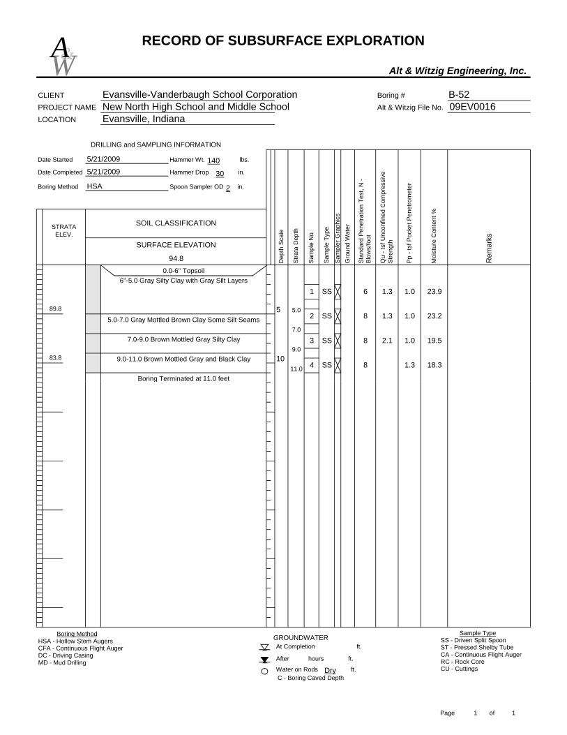
RECORD OF SUBSURFACE EXPLORATION
Alt & Witzig Engineering, Inc.
CLIENT Evansville-Vanderbaugh School Corporation Boring # B-52PROJECT NAME New North High School and Middle School Alt & Witzig File No. 09EV0016LOCATION Evansville, Indiana
Date Started Hammer Wt. lbs.
Date Completed Hammer Drop in.
Boring Method Spoon Sampler OD in.
11.0
5.0
6"-5.0 Gray Silty Clay with Gray Silt Layers
7.05.0-7.0 Gray Mottled Brown Clay Some Silt Seams
9.07.0-9.0 Brown Mottled Gray Silty Clay
9.0-11.0 Brown Mottled Gray and Black Clay1.3 18.3
8 2.1 1.0 19.53 SS
84 SS
23.9
2 SS 8 1.3 1.0 23.2
1.3 1.01 SS
STRATA ELEV.
94.8
Boring Terminated at 11.0 feet
6
5
1083.8
0.0-6" Topsoil
DRILLING and SAMPLING INFORMATION
89.8
Moi
stur
e C
onte
nt %
Rem
arks
Dep
th S
cale
Stra
ta D
epth
Gro
und
Wat
er
Stan
dard
Pen
etra
tion
Test
, N -
Blow
s/fo
ot
Sam
ple
No.
Pp -
tsf P
ocke
t Pen
etro
met
er
Sam
pler
Gra
phic
s
Qu
- tsf
Unc
onfin
ed C
ompr
essi
ve
Stre
ngthSURFACE ELEVATION
Sam
ple
Type
SOIL CLASSIFICATION
5/21/2009
5/21/2009
HSA
W&A
140
30
2
C - Boring Caved Depth
Boring Terminated at 11.0 feet
At Completion ft.
After hours ft.
Water on Rods ft.
GROUNDWATERBoring MethodHSA - Hollow Stem AugersCFA - Continuous Flight AugerDC - Driving CasingMD - Mud Drilling
Sample TypeSS - Driven Split SpoonST - Pressed Shelby TubeCA - Continuous Flight AugerRC - Rock CoreCU - CuttingsDry
Page 1 of 1

RECORD OF SUBSURFACE EXPLORATION
Alt & Witzig Engineering, Inc.
CLIENT Evansville-Vanderbaugh School Corporation Boring # B-53PROJECT NAME New North High School and Middle School Alt & Witzig File No. 09EV0016LOCATION Evansville, Indiana
Date Started Hammer Wt. lbs.
Date Completed Hammer Drop in.
Boring Method Spoon Sampler OD in.
11.0
7"-6.0 Brown Peppered Black Silty Clay
9.0
6.0-9.0 Brown Moist Silt
9.0-11.0 Brown Mottled Gray Clay3.5 20.3
7 2.3 21.53 SS
9 3.04 SS
26.2
2 SS 7 2.3 22.3
4.0
6.0
1 SS
STRATA ELEV.
98.2
Boring Terminated at 11.0 feet
9
5
1087.2
0.0-7" Topsoil
DRILLING and SAMPLING INFORMATION
93.2
Moi
stur
e C
onte
nt %
Rem
arks
Dep
th S
cale
Stra
ta D
epth
Gro
und
Wat
er
Stan
dard
Pen
etra
tion
Test
, N -
Blow
s/fo
ot
Sam
ple
No.
Pp -
tsf P
ocke
t Pen
etro
met
er
Sam
pler
Gra
phic
s
Qu
- tsf
Unc
onfin
ed C
ompr
essi
ve
Stre
ngthSURFACE ELEVATION
Sam
ple
Type
SOIL CLASSIFICATION
5/21/2009
5/21/2009
HSA
W&A
140
30
2
C - Boring Caved Depth
Boring Terminated at 11.0 feet
At Completion ft.
After hours ft.
Water on Rods ft.
GROUNDWATERBoring MethodHSA - Hollow Stem AugersCFA - Continuous Flight AugerDC - Driving CasingMD - Mud Drilling
Sample TypeSS - Driven Split SpoonST - Pressed Shelby TubeCA - Continuous Flight AugerRC - Rock CoreCU - CuttingsDry
Dry
Page 1 of 1
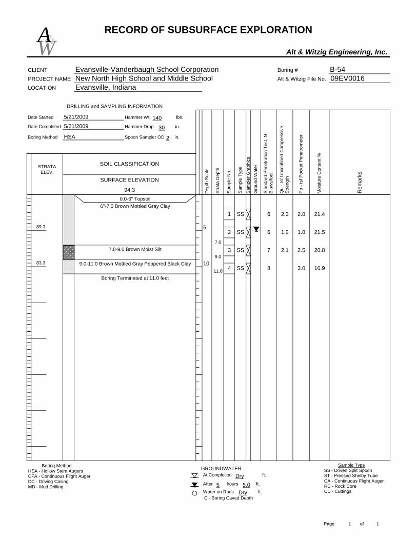
RECORD OF SUBSURFACE EXPLORATION
Alt & Witzig Engineering, Inc.
CLIENT Evansville-Vanderbaugh School Corporation Boring # B-54PROJECT NAME New North High School and Middle School Alt & Witzig File No. 09EV0016LOCATION Evansville, Indiana
Date Started Hammer Wt. lbs.
Date Completed Hammer Drop in.
Boring Method Spoon Sampler OD in.
11.0
7.0
6"-7.0 Brown Mottled Gray Clay
9.07.0-9.0 Brown Moist Silt
9.0-11.0 Brown Mottled Gray Peppered Black Clay3.0 16.9
7 2.1 2.5 20.83 SS
84 SS
21.4
2 SS 6 1.2 1.0 21.5
2.3 2.01 SS
STRATA ELEV.
94.3
Boring Terminated at 11.0 feet
6
5
1083.3
0.0-6" Topsoil
DRILLING and SAMPLING INFORMATION
89.3
Moi
stur
e C
onte
nt %
Rem
arks
Dep
th S
cale
Stra
ta D
epth
Gro
und
Wat
er
Stan
dard
Pen
etra
tion
Test
, N -
Blow
s/fo
ot
Sam
ple
No.
Pp -
tsf P
ocke
t Pen
etro
met
er
Sam
pler
Gra
phic
s
Qu
- tsf
Unc
onfin
ed C
ompr
essi
ve
Stre
ngthSURFACE ELEVATION
Sam
ple
Type
SOIL CLASSIFICATION
5/21/2009
5/21/2009
HSA
W&A
140
30
2
C - Boring Caved Depth
Boring Terminated at 11.0 feet
At Completion ft.
After hours ft.
Water on Rods ft.
GROUNDWATERBoring MethodHSA - Hollow Stem AugersCFA - Continuous Flight AugerDC - Driving CasingMD - Mud Drilling
Sample TypeSS - Driven Split SpoonST - Pressed Shelby TubeCA - Continuous Flight AugerRC - Rock CoreCU - CuttingsDry
5.05Dry
Page 1 of 1

GENERAL NOTES SAMPLE IDENTIFICATION
The Unified Soil Classification System is used to identify the soil unless otherwise noted.
SOIL PROPERTY SYMBOLS
N: Standard "N" penetration: Blows per foot of a 140 pound hammer falling 30 inches on a 2 inch O.D. split-spoon.
Qu: Unconfined compressive strength, TSF
Qp: Penetrometer value, unconfined compressive strength, TSF
Mc: Water content, %
LL: Liquid limit, %
PL: Plastic limit, %
Dd: Natural dry density, PCF
• : Apparent groundwater level at time noted after completion DRILLING AND SAMPLING SYMBOLS
SS: Split-spoon - 1 3/8" I.D., 2" O.D., except where noted ST: Shelby tube - 3" O.D., except where noted AU: Auger sample DB: Diamond bit CB: Carbide bit WS: Washed sample
RELATIVE DENSITY AND CONSISTENCY CLASSIFICATION
TERM (NON-COHESIVE SOILS) BLOWS PER FOOT
Very loose 0 - 4 Loose 5 - 10 Firm 11 - 30 Dense 31 - 50 Very Dense Over 50
TERM (COHESIVE SOILS) Qu (TSF)
Very soft 0 - 0.25 Soft 0.25 - 0.50 Medium 0.50 - 1.00 Stiff 1.00 - 2.00 Very Stiff 2.00 - 4.00 Hard 4.00+
PARTICLE SIZE Boulders 8 in.(+) Coarse Sand 5 mm-0.6 mm Silt 0.075 mm - 0.005 mm Cobbles 8 in. - 3 in. Medium Sand 0.6mm-0.2 mm Clay 0.005mm(-) Gravel 3 in. - 5 mm Fine Sand 0.2mm-0.075 mm