Study PEL Report Alternative A Banning Clarence Street
36
Banning Clarence Street Study PEL Report November 2021 Alternative A Alternative B
Transcript of Study PEL Report Alternative A Banning Clarence Street
Banning Clarence Street Study PEL Report
November 2021
Alternative A
Alternative B
1
Banning/Clarence Street Study
Planning and Environmental Linkage (PEL) Report
Contents Executive Summary ....................................................................................................................................... 1
Study Location ............................................................................................................................................... 3
Study Area ..................................................................................................................................................... 4
Project Purpose and Need ............................................................................................................................ 4
Existing Conditions, Environmental Resources & Project Description ......................................................... 5
Public Involvement ....................................................................................................................................... 8
Alternatives Considered ................................................................................................................................ 8
Cost Estimates ............................................................................................................................................. 14
Recommendations ...................................................................................................................................... 15
Appendix A: Public Workshop 1 Summary Report..................................................................................... 16
Appendix B: Public Workshop 2 Summary Report ..................................................................................... 20
Appendix C: Cost Estimates ....................................................................................................................... 23
Appendix D: PEL Checklist .......................................................................................................................... 24
Figure 1: Project Location ............................................................................................................................ 3
Figure 2: Study Area ..................................................................................................................................... 4
Figure 3: Land Cover ..................................................................................................................................... 5
Figure 4: Tar Ditch Drainage Area ................................................................................................................ 6
Figure 5: Tar Ditch Drainage Area Recommendations ................................................................................ 7
Figure 6: Alternative A Acquisitions .......................................................................................................... 10
Figure 7: Alternative B Acquisitions........................................................................................................... 10
Figure 8: Alternative A ............................................................................................................................... 11
Figure 9: Alternative A North ..................................................................................................................... 11
Figure 10: Alternative B.............................................................................................................................. 12
Figure 11: Alternative B North ................................................................................................................... 12
Figure 12: Off-Street Parking ..................................................................................................................... 13
Figure 13: On-Street Parking ...................................................................................................................... 14
Executive Summary The Dover/Kent County MPO, in coordination with the City of Dover and the Delaware Department of
Transportation (DelDOT), initiated and sponsored the Banning/Clarence Street Study. The Study is located
on the west side of the City of Dover, DE near Eden Hill Medical Complex. The study area is comprised of
2
existing Banning and Clarence Streets, as well as the undeveloped area north of existing Clarence Street
up to Forest Street to the north. S. Saulsbury Road forms the western border, the Delmarva Central
Railroad tracks form the eastern border, and open areas to the south near S. Greenberry Lane comprise
the southern limits of the study area.
The study determined the following Project Purpose and Need statements:
• Connect 600 proposed housing units in S. Greenberry Lane area to Forest Street without using W.
North Street or POW-MIA Parkway
o Reduce cut-through traffic in the local residential neighborhood by providing an
alternative connection
o Provide a direct connection between the Eden Hill Development and Forest Street
o Directly connecting to the future extension of S. Greenberry Lane
• Provide a parallel roadway to S. Saulsbury Road to act as a relief route to additional traffic utilizing
S. Saulsbury Road
The study area is primarily a built environment comprised mainly of residential and commercial uses, as
well as Mixed Urban or Built-up Land uses. Industrial, Institutional/Governmental, and Deciduous Forest
comprise the remainder of the study area.
Based on desk top research and field verification, the study area is primarily a built environment. As a
result, natural resources are not anticipated to be present in the area. However, further coordination with
the appropriate local, state, and federal resource and regulatory agencies is recommended as the project
progresses to the design phase.
Two public workshops occurred during the study. Workshop 1, held on April 28, 2021, reviewed the
project history, alternatives previously developed and updated alternatives. Workshop 2, held on July 14,
2021 presented revised alternatives based on feedback from the first workshop including parking and
flooding concerns.
Four alternatives were developed to address the needs of this study:
• Alternative A, Off-Street Parking
• Alternative A, On-Street Parking
• Alternative B, Off-Street Parking
• Alternative B, On-Street Parking
Alternatives A and B are very similar. Alternative A would tie-in to the intersection with Forest Street
approximately 100 feet west of where Alternative B would tie-in.
Alternative A would require the full acquisition of three residential properties and the partial acquisition
of one residential property, one institutional and office property and one commercial property.
Alternative B would require the full acquisition of two residential properties, and one commercial
property and the partial acquisition of one residential property, one institutional and office property and
one commercial property. However, both Alternatives A and B meet the identified project needs. Both
the Off-Street and On-Street Parking Options are feasible with both Alternatives. Costs are similar for each
3
Alternative, and neither Alternative was clearly favored over the other by the public through two public
workshops.
It is therefore recommended that both Alternatives A and B and both the Off-Street and On-Street Parking
Options be advanced forward to the design phase for further detailed study.
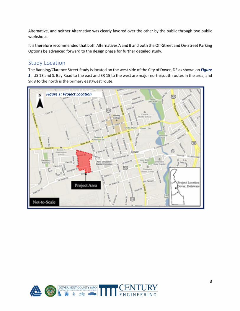
Study Location The Banning/Clarence Street Study is located on the west side of the City of Dover, DE as shown on Figure
1. US 13 and S. Bay Road to the east and SR 15 to the west are major north/south routes in the area, and
SR 8 to the north is the primary east/west route.
Figure 1: Project Location
4
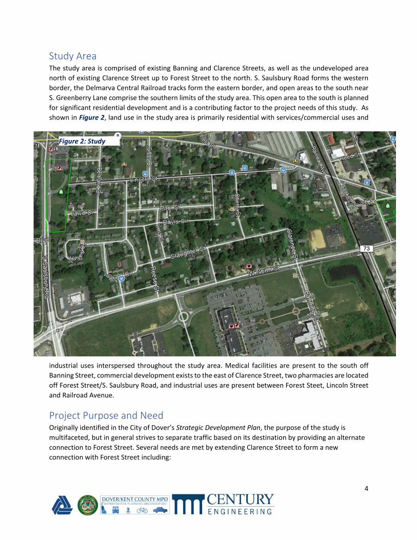
Study Area The study area is comprised of existing Banning and Clarence Streets, as well as the undeveloped area
north of existing Clarence Street up to Forest Street to the north. S. Saulsbury Road forms the western
border, the Delmarva Central Railroad tracks form the eastern border, and open areas to the south near
S. Greenberry Lane comprise the southern limits of the study area. This open area to the south is planned
for significant residential development and is a contributing factor to the project needs of this study. As
shown in Figure 2, land use in the study area is primarily residential with services/commercial uses and
industrial uses interspersed throughout the study area. Medical facilities are present to the south off
Banning Street, commercial development exists to the east of Clarence Street, two pharmacies are located
off Forest Street/S. Saulsbury Road, and industrial uses are present between Forest Steet, Lincoln Street
and Railroad Avenue.
Project Purpose and Need Originally identified in the City of Dover’s Strategic Development Plan, the purpose of the study is
multifaceted, but in general strives to separate traffic based on its destination by providing an alternate
connection to Forest Street. Several needs are met by extending Clarence Street to form a new
connection with Forest Street including:
Figure 2: Study
Area
5
• Connect 600 proposed housing units in S. Greenberry Lane area to Forest Street without using W.
North Street or POW-MIA Parkway
o Reduce cut-through traffic in the local residential neighborhood by providing an
alternative connection
o Provide a direct connection between the Eden Hill Development and Forest Street
o Directly connecting to the future extension of S. Greenberry Lane
• Provide a parallel roadway to S. Saulsbury Road to act as a relief route to additional traffic utilizing
S. Saulsbury Road
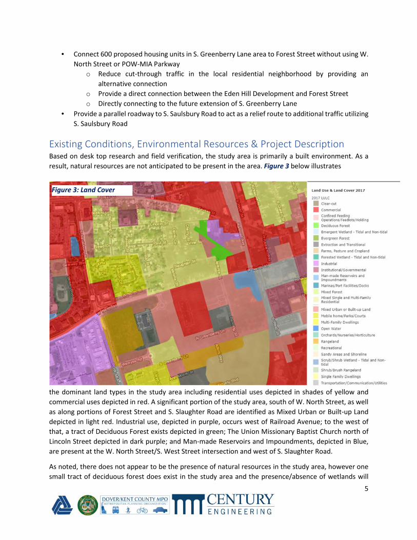
Existing Conditions, Environmental Resources & Project Description Based on desk top research and field verification, the study area is primarily a built environment. As a
result, natural resources are not anticipated to be present in the area. Figure 3 below illustrates
the dominant land types in the study area including residential uses depicted in shades of yellow and
commercial uses depicted in red. A significant portion of the study area, south of W. North Street, as well
as along portions of Forest Street and S. Slaughter Road are identified as Mixed Urban or Built-up Land
depicted in light red. Industrial use, depicted in purple, occurs west of Railroad Avenue; to the west of
that, a tract of Deciduous Forest exists depicted in green; The Union Missionary Baptist Church north of
Lincoln Street depicted in dark purple; and Man-made Reservoirs and Impoundments, depicted in Blue,
are present at the W. North Street/S. West Street intersection and west of S. Slaughter Road.
As noted, there does not appear to be the presence of natural resources in the study area, however one
small tract of deciduous forest does exist in the study area and the presence/absence of wetlands will
Figure 3: Land Cover
6
need to be confirmed, as well as the presence/absence of any Rare, Threatened or Endangered Species.
No active farmland appears to be present in the study area. The presence/absence of any historic
architectural and/or archaeological resources in the study area will also need to be confirmed as the
project moves forward. If any conceptual alternatives advance to the design phase, and if any federal
funds are used and/or any federally protected resources are impacted, the requirements of the National
Environmental Policy Act of 1969 (NEPA) will need to be to be satisfied.
It is therefore recommended that coordination with the following agencies occur at the beginning of the
design phase:
• Delaware State Agricultural Lands Preservation Foundation
• DE SHPO
• Army Corps of Engineers
• DNREC
• USFWS
• FHWA
• City of Dover
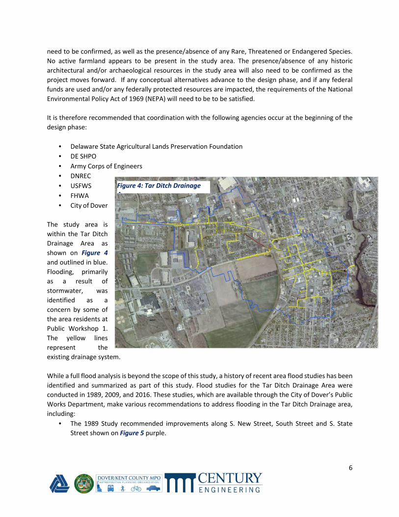
The study area is
within the Tar Ditch
Drainage Area as
shown on Figure 4
and outlined in blue.
Flooding, primarily
as a result of
stormwater, was
identified as a
concern by some of
the area residents at
Public Workshop 1.
The yellow lines
represent the
existing drainage system.
While a full flood analysis is beyond the scope of this study, a history of recent area flood studies has been
identified and summarized as part of this study. Flood studies for the Tar Ditch Drainage Area were
conducted in 1989, 2009, and 2016. These studies, which are available through the City of Dover’s Public
Works Department, make various recommendations to address flooding in the Tar Ditch Drainage area,
including:
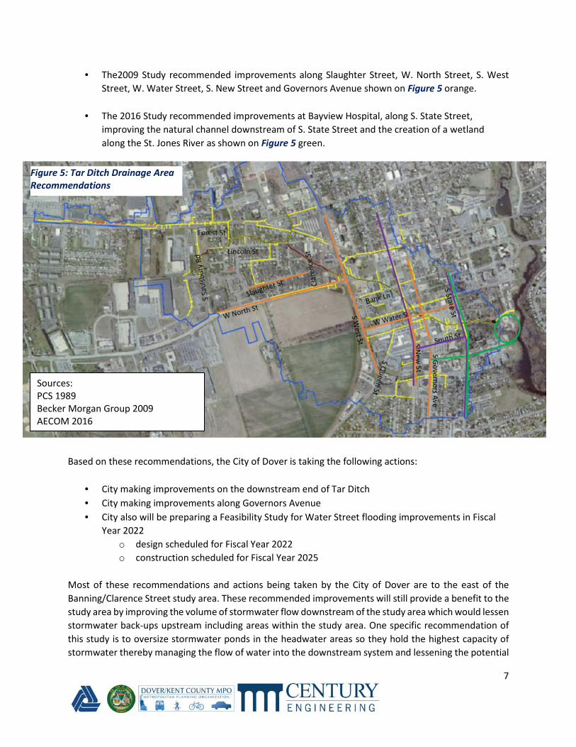
• The 1989 Study recommended improvements along S. New Street, South Street and S. State
Street shown on Figure 5 purple.
Figure 4: Tar Ditch Drainage
Area
7
• The2009 Study recommended improvements along Slaughter Street, W. North Street, S. West
Street, W. Water Street, S. New Street and Governors Avenue shown on Figure 5 orange.
• The 2016 Study recommended improvements at Bayview Hospital, along S. State Street,
improving the natural channel downstream of S. State Street and the creation of a wetland
along the St. Jones River as shown on Figure 5 green.
Based on these recommendations, the City of Dover is taking the following actions:
• City making improvements on the downstream end of Tar Ditch
• City making improvements along Governors Avenue
• City also will be preparing a Feasibility Study for Water Street flooding improvements in Fiscal
Year 2022
o design scheduled for Fiscal Year 2022
o construction scheduled for Fiscal Year 2025
Most of these recommendations and actions being taken by the City of Dover are to the east of the
Banning/Clarence Street study area. These recommended improvements will still provide a benefit to the
study area by improving the volume of stormwater flow downstream of the study area which would lessen
stormwater back-ups upstream including areas within the study area. One specific recommendation of
this study is to oversize stormwater ponds in the headwater areas so they hold the highest capacity of
stormwater thereby managing the flow of water into the downstream system and lessening the potential
Figure 5: Tar Ditch Drainage Area
Recommendations
Sources:
PCS 1989
Becker Morgan Group 2009
AECOM 2016
8
for back flow into the study area. As part of this study, we are recommending that the stormwater facilities
be designed to overmanaged the runoff to improve the overall performance of the Tar Ditch drainage
system.
Public Involvement
Public involvement and community outreach were important components of the Banning/Clarence Street
Study. Residents, the business community, as well as state and local stakeholders were engaged
throughout the Study. The following provides a summary of the public involvement and outreach that
occurred throughout the study and helped guide the development of improvement alternatives:
Community Workshop 1 April 28, 2021
• Virtual - Via Zoom
• Project History, Previous Alternatives, Updated Alternatives
• 16 Registered - 12 Attended
• 6 polling Questions Asked and Tabulated
• 17 Questions Asked and Answered
• 6 Post Workshop Survey Questions Asked and Tabulated
• See Appendix A for Workshop 1 Summary Report
Community Workshop 2 July 14, 2021
• Virtual – Via Zoom
• Revised Alternatives
• 18 Registered and Attended
• 5 Polling Questions Asked and Tabulated
• 19 Questions Asked and Answered
• 7 Post Workshop Survey Questions Asked and Tabulated
• See Appendix B for Workshop 2 Summary Report
Alternatives Considered Two conceptual alternatives, Alternatives A & B, were updated based on concepts originally developed as
part of a 2011 DelDOT study. Both Alternatives have north and south termini at Forest Street and W. North
Street respectively. The southern section, from W. North Street to Slaughter Street, are identical for both
alternatives. North of this section the alternatives vary slightly with Alternative A tying into Forest Street
approximately 600 feet west of the Delmarva Central Railroad tracks and Alternative B approximately 500
feet from the tracks. As a result of this 100-foot variance in the northern terminus, the following
properties would be required for purchase with each Alternative respectively:
Alternative A would require the full acquisition of the following properties:
9
• 701 Slaughter Street
o Zoned: RG1 General Residence Zone
o Property Type: VAC Vacant Land
• 712 Forest Street
o Zoned: RG1 General Residence Zone
o Property Type: SFR Single-Family Residential
• 716 Forest Street
o Zoned: RG1 General Residence Zone
o Property Type: SFR Single-Family Residential
Alternative A would also require the partial acquisition of the following properties:
• 703 Slaughter Street
o Zoned: RG1 General Residence Zone
o Property Type: VAC Vacant Land
• 711 Slaughter Street
o Zoned: IO Institutional and Office Zone
o Property Type: VAC Vacant Land
• 12 Lincoln Street
o Zoned: C3 Service Commercial Zone
o Property Type: COMM Commercial
Alternative B would require the full acquisition of the properties.
• 701 Slaughter Street
o Zoned: RG1 General Residence Zone
o Property Type: VAC Vacant Land
• 700 Forest Street
o Zoned: C3 Service Commercial Zone
o Property Type: COMM Commercial
• 712 Forest Street
o Zoned: RG1 General Residence Zone
o Property Type: SFR Single-Family Residential
Alternative B would also require the partial acquisition of the following properties:
• 703 Slaughter Street
o Zoned: RG1 General Residence Zone
o Property Type: VAC Vacant Land
• 711 Slaughter Street
o Zoned: IO Institutional and Office Zone
o Property Type: VAC Vacant Land
• 12 Lincoln Street
o Zoned: C3 Service Commercial Zone
o Property Type: COMM Commercial
10
Figures 6 and 7 depict the both the full and partial acquisitions associated with Alternatives A and B
respectively.
Figure 6: Alternative A Acquisitions
Figure 7: Alternative B Acquisitions
11
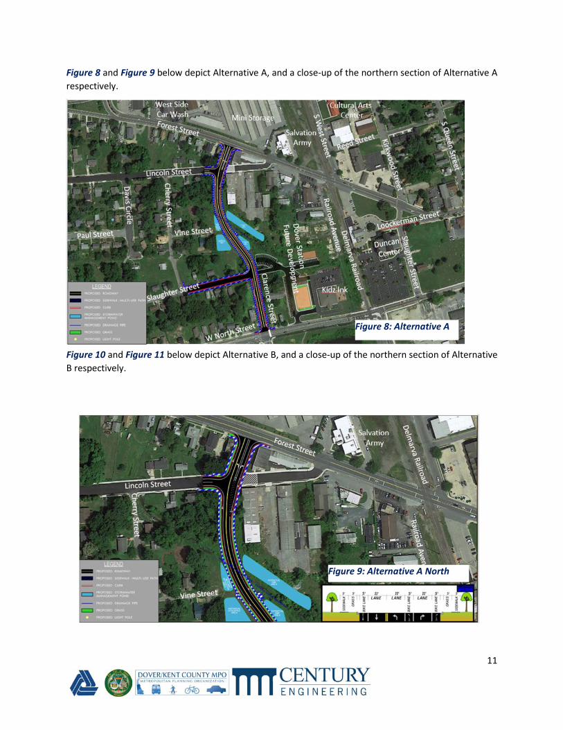
Figure 8 and Figure 9 below depict Alternative A, and a close-up of the northern section of Alternative A
respectively.
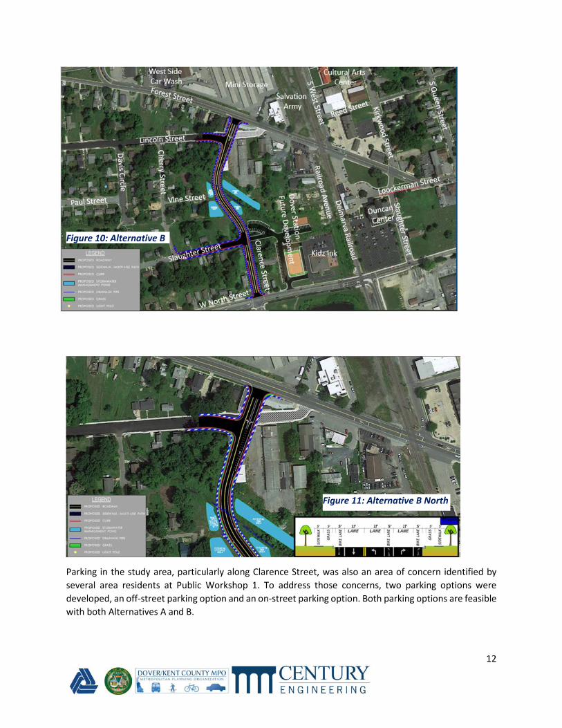
Figure 10 and Figure 11 below depict Alternative B, and a close-up of the northern section of Alternative
B respectively.
Figure 9: Alternative A North
Figure 8: Alternative A
12
Parking in the study area, particularly along Clarence Street, was also an area of concern identified by
several area residents at Public Workshop 1. To address those concerns, two parking options were
developed, an off-street parking option and an on-street parking option. Both parking options are feasible
with both Alternatives A and B.
Figure 10: Alternative B
Figure 11: Alternative B North

13
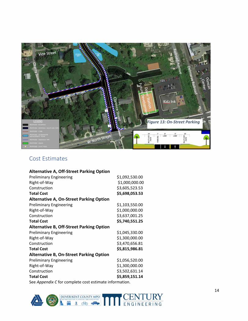
The Off-Street Parking Option would consist of the following:
• Two 11-foot travel lanes – one in each direction
• Two five-foot bicycle lanes – one in each direction
• Curb
• Five-foot grass buffer
• Five-foot sidewalk in both directions
• No On-Street Parking on Clarence Street
• Off-street parking would be increased by the addition of new off-street parking on the west side
of Clearance Street between W. North Street and Slaughter Street
• Off-Street spaces would approximately be doubled in this area
The On-Street Parking Option would consist of the following:
• Two 11-foot travel lanes – one in each direction
• Ten-foot multi-use path on both sides of the road
• Seven-foot parking on west side of Clarence Street
• Curb
• At the intersection of Clarence Street and Slaughter Street the sidewalk would turn into a multi-
use path with this option
• Parking would be maintained on Clarence Street between W. North Street and Slaughter Street
with this option but would not increase
Figure 12 and Figure 13 depict the Off-Road and On-Road parking Options respectively.
Figure 12: Off-Street Parking
14
Cost Estimates
Alternative A, Off-Street Parking Option Preliminary Engineering $1,092,530.00
Right-of-Way $1,000,000.00
Construction $3,605,523.53
Total Cost $5,698,053.53
Alternative A, On-Street Parking Option Preliminary Engineering $1,103,550.00
Right-of-Way $1,000,000.00
Construction $3,637,001.25
Total Cost $5,740,551.25
Alternative B, Off-Street Parking Option Preliminary Engineering $1,045,330.00
Right-of-Way $1,300,000.00
Construction $3,470,656.81
Total Cost $5,815,986.81
Alternative B, On-Street Parking Option Preliminary Engineering $1,056,520.00
Right-of-Way $1,300,000.00
Construction $3,502,631.14
Total Cost $5,859,151.14
See Appendix C for complete cost estimate information.
Figure 13: On-Street Parking
15
Recommendations Alternatives A and B are very similar. Both alternatives meet the project purpose and needs statement
and are both are feasible and constructable. Alternative A would tie-in to Forest Street approximately
100 feet west of where Alternative B would tie-in. While minor, this does provide more distance to the
existing intersection with S. West Street which may improve vehicle stacking lengths and safety. Both
alternatives require both full and partial property acquisitions. Both alternatives will allow traffic to
connect between the new Eden Hill Subdivision and Forest Street without utilizing the already burdened
roadways in the adjacent area including N. and S. West Street and Saulsbury and S. Saulsbury Road. In
addition, it is recommended that the undeveloped area in the center of the proposed roadway be utilized
for stormwater management and drainage facilities. These facilities should be over designed to hold
larger storms so that a managed release can assist and work with the other recommendations for the
downstream outfalls. This will enable the project to move forward without affecting or worsening the
current flood concerns and conditions. Costs are also comparable across the four options. As a result, it
is recommended that both Alternatives A and B and both the Off-Steet and On-Street Parking Options are
advanced forward to the design phase for further detailed study.
16
Appendix A: Public Workshop 1 Summary Report Banning/Clarence Street Study
Community Workshop #1
April 28, 2021
Workshop Summary Report
The first Public Workshop for the Banning/Clarence Street Study was held on April 28, 2021 via Zoom. The
Workshop included a live presentation and was followed by a Question-and-Answer period.
The following provides a summary of the Workshop and corresponding feedback.
The Workshop hosted 12 attendees. The Workshop presentation included a review of the Study Area,
Project Purpose, Project History, Alternatives Previously Studied, Updated Conceptual Alternatives, and
Next Steps of the study. The Presentation focused on the two Updated Conceptual Alternatives (A&B),
both of which propose to improve and extend Clarence Street from its current terminus at Slaughter
Street north to a new terminus with Forest Street. Under both alternatives, Lincoln Street would tie into
the new, extended Clarence Street forming a “T” intersection with the remaining segment of Lincoln
Street to the east serving only as local access. Alternative A would intersect with Forest Street
approximately 100 feet west of where Alternative B would intersect with Forest Street. Typical Sections
were provided for each alternative illustrating the anticipated lane, shoulder, and sidewalk widths.
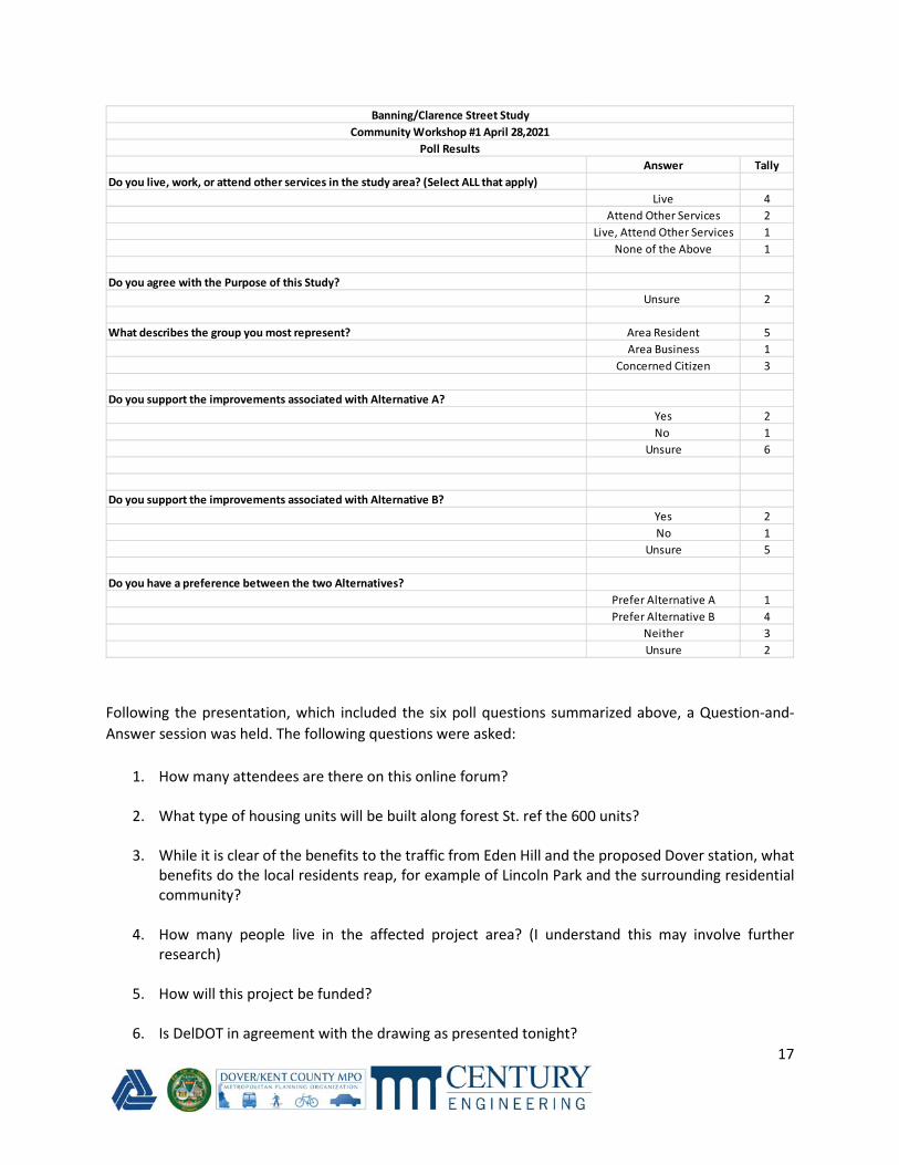
Six Polling questions were asked throughout the presentation to gather information and to encourage
participation from the attendees. The following information was gathered through the polls:
17
Following the presentation, which included the six poll questions summarized above, a Question-and-
Answer session was held. The following questions were asked:
1. How many attendees are there on this online forum?
2. What type of housing units will be built along forest St. ref the 600 units?
3. While it is clear of the benefits to the traffic from Eden Hill and the proposed Dover station, what
benefits do the local residents reap, for example of Lincoln Park and the surrounding residential
community?
4. How many people live in the affected project area? (I understand this may involve further
research)
5. How will this project be funded?
6. Is DelDOT in agreement with the drawing as presented tonight?
Answer Tally
Do you live, work, or attend other services in the study area? (Select ALL that apply)
Live 4
Attend Other Services 2
Live, Attend Other Services 1
None of the Above 1
Do you agree with the Purpose of this Study?
Unsure 2
What describes the group you most represent? Area Resident 5
Area Business 1
Concerned Citizen 3
Do you support the improvements associated with Alternative A?
Yes 2
No 1
Unsure 6
Do you support the improvements associated with Alternative B?
Yes 2
No 1
Unsure 5
Do you have a preference between the two Alternatives?
Prefer Alternative A 1
Prefer Alternative B 4
Neither 3
Unsure 2
Banning/Clarence Street Study
Community Workshop #1 April 28,2021
Poll Results
18
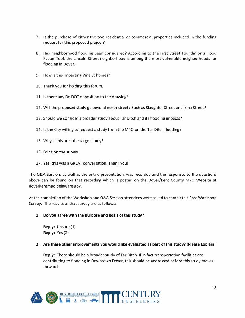
7. Is the purchase of either the two residential or commercial properties included in the funding
request for this proposed project?
8. Has neighborhood flooding been considered? According to the First Street Foundation's Flood
Factor Tool, the Lincoln Street neighborhood is among the most vulnerable neighborhoods for
flooding in Dover.
9. How is this impacting Vine St homes?
10. Thank you for holding this forum.
11. Is there any DelDOT opposition to the drawing?
12. Will the proposed study go beyond north street? Such as Slaughter Street and Irma Street?
13. Should we consider a broader study about Tar Ditch and its flooding impacts?
14. Is the City willing to request a study from the MPO on the Tar Ditch flooding?
15. Why is this area the target study?
16. Bring on the survey!
17. Yes, this was a GREAT conversation. Thank you!
The Q&A Session, as well as the entire presentation, was recorded and the responses to the questions
above can be found on that recording which is posted on the Dover/Kent County MPO Website at
doverkentmpo.delaware.gov.
At the completion of the Workshop and Q&A Session attendees were asked to complete a Post Workshop
Survey. The results of that survey are as follows:
1. Do you agree with the purpose and goals of this study?
Reply: Unsure (1)
Reply: Yes (2)
2. Are there other improvements you would like evaluated as part of this study? (Please Explain)
Reply: There should be a broader study of Tar Ditch. If in fact transportation facilities are
contributing to flooding in Downtown Dover, this should be addressed before this study moves
forward.
19
Reply: The improvements (that I had in mind) were asked and addressed in the online forum
(flooding, increased traffic, residential versus commercial property buyout preference, etc.).
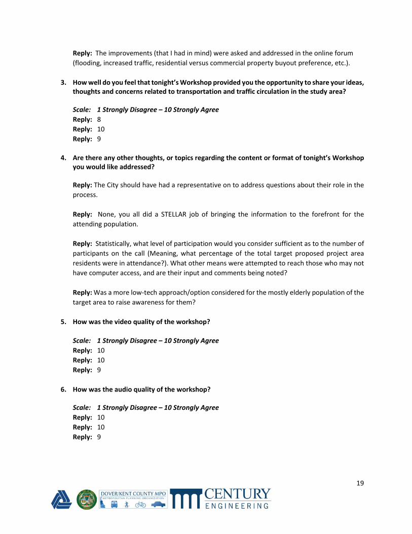
3. How well do you feel that tonight’s Workshop provided you the opportunity to share your ideas,
thoughts and concerns related to transportation and traffic circulation in the study area?
Scale: 1 Strongly Disagree – 10 Strongly Agree
Reply: 8
Reply: 10
Reply: 9
4. Are there any other thoughts, or topics regarding the content or format of tonight’s Workshop
you would like addressed?
Reply: The City should have had a representative on to address questions about their role in the
process.
Reply: None, you all did a STELLAR job of bringing the information to the forefront for the
attending population.
Reply: Statistically, what level of participation would you consider sufficient as to the number of
participants on the call (Meaning, what percentage of the total target proposed project area
residents were in attendance?). What other means were attempted to reach those who may not
have computer access, and are their input and comments being noted?
Reply: Was a more low-tech approach/option considered for the mostly elderly population of the
target area to raise awareness for them?
5. How was the video quality of the workshop?
Scale: 1 Strongly Disagree – 10 Strongly Agree
Reply: 10
Reply: 10
Reply: 9
6. How was the audio quality of the workshop?
Scale: 1 Strongly Disagree – 10 Strongly Agree
Reply: 10
Reply: 10
Reply: 9
20
Appendix B: Public Workshop 2 Summary Report Banning/Clarence Street Study
Community Workshop #2
July 14, 2021
Workshop Summary Report
The second Public Workshop for the Banning/Clarence Street Study was held on July 14, 2021 via Zoom.
The Workshop included a live presentation and was followed by a Question-and-Answer period.
The following provides a summary of the Workshop and corresponding feedback.
The Workshop hosted 18 attendees. The Workshop presentation included a review of the Study Area,
Project Purpose, Revised Alternatives (Including parking options), Recent Flood Studies, and Next Steps of
the study. Revisions to the two Conceptual Alternatives (A&B) including both off-street and on-street
parking options were presented. Updated typical Sections were also provided for each alternative
illustrating the anticipated lane, shoulder, and sidewalk widths. Additionally, recent flood studies in the
Tar Ditch Drainage area were summarized and presented.
Five Polling questions were asked throughout the presentation to gather information and to encourage
participation from the attendees. The following information was gathered through the polls:
21
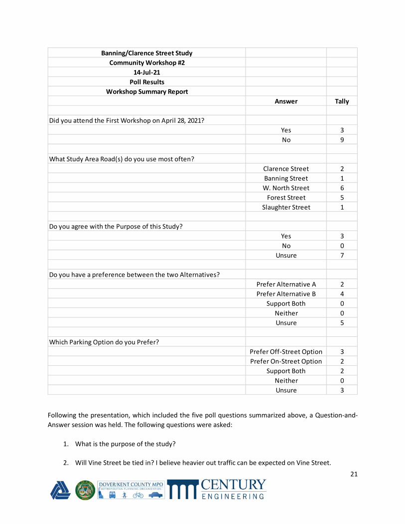
Following the presentation, which included the five poll questions summarized above, a Question-and-
Answer session was held. The following questions were asked:
1. What is the purpose of the study?
2. Will Vine Street be tied in? I believe heavier out traffic can be expected on Vine Street.
Banning/Clarence Street Study
Community Workshop #2
14-Jul-21
Poll Results
Workshop Summary Report
Answer Tally
Did you attend the First Workshop on April 28, 2021?
Yes 3
No 9
What Study Area Road(s) do you use most often?
Clarence Street 2
Banning Street 1
W. North Street 6
Forest Street 5
Slaughter Street 1
Do you agree with the Purpose of this Study?
Yes 3
No 0
Unsure 7
Do you have a preference between the two Alternatives?
Prefer Alternative A 2
Prefer Alternative B 4
Support Both 0
Neither 0
Unsure 5
Which Parking Option do you Prefer?
Prefer Off-Street Option 3
Prefer On-Street Option 2
Support Both 2
Neither 0
Unsure 3
22
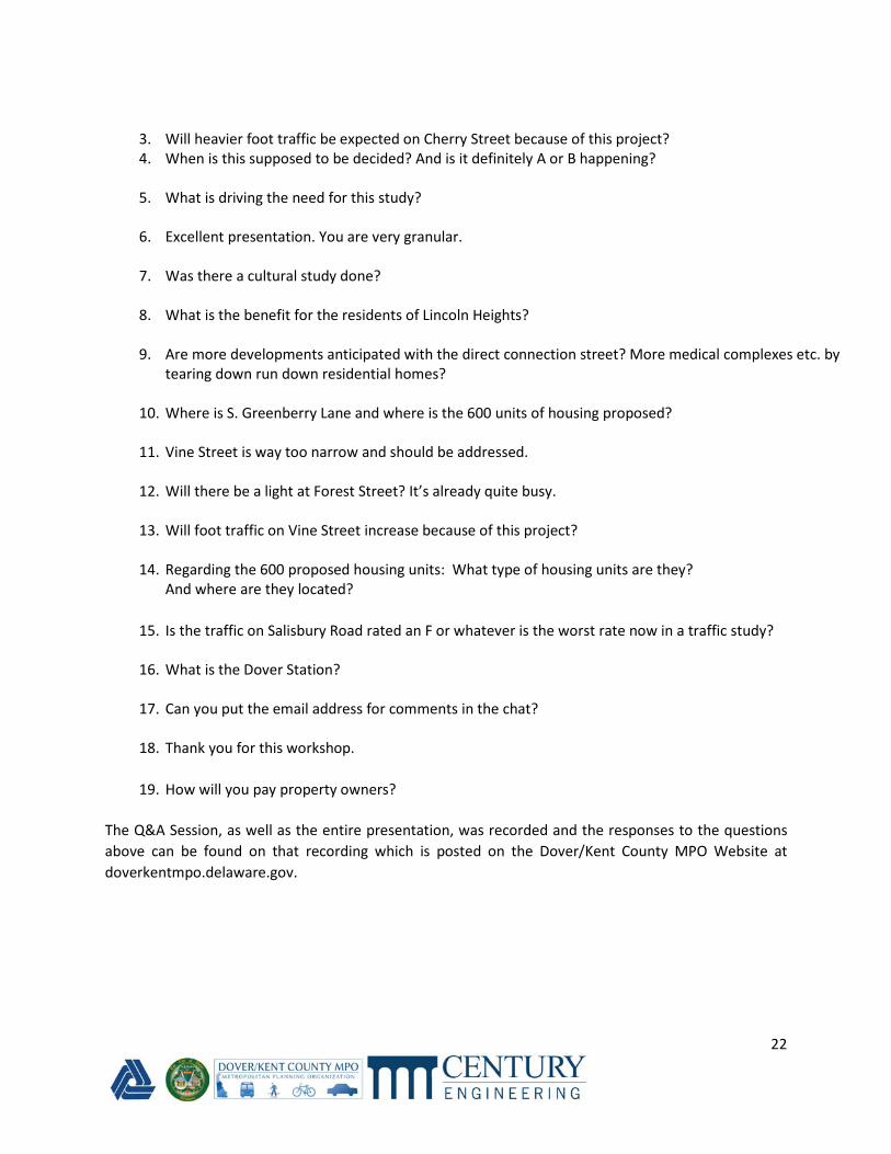
3. Will heavier foot traffic be expected on Cherry Street because of this project?
4. When is this supposed to be decided? And is it definitely A or B happening?
5. What is driving the need for this study?
6. Excellent presentation. You are very granular.
7. Was there a cultural study done?
8. What is the benefit for the residents of Lincoln Heights?
9. Are more developments anticipated with the direct connection street? More medical complexes etc. by
tearing down run down residential homes?
10. Where is S. Greenberry Lane and where is the 600 units of housing proposed?
11. Vine Street is way too narrow and should be addressed.
12. Will there be a light at Forest Street? It’s already quite busy.
13. Will foot traffic on Vine Street increase because of this project?
14. Regarding the 600 proposed housing units: What type of housing units are they?
And where are they located?
15. Is the traffic on Salisbury Road rated an F or whatever is the worst rate now in a traffic study?
16. What is the Dover Station?
17. Can you put the email address for comments in the chat?
18. Thank you for this workshop.
19. How will you pay property owners?
The Q&A Session, as well as the entire presentation, was recorded and the responses to the questions
above can be found on that recording which is posted on the Dover/Kent County MPO Website at
doverkentmpo.delaware.gov.

23
Appendix C: Cost Estimates

201000 CLEARING AND GRUBBING LS $10,000.00 1.00 $10,000.00
202000 EXCAVATION AND EMBANKMENT CY $26.00 2986.00 $77,636.00
202003 UNDERCUT EXCAVATION CY $39.00 538.00 $20,982.00
204000 TEST HOLE CY $200.00 6.00 $1,200.00
209001 BORROW, TYPE A CY $22.00 2166.00 $47,652.00
209002 BORROW, TYPE B CY $28.00 235.00 $6,580.00
301001 GABC CY $72.00 1990.00 $143,280.00
302002 DELAWARE NO. 3 STONE TON $78.00 54.00 $4,212.00
401005 SUPERPAVE TYPE C, PG 64-22 (CARBONATE STONE) TON $100.00 799.00 $79,900.00
401014 SUPERPAVE TYPE B, PG 64-22 TON $95.00 1182.00 $112,290.00
401021 SUPERPAVE TYPE BCBC, PG 64-22 TON $90.00 1945.00 $175,050.00
601033 REINFORCED CONCRETE PIPE, 18", CLASS IV LF $85.00 3672.00 $312,120.00
601039 REINFORCED CONCRETE PIPE, 36", CLASS IV LF $125.00 80.00 $10,000.00
602005 DRAINAGE INLET, 48" X 48" EACH $4,000.00 13.00 $52,000.00
701023 I.PCC CURB AND GUTTER, TYPE 3-8 LF $36.00 3536.00 $127,296.00
705001 PCC SIDEWALK, 4" SF $14.00 15875.00 $222,250.00
705002 PCC SIDEWALK, 6" SF $16.00 1765.00 $28,240.00
705005 PCC SIDEWALK, 8" SF $18.00 380.00 $6,840.00
705007 DETECTABLE WARNING SURFACE SF $38.00 95.00 $3,610.00
762001 SAW CUTTING, CONCRETE, FULL DEPTH LF $15.00 47.00 $705.00
817002 PERMANENT PAVEMENT STRIPING, SYMBOL/LEGEND, ALKYD-THERMOPLASTIC SF $12.50 1476.00 $18,450.00
817013 PERMANENT PAVEMENT STRIPING, EPOXY RESIN PAINT, WHITE/YELLOW, 5" LF $1.50 5382.00 $8,073.00
817015 PREFORMED RETROREFLECTIVE THERMOPLASTIC MARKINGS, BIKE SYMBOL EACH $475.00 11.00 $5,225.00
846001PROVIDE AND INSTALL LOOP WIRE 1-CONDUCTOR #14 AWG ENCASED IN 1/4" FLEXIBLE TUBING
IN A LOOP SAWCUTLF $25.00 7341.00 $183,525.00
846002PROVIDE AND INSTALL A 1-1/2 INCH GALVANIZED RIGID METAL CONDUIT DETECTOR SLEEVE
WITH LOOP WIRELF $30.00 15417.00 $462,510.00
847002 INSTALL OR REMOVAL OF BASE OR PAD MOUNTED CABINET EACH $500.00 1.00 $500.00
847003 LIGHTING CONTROL CABINET - 200 A, 277/480V EACH $15,000.00 1.00 $15,000.00
851511 DECORATIVE LIGHT STANDARD AND FIXTURE, LED, SINGLE EACH $4,000.00 14.00 $56,000.00
905001 SILT FENCE LF $3.50 3541.00 $12,393.50
905004 INLET SEDIMENT CONTROL, DRAINAGE INLET EACH $150.00 13.00 $1,950.00
908004 TOPSOIL, 6" DEPTH SY $8.50 5198.00 $44,183.00
908010 TOPSOILING, 6" DEPTH SY $4.50 3849.00 $17,320.50
908014 PERMANENT GRASS SEEDING, DRY GROUND SY $1.00 5198.00 $5,198.00
908015 PERMANENT GRASS SEEDING, STORMWATER SY $1.50 1722.00 $2,583.00
908017 TEMPORARY GRASS SEEDING SY $0.75 16374.00 $12,280.50
908023 STABILIZED CONSTRUCTION ENTRANCE SY $50.00 239.00 $11,950.00
908024 STABILIZED CONSTRUCTION ENTRANCE, TOPDRESSING TON $78.00 18.00 $1,404.00
910008 STORMWATER MANAGEMENT POND CY $25.00 1722.00 $43,050.00
Subtotal $2,343,438.50
763000 Initial Expense (5%) L.S. $117,171.93 1 $117,171.93
763501 Construction Engineering (2.5%) L.S. $58,585.96 1 $58,585.96
MOT L.S. $150,000.00 1 $150,000.00
TOTAL BASE FOR PROJECT $2,669,196.39
CONSTRUCTION CONTINGENCY 10% $266,919.64 1 $266,919.64
TRAFFIC (FROM TRAFFIC STATEMENT) L.S. $100,000.00 1 $100,000.00
UTILITY L.S. $50,000.00 1 $50,000.00
PLANTING L.S. $20,000.00 1 $20,000.00
QA/QC for HMA L.S. $1,374.10 1 $1,374.10
Asphalt Cost Adj L.S. $14,033.40 1 $14,033.40
TOTAL CONSTRUCTION COST $3,121,523.53
PROJECT DEVELOPMENT L.S. $468,230.00 1 $468,230.00
PRELIMINARY ENGINEERING (DESIGN) L.S. $624,300.00 1 $624,300.00
CONSTRUCTION ENGINEERING - (INSPECTION, CE, ETC) L.S. $484,000.00 1 $484,000.00
ROW COSTS L.S. $1,000,000.00 1 $1,000,000.00
TOTAL BASE CONSTRUCTION COST $5,698,053.53
Banning Street Alternative A, Off-Street Parking
TBD
Conceptual Cost Estimate 9/29/2021
ITEM # TITLE UNITESTIMATE
COST
UNIT
QUANTITYTOTAL
201000 CLEARING AND GRUBBING LS $10,000.00 1.00 $10,000.00
202000 EXCAVATION AND EMBANKMENT CY $26.00 2880.00 $74,880.00
202003 UNDERCUT EXCAVATION CY $39.00 526.00 $20,514.00
204000 TEST HOLE CY $200.00 6.00 $1,200.00
209001 BORROW, TYPE A CY $22.00 2046.00 $45,012.00
209002 BORROW, TYPE B CY $28.00 235.00 $6,580.00
301001 GABC CY $72.00 1974.00 $142,128.00
302002 DELAWARE NO. 3 STONE TON $78.00 54.00 $4,212.00
401005 SUPERPAVE TYPE C, PG 64-22 (CARBONATE STONE) TON $100.00 768.00 $76,800.00
401014 SUPERPAVE TYPE B, PG 64-22 TON $95.00 1143.00 $108,585.00
401021 SUPERPAVE TYPE BCBC, PG 64-22 TON $90.00 1880.00 $169,200.00
601033 REINFORCED CONCRETE PIPE, 18", CLASS IV LF $85.00 3637.00 $309,145.00
601039 REINFORCED CONCRETE PIPE, 36", CLASS IV LF $125.00 80.00 $10,000.00
602005 DRAINAGE INLET, 48" X 48" EACH $4,000.00 13.00 $52,000.00
701023 I.PCC CURB AND GUTTER, TYPE 3-8 LF $36.00 3501.00 $126,036.00
705001 PCC SIDEWALK, 4" SF $14.00 20061.00 $280,854.00
705002 PCC SIDEWALK, 6" SF $16.00 1572.00 $25,152.00
705005 PCC SIDEWALK, 8" SF $18.00 380.00 $6,840.00
705007 DETECTABLE WARNING SURFACE SF $38.00 95.00 $3,610.00
762001 SAW CUTTING, CONCRETE, FULL DEPTH LF $15.00 47.00 $705.00
817002 PERMANENT PAVEMENT STRIPING, SYMBOL/LEGEND, ALKYD-THERMOPLASTIC SF $12.50 1481.00 $18,512.50
817013 PERMANENT PAVEMENT STRIPING, EPOXY RESIN PAINT, WHITE/YELLOW, 5" LF $1.50 5101.00 $7,651.50
817015 PREFORMED RETROREFLECTIVE THERMOPLASTIC MARKINGS, BIKE SYMBOL EACH $475.00 9.00 $4,275.00
846001PROVIDE AND INSTALL LOOP WIRE 1-CONDUCTOR #14 AWG ENCASED IN 1/4" FLEXIBLE TUBING
IN A LOOP SAWCUTLF $25.00 7370.00 $184,250.00
846002PROVIDE AND INSTALL A 1-1/2 INCH GALVANIZED RIGID METAL CONDUIT DETECTOR SLEEVE
WITH LOOP WIRELF $30.00 15477.00 $464,310.00
847002 INSTALL OR REMOVAL OF BASE OR PAD MOUNTED CABINET EACH $500.00 1.00 $500.00
847003 LIGHTING CONTROL CABINET - 200 A, 277/480V EACH $15,000.00 1.00 $15,000.00
851511 DECORATIVE LIGHT STANDARD AND FIXTURE, LED, SINGLE EACH $4,000.00 14.00 $56,000.00
905001 SILT FENCE LF $3.50 3505.00 $12,267.50
905004 INLET SEDIMENT CONTROL, DRAINAGE INLET EACH $150.00 13.00 $1,950.00
908004 TOPSOIL, 6" DEPTH SY $8.50 4823.00 $40,995.50
908010 TOPSOILING, 6" DEPTH SY $4.50 3589.00 $16,150.50
908014 PERMANENT GRASS SEEDING, DRY GROUND SY $1.00 4823.00 $4,823.00
908015 PERMANENT GRASS SEEDING, STORMWATER SY $1.50 1722.00 $2,583.00
908017 TEMPORARY GRASS SEEDING SY $0.75 15193.00 $11,394.75
908023 STABILIZED CONSTRUCTION ENTRANCE SY $50.00 239.00 $11,950.00
908024 STABILIZED CONSTRUCTION ENTRANCE, TOPDRESSING TON $78.00 18.00 $1,404.00
910008 STORMWATER MANAGEMENT POND CY $25.00 1722.00 $43,050.00
Subtotal $2,370,520.25
763000 Initial Expense (5%) L.S. $118,526.01 1 $118,526.01
763501 Construction Engineering (2.5%) L.S. $59,263.01 1 $59,263.01
MOT L.S. $150,000.00 1 $150,000.00
TOTAL BASE FOR PROJECT $2,698,309.27
CONSTRUCTION CONTINGENCY 10% $269,830.93 1 $269,830.93
TRAFFIC (FROM TRAFFIC STATEMENT) L.S. $100,000.00 1 $100,000.00
UTILITY L.S. $50,000.00 1 $50,000.00
PLANTING L.S. $20,000.00 1 $20,000.00
QA/QC for HMA L.S. $1,326.85 1 $1,326.85
Asphalt Cost Adj L.S. $13,534.20 1 $13,534.20
TOTAL CONSTRUCTION COST $3,153,001.25
PROJECT DEVELOPMENT L.S. $472,950.00 1 $472,950.00
PRELIMINARY ENGINEERING (DESIGN) L.S. $630,600.00 1 $630,600.00
CONSTRUCTION ENGINEERING - (INSPECTION, CE, ETC) L.S. $484,000.00 1 $484,000.00
ROW COSTS L.S. $1,000,000.00 1 $1,000,000.00
TOTAL BASE CONSTRUCTION COST $5,740,551.25
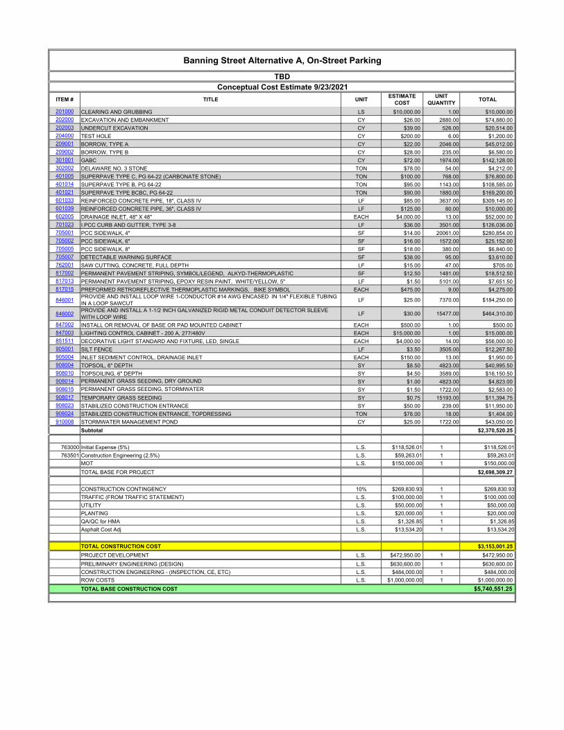
Banning Street Alternative A, On-Street Parking
TBD
Conceptual Cost Estimate 9/23/2021
ITEM # TITLE UNITESTIMATE
COST
UNIT
QUANTITYTOTAL
201000 CLEARING AND GRUBBING LS $10,000.00 1.00 $10,000.00
202000 EXCAVATION AND EMBANKMENT CY $26.00 3408.00 $88,608.00
202003 UNDERCUT EXCAVATION CY $39.00 584.00 $22,776.00
204000 TEST HOLE CY $200.00 6.00 $1,200.00
209001 BORROW, TYPE A CY $22.00 2266.00 $49,852.00
209002 BORROW, TYPE B CY $28.00 237.00 $6,636.00
301001 GABC CY $72.00 2039.00 $146,808.00
302002 DELAWARE NO. 3 STONE TON $78.00 54.00 $4,212.00
401005 SUPERPAVE TYPE C, PG 64-22 (CARBONATE STONE) TON $100.00 825.00 $82,500.00
401014 SUPERPAVE TYPE B, PG 64-22 TON $95.00 1221.00 $115,995.00
401021 SUPERPAVE TYPE BCBC, PG 64-22 TON $90.00 2008.00 $180,720.00
601033 REINFORCED CONCRETE PIPE, 18", CLASS IV LF $85.00 3726.00 $316,710.00
601039 REINFORCED CONCRETE PIPE, 36", CLASS IV LF $125.00 80.00 $10,000.00
602005 DRAINAGE INLET, 48" X 48" EACH $4,000.00 14.00 $56,000.00
701023 I.PCC CURB AND GUTTER, TYPE 3-8 LF $36.00 3614.00 $130,104.00
705001 PCC SIDEWALK, 4" SF $14.00 16271.00 $227,794.00
705002 PCC SIDEWALK, 6" SF $16.00 1586.00 $25,376.00
705005 PCC SIDEWALK, 8" SF $18.00 135.00 $2,430.00
705007 DETECTABLE WARNING SURFACE SF $38.00 95.00 $3,610.00
762001 SAW CUTTING, CONCRETE, FULL DEPTH LF $15.00 47.00 $705.00
817002 PERMANENT PAVEMENT STRIPING, SYMBOL/LEGEND, ALKYD-THERMOPLASTIC SF $12.50 1396.00 $17,450.00
817013 PERMANENT PAVEMENT STRIPING, EPOXY RESIN PAINT, WHITE/YELLOW, 5" LF $1.50 4710.00 $7,065.00
817015 PREFORMED RETROREFLECTIVE THERMOPLASTIC MARKINGS, BIKE SYMBOL EACH $475.00 7.00 $3,325.00
846001PROVIDE AND INSTALL LOOP WIRE 1-CONDUCTOR #14 AWG ENCASED IN 1/4" FLEXIBLE TUBING
IN A LOOP SAWCUTLF $25.00 6024.00 $150,600.00
846002PROVIDE AND INSTALL A 1-1/2 INCH GALVANIZED RIGID METAL CONDUIT DETECTOR SLEEVE
WITH LOOP WIRELF $30.00 12651.00 $379,530.00
847002 INSTALL OR REMOVAL OF BASE OR PAD MOUNTED CABINET EACH $500.00 1.00 $500.00
847003 LIGHTING CONTROL CABINET - 200 A, 277/480V EACH $15,000.00 1.00 $15,000.00
851511 DECORATIVE LIGHT STANDARD AND FIXTURE, LED, SINGLE EACH $4,000.00 4.00 $16,000.00
905001 SILT FENCE LF $3.50 3613.00 $12,645.50
905004 INLET SEDIMENT CONTROL, DRAINAGE INLET EACH $150.00 14.00 $2,100.00
908004 TOPSOIL, 6" DEPTH SY $8.50 5463.00 $46,435.50
908010 TOPSOILING, 6" DEPTH SY $4.50 3803.00 $17,113.50
908014 PERMANENT GRASS SEEDING, DRY GROUND SY $1.00 5463.00 $5,463.00
908015 PERMANENT GRASS SEEDING, STORMWATER SY $1.50 1790.00 $2,685.00
908017 TEMPORARY GRASS SEEDING SY $0.75 17209.00 $12,906.75
908023 STABILIZED CONSTRUCTION ENTRANCE SY $50.00 239.00 $11,950.00
908024 STABILIZED CONSTRUCTION ENTRANCE, TOPDRESSING TON $78.00 18.00 $1,404.00
910008 STORMWATER MANAGEMENT POND CY $25.00 1790.00 $44,750.00
Subtotal $2,228,959.25
763000 Initial Expense (5%) L.S. $111,447.96 1 $111,447.96
763501 Construction Engineering (2.5%) L.S. $55,723.98 1 $55,723.98
MOT L.S. $150,000.00 1 $150,000.00
TOTAL BASE FOR PROJECT $2,546,131.19
CONSTRUCTION CONTINGENCY 10% $254,613.12 1 $254,613.12
TRAFFIC (FROM TRAFFIC STATEMENT) L.S. $100,000.00 1 $100,000.00
UTILITY L.S. $50,000.00 1 $50,000.00
PLANTING L.S. $20,000.00 1 $20,000.00
QA/QC for HMA L.S. $1,418.90 1 $1,418.90
Asphalt Cost Adj L.S. $14,493.60 1 $14,493.60
TOTAL CONSTRUCTION COST $2,986,656.81
PROJECT DEVELOPMENT L.S. $448,000.00 1 $448,000.00
PRELIMINARY ENGINEERING (DESIGN) L.S. $597,330.00 1 $597,330.00
CONSTRUCTION ENGINEERING - (INSPECTION, CE, ETC) L.S. $484,000.00 1 $484,000.00
ROW COSTS L.S. $1,300,000.00 1 $1,300,000.00
TOTAL BASE CONSTRUCTION COST $5,815,986.81
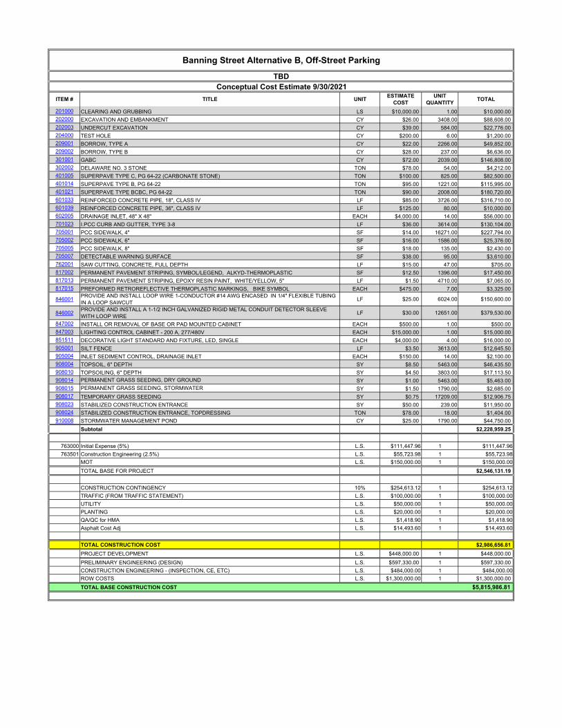
Banning Street Alternative B, Off-Street Parking
TBD
Conceptual Cost Estimate 9/30/2021
ITEM # TITLE UNITESTIMATE
COST
UNIT
QUANTITYTOTAL

201000 CLEARING AND GRUBBING LS $10,000.00 1.00 $10,000.00
202000 EXCAVATION AND EMBANKMENT CY $26.00 3308.00 $86,008.00
202003 UNDERCUT EXCAVATION CY $39.00 573.00 $22,347.00
204000 TEST HOLE CY $200.00 6.00 $1,200.00
209001 BORROW, TYPE A CY $22.00 2168.00 $47,696.00
209002 BORROW, TYPE B CY $28.00 236.00 $6,608.00
301001 GABC CY $72.00 2020.00 $145,440.00
302002 DELAWARE NO. 3 STONE TON $78.00 54.00 $4,212.00
401005 SUPERPAVE TYPE C, PG 64-22 (CARBONATE STONE) TON $100.00 791.00 $79,100.00
401014 SUPERPAVE TYPE B, PG 64-22 TON $95.00 1179.00 $112,005.00
401021 SUPERPAVE TYPE BCBC, PG 64-22 TON $90.00 1938.00 $174,420.00
601033 REINFORCED CONCRETE PIPE, 18", CLASS IV LF $85.00 3714.00 $315,690.00
601039 REINFORCED CONCRETE PIPE, 36", CLASS IV LF $125.00 80.00 $10,000.00
602005 DRAINAGE INLET, 48" X 48" EACH $4,000.00 14.00 $56,000.00
701023 I.PCC CURB AND GUTTER, TYPE 3-8 LF $36.00 3602.00 $129,672.00
705001 PCC SIDEWALK, 4" SF $14.00 20346.00 $284,844.00
705002 PCC SIDEWALK, 6" SF $16.00 1408.00 $22,528.00
705005 PCC SIDEWALK, 8" SF $18.00 135.00 $2,430.00
705007 DETECTABLE WARNING SURFACE SF $38.00 95.00 $3,610.00
762001 SAW CUTTING, CONCRETE, FULL DEPTH LF $15.00 47.00 $705.00
817002 PERMANENT PAVEMENT STRIPING, SYMBOL/LEGEND, ALKYD-THERMOPLASTIC SF $12.50 1419.00 $17,737.50
817013 PERMANENT PAVEMENT STRIPING, EPOXY RESIN PAINT, WHITE/YELLOW, 5" LF $1.50 4598.00 $6,897.00
817015 PREFORMED RETROREFLECTIVE THERMOPLASTIC MARKINGS, BIKE SYMBOL EACH $475.00 6.00 $2,850.00
846001PROVIDE AND INSTALL LOOP WIRE 1-CONDUCTOR #14 AWG ENCASED IN 1/4" FLEXIBLE TUBING
IN A LOOP SAWCUTLF $25.00 6024.00 $150,600.00
846002PROVIDE AND INSTALL A 1-1/2 INCH GALVANIZED RIGID METAL CONDUIT DETECTOR SLEEVE
WITH LOOP WIRELF $30.00 12651.00 $379,530.00
847002 INSTALL OR REMOVAL OF BASE OR PAD MOUNTED CABINET EACH $500.00 1.00 $500.00
847003 LIGHTING CONTROL CABINET - 200 A, 277/480V EACH $15,000.00 1.00 $15,000.00
851511 DECORATIVE LIGHT STANDARD AND FIXTURE, LED, SINGLE EACH $4,000.00 4.00 $16,000.00
905001 SILT FENCE LF $3.50 3569.00 $12,491.50
905004 INLET SEDIMENT CONTROL, DRAINAGE INLET EACH $150.00 14.00 $2,100.00
908004 TOPSOIL, 6" DEPTH SY $8.50 5166.00 $43,911.00
908010 TOPSOILING, 6" DEPTH SY $4.50 3602.00 $16,209.00
908014 PERMANENT GRASS SEEDING, DRY GROUND SY $1.00 5166.00 $5,166.00
908015 PERMANENT GRASS SEEDING, STORMWATER SY $1.50 1790.00 $2,685.00
908017 TEMPORARY GRASS SEEDING SY $0.75 16273.00 $12,204.75
908023 STABILIZED CONSTRUCTION ENTRANCE SY $50.00 239.00 $11,950.00
908024 STABILIZED CONSTRUCTION ENTRANCE, TOPDRESSING TON $78.00 18.00 $1,404.00
910008 STORMWATER MANAGEMENT POND CY $25.00 1790.00 $44,750.00
Subtotal $2,256,500.75
763000 Initial Expense (5%) L.S. $112,825.04 1 $112,825.04
763501 Construction Engineering (2.5%) L.S. $56,412.52 1 $56,412.52
MOT L.S. $150,000.00 1 $150,000.00
TOTAL BASE FOR PROJECT $2,575,738.31
CONSTRUCTION CONTINGENCY 10% $257,573.83 1 $257,573.83
TRAFFIC (FROM TRAFFIC STATEMENT) L.S. $100,000.00 1 $100,000.00
UTILITY L.S. $50,000.00 1 $50,000.00
PLANTING L.S. $20,000.00 1 $20,000.00
QA/QC for HMA L.S. $1,367.80 1 $1,367.80
Asphalt Cost Adj L.S. $13,951.20 1 $13,951.20
TOTAL CONSTRUCTION COST $3,018,631.14
PROJECT DEVELOPMENT L.S. $452,790.00 1 $452,790.00
PRELIMINARY ENGINEERING (DESIGN) L.S. $603,730.00 1 $603,730.00
CONSTRUCTION ENGINEERING - (INSPECTION, CE, ETC) L.S. $484,000.00 1 $484,000.00
ROW COSTS L.S. $1,300,000.00 1 $1,300,000.00
TOTAL BASE CONSTRUCTION COST $5,859,151.14
Banning Street Alternative B, On-Street Parking
TBD
Conceptual Cost Estimate 9/28/2021
ITEM # TITLE UNITESTIMATE
COST
UNIT
QUANTITYTOTAL

24
Appendix D: PEL Checklist
Appendix D – PEL Checklist
Banning / Clarence Street Study
Federal Highway Administration - Planning and Environmental Linkages Questionnaire
https://www.environment.fhwa.dot.gov/env_initiatives/pel/pel_quest.aspx
Topic Section Reference Comments
1. Background:
a. Who is the sponsor of the PEL study? (state DOT, Local Agency, Other) Executive Summary Dover Kent County MPO
b. What is the name of the PEL study document and other identifying project information (e.g. sub-account or
STIP numbers, long-range plan, or transportation improvement program years)?
Title Page Banning/Clarence Street PEL Study
c. Who was included on the study team (Name and title of agency representatives, consultants, etc.)? Title Page DelDOT, City of Dover, Century Engineering
d. Provide a description of the existing transportation facility within the corridor, including project limits,
modes, functional classification, number of lanes, shoulder width, access control and type of surrounding
environment (urban vs. rural, residential vs. commercial, etc.)
Study Area The Study is located on the west side of the City of
Dover, DE. The study area is comprised of existing
Banning and Clarence Streets, as well as the
undeveloped area north of existing Clarence Street up
to Forest Street to the north. S. Saulsbury Road forms
the western boarder, the Delmarva Railroad Tracks
form the eastern boarder, and open areas to the south
near S. Greenberry Lane comprise the southern limits
of the study area.
e. Provide a brief chronology of the planning activities (PEL study) including the year(s) the studies were
completed.
Project Purpose
and Need,
Public Involvement,
Recommendations
Originally identified in City of Dover’s Strategic
Development Plan,
DelDOT Study – completed 2011
Workshop Summaries
f. Are there recent, current, or near future planning studies or projects in the vicinity? What is the relationship
of this project to those studies/projects?
N/A N/A
2. Methodology used:
a. What was the scope of the PEL study and the reason for completing it? Purpose & Need The purpose of the study is multifaceted, but in general
strives to separate traffic based on its destination by
providing an alternate connection to Forest Street.
Several needs are met by extending Clarence Street to
form a new connection with Forest Street including:
Appendix D – PEL Checklist
Banning / Clarence Street Study
Federal Highway Administration - Planning and Environmental Linkages Questionnaire
https://www.environment.fhwa.dot.gov/env_initiatives/pel/pel_quest.aspx
Topic Section Reference Comments
• Reducing cut-through traffic in the local
residential neighborhood
• Providing a direct connection between the
Eden hill Development and Forest Street
• Providing a parallel roadway to Saulsbury Road
• Directly connecting to the future extension of
S. Greenberry Lane
• Connect 600 proposed housing units to Forest
Street without using North Street or POW-MIA
Parkway
b. Did you use NEPA-like language? Why or why not?
Existing Conditions,
Environmental
Resources& Project
Description
Yes – There is the potential for state and federally
regulated environmental and cultural resources to be
present in the study area.
c. What were the actual terms used and how did you define them? (Provide examples or list) Existing Conditions,
Environmental
Resources& Project
Description
Wetlands, Farmlands, Rare, Threatened and
Endangered Species, Historic Architectural and
Archeological Resources
If any conceptual alternatives advance to design
projects, if any federal funds are used and/or any
federally protected resources are impacted, the
requirements of the National Environmental Policy Act
of 1969 (NEPA) will need to be satisfied.
d. How do you see these terms being used in NEPA documents? Existing Conditions,
Environmental
These analyses are described in the report for
reference in a future NEPA study

Appendix D – PEL Checklist
Banning / Clarence Street Study
Federal Highway Administration - Planning and Environmental Linkages Questionnaire
https://www.environment.fhwa.dot.gov/env_initiatives/pel/pel_quest.aspx
Topic Section Reference Comments
Resources& Project
Description
e. What were the key steps and coordination points in the PEL decision-making process? Who were the
decision-makers and who else participated in those key steps? For example, for the corridor vision, the
decision was made by state DOT and the local agency, with buy-in from FHWA, the USACE, and USFWS and
other resource/regulatory agencies.
Public Involvement Throughout the study, representatives from the Dover
Kent MPO, DelDOT, City of Dover, provide existing
conditions information, review the information
prepared, comment on the material, and provide
feedback which was processed through subsequent
revisions. In addition, area residents, legislators and
local business owners were also invited to review and
provide feedback throughout the study.
f. How should the PEL information be presented in NEPA? The PEL Study may be attached
3. Agency coordination:
a. Provide a synopsis of coordination with Federal, tribal, state and local environmental, regulatory and
resource agencies. Describe their level of participation and how you coordinated with them.
Public Involvement,
Recommendations
Throughout the course of this study, alternatives were
developed to address the study’s Purpose and Need
and are based on feedback from the community and
area businesses, as well as input from the Dover Kent
County MPO, DelDOT, and the City of Dover.
b. What transportation agencies (e.g. for adjacent jurisdictions) did you coordinate with or were involved
during the PEL study?
Recommendations DelDOT, Dover Kent County MPO, City of Dover
c. What steps will need to be taken with each agency during NEPA scoping? Existing Conditions,
Environmental
Resources& Project
Description
Each recommendation that moves forward for design
will continue with the NEPA process where this report
leaves off. Each agency will be prepared to have a
scoping meeting for the recommendation and begin
the in-depth investigation into the permitting and
coordination necessary for design.
4. Public coordination:
1. Provide a synopsis of your coordination efforts with the public and stakeholders. Public Involvement Throughout the study, representatives from DelDOT,
City of Dover, Dover Kent County MPO, and the
Appendix D – PEL Checklist
Banning / Clarence Street Study
Federal Highway Administration - Planning and Environmental Linkages Questionnaire
https://www.environment.fhwa.dot.gov/env_initiatives/pel/pel_quest.aspx
Topic Section Reference Comments
community were invited to provide existing conditions
information, review the information prepared,
comment on the material, and provide feedback which
was processed through subsequent revisions. In
addition, legislators and local business owners were
also invited to review and provide feedback
throughout the study.
5. Range of alternatives:
a. What types of alternatives were looked at? Purpose and Need,
Public Involvement,
Recommendations
Throughout the course of this study, alternatives were
developed to address the study’s Purpose and Need
and are based on feedback from the community and
area businesses, as well as input from DelDOT, and the
City of Dover. Two alignment options and two parking
options were developed as part of this study. All four
options are recommended to be carried forward for
future detailed study.
b. How did you select the screening criteria and screening process? Purpose and Need,
Existing Conditions,
Environmental
Resources& Project
Description,
Public Involvement,
Recommendations
Recommendations that were deemed “feasible” were
included in the report and will move forward for
further study. To be deemed feasible the
recommendations must meet the project needs , while
being feasible for design and construction.
c. For alternative(s) that were screened out, briefly summarize the reasons for eliminating the alternative(s).
(During the initial screenings, this generally will focus on fatal flaws.)
Recommendations Fatal flaws on recommendations that did not move
forward included recommendations that did not meet
the purpose and need statement, recommendations
that were too costly or required a large amount of
Appendix D – PEL Checklist
Banning / Clarence Street Study
Federal Highway Administration - Planning and Environmental Linkages Questionnaire
https://www.environment.fhwa.dot.gov/env_initiatives/pel/pel_quest.aspx
Topic Section Reference Comments
right-of-way versus the benefit that the
recommendation provided. Also, if recommendations
were not supported by multiple agencies and the
community they were not chosen to move forward
either.
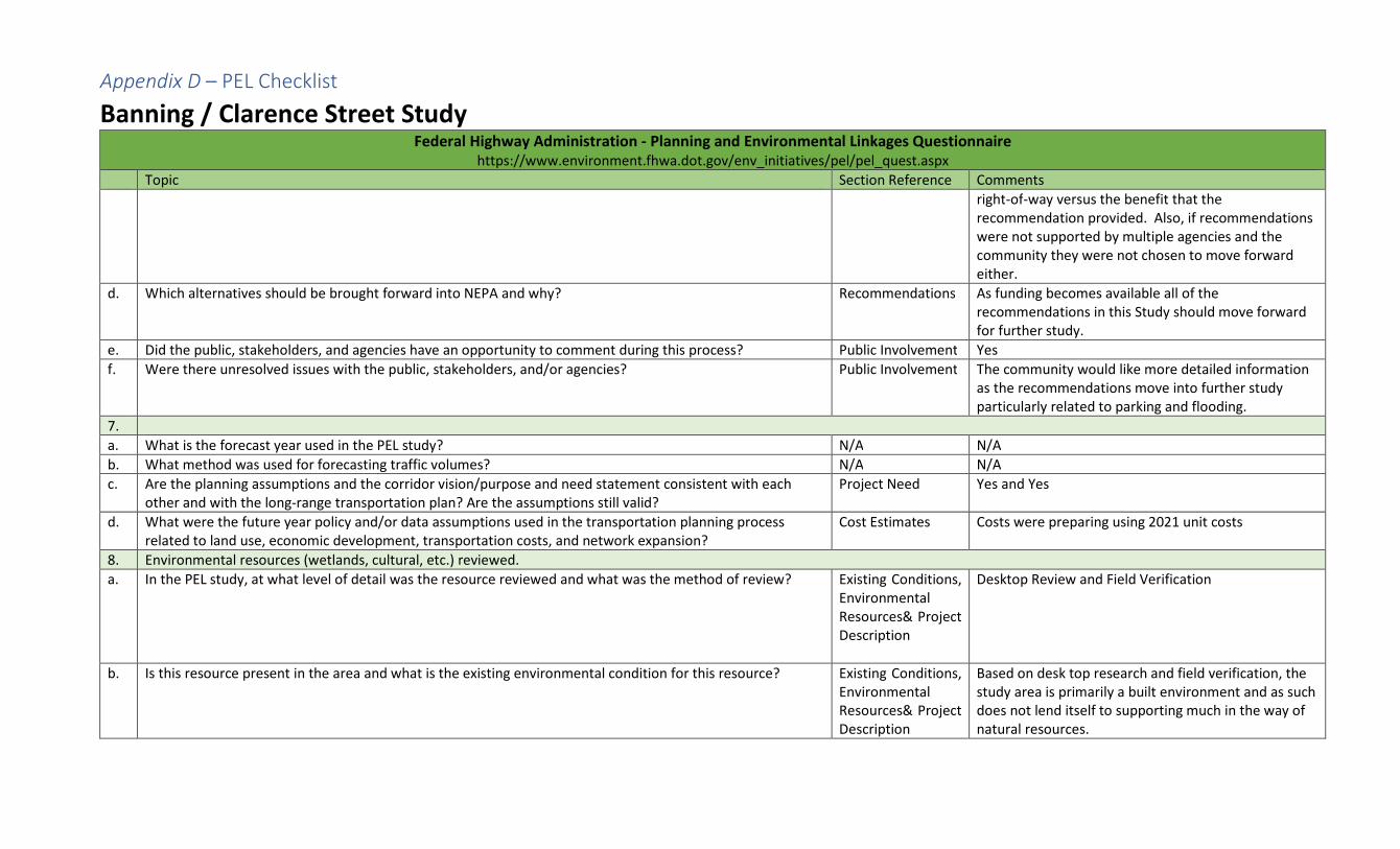
d. Which alternatives should be brought forward into NEPA and why? Recommendations As funding becomes available all of the
recommendations in this Study should move forward
for further study.
e. Did the public, stakeholders, and agencies have an opportunity to comment during this process? Public Involvement Yes
f. Were there unresolved issues with the public, stakeholders, and/or agencies? Public Involvement The community would like more detailed information
as the recommendations move into further study
particularly related to parking and flooding.
7.
a. What is the forecast year used in the PEL study? N/A N/A
b. What method was used for forecasting traffic volumes? N/A N/A
c. Are the planning assumptions and the corridor vision/purpose and need statement consistent with each
other and with the long-range transportation plan? Are the assumptions still valid?
Project Need Yes and Yes
d. What were the future year policy and/or data assumptions used in the transportation planning process
related to land use, economic development, transportation costs, and network expansion?
Cost Estimates Costs were preparing using 2021 unit costs
8. Environmental resources (wetlands, cultural, etc.) reviewed.
a. In the PEL study, at what level of detail was the resource reviewed and what was the method of review? Existing Conditions,
Environmental
Resources& Project
Description
Desktop Review and Field Verification
b. Is this resource present in the area and what is the existing environmental condition for this resource? Existing Conditions,
Environmental
Resources& Project
Description
Based on desk top research and field verification, the
study area is primarily a built environment and as such
does not lend itself to supporting much in the way of
natural resources.
Appendix D – PEL Checklist
Banning / Clarence Street Study
Federal Highway Administration - Planning and Environmental Linkages Questionnaire
https://www.environment.fhwa.dot.gov/env_initiatives/pel/pel_quest.aspx
Topic Section Reference Comments
One small tract of deciduous forest does exist in the
study area and the presence/absence of wetlands will
need to be confirmed, as well as the
presence/absence of any Rare, Threatened or
Endangered Species. No active farmland appears to
be present in the study area. The presence/absence of
any historic architectural and/or archaeological
resource in the study area will also need to be
confirmed.
c. What are the issues that need to be considered during NEPA, including potential resource impacts and
potential mitigation requirements (if known)?
Existing Conditions,
Environmental
Resources& Project
Description
Based on desk top research and field verification, the
study area is primarily a built environment and as such
does not lend itself to supporting much in the way of
natural resources.
One small tract of deciduous forest does exist in the
study area and the presence/absence of wetlands will
need to be confirmed, as well as the
presence/absence of any Rare, Threatened or
Endangered Species. No active farmland appears to
be present in the study area. The presence/absence of
any historic architectural and/or archaeological
resource in the study area will also need to be
confirmed.
d. How will the planning data provided need to be supplemented during NEPA? Existing Conditions,
Environmental
Resources& Project
Description
If any conceptual alternatives advance to the design
phase, and if any federal funds are used and/or any
federally protected resources are impacted, the
requirements of the National Environmental Policy Act
of 1969 (NEPA) will need to be to be satisfied.

Appendix D – PEL Checklist
Banning / Clarence Street Study
Federal Highway Administration - Planning and Environmental Linkages Questionnaire
https://www.environment.fhwa.dot.gov/env_initiatives/pel/pel_quest.aspx
Topic Section Reference Comments
9. List environmental resources you are aware of that were not reviewed in the PEL study and why. Indicate
whether they will need to be reviewed in NEPA and explain why.
N/A N/A
10. Were cumulative impacts considered in the PEL study? If yes, provide the information or reference where
the analysis can be found.
N/A N/A
11. Describe any mitigation strategies discussed at the planning level that should be analyzed during NEPA. N/A N/A
12. What needs to be done during NEPA to make information from the PEL study available to the agencies and
the public? Are there PEL study products which can be used or provided to agencies or the public during the
NEPA scoping process?
The PEL Study will be available to agencies involved in
the planning and design processes and will be posted
on websites of the Dover Kent County MPO, City of
Dover and DelDOT.
13. Are there any other issues a future project team should be aware of? N/A N/A