IH 35 PEL Study Questionnaire -...
60
Transcript of IH 35 PEL Study Questionnaire -...
IH 35 PEL Study Questionnaire
Prepared by:
Texas Department of Transportation
Alamo Regional Mobility Authority
May 2013
IH 35 PEL Study Questionnaire Page 1
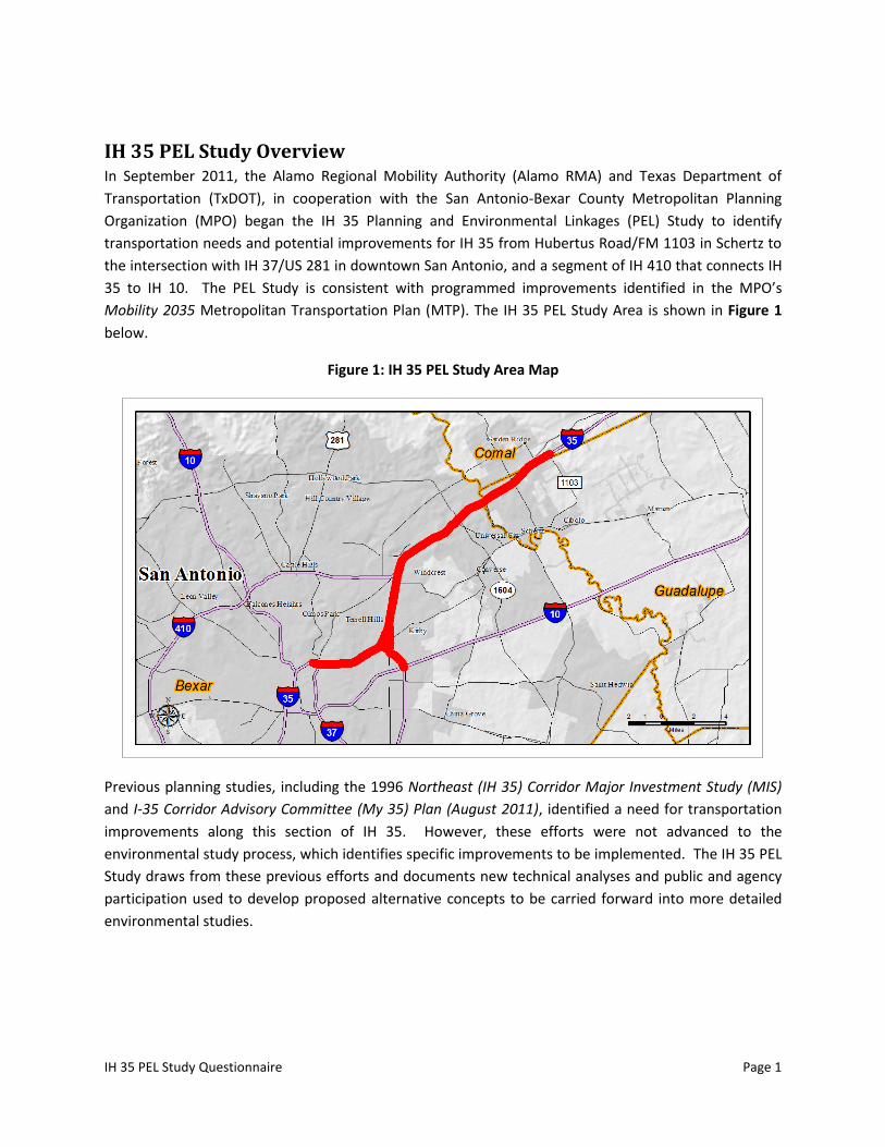
IH 35 PEL Study Overview In September 2011, the Alamo Regional Mobility Authority (Alamo RMA) and Texas Department of
Transportation (TxDOT), in cooperation with the San Antonio-Bexar County Metropolitan Planning
Organization (MPO) began the IH 35 Planning and Environmental Linkages (PEL) Study to identify
transportation needs and potential improvements for IH 35 from Hubertus Road/FM 1103 in Schertz to
the intersection with IH 37/US 281 in downtown San Antonio, and a segment of IH 410 that connects IH
35 to IH 10. The PEL Study is consistent with programmed improvements identified in the MPO’s
Mobility 2035 Metropolitan Transportation Plan (MTP). The IH 35 PEL Study Area is shown in Figure 1
below.
Figure 1: IH 35 PEL Study Area Map
Previous planning studies, including the 1996 Northeast (IH 35) Corridor Major Investment Study (MIS)
and I-35 Corridor Advisory Committee (My 35) Plan (August 2011), identified a need for transportation
improvements along this section of IH 35. However, these efforts were not advanced to the
environmental study process, which identifies specific improvements to be implemented. The IH 35 PEL
Study draws from these previous efforts and documents new technical analyses and public and agency
participation used to develop proposed alternative concepts to be carried forward into more detailed
environmental studies.
IH 35 PEL Study Questionnaire Page 2
Purpose of the FHWA PEL Questionnaire The Federal Highway Administration (FHWA) has developed a questionnaire to serve as a guide for PEL
Studies. This questionnaire is intended to act as a summary of the Planning process and ease the
transition from planning to a National Environmental Policy Act (NEPA) analysis. The questionnaire is
consistent with the 23 CFR 450 (Planning regulations) and other FHWA policy on the PEL process.
Responses to the FHWA PEL Questionnaire Listed below are responses to the FHWA PEL Questionnaire for the IH 35 PEL Study. The responses
given below provide a comprehensive statement of how the IH 35 PEL Study developed conceptual
alternatives for the needs identified in this corridor and facilitated the analysis of specific solutions in
the NEPA process.
1. Background:
a. Who is the sponsor of the PEL study? (state DOT, Local Agency, Other)
The IH 35 PEL Study is a collaborative effort between TxDOT and Alamo RMA. At the initiation of the
IH 35 PEL Study, an interlocal agreement, provided in Appendix A, was signed by TxDOT and Alamo
RMA which specified scope, timelines, roles, and responsibilities related to PEL Study activities. The
San Antonio-Bexar County MPO’s 2035 Metropolitan Transportation Plan provided essential
baseline planning information for the PEL Study. Coordination with the San Antonio-Bexar County
MPO was considered an essential part of the IH 35 PEL Study, and periodic project updates were
presented to the MPO Policy Board at specific project milestones.
b. What is the name of the PEL study document and other identifying project information (e.g.
sub-account or STIP numbers, long-range plan or transportation improvement program
years)?
This study is known as the IH 35 PEL Study and is listed in the San Antonio-Bexar County MPO 2012-
2013 Unified Planning Work Program (UPWP), amended January 23, 2012. Additionally, IH 35
improvements in the PEL Study Area are included in the San Antonio-Bexar County MPO’s 2035 MTP
(Mobility 2035).
c. Who was included on the study team (Name and title of agency representatives, consultants,
etc.)?
The IH 35 PEL Study Team includes representatives from the TxDOT Strategic Projects Division (SPD),
TxDOT San Antonio District, and Alamo RMA, as well as the IH 35 PEL Study Technical Advisory
Committee (TAC) and Community Advisory Committee (CAC). The TAC includes representatives from
local, state, and federal agencies and the CAC is comprised of neighborhood associations,
community organizations, churches, schools, businesses, chambers of commerce, and other
stakeholders. The IH 35 PEL Study consultant team is led by HNTB and includes CDM Smith, Blanton
& Associates, Nancy Ledbetter & Associates, and RJ Rivera Associates. A listing of key staff that
participated in the preparation of the PEL Study is available in Appendix B. A full list of the agencies
and individuals invited to participate on the TAC and CAC, is available in Appendix C. The MPO also
IH 35 PEL Study Questionnaire Page 3
played an integral part, both through their participation on the TAC and through milestone updates
provided by the project team.
d. Provide a description of the existing transportation facility within the corridor, including
project limits, modes, functional classification, number of lanes, shoulder width, access
control and type of surrounding environment (urban vs. rural, residential vs. commercial, etc.)
The IH 35 PEL Study Area begins northeast of San Antonio at FM 1103/Hubertus Road in Schertz and
continues along the existing IH 35 facility southwest towards downtown San Antonio, terminating at
the intersection of IH 37/US 281. The Study Area also includes a segment of existing IH 410 east of
downtown that connects IH 35 to IH 10. See Figure 1 for a graphic representation of the IH 35 PEL
Study Area.
The existing IH 35 and IH 410 facilities are located primarily within an urban/suburban area, and
most land uses along the corridor are warehouse, light industry and heavy commercial
development. IH 35 from FM 1103 to IH 37/US 281 is a controlled-access interstate highway facility
that varies between 6 to 8 barrier-separated mainlanes and typically includes inside and outside
shoulders and continuous frontage roads. IH 410 from IH 35 to IH 10 is a controlled-access interstate
highway facility with 4 mainlanes separated by barrier/median and typically includes inside and
outside shoulders and discontinuous frontage roads.
e. Provide a brief chronology of the planning activities (PEL study) including the year(s) the
studies were completed.
Previous planning activities that have been completed within this corridor include the following:
Northeast (IH 35) Corridor Major Investment Study (1996)
San Antonio I-35 Northeast Corridor Value Pricing Study, by Texas Transportation
Institute for TxDOT and FHWA (2005)
I-35 Corridor Segment 3 Committee Recommendations (2010)
I-35 Corridor Segment 4 Committee Recommendations (2010)
I-35 Corridor Advisory Committee Plan (My 35 Plan) (2011)
San Antonio-Bexar County MPO Mobility 2035 Metropolitan Transportation Plan (2011)
This IH 35 PEL Study was initiated in Fall 2011. A timeline of major IH 35 PEL Study-related activities
and milestones is provided in Figure 2 (see Section 2.e).
f. Are there recent, current or near future planning studies or projects in the vicinity? What is
the relationship of this project to those studies/projects?
Planning Studies
An Environmental Impact Statement (EIS) is being prepared by the Alamo RMA in
partnership with TxDOT and FHWA for Loop 1604 from US 90 West to IH 35. A portion
of the EIS intersects with IH 35 in the northern portion of the IH 35 PEL Study Area.
IH 35 PEL Study Questionnaire Page 4
The Lone Star Rail District (LSRD) is planning commuter rail service and a freight rail
bypass project between Austin and San Antonio. The corridor being studied is west of
and parallel to the IH 35 corridor but does not intersect it within the IH 35 PEL Study
Area. In 2012, LSRD drafted conceptual agreements with FHWA, TxDOT, and CAMPO on
a combined federal environmental approval process and FHWA has committed to serve
as the lead federal agency on environmental studies for the combined project.
Projects
Several operational improvements are currently under construction by TxDOT for IH 35
from FM 3009 to Judson Road that involve expanding the mainlanes to add capacity,
reconstructing and reconfiguring intersections, ramps, and frontage roads and adding
turnarounds. These improvements let to construction in August 2012.
Additional short-term congestion relief improvements are under consideration along IH
35 from IH 37 to IH 410N, including reconstruction and reconfiguration of ramps,
addition of auxiliary lanes, and added capacity between IH 410S and IH 410N. These
improvements are included in the FY 2013-2016 TIP, with an expected implementation
year of 2013. Concepts being considered in this PEL study would consider those
improvements and look at longer-term solutions to manage congestion.
2. Methodology used:
a. What was the scope of the PEL study and the reason for completing it?
The IH 35 PEL Study is a planning-level effort with the intent of establishing a link with past planning
efforts and providing an updated basis for the NEPA phase. This was accomplished through public
participation, agency coordination, re-establishing the need and purpose for IH 35 improvements
and engaging in a new alternatives development and evaluation process. The decision-making
process used in the PEL Study documents how alternatives were delivered to the subsequent NEPA
phase. The PEL Study scope includes:
Determining/defining need and purpose,
Describing the affected environment,
Developing and analyzing reasonable alternative concepts,
Seeking public and agency involvement, and
Recommending alternatives for further study in NEPA.
The reason the IH 35 PEL was completed was to document the decision-making process used in the
planning phase; thereby linking planning to NEPA and streamlining the overall project development
process.
b. Did you use NEPA-like language? Why or why not?
Yes, NEPA terminology was used throughout the IH 35 PEL Study in order to further establish the
link between NEPA and Planning. For example, the terms “need and purpose”, “affected
IH 35 PEL Study Questionnaire Page 5
environment”, and “alternatives” were used throughout the IH 35 PEL Study. These terms are
consistent with those used in NEPA; however, alternatives in the PEL were “conceptual” and not
project-level. More importantly, the planning-level process used in the PEL study was designed to
inform NEPA and provide products that, to the extent possible, could be seamlessly incorporated
into NEPA, such as the Need and Purpose Statement and the Affected Environment Report.
c. What were the actual terms used and how did you define them? Provide examples or list.
Study Area - Approximately 24.3 miles in length and extends from the intersection of IH
35/US 281/IH 37 northeast of downtown San Antonio to FM 1103 in Schertz to the
northeast of San Antonio (21.3 miles) and includes IH 410 from IH 35 to IH 10 northeast
of downtown San Antonio (3 miles). The Study Area is approximately 7,808 acres and
covers 0.25 miles on each side of the existing IH 35 and IH 410 facility center-lines
between the study termini.
Need and Purpose – The Need and Purpose was compiled through a process of problem
identification and solution generation. Public participation was an important part of the
process, as was the establishment of the technical basis.
Alternatives – A universe of conceptual alternatives was compiled that included a no-
build option, adding capacity within existing right of way, adding new capacity outside
of the existing right of way, as well as other transportation modes. The alternatives
developed were conceptual and not project-level alternatives.
Affected Environment - The existing social, economic, and environmental conditions for
the IH 35 PEL Study for the San Antonio region. Inventory and evaluation of the affected
environment provides the baseline information to be used in further project
development.
Environmental Justice - The fair treatment and meaningful involvement of all people
regardless of race, color, national origin, or income with respect to the development,
implementation, and enforcement of environmental laws, regulations, and policies.
Executive Order (EO) 12898 issued by President Clinton mandates that Federal agencies
achieve environmental justice.
Minority Population - Any readily identifiable groups of minority persons who live in
geographic proximity, and if circumstances warrant, geographically dispersed / transient
persons (such as migrant workers) who will be similarly affected by a proposed FHWA
program, policy, and activity. A minority is a person who is Black, Hispanic, Asian
American/Pacific Islander, or American Indian/Alaskan Native.
Low-income population – Any readily identifiable groups of low-income persons who
live in geographic proximity, and if circumstances warrant, geographically dispersed /
transient persons (such as migrant workers) who will be similarly affected by a proposed
FHWA program, policy, and activity.
IH 35 PEL Study Questionnaire Page 6
LEP (Limited English Proficiency) - Persons who do not speak English as their primary
language and who have a limited ability to read, write, speak, or understand English as
specified by FHWA and EO 13166.
Major Traffic Generators – Facilities which generate large volumes of traffic on a daily
basis.
Intermodal - Multiple transportation modes with a high degree of connectivity and
interchange between the modes. From a passenger perspective, transportation modes
include car, bicycle, bus, train, and on foot. From a freight perspective, modes include
rail, truck, airplane, and ship.
Various other NEPA regulatory terms were used, including: Texas Surface Water Quality
Standards (TSWQS); National Flood Insurance Program (NFIP); National Wetland
Inventory (NWI); Edwards Aquifer Authority (EAA); National Ambient Air Quality
Standards (NAAQS); Phase I Environmental Site Assessment (ESA); Threatened and
Endangered Species; Section 4(f); Section 6(f); Historic Resources; Prime Farmland.
d. How do you see these terms being used in NEPA documents?
The terms used in the IH 35 PEL Study are consistent with NEPA terminology and therefore could be
seamlessly incorporated into future NEPA studies. This is based on the fact the methodologies used
to arrive at decisions such as, purpose and need statement, selecting the universe of alternatives,
alternative evaluation methods and alternatives evaluation, etc. were based on similar compilations
of public comment and technical support used in the NEPA process. The MPO Policy Board was
presented project updates at their regular meetings. These updates chronicled any interim
decisions made in the intervening period and provided comment. The MPO stated for the record at
the September 20, 2012 TAC Meeting that the PEL Study met their expectations for technical and
public support of the decisions made. In addition, FHWA provided comment on the decision-making
process at key decision-making nodes through specific updates and their participation on the TAC.
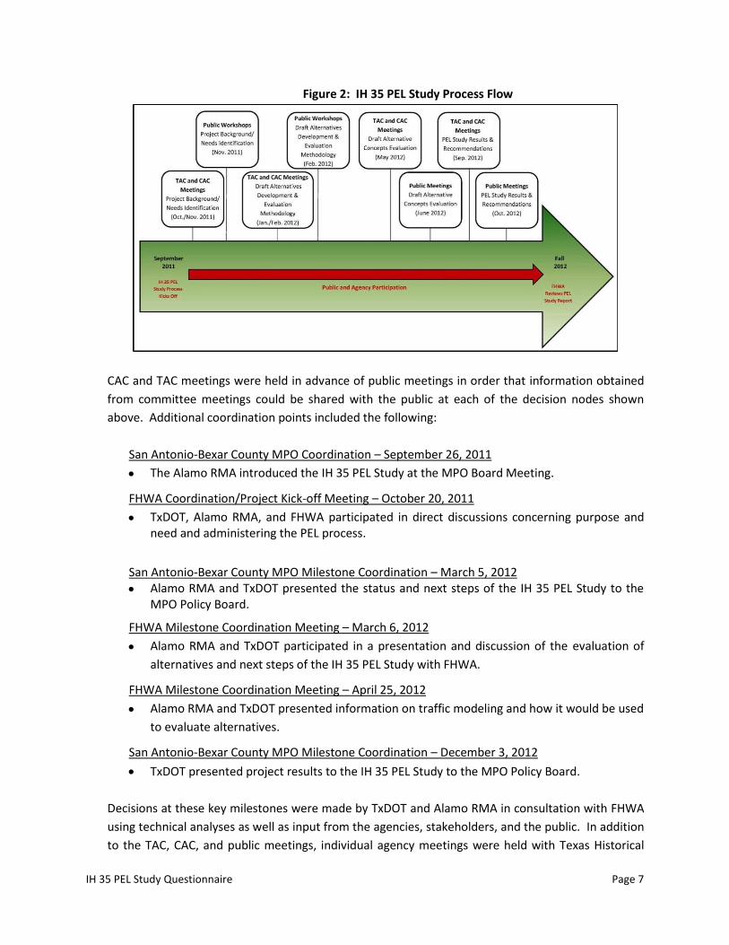
e. What were the key steps and coordination points in the PEL decision-making process? Who
were the decision-makers and who else participated in those key steps? For example, for the
corridor vision, the decision was made by state DOT and the local agency, with buy-in from
FHWA, the USACE, and USFWS and other resource/regulatory agencies.
Meetings were held at key milestones with agencies and project stakeholders throughout the course
of the PEL Study. Figure 2 shows the key steps and coordination points in the PEL decision-making
process.
IH 35 PEL Study Questionnaire Page 7
Figure 2: IH 35 PEL Study Process Flow
CAC and TAC meetings were held in advance of public meetings in order that information obtained
from committee meetings could be shared with the public at each of the decision nodes shown
above. Additional coordination points included the following:
San Antonio-Bexar County MPO Coordination – September 26, 2011
The Alamo RMA introduced the IH 35 PEL Study at the MPO Board Meeting.
FHWA Coordination/Project Kick-off Meeting – October 20, 2011
TxDOT, Alamo RMA, and FHWA participated in direct discussions concerning purpose and need and administering the PEL process.
San Antonio-Bexar County MPO Milestone Coordination – March 5, 2012
Alamo RMA and TxDOT presented the status and next steps of the IH 35 PEL Study to the MPO Policy Board.
FHWA Milestone Coordination Meeting – March 6, 2012
Alamo RMA and TxDOT participated in a presentation and discussion of the evaluation of
alternatives and next steps of the IH 35 PEL Study with FHWA.
FHWA Milestone Coordination Meeting – April 25, 2012
Alamo RMA and TxDOT presented information on traffic modeling and how it would be used
to evaluate alternatives.
San Antonio-Bexar County MPO Milestone Coordination – December 3, 2012
TxDOT presented project results to the IH 35 PEL Study to the MPO Policy Board.
Decisions at these key milestones were made by TxDOT and Alamo RMA in consultation with FHWA
using technical analyses as well as input from the agencies, stakeholders, and the public. In addition
to the TAC, CAC, and public meetings, individual agency meetings were held with Texas Historical
IH 35 PEL Study Questionnaire Page 8
Commission (THC), VIA Metropolitan Transportation, Lone Star Rail, and Joint Base San Antonio
(JBSA) which contributed in the decision-making process.
f. How should the PEL information be presented in NEPA?
Technical reports produced in the IH 35 PEL Study will be directly incorporated in the NEPA
document as appendices, referenced in the text as warranted, and will be part of the project record
and history of the decision-making process. Likewise, the Summary and Analysis Reports generated
from the public and stakeholder outreach activities of the IH 35 PEL Study will provide context for
the public’s role in the decision-making process.
The information produced and decisions made in the PEL Study will serve as a starting point for
more detailed, project-specific analyses in NEPA. PEL Study products may be incorporated as
appendices, referenced in text, and included in the project record of the NEPA Study, as warranted.
3. Agency coordination:
a. Provide a synopsis of coordination with federal, tribal, state and local environmental,
regulatory and resource agencies. Describe their level of participation and how you
coordinated with them.
At the initiation of the IH 35 PEL Study, a Public Involvement and Agency Coordination Plan was
prepared, which outlined tools and strategies for coordinating with and involving agencies in study-
related decision-making. Early in the study process, a scoping letter was sent to federal, state, and
local environmental regulatory and resource agencies that would typically be contacted in a NEPA
study, including but not limited to U.S. Fish and Wildlife Service (USFWS), U.S. Environmental
Protection Agency (EPA), U.S. Army Corps of Engineers (USACE), FHWA, Federal Transit
Administration (FTA), THC, Texas Commission on Environmental Quality (TCEQ), and Texas Parks and
Wildlife Department (TPWD); transportation entities including VIA Metropolitan Transit and Lone
Star Rail District; cities and counties located in the Study Area; and JBSA, the all-service military
command entity that manages the five base complexes in the San Antonio area, including Fort Sam
Houston, Randolph Air Force Base and Martindale Army Air Field. The scoping letter informed the
agencies of the initiation of the IH 35 PEL Study and encouraged them to contact the IH 35 PEL Study
Team with any questions or comments related to the process. Responses were received from the
FHWA, USACE, USFWS, USDA Natural Resources Conservation Service (NRCS), San Antonio Water
System (SAWS) and JBSA indicating how they would like to participate in the process and providing
guidance on incorporating specific resource information in the Study.
Additionally, representatives from federal, state, and local agencies were invited to participate as
members of the IH 35 PEL Study TAC. Four TAC meetings were held at major Study milestones.
Response to the TAC initiative was considered excellent. See Section 2.e for a list of key agency
coordination points, and Appendix C for a list of agencies that were invited to participate on the
TAC.
IH 35 PEL Study Questionnaire Page 9
Alamo RMA conducted additional outreach to elected officials consisting of personal briefings and
group discussions, as documented in the project record.
More detailed information regarding agency coordination can be found in the IH 35 PEL Study
Agency Coordination Technical Report.
b. What transportation agencies (e.g. for adjacent jurisdictions) did you coordinate with or were
involved during the PEL study?
FHWA
TxDOT
San Antonio-Bexar County MPO
VIA Metropolitan Transit
Alamo RMA
Lone Star Rail District
c. What steps will need to be taken with each agency during NEPA scoping?
Each agency will be provided a copy of the IH 35 PEL Study Report at the conclusion of the IH 35 PEL
Study. It is envisioned that the IH 35 PEL Study report will be used in the determination of NEPA
classification that precedes a future NEPA study. It is anticipated that agencies would be reengaged
during the NEPA process in accordance with the regulatory jurisdiction of each agency.
4. Public coordination:
a. Provide a synopsis of your coordination efforts with the public and stakeholders.
At the initiation of the IH 35 PEL Study, a Public Involvement and Agency Coordination Plan was
prepared, which outlined various avenues for public involvement and dissemination of study-related
information. The public involvement tools and strategies utilized for this effort included establishing
the previously mentioned IH 35 PEL Study CAC, a local information office, project hotline, project
website, social media pages, mailing lists, email communications, news media, and coordination
with elected officials, in addition to hosting public workshops.
Primarily, coordination efforts with the public and stakeholders were facilitated through the IH 35
PEL Study CAC and public workshops. The CAC is comprised of representatives from neighborhood
associations, community organizations, churches, schools, businesses, chambers of commerce, and
other stakeholders in the Study Area. Four CAC meetings were held at the major Study milestones.
Prior to each CAC meeting, invitees are sent letters and email notifications of the upcoming
meetings and topics to be discussed, and encouraging their participation. See Section 2.e for a list
of CAC meetings, and Appendix C for a list of stakeholders who were invited to participate on the
CAC.
In addition to the CAC, four rounds of public workshops (two workshops each round) were held at
the major Study milestones. The public workshops were held at locations throughout the Study
Area to provide a venue for public discussion and comment at various stages of the IH 35 PEL Study.
All public outreach was advertised in a manner consistent with NEPA public meetings, complying
IH 35 PEL Study Questionnaire Page 10
with the respective 30-day and 10-day legal requirements of the Texas Administrative Code. In
addition, meetings were advertised through display ads, media releases, e-notifications, and the IH
35 PEL Study website and social media pages. The results of the public workshops conducted are
presented in the IH 35 PEL Study Public Workshop Summary and Analysis Reports.
5. Purpose and Need for the PEL study:
a. What was the scope of the PEL study and the reason for completing it?
As discussed in Section 2.a, the scope of the IH 35 PEL Study includes the establishment of a need
and purpose for improvements, development and evaluation of alternatives concepts, and
identification of reasonable alternatives to be carried into a subsequent NEPA study. The reason for
the IH 35 PEL Study is to link previous planning studies and provide an updated planning record to
inform the subsequent NEPA phase.
b. Provide the purpose and need statement, or the corridor vision and transportation goals and
objectives to realize that vision.
The purpose of the IH 35 PEL study is:
To develop transportation alternatives that improve mobility and safety in the IH 35 corridor in a
manner that will manage vehicle congestion for the projected 25-year planning horizon, promote
efficient use of existing transportation facilities, minimize impacts to the natural and built
environment and complement other modes of transportation and economic development
initiatives in the region.
The IH 35 PEL Study seeks to identify improvements to existing IH 35 within the Study Area to
address the following issues:
Increasing traffic demand and congestion
Inadequate roadway capacity
Roadway safety and operational concerns
Structural and functional roadway deficiencies
Limited integration of IH 35 with other existing and planned transportation modes
These issues lead to increased vehicle delay and have negative economic and environmental
consequences to area residents, commuters, businesses, and freight movements.
The IH 35 PEL Study Need and Purpose Technical Report contains a detailed description of the
conditions in the Study Area and provides data to support the need for major transportation
improvements in the corridor.
c. What steps will need to be taken during the NEPA process to make this a project-level purpose
and need statement?
IH 35 PEL Study Questionnaire Page 11
The Need and Purpose Statement was developed in accordance with Appendix A, 23 CFR 450 –
Linking the Transportation Planning and NEPA Processes (23 USC 139), which details how
information, analyses and products from transportation planning can be incorporated seamlessly
into the NEPA process at the project level. The IH 35 PEL Need and Purpose Statement was a
collaborative effort designed specifically to integrate public involvement and agency coordination in
its development. In addition, detailed technical information was provided with regard to population
trends and projections, major traffic generators, historic and future traffic projections, and roadway
design and safety conditions, all of which support the need for improvements along the IH 35
corridor within the Study Area. It is the intent to utilize this Need and Purpose Statement to validate
project-level alternatives during the NEPA decision-making process.
6. Range of alternatives: Planning teams need to be cautious during the alternative screening
process; alternative screening should focus on purpose and need/corridor vision, fatal flaw
analysis and possibly mode selection. This may help minimize problems during discussions with
resource agencies. Alternatives that have fatal flaws or do not meet the purpose and
need/corridor vision cannot be considered viable alternatives, even if they reduce impacts to a
particular resource. Detail the range of alternatives considered, screening criteria and screening
process, including:
a. What types of alternatives were looked at? (Provide a one or two sentence summary and
reference document.)
The following eleven (11) alternative concepts were considered in the IH 35 PEL Study and described
in detail in the IH 35 PEL Study Alternative Concepts Development and Evaluation Technical Report:
No Build – includes the preservation of the existing transportation network and any
programmed transportation improvements that are reasonably expected to occur
regardless of the outcome of the IH 35 PEL Study
Transportation Demand Management (TDM)/ Transportation Systems Management
(TSM)/ Intelligent Transportation Systems (ITS)-Only – TDM focuses on programs which
encourage people to travel at alternative times or with fewer vehicles in order to reduce
congestion. TSM focuses on minor improvements such as signalization, signage, etc. to
assist the existing system to operate more efficiently. ITS focuses on advanced
technologies such as message signs to provide drivers with greater knowledge of traffic
conditions.
Rail-Only – involves the implementation of rail transit service within the IH 35 PEL Study
Area.
Transit-Only – involves the construction of new and/or enhanced bus transit service or
transit facilities in the IH 35 PEL Study Area.
Truck-Only – involves the construction of a dedicated lane(s) on the existing IH 35 and/or
IH 410 facility that is restricted solely for use by large trucks.
IH 35 PEL Study Questionnaire Page 12
At-Grade Expansion -
Option 1 – expansion of existing IH 35 and IH 410 in the Study Area by
constructing 3 northbound (NB) and 3 Southbound (SB) mainlanes on each
respective facility.
Option 2 – expansion of existing IH 35 and IH 410 in the Study Area by
constructing additional at-grade capacity while optimizing lane balancing,
transitions and merging/weaving (0-5 NB and SB mainlanes on IH 35 and 3 NB
and SB mainlanes on IH 410.
Option 3 – similar to Option 2 with the primary difference being that Option 3
allows for slight deviations from the existing right of way in certain locations
depending on the magnitude of the right-of-way (ROW) constraints.
Elevated Expansion – involves the expansion of existing IH 35 and IH 410 in the Study
Area by constructing 3 NB and 3 SB elevated mainlanes within existing right-of-way
through the entire length of the Study Area.
Elevated/At-Grade Mix Expansion – involves the expansion of existing IH 35 and IH 410
facilities in the Study Area by constructing an additional 3 NB and 3 SB mainlanes on each
respective facility. The additional lanes would be a combination of at-grade and elevated
capacity based on the constraints of the existing right-of-way.
Depressed Expansion – involves the expansion of existing IH 35 and IH 410 facilities in
the Study Area by constructing 3 NB and 3SB mainlanes on depressed capacity within the
existing right-of-way.
Expansion of Parallel Facility – involves the expansion and upgrade of an existing
roadway, or combination of roadways, that parallel the existing IH 35 corridor in the IH
35 PEL Study Area.
New Location Highway – involves the construction of new greenfield controlled-access
highway that would attempt to capture the same travel market currently utilizing the IH
35 facility in the Study Area in order to relieve congestion on existing IH 35.
b. How did you select the screening criteria and screening process?
The screening of the alternative concepts for the IH 35 PEL Study was a two-phased process. Phase I
provided a high-level analysis of the universe of alternative concepts described in Section 6.a above.
Phase I primarily focused on broad, qualitative evaluation factors intended to identify and document
fatal flaws early in the alternative development process such that a differentiation could be
established between: (1) those alternative concepts with a high probability of meeting the need and
purpose and (2) those alternative concepts which would obviously not meet the need and purpose
and thus should be eliminated from further study. Based on the Need and Purpose Statement, the
following issues were used to develop the Phase I screening criteria:
Potential to address the projected transportation needs over the 25 year planning
horizon;
IH 35 PEL Study Questionnaire Page 13
Potential to improve mobility and safety in a manner that will manage vehicle
congestion;
Potential to encourage integration with other transportation modes;
Potential to be compatible with economic development in the region.
Phase II of the alternative concepts development and screening process involved the evaluation of
the reduced set of alternative concepts resulting from the Phase I screening. In a first step,
generalizations among the reduced set of alternatives were recognized, allowing them to be
grouped into two distinct alternative concepts:
Add Roadway Capacity to the Existing IH 35 Facility
o At-Grade Concept
o Elevated Concept
o Elevated/At-Grade Mix Concept
o Depressed Concept
Add Roadway Capacity Away from the Existing IH 35 Facility
o New Location Highway Alternative
o Parallel Facility Alternative
In Phase II, alternative concepts were measured against more quantitative criteria developed in
coordination with the IH 35 PEL TAC, CAC, and the general public, and were specifically designed to
identify alternative concepts that achieved the most mobility benefit for IH 35 while minimizing
impacts in the Study Area. The criteria and measures used to compare the alternative concepts
included the following:
Mobility o Average Speed o Travel Time o Total Vehicle Volume
Potential Impacts o Potential Impacts to residents o Potential Impacts to Businesses o Potential Impacts to the Environment
c. For alternative(s) that were screened out, briefly summarize the reasons for eliminating the
alternative(s). (During the initial screenings, this generally will focus on fatal flaws)
Table 1 provides a summary of the Phase I PEL Study Alternative Concept Screening results. The
Phase I screen attempted to identify which alternative concepts could meet the need and purpose
of the project, in and of themselves as standalone solutions, and eliminate the alternative concepts
from further study that would not meet the need and purpose. More detailed information
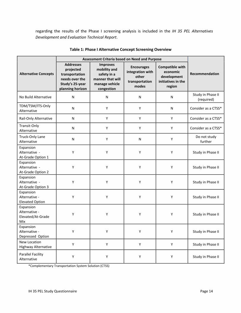
IH 35 PEL Study Questionnaire Page 14
regarding the results of the Phase I screening analysis is included in the IH 35 PEL Alternatives
Development and Evaluation Technical Report.
Table 1: Phase I Alternative Concept Screening Overview
Alternative Concepts
Assessment Criteria based on Need and Purpose
Recommendation
Addresses projected
transportation needs over the Study’s 25-year
planning horizon
Improves mobility and
safety in a manner that will manage vehicle
congestion
Encourages integration with
other transportation
modes
Compatible with economic
development initiatives in the
region
No Build Alternative N N N N Study in Phase II
(required)
TDM/TSM/ITS-Only Alternative
N Y Y N Consider as a CTSS*
Rail-Only Alternative N Y Y Y Consider as a CTSS*
Transit-Only Alternative
N Y Y Y Consider as a CTSS*
Truck-Only Lane Alternative
N Y N Y Do not study
further
Expansion Alternative - At-Grade Option 1
Y Y Y Y Study in Phase II
Expansion Alternative - At-Grade Option 2
Y Y Y Y Study in Phase II
Expansion Alternative - At-Grade Option 3
Y Y Y Y Study in Phase II
Expansion Alternative - Elevated Option
Y Y Y Y Study in Phase II
Expansion Alternative - Elevated/At-Grade Mix
Y Y Y Y Study in Phase II
Expansion Alternative - Depressed Option
Y Y Y Y Study in Phase II
New Location Highway Alternative
Y Y Y Y Study in Phase II
Parallel Facility Alternative
Y Y Y Y Study in Phase II
*Complementary Transportation System Solution (CTSS)
IH 35 PEL Study Questionnaire Page 15
As a result of the Phase I screening analysis, four of the 11 concepts in the universe of alternatives
were recommended for elimination from further study as standalone alternative concepts because
they did not meet the need and purpose of the project. Although eliminated as standalone
solutions, some of the alternative concepts eliminated were identified as potential complementary
transportation system solutions (CTSS), indicating that although they didn’t address the need and
purpose as standalone solutions, they did possess the potential to complement other standalone
transportation improvements. Detailed analysis of potential CTSS has been deferred to the NEPA
process.
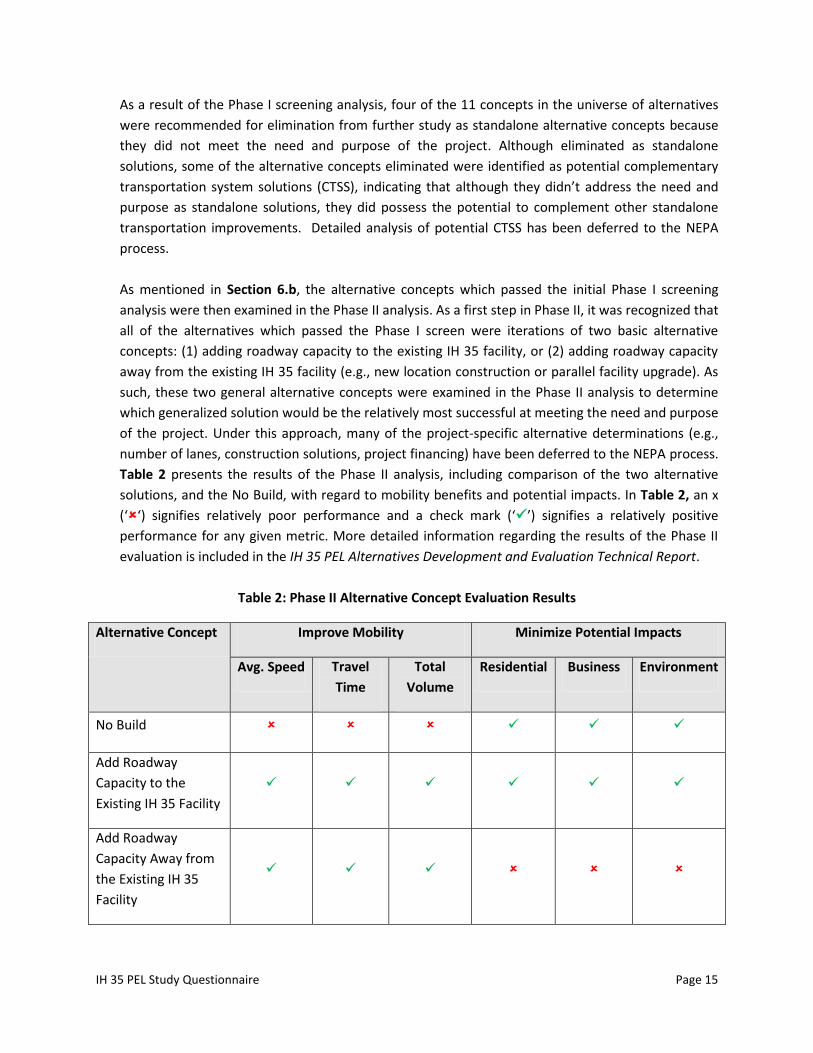
As mentioned in Section 6.b, the alternative concepts which passed the initial Phase I screening
analysis were then examined in the Phase II analysis. As a first step in Phase II, it was recognized that
all of the alternatives which passed the Phase I screen were iterations of two basic alternative
concepts: (1) adding roadway capacity to the existing IH 35 facility, or (2) adding roadway capacity
away from the existing IH 35 facility (e.g., new location construction or parallel facility upgrade). As
such, these two general alternative concepts were examined in the Phase II analysis to determine
which generalized solution would be the relatively most successful at meeting the need and purpose
of the project. Under this approach, many of the project-specific alternative determinations (e.g.,
number of lanes, construction solutions, project financing) have been deferred to the NEPA process.
Table 2 presents the results of the Phase II analysis, including comparison of the two alternative
solutions, and the No Build, with regard to mobility benefits and potential impacts. In Table 2, an x
(‘‘) signifies relatively poor performance and a check mark (‘’) signifies a relatively positive
performance for any given metric. More detailed information regarding the results of the Phase II
evaluation is included in the IH 35 PEL Alternatives Development and Evaluation Technical Report.
Table 2: Phase II Alternative Concept Evaluation Results
Alternative Concept Improve Mobility Minimize Potential Impacts
Avg. Speed Travel
Time
Total
Volume
Residential Business Environment
No Build
Add Roadway
Capacity to the
Existing IH 35 Facility
Add Roadway
Capacity Away from
the Existing IH 35
Facility
IH 35 PEL Study Questionnaire Page 16
As a result of the Phase II screen, it was determined that the alternative concept which involved the
addition of roadway capacity to the existing IH 35 facility would be the most successful at
accomplishing the need and purpose of the study and improving mobility while minimizing potential
impacts in the Study Area.
d. Which alternatives should be brought forward into NEPA and why?
Based on the results of the evaluation analysis, it is recommended to carry forward one alternative
concept into the NEPA process that involves the construction of additional roadway capacity on the
existing IH 35 facility. It was determined that this solution to enhanced mobility would provide the
best method of meeting the need and purpose of the project. Other solutions, such as expanding
existing roadway capacity away from the IH 35 facility, constructing a new transportation facility, or
constructing/enhancing other modes of transportation, were deemed relatively less successful at
meeting the need and purpose and thus were eliminated from further consideration as standalone
solutions. Project-specific determinations regarding the proposed number of lanes to add to
existing IH 35, construction solutions (i.e., elevated, at-grade, depressed, or some combination
thereof), and project funding or tolling remain to be analyzed and decided upon through the NEPA
process.
e. Did the public, stakeholders, and agencies have an opportunity to comment during this
process?
The public, stakeholders, and agencies provided input at every decision node of the project including
problem identification, evaluation factors and criteria, alternatives development and alternatives
screening during the first three rounds of TAC and CAC meetings and public workshops. An
opportunity was provided during the 4th and final round of public involvement for stakeholders to
comment on the alternative concept recommended for future study under NEPA.
f. Were there unresolved issues with the public, stakeholders and/or agencies?
There were no unresolved issues after the last round of public involvement was complete.
However, the public was made aware that issues of funding were beyond the scope of the PEL
Study.
7. Planning assumptions and analytical methods:
a. What is the forecast year used in the PEL study?
2035 is the forecast year for the IH 35 PEL Study which is consistent with the horizon-year forecasts
produced by the San Antonio-Bexar County MPO in the currently adopted MTP, Mobility 2035 Plan.
b. What method was used for forecasting traffic volumes?
The modeling of the corridor travel demand was performed for the year 2035 using the latest
updated network and trip tables that were based on the San Antonio-Bexar County MPO Model. The
demand profiles that were used within the travel demand model to develop traffic forecasts for this
study were based on the socioeconomic data that was used for the Loop 1604 and US 281 Traffic
and Toll Revenue Study.
IH 35 PEL Study Questionnaire Page 17
Between February 25 and March 3, 2012 traffic data was collected within the IH 35 PEL Study Area
to update the latest San Antonio MPO Travel Demand Model with current traffic data. This
collection included:
Traffic Count data
Screen-line point data
Vehicle Classification Counts
Vehicle Occupancy Counts
Speed & Delay runs (Travel time runs) for A.M., P.M., and Off-Peak hours.
This data was used to calibrate the model within the Study Area limits and to identify current
performance of the existing IH 35 facility. It was then used as a benchmark to forecast future traffic
volumes under the No Build Alternative.
As alternatives were run through the travel demand model, peak-period travel times, vehicle hours
of travel, and local vs. through-trip performance were summarized and compared against the no-
build as well as the other alternatives. In addition, screen-line point data helped determine whether
or not demand shifts from/to the facility under various alternatives. Vehicle Classification counts
provided information on the mix of traffic (trucks vs. cars) and were used to identify which
alternatives served differing mixes of traffic. Speed and delay runs provided base information on all
the alternatives and their ability to increase throughput. It should be noted that both the modeling
methodology and the modeling results were reviewed by TxDOT Transportation Planning and
Programming Division (TPP).
c. Are the planning assumptions and the corridor vision/purpose and need statement consistent
with the long-range transportation plan?
The IH 35 PEL Study purpose and need statement is consistent with and in many cases directly
supports the corridor vision and goals from the MTP. The consistency of the IH 35 PEL Study with
the MTP is illustrated in Table 3.
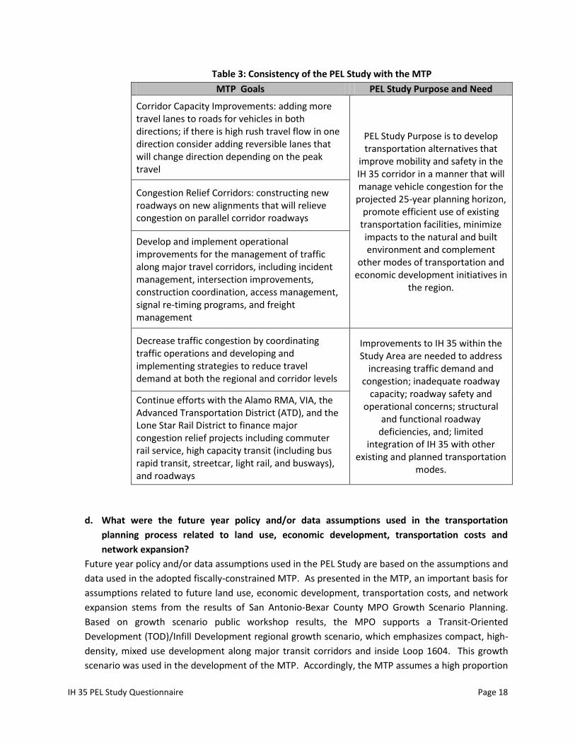
IH 35 PEL Study Questionnaire Page 18
Table 3: Consistency of the PEL Study with the MTP
MTP Goals PEL Study Purpose and Need
Corridor Capacity Improvements: adding more travel lanes to roads for vehicles in both directions; if there is high rush travel flow in one direction consider adding reversible lanes that will change direction depending on the peak travel
PEL Study Purpose is to develop transportation alternatives that
improve mobility and safety in the IH 35 corridor in a manner that will manage vehicle congestion for the
projected 25-year planning horizon, promote efficient use of existing
transportation facilities, minimize impacts to the natural and built environment and complement
other modes of transportation and economic development initiatives in
the region.
Congestion Relief Corridors: constructing new roadways on new alignments that will relieve congestion on parallel corridor roadways
Develop and implement operational improvements for the management of traffic along major travel corridors, including incident management, intersection improvements, construction coordination, access management, signal re-timing programs, and freight management
Decrease traffic congestion by coordinating traffic operations and developing and implementing strategies to reduce travel demand at both the regional and corridor levels
Improvements to IH 35 within the Study Area are needed to address
increasing traffic demand and congestion; inadequate roadway
capacity; roadway safety and operational concerns; structural
and functional roadway deficiencies, and; limited
integration of IH 35 with other existing and planned transportation
modes.
Continue efforts with the Alamo RMA, VIA, the Advanced Transportation District (ATD), and the Lone Star Rail District to finance major congestion relief projects including commuter rail service, high capacity transit (including bus rapid transit, streetcar, light rail, and busways), and roadways
d. What were the future year policy and/or data assumptions used in the transportation
planning process related to land use, economic development, transportation costs and
network expansion?
Future year policy and/or data assumptions used in the PEL Study are based on the assumptions and
data used in the adopted fiscally-constrained MTP. As presented in the MTP, an important basis for
assumptions related to future land use, economic development, transportation costs, and network
expansion stems from the results of San Antonio-Bexar County MPO Growth Scenario Planning.
Based on growth scenario public workshop results, the MPO supports a Transit-Oriented
Development (TOD)/Infill Development regional growth scenario, which emphasizes compact, high-
density, mixed use development along major transit corridors and inside Loop 1604. This growth
scenario was used in the development of the MTP. Accordingly, the MTP assumes a high proportion
IH 35 PEL Study Questionnaire Page 19
of TOD/high density development and mixed-use land use with an associated emphasis on
expansion and accessibility of the transit network. The MTP also assumes fiscal constraints on
future transportation projects, acknowledging that transportation project costs far outweigh
available funding resources, necessitating strict prioritization of transportation projects.
8. Environmental resources (wetlands, cultural, etc.) reviewed. For each resource or group of
resources reviewed, provide the following:
a. In the PEL study, at what level of detail was the resource reviewed and what was the method
of review?
Existing resources present in the Study Area have been identified and documented in the IH 35 PEL
Study Affected Environment Technical Report consistent with a planning-level study. Resources
were reviewed from September 2011 through 2012 based on existing datasets, studies, and plans,
as well as windshield surveys. All resources were reviewed following the latest guidelines available
at the time of research. A brief summary is provided below:
Land Use and Planning – 2011-2012 Bexar, Comal and Guadalupe County land use data
was collected and examined to the parcel level. Local government plans were also
examined, including the San Antonio North Sector Plan, Northeast Gateway Corridor
District Plan, and City of Schertz Comprehensive Land Plan. A windshield survey was
conducted in 2011; recent aerial photographs of the Study Area were also examined.
Socioeconomic Factors – Total, minority, low-income, and limited English proficiency
population data and employment/income data were examined to the block group or
census tract level, as available, from Census 2010 and American Community Survey
2005-2009 sources.
Neighborhoods and Community Resources – Military land, hospitals, schools,
universities, and places of worship were identified through internet search and
windshield surveys for the southern Study Area (intersection of IH 35/US 281/IH 37 to
the IH 35/IH 410 intersection); central Study Area (410 intersection to the IH 35/Loop
1604 intersection); and northern Study Area (IH 35/Loop 1604 intersection to the IH
35/FM 1103 intersection).
Visual and Aesthetic Qualities – Visual resources were inventoried for the southern,
central, and northern portions of the PEL Study Area. The City of San Antonio’s rating
for the PEL corridor was identified (not a scenic corridor). The cities of San Antonio and
Schertz guidelines relevant to visual resources were identified. Factors affecting
personal assessment of visual and aesthetic quality of areas were also outlined.
Existing Transportation Infrastructure – Information on the existing road, transit, and
rail systems and proposed system improvements was obtained from MPO MTP, VIA, and
TxDOT sources and current maps. Existing IH 35 and IH 410 were described, including
crossings and entrance/exit ramp locations. Data for existing and planned PEL Study
Area roadways was presented. Major traffic generators were identified, and current
IH 35 PEL Study Questionnaire Page 20
and future projected traffic volumes including level of service information was
presented. Existing and projected bus transit ridership was presented. Existing and
proposed intermodal and air facilities were also discussed.
Surface Water - Surface water resources (streams, floodplains and wetlands) of the
Study Area were listed and described, referencing TCEQ, Federal Emergency
Management Agency (FEMA), and USFWS sources. Surface drainage characteristics and
surface water quality as well as applicable federal and state surface water, floodplain,
and water quality regulations were also described.
Groundwater - Groundwater aquifer resources of the Study Area were described
referencing information from the TCEQ and EAA. Types of aquifer impacts and the
associated protective regulatory framework were also described.
Air Quality / Area Emissions – Federal (EPA) and state (TCEQ) air quality guidelines and
regulations were presented. Air quality standards for were presented for individual
pollutants, along with the current attainment status.
Noise Analysis – Federal traffic noise standards and regulations were presented, as well
as a description of traffic noise analysis procedures.
Hazardous Materials – A comprehensive list of Federal and State hazardous materials
records databases with readily available data was presented, along with the results of a
current internet search of these databases, showing hazardous materials sites
occurrence in the Study Area. Field verification of database search results was not
performed. NEPA-level hazardous materials assessment procedures and documentation
requirements were also presented.
Threatened and Endangered Species – Applicable federal and state regulations
pertaining to listed species were presented. The most recent federal and state
threatened and endangered species occurrence databases were searched and species
occurring or with potential to occur in the Study Area were presented.
Natural Areas and Preserves – searches of the Texas Natural Diversity Database, NRCS
Grassland Reserve and Farm and Ranch Land Reserve Programs, and USFWS National
Wildlife Refuges databases were conducted, along with a windshield survey.
Parklands and Recreation Areas – The regulatory framework for impacts to park and
recreational facilities was presented, including Section 4(f), Land and Water
Conservation Fund (Section 6(f)), and Texas Parks and Wildlife Code requirements. An
assessment of park and recreation areas in the Study Area was also conducted.
Historic and Cultural Resources – Database searches were conducted to identify historic-
age resources, cemeteries, State Archeological Landmarks (SALs), and heritage farms in
and within 150-ft Area of Potential Effect (APE) of the Study Area. A technical report
with detailed evaluation of the identified resources and the historic context of the area
was drafted, in accordance with the Programmatic Agreement (PA) between FHWA,
IH 35 PEL Study Questionnaire Page 21
State Historic Preservation Officer (SHPO), Advisory Council on Historic Preservation
(ACHP), and TxDOT. A preliminary determination of likelihood of occurrence of
undiscovered archeological resources in the Study Area was made. Certified Local
Governments (CLGs) were identified.
Utilities / Transmissions – Transmission Lines were identified for the southern, central,
and northern sections of the Study Area. The Study Area was also checked for electric
transfer stations (no occurrence).
Mine and Quarry Locations – The Study Area was surveyed for mine and quarry
occurrence and one aggregate materials quarry operating as G.E.M. Materials is located
within the Study Area at Retama Park and IH 35.
Prime Farmland – NRCS Farmland Protection Policy Act guidelines were presented.
Prime soils series of the Study Area were determined from USGS soil survey data, and
respective acreages of these series were determined in Geographic Information Systems
(GIS).
b. Is this resource present in the area and what is the existing environmental condition for this
resource?
The existing condition of each the resources listed in the IH 35 PEL Study Affected Environment
Technical Report have been described in the Affected Environment Technical Report, along with a
summary of any associated legal or regulatory context, and quantified, as appropriate for the
corridor-level of analysis. Please refer to the Affected Environment Technical Report for further
information on each resource. A brief summary is provided below:
Land Use and Planning – Most land use in the PEL Study Area is commercial, followed by
streets and residential land use. Active urban development is ongoing throughout
remaining undeveloped areas of the PEL Study Area, in accordance with San Antonio sector
plans and the Schertz Comprehensive Land Plan.
Socioeconomic Factors – 62.9 percent of the population of block groups intersecting the PEL
Study Area are minority; 14.6 percent of the population of Census Tracts intersecting the
Study Area are low-income; 8.6 percent of the population of Census Tracts intersecting the
Study Area are LEP.
Neighborhoods and Community Resources – Fort Sam Houston (U.S. Army) including the
Brook Army Medical Center is located in the southern Study Area. This facility includes the
Brook Army Medical Center and the Texas National Guard Armory. The Northeast
Methodist Hospital is located in the Study Area. Five elementary schools, two middle
schools, three pre-schools, one private school, and one university are located in the Study
Area Twelve places of worship are also located in the Study Area.
Visual and Aesthetic Qualities – The Study Area is mainly characterized by man-made visual
features, which include single-family residential areas, military uses, and industrial and
IH 35 PEL Study Questionnaire Page 22
commercial areas; however, natural and undeveloped views also occur. The southern
project area includes views of undeveloped land along IH 410, as well as views of the San
Antonio River and Pershing and Walzem Creeks; the central project area includes view of
Beitel and Salitrillo Creeks; the northern project area includes views of Cibolo Creek. Views
of areas of mature live oak and Ashe juniper occur throughout the project area.
Existing Transportation Infrastructure – IH 35 is the primary roadway in the project area,
with connections to other nationally and/or regionally important major roadways including
IH 10, IH 410, Loop 1604, and US 281. Because the Study Area is highly urbanized, many
local major and minor arterials and local streets also occur. Major traffic generators
contributing to traffic in the Study Area include Fort Sam Houston (including Brooks Army
Medical Center), Randolph Air Force base, San Antonio International Airport, downtown
San Antonio, the HEB grocery warehouse district, Windsor Park shopping mall, and Retama
polo park. The Union Pacific freight rail system and intermodal train-truck freight transfer
facility are major features of the Study Area; there is currently no passenger rail system.
Transit features include several VIA bus routes that provide service and connectivity to the
Study Area.
Surface Water – Streams within the project area are the San Antonio River and Salado,
Pershing, Walzem, Beitel, Salitrillo, and Cibolo Creeks. Portions of three of these (Upper San
Antonio River, Salado Creek, and middle Cibolo Creek) are considered by the TCEQ as
impaired regarding water quality. The Study Area also contains 602 acres of FEMA-
designated 100-year floodplain and 20.3 acres of NWI palustrine wetlands.
Groundwater – Approximately 90 percent of the Study Area overlies the artesian zones of
the Edwards and Trinity aquifers, which have a high degree of hydrologic connectivity. The
Edwards Aquifer is the principal source of water for the San Antonio area and has therefore
been designated a sole source aquifer. The aquifer is protected from over-pumpage by the
Edwards Aquifer Authority. Recharge water quality is protected through TCEQ rules which
include regulation of contributing and recharge zone development.
Air Quality / Area Emissions – The San Antonio area, including the Study Area, is in
attainment of all major EPA national air quality standards for the six major pollutants:
ozone, lead, carbon monoxide, sulfur dioxide, nitrogen dioxide, and particulates. However,
unless ozone levels in 2012 are lower than those in 2011, the area will be in violation of EPA
ozone standards.
Noise Analysis – As an urbanized area with a major freeway and extensive roadway
connections, traffic noise is a major constituent of ambient background noise levels.
Hazardous Materials – No obviously apparent sources of hazardous materials contamination
currently occur in the PEL Study Area. According to database searches, a total of 732
hazardous materials sites occur within the American Society for Testing and Materials
(ASTM)-designated search distances from the alternatives centerlines. The sites are
primarily listed in the Industrial and Hazardous Waste Sites, Petroleum Storage Tanks,
IH 35 PEL Study Questionnaire Page 23
Leaking Petroleum Storage Tanks, Tier II Chemical Reporting Program Facilities, and
Resource Conservation and Recovery Act (RCRA) databases.
Threatened and Endangered Species – There are 43 federally- or state- threatened and/or
endangered species occurring in, potentially occurring in, or potentially impacted by,
activities occurring regionally (including areas outside the project Study Area). The Study
Area is highly urbanized with limited potential for actual listed species occurrence; it occurs
on karst zones with low probability of occurrence (Zone 3) and no occurrence (Zone 5) of
listed karst species. Actual occurrence of these species or their habitats would be
determined during NEPA-level studies. The TPWD Natural Diversity Database (NDD) lists
one occurrence in the Study Area, for the Guadalupe bass (State-designated as Rare).
Outside the Study Area but within a 1.5-mile radius, the NDD also lists one occurrence each
for two State-listed (threatened) blindcat fish species and one occurrence of a waterbird
rookery with no identified listed species.
Natural Areas and Preserves – No officially-designated natural areas or preserves are
located within the Study Area.
Parklands and Recreation Areas – The Study Area encompasses 37.2 acres of San Antonio
parks and recreation areas, including all of one park (Pershing Park), part of another park
(Ruth Woodward Park), and portions of two greenways (Salado Creek, Jack White Park). In
addition, the Study Area encompasses 15.6 acres of Olympia Hill Golf Couse, owned by
Universal City.
Historic and Cultural Resources – Three National Register-listed properties occur in the
Study Area: The Old Lone Star Brewery, the Fort Sam Houston historic district, and the John
S. Harrison house. Two National Register-eligible properties also occur, a commercial
building and a property containing two education buildings. The Harrison house is also
recognized by the State of Texas as an SAL. The Harrison and Brown Stage Stop in Selma is
also designated an SAL. Two cemeteries were identified within the Study Area.
Utilities / Transmissions – Twenty electric transmission lines of various kilovolt capacities
occur completely or partly within the Study Area; eleven of these cross IH-35.
Mine and Quarry Locations – One aggregate materials quarry operated as G.E.M. Materials
is located within the Study Area at Retama Park and IH 35.
Prime Farmland – Prime farmland soils that are within roadway ROW or dedicated to urban
development are not subject to the requirements of the FPPA. Therefore, although 66.8%
(5,218.5 acres) of the Study Area contains prime farmland soils, this percentage falls to 8.8%
(684 acres) when roadway ROW and areas dedicated to urban development are removed.
c. What are the issues that need to be considered during NEPA, including potential resource
impacts and potential mitigation requirements (if known)?
IH 35 PEL Study Questionnaire Page 24
The Affected Environment Technical Report identifies resources that may need to be further
examined in NEPA, as warranted, depending on project-level impacts identified during the NEPA
phase of project development. The following includes protocol for resource categories determined
during NEPA to be potentially impacted by a proposed alternative. A brief summary is provided
below:
Land Use and Planning – Any direct effects to businesses or residences (takes) and
associated displacement assistance under the provisions of the Uniform Relocation
Assistance and Real Property Acquisition Policies Act of 1970 would need consideration
during a NEPA-level study. Any indirect effects stemming from access alteration due to
the project with associated land use and development effects (induced development;
alteration of land development patterns) would also need consideration, to ensure the
project is compatible with the prospective MPO regional growth scenario (TOD/Infill)
The consistency of the proposed project with other local city planning would also need
to be ensured throughout the NEPA process.
Socioeconomic Factors – Any impacts to low income and minority populations would
need to be assessed in accordance with EO 12898 Federal Actions to Address
Environmental Justice in Minority Populations and Low-Income Populations and
mitigation would be provided if warranted. Findings from the System level toll analyses
for toll impacts to EJ populations included in the 2035 MTP would be presented, and a
project level toll analysis and any associated impacts to EJ populations would be
included in the NEPA study. The NEPA study would also include measures to ensure the
opportunity for participation and input of LEP persons in the project development
process.
Neighborhoods and Community Resources – Although direct impacts to these resources
(taking) would not be anticipated, potential impacts stemming from indirect effects of
the project such as access alteration would be assessed, if warranted.
Visual and Aesthetic Qualities – Guidelines for visual sensitivity rating and consistency of
the proposed project design with local visual and aesthetic guidelines would need to be
ensured. Regarding project design, the most detailed guidelines are offered by the
TxDOT San Antonio District, which specifies region-specific roadway architecture design
themes; City of San Antonio North Sector Plan and City of Schertz Comprehensive Land
Plan have visual/aesthetic design provisions complementary to the TxDOT guidelines.
Mitigation of visual impacts would be considered during project planning, as specified in
the TxDOT Environmental Manual. These measures could include incorporation of
architectural features and aesthetic elements into the project design,
landscaping/xeriscaping, screening, and earthwork.
Existing Transportation Infrastructure – Connectivity of a proposed project-level
alternative with the existing transportation infrastructure, as well as project effects on
local access and mobility must be considered during NEPA analysis. Compatibility of IH
IH 35 PEL Study Questionnaire Page 25
35 corridor improvements with prospective transit and rail improvements must also be
considered.
Surface Water – A NEPA-level study would need to consider impacts to jurisdictional
streams and wetlands, including permit and potential mitigation requirements. Design
requirements to prevent floodplain impacts would also need to be considered, along
with appropriate coordination requirements with local FEMA floodplain officials.
Groundwater – Potential indirect impacts to Edwards Aquifer recharge zone from
project-induced development north/west of the project area would need to be
considered. Location and proper plugging of abandoned or acquired water wells would
also need to be considered.
Air Quality / Area Emissions – Demonstration of consistency of the proposed
alternatives with the San Antonio-Bexar County MTP and current STIP would be needed.
If modeled projected traffic exceeds 140,000 vehicles per day, a Traffic Air Quality
Analysis (TAQA) would need to be performed. A Mobile Source Air Toxic (MSAT)
analysis would also need to be conducted.
Noise Analysis – Noise impacts to residential receivers would need to be determined
using Traffic Noise Model (TNM) analysis, for each proposed alternative. Noise
abatement measures would need to be determined cooperatively between TxDOT and
affected property owners and incorporated into the project design.
Hazardous Materials – Phase I assessment to ASTM standards would be conducted on a
preferred alternative during NEPA. Phase II site investigations could be required,
depending on the results of the Phase I database search, project design, and locations of
proposed ROW location. Any mitigation requirements for hazardous materials sites
would be discussed.
Threatened and Endangered Species – If a federally-listed species or its habitat was
determined to be affected by the preferred alternative, a biological assessment would
be required with an effect determination (No Effect; May Affect, but is not likely to
Adversely Affect; or May Affect, is likely to Adversely Affect) for submittal to the USFWS
to initiate consultation. Consultation would be informal or formal depending on
proposed impacts; the potentially extended time frame for this coordination should be
considered. Although not anticipated, project impacts to federally listed species or their
habitats would potentially be mitigated through provisions of the Southern Edwards
Plateau Habitat Conservation Plan. Similarly, any impacts to State-listed species would
be coordinated with TPWD. Any required mitigation for impacts to habitat for federal
Candidate species or rare vegetation species providing habitat for State-listed species
would also need to be coordinated with TPWD. In addition to listed species, any impacts
to migratory bird nesting and associated USFWS coordination requirements would need
to be considered.
IH 35 PEL Study Questionnaire Page 26
Natural Areas and Preserves – Although no officially designated natural areas or
preserves occur, in accordance with the Memorandum of Understanding (MOU)
between TxDOT and TPWD, any proposed impacts to bottomland hardwoods, native
prairies, or riparian habitat would be quantified and reported in the NEPA document,
and the potential for mitigation for impacts to these resources discussed.
Parklands and Recreation Areas – Any direct impacts (taking) and constructive use
impacts to parks and recreation areas would be quantified and/or assessed for a
proposed project-level alternative during the NEPA study. Section 4(f) coordination with
the FHWA would be undertaken. Avoidance and minimization of impacts must occur
per regulations. Any potential mitigation for impacts would be determined during the
coordination effort.
Historic and Cultural Resources – Any effects (direct and indirect) to historic resources
identified and evaluated in the PEL Study and during the NEPA study (including any ROW
proposed for acquisition) would be summarized in a Historic Resources Survey Report
(HRSR); coordination with the SHPO in accordance with the MOU regarding HRSR
findings would be undertaken. As warranted, project design would be modified to avoid
adverse impacts to historic resources.
Utilities / Transmissions – Adjustment or relocation of transmission lines or
underground pipelines, and associated costs, would be considered in the NEPA study.
Mine and Quarry Locations – Potential impacts to mining activities would be considered
in the NEPA study.
Prime Farmland – Potential impacts to Study Area farmland subject to the Farmland
Protection Policy Act would be considered in the NEPA study.
d. How will the data provided need to be supplemented during NEPA?
The data collected at the corridor-level in the IH 35 PEL will serve as starting point for NEPA analysis,
but may need to be refined to a greater level of specificity for project-level alternatives. A brief
summary of data that may need to be supplemented in NEPA includes:
Land Use and Planning – Bexar County and the cities of Live Oak, Universal City,
Windcrest and Selma would be contacted to obtain any available land use data or
planning information. Previously obtained data from San Antonio and Schertz would be
updated if necessary. The most recent versions of land use planning documents would
be obtained, if available, to ensure inclusion of data compiled since the PEL Study.
Additional windshield surveys would be conducted to document recent land use
changes since the PEL study.
Socioeconomic Factors – U.S. Department of Health and Human Services (HHS) poverty
guidelines and American Community Survey data would be updated to the NEPA study
year. Population and ethnicity data, and associated project impacts, would be
IH 35 PEL Study Questionnaire Page 27
presented to the block level; low income and LEP population data, including impacts to
low-income populations, would be presented to the block group level.
Neighborhoods and Community Resources – The Study Area would be checked for
changes in inventory of Military land, hospitals, schools, universities, and places of
worship since the PEL study. Data necessary to analyze potential noise, visual/aesthetic,
and MSAT effects to these resources from the project would need to be collected.
Visual and Aesthetic Qualities – The Study Area would be checked for changes in visual
features since the PEL study. Any updates to City of San Antonio, San Antonio North
Sector, TxDOT-San Antonio District, or City of Schertz visual/aesthetic guidelines would
be taken into account. Any newly published guidance from the Cities of Windcrest, Live
Oak, and Selma would also be taken into account.
Existing Transportation Infrastructure – Any updates to the MTP and VIA Long-Range
Plan, and updated rail information from TxDOT or the Lone Star Rail District would be
obtained. Detailed design information regarding proposed project crossings, ramp
locations (connections to existing transportation infrastructure) would be detailed for
each proposed alternative.
Surface Water Field Jurisdictional Determinations and delineations would be performed
for streams and wetlands and impacts quantified for the preferred alternative. The
most recent impairment status (updated annually) of affected stream segments (within
five miles downstream of project) would also be checked. Appropriate USACE
coordination with respect to permitting would be conducted.
Groundwater – The location of any water wells within the Study Area and the associated
aquifer would be determined, in the event such wells might require plugging in
conjunction with the proposed project.
Air Quality / Area Emissions – The NEPA study would report any updated attainment
status for NAAQS, to determine if transportation conformity rules would apply. TAQA
analysis for CO will be included if modeled projected traffic is >140,000 vehicles per day
(vpd).
Noise Analysis – Modeled receiver locations would need to be determined. Existing
ambient noise levels would need to be recorded as appropriate in the field. Existing and
projected future traffic data would be obtained from TxDOT TPP for use in TNM traffic
noise analysis modeling. Areas where noise abatement would potentially be feasible
would need to be identified.
Hazardous Materials – The Phase I database search would be updated to capture any
hazmat issues occurring since the PEL Study. Additional Phase I ESA activities would
include field verification of sites identified in the database searches; review of additional
environmental record sources such as topographic maps; review of reasonably
ascertainable historical land use research sources such as Sanborn maps;
IH 35 PEL Study Questionnaire Page 28
landowner/government official interviews; and Phase I survey documentation such as
the TxDOT Initial Site Assessment form.
Threatened and Endangered Species – State and federal lists would be re-checked to
ensure that any listing changes occurring since the PEL study are captured. A site visit
would be conducted by a qualified biologist to document any occurrence of listed
species or their habitats. A karst survey would be conducted by a qualified geologist to
determine occurrence of undocumented karst features. If karst features are discovered
these would be examined by a qualified biologist for occurrence of suitable habitat
for/occurrence of listed karst species.
Natural Areas and Preserves – It will be determined if any natural areas or preserves
have been established since the PEL study, and field visits will occur to identify and
quantify impacts to bottomland hardwood, prairie, or riparian vegetation within
existing and proposed ROW for a proposed project-level alternative.
Parklands and Recreation Areas – It will be determined if any parklands or recreational
areas have been established since the PEL study, for inclusion in FHWA consultation.
Historic and Cultural Resources – A field historical-age resource and archeological survey
would be conducted for the APE and any additional ROW acquired for the proposed
project. Field identification of cemetery locations and boundaries would be performed
to determine potential impacts. The listing of historic resources compiled in the PEL
study would be updated to include resources which had become NRHP-listed or –
eligible since the PEL study. Qualified historians would draft an HRSR and undertake
formal consultation with the SHPO regarding potential impacts to historic resources
from the preferred alternative and appropriate mitigation.
Utilities / Transmissions – Utility relocation needs and associated costs would be
calculated for a proposed project-level alternative.
Mine and Quarry Locations – The location of any new or expanded mining or quarry
operations with proximity to the Study Area will be assessed.
Prime Farmland – NRCS soils series mapping data for any areas not assessed during the
PEL study would be obtained during coordination with NRCS.
9. List environmental resources you are aware of that were not reviewed in the PEL study and why?
Indicate whether or not they will need to be reviewed in NEPA and explain why.
The list of resources reviewed in this IH 35 PEL study is comprehensive, and is consistent with
resources typically considered in a NEPA analysis. Although the level of analysis detail would be
greater in a NEPA study for all resources, it is not anticipated that additional resources would need
to be included. Resources receiving a cursory review in the PEL study but which would receive more
detailed analysis in NEPA are listed below, along with explanatory notes.
IH 35 PEL Study Questionnaire Page 29
Socioeconomic Factors – Minority population data examined at the Census Block Group
level in PEL would be examined at the Census Block level in NEPA. Income data
examined at the Census Tract level in PEL would be examined at the Census Block Group
level in NEPA. LEP data examined at the Census Tract level in PEL would be examined at
the Census Block Group level in NEPA. The level of analysis in PEL provides a basic
overview of local demographic and a reasonable preview of potential Environmental
Justice impacts that would be detailed during a NEPA-level study.
Air Quality / Area Emissions – This resource was not examined in detail during the PEL
study because TPP traffic forecast numbers are required for required air quality analysis.
The NEPA study would report any updated attainment status for NAAQS, to determine if
transportation conformity rules would apply. TAQA analysis for CO will be included if
modeled projected traffic is >140,000 vpd.
Noise Analysis – This issue was not examined in detail during the PEL study because
exact final design alignments and TPP traffic forecasts are required for TNM analysis. For
NEPA analysis, modeled receiver locations would need to be determined. Existing
ambient noise levels would need to be recorded as appropriate in the field. Existing and
projected future traffic data would be obtained from TxDOT TPP for use in TNM traffic
noise analysis modeling. Areas where noise abatement would potentially be feasible
would be identified.
Hazardous Materials – While the Study Area was visually examined during the PEL
Study, additional Phase I ESA activities would occur during NEPA-level studies including
closer field examination of sites identified in the database searches to detect visual
indicators of hazmat contamination. A Phase I Initial Site Assessment form would be
completed. Any discovered hazardous material sites would be subject to Phase II
investigation.
Threatened and Endangered Species –This resource was not examined in detail during
PEL in part because of the low potential for listed species habitat/occurrence in the
Study Area due to its urbanized character; its location on primarily previously disturbed
ground; and its location in karst zones with low or no likelihood of occurrence of listed
karst species. During NEPA-level analysis, a site visit would be conducted by a qualified
biologist to document any occurrence of listed species or their habitats. A karst survey
would be conducted by a qualified geologist to determine occurrence of undocumented
karst features. If karst features are discovered these would be examined by a qualified
biologist for occurrence of suitable habitat for/occurrence of listed karst species.
Historic and Cultural Resources – These resources were not studied in detail during PEL
because potential ROW needs, and therefore potential impacts, cannot be assessed.
During NEPA analysis, a field historical-age resource and archeological survey would be
conducted for the APE and any additional ROW acquired for the proposed project. Field
identification of cemetery locations and boundaries would be performed to determine
IH 35 PEL Study Questionnaire Page 30
potential impacts. The listing of historic resources compiled in the PEL study would be
updated to include resources which had become NRHP-listed or –eligible since the PEL
study. Qualified historians would draft an HRSR and undertake formal consultation with
the SHPO regarding potential impacts to historic resources from the preferred
alternative and appropriate mitigation.
10. Were cumulative impacts considered in the PEL study? If yes, provide the information or
reference where it can be found.
Cumulative impacts were not considered in the IH 35 PEL Study. Schematic design and project
details necessary to adequately assess cumulative impacts of proposed alternatives was not
available at the PEL level of analysis and would be more appropriately studied in NEPA.
11. Describe any mitigation strategies discussed at the planning level that should be analyzed during
NEPA.
The San Antonio-Bexar County MPO MTP presents environmental issues and mitigation strategies
regarding impacts to water quality, floodplains, wildlife habitat, agricultural land, the Edwards
Aquifer, environmental justice, and threatened and endangered species. These strategies
emphasize avoidance through project alignment and design, as well as a regional approach to land
preservation, generally consisting of in-kind preservation of resources unavoidably impacted by a
project. The PEL addresses many of the concerns to be addressed under NEPA, and the strategies
discussed are consistent with those proposed in the MTP. Planning-level decisions regarding
mitigation strategies includes activities and concepts that may be adopted or incorporated into
NEPA.
12. What needs to be done during NEPA to make information from the PEL study available to the
agencies and the public? Are there PEL study products which can be used or provided to agencies
or the public during the NEPA scoping process?
The NEPA document will be informed by a full spectrum of planning decisions derived from the PEL
process. The IH 35 PEL Study Report and all supporting PEL decision documents will be incorporated
into the NEPA process by reference and become part of the administrative record and history of the
decision-making process. Further, the IH 35 PEL Study Report, including associated technical
reports, will be integrated into the NEPA process and made available to the public, as well as to TAC
and CAC members and the resource and regulatory agencies that were engaged during the initial
stages of the IH 35 PEL Study. Additionally, the IH 35 PEL Study Report will be available on the
project website.
13. Are there any other issues a future project team should be aware of?
a. Examples: Controversy, utility problems, access or ROW issues, encroachments into ROW,
problematic land owners and/or groups, contact information for stakeholders, special or
unique resources in the area, etc.

IH 35 PEL Study Questionnaire Page 31
Funding for the proposed action has yet to be determined. The current MPO plan has indicated that
improvements for segments within the Study Area would be financed under a Comprehensive
Development Agreement (CDA). Specific financing options for the proposed action, including tolling
were not part of the PEL scope; therefore, public comment on these issues would be sought in the
NEPA process.
Design of the proposed action was not part of the PEL scope; therefore, public comment on specific
project design features, including the need for additional ROW, is still an outstanding issue and
would be addressed in the NEPA process.
APPENDIX A – IH 35 PEL STUDY
INTERLOCAL AGREEMENT
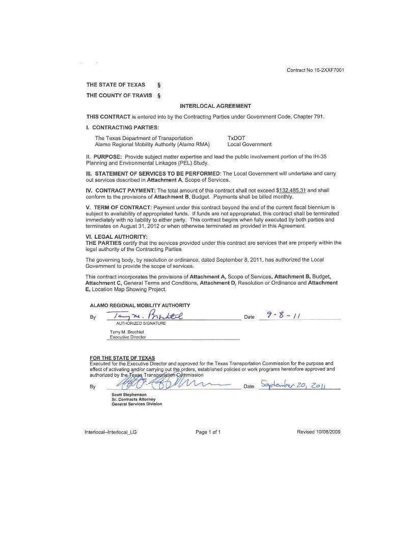
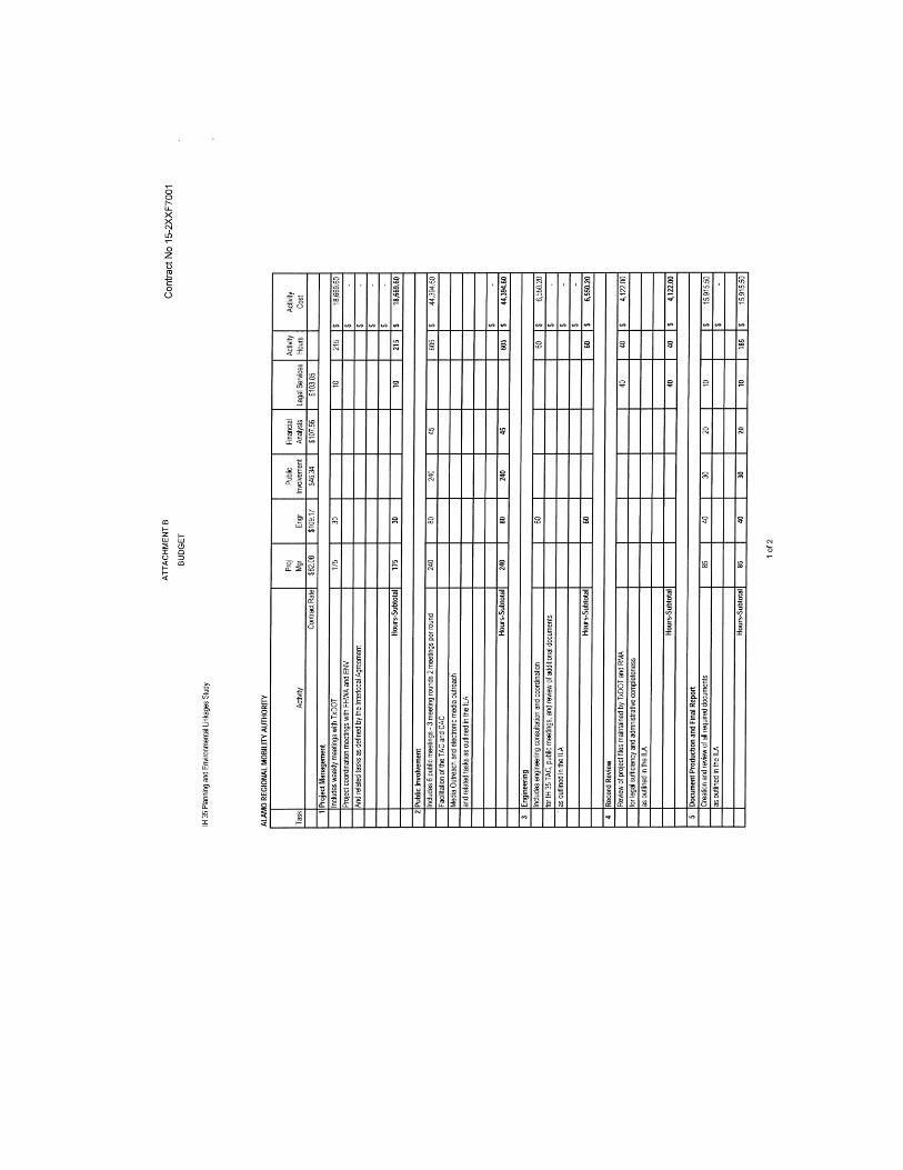
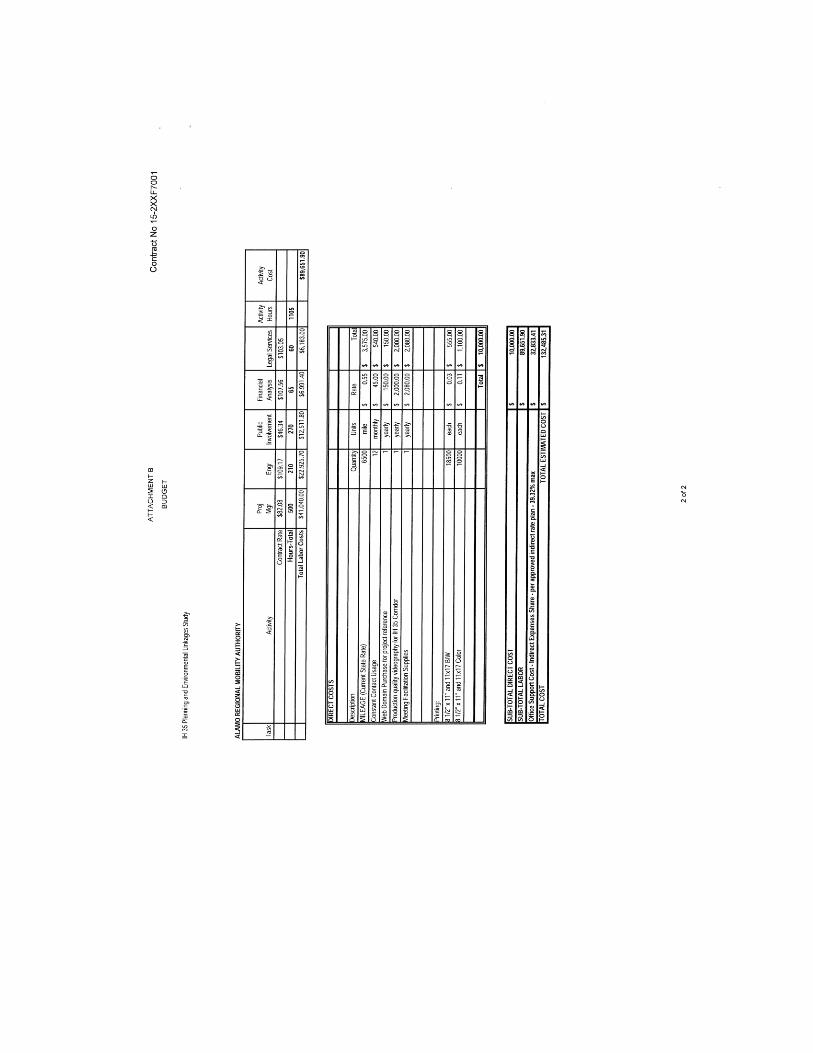
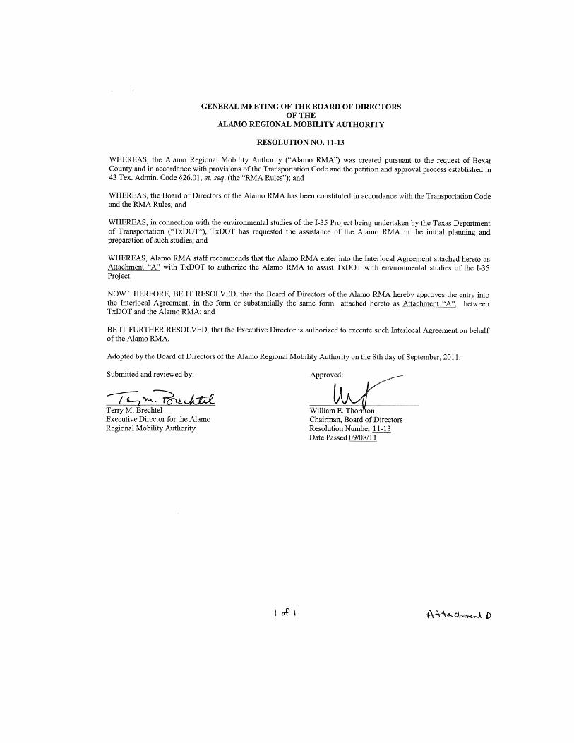
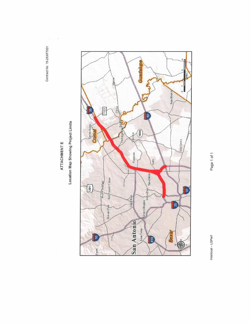
APPENDIX B - IH 35 PEL STUDY TEAM
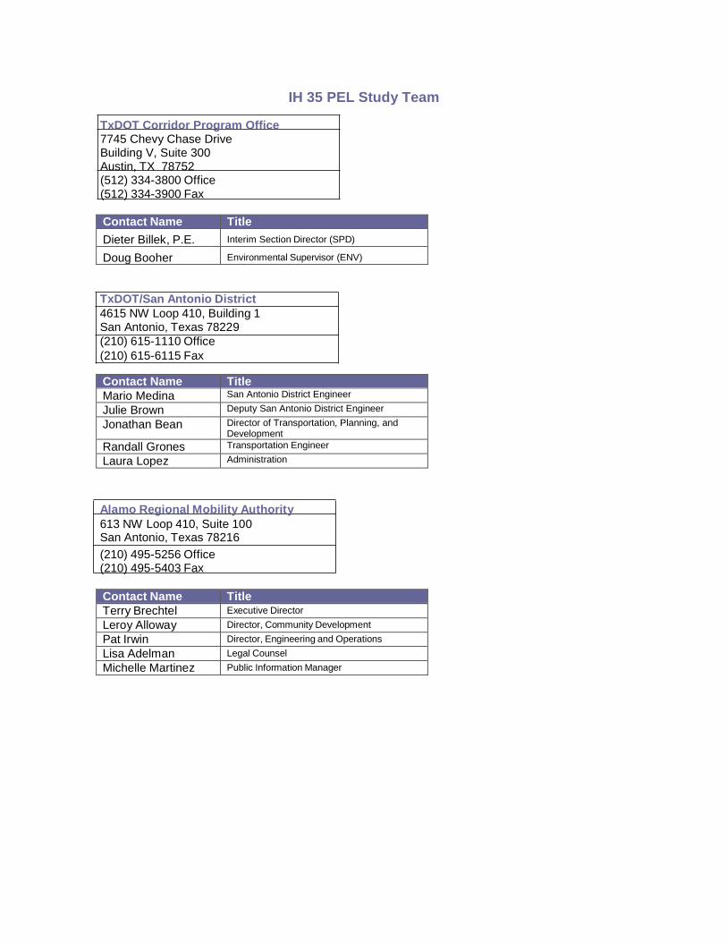
IH 35 PEL Study Team
TxDOT Corridor Program Office 7745 Chevy Chase Drive Building V, Suite 300 Austin, TX 78752 (512) 334-3800 Office (512) 334-3900 Fax
Contact Name Title
Dieter Billek, P.E. Interim Section Director (SPD)
Doug Booher Environmental Supervisor (ENV)
TxDOT/San Antonio District
4615 NW Loop 410, Building 1 San Antonio, Texas 78229
(210) 615-1110 Office
(210) 615-6115 Fax
Contact Name Title
Mario Medina San Antonio District Engineer
Julie Brown Deputy San Antonio District Engineer
Jonathan Bean Director of Transportation, Planning, and Development
Randall Grones Transportation Engineer
Laura Lopez Administration
Contact Name Title
Alamo Regional Mobility Authority
613 NW Loop 410, Suite 100 San Antonio, Texas 78216
(210) 495-5256 Office (210) 495-5403 Fax
Contact Name Title
Terry Brechtel Executive Director
Leroy Alloway Director, Community Development
Pat Irwin Director, Engineering and Operations
Lisa Adelman Legal Counsel
Michelle Martinez Public Information Manager
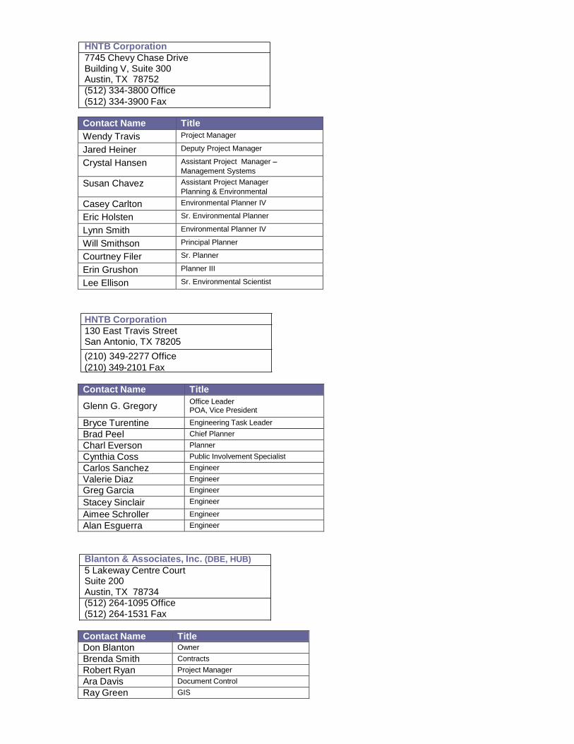
HNTB Corporation
7745 Chevy Chase Drive Building V, Suite 300 Austin, TX 78752
(512) 334-3800 Office
(512) 334-3900 Fax
Contact Name Title
Wendy Travis Project Manager
Jared Heiner Deputy Project Manager
Crystal Hansen Assistant Project Manager –
Management Systems
Susan Chavez Assistant Project Manager
Planning & Environmental
Casey Carlton Environmental Planner IV
Eric Holsten Sr. Environmental Planner
Lynn Smith Environmental Planner IV
Will Smithson Principal Planner
Courtney Filer Sr. Planner
Erin Grushon Planner III
Lee Ellison Sr. Environmental Scientist
Contact itle
HNTB Corporation
130 East Travis Street San Antonio, TX 78205
(210) 349-2277 Office
(210) 349-2101 Fax
Contact Name Title
Glenn G. Gregory Office Leader POA, Vice President
Bryce Turentine Engineering Task Leader
Brad Peel Chief Planner
Charl Everson Planner
Cynthia Coss Public Involvement Specialist
Carlos Sanchez Engineer
Valerie Diaz Engineer
Greg Garcia Engineer
Stacey Sinclair Engineer
Aimee Schroller Engineer
Alan Esguerra Engineer
Blanton & Associates, Inc. (DBE, HUB)
5 Lakeway Centre Court Suite 200 Austin, TX 78734 (512) 264-1095 Office
(512) 264-1531 Fax
Contact Name Title
Don Blanton Owner
Brenda Smith Contracts
Robert Ryan Project Manager
Ara Davis Document Control
Ray Green GIS
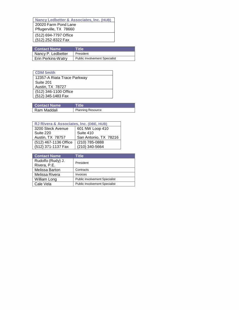
Nancy Ledbetter & Associates, Inc. (HUB)
20020 Farm Pond Lane Pflugerville, TX 78660
(512) 694-7797 Office
(512) 252-8322 Fax
Contact Name Title
Nancy P. Ledbetter President
Erin Perkins-Watry Public Involvement Specialist
CDM Smith
12357-A Riata Trace Parkway
Suite 201 Austin, TX 78727
(512) 346-1100 Office (512) 345-1483 Fax
Contact Name Title
Ram Maddali Planning Resource
RJ Rivera & Associates, Inc. (DBE, HUB)
3200 Steck Avenue Suite 220 Austin, TX 78757
601 NW Loop 410 Suite 410 San Antonio, TX 78216
(512) 467-1136 Office (512) 371-1137 Fax
(210) 785-0888 (210) 340-5664
Contact Name Title
Rudolfo (Rudy) J. Rivera, P.E.
President
Melissa Barton Contracts
Melissa Rivera Invoices
William Long Public Involvement Specialist
Cale Vela Public Involvement Specialist
APPENDIX C – TAC AND CAC MEMBERSHIP
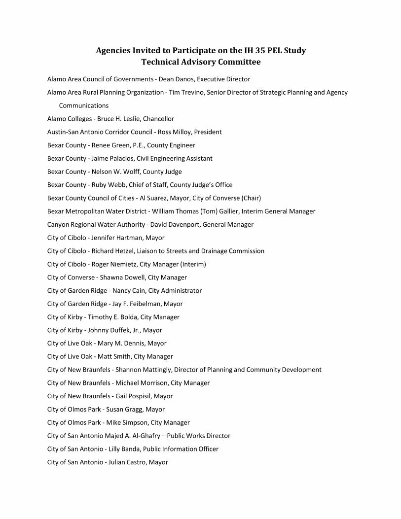
Agencies Invited to Participate on the IH 35 PEL Study
Technical Advisory Committee
Alamo Area Council of Governments ‐ Dean Danos, Executive Director
Alamo Area Rural Planning Organization ‐ Tim Trevino, Senior Director of Strategic Planning and Agency
Communications
Alamo Colleges ‐ Bruce H. Leslie, Chancellor
Austin‐San Antonio Corridor Council ‐ Ross Milloy, President
Bexar County ‐ Renee Green, P.E., County Engineer
Bexar County ‐ Jaime Palacios, Civil Engineering Assistant
Bexar County ‐ Nelson W. Wolff, County Judge
Bexar County ‐ Ruby Webb, Chief of Staff, County Judge’s Office
Bexar County Council of Cities ‐ Al Suarez, Mayor, City of Converse (Chair)
Bexar Metropolitan Water District ‐ William Thomas (Tom) Gallier, Interim General Manager
Canyon Regional Water Authority ‐ David Davenport, General Manager
City of Cibolo ‐ Jennifer Hartman, Mayor
City of Cibolo ‐ Richard Hetzel, Liaison to Streets and Drainage Commission
City of Cibolo ‐ Roger Niemietz, City Manager (Interim)
City of Converse ‐ Shawna Dowell, City Manager
City of Garden Ridge ‐ Nancy Cain, City Administrator
City of Garden Ridge ‐ Jay F. Feibelman, Mayor
City of Kirby ‐ Timothy E. Bolda, City Manager
City of Kirby ‐ Johnny Duffek, Jr., Mayor
City of Live Oak ‐ Mary M. Dennis, Mayor
City of Live Oak ‐ Matt Smith, City Manager
City of New Braunfels ‐ Shannon Mattingly, Director of Planning and Community Development
City of New Braunfels ‐ Michael Morrison, City Manager
City of New Braunfels ‐ Gail Pospisil, Mayor
City of Olmos Park ‐ Susan Gragg, Mayor
City of Olmos Park ‐ Mike Simpson, City Manager
City of San Antonio Majed A. Al‐Ghafry – Public Works Director
City of San Antonio ‐ Lilly Banda, Public Information Officer
City of San Antonio ‐ Julian Castro, Mayor
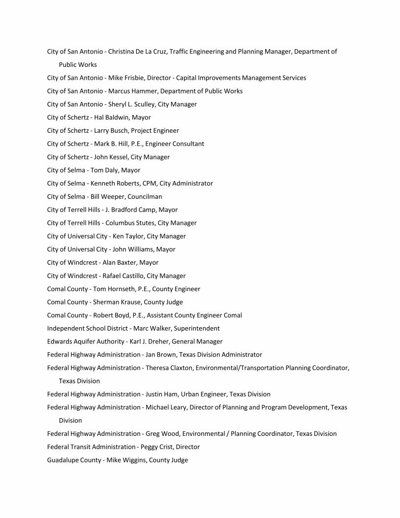
City of San Antonio ‐ Christina De La Cruz, Traffic Engineering and Planning Manager, Department of
Public Works
City of San Antonio ‐ Mike Frisbie, Director ‐ Capital Improvements Management Services
City of San Antonio ‐ Marcus Hammer, Department of Public Works
City of San Antonio ‐ Sheryl L. Sculley, City Manager
City of Schertz ‐ Hal Baldwin, Mayor
City of Schertz ‐ Larry Busch, Project Engineer
City of Schertz ‐ Mark B. Hill, P.E., Engineer Consultant
City of Schertz ‐ John Kessel, City Manager
City of Selma ‐ Tom Daly, Mayor
City of Selma ‐ Kenneth Roberts, CPM, City Administrator
City of Selma ‐ Bill Weeper, Councilman
City of Terrell Hills ‐ J. Bradford Camp, Mayor
City of Terrell Hills ‐ Columbus Stutes, City Manager
City of Universal City ‐ Ken Taylor, City Manager
City of Universal City ‐ John Williams, Mayor
City of Windcrest ‐ Alan Baxter, Mayor
City of Windcrest ‐ Rafael Castillo, City Manager
Comal County ‐ Tom Hornseth, P.E., County Engineer
Comal County ‐ Sherman Krause, County Judge
Comal County ‐ Robert Boyd, P.E., Assistant County Engineer Comal
Independent School District ‐ Marc Walker, Superintendent
Edwards Aquifer Authority ‐ Karl J. Dreher, General Manager
Federal Highway Administration ‐ Jan Brown, Texas Division Administrator
Federal Highway Administration ‐ Theresa Claxton, Environmental/Transportation Planning Coordinator,
Texas Division
Federal Highway Administration ‐ Justin Ham, Urban Engineer, Texas Division
Federal Highway Administration ‐ Michael Leary, Director of Planning and Program Development, Texas
Division
Federal Highway Administration ‐ Greg Wood, Environmental / Planning Coordinator, Texas Division
Federal Transit Administration ‐ Peggy Crist, Director
Guadalupe County ‐ Mike Wiggins, County Judge
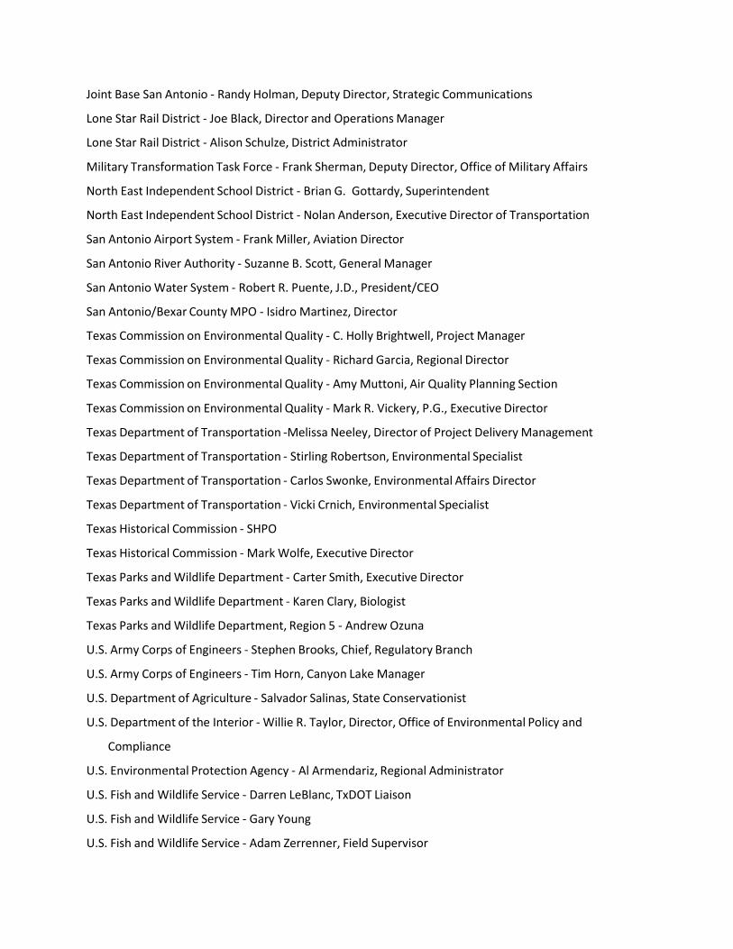
Joint Base San Antonio ‐ Randy Holman, Deputy Director, Strategic Communications
Lone Star Rail District ‐ Joe Black, Director and Operations Manager
Lone Star Rail District ‐ Alison Schulze, District Administrator
Military Transformation Task Force ‐ Frank Sherman, Deputy Director, Office of Military Affairs
North East Independent School District ‐ Brian G. Gottardy, Superintendent
North East Independent School District ‐ Nolan Anderson, Executive Director of Transportation
San Antonio Airport System ‐ Frank Miller, Aviation Director
San Antonio River Authority ‐ Suzanne B. Scott, General Manager
San Antonio Water System ‐ Robert R. Puente, J.D., President/CEO
San Antonio/Bexar County MPO ‐ Isidro Martinez, Director
Texas Commission on Environmental Quality ‐ C. Holly Brightwell, Project Manager
Texas Commission on Environmental Quality ‐ Richard Garcia, Regional Director
Texas Commission on Environmental Quality ‐ Amy Muttoni, Air Quality Planning Section
Texas Commission on Environmental Quality ‐ Mark R. Vickery, P.G., Executive Director
Texas Department of Transportation ‐Melissa Neeley, Director of Project Delivery Management
Texas Department of Transportation ‐ Stirling Robertson, Environmental Specialist
Texas Department of Transportation ‐ Carlos Swonke, Environmental Affairs Director
Texas Department of Transportation ‐ Vicki Crnich, Environmental Specialist
Texas Historical Commission ‐ SHPO
Texas Historical Commission ‐ Mark Wolfe, Executive Director
Texas Parks and Wildlife Department ‐ Carter Smith, Executive Director
Texas Parks and Wildlife Department ‐ Karen Clary, Biologist
Texas Parks and Wildlife Department, Region 5 ‐ Andrew Ozuna
U.S. Army Corps of Engineers ‐ Stephen Brooks, Chief, Regulatory Branch
U.S. Army Corps of Engineers ‐ Tim Horn, Canyon Lake Manager
U.S. Department of Agriculture ‐ Salvador Salinas, State Conservationist
U.S. Department of the Interior ‐ Willie R. Taylor, Director, Office of Environmental Policy and
Compliance
U.S. Environmental Protection Agency ‐ Al Armendariz, Regional Administrator
U.S. Fish and Wildlife Service ‐ Darren LeBlanc, TxDOT Liaison
U.S. Fish and Wildlife Service ‐ Gary Young
U.S. Fish and Wildlife Service ‐ Adam Zerrenner, Field Supervisor

Union Pacific Railroad ‐ Travis Benke, Director of Terminal Operations
Union Pacific Railroad ‐ Joseph A. Garcia, Manager of Industry and Public Projects
U.S. G.S ‐ Loren Wehmeyer, Supervisory Hydrologist
VIA Metropolitan Transit ‐ Christina Castano, Strategic Planner
VIA Metropolitan Transit ‐ Priscilla Ingle, Vice President of Public Affairs
VIA Metropolitan Transit ‐ Keith Parker, President
VIA Metropolitan Transit ‐ Michelle C. Perales, Community Planner
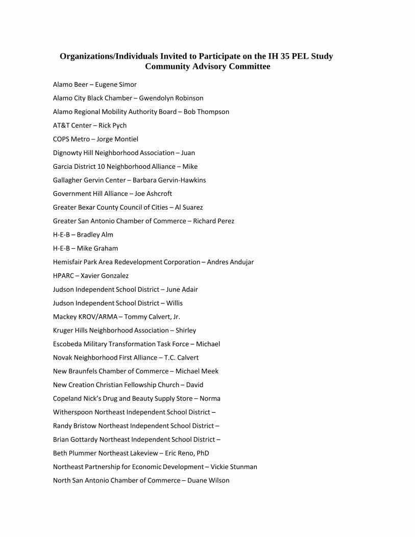
Organizations/Individuals Invited to Participate on the IH 35 PEL Study
Community Advisory Committee
Alamo Beer – Eugene Simor
Alamo City Black Chamber – Gwendolyn Robinson
Alamo Regional Mobility Authority Board – Bob Thompson
AT&T Center – Rick Pych
COPS Metro – Jorge Montiel
Dignowty Hill Neighborhood Association – Juan
Garcia District 10 Neighborhood Alliance – Mike
Gallagher Gervin Center – Barbara Gervin‐Hawkins
Government Hill Alliance – Joe Ashcroft
Greater Bexar County Council of Cities – Al Suarez
Greater San Antonio Chamber of Commerce – Richard Perez
H‐E‐B – Bradley Alm
H‐E‐B – Mike Graham
Hemisfair Park Area Redevelopment Corporation – Andres Andujar
HPARC – Xavier Gonzalez
Judson Independent School District – June Adair
Judson Independent School District – Willis
Mackey KROV/ARMA – Tommy Calvert, Jr.
Kruger Hills Neighborhood Association – Shirley
Escobeda Military Transformation Task Force – Michael
Novak Neighborhood First Alliance – T.C. Calvert
New Braunfels Chamber of Commerce – Michael Meek
New Creation Christian Fellowship Church – David
Copeland Nick’s Drug and Beauty Supply Store – Norma
Witherspoon Northeast Independent School District –
Randy Bristow Northeast Independent School District –
Brian Gottardy Northeast Independent School District –
Beth Plummer Northeast Lakeview – Eric Reno, PhD
Northeast Partnership for Economic Development – Vickie Stunman
North San Antonio Chamber of Commerce – Duane Wilson
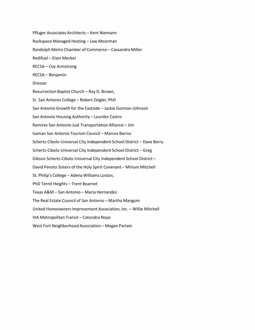
Pfluger Associates Architects – Kent Niemann
Rackspace Managed Hosting – Lew Moorman
Randolph Metro Chamber of Commerce – Cassandra Miller
Redifuel – Elain Meckel
RECSA – Coy Armstrong
RECSA – Benjamin
Dreszer
Resurrection Baptist Church – Ray D. Brown,
Sr. San Antonio College – Robert Zeigler, PhD
San Antonio Growth for the Eastside – Jackie Gorman‐Johnson
San Antonio Housing Authority – Lourdes Castro
Ramirez San Antonio Just Transportation Alliance – Jim
Isaman San Antonio Tourism Council – Marcos Barros
Schertz‐Cibolo‐Universal City Independent School District – Dave Berry
Schertz‐Cibolo‐Universal City Independent School District – Greg
Gibson Schertz‐Cibolo‐Universal City Independent School District –
David Pevoto Sisters of the Holy Spirit Covenant – Mirium Mitchell
St. Philip’s College – Adena Williams Loston,
PhD Terrel Heights – Trent Boarnet
Texas A&M – San Antonio – Maria Hernandez
The Real Estate Council of San Antonio – Martha Mangum
United Homeowners Improvement Association, Inc. – Willie Mitchell
VIA Metropolitan Transit – Catondra Noye
West Fort Neighborhood Association – Megan Partain