Study of urban ventilation corridor planning method based ... · Study of urban ventilation...
6
ICUC9 - 9 th International Conference on Urban Climate jointly with 12 th Symposium on the Urban Environment Study of urban ventilation corridor planning method based on a case study of Guiyang, China Yugang Guan 1 , Hong Chen 2 , Xuefan Zhou 3 1 Huazhong University of Science & Technology, Luoyu Road 1037, Wuhan, China, [email protected] 2 Huazhong University of Science & Technology, Luoyu Road 1037, Wuhan, China, [email protected] 3 Huazhong University of Science & Technology, Luoyu Road 1037, Wuhan, China, [email protected] 1. Introduction In recent years, high temperature and air pollution frequently breaking out in large and medium-sized cities of our country have a strong impact on the urban residents’ living, working and learning environment, reduce the thermal comfort, and even directly threaten people’s health. The reasonable construction of urban Ventilation Corridor can introduce the clean and fresh air from the suburb to the urban area, to make the air between urban area and suburb keep positive cycling, and effectively alleviate urban heat island effect and air pollution. Urban “cross ventilation” formed by reasonable use of “Cold Island” around the city and planning of ventilation aisle can significantly reduce the temperature at the urban center, improve the quality of urban environment, and at the same time achieve the purpose of saving energy. So far, Wuhan [1] , Hong Kong [2] , Changsha [3] , Chongqing [4] , Shenzhen [5] of China have carried out the planning of Ventilation Corridor in succession. Among these cities, Wuhan delimits the different levels of urban Ventilation Corridor by limiting the development intensity of specific areas, and establishes a systemic urban ventilation network with road network as the backbone network. In addition to Wuhan, Chongqing also plans the three-level Ventilation Corridor within the southern new town by using the urban road to help urban ventilation. Hong Kong uses GIS data to calculate the windward area ratio of each direction and find the potential Ventilation Corridor of the city, and plans the corresponding urban Ventilation Corridor on the basis of it. However, our country’s urban planning develops late in the urban ventilation planning research [6] . Internationally, Germany has been keeping the world leading level in the field of urban Ventilation Corridor planning research and practice, and related research theories have been proposed around the early 1980s [7] . Kress divides urban ventilation system into three parts - interaction space, compensation space and air guide channel, and take different planning measures depending on the function of each part. Tokyo, Japan [8] and St. Paulo, Brazil [9] make good use of their geographical location of being near the sea, plan the air duct by keeping perpendicular to the coastline, and improve urban ventilation by introducing sea breeze. In terms of application of technology, foreign planners and researchers also are in a leading position. Gal and Unger [9] plan the urban Ventilation Corridor with high feasibility in Szeged, Hungary by taking 3D building database as the data basis. Mfula et al [10] conduct wind environment simulation of 1:100 street model by wind tunnel experiment, and build urban Ventilation Corridor in the area needing ventilation improvement. Ashie et al [11] simulate the flow field distribution within the area of 5 square kilometers in Tokyo with CFD technology for determining the area needing ventilation improvement. However, the research of above technology means on the urban Ventilation Corridor has a certain limitation. Use of 3D building database or GIS can effectively help find the potential Ventilation Corridor, but the building of urban Ventilation Corridor under the condition of future urban development and forecast on effect have deficiency. Wind tunnel experiment can accurately simulate the wind environment of the blocks, but its limited model scale and high cost make it hard to realize the wind environment simulation on the urban scale. CFD computer simulation technology improves the deficiency of the former two technologies, but because of its complex simulation grid and calculation principle, such technology has bigger dependence on computer performance and computational resources, so it is difficult to deal with the simulation of urban scale with it. Therefore, the research selects the new generation of mesoscale meteorological model WRF – ARW. The model is of mesoscale (1km-100km) meteorology research design, it not only can get more accurate weather simulation data, but also meet urban meteorology research requirement after adding the urban canopy model. It has very strong pertinence to the simulation research of urban Ventilation Corridor needing the investigation on the wind environment and thermal environment on the urban scale (about 50 km), and it is one of the most advanced urban simulation models and is widely used in meteorology, climate and urban problems research [12] . 2. Urban Ventilation Corridor Planning Design Method Liu Shuyu and Shen Jihuang [6] ever put forward the procedures and methods of information collection, climate functional evaluation, guidelines and planning goal setting, definition of measures concept and other planning work through the research and analysis on the case of Ventilation Corridor planning of Stuttgart, Germany. On this basis, the research adds the most advanced analysis and simulation technology during the early and late planning, getting a set of more perfect urban Ventilation Corridor planning design method. The method includes (1) collection of
-
Upload
truonglien -
Category
Documents
-
view
213 -
download
0
Transcript of Study of urban ventilation corridor planning method based ... · Study of urban ventilation...
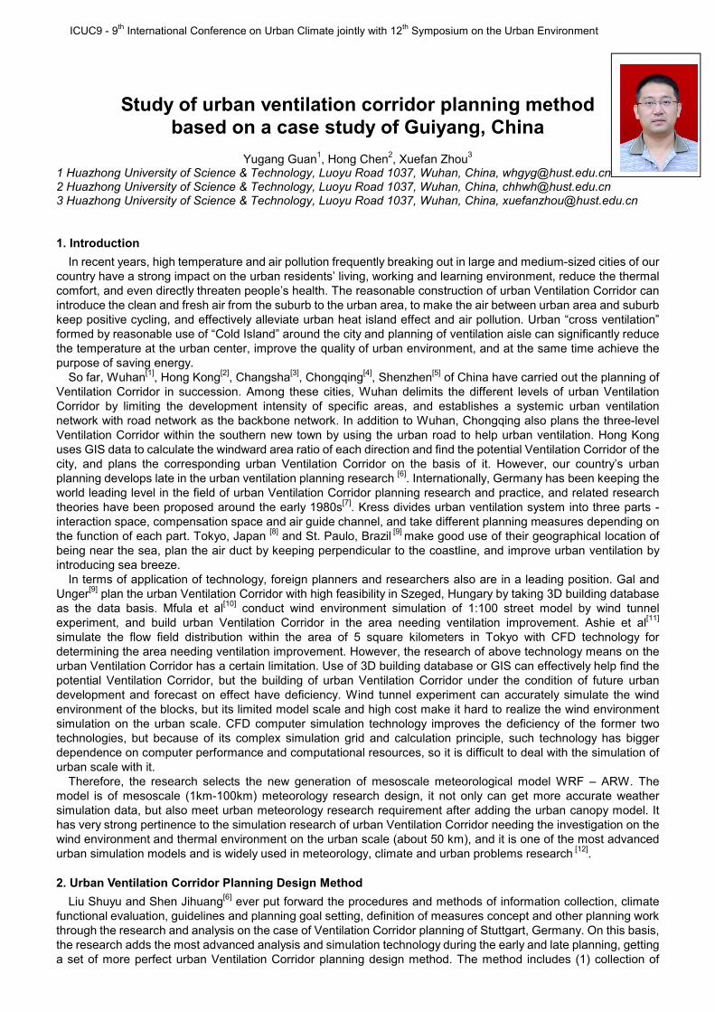
ICUC9 - 9th International Conference on Urban Climate jointly with 12th Symposium on the Urban Environment
Study of urban ventilation corridor planning method based on a case study of Guiyang, China
Yugang Guan
1, Hong Chen
2, Xuefan Zhou
3
1 Huazhong University of Science & Technology, Luoyu Road 1037, Wuhan, China, [email protected] 2 Huazhong University of Science & Technology, Luoyu Road 1037, Wuhan, China, [email protected] 3 Huazhong University of Science & Technology, Luoyu Road 1037, Wuhan, China, [email protected]
1. Introduction
In recent years, high temperature and air pollution frequently breaking out in large and medium-sized cities of our country have a strong impact on the urban residents’ living, working and learning environment, reduce the thermal comfort, and even directly threaten people’s health. The reasonable construction of urban Ventilation Corridor can introduce the clean and fresh air from the suburb to the urban area, to make the air between urban area and suburb keep positive cycling, and effectively alleviate urban heat island effect and air pollution. Urban “cross ventilation” formed by reasonable use of “Cold Island” around the city and planning of ventilation aisle can significantly reduce the temperature at the urban center, improve the quality of urban environment, and at the same time achieve the purpose of saving energy.
So far, Wuhan[1]
, Hong Kong[2]
, Changsha[3]
, Chongqing[4]
, Shenzhen[5]
of China have carried out the planning of Ventilation Corridor in succession. Among these cities, Wuhan delimits the different levels of urban Ventilation Corridor by limiting the development intensity of specific areas, and establishes a systemic urban ventilation network with road network as the backbone network. In addition to Wuhan, Chongqing also plans the three-level Ventilation Corridor within the southern new town by using the urban road to help urban ventilation. Hong Kong uses GIS data to calculate the windward area ratio of each direction and find the potential Ventilation Corridor of the city, and plans the corresponding urban Ventilation Corridor on the basis of it. However, our country’s urban planning develops late in the urban ventilation planning research
[6]. Internationally, Germany has been keeping the
world leading level in the field of urban Ventilation Corridor planning research and practice, and related research theories have been proposed around the early 1980s
[7]. Kress divides urban ventilation system into three parts -
interaction space, compensation space and air guide channel, and take different planning measures depending on the function of each part. Tokyo, Japan
[8] and St. Paulo, Brazil
[9] make good use of their geographical location of
being near the sea, plan the air duct by keeping perpendicular to the coastline, and improve urban ventilation by introducing sea breeze.
In terms of application of technology, foreign planners and researchers also are in a leading position. Gal and Unger
[9] plan the urban Ventilation Corridor with high feasibility in Szeged, Hungary by taking 3D building database
as the data basis. Mfula et al[10]
conduct wind environment simulation of 1:100 street model by wind tunnel experiment, and build urban Ventilation Corridor in the area needing ventilation improvement. Ashie et al
[11]
simulate the flow field distribution within the area of 5 square kilometers in Tokyo with CFD technology for determining the area needing ventilation improvement. However, the research of above technology means on the urban Ventilation Corridor has a certain limitation. Use of 3D building database or GIS can effectively help find the potential Ventilation Corridor, but the building of urban Ventilation Corridor under the condition of future urban development and forecast on effect have deficiency. Wind tunnel experiment can accurately simulate the wind environment of the blocks, but its limited model scale and high cost make it hard to realize the wind environment simulation on the urban scale. CFD computer simulation technology improves the deficiency of the former two technologies, but because of its complex simulation grid and calculation principle, such technology has bigger dependence on computer performance and computational resources, so it is difficult to deal with the simulation of urban scale with it.
Therefore, the research selects the new generation of mesoscale meteorological model WRF – ARW. The model is of mesoscale (1km-100km) meteorology research design, it not only can get more accurate weather simulation data, but also meet urban meteorology research requirement after adding the urban canopy model. It has very strong pertinence to the simulation research of urban Ventilation Corridor needing the investigation on the wind environment and thermal environment on the urban scale (about 50 km), and it is one of the most advanced urban simulation models and is widely used in meteorology, climate and urban problems research
[12].
2. Urban Ventilation Corridor Planning Design Method
Liu Shuyu and Shen Jihuang[6]
ever put forward the procedures and methods of information collection, climate functional evaluation, guidelines and planning goal setting, definition of measures concept and other planning work through the research and analysis on the case of Ventilation Corridor planning of Stuttgart, Germany. On this basis, the research adds the most advanced analysis and simulation technology during the early and late planning, getting a set of more perfect urban Ventilation Corridor planning design method. The method includes (1) collection of
ICUC9 - 9th International Conference on Urban Climate jointly with 12th Symposium on the Urban Environment
basic information on current situation and planning information; (2) wind environment simulation and evaluation of current situation of city; (3) Definition of guidelines and planning goals of urban Ventilation Corridor; (4) proposal of urban Ventilation Corridor planning scheme; (5) simulation and validation of planning scheme; (6) adjustment and implementation of planning scheme.
On the basis of applying the most advanced analysis and simulation technology, the planning design method can more target the analysis on wind environment of current situation of city, find out the area with poor ventilation, and proposes the specific urban Ventilation Corridor planning scheme pertinently. In addition, use of urban scale simulation technology for simulating the planning scheme and evaluating the feasibility of the scheme facilitates the early adjustment and improvement of the scheme, which will greatly improve the ventilation effect of urban Ventilation Corridor.
3. Profile of Guiyang
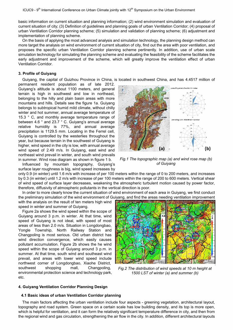
Guiyang, the capital of Guizhou Province in China, is located in southwest China, and has 4.4517 million of permanent resident population as of late 2012. Guiyang’s altitude is about 1100 meters, and general terrain is high in southwest and low in northeast, belonging to the hilly and plain basin areas with more mountains and hills. Details see the figure 1a. Guiyang belongs to subtropical humid mild climate, without chilly winter and hot summer, annual average temperature of 15.3 ° C, and monthly average temperature range of between 4.6 ° and 23.7 ° C. Guiyang’s annual average relative humidity is 77%, and annual average precipitation is 1129.5 mm. Locating in the Ferrel cell, Guiyang is controlled by the westerlies throughout the year, but because terrain in the southwest of Guiyang is higher, wind speed in the city is low, with annual average wind speed of 2.49 m/s. In Guiyang, east wind and northeast wind prevail in winter, and south wind prevails in summer. Wind rose diagram as shown in figure 1 b.
Influenced by mountain topography, Guiyang’s surface layer roughness is big, wind speed increases by only 0.9 (in winter) until 1.6 m/s with increase of per 100 meters within the range of 0 to 200 meters, and increases by 0.3 (in winter) until 1.2 m/s with increase of per 100 meters within the range of 200 to 600 meters. Vertical shear of wind speed of surface layer decreases, weakening the atmospheric turbulent motion caused by power factor, therefore, diffusivity of atmospheric pollutants in the vertical direction is poor.
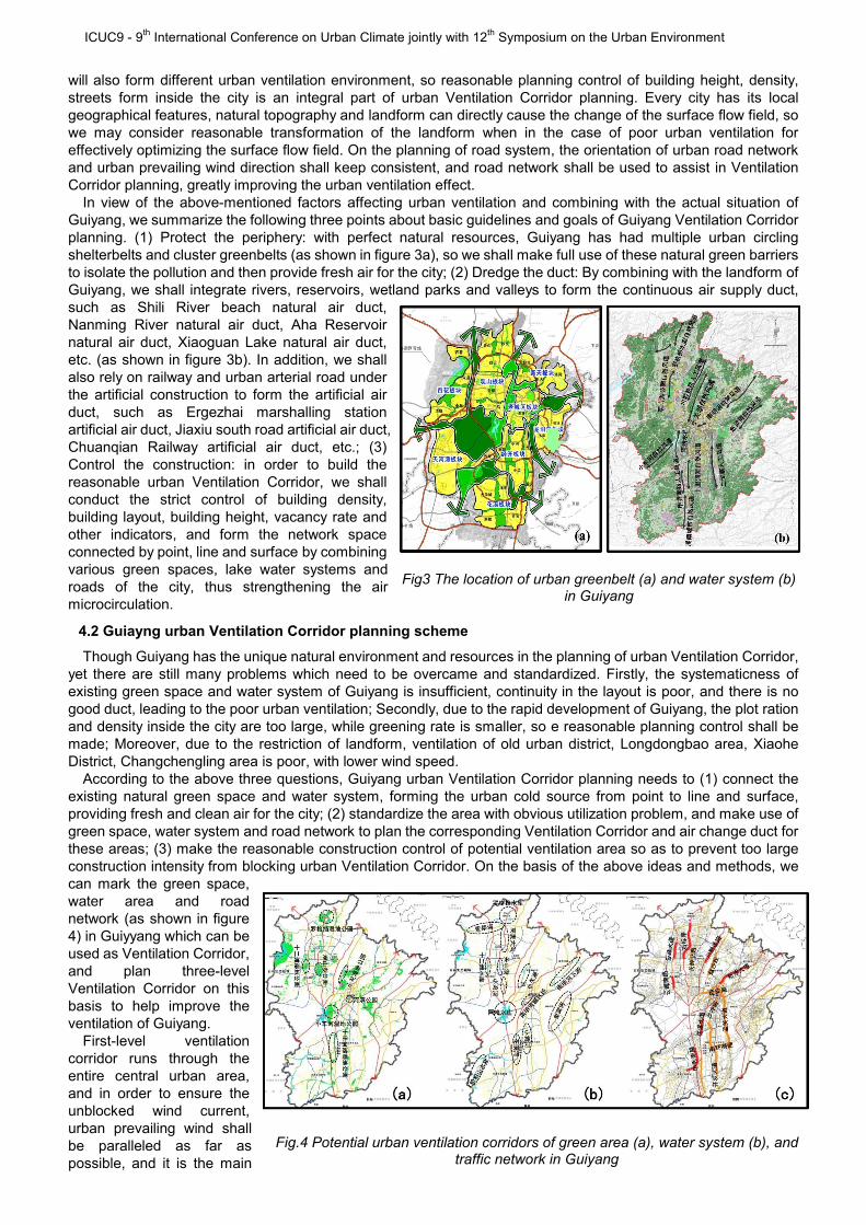
In order to more clearly know the current situation of wind environment of each area in Guiyang, we first conduct the preliminary simulation of the wind environment of Guiyang, and find the areas needing ventilation improvement with the analysis on the result of ten meters high wind speed in winter and summer of Guiyang.
Figure 2a shows the wind speed within the scope of Guiyang around 3 p.m. in winter. At that time, wind speed of Guiyang is not ideal, with speed of most areas of less than 2.0 m/s. Situation in Longdongbao, Yongle Township, North Railway Station and Changpoling is most serious. Old urban district has wind direction convergence, which easily causes pollutant accumulation. Figure 2b shows the he wind speed within the scope of Guiyang around 3 p.m. in summer. At that time, south wind and southeast wind prevail, and areas with lower wind speed include northwest corner of Longdongbao, Xiaohe District, southwest shopping mall, Changpoling, environmental protection science and technology park, etc.
4. Guiyang Ventilation Corridor Planning Design
4.1 Basic ideas of urban Ventilation Corridor planning
The main factors affecting the urban ventilation include four aspects - greening vegetation, architectural layout, topography and road system. Green space on a certain scale has low building density, and its top is more open, which is helpful for ventilation, and it can form the relatively significant temperature difference in city, and then from the regional wind and gas circulation, strengthening the air flow in the city. In addition, different architectural layouts
Fig.1 The topographic map (a) and wind rose map (b) of Guiyang
Fig.2 The distribution of wind speeds at 10 m height at 1500 LST of winter (a) and summer (b)
ICUC9 - 9th International Conference on Urban Climate jointly with 12th Symposium on the Urban Environment
will also form different urban ventilation environment, so reasonable planning control of building height, density, streets form inside the city is an integral part of urban Ventilation Corridor planning. Every city has its local geographical features, natural topography and landform can directly cause the change of the surface flow field, so we may consider reasonable transformation of the landform when in the case of poor urban ventilation for effectively optimizing the surface flow field. On the planning of road system, the orientation of urban road network and urban prevailing wind direction shall keep consistent, and road network shall be used to assist in Ventilation Corridor planning, greatly improving the urban ventilation effect.
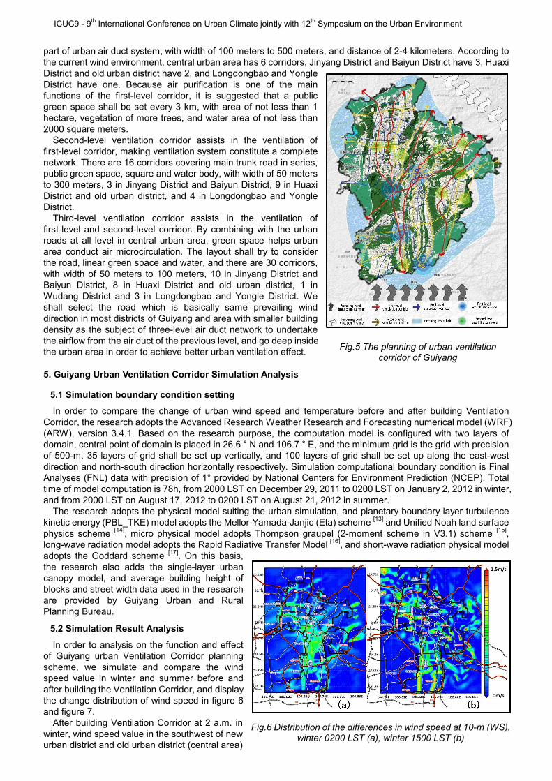
In view of the above-mentioned factors affecting urban ventilation and combining with the actual situation of Guiyang, we summarize the following three points about basic guidelines and goals of Guiyang Ventilation Corridor planning. (1) Protect the periphery: with perfect natural resources, Guiyang has had multiple urban circling shelterbelts and cluster greenbelts (as shown in figure 3a), so we shall make full use of these natural green barriers to isolate the pollution and then provide fresh air for the city; (2) Dredge the duct: By combining with the landform of Guiyang, we shall integrate rivers, reservoirs, wetland parks and valleys to form the continuous air supply duct, such as Shili River beach natural air duct, Nanming River natural air duct, Aha Reservoir natural air duct, Xiaoguan Lake natural air duct, etc. (as shown in figure 3b). In addition, we shall also rely on railway and urban arterial road under the artificial construction to form the artificial air duct, such as Ergezhai marshalling station artificial air duct, Jiaxiu south road artificial air duct, Chuanqian Railway artificial air duct, etc.; (3) Control the construction: in order to build the reasonable urban Ventilation Corridor, we shall conduct the strict control of building density, building layout, building height, vacancy rate and other indicators, and form the network space connected by point, line and surface by combining various green spaces, lake water systems and roads of the city, thus strengthening the air microcirculation.
4.2 Guiayng urban Ventilation Corridor planning scheme
Though Guiyang has the unique natural environment and resources in the planning of urban Ventilation Corridor, yet there are still many problems which need to be overcame and standardized. Firstly, the systematicness of existing green space and water system of Guiyang is insufficient, continuity in the layout is poor, and there is no good duct, leading to the poor urban ventilation; Secondly, due to the rapid development of Guiyang, the plot ration and density inside the city are too large, while greening rate is smaller, so e reasonable planning control shall be made; Moreover, due to the restriction of landform, ventilation of old urban district, Longdongbao area, Xiaohe District, Changchengling area is poor, with lower wind speed.
According to the above three questions, Guiyang urban Ventilation Corridor planning needs to (1) connect the existing natural green space and water system, forming the urban cold source from point to line and surface, providing fresh and clean air for the city; (2) standardize the area with obvious utilization problem, and make use of green space, water system and road network to plan the corresponding Ventilation Corridor and air change duct for these areas; (3) make the reasonable construction control of potential ventilation area so as to prevent too large construction intensity from blocking urban Ventilation Corridor. On the basis of the above ideas and methods, we can mark the green space, water area and road network (as shown in figure 4) in Guiyyang which can be used as Ventilation Corridor, and plan three-level Ventilation Corridor on this basis to help improve the ventilation of Guiyang.
First-level ventilation corridor runs through the entire central urban area, and in order to ensure the unblocked wind current, urban prevailing wind shall be paralleled as far as possible, and it is the main
Fig3 The location of urban greenbelt (a) and water system (b) in Guiyang
Fig.4 Potential urban ventilation corridors of green area (a), water system (b), and traffic network in Guiyang
ICUC9 - 9th International Conference on Urban Climate jointly with 12th Symposium on the Urban Environment
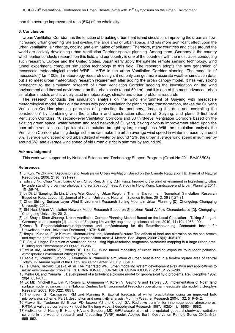
part of urban air duct system, with width of 100 meters to 500 meters, and distance of 2-4 kilometers. According to the current wind environment, central urban area has 6 corridors, Jinyang District and Baiyun District have 3, Huaxi District and old urban district have 2, and Longdongbao and Yongle District have one. Because air purification is one of the main functions of the first-level corridor, it is suggested that a public green space shall be set every 3 km, with area of not less than 1 hectare, vegetation of more trees, and water area of not less than 2000 square meters.
Second-level ventilation corridor assists in the ventilation of first-level corridor, making ventilation system constitute a complete network. There are 16 corridors covering main trunk road in series, public green space, square and water body, with width of 50 meters to 300 meters, 3 in Jinyang District and Baiyun District, 9 in Huaxi District and old urban district, and 4 in Longdongbao and Yongle District.
Third-level ventilation corridor assists in the ventilation of first-level and second-level corridor. By combining with the urban roads at all level in central urban area, green space helps urban area conduct air microcirculation. The layout shall try to consider the road, linear green space and water, and there are 30 corridors, with width of 50 meters to 100 meters, 10 in Jinyang District and Baiyun District, 8 in Huaxi District and old urban district, 1 in Wudang District and 3 in Longdongbao and Yongle District. We shall select the road which is basically same prevailing wind direction in most districts of Guiyang and area with smaller building density as the subject of three-level air duct network to undertake the airflow from the air duct of the previous level, and go deep inside the urban area in order to achieve better urban ventilation effect.
5. Guiyang Urban Ventilation Corridor Simulation Analysis
5.1 Simulation boundary condition setting
In order to compare the change of urban wind speed and temperature before and after building Ventilation Corridor, the research adopts the Advanced Research Weather Research and Forecasting numerical model (WRF) (ARW), version 3.4.1. Based on the research purpose, the computation model is configured with two layers of domain, central point of domain is placed in 26.6 ° N and 106.7 ° E, and the minimum grid is the grid with precision of 500-m. 35 layers of grid shall be set up vertically, and 100 layers of grid shall be set up along the east-west direction and north-south direction horizontally respectively. Simulation computational boundary condition is Final Analyses (FNL) data with precision of 1° provided by National Centers for Environment Prediction (NCEP). Total time of model computation is 78h, from 2000 LST on December 29, 2011 to 0200 LST on January 2, 2012 in winter, and from 2000 LST on August 17, 2012 to 0200 LST on August 21, 2012 in summer.
The research adopts the physical model suiting the urban simulation, and planetary boundary layer turbulence kinetic energy (PBL_TKE) model adopts the Mellor-Yamada-Janjic (Eta) scheme
[13] and Unified Noah land surface
physics scheme [14]
, micro physical model adopts Thompson graupel (2-moment scheme in V3.1) scheme [15]
, long-wave radiation model adopts the Rapid Radiative Transfer Model
[16], and short-wave radiation physical model
adopts the Goddard scheme [17]
. On this basis, the research also adds the single-layer urban canopy model, and average building height of blocks and street width data used in the research are provided by Guiyang Urban and Rural Planning Bureau.
5.2 Simulation Result Analysis
In order to analysis on the function and effect of Guiyang urban Ventilation Corridor planning scheme, we simulate and compare the wind speed value in winter and summer before and after building the Ventilation Corridor, and display the change distribution of wind speed in figure 6 and figure 7.
After building Ventilation Corridor at 2 a.m. in winter, wind speed value in the southwest of new urban district and old urban district (central area)
Fig.5 The planning of urban ventilation corridor of Guiyang
Fig.6 Distribution of the differences in wind speed at 10-m (WS), winter 0200 LST (a), winter 1500 LST (b)

ICUC9 - 9th International Conference on Urban Climate jointly with 12th Symposium on the Urban Environment
has obvious increase, up to 1 m/s to 1.5 m/s. At this moment, Ventilation Corridor along east-west direction has obvious effect. After building Ventilation Corridor at 3 p.m. in winter, three first-level Ventilation Corridors along north-south direction in the south of Guiyang have the most obvious effect. The common effect of these Ventilation Corridors is making the wind speed of old urban district of Guiyang increase by more than 1.5 m/s. Ventilation Corridor helps solve the problem in the previous case that wind speed in the south of old urban district is too low, removes the dead corner of urban ventilation, and relieves the problem of pollutant accumulation in the city.
After building the north-south Ventilation Corridor, wind speed is gradually increasing along the north-south first-level air duct in the south of Guiyang at 2 a.m. in summer. Obvious increase of wind speed shows that Ventilation Corridor can introduce the airflow from the suburb to the old urban district (central area). According to the result around 3 p.m. in summer, crisscross synergism of east-west and north-south Ventilation Corridors breaks the static and stable atmospheric conditions, keeping the more disorder wind speed growth trend. Wind speed value in central area of old urban district of Guiyang has obvious increase, up to 1.5 m/s.
Table 1 Wind Speed at 10 meter height of Guiyang
Improvement of wind speed (m/s) Maximum
wind speed difference (m/s)
Minimum wind speed difference
(m/s)
Average wind speed difference
(m/s)
Improvement percentage of wind
speed (%) Average of whole city 0.30 0.001 0.16 8
Winter Old urban district 0.43 0.003 0.12 12
Average of whole city 0.44 0.0007 0.18 6 Summer
Old urban district 0.87 0.0009 0.26 9 It can be seen from the daily change rule of wind speed in winter in figure 8a that the improving effect of urban
ventilation upon the urban wind environment mainly occurs before sunrise and after sunset, but is not obvious at noon. Therefore, urban residents don’t worry too big wind speed will cause discomfort in the main time periods of taking outdoor activities. At night, the wind will gradually increase, and accumulated air pollutant will disperse in order to prevent the siltation of heat-island circulation in the city from forming the vicious circle
It can be seen from the comparison that the improvement effect of Guiyang urban Ventilation Corridor upon the old urban district’s wind environment is more obvious than that upon most area of the whole city. It can be seen from table 1 that the improvement proportion of average wind speed in the old urban district is as high as 12%, higher than the average improvement ratio (8%) of the whole city. Figure 8b
shows the change of average wind speed before and after building Ventilation Corridor in summer. Compared to orderly daily change of wind speed in winter (as shown in figure 8a), change in summer is more disorderly. The obvious effect of building Ventilation Corridor upon improving the ventilation only occurs from 10 a.m. to 5 p.m., and the effect of Ventilation Corridor increasing wind speed at summer night is not so obvious as that at winter night. Therefore, urban Ventilation Corridor may not be able to give full play to its role of eliminating pollutants and cleaning air at summer night, but in the day, due to the effect of Ventilation Corridor, the wind speed has the obvious increase, which plays a more active role in cooling the city.
Similar to the result of case in winter, it can be seen from the comparison that the improvement effect of Guiyang urban Ventilation Corridor upon the old urban district’s wind environment is more obvious than that upon most area of the whole city, and improvement proportion of average wind speed in old urban district is as high as 9%, higher
Fig.7 Distribution of the differences in wind speed at 10-m (WS), summer 0200 LST (a), summer 1500 LST (b)
Fig.8 Diurnal wind speed at 10-m (WS) for winter (a) and summer (b)
ICUC9 - 9th International Conference on Urban Climate jointly with 12th Symposium on the Urban Environment
than the average improvement ratio (6%) of the whole city.
6. Conclusion
Urban Ventilation Corridor has the function of breaking urban heat island circulation, improving the urban air flow, increasing urban greening rate and dividing the large area of urban space, and has more significant effect upon the urban ventilation, air change, cooling and elimination of pollutant. Therefore, many countries and cities around the world are actively developing urban Ventilation Corridor special planning. Among them, Germany is the country which earlier conducts research on this field, and our country is one of the countries with the most cities conducting such research. Europe and the United States, Japan early apply the satellite remote sensing technology, wind tunnel experiment, computer simulation technology to this field. The research adopts the new generation of mesoscale meteorological model WRF – ARW in the urban Ventilation Corridor planning. The model is of mesoscale (1km-100km) meteorology research design, it not only can get more accurate weather simulation data, but also meet urban meteorology research requirement after adding the urban canopy model. It has very strong pertinence to the simulation research of urban Ventilation Corridor needing the investigation on the wind environment and thermal environment on the urban scale (about 50 km), and it is one of the most advanced urban simulation models and is widely used in meteorology, climate and urban problems research.
The research conducts the simulation analysis on the wind environment of Guiyang with mesoscale meteorological model, finds out the areas with poor ventilation for planning and transformation, makes the Guiyang Ventilation Corridor planning principles of “protecting the periphery, dredging the duct and controlling the construction” by combining with the landform and construction situation of Guiyang, and plans 6 first-level Ventilation Corridors, 16 second-level Ventilation Corridors and 30 third-level Ventilation Corridors based on the existing green space, water system and road network of Guiyang, having obvious improvement effect upon the poor urban ventilation and pollutant accumulation brought by larger roughness. With the simulation analysis, the Ventilation Corridor planning design scheme can make the urban average wind speed in winter increase by around 8%, average wind speed of old urban district in winter by around 12%, the urban average wind speed in summer by around 6%, and average wind speed of old urban district in summer by around 9%.
Acknowledgment
This work was supported by National Science and Technology Support Program (Grant No.2011BAJ03B03).
References
[1] Li Kun, Yu Zhuang. Discussion and Analysis on Urban Ventilation Based on the Climate Regulation [J]. Journal of Natural Resources, 2006, 21 (6): 991-997.
[2] Edward Ng, Chao Yuan, Liang Chen, Chao Ren, Jimmy C.H. Fung. Improving the wind environment in high-density cities by understanding urban morphology and surface roughness: A study in Hong Kong. Landscape and Urban Planning 2011; 101:59-74.
[3] Le Di, Li Nianping, Su Lin, Li Jing, Wei Xiaoqing. Urban Regional Thermal Environment Numerical Simulation Research Based on Road Layout [J]. Journal of Hunan University: Natural Science Edition, 2012, 39 (1):27-31.
[4] Chen Shiling. Surface Layer Wind Environment Research Suiting Mountain Urban Planning [D]. Chongqing: Chongqing University, 2012.
[5] Shi Hua. Urban Ventilation Network Model Research Based on Shenzhen Road Airflow Characteristics [D]. Chongqing: Chongqing University, 2012.
[6] Liu Shuyu, Shen Jihuang. Urban Ventilation Corridor Planning Method Based on the Local Circulation – Taking Stuttgart, Germany as an example [J]. Journal of Zhejiang University: engineering science edition, 2010, 44 (10): 1985-1991.
[7]Kress R. Regionaleluftaustauschprozesse und ihreBedeutung fur die Raumlicheplanung. Dortmund: Institut fur Umweltschutz der Universitat Dortmund, 1979:15-55.
[8]Hiroyuki Kusaka, Fujio Kimura, HiromaruHirakuchi, MasafumiMizutori: The effects of land-use alteration on the sea breeze and daytime heat island in the Tokyo metropolitan area: J. Meteor. Soc. Japan, 2000: 78(4): 405-420.
[9]T. Gal, J. Unger. Detection of ventilation paths using high-resolution roughness parameter mapping in a large urban area. Building and Environment 2009;44:198-206
[10]Mfula AM, Kukadia V, Griffiths RF, Hall DJ. Wind tunnel modelling of urban building exposure to outdoor pollution. Atmospheric Environment 2005;39 (15):2737e45.
[11]Ashie Y, Tokairin T, Kono T, Takahashi K. Numerical simulation of urban heat island in a ten-km square area of central Tokyo. In: Annual report of the Earth Simulator Center; 2007. p. 83e87.
[12]Fei Chen, Hiroyuki Kusaka, et. al. The integrated WRF urban modeling system development evaluation and applications to urban environmental problems. INTERNATIONAL JOURNAL OF CLIMATOLOGY. 2011,31:273-288.
[13]Mellor GL and Yamada T. Development of a turbulence closure model for geophysical fluid problems. Rev Geophys 1982; 20(4):851–875.
[14]Ek MB, Mitchell KE, Lin Y, Rogers E, Grunmann P, Koren V, Gayno G and Tarpley JD. Implementation of Noah land surface model advances in the National Centers for Environmental Prediction operational mesoscale Eta model. J Geophys Research 2003; 108(D22): 8851.
[15]Thompson G, Rasmussen RM and Manning K. Explicit forecasts of winter precipitation using an improved bulk microphysics scheme. Part I: description and sensitivity analysis. Monthly Weather Research 2004; 132: 519–542.
[16]Mlawer EJ, Taubman SJ, Brown PD, Iacono MJ and Clough SA. Radiative transfer for inhomogeneous atmospheres: RRTM, a validated correlated-k model for the long wave. J Geophysical Research 1997; 102(D14): 16663–16682.
[17]Mielikainen J, Huang B, Huang HA and Goldberg MD. GPU acceleration of the updated goddard shortwave radiation scheme in the weather research and forecasting (WRF) model. Applied Earth Observation Remote Sense 2012; 5(2): 555–562.