STUDY AREA C LINDA VISTA PARK THROUGH … · trail alignment - study area c page 62 pre-print final...
29
T RAIL A LIGNMENT - S TUDY A REA C P AGE 62 P RE -P RINT F INAL S TEVENS C REEK T RAIL F EASIBILITY R EPORT STUDY AREA C LINDA VISTA PARK THROUGH MCCLELLAN RANCH TO BLACKBERRY FARM LOCATION, LAND USE AND OWNERSHIP Study Area C includes Linda Vista Park, McClellan Ranch, the Simms property, an abandoned haul road, a floodplain parcel, a well site and a crossing at McClellan Road. The 11-acre Linda Vista Park, 15.6-acre McClellan Ranch and 3.1-acre Simms property are owned and operated by the City of Cupertino. A private school, Canyon Heights Academy, which is proposed on the 131-acre closed quarry in Study Area B also owns the 40 foot abandoned haul road that extends from Linda Vista Park to McClellan Road. It is anticipated that a land dedication for park and open space purposes will be a component of any private development project proposed on the closed quarry site and that the haul road would be a component of any dedication. A trail route across these sites is identified in the 1993 City of Cupertino General Plan and the 1995 Santa Clara Countywide Trails Master Plan Update. The 2.55-acre floodplain parcel is owned by Santa Clara Valley Water District and has been leased to the City of Cupertino since 1974. The lease is for the purpose of providing beautification and recreational amenities to residents. The lease expires in 2024. The San Jose Water Company operates the well site, which lies directly adjacent to this leased parcel. McClellan Road is a city facility. Study Area C is bordered by Blackberry Farm to the north, Linda Vista neighborhood to the east, Deep Cliff Golf Course and Scenic Circle neighborhood to the west and Linda Vista Park to the south. Trails through Study Area C will connect Cupertino park and open space resources to neighborhoods and provide an off-street location for recreational bicycling, walking and jogging. CULTURAL HISTORY The Linda Vista Park site was purchased by the City of Cupertino in 1969. The 11-acre site was originally a part of the McDonald-Dorsa quarry. The park was dedicated in 1970 and was one of the first parks developed in Cupertino. The old haul road that connected the quarry to McClellan Road was retained as a part of the 131-acre quarry. In 1999, the quarry site was
Transcript of STUDY AREA C LINDA VISTA PARK THROUGH … · trail alignment - study area c page 62 pre-print final...

TRAIL ALIGNMENT - STUDY AREA C
P A G E 6 2 P R E - P R I N T F I N A L S T E V E N S C R E E K T R A I L F E A S I B I L I T Y R E P O R T
STUDY AREA C LINDA VISTA PARK THROUGH MCCLELLAN RANCH TO BLACKBERRY FARM LOCATION, LAND USE AND OWNERSHIP Study Area C includes Linda Vista Park, McClellan Ranch, the Simms property, an abandoned haul road, a floodplain parcel, a well site and a crossing at McClellan Road. The 11-acre Linda Vista Park, 15.6-acre McClellan Ranch and 3.1-acre Simms property are owned and operated by the City of Cupertino. A private school, Canyon Heights Academy, which is proposed on the 131-acre closed quarry in Study Area B also owns the 40 foot abandoned haul road that extends from Linda Vista Park to McClellan Road. It is anticipated that a land dedication for park and open space purposes will be a component of any private development project proposed on the closed quarry site and that the haul road would be a component of any dedication. A trail route across these sites is identified in the 1993 City of Cupertino General Plan and the 1995 Santa Clara Countywide Trails Master Plan Update. The 2.55-acre floodplain parcel is owned by Santa Clara Valley Water District and has been leased to the City of Cupertino since 1974. The lease is for the purpose of providing beautification and recreational amenities to residents. The lease expires in 2024. The San Jose Water Company operates the well site, which lies directly adjacent to this leased parcel. McClellan Road is a city facility. Study Area C is bordered by Blackberry Farm to the north, Linda Vista neighborhood to the east, Deep Cliff Golf Course and Scenic Circle neighborhood to the west and Linda Vista Park to the south. Trails through Study Area C will connect Cupertino park and open space resources to neighborhoods and provide an off-street location for recreational bicycling, walking and jogging. CULTURAL HISTORY The Linda Vista Park site was purchased by the City of Cupertino in 1969. The 11-acre site was originally a part of the McDonald-Dorsa quarry. The park was dedicated in 1970 and was one of the first parks developed in Cupertino. The old haul road that connected the quarry to McClellan Road was retained as a part of the 131-acre quarry. In 1999, the quarry site was
TRAIL ALIGNMENT - STUDY AREA C
P R E - P R I N T F I N A L S T E V E N S C R E E K T R A I L F E A S I B I L I T Y R E P O R T P A G E 6 3
bought for the purposes of developing a private school, Canyon Heights Academy. The old haul road transferred title to Canyon Heights Academy during this transaction. The City of Cupertino purchased McClellan Ranch in 1972. Additional acreage was added to the park through subsequent purchases. William Taylor McClellan purchased the property in the late 1850s. Several historic buildings have been moved to McClellan Ranch. CREEK CHARACTER, PLANT COMMUNITIES AND ANIMAL LIFE Study Area C includes Deep Cliff Golf Course, McClellan Ranch and Linda Vista Park. Suburban development abuts this Study Area on east and west sides. Five habitat types occur in the area: in-stream habitat, sycamore-oak riparian vegetation, open grassland, golf course/park lands and suburban development (See Map 4 - Study Area Habitat Map). Rare, sensitive or listed species potentially existing in the area include steelhead trout, red-legged frog, western pond turtle and birds of prey. Stevens Creek flows through this Study Area. The in-stream habitat of Stevens Creek is known to support adult and juvenile steelhead trout along its entire length from the reservoir in Stevens Creek County Park to Shoreline Park in Mountain View, where the creek meets San Francisco Bay. Steelhead are listed as threatened under the federal Endangered Species Act and are under the jurisdiction of the National Marine Fisheries Service. This anadromous form of rainbow trout lives in streams for some of their life cycle and in the ocean for the rest. Since 1937, water has been impounded in a reservoir at the head of Stevens Creek, resulting in only winter and spring flows. Stevens Creek was allowed to go dry each summer. As a result, the entire creek was used only for migration and rearing habitat was eliminated from the lower reaches. Recently, the Santa Clara Valley Water District, which manages flows in the creek, has allowed year round flows (Padley pers. comm. 1999). This new policy was initiated in 1998, and in September of that year, first and second year age class steelhead were observed in Stevens Creek in Mountain View (G. Seeds, pers. comm. 1998). The Fisheries and Aquatic Habitat Collaborative Effort (FACHE) was initiated to research the habitat needs of steelhead, collect information on the effects of different water release policies in Santa Clara County streams, and provide recommendations for managing in-stream habitats for steelhead populations given the constraints of this urban setting. Research shows that

TRAIL ALIGNMENT - STUDY AREA C
P A G E 6 4 P R E - P R I N T F I N A L S T E V E N S C R E E K T R A I L F E A S I B I L I T Y R E P O R T
Stevens Creek is a viable spawning habitat for adults and summer rearing habitat for juveniles if managed properly. Adult steelhead are limited in their distribution by in-stream fish barriers that impede their upstream movement in Stevens Creek. The survival of juvenile steelhead seems to be most limited by high in-stream water temperatures, which are not tolerated by young fish. Protecting this valuable steelhead habitat is a high priority. The in-stream habitat of Stevens Creek is also potential red-legged frog and western pond turtle habitat. The Red-legged frog is listed as threatened under the federal Endangered Species Act and are under the jurisdiction of the US Fish and Wildlife Service. The western pond turtle is a California Species of Special Concern. Western pond turtles are found in ponds, marshes, rivers, streams and irrigation ditches containing aquatic vegetation. They are usually seen sunning on logs, banks or rocks near banks. Individuals move up to three or four miles within a creek system, especially during “walk-abouts” before a female lays eggs. Eggs are laid in nest burrows that can be up to several hundred feet away from river or pond banks in woodlands, grasslands, and open forest. Eggs are laid from April-August; time varies with locality. Suitable riverine habitat for western pond turtles occurs within the project area as Stevens Creek contains escape cover such as deep pools, undercut banks, overhanging vegetation and in-stream tree roots. There appears to be suitable grassy, upland nesting habitat adjacent to Stevens Creek at the Simms Property, McClellan Ranch and the open grassland parcel just north of McClellan Ranch. The open grassland at McClellan Ranch also provides foraging habitat for a wide variety of bird species, including birds of prey. Deer, coyote, and bobcat have all been observed here (C. Breon, pers. comm.; pers. observ.). Sycamore and coast live oaks dominate the riparian vegetation along most of this stretch of the creek. The Santa Clara Valley Audubon Society’s McClellan Ranch Checklist of Birds notes over 106 species of birds found in the riparian corridor and grasslands of the ranch. Riparian cover is especially good through McClellan Ranch to Blackberry Farm where the understory includes coyote bush, box elder and native blackberry. Non-native invasive species here include periwinkle, German ivy and tree of heaven. The stream is well shaded through this section and the in-stream habitat, which includes riffles, pools and exposed gravel, appears to provide high quality fish habitat. The riparian corridor and in-stream habitats through Deep Cliff Golf Course were not evaluated because this area is not part of a potential trail alignment. POINTS OF INTEREST
TRAIL ALIGNMENT - STUDY AREA C
P R E - P R I N T F I N A L S T E V E N S C R E E K T R A I L F E A S I B I L I T Y R E P O R T P A G E 6 5
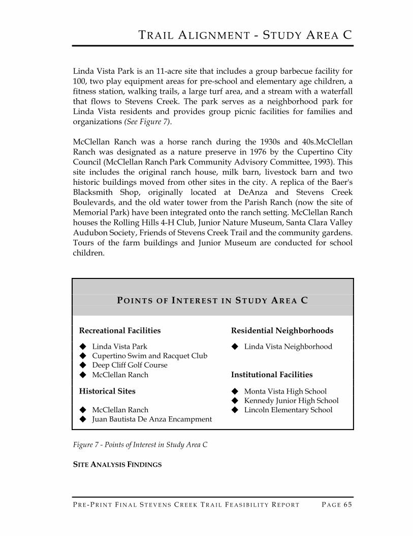
Linda Vista Park is an 11-acre site that includes a group barbecue facility for 100, two play equipment areas for pre-school and elementary age children, a fitness station, walking trails, a large turf area, and a stream with a waterfall that flows to Stevens Creek. The park serves as a neighborhood park for Linda Vista residents and provides group picnic facilities for families and organizations (See Figure 7). McClellan Ranch was a horse ranch during the 1930s and 40s.McClellan Ranch was designated as a nature preserve in 1976 by the Cupertino City Council (McClellan Ranch Park Community Advisory Committee, 1993). This site includes the original ranch house, milk barn, livestock barn and two historic buildings moved from other sites in the city. A replica of the Baer's Blacksmith Shop, originally located at DeAnza and Stevens Creek Boulevards, and the old water tower from the Parish Ranch (now the site of Memorial Park) have been integrated onto the ranch setting. McClellan Ranch houses the Rolling Hills 4-H Club, Junior Nature Museum, Santa Clara Valley Audubon Society, Friends of Stevens Creek Trail and the community gardens. Tours of the farm buildings and Junior Museum are conducted for school children.
PO I N T S O F IN T E R E S T I N ST U D Y AR E A C
Recreational Facilities Residential Neighborhoods ◆ Linda Vista Park ◆ Linda Vista Neighborhood ◆ Cupertino Swim and Racquet Club ◆ Deep Cliff Golf Course ◆ McClellan Ranch Institutional Facilities
Historical Sites ◆ Monta Vista High School ◆ Kennedy Junior High School ◆ McClellan Ranch ◆ Lincoln Elementary School ◆ Juan Bautista De Anza Encampment
Figure 7 - Points of Interest in Study Area C SITE ANALYSIS FINDINGS
TRAIL ALIGNMENT - STUDY AREA C
P A G E 6 6 P R E - P R I N T F I N A L S T E V E N S C R E E K T R A I L F E A S I B I L I T Y R E P O R T
More than 35 acres of public open space are available for trail development in Study Area C. The old haul road provides a link between Linda Vista Park and McClellan Ranch. However, there are three key challenges to trail design in Study Area C. The challenges include land ownership, neighborhood privacy and security and the crossing at McClellan Road. The old haul road is privately owned by Canyon Heights Academy. Trail access through the property will likely be a condition of any future development of the property. However, even with access through the old haul road the site poses neighborhood privacy and security challenges to trail development. The old haul road extends behind the backyards of homes located on Linda Vista Drive, Baxley Court, Evulich Court and Rae Lane. The abandoned road is depressed beneath the grade of these backyards. A number of design features are proposed with the trail alignment to enhance the security and privacy in this neighborhood. Stevens Creek flows beneath McClellan Road between the old haul road and Deep Cliff Golf Course. The roadway bridge is low and flooding occurs during significant storm events. Floodwaters backup over Deep Cliff Golf Course and McClellan Road. After passing beneath the road, Stevens Creek flows between the Simms property and McClellan Ranch. These sites are also located in the natural floodplain of the creek and flood during substantial storm events. The low height of the bridge poses a challenge to developing a grade-separated trail crossing that would allow pedestrians and bicyclists to pass beneath the roadway separate from automobile traffic. Any changes to the roadway will require numerous permits from the regulatory agencies that have jurisdiction over sensitive species (steelhead, red-legged frog and western pond turtle), waterways and wetlands, and water quality. TRAIL ALIGNMENT A trail connecting Linda Vista Park to Blackberry Farm is proposed along the old haul road and through Linda Vista Park and McClellan Ranch in Study Area C. Design concepts for the trail through Linda Vista Park and along the old haul road are detailed in this report. The route is proposed as multi-use, all weather trail open to bicyclists, walkers, joggers, strollers and in-line skaters. The trail is proposed as a 10-foot wide path with 2 1/2-foot gravel shoulders. The trail surfacing could take several forms including asphalt paving, concrete, a pine resin mixed with native soil (recently approved by US Army Corps), wood or recycled materials for the boardwalk sections or other all weather material to be specified during the development of construction drawings. The multi-use trail will support a wide variety of

TRAIL ALIGNMENT - STUDY AREA C
P R E - P R I N T F I N A L S T E V E N S C R E E K T R A I L F E A S I B I L I T Y R E P O R T P A G E 6 7
recreational activities. The all weather surface has the lowest long-term maintenance costs (See Map 7 - Study Area C Trail Alignment - Linda Vista Park through McClellan Ranch to Blackberry Farm). Approximately 1.00 miles of multi-use trail is proposed within Study Area C. Study Area C also includes a trail crossing at McClellan Road. Two alternatives are retained for future consideration. The option, preferred almost unanimously by Linda Vista residents, is a grade-separated crossing created through the construction of an off stream tunnel or complete reconstruction of the McClellan Road bridge. Any changes to the roadway will require numerous permits from the regulatory agencies that have jurisdiction over sensitive species (steelhead, red-legged frog and western pond turtle), waterways and wetlands, and water quality. The alternative option is a crosswalk with pedestrian activated, lighted pavement markings and warning lights in either direction on McClellan Road (See Map 7 - Study Area C Trail Alignment - Linda Vista Park through McClellan Ranch to Blackberry Farm). WALKING AND BICYCLING TRAIL The neighborhood parks and open space preserves along Stevens Creek are isolated from each other and from nearby neighborhoods. One of the goals within Study Area C is to provide a non-motorized route that links neighborhoods to existing recreational facilities, community services and schools. The Stevens Creek Trail will give residents the opportunity to walk and bicycle to Deep Cliff Golf Course, McClellan Ranch, Blackberry Farm and

TRAIL ALIGNMENT - STUDY AREA C
P A G E 6 8 P R E - P R I N T F I N A L S T E V E N S C R E E K T R A I L F E A S I B I L I T Y R E P O R T
See Map 7 - Study Area C Trail Alignment Map

TRAIL ALIGNMENT - STUDY AREA C
P R E - P R I N T F I N A L S T E V E N S C R E E K T R A I L F E A S I B I L I T Y R E P O R T P A G E 6 9
TRAIL ALIGNMENT - STUDY AREA C
P A G E 7 0 P R E - P R I N T F I N A L S T E V E N S C R E E K T R A I L F E A S I B I L I T Y R E P O R T
Golf Course, newly acquired open spaces, nearby schools and colleges, and bus stops. The trail will offer an informal setting for meeting and greeting neighbors who live along the Stevens Creek corridor. Study Area C begins in Linda Vista Park. The trail alignment in Linda Vista Park is approximately 0.25 miles and generally follows the perimeter of the park, but excludes the lower picnic area and stream that is adjacent to Deep Cliff Golf Course. The trail does share the existing park path adjacent to Deep Cliff Golf Course from the haul road to just opposite the par course area. The intersection of the old haul road with Linda Vista Park (area near the old telephone booth) will be closed and vegetated with native trees and shrubs (See Map 8 - Study Area C - Linda Vista Park Trail Alignment). A new 200-foot section of trail is proposed to connect this shared path with the upper park path located behind the par course. This section of trail will be built as an elevated trestle to extend through the trees below the par course (See Map 8 - Study Area C - Linda Vista Park Trail Alignment - Section 'A' - Adjacent to Par Course). The trestle is used to meet accessibility guidelines. The trestle will meet the grade of the existing upper park trail. This existing, short section of trail does not currently meet accessibility guidelines. Overlooks will be installed along the trail to provide resting spots for trail users. These overlooks will bring this stretch of trail from the par course to the picnic area (picnic benches in gravel) into compliance with the Accessibility Guidelines for Outdoor Developed Areas (U.S. Architectural and Transportation Barriers Compliance Board, 1999). From trail intersection nearest the picnic area a new section of trail is proposed to extend above and behind the playground. This stretch of trail will begin to climb the hillside to reach the ravine trail proposed on the Canyon Heights Academy property. Boulder gravity and low wooden retaining walls will be used to secure the trail in this erosion prone area (See Map 8 - Study Area C - Linda Vista Park Trail Alignment - Sections 'B' - Adjacent to Play Area and Section 'C' - New Trail in Slope). A vegetated buffer will be planted between the trail and the playground (See Map 8 - Study Area C - Linda Vista Park Trail Alignment - Section 'B' - Adjacent to Play Area). A short stretch of trail is also proposed from the ravine to the entrance of Linda Vista Park. This trail will provide a direct connection to Linda Vista Drive and to a new six car parking area proposed at the entrance to the park. The new parking is proposed on both City of Cupertino and Canyon Heights Academy property. The trail will extend from Linda Vista Park through the 40-foot wide haul road owned by Canyon Heights Academy. Residents expressed concern

TRAIL ALIGNMENT - STUDY AREA C
P R E - P R I N T F I N A L S T E V E N S C R E E K T R A I L F E A S I B I L I T Y R E P O R T P A G E 7 1
about privacy and security along this route. The trail alignment that runs approximately 0.30 miles between Linda Vista Park and McClellan Road is located 6 feet down the slope from the existing haul road toward Deep Cliff Golf Course. The trail is situated a minimum of 23 feet from the far edge of the haul road (See Map 9 - Study Area C - Haul Road Trail Alignment with Boardwalk Cross-Section). This distance may be greater in areas where the trail swings farther away from the top of the slope to protect significant, mature trees. The old haul road will be closed and revegetated with native shrubs and/or trees to create additional buffer between the trail and the homes that front Deep Cliff Golf Course. The trail will be constructed using a boardwalk that could be built on drilled and cast piers or driven piles (See Map 9 - Study Area C - Haul Road Trail Alignment with Boardwalk Cross-Section - Boardwalk with Native Plantings). A safety fence will be installed on the down slope side of the trail to prevent golf balls from reaching the trail. A grade-separated crossing at McClellan Road is proposed. Several grade-separated crossing solutions were evaluated at McClellan Road (See Appendix C - Geotechnical Feasibility Evaluation). They included a tunnel, an overpass, a channel deepening and a complete bridge replacement. The overpass was rejected to due inconsistency with the neighborhood character and impacts on private residences and Deep Cliff Golf Course. The channel deepening was rejected due to limited trail access periods and the potential to increase downstream erosion. A cut and cover tunnel is a feasible alternative. However, the cost of the tunnel is nearly the same as a full bridge replacement. A new bridge would provide a grade-separated trail crossing and help to alleviate the localized flooding that occurs along McClellan Road. The cross-sectional area beneath the bridge does not handle high flood flows. During high flow periods, flood waters back up at the bridge and flood Deep Cliff Golf Course, McClellan Road, the Simms property and McClellan Ranch. A complete bridge replacement would resolve both the flooding and trail crossing issues. The complete bridge replacement and tunnel options would both include ramps to the roadway underpass. Preliminary engineering studies indicated that these ramps could extend 240 feet into McClellan Ranch and 480 feet up the old haul road (See Map 7 - Study Area C Trail Alignment - Linda Vista Park through McClellan Ranch to Blackberry Farm). The length of the southern ramp was based upon maintaining the current elevation of the old haul road. This ramp will be shortened by approximately one fourth as a result of lowering the elevation of the trail by 6 feet along the old haul road. The entire engineered structure would be approximately 0.10 miles. The bridge replacement and tunnel options would both likely require the removal of two

TRAIL ALIGNMENT - STUDY AREA C
P A G E 7 2 P R E - P R I N T F I N A L S T E V E N S C R E E K T R A I L F E A S I B I L I T Y R E P O R T
redwood trees located at the entrance of McClellan Ranch. The east bank tunnel crossing option should be retained as a comparison to the east bank underpass for purpose of evaluating flood flows and hydrology. The Linda Vista Neighborhood overwhelmingly supports a grade-separated option. The preferred alternative remains the underpass. In the event neither the bridge replacement with underpass or east bank tunnel are acceptable to the regulatory agencies, an at-grade crossing of McClellan Road is retained. Steep down grades and poor lines of sight along McClellan Road indicate that any at-grade trail crossing should be controlled. A crosswalk with pedestrian activated, lighted pavement markings and warning lights in either direction on McClellan Road is proposed between

TRAIL ALIGNMENT - STUDY AREA C
P R E - P R I N T F I N A L S T E V E N S C R E E K T R A I L F E A S I B I L I T Y R E P O R T P A G E 7 3
See Map 8 - Study Area C - Linda Vista Park Trail Alignment

TRAIL ALIGNMENT - STUDY AREA C
P A G E 7 4 P R E - P R I N T F I N A L S T E V E N S C R E E K T R A I L F E A S I B I L I T Y R E P O R T

TRAIL ALIGNMENT - STUDY AREA C
P R E - P R I N T F I N A L S T E V E N S C R E E K T R A I L F E A S I B I L I T Y R E P O R T P A G E 7 5
See Map 9 - Study Area C - Haul Road Alignment with Boardwalk Cross-Section

TRAIL ALIGNMENT - STUDY AREA C
P A G E 7 6 P R E - P R I N T F I N A L S T E V E N S C R E E K T R A I L F E A S I B I L I T Y R E P O R T

TRAIL ALIGNMENT - STUDY AREA C
P R E - P R I N T F I N A L S T E V E N S C R E E K T R A I L F E A S I B I L I T Y R E P O R T P A G E 7 7
Clubhouse Drive and Stevens Creek at the site of the existing crosswalk. This at-grade crossing would be accessed from the old haul road via a pedestrian/bicycle bridge and short segment of trail parallel to McClellan Road on either side of street. Pedestrian bridges existed on both the upstream and downstream side of McClellan Road. The upstream bridge serves the patrons of Deep Cliff Golf Course by connecting the 17th and 18th golf holes. The downstream bridge acts as a sidewalk to McClellan Road. A new bridge would be required on the upstream side of McClellan Road. It is the current desire of Deep Cliff Golf Course management to keep the two recreational uses separate. A new bridge might replace the existing Deep Cliff Golf Course bridge and serve both the trail and golf course users. A lane divider could be installed in the center of this bridge structure to maintain separation between the two recreational uses. A narrower single use bridge could be positioned between the existing golf course pedestrian bridge and McClellan Road bridge. The downstream bridge is adequate to serve the needs of trail users. Upon entering McClellan Ranch the trail parallels the parking lot fence and exits the far end of the parking area to skirt behind the Rolling Hills 4-H farm animal area and community gardens. This route connects to the existing interpretive trail at the bend in Stevens Creek. The Rolling Hills 4-H animal pens will likely need to be reconstructed to accommodate the trail through this area. The trail will extend behind the community gardens and continue past the bend in the Stevens Creek toward Blackberry Farm. In this area, the trail extends through the old walnut orchard on property owned by Santa Clara Valley Water District and leased to the City of Cupertino through 2024 (See Map 7 - Study Area C Trail Alignment - Linda Vista Park through McClellan Ranch to Blackberry Farm). The trail through McClellan Ranch is approximately 0.35 miles. The existing interpretive trail in McClellan Ranch is located along the creek and beneath the canopy of the sycamore-oak riparian habitat. No changes are proposed to this single-track, soft surface nature trail. Study Area C ends at the edge of Blackberry Farm. ACCESS POINTS Access Points provide a direct connection to the trail from neighborhoods, recreational facilities and the public transportation and roadway systems. Study Area C access points are intended to accommodate trail users wishing
TRAIL ALIGNMENT - STUDY AREA C
P A G E 7 8 P R E - P R I N T F I N A L S T E V E N S C R E E K T R A I L F E A S I B I L I T Y R E P O R T
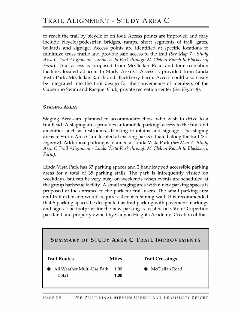
to reach the trail by bicycle or on foot. Access points are improved and may include bicycle/pedestrian bridges, ramps, short segments of trail, gates, bollards and signage. Access points are identified at specific locations to minimize cross traffic and provide safe access to the trail (See Map 7 - Study Area C Trail Alignment - Linda Vista Park through McClellan Ranch to Blackberry Farm). Trail access is proposed from McClellan Road and four recreation facilities located adjacent to Study Area C. Access is provided from Linda Vista Park, McClellan Ranch and Blackberry Farm. Access could also easily be integrated into the trail design for the convenience of members of the Cupertino Swim and Racquet Club, private recreation center (See Figure 8). STAGING AREAS Staging Areas are planned to accommodate those who wish to drive to a trailhead. A staging area provides automobile parking, access to the trail and amenities such as restrooms, drinking fountains and signage. The staging areas in Study Area C are located at existing parks situated along the trail (See Figure 8). Additional parking is planned at Linda Vista Park (See Map 7 - Study Area C Trail Alignment - Linda Vista Park through McClellan Ranch to Blackberry Farm). Linda Vista Park has 33 parking spaces and 2 handicapped accessible parking areas for a total of 35 parking stalls. The park is infrequently visited on weekdays, but can be very busy on weekends when events are scheduled at the group barbecue facility. A small staging area with 6 new parking spaces is proposed at the entrance to the park for trail users. The small parking area and trail extension would require a 4-foot retaining wall. It is recommended that 6 parking spaces be designated as trail parking with pavement markings and signs. The footprint for the new parking is located on City of Cupertino parkland and property owned by Canyon Heights Academy. Creation of this
SU M M A R Y O F ST U D Y AR E A C TR A I L IM P R O V E M E N T S
Trail Routes Miles Trail Crossings
◆ All Weather Multi-Use Path 1.00 ◆ McClellan Road Total 1.00

TRAIL ALIGNMENT - STUDY AREA C
P R E - P R I N T F I N A L S T E V E N S C R E E K T R A I L F E A S I B I L I T Y R E P O R T P A G E 7 9
Access Points Staging Areas
◆ Linda Vista Park ◆ Linda Vista Park ◆ Cupertino Swim and Racquet Club ◆ McClellan Ranch ◆ McClellan Road ◆ McClellan Ranch ◆ Blackberry Farm
Figure 8 - Summary of Study Area C Trail Improvements staging area will require negotiations with the Canyon Heights Academy. This additional parking should be constructed simultaneously with the development of the trail through the quarry in Study Area B. INTERPRETIVE STATIONS Interpretive Stations are trailside way points that provide opportunities to experience scenic vistas, observe the flora and fauna of the creek environment, reflect on local history and/or learn about hydraulic, geologic or biological phenomena. These stations may include benches, overlooks or interpretive signs or monuments. Study Area C includes five interpretive stations with three focused on natural science and two on historical subjects (See Map 7 - Study Area C Trail Alignment - Linda Vista Park through McClellan Ranch to Blackberry Farm). An existing nature trail is located along the banks of Stevens Creek in McClellan Ranch. This trail is used in school and after-school environmental education programs. The trail is recognized and designated as a natural science interpretive area. McClellan Ranch is a historical site. An interpretive feature is recommended to celebrate the past and present workings of the ranch. The Community Gardens provide an outdoor classroom for exploring plant and soil science. The organic gardens are designated a natural science interpretive area. The 4-H Program represents another link to the history of Santa Clara Valley. The program also provides significant educational opportunities for the children who participate. The 4-H facilities and program are recognized as a natural science interpretive site. A historical monument that describes the Juan Bautista de Anza Expedition is recognized and designated as historical/cultural interpretive site. This existing monument is located in the parking area of the Monta Vista High School, a short distance from the trail
TRAIL ALIGNMENT - STUDY AREA C
P A G E 8 0 P R E - P R I N T F I N A L S T E V E N S C R E E K T R A I L F E A S I B I L I T Y R E P O R T
REJECTED ALTERNATIVES An on-street alignment using Linda Vista Drive and McClellan Road was eliminated in preference of off-street route using the old haul road. A route through McClellan Ranch that skirted the meadow side of the community gardens was eliminated in preference of the route located behind the 4-H area. Several grade-separated crossing options at McClellan Road were rejected due to infeasibility (See Appendix C - Geotechnical Feasibility Evaluation). HABITAT ENHANCEMENT OPPORTUNITIES In Study Areas C and D restoration opportunities can be undertaken in two habitats: the streamside vegetation (riparian forest) and the aquatic (in-stream habitat). Both zones are closely linked, but enhancement in each zone focuses on different activities and species. The creek habitats are harmed by non-native invasive species, loss of riparian vegetation, in-stream fish barriers and other structures that degrade fish habitat, poor management practices, and some adjacent land uses. Restoration work in these habitats will require close coordination with resource agencies and other existing habitat improvement efforts. The Stevens Creek watershed in Cupertino is the focus of this restoration region. Specifically, restoration/enhancement would occur in and adjacent to the Creek corridor, which runs from Deep Cliff Golf Course to Stevens Creek Boulevard (see Figure 1—Map of the Study Area). The Creek flows from the reservoir in Stevens Creek County Park, which regulates water levels. It is also fed by springs and seeps from the closed quarry. Adult and juvenile steelhead trout (Onchorhynchus mykiss), a federally-listed threatened species, occur along the entire length of the Creek; however, Stevens Creek could provide higher quality breeding and rearing habitat, if properly managed. A recent lawsuit to protect and enhance steelhead habitat resulted in a process called the Fish and Aquatic Habitat Collaborative Effort (FAHCE). The Santa Clara Valley Water District is a key player in this process. FAHCE studies have identified high water temperatures and barriers to fish movement as current constraints fish use of the Creek. Other rare species likely to occur in the corridor are red-legged frogs and the western pond turtle (Clemmys marmorata), a California species of special concern. The riparian forest, dominated by native sycamores, live oaks, elderberry and box elder, lines the Creek banks. Some stretches, especially

TRAIL ALIGNMENT - STUDY AREA C
P R E - P R I N T F I N A L S T E V E N S C R E E K T R A I L F E A S I B I L I T Y R E P O R T P A G E 8 1
through Blackberry Farm and Golf Course have little to no vegetation. Non-native plant species found in the corridor include periwinkle, german ivy, giant reed, and tree-of-heaven. The corridor is bordered by public open space including McClellan Farm and the orchard at the Stocklmeir property. Other than these parcels, the Creek is surrounded by suburban development, two golf courses, and the large parking and picnic area of Blackberry Farm, a city-owned park. Natural Communities/Habitats Freshwater stream community, which includes steelhead habitat Sycamore/live oak riparian forest Open grassland dominated by non-native species
Problems Affecting Habitats in this Drainage Invasion by non-native species in the riparian corridor Riprap along stream banks Loss of riparian habitat Fish barriers, especially old dams Low-flow auto crossings through the Creek Degraded fish habitat Run-off impacts from golf courses and suburban development
Benefits of Restoration in this Region Protect and improve steelhead habitat Enhance native plant and animal diversity Improve shade and cover for trail users and other recreationists Provide community restoration projects
Agencies/Experts to Involve in Planning Agencies: Army Corps of Engineers, California Department of Fish and
Game, U.S. Fish and Wildlife Service, National Marine Fisheries Service, Santa Clara Valley Water District Experts: Riparian restoration specialist, steelhead and western pond turtle
experts, geotechnical expert, hydrologist, engineer, volunteer coordinator Project 1: Remove Non-native Species Description of Problem
Location—along the riparian corridor, especially McClellan Ranch (periwinkle, German ivy, tree-of-heaven), Blackberry Golf Course (German ivy, periwinkle) and Stocklmeir property (giant reed)
TRAIL ALIGNMENT - STUDY AREA C
P A G E 8 2 P R E - P R I N T F I N A L S T E V E N S C R E E K T R A I L F E A S I B I L I T Y R E P O R T
Non-native vegetation species are usurping habitat from natives Project Goals
Use mechanical and other non-chemical removal methods whenever possible Significantly reduce or eliminate the occurrences of non-native plants
in target areas and allow more room for native species cover Potential Methods
Focus on specific areas to thoroughly remove the non-native species targeted; move out from there to expand the non-native plant-free zone Different non-native species will have different methods for removal;
work with a restoration expert to develop an effective plan for the target non-natives Use chemical methods of removal as a last resort; if chemicals are used,
develop a plan with an expert in the use of the chemical and consult with DFG and NMFS Replant areas cleared of non-natives with native riparian species as
quickly as possible Timing Issues
If chemicals are used, application may need to be timed to avoid breeding seasons and other sensitive life cycle phases of native animals This is a very long-term project, which could continue for many years
Agencies to Consult/Potential Permits Santa Clara Valley Water District for other projects Santa Clara Valley Audubon Society for map of non-native species
occurrences Department of Fish and Game and National Marine Fisheries Service,
if chemical plant killers are used Experts Needed
Restoration expert, volunteer coordinator, possibly an herbicide expert Volunteer Opportunities
Mechanical or hand removal of non-natives Monitoring/Maintenance Needed
Monitor for regrowth of non-natives Plant native species as quickly as possible to avoid regrowth of
invasives and to avoid erosion

TRAIL ALIGNMENT - STUDY AREA C
P R E - P R I N T F I N A L S T E V E N S C R E E K T R A I L F E A S I B I L I T Y R E P O R T P A G E 8 3
Project Difficulty: _X_ Relatively Simple ____Moderately Difficult ____Difficult Non-native species removal methods are well established; can be effective when vigorously pursued. Project 2: Remove Rip-rap/Resculpt Creek Banks Description of Problem
Location—Rip-rap occurs in Blackberry Farm; creek banks in Blackberry Farm, the Golf Course and Deep Cliff Golf course need resculpting Installing rip-rap and compacted soil banks resulted in the loss of
riparian species, contributing to high water temperatures and degradation of steelhead habitat
Project Goals
Reestablish a more natural riparian edge, which allows growth of native species Provide bank edge habitat for turtles and steelhead Protect banks from scour and erosion
Potential Methods
Examine historical photos of original stream morphology to guide restoration Have hydrologist develop estimates of scour and erosion rates to
determine type of structures that will be adequate Remove rip-rap with heavy equipment; try to integrate some of the
material in the resculpting work to keep costs down Recreate creek meanders, if possible, to dissipate flow energy and
allow more natural stream functioning Create more gentle bank slopes and soften the consolidated bank soil;
add soil that supports native riparian species Stabilize banks with geotechnical material, root wads, logs, willow
wattling or other methods effective in preventing erosion while promoting the growth of native species and providing bank habitat for native animals Replant banks as quickly as possible with native riparian species
Timing Issues

TRAIL ALIGNMENT - STUDY AREA C
P A G E 8 4 P R E - P R I N T F I N A L S T E V E N S C R E E K T R A I L F E A S I B I L I T Y R E P O R T
Conduct construction to avoid impacts to steelhead, pond turtles, and red-legged frogs Avoid construction in the rainy season, if possible This is a medium length project that will take approximately 2 to 4
years to complete. Agencies to Consult/Potential Permits
Santa Clara Valley Water District/local permits, coordinate with FAHCE Army Corps of Engineers/Clean Water Act, Section 404 permit Department of Fish and Game/Stream Alteration Agreement,
consultation on pond turtle protections National Marine Fisheries Service/Endangered Species Act, Section 7
consultation Experts Needed
Restoration expert, permits specialist, geotechnical expert, hydrologist, engineer
Volunteer Opportunities
None Monitoring/Maintenance Needed Monitor scour and erosion around new features; repair if needed
Project Difficulty: ____ Relatively Simple ____ Moderately Difficult _X_ Difficult Heavy equipment and engineering are needed. Getting engineers to use good bioengineering approaches (rather than traditional “hardscape” engineering) can be difficult. These projects are expensive and require many permits. Project 3: Revegetate with Native Riparian Species Description of Problem
Location—along creek corridor through Study Areas C and D, but especially through Blackberry Farm and through both golf courses Loss of riparian vegetation results in bank erosion, has degraded
steelhead habitat through lack of shading, has reduced habitat for riparian species such as migratory birds, and has reduced shading and aesthetic value for people

TRAIL ALIGNMENT - STUDY AREA C
P R E - P R I N T F I N A L S T E V E N S C R E E K T R A I L F E A S I B I L I T Y R E P O R T P A G E 8 5
Project Goals Reestablish a diversity of upper and lower canopy plant species that
are native to the corridor Provide shade over the creek to improve steelhead habitat and shade
for the trail, if possible Provide as wide a riparian buffer as possible between the creek and
adjacent land uses, to help protect creek water quality Reestablish a continuous riparian habitat for resident and migratory
species, especially birds
Potential Methods Pull parking and picnic areas at Blackberry Farm back from the creek
edge to allow a 100 foot riparian corridor Remove Blackberry Farm parking lot and replace with a permeable
material that reduces runoff Collect native plant materials from Stevens Creek corridor, whenever
possible, or failing that, from other South San Francisco Bay watersheds Have a native plant nursery grow seedlings Collect information on the soil types and water table location along the
corridor Plant species in acceptable locations based on correct soil type, stream
bank elevation, frequency of flooding, and water table level Plant native species after non-natives have been removed and creek
bank has been resculpted
Timing Issues Allow 1 year for growing plants in a nursery Plant seeds and seedlings during the rainy season or when most
appropriate for each species This is a long-term, multi-year project
Agencies to Consult/Potential Permits Santa Clara Valley Water District (on potential impediments to creek
flow)
Experts Needed Riparian restoration expert, volunteer coordinator, engineer
Volunteer Opportunities
Plant material collection Nursery assistance Planting, watering, weeding

TRAIL ALIGNMENT - STUDY AREA C
P A G E 8 6 P R E - P R I N T F I N A L S T E V E N S C R E E K T R A I L F E A S I B I L I T Y R E P O R T
Monitoring for plant health and growth
Monitoring/Maintenance Needed Watering and weeding may be needed Monitor number of plants of each species surviving and growth rate of
survivors
Project Difficulty: ____ Relatively Simple _X_ Moderately Difficult ____ Difficult Project 4: Remove Fish Barriers and Low-Flow Auto Crossings Description of Problem
Location—A small dam, which is a fish barrier, and several low-flow auto crossings are located in Blackberry Farm. Other barriers and low-flow crossing may be located in the two golf courses. Structures impede fish passage upstream and reduce habitat quality
for adult and juvenile fish Project Goals
Remove these structures that prevent steelhead from having full access to the creek Prepare creek bed for further fish habitat enhancement
Potential Methods
Methods to remove the barriers with the least damage possible to the creek morphology, water quality or vegetation will be determined by a hydrologist, geologist, steelhead expert, and engineer
Timing Issues
Avoid impacts to steelhead, pond turtles or red-legged frogs Removing structures can be done relatively quickly and should be
completed in one season. Agencies to Consult/Potential Permits
Santa Clara Valley Water District/local permits, coordinate with FAHCE Army Corps of Engineers/Clean Water Act, Section 404 permit Department of Fish and Game/Stream Alteration Agreement,
consultation on pond turtle protections

TRAIL ALIGNMENT - STUDY AREA C
P R E - P R I N T F I N A L S T E V E N S C R E E K T R A I L F E A S I B I L I T Y R E P O R T P A G E 8 7
National Marine Fisheries Service/Endangered Species Act, Section 7 consultation
Experts Needed
Hydrologist, geotechnical expert, steelhead expert, engineer, permits expert
Volunteer Opportunities None
Monitoring/Maintenance Needed
None Project Difficulty: _X_ Relatively Simple ____Moderately Difficult ____Difficult Removing the structures is relatively easy. Receiving permits and approvals from agencies is likely to be the greatest hurtle. Project 5: Enhance Degraded Fish Habitat Description of Problem
Steelhead habitat has been degraded by changes to the creek structure and vegetation. Water management practices that damage steelhead population
Project Goals
Increase survival of adults and juvenile steelhead by providing habitat needed at each phase of their lives Increase steelhead productivity by increasing breeding habitat
Potential Methods
Work with a steelhead expert to determine what habitat needs are lacking in the creek Work with FAHCE to ensure that enough water is released from the
dam to support year-round fish habitat Work with FAHCE to determine which habitat enhancements are
being implemented by FAHCE members and which ones remain to be done Enhancement may include a number of methods. Several typical
enhancement features are: adding appropriately sized gravel to the creek bed to create spawning habitat, installing check dams, gravel and

TRAIL ALIGNMENT - STUDY AREA C
P A G E 8 8 P R E - P R I N T F I N A L S T E V E N S C R E E K T R A I L F E A S I B I L I T Y R E P O R T
pools to make pool and riffle habitat, installing root wads to create cover habitat for fry and juveniles
Timing Issues
Time work to avoid impacts to steelhead Structures can be put in quickly, within a season. Monitoring fish use
and changing or adding structures to meet fish requirements make this a multi-year project.
Agencies to Consult/Potential Permits
Santa Clara Valley Water District/local permits, coordinate with FAHCE Army Corps of Engineers/Clean Water Act, Section 404 permit Department of Fish and Game/Stream Alteration Agreement,
consultation on pond turtle protections National Marine Fisheries Service/Endangered Species Act, Section 7
consultation Experts Needed
Steelhead expert, engineer, hydrologist, geotechnical expert Volunteer Opportunities
None Monitoring/Maintenance Needed
Monitor the use of new habitat by fish; modify or add other features as needed Monitor the integrity of the new features and fix them if they degrade
Project Difficulty: ____Relatively Simple _X_ Moderately Difficult ____Difficult Salmon and steelhead biologists have developed and tested a wide range of habitat enhancement features. Appropriate features can be very successful in improving steelhead productivity and survivorship. Close coordination with many agencies will be a challenge for these projects. Project 6: Educate Adjacent Land Owners and Managers about Runoff Impacts
TRAIL ALIGNMENT - STUDY AREA C
P R E - P R I N T F I N A L S T E V E N S C R E E K T R A I L F E A S I B I L I T Y R E P O R T P A G E 8 9
Description of Problem Pesticide and herbicides runoff from residential and golf course land
uses into Stevens Creek, reducing water quality and the overall health of the creek and riparian system
Project Goals
Determine what pollutants could come from homes, landscaping, and golf courses Identify solutions homeowners and golf course managers could take to
reduce pollutant use Inform local homeowners and land managers about the solutions
Potential Methods
Work with a watershed expert to determine the pollutants likely to come from homes and golf courses and develop solutions. Develop an informational packet and survey to give to local
homeowners and golf course managers to inform them about impacts to wetlands and what they can do. Deliver the information and survey (methods include door-to-door, a
community meeting, a mailing). Follow-up, after an appropriate period, to determine homeowner/land
manager views and actions taken.
Timing Issues Can be done any time of the year This project can be done quickly, within a year
Agencies to Consult/Potential Permits
None/None Maybe use materials already developed by SCVWD
Experts Needed Restoration expert to help with developing watershed protection
measures Volunteer coordinator to organize and support volunteers
Volunteer Opportunities
Develop questionnaire and administer it Help with information analysis Revisit households for follow-up interview
Follow-up Needed
TRAIL ALIGNMENT - STUDY AREA C
P A G E 9 0 P R E - P R I N T F I N A L S T E V E N S C R E E K T R A I L F E A S I B I L I T Y R E P O R T
Return to households to find out if homeowners implemented any of the recommendations and to assess their views of changing their yard care practices. Follow-up with golf course managers.
Project Difficulty: _X_ Relatively Simple
____ Moderately Difficult ____ Difficult
This project is relatively easy to implement, but assessing effectiveness can be difficult.