STRATEGY FOR FLOOD MANAGEMENT FOR … · Strategy for Flood Management for Kafue River Basin 6...
158
Transcript of STRATEGY FOR FLOOD MANAGEMENT FOR … · Strategy for Flood Management for Kafue River Basin 6...
STRATEGY
FOR
FLOOD MANAGEMENT
FOR
KAFUE RIVER BASIN, ZAMBIA
Prepared under Associated Programme Flood Management (APFM)
August 2007

Strategy for Flood Management for Kafue River Basin 1
TABLE OF CONTENTS Abbreviations and Acronyms ………………………………………………………………………4 Foreword ……………………………………………………………………………………………….5 Preface ………………………………………………………………………………………………… 6 Executive Summary …………………………………………………………………………………..7 Acknowledgement …………………………………………………………………………………..10 PART I BACKGROUND, PHYSICAL, SOCIAL AND ECONOMIC SET UP 1. BACKGROUND ……………………………………………………………………………..12 2. PHYSICAL AND SOCIAL SET UP ………………………………………………………..14
2.1 The Kafue River Basin ……………………………………………………………...14 2.2 Resources …………………………………………………………………………….24 2.3 Flood Situation in the Basin ………………………………………………………...29 2.4 Rural and Urban Development and Future Plans ………………………………...31
PART II STRATEGY FOR FLOOD MANAGEMENT 3. RATIONALE FOR A STRATEGY ……………………………………………………….....35
3.1 Vulnerability of People to Floods …………………………………………………...35 3.2 Factors Contributing to Increasing Flood Risks …………………………………...35 3.3 Flooding Incidences in the Kafue Basin ……………………………………………36 3.4 Climate Variability and Change in Zambia …………...........................................37
4. STRATEGY FORMULATION PROCESS ………………………………………………….38
4.1 Steering Committee …………………………………………………………………..38 4.2 The World Meteorological Organization ……………………………………………38 4.3 Stakeholders Contribution and Involvement in the Strategy Development ……..38 4.4 Policy Makers’ Contribution and Involvement in the Development Process ……39
5. COMPONENTS OF THE STRATEGY ………………………………………………………40
5.1 Reducing Vulnerability ………………………………………………………………..41 5.2 Reorientation of Approach to Development and Floods ………………………….44 5.3 Integrated Approach to Water Resources Development and Flood
Management …………………………………………………………………………..45 5.4 Protecting and Conserving Environment …………………………………………...49 5.5 Addressing Weather and Climate Variability and Change ………………………..51 5.6 Coordination Between Various Ministries and Agencies …………………………55
Strategy for Flood Management for Kafue River Basin 2
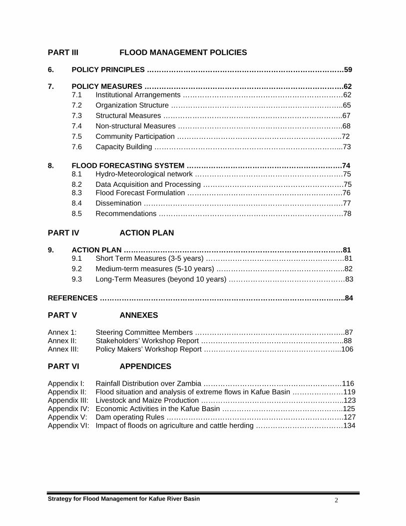
PART III FLOOD MANAGEMENT POLICIES 6. POLICY PRINCIPLES ………………………………………………………………………59 7. POLICY MEASURES ……………………………………………………………………….62
7.1 Institutional Arrangements …………………………………………………………62 7.2 Organization Structure ……………………………………………………………..65 7.3 Structural Measures ………………………………………………………………..67 7.4 Non-structural Measures …………………………………………………………..68 7.5 Community Participation …………………………………………………………..72 7.6 Capacity Building …………………………………………………………………...73
8. FLOOD FORECASTING SYSTEM ……………………………………………………….74
8.1 Hydro-Meteorological network …………………………………………………….75 8.2 Data Acquisition and Processing ………………………………………………….75 8.3 Flood Forecast Formulation ……………………………………………………….76 8.4 Dissemination ……………………………………………………………………….77 8.5 Recommendations ………………………………………………………………….78
PART IV ACTION PLAN 9. ACTION PLAN ………………………………………………………………………………81
9.1 Short Term Measures (3-5 years) …………………………………………………81 9.2 Medium-term measures (5-10 years) ……………………………………………..82 9.3 Long-Term Measures (beyond 10 years) …………………………………………83
REFERENCES ………………………………………………………………………………………..84 PART V ANNEXES Annex 1: Steering Committee Members ……………………………………………………..87 Annex II: Stakeholders’ Workshop Report …………………………………………………..88 Annex III: Policy Makers’ Workshop Report ………………………………………………...106
PART VI APPENDICES Appendix I: Rainfall Distribution over Zambia …………………………………………………116 Appendix II: Flood situation and analysis of extreme flows in Kafue Basin …………………119 Appendix III: Livestock and Maize Production …………………………………………………..123 Appendix IV: Economic Activities in the Kafue Basin …………………………………………..125 Appendix V: Dam operating Rules ……………………………………………………………….127 Appendix VI: Impact of floods on agriculture and cattle herding ………………………………134
Strategy for Flood Management for Kafue River Basin 3
Appendix VII: Kafue Gorge Flash Floods Report …………………………………………………136 Appendix VIII: Soils description of the Kafue Basin ……………………………………………….141 Appendix IX: Status of Deforestation in Zambia …………………………………………………144 Appendix X: RANET Zambia Project ……………………………………………………………..150 Appendix XI: Glossary ………………………………………………………………………………154 List of Figures Figure 1: Rainfall amounts and associated raindays for Ndola ……………………………..13 Figure 2: Location of Kafue Basin ………………………………………………………………15 Figure 3: Kafue Basin Rainfall Distribution …………………………………………………….17 Figure 4: Flood prone areas as captured on landsat imagery ………………………………20 Figure 5: Location of Flood prone areas of Kafue Basin …………………………………….21 Figure 6: Peak flow losses from Kafue river into Lukanga …………………………………..28 Figure 7: Wet and dry rainfall trends at Itezhi-tezhi …………………………………………..37 Figure 8: Agro-Ecological Regions of Zambia ………………………………………………...53 Figure 9: Typical organisational flowchart relating to river basin management …………...57 Figure 10: Various structural and non-structural adaptations …………………………………70 Figure 11: Hydrometeorological network of the Kafue Basin …………………………………76 Figure 12: Flood forecasting and dissemination mechanism …………………………………79 List of Tables Table 1: Characteristics of the Kafue Basin ………………………………………………….18 Table 2: Administrative divisions of the Kafue River Basin …………………………………24 Table 3: Summary of water resources by sub-basin ………………………………………...26 Table 4: Summary of Water abstraction data for Kafue Basin ……………………………..27 Table 5: Population in the Kafue river basin, 1990 …………………………………………..32 Table 6: Summary of Strategy components ………………………………………………….40 List of Plates Plate 1: LANDSAT imagery of the Flood prone areas of Kafue River Basin …………….19 Plate 2: Kafue Flats as seen from Chanyanya Fishing harbour …………………………...22 Plate 3: Wildlife in the Kafue Flats …………………………………………………………….22 Plate 4: Kafue Flats in Flood …………………………………………………………………..23 Plate 5: Kafue Flats showing ox-bowl lakes and lagoons ………………………………….23 Plate 6: Itezhi-tezhi dam main spill way ……………………………………………………...47 Plate 7: Kafue Gorge Dam …………………………………………………………………….48 Plate 8: Participants of the Stakeholders’ Workshop ……………………………………….88 Plate 9: Minister of Energy and Water Development Honourable Felix Mutati
delivering the opening speech ………………………………………………………90 Plate 10: Stakeholders’ group discussions ……………………………………………………93 Plate 11: Participants of the Policy Makers’ Workshop …………………………………….106 Plate 12: WMO representative Mr Datius Rutashobya making opening remarks ……….108 Plate 13: Permanent Secretary, Ministry of Energy and Water Development
Mr Buleti Nsemukila giving the opening speech …………………………………108 Plate 14: Workshop participants listening to the presentation ……………………………..109 Plate 15: Policy Makers’ Group discussions …………………………………………………111

Strategy for Flood Management for Kafue River Basin 4
ABBREVIATIONS AND ACRONYMS APFM Associated Programme on Flood Management ASP Agricultural Section Support Programme CBNRM Community Based National Resources Management CBO Community Based Organisation CFFO Central Flood Forecasting Office CLUSA Cooperation League of the United Nations CSO Central Statistical Office EIA Environmental Impact Assessment ENSO El Nino Southern Oscillation ESP Environmental Support Programme FFO Flood Forecasting Office FRA Food Reserve Agency FRMP Forest Resources Management Project GDP Gross Domestic Product MACO Ministry of Agriculture and Cooperation MEWD Ministry of Energy and Water Development MLGH Ministry of Local Government and Housing MOFNP Ministry of Finance and National Planning MTENR Ministry of Tourism, Environment and Natural Resources NAP National Agricultural Policy NGO Non-Governmental Organisation OVP Office of the Vice President PFAP Provincial Forest Action Programme RANET Radio Internet System SADC Southern Africa Development Community SCAPE Soil Conservation and Agro-Forestry Extension Programme SWECO Swedish Engineering Consultants UNFCCC United Nations Framework Convention on Climate Change WMO World Meteorological Organization WWF Worldwide Wildlife Fund ZFAP Zambia Forest Action Programme

Strategy for Flood Management for Kafue River Basin 5
Foreword This Flood Management Strategy brings to the fore the proactive and integrated ways of managing floods for the sustainable development of our flood plains. The Strategy has been developed at an appropriate time when the Zambian people’s memories are still fresh with images of devastating and destructive floods that destroyed both human life and infrastructure (property) in terms of the mud slide associated with flash floods that disrupted the operations of the ZESCO Hydroelectricity Generating Plant at Kafue Gorge and the Kazungula flood situation of the 2005/6 rainy season. In developing this Strategy, a balanced view was taken that took on board all interests of key stakeholders such that during implementation people’s livelihoods would be improved and this would culminate into accelerated attainment of the Millennium Development Goals (MDGs) in Zambia, and in particular, among the flood plain communities in surrounding urban and peri-urban areas. Floods and droughts are natural phenomena and they need timely and effective mitigation measures to minimise their impacts. Floods are very unpredictable and sudden. Mankind has always been overwhelmed by floods due to the magnitude of loss of life and property. Therefore, proper water management measures are required to be in place before the occurrence of any such event. The rationale for the development of this Strategy was mainly to develop a policy that will remove flood management from ad hoc arrangement to a well planned programme with clear fiscal provisions mainstreamed in the national budget to cater for lines of Ministries responsible for flood management related activities. This would be a complete shift from the uncoordinated type of management of floods to a systematic and integrated mode with strong links with communities and key stakeholders. The Strategy has outlined a specific action plan comprising short, medium and long term activities that would require to be done by identified institutions mandated to undertake such activities. It has also gone further to propose a versatile flood forecasting and warning system to ensure effective collection, transmission and timely analysis of flood related data and prompt dissemination of information to end users who would include communities and the district administrators in case of impending dangers due to anticipated floods. On behalf of the Zambian Government, I wish to express my sincere gratitude to the World Meteorological Organization for its invaluable support in ensuring that the Strategy for the Kafue River Basin was developed within the planned timeframe as a pilot project. The experience gained during the development of this Strategy will be used to develop a Flood Management Strategy for the whole country.
Hon. Kenneth Konga, MP MINISTER OF ENERGY AND WATER DEVELOPMENT

Strategy for Flood Management for Kafue River Basin 6
Preface Mitigating the adverse impacts of extreme hydro-meteorological events such as floods has been recognized internationally as one of the essential components of sustainable development and poverty alleviation, as well as one of the key measures required for the achievement of the internationally agreed-upon UN Millennium Development Goals. Flood management strategies pursued over the years have been largely reactive up to now and made in response to flood threats, rather than proactive. Furthermore, the increasing challenges of population pressure on natural resources, the need for economic development, the increasing climate variability and potential climate change, will tend to make unsustainable the current practices through which we deal with floods. There is therefore the need for a paradigm shift, to move away from flood control towards flood management. Such a paradigm shift requires a proactive approach rather than reactive actions – a move towards a culture of prevention by managing the risks of and living with floods. This need is actually the catalyst behind the concept of integrated flood management (IFM), which seeks to integrate land and water resources development in a river basin, thereby maximising benefits from natural resources and minimising loss of life. Integrated Flood Management is an approach being promoted by the Associated Programme on Flood Management (APFM), which is a joint initiative of WMO and the Global Water Partnership (GWP). WMO strives to support its Members in evolving the development strategies that most appropriately factor natural disaster risks, including those due to floods, in their development policies. WMO is therefore very pleased to have had the opportunity to assist the Government of the Republic of Zambia in developing the Flood Management Strategy for Kafue River Basin. On behalf of WMO, I would like to express my thanks to the political leadership, all national experts and local communities who contributed their time and expertise in the preparation of this important document, which I am confident will spur actions to achieve the development objectives in the basin. WMO maintains its commitment to continue working closely with the Zambian authorities and those of the other countries in the region, in the development of similar strategy for the entire Zambezi river basin, with the objective to achieve sustainable development in the region.
M. Jarraud Secretary-General Date: August 2007

Strategy for Flood Management for Kafue River Basin 7
EXECUTIVE SUMMARY The Kafue Basin, one of the most sensitive basins in Zambia, has been subjected to flooding. The year 1994 saw severe floods in the Kafue Flats when fishing camps and some settlements along the river were inundated and people were displaced. Mud brick houses collapsed and bridges were washed away cutting off Monze and Namwala towns from the rest of the country. Earlier on, in the year 1988/89, urban flooding left more than 50,000 people in the Kafue Basin towns of Kitwe, Ndola, Kapiri Mposhi, Kabwe, Lusaka and Mazabuka homeless. Urban flooding was also experienced in 1992/93, 2000/01 and 2005/06. Recent floods in the Basin have affected some parts of towns and population centres located near dambos and swampy areas including some well built up areas of Lusaka and Kabwe which are located in low lying zones but not properly drained. The most recent floods in the basin have been the wide spread floods associated with flashy floods which occurred in the 2005/2006 rainy season. The flashy floods that affected the Kafue Gorge Power Station in December 2005 rank highly in terms of extent of damage, which disrupted power generation for a period of two weeks. Wide spread flooding also occurred in March 2006, affecting housing units and agricultural fields in the Southern Province towns of Mazabuka, Monze and Choma. This document has been prepared in response to the request received by the World Meteorological Organization (WMO) to assist the Government of the Republic of Zambia in developing a Strategy for Flood Management for Kafue River Basin. The Strategy has been developed as a pilot project under the WMO-GWP Associated Programme on Flood Management (APFM) which is funded by the Government of Japan and the Government of the Netherlands. It has been prepared as a collaborative effort between WMO and a Project Team of Zambian experts and with inputs from key stakeholders and policy makers including Zambian Government Ministries and Departments, local authorities, parastatal organizations, academicians and researchers, non-governmental organizations (NGOs), and farmers’ and fishing associations in the Kafue flood prone areas. The document highlights the major flood problems in the basin that range from loss of lives to widespread destruction of crops and other economic activities. It traces historical and recent floods in the basin as well as the wide spread flash floods. It shows how the construction of Itezhi-tezhi dam on the upstream of the flood plain and Kafue Gorge dam on the downstream and their subsequent operation has changed the flow regime of the river and therefore impacted on the environment in the Kafue Flats. At the same time, it points out flooding as an environmental requirement for sustenance of the various components of the ecosystem for the flood plain of the Kafue Basin. The Strategy emphasises that the starting point for Integrated Flood Management (IFM) is a reorientation of the approach to floods and development and the need for pro-active and dynamic planning which takes into consideration the full benefits from a flood plain. It addresses environmental concerns related to flood plain ecosystem sustenance and socio-economic issues of the communities in the Kafue River Basin. In initiating the process for Strategy development, WMO prepared a project document which was discussed in Lusaka and agreed upon with senior officials of the Ministry of Energy and Water Development and the Meteorological Department of Zambia. A Stakeholders’ Workshop was organized in Lusaka as a way of initiating stakeholders’ awareness and participation in the project. This also served to establish interaction with the local, national and regional development agencies, departments and ministries working in the fields of water resources, energy, agriculture, fisheries, urban development, land use, transport, water supply and

Strategy for Flood Management for Kafue River Basin 8
sanitation and other water related fields. A Steering Committee was established to guide the Zambian Project Team in the implementation of the project. The Project Team produced two drafts of the Strategy, each of which was submitted to WMO and also discussed at the Steering Committee meetings. The comments made by WMO, together with results of discussions at the Steering Committee meetings were incorporated into a revised draft which was presented at the Policy Markers’ Workshop in September 2006. Following discussions at this Workshop, a final draft was submitted to WMO. WMO then used this draft to come up with the final document. Some of the issues raised or pointed out during the Stakeholders’ Workshop were:
• The most vulnerable people to floods in the Kafue Basin are the poor peasants whose livelihoods depended on subsistence farming, fishing, doing odd jobs and selling various articles such as reed-mats, baskets and forest products.
• After living in the Kafue Flats for so many years the people have become used and attached to their conditions and the seasonal floods have become part of their lives. This has made it very difficult to shift to higher lands to go and start a new life. Their unwillingness to move away is also compounded by cultural beliefs that it is taboo to abandon the burial grounds of their ancestors and recently departed loved ones.
• Poor land use practices coupled with bad settlement plans in urban areas have made some people to build houses in areas prone to flooding. This has been due to population pressure and demand for new land to settle.
• The stakeholders recommended establishment of a standing fund for emergencies to be called Flood/Drought Emergency Fund to be used when floods occur.
• There is no Land Use policy in Zambia, and therefore no land use issues have been linked to Integrated Water Resources Management in general.
• Currently there is no existing policies addressing climate variability and change, but the development of a Meteorological Policy is at inception phase.
• There are no specific laws or policies related to floods in the basin/country. However, laws and policies relating to land use and water management have some indirect bearing on floods.
Some of the outcomes of the Policy Makers’ workshop were:
• The Strategy policy measures should be integrated and harmonized with all relevant national policies and pieces of legislation.
• A Steering Committee for Flood Management Strategy should be formed at Permanent Secretary level to facilitate effective coordination among the line Ministries.
• The Flood Management Strategy Steering Committee should meet once or twice a year in order to review progress on implementation of the various recommendations and to review budget allocations for line ministries to ensure the recommended activities are well funded.
The proposed Strategy for flood management in Kafue Basin has the following components: Component 1: Vulnerability reduction of the flood plain communities should be addressed
through appropriate policies in different sectors. Component 2: Implementation of the National Agricultural Policy should be pursued to exploit
the full potential of the fertile flood plains.
Strategy for Flood Management for Kafue River Basin 9
Component 3: The Ministry of Agriculture and Cooperatives should develop, support and encourage flood resistant crops and cropping patterns that would help income growth in flood prone areas.
Component 4: The Ministry of Lands together with Ministry of Local Government and Housing should prepare and implement plans for integrated development of nearby urban areas.
Component 5: Ministry of Agriculture and Cooperatives and other stakeholders should evolve a policy that considers flood plains as national asset that is key for accelerated growth of GDP.
Component 6: Industrial policy should be formulated for flood prone areas based on the imperatives of future development and employment generation within and on the fringes of flood plains with emphasis on agro-based industries.
Component 7: Related national policies on Flood Management should be developed, revised and harmonized to take into account the Integrated Flood Management concept integrating land and water management through the process of IWRM.
Component 8: A National Land Use Policy addressing the land issues in flood plains should be developed
Component 9: The New Reservoir Operation Rules for Itezhi-tezhi and Kafue Gorge Dam developed under the Integrated Water Resources Management Study of the Kafue Flats by WWF should be revised, harmonized and implemented to take into account the Integrated Flood Management principles in the operations of the reservoirs.
Component 10: The Kafue Catchment Council should be established to accelerate the pace of development in the basin with water as an input through implementation of comprehensive schemes aimed at optimal utilization of available water resources in various sectors of economy.
Component 11: The environmental impacts of flood management options and impacts of floods on the environment should be addressed.
Component 12: Land use regulations should be developed and forest protection laws enforced to protect and develop the watersheds.
Component 13: Watershed development plans should be prepared and implemented with due emphasis on the soil conservation to prevent excess sheet erosion and consequent silting of rivers.
Component 14: Weather and climate forecasts and early warning should be used for risk management in developmental plans and implementation of the programmes.
Component 15: Long-term adaptation plans based on current predictions and forecasts for weather and climate changes should be prepared.
Component 16: An effective and evolving inter-sector coordination mechanism should be established at various levels to plan and implement pre-disaster and post-disaster flood prevention and mitigation measures.
This Strategy proposes 31 Policy Measures to be integrated in existing national policies and legislation with a goal of effecting more efficient institutional arrangements, and enhancing community participation and capacity building. A flood forecasting system is also proposed. Finally, an action plan outlining short-term (3-5 years), medium-term (5-10 years) and long-term (beyond 10 years) measures is recommended in order to put this Strategy into action.
Strategy for Flood Management for Kafue River Basin 10
Acknowledgement On behalf of WMO, I would like to express my thanks to all persons who contributed their time and expertise in the preparation of this important document. My special thanks go to Hon. Kenneth Konga, MP, current Minister of Energy and Water Development, Hon. Felix Mutati, MP, ex-Minister of Energy and Water Development, Dr Buleti Nsemukila, Permanent Secretary of the Ministry of Energy and Water Development, Mr Russell Mulele, Permanent Secretary of the Ministry of Tourism, Environment and Natural Resources, Mr Maswabi M. Maimbolwa, Permanent Secretary of the Ministry of Local Government and Housing, and Brig. Gen. P. Tembo, Permanent Secretary of the Ministry of Transport and Communications for their guidance in preparation of this Strategy. Acknowledgement is also due to the Governments of Japan and the Netherlands for providing funds, under the Associated Program on Flood Management, to undertake this study. It is encouraging to note that the Zambian Government, apart from the expertise and logistics for the study, also allocated special funds for developing the Strategy.
Avinash Tyagi
Director, Hydrology and Water Resources Department
Strategy for Flood Management for Kafue River Basin 11
PART I
BACKGROUND, PHYSICAL, SOCIAL AND ECONOMIC SET UP

Strategy for Flood Management for Kafue River Basin 12
1. BACKGROUND Zambia is endowed with abundant water resources as it experiences a sub-humid tropical climate. The average annual rainfall and rain days in Zambia range from 657 mm and 68 days to 1402 mm and 142 days with an overall average for Zambia of 1001 mm and 97 days. This average rainfall over the whole country makes the country one of the well watered countries in the Southern Africa region which has comparatively abundant surface and groundwater resources. In Zambia, like elsewhere in the world, water is a key factor in sustenance of life and support to development. Its availability has determined the human settlement patterns and has influenced the location of key developmental activities such as agriculture, mining and manufacturing industries. In spite of the benefits water provides, it also causes destruction and damage, which results in loss of lives, widespread crop destruction and associated economic disasters. Numerous examples in Zambia demonstrate that floods are among the most damaging natural disasters. Flood damage ranges from loss of lives to widespread destruction of crops and other economic activities. Many parts of Zambia are subjected to floods, one example being the Kafue Flats in the Kafue Basin. In some years, Zambia has experienced shorter rain seasons though with high rainfall amounts especially the upper catchment area as seen in Figure 1 for Ndola. The expected trend in the two curves is that the gap between the two curves should be as small as possible indicating that the more the rainfall amount, the more the days when that amount occurred. However when the gap between the two curves gets wider (with the rain days curve below that of rainfall), it means that high rainfall amounts occurred within a shorter time period. Such conditions have been observed to have higher chances of flash flood occurrences. For Ndola, such a condition occurred in the hydrological years, 1993/94, 1995/96, 2003/04 and 2005/06. On the other hand, rain days curve being higher than that of rainfall amount tend to indicate drought conditions.

Strategy for Flood Management for Kafue River Basin 13
NDOLA RAINFALL
0
20
40
60
80
100
120
140
1991
/92
1992
/93
1993
/94
1994
/95
1995
/96
1996
/97
1997
/98
1998
/99
1999
/2000
2000
/01
2001
/02
2002
/03
2003
/04
2004
/05
2005
/06
TIME (YEARS)
PER
IOD
(RA
IND
AYS
)
0
200
400
600
800
1000
1200
1400
1600
RA
INFA
LL (m
m)
RAINDAYS RAINFALL Figure 1: Rainfall amounts and associated rain days for Ndola
The Dublin conference (1992), the subsequent Ministerial Declaration (2001) at The Hague and the World Summit on Sustainable Development (2002) have increasingly crystallized the global opinion in recognizing that Integrated Water Resources Management (IWRM) is a necessary approach for sustainable development. It is recognized as the most appropriate approach for sustainable development of water resources, of which Integrated Flood Management (IFM) forms an important subset. Integrated Flood Management is a process promoting an integrated – rather than fragmented – approach to flood management. It integrates land and water resources development in a river basin, within the context of IWRM, and aims at maximising the net benefits from flood plains and minimising loss to life from flooding (APFM, 2004). The Associated Program on Flood Management (APFM), a joint program between the World Meteorological Organization (WMO) and the Global Water Partnership (GWP) is an initiative to support the efforts of countries towards implementing Integrated Flood Management. A number of pilot projects are being implemented under the APFM in different parts of the world to develop and apply various components of the IFM concept. In response to the request for technical assistance submitted to WMO, an Agreement was signed between WMO and the Government of the Republic of Zambia for the development of the Flood Management Strategy in the Kafue Basin. WMO assisted the Ministry of Energy and Water Development (MEWD) of the Government of Zambia to develop the Strategy as a pilot project under the APFM. The Strategy was developed with the assistance of a team of Zambian experts and with full participation of key stakeholders and policy makers which included Government Ministries and

Strategy for Flood Management for Kafue River Basin 14
Departments, local authorities, parastatal organizations, academicians and researchers, non-governmental organizations (NGOs), and farmers’ and fishing associations in the flood prone areas. The strategy for flood management in the Kafue River Basin simultaneously addresses present environmental concerns related to flood plain ecosystem sustenance, socio-economic issues and concerns of the flood plain communities, the current water regulation schemes for power generation, and the imperative future development of the entire fertile land in the flood plains. The starting point in an Integrated Flood Management (IFM) Strategy is a reorientation of the approach to floods and development. The developmental planning must be pro-active and dynamic and take into consideration the likely multiplier effects on various other sectors of the economy that may spread far and wide beyond the flood plains. This document outlines a proposed flood management strategy for the Kafue River Basin in Zambia. It is expected to serve as a base document for the development of the National Strategy and Policy for Flood Management in Zambia. The document contains six parts. Part I provides the background, including the physical and social context in the basin, administrative aspects, resources, floods and their impacts, and the status of development imperatives in the Kafue River Basin. Part II describes the proposed Strategy for Flood Management, and identifies various initiatives to be implemented by the Ministries, Departments and other institutions concerned. A mechanism for coordination is also provided. Part III outlines the basic policy principles and proposes various policy measures and objectives that include structural and non-structural options. It also provides an institutional mechanism that facilitates community participation. Part IV gives a proposed Flood Forecasting System for the Kafue basin. Part V outlines a proposed Action Plan suggesting various short, medium and long-term measures for the implementation of the strategy. The Annexes are included in Part VI which provides detailed discussion of stakeholders’ and policy makers’ workshops and some of the elements included in the strategy. Finally Part VII contains appendices providing socio-economic and other supporting information from which the strategy is being drawn. 2. PHYSICAL AND SOCIAL SET UP 2.1 The Kafue River Basin The Kafue River is one of the major tributaries of the Zambezi River. The Kafue catchment is all within Zambia and has an area of 156 995 km2 at the river’s confluence with the Zambezi. This catchment area is 20% of Zambia's total land area. The Kafue River has a length of 1 300 km. The density of tributaries is high in the northern parts of the basin, and becomes lower in the southern part of the basin. The mean flow of the Kafue River at Hook Bridge is estimated to be
Strategy for Flood Management for Kafue River Basin 15
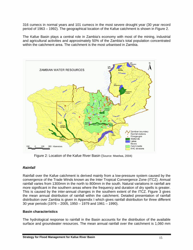
316 cumecs in normal years and 101 cumecs in the most severe drought year (30 year record period of 1963 – 1992). The geographical location of the Kafue catchment is shown in Figure 2. The Kafue Basin plays a central role in Zambia's economy with most of the mining, industrial and agricultural activities and approximately 50% of the Zambia's total population concentrated within the catchment area. The catchment is the most urbanised in Zambia.
Figure 2: Location of the Kafue River Basin (Source: Mwelwa, 2004)
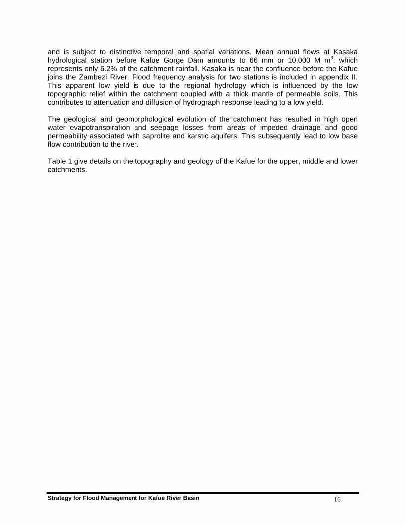
Rainfall Rainfall over the Kafue catchment is derived mainly from a low-pressure system caused by the convergence of the Trade Winds known as the Inter Tropical Convergence Zone (ITCZ). Annual rainfall varies from 1300mm in the north to 800mm in the south. Natural variations in rainfall are more significant in the southern areas where the frequency and duration of dry spells is greater. This is caused by the inter-annual changes in the southern extent of the ITCZ. Figure 3 gives the mean annual distribution of rainfall within the catchment. Detailed presentation of rainfall distribution over Zambia is given in Appendix I which gives rainfall distribution for three different 30 year periods (1976 – 2005, 1950 – 1979 and 1961 – 1990). Basin characteristics The hydrological response to rainfall in the Basin accounts for the distribution of the available surface and groundwater resources. The mean annual rainfall over the catchment is 1,060 mm
Strategy for Flood Management for Kafue River Basin 16
and is subject to distinctive temporal and spatial variations. Mean annual flows at Kasaka hydrological station before Kafue Gorge Dam amounts to 66 mm or 10,000 M m3; which represents only 6.2% of the catchment rainfall. Kasaka is near the confluence before the Kafue joins the Zambezi River. Flood frequency analysis for two stations is included in appendix II. This apparent low yield is due to the regional hydrology which is influenced by the low topographic relief within the catchment coupled with a thick mantle of permeable soils. This contributes to attenuation and diffusion of hydrograph response leading to a low yield. The geological and geomorphological evolution of the catchment has resulted in high open water evapotranspiration and seepage losses from areas of impeded drainage and good permeability associated with saprolite and karstic aquifers. This subsequently lead to low base flow contribution to the river. Table 1 give details on the topography and geology of the Kafue for the upper, middle and lower catchments.
Strategy for Flood Management for Kafue River Basin 17
Figure 3: Kafue basin rainfall distribution (Source: Scot Wilson, 2004)

Strategy for Flood Management for Kafue River Basin 18
Table 1: Characteristics of Kafue Basin
Catchment Physical Vegetation Geology Activities
Upper
Slope:1:1,000 Topography: Plateau at altitudes 0 – 1200 mamsl Area: 23,065 km2 Rainfall: 1200 mm Discharge at Machiya 138 m3/s
Savanna grasslands and predominant Miombo woodlands. Industrial plantations of Eucalyptus and pines have replaced woodlands.
From north to south: Kundelungu limestone and shale; Basement complex ganatic gneiss; Roan dolomite, quartzite.
Copper, cobalt and emerald mining. Manufacturing, farming , livestock rearing, tourism and industrial plantation.
Middle
Slope: 1:20,000 Topography: Partly plateau and plains at altitudes - 900 mamsl Area: 148,265km2 Rainfall: Discharge:285 m3/s
Miombo and mixed woodlands, thickets and swamps.
Kundelungu shales and alluvia; Basement complex; Isolated limestone; Kalahari sands and granite in the plains.
Hydropower generation, mining farming, livestock rearing, fishing and tourism.
Lower
Slope: 1:20,000 (Flats) 1:100 (Gorge) Topography: flood- plains Area:156,995 km2 Rainfall: 1057 mm Discharge at Kasaka: 316 m3/s
Flood-plain grasslands; Miombo woodlands and in some places mixed with Acacia species.
Kafue Flats alluvia bordered with dolomite and folded Basement complex
Hydropower generation, manufacturing farming, fishing, tourism,
A detailed description of the soils of Kafue basin is presented in appendix VIII.
Flood prone areas of the Kafue Basin The Kafue catchment has two major natural flood control features, which contribute to the low yield of catchment outflows compared to the catchment average rainfall. The Kafue River has a mean annual flow of 350 m3 s-1 near the confluence with the Zambezi River. The mean annual flow represents only 6.2% of the mean annual rainfall of 1057mm falling over the catchment. The main features of the Basin are extensive dambos, the Lukanga Swamps and the Kafue Flats, which have been known to be prone to flooding. At peak flows the Kafue River also experiences riverine flooding which is quite extensive in some areas. This riverine flooding has been known to disrupt ferry operations and other activities done along the river banks because it makes routes to the river impassable. Structures associated with landing of the ferries are in some cases under designed in terms of flood water levels and this puts some ferries out of function during high flood seasons. River banks on the Kafue are generally natural except in a few places like Kafue Polder where land was reclaimed for farming purposes using dykes and Nakambala Sugar Estate where
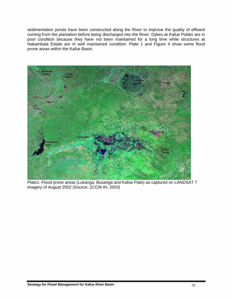
Strategy for Flood Management for Kafue River Basin 19
sedimentation ponds have been constructed along the River to improve the quality of effluent coming from the plantation before being discharged into the River. Dykes at Kafue Polder are in poor condition because they have not been maintained for a long time while structures at Nakambala Estate are in well maintained condition. Plate 1 and Figure 4 show some flood prone areas within the Kafue Basin.
Plate1: Flood prone areas (Lukanga, Busanga and Kafue Flats) as captured on LANDSAT 7 imagery of August 2002 (Source: ZCCM-IH, 2003)

Strategy for Flood Management for Kafue River Basin 20
Figure 4: Location of flood prone areas of the Kafue Basin
Lukanga swamps The Lukanga Swamps constitute one of the major wetlands of the Kafue River System. They are located between latitudes 13.50 to 14.500 south and longitudes 27.150 to 28.100 east, in the central part of the Kafue Basin. It is extensive, covering an area of 2,600 km2 at peak water level and have a shallow average depth of 6.1m. The capacity of the swamp depression between its average low water level and maximum water level is about 7,398 million cubic meters. It is said that the Lukanga falls into the category of a side-stream reservoir for the flood flows of the Kafue River. Considerable losses are observed to occur from the Kafue river flood flows into the Lukanga Swamps. For the wet year of 1978/79, Chilenga gauging station, which is a station just before the Lukanga swamps and has a catchment area of 34,162 km2 had a peak flow of 2,165 MCM while Mswebi which is just after the Lukanga swamps with a catchment area of 50,479 km2 had a peak flow of 1,517 MCM (Figure 5). . The main human activities in the swamp area include fishing, peasant farming (gardening), reed harvesting and straw harvesting. The Lukanga also provides a good habitat for wildlife.
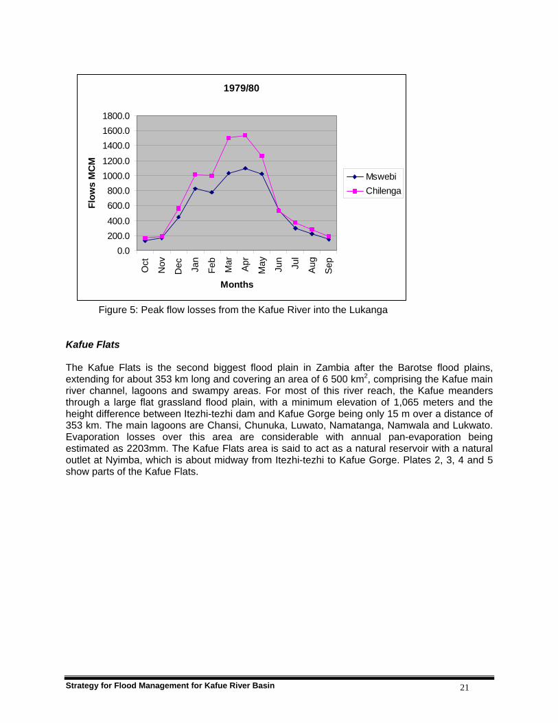
Strategy for Flood Management for Kafue River Basin 21
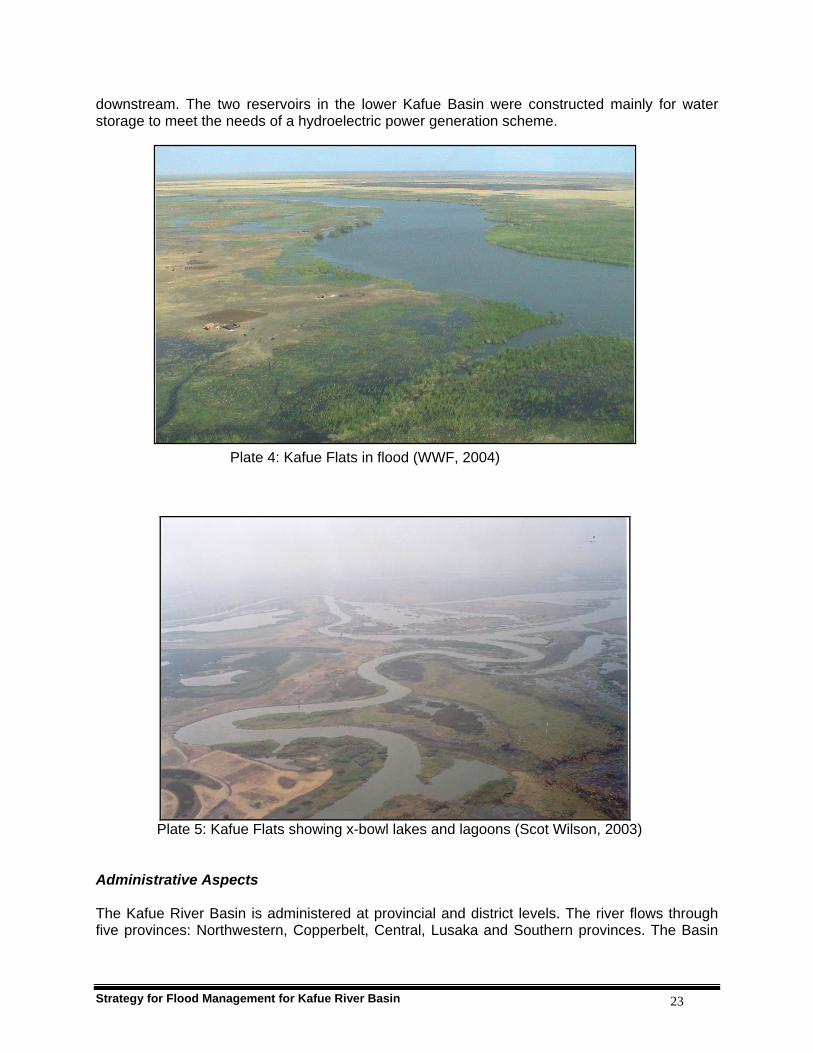
Figure 5: Peak flow losses from the Kafue River into the Lukanga Kafue Flats The Kafue Flats is the second biggest flood plain in Zambia after the Barotse flood plains, extending for about 353 km long and covering an area of 6 500 km2, comprising the Kafue main river channel, lagoons and swampy areas. For most of this river reach, the Kafue meanders through a large flat grassland flood plain, with a minimum elevation of 1,065 meters and the height difference between Itezhi-tezhi dam and Kafue Gorge being only 15 m over a distance of 353 km. The main lagoons are Chansi, Chunuka, Luwato, Namatanga, Namwala and Lukwato. Evaporation losses over this area are considerable with annual pan-evaporation being estimated as 2203mm. The Kafue Flats area is said to act as a natural reservoir with a natural outlet at Nyimba, which is about midway from Itezhi-tezhi to Kafue Gorge. Plates 2, 3, 4 and 5 show parts of the Kafue Flats.
1979/80
0.0200.0400.0
600.0800.0
1000.01200.0
1400.01600.01800.0
Oct
Nov
Dec Ja
n
Feb
Mar
Apr
May Jun
Jul
Aug
Sep
Months
Flow
s M
CM
MswebiChilenga

Strategy for Flood Management for Kafue River Basin 22
Plate 2: Kafue Flats as seen from Chanyanya Fishing Harbour (Photo by Project Team, 2006) Plate 3: Wildlife in the Kafue Flats (Source: WWF, 2004) The Kafue Flats is a very critical sub-basin as it supports some of the key economic activities of the country. These include hydropower generation, tourism, fishing, farming and livestock. It is therefore important that the issues in this sub-basin are critically considered in the strategy. There are three reservoirs in the Lower Kafue Basin: Itezhi-tezhi, which is the main reservoir; Kafue Flats, a natural reservoir with a natural outlet at Nyimba and the Kafue Gorge reservoir
Strategy for Flood Management for Kafue River Basin 23
downstream. The two reservoirs in the lower Kafue Basin were constructed mainly for water storage to meet the needs of a hydroelectric power generation scheme. Plate 4: Kafue Flats in flood (WWF, 2004)
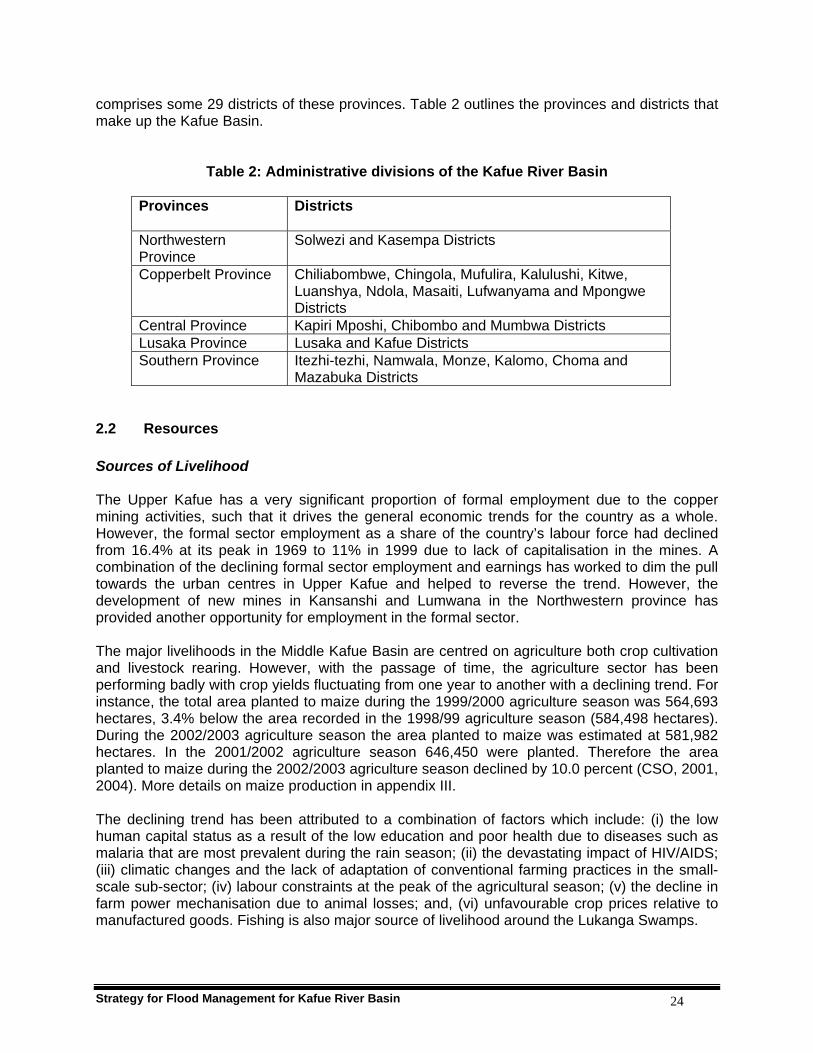
Plate 5: Kafue Flats showing x-bowl lakes and lagoons (Scot Wilson, 2003) Administrative Aspects The Kafue River Basin is administered at provincial and district levels. The river flows through five provinces: Northwestern, Copperbelt, Central, Lusaka and Southern provinces. The Basin
Strategy for Flood Management for Kafue River Basin 24
comprises some 29 districts of these provinces. Table 2 outlines the provinces and districts that make up the Kafue Basin.
Table 2: Administrative divisions of the Kafue River Basin
Provinces Districts
Northwestern Province
Solwezi and Kasempa Districts
Copperbelt Province Chiliabombwe, Chingola, Mufulira, Kalulushi, Kitwe, Luanshya, Ndola, Masaiti, Lufwanyama and Mpongwe Districts
Central Province Kapiri Mposhi, Chibombo and Mumbwa Districts Lusaka Province Lusaka and Kafue Districts Southern Province Itezhi-tezhi, Namwala, Monze, Kalomo, Choma and
Mazabuka Districts 2.2 Resources Sources of Livelihood The Upper Kafue has a very significant proportion of formal employment due to the copper mining activities, such that it drives the general economic trends for the country as a whole. However, the formal sector employment as a share of the country’s labour force had declined from 16.4% at its peak in 1969 to 11% in 1999 due to lack of capitalisation in the mines. A combination of the declining formal sector employment and earnings has worked to dim the pull towards the urban centres in Upper Kafue and helped to reverse the trend. However, the development of new mines in Kansanshi and Lumwana in the Northwestern province has provided another opportunity for employment in the formal sector. The major livelihoods in the Middle Kafue Basin are centred on agriculture both crop cultivation and livestock rearing. However, with the passage of time, the agriculture sector has been performing badly with crop yields fluctuating from one year to another with a declining trend. For instance, the total area planted to maize during the 1999/2000 agriculture season was 564,693 hectares, 3.4% below the area recorded in the 1998/99 agriculture season (584,498 hectares). During the 2002/2003 agriculture season the area planted to maize was estimated at 581,982 hectares. In the 2001/2002 agriculture season 646,450 were planted. Therefore the area planted to maize during the 2002/2003 agriculture season declined by 10.0 percent (CSO, 2001, 2004). More details on maize production in appendix III. The declining trend has been attributed to a combination of factors which include: (i) the low human capital status as a result of the low education and poor health due to diseases such as malaria that are most prevalent during the rain season; (ii) the devastating impact of HIV/AIDS; (iii) climatic changes and the lack of adaptation of conventional farming practices in the small-scale sub-sector; (iv) labour constraints at the peak of the agricultural season; (v) the decline in farm power mechanisation due to animal losses; and, (vi) unfavourable crop prices relative to manufactured goods. Fishing is also major source of livelihood around the Lukanga Swamps.
Strategy for Flood Management for Kafue River Basin 25
Besides agriculture, some communities are engaged in timber production, especially around the Kasempa area which has suitable tree species for sustainable exploitation. Apart from the areas covered by swamps, the potential for timber production exists elsewhere as well. However, the establishment of the Kafue National Park means that a large part of this potential is out of reach for exploitation. Where timber production is taking place, over-exploitation is evident and is threatening this resource. At the same time, there is low productivity by those engaged in timber production resulting in poor returns. Cattle herding has been a very significant part of the livelihood of the people in the Kafue Flats and generally the whole of the Kafue basin. The Kafue Flats have the highest concentration of cattle in the country. At the peak of cattle population in the 1970s, the inhabitants of Namwala district within the basin, the Ila, had 13 heads of cattle for each adult male and were said to be the richest cattle keeping people in Central Africa (Williams, 1984). The Plateau Tonga of Mazabuka and Monze are also cattle keepers. Refer to Appendix III on livestock production. In the Kafue Flats, the cattle economy is linked to flooding which has implications for the grazing of the animals throughout the year (Rennie, 1978). During the flood period, cattle are made to graze near human settlements just outside villages. During May to June when the floods subside, cattle are grazed in the plains following the receding waters. In the dry season, they are taken to some cattle outpost distant from human settlement under the care of herders. Rising incidence of animal diseases and droughts, especially the 1991/92 drought, decimated the cattle population. With the decline in cattle rearing seen above, most people in the Kafue Flats sub-catchment now rely on crop farming. This has been a major change in how the livelihood systems of the sub-catchment operated. Fishing in the Kafue Flats has been an important occupation and is a major element of the local economy alongside cattle rearing and crop farming. It is, however, the main source of protein owing to the fact that cattle keeping communities look at animals as a store of value rather than for consumption purposes. Generally fishing in the Kafue Flats has been conducted by the Twa people. These have been joined by new settlers from areas as far as Luapula, Eastern and Western Provinces. The local people have ventured little into fishing except in recent years owing to the impact of failing agriculture as a viable source of livelihood. It has been observed that fisheries as a source of livelihood, is being threatened by over-fishing and bad fishing practices. In the Kafue Flats there has been a significant increase in the number of fishermen over the years, mainly new settlers from other regions of the country. Although the significance of formal sector jobs in the Kafue Flats sub-catchment is much less compared to the situation in the Upper Kafue, the presence of major industries in some districts make them an important source of people’s livelihoods particularly in Kafue, Mazabuka and Choma towns. However, the industrial failure due to liberalisation of the economy saw major industries operating at very low capacity leading to a rise in joblessness and stagnation of formal sector employment in Kafue and other towns. Refer to Apendix IV for details of economic activities in the Kafue Basin. Water Availability and Requirement The Kafue River is subjected to the heaviest water demand in terms of water rights and water abstraction in the country. About 284 water rights totalling 9,438 MCM/year represent direct water abstraction for domestic, industrial and agricultural abstractions. Zesco (Zambian

Strategy for Flood Management for Kafue River Basin 26
Electricity Utility) holds the biggest water right of 8,360 MCM/year in the lower Kafue Basin. A summary of water abstractions and the water resources available are outlined in Tables 3 and 4 respectively. This is a non-consumptive water right, as it does not take the water out of the system. Water is stored in reservoirs and used to drive the turbines for electric power generation. Extensive groundwater aquifers are found within the basin particularly in the areas of the Copperbelt and Lusaka. Limited exploitation of these aquifers has taken place. Groundwater has been used on a local scale for urban water supply and rural water supply. However, surface water sources have formed the predominant source of supply in the Basin. The poor quality and unreliability of surface resources in some areas makes development of groundwater for water supply a desirable option in the future.
Table 3: Summary of water abstraction data for Kafue catchment
Sub-catchment Number of water users
Purpose Quantity MCM/year
Kafue at Kafironda 7 Domestic / industrial supply 58.81 Kafue at Kafironda 26 Agricultural use 13.71 Mwambashi at Mwambashi
2 Domestic / industrial supply 0.63
Mwambashi at Mwambashi
13 Agricultural use 3.52
Kafue at Wusakile 5 Domestic / industrial supply 78.20 Kafue at Wusakile 24 Agricultural use 14.11 Kafue at Mpatamato 3 Domestic / industrial supply 13.18 Kafue at Mpatamato 35 Agricultural use 9.93 Kafulafuta at Ibenga 1 Domestic supply 0.02 Kafulafuta at Ibenga 5 Agricultural use 2.75 Kafue at Ndubeni 7 Domestic / industrial supply 21.09 Kafue at Ndubeni 103 Agricultural use 172.85 Kafue at Machiya 3 Agricultural use 1.02 Lunga at Chipembele 1 Domestic supply 2.63 Lunga at Chipembele 1 Agricultural use 0.33 Lufupa at Ntemwa Camp 1 Domestic supply 0.32 Itezhi-tezhi 1 Domestic supply 0.73 Kafue Gorge 6 Domestic / industrial supply 117.81 Kafue Gorge 39 Agricultural use 566.77 Total Consumptive abstraction 1,078.41 Itezhi-tezhi and Kafue Gorge
1 Electric power generation (non-consumptive)
8,360.00
Source: Water Development Board, 2003

Strategy for Flood Management for Kafue River Basin 27
Table 4: Summary of Water Resources by Sub-Basin
Sub-Basin Ref. Gauge
Total Catchment
Area [km2]
Incremental Catchment
Area [km2]
Min. AnnualFlow *
1963 - 92 [m3/s]
Average Flow *
1963 - 92 [m3/s]
Upper Kafue 4-280 23,065 23,065 18.5 138 Middle Kafue 4-710 107,191 84,126 85 278 Kafue Flats 4-975 148,265 41,074 96 285 Lower Kafue 4-999 156,995 8,730 101 316
*Cumulative flow including effects of regulation by Itezhi-tezhi (Source: Yachiyo, (NWRMP), 1995) Hydropower development The largest water right holder of 8,360 MCM/year in the Kafue River is ZESCO limited. This is for the purpose of sustaining the Kafue Hydroelectric system. Currently the hydroelectric system comprises: the Itezhi-tezhi reservoir of 6,000 MCM storage at full supply level, the Kafue Gorge reservoir of 900 MCM at full supply level and the 900 MW Kafue Gorge Power Station. The Itezhi-tezhi reservoir is the main water storage reservoir for the system and is located some 250 kilometres upstream of the Kafue Gorge Power Station. The Kafue River has a unique longitudinal profile that provides a drop of 600 meters over a river distance of 20 kilometres in the Kafue gorge area, as can be seen from Figure 6 which shows a comparison between Zambezi River and Kafue River profiles. The existing Kafue Gorge Power Station has utilised 400 meters of this drop for its power generation while the planned Kafue Gorge Lower Power Station will utilise the remaining 200 meters to be able to generate 750 MW of hydropower. Planned also is the construction of a 120MW power station at Itezhi-tezhi. This gives the Kafue River a hydropower potential of over 1,700 MW. The Kafue River Basin is therefore a key river basin in meeting the electricity needs of Zambia. Refer to Appendix V for details of the Kafue Hydroelectric system.

Strategy for Flood Management for Kafue River Basin 28
Figure 6: Longitudinal profile of Kafue and Zambezi Rivers (Source: Yachiyo, 1995)
Strategy for Flood Management for Kafue River Basin 29
2.3 Flood Situation in the Basin Numerous examples in Zambia demonstrate that floods are among the most damaging natural disasters. Flood damage ranges from loss of lives to widespread crop destruction and other economic activities. Many parts of Zambia are subjected to floods, one example being the Kafue Flats in the Kafue Basin. Historical record of floods The Kafue Flats in the Kafue Basin is a good example of an area in Zambia which is subjected to flooding. The year 1994 saw severe floods in the Flats when fishing camps and some settlements along the river were inundated resulting in displacing the people. Mud brick houses especially those in the plain collapsed; two bridges in the Kafue Flats were washed away cutting off Monze and Namwala towns from the rest of the country. Flood relief and other requisites had to be flown in by helicopters. All the pontoons on the river were rendered useless due to torrential currents. Other past floods in the Kafue Flats include those of 1977/78 and 1988/89. The effects of the 1994 floods were compounded by the fact that Zambia had not yet recovered from the impact of the preceding 1991/92 drought. This drought was considered to be the worst in recent years in terms of Kafue River flows. A record low mean annual flow of 83 cumecs was reported at Kafue Hook Bridge which has a long term annual mean of 297 cumecs (1973 – 2005). The daily flows which went as low as 8 cumecs at Kafue Hook bridge drew most fishing camps, grazing grounds and gardens into the normally flood areas because even the earlier years, namely 1989/90 and 1990/91, had flows below average. A marked example of urban flooding is the year 1988/89 when more than 50, 000 people in the Kafue Basin towns of Kitwe, Ndola, Kapiri Mposhi, Kabwe, Lusaka and Mazabuka were left homeless. Though most of the damaged homes were from shanty compounds a number of houses in wealthy suburbs were also damaged. People had to be shifted to makeshift camps made by Government and Red Cross Society. One of the wealthy townships in Lusaka was completely cut off when the access tarred road caved in after two weeks of continuous heavy rains. Urban flooding was also experienced in 1977/78, 1992/93, 2000/01 and 2005/06. Recent floods Some recent floods in the Basin have been associated with some parts of towns and population centres located near dambos and swampy areas. These include Makululu in Kabwe, Kanyama and Chawama in Lusaka. Even some well built up areas of Lusaka and Kabwe which are located in low lying zones but not properly drained are prone to flooding; these are Emmasdale and Avondale and Mine Compound respectively. Urban flooding has been experienced each year when the Basin has received normal to above normal rainfall. These floods can be said to be human induced due to various factors that include poor urban planning, non provision of adequate storm drainage system and poor designs and quality of housing units and other infrastructure. The most recent floods in the Basin are the wide spread floods associated with flashy floods which occurred in various places in the 2005/2006 rainy season. The flashy floods that affected the Kafue Gorge Power Station in December 2005 rank highly in terms of extent of damage, which disrupted power generation for a period of two weeks. Wide spread flooding was also reported in months of February and March 2006 which affected housing units and agricultural fields in the Southern Province towns of Mazabuka, Monze and Choma.
Strategy for Flood Management for Kafue River Basin 30
Impact of Floods Human and property losses: The main factors that lead to incidents of loss of life in the Kafue Basin are: high floods, waterborne diseases, flood related plagues and human encounters with wildlife such as crocodiles and hippos. Despite inadequate documentation on these events, media reported that during the 1978 floods, 771 houses collapsed in Lusaka leaving 4,040 people homeless and 6 people dead (Times of Zambia, 8th February 1978). The affected areas were Kanyama, Misisi and John Laing. In the flood prone areas, the general population is vulnerable to diseases associated with floods such as cholera, dysentery, malaria and bubonic plague. Cholera and dysentery occurrences are high during the flood periods due to poor sanitation and most affected areas include: Copperbelt towns, Kabwe, Lukanga swamps, Lusaka, and recently Mazabuka town. Malaria prevalence is quite high throughout the Basin during the flood periods due to stagnation and poor drainage of water. Namwala district has had a major incidence of bubonic plague due to rats that moved from the flooded areas to the residential areas during peak floods. Heavy floods sometimes destroy economic infrastructure such as roads and bridges. This results in disruption of movement of goods and services to the affected areas. The high disease incidences associated with floods also disrupt economic and developmental activities. Environmental impact: The flooding incidences especially in poorly planned urban residential areas with poor sanitation and water supply has been observed to cause increase in coli form count levels in groundwater resource leading to high incidences of water borne diseases. For the flood plain of the Kafue Basin, flooding is an environmental requirement for sustenance of the various components of the ecosystem. This includes the provision of silt for soils, pastures for wildlife and livestock, fish breeding grounds and maintaining biodiversity. However, there has been growing concern about the increased economic activities in the Kafue Flats leading to water demand conflicts among various users. The construction of Itezhi-tezhi dam on the upstream of the flood plain and Kafue Gorge dam on the downstream and their subsequent operation has changed the flow regime of the river and therefore impacting on the environment in the Kafue Flats. These growing concerns have attracted a lot of studies of Kafue Flats area though few have studied environmental flows in the Kafue Flats. Hydropower Development Studies of Kafue Basin by SWECO of Sweden in the late 1970s recommended a minimum discharge from Itezhi-tezhi of 55 cumecs throughout the year with a minimum of 300 cumecs during the month of March. The recent study by DHV Consultants of Netherlands have not recommended any minimum flow but recommends that flooding using Itezhi-tezhi dam should start earlier than the month of March to better imitate the timing of the natural floods. It also recommends increasing the flood recession area in the dry season by reducing outflow from ITT dam and allowing the Kafue Gorge dam level to go lower. More information has been included in Appendix V. For further details, refer to Integrated Kafue River Basin Environmental Impact Assessment Study - STRATEGIC ENVIRONMENTAL IMPACT ASSESSMENT. Impact on economic sector: Flooding submerges crop land which leads to crop damage in various ways. Crops are sometimes washed away by fast flowing flood waters. Tuber crops such as potatoes and cassava end up rotting. Even rice, which is water tolerant, may be destroyed if it is submerged for more than one week. Flooding destroys grazing land, reduces grazing areas and forces livestock to move to higher grounds. This sometimes results in higher concentrations or overcrowding of cattle in the few available grazing areas. This creates opportunities for cross infection of diseases. Cross infection may occur not only among cattle

Strategy for Flood Management for Kafue River Basin 31
but also between cattle and wildlife as cattle compete with wildlife in the small grazing areas. Flooding may force animals to overgraze the available grazing land. Floods may create mud and weak animals cannot move freely. This may lead to higher mortality rate for weak and young animals. In the Kafue Flats, the cattle economy is linked to flooding which has positive impact of provision of sufficient grazing grounds through out the year. The herding of cattle therefore follows the pattern of flooding and recession of flood waters. The flooding and recession of floods also allow the local people to practice recession agriculture allowing them to grow more than one crop in a year due to availability of residue soil moisture. However floods can be quite destructive to agricultural activities. The negative impacts of floods in the Kafue Basin include: flooding of premature crops and flooding of grazing grounds. These two impacts are mainly enhanced by the reservoir water regulation that causes what is known as “dry season flooding”. For more details of impact of floods on agriculture, refer to appendix VI The damage to infrastructure has major financial impact. For instance the Kafue Gorge flashy floods disaster was estimated to have cost over US$ 2,000,000.00 both in terms of loss of generation and cost of remedial measures. The details of the impact s outlined in Appendix VII. 2.4 Rural and Urban Development and Future Plans There are significant agro-based and other industries in the Kafue Basin. The major economic activities in the upper part of the Basin are copper mining, manufacturing and large commercial agriculture by Mpongwe Development Company (4,200ha). The middle and lower parts of the Basin have major agricultural projects such as Nakambala Sugar Estate, Kafue Sugar Estate and Nanga Farms. These have a combined land area of approximately 25,000ha. There are two major sugar refineries, a fertilizer factory, a textile factory, boat manufacturing and a tannery. While creating employment, these industries pose a big challenge of pollution in the Basin. These developments need to be monitored carefully for both economic and environmental sustainability. There is a marked distinction between rural and urban development due to both socio-economic and demographic factors. Table 5 gives population distribution for all sub-catchments in the Kafue Basin.

Strategy for Flood Management for Kafue River Basin 32
Table 5: Population in the Kafue river basin, 1990
Source: Yachiyo, NWRMP, Volume 1, 1995. The economy in rural areas in the basin as in all rural parts of Zambia is dominated by agricultural production, mostly small scale subsistence farming of traditional crops. Farmers are also engaged in cash crops with maize as the dominant crop. This is particularly the case in the Middle Kafue and the Kafue Flats. However, the significance of agriculture has been on the rise in the Upper Kafue as mining has been declining. In most rural areas, crop production is practised alongside livestock production, particularly cattle rearing. This is mainly the case in the Kafue Flats sub-catchment which has the highest concentration of cattle in the country.
With respect to infrastructure development, there is a very big variety within the basin, a stark difference between urban and rural districts. Most of the urban districts’ populations claimed a distance of less than 1 kilometre to a tarred road in 1996. This is in contrast to the distances for Kasempa and Namwala of 89 kilometres and 74 kilometres respectively. Between these two ranges, there was great variability from one district to another. Urban districts have a much better access in terms of distance to primary and secondary schools and health centres. A critical situation exists in Monze and Kasempa Districts where in 1996 people had to walk a distance of 35 and 16 kilometres respectively to get to the nearest clinic (Scott Wilson, 2003).
Rural districts also lag behind in terms of access to electricity. Therefore, only 8% of the population in Namwala that borders Itezhi-tezhi, and which has felt the full ecological and social impact of building the dam, had access in 1996 to electricity for lighting. Compare this with the 65% who had access to electricity for lighting in Chililabombwe. All urban districts had more than 44% of their population accessing electricity for lighting (Central Statistical Office, 2000).
Area Total Urban Rural Kafue basin 2,864,334 1,801,410 1,062,924 Upper Kafue 34,813 1,795 33,018 Mwambashi 13,389 0 13,389 Mufulira 392,094 325,125 66,969 Smith’s bridge to Mpatamatu 486,089 423,095 62,994 Kafulafuta and Lufwanyama 485,175 362,622 122,553 Machiya Ferry to Confluence 7,322 0 7,322 Upper Kafue - Total 1,418,882 1,112,637 306,245 Confluence to Chilenga 3,568 0 3,568 Luswishi 13,145 0 13,145 Lukanga swamp 89,495 13,790 75,705 Upper Lungu 82,448 26,223 56,225 Lower Lungu 0 0 0 Lufupa and others 21,566 4,151 17,415 Itezhi-tezhi reservoir 2,778 0 2,778 Middle Kafue - Total 213,000 44,164 168,836 Kafue Flats 1,211,319 641,796 569,523 Lower Kafue 21,133 2,813 18,320 Total - Zambia 7,383,097 2,905,283 4,477,814

Strategy for Flood Management for Kafue River Basin 33
Substantial hydroelectric potential in the Kafue River Basin still remains unexploited. Electricity would stimulate development in the flood plains by providing a tool for enhancing new and existing developmental activities. Hydropower would provide relatively affordable electricity for irrigation and industry. Discussions with the District Development Coordinating Committee (DDCC) in Namwala revealed that the local people in the plains feel that there should be a deliberate policy by the Government to electrify all villages in the plains. It is felt that the local communities are the ones sacrificing their habitat change for electricity power generation. Industry mostly related to pastoral farming and fishing need to be encouraged as this is closer to the livelihoods of the local people and will therefore be easily appreciated. Some industries that need to be considered are abattoirs, fish cannery, livestock laboratories, tannery, glue and boat making. For these industries to prosper, the road network needs to be improved.
Strategy for Flood Management for Kafue River Basin 34
PART II
STRATEGY FOR FLOOD MANAGEMENT

Strategy for Flood Management for Kafue River Basin 35
3. RATIONALE FOR A STRATEGY Flood and drought occurrences are natural phenomena but can also be induced or influenced by human activities. The flood/drought events, depending on their magnitude, may result in disasters. Disasters are events that are associated with the impacts of human-induced or natural hazards which cause serious disruption in the functioning of a group of people or society causing widespread human, material or environmental losses that exceed the ability of the affected people to cope using only their own resources (DMMU, 2005). Strategies for disaster management for the country therefore not only directly deal with the hazards associated with a particular disaster, but also has strong links with national social, economic and other development policies. Disaster prevention and mitigation due to floods is therefore a multidisciplinary endeavour wherein development activities in different sectors of the economy help in the prevention of the disasters and reduce the vulnerability of the society (APFM, 2004). It is against this background that this Strategy is developed for flood management in the Kafue Basin of Zambia.
3.1 Vulnerability of People to Floods Vulnerability is the characteristic that describes the capacity of a person, community or society to anticipate, cope with, resist and recover from the impact of a natural or human induced hazard. It involves a combination of factors that determine the extent to which people’s lives and their livelihoods have been put at risk by the hazardous event (DMMU, 2005). It is the vulnerability of the community at risk that determines the extent of the flood disasters. Hence it is imperative to determine the vulnerability of the group of people, analyzing the causative effects so that conditions that put them at risk could collectively be changed. The major causes of vulnerability of people to floods are many, complex and interrelated. They include, but not limited to, exposure to floods and degree of protection from flood hazards, quality of buildings and infrastructure available, degree of access to resources, information and knowledge, lack of access to political power and representation, and capacity to avoid, withstand or recover from the flood hazards. Socio-economic factors like acute poverty and high population densities; disintegration of extended families making the weaker families stranded; lack of education and public awareness; poor land use planning and environmental degradation; limited economic and food diversification; and low, slow or lack of adaptation of appropriate farm technological options to cope with the situation increases the vulnerability of the population to floods. Occupation also plays a role, for example, fishermen whose occupation requires them to live close to rivers and other water bodies, are more at risk than others and are therefore more vulnerable. Recession agriculture in the flood plains also requires people to live close or in the plains to grow crops using moisture as the floods recede; very minimal irrigation water is applied. Crops such as maize, potatoes, pumpkins and vegetables do well with this type of farming, this cropping system is more vulnerable to flood destruction. Inadequate medical services and absence of social welfare coupled with weak institutional structures to manage flood emergencies have also increased vulnerability. 3.2 Factors Contributing to Increasing Flood Risks There are three broad categories of disasters caused by flooding that have afflicted the people of the Kafue River Basin (DMMU, 2005). These are natural floods, human induced floods and

Strategy for Flood Management for Kafue River Basin 36
complex humanitarian emergencies (such as outbreak of diseases that are flood related). Natural floods in the Basin, like in most cases worldwide are caused by heavy rainfall interacting with hill slopes. Because of intensive livestock grazing especially in the Choma, Monze and Namwala areas, hill slopes with scanty vegetative cover give the floods the characteristics of flash floods in the vicinity of foothills and produce substantial amount of sediments and debris. Adverse effects include washing away of bridges, roads, buildings and other infrastructure. Human induced floods are related to hydropower dam operations at Itezhi-tezhi and Kafue Gorge reservoirs, increased agricultural and livestock rearing activities on the surrounding highlands and the flood plains, rapid urbanization, lack of maintenance of storm drains and absence of drainage systems in built-up areas and other economic activities such as sand mining on tributaries of the Kafue River and deforestation. Complex humanitarian emergencies due to floods happened in the mid 1990s when outbreaks of bubonic plaque and foot and mouth disease attacked the people and cattle respectively in Namwala and many lost lives. Excessive wet conditions caused an influx of rats to spread bubonic plaque. Factors contributing to increased flood disasters in the Kafue Basin could be both natural and anthropogenic, summarized as follows:
1. Intensive economic use of the flood plains for fishing, agriculture and livestock farming.
2. Seasonal release of water at Itezhi-tezhi Dam and storage at Kafue Gorge Dam: The national hydropower generation company, Zesco Limited, releases water from the Itezhi-tezhi dam seasonally to create room for flood inflow in the middle of the rainy season. On the other hand the Kafue Gorge Dam storage sustains a high water level for much of the year for power generation (See Appendix V). Both these factors cause flooding in the Kafue Flats. The people mostly affected are fishermen living by the river banks and herdsmen who graze their cattle in the flood plain.
3. Environmental degradation of watersheds caused by uncontrolled and unregulated
human activity, especially large-scale deforestation (See Appendix VIII) due to overgrazing, charcoal production and poor cultivation practices, resulting in increase in flood peaks and frequencies, reduced flood carrying capacity of the rivers due to excessive siltation of their beds, shifting of river courses causing erosion of the banks and formation of lagoons in the flood plains, land slides in the upper and middle catchment areas causing mass erosion and subsequent siltation of river channels, and outbreaks of diseases such as cholera, bubonic plaque, dysentery and animal infections such as foot-and-mouth and other tick-borne diseases.
4. Prolonged period of dry years from the 1980s to 1990s led to people to encroach in flood
prone areas both in terms of settlements and agricultural activities. 3.3 Flooding Incidences in the Kafue Basin Flood analysis studies in the Kafue Basin have concentrated mainly on the Kafue Flats area which is the largest flood prone area of the Basin. In the Scott Wilson, 2004 study, the Kafue Flats has been classified as a highly sensitive environment which requires major flood management interventions for sustainability. The construction of Kafue Gorge Upper Dam in 1972 and Itezhi-tezhi Dam in 1978 altered the flow regime and extent of flooding within the Kafue Flats. Operation of Itezhi-tezhi reservoir has reduced the inflow to the Kafue Flats during the wet season but increased flow during the dry season (See Appendix V). As a result of flow regulation, a number of hydrological changes have taken place in the Kafue Flats. There is now
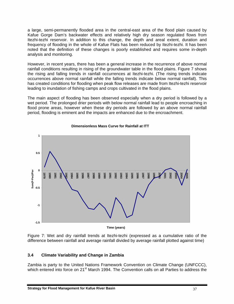
Strategy for Flood Management for Kafue River Basin 37
a large, semi-permanently flooded area in the central-east area of the flood plain caused by Kafue Gorge Dam’s backwater effects and relatively high dry season regulated flows from Itezhi-tezhi reservoir. In addition to this change, the depth and areal extent, duration and frequency of flooding in the whole of Kafue Flats has been reduced by Itezhi-tezhi. It has been noted that the definition of these changes is poorly established and requires some in-depth analysis and monitoring. However, in recent years, there has been a general increase in the recurrence of above normal rainfall conditions resulting in rising of the groundwater table in the flood plains. Figure 7 shows the rising and falling trends in rainfall occurrences at Itezhi-tezhi. (The rising trends indicate occurrences above normal rainfall while the falling trends indicate below normal rainfall). This has created conditions for flooding when peak flow releases are made from Itezhi-tezhi reservoir leading to inundation of fishing camps and crops cultivated in the flood plains. The main aspect of flooding has been observed especially when a dry period is followed by a wet period. The prolonged drier periods with below normal rainfall lead to people encroaching in flood prone areas, however when these dry periods are followed by an above normal rainfall period, flooding is eminent and the impacts are enhanced due to the encroachment.
Dimensionless Mass Curve for Rainfall at ITT
-1.5
-1
-0.5
0
0.5
1
1979
1980
1981
1982
1983
1984
1985
1986
1987
1988
1989
1990
1991
1992
1993
1994
1995
1996
1997
1998
1999
2000
2001
2002
2003
2004
2005
Time (years)
Sum
(P-P
av)/P
av
Figure 7: Wet and dry rainfall trends at Itezhi-tezhi (expressed as a cumulative ratio of the difference between rainfall and average rainfall divided by average rainfall plotted against time) 3.4 Climate Variability and Change in Zambia Zambia is party to the United Nations Framework Convention on Climate Change (UNFCCC), which entered into force on 21st March 1994. The Convention calls on all Parties to address the

Strategy for Flood Management for Kafue River Basin 38
issue of greenhouse gas emission inventories and develop appropriate adaptation measures. Specifically, Article 4 of the UNFCCC calls upon all Parties to prepare national communications that describe inventories of greenhouse gas emissions, mitigation and adaptation to climate change. To date, Zambia has completed the following studies (ECZ, 2000): Greenhouse Gas Inventories; Vulnerability and Adaptation Studies; and Mitigation Studies. Zambia has also completed its initial communication. It has also signed and ratified the Kyoto Protocol on regulation of carbon emissions. Studies have also shown that Zambia has experienced climate variability and change notably since the early 1970s through a modest warming in the cool season mean minimum temperature and a considerable warming of the mean maximum temperature during the hot season (ECZ, 2000). This is the case especially over the northern half of Zambia, which is upstream and has the highest density of water sources. The increase in mean temperature may have serious implications on water availability for domestic, agricultural and industrial use as a result of insufficient recharging of surface and ground water resources due to increased evaporation. With the scarcity of water, people have tended to settle in flood prone areas of the plains in order to be closer to the river course. However, it has been observed that these dry cycles are followed by wet cycles as can be seen in Figure 7, which lead to increased flood disasters. For further information on climate change in Zambia, refer to State of Environment in Zambia 2000 (Chapter 13) – a report compiled by Environmental Council of Zambia. 4. STRATEGY FORMULATION PROCESS 4.1 Steering Committee A Steering Committee consisting of representatives from i) Ministry of Energy and Water Development, ii) Ministry of Tourism, Environment and Natural Resources, iii) Ministry of Local Government and Housing, iv) Ministry of Finance and National Planning, v) Ministry of Lands, vi) Ministry of Agriculture and Cooperatives, vii) Zambia Meteorological Department, viii) Disaster Management and Mitigation Unit in the Office of the Vice-President, ix) Environmental Council of Zambia, x) Worldwide Wildlife Fund (WWF) Zambia, xi) Zesco Limited and xii) Kafue District Council in the Kafue Basin was constituted to oversee the process of developing the Strategy. The Steering Committee was supported by the Project Team. The Steering Committee held two meetings in which they guided the development of the IFM Strategy. The Steering Committee reviewed the drafts of the Strategy and ensured its finalization. 4.2 The World Meteorological Organization The WMO Hydrology and Water Resources Department gave backstopping to the Strategy formulation process by providing overall guidance and the necessary technical input. The Department reviewed the drafts of the Strategy and made comments. Staff of the Department also made contributions at both the Stakeholders’ and Policy Makers’ workshops. 4.3 Stakeholders Contribution and Involvement in the Strategy Development In recent years Zambia has adopted a combination of bottom–up and top-down approaches in formulating her national development plans. There has been a shift from centralized planning

Strategy for Flood Management for Kafue River Basin 39
associated with the single party-government dispensation. This approach was used in formulating the Poverty Reduction Strategy Paper (2002-2004), the Transitional National Development Plan (2003-2005) and the Fifth National Development Plan. Essentially extensive consultations were held with all sectors of the population and organizations to get people’s views and input in these documents. A similar process was followed to develop this Flood Management Strategy. After desk studies of flood issues through governmental reports and documents, newspaper articles and journals, the flood and other development issues were discussed with key stakeholders to assess how they viewed the issues of development and flood management. Visits in the flood plains of Kafue were undertaken to hold meetings and interviews with villagers, local authorities and interest community based groups to get their views on how best the Strategy could be formulated to benefit affected communities. In the consultative meeting held at Namwala with the District Development Coordination Committee and interviews held at Maala and Chanyanya Fishing Camp with Chief Mungaila of the Ila people and Headman Samson Molomoka respectively between the 9th and 11th June, 2006, causes of flooding in the Kafue flats were identified as both natural and human induced. It was indicated that the operations of the Itezhi–tezhi Dam upstream the Kafue Flats sometimes causes sudden floods that lead to loss of crops and property. The two types of floods call for different approaches for their management. For instance, crops grown in the plains are usually harvested before the annual and natural floods and the fishermen in low-lying fish camps evacuate to high grounds on the main land; only those living on islands that are not inundated remain behind. The main complaint, as learnt from these interactions, was that in recent years people were not given enough notice by the dam operator when the flood gates were to be opened at Itezhi-tezhi Dam. Though radio announcements and messages by word of mouth are made, these have not been effective to reach fishing camps that are remote. This inconveniences the fishermen. Because of this, it was unanimously pointed out that government should intervene by improving communication in the affected areas to ensure that all receive early warning messages to act in good time. The Kafue flood plains have good fertile soils with high potential for agriculture, livestock and fisheries. The middle reaches of the river upstream of Itezhi-tezhi Dam host the Kafue National Park and are more productive for agriculture, fisheries in the Lukanga Swamps and mining. In recent years, commercial farming, tourism and game management have become major activities. The upper catchment of the Kafue has copper mining and related industries as the main preoccupations. The participants of the Stakeholders’ workshop, therefore, felt that by developing these economic ventures, the vulnerability of those living in areas prone to flood hazard could be reduced, which could also help long-term prosperity in the region. A detailed Stakeholders’ Workshop report is attached in Annex II. 4.4 Policy Makers’ Contribution and Involvement in the Development Process The Strategy development process was designed to take into account the full participation of key stakeholders and policy makers which included Government Ministries and Departments, local authorities, parastatal organizations, academicians and researchers, non-governmental organizations(NGOs), and farmers’ and fishing associations in the flood prone areas. At the apex of stakeholder consultation was the presentation of the draft Strategy to Policy Makers who were mainly Permanent Secretaries of line Ministries and their directors. The Policy Makers Workshop was held at Chaminuka Lodge in Lusaka on 8th September 2006. The

Strategy for Flood Management for Kafue River Basin 40
Workshop was officiated by the Permanent Secretary of the Ministry of Energy and Water Development. In attendance were Permanent Secretaries from the Ministries of Tourism, Environment and Natural Resources; Transport and Communication; and Local Government and Housing. The other line Ministries and institutions were represented by directors and senior officials. The report of the Policy Makers’ Workshop is presented in Annex III. The main objective of the workshop was to seek approval by the Policy Makers on the draft Flood Management Strategy for Kafue River Basin. This was successfully achieved. The following key conclusions and recommendations were made during the Workshop:
• All line Ministries are important partners to ensure implementation of the strategy recommendations.
• The Strategy policy measures should be integrated and harmonized with all relevant
national policies and pieces of legislation.
• A Flood Management Strategy Steering Committee should be formed at Permanent Secretary level to facilitate effective coordination among the line Ministries.
• The Flood Management Strategy Steering Committee should meet once or twice a year
in order to review progress on implementation of the various recommendations and to review budget allocations for line Ministries to ensure the recommended activities are well funded.
5. COMPONENTS OF THE STRATEGY The Strategy presents 16 components under the six thematic areas. These are: reducing vulnerability; reorientation of approach to development and floods; integrated approach to water resources development and flood management; protecting and conserving environment; addressing weather and climate variability and change; and coordination between various ministries and agencies. Summary of the Strategy components are outlined in Table 6.
Table 6: Summary of Strategy components No. Thematic Area Strategy Components
Vulnerability reduction of the flood plain communities should be addressed through appropriate policies in different sectors Implementation of the National Agricultural Policy should be pursued to exploit the full potential of the fertile flood plains The Ministry of Agriculture and Cooperatives should develop, support and encourage flood resistant crops and cropping patterns that would help income growth in flood prone areas
1
Reducing Vulnerability
The Ministry of Lands together with Ministry of Local Government and Housing should prepare and implement plans for integrated development of nearby urban areas
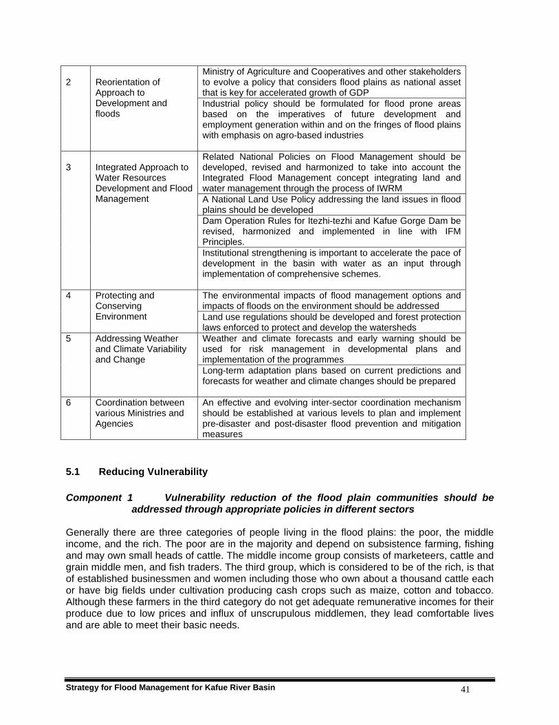
Strategy for Flood Management for Kafue River Basin 41
Ministry of Agriculture and Cooperatives and other stakeholders to evolve a policy that considers flood plains as national asset that is key for accelerated growth of GDP
2
Reorientation of Approach to Development and floods
Industrial policy should be formulated for flood prone areas based on the imperatives of future development and employment generation within and on the fringes of flood plains with emphasis on agro-based industries Related National Policies on Flood Management should be developed, revised and harmonized to take into account the Integrated Flood Management concept integrating land and water management through the process of IWRM A National Land Use Policy addressing the land issues in flood plains should be developed Dam Operation Rules for Itezhi-tezhi and Kafue Gorge Dam be revised, harmonized and implemented in line with IFM Principles.
3
Integrated Approach to Water Resources Development and Flood Management
Institutional strengthening is important to accelerate the pace of development in the basin with water as an input through implementation of comprehensive schemes. The environmental impacts of flood management options and impacts of floods on the environment should be addressed
4 Protecting and Conserving Environment Land use regulations should be developed and forest protection
laws enforced to protect and develop the watersheds Weather and climate forecasts and early warning should be used for risk management in developmental plans and implementation of the programmes
5 Addressing Weather and Climate Variability and Change
Long-term adaptation plans based on current predictions and forecasts for weather and climate changes should be prepared
6 Coordination between various Ministries and Agencies
An effective and evolving inter-sector coordination mechanism should be established at various levels to plan and implement pre-disaster and post-disaster flood prevention and mitigation measures
5.1 Reducing Vulnerability Component 1 Vulnerability reduction of the flood plain communities should be
addressed through appropriate policies in different sectors Generally there are three categories of people living in the flood plains: the poor, the middle income, and the rich. The poor are in the majority and depend on subsistence farming, fishing and may own small heads of cattle. The middle income group consists of marketeers, cattle and grain middle men, and fish traders. The third group, which is considered to be of the rich, is that of established businessmen and women including those who own about a thousand cattle each or have big fields under cultivation producing cash crops such as maize, cotton and tobacco. Although these farmers in the third category do not get adequate remunerative incomes for their produce due to low prices and influx of unscrupulous middlemen, they lead comfortable lives and are able to meet their basic needs.

Strategy for Flood Management for Kafue River Basin 42
The most vulnerable people in the flood plains are fishermen, subsistence farmers and school going children. The poor are the most affected by floods since they depend either on fishing or subsistence farming for their livelihoods. The general population around the flood plains is also vulnerable to diseases associated with floods such as cholera, dysentery, malaria and bubonic plague. Most of the people living in the flood plains are poor due to small land holdings and low yields due to poor quality of agricultural inputs and crop husbandry. The farmers experience difficulties to access market for their produce and the support provided by the Food Reserve Agency (FRA) is often inadequate. The mandate of FRA is limited to purchasing maize and other crops for strategic food reserve and not all the crops harvested, leaving the remainder of the crops to either go to waste or to be sold at unprofitable prices. Their vulnerability to floods is further compounded by poor physical and social infrastructure; human-wildlife conflict; lack of awareness about health and hygiene; and incidence of HIV/AIDS. Steps should therefore be taken through appropriate policy instruments and through coordination mechanisms to reduce vulnerability of the flood plain communities by improving their resource base and incomes. Current programmes by Government and nongovernmental organizations aimed at reducing vulnerability of the flood plain communities and improving their resource base and incomes should be encouraged and supported. Raising the standards of living of all the people through various socio-economic development initiatives such as improved education and health, easy access to resources and income generation would culminate into taking effective mitigation measures against floods and their effects. A reduction in vulnerability has a corresponding effect on reducing the adverse impacts of floods. Component 2 Implementation of the National Agricultural Policy should be pursued to
exploit the full potential of the fertile flood plains. Agriculture is the mainstay of the income generation for majority of population in flood plains. In Namwala District, for instance, cattle rearing is the most important livelihood followed by crop production and fishing. The vision of the agricultural sector as explained in the National Agriculture Policy (NAP, 2004-2015) is “to promote development of an efficient, competitive and sustainable agricultural sector, which assures food security and increased income.” In order to empower the farming communities some of the relevant strategies that should be pursued include:
a) Diversification of agricultural production and utilization;
b) Promotion of sustainable and environmentally sound agricultural practices;
c) Prevention and control of pests, crop and livestock diseases of national economic importance;
d) Promotion of conservation of fisheries resources;
e) Strengthening emergency preparedness through early warning and timely and efficient crop forecasting;
f) Promotion of irrigation development;
g) Maintaining agro-biodiversity and promoting conservation of riverine ecosystem and sustainable utilization of natural resources;

Strategy for Flood Management for Kafue River Basin 43
h) Promoting and strengthening Cooperatives and Farmer Organizations as a vehicle for agricultural development;
i) Facilitating availability of and accessibility to land for agriculture and development of infrastructure in potentially productive agricultural areas.
Component 3 The Ministry of Agriculture and Cooperatives should develop, support
and encourage flood resistant crops and cropping patterns that would help income growth in flood prone areas.
The National Agricultural Policy (NAP) has provision for the issues and problems related to crop production in areas prone to floods and droughts. For instance the NAP recognizes that the soils in the flood plains consists of loamy to clayey soils and are therefore fairly fertile for crop and pasture production. Early maturing crops such as vegetables and winter maize; and flood resistant crops like cane sugar, bananas and palms should be encouraged. These offer alternative livelihood options to enhance income generation for the local communities. The Policy encourages diversification of agricultural production and utilization. The Kafue Flats are suitable for livestock farming and fishing. The abundant water resources should also be utilized for irrigated crop production by small-scale as well as commercial farmers to ensure food security and income generation. The Namwala Farmers Association is implementing some small scale irrigation initiatives using treadle pumps to grow vegetables for sale. The Zambia Prison Services in Namwala is also producing winter maize and vegetables under irrigation. These initiatives should be strengthened so that more people benefit. The Irrigation Policy also encourages the development of common infrastructure that brings bulk irrigation water supplies within reach of farmers. This could involve the construction of dams, pipelines and canal systems for water storage and distribution. The livestock herds in the Kafue Flats and other drought and flood prone areas are benefiting from the national disease control programme in line with the national strategy to prevent and control pests, crop and livestock diseases of national economic importance. There is however, a problem of lack of scientific information on the soils of the districts in general and the flood plains in particular. In the absence of this information, it is feared that utilizing large areas for agricultural production may lead to increase in soil erosion and consequent sedimentation of the Kafue River. Therefore, soil and land capability studies of the Kafue Basin should be undertaken to determine land types and potential uses. This will in turn facilitate proper planning and sustainable utilization of this valuable land resource. In view of the entrenched attitudes and traditions, a serious education for behaviour and attitude change should also be undertaken. It should be noted that although flood plains offer good possibilities for agricultural production, flood incidents have had destructive effects to crops in areas along the plains. The flood plains are habitat for wild animals such as hippos, which are potential pests that could retard agricultural production in the plains. Therefore an IFM strategy will go a long way in ensuring that all these conflicting issues are carefully considered. Component 4 The Ministry of Lands together with Ministry of Local Government and
Housing should prepare and implement plans for integrated development of nearby urban areas.
Strategy for Flood Management for Kafue River Basin 44
The rural communities in the customary and peri-urban areas of Kafue Basin faces stiff competition from the urbanites who are seeking smallholdings close to towns, thereby leading to loss of land to the new settlers. In the Kafue Flats, for instance, the development of large commercial farming has created conflicts between the commercial farming companies and traditional farmers. There is need therefore for a systematic planning of these areas to avoid undesirable community displacements and potential conflicts. These community displacements are likely to lead to increased rural-urban migration. One way of avoiding this is to plan and create new economic centres whereby commercial farmers could be located among small scale and medium farmers growing cash crops that easily find a ready market with commercial farmers. The commercial farmers would be providers of extension services and inputs to the small scale farmers. Therefore the commercial farmers would form focal points for agricultural development. Markets, clinics and schools would be established at such points. This could be possible if farming blocks are planned in the way that encourages commercial and small scale farmers coexist. The towns near the flood plain areas can facilitate development in flood plains by: creation of markets and cold chains for agricultural and livestock produce; agricultural processing industries; and fish production, storage and processing industries. This is a necessary condition for increasing productivity and incomes in flood plain areas. 5.2 Reorientation of Approach to Development and Floods Component 5 Ministry of Agriculture and Cooperatives and other stakeholders to
evolve a policy that considers flood plains as national asset that is key for accelerated growth of GDP.
Flood plains have great potential for socio-economic development that awaits to be tapped. Flood plains offer enormous advantages by making available the fertile alluvial soils which are ideal for high value crops, livestock farming and other economic activities. Flood plains are also a sanctuary for fish and wildlife that is not common in any other parts of the basin. All these good features are there because of flooding. The current investment in flood management infrastructure is largely based on humanitarian considerations and is basically ad hoc after major flood disasters. This may have protected people and contributed to socio-economic development but this has created a false sense of security and distortion in the communities’ perception of flood issues. In particular, structural flood protection works have in the past provided a false sense of security without factoring in residual risk and stunted community initiates into passivity. This perception needs to be revised. Therefore, forward looking developmental planning that fully involves the communities is likely to provide greater socio-economic benefits and justification for integrated flood management practices. Subsistence farming and traditional cattle rearing alone cannot encourage investments in flood management. Various structural and non structural measures have to be implemented concurrently balancing development, risk and environmental preservation. The NAP does provide for facilitating availability of and accessibility to land for agriculture and development of infrastructure in potentially productive agricultural areas. The Strategy for flood management in the Kafue River Basin, therefore, must simultaneously address the present problems of the poor segment of the flood plain communities and the

Strategy for Flood Management for Kafue River Basin 45
imperatives of future developments of the entire Basin. The developmental planning must be pro-active and dynamic. It should take into consideration the probable multiplier effects the development of fertile flood plains has on various other sectors of the economy. These are likely to spread far beyond the target areas, thereby reducing the vulnerability of the flood plain communities. On the other hand, the interests of the traditional inhabitants and their way of life should be carefully considered as flood plains are subjected to the pressures of full exploitation. Component 6 Industrial policy should be formulated for flood prone areas based on
the imperatives of future development and employment generation within and on the fringes of flood plains with emphasis on agro-based industries.
The introduction of cell phones in rural areas of the flood plains will enhance communication and increase opportunities for economic growth in these areas. The cell phone transmitter tower in Maala village of Namwala, for instance, will contribute to establishment of flood early warning system. It should be compulsory for the infrastructure developed within the flood plains to be flood proofed with adequate design flood return periods. 5.3 Integrated Approach to Water Resources Development and Flood Management Component 7 Related National Policies on Flood Management should be developed,
revised and harmonized to take into account the Integrated Flood Management concept integrating land and water management through the process of IWRM
The present strategy for flood management is based on the concept of Integrated Flood Management (IFM), which in its broadest sense is a subset of Integrated Water Resources Management (IWRM), a necessary criterion for sustainable development. IWRM is a process which promotes the coordinated management and development of water, land and related resources in order to maximize the resultant economic and social welfare in an equitable manner without compromising the sustainability of the vital ecosystems. Thus, IWRM would facilitate provision of water in adequate quantity and of appropriate quality for all competing sectors of economy, which depend directly or indirectly on water in such a way that the minimum injury is caused to the environment. Accordingly, the defining characteristic of IFM is integration, expressed simultaneously in structural or non structural, short term or long term measures and a participatory approach to decision making. The Ministry of Energy and Water Development is presently preparing the Water Resources Management Bill which is based on IWRM principles. The Ministry is also presently preparing the IWRM/water efficiency plans for the country. The Ministry of Tourism Environment and Natural Resources is in the process of developing two policies: the National Environmental Policy and the Wetlands Policy. The Ministry of Lands is also developing the National Land Policy. All these instruments should take account of this Strategy and vice versa, and should be harmonized to avoid contradiction and minimize overlap.

Strategy for Flood Management for Kafue River Basin 46
Component 8 A National Land Use Policy addressing the land issues in flood plains should be developed
Presently, there is no policy on land use in flood plains. However, some traditional pastoral farmers strongly believe that the flood plains should be reserved for cattle rearing alone. A clear and long term national land use policy addressing the development issues in totality including land administration, access to land, land use planning, land information management system and public land allocations is essential for both water resources and flood management. A new Land Policy is still in draft form. Land policy should also favour women because women are largely marginalized in land allocation. Currently land title is possible on the plateau areas, but this is largely being resisted in the flood plains. Due to the predominant use of the flood plains for cattle grazing, the cattle owners have a policy which states that if cattle graze someone’s crop, the crop owner should compensate the cattle owner! It is therefore imperative for the crop farmers to fence their fields to avoid cattle destroying their crops and suffer the consequences. On the other hand on the plateau areas, for instance at Maala village many cattle owners are now adopting the concept of paddocks for their cattle. Paddocks can greatly help to control some cattle diseases such as corridor which are prevalent in areas where farmers practice irregular dipping and communal grazing where animals that are managed differently graze together. This system of fencing fields which currently is grudgingly accepted could eventually evolve in systematically demarcated land holding with title deeds. There should therefore, be ongoing consultations with local communities to cultivate some understanding of this modern way of land administration and management. In Namwala some areas like Muchila only experience floods when there is above normal rain, otherwise the area is dry for much of the year. The people in this area are livestock farmers who are forced to travel long distances to bring their animals to the river for grazing and watering. To enhance their animal production it is proposed that dams and dykes be constructed in the far flung plains to harvest rain water for these people. The need for flood mapping aimed at delineating areas prone to flooding should be mandatory in order to avoid potential damages to planned infrastructure and property due to floods. Industrial zones contiguous to the flood plains should be located well above these flood prone areas. These areas could also be developed for agriculture and aqua culture in order to provide alternative means of income for the flood plain communities. Component 9 The New Reservoir Operation Rules for Itezhi-tezhi and Kafue Gorge Dam
developed under the Integrated Water Resources Management Study of the Kafue Flats by WWF should be revised, harmonized and implemented to take into account the Integrated Flood Management principles in the operations of the reservoirs.
The operations of the Itezhi-tezhi and Kafue Gorge dams have evolved with time through three sets of Rules. These are: (i) SWECO Rules; (ii) SADC Rules; and (iii) Integrated Operating Rules. The first set of Rules were designed by SWECO and were in operation from 1977 to 1994. These Rules were concerned with maximising hydropower generation from the available water. They made a provision for a minimum release of 55 cumecs and a freshet release of 300 cumecs every March from Itezhi-tezhi dam (see Plate 6). The second set of Rules came as a result of the severe drought of the 1991/92 rainy season and were in effect from 1994 to 2004. Shawinigan Engineering under the SADC project developed the Lower Rule Curves for the two reservoirs. These were to act as a safeguard for hydropower production from severe drought

Strategy for Flood Management for Kafue River Basin 47
and for dam safety from severe floods coming from upstream of Itezhi-tezhi dam. There was no clear instruction for release of minimum or excess flows. The third set of rules developed by DHV Consultants under IWRM Project for Kafue Flats are the latest in use.
Plate 6: Itezhi-tezhi Dam main spillway (Zesco, 2006) These are aimed at restoring the old habitat without compromising hydropower generation. The Rules aim at improving the timing of the release of excess water from Itezhi-tezhi dam for flooding and increasing the recession area during the dry season by drawing down the Kafue Gorge dam (refer to Plate 7). Further information on the Integrated Reservoir Operating Rules have been included in Appendix V. There is need to review this set of rules in line with the IFM concept.

Strategy for Flood Management for Kafue River Basin 48
Plate 7: Kafue Gorge Dam, ZESCO, 2004
Component 10 The Kafue Catchment Council should be established to accelerate the
pace of development in the basin with water as an input through implementation of comprehensive schemes aimed at optimal utilization of available water resources in various sectors of economy.
Integrated water development plans are better implemented at a river basin level where key issues are adequately considered and taken into account when such plans are being formulated and mitigation measures are put in place at the onset. The Zambian government is in the process of enacting a new water law called the Water Resources Management Act to facilitate the establishment of river management organizations as a strategy to entrench IWRM in water resources management in the country with strong stakeholder participation. The Kafue Basin has been targeted to pilot this initiative before replicating to the other four basins of Lake Tanganyika, Luangwa, Luapula/Chambeshi and Zambezi. At the moment all water related developments are coordinated from a central place which makes the pace of development very slow. However, the new proposed Water Resources Management Bill provides for formation of the National Water Resources Management Authority to supervise the Catchment Councils. These Catchment Councils will have among many other functions the duty to prepare and periodically update catchment management plans in accordance with the Act. The Catchment Councils will also propose development projects to the National Authority, implement early warning systems, undertake catchment protection and resource quality monitoring. The creation of the Kafue Catchment Council is largely accepted. However, such a structure should be composed of proper representatives of the local communities. The local communities
Strategy for Flood Management for Kafue River Basin 49
should also have an input in the development of guidelines and other water resources management tools. This will ensure community ownership and policing of water abstractions. 5.4 Protecting and Conserving Environment Component 11 The environmental impacts of flood management options and
impacts of floods on the environment should be addressed. There are both adverse as well as beneficial impacts of floods on environment. At the same time the environment influences the characteristics and other impacts of floods. The Environmental Protection and Pollution Control Act (Cap 204 of 1990) has elaborate provisions for protection and conservation of environment with specific references to rivers, lakes and wetlands. The Act empowers the Environmental Council of Zambia (ECZ) to:
a) Conduct or sponsor research on land use practices and their impact on natural
resources, and such other studies which shall be the basis for better conservation and protection of natural resources;
b) Establish and review land use guidelines;
c) With the approval of the Minister, make regulations for the conservation and protection of natural resources;
d) Monitor dereliction of land and where derelict land exists, assess the nature of rehabilitation works required;
e) Monitor land contamination and where such contamination exists, assess the nature of any rehabilitation works required;
f) Carry out campaigns to increase public awareness about natural resources conservation; and
g) Take stock of the nation's natural resources and their utilisation in liaison with other relevant agencies and experts dealing with natural resources conservation.
To facilitate environmental impact assessment which ensures protection of areas such as flood plains, the ECZ has developed the Environmental Impact Assessment (EIA) Regulations, Statutory Instrument No. 28 of 1997 which states that: “A developer shall not implement a project for which a project brief or an environmental impact statement is required under these Regulations, unless the project brief or an environmental impact assessment has been concluded in accordance with these Regulations and the Council has issued a decision letter”. An EIA study is mandatory for the following developments: water transport; flood control schemes; hydropower schemes and electrification; recreational development in national parks or similar reserves; and projects located in or near environmental sensitive areas such as:- wetlands; zones of high biological diversity; areas supporting populations of rare and endangered species; zones prone to erosion or desertification; areas of cultural or religious significance; areas used extensively for recreation and aesthetic reasons; areas prone to flooding and natural hazards; water catchments containing major sources for public, industrial or agricultural uses.

Strategy for Flood Management for Kafue River Basin 50
While the principal objective is to protect the places where people live, work and spend their leisure time, a secondary objective is to preserve the quality of the spatial environment including natural as well as cultural and historical sites. The socio-economic interests of many sectors of society must be considered when designing alternatives for flood risk reduction. At the moment flood management of the Kafue Flats is being implemented by Zesco Limited, the company dealing in generation, transmission and distribution of electric power. Zesco is using flood management rules which have evolved over the years to try to satisfy environmental needs of water in the Kafue Flats without compromising power generation. These rules have come up after observing that the habitat in the Kafue Flats had changed because of the changed flow regime after construction of the two hydropower dams on both ends of the Kafue Flats. With this change in the operation rules of the dams there is need for a deliberate arrangement to monitor the restoration of the habitat as close as possible to its original status. Component 12 Land use regulations should be developed and forest protection
laws enforced to protect and develop the watersheds. Large-scale deforestation and human activities in the watershed areas have led to serious degradation of the water resource base. The rate of deforestation countrywide in Zambia is currently estimated at over 800,000 hectares per annum (Refer to Appendix IX on Deforestation). Clearance for agriculture is estimated to account for 80 percent of deforestation. The major causes of deforestation in the basin are tree logging to clear land for agriculture, clearing of land to open new mines on the Copperbelt and North Western Provinces, timber production and for firewood and uncontrolled bush fires throughout the Kafue Basin. Conversion of indigenous forest to plantations of fast growing pine and eucalyptus species in the upper catchment around the Copperbelt Province and the uncontrolled settlement of people in the Game Management Areas are a big source of worry to proper land use. Generally, encroachment has been most severe in populated areas like Copperbelt and least severe in Northwestern Province. The negative impacts of deforestation are already evident in the form of excessive sheet erosion from the catchments and subsequent deposition of sediments in the roads, river channels and reservoirs. Several initiatives and programmes have been undertaken in Zambia and in the Kafue Basin in particular to combat deforestation and the resulting effects. Component 13 Watershed development plans should be prepared and implemented
with due emphasis on the soil conservation to prevent excess sheet erosion and consequent silting of rivers.
In order to check further degradation of the watersheds and siltation of the rivers, immediate steps have to be initiated for watershed development and management. This highlights the urgent need for taking up massive watershed development programmes. However, these measures have to be planned carefully taking into consideration the livelihood options of the people living in those areas and with their active involvement at various stages. For instance the pastoral people of Namwala feel that there should be no form of farming in the plains because this would interfere with cattle grazing. This is a perception which needs to be discussed with the local communities until consensus is reached on the way forward. The main objective of sound management of land and water resources should be to ensure sustained productivity of the resources. In this regard, the strategies should be relevant and practical in order for beneficiaries to adopt them. The main objective of particular strategies

Strategy for Flood Management for Kafue River Basin 51
should be productivity, sustainability and adoptability. Some initiatives and/programmes in soil conservation have been undertaken. For instance, the Soil Conservation and Agro-Forestry Extension (SCAFE) programme was a programme aimed at combating soil degradation and undertaking integrated (agriculture and forestry) extension efforts with communities in Southern, Central, Lusaka and Eastern Provinces. Three of these provinces, Southern, Central and Lusaka are relevant to the Kafue Basin area. Appendix VIII gives a detailed description of soils of the Kafue Basin. The successor programme, the Agricultural Sector Support Programme (ASP) while maintaining the concept of sustainable conservation farming practices, is endeavouring to inculcate the attitude of treating “farming as a business”. That is farming should not only assure food security but also generate incomes and graduate from peasantry to commercial farming. 5.5 Addressing Weather and Climate Variability and Change Component 14 Weather and climate forecasts and early warning should be used for
risk management in developmental plans and implementation of the programmes.
Climate variability and change is one of the environmental stresses that have impacted negatively on the Zambian economy (ECZ, 2000). In Zambia, climate variability and change has been manifest mainly through the occurrence of extreme climatic events, such as droughts and floods, both of which have disrupted socio-economic developmental activities. For example, the combination of heavy rains and poor drainage often result in urban flooding. In dry years, agricultural production is often low resulting in diversion of national financial resources to relief activities. Although extreme weather events such as droughts and floods are unavoidable, there is now general recognition that the Zambia Meteorological Department (ZMD) can provide forecasts and warnings of occurrences of these extreme events to minimize economic disruption, damage to property and loss of life. Accordingly, weather and climate information should be used as integral components for risk management in implementing flood management programmes. Assessments of other climate change related outcomes such as degradation of land and soils; depletion and deterioration of fresh water resources; and air pollution largely depend on the availability of accurate weather and climate information. Zambia is well endowed with vast water resources; both ground and surface water (refer to Section 2). It is also endowed with renewable energy sources, which includes hydro, solar and wind. Climate variability and change affect the optimal utilisation and exploitation of these resources. Therefore, timely and accurate weather forecasts and warnings are needed for assessment, exploitation and management of these resources. Water resources management agencies use climate and weather data and information to enable them effectively and objectively allocate water rights to various users. Meteorological information is also provided to hydro-power generating companies to assist them in planning of electricity power generation. During times of low water levels, as a result of insufficient rainfall, electricity power generation companies use weather and climate forecasts to schedule energy generation. During times of high water levels due to excessive rainfall, weather and climate forecasts are used in regulating dam levels through spill gates. In case of plans to harness the wind, to provide low-cost power,

Strategy for Flood Management for Kafue River Basin 52
meteorological data and information is used to determine whether it is of sufficient force or regularity to generate sufficient power. Prior to the commencement of each rainy season, the Zambia Meteorological Department (ZMD) issues a seasonal rainfall forecast in order to provide some indication of the likelihood (timing and nature of the rains) of the coming season. These forecasts enable the water resources managers and other stakeholders to make informed decisions and plan appropriately for their activities. Other meteorological information provided includes daily weather forecasts; 7-day weather forecasts; and 10-day (dekad) weather bulletins. A comprehensive hydrometeorological monitoring and dissemination system is desired to achieve accurate and timely weather and climate forecasts and early warnings for risk management in developmental plans and implementation of the programmes. This requires appropriate and adequate structures and financial resources to be allocated to the ZMD, which is currently inadequately funded. Findings from field surveys by the project Team in the Kafue River Basin on whether local community received weather and climate forecasts and early warnings from ZMD revealed the following:
a) Weather and climate information and early warnings are only received by those communities in the peri-urban areas where there is radio and television reception (the case of Chanyanya Fishing Camp; field survey, 11 June 2006).
b) No weather and climate information and early warnings are received by rural communities due to absence of transmission signals for radio and television reception (the case of Namwala District consultative meeting, 9 June 2006).
c) There is a general perception among local communities that dissemination of weather and climate information and early warnings through Lusaka based broadcasting stations such as Zambia National Broadcasting Corporation is not appropriate for rural communities due to poor reception.
d) Local communities recommended that weather and climate information and early warnings be disseminated through community based radio stations working under the radio-internet (RANET) system. See detailed description of RANET in Appendix IX.
e) Local communities requested that RANET radios be distributed to as many communities as possible in the Kafue River Basin.
f) In terms of effective early warnings for disaster preparedness, communities recommended the use of public speaker systems on 4x4 vans and speed boats; and/or helicopters and low flying aircrafts to distribute flyers written in local languages.
g) In the case of peri-urban areas, where the weather and climate information and early warnings are received, local communities confirmed that they found the information useful in planning their activities especially in times of disasters such as droughts and floods.
Component 15 Long-term adaptation plans based on current predictions and
forecasts for weather and climate changes should be prepared.
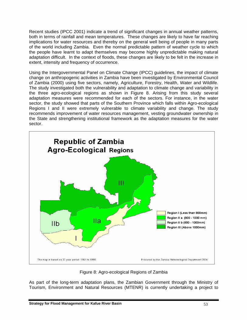
Strategy for Flood Management for Kafue River Basin 53
Recent studies (IPCC 2001) indicate a trend of significant changes in annual weather patterns, both in terms of rainfall and mean temperatures. These changes are likely to have far reaching implications for water resources and thereby on the general well being of people in many parts of the world including Zambia. Even the normal predictable pattern of weather cycle to which the people have learnt to adapt themselves may become highly unpredictable making natural adaptation difficult. In the context of floods, these changes are likely to be felt in the increase in extent, intensity and frequency of occurrence. Using the Intergovernmental Panel on Climate Change (IPCC) guidelines, the impact of climate change on anthropogenic activities in Zambia have been investigated by Environmental Council of Zambia (2000) using five sectors, namely, Agriculture, Forestry, Health, Water and Wildlife. The study investigated both the vulnerability and adaptation to climate change and variability in the three agro-ecological regions as shown in Figure 8. Arising from this study several adaptation measures were recommended for each of the sectors. For instance, in the water sector, the study showed that parts of the Southern Province which falls within Agro-ecological Regions I and II were extremely vulnerable to climate variability and change. The study recommends improvement of water resources management, vesting groundwater ownership in the State and strengthening institutional framework as the adaptation measures for the water sector.
Figure 8: Agro-ecological Regions of Zambia As part of the long-term adaptation plans, the Zambian Government through the Ministry of Tourism, Environment and Natural Resources (MTENR) is currently undertaking a project to
Strategy for Flood Management for Kafue River Basin 54
come up with a comprehensive national climate change adaptation plan. This project is known as the National Adaptation Plan of Action to Climate Change (NAPA). The following were the local communities’ perceptions on climate change and variability in the Kafue River Basin:
a) Change in wind regimes: strong winds are normally expected in July but of late they are at times experienced in April/May.
b) Changes in temperatures: in recent times, February/March has become comparatively
colder. September has become cold and windy.
c) Changes in onset and cessation of rainfall: there is a delay in the onset of rains in recent times varying between November and mid December instead of end of October. There is a noticeable early cessation of rains in recent times; ending in February instead of March.
d) Some areas that had no trees have now forests especially in plains; a sign of climate
change in terms of shifts in local rainfall regimes.
e) A lot of anthills have developed in the plains; a sign of changes in the local weather and climate conditions. This is an indication of increasing water recession and dryness.
f) A noticeable reduction in bird population such as the black storks; a sign of bird
migration due to changes in weather and climate conditions. Some birds have been found dead in the wild.
g) More gray haired people now even for people below 30 years; this could be attributed to
climate change.
The following were the local communities’ perceptions on adaptation measures to climate change and variability in the Kafue River Basin:
a) Planting of trees, this helps in promotion of rainfall;
b) Appropriate farming technologies and practices such as conservation farming and recession agriculture. Need for dialogue and consultation among the various interest groups (livestock and crop based farmers) before adoption of new farming methods and technologies). Conservation farming (potholing) was once tried in Namwala, but proved unsuitable during very wet years due to excessive weed growth and rats’ invasion.
c) Promotion of agro-forestry to minimise soil erosion and siltation.
d) Discouraging riverine cultivation to prevent river bank erosion and siltation.
e) Fishermen to build permanent houses on the main land and voluntarily vacate the plains
before floods.

Strategy for Flood Management for Kafue River Basin 55
5.6 Coordination between Various Ministries and Agencies Component 16 An effective and evolving inter-sector coordination mechanism
should be established at various levels to plan and implement pre-disaster and post-disaster flood prevention and mitigation measures.
To establish an effective inter-sector coordination mechanism for flood / drought disaster management requires bringing together efforts of all stakeholders and design an holistic approach for implementation of disaster management programmes. The capabilities and responsibilities of the individual stakeholders should be recognized and respected. Assignment of roles and additional responsibilities during programme design through to implementation should be closely monitored and this calls for a strong coordination office to supervise all the actors. A typical coordination mechanism in the water sector as relates to disaster management is shown in Figure 9 as adapted from DMMU, 2005. Such mechanisms have to be developed through extensive consultations with all the key line ministries/departments and institutions such as and not limited to:
(i) Ministry of Energy and Water Development (MEWD)
(ii) Department of Water Affairs
(iii) Department of Energy
(iv) Zesco Limited (Zambian electricity utility)
(v) Ministry of Agriculture and Coperatives (MACO)
(vi) Ministry of Tourism, Environment and Natural Resources (MTENR)
(vii) Ministry of Communication and Transport
(viii) Zambia Meteorological Department (ZMD)
(ix) Department of Maritime and Inland Waters
(x) Ministry of Lands
(xi) Ministry of Local Government and Housing
(xii) Ministry of Finance and National Planning
(xiii) Ministry of Works and Supply
(xiv) Ministry of Mines and Mineral Development
(xv) Community Based Organisations (Farmers and Fishermen)
(xvi) Zambia Wildlife Authority (ZAWA)
(xvii) Academic/Research Institutions
(xviii) Nakambala Sugar Company
(xix) Appropriate Local Administration
The Organizational Structure under the National Disaster Management Office includes the following:
Strategy for Flood Management for Kafue River Basin 56
(i) National Disaster Management Committee, chaired by the Vice President;
(ii) National Disaster Management Technical Committee (NDMTC);
(iii) NDMTC sub-committees;
(iv) Provincial Disaster Management Committees;
(v) District Disaster Management Committees;
(vi) Satellite Disaster Management Committees;
The Disaster Management and Mitigation Unit (DMMU) is the secretariat to the entire National Disaster Management structure, and primary driver of all disaster management activities in the country, guided by their foresaid committees (DMMU, 2005). Local communities recommended that for an effective multi-sector flood management strategy in the Kafue River Basin, it should involve:
(i) District Development Coordinating Committees (DDCC);
(ii) Disaster Management Committees;
(iii) District Epidemic Preparedness Committees;
(iv) District Rapid Response Committees;
(v) Information dissemination through the District Agriculture Coordinators;
(vi) Good and reliable communication network based on community radio stations and Vsat receiver system
(vii) Effective sensitisation and awareness campaigns;
(viii) Full participation of local communities, NGOs and CBOs
(ix) Passing of by-laws to regulate local communities’ activities and behaviour;
(x) Funding for community awareness and sensitization programmes;
(xi) Provision of equipment and tools;
(xii) Transport (boats for fishing out stranded fishermen); and
(xiii) Capacity building at all levels in disaster management.
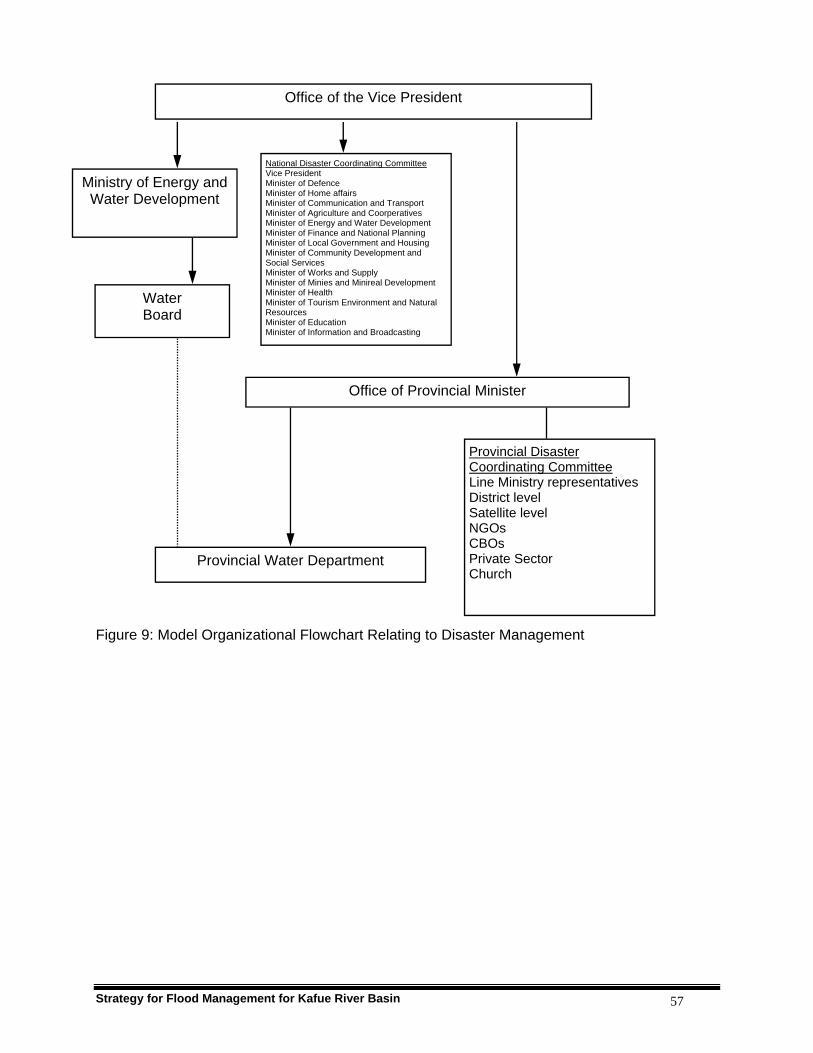
Strategy for Flood Management for Kafue River Basin 57
Figure 9: Model Organizational Flowchart Relating to Disaster Management
Office of Provincial Minister
Ministry of Energy and Water Development
National Disaster Coordinating Committee Vice President Minister of Defence Minister of Home affairs Minister of Communication and Transport Minister of Agriculture and Coorperatives Minister of Energy and Water Development Minister of Finance and National Planning Minister of Local Government and Housing Minister of Community Development and Social Services Minister of Works and Supply Minister of Minies and Minireal Development Minister of Health Minister of Tourism Environment and Natural Resources Minister of Education Minister of Information and Broadcasting
Water Board
Provincial Water Department
Office of the Vice President
Provincial Disaster Coordinating Committee Line Ministry representatives District level Satellite level NGOs CBOs Private Sector Church

Strategy for Flood Management for Kafue River Basin 58
PART III
FLOOD MANAGEMENT POLICIES

Strategy for Flood Management for Kafue River Basin 59
6. POLICY PRINCIPLES Having established the factors contributing to increasing flood disasters and describing elements of the Strategy for Flood Management, the next step is to develop a Flood Management Policy. This Policy would stipulate the fundamental principles of flood management clearly outlining mitigation measures appropriate to specific conditions and to address pre- and post- flood situations. Special areas of interest should be resolution of legal and institutional issues and identification of developmental projects supportive of flood management and incorporate them in the overall integrated flood management programmes. This could best be done in full cognizance of various priority options for flood mitigation according to current hydro-meteorological conditions, state of existing infrastructure, technical and financial resources, and competences in responsible institutions. Good practice makes it mandatory to review the Policy at least once in ten years. Nevertheless, reviews of policy documents could be done any time depending on the dictates of prevailing conditions and circumstances. This Flood Management Policy is based on the Integrated Flood Management concept as outlined by the APFM (2004), with special emphasis on the following: 1. Flood Management and Development
Flood management should be an integral part of poverty reduction within the national framework for sustainable development.
Floodwaters, though destructive at times, are good for the sustenance of natural ecosystems and should be harnessed for various economic and social benefits.
Construction of hydraulic structures for storage, conservation and channel control of floodwaters modifies the flood hazard and is necessary to meet various requirements in periods of scarcity.
For conservation of the ecosystem, interference with natural flow regime of the rivers has to be avoided as far as possible.
Designs and construction of buildings and public infrastructure such as roads, bridges, power and communication lines should be appropriate to withstand flood conditions.
Developmental initiatives in flood plains should be designed and implemented taking into consideration gender issues especially the needs of women, children and the people with disabilities.
2. Integrative Approach to Flood Management
Integration of land, water and natural resources management within the overall watershed development plans.
Integrated Flood Management approach within the overall framework of Integrated Water Resources Management.
The vulnerability of the flood plain communities calls for immediate, medium and long-term measures within an overall master plan based on basin approach.
Development and refinements in planning, designing and construction norms/practices.
Cross-cutting issues like gender mainstreaming and HIV/AIDS to be adequately addressed.
Preparation of standards, manuals and guidelines for effective flood management.
Strategy for Flood Management for Kafue River Basin 60
3. Flood Risk Management
Full protection from floods is a myth. Flood preparedness should be a must. Anticipate floods instead of waiting to react to them. Evolve criteria for allowable risks and affordable costs incorporating potential failures
beyond design discharge or breaches. Enhancement of public education and awareness of floods and their impacts.
4. Appropriate Mix of Measures
Mitigation and non-structural measures are effective and sustainable. Developing adaptation measures at provincial and district levels to minimise the
impact of floods. Effective flood forecasting and warning minimises adverse impact of floods both in a
stand-alone mode as well as in combination with other options. Preparedness against emergency and quick response forms the backbone of flood
mitigation measures. Structural measures are important elements with focus on human health, safety and
valuable goods and property. Coordination of mitigation measures should be a must for effective flood
management strategy implementation.
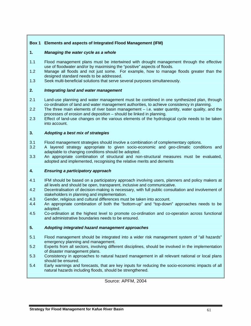
Strategy for Flood Management for Kafue River Basin 61
Box 1 Elements and aspects of Integrated Flood Management (IFM) 1. Managing the water cycle as a whole 1.1 Flood management plans must be intertwined with drought management through the effective
use of floodwater and/or by maximising the “positive” aspects of floods. 1.2 Manage all floods and not just some. For example, how to manage floods greater than the
designed standard needs to be addressed. 1.3 Seek multi-beneficial solutions that serve several purposes simultaneously. 2. Integrating land and water management 2.1 Land-use planning and water management must be combined in one synthesized plan, through
co-ordination of land and water management authorities, to achieve consistency in planning. 2.2 The three main elements of river basin management – i.e. water quantity, water quality, and the
processes of erosion and deposition – should be linked in planning. 2.3 Effect of land-use changes on the various elements of the hydrological cycle needs to be taken
into account. 3. Adopting a best mix of strategies 3.1 Flood management strategies should involve a combination of complementary options. 3.2 A layered strategy appropriate to given socio-economic and geo-climatic conditions and
adaptable to changing conditions should be adopted. 3.3 An appropriate combination of structural and non-structural measures must be evaluated,
adopted and implemented, recognising the relative merits and demerits 4. Ensuring a participatory approach 4.1 IFM should be based on a participatory approach involving users, planners and policy makers at
all levels and should be open, transparent, inclusive and communicative. 4.2 Decentralisation of decision-making is necessary, with full public consultation and involvement of
stakeholders in planning and implementation. 4.3 Gender, religious and cultural differences must be taken into account. 4.4 An appropriate combination of both the “bottom-up” and “top-down” approaches needs to be
adopted. 4.5 Co-ordination at the highest level to promote co-ordination and co-operation across functional
and administrative boundaries needs to be ensured. 5. Adopting integrated hazard management approaches 5.1 Flood management should be integrated into a wider risk management system of “all hazards”
emergency planning and management. 5.2 Experts from all sectors, involving different disciplines, should be involved in the implementation
of disaster management plans. 5.3 Consistency in approaches to natural hazard management in all relevant national or local plans
should be ensured. 5.4 Early warnings and forecasts, that are key inputs for reducing the socio-economic impacts of all
natural hazards including floods, should be strengthened.
Source: APFM, 2004

Strategy for Flood Management for Kafue River Basin 62
7. POLICY MEASURES The policy measures outlined in this section are meant to be integrated in existing national policies and existing pieces of legislation. 7.1 Institutional Arrangements Flood Related Legislative Arrangement The current Water Act Cap 198 of 1949 has no legal provisions for flood management. Neither does it regulate the management of other disaster situations. The only thing provided for is use of water in private dams for domestic and municipal water supply in times of droughts. However the situation is going to be normalized by the new Water Resources Management Bill when enacted into an Act by the end of 2007. This has specific provisions for early warning systems; when and what procedures to follow to declare a national disaster; measures to take during droughts and floods; emergency water works and control of spillage of harmful or toxic substances into water bodies. Apart from disaster management, the Bill also provides for establishment of river basin institutions for each of the five major river catchments in Zambia. The Kafue Basin will be managed by the Kafue Catchment Council. This will be a pilot project before scaling up to the rest of the country. At the apex will be a National Water Resources Management Authority to supervise all the Catchment Councils’ activities. The Authority’s main task will be to ensure that water resources in Zambia are managed in an integrated manner with key stakeholder participation. The Authority will ensure equitable, reasonable and sustainable utilization of water resource by providing guidance in the management, development, conservation, protection and preservation of the resource and its ecosystem. Each Catchment Council shall develop integrated water resources management and development plans and will inherit the functions of the current Water Development Board and the Department of Water Affairs that deal with water assessment, allocation and development in the districts. The Catchment Councils shall have regional offices through which they will be implementing their strategic management programmes and developmental projects. Strong community involvement in the catchment programmes and projects shall be through Water Users’ Associations to be formed at village/community levels. The strategy is to ensure cooperative management of water resources and to resolve local conflicts in water use. Conflict that cannot be resolved at that level will be referred to the Sub-catchment or Catchment Councils. Planning of flood mitigation measures should also be factored into the Integrated Water Resources Management programmes of the Catchment Councils. These Catchment Councils can therefore provide a forum for the effective participation of the communities in planning of flood mitigation measures considering the basin as a planning unit. Policy measure 1: The river basin approach to Integrated Water Resources
Management (IWRM) should be adopted and extended to flood management in accordance with the IFM concept. Kafue River Catchment Council should be charged with planning flood management measures in line with IWRM.
Strategy for Flood Management for Kafue River Basin 63
Policy measure 2: Operating Rules for Itezhi-tezhi and Kafue Gorge Dams should be revised and harmonized with the Integrated Water Resources Management and Integrated Flood Management principles and incorporated in the conditions of the Water Right for the Dam Operator.
Disaster Management Disaster Management and Mitigation Unit under the Office of the Vice President is responsible for management of all disasters through the District Disaster Management Committee (DDMC) at district level, under the chairmanship of the District Commissioner. The role of DMMU is co-ordination of post disaster related activities of various Ministries down to the district level. The role of MEWD is mainly in relief operations by providing drinking water for the evacuated people in relief camps. The DMMU is provided with weather forecast and early flood warning by the Zambia Meteorological Department. After making an assessment of the magnitude of the impending flood and its disaster potential, the DMMU informs the DDMCs. These committees are responsible for rescue and relief operations through multidisciplinary teams at the district and community levels. Usually very little time is given for advance warning of incoming floods taking the public unaware, leaving no time to take preventive measures. Livestock and gardens are prone to flooding. The flood forecasting and warning system at the river level needs to be put in place with clear definitions of roles. There are no institutional arrangements to review and update the early warning system. There is therefore need to strengthen linkage between MEWD, DMMU, Zesco and ZMD to develop an integrated flood forecasting and a pro-active disaster management system in the Kafue Basin. Existing disaster management mechanism is geared primarily to deal with rescue and relief measures and not towards preventive action to minimize the disaster itself. Policy measure 3: Flood emergencies should be managed in an integrated manner
within the overall National Disaster Management Policy with clearly defined responsibility for flood forecasting and warning. DMMU should have strong links with the District Disaster Management Committees.
Financial and Economic Arrangements A combination of flood relief and building capacity in community preparedness through public and private participation, largely depending on local initiatives and self-help, should be encouraged. The requirement for emergency relief should be avoided as much as possible. Flood relief should only be provided in critical situations and more resources should be channeled towards investments in flood management measures that target at enhancement of preparedness and prevention of disasters. Funding arrangements for sustainable flood management measures are a very important part of institutional arrangements (APFM, 2004). Major flood management projects/programmes should

Strategy for Flood Management for Kafue River Basin 64
be incorporated in the national development planning and funding processes to ensure that priority areas are addressed in a timely and sustainable manner. National development plans are a consolidation of community, district and provincial socio-economic development initiatives. The roles of communities and the private sector in these plans should be recognized by government through the provision of incentives to enable their participation in flood management. Direct funding to provinces, districts and communities is in line with the policies of decentralization and this should be encouraged as this approach enhances a sense of ownership of projects/programmes at all levels. Food for work and provision of essential construction materials by government give incentives for communities to participate in self help construction projects such as roads, bridges, dams, water wells, schools and individual dwelling houses during emergency recovery periods. The international community is encouraged to mobilize financial and material support where local communities afflicted by calamity are seen to help themselves. Current funding mechanisms include central government capital and recurrent allocations to line ministries, provinces and selected departments (Agriculture, Health and Education) at district levels; and grants to district councils and statutory boards. Micro financing of infrastructure development coupled with empowering local communities to manage such initiatives could go a long way to sustain developmental projects targeted at improving lives of the vulnerable people. The main sources of micro finance are the quasi-government institutions, nongovernmental organisations, banks and religious associations. The National Disaster Management Policy has provided for government to mobilize resources and to finance disaster management and support related activities. However, budgetary constraints have led to reduced allocations and no release of adequate funds towards disaster management and related activities. Policy measure 4: There is need to develop a clear fiscal policy on flood management
in consultation with the Ministry of Finance and National Planning There are two possible methods employed for appraisal and making choices between various available intervention options for flood management; these are the benefit-cost ratio and the net present value. Funding and financing arrangements critically influence the choice of options, for example, where financial resources are faced with competing demands; benefit-cost analysis provides a good appraisal system. The net present value method gives an analysis of economic benefit of undertaking a particular project to determine its viability and the pay back period. There is a need to develop and adopt clear guidelines for such analysis for flood management projects in the country. A range of planning, regulatory and economic instruments such as levying taxes or flood insurance are used in many countries to encourage and develop integrated flood management (APFM, 2004). In Zambia, due to low levels of development and slow economic growth, the use of economic instruments is very limited to private sector developmental initiatives. The tools used in formulating government projects are planning instruments, such as mid-term public investment programmes, national development plans supported by sector master plans. Projects like infrastructure development including flood protection are considered as government imperatives to provide public services to the needy communities.

Strategy for Flood Management for Kafue River Basin 65
Policy measure 5: Guidelines for economic appraisal of flood management projects should be developed.
7.2 Organization Structure Flood Management Units The subject of flood management is presently dealt with by the Department of Water Affairs (DWA) under the Ministry of Energy and Water Development (MEWD).The district units of DWA also report on the flood situations. In DWA, there is no section to deal exclusively with flood management issues; as such flood management is an array of ad hoc activities answering to a flood emergency using available resources. However the current water sector reforms will facilitate the enactment of a new water law to provide for the establishment of the Water Resources Management Authority that will take over the water development functions including flood management from DWA. The Department of Water Affairs will remain with the responsibility of policy and management of international waters. Policy measure 6: Flood Management Units should be set up under the Water
Resources Management Authority at catchment and sub-catchment levels with strong Water Users Associations involvement to deal with flood management issues.
The flood management issues to be dealt by the Water Resources Management Authority and its subsidiary organs will include but not limited to the following:
Establishing a Flood Information System through compilation of flood damage data; preparation of daily, seasonal and annual flood reports and a knowledge base;
Field surveys and investigations including environmental baseline surveys;
Project formulation, planning and design.
Construction, supervision and maintenance of flood management works;
Coordination with other related Ministries and organizations
The Ministry is currently implementing the National Water Resources Master Plan (NWRMP) for the period 1995 - 2015 as one of the principal tools for water resources management and development in the country. However, it is worthy noting that the NWRMP has not considered floods as a problem in Zambia in general and in the Kafue Basin, in particular. This is a grave omission; hence the NWRMP has not proposed any flood management measures despite the fact that floods do occur. Policy measure 7: The National Water Resources Master Plan should be revised to take
into account issues of integrated flood management. Flood Related Data Collection Assessment of flood damage is carried out by the Disaster Management and Mitigation Unit, Ministry of Agriculture and Cooperatives, Ministry of Energy and Water Development and the
Strategy for Flood Management for Kafue River Basin 66
Famine and Early Warning System Network (FEWSnet) assisted by other institutions co-opted in the assessment team formed for a specific and occasional incidence of a devastating flood. The assessments are usually quantitative targeted at populations affected, if there are lives and property lost, and the extent of damage to infrastructure. Due to financial constraints, there is often considerable time lag between occurrence of damaging floods and assessment surveys and compilation of relevant reports. The DMMU is responsible to coordinate such assessment activities through report writing. The coordination mechanism is adequate but is always constrained by lack of financial resources. Because of this there is a great dependence on financial and material support from cooperating partners. In the area of hydrological data collection, analysis and database management there are significant institutional weaknesses that have led to considerable data gaps and reduced reliability of data. The Structural Adjustment Programme of the 1980s triggered retrenchments in the Civil Service and the Hydrological Services were not spared. Of the 250 gauging stations distributed across the country, only 80 remained operational as many gauge readers lost their jobs and consequently, the respective stations were closed down. The Kafue basin had 120 hydrologic stations before 1985. By 2005 only 32 remained operational. Due to old age and non availability of spare parts, automatic water level recorders fell in poor state of disrepair, became obsolete and have been replaced with gauge plates. However, the SADC Hydrological Cycle Observing System (SADC-HYCOS) 6 data collecting platforms and WWF brought in 4 high frequency radios to improve data collection and transmission. The data from SADC HYCOS stations can be used in flood forecasting and together with radio transmission are ideal tools for early warning systems. There is an urgent need to review the existing river gauging stations and expand the telemetric network to enhance data collection and early warning system. Policy measure 8: The Hydrological Unit under DWA should be strengthened and
transferred to the proposed WRMA in order to effectively collaborate with Catchment Councils to maintain and manage river gauging stations, hydrological data collection and processing, database management and flood forecasting.
Policy measure 9: The existing policy to build and strengthen capacity in DWA to
ensure sustainable hydrological data collection and processing, database management including information dissemination supported by well equipped trained personnel at all levels should be upheld and fully implemented. This capacity should be strengthened in the Hydrological Unit after its transfer to the proposed WRMA.
Policy measure 10: Appropriate mechanism, formats and protocols should be
developed for smooth data exchange between different stakeholders.
Policy measure 11: Regular flood damage assessment mechanism should be created
under the Disaster Management and Mitigation Unit (DMMU).

Strategy for Flood Management for Kafue River Basin 67
7.3 Structural Measures Basin Master Plan The river basin or watershed is the most appropriate unit for water resources management approaches considering the interdependence of watercourse uses and the relationship between land and water development. A combination of flood mitigation measures broadly categorised, as structural and non-structural measures are available for adoption in a given basin depending on the physical, hydro-meteorological, social, economical and political setting of the flood prone areas. A long-term basin Master Plan for the Kafue Basin should be prepared, choosing a best mix of options depending on the objectives and available resources, with active involvement of all stakeholders. Existing project proposals under the NWRMP need to be updated taking into consideration the additional hydrological data for subsequent years, fresh baseline environmental surveys and the prevailing developmental requirements. The Kafue Basin Master Plan so prepared will have to follow the overall IWRM approaches to include appropriate measures for flood management. Therefore detailed guidelines for preparing Flood Mitigation Plans need to be developed (APFM, 2004). Policy measure 12: Prepare river basin master plans for integrated development of
water resources including IFM after detailed surveys and investigations.
Dykes and Multi-purpose reservoirs Basically dykes and dams store excess river flow. This storage reduces flood causing river flows. Storage is helpful for flood control in the entire downstream area of the storage structure. For controlled flooding in a way that limits damage, emergency overflow and temporary storage areas should be considered. A segment of the discharge peak could be attenuated by temporarily storing it in a dyked area. After the flood peak has passed through, the temporarily stored water can be released. Since the desired effect of a detention area occurs downstream from the flood plains of the Kafue Flats, a location as far upstream as possible is preferred. For this reason detention of the flood waters for the Kafue Flats is done at Itezhi-tezhi Dam. However, sometimes heavy rainfall in the Kafue Flats causes widespread flooding despite low outflows from Itezhi-tezhi Dam. The effect of 2005/06 floods was aggravated as a result of heavy rains in the Kafue Flats area. Protection from these floods could come from constructing dykes around permanent settlements, improving river channel carrying capacity through river training and construction of levees in selected reaches of the Kafue River. Policy measure 13: Existing protection works including river training and anti-erosion
works should be revived and implemented after reviewing their efficacy, engineering design adequacy, the river morphological behaviour and public acceptance.

Strategy for Flood Management for Kafue River Basin 68
Policy measure 14: Appropriate guidance materials answering the needs of local conditions and utilising indigenous resources should be prepared in form of manuals for field investigations, design, construction and maintenance of dykes/embankments for flood protection.
Policy measure 15: Implementation of multi-purpose reservoir projects should be
initiated with appropriate environmental safeguards. Policy measure 16: Criteria for protection of critical unprotected areas with new dykes
should be evolved duly accounting for the level of proposed development.
Indicative criteria for implementation of the above policy objective should include but not limited to the following:
Extensive Agricultural areas (Medium to high economic value) - 25 year return period.
Towns and densely populated Village clusters - 50 year return period. Important towns public utilities/infrastructure - 100 year return period. Cities, major infrastructure, industrial areas or monuments of national
importance 100 year to 500 year. 7.4 Non-structural Measures Development of Flood Forecasting and Warning System Structural measures for flood protection like dykes are designed for floods of certain return period (usually 25 years), therefore there is a risk of disaster from floods of higher magnitude. It is therefore important to have other complementary measures in place. Among the non-structural measures, flood forecasting and warning is one of the most effective methods, of reducing risk to life and property. Figure 11 outlines both structural and non-structural measures. The most catastrophic impact of floods is the loss of human lives. The main reason is that people are often taken unawares when floods occur due to heavy concentrated rainfall in the upper catchment of rivers with moderate or little rainfall in the plains. In the case of the Kafue Flats, this is compounded by the opening of spillway gates at Itezhi-tezhi Dam by Zesco. Presently there is no established flood flow forecasting system on any of the flood prone areas in the river basin. Some indicative forecast is made by the ZMD in the form of seasonal and daily rainfall forecasts. However, the ZMD network is not equipped with automatic rain gauge stations suitable to provide real time observations and rainfall intensities which is critical for flood forecasting. Zesco also provides short term flood forecasts using qualitative data from ZMD. This forecast usually comes in late especially for farmers who need it at the beginning of the rainy season. It is important that the flood warnings are delivered to affected communities without loss of time, and that they understand them, in order to take immediate preventive measures. However, this is a complex process and needs proper public awareness campaigns and education of both the forecasters and the communities. The local knowledge and beliefs of the communities and their special social and cultural setting have to be kept in perspective while issuing flood warnings

Strategy for Flood Management for Kafue River Basin 69
The ZMD and Ministry of Agriculture and Cooperatives have an Early Warning System; however, this is biased towards crop yield assessments and food security. This facility does not address flood warnings Policy measure 17: Appropriate linkage should be developed between DWA, ZMD and
Zesco for timely forecast of concentrated and localised heavy rainfall/cloud burst through radar system to enable forecasting for flash floods.
Policy measure 18: A river flood forecasting system should be established and duly
integrating the rainfall warning system of ZMD. Policy measure 19: The national early warning system which is currently biased towards
food insecurity arising from drought conditions should be broadened and strengthened to incorporate flood forecasting.

Strategy for Flood Management for Kafue River Basin 70
Figure 10: Various Structural and Non-Structural Adaptations Policy measure 20: Appropriate communication system, preferably the RANET
community based radio system, should be setup to provide advance flood warning to the village level communities.
Preparedness and Flood Proofing It has been noticed from the interviews with the people living in the flood plains that flooding is very important to them because it provides breeding grounds for fish, fertile grounds for farming, pasture for livestock and wildlife. In this situation flood control would not be the best option as the benefits of flooding outweighs the disadvantages caused by floods. In such cases it is
Flood vulnerability reduction measures
Flood Risk reduction measures
Structural adoptions
Flood exposure reduction measures (modify human behavior and use) Non-
Structural adoptions
Barriers, barrages and Dams
Dykes, levees, embankments
Flood abatement
Flood forecasting and warning
Public awareness and sensitization
Acquisition of flood land and property relocation
Social security measures (e.g. compensation)
Flood insurance
Flood Protection and Drainage projects
Flood Proofing
Disaster preparedness, planning response (including evacuation)
Land use and planning control
River channel improvements
Strategy for Flood Management for Kafue River Basin 71
desirable to cope with floods through various adaptation measures like flood proofing of houses and infrastructure. Other effective options for flood plain management include: land use regulations and redevelopment policies; disaster preparedness and response planning; emergency measures like evacuation, flood fighting and provision of public health services. Policy measure 21: Contingency plans for both protected and unprotected flood prone
areas for all floods including Probable Maximum Flood (PMF) should be prepared for rescue and relief with clear allocation of duties/functions.
Policy measure 22: Criteria and norms for planning, design and implementation of flood
proofing measures like ring dyke around the villages, building houses on stilts with provision for cattle shelter and storage of food and fodder etc should be developed and specific schemes prepared and implemented. Appropriate coordination mechanism between the DMMU and related line ministries should be strengthened.
Flood Plain Regulation The Kafue Flats are highly populated wetlands and land conflicts are quite eminent in this area. The local people are generally pastoralist while most of the new settlers are involved in fishing and farming. Large commercial farmers like Nakambala Sugar Estates and Kafue Sugar keep on expanding. There is also potential for hydropower development at Itezhi-tezhi Dam. All these increased economic activities have brought tremendous pressure in the Kafue Flats increasing the potential damage of floods. Certain infrastructural works like Kafue Gorge diversion dam and Kafue road and railways bridges tend to increase the flood levels upstream in the Flats. This is mainly attributed to lack of policy on land use and mechanism to regulate the use of flood plains. In order to regulate future developments especially due to expansion of urban centres and industrial activities, it would be necessary to establish appropriate mechanisms to regulate future development. The Environmental and Pollution Control Act has prescribed some of these measures which still need to be implemented. The Water Resources Management Bill proposes planning at catchment level which is a step in the right direction. Settlement development in flood plains and low laying urban areas should be regulated by zoning off flood prone localities. These areas should not be allocated for development unless measures are put in place to provide proper drainage systems and appropriate building plans to mitigate floods are implemented. Buildings with high foundations and platforms are ideal in such conditions. Policy measure 23: Enforcement of Selective flood plain regulations around the
developing urban centres restricting development of water polluting industries, and avoiding high concentration of urban development in flood prone areas should be encouraged.
Policy measure 24: Appropriate communication system should be setup to provide
advance flood warning to the village level communities.

Strategy for Flood Management for Kafue River Basin 72
7.5 Community Participation Developing economies are always faced with a financial resource crunch. The development plans have to prioritise various development schemes competing for limited financial resources. In addition a major concern is the allocation of resources for the proper maintenance of the infrastructure. Further, in integrated water resources management, planners have to appropriately balance the aspirations of various sectors of society. In flood management planning, the conflict between the upstream and downstream stakeholders has to be resolved. Active community participation in the planning and management at all levels helps in resolving such potential conflicts through negotiations and reaching consensus. It can also be beneficial in maintaining the infrastructure particularly when it is widely dispersed, as is the case of flood management structures. However, this is possible only if the participation in the decision making process is right from the inception stages. According to the Zambian law, all water related activities including those associated with flood management fall within the public domain. These activities are performed or are required to be performed by designated government ministries/departments at National, Provincial, District and local levels. In order to promote community participation, there is need to put in place legal and administrative instruments to transfer the related functions, responsibility and accountability to the recognised community organizations together with detailed guidelines specifying the manner in which the activities will be performed. The linkages between the government agencies and the community organizations have to be clearly defined in these guidelines. Where the interests of the local people are in conflict with the objectives of the government it may not be possible to enact legislation. When the interests of two or more groups are in conflict a process of dialogue has to be initiated to narrow down the differences and to evolve a mutually agreed action plan. Promoting active community participation requires knowledge based on basic data and information, special skills and training along with experiences of the community in coping with the situation. NGOs and CBOs having services of a social scientist with specialisation in mass communication can play an important role and should be entrusted with the task. However the necessary training material for them has to be prepared by a specialist organization. As a general rule, community participation is easily achieved in those activities, which hold promise for quick benefits to the participants. Demonstration schemes therefore should be taken up to convince the communities that they would indeed benefit from such schemes. Women, being the family providers, have special concerns, which need to be addressed. Their participation in planning of flood mitigation, provision of relief and rescue operations should be ensured. Generally, communities comprising of homogenous social settings tend to effectively participate in community based programmes than heterogeneous ones due to conflict of interests. In the latter case it is necessary to take up suitably designed social integration programmes. In the case of the Kafue Basin, despite the heterogeneity of the communities, common purpose projects have been successfully implemented by using community participation in projects such as: Micro projects, Rural Investment Fund and Zambia Social Investment Fund. Rural infrastructure built through these projects include: schools, health centres, roads, market sheds, water wells, boreholes, dams, irrigation schemes, storm drains and embankments.
Strategy for Flood Management for Kafue River Basin 73
Community support could be useful in assisting the field staff of DWA in hourly monitoring of river water levels at the flood forecasting sites, communicating water levels to the flood forecasting office (FFO), receiving flood warning from the FFO and its dissemination, and mobilising and directing transport to disaster management units (DMU) of the district during rescue operations. Community based organizations (CBOs) and NGOs collaborate with DMMU in organising relief and distributing essential supplies. Policy measure 25: All the policy instruments should incorporate the principle of
community participation at various levels of planning, implementation and management with special provisions for enabling participation of women and other vulnerable groups.
Policy measure 26: Appropriate communication strategy to prepare conducive
atmosphere for developing trust and confidence of community should be evolved through sharing data and information, developing transparent procedures for all decision making, building formal mechanisms to enable community participation and by enabling capacity building.
Policy measure 27: Community participation in arriving at consensual flood
management options, monitoring and rescue and relief operations should be strengthened and formalised through their participation in River Basin Organisations.
Policy measure 28: Non-governmental Organisations (NGOs) and community based
organisations (CBOs) should be encouraged to motivate and facilitate community participation at various stages including relief and rescue operations and capacity building at community level.
7.6 Capacity Building Capacity of institutions and individuals to perform their assigned roles is very important. It has been a common practice in the public sector to engage external consultants to prepare master plans, guidelines and manuals. This total dependence on external consultants and contractors has denied serving technocrats of the opportunity to gain relevant project related experience. There have not been significant activities in the area of flood management since the construction of dykes, drainage channels, sluices and river training works during the seventies and eighties. This also has not provided opportunities for the staff to develop the requisite skills and knowledge in planning, design, construction and maintenance of flood protection works. The existing manual on water supply does not cover all aspects of water resources development in general and flood management in particular. The planning and design norms have also not been reviewed and updated for more than two decades.
Policy measure 29: The need for capacity building at various levels and in different organizations/ institutions is recognized. A comprehensive capacity building programme on flood management issues should be prepared and implemented in phases.

Strategy for Flood Management for Kafue River Basin 74
Providing information to Communities to Enable Participation. Knowledge of the entire basin and how different factors contribute to the development of flood situation and an understanding of the downstream/upstream relation are necessary for planning of flood mitigation measures on a basin scale where tradeoffs are called for. In order to enable all sections of the community to participate in the decision making process, and not only a few dominant members, it is important that all the stakeholders are well informed. Both electronic and print media could play an important role in spreading information and promoting community participation. For the rural areas, radio communication is the most preferred. Members of Parliament, Councillors and traditional leaders could be involved in sensitizing and educating the people about the benefits of their participation in various activities. The process should present a balanced approach through involvement of technocrats, NGOs, CBOs and Church organisations. Policy measure 30: A policy on sharing and exchange of data and information on a
regular basis in the local languages should be formulated defining appropriate role for the media, education institutions, cultural organizations and other similar and innovative modes of mass communication.
Policy measure 31: Technical NGOs and CBOs should be encouraged to play a key role in generating educative and information material in simple local language
8. FLOOD FORECASTING SYSTEM Floods have a catastrophic impact on human lives sometimes resulting in loss of life and property. Relevant authorities and affected communities are usually taken unawares when flood-causing rainfall occurs; this is due to the special meteorological situation in a river basin. The upper catchments receive higher rainfall while the plains lower down receive relatively low rainfall. Establishing an effective flood forecasting and warning system, therefore, forms part of the overall flood management policy. This section briefly describes the essential aspects of the proposed flood forecasting system in the Kafue River Basin.
The following are the proposed components of a flood forecasting system for the Kafue Basin:
(i) Hydro-Meteorological network
(ii) Data acquisition and processing
(iii) Forecast formulation
(iv) Forecast dissemination
(v) Forecast review and development

Strategy for Flood Management for Kafue River Basin 75
8.1 Hydro-Meteorological network Rainfall and the current hydrological conditions in the basin are the basic real time inputs required for predicting future flood flows and river levels. At present the field units of DWA have district wise functional jurisdictions, thus the river gauging stations in a river basin are under the charge of different District Water officers. There is a need to reorganize the existing departmental structure for flood forecasting purposes, from district divisions to sub basin divisions, which is feasible under the on-going institutional reforms process. It is necessary that all hydrological observation stations in a river basin be placed under the charge of the Flood Forecasting Office (FFO) for the basin for better coordination and supervisory control. Considering the proximity to the flood prone areas and functional requirements, location of FFOs for the Kafue River Basin are recommended as follows:
(i) Chilenga and Mswebi (ii) Kafue Hook Bridge (iii) Itezhi-tezhi (iv) Namwala (v) Nyimba and Kasaka
The Zambia Meteorological Department, the institution responsible for meteorological issues throughout Zambia collects climatological data, including rainfall data, from all the stations that monitor this information. There is a record of close to 199 rainfall stations in the Kafue basin being run by individuals or institutions. At present only about 50 stations are sending data. Of these 50 stations, the Zambia Meteorological Department runs nine (9) full climatological stations. For an efficient IFM Strategy, it is desired that all the raingauge stations within the basin be sending their daily data to a centralised point (ZMD) on a regular and timely basis. It is noted that ZMD currently does not have automatic raingauge network and hence does not have the rainfall intensity data which is critical for flood forecasting. Therefore the IFM Strategy Development process needs to address such issues The mandate for water resources management (including data collection / exchange) lies with DWA. There are some 120 hydrometric stations in the Kafue Catchment area that are of particular interest. Over the years most of the hydrometric stations have closed down and only 32 are operational at the moment: 20 in the Upper Kafue Catchment area and 12 in the Kafue Flats Catchment area. The IFM Strategy development process is expected to review the effectiveness of the network and recommend ways of strengthening it. Figure 11 show the rainfall and hydrometric stations of the Kafue Basin. 8.2 Data Acquisition and Processing The meteorological stations of ZMD transmit data to the ZMD Headquarters every three hours. This is done through radio telephones. The rainfall warning issued by ZMD to DMMU is normally delivered by hand. The electronic and print media receive the forecast through email. Under an arrangement between WWF, Zesco, DWA, DMMU and ZMD, there are several rainfall stations that are operated outside the main stream ZMD synoptic stations within the Kafue River Basin. These stations also send their data to ZMD Headquarters.

Strategy for Flood Management for Kafue River Basin 76
Figure 11: Hydro-meteorological network of the Kafue Basin (Mwelwa, 2004) The FFOs of DWA should have the same mode of data communication as the ZMD, which are radiotelephone and landlines. A memorandum of understanding needs to be signed between the two departments for real time data communication. The FFO should be equipped with a separate arrangement of radiotelephones for communication with DMMU and DDCC/District commissioners within the Kafue River Basin. It would be desirable that the Office of District Commissioner uses their own staff and communication equipment in the premises of the FFO during the rainy season. The processing of input data for the formulation of forecasts depends largely on the flood forecasting techniques being used. However it is useful to process data in a database with provision for converting the data into universally acceptable format. 8.3 Flood Forecast Formulation In view of the short travel time from base station to the forecasting station, gauge-to-gauge correlation method would not be very effective for operational flood forecasting. There is currently no flood forecasting being undertaken by ZMD and DWA. For the flood forecast to be effective, with adequate lead-time it is absolutely necessary to have rainfall-runoff based forecasting system using quantitative precipitation forecast (QPF) at least 24 hours in advance for which a system of radars may have to be installed. For the same reasons it is necessary that QPF is provided not at a fixed time in a day but every 8 hours with updates every 3 hours in

Strategy for Flood Management for Kafue River Basin 77
case the forecast is beyond a threshold. The ZMD and DWA would therefore need to make necessary arrangements for QPF accordingly. Some recommended flood forecasting models include.
(i) Galway Flood Forecasting System (GFFS) model
(ii) Geo Spatial Flood Forecasting Model (Geo SFM)
(iii) NAM Rainfall- Runoff model.
8.4 Dissemination The forecast should be issued by the Central Flood Forecasting Office (CFFO) located in Lusaka and should be under the charge of a Principal Hydrometeorologist. The CFFO should act as the central dissemination centre and mouthpiece with responsibility for link with the press. A proposed Flood Forecasting and Dissemination mechanism is shown in Figure 9. Flood forecast need to be disseminated immediately after being received from the forecast formulation team. The nodal agencies/officials like the DMMU and District Commissioners and others, have to be given the forecast by wireless or telephone and it must be confirmed in writing in a standard format. Internet could also be used to disseminate the forecast to a wider audience. RANET can serve as a useful tool for dissemination of flood forecast in the flood-affected areas. Currently there are seventeen RANET radio transmission stations operational in the country. In the Kafue River Basin, there are five RANET radio community based stations (Radio Mazabuka in Mazabuka, Radio Chikuni in Monze, Mumbwa Community Radio Station in Mumbwa, Radio Twitemwe in Solwezi and Radio Chengelo in Kitwe) Details on RANET are given in Appendix X. RANET has the following equipments for communication:
(i) Suitcase radio transmitters that can be used within a radius of 25 km.
(ii) Hand held radios, which are used for receiving broadcasts. They normally use hand-winding mechanism for power.
The value of a forecast lies in its dissemination to the Public with adequate lead-time. A late warning with little lead-time is of no use to the community. Most of the times the normal floods are not disastrous and people have learned to live with them. In such situations people have to be educated to understand that there is always a possibility of a high flood occurring and therefore they should remain vigilant and act quickly on receiving the warning. It is however, necessary to avoid issuing unwarranted flood warnings which keep people tense because if such a practice is repeated, it may cause people to lose faith in the forecasting system. Merely issuing flood forecasting in terms of Water levels is not of much use unless the significance of these levels in terms of damage potential is also explained to the people. The water level information should be translated into its impact on the area. This should be described with reference to certain threshold levels like “Warning Level” “Danger Level” and Highest Flood Level.” For public information, guideposts marked with these threshold levels should be displayed at prominent public places in the flood prone areas.

Strategy for Flood Management for Kafue River Basin 78
8.5 Recommendations The following steps are required in order to set up a flood forecasting and warning systems in Kafue River Basin as outline in Figure 12:
(i) Draw up a Memorandum of Understanding between ZMD and DWA for exchange of real time hydrometric and hydrometeorological data.
(ii) Re-organize the field setup of DWA and ZMD to establish the FFOs and CFFO and provide the necessary staff. For logistics, the CFFO could be initially be set up in Lusaka.
(iii) Organize intensive training for the staff dedicated to manage the FFOs and CFFO. (iv) Start flood forecast formulation based on gauge-to-gauge correlation to begin with
until a suitable model is chosen and perfected. (v) After selecting one of the models discussed above, obtain the selected software
with multi-user license. (vi) Carry out surveys to connect the river gauges with common datum, obtaining the
required river cross-section and establishing Warning Levels, Danger Levels and Highest Flood Levels.
(vii) Establish radio transceiver links between the rain gauges in the Kafue River Basin and the FFOs and /or operationalise the meteosat facilities for data transmission.
(viii) Operationalise the RANET and provide receiver sets in the most flood affected villages.
(ix) Organize a coordination meeting with all players in the flood forecasting and warning activities including the DMMU.
ZMD should initiate action for radar based QPF equipment and training.

Strategy for Flood Management for Kafue River Basin 79
Figure 12: Flood Forecasting and Dissemination Mechanism
RANET Transmission
Disaster Management and
Mitigation Unit
National Hydrological
Services
ZMD Headquarters
Center
Chief Flood Forecasting
Office Lusaka
Department of Water
Affairs
Disaster Operations
centre
All Stakeholders And Media
Zambia Meteorological
Department
Itezhi-tezhi
Kafue Hook
Bridge
Namwala
Nyimba and
Kasaka
Disaster Management Committee
Disaster Management Committee
Disaster Management Committee
Rainfall Stations
RANET Transmission
RANET Transmission
RANET Villages Transmission
Chilenga and
Mswebi

Strategy for Flood Management for Kafue River Basin 80
PART IV
ACTION PLAN
Strategy for Flood Management for Kafue River Basin 81
9. ACTION PLAN This section outlines 39 measures that should be implemented in the Kafue Basin in order to put this Flood Management Strategy into action. The measures and actions recommended will have to meet and deal with issues to do with: flood related legislative arrangement; disaster management; financial and economic arrangements; flood management units; flood related data collection; basin master plan; dykes and multi-purpose reservoirs; development of flood forecasting and warning system; preparedness and flood proofing; flood plain regulation; and empowerment of communities to enable participation. The measures have been classified into short-term, medium-term and long-term.
9.1 Short Term Measures (3-5 years) Policy Reforms
1. Develop and adopt a policy for flood management in Kafue Basin (to be fully incorporated in the National Water Policy currently under review and other related national instruments). [MEWD]
2. Develop and adopt a policy that looks at flood plains as national assets that are crucial for accelerated growth of GDP. [MACO and MoFNP]
3. Implement the National Agriculture Policy to exploit the full potential of the flood plains. [MACO]
4. Develop and adopt industrial policy for flood plain areas based on the imperatives of future development and employment generation. [Ministry of Commerce and Industry]
5. Revise and strengthen the Disaster Management and Mitigation Policy to integrate flood management issues as stipulated in the IFM Strategy [DMMU]
6. Incorporate issues of flood plain land use in the Land Policy currently under development to address the control and regulation of future development in flood plains. [MACO, MLGH and Ministry of Lands]
7. Incorporate issues of early warning and flood forecasting system in the National Meteorology Policy and Act currently under development. [ZMD, DWA, Zesco and MACO]
8. Include vulnerability to floods in the DMMU Vulnerability Assessment Programme [OVP]
9. Develop and adopt a fiscal policy on flood management. Activities related to flood management to be fully incorporated in the development of MTEF budgeting process [MEWD, MoFNP, MACO, MLGH, ZMD and DMMU]
Institutional Arrangements and Basic Infrastructure
10. Set up flood management units under the Water Resources Management Authority at Catchment and Sub-catchment levels. [MEWD]
11. Rehabilitate the existing hydro-meteorological stations and strengthen the database. [DWA, ZMD and Zesco]
Strategy for Flood Management for Kafue River Basin 82
12. Strengthen all line ministries and institutions responsible for flood management. [OVP]
13. Strengthen linkages and data exchange mechanisms amongst MACO, DMMU, DWA, ZMD and Zesco to facilitate the development and implementation of an integrated flood forecasting and disaster management system [OVP and line ministries]
14. Strengthen linkages between DMMU and all relevant Disaster Management Committees at national, provincial, district and satellite levels. [OVP]
Promoting Community participation and Capacity Building
15. Capacity building in MEWD and ZMD for flood forecasting. [MEWD and MTC]
16. Establish communication links for flood warning with existing and set up new community radio stations. [DWA, ZMD, DDCCs and Zesco]
17. Promote and strengthen community participation in flood monitoring and disaster management through a well coordinated mechanism. [DDCCs, CBOs and NGOs]
Programme Implementation
18. Disaster Management to be factored into overall development plans. [MoFNP]
19. Set up village level communication system (RANET – based) to provide advance flood warning to communities from the existing rainfall warning mechanism of ZMD [DDCCs]
20. Prepare contingency plans for rescue and relief with clear allocation of duties and functions [OVP]
21. Introduce flood forecasting based on gauge to gauge correlation and integrate it with existing rainfall warning system. [ZMD, DWA and MACO]
22. Initiate action to obtain and operationalise a flood forecasting model that has been thoroughly tested in all the agro-ecological regions (covering all the river basins). [ZMD and DWA]
23. Rehabilitate and improve the existing protection works like dams, dykes levees and drainage channels. [MEWD, MACO, DMIW, NGOs, CBOs, Zesco, and local authorities]
24. Revise the National Water Resources Master Plan to incorporate issues of integrated flood management. [MEWD]
9.2 Medium-term measures (5-10 years)
Programme implementation
25. Develop small reservoirs and check dams to store flood waters. [MEWD, MACO and local authorities]
Strategy for Flood Management for Kafue River Basin 83
26. Adopt crops and cropping patterns that will increase income growth and investment in flood plain areas to contribute to growth of GDP. [MACO, PAM, MoFNP and private sector]
27. Adopt flood resistant crops and early maturing crops that can be grown and harvested during relatively flood free periods. Develop contingent crop options. [MACO and private sector]
28. Prepare disaster management plans for probable maximum floods (PMF) and consider sudden failure of flood protective structures especially large and medium size dams. [MEWD, MACO, DMMU, ZMD, Zesco and private sector]
29. Procure and operationalise state-of-the-art equipment relevant for rainfall and flood forecasting (including automatic raingauges and river flow recorders). [ZMD, DWA, MCT, and MoFNP]
30. Initiate pilot projects on flood proofing (storm drains, contour ridges, embankments, raised concrete foundations and floating platform houses), at local community levels. [MACO, DWA, DDCCs, local authorities, NGOs and CBOs]
31. Prepare basin master plans for integrated water resources management and carry out periodic reviews in line with the existing National Water Policy. [MEWD]
32. Develop and adopt project performance indicators for ease of appraisal of IFM projects. [MEWD, ZMD and MACO]
9.3 Long-Term Measures (beyond 10 years)
Programme implementation
33. Prepare and implement plans for integrated development of towns. [MLGH, Ministry of Lands, Ministry of Commerce and Industry]
34. Implement the recommended schemes envisaged in the National Water Resources Master Plan. [MEWD]
35. Develop large and medium storage reservoirs. [MEWD and Zesco]
36. Develop and implement watershed development and management to protect riverine and flood plain ecosystems. [MEWD, MACO, MTENR]
37. Accelerate pace of development in river basins with water as a valuable input. [MoFNP and water catchment councils]
38. Prepare and implement a long-term flood adaptation plan based on current predictions and forecasts of weather and climate changes. [MCT, MTENR, MEWD, MACO, MoFNP and Zesco]
39. Develop and implement and effective capacity building programme to answer the needs of the apparent climate change. [MCT, MTENR, MEWD MACO, MoFNP and Zesco]

Strategy for Flood Management for Kafue River Basin 84
REFERENCES APFM, 2004: APFM Technical Document No. 1, Second Edition. Integrated Flood management: Concept paper. WMO, Geneva, Switzerland Central Statistical Office, 2000: Living Conditions Monitoring Survey 1998: Preliminary Report, Central Statistical Office, Lusaka DHV Consulting Engineers. 1980 Kafue Flats Hydrological Studies: Final Report.
Department of Water Affairs, Lusaka. DHV Consultants, 2004: Integrated Water Management of Kafue River Flats, WWF, Lusaka, Zambia DMMU, 2005: National Disaster Management Policy, Disaster Management and Mitigation Unit, Cabinet Office, Lusaka, Zambia ECZ, 2000: State of the Environment, Environmental Council of Zambia, Lusaka,
Zambia
GRZ 1964: Chapter 198, Laws of Zambia, Ministry of Justice, Lusaka, Zambia. GRZ, 1990: Chapter 209 of the Laws of Zambia, Ministry of Justice, Lusaka, Zambia GRZ, 1997: Chapter 28 Laws of Zambia, Ministry of Justice, Lusaka, Zambia MACO, 2004: National Agriculture Policy 2004 – 2015, Ministry of Agriculture and Cooperatives, Lusaka, Zambia MOFNP 2002: Poverty Reduction Strategy Paper 2002 – 2004 MOFNP 2002: Transitional National Development Plan Mwelwa, E. M., 2004: The Application of the monthly time step Pitman Rainfall-Runoff
Model to the Kafue River Basin of Zambia, Rhodes University, Grahamstown, South Africa.
Rennie, J. K., 1978: Traditional and Modern Development in Namwala District, in
Howard, G. W. and Williams, G. J. (eds) 1982. Proceedings of the National Seminar on Environment and Change: the consequences of hydroelectric power development on the utilization of the Kafue Flats. Kafue Basin Research Committee, University of Zambia, Lusaka, Zambia.
Scott Wilson, 2004: Integrated Kafue River Basin Strategic Environmental Impact
Assessment Study, ZESCO Limited SWECO, 1971: Itezhi-tezhi Reservoir and Extension of Kafue Gorge Upper Power Station, Preinvestment Study. ZESCO Limited, Lusaka, Zambia Times of Zambia, 8th February 1978 and April1989 Issues
Strategy for Flood Management for Kafue River Basin 85
Water Board, 2003: Water Rights Database Williams, G.J., 1984: The Kafue Hydroelectric Scheme and its Environmental Setting, in
Handlos, W. L and Williams G. J. (eds): Development on the Kafue Flats – the last five years. Kafue Basin Research Committee, University of Zambia, Lusaka.
Yachiyo, (JICA) 1995: National Water Resources Master Plan, Ministry of Energy and Water Development, Lusaka, Zambia (NWRMP) ZCCM-IH, 2003: Copperbelt Environmental Programme, ZCCM-IH, Kitwe, Zambia ZMD 2004: Intergovernmental Panel on Climate Change Report for Zambia ZMD, 2006: Intergovernmental Panel on Climate Change for Zambia

Strategy for Flood Management for Kafue River Basin 86
PART V
ANNEXES

Strategy for Flood Management for Kafue River Basin 87
Annex 1
STEERING COMMITTEE MEMBERS No. Name Position Organisation Phone No. E-mail Address 1 Mr. Adam Hussen Director Department of Water
Affairs 252570 [email protected]
2 Mr. Hastings Chibuye Ag / Secretary
Water Board 251525 / 096 453774
3. Mr. Mellon Chinjila Ag / Chief Environmental Scientist
ZESCO Limited 362347 [email protected]
4 Mr.Thomson C. Musonda Principal Planner
Ministry of Tourism Environment and Natural Resources
229410-13 / 099996904
5 Mr. Maurice Muchinda Director Zambia Meteorological Department
252728 / 096 758337
6 Mr. Christopher Chileshe Ass. Director Department of Water Affairs
252570 / 096433430
7 Dr. I. M. Akayombokwa Ag. Director Agriculture 252869 [email protected]
8 Mr. M. K. Mbunji ZBU Manager
SEED CO 288049 [email protected]
9 Mr. Ilukena Mukata Chief Lands Officer
Ministry of Lands 252288 -
10 Ms. Ronica Miyoba Council Secretary
Kafue Council 311378 -
11 Mr. Patrick Kangwa HOLM Disaster Management and Mitigation Unit
253142 / 095776328
12 Mr. Andy Mondoka Manager Water Resources Action Programme
243543 -
13 Mr C. Ngwata - Environmental Council of Zambia
- -
14 Director Local Government administration
15 Mr. Romas Kamanga Hydropower Expert
IFM Project 095920147 [email protected]
16 Mr. George W. Sikuleka Agricultural Expert
IFM Project 097777573 [email protected] / [email protected]
17 Mr. Joseph Kanyanga Meteorological Expert
IFM Project 097698781 [email protected]
18 Mr. Peter Chola Water Expert
IFM Project 097873314 [email protected]
19 Mrs. Elenestina Mwelwa Team Leader
IFM Project 095849340 [email protected]

Strategy for Flood Management for Kafue River Basin 88
Annex II
STAKEHOLDERS’ WORKSHOP REPORT
MINISTRY OF ENERGY AND WATER DEVELOPMENT
WORLD METEOROLOGICAL ORGANISATION
Plate 8: Participants of the Stakeholders’ Workshop
1. BACK GROUND TO THE WORKSHOP In November 1994 the Zambian Government adopted the National Water Policy to regulate water resources management, water use and water quality aspects. The aim of this Policy is to promote sustainable water resources development with a view to facilitate an equitable provision of adequate quantity and quality of water for all competing groups of users at
Strategy for Flood Management for Kafue River Basin 89
acceptable costs and ensuring security of supply under varying conditions. The Water Resources Action Programme (WRAP), formulated by the Ministry of Energy and Water Development, has been implementing the National Water Policy in the establishment of a comprehensive framework that will promote the use, development and management of water resources in a sustainable manner. The WRAP sets out to develop and implement strategies for integrated water resources management (IWRM). Water related disasters such as floods and droughts, that play an important part in determining sustainable development, need to be integrated within water resources management. Thus, a Flood Management Strategy has to be put in place and implemented to prevent flood disasters hampering the development process.
Following the concept paper submitted jointly by the Department of Water Affairs and Zambia Meteorological Department in August 2005, and in response to the request for technical assistance submitted to WMO, WMO signed an MOU with GRZ in March 2006 for the development of the IFM Strategy in the Kafue Basin. Upon constitution of the Task Team by the Ministry of Energy and Water Development, a Workshop Preparation Team was appointed to assist the Task Team to identify the key stakeholders and organize an Inception Workshop. Therefore a list of key stakeholder institutions to be invited to the workshop was drawn up, attached as annex-I. Invitation letters were therefore sent to the various stakeholders, attached as annex-II(a) and annex-II(b) and the workshop program, annex-III. A total number of 58 participants attended the workshop, a complete list is attached as annex-IV. During the Workshop, an inception report was distributed to help the participants understand the IFM Strategy development background and process, attached as annex-V. This Workshop was the first step in initiating stakeholders’ awareness and participation in the development of an effective Integrated Flood Management Strategy for the Kafue Basin. This is in accordance with Task Team Terms of Reference which states that the Task Team needs to:
• carry out a public awareness drive to sensitize the public on the dangers and benefits of floods and ensure that the public is aware of the initiative for managing the floods in the Kafue Basin;
• establish interaction with the local, national and regional development agencies, departments and ministries working in the different fields (Agriculture, Fisheries, Water Resources, Energy, Urban Development, Land use, Transport, Water Supply and Sanitation and other water related fields);
• identify all stakeholders (representing all interest groups, disciplines, professions, vocations), including women groups in the Basin for consultation in the Stakeholders’ Workshops in order to produce Stakeholders’ Perspective Report which is key to the development of the IFM Strategy.
2. OBJECTIVES OF THE WORKSHOP The Workshop had the following objectives:
• To have an official launch of the project; • Raising awareness on the IFM Strategy development process for the Kafue Basin
among the Stakeholders; • To get comments from the Stakeholders on the proposed approach; • To initiate discussions and comments from the Stakeholders on the four themes
key to IFM development:

Strategy for Flood Management for Kafue River Basin 90
• Social Aspects of Flood Management; • Integrated Approach to Water Resources Management and Flood
Management; • Protecting and Conserving the Environment; • Coordination between various Ministries and Agencies
3. TARGET GROUP OF STAKEHOLDERS The workshop had representation from a wide range of stakeholders in the Kafue Basin, these included: Government Ministries and Departments, Local Council Authorities, Parastatal organizations, academicians/researchers, non governmental organizations(NGOs), farmers’ associations and fishing associations in the flood prone areas. A total number of 60 participants attended the workshop. The participation and contributions from all the participants was quite good especially during the group discussions. 4. INAUGURAL SESSION OF THE WORKSHOP The workshop was inaugurated by the former Minister of Energy and Water Development – Honourable Felix Mutati, MP.
Plate 9: Former Minister of Energy and Water Development Honourable Felix Mutati delivering the opening speech
The former Minister of Energy in his speech highlighted the importance of managing the risks associated with floods. He thanked WMO for the financial assistance and gave a commission to the Task Team to ensure that the resources are put to good use for the development of the

Strategy for Flood Management for Kafue River Basin 91
Flood Management Strategy that should benefit the people of Zambia. He added that as Government commitment to the Project, Government through Ministry of Energy and Water Development had a budget line to co-finance this Project. He referred to the traditional way of dealing with floods which mainly targets at damage control and restoration, like the Kafue Gorge mud slide and the Kazungula flooding. He encouraged the participants on the need for a paradigm shift in dealing with floods, from a traditional approach to an integrated approach that looks at the interactions between land and water resources which brings in the need to focus on the basin approach. He drew a parallel that the flood management strategy will fit in very well in the new Water Resources Bill which also introduces the need to focus on the basin approach in management of water resources. He reminded the participants that since floods cannot be eliminated, the participants have a challenge to come up with an effective strategy to manage and minimize the negative impacts of floods. He encouraged the participants to think further on how we can move from strategy to implementation and how we can go beyond the Kafue Basin in the application of the Strategy. He went on to give an analogy how wildlife is so well adopted to natural calamities such as floods, therefore as human beings, we could also come up with strategies on how we can manage floods more effectively. The full speech is attached as annex-VI. Earlier, Mrs. Esther Sinkala Banda, the Acting Permanent Secretary, Ministry of Energy and Water Development gave some opening remarks, welcoming all the participants and highlighted the key institutions that were represented. Mr Datius Rutashobya, Department of Hydrology and Water Resources, WMO Geneva spoke on behalf of WMO and gave the participants general information on WMO and the role the Organisation will play in the development of the IFM Strategy for the Kafue Basin. He also acknowledged the valuable financial support from the Government of Japan through the Associated Program on Flood Management (APFM) which is being implemented through collaboration between WMO and Global Water Partnership (GWP). 5. PRESENTATIONS The inaugural session was followed by a plenary session with two presentations. 5.1 Presentation on Integrated Flood Management – Mr Datius Rutashobya (WMO) The Presentation gave the background to the development of the Integrated Flood Management concept and how IFM fit into the Integrated Water Resources Management principles. The importance of IFM was also highlighted, drawing a parallel on the traditional approach to dealing with flood versus the integrated approach and that Flood policy is a neglected issue both on the international and national levels. He further highlighted the challenges of flood management which include: population increase; the need to secure livelihoods; the ecosystem conservation; climate variability and change; changes in the decision making process; and the fact that absolute safety from flooding is a myth. The presentation also gave the four main objectives of IFM which are: sustainable development; maximizing benefits; minimizing loss of life; and environmental protection. The presentation further gave the characteristics of IFM which include: the recognition that a river basin is a dynamic system with many interactions/fluxes between land and water bodies; that there are

Strategy for Flood Management for Kafue River Basin 92
linkages between upstream changes and downstream effects and vice-versa; that land use planning and water management need to be combined in a synthesized plan; the need for improvements in the functioning of the river basin as a whole without just fixing local problems; that climate, basin characteristics, ecology and socio-economic conditions in a region are linked factors that determine appropriate flood management options; the need to recognize the “best-mix” of strategies; the need to manage the water cycle as a whole; and the need to adopt a participatory approach. The presentation concluded by emphasizing that IFM requires clear and objective policies with a multidisciplinary approach which should be supported with appropriate: legislation and regulations; institutional structures; economic instruments; enabling participatory processes; and information management and exchange mechanisms. 5.2 Presentation on the Integrated Flood Management Strategy for the Kafue Basin –
Mrs Elenestina Mwelwa (Project Team Leader) The presentation gave highlights some physical characteristics of the Kafue River Basin and how that the Kafue catchment plays a central role in Zambia’s economy in that it is a host to most of the mining industrial and agricultural activities; approximately 50 percent of Zambia’s population; and that it’s the most urbanized catchment in Zambia. The presentation further gave highlights of the flood prone areas of the Kafue Basin which include: the wide spread dambo systems; the Lukanga swamps; the Kafue Flats; and areas affected by riverine flooding at peak flows. The presentation gave a brief on the current status of the meteorological network in the basin, noting the declining numbers of operational stations. The presentation emphasized that, for an efficient IFM Strategy, there is need for all raingauge stations within the basin to be sending their daily data to a centralized point on a regular and timely basis. The presentation further noted that currently, the Zambian Meteorological Department does not have automatic raingauge network and therefore does not have the rainfall intensity data which is required for flood forecasting and there is therefore the need to establish automatic raigauge stations for effective flood forecasting which is key for the IFM strategy. The presentation further gave a brief on the current status of the hydrometric network in the Kafue Basin, noting the declining numbers of the operational stations. It did highlight the need for the network to be strengthened for an effective IFM Strategy. The objectives of the project were presented which are: assessing the flood impact in the Kafue Basin; to draw up an integrated Flood management Strategy for the Basin; and to design a Flood Forecasting System for the Kafue Basin. The proposed approach for the implementation was presented. The project was to be implemented through National experts who were to carry out the activities according to the specific terms of reference for the project. The Project Organisation Structure and the implementation plan was also presented. The presentation concluded with an emphasis on the need for active participation and contributions for the IFM strategy development process. The participants were therefore encouraged to make contributions and participate fully during the workshop.
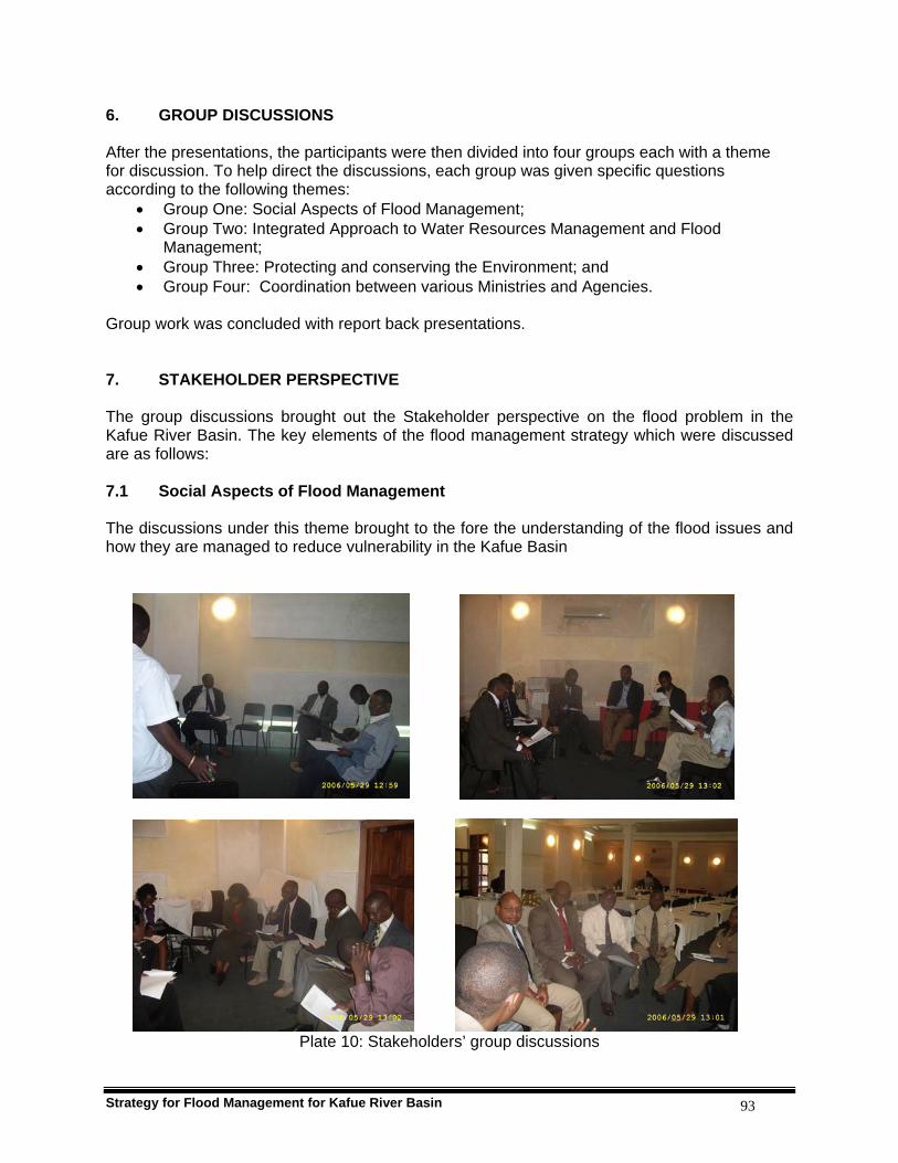
Strategy for Flood Management for Kafue River Basin 93
6. GROUP DISCUSSIONS After the presentations, the participants were then divided into four groups each with a theme for discussion. To help direct the discussions, each group was given specific questions according to the following themes:
• Group One: Social Aspects of Flood Management; • Group Two: Integrated Approach to Water Resources Management and Flood
Management; • Group Three: Protecting and conserving the Environment; and • Group Four: Coordination between various Ministries and Agencies.
Group work was concluded with report back presentations. 7. STAKEHOLDER PERSPECTIVE The group discussions brought out the Stakeholder perspective on the flood problem in the Kafue River Basin. The key elements of the flood management strategy which were discussed are as follows: 7.1 Social Aspects of Flood Management The discussions under this theme brought to the fore the understanding of the flood issues and how they are managed to reduce vulnerability in the Kafue Basin
Plate 10: Stakeholders’ group discussions

Strategy for Flood Management for Kafue River Basin 94
7.1.1 Vulnerabilities to floods in Kafue The most vulnerable people to floods in the Kafue Basin were identified by the discussion groups as the poor peasants whose livelihoods depended on subsistence farming, fishing, doing odd jobs and selling various articles such as reed-mats, baskets and forest products. Communities living in squatter compounds usually located in low laying surrounding areas of towns. The houses are mostly lowly built and are of poor quality. Farms and roads; some parts of towns and population centres located near swampy areas tend to flood: these include Makululu in Kabwe, Kanyama and Chawama in Lusaka. Even some well built up areas of Lusaka and Kabwe which are located in low laying zones but not properly drained are prone to flooding; these are Emmasdale and Avondale and Mine Compound respectively. Roads and bridges that are at risk in the Basin include those connecting the Kafue Flats and the line of rail especially the Namwala – Monze and Choma-Monze roads. During the rainy season most roads to fishing camps become impassable in the Flats. 7.1.2 Social factors influencing vulnerabilities of communities After living in the Kafue Flats for so many years the people have become used and attached to their conditions and the seasonal floods have become part of their lives. This has made it very difficult to shift to higher lands to go and start a new life. Their unwillingness to move away is also compounded by cultural beliefs that it is taboo to abandon the burial grounds of their ancestors and recently departed loved ones. The fishermen in the Kafue Flats have two dwelling places: a permanent house on high grounds and temporary huts at fish camps. During the flood period they leave the fish camps and go to dry land. They do that after harvesting their crops, maize, potatoes, beans and other vegetables which they grow in swampy grounds. They use rudimentary watering cans to apply water to crops. Poor land use practices coupled with bad settlement plans in urban areas have made some people to build houses in areas prone to flooding. This has been due to population pressure and demand for new land to settle. The involvement of grass-root politicians in allocation of land has led to disregard of local authorities’ settlement plans culminating into haphazard and uncoordinated building of houses even in dambo areas. Encroachment of retirees in gazetted rural area and peri-urban low lands has also increased vulnerability to floods. It is not only the poor and uneducated who are vulnerable to flooding; even the educated ones fall prey to local area councillors who allocate them plots of land in undesignated areas due to desperation. Pensioners belong to this category of people who are sold plots of land illegally in flood prone areas in the inner cities and periphery of towns. In these areas the municipalities have no plans to construct storm drains and other amenities to reduce the risk of flooding. 7.1.3 Efforts made to reduce vulnerability The following are currently being used to reduce vulnerability of the Kafue Basin communities:
Seasonal shifting from the flood plains to higher grounds; Traditional rituals to pray that the floods should not be severe or abated; Construction and rehabilitation of storm drains in towns; and Community sensitization not to buy plots of land in flood prone areas.

Strategy for Flood Management for Kafue River Basin 95
7.1.4 Community based activities to reduce vulnerability Consensus was reached on the following community work during flood emergencies:
Flood victims and livestock rescue operations; Participation in food for work; Offering of donations and shelter; and Early warning and information dissemination using traditional systems, churches and
schools. 7.1.5 Cooperative activities Cooperative activities before, during and after floods include the following:
Flood victims and livestock rescue operations; Relief food and camping kit distribution; Crop and household rescue operations; and Construction of relief shelter
7.1.6 Strategies to enhance resilience of society to floods The following measures were identified by the groups to enhance society’s resilience to floods:
Improve community awareness to effects of floods and how to manage them; Establishment of operational early warning mechanisms; Enhancement of community participation; Proper planning of settlements and land use patterns; and Effective communications.
7.1.7 Responsible organs for emergency management The following organizations were identified as responsible agents for emergency management:
Disaster Management and Mitigation Unit; Department of Water Affairs; Local authorities; Traditional leaders; Community Based Organisations; Zambia Police; Zambia Army and Air Force.
7.1.8 Role of national / local government and community in flood management The Stakeholders identified the following as roles of central government in flood management at national level:
Formulation, revision and implementation of policy on flood management; Development and implementation of emergency flood plans; Mobilization and coordination of distribution of resources; Coordinate and oversee rescue operations;
Strategy for Flood Management for Kafue River Basin 96
The Local Government’s roles identified by the Stakeholders group were as follows:
Development and implementation of flood management plans; Community mobilization; Mobilisation of financial and physical resources; provide emotional, psychological support;
Communities were expected to perform the following roles in flood management:
Request government to provide emergency services; Demand for flood mitigation programmes and communication facilities; and Participate in community flood management projects.
7.1.9 Coordinated mechanisms in government for flood management The Stakeholders recognized the government coordination mechanisms put in place by the Office of the Vice President for disaster management:
National disaster management committee; District disaster management committees; Village committee to distribute resources; and
That the role of the private sector was encouraged to complement government effort at all levels. 7.1.10 Community involvement in decision making in flood management The Stakeholders recognized that community involvement in providing accurate information to relevant authorities on the nature and extent of floods and droughts was critical for planning and decision-making purposes. It was also recognized that Non-governmental organizations have been participating through involvement in Standing Committees at operational levels when floods occur and they are involved in coordination of flood management programme implementation either at National or District levels. 7.1.11 Capacity building programs available The Stakeholders observed that there was no capacity building programmes available at village level at the moment. However, some ad-hock emergency training were given when need arose. The following training periodic capacity building programmes exist at national level:
Training in first aid and vulnerability assessment, Rescue equipment.
The Stakeholders also recommended the need for the establishment of a standing fund for emergencies to be called Flood/Drought Emergency Fund to be used during such operations. 7.1.12 External support required to sustain communities

Strategy for Flood Management for Kafue River Basin 97
The Stakeholders unanimously appreciated the role of external support in disaster management and identified the following areas to be targeted:
Training in all spheres of disaster management from preparedness, prevention, mitigation, rehabilitation and recovery.
Operationalisation of flood emergency fund; Adaptable housing design for flood situations; and Cost effective and adaptable access infrastructure.
7.2 Integrated Approach to Water Resources Management and Flood Management Under the theme of Integrated Approach to Water Resources Management and Flood management, the Stakeholders brought their perspectives on the key issues to the IFM Strategy 7.2.1 Development Activities and Imperatives The main development activities in the Kafue Basin include Hydropower production, Agriculture, Livestock, Fisheries, Wildlife, Tourism, Water Supply, Mining, Logging and Charcoal production. Kafue river is a host to the Kafue Hydroelectric system that comprises the 6*106 m3 capacity Itezhi Tezhi reservoir, 0.9*106 m3 capacity Kafue Gorge reservoir and the 900MW Kafue Gorge power station in the mid catchment. The Itezhi Tezhi reservoir is a main storage reservoir for the Kafue Gorge power station. The distance between Itezhi and Kafue Gorge is 260Km and is covered by flood plain called Kafue Flats. Flooding in the area is mostly controlled by releases from Itezhi Tezhi dam. Plans are underway to put up a 120MW power plant at the Itezhi Tezhi reservoir and a 750MW Kafue Gorge Lower Hydropower plant further down stream of the Kafue Gorge power plant. There are also further future plans to heighten the Itezhi Tezhi dam by 10m and the expand the Kafue Gorge power plant by another 900MW. Commercial farming is very prevalent in the basin. In the upper catchment there is the Mpongwe estates which grows wheat and maize while in the mid catchment there are a number of sugar plantations which include Nakambala, Kafue and Kaleya. The creation of more farming blocks in the Kafue Flats in Mazabuka area and Itezhi Tezhi has also continued. Livestock farming is the main stay for the indigenous people of the Kafue Flats. These people depend on flooding for pasture. Fishing for commercial as well as subsistence purposes has brought a lot of immigrants to the Kafue Flats. Fishing is also quite prevalent in the other parts of the Kafue Basin like Lukanga swamps and lake Itezhi Tezhi. Fish farms are emerging in the basin like Kafue Fisheries. The largest National Park in Zambia is found in the Kafue Basin. This is a major boost to tourism in the Basin. Kafue Basin is the most populated basin in Zambia. It has major towns of Zambia like Chingola, Kitwe, Ndola and Lusaka. These towns draw their water supply from the Kafue river and its tributaries. These towns especially on the northern part where the copper industry is booming are ever growing. Mining of Nickel near Mazabuka Town is also promising after the recent explorations. Several other industries are coming up following the recent boom in the economy which include the cement factory in Ndola and a Steel plant in Kafue Town.
Strategy for Flood Management for Kafue River Basin 98
7.2.2 Basin Management Plans The Ministry of Energy and Water Development (MEWD) has formulated a programme called Water Resources Management Programme (WRAP) which sets out to promote the use, development and management of water resources in a sustainable manner by use of integrated water resources management strategies. For this purpose Kafue Basin has been chosen as a pilot project. MEWD is also involved in the implementation of Zambezi Action Programme (ZACPRO 6.2) which aims at using IRWM strategies on the whole Zambezi basin. MEWD is committed to implement a bottom up approach to programme planning and implementation ensuring that what goes into the National Development Plan in terms of water resources planning is in agreement with what is contained in the plans at local level. Other sub-basin management plans which are being done in liaison with WRAP included the Integrated Water Resource Management of the Kafue Flats being done by Zesco, Department of Water Affairs, Zambia Meteorological Department and WWF. This is aimed at managing floods in the Kafue Flats with regards to ecosystem requirements. Other projects are SEED project by Zambia Wildlife Authority, Copperbelt Environmental Project under Ministry of Tourism, Environment and Natural Resources, Wetlands Conservation Project at National and Basin level under WWF and ZAWA and Integrated Water Resources Management and Food Security by WWF. Floods are part and parcel of the hydrological cycle which ensures that ecosystems are sustained especially in flood plains. In Kafue Flats in particular because of the upstream control at Itezhi Tezhi there has been a lot of refinement of the flood release rules in order to restore the original habitat. The Stakeholders noted that there is no Land Use policy in Zambia, and therefore no land use issues have been linked to Integrated Water Resources Management in general. 7.3 Protecting and conserving the Environment Under the theme of protecting and conserving the environment, the Stakeholders brought out their perspectives on the key issues to the IFM Strategy
7.3.1 Main environmental issues with regard to flood management The Stakeholders identified the key environmental issues arising from floods and associated management activities
• Change of habitat • Loss in biodiversity • Increase in sediment load which may be related to increased erosion • Increased fishery, with regard to creation of reservoirs • Increased water availability due to availability of water storage through reservoirs • Increased soil fertility related to annual deposition of silt. • Increased pasture due to availability of moisture and flood recession. • Increase in water borne diseases • Creation of jobs as new economic activities arise from flood control and management
facilities.
Strategy for Flood Management for Kafue River Basin 99
7.3.2 Integration of Environmental consideration into decision making process of river planning
The Stakeholders identified as key the development of Environmental Impact Assessment Regulations (Statutory Instrument No. 28 of 1997) which puts it as a mandatory requirement that any new development in any sector in a basin is subjected to the Environmental Impact Assessment Study, this ensures that environmental issues are incorporated at planning stage of any project 7.3.3 Key Ecosystems in the Basin that support development or livelihoods The Stakeholders identified the following key wetlands and riverine ecosystems in the Basin:
• Main river and its tributaries and associated dambo system provide a key riverine ecosystem that provide resources to support development and enhance livelihoods
• Lukanga swamps, known to be key to support fishing, subsistence agriculture and provide a habitat for wildlife
• Busanga swamps, situated in the Kafue National Park is a key ecosystem supporting wildlife
• The Extensive Kafue Flats, key for the support of fishery, agriculture, wildlife with two National Parks, Lochnivar and Blue Lagoon, It also supports hydroelectric power system, support local peoples livelihoods through provision of pasture for livestock and fertile soil for subsistence agriculture
7.3.4 Provisions under law or policy to assess environmental impacts The Stakeholders identified the key environmental law, the Environmental Protection and Pollution Control Act (Cap 204) of 1990 with its associated Statutory Instrument No. 28 of 1997 – The Environmental Impact Assessment Regulations as the main provision under the Zambia Law to ensure comprehensive assessment of environmental impacts. The Stakeholders also identified the National Environmental Action Plan, 1994 (NEAP) and the draft National Policy on Environment which give broad guidelines for management of environmental issues in different sectors. 7.3.5 Development activities or structural measures that may have possible impacts on
the environment in the basin The Stakeholders identified that due to urbanization and mining industry development in the upper catchment, there is extensive deforestation and encroachment into the National Forest Reserves. The Stakeholders also identified the hydraulic structure for Kafue Hydroelectric System, the Itezhi-tezhi and the Kafue Gorge Dams constructed as water storage reservoirs for the Kafue Gorge Hydropower Station. Large irrigation schemes were also identified such as: Nanga irrigation scheme; Kafue Sugar irrigation scheme; Nakambala Sugar Estates, Mpongwe Development Company; and Ipafu Coffee Scheme.
Strategy for Flood Management for Kafue River Basin 100
The Basin also has major Tourism development activities such as lodges and boating. The Basin is also a host to major industries such as: Copper mining; Nitrogen Chemicals Company (NCZ); breweries companies; Bata Tannery Company; Kafue Textiles; and Nickel mines in Munali Hills. 7.3.6 Measures or activities taken to preserve ecosystems in the Basin The Stakeholders identified the following measures and activities:
• Promoting afforestation, programs such as: Provincial Forestry Action Program (PFAP); Zambia Forestry Action Program (ZFAP); Environmental protection and natural resources management; and Community Based Natural Resources Management Boards (CBNRM);
• Improved dam operation rules (e.g. Itezhi tezhi dam and Kafue Gorge dam); • Good land management practices such as: contour ploughing, agro forestry and
conservation farming; and game farming; • Constructed wetlands such as: Kansanshi mine tailings dam; Copper Belt mine tailing
dams; and Nakambala sugar runoff lagoons; • Improved and rehabilitation of hydrometeorological network such as efforts under the
WWF project. 7.3.7 Policies addressing weather and climate variability and change The Stakeholders noted that currently there was no existing policies addressing climate variability and change, but the development of a Meteorological Policy is at inception phase. 7.4 Coordination between various Ministries and Agencies The Stakeholders brought out some key issues on institutional arrangements and coordination as relates to Flood management.
7.4.1 Laws and policies relating to land use and water management The Stakeholders identified that there are several pieces of legislation which refer to land use and water management. These include the Land Act; Water Bill; Local Govt Act; Town & Country Planning Act,1962; Environmental Pollution Protection Act (EPPA), 1990, the Forestry Act, 1999 and the Water Policy, 1994. 7.4.2 Laws or Policy related to Floods in the basin/country The Stakeholders pointed out that there are no specific flood laws or policy in the Basin or the Country. However, the above referred to Laws have some indirect bearing to floods.
7.4.3 Framework for coordination between all stakeholders in the Kafue basin and the
entire Zambezi basin?
Strategy for Flood Management for Kafue River Basin 101
The Stakeholders acknowledged that though there is the Disaster Management and Mitigation Unit (DMMU) which coordinates activities relating to disasters, there is no legal backing to oblige stakeholders to recognize its role. DMMU has no capacity to monitor and control coordination mechanism. No legal recourse for local communities. 7.4.4 Institutions that can be the Stakeholders in Flood and Water Resources
Management The Stakeholders identified the following institutions: Department of Water Affairs (DWA); Zambia Meteorological Department (ZMD); ZESCO LTD; Ministry of Local Government and Housing (MLGH); Department of Maritime and Inland Waters (DMIW); Local Authorities; Water User Associations; Chiefdoms; Environmental Council of Zambia (ECZ); Ministry of Agriculture and Cooperatives (MACO); Ministry of Lands; Zambia Wildlife Authority (ZAWA); Community Based Organisations (CBOs); and Non-Governmental Organisations (NGOs). The Stakeholders further pointed out that although there are rights and powers for institutions and individuals, there is no obligation for compliance and sharing the cost benefits especially to individuals. 7.4.5 Mechanisms to exchange of data among the Stakeholders in the Kafue basin or
the Zambezi basin The Stakeholders identified that there is mechanism to exchange data and information especially between ZMD, DWA, ZESCO, WWF and DMMU; but most stations are privately owned and hence there is no obligation to sharing the data. Also most of the data is highly centralized in terms of data bank and thus difficult to access by non institutionalized users. 7.4.6 Existing difficulties in coordination of ministries and agencies in water issues The Stakeholders identified as major constraints related to infrastructure, human resources and financial resources to sustain operations of the station network. The Stakeholders were of the view that these constraints can be practically reduced through increased GRZ funding to ZMD and DWA for maintenance and sustenance of Hydrometeorological station network. 8. CONCLUSION It was observed that the workshop was quite successful in that all the set objectives were met and the target group of stakeholders attended representing all the key institutions, local authorities, local communities and fishing communities in the flood prone areas of the basin. It is also important to note that the keynote address by the Minister of Energy and Water Development set the pace of this project and made it clear to the stakeholders what Government’s position is on the development of the Flood Management Strategy for the Kafue Basin. From the discussions during the workshop a general stakeholder perspective on the various issues related to IFM was captured, although it should be noted that there was constraint of time which did not allow the participants to discuss the various issues to a sufficient depth. However,
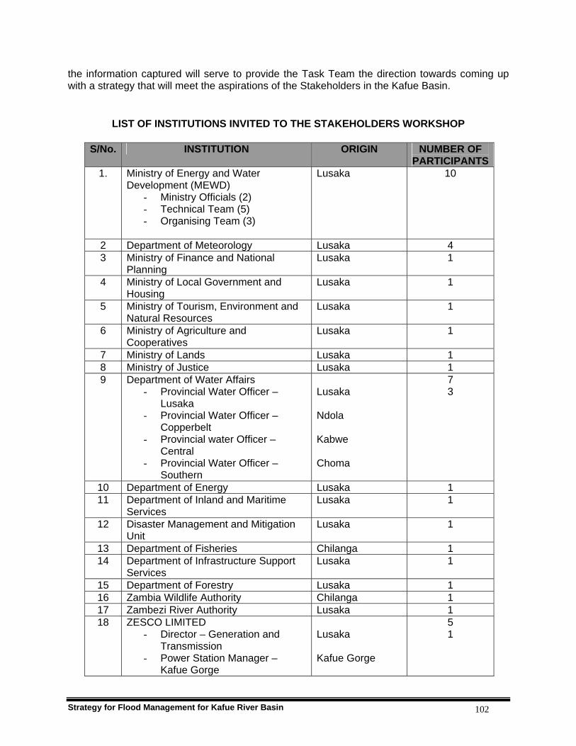
Strategy for Flood Management for Kafue River Basin 102
the information captured will serve to provide the Task Team the direction towards coming up with a strategy that will meet the aspirations of the Stakeholders in the Kafue Basin.
LIST OF INSTITUTIONS INVITED TO THE STAKEHOLDERS WORKSHOP
S/No. INSTITUTION ORIGIN NUMBER OF PARTICIPANTS
1. Ministry of Energy and Water Development (MEWD)
- Ministry Officials (2) - Technical Team (5) - Organising Team (3)
Lusaka 10
2 Department of Meteorology Lusaka 4 3 Ministry of Finance and National
Planning Lusaka 1
4 Ministry of Local Government and Housing
Lusaka 1
5 Ministry of Tourism, Environment and Natural Resources
Lusaka 1
6 Ministry of Agriculture and Cooperatives
Lusaka 1
7 Ministry of Lands Lusaka 1 8 Ministry of Justice Lusaka 1 9 Department of Water Affairs
- Provincial Water Officer – Lusaka
- Provincial Water Officer – Copperbelt
- Provincial water Officer – Central
- Provincial Water Officer – Southern
Lusaka Ndola Kabwe Choma
7 3
10 Department of Energy Lusaka 1 11 Department of Inland and Maritime
Services Lusaka 1
12 Disaster Management and Mitigation Unit
Lusaka 1
13 Department of Fisheries Chilanga 1 14 Department of Infrastructure Support
Services Lusaka 1
15 Department of Forestry Lusaka 1 16 Zambia Wildlife Authority Chilanga 1 17 Zambezi River Authority Lusaka 1 18 ZESCO LIMITED
- Director – Generation and Transmission
- Power Station Manager – Kafue Gorge
Lusaka Kafue Gorge
5 1

Strategy for Flood Management for Kafue River Basin 103
S/No. INSTITUTION ORIGIN NUMBER OF PARTICIPANTS
- Resident Engineer – Itezhi-tezhi
- Manager – Environment - Hydrological Unit
Itezhi-tezhi
19 Environmental Council of Zambia Lusaka 1 20 Water Board Lusaka 1 21 Zambia National farmers Union Lusaka 1 22 Zambia Sugar Company Mazabuka 1
Kafue Fisheries Kafue 1 23 Mpongwe Development Company Mpongwe 1 24 Chanyanya Fisheries Association Kafue 2 25 District Authority and Representative
From Communities prone to flooding Namwala Mazabuka
3
26 UNZA – Dr. Chabwela and Prof. Chidumayo
Lusaka 2
27 Zambia Water Partnership Lusaka 1 28 WWF – Water Dialogue Lusaka 1 29 NGOCC (Women for Change) Lusaka 1
Total Number of Participants 60
LIST OF PARTICIPANTS OF THE STAKEHOLDERS’ WORKSHOP
S/No.
NAME
ORGANIZATION
ADDRESS/E-MAIL
1 Hon. F. Mutati MEWD - Minister MEWD 2 E.S B. Sinkala (Mrs) MEWD - AG/PS MEWD 3 A. Hussen DWA - Director DWA 4 C. Chileshe DWA DWA 5 P. Chola DWA DWA 6 A. Lusaka DWA DWA 7 Y M Chulu MEWD MEWD, [email protected] 8 Wesley Mbula Council Secretary,
Namwala Council Box 67, Namwala - 097800198
9 Mellon H Chinjila Zesco Ltd Box 33304,Lusaka - 097-844803 10 Morgan Muleya Zambia Sugar Plc Box 670240, Mazabuka -097-851165 11 Mwangala B.
Mubiana MEWD MEWD, Lusaka
12 C. Mwasile WWF Box 50551, Lusaka. 13 A. Sinyangwe ZESCO Box 33304 Lusaka
[email protected] 14 F. Mulenga PWO – Kabwe DWA, Kabwe
[email protected] 15 J. Mwitwa WWF Box 50557 RW, Lusaka
[email protected] 16 F. Ngoma PWO – Lusaka Box 30530, Lusaka
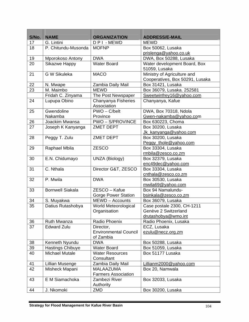
Strategy for Flood Management for Kafue River Basin 104
S/No.
NAME
ORGANIZATION
ADDRESS/E-MAIL
17 G. Lintini D P I - MEWD MEWD 18 P. Chitundu-Musonda MOFNP Box 50062, Lusaka
[email protected] 19 Mporokoso Antony DWA DWA, Box 50288, Lusaka 20 Sikazwe Happy Water Board Water development Board, Box
51059, Lusaka 21 G W Sikuleka MACO Ministry of Agriculture and
Cooperatives, Box 50291, Lusaka 22 N. Mwape Zambia Daily Mail Box 31421, Lusaka 23 M. Maimbo MEWD Box 36079, Lusaka. 252581 Fridah C. Zinyama The Post Newspaper [email protected] 24 Lupupa Obino Chanyanya Fisheries
Association Chanyanya, Kafue
25 Gwendoline Nakamba
PWO – C/belt Province
DWA, Box 70318, Ndola [email protected]
26 Joackim Mwansa PWO – S/PROVINCE Box 630223, Choma 27 Joseph K Kanyanga ZMET DEPT Box 30200, Lusaka
[email protected] 28 Peggy T. Zulu ZMET DEPT Box 30200, Lusaka
[email protected] 29 Raphael Mbila ZESCO Box 33304, Lusaka
[email protected] 30 E.N. Chidumayo UNZA (Biology) Box 32379, Lusaka
[email protected] 31 C. Nthala Director G&T, ZESCO Box 33304, Lusaka
[email protected] 32 P. Mwila DWA Box 30530, Lusaka
[email protected] 33 Bornwell Siakala ZESCO – Kafue
Gorge Power Station Box 94 Namalundu- [email protected]
34 S. Muyakwa MEWD – Accounts Box 36079, Lusaka 35 Datius Rutashobya World Meteorological
Organisation Case postale 2300, CH-1211 Genève 2 Switzerland [email protected]
36 Ruth Mwanza Radio Phoenix Radio Phoenix, Lusaka 37 Edward Zulu Director,
Environmental Council of Zambia
ECZ, Lusaka [email protected]
38 Kenneth Nyundu DWA Box 50288, Lusaka 39 Hastings Chibuye Water Board Box 51059, Lusaka 40 Michael Mutale Water Resources
Consultant Box 51177 Lusaka
41 Lillian Musenge Zambia Daily Mail [email protected] 42 Misheck Mapani MALAAZUMA
Farmers Association Box 20, Namwala
43 E M Siamachoka Zambezi River Authority
Box 32033, Lusaka
44 J. Nkomoki ZMD Box 30200, Lusaka
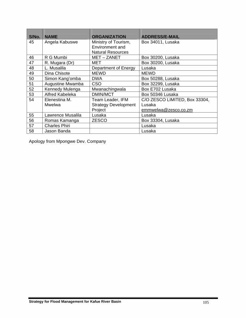
Strategy for Flood Management for Kafue River Basin 105
S/No.
NAME
ORGANIZATION
ADDRESS/E-MAIL
45 Angela Kabuswe Ministry of Tourism, Environment and Natural Resources
Box 34011, Lusaka
46 R G Mumbi MET – ZANET Box 30200, Lusaka 47 R. Mugara (Dr) MET Box 30200, Lusaka 48 L. Musalila Department of Energy Lusaka 49 Dina Chisote MEWD MEWD 50 Simon Kang’omba DWA Box 50288, Lusaka 51 Augustine Mwamba CSO Box 32299, Lusaka 52 Kennedy Mulenga Mwanachingwala Box E702 Lusaka 53 Alfred Kabeleka DMIN/MCT Box 50346 Lusaka 54 Elenestina M.
Mwelwa Team Leader, IFM Strategy Development Project
C/O ZESCO LIMITED, Box 33304, Lusaka [email protected]
55 Lawrence Musalila Lusaka Lusaka 56 Romas Kamanga ZESCO Box 33304, Lusaka 57 Charles Phiri Lusaka 58 Jason Banda Lusaka Apology from Mpongwe Dev. Company

Strategy for Flood Management for Kafue River Basin 106
Annex III
POLICY MAKERS’ WORKSHOP REPORT
WMO
GRZ
APFM
Plate 11: Participants of the Policy Makers’ Workshop 1. Background The Integrated Flood Management Project for the Kafue Basin was initiated by the Department of Water Affairs and the Zambia Meteorological Department. A concept paper was then submitted jointly by the Department of Water Affairs (DWA) and Zambia Meteorological Department (ZMD) to WMO to request for technical assistance to be able to undertake the project. In response to this request, an Agreement was signed between WMO and the Government of the Republic of Zambia for the development of the Integrated Flood

Strategy for Flood Management for Kafue River Basin 107
Management (IFM) Strategy in the Kafue Basin. WMO assisted the Ministry of Energy and Water Development (MEWD) of the Government of Zambia to develop the Strategy as a pilot project under the APFM. A team of Zambian experts was assigned to prepare the Flood Management Strategy, with was done in close consultation with WMO experts. The Strategy development process was designed to take into account the full participation of key stakeholders and policy makers which included Government Ministries and Departments, local authorities, parastatal organizations, academicians and researchers, non governmental organizations(NGOs), and farmers’ and fishing associations in the flood prone areas. Upon the constitution of the Project Team, a Steering Committee was appointed from key line Ministries and institutions whose operations have close relation to flood management. The Steering Committee’s main task was to give direction to the project and approve the draft Strategy documents. At the apex of stakeholder consultation was the consultation and presentation of the draft Strategy to Policy Makers who are mainly the Permanent Secretaries of line Ministries and their Directors. This report presents the proceedings of the Policy Makers Workshop which was held at Chaminuka Lodge on 8th September 2006. 2. Opening Remarks The Project Team leader gave a brief background of the Project and then she called upon the Assistant Director of Water affairs, Mr. Chileshe to give the opening remarks. The Assistant Director of Water Affairs welcomed the participants and then called upon the WMO official to give his remarks. After the remarks from the WMO representative, the Assistant Director then called upon the Permanent Secretary to give the opening speech. 2.1 Remarks by the WMO Representative The WMO representative Mr Datius Rutashobya expressed delight that he was able to be present at this important Policy Makers Workshop. He outlined the roles of WMO which include the responsibility to assist countries to attain better meteorological and hydrological services. He gave a brief background on WMO’s involvement in the Integrated Flood Management (IFM) initiative which is funded through the Associated Programme on Flood Management (APFM). He commended the Zambian project team members for the good work they had done so far. He further went on to urge the policy makers to look critically at the proposed policy elements and measures and endorse them because the implementations of the strategy can only go ahead with the blessings of policy makers. He assured the participants that WMO was willing to assist in seeking for resources from various partners to be able to ensure the implementation of the strategy when finalised. He also informed the participants that there was a desire for a programme on the IFM for the whole Zambezi Basin and urged Zambia to take active participation in the programme.

Strategy for Flood Management for Kafue River Basin 108
Plate 12: WMO representative Mr Datius Rutashobya making opening remarks 3.3 Opening speech by the Permanent Secretary – Dr. Buleti Nsemukila
Plate 13: Permanent Secretary, Ministry of Energy and Water Development Mr Buleti Nsemukila giving the opening speech The permanent Secretary in highlighted the fact that the Project was conceived at the right time when the country had experienced devastating and destructive flood such as the mud slide flash floods that affected Kafue Gorge Power station and Kazungula. He gave a brief on the importance of using IFM concept in finding lasting solutions to flood management and that the

Strategy for Flood Management for Kafue River Basin 109
IFM Strategy was going to add value to the Integrated Water Resources Management initiatives which the country was carrying out. He gave a brief on the process and approach used to come up with the draft strategy for flood management in the Kafue Basin. The key rational for the development of the strategy was given as mainly to develop a policy that would remove flood management from ad hoc management to a well planned programme with clear fiscal provisions in the main budget lines of ministries responsible for flood management and related activities. He went on to give the objectives of the workshop, being: provision of general and specific comments on the draft strategy; adoption and endorsement of the draft strategy taking into account the participants comments; and to come up with the proposal on the way forward for the strategy. He encouraged the participants to ensure that the workshop objectives are met in order to allow the project team to finalise the strategy document. The permanent Secretary further emphasised the need for effective data collection and monitoring if floods have to be managed. He gave a quote that, “If you can not measure it, you can not manage it”. He elaborated that if we can not measure floods, then we would not be able to manage flood events, emphasising the need for effective and adequate hydrometeorological network. 3.4 Presentation of the IFM Strategy – Mrs Elenestina Mwelwa The project Team Leader presented an outline and the key points in the Draft Strategy. Under the project background, the project conception and the management aspects were presented, giving details of the Project Team and the approach used in the preparation of the Strategy. Aspects of the Kafue River Basin were also presented.
Plate 14: Workshop participants listening to the presentation

Strategy for Flood Management for Kafue River Basin 110
The Strategy for flood management was presented giving the rationale for the preparation of Strategy and the strategy formulation process which comprised project steering committee, extensive stakeholder consultation and at the apex was the policy makers’ workshop. Then the sixteen strategy objectives were presented under the six thematic areas of: reducing vulnerability; Reorientation of approach to development and floods; integrated approach to water resources development and flood management; protecting and conserving environment; addressing weather and climate variability and change; and coordination between various ministries and agencies. Arising from the sixteen strategy objectives are policy measures, therefore the policy measures recommended to cover six areas were presented. The six areas under which policy measure were recommended were: institutional arrangements; organisation structure; structural measures; non-structural measures; community participation; and capacity building. Highlights of the proposed flood forecasting system for the Kafue River Basin were presented. The flood forecasting key elements were: the need for an efficient hydrometeorological network which includes the establishment of Flood Forecasting Offices and forecast dissemination aspects which will include the use of RANET. The presentation concluded with outlining the action plan recommended for implementation of the Strategy. The activities were prioritized according to short term measures (0-5 years); Medium term measures (5-10 years); and long term measures (beyond 10 years). 4. GENERAL COMMENTS AND DISCUSSION After the above presentation, the discussions were opened for general comments on the presentations. The Policy Makers commended the Project Team for their work and effort in putting together a well thought and well structured strategy document on flood management. There was a strong recommendation that there was need for quick integration of the IFM strategy principles in the current revision process of the National Water Policy which were underway. The Project Team was requested to look at the National water Policy and ensure that IFM principals are included in the various relevant sections. To facilitate completeness of the strategy document, it was observed that since floods are closely associated with droughts, there was need to strategise how the drought management aspects could be covered, whether under the same Strategy document or a separate strategy document. It was pointed out that once flood management aspects are integrated with drought management aspects, then the flood management measures would be designed in such a way that they help the drought prone areas by conserving the excess water during the floods. The excess water could be channelled to water conservation reservoirs instead of the current practice where the excess water in the current reservoirs when released, just increase the flooding in the flood plans. The Participants pointed out that the total dependence on ground water in drought prone areas has not helped alleviate impacts of droughts, therefore excess

Strategy for Flood Management for Kafue River Basin 111
surface water need to be diverted and held in small reservoirs to improve recharge to groundwater aquifers. This would improve both the quantity and the quality of ground water. The WMO representative observed that it would be a big challenge to handle both floods and droughts in one document because these two events represent two extremes. However he did point out that WMO would be willing to support the development of a drought management strategy if requested. 5. GROUP DISCUSSIONS To ensure that the document was thoroughly discussed, the participants were divided into 4 groups: group 1 to discuss part 1; group 2 to discuss part 2; group 3 to discuss part 3; and group 4 to discuss part 4 The Permanent Secretaries’ group continued their reflections and discussions on the general structure of the strategy and the way forward to ensure effective implementation. 5.1 Group one Discussion – Part 1: Background This group was assigned to discuss the section on the background of the strategy. They provided comments that were both editorial but also proposed changes in some areas of the section. The detailed comments were compiled and handed over to the Project Team to help with editing of the final draft.
Plate 15: Policy Makers’ Group discussions
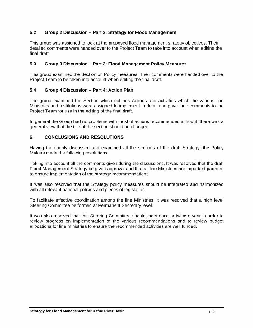
Strategy for Flood Management for Kafue River Basin 112
5.2 Group 2 Discussion – Part 2: Strategy for Flood Management This group was assigned to look at the proposed flood management strategy objectives. Their detailed comments were handed over to the Project Team to take into account when editing the final draft. 5.3 Group 3 Discussion – Part 3: Flood Management Policy Measures This group examined the Section on Policy measures. Their comments were handed over to the Project Team to be taken into account when editing the final draft. 5.4 Group 4 Discussion – Part 4: Action Plan The group examined the Section which outlines Actions and activities which the various line Ministries and Institutions were assigned to implement in detail and gave their comments to the Project Team for use in the editing of the final draft. In general the Group had no problems with most of actions recommended although there was a general view that the title of the section should be changed. 6. CONCLUSIONS AND RESOLUTIONS Having thoroughly discussed and examined all the sections of the draft Strategy, the Policy Makers made the following resolutions: Taking into account all the comments given during the discussions, It was resolved that the draft Flood Management Strategy be given approval and that all line Ministries are important partners to ensure implementation of the strategy recommendations. It was also resolved that the Strategy policy measures should be integrated and harmonized with all relevant national policies and pieces of legislation. To facilitate effective coordination among the line Ministries, it was resolved that a high level Steering Committee be formed at Permanent Secretary level. It was also resolved that this Steering Committee should meet once or twice a year in order to review progress on implementation of the various recommendations and to review budget allocations for line ministries to ensure the recommended activities are well funded.
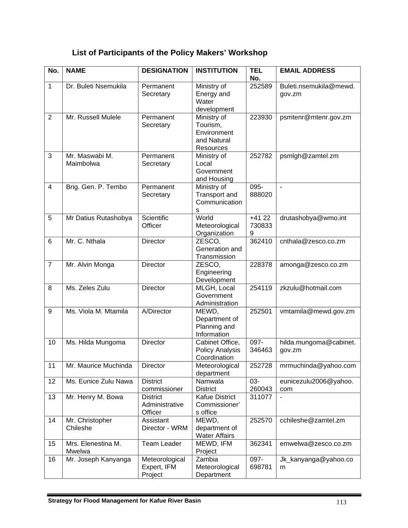
Strategy for Flood Management for Kafue River Basin 113
List of Participants of the Policy Makers’ Workshop No. NAME DESIGNATION INSTITUTION TEL
No. EMAIL ADDRESS
1 Dr. Buleti Nsemukila Permanent Secretary
Ministry of Energy and Water development
252589 [email protected]
2 Mr. Russell Mulele Permanent Secretary
Ministry of Tourism, Environment and Natural Resources
223930 [email protected]
3 Mr. Maswabi M. Maimbolwa
Permanent Secretary
Ministry of Local Government and Housing
252782 [email protected]
4 Brig. Gen. P. Tembo Permanent Secretary
Ministry of Transport and Communications
095-888020
-
5 Mr Datius Rutashobya Scientific Officer
World Meteorological Organization
+41 22 7308339
6 Mr. C. Nthala Director ZESCO, Generation and Transmission
362410 [email protected]
7 Mr. Alvin Monga Director ZESCO, Engineering Development
228378 [email protected]
8 Ms. Zeles Zulu Director MLGH, Local Government Administration
254119 [email protected]
9 Ms. Viola M. Mtamila A/Director MEWD, Department of Planning and Information
252501 [email protected]
10 Ms. Hilda Mungoma Director Cabinet Office, Policy Analysis Coordination
097-346463
11 Mr. Maurice Muchinda Director Meteorological department
252728 [email protected]
12 Ms. Eunice Zulu Nawa District commissioner
Namwala District
03-260043
13 Mr. Henry M. Bowa District Administrative Officer
Kafue District Commissioner’s office
311077 -
14 Mr. Christopher Chileshe
Assistant Director - WRM
MEWD, department of Water Affairs
252570 [email protected]
15 Mrs. Elenestina M. Mwelwa
Team Leader MEWD, IFM Project
362341 [email protected]
16 Mr. Joseph Kanyanga Meteorological Expert, IFM Project
Zambia Meteorological Department
097-698781
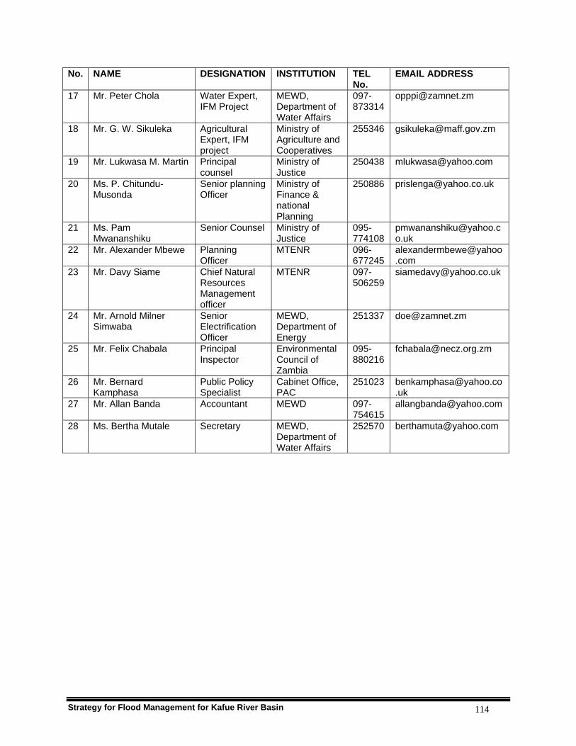
Strategy for Flood Management for Kafue River Basin 114
No. NAME DESIGNATION INSTITUTION TEL No.
EMAIL ADDRESS
17 Mr. Peter Chola Water Expert, IFM Project
MEWD, Department of Water Affairs
097-873314
18 Mr. G. W. Sikuleka Agricultural Expert, IFM project
Ministry of Agriculture and Cooperatives
255346 [email protected]
19 Mr. Lukwasa M. Martin Principal counsel
Ministry of Justice
250438 [email protected]
20 Ms. P. Chitundu-Musonda
Senior planning Officer
Ministry of Finance & national Planning
250886 [email protected]
21 Ms. Pam Mwananshiku
Senior Counsel Ministry of Justice
095-774108
22 Mr. Alexander Mbewe Planning Officer
MTENR 096-677245
23 Mr. Davy Siame Chief Natural Resources Management officer
MTENR 097-506259
24 Mr. Arnold Milner Simwaba
Senior Electrification Officer
MEWD, Department of Energy
251337 [email protected]
25 Mr. Felix Chabala Principal Inspector
Environmental Council of Zambia
095-880216
26 Mr. Bernard Kamphasa
Public Policy Specialist
Cabinet Office, PAC
251023 [email protected]
27 Mr. Allan Banda Accountant MEWD 097-754615
28 Ms. Bertha Mutale Secretary MEWD, Department of Water Affairs
252570 [email protected]

Strategy for Flood Management for Kafue River Basin 115
PART VI
APPENDICES
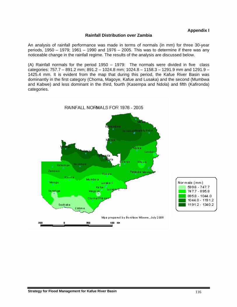
Strategy for Flood Management for Kafue River Basin 116
Appendix I Rainfall Distribution over Zambia
An analysis of rainfall performance was made in terms of normals (in mm) for three 30-year periods, 1950 – 1979; 1961 – 1990 and 1976 – 2005. This was to determine if there was any noticeable change in the rainfall regime. The results of the analysis are discussed below. (A) Rainfall normals for the period 1950 – 1979: The normals were divided in five class categories: 757.7 – 891.2 mm; 891.2 – 1024.8 mm; 1024.8 – 1158.3 – 1291.9 mm and 1291.9 – 1425.4 mm. It is evident from the map that during this period, the Kafue River Basin was dominantly in the first category (Choma, Magoye, Kafue and Lusaka) and the second (Mumbwa and Kabwe) and less dominant in the third, fourth (Kasempa and Ndola) and fifth (Kafironda) categories.

Strategy for Flood Management for Kafue River Basin 117
(B) Rainfall normals for the period 1961 – 1990: During this period, the five categories were 655.2 – 814.8 mm; 814.8 – 964.4 mm; 964.4 – 1113.9 mm; 1113.9 – 1263.5 mm 1263.5 – 1413.1 mm. Both the lower and upper class limits in all the categories are lower during this period than in the 1950 -1979 period. This implies that on average, there was a reduction in annual cumulative rainfall amounts in the period 1961 – 1990. For the Kafue River Basin, the first two class boundaries dominate during this period than the other three class boundaries. The first category (Choma, Magoye and Kafue); the second (Lusaka, Mumbwa and Kabwe); the third, fourth (Kasempa and Ndola) and fifth (Kafironda).
(C) Rainfall normals for the period 1976 – 2005: The five categories during this period were 539.6 – 747.7 mm; 747.7 – 895.8 mm; 895.8 – 1044.0 mm; 1044.0 – 1191.2 mm 1191.2 –

Strategy for Flood Management for Kafue River Basin 118
1340.2 mm. The lower and upper class limits in all the five class categories are Lower during this period than in the 1950 -1979 and 1961 - 1990 periods. This means on average, there has been a progressive reduction in annual cumulative rainfall amounts since the 1950s through to 2005. During the period 1976 – 2005, the Kafue River Basin was dominated by the first two class categories. The first category (Choma, Magoye and Kafue); the second (Lusaka, Mumbwa and Kabwe); the third, fourth (Kasempa and Ndola) and fifth (Kafironda).

Strategy for Flood Management for Kafue River Basin 119
Appendix II Flood situation and analysis of extreme flows in Kafue Basin
Flood Situation in Kafue basin The Kafue Flats in the Kafue Basin has been subjected to flooding. The year 1994 saw severe floods in the Flats when fishing camps and some settlements along the river were inundated and people were displaced. Mud brick houses especially those in the plain collapsed. Two bridges in the Kafue Flats were washed away cutting off Monze and Namwala towns from the rest of the country. Flood relief and other requisites had to be flown in by helicopters. All the pontoons on the river were rendered useless due to torrential currents. The effect of the 1994 floods were compounded by the fact that Zambia had not yet recovered from the impact of the preceding 1991/92 drought. A marked example of urban flooding is the year 1988/89 when more than 50, 000 people in the Kafue Basin towns of Kitwe, Ndola, Kapiri Mposhi, Kabwe, Lusaka and Mazabuka were left homeless. Though most of the damaged homes were from shanty compounds a number of houses in wealthy suburbs were also damaged. People had to be shifted to makeshift camps made by Government and Red Cross Society. One of the wealthy townships in Lusaka was completely cut off when the access tarred road caved in after two weeks of continuous heavy rains. Urban flooding was also experienced in 1992/93, 2000/01 and 2005/06. Recent floods in the Basin have been associated with some parts of towns and population centres located near dambos and swampy areas. These include Makululu in Kabwe, Kanyama and Chawama in Lusaka. Even some well built up areas of Lusaka and Kabwe which are located in low lying zones but not properly drained are prone to flooding. These are Emmasdale and Avondale and Mine Compound respectively. Urban flooding has been experienced each year when the Basin has received normal to above normal rainfall. These floods can be said to be human induced due to various factors that include poor urban planning, non provision of adequate storm drainage system and poor designs and quality of housing units and other infrastructure. The most recent floods in the Basin are the wide spread floods associated with flashy floods which occurred in various places in the 2005/2006 rainy season. The flashy floods that affected the Kafue Gorge Power Station in December 2005 rank highly in terms of extent of damage, which disrupted power generation for a period of two weeks. Wide spread flooding was also reported in months of February and March 2006 which affected housing units and agricultural fields in the Southern Province towns of Mazabuka, Monze and Choma. Analysis of annual extreme flows The analysis of annual extreme flows can be illustrated with the following numerical example, for a period of 10 years the maximum daily flows in each year is listed in table 1. For convenience a (too) short period of 10 years is considered. Rank the data in descending order (see table 2)
Compute for each year the probability of exceedence.
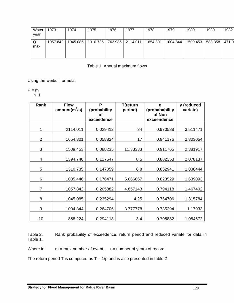
Strategy for Flood Management for Kafue River Basin 120
Water year
1973 1974 1975 1976 1977 1978 1979 1980 1980 1982
Q max
1057.842 1045.085 1310.735 762.985 2114.011 1654.801 1004.844 1509.453 588.358 471.02
Table 1. Annual maximum flows
Using the weibull formula, P = m n+1
Table 2. Rank probability of exceedence, return period and reduced variate for data in Table 1. Where in m = rank number of event, n= number of years of record The return period T is computed as T = 1/p and is also presented in table 2
Rank Flow amount(m3/s)
P (probability
of exceedence
T(return period)
q (probabability
of Non exceendence
y (reduced variate)
1 2114.011 0.029412 34 0.970588 3.511471
2 1654.801 0.058824 17 0.941176 2.803054
3 1509.453 0.088235 11.33333 0.911765 2.381917
4 1394.746 0.117647 8.5 0.882353 2.078137
5 1310.735 0.147059 6.8 0.852941 1.838444
6 1085.446 0.176471 5.666667 0.823529 1.639093
7 1057.842 0.205882 4.857143 0.794118 1.467402
8 1045.085 0.235294 4.25 0.764706 1.315784
9 1004.844 0.264706 3.777778 0.735294 1.17933
10 858.224 0.294118 3.4 0.705882 1.054672

Strategy for Flood Management for Kafue River Basin 121
Annual flow extremes tend to plot as a straight line on extreme- value–probability (Gumbel) paper is only applicable to annual extremes, the method uses the probability of non-exceedence q = 1 – p (the probability that the annual maximum daily flow is less than a certain magnitude). The values are listed in table 2. Gumbel makes use of a reduced variant y as a function of q. which allows the plotting of the distribution as a linear function between y and x (the flow in this case). y = a (x-b) The function for the reduced variate reads: y = -ln (-ln(q)) = - ln (-ln(1-p)) The computed values of y for the data in table 1 are presented in table 2. A linear plot of these data on extreme-value- probability paper (fig. 1) is an indication that the frequency distribution that the frequency distribution fits the extreme value theory of Gumbel. From the plot, the flows for different values of return periods T are estimated. Care should be taken with regard to extrapolation of frequency estimates, in particular if the return period is larger than twice the record length.
Kafue River at Namwala Pontoon 4-760
0
200
400
600
800
1000
1200
1400
1600
1800
-2 -1 0 1 2 3 4 5
Reduced Variate
Dis
scha
rge
(m3 /s
)
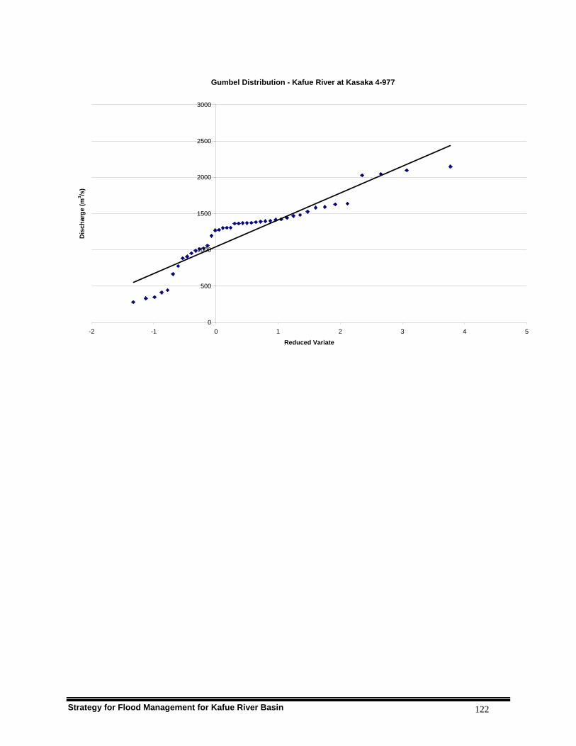
Strategy for Flood Management for Kafue River Basin 122
Gumbel Distribution - Kafue River at Kasaka 4-977
0
500
1000
1500
2000
2500
3000
-2 -1 0 1 2 3 4 5
Reduced Variate
Dis
char
ge (m
3 /s)

Strategy for Flood Management for Kafue River Basin 123
Appendix III Livestock and Maize Production
CATTLE The cattle population at the end of the 1999/2000 agricultural season was estimated at 1, 186,495, just 0.05% less than the number that was held at the beginning of the agricultural season. Southern province recorded the highest decline in cattle numbers. Southern province which had 30% of the cattle reared in the country reported a decline of 4% by close of the season. This could be attributed to the livestock diseases that ravaged the province during the season. Source: Agricultural and Pastoral Production (Small and Medium Scale Holdings), 1999/2000: Central Statistical Office, September 2001, page 62. LIVESTOCK PRODUCTION Southern province recorded the highest proportion of agricultural households involved in livestock rearing with 48.2 percent and in poultry production, with 86.6 percent. Rural Households by Type of Agricultural Activity
Percentage of households by Type of Agricultural Activity Household Reporting
Crops Livestock Poultry Fish
Farming Province 1999/2000 2002/2003 1999/2000 2002/2003 1999/2000 2002/2003 1999/2000 2002/2003 2002/2003
Central 70,9916 108,918 94.3 93.2 29.1 31.2 80.7 80.7 2.1 Copperbelt 34,540 66,909 99.4 94.5 18.0 9.5 66.7 64.9 0.5
Eastern 188,592 225,047 98.9 97.7 45.4 42.1 67.7 70.9 0.9 Luapula 106,661 106,784 98.1 92.2 17.9 21.7 62.9 67.2 0.7 Lusaka 17,265 18,876 100.0 87.1 22.4 26.1 62.2 63.7 0.7
Northern 136,538 191,915 97.6 95.1 28.5 32.6 67.4 80.6 2.5 N/Western 50,379 74,290 99.4 94.9 17.6 20.1 48.0 61.5 0.9
Southern 110,810 122,342 94.9 94.9 48.7 48.2 84.4 86.8 0.2 Western 102,743 106,048 99.5 94.5 18.7 28.7 64.6 61.1 1.2 Zambia
Total
818,445
1,02,128
97.8
94.9
31.3
32.3
68.6
73.1
1.2 Sources: Agricultural and Pastoral Production (Small and Medium Scale Holdings), 1999/2000: Central Statistical Office, September 2001 Agricultural and Pastoral Production (Structural Type and Post Harvest Data 2002/2003 for Small and Medium Scale Farmers: Central Statistical Office, December 2004. At national level, the households raising cattle declined by 14 percent and cattle population declined by 22 percent countrywide. page x The 2002/2003 Agricultural Season, recorded a total of 250,611 cattle losses in the country due to disease. The highest number was recorded in Western Province at 36.3 percent, followed by Eastern and Southern provinces at 17.6 and 14.9 percent respectively. Page 68 Cattle: Number of households raising, number owned, deaths due to disease Southern province during 2002/2003 agricultural season
District Number of Households
raising
Number of cattle owned
Number of cattle per
household
Number died due to
disease Choma 5,551 33,789 6.1 6,421 Gwembe 1,236 8,020 6.5 1,243 Itezhi-tezhi 691 7,536 10.9 267

Strategy for Flood Management for Kafue River Basin 124
Kalomo 5,084 35,404 7.0 14,392 Kazungula 945 9,409 10.0 1,205 Livingstone 21 408 19.4 376 Mazabuka 6,702 43,583 6.5 7,260 Monze 3,378 26,165 7.7 2,807 Namwala 1,086 31,376 28.9 1,154 Siavonga 1,616 9,955 6.2 627 Sinazongwe 3,559 31,928 9.0 1,819 Province Total
29,869 237,572 8.0 37,572
Source: Agricultural and Pastoral Production (Structural Type and Post Harvest Data 2002/2003 for Small and Medium Scale Farmers: Central Statistical Office, December 2004. MAIZE PRODUCTION Maize is the most important staple food crop in Zambia. It also serves as a source of income for households through marketing the surplus. There were 760,515 households that reported to have grown maize during the 2002/2003 agriculture season compared to 648,050 households during the 2001/2002 agriculture season and 610,282 households during the 1999/2000 agriculture season (CSO 2001, 2004). The total area planted to maize during the 1999/2000 agriculture season was 564,693 hectares, 3.4% below the area recorded in the 1998/99 agriculture season (584,498 hectares). During the 2002/2003 agriculture season the area planted to maize was estimated at 581,982 hectares. In the 2001/2002 agriculture season 646,450 were planted. Therefore the area planted to maize during the 2002/2003 agriculture season declined by 10.0 percent.
Province Number of households reporting Total area planted Yield Mt/Ha 1999/2000 2002/2003 2003/2004 1999/2000 2002/2003 2003/2004 2002/2003 2003/2004 Central 61,028 93,942 110,000 61,552 93,622 88,782.1 1.77 2.34 Copperbelt 31,735 60,914 58,763 44,046 52,387 41,605.6 1.36 2.04 Eastern 185,526 214,695 234,531 191,996 171,728 182,328.7 1.63 1.63 Luapula 37,227 30,328 40,679 11,294 9,868 10,419.7 1.68 1.52 Lusaka 17,088 16,405 24,084 15,247 13,663 16,892.6 1.55 1.96 Northern 61,028 101,883 98,810 37,270 46,138 45,765.6 1.47 1.68 North Western
29,904 53,473 52,290 18,070 29,842 27,927.8 1.38 1.46
Southern 100,697 103,485 127,339 144,561 117,170 118,305 1.45 2.03 Western 85,439 85,390 100,823 41,223 47,563 59,717.0 0.75 0.94 Zambia total
610,282 760,515 847,320 564,693 581,982 591,744.2 1.49 1.79
Sources: Agricultural and Pastoral Production (Small and Medium Scale Holdings), 1999/2000: Central Statistical Office, September 2001 Agricultural and Pastoral Production (Structural Type and Post Harvest Data 2002/2003 for Small and Medium Scale Farmers: Central Statistical Office, December 2004. Agricultural Production for Small and Medium Scale Farmers. Post Harvest Data 2003/2004: Central Statistical Office, May 2006.
Strategy for Flood Management for Kafue River Basin 125
Appendix IV Economic Activities in the Kafue Basin
The major economic activities in the Kafue Basin include farming, fisheries, trading, mining, manufacturing, construction, tourism, hydropower generation, transport and communication, community and public service. Farming: The Kafue Basin has commercial, medium, small scale and peasant farmers. Commercial farmers are mainly concentrated along the line of rail and major roads. They are involved in cash crops and livestock production. Cash crops include maize, wheat, potatoes, flowers and herbs. Intensive irrigation methods are used for cash crop production. Livestock rearing is for dairy, chicken and beef production. Medium, small scale and peasant farmers are found all over the country. However, medium and small scale farmers tend to be found near towns and population growth centres where there is easy access to agricultural services. Fisheries: Fishing is a commercial and subsistence activities. It is mainly done on rivers and lakes. Fish-farming is developing fast especially in recent years when fish catches are dwindling from natural water bodies: rivers and lakes. Trading in various merchandise at both wholesale and retail outlets is common especially in towns and large villages. Mining: Copper mining is a mainstay of the Zambian economy and it is concentrated in the Kafue Basin in an area called the Copperbelt. Other minerals produced include cobalt, gold, and precious stones. Manufacturing: The Kafue Basin accommodates the bulk of factories as it is the most urbanized river basin in the country. Steel fabrication to support mining and the construction industry; manufacturing of food stuffs, furniture and wood processing, paints, textiles, fertilizers, tannery and boats are common activities. Construction: Real estates development and road constructions are major activities especially this time when new mines are opening and ordinary people are being empowered to own houses by government. Tourism: Hotels, restaurants and public transport operators are the main drivers of the tourism industry. The major attractions in the Kafue Basin include the game parks, wetlands and the mining industries. Hydropower generation: This is done at Kafue Gorge Dam. Water storage for power generation is kept upstream at Itezhi-tezhi Reservoir and the flood plains called the Kafue Flats. The electricity utility Zesco Limited employs people for power generation, transmission and distribution. Transport and communication: Public and private transport and communication utilities provide employment to people especially in towns. Public service: The public sector is the largest employer in Zambia. Teachers, doctors, engineers, administrators and other office workers are mostly employed by government.

Strategy for Flood Management for Kafue River Basin 126
Economic Activities of Kafue Basin
Sub-basin
District Mining Farming Manufacturing Others
Upper Chililabombwe Chingola Kalulushi Kitwe Luanshya Masaiti Mpongwe Mufulira Ndola Solwezi
Copper Cobalt Gold Precious stones (emeralds)
Maize Cotton Wheat Flowers Potatoes Sorghum Coffee Livestock Fish Game-ranching
Steel fabrication Petroleum products Paper Breweries Paint Textiles Maize meal Beef and pork Chemicals
Tourism Transport Communication Public service Construction Trading
Middle Chibombo Choma Itezhi-tezhi Gwembe Kalomo Kasempa Mazabuka Monze Mufumbwe Mumbwa Solwezi Siavonga
Emaralds Copper Cobalt
Maize Cotton Wheat Flowers Potatoes Sorghum Coffee Livestock Fish Game-ranching
Breweries, Maize meal, Beef and pork, Hydropower generation.
Tourism, Transport, Communication, Public service, Construction, Trading.
Lower Kafue Mazabuka Siavonga
Nickel Emaralds Amethyst
Maize, Cotton, Wheat, Flowers, Potatoes, Sorghum, Coffee, Livestock Fish Game-ranching.
Breweries, Maize meal, Beef and pork, Hydropower generation.
Tourism, Transport, Communication, Public service, Construction, Trading.
Adapted from: National Water Resources Master Plan (1995 and ZACPRO 6.1.2)
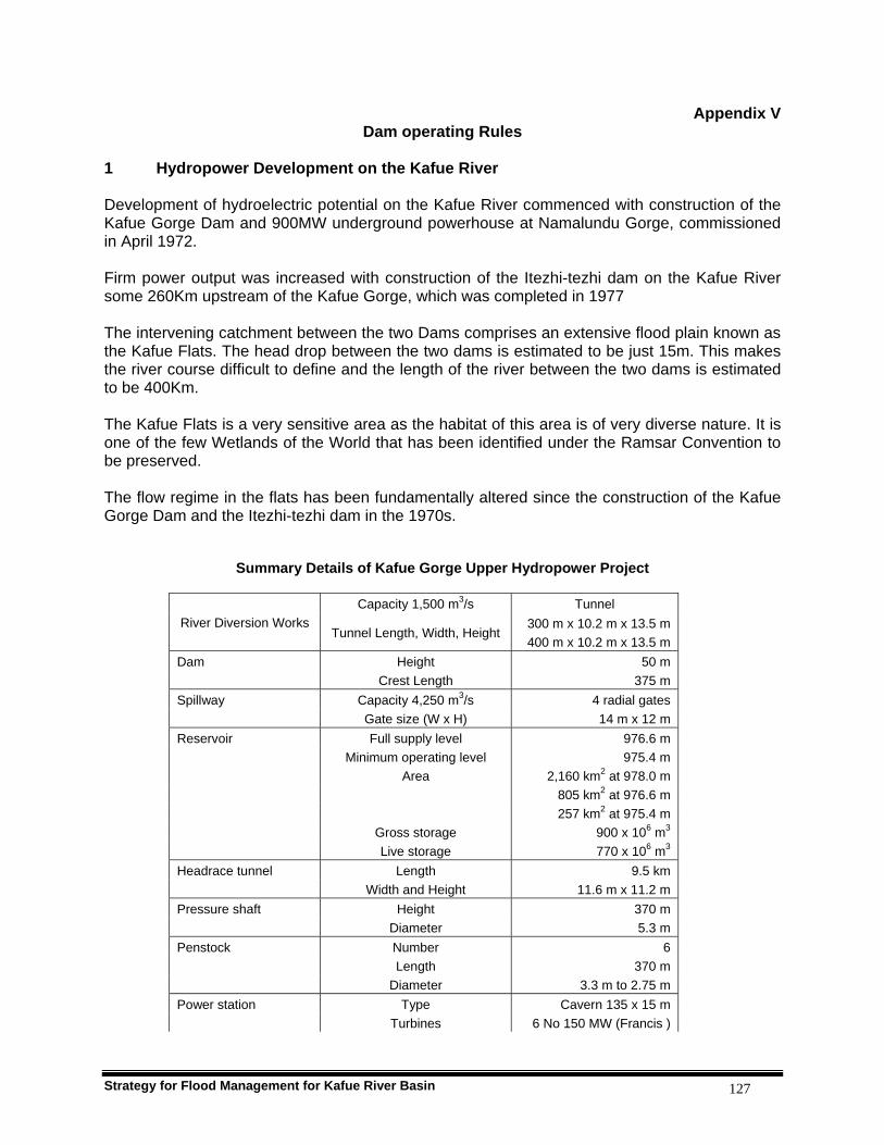
Strategy for Flood Management for Kafue River Basin 127
Appendix V Dam operating Rules
1 Hydropower Development on the Kafue River Development of hydroelectric potential on the Kafue River commenced with construction of the Kafue Gorge Dam and 900MW underground powerhouse at Namalundu Gorge, commissioned in April 1972. Firm power output was increased with construction of the Itezhi-tezhi dam on the Kafue River some 260Km upstream of the Kafue Gorge, which was completed in 1977 The intervening catchment between the two Dams comprises an extensive flood plain known as the Kafue Flats. The head drop between the two dams is estimated to be just 15m. This makes the river course difficult to define and the length of the river between the two dams is estimated to be 400Km. The Kafue Flats is a very sensitive area as the habitat of this area is of very diverse nature. It is one of the few Wetlands of the World that has been identified under the Ramsar Convention to be preserved. The flow regime in the flats has been fundamentally altered since the construction of the Kafue Gorge Dam and the Itezhi-tezhi dam in the 1970s.
Summary Details of Kafue Gorge Upper Hydropower Project
Capacity 1,500 m3/s Tunnel River Diversion Works
Tunnel Length, Width, Height 300 m x 10.2 m x 13.5 m 400 m x 10.2 m x 13.5 m
Dam Height 50 m Crest Length 375 m Spillway Capacity 4,250 m3/s 4 radial gates Gate size (W x H) 14 m x 12 m Reservoir Full supply level 976.6 m Minimum operating level 975.4 m Area 2,160 km2 at 978.0 m 805 km2 at 976.6 m 257 km2 at 975.4 m Gross storage 900 x 106 m3 Live storage 770 x 106 m3 Headrace tunnel Length 9.5 km Width and Height 11.6 m x 11.2 m Pressure shaft Height 370 m Diameter 5.3 m Penstock Number 6 Length 370 m Diameter 3.3 m to 2.75 m Power station Type Cavern 135 x 15 m Turbines 6 No 150 MW (Francis )

Strategy for Flood Management for Kafue River Basin 128
Rated head 396m Rated flow 6 x 43 m3/s Tailrace tunnel Length 1.4 km Size 11.6 x 11.1 m Transmission Voltage 330 kV
Source: Sweco 1971;ZESCO, SADCC, 1993
Summary Details of Itezhi-tezhi Dam and Hydropower Project River Diversion Works 2 No. Tunnel 13 m x 16 m x 480/550 m length Capacity 3,000 m3/s Dam Crest Elevation 1,035 .0 m Crest Length 1,800 m Spillway Type Radial gated chute Capacity 4,450 m3/s Sill Elevation 1,018.7 m Emergency Spillway Type Fuseplug Capacity 750 m3/s Reservoir Full supply Level 1,029.5 m (Planned)
1,030.5 m (Current operation) Min. Operating Level 1,006.0 m Surface Area 374 km2 at 1,029.5 m
392 km2 at 1,030.5 m
EX
ISTI
NG
Gross Storage 5,624 x 106 m3 at 1029.5 m 6,000 x 106 m3 at 1030.5 m
Penstocks 2 No. (1 No. constructed within existing tunnel) Diameter 6 m Length 70 m Powerhouse Size 74 x 19 x 42 m high Plant 2 No. 60 MW Kaplan turbines Transformer Gallery Size 59 x 12 x 12.5 m high Plant 2 No. 3 phase 13.8/220 kV Draft Tubes 2 No converging into existing tunnel Access Tunnel Size 7 x 7 m Length 200 m Surface Works Switchyard & Administration Building Transmission Capacity 220 kV
PR
OP
OS
ED
Length 220 km Source: Harza and Rankin: 1999, and SADCC, 1992
2 Dam Operation Rules The operation rules for Itezhi-tezhi and Kafue Gorge dams have evolved over time. Each set of rules has been developed on the basis of earlier ones. The first generation of rules were the ones developed by SWECO, a Consulting Firm from Sweden who designed the dams, and were in operation from 1977 to 1994. From 1994 to 2004 SADC rules were in operation. These were
Strategy for Flood Management for Kafue River Basin 129
developed by Shawinigan-Lavalin Engineering of Canada under the SADC AAA 3.4 Hydroelectric Hydrological Assistance Project. Presently the New Improved Operation Rules, developed under IWRM for Kafue Flats by DHV Consultants of The Netherlands, are in operation. The SADC generation of rules had built on earlier experiences with the SWECO rules while the new improved operation rules have built on the two previous experiences. In the following sections the history of the operation rules is described briefly 2.1 SWECO After the Kafue Gorge and Itezhi-tezhi dams were built, the SWECO operation rules were implemented. These rules can be characterised by aiming at maximum storage levels for both reservoirs, with maximum power generating potential as a result. The operation of the Itezhi-tezhi dam to regulate flow for power generation at Kafue Gorge was originally conceived as being dependent on the water level of the Kafue Gorge reservoir. When Kafue Gorge was full, release of water from Itezhi-tezhi was limited to 55 cumecs, but increased proportionally to the falling reservoir level to 215 cumecs when Kafue Gorge reservoir level fell to 1.2m below supply level. At lower levels the discharge of 215 cumecs from Itezhi-tezhi was kept constant. This mode of operation was planned to ensure that a minimum regulation flow of 178 cumecs was available at Kafue Gorge of which 15 cumecs was set aside for other users. The SWECO rules as one of the first in the world, implemented a release for nature. An extra release of water was proposed for specific purpose of flooding the flats for the benefit of fish breeding. To facilitate this, the live storage in Itezhi-tezhi reservoir was set 20% greater than the quantity estimated as being required to provide a regulated flow for power purposes alone. A release of at least 370 million cubic metres in excess of regulated flow of 181 cumecs was proposed. It was proposed that this should be released as a discharged of at least 340 cumecs during four weeks in March. 2.2 SADC In 1991, Zambia was hit by a severe drought that caused low water levels in both Itezhi-tezh and Kafue Gorge reservoirs, leading to power shortages Countrywide. It was found that this situation could have been prevented if other operation rules for the two dams had been used. The SADC Project which was already in progress then, therefore, initiated a study to improve on the SWECO operation rules to prevent power shortages in dry years. The result of this project was the SADC operation rules for Itezhi-tezhi and Kafue Gorge dams. The rules consisted of lower rule curves, indicating minimum water levels for the two reservoirs. The lower rule curve for Itezhi-tezhi indicates the minimum level at any moment in time that should be exceeded in order to generate energy higher than firm energy at Kafue Gorge. The curve requires that generation is restricted to firm generation whenever the water level at Itezhi-tezhi dam is on or below this curve. The lower rule curve for Kafue Gorge reservoir allows for limited depletion of the water level in the downstream part bearing in mind the requirements of safe power generation. The lower rule curves are presented in figures 1 and 2. These rules came into effect in 1994. 2.3 New Improved Dam Operation Rules In Phase 1 of the Integrated Water Resources Management Project for the Kafue Flats, it was found that the SADC rules were an improvement on the SWECO rules in terms of flood dynamics. The flood recession area was larger due to the fact that a larger area is flooded in the wet season and a larger area falls dry in the dry season. However, the SADC rules were still far

Strategy for Flood Management for Kafue River Basin 130
from mimicking the natural situation. It was decided that more should be done to improve the SADC rules to closely mimic natural situation. The improved operation rules are aimed at incorporating a freshet and flood recession strategy into the SADC rules. The SADC rules were fine-tuned with the view of achieving a better congruence with the ecological requirements. The fine-tuning was aimed at better timing of the beginning of the freshet, increasing the volume of the freshet release and increasing the flood recession area during dry season. This was going to be achieved by use of real time rainfall and water levels in the simulation models to improve river flow forecasting. The new approach aims at saving a volume of water in the Itezhi-tezhi reservoir, which is designated for freshet. The volume available is based on a better forecast of incoming flows from Upper Kafue Basin and therefore strategically aiming at a pronounced and designated freshet, which follow the ‘natural’ freshet as closely as possible. The strategy to achieve this is as follows:
To minimise releases from Itezhi-tezhi in the dry season To minimise the storage volume in the Kafue Gorge reservoir in the dry season To save water in Itezhi-tezhi reservoir for freshet To incorporate the SADC Operation Rules with a strategy for the freshet.
3 Zesco Water Right Conditions Water Right conditions are the only legally binding condition that a holder needs to conform to under the Water Act. Zesco’s Water Right on the Kafue River has never changed since it was originally obtained despite the evolution of the operation rules. The conditions of the Zesco Water Right, which relate to reservoir operations, seem to have mostly been drawn from the SWECO Operation Rules. The following are three of ten conditions in the Zesco Water Right that relate to reservoir operations: 1. The holder shall store and release from the Itezhi-tezhi Dam a minimum of three hundred
cumecs (300m3/s) over a period of four weeks in each year to preserve the ecological balance of the Kafue Flats.
2. The holder shall store and release sufficient water to ensure that a minimum of fifteen cumecs (15m3/s) is available for other users between Itezhi-tezhi Dam and Kafue Gorge Dam at all times.
3. The holder shall ensure that a minimum flow of twenty-five cumecs (25m3/s) in the river between the Itezhi-tezhi dam and Kafue Gorge Dam is maintained at all times.
4 Current Practice Records still show that there is usually a delay in releasing of seasonal flood water from itezhi-tezhi reservoir and Kafue Gorge is kept high for much of the year. This has been attributed to the fact that there is still no full coverage of data collection on rainfall, water levels and discharge, therefore, it is not possible to arrive at a proper assessment of the actual hydraulic and hydrological situation throughout the Kafue Basin. This leads to reservoirs being operated on the safe side in terms of hydropower production.

Strategy for Flood Management for Kafue River Basin 131
The operating rules of the two reservoirs are not part and parcel of the conditions of the Water Right. This, therefore, means that they are not Law and may be followed or not without penalties.
SADC OPERATION RULES
Operation rule curve for ITT
1000.0
1004.0
1008.0
1012.0
1016.0
1020.0
1024.0
1028.0
1032.0
1036.0
october
november
december
january
february
march
april
may
june
july
august
september
month
leve
l (m
) lower rule curve
full supply level (1030.5m)
lower supply level (1006.0m)
operation rule curve for Kafue Gorge
974.5
975.0
975.5
976.0
976.5
977.0
977.5
october
november
december
january
february
march
april
may
june
july
august
september
month
leve
l (m
)

Strategy for Flood Management for Kafue River Basin 132
MODIFIED SADC OPERATION RULES (INTEGRATED DAM OPERATION RULES) KAFUE GORGE RESERVOIR (LOWER RECESSION IN DRY SEASON)
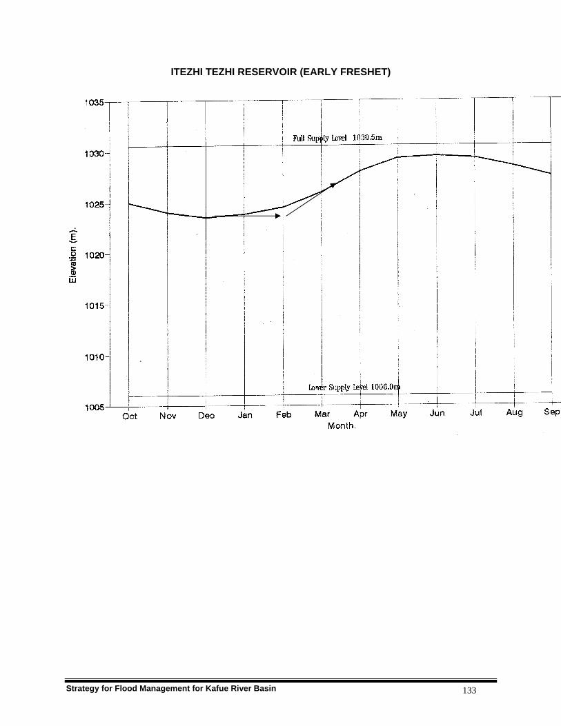
Strategy for Flood Management for Kafue River Basin 133
ITEZHI TEZHI RESERVOIR (EARLY FRESHET)
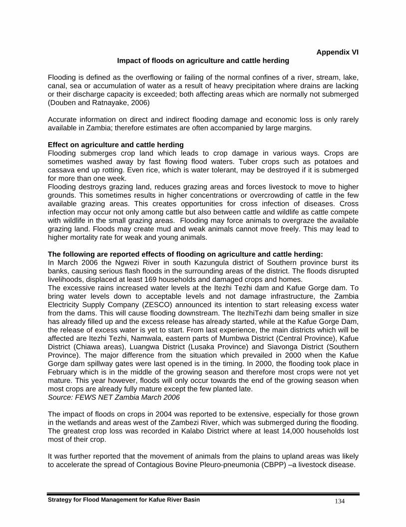
Strategy for Flood Management for Kafue River Basin 134
Appendix VI Impact of floods on agriculture and cattle herding
Flooding is defined as the overflowing or failing of the normal confines of a river, stream, lake, canal, sea or accumulation of water as a result of heavy precipitation where drains are lacking or their discharge capacity is exceeded; both affecting areas which are normally not submerged (Douben and Ratnayake, 2006) Accurate information on direct and indirect flooding damage and economic loss is only rarely available in Zambia; therefore estimates are often accompanied by large margins. Effect on agriculture and cattle herding Flooding submerges crop land which leads to crop damage in various ways. Crops are sometimes washed away by fast flowing flood waters. Tuber crops such as potatoes and cassava end up rotting. Even rice, which is water tolerant, may be destroyed if it is submerged for more than one week. Flooding destroys grazing land, reduces grazing areas and forces livestock to move to higher grounds. This sometimes results in higher concentrations or overcrowding of cattle in the few available grazing areas. This creates opportunities for cross infection of diseases. Cross infection may occur not only among cattle but also between cattle and wildlife as cattle compete with wildlife in the small grazing areas. Flooding may force animals to overgraze the available grazing land. Floods may create mud and weak animals cannot move freely. This may lead to higher mortality rate for weak and young animals. The following are reported effects of flooding on agriculture and cattle herding: In March 2006 the Ngwezi River in south Kazungula district of Southern province burst its banks, causing serious flash floods in the surrounding areas of the district. The floods disrupted livelihoods, displaced at least 169 households and damaged crops and homes. The excessive rains increased water levels at the Itezhi Tezhi dam and Kafue Gorge dam. To bring water levels down to acceptable levels and not damage infrastructure, the Zambia Electricity Supply Company (ZESCO) announced its intention to start releasing excess water from the dams. This will cause flooding downstream. The ItezhiTezhi dam being smaller in size has already filled up and the excess release has already started, while at the Kafue Gorge Dam, the release of excess water is yet to start. From last experience, the main districts which will be affected are Itezhi Tezhi, Namwala, eastern parts of Mumbwa District (Central Province), Kafue District (Chiawa areas), Luangwa District (Lusaka Province) and Siavonga District (Southern Province). The major difference from the situation which prevailed in 2000 when the Kafue Gorge dam spillway gates were last opened is in the timing. In 2000, the flooding took place in February which is in the middle of the growing season and therefore most crops were not yet mature. This year however, floods will only occur towards the end of the growing season when most crops are already fully mature except the few planted late. Source: FEWS NET Zambia March 2006 The impact of floods on crops in 2004 was reported to be extensive, especially for those grown in the wetlands and areas west of the Zambezi River, which was submerged during the flooding. The greatest crop loss was recorded in Kalabo District where at least 14,000 households lost most of their crop. It was further reported that the movement of animals from the plains to upland areas was likely to accelerate the spread of Contagious Bovine Pleuro-pneumonia (CBPP) –a livestock disease.

Strategy for Flood Management for Kafue River Basin 135
Source: OCHA Situation Report No. 2; Zambia- Floods, 2 June 2004, United Nations Office for the Coordination of Humanitarian Affairs, OCHA/GVA-2004/0088) Zambia was hit by floods in February 2000. About 13,000 households were affected by these floods, and the crop area lost due to floods was 1,515 hectares. Table below shows the crop area that was damaged by floods in Zambia in 2000.
Crop type Estimated crop area damaged by floods (ha)
Maize 1 100Sorghum 100Pearl millet 110Groundnuts 100Rice 60Banana 45Total 1 515
Source: F. Miti, Seed Control and Certification Institute, Zambia Farmers will require maize, rice, sorghum, pearl millet and groundnut seed as well as banana suckers. Seed stocks that are available in Zambia are adequate to meet the needs of farmers affected by floods. Seed could be therefore be procured from seed companies and rural seed projects within Zambia, and this is expected to cost about US$246,000. Source: Bella Mpofu (PhD) May 2000: Assessment of Seed Requirements in Southern African Countries Ravaged By Floods and Drought 1999/2000.

Strategy for Flood Management for Kafue River Basin 136
Appendix VII Kafue Gorge Flash Floods Report
Mud Slide Report
1 Mud slide event
1.1 Background Kafue Gorge power station is located about 100 kilometres south west of Lusaka. The area has an annual rainfall of 800 millimetres and a relative humidity of 85 percent.
The Power Station is made up of two underground caverns, namely the transformer and the machinery halls. The station has an installed capacity of 900 MW, comprising of six generating units of 150 MW each. It is the largest power station in Zambia contributing about 56% of the nation’s generated electricity. Presently, as a result of the Power Rehabilitation Project (PRP), two machines are out of service for rehabilitation works, leaving a generation capacity of 600 MW.
Access to the power house is by means of either a 500 metre lift shaft from the administration building to the underground cavern or a 9 kilometre long road, which includes a 1 kilometre long access tunnel at the end. At the lowest point of the machinery hall is a drain pit from which seepage water is pumped out of the station by four submersible drain pumps and two emergency ejectors operated by water pressure.
Operation of the plant is carried out in three shifts per day, namely morning shift from 07:00hrs to 14:00hrs, evening shift from 14:00hrs to 22:00hrs and night shift from 22:00 hrs to 07:00hrs. At the time of the mud slide during the evening shift consisting of one shift charge engineer, a control room engineer and two plant operators were on duty.
1.2 Sequence of events The Kafue Gorge Power Station was forced to shut down on Christmas Eve, 24th December 2005 due to a mud slide which caused the power station to be flooded with mud and rain water, and as a result the national electricity grid was deprived of a vital 600 MW of power.
Around 20:00hrs on the same day, the Kafue Gorge area experienced unprecedented severe weather conditions in the form of high intensity, short duration rainfall and gusts of strong winds. Events happened in quick succession. Within a few minutes of the rainfall, the ground was saturated with water and fast flowing streams were formed on the steep mountain sides. The now weakened top soil, along with its trees, varying sizes of loose rocks and grass easily gave way to the fast flowing water forming formidable debris-flows. This resulted in wide erosion channels or ravines being formed at several places on the hill side above the Penstock Mid-Height and Power House access roads.
The mudslide rushed down the mountain side, gathering speed and volume on the steep slopes as it eroded the hillsides of loose rocks, trees and soil. It overwhelmed and broke through the wire fence at the pot head yard for the transmission line for transformers T3 and TQ, depositing some of its burden inside the yard.
Owing to the large volume of debris, the mudslide clogged up all the drainage systems at the entrance to the power house access tunnel, causing the debris to start flowing on the
Strategy for Flood Management for Kafue River Basin 137
road surface along the Power House access tunnel. Along the tunnel, the mudslide seriously eroded and undercut the 330 k V cable culverts and raced down the steep gradient towards the Power House. The main Power House access door was in a closed position, but the door gave way due to the force of the flowing mud and debris. From this point three mud streams were formed.
The first mud stream rushed forward, forcefully into the machinery hall housing the six generating units. The Hall consists of four floors with the lowest being the valve floor. Underneath the valve floor is a drain pit with four drain pumps that removes normal seepage water. However, the huge volume of mud and water and loss of auxiliary power supply to the drain pumps due to the loss of main transformer T1 caused the water level in the drain pit to rise rapidly. Soon, the protection shut down the remaining machines to avoid further damage. The maintenance bay where a new transformer was being kept was drenched with mud while some equipment that was on the excitation floor was swept away. Of all the machines, Units one and two were the most affected in that order as they were the closest to the entrance to the machinery hall.
The second mud stream raced into the main 330/17.5 kV Transformer Hall. Since the Transformers are in secure cubicles, the mud instead flowed into the drainage pits under the transformers and also blocked the entire passage into the Hall.
The third mud stream flowed towards the lift sump affecting the operation of the lift. The mud also found its way into the battery charger room accommodating five chargers. It filled up the room up to about twenty five centimetres and consequently soaked the lower components in the chargers, like transformers and chokes.
All these events happened in a relatively short period of time, at most not more than an hour. In the mean time the mud rush continued to flow into the power house since all the drainage defence systems had been breached. The main access road to the Power House was rendered impassable by the sediments and large boulders that were scattered along its entire length from the Mid-Height road junction down to the Power House access tunnel entrance.
1.3 Damage caused
The mud slide caused extensive damage to the hill sides, roads as well as to various equipment in the powerhouse as detailed below.
The Hill Sides
Major erosion channels or ravines were formed at six points on the hill side above the access road to Penstock Mid-Height and also above the Power House access road. Huge boulders rolled down the slope pulling down trees on their way down. A number of trees that hold the ground and the rock were either uprooted or undercut by fast flowing water, leaving them loose and unstable.
Access Roads The drains and culverts along the access road to Penstock Mid-Height and Power House access road were completely choked with sediments in many places or had huge boulders deposited on them. The road surface was also severely eroded in some areas owing to the flowing mud and debris. The access road to Penstock Mid-Height suffered heavy deposition of debris and the roadside storm water drain was badly choked and eroded.
Strategy for Flood Management for Kafue River Basin 138
The Power House main access road starting from the junction with the access road to Penstock Mid-Height and the tailrace access road also suffered heavy deposition of debris and were seriously undercut on the side towards the river valley.
The Pothead Yard The Pothead yard was overwhelmed by debris and the wire fence was damaged and a huge amount of debris was deposited inside the yard.
Access Tunnel & Power House
A large amount of debris was deposited along the Power House access tunnel and inside the machinery and transformer halls. Stones and sand ( approximately 1000 m3) were deposited at the depression along the access tunnel just before the tailrace surge gallery while finer material, i.e. clay and silt proceeded into the Power House and got deposited in the No.2 Battery room ,transformer hall , lift sump, machine hall, generator floor, turbine floor, valve floor and drainage pit.
Gates
The Folding gate which is at the bottom of the access tunnel, just before the Power House was overwhelmed by the huge volumes of mud rushing inside the power house and consequently came off its sliding rails.
Equipment Damaged Battery Chargers (6 x 220V chargers and 2 x 48V chargers) in Battery room No.2 were partially immersed in mud. The four drain pumps in the drainage pit were damaged as a result of the slurry. Mud found its way inside Generators No.1 and No.2 which were running and No.3 and No.4 which were under rehabilitation.
PRP interruption & damage Mud and other foreign materials also found their way into generators No. 3 and No. 4 which are undergoing rehabilitation under the PRP project. Apart from the damage caused on to the machines, the mud slide also resulted into a work stoppage by the contractors. Work only resumed after all the mud and other materials had been removed from the valve, turbine, generator and excitation floors of the machinery house and also from the transformer hall.
2 Cost Estimates
2.1 Cost of Lost Generation
The Power Station lost a total of about US$ 1,000,000.00 in generation due to the forced outage resulting from the mud slide.
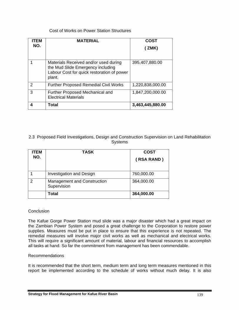
Strategy for Flood Management for Kafue River Basin 139
Cost of Works on Power Station Structures
ITEM NO.
MATERIAL COST ( ZMK)
1 Materials Received and/or used during the Mud Slide Emergency including Labour Cost for quick restoration of power plant.
395,407,880.00
2 Further Proposed Remedial Civil Works 1,220,838,000.00
3 Further Proposed Mechanical and Electrical Materials
1,847,200,000.00
4 Total 3,463,445,880.00
2.3 Proposed Field Investigations, Design and Construction Supervision on Land Rehabilitation Systems
ITEM NO.
TASK COST ( RSA RAND )
1 Investigation and Design 760,000.00
2 Management and Construction Supervision
364,000.00
Total 364,000.00
Conclusion The Kafue Gorge Power Station mud slide was a major disaster which had a great impact on the Zambian Power System and posed a great challenge to the Corporation to restore power supplies. Measures must be put in place to ensure that this experience is not repeated. The remedial measures will involve major civil works as well as mechanical and electrical works. This will require a significant amount of material, labour and financial resources to accomplish all tasks at hand. So far the commitment from management has been commendable. Recommendations It is recommended that the short term, medium term and long term measures mentioned in this report be implemented according to the schedule of works without much delay. It is also

Strategy for Flood Management for Kafue River Basin 140
important that further investigations mentioned in section 2.3 be implemented in order to fully understand the mud slide phenomenon in Kafue Gorge. Finally, it is recommended that the situation at Kariba North Bank Power Station also be studied in detail with a view to preventing a similar phenomenon from occurring there.

Strategy for Flood Management for Kafue River Basin 141
Appendix VIII Soils description of the Kafue Basin
SOILS OF ZAMBIA (2nd edition)
W. J. Veldkamp
Description of Kafue Basin Soils extracted from Soil Map of Zambia Legend
Map unit Description 25 (Upper Kafue basin, northwest of Mumbwa)
Association of moderately to strongly leached, strongly to medium acid, well drained, reddish to yellowish, loamy to clayey soils (with coarse loamy to clayey topsoils) (40% map unit 8 Miombo vegetation) and poorly to very poorly drained soils of variable texture and acidity occurring in large depressions or valleys (60% map unit 29, termitary associated vegetation) associated . The main limitations: Wetness: none to very severe, generally moderate to very severe Acidity: none to strong, generally moderate Nutrient retention: low to moderate Nutrient reserves: moderate to very low, in general low Topsoil capping: severe in places The agro-ecological conditions are characterized by a length of growing period of 120 to 180 days. Drought occurs in the southern parts. Sunshine is limited to some extent in the Kafue headwater areas. Throughout the region dambo frost occurs, but in the most parts of the kafue National Park upland frost may also be experienced.
28 (Kafue Flats)
Imperfectly to very poorly drained, slightly acid to alkaline, clayey floodplain soils (vertisols) with clayey topsoils) The main limitations are:
• Wetness: moderate very severe • Alkalinity: occasionally slightly alkaline in reaction • Topsoil texture: very clayey • Water holding capacity: low to moderate, generally moderate • Erosion: none to moderate, generally none due to flatness • Workability: this is a severe problem due tto the heavy topsoils, which
tend to be slippery in the wet season. The agro-ecological conditions are 110-120 days growing period (70% probability) with 2-3 dry 10 day periods within this period. There is a high amount of sunshine in the rainy season. Frost occurs to some extent in the eastern part of the map unit, but is more serious in the western part during the dry season. Rice cultivation seems to be the most appropriate use on these soils, there is a moderate potential for wetland rice, provided a system of bunded fields and organized supply and drainage of irrigation water is made. According to the general fertility index for upland soils, map unit 28 soils belong to soils with only minor fertility limitations.

Strategy for Flood Management for Kafue River Basin 142
Map unit Description These soils are moderately to marginally suited to sorghum, finger millet and sunflower; moderately suited to unsuited for cotton, soyabeans and cassava; the other crops are generally unsuited.
29 (south of Luanshya)
Poorly to very poorly drained floodplain soils of variable texture and acidity (Termitary associated vegetation and grassland) The main limitations are:
• Wetness: severe to very severe • Acidity: slight to strong, generally moderate • Nutrient reserves: moderate to low, generally low • Topsoil capping: severe in places
The agro-ecological conditions are a growing season with 100 to 180 days (70% probability) increasing northwards. As these soils are poor to very poorly drained, shallow groundwater provide water to the crops for much longer periods. Most floodplains are characterized by frost during the dry season, with exception of the northern and Luapula province ones. The Chambishi flood plain has somewhat lower amount of sunshine. The occurrence of drought plays a smaller role in these soils compared to upland soils. Still for cultivation during the rainy season drought may be important. The flood plain soils in Central province usually have 1-2, the ones in Western province 2-3 and the Southern province ones 3-4 dry 10-day periods. Sunshine in these provinces is not restricted.
30 ( Lukanga and Busanga swamps)
Swamps (grassland) Mostly non arable because of permanent water. This unit occurs around lake Bangweulu (Luapula and Northern provinces), Lukanga swamp (Central province) and a relatively small area (Busanga swamp in North Western province). Smaller swamps may occur in almost any province.. Not very much is known about the swamp soils. They tend to be silty with variable degree of soil acidity. Wind erosion has been observed near Bangweulu swamps (Chimbwi series cf. map unit 29). The margins of the swamps may be suitable to rice cultivation in the dry season (potential class 2, moderate potential). Adaptation of the soil conditions by making mounds on the swamp margins may provide excellent conditions for crop growth of crops like maize, sweet potato, etc. The agro-ecological conditions within map unit 30 are a growing season of 130 to 160 days, but usually longer because of residual soil moisture or shallow groundwater. Frost is a serious constraint in the dry season in the Busanga swamp. Less serious frost is experienced in the Lukanga swamp, whereas probably no frost occurs in the Bangweulu swamps.
Source: Soil Bulletin No. 13, Soil Survey Unit, Department of Agriculture, Mt. Makulu, 1987

Strategy for Flood Management for Kafue River Basin 143

Strategy for Flood Management for Kafue River Basin 144
Appendix IX Status of Deforestation in Zambia
1. Background 1.1 Forest Cover Forests in Zambia cover an area of about 44.6 million hectares or about 60 percent of the total land area and of which 9.6% are gazetted forest reserves. There are about 480 protected forest areas, 180 National Forests and 300 local forests. The rest of the forests are in Game Management Areas, National Parks and open areas. Generally, Zambia still has sufficient forest cover which permits for subsistence and commercial usage. The country has been able to reduce pressure on the natural forests also establishing forest plantations in Copperbelt, Northern, Eastern, Southern and North-western Provinces.
However, Zambia’s forests are facing considerable threats such as rapid conversion of forestland into agricultural land, wild fires, over exploitation of valuable timber species, fuelwood collection and uncontrolled charcoal production.
1.2 Forest Estate
There are 180 National Forests covering 5.1 million hectares or 6.8 % and 300 Local Forests covering 2.1 million hectares or 2.8 % of the land area of the country respectively. 15.6 million hectares are designated, as Game Management and 6.4 million hectares are National Parks. The table below shows the area of gazetted forests in each province. Table 1. Estimated Area of Forest Estate by Province
National Forest
Local Forests
Total Forest Estate
Province
Total Land Area Hectares
No. Hectares No. Hectares No. Hectares
% of Total Land Area
Central 9,439,448 16 289,953 22 192,043 38 481,996 51%Copperbelt 3,101,400 43 474,324 12 42,787 46 517,111 16.7%Eastern 6,881,451 14 680,584 64 206,747 78 887,331 12.9%Luapula 5,056,681 09 680,584 19 200,490 28 413,037 8.2%Lusaka 2,890,571 01 212,547 07 26,992 08 27,360 1.2%Northern 14,793,870 23 368 47 335,434 70 1,137,026 7.7%Northwestern 12,582,000 34 801,592 28 390,924 62 2,802,889 22.3%Southern 8,525,293 7 2,411,965 26 433,429 33 644,681 7.6%Western 12,638,595 35 211,252 83 346,930 118 913,499 6.4%TOTAL 75,243,400 180 5,181,503 300 2,175,770 480 7,357,279 9.6% Plantations are estimated to cover 60,000 hectares, with the gazetted forest areas, and distributed as follows:
Strategy for Flood Management for Kafue River Basin 145
ZAFFICO Plantations, covering 40,000 hectares of pine and 10,000 hectares of Eucalyptus.
Local and Regional Supply Plantations under the Forestry Department, covering 7,000
hectares of Pine and Eucalyptus together. 3,000 hectares of Private owned and community woodlots distributed across the country
mainly of Eucalyptus trees. 2. Deforestation in Zambia 2.1 Rate of Deforestation The rate of deforestation countrywide is currently estimated at over 800,000 hectares per annum. The rate of deforestation was for a long time estimated at 300,000 hectares per annum in the past. 2.2 Causes of Deforestation 2.1 Agriculture Expansion Clearance for agriculture is estimated to account for 80 percent of deforestation. Most of the agriculture production comes from the 500,000 to 850,000 small-scale farmers producing under rain fed conditions often using shifting cultivation “Chitemene” involves cutting trees and burning them for providing mineral fertilization. If the human population pressure increases, this traditional system does not give sufficient time to the woodland to regenerate and be productive. Eliminating deforestation caused by agriculture expansion will not be feasible over the next few years, as the rural population is still practicing shifting cultivation and do not have their basic needs met. These people in the name of agriculture are moving and illegally settling in forest reserves and illegally opening – up agriculture fields in forest reserves without respect for the forest law. 2.2 Unsustainable Fuelwood Collection
According to best current estimates, annual consumption of woodfuel reaches about 11 million tonnes of wood of which two-thirds are used as fuelwood and one third is used as charcoal. Charcoal is pre-dominantly an urban fuel and urban households and industry consume 85 percent and 45 percent respectively of this fuel while rural households use 11 percent. The average annual consumption of firewood is estimated at 5,000kg and 635kg per household in rural and urban areas, respectively. The consumption of charcoal averages at 100 kg per rural household per year and 1,040kg per urban household.
Woodfuel remains the dominant principal source of energy, which is consumed in the form of firewood and charcoal. The household sector derives 96 percent of their energy from fuelwood. It is estimated that about 700,000 tons of charcoal are consumed annually and this is projected to increase to over 1.2 million tons annually by the year 2010.
The cutting of trees for fuelwood and charcoal from indigenous forests is associated with the emergence and growth of urban fuelwood markets. The wood used in charcoal is either clear felled or selectively cut with hand axes.

Strategy for Flood Management for Kafue River Basin 146
The coupe system, which was earlier, practiced by Forestry Department never worked. Due to increasing demand for charcoal in peri-urban areas and the many constraints of Forestry Department, charcoal burner’s move into coupes before the woodland has fully recovered. 2.3 Uncontrolled Forest Fires Wild or bush fires are another cause of deforestation. Most fires are caused by human agencies such as in order to promote new flushes of grass, hunting, collection of honey or preparation of land for and shifting cultivation. Severe or late fires are destructive to forests. Frequent late fires prevent regeneration of fire tender species and thus change species composition.
In view of increasing fire occurrences and decreasing fire suppression budgets, my Ministry is presently considering the full range of fire management options to include proactive approaches that engage local communities in planning and implementing of fire management activities. 2.4 Over Exploitation of Timber Timber production in Zambia is considered to be a driving force for industrial development particularly in rural areas, having the potential to create an economic and structural basis for small-scale industry and handcrafts and to create employment opportunities. However, due to lack of management plans and the limited capacity of Forestry Department to supervise concessionaires, logging operations in indigenous forests is carried out in an ad-hoc manner largely in unplanned way resulting in over-exploitation of some timber trees which are currently now threatened to extinction.
Illegal logging is common in most parts of the country and include extracting more timber than authorized, logging without authorization, logging outside concession areas, logging in prohibited areas such as, riverbanks, water catchment areas, removing undersized trees and under-declaration of timber smuggling of timber. These operations take place when wood is harvested, transported, processed, bought or sold in violation of the forest law. The underlying causes of illegal logging operations in the forestry sector include minimal enforcement capacity insufficient data or information about timber resources and illegal operations. These illegal activities have far-reaching economic social and environmental impacts including government revenue loss, ecological degradation and greater income inequality. 3. Measures to Combat Deforestation Measures, which Government has put in place to curb deforestation, include the following: 3.1 Regulation of Forest Exploitation This measure is put in place to ensure that forests are not over cut when timber producers are licensed to exploit trees for wood based needs. Regulation of forest exploitation ensures that forests are used in a sustainable manner. The measure is achieved through issuing forest licenses, which are given to concessionaires for cutting trees in specified areas of forests according to forest regulations e.g. no cutting of trees below 30 cm in diameters at breast height and trimming of stumps to promote natural regeneration. In addition all timber cut is hammer marked with a number carried by an authorized Forestry Officer to check on any illegally cut timber.

Strategy for Flood Management for Kafue River Basin 147
3.2 Fire Management and Control During the dry season late fires through careless human activity destroy trees and forests. To reduce the loss of tree cover through late fires Forestry Department Staff carry out early burning in forest reserves and open areas. This activity takes place yearly between May and July depending on the rainfall pattern that year. The practice reduces forest floor fuel (mainly grass) to an extent that any late fires cannot become so severe as to destroy trees. The practice even stimulates germination and growth of certain tree species. 3.3 Forest Patrols Forestry Officers conduct both general and blitz patrols and road blocks to control illegal timber and charcoal production in forest areas. It is also aimed at controlling transportation of illegal timber and charcoal as well as squatting for farming in forest reserves. The essence of patrolling forests is also to check their status, and remove threats to forest growth and development. In addition, patrols reveal what products could be obtained from particular forests and which best use a forest could be put to. 3.4 Pricing of Forest Products The main purpose of pricing of forest products is to monitor and control forest exploitation and therefore regulate forest utilization. It is also meant to generate revenue intended for assistance in sustainable forest management. Pricing forest products also cuts off many forest exploiters who would have otherwise engaged in indiscriminate timber cutting had there been no prices attached to timber products and charcoal production. 3.5 Promotion of Agroforestry This involves the inclusion of planted trees in the farming systems. Most of these trees are fast growing and farming and in addition to providing timber may also provide poles, wood fuel, fodder as well as nutrients to the soil. Agroforestry systems reduce fertilizer input for agriculture, improve soil structure and quality and reduce pressure on the natural forest by providing poles for building purposes and wood for fuel. 3.6 Forest Extension Programmes This involves sensitization and awareness campaigns to enlighten local communities on the importance of forest conservation and the negative consequences of deforestation, such as the drying of rivers and streams, reduction in crop yields and unfavourable weather patterns. These campaigns are carried out through workshops, meetings, demonstrations, drama sketches and through the electronic media (radio, video shows etc). 3.7 Re-afforestation Programmes Every year the Forestry Department carries out tree planting on an appropriate date designated as a National Planting Day between 15th December and 15th January every year. This activity takes place in all the provinces in conjunction with local communities, NGOs, political leaders and other stakeholders. Between 2000 and 2005 a total of K1,504,154,478 was released by Government for afforestation through out the country. In 2005 alone funding for this purpose

Strategy for Flood Management for Kafue River Basin 148
amounted to K500,894,478. Planting of trees is intended to some extent to replace trees being cut down for various uses, thus reducing the effects of deforestation. In addition commercial licence holders are obliged to plant trees in areas of their operation or contribute to the planting of these areas in kind by providing resources for the same. 4. Forestry Development Credit Facility This is a poverty reduction programme aimed at promoting sustainable utilization of forest resources such as timber, honey, mushrooms, caterpillars and wood fuel. The expected outcome is that the rural and urban forestry stakeholders gain access to the credit facility for capital in form of loans to develop forestry sub-sector projects in beekeeping, carpentry and joinery, forest nurseries, plantations, mushroom growing and other related projects. This programme is intended to divert attention to more destructive uses of forests for wealth creation. In 2005 Government released K4,000,000,000 to the Forestry Department Credit Facility which is operating as a revolving fund. 5. Forest Management Projects 5.1 Provincial Forestry Action Programme (PFAP) PFAP which was in two phases with the second phase running from 2000 to 2005 was a joint initiative between the Governments of Zambia and Finland. The main aim of the project was to enable forest dependent communities to use forest resources for income generation in a sustainable manner. This was done through beekeeping (honey and beeswax production), forest nurseries using community labour, Pitsawing among other income generating activities. The Provincial Forestry Action Programme also trained both men and women in forest products production, utilization and management. The project covered four provinces: Luapula, Central, Copperbelt and Southern. 5.2 Forest Resource Management Project (FRMP) This project is mainly funded by the International Fund for Agricultural Development (IFAD) with a grant from the Irish Government. The operational areas are Luapula and Northwestern Provinces. The main objective of the project is to secure a sustainable income for poor and rural communities dependent on forest resources in Northwestern and Luapula Provinces. So far local communities have been trained in beekeeping, basket making, sustainable “munkoyo” root harvesting, carpentry and joinery, tree planting among other ventures. Some villagers have also been employed in road construction and building. The above income generating activities have reduced attention on destructive forest harvesting for timber, fuel wood and charcoal thus arresting deforestation. 5.3 Community based Natural Resources Management (CBNRM) Programme The main goal of this programme is to raise farmer’s income and alleviating poverty by improving production and marketing of agriculture and small enterprise development. In addition

Strategy for Flood Management for Kafue River Basin 149
CBNRM has initiated pilot forest management sites to demonstrate its approach to community based forest management. Among the CBNRM projects are the Chiulukire CBNRM sponsored by the Cooperative League of the United States of America (CLUSA) and the Zambian Government. There is also another CBNRM in Western Province sponsored by the Dutch Government in cooperation with the Zambian Government. These CBNRM like their sister Community Based Resource Boards in the Zambian Wildlife Authority are aimed at reducing uncontrolled deforestation and wildlife poaching yet allowing the flow of resources to forestry and wildlife resource users in a more sustainable manner.

Strategy for Flood Management for Kafue River Basin 150
Appendix X RANET Zambia Project
INTRODUCTION The word RANET is an acronym of Radio and Internet. RANET Zambia Project is under the Ministry of Communications and Transport with the Meteorological Department being responsible for the implementation. RANET Zambia Project is a member of the African based RANET Project whose headquarters is at the African Centre of Meteorological Applications for Development (ACMAD) at Niamey in Niger.
1. AIM OF THE RANET PROJECT: The overall project goal is to respond to the challenge of exchanging vital information with the rural communities of Zambia by introducing new information technologies through the use of the WorldSpace Foundation’s Digital Satellite Radio Broadcasts, and solar/windup radios.
2. RANET’S OBJECTIVES IN ZAMBIA The overall objective is to enhance the living standards of rural communities by way of increasing their access to vital information on agriculture, education, health, environment, weather, natural calamities and other vital developmental information needed in order to improve their well-being and widen their food security base.
3. JUSTIFICATION The greatest limitations to the use of information are: inaccessibility, timeliness, poor reliability and language of communication. Currently there facilities in Zambia for dissemination of information to the people, however, these facilities are only accessible within the urban and peri-urban areas and not the remote rural areas. RANET and its partners possess a unique ability in content production, dissemination as well as having a local presence and the use of the local language. After identifying the need to distribute information down to the village level, ACMAD in collaboration with the NOAA/National Weather Services (NWS) of USA came up with a system which uses low power FM broadcasting capabilities to down scale information into local languages, by local priority and choice. By taping into the WorldSpace Foundation’s digital broadcast as well as the support of the broadcasts of the country and region, RANET stations are able to retrieve relevant information not normally available in as easy and timely manner. In areas without electricity, or where the batteries are expensive or unavailable, windup and solar powered radios, as well as solar powered broadcasts stations have broken previous broadcast and listening time limitations, thereby allowing for more detail content to be disseminated. In addition the cost of the system is redeemed by not having to pay for electricity or purchase batteries. The WorldSpace Foundation’s technology provides a unique medium through which to disseminate weather, health, agriculture, and disaster management information as well as
Strategy for Flood Management for Kafue River Basin 151
warning and relief information. By utilizing digital satellite broadcasts, the meteorological and partner community can receive high memory content while not being hampered by inadequate internet connection or access. In addition it provides the opportunity to share digitally formatted documents that otherwise would tax e-mail transfer or arrive weeks later through traditional mail. Timely delivery of information can mean timely and better decision making in agriculture, forestry, disaster management, energy and other sectors. There is no cost associated with the broadcast, and receiving the broadcast requires comparatively modest hardware investment. 4. ACTIVITIES TO BE CARRIED OUT Following the inaugural workshop’s resolution that implementation of the project be effected in phases, with four radio stations established in phase one followed by slightly more in phase two, the specific outputs of this year one activity will be to:
(a) Facilitate acquisition and installation of FM-radio broadcasting equipment for community radio broadcasting stations and provide solar/windup radios to the communities for the reception of the broadcasts. (b) Appropriate and timely agricultural, technical and marketing information to the small-scale farmers.
(c) Timely weather and climate information to rural communities. (d) Timely warnings about impending natural disasters. (e) Monitoring and providing impact assessment on various natural disasters. (f) Training of personnel involved in the running of the radio stations. (g) Provide a forum for discussion of local issues so that it would lead to the solution of problems. (h) Encouraging creativity as a way of promoting self-reliance and development. (I) Support for the health and education of the communities.
5. EXPECTED RESULTS At the end of the first year of the project it was expected that all four newly established community radio stations would be operational. These stations, along with the four existing stations that would form the initial RANET Zambia Network and would be reaching a listening audience of over 350,405 people. At the end of the Phase I, each of the stations will also have a trained station manager, a functioning board of directors, an operating license, and at least 20 hours of educational/informational local language broadcasting weekly. A total of 1,500 radios will also have been distributed to primarily women and youth groups in the listening areas. Each of the stations will also have been expected to have established an annual operational budget and developed a provisional business plan. This would result in the improvement of the living conditions of rural communities measured by: (a) higher total agricultural production of staple food crop
(b) Greater food self-sufficiency (10% of the food bought versus produced) (c) More varieties plus healthier diet of food consumed per day (d) Adoption of soil conservation practices by 70% of farmers (e) Lower rate of malnutrition.

Strategy for Flood Management for Kafue River Basin 152
6. TARGET GROUPS The RANET broadcasting project is intended to reach rural communities in isolated areas. It is these areas that are poor and have no/less access to information. Communities will be required to significantly involve women in the project. Programming will be targeted to these groups and efforts made to involve them directly in programming and station management. Since many of these targeted beneficiaries do not have access to radios, listening groups will be encouraged and wind-up radios given at a nominal cost to selected groups.
7. PARTICIPATION There will be equal participation in decision making, by improving information accessibility to remote rural communities, increasing capacity to participate, encouraging a sense of belonging, community ownership, management and sustainability.
8. PHASE II OF RANET (2005-2008)
Funds being available 12 community radio stations would be installed. The districts that would be covered in this phase are: - Luangwa, Mambwe, Lufwanyama, Chama, Kawambwa, Samfya, Mbala, Isoka, Zambezi, Mwinilunga, Kalabo and Shangombo.

Strategy for Flood Management for Kafue River Basin 153
RANET Zambia Community radio partners
*
Strategy for Flood Management for Kafue River Basin 154
Appendix XI Glossary Aquifer is any geological formation that absorbs, stores and transmits groundwater. Basin or river catchment is a geographical area that naturally drains into a water resource and from which the resource receives surface or groundwater originating from rainfall. Bubonic Plague is a contagious, often fatal epidemic disease caused by bacterium Yersinia Pestis, transmitted from person to person by the bite of fleas from an infected rodent, especially a rat, and characterised by chills, fever, vomiting, diarrhoea and formation of black spots on the skin. Climate is the average state of the atmosphere in a particular geographical location taken over a long time (usually months to years). Climate Change refers to a statistically significant variation in either the mean state of the climate or in its variability, persisting for an extended period (typically decades or longer). Climate change may be due to natural internal processes or external forces, or to persistent anthropogenic changes in the composition of the atmosphere or in land use. Climate Variability refers to variations in the mean state and other statistics (e.g. occurrence of extremes) of the climate on all temporal (time) and special (space) scales beyond that of individual weather events. Variability may be due to natural internal processes within the climate system, or due to variations in natural or anthropogenic (human induced) external force. Drought is low hydrologic extreme resulting from disturbances in the hydrological cycle over a sufficiently long time resulting into significant water deficiency. Disaster means an emergence situation which has been declared by an appropriate authority connected with flood or drought and any other catastrophe that causes or poses a serious harm or damage to property and may result in injury or loss of life. Ecosystem is a dynamic set of living organisms (plants, animals and micro-organisms) all interacting among themselves and with the environment in which they live (soil, climate, water and light). Flood is high hydrologic extreme resulting from natural or human activities that disturb the hydrological cycle over a period of time resulting into excessive occurrence of water. Flood Return Period is the average number of years within which a given flood is expected to be equalled or exceeded only once. Freshet – a process of water release to meet the environmental requirement for flooding and recession Global warming is a natural phenomenon which occurs when solar radiation bouncing off the Earth’s surface is absorbed by carbon dioxide and other greenhouse gasses. This causes what is termed the greenhouse effect and is responsible for heating up the atmosphere.
Strategy for Flood Management for Kafue River Basin 155
Greenhouse Gas is any gas (such as carbon dioxide, chlorofluorocarbons (CFCs), Methane and Nitrous oxide) that absorbs infra-red radiation in the atmosphere leading to the gradual increase of air temperature in the Earth’s lower atmosphere which is referred to as global warming. Hydrological Cycle consists of the circular process in which the water of the Earth evaporates from oceans, condenses, falls to the Earth as rain or snow, and eventually returns to the oceans through runoff in the rivers or streams. Some water is absorbed by plants and returned to the atmosphere as vapour. Integrated flood management is the process promoting an integrated – rather than fragmented – approach to flood management. It integrates land and water resources development in a river basin, within the context of Integrated Water Resources Management, and aims at maximising the net benefits from plains and minimising loss to life from flooding. Integrated water resources management is a process that promotes coordinated development and management of water, land and related resources in order to maximise the resultant economic and social welfare in an equitable manner without compromising the sustainability of vital ecosystems. Natural causes of climate variability and change: Shifts in the Earth’s orbit and tilt, the relative position of its axis, changes in solar activity, volcanic eruptions and changes in the distribution of naturally-occurring aerosols (solid or suspended particles). Operating Rule Curves are a representation that give the minimum reservoir storage required to maintain delivery of firm energy based on historical adverse hydrological conditions. Vulnerability is the characteristic that describes the capacity of a person, community or society to anticipate, cope with, resist and recover from the impact of a natural or human induced hazard. Weather is defined as the atmospheric conditions (e.g. temperature, wind, rainfall, pressure) experienced in a particular geographical location at a given time.