State of Louisiana - NOAA Office for Coastal … State CELCP Plan State of Louisiana Coastal and...
42
Louisiana State CELCP Plan State of Louisiana Coastal and Estuarine Land Conservation Program Plan May 2011 Prepared by The Louisiana Department of Natural Resources
Transcript of State of Louisiana - NOAA Office for Coastal … State CELCP Plan State of Louisiana Coastal and...

Louisiana State CELCP Plan
State of Louisiana
Coastal and Estuarine Land Conservation Program Plan
May 2011
Prepared by The Louisiana Department of Natural Resources

Louisiana State CELCP Plan
Table of Contents 1. Introduction ................................................................................................................................................................... 1
1. A. Program Authority and Definition ................................................................................................................. 1 1. B. Program Guidelines and Purpose ................................................................................................................... 1 1. C. Project Funding Process Overview ................................................................................................................ 2
2. Louisiana CELCP Area and Priorities .......................................................................................................................... 2 2. A. Louisiana Coastal and Estuarine Land Conservation Area ............................................................................ 2
2. A. 1. Geographic Extent ................................................................................................................................ 2 2. B. Priority Lands to Protect in Louisiana’s CELCP Area ................................................................................... 4
2. B. 1. Landscape context for Louisiana’s CELCP Priorities ........................................................................... 4 2. B. 2. Priority Lands for Protection through CELCP ...................................................................................... 5 2. B. 3. Priorities of Special Consideration ....................................................................................................... 6 2. B. 1. a. Planning Unit 1 ................................................................................................................................. 6 2. B. 1. b. Planning Unit 1 Assessment of Need for Conservation .................................................................... 7 2. B. 2. a. Planning Unit 2 ................................................................................................................................. 8 2. B. 2. b. Planning Unit 2 Assessment of Need for Conservation .................................................................... 8 2. B. 3. a. Planning Unit 3 ................................................................................................................................. 8 2. B. 3. b. Planning Unit 3 Assessment of Need for Conservation .................................................................... 9 2. B. 4. a. Planning Unit 4 ............................................................................................................................... 10 2. B. 4. b. Planning Unit 4 Assessment of Need for Conservation .................................................................. 11
2. C. Identification of “Project Areas” .................................................................................................................. 11 2. C. 1. Project Areas: ..................................................................................................................................... 11
2. D. Existing Plans Summaries ........................................................................................................................... 12 2. D. 1. Louisiana Coastal Wetlands Conservation Plan ................................................................................. 12 2. D. 2. Louisiana’s Master Plan ..................................................................................................................... 12 2. D. 3. Atchafalaya Basin Program ................................................................................................................ 13 2. D. 4. Barataria-Terrebonne National Estuary Program ............................................................................... 13 2. D. 5. Lake Pontchartrain Basin Foundation ................................................................................................ 13 2. D. 6. Louisiana Department Wildlife and Fisheries .................................................................................... 13
3. Implementation Process for state CELCP Plan ........................................................................................................... 14 3. A. Lead State Agency ....................................................................................................................................... 14 3. B. Eligible Land Holding Entities .................................................................................................................... 15 3. C. State Nomination Process ............................................................................................................................ 16
3. C. 1. Solicitation of Projects ........................................................................................................................ 16 3. C. 2. State Review and Prioritization .......................................................................................................... 17 3. C. 3. Evaluation Factors for Projects ........................................................................................................... 18
4. Stakeholder Involvement ............................................................................................................................................ 21 5. Certification and Approval .......................................................................................................................................... 22
5. A. Certification of Consistency ........................................................................................................................ 22 5. B. Plan Approval .............................................................................................................................................. 22
6. Reference: ................................................................................................................................................................... 23 Appendix A: .................................................................................................................................................................... 24 Appendix B: .................................................................................................................................................................... 25
Figure 1 ........................................................................................................................................................... 25 Figure 2 ........................................................................................................................................................... 26 Figure 3 ........................................................................................................................................................... 27 Figure 4 ........................................................................................................................................................... 28 Figure 5 ........................................................................................................................................................... 29 Figure 6 ........................................................................................................................................................... 30 Figure 7 ........................................................................................................................................................... 31 Figure 8 ........................................................................................................................................................... 32 Figure 9 ........................................................................................................................................................... 33 Figure 10 ......................................................................................................................................................... 34 Figure 11 ......................................................................................................................................................... 35 Figure 12 ......................................................................................................................................................... 36 Figure 13 ......................................................................................................................................................... 37 Figure 14 ......................................................................................................................................................... 38 Figure 15 ......................................................................................................................................................... 39 Figure 16 ......................................................................................................................................................... 40

Louisiana State CELCP Plan
1. Introduction
1. A. Program Authority and Definition In 2002, Congress directed the Secretary of Commerce to establish a Coastal and Estuarine Land Conservation Program (CELCP) “for the purpose of protecting important coastal and estuarine areas that have significant conservation, recreation, ecological, historical, or aesthetic values, or that are threatened by conversion from their natural or recreational state to other uses” (The Department of Commerce, Justice, and State Appropriations Act of 2002, Public Law 107-77). CELCP was re-authorized in 2009 as part of the Omnibus Public Land Management Act (P.L. 111-11). In establishing this program, Congress directed:
• the Secretary of Commerce to develop guidelines delineating the criteria for grant awards through the program;
• that the funds be issued “in consultation with the State’s Coastal Zone Managers’ or Governor’s designated representatives based on demonstrated need and ability to successfully leverage funds;
• that the program give priority to lands which can be effectively managed and protected and which have significant ecological value; and
• that states provide 1:1 matching funds for any financial assistance awarded under the program.
The National Oceanic and Atmospheric Administration’s Office (NOAA), through its role in implementing the Coastal Zone Management Act of 1972 (CZMA), as amended (16 U.S.C. 1451 et seq.) is working with coastal states and territories to develop a plan that provides an assessment of priority land conservation needs, and clear guidance for nominating and selecting land conservation projects within the state.
1. B. Program Guidelines and Purpose In 2003, NOAA issued final Program Guidelines for the states to follow in developing their own CELCP. These guidelines establish the eligibility, procedural, and programmatic requirements for participation in CELCP, in addition to delineating the criteria for financial assistance awards. The NOAA guidelines outline a three-stage process for competitive funding: • develop a state coastal and estuarine land conservation plan, • identify and rank qualified projects within the state and nominate them to a national
competitive selection process annually; and • create a process for conducting peer review and selection of projects at the national
level. The Louisiana Department of Natural Resources, Office of Coastal Management, Interagency Affairs and Field Service Division (LDNR/OCM/IAFSD) is the lead agency for the State of Louisiana’s coastal management program, and as such is developing the CELCP Plan as outlined in the CELCP Program Guidelines issued by NOAA in 2003.
Page 1

Louisiana State CELCP Plan
This document is intended to be simple and concise, and fully describes the state’s protocols for implementing the CELCP Plan throughout Louisiana. This document specifically addresses: • The geographic extent of coastal and estuarine areas within the state, as defined on
the attached map (Appendix B. Figure 1.). • A description of the types of lands and associated values to be protected through the
program and the need for conservation through acquisition. • The “project areas” that represent the state’s priority areas for conservation, including
areas threatened by conversion.
1. C. Project Funding Process Overview When the National Oceanic and Atmospheric Administration (NOAA) notifies states of a project submittal opportunity and timelines for applications, the state will then release a request for proposals (RFP). When proposals are received they will be reviewed and prioritized by the state using the established criteria in this plan. Top ranking projects will then be submitted to NOAA’s Office of Ocean and Coastal Resource Management (OCRM) in Silver Spring, MD to compete in the national review competition. Projects will be selected for funding based on the amounts appropriated to CELCP each year, in accordance with the project’s ranking achieved through a competitive, merit-based review process. Funding will be provided by NOAA to the state for granting to the successful applicant(s) or NOAA can make a grant directly to the sub-recipient, with the state’s concurrence. During the grant funding process, assurance of permanent land conservation will be required by the state.
2. Louisiana CELCP Area and Priorities
2. A. Louisiana Coastal and Estuarine Land Conservation Area Louisiana’s uniquely formed coastal zone area has been shaped by the Mississippi River system. Due in large part to this natural and dynamic system, the wetland dominated ecosystem, which covers Louisiana’s coastal zone, is filled with sensitive resources. These resources are important to Louisiana citizens, as well as the nation, who depend on them for commerce and recreation. These wetlands truly are America’s Wetlands. The Louisiana Coastal Resources Program (LCRP) seeks to acquire land through the CELCP in order to aid in efforts to protect and conserve habitats that provide environmental, historical, aesthetic, and recreational benefits for the public of today and for future generations.
2. A. 1. Geographic Extent The final CELCP Program guidance published by NOAA on June 17, 2003, defines “coastal and estuarine areas” as: “Those areas within a coastal state that are: part of the state’s coastal zone, as designated in the state’s federally approved coastal management program under the CZMA or within the state’s coastal watershed boundary as described in NOAA’s Coastal Zone Boundary Review (October 1992). The coastal watershed boundary is defined: for estuarine drainage areas by the inland boundary of those 8-digit USGS hydrologic cataloguing units that contain the head of tide.”
Page 2

Louisiana State CELCP Plan
LDNR/OCM/IAFSD chose to use the same boundary as designated for Louisiana’s conditionally approved Coastal Nonpoint Pollution Control Program (CNPCP) management area which is within the inland boundary of the 8-digit units. When the CNPCP management area was determined the Louisiana Department of Environmental Quality (co-lead for Louisiana’s CNPCP) used 6 digit subsegments, which fall within the 8-digit units, to define sub-watersheds so the CELCP area has been delineated by incorporating water quality management subsegments/watersheds as shown in Appendix B. Figure 1. that:
• occur within the Louisiana Coastal Zone boundary; • are adjacent to the Louisiana Coastal Zone boundary; and/or • occur in the Louisiana Coastal Wetlands Conservation Plan boundary, of which
“The northernmost Plan designated boundary overlaps the Coastal Zone Boundary, falling in and outside of that boundary as determined by the inland limit of tidally-influenced fresh marsh and bald cypress/tupelo gum swamps” (Louisiana Coastal Wetlands Conservation Plan, May 1997, p.7)
All or part of the following 30 parishes are in the CELCP area: Acadia, Ascension, Assumption, Calcasieu, Cameron, East Baton Rouge, East Feliciana, Iberia, Iberville, Jefferson, Jefferson Davis, Lafayette, Lafourche, Livingston, Orleans, Plaquemines, St. Bernard, St. Charles, St. Helena, St. James, St. John The Baptist, St. Martin, St. Mary, St. Tammany, Tangipahoa, Terrebonne, Vermilion, Washington, West Baton Rouge. As designated in the LCRP, Louisiana’s coastal zone inland boundary is a geo-political boundary that varies from 16 to 32 miles inland encompassing 19 parishes generally following the Intracoastal Waterway from the Texas-Louisiana state line to the intersection of the Gulf Intracoastal Water Way (GIWW) and Louisiana state Highway 82 at Forked Island and then follows highways through Vermilion, Iberia, and St. Mary parishes, then dipping southward following the natural ridges below Houma, then turning northward to take in Lake Pontchartrain and ending at the Mississippi-Louisiana border. A detailed description can be found at http://www.legis.state.la.us/lss/lss.asp?doc=103629. Louisiana’s Coastal Wetlands Conservation Plan (CWCP) inland boundary overlaps the Coastal Zone Boundary, falling in and outside of that boundary as determined by the inland limit of tidally-influenced fresh marsh and bald cypress/tupelo gum swamps. It generally begins at the state line of Texas and Louisiana and proceeds easterly through the parishes of Calcasieu and Cameron then south through Vermilion, Iberia, St. Mary, St. Martin, Assumption, Terrebonne and Lafourche. The boundary then turns to the north to include the parishes of St. Charles, St. John the Baptist, St. James and then east again through Livingston, Tangipahoa and St. Tammany parishes to the Mississippi state line. More on the CWCP can be found in the existing plans summary section.
Page 3

Louisiana State CELCP Plan
2. B. Priority Lands to Protect in Louisiana’s CELCP Area
2. B. 1. Landscape context for Louisiana’s CELCP Priorities Louisiana’s coastal area is a high priority for the state for hurricane protection and coastal restoration. On January 23, 2008 the Governor of Louisiana signed Executive Order No. BJ 2008-7. This Executive Order proclaimed that Louisiana’s coastal master plan, entitled “Integrated Ecosystem Restoration and Hurricane Protection: Louisiana’s Comprehensive Master Plan for a Sustainable Coast”, (hereinafter “Master Plan”), is the state’s conceptual plan for the integration of coastal protection and restoration based upon the best available science and engineering. The Master Plan was approved by the Coastal Protection and Restoration Authority (CPRA) at its April 12, 2007 meeting and thereafter unanimously approved by the Louisiana Legislature by passing Senate Concurrent Resolution No. 11 during the 2007 Regular Session. The Master Plan states a goal of integration of flood control projects and coastal restoration initiatives to help both human and natural communities survive and thrive over the long-term. The Master Plan also recommends, among other things, improvements to land use planning, zoning and permitting to more effectively achieve its stated goals. The Master Plan is based on planning units and within those planning units activities must be consistent with the Master Plan. In order to integrate CELCP into the current efforts in Louisiana and make the most of CELCP as an acquisition tool, CELCP project areas will utilize the framework of the planning units of the Master Plan (Appendix B. Figure 3.), as delineated by the CELCP boundary (Appendix B. Figure 1.). It is within these planning units that the lands and values of each basin will be protected through the CELCP (Appendix B. Figure 4.). The CELCP area, which includes the Louisiana coastal area from Mississippi to Texas, comprises two wetland-dominated ecosystems, the Deltaic Plain of the Mississippi River and the closely linked Chenier Plain (Appendix B. Figure 2.), both of which are influenced by the Mississippi River. The Deltaic Plain comprises planning units 1, 2, and 3; the Chenier Plain comprises planning unit 4. Today, the Deltaic Plain is a vast wetland area stretching from the eastern border of Louisiana to Freshwater Bayou. “The geologic development of coastal Louisiana and the resulting coastal landscape were dependent upon shifting Mississippi River courses and are influenced by the orderly progression of events related to the "deltaic cycle." The deltaic cycle is a dynamic and episodic process alternating between periods of “delta-building” with seaward advancement (progradation) of deltas and the subsequent landward retreat (degradation). As deltas are abandoned, the seaward edges are reworked into barrier headlands and barrier islands. Subsequently, the wetland complex behind the headlands and islands, without a significant and continuous source of sediment and nutrients, eventually succumbs to subsidence and becomes submerged by marine waters. The Mississippi River has changed its course several times during the last 7,000 years. Each time the Mississippi River has built a major delta it has eventually abandoned that river course in favor of a shorter, more direct route to the Gulf of Mexico. It is characterized by several large lakes and bays, natural levee ridges (up to 20 feet [6.1 meters] above sea level), and bottomland hardwood forests that gradually decrease in elevation to various wetland marshes.” The Deltaic Plain contains numerous barrier
Page 4

Louisiana State CELCP Plan
islands and headlands, such as the Chandeleur Islands, Barataria Basin Barrier Islands, and Terrebonne Basin Barrier Islands. The Chenier Plain extends from the Teche/Vermilion bays to Louisiana’s western border with Texas, and is characterized by several large lakes, marshes, cheniers, and coastal beaches. “During periods of Mississippi River Delta progradation in the western portion of the Deltaic Plain, fine-grained sediments were transported west to the Chenier Plain by littoral currents, and the shoreline prograted through the development of mudflats and coastal marsh deposits. When the Mississippi River shifted eastward, sediment supplies decreased and the gulfward progradation of the Chenier Plain slowed. In some instances, marine processes eroded the shoreline, creating beach ridges. This alternating progradation and erosion of the Chenier Plain was cyclic and resulted in a series of abandoned beach ridges which mark ancient shorelines. The oldest ridges are the Chenier-Little Pecan Island trend, the back ridge of Bell Isle, Junius Ridge, and Wildcat Ridge. These ridges have been radiocarbon dated at 2800 years before present (B.P.) and formed well after sea level reached a still stand about 4800 years B.P. One of the longest ridges is Grand Chenier which extends eastward from the Mermentau River for almost 70 miles. Like most ridges this one is narrow, about 400 yards, except where prongs curve inland over the marsh, and seldom exceeds 10 feet in elevation. However, cheniers are very distinctive features, naturally vegetated by live oaks (Quercus virginiana), on the otherwise low-lying, low-relief, coastal marshlands. Because of this prominence, the region labled Chenier Plain; Chêne being the French word for oak” (Gould and Morgan 1962). The Planning Units of the Deltaic and Chenier Plain contain a mix of different coastal habitats. Within the broadly delineated zones of marsh habitat types, a variety of other wetland habitats (with distinct surface features and vegetative communities) occur in association with the marshes. These include swamp and wetland forests, beach and barrier islands, upland, and other important habitats. There are also unique vegetative communities in the coastal area that contribute to the extensive diversity of the coastal ecosystem and which are essential to the overall stability of the ecosystem.
2. B. 2. Priority Lands for Protection through CELCP Wetlands, Shorelines, and Adjacent Uplands (undeveloped, natural habitat) will be the Louisiana’s CELCP priority areas for projects. Important ecological aspects of these priority areas are biotic production, corridors/connectivity and/or core conservation areas, migrating bird habitat, and landscape processes and functions. The conservation of these priority areas will rely on feasibility of success (property availability), long-term ease of management, and storm impact attenuation. The priority areas also provide many chances for recreation for anyone willing to enjoy nature. All of the priority areas are rich with historic and cultural significance. All of which highlights the aesthetic values the lands have for the people of Louisiana and the need for conservation through acquisition of lands in these priority areas. These priority lands were chosen because they are under the most significant threat from imminent development or use impact and coastal land loss/subsidence. We intend to target those lands not immediately threatened but are representative of those habitats that are eroding and are subsiding. These threats will be further described in this document.
Page 5

Louisiana State CELCP Plan
The land cover of Wetlands, Shorelines, and Adjacent Uplands within the planning units has been determined by LDNR/OCM/IAFSD by utilizing NOAA Coastal Change Analysis Program data for 2005 (http://www.csc.noaa.gov/crs/lca/ccap.html). This data was grouped into Wetlands, Shorelines, and Adjacent Uplands that are Louisiana’s CELCP priority areas for projects. Wetlands include: Palustrine Forest, Palustrine Scrub/Shrub, Palustrine Emergent, Estuarine Scrub/Shrub, and Estuarine Emergent. Shorelines include Unconsolidated Shore. Adjacent Uplands include: Deciduous Forest, Evergreen Forest, Mixed Forest, and Scrub/Shrub.
2. B. 3. Priorities of Special Consideration Within the Wetlands, Shorelines, and Adjacent Uplands special consideration will be applied to Coastal Forest, landforms such as Cheniers/Natural Levees, and other lands that serve as protection and allows for the coast to be more resilient from hurricanes. Additionally, land purchases that include Natural Heritage sites will receive special consideration. The Louisiana CELCP will also give special consideration to areas identified by the Master Plan that should be targeted for acquisition.
• Coastal forest – The following coastal forest types would receive special consideration within each of the planning areas: Cypress Swamp, Bottomland hardwoods, live oak forests. These coastal forest types are described on pages 20 through 24 of the document “Louisiana’s Natural Communities”, which can be found at: http://www.wlf.louisiana.gov/sites/default/files/pdf/page_wildlife/6776-Rare%20Natural%20Communities/LA_NAT_COM.pdf
• Geological land forms that buffer storm impacts – The following land forms provide protection to Louisiana’s coast and would receive special consideration: Cheniers and beach ridges in the Chenier Plain (planning unit 4), as well as barrier headlands, barrier islands and natural levee ridges, found primarily in the Deltaic plan (planning units 1, 2 and 3).
• Natural heritage sites –The Louisiana Natural Heritage Program, within the Louisiana Department of Wildlife and Fisheries, has compiled information on rare, threatened and endangered species of plants and animals and natural communities for Louisiana and identified some 380 ecologically significant sites statewide. Ecologically significant sites within planning units 1, 2, 3, and 4 will be given special consideration. The location of these sites can be found at: http://www.wlf.louisiana.gov/wildlife/louisiana-natural-heritage-program
• Master Plan acquisition targets – More information can be found at the Office of Coastal Protection and Restoration: http://www.ocpr.louisiana.gov/
2. B. 1. a. Planning Unit 1 This unit consists of the Pearl, Pontchartrain and the eastern half of the Mississippi River Drainage Basins; it contains protected features such as State Parks, Wildlife Management Areas, and Refuges. (Appendix B. Figure 5.) Pearl – The East Pearl River system is one of Louisiana and Mississippi's principal rivers, draining an approximate area of 8,760 square miles of this approximately 153 square miles are within the CELCP area. The river divides into distinct channels west of
Page 6

Louisiana State CELCP Plan
Picayune, Mississippi where the main stream is known as the West Pearl River. The East Pearl River is formed by a confluence of the Hobolochitto Creek and Farrs Slough, and forms the boundary between Mississippi and Louisiana. The East Pearl River drains into Lake Borgne and eventually into the Mississippi Sound. (Appendix B. Figure 4) Land Cover – Land use within the basin is predominately agriculture and forestry. Urbanization is steadily increasing as residents from the metropolitan areas of New Orleans continue to emigrate into St. Tammany and Washington Parishes. (Appendix B. Figure 6.) Pontchartrain – Approximately 6,791 square miles of Pontchartrain Basin, including Lake Pontchartrain and Lake Maurepas, are within the CELCP area. The northern half of the basin is commonly referred to as the Florida Parishes, and it contains all or portions of the following parishes: East Baton Rouge, East Feliciana, Livingston, St. Helena, St. Tammany, Tangipahoa, and Washington. Many rivers drain the Florida Parishes, introducing fresh water into Lakes Maurepas, Pontchartrain and Borgne. The largest of these, the Pearl and Amite Rivers, have headwaters in Mississippi. The rivers of this basin have eroded and incised the uplands to form distinct river valleys. Lakes Maurepas, Pontchartrain and Borgne form a shallow brackish receiving basin for fresh water from the Amite, Tickfaw, Blind, Tangipahoa, Tchefuncte, and Pearl Rivers, as well as Bayou Lacombe and Bayou Bonfouca. Fresh water is also introduced through regional drainage and diversion canals while salt water enters these lakes from the Gulf of Mexico via the Mississippi Sound, Mississippi River Gulf Outlet (MRGO), Chef Pass, and Rigolets Pass. The Mississippi River Deltaic Plain lies to the south of these lakes. (Appendix B. Figure 4) Land Cover – Land use within this basin is varied, ranging from high-density urban areas that drain through metropolitan Baton Rouge and New Orleans drainage canals to rural pastures and dairies in the Florida Parishes. (Appendix B. Figure 6.) Mississippi – The portion of the Mississippi River which occurs in Louisiana is part of the Lower Missisippi Drainage Basin which extends from Cairo, Illinois to Head-of-Passes in the Gulf of Mexico. Within Louisiana, the Mississippi Basin is comprised of the Mississippi River along with West Feliciana Parish, portions of East Feliciana Parish east of Redwood Creek, portions of East Baton Rouge Parish east of the Comite River and the city of Baton Rouge, and the delta. Approximately 875 square miles are within the CELCP area. The river is completely leveed on its western side from the Arkansas line to Venice and on its eastern side from Baton Rouge to Bohemia. (Appendix B. Figure 4) Land Cover – The primary habitat types within the basin are batture lands, bottomland hardwood forests, and sandbars. The basin also contains all of the southern mesophytic forest found in Louisiana. The delta is characterized by river channels with attendant channel banks, natural bayous, and man-made canals which are interspersed with intermediate and fresh marshes. (Appendix B. Figure 6.)
2. B. 1. b. Planning Unit 1 Assessment of Need for Conservation Threats – Acquisition would help to alleviate threats by removing the potential for development and reduce the lands use as it pertains to Altered Water Quality, Nutrient
Page 7

Louisiana State CELCP Plan
Loading, Sedimentation, Toxins/Contaminants, and Competition for Resources. Once acquired, the lands will be preserved and maintain a natural ecosystem with minimum Altered Composition/Structure, Habitat Destruction or Conversion, Habitat Disturbance, and Modification of Water Levels; Changes in Natural Flow Patterns. The table in Appendix B. Figure 7. further describes the threats for Planning Unit 1.
2. B. 2. a. Planning Unit 2 This unit consists of the Barataria and the western half of the Mississippi River Drainage Basins; it contains protected features such as State Parks and Wildlife Management Areas. (Appendix B. Figure 8.) Mississippi – The western half of the basin is leveed from the Arkansas line to Venice, Louisiana. See Planning Unit 1 for complete description. (Appendix B. Figure 4) Barataria – The upper Barataria Basin was formed approximately 3,500-4,000 years ago as part of the Lafourche Delta complex. Encompassing approximately 468 square miles and completely within the CELCP area, it is bordered on the north and east by the levees of the Mississippi River, which were constructed after the flood of 1927, on the west by Bayou Lafourche and on the south by the Gulf of Mexico. (Appendix B. Figure 4) Land Cover - The basin is mainly comprised of the following 4 terrestrial habitat types: ag-crop-grasslands (primarily sugarcane), bottomland hardwood forests, cypress-tupelo swamps, and coastal marshes which range from fresh to salt water. Almost all freshwater input is from local precipitation with minor inflow from the Greater Intracoastal Waterway (LaCoast 2005). The basin supports many commercial activities ranging from sugarcane production and aquaculture to commercial fishing, trapping, logging, and oil and gas production. Recreational activities include fishing, hunting, bird watching, swimming, and boating. (Appendix B. Figure 9.)
2. B. 2. b. Planning Unit 2 Assessment of Need for Conservation Threats – Acquisition would help to alleviate threats by removing the potential for development and reduce the lands use as it pertains to Altered Water Quality, Nutrient Loading, Sedimentation, and Toxins/Contaminants. Once acquired, the lands will be preserved and maintain a natural ecosystem with minimum Altered Composition/Structure, Habitat Disturbance, Modification of Water Levels; Changes in Natural Flow Patterns, and Salinity Alteration. The table in Appendix B. Figure 10. further describes the threats for Planning Unit 2.
2. B. 3. a. Planning Unit 3 This unit consists of the Terrebonne, Atchafalaya, and Vermilion-Teche Drainage Basins; it contains protected features such as State Parks, Wildlife Management Areas, and Refuges. (Appendix B. Figure 11.) Terrebonne – The Terrebonne Basin is in south-central Louisiana, bordered by Bayou Lafourche to the east, the Atchafalaya Basin floodway to the west, the Mississippi River to the north, and the Gulf of Mexico to the south. Approximately 3,211 square miles, including water bodies, are within the CELCP area. It includes all of Terrebonne Parish and parts of Lafourche, Assumption, St. Martin, St. Mary, Iberville, and Ascension Parishes. The two primary water sources that enter this system are rain water and flood
Page 8

Louisiana State CELCP Plan
water from the Atchafalaya River containing nutrient-rich sediments which inundate the southwestern coastal marshes (LCWCRTF 1993). (Appendix B. Figure 4) Land Cover – The extreme northern portion of the basin is primarily agriculture lands which continue south along its eastern edge within the historic floodplains of the Mississippi River and Bayou Lafourche. The western half of the basin consists of bottomland hardwood forests and cypress-tupelo-blackgum swamps. The coastal zone consists of fresh and intermediate marsh inland to brackish and salt marsh near the bays and gulf (LCWCRTF 1993). Approximately 729,000 acres of the Terrebonne Basin are wetlands which consist of about 21% freshwater swamp and 79% marsh (LCWCRTF 1993). (Appendix B. Figure 12.) Atchafalaya – The Atchafalaya Basin is the nation’s largest river-swamp system (Demas et al. 2001). Approximately 1,354 square miles of the Atchafalaya Basin are within the CELCP area. Located in south-central Louisiana, the system stretches from the river’s origin near Simmesport to its termination into the Atchafalaya Bay. It is contained on its east and west borders by flood protection levees. Water flow into the Atchafalaya Basin is controlled at the Old River control structure. The structure diverts 30% of Mississippi River water down through the Atchafalaya Basin (LDEQ 1993). A unique feature of the Atchafalaya Basin is that it has one of the last active river delta systems in Louisiana (LCWCRTF 1993). (Appendix B. Figure 4) Land Cover – The Atchafalaya Basin has many commercial uses including commercial fishing, trapping, logging, oil and gas production, nature tours, and limited commerce. Recreational activities include fishing, hunting, camping, bird watching, swimming, and boating. Species diversity of the Atchafalaya Basin ecosystem ranges from wild turkeys in the bottomland hardwood forests of Pointe Coupee Parish to blue crabs and shrimp in the coastal marshes. (Appendix B. Figure 12.) Vermilion-Teche – The Vermilion-Teche basin’s drainage area covers approximately 4,047 square miles. Approximately 1,733 square miles are within the CELCP area. Water from the Atchafalaya River is diverted into the Vermilion-Teche River Basin through the Bayou Teche water project. Authorized by the Flood Control Act of 1966, this structure allows the diversion of supplemental fresh water from the Atchafalaya River upstream of Krotz Springs to the head of Bayou Teche at Port Barre. The supplemental fresh water is distributed among Bayou Teche, the Vermilion River, and the west side borrow pit along the Atchafalaya basin protection levee for municipal, industrial, irrigation, and water-quality control uses (COE 1998). (Appendix B. Figure 4) Land Cover – Agricultural uses within the basin range from rice to sugarcane in its central and southern portions. The coastal zone is mostly freshwater marsh from Bayou Cypremort east to LA Hwy 317. Intermediate and brackish marsh occupies the entire coastal zone west of Bayou Cypremort with small areas of salt marsh on Marsh Island WMA and Paul J. Rainey Wildlife Sanctuary. (Appendix B. Figure 12.)
2. B. 3. b. Planning Unit 3 Assessment of Need for Conservation Threats – Acquisition would help to alleviate threats by removing the potential for development and reduce the lands use as it pertains to Altered Water Quality, Change in Land Use Practices, Nutrient Loading, Sedimentation, Toxins/Contaminants, and
Page 9

Louisiana State CELCP Plan
Competition for Resources. Once acquired, the lands will be preserved and maintain a natural ecosystem with minimum Altered Composition/Structure, Habitat Destruction or Conversion, Habitat Disturbance, Habitat Fragmentation, and Modification of Water Levels; Changes in Natural Flow Patterns. The table in Appendix B. Figure 13. further describes the threats for Planning Unit 3.
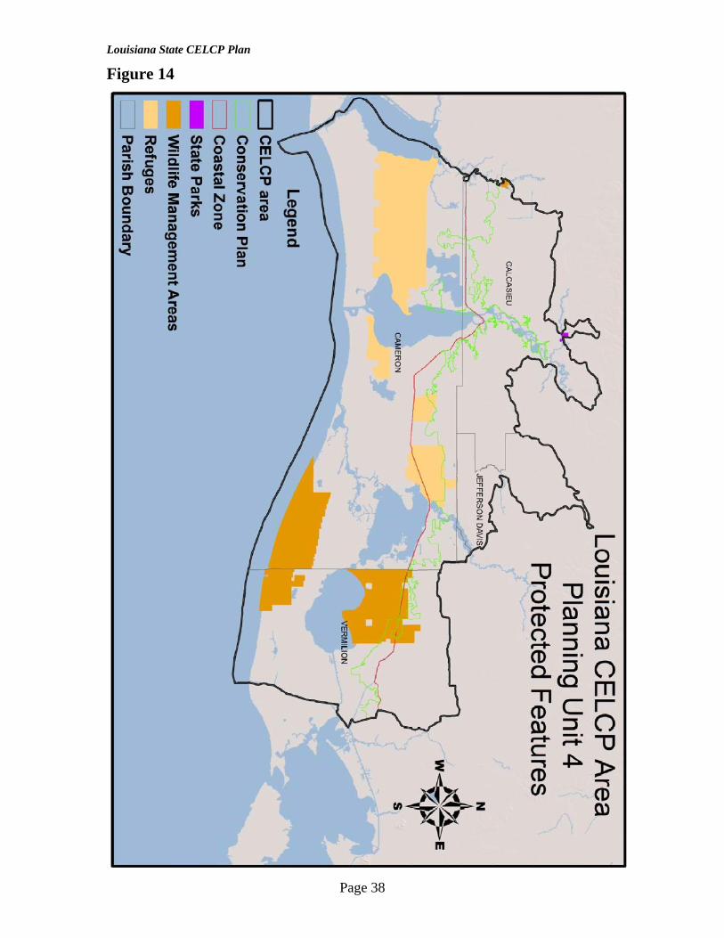
2. B. 4. a. Planning Unit 4 This unit consists of the Sabine, Calcasieu, and Mermentau Drainage Basins; it contains protected features such as State Parks, Wildlife Management Areas, and Refuges. (Appendix B. Figure 14.) Mermentau – The Mermentau River Basin is located in the southwestern part of Louisiana and comprises a drainage area of approximately 6,730 square miles. Approximately 1,960 square miles are within the CELCP area. This basin, located between the Teche-Vermilion and Calcasieu river basins, comprises a controlled system for the drainage of the Mermentau River and its tributaries. Catfish Point and Schooner Bayou Control Structures and Calcasieu and Leland Bowman Locks control the impoundment of winter runoff for irrigation use in the summertime (COE 1998). (Appendix B. Figure 4) Land Cover – The Mermentau Basin is comprised of prairie which is characterized by large expanses of flat grassland dissected by the numerous tributaries of the basin and dotted with “islands” of oak trees and other mixed hardwoods. The prairie, which is extensively cultivated, gives way to a band of marshland which extends from east to west along Louisiana’s entire coastline. The marsh is further subdivided into a fresh water marsh, which borders the prairie to the north, then merges into intermediate and brackish marshes and finally terminating with salt water marsh which forms the coastline adjacent to the Gulf of Mexico and its bays (Domingue, Szabo & Assoc. Inc. 1975). (Appendix B. Figure 15.) Calcasieu – The Calcasieu River Basin, located in southwest Louisiana, comprises approximately 4,105 square miles of drainage area and represents 8 percent of the area of the state. Approximately 947 square miles are within the CELCP area. The Calcasieu River flows through the coastal prairie and coastal marshes, which have an elevation ranging from 1-2 feet above mean sea level. The flood plains are extremely flat with little relief and average 2-3 feet above mean sea level. The river flows through the following lakes: Lake Charles, Prien Lake, Moss Lake and Calcasieu Lake. Dominant features include oxbow lakes, natural levees and the surrounding Pleistocene Uplands (Weston 1974). The Calcasieu River varies from a small fast flowing stream in the headwaters to a broad, sluggish estuary from the latitude of Lake Charles to its entrance into the gulf. The lower portion of the river from the city of Lake Charles to the gulf is subject to tidal variation. A semidiurnal tide extends 65 miles upstream and has mean tidal ranges of 1.7 feet at the river mouth and 0.7 foot at Lake Charles. (Appendix B. Figure 4) Land Cover – The city of Lake Charles lies in the southern portion of the basin and this area has been heavily industrialized by petro-chemical plants. An existing saltwater barrier across the Calcasieu River at Lake Charles divides the upper and lower basins and prevents saltwater intrusion from degrading this major source of irrigation water supply
Page 10

Louisiana State CELCP Plan
for rice production. Navigation improvements have modified the Calcasieu from its mouth approximately 52.6 river miles inland (Weston 1974). (Appendix B. Figure 15.) Sabine – The Sabine River flows as boundary waters between Texas and Louisiana for some 270 river miles to the Gulf of Mexico. The Sabine River drains an area of approximately 9,700 square miles, of which 7,190 square miles are above the Toledo Bend Reservoir (A.I.D. Associates 1981). Roughly 2,510 square miles of drainage are situated below the dam which is located at river mile 200. The entire basin drains 3,257 square miles within the state. Approximately 610 square miles are within the CELCP area. The Toledo Bend Reservoir was constructed in the 1960’s and became operational in 1969. Operation of the hydroelectric plant has affected water flows on the lower portions of the river since that time. Sand and silt are the predominant substrates below the dam to the Gulf of Mexico. (Appendix B. Figure 4) Land Cover – The northern and central portions of the basin are primarily forested with scattered agriculture lands throughout. Most of the basin is pinelands with the majority of hardwoods located along principle drainages. Along the coastal zone almost all of the freshwater marsh was converted to intermediate and brackish marsh by the late 1970s as a result of saltwater intrusion and increased tidal influence (LCWCRTF 1993). (Appendix B. Figure 15.)
2. B. 4. b. Planning Unit 4 Assessment of Need for Conservation Threats – Acquisition would help to alleviate threats by removing the potential for development and reduce the lands use as it pertains to Altered Water Quality, Change in Land Use Practices, Loss of Genetic Diversity, Nutrient Loading, Sedimentation, and Toxins/Contaminants. Once acquired, the lands will be preserved and maintain a natural ecosystem with minimum Altered Composition/Structure, Habitat Fragmentation, Modification of Water Levels; Changes in Natural Flow Patterns and Salinity Alteration. The table in Appendix B. Figure 16. further describes the threats for Planning Unit 4.
2. C. Identification of “Project Areas”
2. C. 1. Project Areas: The project areas are defined as: • discrete areas identified within a state’s CELCP Plan, describing the state’s priority
areas for conservation based on national and state criteria; • areas that represent the values to be protected through the program; and • areas threatened by conversion. Project areas are identified based on the presence of state’s identified priorities for protection (section 2.B.2.); wetlands, shoreline, and adjacent uplands (undeveloped, natural habitat) at a geographic site within each planning unit basin. If a project area is present, then the site becomes eligible for a broader examination of other attributes and core qualities, including the state’s priorities of special consideration: coastal forests, geological land forms, natural heritage sites, and Master Plan acquisition targets. Project sites which provide the most extensive complement of qualities compatible with the definition of these elements will rate highest on Louisiana’s nomination list. This list is an outline of the categories and elements that are Louisiana’s CELCP priorities for
Page 11

Louisiana State CELCP Plan
project areas. (Appendix B. Figure 6., Appendix B. Figure 9., Appendix B. Figure 12., and Appendix B. Figure 15.)
2. D. Existing Plans Summaries Project site identification and nomination for funding will be supported by several efforts already completed or underway within Louisiana. The following plans include natural resource areas of highest interest and importance to the state in the respective areas of wildlife, native plant communities, biodiversity, and landscape/shoreline processes. These plans (and their resource databases) will be used by LDNR/OCM as core references, providing assessment information which will help identify what areas should be focused on, thus serving to substantiate the relative value of a candidate project site. These plans, however, are not the exclusive references or definitive works on which a project approval will be based. It should be noted that the following list of reference assessments and program efforts is ever expanding. As it expands, new and valuable information will become available regarding ecologically significant coastal and estuarine areas. It is in the best interest of coastal and estuarine resource protection in Louisiana that the CELCP Plan be open to “new science” in the form of new assessment data as they become available, thus substantiating a project site’s ecological role. Therefore, the list below highlights broader state and/or regional efforts, but does not detail all of the prolific and evolving local assessment work that will also be reviewed in determining a proposed project’s significance.
2. D. 1. Louisiana Coastal Wetlands Conservation Plan The Coastal Wetlands Planning, Protection, and Restoration Act (Public Law 101-646, Title III--CWPPRA) was enacted and signed into law on November 29, 1990. The Act directed that a task force consisting of representatives of five federal agencies (U.S. Army Corps of Engineers (USACE), U.S. Fish and Wildlife Service (USFWS), Environmental Protection Agency (EPA), U.S. Department of Interior, and the U.S. Department of Commerce) and State of Louisiana develop a “comprehensive approach to restore and prevent the loss of coastal wetlands in Louisiana.” In order to ensure a comprehensive approach, coastal restoration and management activities must address not only past human development and natural degradation processes but also ongoing human development in the coastal zone under the provisions of CWPPRA. The LDNR/OCM pursuant to CWPPRA developed the Coastal Wetlands Conservation Plan (CWCP) to address the possible losses attributable to human activities and construction and achieve the goal of “no net loss” of coastal Louisiana’s valuable wetlands. The boundary for this plan was used in determining the CELCP Area.
2. D. 2. Louisiana’s Master Plan The Louisiana Legislature approved the CPRA's master plan for coastal restoration and hurricane protection on May 30, 2007 entitled "Integrated Ecosystem Restoration and Hurricane Protection: Louisiana's Comprehensive Master Plan for a Sustainable Coast. The plan is the first document to completely incorporate hurricane protection projects with restoration projects aimed at rebuilding Louisiana's rapidly eroding coastal wetlands. The plan reflects more than 18 months of research, stakeholder and scientific review and writing. It will be the guide for all coastal restoration and hurricane protection efforts in
Page 12

Louisiana State CELCP Plan
Louisiana over the next several decades. More information can be found at http://www.lacpra.org/.
2. D. 3. Atchafalaya Basin Program Louisiana Department of Natural Resources Atchafalaya Basin Program was created to conserve, restore, and enhance the natural habitat of the basin. The Atchafalaya Basin is the nation’s largest river swamp, containing almost one million acres of our nation’s most significant bottomland hardwoods, swamps, bayous, and back-water lakes. In 1986, Congress authorized $250 million dollars to preserve and enhance the Basin through the US Corps of Engineers by expanding public access, environmental easements, water-management, and recreation. In 1999, the Louisiana Legislature voted unanimously for the State Master Plan of the Atchafalaya Basin (Act 920), authorizing $85 million to be spent over a 15 year period, in order to match the federal dollars. More information can be found at http://dnr.louisiana.gov/sec/atchafalaya/.
2. D. 4. Barataria-Terrebonne National Estuary Program The National Estuary Program (NEP) was established by Congress through section 320 of the Clean Water Act in 1987 and administrated by the Environmental Protection Agency. The goal of the National Estuary Program is to prevent activities that threaten an estuary's public water supply, are harmful to shellfish, fish and wildlife populations, and negatively impact recreational opportunities for estuary residents. Louisiana's Barataria and Terrebonne basins were nominated for participation in the EPA administered National Estuary Program on October 16, 1989. The Barataria Terrebonne National Estuary Program operates under a comprehensive conservation management plan. This plan was developed democratically by the Management Conference of the concerned estuary interests. A formal management plan with specific action plans was developed to promote and preserve the Barataria and Terrebonne estuaries. More information can be found at http://www.btnep.org/home.asp.
2. D. 5. Lake Pontchartrain Basin Foundation The Lake Pontchartrain Basin is a 10,000 square mile watershed encompassing 16 Louisiana parishes. The land use of the region ranges from rural to urban and is the most densely populated region in Louisiana, including metro New Orleans and the state capital, Baton Rouge. It is one of the largest estuarine systems in the Gulf of Mexico containing over 22 essential habitats. The Basin's topography ranges from rolling woodlands in the north to coastal marshes in the south, with the 630 square mile Lake Pontchartrain as its centerpiece. In 1995, the Lake Pontchartrain Basin Foundation released the Comprehensive Management Plan (CMP) for the restoration of the Pontchartrain Basin. The CMP was developed jointly with the U.S Environmental Protection Agency (EPA) and numerous other federal, state, and local agencies, elected officials, area universities, sporting and recreational organizations, citizens groups, commercial fishing organizations, and representatives from the agricultural community and the business community. Its contributors exhaustively cataloged the threats to the Basin by sewage, agricultural and urban runoff, saltwater intrusion, and wetlands loss. More information can be found at http://www.saveourlake.org/.
2. D. 6. Louisiana Department Wildlife and Fisheries The Louisiana Department of Wildlife and Fisheries (LDWF) Wildlife Action Plan (WAP, formerly Comprehensive Wildlife Conservation Strategy (CWCS)) was
Page 13

Louisiana State CELCP Plan
developed with a purpose to develop a blueprint for guiding LDWF in the development of management actions for Louisiana’s fish and wildlife species with emphasis on species of conservation concern and associated habitats they depend upon. The goals of this plan are Species Conservation, Habitat Conservation, Public Outreach and Education, and the Development of new and existing Partnerships. The LDWF also has a Louisiana Natural Heritage Program (LNHP) with the goal of developing and maintaining a database on rare, threatened and endangered (r/t/e) species of plants and animals and natural communities for Louisiana. More information can be found at http://www.wlf.state.la.us/.
3. Implementation Process for state CELCP Plan
3. A. Lead State Agency The Interagency Affairs and Field Service Division (IAFSD) of the Louisiana Department of Natural Resources (LDNR) is charged with implementing the Louisiana Coastal Resources Program (LCRP) under authority of the State and Local Coastal Resources Management Act (SLCRMA) of 1978, as amended (LA. R.S. 49:214.21-214.41). The agency responsible for coordinating the establishment and implementation of the CELCP in Louisiana is the Louisiana Department of Natural Resources, Office of Coastal Management, Interagency Affairs and Field Service Division (LDNR/OCM/IAFSD). LDNR/OCM has been the lead agency implementing the Louisiana Coastal Resources Program (LCRP) under authority of the State and Local Coastal Resources Management Act (SLCRMA) of 1978, as amended (LA. R.S. 49:214.21-214.41). This law seeks to protect, develop, and, where feasible, restore or enhance the resources of the state’s coastal zone. Its broad intent is to encourage multiple uses of resources and adequate economic growth while minimizing adverse effects of one resource use upon another without imposing undue restrictions on any user. Besides striving to balance conservation and resources, the guidelines and policies of the LCRP also help to resolve user conflicts, encourage coastal zone recreational values, and determine the future course of coastal development and conservation. The guidelines are designed so that development in the Coastal Zone can be accomplished with the greatest benefit and the least amount of damage. The LDNR/OCM oversees implementation of the state’s LCRP which regulates development activities within Coastal Zone of Louisiana. Coastal Zone Management in LDNR/OCM/IAFSD also focuses on watersheds, floodplains, and wetlands management in general. LDNR/OCM/IAFSD staff provides direct technical assistance to local governments and local watershed groups/councils working on these resource management issues. Under the CELCP Plan LNDR/OCM will not hold full-fee title to the project properties, but will continue the practice of conditioning deeds with grant funding terms and any appropriate conservation conditions, including conditions required by NOAA’s CELCP grant award. Should a change from conservation status occur, the conditioning with grant terms and or conservation deed restriction will provide a course of action for minimizing the conservation loss and/or recovering the financial investment to assure compliance in perpetuity with conservation terms.
Page 14

Louisiana State CELCP Plan
Louisiana will update the CELCP plan at least once every 5 years to reflect changes that have taken place within the CELCP area and will submit the updated plan to NOAA.
3. B. Eligible Land Holding Entities The CELCP guidelines define eligible land holding entities to include state agencies and local governments. Local governments are defined by 15 CFR 24.3, and under section 306A(e) of the CZMA (16USC 1455a(e)). As defined at 15 CFR 24.3, local government means a county, municipality, city, town, township, local public authority (including any public and Indian housing agency under the United States Housing Act of 1937), school district, special district, intrastate district, council of governments (whether or not incorporated as a nonprofit corporation under State law), any other regional or interstate government entity, or any agency or instrumentality of a local government. Under section 306A(e) of the CZMA, an eligible entity may be a local government, an area-wide agency designated under Chapter 41, Subchapter II, section 3334 of Title 42, a regional agency, or an interstate agency. Land holding authority among public entities in Louisiana is defined in the Constitution and by other Legislative acts. This includes state and local government. Examples of some but not all state land holding entities that have a mission consistent with CELCP are: Office of State Lands, Department of Wildlife and Fisheries, and Office of State Parks. In Louisiana the provision for local government to hold title can be found in the Louisiana Constitution and states: La. Const. Art. 6 Sec. 23 §23. Acquisition of Property Section 23. Subject to and not inconsistent with this constitution and subject to restrictions provided by general law, political subdivisions may acquire property for any public purpose by purchase, donation, expropriation, exchange, or otherwise. http://www.legis.state.la.us/lss/lss.asp?doc=206495 These local entities are defined by and include: La. Const. Art. 6 Sec. 44 PART V. DEFINITIONS §44. Terms Defined Section 44. As used in this Article: (1) "Local governmental subdivision" means any parish or municipality. (2) "Political subdivision" means a parish, municipality, and any other unit of local government, including a school board and a special district, authorized by law to perform governmental functions.
Page 15

Louisiana State CELCP Plan
(3) "Municipality" means an incorporated city, town, or village. (4) "Governing authority" means the body which exercises the legislative functions of the political subdivision. http://www.legis.state.la.us/lss/lss.asp?doc=206519 It is within the frame work of these constitutional provisions that LDNR/OCM/IAFSD will determine if a proposed local or state entity is public and can hold title to proposed lands pursuant to CELCP requirements. Non-governmental organizations, corporations, or individuals may participate in the acquisition and long-term stewardship of lands, but may not hold title. Except that under CELCP’s 2009 re-authorization, qualified nongovernmental organizations with a mission to acquire and manage land for conservation purposes (e.g., a land trust) are now eligible to hold title to property being used as in-kind match to a CELCP grant.
3. C. State Nomination Process
3. C. 1. Solicitation of Projects The process for submitting projects for national review begins with receipt of a Request for Proposals (RFP) from NOAA. It is to be noted that the Congressional appropriation does not initiate the annual competition. Under current operation, the competition is conducted prior to Congress’ appropriation. Congressional appropriations may or may not occur on an annual basis, as it is solely at the discretion of Congress. NOAA will publish a Federal funding opportunity notice to solicit project proposals from eligible states each year. The schedule for this process may vary. Based on the federal RFP, LDNR/OCM/IAFSD would then announce a formal request for proposals to all eligible parties, with a reasonable turnaround time (30 days prior to submitting projects to NOAA) to complete the project proposal. Applications submitted within the appropriate timeline would be reviewed and ranked by LDNR/OCM/IAFSD and submitted to NOAA within the federally authorized timeline. Once an RFP has been received, LDNR/OCM/IAFSD will solicit project applications. At LDNR/OCM/IAFSD’s discretion, an annual project solicitation may focus on specific priorities or areas identified in the approved CELCP Plan, as deemed necessary based on urgency of resource need. Candidate project proposals may also be conditioned with a minimum threshold funding request (i.e., funding “floor”) to limit overall project submittals to a manageable number. These priorities and limitations will be specified in the state’s project solicitation. Based on the requirements of LDNR/OCM/IAFSD’s solicitation for project applications, eligible applicants would submit proposals within the allotted timeframe. A framework of necessary information will be provided to the applicant at that time to guide both structure and content of the project proposal. Louisiana’s CELCP Plan priorities and review criteria questions will be available such that the applicant is aware of the parameters for scoring and prioritizing proposals. As stated in the federal guidelines, “a project proposal that includes several separate and distinct phases may be submitted in
Page 16

Louisiana State CELCP Plan
phases, but any succeeding phases must compete against other proposals in the year submitted.”
3. C. 2. State Review and Prioritization Proposal Acceptance: LDNR/OCM/IAFSD will be responsible for the review of proposals; however, IAFSD will solicit proposals from eligible public land holding entities. Non-governmental organizations, corporations, and/or individuals may participate in the acquisition and long-term stewardship of lands as well as development of the project proposal, but may not directly apply for or receive funds. LDNR/OCM/IAFSD determines whether a proposal should be accepted for consideration on the basis that it is (1) complete (meets CELCP program guidelines project application checklist, the checklist will be provided by LDNR/OCM/IAFSD at the time of the RFP) and (2) eligible under the national and state criteria. If the application is incomplete, LDNR/OCM/IAFSD can choose to provide additional time for the applicant to submit missing information. It will be recommended that applicants notify LDNR/OCM/IAFSD early regarding a pending project submittal. This will: (1) afford technical guidance regarding proposal content to be offered prior to the closing deadline, and (2) allow for a project’s competitive viability to be assessed prior to the applicant’s investing extensive time in completing a full proposal. Once deemed complete and eligible LDNR/OCM/IAFSD will determine if the project falls into the CELCP plans project areas of Wetlands, Shorelines, and Adjacent Uplands (undeveloped, natural habitat). When the above is met LDNR/OCM/IAFSD will proceed with proposal review and ranking. Proposal Review and Ranking: Project proposals will be ranked according to the degree to which they meet Louisiana’s CELCP Plan criteria. A Proposal Score percentage will be calculated and assigned to each project. The percentage will be derived from the total of points within the Evaluation Factors. Each of the Evaluation Factors (Purpose/Merit, Ecological, Conservation, and Threats) will be worth one-quarter of the total Proposal Score percentage. A minimum of one point for each Evaluation Factor will be required in order to proceed with the review and ranking. (see Appendix A for Scoring sheet) Project evaluations will be conducted by LDNR/OCM/IAFSD, and projects with highest Proposal Scores will be submitted to NOAA. Once all project proposals are submitted to LDNR/OCM/IAFSD, the CELCP review will begin and the proposals ranked. It is not anticipated that in-person project presentations will be required of applicants; however, clarification questions may be addressed to the applicant by LDNR/OCM/IAFSD at the time of project review and ranking. Notification of project status will be provided to the applicant following review and selection. The final step is when a list of prioritized projects is submitted to NOAA for consideration at the national level competitive review.
Page 17

Louisiana State CELCP Plan
3. C. 3. Evaluation Factors for Projects Purpose/Merit: Recreation/Public Access and Compatibility Historic or Cultural Aesthetic Ecological: Biotic Production (fisheries, wildlife, etc.) Corridors/Connectivity and/or Core Conservation Areas Migrating Bird Habitat Landscape Processes & Functions* Conservation: Feasibility of success (property availability) Long-term ease of management
Buffers (appropriate width protection for feature) Condition: non-fragmented, water quality
Storm Impact Attenuation* Threat: Imminent development or use impact Coastal Land Loss/Subsidence
Altered Water Quality Altered Composition / Structure Change in Land Use Practices Habitat Destruction or Conversion Competition for Resources Habitat Disturbance Nutrient Loading Habitat Fragmentation Toxins/ Contaminants Modification of Water Levels, Loss of Genetic Diversity Changes in Natural Flow Patterns Sedimentation Salinity Alteration
*These evaluation factors fall within 2. B. 3. Priorities of Special Consideration Purpose/Merit Recreation/Public Access Passive recreational access to land acquired under CELCP is allowed, and often desired, but not mandatory in all acquisition cases should the sensitivities of the resource preclude recreation due to degradation and/or loss of the features being conserved. (This implies that any recreational access that results in degradation or destruction of the conserved resource works against the purpose of investing in its conservation and thus wastes taxpayer dollars.) Louisiana will encourage, where possible, the integration of low-impact human activities with natural settings. Some examples of recreation/public access are hiking, bird watching, and canoeing. Historic/Cultural Historic and cultural resources are important to Louisiana citizens. Documentation of historic, archaeological, and/or cultural resources recorded with the Louisiana
Page 18

Louisiana State CELCP Plan
Department of Culture, Recreation, and Tourism will serve to verify significance of this attribute. Some examples of historic and cultural resources are burial grounds, abandoned towns, historic sites and districts. Aesthetic A good portion of Louisiana’s vitality is attributable to the aesthetic amenities of our coast. Although aesthetic amenities are a more subjective attribute, these qualities will be considered important additional contributions. Some examples of aesthetic amenities include serenity of the natural environment, scenic outlooks, relaxation, scenic vistas looking toward or from sites designated as scenic byways, scenic rivers, and/or other state- or locally-designated cultural landscapes, sites designated nationally as a scenic byway or wild and scenic river, and sites that provide a buffer for these designated areas. Ecological Biotic Production Louisiana’s CELCP’s approach will be ecosystem-conscious by carefully considering the mix of listed and non-listed, rare and common, and unique and ecologically significant species compositions available in the CELCP area. Corridors/Connectivity and/or Core Conservation Areas Candidate projects will be examined for how they enhance existing protected areas to build the capability of separated smaller “islands” of habitat to be more sustainable, or to provide a new core area of protection that builds the capacity for sustaining biodiversity on the landscape overall. A project may also add to the connectivity of protected habitats and/or improve linkages to habitats of key importance as corridors of migration. Migrating Bird Habitat Coastal Louisiana is a home to many resident bird species and a resting place for migrating birds in the Mississippi flyway. Through Louisiana’s CELCP the conservation of areas that serve as a valuable resting place for migrating birds will be taken into consideration. Landscape Processes and Functions Recognizing the integral linkages across wetlands, shorelines, and adjacent upland landscapes, The Louisiana Coastal Resources Program (LCRP) increasingly addresses land use management decisions from the perspective of first understanding the underlying processes and functions at work that support important landscape features. These large scale processes and functions such as exchanges between climate, geology, topography, and water are what has created habitat within wetlands, shorelines, and adjacent uplands. Louisiana’s CELCP will apply a landscape ecological assessment of assessing the underlying workings of landscape processes, for a clearer understanding of which landscape features are providing the most essential functional contributions to the integrity of the overall ecosystem. Applying this ecological assessment of processes to build a network of sustainable estuarine and coastal biodiversity is a foundational concept in Louisiana’s CELCP Plan. The use of this practice leads to a broader interpretation of “values” for preservation. When applying this concept what becomes worthy of preservation is a balance of those features which are both: 1) already known to be limiting and thus are identified generally
Page 19

Louisiana State CELCP Plan
as “important” and the 2) further local identification, when an ecological assessment of processes is conducted, which informs us the area may be “essential” for maintaining watershed function. Therefore, this plan presents an overview of those features which are known to be limited and therefore “important” to Louisiana. An example of landscape processes and functions may include a CELCP project area that support in the production and/or movement of deer or birds, in the storage of water, or in the production and/or movement of fish. Conservation Feasibility of success (property availability) Under feasibility of success, projects will be evaluated for their readiness to proceed with acquisition. This readiness will certainly include property availability; timeliness and timelines of the project; public interest & local community support; established partnerships; options for purchase and opportunities on the property, etc. Demonstrated support from the local community and jurisdiction will be a significant factor in assessing timeliness of project completion. Long-term ease of management Ease of management covers a number of issues. First is the need for inclusion of buffers to protect the desired features and for those buffers to have widths agreed upon by all parties. Additionally, the current condition of the property will be examined for level of environmental impacts. This will examine the condition of the habitat, the water quality, and any known toxins and invasive species present on the site. Adaptive management and monitoring needs will also be identified. Storm Impact Attenuation Hurricanes and tropical storms can have a dramatic effect on south Louisiana. Encouragement of projects that have the possibility of reducing storm impacts will be an important part of the Louisiana’s CECLP. Threats Imminent development of, or heavy use impacts to, a high quality coastal or estuarine area is of high concern in Louisiana’s CELCP. Threats which are immediate and most dangerous to an identified high-quality system for preservation will raise the likelihood of that candidate project being nominated for funding. Examples of this threat are Altered Water Quality, Change in Land Use Practices, Competition for Resources, Nutrient Loading, Toxins/ Contaminants, Loss of Genetic Diversity, and Sedimentation. Sedimentation is often a desirable process in Louisiana coastal estuarine areas. It is a negative process for smaller inland streams and waterbodies. Coastal Land Loss/Subsidence is of high concern also for Louisiana’s CELCP. Examples of this threat are Altered Composition / Structure, Habitat Destruction or Conversion, Habitat Disturbance, Habitat Fragmentation, Modification of Water Levels and Changes in Natural Flow Patterns, and Salinity Alteration. Project proposals will need to validate any claims of resource attributes present on the site with clear documentation. Project applicants may reference existing state databases, scientifically sound ecological assessments, and research/study documents, as well as scientific expertise, to make the case for a project site’s quality.
Page 20

Louisiana State CELCP Plan
4. Stakeholder Involvement In following the CELCP guidelines this state plan was developed through a public process, which included a public scoping process and comment period. Initial input on the development of the CELCP state plan was gathered from interagency contacts at a meeting held on April 7, 2008. Notice of this meeting was placed in Louisiana’s official state and parish journals as well as sending invitations directly to state and federal agencies, state and parish government, and non-profit groups. Initial interagency contacts included Louisiana Department of Environmental Quality, Office of State Parks, Department of Wildlife and Fisheries, and Office of State Lands, the US Fish and Wildlife Service, and non-profits such as The Nature Conservancy, The Trust for Public Land, Coalition to Restore Coastal Louisiana, Barataria-Terrebonne National Estuary Program, and the Lake Pontchartrain Basin Foundation. These contacts gave insight and recommendations on the geographic extent as well as possible priority areas. The draft plan was placed on public notice from May 7 to June 17, 2008. The purpose of this public scoping process was to inform stakeholders about CELCP state plan development, scope out local concerns, and identify resource areas considered to be of high ecological significance. After receiving interagency and public comments they were included into the CELCP state plan. Comments were received through both the public meeting and comment period. In addition, all of the conservation plans incorporated into the Louisiana CELCP plan were developed with public involvement process. The most recent plan to have public comment is the Louisiana's Comprehensive Master Plan for a Sustainable Coast, or “Louisiana’s Master Plan.” Public input from concerned stakeholders for this plan was gathered at meetings as well as other outreach efforts beginning in the summer of 2006. As stated in section 3. A. of this plan Louisiana will update the CELCP plan at least once every 5 years to reflect changes that have taken place within the CELCP area and will submit the updated plan to NOAA. LDNR will gather comments made during the 5 year interval and will make a public announcement for comments at or before the end of every 5 years. The public announcement will at a minimum contain a public notice in Louisiana’s official state journal.
Page 21


Louisiana State CELCP Plan
6. Reference: A.I. D. ASSOCIATES. 1981. Report prepared for Sabine River Authorities of Texas and Louisiana. Toledo Bend Dam and Reservoir. COASTAL ENVIRONMENTS, INC. 1981. Chenier Plain Region Ecological Characterization: A Habitat Mapping Study, Report prepared for LDNR, LCRP and NOAA, OCZM DEMAS, C. R., S. R. BRAZELTON, AND N. J. POWELL. 2001. The Atchafalaya Basin—River of Trees. USGS fact sheet 021-02. Website. http://la.water.usgs.gov/pdfs/rivertree-web.pdf. DOMINGUE, SZABO, AND ASSOCIATES. INC. 1975. Water Quality Management Plan, Mermentau-Vermilion-Teche Basin. Prepared for Louisiana Health and Human Resources Administration. Gould, H.R. and J.P. Morgan. 1962 Coastal Louisiana swamps and marshlands. Field trip No. 9. Pages 287-341 in E.H. Rainwater and R.P. Zingula, editors, Geology of the Gulf Coast and Central Texas and guidebook of excursions, Houston. LESTER, GARY. D., STEPHEN G. SORENSEN, PATRICIA L. FAULKNER, CHRISTOPHER S. REID, AND INES E. MAXIT. 2005. Louisiana Comprehensive Wildlife Conservation Strategy. Louisiana Department of Wildlife and Fisheries. Baton Rouge. 455 pp. LOUISIANA COASTAL WETLANDS CONSERVATION AND RESTORATION TASK FORCE. 1993. Louisiana Coastal Restoration Plan— Summary of Basins. Website. http://www.lacoast.gov/reports/program/program.asp?r=13439. LOUISIANA DEPARTMENT OF ENVIRONMENTAL QUALITY. 1993. Nonpoint source pollution program. Website. http://nonpoint.deq.louisiana.gov/wqa/default.htm. National Oceanographic and Atmospheric Administration (NOAA) Coastal 2006, C-CAP zone 46 2000-2005-Era Land Cover Change Analysis, Map, NOAA CSC, Charleston, SC, NOAA Coastal Change Analysis Program (C-CAP) http://www.csc.noaa.gov/crs/lca/locateftp.html WESTON, R. F. INC. 1974. Water Quality Management Plan for the Calcasieu River Basin. Prepared for Louisiana Health and Social and Rehabilitation Services Administration. U.S. ARMY CORPS OF ENGINEERS. 1998. Water resources development in Louisiana. U.S. Army Corps of Engineers, New Orleans District. 191 pp.
Page 23

Louisiana State CELCP Plan
Appendix A:
Page 24

Louisiana State CELCP Plan
Appendix B:
Figure 1
Page 25

Louisiana State CELCP Plan
Figure 2
Page 26

Louisiana State CELCP Plan
Figure 3
Page 27

Louisiana State CELCP Plan
Figure 4
Page 28

Louisiana State CELCP Plan
Figure 5
Page 29

Louisiana State CELCP Plan
Figure 6
Page 30

Louisiana State CELCP Plan
Figure 7
(Lester et al. 2005)
Page 31

Louisiana State CELCP Plan
Figure 8 Figure 9
Page 32

Louisiana State CELCP Plan
Figure 9
Page 33

Louisiana State CELCP Plan
Figure 10 (Lester et al. 2005)
Page 34

Louisiana State CELCP Plan
Figure 11
Page 35

Louisiana State CELCP Plan
Figure 12
Page 36

Louisiana State CELCP Plan
Figure 13
(Lester et al. 2005)
Page 37
Louisiana State CELCP Plan
Figure 14
Page 38

Louisiana State CELCP Plan
Figure 15
Page 39

Louisiana State CELCP Plan
Page 40
Figure 16 (Lester et al. 2005)