Spatio-temporal Modeling And Monitoring Of Extreme …
17
Spatio-temporal Modeling And Monitoring Of Extreme Weather Events And Conditions Markus M¨ oller, Sandra Krengel, Detlef Deumlich, Rolf Lessing & Burkhard Golla M¨ oller, Krengel, Deumlich, Lessing, Golla Extreme Weather Modeling & Monitoring ESA Φ-week 2018 1 / 17
Transcript of Spatio-temporal Modeling And Monitoring Of Extreme …
Spatio-temporal Modeling And Monitoring Of ExtremeWeather Events And Conditions
Markus Moller, Sandra Krengel, Detlef Deumlich, Rolf Lessing &Burkhard Golla
Moller, Krengel, Deumlich, Lessing, Golla Extreme Weather Modeling & Monitoring ESA �-week 2018 1 / 17
Gliederung
1 Motivation and objectives
2 Geodata integration approachPhenological ModellingLocalization of extreme weather events
3 Conclusion
Moller, Krengel, Deumlich, Lessing, Golla Extreme Weather Modeling & Monitoring ESA �-week 2018 2 / 17
Motivation and objectives
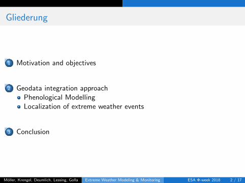
Extreme weather in Europe
Situation
Global climate change leads to increasing occurrence of extreme weather,which can have an impact on crop yield levels and yield stability.
Phenomena and impacts
Conditions heat, frost, drought ) damages to tissue and reproductiveorgans, significant reduction of photosynthesis up toirreversible tissue damages due to water deficit
Events heavy rainfall, hail ) root damages from oxygen deficit as aconsequence of soil water logging, soil erosion and nutrientleaching
Makinen, H., Kaseva, J., Trnka, M., Balek, J., Kersebaum, K.C., Nendel, C., Gobin, A., Olesen, J.E., Bindi, M., Ferrise,
R., Moriondo, M., Rodr’ıguez, A., Ruiz-Ramos, M., Takac, J., Bezak, P., Ventrella, D., Ruget, F., Capellades, G. &Kahiluoto, H. (2018): Sensitivity of European wheat to extreme weather. Field Crops Research 222, 209-217.
Moller, Krengel, Deumlich, Lessing, Golla Extreme Weather Modeling & Monitoring ESA �-week 2018 3 / 17
Motivation and objectives
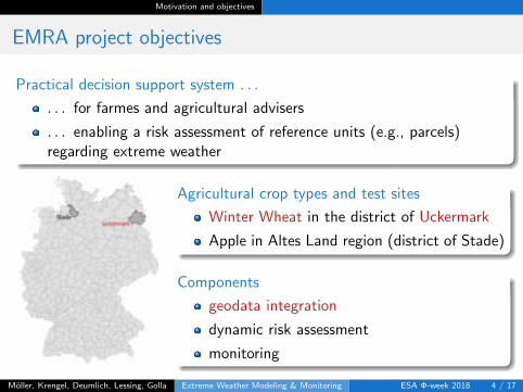
EMRA project objectives
Practical decision support system . . .
. . . for farmes and agricultural advisers
. . . enabling a risk assessment of reference units (e.g., parcels)regarding extreme weather
Agricultural crop types and test sites
Winter Wheat in the district of Uckermark
Apple in Altes Land region (district of Stade)
Components
geodata integration
dynamic risk assessment
monitoring
Moller, Krengel, Deumlich, Lessing, Golla Extreme Weather Modeling & Monitoring ESA �-week 2018 4 / 17
Motivation and objectives
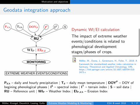
Geodata integration approach
RU
Pd,h Td,h DOYP IS IT S
WIP | EIP,d
MONITORING
EXTREME WEATHER EVENTS/CONDITIONS
Dynamic WI/EI calculation
The impact of extreme weatherevents/conditions is related tophenological developmentstages/phases of crops.
Moller, M., Doms, J., Gerstmann, H., Feike, T., 2018. A
framework for standardized weather index calculation inGermany. Theoretical and Applied Climatology. URLhttps://link.springer.com/article/10.1007/s00704-018-2473-x
Pd,h – daily and hourly precipitation | Td – daily mean temperature | DOYP – DOY ofbegining phenological phases | IS – spectral index | IT – terrain index | S – soil data |RU – Reference unit | WIP – Weather Index | EIP,d,h – Erosion Index
Moller, Krengel, Deumlich, Lessing, Golla Extreme Weather Modeling & Monitoring ESA �-week 2018 5 / 17
Motivation and objectives
Geodata integration approach
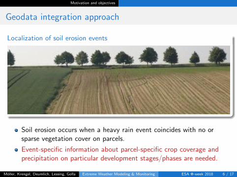
Localization of soil erosion events
Soil erosion occurs when a heavy rain event coincides with no orsparse vegetation cover on parcels.
Event-specific information about parcel-specific crop coverage andprecipitation on particular development stages/phases are needed.
Moller, Krengel, Deumlich, Lessing, Golla Extreme Weather Modeling & Monitoring ESA �-week 2018 6 / 17
Geodata integration approach Phenological Modelling
Geodata integration approach
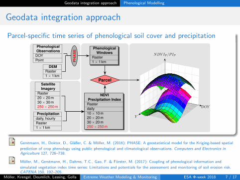
Parcel-specific time series of phenological soil cover and precipitation
PhenologicalWindows
Raster1 ⇥ 1 km
PhenologicalObservations
DOYPoint
DEMRaster1 ⇥ 1 km
PH
AS
E
NDVIPrecipitation IndexRasterdaily10 ⇥ 10 m20 ⇥ 20 m30 ⇥ 20 m250 ⇥ 250 m
SatelliteImagery
Raster20 ⇥ 20 m30 ⇥ 30 m250 ⇥ 250 m
Precipitationdaily, hourlyRaster1 ⇥ 1 km
Parcel
Y
DOY
NDV IP /PIP
Gerstmann, H., Doktor, D., Glaßer, C. & Moller, M. (2016): PHASE: A geostatistical model for the Kriging-based spatial
prediction of crop phenology using public phenological and climatological observations. Computers and Electronics in
Agriculture 127, 726–738.
Moller, M., Gerstmann, H., Dahms, T.C., Gao, F. & Forster, M. (2017): Coupling of phenological information and
simulated vegetation index time series: Limitations and potentials for the assessment and monitoring of soil erosion risk.CATENA 150, 192–205.
Moller, Krengel, Deumlich, Lessing, Golla Extreme Weather Modeling & Monitoring ESA �-week 2018 7 / 17
Geodata integration approach Phenological Modelling
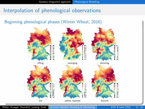
Interpolation of phenological observations
Beginning phenological phases (Winter Wheat, 2016)
tilling emerging shooting
ear yellow ripeness harvest
Moller, Krengel, Deumlich, Lessing, Golla Extreme Weather Modeling & Monitoring ESA �-week 2018 8 / 17
Geodata integration approach Phenological Modelling
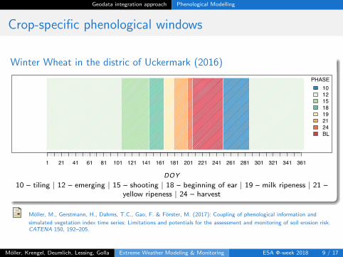
Crop-specific phenological windows
Winter Wheat in the distric of Uckermark (2016)2016
DOY
1 21 41 61 81 101 121 141 161 181 201 221 241 261 281 301 321 341 361
PHASE10121518192124BL
10 – tiling | 12 – emerging | 15 – shooting | 18 – beginning of ear | 19 – milk ripeness | 21 –yellow ripeness | 24 – harvest
Moller, M., Gerstmann, H., Dahms, T.C., Gao, F. & Forster, M. (2017): Coupling of phenological information and
simulated vegetation index time series: Limitations and potentials for the assessment and monitoring of soil erosion risk.CATENA 150, 192–205.
Moller, Krengel, Deumlich, Lessing, Golla Extreme Weather Modeling & Monitoring ESA �-week 2018 9 / 17
Geodata integration approach Phenological Modelling
Crop-specific phenological windows
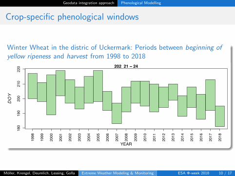
Winter Wheat in the distric of Uckermark: Periods between beginning of
yellow ripeness and harvest from 1998 to 2018
●
●
●
●
●
●
●●
●
●
●
●
●
●
●
●
●
●
●
●
●
180
190
200
210
220 202 21 − 24
YEAR
DOY
1998
1999
2000
2001
2002
2003
2004
2005
2006
2007
2008
2009
2010
2011
2012
2013
2014
2015
2016
2017
2018
Moller, Krengel, Deumlich, Lessing, Golla Extreme Weather Modeling & Monitoring ESA �-week 2018 10 / 17
Geodata integration approach Localization of extreme weather events
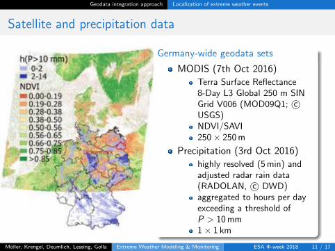
Satellite and precipitation data
Germany-wide geodata sets
MODIS (7th Oct 2016)
Terra Surface Reflectance8-Day L3 Global 250 m SINGrid V006 (MOD09Q1; c�USGS)NDVI/SAVI250 ⇥ 250m
Precipitation (3rd Oct 2016)
highly resolved (5min) andadjusted radar rain data(RADOLAN, c� DWD)aggregated to hours per dayexceeding a threshold ofP > 10mm1 ⇥ 1 km
Moller, Krengel, Deumlich, Lessing, Golla Extreme Weather Modeling & Monitoring ESA �-week 2018 11 / 17
Geodata integration approach Localization of extreme weather events
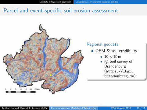
Parcel and event-specific soil erosion assessment
Regional geodata
DEM & soil erodibility
10 ⇥ 10mc� Soil survey ofBrandenburg(https://lbgr.brandenburg.de)
Moller, Krengel, Deumlich, Lessing, Golla Extreme Weather Modeling & Monitoring ESA �-week 2018 12 / 17
Geodata integration approach Localization of extreme weather events
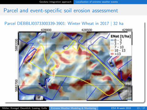
Parcel and event-specific soil erosion assessment
Parcel DEBBLI0373300339-3901: Winter Wheat in 2017 | 32 ha
Moller, Krengel, Deumlich, Lessing, Golla Extreme Weather Modeling & Monitoring ESA �-week 2018 13 / 17
Geodata integration approach Localization of extreme weather events
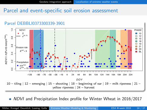
Parcel and event-specific soil erosion assessment
Parcel DEBBLI0373300339-3901
0.0
0.2
0.4
0.6
0.8
1.0
DEBBLI0373300339−3901
DOY
NDVI |
h(P
>10
mm
)/hm
ax)
−126 −96 −76 −56 −36 −16 4 24 44 64 84 104 124 144 164 184 204 224●●
●
●
●
●●●●●●
●●
●●●●●●●●●●●●●●●●
●
●
●●●●●●●●●●●●●●●●●●●●
●
●
●
●
●
●
●●●
●
●●●
●
●
●
●●●●●●●●●
●
●
●
●
●
●
●●●●●●●●●●●●●●●●●●●
●●
●
●
●
●
●●●
●●
●●
●
●●●
●
●●
●
●
●
●●●●●●●●
●●
●●●●●●●●
●
●●●●●●
●
●●●●
●
●
●
●
●
●
●
●
●●●●
●
●●●●●
●
●●
●●
●●
●
●
●
●
●
●
●
●
●
●●
●●
●
●●●●●●●
●
●
●●
●
●
●
●
●
●●●●●●●
●
●●●●
●
●
●●●●
●
●
●●●
●
●●●●●
●
●●●●●●
●●
●●●●●●●●
●
●●
●
●●●●●
●
●●
●
●
●
●
●●●●●●●●●●●
●
●
●
●
●
●
●●●
●
●●●
●
●●
●
●
●●●
●
●●●●●●●●
●
●●
●
●
●
●
●●●●●●●●
●
●●
●●
●
●●
●●
●
●●●●●●●●●●●●●●●
●
●
●
●●
●●
●●
●
● ● ●
●
●● ●
● ● ●
●●
●
●
●●
●
●
●
●
●●
●
●●
●
●
●
●
● ●
●
●
●
PHASE10121518192124BL
●
NDVIx~x25−75
●
Precipitationh /hmax
hmax = 15
Erosion riskEnat = 5
10 – tiling | 12 – emerging | 15 – shooting | 18 – beginning of ear | 19 – milk ripeness | 21 –yellow ripeness | 24 – harvest
NDVI and Precipitation Index profile for Winter Wheat in 2016/2017
Moller, Krengel, Deumlich, Lessing, Golla Extreme Weather Modeling & Monitoring ESA �-week 2018 14 / 17
Conclusion
Summary
Scale-specific geodata integration of current and historical geodata for theassessment of extreme weather
phenological information
daily weather data
satellite imagery
) Parcel-specific localization of historical/up-to-date soil erosion events ofhigh probability
Challenges
Applying ML techniques to detect Germany-wide pattern of extremeweather risk
Integration and visualization of spatio-temporal dataqualities/inaccuracies
Moller, Krengel, Deumlich, Lessing, Golla Extreme Weather Modeling & Monitoring ESA �-week 2018 15 / 17
Questions?
Contact Markus Moller · Federal Research Centre for CultivatedPlants · Institute for Strategies and Technology Assessment ·Stahnsdorfer Damm 81 · 14532 Kleinmachnow (Germany) ·Email: [email protected] · URL:http://emra.julius-kuehn.de
Moller, Krengel, Deumlich, Lessing, Golla Extreme Weather Modeling & Monitoring ESA �-week 2018 16 / 17
http://emra.julius-kuehn.de
Joint project partnersFederal Research Centre for Cultivated Plants, Institute for Strategies andTechnology Assessment · Stahnsdorfer Damm 81 · 14532 Kleinmachnow(Germany)German Weather Service (Deutscher Wetterdienst DWD) · Centre forAgrarmeteorological Research · Bundesallee 50 · 38116 Braunschweig(Germany)Leibniz Centre for Agricultural Landscape Research (ZALF) · EberswalderStraße 84 · 15374 Muncheberg (Germany)DELPHI IMM GmbH · Eisenhartstraße 2 · 14469 PotsdamproPlant Agrar-und Umweltinformatik GmbH · Nevingho↵ 40 · 48147MunsterObstbauversuchsring des Alten Landes e.V. (OVR) · ESTEBURG – Obst-bauzentrum Jork · Moorende 53 · 21635 JorkLandesamt fur Landliche Entwicklung, Landwirtschaft und Flurneuord-nung (LELF) · Pflanzenschutzdienst ·FGL Risiko- und Kontrollmanage-ment · Mullroser Chaussee 54 · 15306 Frankfurt (Oder)
Moller, Krengel, Deumlich, Lessing, Golla Extreme Weather Modeling & Monitoring ESA �-week 2018 17 / 17