Southwest Minnesota Regional Trail Local Plans
54
Appendix B - 1 APPENDIX B—LOCAL PLANS – PAGES Cottonwood ............................................................................................... B-2 – B-6 Jackson .................................................................................................... B-7 – B-11 Lincoln ................................................................................................... B-12 – B-15 Lyon .......................... ............................................................................ B-16 – B-21 Murray ................................................................................................... B-24 – B-27 Nobles .................................................................................................... B-28 – B-30 Pipestone ............................................................................................... B-31 – B-32 Redwood ............................................................................................... B-33 – B-39 Rock ....................................................................................................... B-40 – B-43 Casey Jones Trail Analysis ...................................................................... B-44 – B-53 Each Local Plan has five sections. 1. Trailheads and Potential Trailheads is a list of locations that were identified as areas where a trail is / could be accessed. The list includes trailheads that are access points to existing trails. 2. Existing Trails is a list of trails that currently exist within the County. The Trail User Group A, B, or C and the Statewide (S), Regional (R) on or Local (L ) significance trail signifi cance of the trail will be identified. 3. Planned Trails/corridors describes projects that are being proposed with an estimated 10 year time frame. The Trail User Group A, B, or C and the Statewide (S), Regional (R) on or Local (L) significance trail significance of the trail will be identified. 4. Potential Trail corridors are those trail corridors that are envisioned for future trail development. These are corridors where future development would complete a trails network. A potential trail corridor may move into the planned trails / corridors category if conditions exist that put them on a faster track, such as land acquisition. 5. Analysis of selected planned trail corridors. A more detailed analysis of the corridors likely to see development in the next ten years will be included to identify potential segments that may require additional planning and coordination with affected jurisdictions, road authorities, and regulatory agencies. Rating bicycle trails Some of the trails have been rated t o identify what specific type of user the trail will target. The following definitions describe Group A, Group B and Group C users: GROUP A –ADVANCED OR EXPERIENCED BICYCLISTS . The FHWA Design Bicyclists comprised of experienced riders who can operate under most traffic conditions. (on-road, signed) GROUP B – BASIC BICYCLISTS. The FHWA Design Bicyclists comprised of casual or new adult and teenage riders who are less able to operate in traffic without provisions for bicycles. (bicycle lanes, shoulders and signed) GROUP C – CHILDREN. The FHWA Design Bicyclists comprised of pre-teen riders who roadway use is initially monitored by parents and eventually are accorded independent access to the roadway system. (off-road)
-
Upload
livewire-printing-company -
Category
Documents
-
view
220 -
download
0
Transcript of Southwest Minnesota Regional Trail Local Plans
8/8/2019 Southwest Minnesota Regional Trail Local Plans
http://slidepdf.com/reader/full/southwest-minnesota-regional-trail-local-plans 1/54
8/8/2019 Southwest Minnesota Regional Trail Local Plans
http://slidepdf.com/reader/full/southwest-minnesota-regional-trail-local-plans 2/54
Appendix B - 2
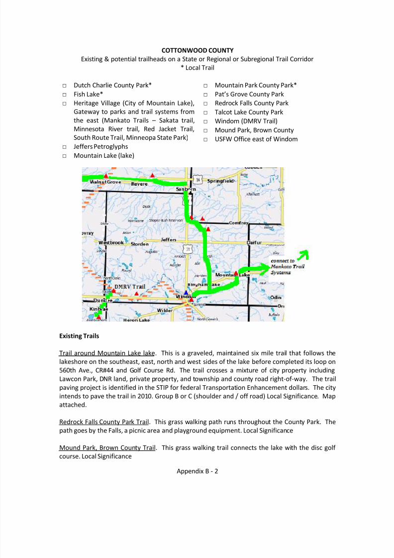
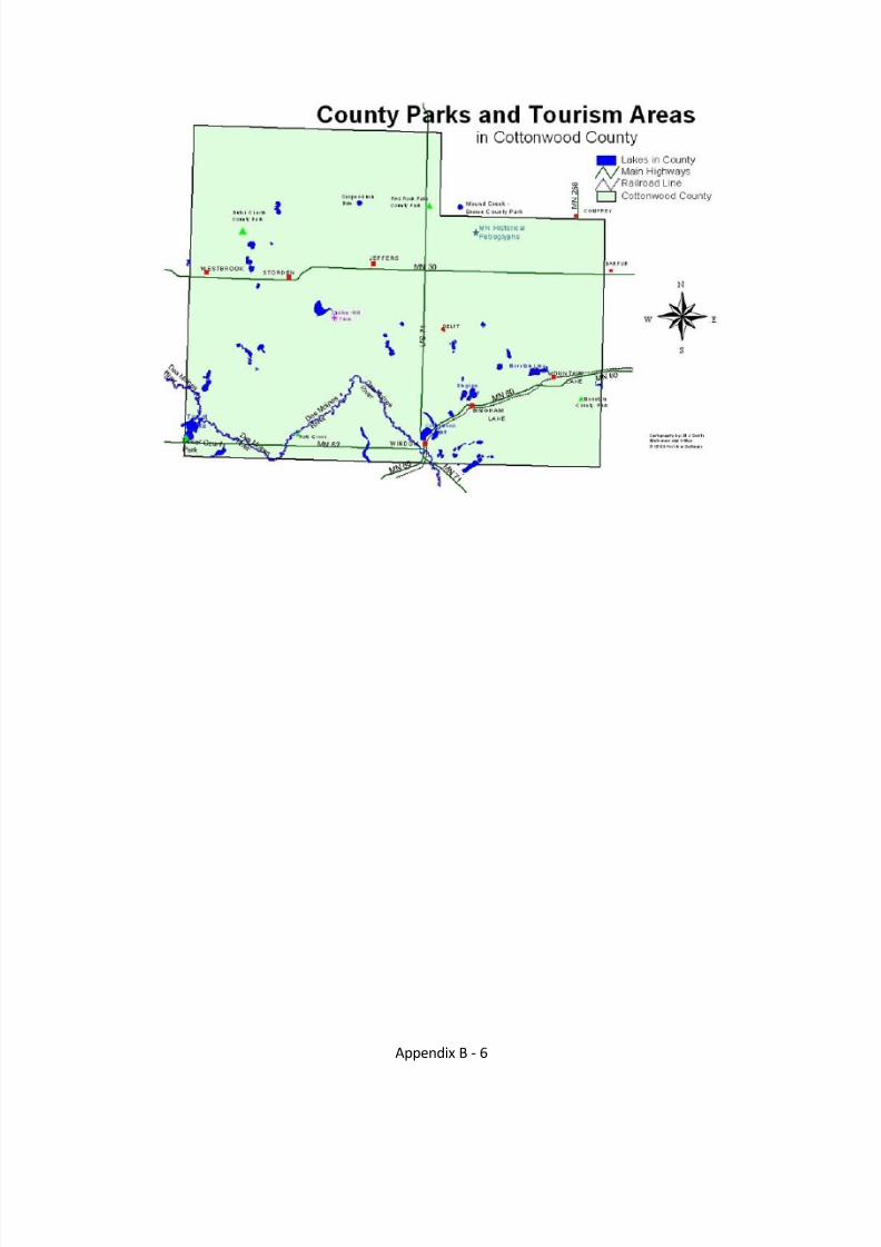
COTTONWOOD COUNTYExisting & potential trailheads on a State or Regional or Subregional Trail Corridor
* Local Trail
□ Dutch Charlie County Park*□ Fish Lake*□ Heritage Village (City of Mountain Lake),
Gateway to parks and trail systems fromthe east (Mankato Trails – Sakata trail,Minnesota River trail, Red Jacket Trail,South Route Trail, Minneopa State Park)
□ Jeffers Petroglyphs□ Mountain Lake (lake)
□ Mountain Park County Park*□ Pat’s Grove County Park□ Redrock Falls County Park□ Talcot Lake County Park□ Windom (DMRV Trail)□ Mound Park, Brown County□ USFW Office east of Windom
Existing Trails
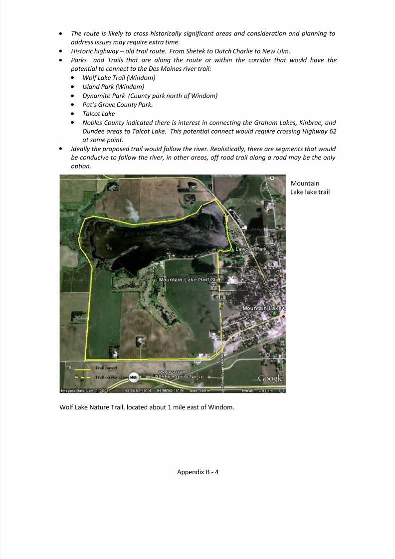
Trail around Mountain Lake lake. This is a graveled, maintained six mile trail that follows thelakeshore on the southeast, east, north and west sides of the lake before completed its loop on560th Ave., CR#44 and Golf Course Rd. The trail crosses a mixture of city property includingLawcon Park, DNR land, private property, and township and county road right-of-way. The trailpaving project is identified in the STIP for federal Transportation Enhancement dollars. The cityintends to pave the trail in 2010. Group B or C (shoulder and / off road) Local Significance. Mapattached.
Redrock Falls County Park Trail. This grass walking path runs throughout the County Park. Thepath goes by the Falls, a picnic area and playground equipment. Local Significance
Mound Park, Brown County Trail. This grass walking trail connects the lake with the disc golf course. Local Significance
8/8/2019 Southwest Minnesota Regional Trail Local Plans
http://slidepdf.com/reader/full/southwest-minnesota-regional-trail-local-plans 3/54
Appendix B - 2
Dutch Charlie County Park Trail. This grass walking path connects all the campsites within thepark. The trail goes over a little bridge and all throughout the park. Local Significance
Minnesota Historical Society Jeffers Petroglyphs Trail. This is a 1.75 mile gravel/grass walkingpath. The trail goes by the Petroglyphs and Virgin Prairie. Local Significance
Talcot Lake County Park Trail. This grass and sand walking path connects the campsites with thebeach. The trail goes by a small pond and follows the beach of Talcot Lake. Currently localsignificance, if connected to the Des Moines River Valley Trail the significance would becomeRegional.
Witt Memorial Park in Windom. Witt Memorial Park sports a roller-blading court, spearheadedby Windom Hockey Association Boosters in 1995 and was completed in 1997. It includes a 60 by175 foot cement pad and sideboards. Local Significance.
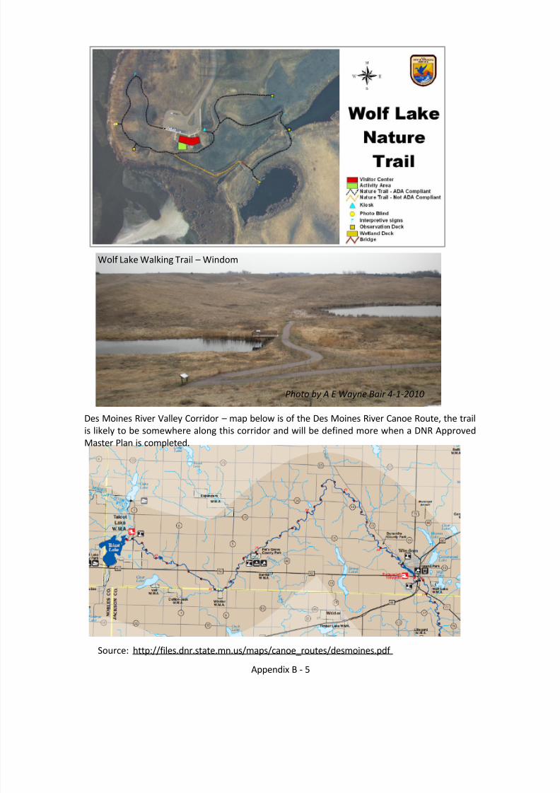
Wolf Lake Nature Trail. The trail head is located at the US Fish & Wildlife Office east of Windom.This is a ¾ mile walking trail nature trail (no bicycles on the trail), with one short segment that isnot ADA compliant. Parking areas are available at the USFW Office parking lots. The USFW also
maintains a mowed grass path to CSAH 17 which could in the future be used to connect to otherareas of Windom. Currently local significance, if connected to the Des Moines River Valley Trailthe significance would become Regional Significance. Map attached.
Planned Trails / Corridors
Windom Municipal Recreation Area Trail. The City of Windom desires to develop a recreationarea to include three softball fields, a soccer field, a winter sledding area, shelterhouse/restroom and 3 miles of paved multi-use trails. The scope of work will include a 40-acretract of land that is currently used as a well field for the City of Windom an adjacent landfillreclamation property and an existing city park. The City of Windom currently owns all of the
land. Group B and C. Currently the proposed trail in the City of Windom would be localsignificance, if connected to the Des Moines River Valley Trail they significance would becomeRegional Significance.
The multi-use trails incorporated into the adjoining parks would link residential areas to cityparks including Kastle Kingdom, Tegels Park and the new community center. All of theseproperties are located on the north/east section of the City of Windom. Excerpts of the projectrelated to trails and paths are as follows:
Develop 3 miles of paved multi-use trails. The trails will connect two City parks, theCommunity Center and several residential areas. The trails will also link Windom RecreationArea to the Southwest Minnesota Regional Trail Plan and will serve as a trailhead for theRegional Trails. The paved trails will be used for walking, bicycling and rollerblading withinthe recreation area. Landscaping such as wildflowers and natural prairie vegetation andtrees would be planted along the trails. Rest areas with park benches would be scatteredthroughout the trails.
Construct shelter house/restroom near the softball fields. The shelter house/restroomswould meet accessibility requirements.
8/8/2019 Southwest Minnesota Regional Trail Local Plans
http://slidepdf.com/reader/full/southwest-minnesota-regional-trail-local-plans 4/54
Appendix B - 3
Amphitheater, Gazebo, Patio and BBQ pit. The project would also include a naturalamphitheater in Tegels Park, a gazebo, patio and BBQ pit along the trail near the communitycenter. The Community Center includes a Senior Center the addition of a patio wouldprovide an outdoor space for area seniors to enjoy outdoor recreation including walkingpaths, a gazebo and barbecues.
Landfill Reclamation. A former landfill site that is on the Minnesota Pollution ControlAgency’s Superfund Site list and is currently in the process of being delisted will become auseful and attractive area for recreation purposes. Multi-use paved trails can be developedon the property and wildflowers and natural prairie vegetation can be established along thetrail.
Windom may consider striping bike lanes on a few streets where there is sufficient room.
Des Moines River Valley Trail, Jackson, Cottonwood, and Murray Counties. The trail shalloriginate in Jackson County at the Minnesota-Iowa border and connect with theDickinson Trail in Mini-Wakan State Park in Iowa. To the greatest extent possible, thetrail shall follow the Des Moines River Valley, extending northwesterly through JacksonCounty to Kilen Woods State Park, through Cottonwood County, and into Murray County.The trail shall terminate at Casey Jones Trail in Murray County. Group B / C, Regionalsignificance. Map attached
Potential Trail Corridors Westbrook North to Walnut Grove Windom to Lamberton to include Jeffers Petroglyphs, Redrock Falls County Park, and
Sanborn. Note Cottonwood CSAH 2 from CSAH 13 to Jeffers Petroglyphs was recently upgraded awith 8’ gravel shoulders. To safely cross TH 60 it was suggested a route under TH 60 at BighamLake be considered, especially when roads are upgraded. Mountain Lake to Mountain Park and south to Fish Lake near Windom. Note: Cottonwood
CSAH 13 from Windom to CSAH 1 was recently upgraded and includes 8’ graveled shoulders.
Mountain Lake East to St. James
Analysis of Selected Planned Trail / Corridors
Des Moines River Valley Trail in Cottonwood County Analysis . Assumption that the Trail entersCottonwood County from the south at Windom and connecting with the Casey Jones Trail inMurray County, along or near the Des Moines River Corridor. The exact route will be dependent on the outcome of the DNR Trail Plan. Assuming the route will follow along and near the DesMoines River, DNR has a Water Trail Map that identifies Parks along the approximately 37 milesof river in Cottonwood County, from Windom to Talcot Lake. The following notations should beconsidered:
The Des Moines River crosses State Highway 62 at three locations (the river is approximately 37 miles within Cottonwood County. Communication with the Department of Transportation(DOT) Mankato District to assist in determining best locations (and locations to avoid) for crossing the highway should be done early in the Trail Plan process that determines theroute.Other road jurisdictions will include Cottonwood County and Townships in the County.Contact with permitting agencies in connection with water, waterways wetlands and wildlifeareas (federal, state and local) are recommended early in the potential routing process.Trout stream
8/8/2019 Southwest Minnesota Regional Trail Local Plans
http://slidepdf.com/reader/full/southwest-minnesota-regional-trail-local-plans 5/54
Appendix B - 4
The route is likely to cross historically significant areas and consideration and planning toaddress issues may require extra time.Historic highway – old trail route. From Shetek to Dutch Charlie to New Ulm.Parks and Trails that are along the route or within the corridor that would have the potential to connect to the Des Moines river trail:
Wolf Lake Trail (Windom)Island Park (Windom)
Dynamite Park (County park north of Windom)Pat’s Grove County Park. Talcot LakeNobles County indicated there is interest in connecting the Graham Lakes, Kinbrae, and Dundee areas to Talcot Lake. This potential connect would require crossing Highway 62at some point.
Ideally the proposed trail would follow the river. Realistically, there are segments that would be conducive to follow the river, in other areas, off road trail along a road may be the only option.
MountainLake lake trail
Wolf Lake Nature Trail, located about 1 mile east of Windom.
8/8/2019 Southwest Minnesota Regional Trail Local Plans
http://slidepdf.com/reader/full/southwest-minnesota-regional-trail-local-plans 6/54
Appendix B - 5
Wolf Lake Walking Trail – Windom
Photo by A E Wayne Bair 4-1-2010
Des Moines River Valley Corridor – map below is of the Des Moines River Canoe Route, the trailis likely to be somewhere along this corridor and will be defined more when a DNR ApprovedMaster Plan is completed.
Source: http://files.dnr.state.mn.us/maps/canoe_routes/desmoines.pdf
8/8/2019 Southwest Minnesota Regional Trail Local Plans
http://slidepdf.com/reader/full/southwest-minnesota-regional-trail-local-plans 7/54
Appendix B - 6
8/8/2019 Southwest Minnesota Regional Trail Local Plans
http://slidepdf.com/reader/full/southwest-minnesota-regional-trail-local-plans 8/54
Appendix B - 7
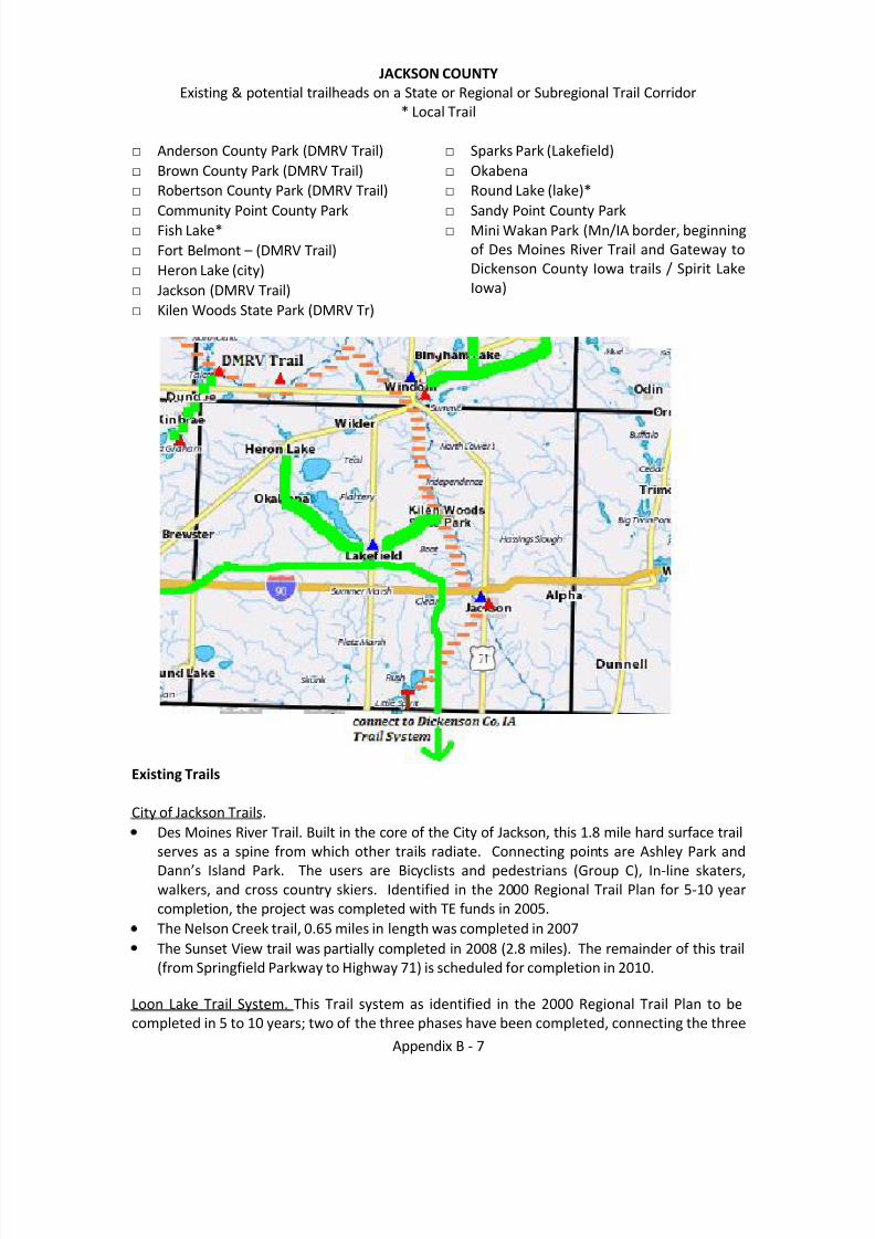
JACKSON COUNTYExisting & potential trailheads on a State or Regional or Subregional Trail Corridor
* Local Trail
□ Anderson County Park (DMRV Trail)□ Brown County Park (DMRV Trail)□ Robertson County Park (DMRV Trail)□
Community Point County Park□ Fish Lake*□ Fort Belmont – (DMRV Trail)□ Heron Lake (city)□ Jackson (DMRV Trail)□ Kilen Woods State Park (DMRV Tr)
□ Sparks Park (Lakefield)□ Okabena□ Round Lake (lake)*□
Sandy Point County Park□ Mini Wakan Park (Mn/IA border, beginning
of Des Moines River Trail and Gateway toDickenson County Iowa trails / Spirit LakeIowa)
Existing Trails
City of Jackson Trails.Des Moines River Trail. Built in the core of the City of Jackson, this 1.8 mile hard surface trailserves as a spine from which other trails radiate. Connecting points are Ashley Park andDann’s Island Park. The users are Bicycli sts and pedestrians (Group C), In-line skaters,walkers, and cross country skiers. Identified in the 2000 Regional Trail Plan for 5-10 yearcompletion, the project was completed with TE funds in 2005.The Nelson Creek trail, 0.65 miles in length was completed in 2007The Sunset View trail was partially completed in 2008 (2.8 miles). The remainder of this trail(from Springfield Parkway to Highway 71) is scheduled for completion in 2010.
Loon Lake Trail System. This Trail system as identified in the 2000 Regional Trail Plan to becompleted in 5 to 10 years; two of the three phases have been completed, connecting the three
8/8/2019 Southwest Minnesota Regional Trail Local Plans
http://slidepdf.com/reader/full/southwest-minnesota-regional-trail-local-plans 9/54
Appendix B - 8
Jackson County Parks (Anderson, Brown and Robertson) to Iowa’s Mini Wakan State Park andthe Dickenson County Iowa Trail system. This segment serves as a gateway trail between Iowaand Minnesota. The hard surface trail targets all groups of trail users (Groups B & C). Trails of Regional significance.
Phase I of the project was 0.75 miles and connected Brown County Park with RobertsonCounty Park. This segment was completed in 2006 with TE funds.Phase II of the project is a 2.1 mile hard surface trail completed in 2009 with TE funds andconnects the Jackson county Parks to Mini Wakan State Park on the Iowa / Minnesotaborder and the Dickenson County Trail system.Phase III – see Proposed Trails.Robertson Park Trail. This1750 foot wood chip walking trail goes through Robertson Park.Belmont Park Trail. This 3350 foot wood chip walking trail goes throughout Belmont Parkalong the Des Moines River.
Sparks Environmental Park Trail (Lakefield)This 1200 foot wood chip walking trail goes through the Sparks Environmental Park, a 40acre park located on the north edge of Lakefield and serves as the home base of the PrairieEcology Bus Center. The trail is primarily used for environmental programs.
Planned Trails / Corridors
Loon Lake Trail System. Group C, Trail of Regional Significance – connection to (DMRV Trail)Phase III – proposed for 2012 the final one mile segment of the Loon Lake Trail system.
City of Jackson: Group B and C. Trail segments are part of or connect to trail of Regionalsignificance (DMRV Trail)
Springfield Parkway a one mile segment in the city of Jackson scheduled for completion in2011. Transportation Enhancement Funds.
Ft Belmont – 1.6 miles from CSAH 14 and Hills Ave to Ft Belmont to the Des Moines RiverValley trail in Jackson. TE funding scheduled for 2011.
City of Lakefield. The City of Lakefield is working on the development of a looped trail systemaround the community. The Looped trail will be developed in phases and application to variousfunding sources to develop the trail. Primarily Group C, may incorporate Group B. Currently alocal trail system with plans to connect to a trail of Regional significance (DMRV Trail)
Phase 1. The Old Mill Trail will include construction of approximately 1.5 miles of trail in theCity of Lakefield. The trail will begin at Pleasantview Elementary School and then traversealong the east side of Lakefield making connections to the city-school baseball diamondsand the city’s outdoor pool. The trail will end at Colonial Avenue at the north end of Lakefield making a link to Emerald Valley Golf Club and Colonial Manor Nursing Home. Thealignment of the trail is on school owned property, city owned property, and through autility property. The Old Mill Trail will serve in conjunction with a trail plan to loop aroundthe City of Lakefield. The City has submitted a Transportation Enhancement Application for$373,056 through Jackson County to the ATP 7 for STIP 2014 funding. The local match willbe provided through the City of Lakefield.Phase 2 of the Lakefield Trail Plan would include a joint cooperation with Emerald ValleyGolf course for a trail through or around the facility. The trail would then cross State
8/8/2019 Southwest Minnesota Regional Trail Local Plans
http://slidepdf.com/reader/full/southwest-minnesota-regional-trail-local-plans 10/54
Appendix B - 9
Highway 86 to Sparks County Park, home of the Prairie Ecology Bus. Sparks Park has severalnature trails for exploring the environment around Lone Tree Creek.A connection of the southern neighborhoods of Lakefield to Pleasantview ElementarySchool to enable safe pedestrian and bicycling of students to school. The community istargeting safe Routes to School as a potential funding source to assist in providing a safe nonmotorized transportation route to school.
Heron Lake to Kilen Woods. This proposed trail would connect Heron lake and Kilen Wood trailheads utilizing both on-road and off road trail options. View of Heron Lake and CommunityPoint will be potential attractions. Group B and C. this would connect at Kielen Woods to theDes Moines River Valley trail, a trail of Regional Significance.
Segment 1: CSAH 9. This proposed trail will connect the communities of Okabena and HeronLake which share a school located in Okabena. This proposed trail will provide a linkbetween these two communities. Targeted are Bicyclist (Group B), In-line skaters andwalkers. The trail will feature Rural Scenery along its double 4 mile trail with BituminousShouldering.Segment 2: CSAH 20 (Okabena to Lakefield). This proposed trail will connect the
communities of Okabena to Lakefield. This proposed 7-8 miles trail would provide a linkbetween the communities and target bicycling and walkers.Segment 3: CSAH 14 (Lakefield to Des Moines River Trail). This proposed 7-8 mile trailwould connect to the Des Moines River State Trail.
Des Moines River Valley Trail. Legislatively designated by the Minnesota Legislature in 2009, thistrail planning process is overseen by the Minnesota Department of Natural Resources (DNR).The development of a trail plan is required before any trail development can be implemented.The legislative text is as follows: Des Moines River Valley Trail, Jackson, Cottonwood, andMurray Counties. The trail shall originate in Jackson County at the Minnesota-Iowa border andconnect with the Dickinson Trail in Mini-Wakan State Park in Iowa. To the greatest extentpossible, the trail shall follow the Des Moines River Valley, extending northwesterly throughJackson County to Kilen Woods State Park, through Cottonwood County, and into MurrayCounty. The trail shall terminate at Casey Jones Trail in Murray County.
The 2000 Regional Trail Plan identified two segments that are along part of the corridor of theDes Moines River Valley Trail:
City of Jackson to South. The target group is Bikes (Group A, B & C). Potential attractionswill be River Views connecting the City of Jackson, Petersburg & Loon Lake. We areanticipating using the existing road surface and updating the signage currently on the road.Jackson to Windom. Bikers, (Group B & C), Hikers, Walkers and Equestrian will be the usersof this system. It is anticipated to be 18 miles long and completed in the next 10 to 20years. The trail is proposed to connect Jackson and Windom with attractions of Des MoinesRiver Scenery, Belmont County Park and Kilen Woods Park.
Potential Trail CorridorsRiver Loop near Jackson. This 22 mile project is targeting Bike users (Group A & B). The projectis expected to be completed in 5 to 10 years. The direction of this trail will be Ashley Park toCSAH 23, North on CR 83, West on CSAH 16, South on CSAH 19, East on CSAH 14 and back toAshley Park. Along this route you will experience various views of the Des Moines River. GroupA, using the existing roadways with increased signage.
8/8/2019 Southwest Minnesota Regional Trail Local Plans
http://slidepdf.com/reader/full/southwest-minnesota-regional-trail-local-plans 11/54
Appendix B - 10
Lakefield – a connection on the north side of Lakefield to Boot Lake.
Analysis of Selected Planned Trail Corridors
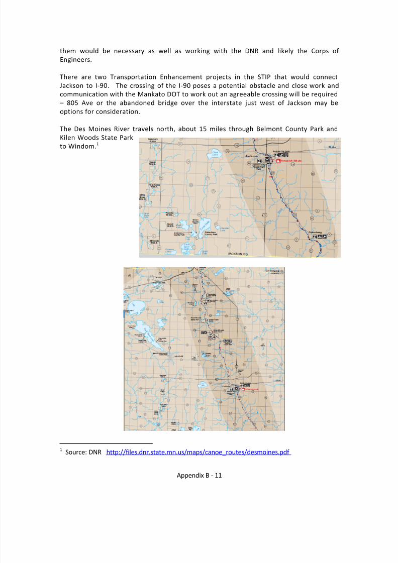
Des Moines River Trail in Jackson County“The trail shall originate in Jackson County at the Minnesota-Iowa border and connectwith the Dickinson Trail in Mini-Wakan State Park in Iowa. To the greatest extentpossible, the trail shall follow the Des Moines River Valley, extending northwesterlythrough Jackson County to Kilen Woods State Park…”
Based on visioning by the Friends of the Jackson County Trails the following potentialcorridor routes for the Des Moines River Valley Trail from Mini Wakan Trailhead to Jackson willbe examined: The existing trail travels from the Iowa /MN line to the Jackson CountyParks (Anderson, Brown, Robertson). At this point the Friends Group suggests twodifferent routes to reach Jackson:
A. From Robertson Park east approximately 9 miles along Jackson CSAH 4, intersecting
with Jackson CSAH 23 at Petersburg and paralleling CSAH 23 and the Des MoinesRiver to the city of Jackson and connecting with the City Trail system.Review of route: There will be homes along Jackson CSAH 4 to Petersburg with a fewwaterways to cross. At Petersburg there is a bridge over the Des Moines River, canpedestrian and bicycle traffic utilize the existing bridge? Will modifications or aseparate bridge be needed? The route paralleling Jackson CSAH 23 from Petersburgto Jackson would be a scenic route because it also parallels the Des Moines River; italso will have several waterways to cross.
B. From Brown County Park travel around the west side of Loon Lake (1 mile) and runparallel Jackson CSAH 17 north 6 miles) to Jackson CSAH 10 at Clear Lake, parallel
CSAH 10 4 miles east to Jackson and connecting with the trail system.Review of Route: There appears to be a private access road along the west side of Loon Lake, north of Brown County Park. An alternative may be traveling north fromAnderson County Park along CR 73 to CR 66 and joining CSAH 17. This route appearsto have fewer waterways to cross, however in the County Park Area there may bewetland issues and DNR should be consulted.
Once at Jackson, the existing and planned Trail System in the community is likely to beutilized. The planned Ft Belmont trail connects the Jackson Trails Ft Belmont which islocated near Interstate 90. A major barrier for the trail could be Interstate 90. There is anexisting bridge crossing the Interstate, located between TH 71 and the Des Moines Rive,and owned by Jackson County. There is a possibility that this structure could berehabilitated for Bicycle and Pedestrian use to safely cross the Interstate. Discussion withMnDOT District 7 is recommended to examine this as a potential route or for otherrecommendations for a safe crossing over the Interstate.
Once north of the Interstate, there are no roads that parallel the Des Moines River, andonly three roads that cross the river between the Interstate and the south side of Windom. A potential alternative river crossing would be a former Railroad Bridge calledBlack Bridge. Pilings in the River are what remain of that structure, and examination of
8/8/2019 Southwest Minnesota Regional Trail Local Plans
http://slidepdf.com/reader/full/southwest-minnesota-regional-trail-local-plans 12/54
Appendix B - 11
them would be necessary as well as working with the DNR and likely the Corps of Engineers.
There are two Transportation Enhancement projects in the STIP that would connectJackson to I-90. The crossing of the I-90 poses a potential obstacle and close work andcommunication with the Mankato DOT to work out an agreeable crossing will be required
– 805 Ave or the abandoned bridge over the interstate just west of Jackson may beoptions for consideration.
The Des Moines River travels north, about 15 miles through Belmont County Park andKilen Woods State Parkto Windom. 1
1 Source: DNR http://files.dnr.state.mn.us/maps/canoe_routes/desmoines.pdf
8/8/2019 Southwest Minnesota Regional Trail Local Plans
http://slidepdf.com/reader/full/southwest-minnesota-regional-trail-local-plans 13/54
Appendix B - 12
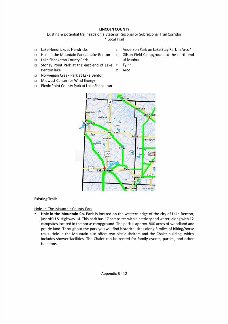
LINCOLN COUNTY Existing & potential trailheads on a State or Regional or Subregional Trail Corridor
* Local Trail
□ Lake Hendricks at Hendricks□ Hole in the Mountain Park at Lake Benton□ Lake Shaokatan County Park□ Stoney Point Park at the east end of Lake
Benton lake□ Norwegian Creek Park at Lake Benton□ Midwest Center for Wind Energy□ Picnic Point County Park at Lake Shaokatan
□ Anderson Park on Lake Stay Park in Arco*□ Gilson Field Campground at the north end
of Ivanhoe□ Tyler□ Arco
Existing Trails
Hole-In-The-Mountain County Park. Hole in the Mountain Co. Park is located on the western edge of the city of Lake Benton,
just off U.S. Highway 14. This park has 17 campsites with electricity and water, along with 12campsites located in the horse campground. The park is approx. 800 acres of woodland andprairie land. Throughout the park you will find historical sites along 5 miles of hiking/horsetrails. Hole in the Mountain also offers two picnic shelters and the Chalet building, whichincludes shower facilities. The Chalet can be rented for family events, parties, and otherfunctions.
8/8/2019 Southwest Minnesota Regional Trail Local Plans
http://slidepdf.com/reader/full/southwest-minnesota-regional-trail-local-plans 14/54
Appendix B - 13
Hendricks. Trail constructed in 2001. From the City of Hendricks park, approximately 1.5 miles to the
north and west to the golf course, paved shoulder bicycle/pedestrian trail, funded in partthrough TEA-21 Enhancement funds. Group B, Local Trail.
Lake Hendricks Park and Play ground features a walking trail, 25 campsites, picnic andplayground facilities, running water and electricity.
Ivanhoe. Gilson Field Campground near the ball field has a walking trail, picnic tables, electricity and
running water.
Planned Trails / Corridors
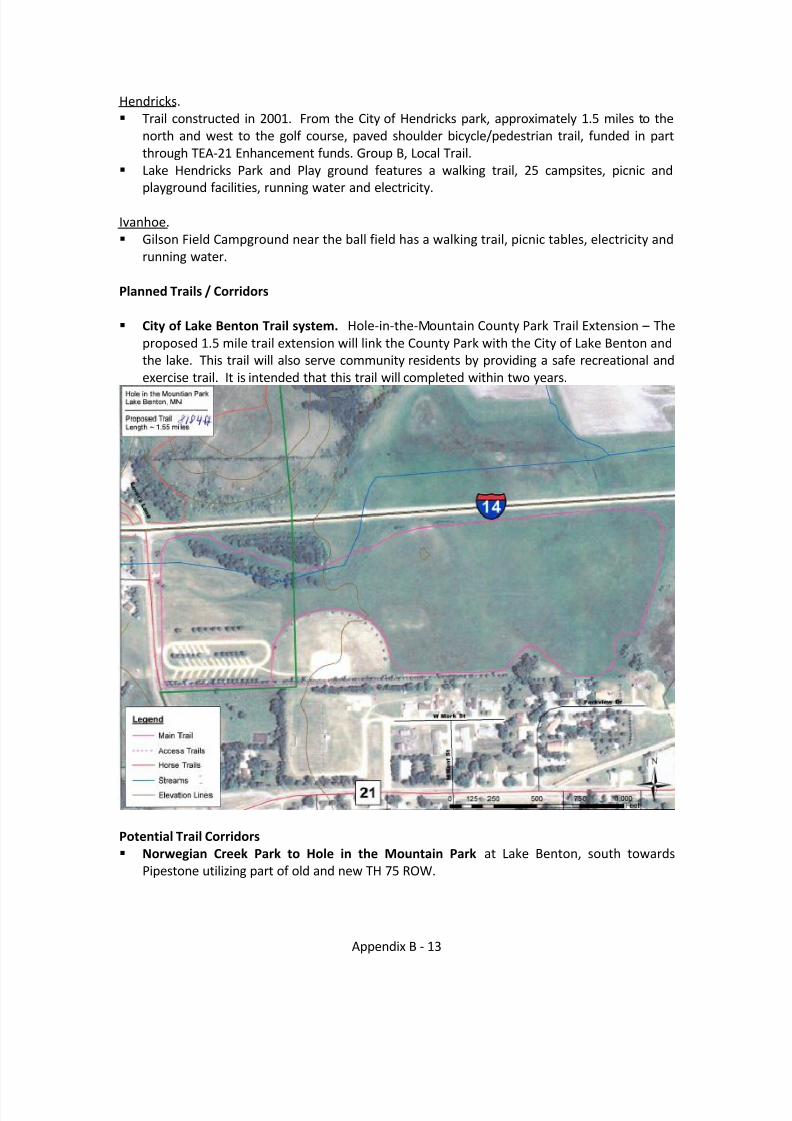
City of Lake Benton Trail system. Hole-in-the-Mountain County Park Trail Extension – Theproposed 1.5 mile trail extension will link the County Park with the City of Lake Benton andthe lake. This trail will also serve community residents by providing a safe recreational andexercise trail. It is intended that this trail will completed within two years.
Potential Trail Corridors Norwegian Creek Park to Hole in the Mountain Park at Lake Benton, south towards
Pipestone utilizing part of old and new TH 75 ROW.
8/8/2019 Southwest Minnesota Regional Trail Local Plans
http://slidepdf.com/reader/full/southwest-minnesota-regional-trail-local-plans 15/54
Appendix B - 14
Picnic Point Co. Park Picnic Point is locate d 8 miles north, 3 miles west, and one mile northof the city of Lake Benton. The park is 43 acres located on the southern side of LakeShaokatan. Picnic Point offers 12 campsites with electricity and water. It also has numeroussites without electricity. Also, Picnic Point has one picnic shelter, a swimming beach, twoboat launches, a floating T-dock, a fish cleaning shed, and an RV dump station.
Norwegian Creek Co. Park. Norwegian Creek is located one mile north, and one mile east of the city of Lake Benton. The park is 128 acres located on the western side of Lake Benton.Norwegian Creek has 30 campsites with electricity and water. Facilities include two picnicshelters, a bathhouse with showers, a fish cleaning shed, and an RV dump station.Norwegian Creek also offers a hiking trail, a swimming beach, and two boat launches.
Lake Benton to Tyler and east to connect to the Lyon County Proposed trail network. Theconnection between the two communities via Stoney Point County Park would be a veryworkable and enjoyable ride for beginners and experienced riders. It is recommended thatthis corridor NOT use a shorter 7 mile route along Highway 14. It is reported from bicyclistsboth local and from the American Lung Association that the ride from Brookings to Tyler was
the most dangerous section yet they had experienced as they began their journey fromWashington State.
Arco to Stoney Point – via Tyler.
Abandoned Rail Line Tyler – Arco – Ivanhoe – Hendricks.
Buffalo Ridge. The Buffalo Ridge is a geographic feature also known as the Mississippi – Missouri River Basin Divide. The land in this Corridor is some of the most scenic in southwestMinnesota with natural areas, crops, and turbines. While it may not be realistic to develop atrail along the entire corridor, access to segments and loop trails from other regional trails
would be desirable.
Potential Corridors for Pedestrian/Bicycle or Multi-use trails/routes Along the Wind Turbine Corridor (Hendricks, Visitors Center, Picnic Pont, Lake Benton) Hendricks West to Brookings, SD (Connect with SD lakes/parks) Connection to Lake Benton from the east (Lyon County Garvin Park area) Connection to Lake Benton from the south (Pipestone area) Hendricks towards Brookings and the wind turbine corridor near Lincoln CSAH 1
Analysis of Selected Planned Trail corridorsConnection from Lake Benton, South to Pipestone along the TH 75 corridor. Lake Benton is atthe crossroads of two historic highways:
TH 75 was registered as the King of Trails by the Minnesota Commissioner of Highways in1919. The King of Trails maintains a website for the Minnesota Segments:http://www.highway75.com/section5.html The Black and Yellow Trail was registered in 1917, the trail corridor is the route of USHighway 14. It begins at Yellowstone National Park and ends in Chicago.

8/8/2019 Southwest Minnesota Regional Trail Local Plans
http://slidepdf.com/reader/full/southwest-minnesota-regional-trail-local-plans 16/54
Appendix B - 15
Analysis of Selected Planned Trail Corridors:The distance between Lake Benton and Pipestone is about 17 miles. To the south of Lake Bentonthere is a five mile corridor which was abandoned years ago when US Highway 75 was moved tothe east. This corridor is now owned by Lincoln County and runs from Lake Benton south to near the Pipestone County line. The corridor runs through hundreds of acres of Nature Conservancy natural prairie and along miles of DNR Wildlife Management areas. Issues may include:
Controversy with the Nature Conservancy with a publicly owned and used corridor through Nature Conservancy land.Compatibility issues between trails and Wildlife Management areas.Land acquisition from the end of the county owned land to joining the Casey Jones Trail at Pipestone. One option would be to route bicycle and pedestrian traffic on a lower volume road into Pipestone.
http://www.co.lincoln.mn.us/Tourism/Lincoln%20County%20Map.pdf
8/8/2019 Southwest Minnesota Regional Trail Local Plans
http://slidepdf.com/reader/full/southwest-minnesota-regional-trail-local-plans 17/54
Appendix B - 16
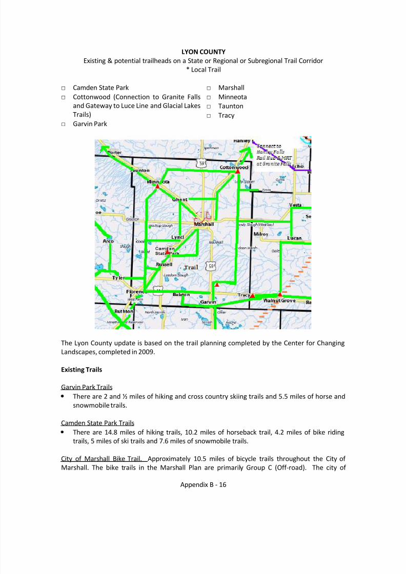
LYON COUNTYExisting & potential trailheads on a State or Regional or Subregional Trail Corridor
* Local Trail
□ Camden State Park□ Cottonwood (Connection to Granite Falls
and Gateway to Luce Line and Glacial LakesTrails)
□ Garvin Park
□ Marshall□ Minneota□ Taunton□ Tracy
The Lyon County update is based on the trail planning completed by the Center for ChangingLandscapes, completed in 2009.
Existing Trails
Garvin Park TrailsThere are 2 and ½ miles of hiking and cross country skiing trails and 5.5 miles of horse andsnowmobile trails.
Camden State Park TrailsThere are 14.8 miles of hiking trails, 10.2 miles of horseback trail, 4.2 miles of bike ridingtrails, 5 miles of ski trails and 7.6 miles of snowmobile trails.
City of Marshall Bike Trail. Approximately 10.5 miles of bicycle trails throughout the City of Marshall. The bike trails in the Marshall Plan are primarily Group C (Off-road). The city of
8/8/2019 Southwest Minnesota Regional Trail Local Plans
http://slidepdf.com/reader/full/southwest-minnesota-regional-trail-local-plans 18/54
Appendix B - 17
Marshall is a Regional Center in SW Minnesota. The city of Marshall has a Trail Plan 2 and iscurrently working on the following projects: Paving the existing gravel trail on the flood control dikes along the Redwood River from
Wayside Park to Lyon County Hwy. 7 and again from Kossuth Street to T.H.23. This projectalso includes two new segments of trail with the first segment continuing along T.H.23 souththrough the SMSU Campus to T.H.19 and a segment along Country Club Drive fromSouthview Street to S. 4 th Street. It is funded through TE funds and in the 2010 STIP.
Additional trail segments have been constructed along Windstar Street (Scott Street toT.H.59) and Clarice Avenue (Windstar Street to Susan Avenue).
In 2007 a trail segment along T.H.19 from O’Connell Street east to Tiger Drive, then northalong Tiger Drive to the new high school was constructed.
A project is planned in 2010 for a trail segment along Clarice Avenue (Susan Drive to T.H.23)and then in 2013 planned to extend this north to T.H. 23. Funding source?
TH 23 underpass from SSU to the High School scheduled for 2010 will allow safe passage of under the heavily traveled Highway 23.
City of Minneota Trail
There is a loop trail, approximately 2.4 miles that runs along East and West Lyon Street onthe south, North Jackson Street on the east, through the Park on the north, follows 150 th Ave on the west connecting with west Lyon, completing the loop.
TH 23 Trail CorridorMarshall to Camden. The Marshall to Camden connection was completed in 2000. Thisconnected Marshall from north of SSU to Wayside Park south of Marshall using some of theflood control structures that have been built. Due to the traffic on TH 23 and the speeds,alternative routes are being addressed.
LyndThe Marshall to Camden Trail runs along TH 23 at the north east side of the community and
enters Lynd following the river corridor to Camden State Park.
City of TracyUsing Transportation Enhancement funds, the City constructed a bike trail consisting of approximately two (2) miles and signing five (5) miles of designated paved bike/pedestrianroute. The trail will provide a safe environment for both walking and biking. The trail startsat the Wheels Across the Prairie Museum located at the west end of Tracy, and continues onT.H. 14 to County Road 11 which provides access using the shoulders on County Road 11 toSwift Lake Park. Swift Lake is a scenic area with a natural terrain including a small lakelocated on the 23.4 acre tract with handicapped accessible dock and a modern campsitewith bathroom and shower facilities. The trail extends from the park to the east side of thesoftball complex. Benches are strategically placed to provide an opportunity to enjoy thescenic view and is designated as a trail head facility to provide access to future trail systems.Bike racks are located in both Swift Lake and Sebastian Park. Traffic control signs are placedthroughout the trail to provide safe corridors plus directions for the biker/pedestrian, andinform motorists of the trail location. This trail crosses TH 14 on the west side on town and
2 A Pedestrian and Bikeway Plan: A Safe and Healthy Marshall, October 2008http://www.marshallmn.com/portal/images/stories/pdf/bike/A-Pedestrian-and-Bikeway-Plan-10-2008.pdf
8/8/2019 Southwest Minnesota Regional Trail Local Plans
http://slidepdf.com/reader/full/southwest-minnesota-regional-trail-local-plans 19/54
Appendix B - 18
crosses the Canadian Pacific (DM&E) Railroad in two locations. Group B and C. Currentlylocal significance, but if connected to the Casey Jones Trail would increase to RegionalSignificance.
CottonwoodBarstad Road Path. Cottonwood has approximately a 2/3 mile trail running from downtownCottonwood to the new school on the northeast corner of town. This trail was constructedduring 2009. The trail connects existing sidewalks near Lakeview School and downtownCottonwood. The trail is 2,200 feet long and 10 feet wide to accommodate both bicycles andpedestrians. The project was funded through $101,000 Safe routes to School Grant and$14,000 raised locally. Group C. Local trail.
Planned Trails / Corridors –
City of Marshall. The City of Marshall will be working with Lyon County in the next few years toconstruct a trail segment along the southwest section of the City. This would complete the outerloop around Marshall.City of Marshall Trail Phasing 3. The following describes the trail system to be built incrementallyover time. There are no expectations that the trail system be built at once. A few suggestionsand comments on the plan phasing for the City’s consideration are:
The current safety problems along Highway 23 make it a first priority. The connectionbetween Southwest Minnesota State University and Marshall High School needs to beaddressed first. A pedestrian underpass was identified for funding in the 2010 STIP.Marshall has many schools in its neighborhoods and the city has invested in many fineparks; however, access to the schools and the parks is problematic, particularly for youngchildren. Creating safe pathways to the schools and parks should be a priority.The Downtown Loop builds on and extends the work that has been done to strengthen thedowntown.
Although the Water Ring is ambitious, a large portion of it could be completed if existingsegments were to be connected.The Prairie Parkway could help to structure the pattern for new residential developments,and developers could build parkway segments incrementally as new neighborhoods areadded to the city.Enhancing existing sites along the trails and making some new ones not only make the trailsmore attractive, but they encourage trail use, celebrate Marshall’s character, and reinforceMarshall as a prairie city.
3 A Pedestrian and Bikeway Plan: A Safe and Healthy Marshall, October 2008http://www.marshallmn.com/portal/images/stories/pdf/bike/A-Pedestrian-and-Bikeway-Plan-10-2008.pdf
8/8/2019 Southwest Minnesota Regional Trail Local Plans
http://slidepdf.com/reader/full/southwest-minnesota-regional-trail-local-plans 20/54
Appendix B - 19
Potential Trail Corridors
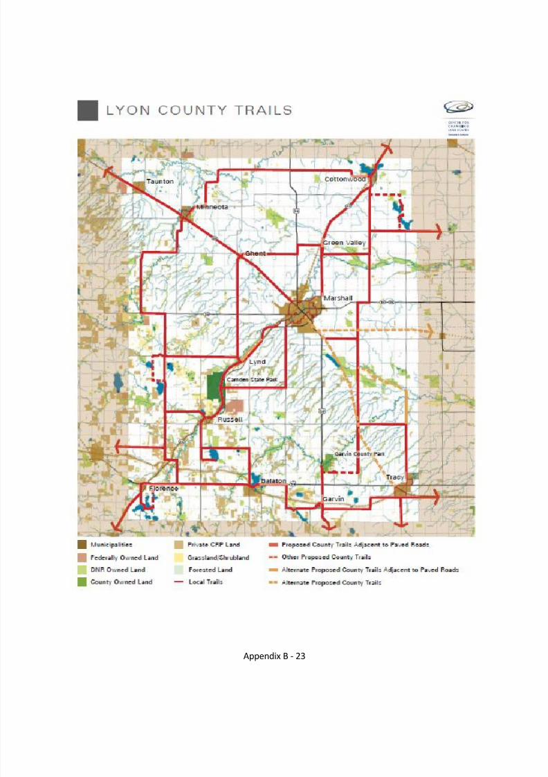
Lyon County will be using the plan created by the Center for Changing Landscapes as their guidefor development. It was approved by Lyon County and incorporated into the CountyComprehensive Plan. Highlights of the plan include six trail corridors:
Lyon County. Proposed trail corridors based on the Center for Changing Landscapes.Marshall to Canby Corridor. A regional corridor along TH 68 and the old rail corridor,approximately 20 mile corridor connecting Marshall, Ghent, Minneota and Taunton in LyonCounty to Canby in Yellow Medicine County.County Loop. Approximately 100 mile loop connecting communities and places in thecounty.East – West Connection to the County Loop Trail. Approximately 27 miles of trail connectingthe West side of the County Loop Trail west of Lynd to Lynd, traveling north to Ghent, eastthrough Green Valley and terminating on the east side of the County Loop Trail.Highway 23 Corridor. From the south, the TH 23 corridor intersection with the County LoopTrail corridor at TH 14 and diverts off TH 23 offering two alternative routes to reach Russelland the TH 23 corridor. One alternative uses the County Loop trail on the west side of thecounty and sends a spur to Russell, the second alternative uses the County Loop trailcorridor to the east and turns north at Balaton and connects at Russell. This trail corridorfollows a parallel route (within 1-2 miles) of TH 23 to Marshall. Connecting with the MarshallTrail network, the TH 23 trail follows TH 23 through Green Valley and Cottonwood andconnects to the Minnesota River Trail.TH 59 from Garvin Park south. This corridor segment in Lyon County would begin at GarvinPark with its trail system and travel south through Garvin and south into Murray County toconnect to Lake Sarah, Lake Shetek, or the Casey Jones Trail.Off road trail Marshall to Milroy from near TH 59 south of Marshall through Dudly to Milroy.Off road trail Marshall to Tracy from near TH 59 south of Marshall connecting to Lake
Marshall and Tracy, and connecting to the Casey Jones Trail at Currie or Walnut Grove.
Analysis of Selected Planned Trail Segments
None selected at this time
8/8/2019 Southwest Minnesota Regional Trail Local Plans
http://slidepdf.com/reader/full/southwest-minnesota-regional-trail-local-plans 21/54
Appendix B - 20
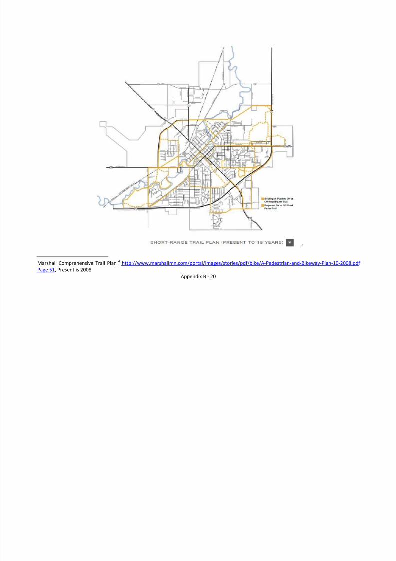
4
Marshall Comprehensive Trail Plan 4 http://www.marshallmn.com/portal/images/stories/pdf/bike/A-Pedestrian-and-Bikeway-Plan-10-2008.pdf Page 51 , Present is 2008
8/8/2019 Southwest Minnesota Regional Trail Local Plans
http://slidepdf.com/reader/full/southwest-minnesota-regional-trail-local-plans 22/54
Appendix B - 21
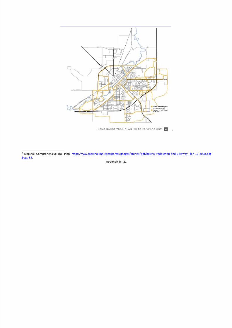
5
5 Marshall Comprehensive Trail Plan http://www.marshallmn.com/portal/images/stories/pdf/bike/A-Pedestrian-and-Bikeway-Plan-10-2008.pdf Page 53 ,
8/8/2019 Southwest Minnesota Regional Trail Local Plans
http://slidepdf.com/reader/full/southwest-minnesota-regional-trail-local-plans 23/54
Appendix B - 22
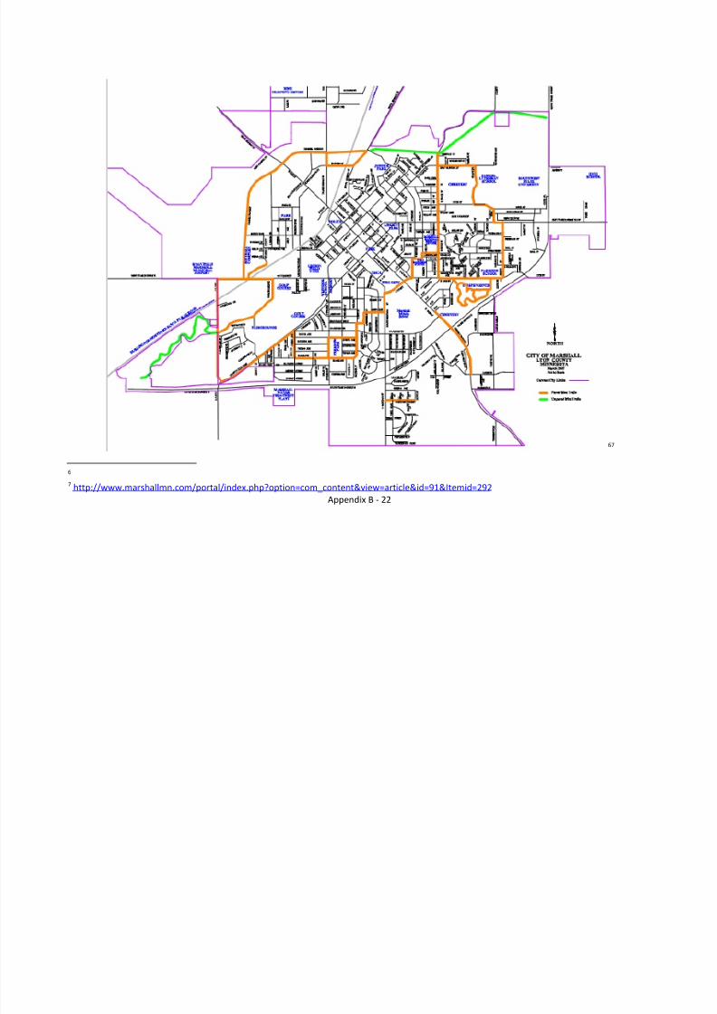
67
6 7 http://www.marshallmn.com/portal/index.php?option=com_content&view=article&id=91&Itemid=292
8/8/2019 Southwest Minnesota Regional Trail Local Plans
http://slidepdf.com/reader/full/southwest-minnesota-regional-trail-local-plans 24/54
Appendix B - 23
8/8/2019 Southwest Minnesota Regional Trail Local Plans
http://slidepdf.com/reader/full/southwest-minnesota-regional-trail-local-plans 25/54
Appendix B - 24
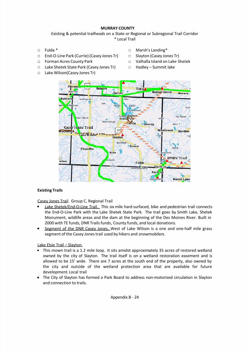
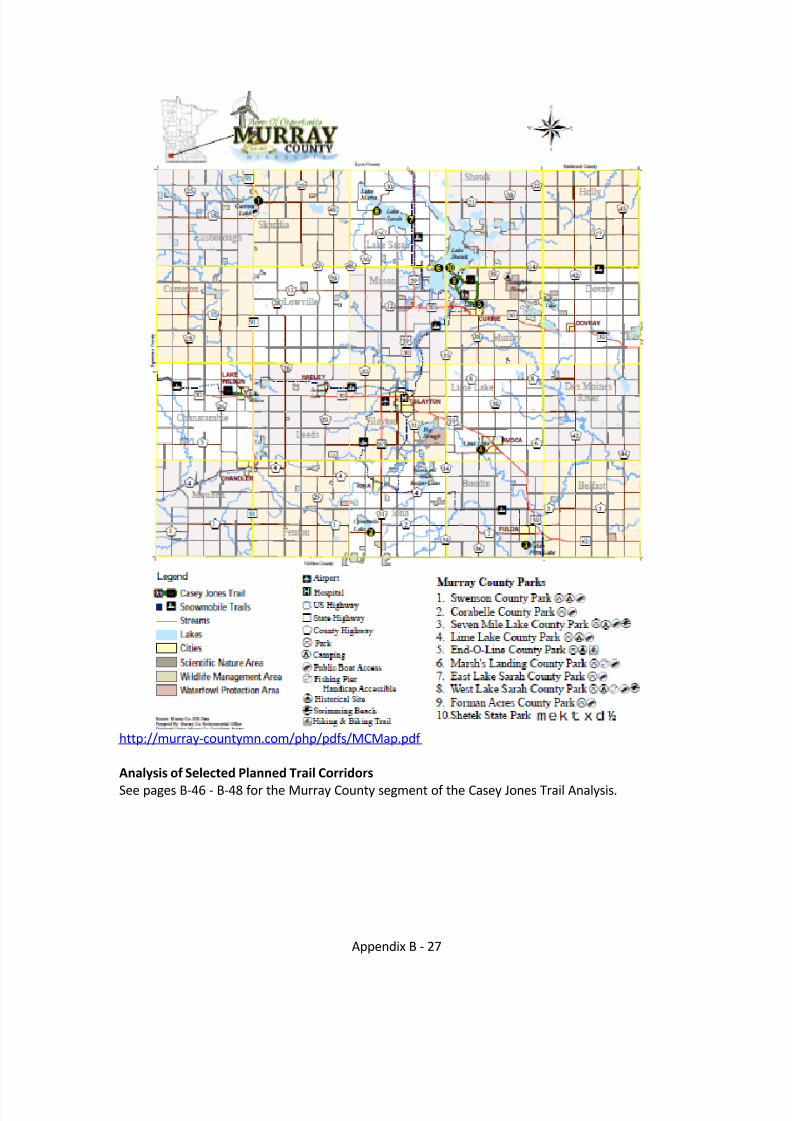
MURRAY COUNTYExisting & potential trailheads on a State or Regional or Subregional Trail Corridor
* Local Trail
□ Fulda *□ End-O-Line Park (Currie) (Casey Jones Tr)□ Forman Acres County Park□ Lake Shetek State Park (Casey Jones Tr)□ Lake Wilson(Casey Jones Tr)
□ Marsh’s Landing *□ Slayton (Casey Jones Tr)□ Valhalla Island on Lake Shetek□ Hadley – Summit lake
Existing Trails
Casey Jones Trail. Group C, Regional TrailLake Shetek/End-O-Line Trail. This six mile hard surfaced, bike and pedestrian trail connectsthe End-O-Line Park with the Lake Shetek State Park. The trail goes by Smith Lake, ShetekMonument, wildlife areas and the dam at the beginning of the Des Moines River. Built in2000 with TE funds, DNR Trails funds, County funds, and local donations.Segment of the DNR Casey Jones. West of Lake Wilson is a one and one-half mile grasssegment of the Casey Jones trail used by hikers and snowmobilers.
Lake Elsie Trail – Slayton.This mown trail is a 1.2 mile loop. It sits amidst approximately 35 acres of restored wetlandowned by the city of Slayton. The trail itself is on a wetland restoration easement and isallowed to be 15’ wide. There are 7 acres at the south end of the property, also owned bythe city and outside of the wetland protection area that are available for futuredevelopment. Local trailThe City of Slayton has formed a Park Board to address non-motorized circulation in Slaytonand connection to trails.
8/8/2019 Southwest Minnesota Regional Trail Local Plans
http://slidepdf.com/reader/full/southwest-minnesota-regional-trail-local-plans 26/54
Appendix B - 25
Planned Trails / Corridors
Casey Jones State Trail 8. Group C, Regional Trail.This state-authorized trail runs from Rock County through Pipestone and Murray Counties toRedwood County. The designated corridor is from Schoneman Park north to Luverne,northeast to Blue Mounds State Park, northwest to Split Rock Creek State Park, northeast toPipestone, east to Slayton, northeast to Lake Shetek State Park, northeast to Walnut Groveand northeast to Redwood Falls to join the Minnesota River State Trail. The existing trail inMurray County consists of two sections, not yet connected to one another: A naturally-surfaced segment that runs from one and a half miles west of Lake Wilson into the city of Lake Wilson and a six mile paved loop between Lake Shetek State Park and the city of Currie.9 The 2000 Regional Trail Plan identified a connection from Lake Shetek Park to Walnut Grove(Plum Creek Trail) which is now incorporated in the Casey Jones State Trail legislativelanguage.
The City of Hadley is actively pursuing serving as a trailhead for the Casey Jones Trail. The
Community of Hadley could be connected to Summit Lake which features a clean lake with asand beach. The city park features a baseball diamond and has restroom facilities, as doesthe Community Center located 100 feet away.
Slayton Perimeter Trail. The City has passed a Park Board Ordinance and appointed people tothe Park Board in January 2010 to meet some of the trail needs in the community, such asconnections to the Casey Jones Trail and Lake Elsie trail, and non-motorized circulation withinthe community. Plans are to develop this trail in phases:
Pave the Lake Elsie Trail and add a parking lot,construct a trail on the western edge of Slayton running south from the proposed CaseyJones Trail corridor to the pool,
designate a trail from the pool east to Lake Elsie andconstruct or designate a trail from Lake Elsie north to the proposed Casey Jones Trailcorridor.
Valhalla Island/Keeley Island Trail. This proposed trail would run from the intersection of Hwy59 and Valhalla Road to Lake Shetek Lutheran Ministries on Keeley Island. This corridor has highpedestrian traffic in the spring, summer and fall, particularly between the first dike on ValhallaRoad and Shetek Lutheran Ministries. While this trail would be an amenity for area residentsand campers, safety concerns along the dike road are the main impetus driving the planning of this trail. This potential poses some limitations due to the water body on either side of the road. A potential alternative suggested by a Complete Streets spokesperson would be to limit motor traffic to one lane allowing for safer movement of pedestrians and bicycles.
Des Moines River Valley State Trail. This legislatively designated trail will connect to the CaseyJones trail in Murray County.
8 http://files.dnr.state.mn.us/maps/state_trails/casey_jones.pdf 9 2005 DNR Master Plan for the Casey Jones Trailhttp://files.dnr.state.mn.us/input/mgmtplans/trails/caseyjones/cj_masterplan.pdf
8/8/2019 Southwest Minnesota Regional Trail Local Plans
http://slidepdf.com/reader/full/southwest-minnesota-regional-trail-local-plans 27/54
Appendix B - 26
Potential Trail Corridor
Shetek/End-0-Line Trail to Tracy. This 10 mile hard surface trail will connect Shetek State Parkand Tracy. It will be targeted for Bicyclists (Group C) and Hikers.
Fulda Trails. Residents in the City of Fulda have expressed concern and need for a safe walkingalternative to residents walking along TH 59. One suggestion has been developing a walking loopfrom CSAH 2/ TH 62 south parallel to TH 59 to the Twp Road on the south side of First FuldaLake west for approximately 1/3 mile, then north on the west side of the Lake past the CountyPark and into the Community.
Currie (east side of Lake Shetek) to Valhalla Drive (west side of Lake Shetek)Fulda/Graham Lakes/Talcot Lake AreaWater trail along the Des Moines RiverLake Shetek to Tracy – Lyon County identifies Tracy being connected to the Casey Jones Trail viaone of two routes: south from Tracy or to the east to Walnut Grove.
Buffalo Ridge . The Buffalo Ridge is a geographic feature also known as the Mississippi – MissouriRiver Basin Divide. The land in this Corridor is some of the most scenic in southwest Minnesotawith natural areas, crops, and turbines. While it may not be realistic to develop a trail along theentire corridor, access to segments and loop trails from other regional trails would be desirable.
8/8/2019 Southwest Minnesota Regional Trail Local Plans
http://slidepdf.com/reader/full/southwest-minnesota-regional-trail-local-plans 28/54
Appendix B - 27
http://murray-countymn.com/php/pdfs/MCMap.pdf
Analysis of Selected Planned Trail CorridorsSee pages B-46 - B-48 for the Murray County segment of the Casey Jones Trail Analysis.
8/8/2019 Southwest Minnesota Regional Trail Local Plans
http://slidepdf.com/reader/full/southwest-minnesota-regional-trail-local-plans 29/54
Appendix B - 28
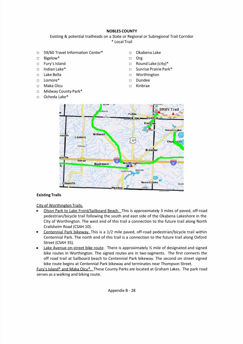
NOBLES COUNTYExisting & potential trailheads on a State or Regional or Subregional Trail Corridor
* Local Trail
□ 59/60 Travel Information Center*□ Bigelow*□ Fury’s Island □ Indian Lake*□ Lake Bella□ Lismore*□ Maka Oicu□ Midway County Park*□ Ocheda Lake*
□ Okabena Lake□ Org□ Round Lake (city)*□ Sunrise Prairie Park*□ Worthington□ Dundee□ Kinbrae
Existing Trails
City of Worthington Trails.Olson Park to Lake Front/Sailboard Beach. This is approximately 3 miles of paved, off-roadpedestrian/bicycle trail following the south and east side of the Okabena Lakeshore in theCity of Worthington. The west end of this trail a connection to the future trail along NorthCrailsheim Road (CSAH 10).Centennial Park bikeway. This is a 1/2 mile paved, off-road pedestrian/bicycle trail withinCentennial Park. The north end of this trail is a connection to the future trail along OxfordStreet (CSAH 35).Lake Avenue on-street bike route. There is approximately ½ mile of designated and signedbike routes in Worthington. The signed routes are in two segments. The first connects theoff road trail at Sailboard beach to Centennial Park bikeway. The second on street signedbike route begins at Centennial Park bikeway and terminates near Thompson Street.
Fury’s Island* and Maka Oicu*. These County Parks are located at Graham Lakes. The park roadserves as a walking and biking route.
8/8/2019 Southwest Minnesota Regional Trail Local Plans
http://slidepdf.com/reader/full/southwest-minnesota-regional-trail-local-plans 30/54
Appendix B - 29
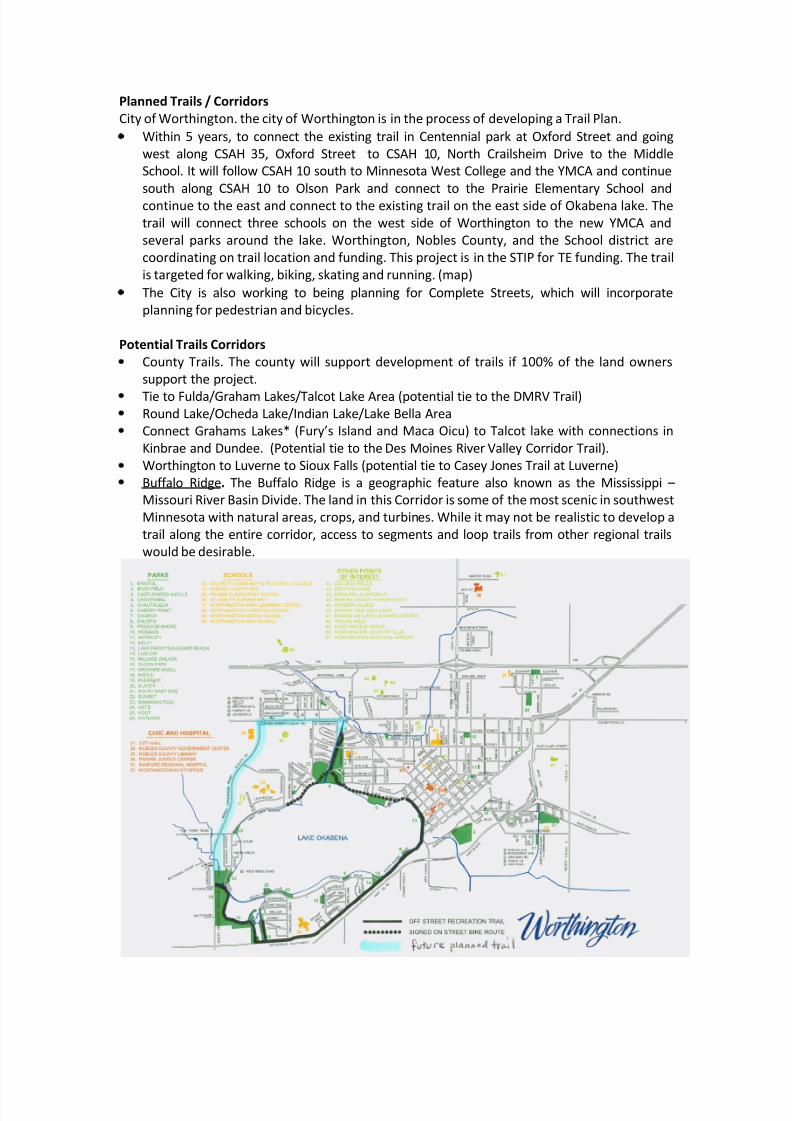
Planned Trails / CorridorsCity of Worthington. the city of Worthington is in the process of developing a Trail Plan.
Within 5 years, to connect the existing trail in Centennial park at Oxford Street and goingwest along CSAH 35, Oxford Street to CSAH 10, North Crailsheim Drive to the MiddleSchool. It will follow CSAH 10 south to Minnesota West College and the YMCA and continuesouth along CSAH 10 to Olson Park and connect to the Prairie Elementary School andcontinue to the east and connect to the existing trail on the east side of Okabena lake. Thetrail will connect three schools on the west side of Worthington to the new YMCA andseveral parks around the lake. Worthington, Nobles County, and the School district arecoordinating on trail location and funding. This project is in the STIP for TE funding. The trailis targeted for walking, biking, skating and running. (map)The City is also working to being planning for Complete Streets, which will incorporateplanning for pedestrian and bicycles.
Potential Trails CorridorsCounty Trails. The county will support development of trails if 100% of the land ownerssupport the project.Tie to Fulda/Graham Lakes/Talcot Lake Area (potential tie to the DMRV Trail)Round Lake/Ocheda Lake/Indian Lake/Lake Bella AreaConnect Grahams La kes* (Fury’s Island and Maca Oicu) to Talcot lake with connections inKinbrae and Dundee. (Potential tie to the Des Moines River Valley Corridor Trail).Worthington to Luverne to Sioux Falls (potential tie to Casey Jones Trail at Luverne)Buffalo Ridge . The Buffalo Ridge is a geographic feature also known as the Mississippi – Missouri River Basin Divide. The land in this Corridor is some of the most scenic in southwestMinnesota with natural areas, crops, and turbines. While it may not be realistic to develop atrail along the entire corridor, access to segments and loop trails from other regional trailswould be desirable.

8/8/2019 Southwest Minnesota Regional Trail Local Plans
http://slidepdf.com/reader/full/southwest-minnesota-regional-trail-local-plans 31/54
Appendix B - 30
This page is intentionally left blank.
8/8/2019 Southwest Minnesota Regional Trail Local Plans
http://slidepdf.com/reader/full/southwest-minnesota-regional-trail-local-plans 32/54
Appendix B - 31
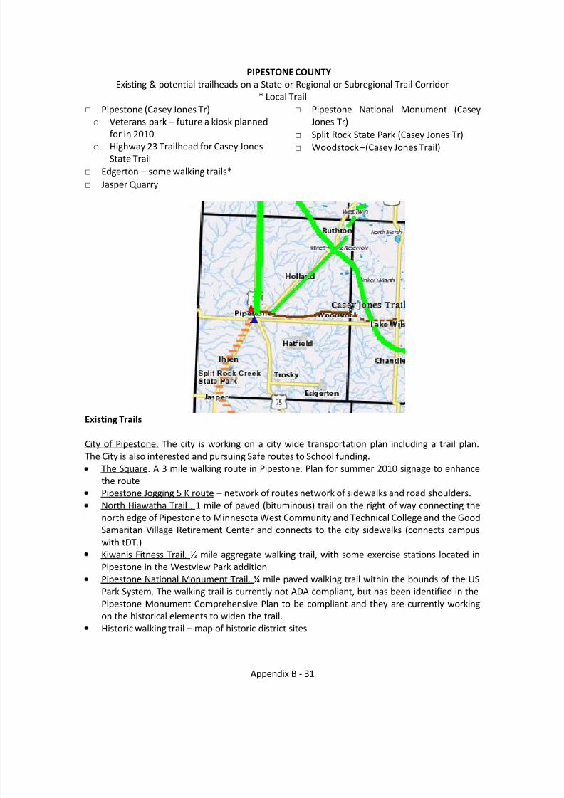
PIPESTONE COUNTYExisting & potential trailheads on a State or Regional or Subregional Trail Corridor
* Local Trail□ Pipestone (Casey Jones Tr)
o Veterans park – future a kiosk plannedfor in 2010
o Highway 23 Trailhead for Casey JonesState Trail
□ Edgerton – some walking trails*□ Jasper Quarry
□ Pipestone National Monument (CaseyJones Tr)
□ Split Rock State Park (Casey Jones Tr)□ Woodstock –(Casey Jones Trail)
Existing Trails
City of Pipestone. The city is working on a city wide transportation plan including a trail plan.The City is also interested and pursuing Safe routes to School funding.
The Square. A 3 mile walking route in Pipestone. Plan for summer 2010 signage to enhancethe routePipestone Jogging 5 K route – network of routes network of sidewalks and road shoulders.North Hiawatha Trail . 1 mile of paved (bituminous) trail on the right of way connecting thenorth edge of Pipestone to Minnesota West Community and Technical College and the GoodSamaritan Village Retirement Center and connects to the city sidewalks (connects campuswith tDT.)
Kiwanis Fitness Trail. ½ mile aggregate walking trail, with some exercise stations located inPipestone in the Westview Park addition.Pipestone National Monument Trail. ¾ mile paved walking trail within the bounds of the USPark System. The walking trail is currently not ADA compliant, but has been identified in thePipestone Monument Comprehensive Plan to be compliant and they are currently workingon the historical elements to widen the trail.Historic walking trail – map of historic district sites
8/8/2019 Southwest Minnesota Regional Trail Local Plans
http://slidepdf.com/reader/full/southwest-minnesota-regional-trail-local-plans 33/54
Appendix B - 32
Split Rock Creek State Park Trail. 4 miles of grass walking trails within the boundaries of theState Park. Trail of Regional Significance – part of the Casey Jones Trail.
Casey Jones Trail http://files.dnr.state.mn.us/maps/state_trails/casey_jones.pdf . In PipestoneCounty, the existing right of way follows the railroad bed and is twelve miles, from the city of Pipestone to the Murray County line. Currently, there is 5 miles of paved trail, with 7 miles thatare cleared and ready for trail construction. This is a multi track trail with the twelve miles isclear of fence and groomed for use by the SnoBlazers Snowmobile Club. Trail of RegionalSignificance.
Snowmobile trails in Pipestone County – 125 miles which includes the duel track of the CaseyJones Trail. DNR site www.snowmobile.org
Planned Trails/Corridors
Casey Jones Trail. preferred Group C, Trail of Regional Significance.This state-authorized trail runs from Rock County through Pipestone and Murray Counties to
Redwood County. The designated corridor is from Schoneman Park north to Luverne,northeast to Blue Mounds State Park, northwest to Split Rock Creek State Park, northeast toPipestone, east to Slayton, northeast to Lake Shetek State Park, northeast to Walnut Groveand northeast to Redwood Falls to join the Minnesota River State Trail. The existing trail inMurray County consists of two sections, not yet connected to one another: A naturally-surfaced segment that runs from one and a half miles west of Lake Wilson into the city of Lake Wilson and a six mile paved loop between Lake Shetek State Park and the city of Currie.
Potential Trail Corridors
Pipestone/National Monument to Lake Benton/Hole in the Mountain Park
Highway 23 from Florence to Pipestone Initiatives – connecting the Technical School to the Monument. Working south for two miles (9 blocks of old RR bed) terminating by the Suzlon Plant Buffalo Ridge . The Buffalo Ridge is a geographic feature also known as the Mississippi –
Missouri River Basin Divide. The land in this Corridor is some of the most scenic in southwestMinnesota with natural areas, crops, and turbines. While it may not be realistic to develop atrail along the entire corridor, access to segments and loop trails from other regional trailswould be desirable.
Analysis of Selected Planned Trail CorridorsSee pages B-43 - B-45 for the Pipestone County section of the Casey Jones Trail Analysis.
8/8/2019 Southwest Minnesota Regional Trail Local Plans
http://slidepdf.com/reader/full/southwest-minnesota-regional-trail-local-plans 34/54
Appendix B - 33
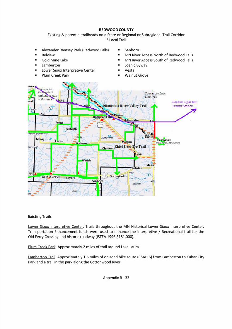
REDWOOD COUNTYExisting & potential trailheads on a State or Regional or Subregional Trail Corridor
* Local Trail
Alexander Ramsey Park (Redwood Falls) Belview Gold Mine Lake Lamberton Lower Sioux Interpretive Center Plum Creek Park
Sanborn MN River Access North of Redwood Falls MN River Access South of Redwood Falls Scenic Byway Vesta Walnut Grove
Existing Trails
Lower Sioux Interpretive Center. Trails throughout the MN Historical Lower Sioux Interpretive Center.Transportation Enhancement funds were used to enhance the Interpretive / Recreational trail for theOld Ferry Crossing and historic roadway (ISTEA 1996 $181,000).
Plum Creek Park. Approximately 2 miles of trail around Lake Laura
Lamberton Trail. Approximately 1.5 miles of on-road bike route (CSAH 6) from Lamberton to Kuhar CityPark and a trail in the park along the Cottonwood River.
8/8/2019 Southwest Minnesota Regional Trail Local Plans
http://slidepdf.com/reader/full/southwest-minnesota-regional-trail-local-plans 35/54
Appendix B - 34
Alexander Ramsey Park Trails. This city park occupies approximately 220 acres in Redwood Falls and isthe largest municipal park in Minnesota. A trial system, totaling five miles, has been developed toprovide pedestrian access to some of the steep slope areas, as well as to separate pedestrian andvehicle flows on the through road; three miles are paved and 2 miles are gravel. In addition, there is a3.5 miles cross-country ski trail.
Redwood Valley High School Trail. Trails are part of the Redwood Valley High School EnvironmentalLearning Center.
School Trail. Connect Redwood Valley High School with the Reede Gray Elementary School.
North Redwood Trail. Connect the Old North Redwood Road trail to Redwood Falls trail along NorthLincoln Street.
Redwood Falls Trail. Trail along North Lincoln Street.
Planned Trails/corridors
Redwood Falls.From Normandale Street connecting to the existing trail that goes to the Redwood Area School(constructed in 2008). Programmed in the 2011 STIP for $116,622.Trail along Old North Redwood Road.County Ditch 52 Phase II Trail, Normandale Road to Sunrise Blvd(4800')Phase I Trail extension, Northwood Drive going south along CSAH 101 to E/W frontage road alongTH 19/71Phase III Trail Loop TH19 West to CSAH 17 N to CSAH 25 East to CSAH 101 S-to North Redwood -connection to established River Link on 101Phase IV Trail Loop to Ramsey Park West- From CSAH 17 west on 350th St. to Liberty Ave Park North
West Access and trail connectionPhase V, W. Bridge Street to Grove Street Ped/Bike Bridge over old bridge alignment- S. off TH 19access to Ramsey Park
Plum Creek Park. Connect Plum Creek Park to the City of Walnut Grove and develop additional trailswithin the Plum Creek Park. Estimated timeline is 2-5 years to develop a paved trail, 3 miles in length,with termini’s at Plum Creek Park and the museum in Walnut Grove. This would target bicyclists,walkers, and hikers. Potential attractions is nature (wildlife, wildflowers, and would connect to thecurrent walking trail within the Park which identifies over twenty different type of trees).
Kuhar Trailhead. The trail will run from the Kuhar Park Entrance to the Kuhar Park west boundary.
Estimated timeline for completion: 2-5 years. This will be an estimated one mile unpaved/wood shavingtrail that will target walkers and cross county skiers. The primary attraction is nature and the naturalbeauty of the park located along the Cottonwood River.
Lamberton Outreach Center Trail. 1999 Estimated Timeline for Completion: 5-10 years. This will be anestimated two mile unpaved/wood shaving trail that will target walkers and cross country skiers. Thetrail will connect the Lamberton Outreach Center to the West boundary of Kuhar Park. Potentialattractions are the Cottonwood River and the Lamberton Outreach Center. Ultimately would like tohave the swinging bridge over the Cottonwood River connected to Kuhar Park.
8/8/2019 Southwest Minnesota Regional Trail Local Plans
http://slidepdf.com/reader/full/southwest-minnesota-regional-trail-local-plans 36/54
Appendix B - 35
Sanborn. Proposed trail along the Cottonwood River southwest of Sanborn.
Casey Jones Trail. This state-authorized trail runs from Rock County through Pipestone and MurrayCounties to Redwood County. The designated corridor is from Schoneman Park north to Luverne,northeast to Blue Mounds State Park, northwest to Split Rock Creek State Park, northeast to Pipestone,east to Slayton, northeast to Lake Shetek State Park, northeast to Walnut Grove and northeast toRedwood Falls to join the Minnesota River State Trail. The existing trail in Murray County consists of two sections, not yet connected to one another: A naturally-surfaced segment that runs from one and ahalf miles west of Lake Wilson into the city of Lake Wilson and a six mile paved loop between LakeShetek State Park and the city of Currie.
Minnesota River Valley TrailThe trail shall originate at the entrance to Big Stone Lake State Park and extend along theMinnesota River Valley to connect to the Minnesota Valley Trail at the city of Le Sueur. Thetrail shall include a loop between Fort Ridgely State Park and the cities of Redwood Falls andSleepy Eye. A segment shall be established connecting the cities of Granite Falls andMontevideo.Chief Sleepy Eye Trail connecting Redwood Falls, Gilfillan, Morgan, Evan and Sleepy Eye togetherand then north to Fort Ridgely State Park, and then on to Fairfax which already has an 8 mile trail onthe ground! This trail will connect to the Sleepy Eye Lake Trail (a 3.1 mile trail around Sleepy Eyelake) and head north to Ridgley, tying the existing trails together. The abandoned railroad iscurrently owned by one property owner and fund raising is occurring to purchase of the corridor todevelop the trail.
http://files.dnr.state.mn.us/maps/canoe_routes/minnesota2.pdf Minnesota River and Redwood River
Potential Trail Corridors
Water Trail along Redwood River (Minnesota River to Ruthton) Lower Sioux Interpretive Center to MN River Access include Scenic ByWay to Redwood Falls to
Gold Mine Lake to the MN River Access North of Redwood Falls Belview to Vesta Walnut Grove to Lamberton to Sanborn Lamberton to Jeffers Petroglyphs Sanborn to Windom to include Jeffers Petroglyphs and Red Rock Dells Redwood County (Green Corridor) is diligently working on acquiring trail potential trail corridors
for the “Bridge -to- Bridge Trail Loops” along the Minnesota River.
The county worked with The Center for Changing Landscapes to develop a more detailed Trail Plan. Acopy of the final plan may be found on the Redwood Area Development Corporation website:http://www.radc.org/vertical/Sites/%7B8F00FAA5-999F-415E-A32F-61D7D805F17C%7D/uploads/%7B850A3F83-4104-48F1-94BF-9807B34797F0%7D.PDF . The Redwoodcounty Board of Commissioners approved the Redwood county trail Plan on September 21, 2010.
8/8/2019 Southwest Minnesota Regional Trail Local Plans
http://slidepdf.com/reader/full/southwest-minnesota-regional-trail-local-plans 37/54
Appendix B - 36
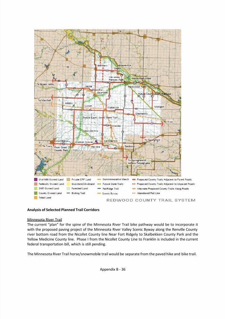
Analysis of Selected Planned Trail Corridors
Minnesota River TrailThe curren t “plan” for the spine of the Minnesota River Trail bike pathway would be to incorporate itwith the proposed paving project of the Minnesota River Valley Scenic Byway along the Renville Countyriver bottom road from the Nicollet County line Near Fort Ridgely to Skalbekken County Park and theYellow Medicine County line. Phase I from the Nicollet County Line to Franklin is included in the currentfederal transportation bill, which is still pending.
The Minnesota River Trail horse/snowmobile trail would be separate from the paved hike and bike trail.
8/8/2019 Southwest Minnesota Regional Trail Local Plans
http://slidepdf.com/reader/full/southwest-minnesota-regional-trail-local-plans 38/54
Appendix B - 37
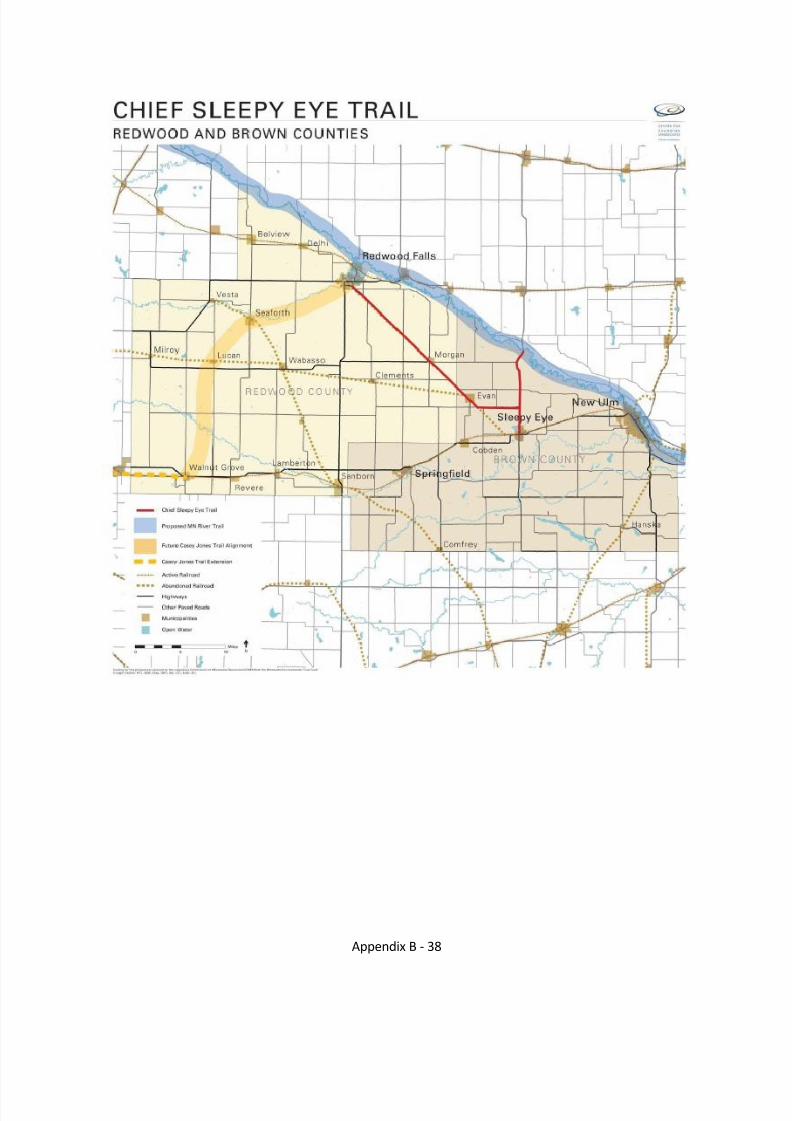
Chief Sleepy Eye Trail. The Minnesota River Trail authorization includes the Redwood Falls to Sleepy Eyeto Fort Ridgely State Park Loop. The realistic discussion has been to follow the old railroad right-of-wayfrom Redwood Falls to Evan and then follow MN Hwy #68 to where it “T’s” with MN Hwy #4 and wouldconnect to Sleepy Eye to the south and Fort Ridgely to the North.
Beginning at Redwood Falls, the former Chicago and North Western – (Sleepy eye to Redwood FallsBranch) 10 railroad bed parallels the south side of TH 67. Safely crossing roads will be an issue. CSAH 101intersects TH 67 at a skew which currently poses a motorized traffic crossing issue. This could increasedriver distraction with the mixing of non motorized and will need to be addressed. There are several lesser volume roads that intersect with TH 67 and the proposed route of the trail, most intersect at askew. Again safety will be a concern and need to be addressed. There appears to be ditch / waterwaysto cross. Ditch authority and DNR will need to be worked with to address crossing issues and plan for safeaccess to waters (or restrict for safety reasons). There are a few homes located along the south side of TH 67, and the proposed trail will cross the driveways. A proposed wind farm is in the process of being permitted in this area. The route passes near or through Gilfillan, Morgan in Redwood County and beyond the SW Region into the Brown County communities of Evan and Sleepy Eye) .
Once the trail is in place, issues that may pose a problem for maintenance include crossing of the trail by heavy farm equipment and equipment to repair the turbines.
Analysis of Selected Planned Trail CorridorsSee pages B-48 to B-49 for the Redwood County portion of the Casey Jones Trail analysis.
10 Minnesota Historic Railroad report studies the Sleepy Eye to Redwood Falls segment:http://www.dot.state.mn.us/environment/pdf_files/rail/rrfpr.pdf pages 11-25 describe this segment of theformer Rail.
8/8/2019 Southwest Minnesota Regional Trail Local Plans
http://slidepdf.com/reader/full/southwest-minnesota-regional-trail-local-plans 39/54
Appendix B - 38
8/8/2019 Southwest Minnesota Regional Trail Local Plans
http://slidepdf.com/reader/full/southwest-minnesota-regional-trail-local-plans 40/54
Appendix B - 39
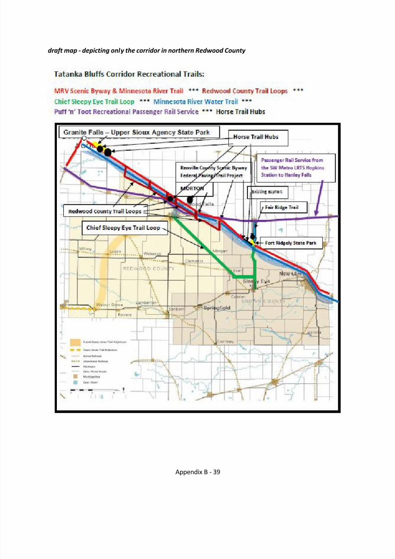
draft map - depicting only the corridor in northern Redwood County
8/8/2019 Southwest Minnesota Regional Trail Local Plans
http://slidepdf.com/reader/full/southwest-minnesota-regional-trail-local-plans 41/54
Appendix B - 40
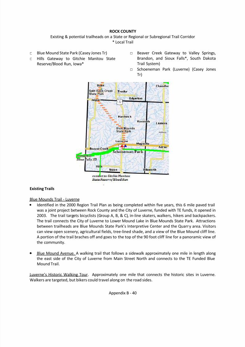
ROCK COUNTYExisting & potential trailheads on a State or Regional or Subregional Trail Corridor
* Local Trail
□ Blue Mound State Park (Casey Jones Tr)□ Hills Gateway to Gitchie Manitou State
Reserve/Blood Run, Iowa*
□ Beaver Creek Gateway to Valley Springs,Brandon, and Sioux Falls*, South DakotaTrail System)
□ Schoeneman Park (Luverne) (Casey JonesTr)
Existing Trails
Blue Mounds Trail - LuverneIdentified in the 2000 Region Trail Plan as being completed within five years, this 6 mile paved trailwas a joint project between Rock County and the City of Luverne, funded with TE funds, it opened in2003. The trail targets bicyclists (Group A, B, & C), in-line skaters, walkers, hikers and backpackers.The trail connects the City of Luverne to Lower Mound Lake in Blue Mounds State Park. Attractionsbetween trailheads are Blue Mounds State Park’s Interpretive Center and the Quarr y area. Visitorscan view open scenery, agricultural fields, tree-lined shade, and a view of the Blue Mound cliff line.A portion of the trail braches off and goes to the top of the 90 foot cliff line for a panoramic view of
the community.
Blue Mound Avenue. A walking trail that follows a sidewalk approximately one mile in length alongthe east side of the City of Luverne from Main Street North and connects to the TE Funded BlueMound Trail.
Luverne’s Historic Walking Tour . Approximately one mile that connects the historic sites in Luverne.Walkers are targeted, but bikers could travel along on the road sides.
8/8/2019 Southwest Minnesota Regional Trail Local Plans
http://slidepdf.com/reader/full/southwest-minnesota-regional-trail-local-plans 42/54
Appendix B - 41
Blue Mound State Park Trails. Blue Mound State Park has hiking and snowmobile trails. They consist of dirt or dirt/grass trails respectively. They are approximately 15 miles/7 miles respectively.
Hills has a trail along the reservoir locals call “The Rez.” It is approximately a half mile in length alongthe west edge of the City and is used as a walking path and to reach fishing locations.
Planned Trails / Corridors
Casey Jones State Trail.This state-authorized trail runs from Rock County through Pipestone and Murray Counties toRedwood County. The designated corridor is from Schoneman Park north to Luverne, northeast toBlue Mounds State Park, northwest to Split Rock Creek State Park, northeast to Pipestone, east toSlayton, northeast to Lake Shetek State Park, northeast to Walnut Grove and northeast to RedwoodFalls to join the Minnesota River State Trail. There is one segment of the trail in Rock County thatconnects Luverne to Blue Mound Park. The beginning point of the Casey Jones State Trail isSchoeneman Park located south of I-90 and was identified as a proposed trail in the 2000 Plan aswas the Blue Mound State Park corridor to Split Rock Creek State Park.
Within Luverne. The City of Luverne is exploring the continuation of the Blue Mounds Bikingand Hiking Trail to extend from downtown Luverne, south to Schoneman Park (county park)south of Luverne
Luverne. A tunnel under TH 75 at the high school to increase the safety of students crossing thehighway. This has been submitted for funding to ATP 7 for Transportation Enhancement funding. Plansfor this project call for a 120-foot tunnel to cut under Highway 75 near Bethany Lutheran Church and theHigh School. The tunnel would be lighted at all times and would likely be equipped with securitycameras. It would have appropriate drains to accommodate water runoff, and the school district wouldlikely be responsible for snow removal and maintenance. A safety fence would be part of the exterior oneach end of the underpass. A major water line would have to be moved, in addition to several other
utilities, and those costs have been built into the estimate. The project is scheduled for funding in 2012for $343,020.
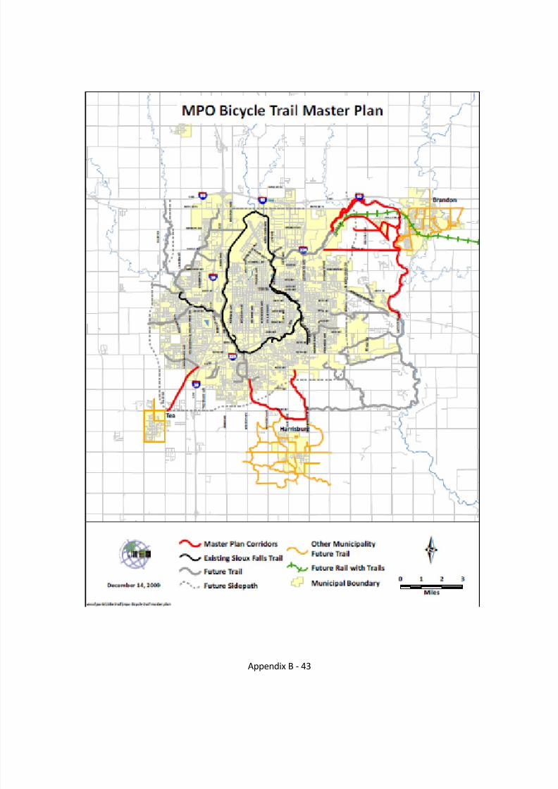
Potential Trail Corridors
Luverne to Sioux Falls. The Sioux Falls MPO has a Bicycle Trail Master Plan Map (December 2009) thatdepicts a suture rail with trails connecting Sioux Falls to Brandon, SD and continuing east. Valley Springs,SD is located along the SD/MN border approximately 4.5 miles east of Brandon along SD State Highway264 and meets Rock County CSAH 4 at the border. A logical trail linkage or gateway would be to connectthe Minnesota Casey Jones State Trail (currently terminating at Luverne) to a future South Dakota trailextending east of Brandon. It is expected to be a paved – Bituminous base of about 28 miles connectingLuverne with Sioux Falls. It is hoped to be able to serve Bicyclists, (Group A & B) In-line Skaters, Walkers,Cross Country Skiers. The estimated timeline for this project is more than 20 years. The Potentialattractions between trailheads are the cities of Beaver Creek, Valley Springs and Brandon.
Luverne to Gitchie Manitou Trail. The estimated timeline for this project is 20 years. It will encompassthe trailheads of Luverne to Girchie Manitou St. Reserve/Blood Run and serve as a Gateway into Iowa. Itis anticipated to be an aggregate surface and serve the Bicyclists, (Group A & B) Cross Country Skiers,Walkers, Hikers, Backpackers, Equestrian population. Areas of interest between trailheads are the citiesof Hills and Larchwood. Gitchie Manitou is a small (91 acre) nature preserve in Lyon County , IA located
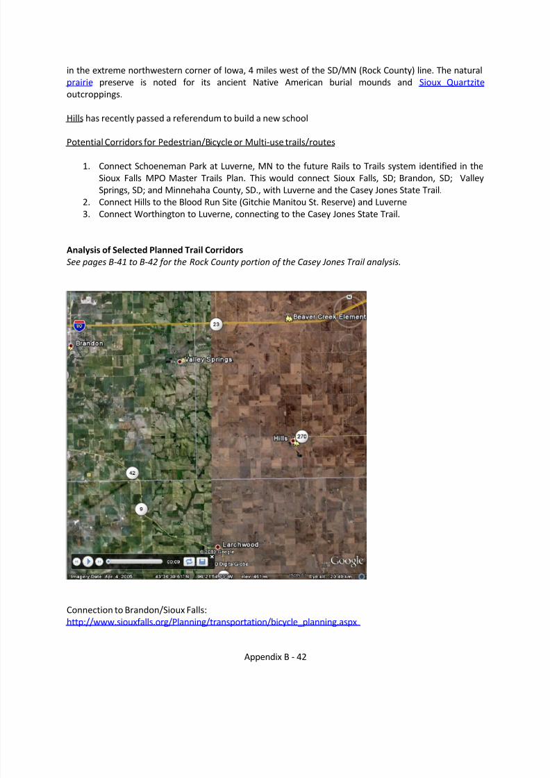
8/8/2019 Southwest Minnesota Regional Trail Local Plans
http://slidepdf.com/reader/full/southwest-minnesota-regional-trail-local-plans 43/54
Appendix B - 42
in the extreme northwestern corner of Iowa, 4 miles west of the SD/MN (Rock County) line. The naturalprairie preserve is noted for its ancient Native American burial mounds and Sioux Quartzite outcroppings.
Hills has recently passed a referendum to build a new school
Potential Corridors for Pedestrian/Bicycle or Multi-use trails/routes
1. Connect Schoeneman Park at Luverne, MN to the future Rails to Trails system identified in theSioux Falls MPO Master Trails Plan. This would connect Sioux Falls, SD; Brandon, SD; ValleySprings, SD; and Minnehaha County, SD., with Luverne and the Casey Jones State Trail.
2. Connect Hills to the Blood Run Site (Gitchie Manitou St. Reserve) and Luverne3. Connect Worthington to Luverne, connecting to the Casey Jones State Trail.
Analysis of Selected Planned Trail CorridorsSee pages B-41 to B-42 for the Rock County portion of the Casey Jones Trail analysis.
Connection to Brandon/Sioux Falls:http://www.siouxfalls.org/Planning/transportation/bicycle_planning.aspx
8/8/2019 Southwest Minnesota Regional Trail Local Plans
http://slidepdf.com/reader/full/southwest-minnesota-regional-trail-local-plans 44/54
Appendix B - 43
8/8/2019 Southwest Minnesota Regional Trail Local Plans
http://slidepdf.com/reader/full/southwest-minnesota-regional-trail-local-plans 45/54
Appendix B - 44
Casey Jones Trail Analysis (italics are excerpts from the Casey Jones Trail Master Plan).Overall, the Casey Jones Trail standard criteria for trail location are as follows:
Criteria for location of the Casey Jones T rail: Work with willing landowners to acquire right-of-way that showcases features of the landscape. Acquire a right-of-way wide enough to
accommodate two treadways. Minimize trail user exposure to vehicular traffic. Avoid acquisitionof high quality agricultural lands. Minimize impact on wetlands. Avoid negative impacts on rareand endangered species, and avoid fragmentation or disturbance of significant native plant communities identified by the Minnesota County Biological Survey. Avoid siting the trail throughwildlife management areas. Consider siting the trail adjacent to wildlife management areas totake advantage of the scenic wooded corridor and to provide additional buffer for the wildlifemanagement areas. Township road rights-of-way. Edges and boundary lines. A combination of above.
Rock County: from Luverne to Split Rock Creek State Park (in Pipestone County).The 2005 Casey Jones Trail Plan identifies Split Rock Creek State Park to Jasper (4 miles south of the Park) and Blue Mounds State Park as future Trail connections. Since the 2005 Casey JonesTrail Master Plan was completed, the trail corridor was legislatively extended.
This segment is a future connection, and will require an updated DNR Plan for this segment.There is one segment of the trail in Rock County that connects Luverne to Blue Mound Park.The legislatively designated Casey Jones Trail Corridor begins at Schoeneman Park (locatedsouth of I-90), into Luverne, northeast to Blue mounds State park, northwest to Split rockState Park.The City of Luverne is exploring the continuation of the Blue Mounds Biking and Hiking Trailto extend from downtown Luverne, south to Schoneman Park (county park) south of LuverneWithin two years, there will be a TH 75 pedestrian underpass adjacent to the Luverne HighSchool.
There are two logical routes to Luverne from Schoneman Park. One of the major players inrouting the trail will be MnDOT and crossing I-90.
The first follows the TH 75 corridor, uses TH 75 to cross I-90 into Luverne. Close coordinationwith MnDOT will be needed to coordinate and minimize conflict with motorized traffic,paralleling and crossing TH 75, and crossing the Interstate (over or under).The second may involve some use of paralleling TH 75, turning east before the Interstateand paralleling the Rock River under Interstate 90. Crossing under the Interstate wouldinvolve coordination with MnDOT, additional issues would involve working with the DNR,potentially a ditch authority, and private land owners. A complication of this route would bethe potential flooding of a trail along the Rock River. This route would allow access to the
existing trail that leads to Blue Mound State Park.
8/8/2019 Southwest Minnesota Regional Trail Local Plans
http://slidepdf.com/reader/full/southwest-minnesota-regional-trail-local-plans 46/54
Appendix B - 45
Blue Mound State Park northeast to Split Rock Creek State Park.The Northern Tallgrass Prairie National Wildlife Refuge is located to the west of Blue MoundState Park, and may be an area for the trail to pass by.A northwest route will require crossing TH 75. Work with MnDOT to identify crossinglocations that would be the safest for trail users. Within the next two years there will be aTH 75 pedestrian underpass in Luverne.Wind Farm development is beginning to occur in this part of the Region. It is recommendedthat an alignment be identified in a DNR approved plan which can then be identified in thepublic input process for Wind Turbine Site Permits which have a 250 road and trail right of way setback.Work with the Rock County Highway Engineer, MnDOT District 7 Planning staff and theapplicable Township road authorities and communities to identify the logical corridor for thetrail, and if bridge replacement or road upgrades are planned, to study inclusion of a non-motorized trail during the planning stage of these projects.
Pipestone County: Split Rock Creek State Park northeast to Pipestone, east to WoodstockTwo separate trail alignments are proposed between Split Rock Creek State Park and Pipestone – a paved trail alignment for bicyclists and walkers and a natural surface trail for horseback riders.The proposed paved trail would enter the park at the northwest and the horse trail would enter from the south. Trail users will have views of the rural, agricultural landscape as they travel between Pipestone and Split Rock Creek State Park. The small town of Ihlen is located on thenorthern boundary of the state park. There are no services available for trail users here, with theexception of a restaurant. Split Rock Creek State Park will serve as a trail access and rest area.The park will serve as a major trailhead for horseback riders. A campground for horses and ridersis proposed in the southern part of the park. The existing campground will serve bicyclists and pedestrians. Water and restroom facilities are also available. Additional scenic and recreational opportunities include picnicking, hiking, wildlife observation and swimming.
The community of Pipestone offers numerous services, cultural resources and points of interest. A variety of options for food and lodging exist. Camping is available at the state park and a private RV campground. Historic downtown (a historic walking tour of downtown Pipestone hasbeen developed), the Pipestone County Museum, Performing Arts Center, Keepers of the Sacred Tradition of Pipemakers, and Little Feather Indian Center are other cultural amenities. The water tower is a historic structure.... The Casey Jones State Trail will connect to Pipestone National Monument. The trail will end at the entrance to the Pipestone National Monument and trail users can access the visitor center on the existing entrance road by foot, bicycle or automobile.Moore Park in Pipestone has been identified as a potential trailhead. Amenities at this siteinclude restrooms, water, and a shelter. Development of a kiosk with trail orientation and interpretive information is recommended for this access/rest area.
Bicycle/pedestrian trail alignment: The existing Casey Jones State Trail begins just south of theintersection of TH 75 and TH 23 in Pipestone and travels east for 13 miles. This trail wasdeveloped on an abandoned railroad grade acquired by the state in 1967. A small parking area islocated at this location. The recommendation of this plan (Casey Jones Trail Master Plan) is for three separate trail segments to converge at this point in the future.

8/8/2019 Southwest Minnesota Regional Trail Local Plans
http://slidepdf.com/reader/full/southwest-minnesota-regional-trail-local-plans 47/54
Appendix B - 46
Split Rock Creek State Park: The bicycle/pedestrian trail is planned to enter the park in thenorthwestern corner. One alternative for the paved trail alignment is to use the westernmost existing hiking trail in the park that parallels CSAH 20 to the dam. The Split Rock Creek State Park Management Plan does not address this bicycle/pedestrian trail alignment. Modification of the plan would be necessary in order to allow trail development.
A paved trail segment from the south of Pipestone connecting Split Rock Creek State Park and Pipestone: This segment of trail will travel south and connect to Split Rock Creek State Park. Alternatives identified for this segment are the TH 23 corridor, the CSAH 56 corridor, or the TH 75corridor. The specific alignment of this segment through Pipestone will depend on the alternativeselected. If the trail follows TH 23, the trail could follow the existing railroad right of way NE tointersect the existing trail. If TH 75 is the route selected, the abandoned railroad grade north and south of TH 30 could be used.
TH 23 corridor following BNSF Right of way. The BNSF Railroad is a 49 mph track with 13 trainsper day. Utilizing the railroad right of way will require close work with the BNSF. Crossing TH 30between CSAH 15 and TH 23 will require working with MnDOT District 8, safety will be an issue.
Traffic counts in this segment of TH 30 are 4600 to 7400.
CSAH 15 Corridor: note that the reference to CSAH 56 is likely an error and would be CSAH 15located between the THs 75 and 23 corridors. If on the shoulder or in the road right of way willrequire close work with the Pipestone County Highway Department. Crossing TH 30 safely willbe an issue to be worked out closely with MnDOT District 8. To the west of the TH 30 / CSAH 15intersection, the traffic count is lower at 2500, however, the speed of traffic increases.
TH 75 corridor along the old railroad bed. This option may lend itself to allowing increased non-motorized access for employees to the manufacturing businesses along TH 75 and may lenditself to a more active, healthier alternative mode of transportation which could result in
healthier employees with less sick days. This may be attractive for businesses that mayencourage the development of this option.
A paved trail segment connecting to Pipestone National Monument: This trail segment will cross TH 75 and proceed west to Hiawatha Avenue providing access to downtown Pipestone . Ingeneral, the trail will follow the 4th street corridor to Hiawatha. The trail will then connect to thehistoric depot, pageant grounds, and National Monument. This segment will end at the entranceto Pipestone National Monument.
Design and develop a safe crossing of Highway 75 and Highway 23. The Average Annual Trafficof TH 23 and 75 is 3800 and 1600 respectively where they intersect near the Casey Jones TrailHead in the northern section of Pipestone, the BNSF Railroad is also located near the highwayand trail intersections with a track speed of 49 mph and 30 trains per day. The community isworking with MnDOT District 8 to identify and implement measures to provide a safe crossing of the highways. The Casey Jones Trail Master Plan calls for the junction of the three trailsegments at this location, which may be worthy of reconsideration. The high volume of trafficon TH 23 and 75 and the BNSF in close proximity to the proposed junction of the trails mayincrease safety issues.
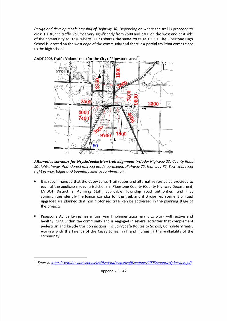
8/8/2019 Southwest Minnesota Regional Trail Local Plans
http://slidepdf.com/reader/full/southwest-minnesota-regional-trail-local-plans 48/54
Appendix B - 47
Design and develop a safe crossing of Highway 30. Depending on where the trail is proposed tocross TH 30, the traffic volumes vary significantly from 2500 and 2300 on the west and east sideof the community to 9700 where TH 23 shares the same route as TH 30. The Pipestone HighSchool is located on the west edge of the community and there is a partial trail that comes closeto the high school.
AADT 2008 Traffic Volume map for the City of Pipestone area 11
Alternative corridors for bicycle/pedestrian trail alignment include: Highway 23, County Road 56 right-of-way, Abandoned railroad grade paralleling Highway 75, Highway 75, Township road right of way, Edges and boundary lines, A combination.
It is recommended that the Casey Jones Trail routes and alternative routes be provided toeach of the applicable road jurisdictions in Pipestone County (County Highway Department,MnDOT District 8 Planning Staff, applicable Township road authorities, and thatcommunities identify the logical corridor for the trail, and if Bridge replacement or roadupgrades are planned that non motorized trails can be addressed in the planning stage of the projects.
Pipestone Active Living has a four year Implementation grant to work with active andhealthy living within the community and is engaged in several activities that complementpedestrian and bicycle trail connections, including Safe Routes to School, Complete Streets,working with the Friends of the Casey Jones Trail, and increasing the walkability of thecommunity.
11 Source: http://www.dot.state.mn.us/traffic/data/maps/trafficvolume/2008/counties/pipeston.pdf
8/8/2019 Southwest Minnesota Regional Trail Local Plans
http://slidepdf.com/reader/full/southwest-minnesota-regional-trail-local-plans 49/54
Appendix B - 48
Alternative corridors for future trail alignment: Two separate trail corridors are envisioned for this segment – a natural surfaced horse trail alignment and a paved trail for bicyclists and walkers.
Horse trail alignment: The Casey Jones State Trail horse trail alignment would enter Split RockCreek State park at the southern boundary (along the CSAH 7 corridor) and proceed to the horsetrailhead/campground. : A corridor traveling southeast from the existing Casey Jones State Trail to Twp 101 to 21 st Street (Twp. 7) to Split Rock Creek State Park) and Moore Park has beenidentified as a potential trailhead in Pipestone.
Horse trail recommendations Avoid siting the horse trail adjacent to an active railroad or busy highway.To provide a satisfactory opportunity, a 10 – 12 mile loop is needed (a 15-20 mile loop ismore desirable).Connect to the existing Casey Jones State Trail.
Alternative corridors for horse trail alignment include: A corridor traveling southeast from theexisting Casey Jones State Trail to Twp 101 to 21 st Street (Twp. 7) to Split Rock Creek State Park),Township road rights-of-way, Edges and boundary lines, A combination.
Pipestone to Woodstock Fourteen and one half miles of former railroad grade are currently in state ownership in thissegment (13 miles from Pipestone to the Pipestone/Murray county line, and two miles from LakeWilson west). There is a four-mile gap in ownership between these two segments. Most of theright-of-way is 100 feet wide, but there are a few sections where the trail right-of-way is 300 feet wide. Adjacent land is predominately agricultural. Trail users will experience vistas of rural farmland from the trail. Views of wind towers dominate the agricultural landscape. There areareas of high quality prairie in the right-of-way in some segments. Other segments are
predominately brome grass. Windbreaks of pine and spruce were planted in the 1970s after state acquisition. In some sections, the grade is elevated and slopes away sharply to the adjacent farmland below. The trail begins in Pipestone and travels east through the small community of Woodstock. A restaurant is located in Woodstock and a community park could serve as a rest area.Master Plan Recommendations:
Develop an asphalt bike trail on the grade.Develop a parallel treadway for horseback riding and snowmobiling.In segments where the grade is elevated – allow snowmobiling both on the asphalt and onthe parallel treadway below the elevated grade, depending on the snow depth.Develop two bridges over the Rock River and Little Rock River.
Develop an interpretive spur walking trail through a prairie area (Loop trail) .Develop a rest area where the right-of-way widens in the East Branch of the Rock River area.Woodstock trail access/rest area: The community park in Woodstock provides a pleasant rest stop for trail users.
The ownership of this segment is secure and development of this dual path segment is on-goingas funding becomes available. State bonding dollars and Transportation Enhancement dollarshave been accessed for development on this segment.

8/8/2019 Southwest Minnesota Regional Trail Local Plans
http://slidepdf.com/reader/full/southwest-minnesota-regional-trail-local-plans 50/54
Appendix B - 49
Murray County: Pipestone/Murray County line to northeast of Lake Shetek State Park(terminating at Walnut Grove in Redwood County). Land acquisitions have been occurring alongthis corridor with willing landowners since the completion of the Master Plan. Land acquisitiontakes many years and development will occur as connections are made.
Murray / Pipestone line to Lake Wilson. One and one half miles of former railroad grade arecurrently in state ownership in this segment (two miles from Lake Wilson west). There is a four-mile gap in ownership between these two segments between the Murray/Pipestone Line andLake Wilson.
Services in Lake Wilson include a restaurants and a convenience store/service station. Acommunity park and Lake Wilson are other highlights of the community.Recommendations:
Acquire a trail alignment to close the gap between the Pipestone/Murray County line and two miles west of Lake Wilson.Develop an asphalt bike trail on the grade.Develop a parallel treadway for horseback riding and snowmobiling.In segments where the grade is elevated – allow snowmobiling both on the asphalt and onthe parallel treadway below the elevated grade, depending on the snow depth.
Most of the right-of-way is 100 feet wide, but there are a few sections where the trail right-of-way is 300 feet wide. Adjacent land is predominately agricultural. Trail users will experiencevistas of rural farmland from the trail. Views of wind towers dominate the agricultural landscape. There are areas of high quality prairie in the right-of-way in some segments. Other segments are predominately brome grass. Windbreaks of pine and spruce were planted in the1970s after state acquisition. In some sections, the grade is elevated and slopes away sharply tothe adjacent farmland below.
Lake Wilson to Lake Shetek: Criteria for location of the trail: Connect to Summit Lake, Connect toHadley, and Provide access to downtown Slayton, Minimize use of the Highway 30 corridor. Alternative corridors for future trail alignment: Highway 30, Old railroad grade, Townshiproad rights-of-way, Edges and boundary lines, Beaver Creek corridor, A combination
Lake Wilson and the Casey Jones State Trail. No specific alignment has been determined for theCasey Jones State Trail through the community of Lake Wilson. One alternative identified in the planning process is for the trail to travel north along a corridor west of Lake Wilson to CSAH 27, parallel 27 to the community park and then continue east. A small trail head/rest area is proposed at the community park , which has restrooms and ballfields. Development of a kiosk with trail orientation and interpretive information is recommended for this site.
Hadley and the Casey Jones State Trail: A specific alignment to and through Hadley has not been determined. The concept that has emerged from the planning process thus far is for thetrail to approach the community from the west and connect to the north end of Summit Lake. Atrail head/rest area is proposed for at the north shore of Summit Lake. This trailhead/rest areacould be developed to include parking, restrooms, water, and interpretation and trail orientationinformation in cooperation with the proposed lake access and fishing pier. This site is one of three locations along the Casey Jones State Trail where trail users will have access to a lake (LakeShetek State Park and Split Rock Creek State Park are the other locations). A connection to the
8/8/2019 Southwest Minnesota Regional Trail Local Plans
http://slidepdf.com/reader/full/southwest-minnesota-regional-trail-local-plans 51/54
Appendix B - 50
city park should be made. The park could also be an alternative location for a trailhead. Aspecific location has not been determined for the trail as it travels east from this point, but ingeneral, the trail will continue east paralleling the north side of TH 30 to Slayton.
Slayton and the Casey Jones State Trail A specific trail alignment has not been determined between Hadley and Slayton or throughSlayton. It is anticipated that the future trail corridor will be located north of TH 30, so it will beapproaching the northern part of the community. An alignment through the northern part of thecity connecting with the Beaver Creek corridor needs to be determined. A trailhead and rest areawill be located in Slayton. The community has not determined the best location for a trailhead.Development of a trailhead is envisioned somewhere in the northern part of Slayton. Thecommunity of Slayton is searching for a site to serve as the trailhead north of Highway 30 for theCasey Jones State Trail. This site should accommodate overnight parking for trail users, water,restrooms, picnic area, bike racks, and trail interpretation and orientation information.
Slayton to Lake Shetek State Park No specific alignment has been determined for this segment, except for the paved six-mile loop
between Lake Shetek State Park and End-O-Line Park in Currie. It is recommended that fromSlayton, the trail go north using the Beaver Creek corridor, to the extent possible, and connect toCurrie. Three state wildlife management areas are located in the segment between Slayton and Currie. Two are located along Beaver Creek. The wooded Beaver Creek corridor is scenic and provides excellent wildlife habitat including turkey habitat. The community of Currie providesservices for trail users and other amenities.
Currie and the Casey Jones State Trail. A specific alignment has not been determined betweenSlayton and Currie. The concept that was identified in the planning process was for the trail to follow the Beaver Creek corridor to Currie. This alignment will depend on where a contiguouscorridor can be put together from willing sellers. At Currie, the alignment will connect to the
existing six mile loop trail connecting Currie to Lake Shetek State Park. The End-O-Line Railroad Park and Museum is currently serving as a trailhead for the six-mile loop trail from Currie to LakeShetek State Park. This site serves as an excellent trailhead because it has restroom facilities,information about the area and parking.
Lake Shetek State Park and the Casey Jones State Trail. A six mile paved loop trail connects LakeShetek State Park to Currie. The authorizing legislation for the Casey Jones State Trail includesthis loop as part of the Casey Jones State Trail. The park will serve as a trailhead for the Casey Jones State Trail. The concept that emerged during the trail planning process was for the paved trail to branch north from an intersection with the existing paved loop trail, exiting the park inthe northeastern corner. Using the existing Bluebird Trail was suggested. The Casey Jones StateTrail is not addressed in the Lake Shetek Management Plan. Before a specific alignment throughthe park can be determined, the master plan for Lake Shetek State Park must be revised toinclude the trail alignment and trailhead. .
Alternative corridors for future trail alignment: The most desirable corridor for a trail would parallel Beaver Creek, Township road rights-of-way, Edges and boundary lines, Acombination of above, Explore the feasibility of using an alignment close to the old railroad right-of-way.
8/8/2019 Southwest Minnesota Regional Trail Local Plans
http://slidepdf.com/reader/full/southwest-minnesota-regional-trail-local-plans 52/54
Appendix B - 51
Slaughter Slough Interpretive Site. Slaughter Slough is a 640 acre Waterfowl Production areamanaged by the U.S. Fish and Wildlife Service. It is an excellent place for birdwatching. It is alsosignificant in the Dakota Conflict story as casualties occurred on both sides at this site.Interpretive information about the history and natural resources of this site should be developed. In May 2010, an interpretative kiosk was opened.
Criteria for Location of the Trail Alignment The following objectives were identified to guide the location of the trail alignment through the park: Provide a paved corridor north branching off from the existing paved six-mile loop trail,Provide parking for trail users, Provide a rest area for trail users, Provide trail and park orientation information, Provide a connection to the campground, Provide access to the visitor center, Protect archaeological resources, Minimize impact to wetlands, Use existing corridorswhere possible, Avoid severing plant communities.
Lake Shetek State Park to Walnut Grove (Redwood County)
The trail will exit Lake Shetek State Park to the north and head northeast to Walnut Grove. Both
a paved trail and a natural surfaced trail for horseback riding are envisioned through the park and on to Walnut Grove. After leaving the park, the trail will meander towards Plum Creek alongexisting rights-of-ways or boundaries and edges as willing landowners, land managers and road authorities agree to. A private campground to the north of Lake Shetek State Park providescamping opportunities and access to Lake Shetek. Plans are for this campground to develop facilities for horseback riders in the future. The Plum Creek corridor is a desirable trail corridor because of its scenic quality – wooded bluffs, varied terrain and the creek.
Redwood County and the Casey Jones State Trail: From Lake Shetek State Park, northeast toWalnut Grove and northeast to Redwood Falls to join the Minnesota River State Trail. The 2005Casey Jones Trail Master Plan terminates at Walnut Grove and identifies future trail connections
to the future Minnesota River Trail at Redwood Falls, located to the north and to Tracy. Since thewriting of the Master Plan, the trail has been legislatively extended to Redwood Falls,connecting to the legislatively designated Minnesota River Trail. The DNR Master Plan willrequire updating before development may occur between Walnut Grove and Redwood Falls,however, land acquisition may occur..
Walnut Grove provides services for trail users – food and lodging and cultural amenities. LauraIngalls Wilder lived near Walnut Grove and her book “On the Banks of Plum Creek” is set in thisarea. The site of her sod house described in the book is located 1½ miles north of Walnut Grove.The site is privately owned, but the owner allows the public to view the site. The owner has alsorestored prairie on the site. The Laura Ingalls Wilder Museum in Walnut Grove is a popular destination. A pageant performed outdoors three weekends in July is based on the life of LauraIngalls Wilder in Walnut Grove. Plum Creek County Park provides camping, swimming, picnicking, hiking, and a Frisbee disc course. Wetlands, prairie and forest areas are included inthis 205 acre park. A variety of special events, such as black powder shoots and horse shows areheld at the The Plum Creek Rodeo Grounds.
Walnut Grove and the Casey Jones State Trail. A specific trail alignment has not yet beendetermined for the segment that would connect Lake Shetek State Park to Walnut Grove(including connections to Plum Creek Park, Laura Ingalls Wilder Pageant Site, and Laura Ingalls
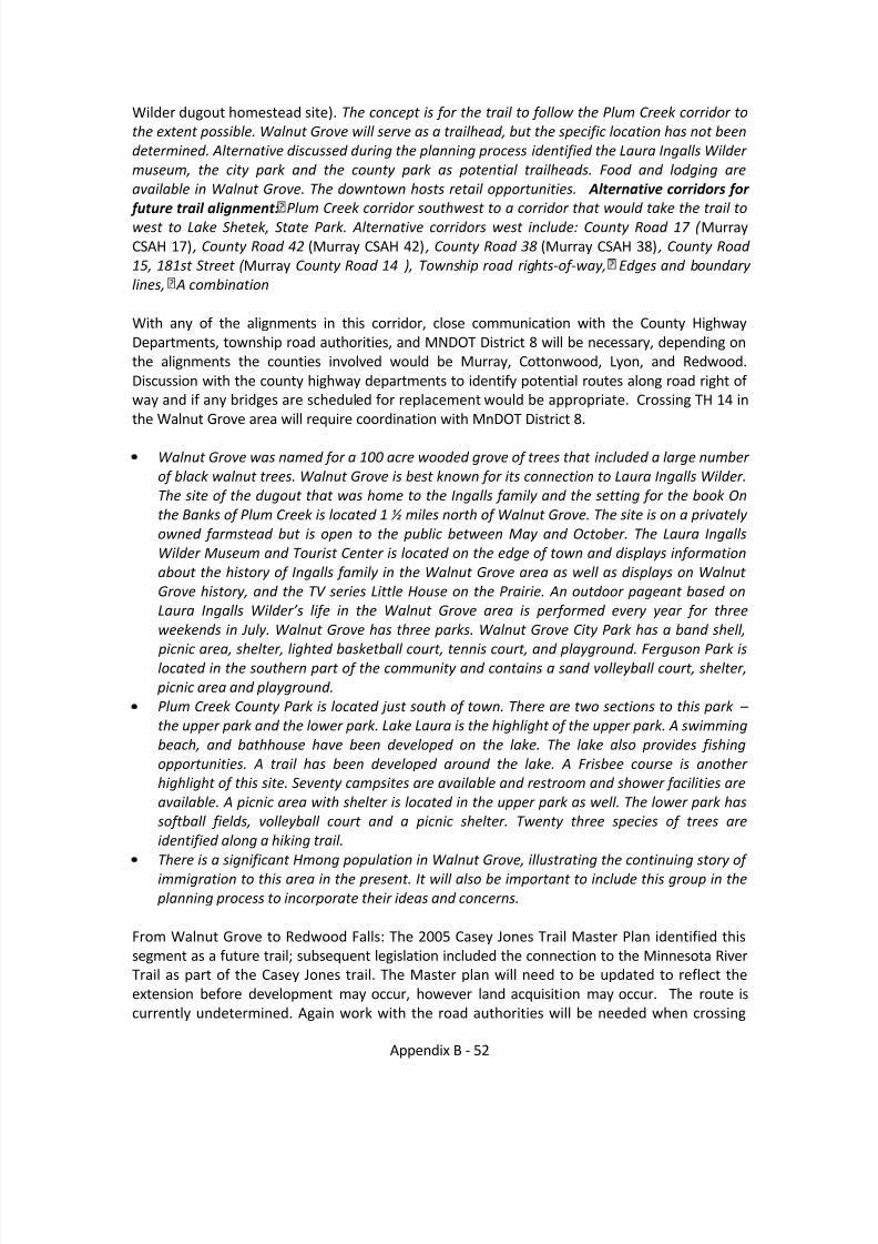
8/8/2019 Southwest Minnesota Regional Trail Local Plans
http://slidepdf.com/reader/full/southwest-minnesota-regional-trail-local-plans 53/54
Appendix B - 52
Wilder dugout homestead site). The concept is for the trail to follow the Plum Creek corridor tothe extent possible. Walnut Grove will serve as a trailhead, but the specific location has not beendetermined. Alternative discussed during the planning process identified the Laura Ingalls Wilder museum, the city park and the county park as potential trailheads. Food and lodging areavailable in Walnut Grove. The downtown hosts retail opportunities. Alternative corridors for
future trail alignment: Plum Creek corridor southwest to a corridor that would take the trail towest to Lake Shetek, State Park. Alternative corridors west include: County Road 17 ( MurrayCSAH 17) , County Road 42 (Murray CSAH 42) , County Road 38 (Murray CSAH 38) , County Road 15, 181st Street ( Murray County Road 14 ), Township road rights-of-way, Edges and boundary lines, A combination
With any of the alignments in this corridor, close communication with the County HighwayDepartments, township road authorities, and MNDOT District 8 will be necessary, depending onthe alignments the counties involved would be Murray, Cottonwood, Lyon, and Redwood.Discussion with the county highway departments to identify potential routes along road right of way and if any bridges are scheduled for replacement would be appropriate. Crossing TH 14 inthe Walnut Grove area will require coordination with MnDOT District 8.
Walnut Grove was named for a 100 acre wooded grove of trees that included a large number of black walnut trees. Walnut Grove is best known for its connection to Laura Ingalls Wilder.The site of the dugout that was home to the Ingalls family and the setting for the book Onthe Banks of Plum Creek is located 1 ½ miles north of Walnut Grove. The site is on a privately owned farmstead but is open to the public between May and October. The Laura IngallsWilder Museum and Tourist Center is located on the edge of town and displays informationabout the history of Ingalls family in the Walnut Grove area as well as displays on Walnut Grove history, and the TV series Little House on the Prairie. An outdoor pageant based onLaura Ingalls Wilder’s life in the Walnut Grove area is performed every year for threeweekends in July. Walnut Grove has three parks. Walnut Grove City Park has a band shell,
picnic area, shelter, lighted basketball court, tennis court, and playground. Ferguson Park islocated in the southern part of the community and contains a sand volleyball court, shelter, picnic area and playground.Plum Creek County Park is located just south of town. There are two sections to this park – the upper park and the lower park. Lake Laura is the highlight of the upper park. A swimmingbeach, and bathhouse have been developed on the lake. The lake also provides fishingopportunities. A trail has been developed around the lake. A Frisbee course is another highlight of this site. Seventy campsites are available and restroom and shower facilities areavailable. A picnic area with shelter is located in the upper park as well. The lower park hassoftball fields, volleyball court and a picnic shelter. Twenty three species of trees areidentified along a hiking trail.There is a significant Hmong population in Walnut Grove, illustrating the continuing story of immigration to this area in the present. It will also be important to include this group in the planning process to incorporate their ideas and concerns.
From Walnut Grove to Redwood Falls: The 2005 Casey Jones Trail Master Plan identified thissegment as a future trail; subsequent legislation included the connection to the Minnesota RiverTrail as part of the Casey Jones trail. The Master plan will need to be updated to reflect theextension before development may occur, however land acquisition may occur. The route iscurrently undetermined. Again work with the road authorities will be needed when crossing

8/8/2019 Southwest Minnesota Regional Trail Local Plans
http://slidepdf.com/reader/full/southwest-minnesota-regional-trail-local-plans 54/54
roads and if road right of way is proposed for use. As the Plan is developed, consultation withthe County Highway Department to coordinate where the trail would cross county jurisdictionroads and if there are future upgrades to roads and bridges that could integrate trail alignmentas needed. Work with MnDOT District 8 will be needed at a minimum for safely crossing TH 68,and THs 71 / 19 / 67 in the Redwood Falls area.