Southeast Oregon - Photo Trip USA
12
SOUTHEAST Chapter 12 SOUTHEAST OREGON Owyhee Lake at Leslie Gulch
Transcript of Southeast Oregon - Photo Trip USA

SOUTHEASTChapter 12
SOUTHEAST OREGON
Owyhee Lake at Leslie Gulch

234 Photographing Oregon Southeast Oregon 235
change quickly to howling winds. Unlike the western part of the state, there’s not much chance you’ll run into a bear out here, but it is definitely rattlesnake coun-try. It’s an area of sparse human population, and most of the people who live here like it that way. Cowboy is spoken here. A good way to begin your exploration of this fascinating part of the state is by traveling the Oregon Outback National Scenic Byway, breaking away from the Cascades and journeying south and east into the Great Basin via OR 31.
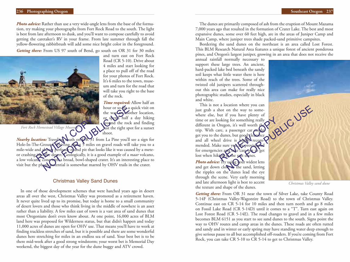
Fort Rock
Rising up out of surrounding sagebrush desert, Fort Rock is a towering jagged rock formation, technically a tuff ring, set in an ancient seabed. It is also perhaps the most famous anthropological site in Oregon, as a pair of 9,000–year old sagebrush bark sandals were discovered here. Trails lead up into the bowl of this crater-like formation, and you can scramble to the top for views of the surround-ing desert. Fort Rock has been designated a National Natural Landmark, and an Oregon State Parks interpretive display at the base of the rock does a good job of relating the natural and human history of the area.
The town of Fort Rock has a museum with several pioneer-days buildings that have good potential for ghost town-like photographs. Hours and access are limited so you can’t get the best angles during the golden hours, but it is possible to make some nice images from the parking area at those times.
SOUTHEAST OREGON
For most people, the image of Oregon is that of the dense forests of the Coast and Cascade Ranges, the fertile fields of the Willamette Valley, or perhaps the sandy beaches and rocky headlands of the coast. In truth, much of Oregon is arid desert, blazingly hot in summer and bitterly cold in winter. The southeast-ern quadrant of the state is part of the Northern Great Basin—a series of vast sagebrush-filled valleys broken by uplifted craggy mountains, a continuation of the topography of neighboring Nevada. To some, it’s an empty, desolate and forbidding wasteland; for desert and wilderness lovers, it means big sky country, bazillion star nights, the pungent aroma of sage, peacefulness and sometimes a quiet so complete that all you can hear is your own heartbeat.
Oregon’s Outback is wonderful in spring when temperatures are mild and wildflowers make their annual appearance in the rock and sand gardens. Summer brings baking dry heat to the valleys, and also incredible thunder and lightning storms that make fantastic big sky photos. Cooling temperatures and the bright yellows of rabbitbrush, cottonwood and aspen make autumn a delightful season to venture into basin and range territory. Winter snow and seasonal standing water lend a whole different look, softening the often stark landscape.
Traveling in southeast Oregon, you need to keep in mind that distances are long and services are few and far between. Aside from a few major highways, roads are gravel and dirt, many of which turn to slimy mud with any rain. Calm breezes can
Lone tree in Harney Valley ranch country near Burns
Fort Rock
REVIEW COPY
NOT FOR PUBLIC U
SE
REVIEW COPY
NOT FOR PUBLIC U
SE
236 Photographing Oregon Southeast Oregon 237
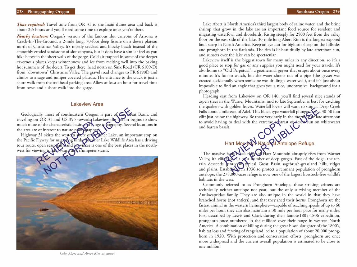
The dunes are primarily composed of ash from the eruption of Mount Mazama 7,000 years ago that resulted in the formation of Crater Lake. The best and most expansive dunes, some over 60 feet high, are in the areas of Juniper Camp and Main Camp, where juniper trees shade packed-sand primitive campsites.
Bordering the sand dunes on the northeast is an area called Lost Forest. This BLM Research Natural Area features a unique forest of ancient ponderosa pines, and Oregon’s largest juniper, growing in an area that does not receive the annual rainfall normally necessary to support these large trees. An ancient, hard-packed lake bed beneath the sandy soil keeps what little water there is here within reach of the trees. Some of the twisted old junipers scattered through-out this area can make for really nice photographic studies, especially in black and white.
This is not a location where you can just grab a shot on the way to some-where else, but if you have plenty of time or are looking for something really different in Oregon, it’s well worth the trip. With care, a passenger car might get you to the dunes, but good clearance and all wheel drive is highly recom-mended. Make sure you are provisioned for emergencies and take care not to get lost when hiking in the vast dunes. Photo advice: Try using your widest lens and get down close to the sand, letting the ripples on the dunes lead the eye through the scene. Very early morning and late afternoon light is best to accent the texture and shape of the dunes. Getting there: From OR 31 near the town of Silver Lake, take County Road 5-14F (Christmas Valley-Wagontire Road) to the town of Christmas Valley. Continue east on CR 5-14 for 10 miles and then turn north and go 8 miles on Fossil Lake Road (CR 5-14D) until it comes to a “T”. Turn east again on Lost Forest Road (CR 5-14E). The road changes to gravel and in a few miles becomes BLM 6151 as you start to see sand dunes to the south. Signs point the way to OHV routes and camp areas in the dunes. These roads are often rutted and sandy and in winter or early spring may have standing water deep enough to give serious pause to all but accomplished off-roaders. If you’re coming from Fort Rock, you can take CR 5-10 to CR 5-14 to get to Christmas Valley.
Photo advice: Rather than use a very wide-angle lens from the base of the forma-tion, try making your photographs from Fort Rock Road to the south. The light is best from late afternoon to dusk, and you’ll want to compose carefully to avoid getting the caretaker’s RV in your frame. From late summer through fall the yellow-flowering rabbitbrush will add some nice bright color in the foreground.Getting there: From US 97 south of Bend, go south on OR 31 for 30 miles
and turn east on Fort Rock Road (CR 5-10). Drive about 4 miles and start looking for a place to pull off of the road for your photos of Fort Rock. It’s 6 miles to the town, muse-um and turn for the road that will take you right to the base of the rock.Time required: Allow half an hour or so for a quick visit on the way to another location, or spend half a day hiking around the rock and finding just the right spot for a sunset shoot.
Nearby location: Traveling south on OR 31 from La Pine you’ll see a sign for Hole-In-The-Ground. Driving about 5 miles on gravel roads will take you to a mile-wide and almost perfectly round pit that looks like it was caused by a mete-or crashing into the desert. Geologically, it is a good example of a maar volcano, a low volcanic cone with a broad, bowl-shaped crater. It’s an interesting place to visit but the photo potential is somewhat marred by OHV trails in the crater.
Christmas Valley Sand Dunes
In one of those development schemes that were hatched years ago in desert areas all over the west, Christmas Valley was promoted as a retirement haven. It never quite lived up to its promise, but today is home to a small community of desert lovers and those who think living in the middle of nowhere is an asset rather than a liability. A few miles east of town is a vast area of sand dunes that most Oregonians don’t even know about. At one point, 16,000 acres of BLM land here was proposed for Wilderness status, but that didn’t happen and today 11,000 acres of dunes are open for OHV use. That means you’ll have to work at finding trackless stretches of sand, but it is possible and there are some wonderful dunes here stretching for miles in an endless sea of sand. Your best bet is to be there mid-week after a good strong windstorm; your worst bet is Memorial Day weekend, the biggest day of the year for the dune buggy and ATV crowd.
Christmas Valley sand dune
Fort Rock Homestead Village Museum
REVIEW COPY
NOT FOR PUBLIC U
SE
REVIEW COPY
NOT FOR PUBLIC U
SE
238 Photographing Oregon Southeast Oregon 239
Time required: Travel time from OR 31 to the main dunes area and back is about 2½ hours and you'll need some time to explore once you're there.Nearby location: Oregon’s version of the famous slot canyons of Arizona is Crack-In-The-Ground, a 2-mile long, 70-foot deep fissure on a desert plateau north of Christmas Valley. It’s mostly cracked and blocky basalt instead of the smoothly eroded sandstone of slot canyons, but it does have a similar feel as you hike between the sheer walls of the gorge. Cold air trapped in some of the deeper cavernous places keeps winter snow and ice from melting well into the baking hot summers of the desert. To get there, head north on Sink Road (CR 6109-D) from “downtown” Christmas Valley. The gravel road changes to FR 6190D and climbs to a sage and juniper covered plateau. The entrance to the crack is just a short walk from the trailhead parking area. Allow at least an hour for travel time from town and a short walk into the gorge.
Lakeview Area
Geologically, most of southeastern Oregon is part of the Great Basin, and traveling on OR 31 and US 395 towards Lakeview the terrain begins to show much more of the characteristic basin and range topography. Several locations in the area are of interest to nature photographers.
Highway 31 skirts the western shore of Summer Lake, an important stop on the Pacific Flyway for migrating birds. Summer Lake Wildlife Area has a driving tour route, open seasonally, and in winter is one of the best places in the north-west for viewing tundra swans and trumpeter swans.
Lake Abert and Abert Rim at sunset
Lake Abert is North America’s third largest body of saline water, and the brine shrimp that grow in the lake are an important food source for resident and migrating waterfowl and shorebirds. Rising steeply for 2500 feet from the valley floor on the east side of the lake, 30-mile long Abert Rim is the longest exposed fault scarp in North America. Keep an eye out for bighorn sheep on the hillsides and pronghorn in the flatlands. The rim is lit beautifully by late afternoon sun, and sunsets over the lake can be spectacular.
Lakeview itself is the biggest town for many miles in any direction, so it’s a good place to stop for gas or any supplies you might need for your travels. It’s also home to “Old Perpetual”, a geothermal geyser that erupts about once every minute. It's fun to watch, but the water shoots out of a pipe (the geyser was created accidentally when someone was drilling a water well), and it's just about impossible to find an angle that gives you a nice, unobtrusive background for a photograph.
Heading east from Lakeview on OR 140, you’ll find several nice stands of aspen trees in the Warner Mountains; mid to late September is best for catching the quakers with golden leaves. Waterfall lovers will want to stop at Deep Creek Falls about a mile east of Adel. This block type waterfall plunges over a 30-50 foot cliff just below the highway. Be there very early in the morning or late afternoon to avoid having to deal with the extreme contrast of desert sun on whitewater and barren basalt.
Hart Mountain National Antelope Refuge
The massive fault block ridge of Hart Mountain abruptly rises from Warner Valley, it’s cliff face cut by a number of deep gorges. East of the ridge, the ter-rain descends gently in typical Great Basin sagebrush-grassland hills, ridges and plains. Established in 1936 to protect a remnant population of pronghorn antelope, the 278,000-acre refuge is now one of the largest livestock-free wildlife habitats in the west.
Commonly referred to as Pronghorn Antelope, these striking critters are technically neither antelope nor goat, but the only surviving member of the Antilocapridae family. They are also unique in the world in that they have branched horns (not antlers), and that they shed their horns. Pronghorn are the fastest animal in the western hemisphere—capable of reaching speeds of up to 60 miles per hour, they can also maintain a 30 mile per hour pace for many miles. First described by Lewis and Clark during their famous1805-1806 expedition, pronghorn once numbered in the millions over their range in western North America. A combination of killing during the great bison slaughter of the 1800’s, habitat loss and fencing of rangeland led to a population of about 20,000 prong-horn in 1920. With protection and conservation efforts, pronghorn are once more widespread and the current overall population is estimated to be close to one million.
REVIEW COPY
NOT FOR PUBLIC U
SE
REVIEW COPY
NOT FOR PUBLIC U
SE

240 Photographing Oregon Southeast Oregon 241
The area around Petroglyph Lake and nearby Hilltop Reservoir is a good place to look for pronghorn, bighorn sheep and mule deer, especially early in the morning and very late in the afternoon. As at any wildlife refuge, you’ll do better by staying in your vehicle and using it as a blind. Jump out to get a shot and the critters will be gone before you can get your camera in shooting position. When alarmed, pronghorn take off in bounding leaps, quickly hitting high-speed flight. If they’re running across your field of vision (as opposed to away from you), try panning with a slow shutter speed to show a motion effect. They are striking creatures, and it’s well worth taking your time to get a great shot of them.
There is a small visitor center at refuge headquarters, and it’s a good place to check for information on road conditions and recent wildlife sightings. Immediately south of the visitor center the road forks, offering you the choice of heading east across the refuge and eventually to Catlow Valley, or to the southern
half of the refuge. There is a very nice campground 4 miles to the south, and not only is it a nice place to stay, it has two bonus attractions: a great natural hot springs and some beautiful aspen trees. Prime time for fall color on the aspens is mid- to late-September. However, that’s hunting season, too, and the camp-ground can be busy at that time, especially on weekends. If you’re going to be out hiking around during hunting season, remember to wear brightly colored clothing (that goes for any forest, desert or wetland area in the northwest during hunting season). Visit Hart Mountain in early spring and you’ll likely have the campground all to yourself, and while you’ll miss the golden leaves on the aspen, the tree trunks and bare branches make great graphic images.
You probably noticed aspens up in the creek drainages on the west side of Hart Mountain as you drove the county road to get here. There are more such groves, and hiking trails to get to them, scattered throughout the central part of the refuge. A network of roads and tracks leads to remote areas of the refuge, and the further you get from the main road, the more likely you’ll need a high clearance vehicle and 4WD.
East of the refuge headquarters, the terrain flattens to a vast, desolate expanse of sagebrush. If you’re heading to Malheur National Wildlife Refuge or Steens
There is, of course, a lot more to the refuge at Hart Mountain than pronghorn. Wildlife enthusiasts will also find bighorn sheep, mule deer, coyotes, and sage grouse. Also of interest to photographers are some very good petroglyphs and beautiful stands of aspen trees.
On your way to Hart Mountain NAR, stop at the Warner Wetlands interpretive display at Hart Bar on the north side of Hart Lake. A BLM Area of Critical Environmental Concern, the potholes, lakes and marshes of Warner Wetlands is a unique and very important habitat for hundreds of thou-sands of migratory and resident birds. There is a great panoram-ic view of the Warner Wetlands from Lookout Point on the west side of Hart Mountain. An easy
quarter-mile walk from the signed parking area leads to several viewpoints with interpretive panels explaining the history, geology and ecology of the area. The view is almost due west, and there’s potential for great photos at sunset when the sky is reflected in the glassy water of the ponds. Panoramic images work well here, but so do tele shots framing the water and shorelines of the potholes and lakes in almost abstract compositions.
Hart Mountain was an important place for the native people of the region, and evidence of their long association with the area can be found in rock carvings on the cliffs at Petroglyph Lake. Look for the signs on the main road one mile west of refuge headquarters. The dirt and gravel spur road ends in 1.5 miles at
a small parking area a short distance from the lake. It’s a bumpy road but okay for most passenger cars except for possibly the last 0.2 mile if it’s rained recently or if you’re there in early spring. From the parking area, take the trail to the left and in 0.3 miles start looking for petroglyphs on the basalt boulders and cliffs facing the lake. The best images are towards the far end of the cliff, about 0.8 mile from the parking area. There are some very good animal and human figures etched in the rocks here. I like to do tight frames of individual figures, but using a superwide lens lets you also include the sur-rounding terrain and gives your images more of a sense of place. The cliff faces east, so is beautifully lit at sunrise.
Warner Wetlands potholes vary with rainfall and season
Pronghorn at Hart Mountain
Rock art at Petroglyph Lake
REVIEW COPY
NOT FOR PUBLIC U
SE
REVIEW COPY
NOT FOR PUBLIC U
SE

242 Photographing Oregon Southeast Oregon 243
A good place to start your exploration is at refuge headquarters, a half hour drive south of Burns on OR 205. Even if you’re only casually interested in the wildlife, check out the displays in the little museum and spend a few minutes at the viewpoint overlooking Malheur Lake. If you’re interested in capturing photos of the birds, check at the visitor center for recent sightings, and it’s always a good idea to inquire about road conditions. Pick up one of their maps, as roads and accesses change, particularly during breeding season.
Frenchglen Highway, OR 205, runs all along the western side of the refuge, but you’ll get a better idea of what Malheur is all about by driving south from refuge headquarters on Center Patrol Road, which more or less bisects the prime wetland areas from north to south. Allow plenty of time, however, as it’s slow going and it can take 2-3 hours to drive the entire length of the refuge.
The upland sagebrush and crop lands managed as food sources for the ducks, geese, swans and cranes are good places to spot mule deer, pronghorn and coyotes. Sage grouse strut their stuff at leks in the Foster Flats area on the slopes of Jackass Mountain in March and April. If you’re going for wildlife photos, use your vehicle as a blind; otherwise, as soon as you jump out your feathered or furry friends will turn tail and be gone.
For landscape photographers, one of the best views of and on the refuge is from Buena Vista Overlook. Located just off OR 205 about half way between the visitor center and Frenchglen, the overlook has a panoramic view of ponds and marshland, with Steens Mountain rising in the distance. The view faces east, and while late afternoon light across Buena Vista Ponds is beautiful, the sun drops behind the ridge you’re stand-ing on well before sunset caus-ing the ponds to be in shade. Ah, but sunrise is a magical time to be here. As first light appears in the sky, birds in the ponds below begin vocalizing, softly at first and then build-ing in intensity as more honkers and cacklers fly in. A lone coyote sends out a mournful cry and a yipping, yowling pack soon responds. The sun's golden rays break the horizon, light up the sky and are reflected by glassy water. Breath in the clean, pungent aroma of sage, make your exposures, mutter a prayer of thanks and proclaim to all “Life Is Good”.
At the south end of the refuge, visit the historic P Ranch for photos of a clas-sic old wooden barn and beef wheel. There are some big, old cottonwood trees in this area that are especially beautiful in autumn when the leaves turn bright
Mountain, the road from refuge headquarters is 40 miles of dusty gravel. Depending on when it was last graded, it can be fairly smooth or bone jarring washboard. Count on everything being coated with a layer of grit after you make this drive unless your vehicle is extremely well sealed. Getting there: From Highway 140 crossing southern Oregon, go north on either CR 3-13 or CR 3-10 to the town of Plush (which ain’t). Head north from town on CR 3-10 and then jog east and north on Hart Mountain Road, CR 3-12. The paved road ends 14 miles after leaving Plush, and at 17.7 miles you’ll come to the large entry sign for Hart Mountain NAR. The road narrows and begins to climb to the top of the ridge, arriving at refuge headquarters in another 5 miles. The road is well-packed gravel and fine for passenger cars but there may be sec-tions of washboard.
Time required: Take a look at the map: Hart Mountain encompasses a big area and it's a long ways from any-where. Unless you're just passing through on your way to or from Malheur or the Steens, you'll really want to spend at least a day here to make the trip worthwhile. Nearby location: If you’re a petroglyph fan, and you have a 4WD vehicle with good ground clearance, travel the gravel and dirt road on the eastern side of Hart Lake for about 6.5 miles south from
the junction with CR 3-12 at Hart Bar. Large basalt boulders along the road display some excellent Native American rock carvings.
Malheur National Wildlife Refuge
World renown amongst serious birders, Malheur NWR covers 187,000 acres of sagebrush desert, open water lakes and marshy wetlands. The 40 mile wide by 40 mile long territory also features riparian habitat along the Donner und Blitzen River and remnants of historic cattle ranches. During the annual spring and fall migrations, thousands upon thousands of waterfowl visit the refuge, but among bird lovers, many of whom make an annual pilgrimage to Malheur, it is also known as a fabulous place to see a large variety of shorebirds, songbirds and raptors. As with most wildlife refuges, Malheur has something to offer landscape photographers, too.
Buena Vista Ponds at Malheur
Hart Mountain aspen trees in early Spring.REVIEW COPY
NOT FOR PUBLIC U
SE
REVIEW COPY
NOT FOR PUBLIC U
SE

244 Photographing Oregon Southeast Oregon 245
both the author and I chose as an inspirational start for our work on the book. Steens Mountain, or simply The Steens as many call it, is a 30-mile long basalt
fault-block mountain, the largest such formation in the northern Great Basin. Rising slowly in the west from the Blitzen River Valley, it builds to an elevation of 9,773 feet at the summit and then drops abruptly to the Alvord Desert a mile below. Glacial cirques are carved into the mountain, deep gorges accessible only by rugged trails. Wildflowers hug the rocky terrain, adapting to the strong winds common-ly blowing over the exposed slopes. Kiger mustangs and other wild horses roam the western side of the Steens, a herd of bighorn sheep claim the upper slopes as home, and some of Oregon’s best stands of aspen trees are found here.
For many years, grazing cattle and off-road vehicle use raised havoc in the ecology here, and at one time con-cerned lovers of the moun-tain fought for wilderness or even national park status for the Steens. Most of Steens Mountain is under BLM juris-diction, and is now managed with a unique cooperative agreement forged by environ-mentalists, ranchers, and out-door recreation enthusiasts.
Steens Mountain National Backcountry Byway is a rug-ged 66-mile gravel road that will take you from the south-ern boundary of Malheur National Wildlife Refuge to the top of Steens Mountain and then back down to the Catlow Valley. It’s a summer and early autumn trip only, as the upper road closes at the end of October and doesn’t reopen until July. Parts of this road can be very rugged; you’ll need a vehicle with good ground clearance at a minimum, and 4WD may be necessary early in the summer to navigate muddy spots. Expect a long, bumpy, dusty drive, make sure you have plenty of gas to start, and go with the usual preparations for emergencies. If that kind of warning makes you just itch to go, the Steens is your kind of place.
yellow. Another good stand of cottonwoods is at Benson Pond, a good place to spot great horned owls or work on graphic images of cattails.
The tiny community of Frenchglen is also at the southern end of the refuge. Historic Frenchglen Hotel, open from mid-March to mid-November is owned by Oregon State Parks. The rustic inn has eight rooms for rent and the dining room has a reputation for excellent and very hearty breakfasts and dinners. The old corral and barn at Frenchglen look like a set from a western movie, but they’re the real deal and still used by local ranchers at roundup time. Campers can stay at the nearby BLM Page Springs Campground at the base of Steens Mountain Road, or opt for Steens Mountain Resort for RV spots with hookups.
Late March through early April and late September through mid-October are peak times for catching waterfowl during the migration periods, while early summer sees the highest number of songbirds. The mosquitoes at Malheur are notoriously fierce, but don't let that stop you from going; just be prepared with quantities of good repellent. Getting there: From the town of Burns, go east on OR 78 for about 1 mile, look for the signs for Malheur NWR and turn south on Frenchglen Highway, OR 205. Follow this two-lane, paved road for 25 miles, going up to a ridge and then down into Harney Valley, passing ranches, sagebrush desert, and the wetlands at Harney Lake. Turn east at the Narrows on the signed road for refuge head-quarters. If you’re coming from, or going to, Hart Mountain National Antelope Refuge, the road between the two refuges is miles of dusty gravel, with sections of nasty washboard likely, but should be okay for passenger cars. Highway 205 from the California border and Alvord Desert is a good, paved road and presents no difficulties except in severe weather. Time required: A casual visitor could probably take in the highlights at Malheur in a few hours but you're likely to want to spend a least a full day here. Nearby location: Just south of Buena Vista, look for the information kiosk for Diamond Loop National Backcountry Byway. Follow this route east to Diamond Craters Outstanding Natural Area, a vast area of lava flows, craters and other vol-canic features. It’s largely barren lava with scattered sage, rabbitbrush and Juniper. A very interesting geological site, it’s a bit challenging landscape for photography. Another worthwhile stop on this byway is the Round Barn built by cattle baron Pete French in the 1880s. The circular wooden plank building was constructed so that horses could be broken inside the barn during severe winters.
Steens Mountain
Several years ago I was selected to provide photos for an Oregon guidebook. The author and I met briefly with the editor, and then went our separate ways, not expecting to meet again until the book was almost complete. Three days later we ran into each other at the top of Steens Mountain—a special place in the hearts and minds of many outdoors people in the northwest, and the place that
Big Indian Gorge on Steens Mountain
REVIEW COPY
NOT FOR PUBLIC U
SE
REVIEW COPY
NOT FOR PUBLIC U
SE

246 Photographing Oregon Southeast Oregon 247
At the top of the loop road, a short scramble will take you to the rim of Steens Mountain, where the precipitous drop affords an incredible panoramic view. To the northeast are the Sheepshead Mountains, the alkali plain of the Alvord Desert lies directly below, and to the southeast are the Trout Creek Mountains. Being here at dawn is awesome, akin to sunrise watching at Haleakala Crater on Maui, but without the crowds.
A short spur road ends at the parking area where you can hike 0.5 mile up to the true summit of Steens Mountain, or walk 0.2 mile to a view of Wildhorse Lake, best photographed early to mid-morning. The south-facing slopes of the hanging valley of glacier-carved Wildhorse Canyon are good places to look for wildflowers.
Steens Loop Road turns west at the Alvord Desert Viewpoint, following the ridge between Little Blitzen Gorge and Big Indian Gorge before descending to the Donner Und Blitzen River and winding its way through sagelands to OR 205 in the Catlow Valley. This southern section of the road can be pretty gnarly; there are deep ruts, and if it's wet, slimy mud makes it more than likely you won't be able to do this section in a passenger car. Not to worry, you won’t miss any significant landscape photo opportunities if you return the way you came instead of making the whole loop.Getting there: Visiting Steens Mountain is a real treat, but just looking at a map will show you that it’s no easy day trip. It’s one of the most remote areas in the northwest and a long drive from any major metro area. From the town of Burns, go east on OR 78 for about a mile and turn south on OR 205. Follow this two-lane, paved road along the western side of Malheur NWR for 60 miles to Frenchglen, then go east for 3 miles on the gravel road to Page Springs Campground and Steens Mountain Road.Time required: If the road is in decent condition, it's possible to drive the Steens Loop in a few hours; I'm betting you'll want at least one long day.
Alvord Desert
Most of southeastern Oregon could be described as desert, but the Alvord Desert is different. The salt flats of this playa cover an area six miles wide and 11 miles long. A shallow lake appears in winter, drying into a hard, flat alkali plain and a popular place for land sailing and glider flying. Along its western edge, Steens Mountain rises abruptly to a peak a mile above the desert floor, creating a rain shadow that allows only 6 inches of rain a year to reach the desert.
At the southern end of the desert plain, borax hot springs feed shallow Alvord Lake, and when dry, the cracked and crinkled brilliant white surface resembles Devil’s Golf Course in Death Valley. Steens Mountain looms above the desert, and the scene is particularly beautiful at sunrise, giving you the opportunity for panoramas of the long fault-block mountain, or classic toes-to-infinity land-scapes from the alkali formations and mud flats to the peak of Steens.
A good place to start your Steens journey is at the BLM’s Page Springs Campground, where you can fill your water jugs and check your gear. Steens Mountain Road starts right at the entrance to the campground and climbs steadi-ly toward the summit. The first real attraction for photographers is Fish Lake, a beautiful little trout pond with a very nice stand of aspen trees on one side. Stay
at the campground here in mid- to late-September for a fantastic photo of golden aspens reflected in the calm water of the lake just before sunset.
There are a lot more aspen, prob-ably the biggest expanse of them in Oregon, further up the moun-tain at an area called Jackman Park. Panoramic views are available from pullouts along the road that over-look the area, or stop in and near the campground to wander among the trees. The views from the roadside pullouts are generally better in the afternoon when the trees are back- or side-lit. If you are here for the fall color, keep in mind that this is also elk and deer hunting season, so don’t expect the campgrounds to be quiet or empty, and be sure to wear bright colors.
Glacial cirques are part of the unique geology of Steens Mountain and there are good viewpoints along the loop road at three of these 2,000-foot deep canyons. Kiger Gorge looks like God used a giant ice cream scoop to carve into the mountain, creating
a long and remarkably smooth-sided canyon. A short walk from a parking area will take you to the edge of the gorge, where you’ll need a very wide-angle lens to get it all in. Further up the road are lookouts for Little Blitzen Gorge and Big Indian Gorge. Cottonwood and aspen trees brighten these deep gorges in autumn, giving golden yellow highlights to an otherwise gray and brown lava landscape. Little Blitzen and Big Indian gorges run east-west, and they’re most easily photographed in mid-morning when the sun is high enough to reach the bottom of the gorge but not so far west to create extreme backlighting. The sweet light of dawn and dusk could also work if conditions were right for some nice color in the sky.
Fall color at Jackman Park on Steens Mountain
REVIEW COPY
NOT FOR PUBLIC U
SE
REVIEW COPY
NOT FOR PUBLIC U
SE

248 Photographing Oregon Southeast Oregon 249
Owyhee Uplands
Way down in the southeast corner of Oregon, and a lot closer to Boise, Idaho than Portland, are some very interesting geological features that make good photo subjects. The area is also interesting from a cultural and historic stand-point. Many years ago a number of Basque sheepherders settled here and the cultural influence is still seen in the town of Jordan Valley, where the pelota court in the municipal park is central to the community.
One of Oregon’s more unusual landmarks is the Pillars of Rome, a long, 100-foot high formation of fossil-bearing clay that reminded Oregon Trail pioneers of pictures they’d seen of ancient Roman ruins. To get to the Pillars, travel US 95 to the little town of Rome and turn north on Rome Road. Follow the road for about 3 miles as it curves west and you see the formation. The topography is such that some sections of the Pillars of Rome are best photographed at sun-rise and some are better dur-ing the golden hour around sunset. If, in an endeavor to find a better angle, you jour-ney down a back road and come to a sign saying “$10.00 entry fee”, stop right there and turn around. I ventured that way once, figuring it would be worth it to pay ten bucks to the landowner if I could get a great angle on the Pillars of Rome. I’d gone about half a mile down the road when a cowboy came roaring up, rifle at the ready across the handlebars of his ATV. Rancher Del demanded I immediately pay him the thousand-dollar entry fee or he’d call the sheriff and have me arrested for trespassing. It seems that what I took for a decimal point on his sign was actually a knothole between two zeroes. I somehow managed to talk my way out of the fee, and didn’t get thrown in the local hoosegow, but I didn’t get any closer to the Pillars, either. It turned out Del wasn’t such a bad guy, he was just tired of people leaving his gates open and breaking fences trying to get to the Owyhee River, and vandals had repeat-edly hit his corral and line cabin.
The Owyhee, named for three native Hawaiian fur trappers who died in the area, is a fabled run for river rafters as it makes its run through a deep canyon in the very southeast corner of Oregon. If you’re not floating the river, access is very limited and involves many miles of driving bumpy, dusty roads. From US 95 near the settlement of Danner, turn south on Three Forks Road (BLM 6366) and drive about 20 miles to Owyhee Canyon Overlook. It’s a challenging scene
If you’re a hot springs lover, look for the tin-roofed shelter a hundred yards or so from the road just south of Alvord Ranch and directly below the peak of Steens Mountain. You might be tempted to just sit in the hot tub for the sunrise
view across miles and miles of flat and barren desert.
Fields-Denio Road, the grav-el highway that runs along the western edge of Alvord Desert, is fondly referred to by some as Herp Alley, because the desert around here is the best place in Oregon to find lizards and snakes; you’ll probably see lots of them on the road, both dead and alive. Jackrabbits are some-times plentiful, and coyotes are frequently seen as well.
Mann Lake is known for its Lahontan cutthroat trout fishing, but there’s also a good view of the highest point of Steens Mountain from the lake; the local campground is a con-venient place to stay if you’re spending several days in the area.
A series of seasonal lakes and mud flats along the road, just south of OR 78, can be excellent locations for wild-flower photography in spring. One year I happened to catch
Fifteen Cent Lake in May when there was no water but the entire lake bed was carpeted with bright yellow tansy-leafed evening primrose.Photo advice: The best time to visit is April and May, when wildflowers dot the desert and there’s still snow on top of Steens Mountain. Early autumn when the rabbit-brush is blooming is also nice. Mid-summer is a great time to be out here for the tremendous lightning storms. Getting there: If you’re coming from Steens Mountain or the southern end of Malheur NWR, travel south on OR 205 to Fields, then north on Fields-Denio Road. From the town of Burns, drive east and then south on OR 78 for 66 miles. Turn south on Fields-Denio Road, a two-lane well-graded gravel road; it’s about 35 miles to the northern edge of the playa.
Alvord Desert dawn (photo by Adrian Klein)
Pillars of Rome
REVIEW COPY
NOT FOR PUBLIC U
SE
REVIEW COPY
NOT FOR PUBLIC U
SE

250 Photographing Oregon Southeast Oregon 251
photographically—you’re looking down into a north-south running gorge with dark gray basalt canyon walls. Early and late in the day, one side or the other will be in deep shadow and mid-day the scene is mostly backlit. You can get another view of the Owyhee River by continuing south another 15 miles or so to Three Forks, the main river runners’ launch site.
While you’re in the area, you might want to pay your respects to Jean Baptiste Charbonneau, the son of Sacagawea who was born during the Lewis & Clark expedition. Nicknamed “Pomp” by Captain Clark, Charbonneau died near
here in 1866. Today, a small memorial marks his grave at the little settlement of Danner. Nearby on US 95, a Bureau of Land Management viewpoint and interpretive display tells that bunchgrass was once the dominant vegetation around here but sagebrush has taken over as a result of overgraz-ing by cattle. The BLM’s Vale Project is an attempt to re-establish bunchgrass, not only for ecological reasons but because it is better forage for cattle.
For the most part, this part of Oregon is sagebrush as far as the eye can see, but in the midst of all this desert is Jordan Craters, a 27 square mile area where relatively recent volcanic activity has produced craters, spatter cones, and lava tubes. Pressure ridges and lava gutters accentuate the smooth, ropy pahoehoe lava. To get to this BLM-designated Area of Critical Environmental Concern, travel north from the town of Jordan Valley for 9 miles on US 95 and turn west on Jordan Crater Road (aka Cow Creek Road). Go 24 miles on the gravel road and look for an unmarked road leading south in 1.4 miles to a parking area for Coffee Pot Crater.
Leslie Gulch – Succor Creek – Lake Owyhee
Some people have likened Leslie Gulch to Utah’s red rock country; others may think that’s a bit of a stretch, but it is a really cool place nevertheless. Towering spires of volcanic tuff line the talus slopes of this winding, 7.5 mile long desert canyon, and some features really are similar to those found in Arizona and Utah. For wildlife photographers, there is a resident band of bighorn sheep at Leslie Gulch, sometimes spotted right on the road. Depending on the time of year and how long it’s been since the BLM has graded the road, getting there can be an easy,
if dusty, drive, but the road can also be a dicey, muddy, potholed mess. There are some rather steep sections, and part of the road is that kind of dirt that instantly turns to slime when it rains. At road's end, there is an excellent view across Lake Owyhee that is especially nice at sunrise when the water is mirror-like. A BLM campground at the lower end of the gulch makes it easy to be there for the golden light without having to drive for many miles in the dark.
Succor Creek State Park is known as a good place to look for thunder eggs, the state rock of Oregon. Technically speaking, thunder eggs are not rocks, but geological structures, similar to geodes. Plain looking orbs on the outside, the interior crystals make them prized by collectors. The campground here along the creek is something of a desert oasis, and at the southern end of the state park there’s a lookout just off the road with a nice view looking north into the steep-walled canyon.
Lake Owyhee State Park is a favorite summer recreation area for folks from eastern Oregon and nearby Idaho towns. Photographers will find scenic views of the lake and surrounding Owyhee Mountains; wildlife enthusi-asts can look for pronghorn, bighorn sheep, mule deer, coyotes, wild horses and golden eagles. Getting there: Coming from the south, travel 18 miles north on US 95 from Jordan Valley and turn west on Succor Creek Road. In about 9 miles you’ll come to the settlement of Rockville, and shortly after that you can turn west to Leslie Gulch or continue north to Succor Creek State Park. Coming from Ontario, travel south on OR 201 for 20 miles to the turn for Lake Owyhee State Park or 34 miles to the junction for Succor Creek Road. If you're just heading to Leslie Gulch from Ontario it will be faster to cross over into Idaho and take US 95 south for about 60 miles, then turn west to Rockville on McBride Road. It’s about 25 miles on gravel and dirt road from this junction to Leslie Gulch.Time required: You can cruise through the Succor Creek area in an hour or so, but you'll need the better part of a day for Leslie Gulch.
Owyhee Canyon Overlook
Succor Creek State Park
following pages: Leslie Gulch
REVIEW COPY
NOT FOR PUBLIC U
SE
REVIEW COPY
NOT FOR PUBLIC U
SE


254 Photographing Oregon
Highway 20
Spanning the state from the coast to Idaho, US Highway 20 traverses some of Oregon’s most beautiful landscapes, but only die-hard desert lovers find much to like along this two-lane blacktop between Bend and the eastern border of the state. There are only a couple of cities on the route, and most places marked as towns on a map are just former stage stops or farm and ranch settlements of a few houses. Passing through the sage and juniper terrain of the Stinkingwater Mountains and the vast flatlands in the center of the state, there are a few his-torical markers and a couple of geologically interesting sites, such as obsidian-covered Glass Buttes, but not much to entice photographers looking for grand landscapes.
If you want to do one of those road shots where a perfectly straight highway runs to the horizon, there’s a nice stretch of US 20 that does just that a bit east of the old Brothers Stage Stop. And if you like photographing bullet-ridden car carcasses, rusty old farm machinery and abandoned homesteads, you’ll find some good material out here, too. Otherwise, load up some good road music, keep an eye out for the occasional stray cow or deer, and enjoy the ride. ✿
Highway 20 roadside attraction
REVIEW COPY
NOT FOR PUBLIC U
SE