SOUTH WEST RAIL LINK EXTENSION - Transport for NSW · SOUTH WEST RAIL LINK EXTENSION. 5. WHAT IS...
28
SOUTH WEST RAIL LINK EXTENSION Public transport corridor protection April 2014
-
Upload
nguyenlien -
Category
Documents
-
view
218 -
download
2
Transcript of SOUTH WEST RAIL LINK EXTENSION - Transport for NSW · SOUTH WEST RAIL LINK EXTENSION. 5. WHAT IS...

SOUTH WEST RAIL LINK EXTENSION Public transport corridor protection April 2014
South West Rail Link ExtensionApril 2014ISBN: 978-1-922030-72-6© State of New South Wales through Transport for NSW, 2014.
Transport for NSW18 Lee St, Chippendale NSW 2008.
DisclaimerWhile every reasonable effort has been made to ensure that this document is correct at the time of printing, the State of NSW, its agents and employees, disclaim any and all liability to any person in respect of anything or the consequences of anything done or omitted to be done in reliance upon the whole or any part of this document.

3SOUTH WEST RAIL LINK EXTENSION
CONTENTS
MINISTER’S MESSAGE 4
WHAT IS THIS REPORT ABOUT? 5
INTEGRATED PLANNING IN NSW 6
ACCOMMODATING SYDNEY’S GROWTH 8
TRANSPORT FOR THE SOUTH-WEST 10
CONNECTING CENTRES 12
SOUTH WEST GROWTH CENTRE AND PRECINCT PLANNING 16
BROADER WESTERN SYDNEY EMPLOYMENT AREA 18
OVERVIEW OF THE CORRIDOR 20
SYDNEY’S MAJOR TRANSPORT CORRIDORS 22
WHY PROTECT A CORRIDOR? 23
PROTECTING PUBLIC TRANSPORT CORRIDORS 24
NEXT STEPS 25
HAVE YOUR SAY 26

4 SOUTH WEST RAIL LINK EXTENSION
MINISTER’S MESSAGE
Sydney’s population continues to grow strongly: by 2031, it is expected to increase by 1.3 million people. Half of Sydney’s population will call Western Sydney home.
The NSW Government is planning ahead to ensure that critical public transport services can be delivered in line with growing community needs.
The South West Growth Centre is Sydney’s largest “greenfield” land release area, and is being planned to accommodate over 300,000 additional people over the next 25 to 30 years. The Broader Western Sydney Employment Area will ultimately provide over 200,000 jobs and include the second Sydney airport proposed by the Australian Government.
Delivering transport options for Western Sydney is a priority of the NSW Long Term Transport Master Plan to support the growing population.
A key component of our approach is to protect transport corridors today to ensure the effective development of tomorrow’s transport systems.
Transport for NSW has worked with the NSW planning cluster to identify the opportunity for a major public transport corridor for Western Sydney.
This extension of the South West Rail Link in the longer term would serve the South West Growth Centre and Broader Western Sydney Employment Area, and link with the rail network at the Western Line. The corridor will connect communities, businesses, jobs and services, and provide transformative cross-regional connectivity across Sydney’s west.
Discussion with local communities is critical in planning for the future, and we are glad to be commencing dialogue with you on this important project.
We look forward to hearing your ideas.
Gladys Berejiklian Minister for Transport

5SOUTH WEST RAIL LINK EXTENSION
WHAT IS THIS REPORT ABOUT?
This document provides an overview of a future public transport corridor to serve Western Sydney, including the South West Growth Centre, the Broader Western Sydney Employment Area and the second Sydney airport at Badgerys Creek.
Transport for NSW is seeking the community’s input on the corridor and the proposed locations of core stations.
The proposed public transport corridorThe transport corridor is proposed to connect Leppington to Bringelly and then head in two directions: north to the Western Line near St Marys and south to Narellan.
A number of core stations are proposed in the existing and planned centres of Rossmore, Bringelly, North Bringelly, Oran Park and Narellan. It is also proposed to locate a station at Badgerys Creek. The corridor could include additional stations, informed by community feedback.
Together with further environmental, land use and engineering investigations, your comments on the proposed corridor and station locations will help us define a specific alignment. The specific alignment will be brought back to the community and affected landowners for further consultation. Once further feedback has been received, a final alignment can be refined and protected for future public transport services. Statutory protection for the future corridor will provide greater certainty for the community and landowners.
SECOND SYDNEY AIRPORTProtecting the corridor for the South West Rail Link extension would support the development of Western Sydney and in the long term serve the proposed second Sydney airport at Badgerys Creek.
The Australian Government has decided that the location of the second Sydney airport will be at Badgerys Creek. It is now undertaking detailed planning that would see the commencement of passenger flights by around 2025.
The NSW Government is working with the Australian Government on an infrastructure package to support the needs of the airport as travel demand grows over time.
Detailed forecasts for the demand for travel at the second Sydney airport will be developed by the Australian Government in consultation with the aviation industry.
Preliminary estimates prepared for the Australian Government indicate that
demand at Badgerys Creek could be around 3 million annual passengers initially – comparable with Canberra and Hobart and well below the annual passenger figures of Perth (13 million) and Melbourne International Airport (30 million).
Melbourne International Airport is an example of a major airport with significant public transport demands that are met by a fleet of express buses. Perth, Canberra and Hobart airports also rely on buses for their public transport needs.
In the short term, access to the second Sydney airport could be provided through road upgrades, park and ride facilities and new bus services directly linking to major centres in Western Sydney.
The Australian Government will also preserve a rail corridor and station box at the airport site during construction for future use.
In the longer term, an extension of the South West Rail Link would provide mass transit access to realise the airport’s full benefits for Western Sydney.

6 SOUTH WEST RAIL LINK EXTENSION
INTEGRATED PLANNING IN NSW
The NSW Government’s strategic planning framework guides priority action and investment for the state’s long-term benefit.
NSW 2021 sets the Government’s priorities and provides the overarching plan to make NSW number one. Supporting the Government’s goals are the NSW Long Term Transport Master Plan and the Draft Metropolitan Strategy for Sydney, both developed in collaboration and through consultation with the community.
NSW strategic planning framework
Draft Metropolitan Strategy for Sydney 2031The Draft Metropolitan Strategy for Sydney to 2031 sets out a new plan for the city’s future over the next two decades. It outlines a clear vision: to cement Sydney as the best place to live and do business in Australia.
The Draft Strategy aligns transport and infrastructure planning to ensure there are more affordable homes, good job opportunities and easier ways to get around.
Transport for NSW is working closely with the NSW planning cluster as part of this work.
The NSW Long Term Transport Master Plan The Long Term Transport Master Plan brings together land use planning with transport planning and sets a clear direction for transport in NSW for the next 20 years. It brings together all modes of transport, across all regions of the state into a world class, integrated network that puts the customer first.
The Master Plan was developed as a result of detailed technical analysis, research and extensive consultation with key stakeholders, experts and our customers. It contains a number of major projects which have both funding and delivery timeframes and will bring real improvements to roads and public transport.
The NSW Government has successfully protected a public transport corridor from the end of the North West Rail Link in the North West Growth Centre to Marsden Park. In consultation with the community, the NSW Government undertook coordinated land use and transport planning to ensure public transport can be delivered as the North West Region develops. Transport for NSW is applying the same best practice planning to the South West Rail Link Extension Corridor Protection.
Sydney’s Rail Future
Sydney’s Rail Future – a plan to modernise Sydney’s trains – complements the NSW Long Term Transport Master Plan and sets the long term strategy to increase the capacity of Sydney’s rail network and improve the customer experience. A number of infrastructure and service improvements will benefit Western Sydney including completion of the South West Rail Link and delivery of the North West Rail Link and Second Harbour Crossing, which will result in massive capacity upgrades on the Western Line (T1).

7SOUTH WEST RAIL LINK EXTENSION
South West Rail Link extension - proposed corridor and core stations
M4
M7
M5
M31
M2
NORTH WESTGROWTH CENTRE
St Marys
BadgerysCreek
NorthBringelly
Bringelly
Rossmore
Oran Park
Narellan
Marsden ParkBusiness Park
RouseHill
Castle
Blacktown
Parramatta
Leppington
Campbelltown
Bankstown
Liverpool
Hill
MountPenrith
Druitt
SOUTH WEST
Broader WesternSydney Employment
Area
GROWTH CENTRE
*Additional station opportunities will be explored.

8 SOUTH WEST RAIL LINK EXTENSION
ACCOMMODATING SYDNEY’S GROWTH
By 2031, Sydney’s population is expected to grow by 1.3 million to around 5.6 million. Western Sydney will be home to over half of Sydney’s population. The NSW Government is responding to this growth through continued land supply in new urban areas including the North West and South West Growth Centres, and established areas across Sydney.
The South West Growth Centre is a major greenfield release area that will meet a substantial portion of demand for new housing in the Sydney region.
Over the next 30 years, over 300,000 new residents are expected to move into the South West Growth Centre, accommodated in more than 110,000 new dwellings.
The increased population in Western Sydney will be supported by employment growth across Sydney.
Badgerys Creek has been identified as the site for Sydney’s second airport.
The Broader Western Sydney Employment Area – including the planned airport – will
be fundamental to the growth of Western Sydney over the next 20 years and beyond. The area is expected to generate an additional 57,000 jobs in the next 30 years, and over 200,000 jobs when fully developed. The South West Growth Centre will also provide local jobs through dedicated employment areas in precincts such as Bringelly, North Bringelly and Turner Road.
The growth of the Regional Cities of Parramatta, Liverpool and Penrith, and Major Centres such as Campbelltown/Macarthur will be critical in supporting Sydney’s role as a global city, and ensure jobs are provided closer to homes.
New centres will be developed to provide access to services and community facilities. They will also provide local retail and employment. New town centres in the South West Growth Centre including Bringelly, Oran Park and Catherine Field will complement the Planned Major Centre at Leppington and key existing centres such as Campbelltown/Macarthur.
Oran Park

9SOUTH WEST RAIL LINK EXTENSION
Major residential and employment drivers in south-west Sydney
M4
M7
M5
M31
M2
NORTH WESTGROWTH CENTRE
Norwest
St Marys
Westmead
BadgerysCreek
Bankstown Airport- Milperra
Bringelly
Oran Park
Narellan
BusinessPark
Marsden ParkBusiness Park
RouseHill
Castle
Blacktown
Fairfield
Leppington
Campbelltown- Macarthur
BankstownLIVERPOOL
PARRAMATTA
Hill
MountPenrith
Druitt
SOUTH WEST
Broader WesternSydney Employment
Area
GROWTH CENTRE
>95,000 residents**
>180,000 residents*
>120,000 residents*
>200,000 jobs*
Remainder of Camden Local Government Area
*At full development ** By 2031

10 SOUTH WEST RAIL LINK EXTENSION
TRANSPORT FOR THE SOUTH-WEST
Population and employment growth across south-west and Western Sydney will generate additional demand for travel to, from and within the region. New transport links need to be delivered to provide access to the full range of residential, employment, health, educational and recreational opportunities that Western Sydney has to offer, including the second Sydney airport.
Planning for a number of key connections is important as the region develops. A number of these connections could be unlocked or complemented by an extension of the South West Rail Link.
Across Western Sydney residents need access to jobs, services, health and education. The regional cities of Liverpool, Parramatta and Penrith are important centres as are health and education precincts, including University of Western Sydney campuses at Penrith, Parramatta, Blacktown and Campbelltown and major hospitals at Liverpool, Westmead, Nepean and Camden/Campbelltown.
Historically Sydney has grown around connections linking centres and suburbs to Sydney CBD and while this will remain an important destination for people in Western Sydney, there is a need to support local travel. Improving existing links and providing new connections, will support people to live, work and access education and facilities locally.
Without continued action to upgrade road and public transport links, residents of the region will have limited transport choices, relying heavily on cars and suffering from excessive road congestion. Without adequate planning and investment for the future, Western Sydney businesses will not be able to grow and flourish resulting in a lack of local employment.
While planning for the future, the NSW Government is also getting on with the job of delivering much needed road and rail infrastructure, such as the Northern Road and Camden Valley Way road upgrades and the early completion of the South West Rail Link in 2015.

11SOUTH WEST RAIL LINK EXTENSION

12 SOUTH WEST RAIL LINK EXTENSION
CONNECTING CENTRES
The South West Growth Centre and Broader Western Sydney Employment Area will be developed with strong linkages to Major Centres across Western Sydney.
The South West Rail Link will provide a major expansion of the rail network into the South West Growth Centre and improve the public transport options for South West Growth Centre residents. It will minimise pressure on the South Line from Macarthur and Campbelltown as the population expands. Over time, a complementary bus network including significant service and infrastructure upgrades will be delivered, linking residential areas, Town Centres and Major Centres.
The South West Rail Link will also support the development of the Planned Major Centre of Leppington. Similarly, improvements to roads and public transport are crucial to unlock the full potential of growing centres and precincts like Badgerys Creek.
Both residents and businesses will benefit from strong centres and direct connections between centres. Coordinated planning now will ensure that fast and convenient transport can be provided when it is needed.
Future connections will be required to support travel demand for both residents and businesses of south-west and Western Sydney.

13SOUTH WEST RAIL LINK EXTENSION
Key centres in south-west Sydney
Catherine Field
Catherine FieldNorth
North Rossmore
M4
M7
M5
M31
M2
NORTH WESTGROWTH CENTRE
Norwest
St Marys
Westmead
BadgerysCreek
Penrith Education and Health
Bankstown Airport- Milperra
NorthBringelly
Bringelly
Rossmore
Oran Park
Narellan
BusinessPark
Marsden ParkBusiness Park
RouseHill
Castle
Blacktown
Prairiewood
Fairfield
Leppington
Campbelltown- Macarthur
BankstownLIVERPOOL
PARRAMATTA
Hill
Mount
Penrith
Druitt
SOUTH WEST
Broader WesternSydney Employment
Area
GROWTH CENTRE

14 SOUTH WEST RAIL LINK EXTENSION
SOUTH WEST RAIL LINKThe South West Rail Link is a NSW Government initiative to respond to issues of reliability and passenger growth on the metropolitan rail network and population growth in south-west Sydney.
The South West Rail Link includes a major upgrade of Glenfield Station and a new twin track passenger rail line to Leppington via Edmondson Park. The South West Rail Link is on track to be completed in 2015, one year ahead of schedule and $100 million under budget.
The South West Rail Link includes:
• a new 11.4-kilometre rail line from Glenfield to Leppington
• two new stations located at Edmondson Park and Leppington, including commuter car parking
• a train stabling facility at Rossmore
• an upgrade of the existing Glenfield Station and bus/rail interchange, including new commuter car parking
• construction of Glenfield North and Glenfield South rail flyovers.

15SOUTH WEST RAIL LINK EXTENSION
ROAD UPGRADES
M5 West widening Connecting Sydney’s growing South West
The M5 West widening is one of the NSW Government’s headline investments in infrastructure, as outlined in the NSW Long Term Transport Master Plan.
The M5 West widening project supports up to 500 jobs and is due for completion in late 2014. The $400 million project will expand the M5 West from two to three lanes in each direction between Camden Valley Way and King Georges Road, reducing travel times for motorists.
WestConnexBuilding transport options for the future
The NSW Government is investing $1.8 billion in WestConnex and the Australian Government is investing $1.5 billion to link Sydney’s west with Sydney Airport and Port Botany. It includes an extension of the M4 Motorway, east of North Strathfield and the duplication of the M5 East to King Georges Road. Work is due to start on stage one in early 2015.
Outer Sydney Orbital Protecting a strategic corridor
The Outer Sydney Orbital is a proposed north-south multimodal corridor to connect existing and planned road and rail networks north and south of Sydney.
The Outer Sydney Orbital is one of the 19 major transport corridors across Sydney that has been identified for protection in the NSW Long Term Transport Master Plan.

16 SOUTH WEST RAIL LINK EXTENSION
SOUTH WEST GROWTH CENTRE AND PRECINCT PLANNINGThe Draft Metropolitan Strategy for Sydney to 2031 confirms that the North West and South West Growth Centres will continue to be Sydney’s primary areas of greenfield growth.
The South West Growth Centre comprises approximately 17,000 hectares and has capacity for at least 110,000 new dwellings and more than 300,000 residents.
The NSW planning cluster is coordinating the release of 18 precincts in accordance with the South West Growth Centre Structure Plan. The Structure Plan provides the strategic planning framework for more detailed land use, transport and infrastructure planning, and guides the location of housing, town centres, schools, shops, parks, industrial areas and infrastructure.
The detailed precinct planning process ensures land is properly planned to meet the needs of future urban development, and underpins the release of land.
To date nine precincts have been partly or wholly rezoned, or are currently subject to detailed precinct planning.
During the precinct planning process, the NSW Government works with the relevant council to determine future zoning and development controls. This is based on the South West Growth Centre Structure Plan, a review of issues such as environmental constraints, possible Town Centre locations, and transport needs including public transport corridors.
Amendments to precincts that have already been rezoned will be considered when a preferred alignment has been identified.

17SOUTH WEST RAIL LINK EXTENSION
South West Growth Centre – precinct planning status
Austral
Marylands
Oran Park
Rossmore
Bringelly
Catherine Field
North Rossmore
Leppington North
Lowes Creek
Kemps Creek
Future Industrial
Edmondson Park
North Bringelly
Turner Road
Leppington
East Leppington
Catherine Field North
FutureIndustrial

18 SOUTH WEST RAIL LINK EXTENSION
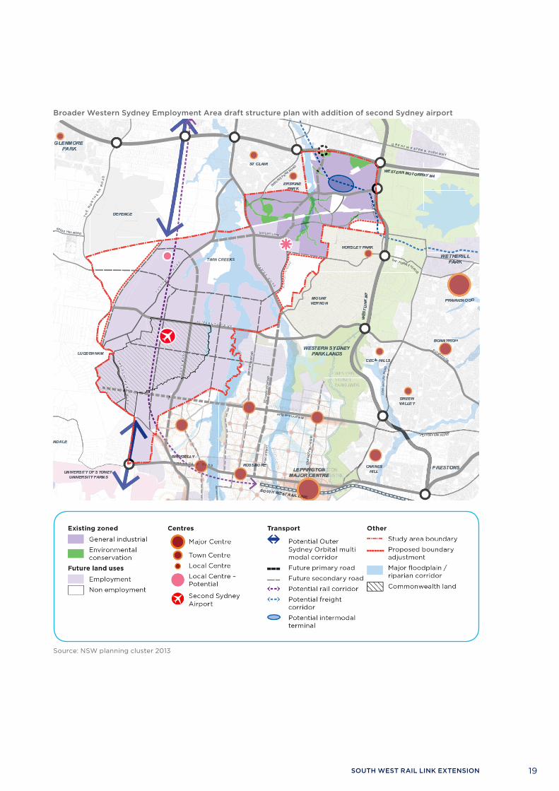
BROADER WESTERN SYDNEY EMPLOYMENT AREA
The Broader Western Sydney Employment Area extends 20km south-west from the intersection of the M4 and M7 motorways, between the North West and South West Growth Centres. The area covers more than 10,000 hectares.
The Broader Western Sydney Employment Area has the potential for 57,000 jobs in the next 30 years with a total of over 200,000 jobs planned for the longer term.
In 2013 the NSW Government undertook broad consultation and exhibited the draft Structure Plan for the Broader Western Sydney Employment Area. The aim of the draft Structure Plan is to provide a framework for land use, transport and infrastructure planning at a strategic level.
The draft Structure Plan identifies two Potential Specialised Centres within the Broader Western Sydney Employment Area, including one at Badgerys Creek to
cater for development of employment uses on Commonwealth land. This is the site now planned to accommodate the second Sydney airport.
The draft Structure Plan also includes an indicative “potential rail corridor” for the future South West Rail Link extension north to the Western Line (T1) via Badgerys Creek.
The draft Structure Plan reflects the NSW Government’s priority to ensure land release is fully integrated with transport and infrastructure planning and delivery.
Prior to rezoning, the NSW Government will progress detailed master planning of individual precincts in consultation with stakeholders to confirm site specific land use opportunities and constraints. This will include proposed significant transport infrastructure such as the extension of the South West Rail Link.
SECOND SYDNEY AIRPORTThe Australian Government has announced that Badgerys Creek will be the site of a future second Sydney airport.
The NSW Government is working with the Australian Government on a package of infrastructure to support and complement the development of the airport both in the short-term and longer term.
19SOUTH WEST RAIL LINK EXTENSION
Broader Western Sydney Employment Area draft structure plan with addition of second Sydney airport
Existing Zoned
General Industrial
Environmental Conservation
Future Land Uses
Employment
Non Employment
Centres
Major Centre
Town Centre
Local Centre
Potential Local Centre
Potential SpecialisedCentre
Transport
Potential Outer Sydney
Orbital Multi Modal Corridor
Future Primary Road
Future Secondary Road
Potential Rail Corridor
Potential Freight Corridor
Potential Intermodal
Terminal
Interchange
Other
Study Area Boundary
Proposed Boundary
Adjustment
Major Floodplain
/ Riparian Corridor
Commonwealth Land
05 April 2013
5km
Source: NSW planning cluster 2013

20 SOUTH WEST RAIL LINK EXTENSION
OVERVIEW OF THE CORRIDOR
The NSW Government has identified a potential transport corridor extension that connects to the end of the South West Rail Link at Leppington. The proposed corridor extends from Leppington to Bringelly and then heads in two directions: north to the Western Line near St Marys and south to Narellan.
Benefits of the corridor:The proposed corridor would:
• Provide excellent coverage with well-spaced stations and balanced station catchments (accessed by walking, public transport and private vehicle) when fully developed
• Allow for new stations at Rossmore, Bringelly, Oran Park, Narellan, North Bringelly, and Badgerys Creek
• Serve the second Sydney airport at Badgerys Creek
• Support and facilitate a variety of station types – residential-based stations, centre and business park stations, including interchange opportunities and park and ride
• Provide opportunities for additional stations if required
• Lessen growth pressure on road infrastructure and the Main South Rail Line (T2)
• Support a networked city and balanced residential and jobs growth.
In addition, the section from Leppington to Bringelly then north to Badgerys Creek and the Western Line (T1) near St Marys would:
• Provide new cross-regional connectivity between the Main South (T2) Line, the core of the South West Growth Centre, the Broader Western Sydney Employment Area, the second Sydney airport and the Western Line (T1), connecting to Parramatta, Penrith and potentially the North West Growth Centre in the long term
• Provide access to jobs in and around the second Sydney airport at Badgerys Creek and the Broader Western Sydney Employment Area from major residential catchments in the South West Growth Centre and in the Penrith and Parramatta catchments.
The section from Bringelly to Narellan would:
• Provide mass public transport to the southern residential core of the South West Growth Centre and the nearby areas of Narellan and Camden
• Relieve significant growth pressure on the Main South Line (T2)
• Provide connectivity to the jobs and services at Leppington Major Centre and Liverpool
• Provide a north-south public transport spine and connectivity to the Broader Western Sydney Employment Area.

21SOUTH WEST RAIL LINK EXTENSION
Role of proposed core stations*
Station RoleRossmore Rossmore Station would serve the Planned Town Centre and
residential catchment, and provide a bus interchange and park and ride facilities.
Bringelly Bringelly Station would serve the Planned Town Centre and residential catchment, and provide a rail and bus interchange.
North Bringelly North Bringelly Station would serve the Planned Town Centre and residential catchment, and provide a bus interchange and park and ride facilities.
Badgerys Creek Badgerys Creek Station would serve the second Sydney airport and the Planned Specialised Centre.
Oran Park Oran Park station would serve the Town Centre and residential catchment and provide a bus interchange and potentially park and ride facilities.
Narellan Narellan Station would serve the Town Centre and residential catchment, and provide a bus interchange and park and ride facilities.
* Additional stations will also be considered.

22 SOUTH WEST RAIL LINK EXTENSION
SYDNEY’S MAJOR TRANSPORT CORRIDORS
The NSW Long Term Transport Master Plan identifies 19 major transport corridors across Sydney for future transport requirements. These corridors will provide essential cross-regional connections as Sydney continues to grow. Their protection will allow the cost efficient, long term development of the transport network.
Protected corridors

23SOUTH WEST RAIL LINK EXTENSION
WHY PROTECT A CORRIDOR?
Smart planning for an efficient futureIt makes good transport and planning sense to identify and protect transport corridors before they are needed – to ensure the government is ready to deliver transport infrastructure projects in line with Sydney’s growth.
The NSW Government is building for the future and at the same time the Government is planning for the future by protecting the South West Rail Link extension corridor. In planning ahead, the NSW Government will identify and protect a dedicated corridor that can be used to deliver public transport infrastructure to Sydney’s expanding west and south-west regions.
Corridor protection – why it mattersThe protection of a transport corridor is critical to ensure transport infrastructure can be provided in the longer term to support growth and improve access, particularly in new urban areas.
It is particularly important that key surface corridors are protected for future transport infrastructure as the South West Growth Centre develops alongside the Broader Western Sydney Employment Area and precinct plans are realised.
By planning ahead, the NSW Government is able to provide certainty for local government and the broader community. Identifying the corridor early on means that infrastructure, services and urban development such as housing, schools and hospitals can proceed in a way that allows for and is integrated with transport services.
Corridor protection – what it meansExisting planning powers will be used to protect the South West Rail Link extension corridor for future public transport use. Protecting the corridor this way will ensure development within or near the corridor will not impact the viability of the corridor’s future use for public transport. The NSW Government will eventually acquire all land required for public infrastructure purposes when a specific project has been approved.
Determining a transport modeThe intention is that heavy rail will operate within the public transport corridor. However, a public transport mode for the corridor has not been finalised at this stage.
A decision on the public transport mode for the corridor will be based on detailed analysis to ensure the most appropriate mode is selected that best serves the corridor and the region in the longer term.
Protecting a corridor using design parameters for heavy rail will allow the flexibility for other modes to use the corridor.

24 SOUTH WEST RAIL LINK EXTENSION
PROTECTING PUBLIC TRANSPORT CORRIDORS
As outlined in the NSW Long Term Transport Master Plan, the process of reserving important transport corridors enables the cost efficient, long term development of the transport network.
Transport for NSW is working with the NSW planning cluster to optimise the process for identifying and protecting transport corridors.
The NSW Government is considering corridor protection mechanisms as part of the Planning Reform process.
Currently, the NSW Government principally uses planning instruments known as State Environmental Planning Policies (SEPPs) to protect corridors for future public transport.
The two policies relevant to this project are the Growth Centres SEPP and the Infrastructure SEPP.
About the Growth Centres SEPPSections of the South West Rail Link extension corridor fall within the South West Growth Centre.
Precinct planning is carried out through the State Environmental Planning Policy (Sydney Region Growth Centres) 2006 (the Growth Centres SEPP).
Precinct planning coordinates land use planning and delivery of essential infrastructure including water, wastewater, recycled water, power, roads, transport and other services in time to meet the needs of new communities.
Precinct planning, including zoning controls for the South West Growth Centre, has commenced.
Zoning within a growth centre can make provision for future transport corridors through a special purpose zoning for infrastructure (SP2 – Infrastructure) or special purpose areas.
Once land has been reserved for future public transport, most types of development within or adjacent to the reserved corridor require written agreement from Transport for NSW.
About the Infrastructure SEPPThe NSW Government can also protect corridors for future public transport infrastructure under the Infrastructure SEPP. This protection process can begin once a preferred corridor is identified and endorsed by Government.
The provisions of the Infrastructure SEPP ensure that development within or adjacent to a protected rail corridor does not adversely impact on the viability of future public transport infrastructure.
This type of protection is enforced through a referral process. Approvals for certain types of development within or adjacent to the corridor require the consent authority, such as the local government, to obtain the concurrence of Transport for NSW. This advice would identify whether or not the development proposal would adversely affect the corridor.
Land does not necessarily need to be zoned specifically for infrastructure purposes as part of this corridor protection process.
Corridor acquisitionThe NSW Government would eventually acquire all land zoned for public infrastructure purposes. However, Transport for NSW would generally only acquire property after a specific project has been approved and when funds have been made available for acquisition. In certain limited circumstances, land owners may request an earlier acquisition of land that is reserved for a public purpose.

25SOUTH WEST RAIL LINK EXTENSION
NEXT STEPS
This document is part of the first stage of protecting the future South West Rail Link Extension corridor.
This document supports the first stage of discussion and consultation with the community, councils and other stakeholders along the proposed South West Rail Link Extension corridor.
We invite comments during this and subsequent consultation periods, and will consider your feedback together with further investigations to confirm the future transport corridor.
Steps to protect the corridorProtecting the South West Rail Link extension corridor involves a range of land use, engineering and environmental studies, together with two stages of community and stakeholder consultation.
Identifypotential station locations and a public transport corridor
Investigatespecific alignment options
Protectthe alignment and stations through a statutory planning process
Consultwith stakeholders and the community about station locations and the proposed public transport corridor
Consultwith stakeholders and the community on specific alignment options

26 SOUTH WEST RAIL LINK EXTENSION
HAVE YOUR SAY
To help us best plan for the future public transport needs of Western Sydney, we are consulting with the community about the proposed public transport corridor.
Stage oneBetween 28 April and 6 June 2014, community members and stakeholders have the opportunity to provide feedback on the station locations and the proposed public transport corridor.
Information about the proposal to protect the South West Rail Link extension corridor will be on display at community information and feedback sessions scheduled to correspond with stage one of consultation. Dates and times of the information sessions will be advertised in the local media and online at www.transport.nsw.gov.au/projects-swrl-extension-corridor-protection.
Stage twoAfter the initial community feedback has been received and more detailed alignment work completed, we will be inviting community members and stakeholders to comment on specific alignment options for corridor protection.
HOW TO HAVE YOUR SAYYou can have your say and make a submission on the corridor options by:
• Visiting www.transport.nsw.gov.au/projects-swrl-extension-corridor-protection Follow the links to have your say online
• Emailing us at [email protected]
• Attending a community information and feedback session (details advertised in local media and online at www.transport.nsw.gov.au/projects-swrl-extension-corridor-protection)
• Calling us on 1800 263 882
• Writing to us at: PO Box K659, Haymarket, NSW 1240
You can read a copy of this document at:
Transport for NSW Level 6, 18 Lee Street, Chippendale (near Central Station)
NSW planning cluster Level 5, 10 Valentine Avenue, Parramatta
Submissions close on 6 June, 2014

27SOUTH WEST RAIL LINK EXTENSION

For more information, visit www.transport.nsw.gov.au