City Rail Link Urban Design Framework - Auckland … · 07 August 2012 City Rail Link Urban Design...
34
07 August 2012 City Rail Link Urban Design Framework TO SUPPORT ASSESSMENT OF ENVIRONMENTAL EFFECTS (CITY RAIL LINK NOTICE OF REQUIREMENT) FINAL ISSUE
Transcript of City Rail Link Urban Design Framework - Auckland … · 07 August 2012 City Rail Link Urban Design...

07 August 2012
City Rail Link Urban Design Framework
to sUpport assessment oF environmental eFFects(city rail link notice oF reqUirement)
FINAL ISSUE

i. Revision History
REVISION DATE PREPARED BY DESCRIPTION
A 19th April 2012 Alistair Ray First Draft for Client
B 25th May 2012 Alistair Ray Second Draft
C 8th June 2012 Alistair Ray Final Draft
D 20th June 2012 Alistair Ray Final - Client Issue
E 20th July 2012 Alistair Ray Revised Client Issue
F 7th August 2012 Alistair Ray Final
G 10th December 2012 Alistair Ray Final - Removal of NOR 7, Optimisation of NOR 6
urban design framework: to support assessment of environmental effects (city rail link notice of requirement) august 2012 3

ii. Table of Contents
1.0 introduction1.1 Purpose of this Document ..............................................................................6
1.2 Project Description..........................................................................................6
1.3 Scope, Role and Process ...............................................................................7
1.4 Urban Design Framework Methodology .........................................................8
1.5 Existing Urban Design Principles
and Policy Inputs ..................................................................................9
2.0 urban design principles2.1 Principles ......................................................................................................12
2.2 Mana Whenua Cultural Design Principles ....................................................12
2.3 Movement and Connections ........................................................................16
2.4 Public Realm and Landscape .....................................................................18
2.5 Existing and New Buildings/Structures ........................................................20
3.0 britomart3.1 Existing Environment ....................................................................................22
3.2 Public Realm and Landscape ....................................................................25
4.0 aotea station4.1 Existing Environment ....................................................................................28
4.2 Movement and Connections .......................................................................33
4.3 Public Realm and Landscape .....................................................................34
4.4 Existing and New Buildings/Structures .................................................................................36
5.0 karangahape station5.1 Existing Environment ....................................................................................38
5.2 Public Realm and Landscape .......................................................................45
5.3 Existing and New Buildings/Structures ........................................................47
6.0 newton station6.1 Existing Environment ....................................................................................48
6.2 Movement and Connections ........................................................................53
6.3 Public Realm and Landscape ......................................................................54
6.4 Existing and New Buildings/Structures ........................................................55
7.0 connection to the north auckland line 7.1 Existing Environment ....................................................................................56
7.2 Movement and Connections ........................................................................61
7.3 Public Realm and Landscape .......................................................................61
8.0 urban design matrix8.1 Urban Design Matrix .....................................................................................62
9.0 supporting information9.1 Glossary........................................................................................................64
9.2 Abbreviations ................................................................................................67
9.3 List of Figures ...............................................................................................68
urban design framework: to support assessment of environmental effects (city rail link notice of requirement) august 2012 5

1.1 Purpose of this Document
this urban design framework (udf) has been commissioned by auckland transport to support the notice of requirement (nor) city rail link (crl) with the purpose to establish a framework of urban design principles for the crl that will inform subsequent phases of the crl to deliver high quality urban design outcomes and integration with the surrounding environment.
this urban design framework has been developed by Jasmax, in liaison with rau Hoskins, who provided specialist advice on the incorporation of maori values into the udf.
this udf is an appendix of the assessment of environmental effects (aee) which supports the nor to be served by auckland transport on auckland council to designate the crl for future construction, operation and maintenance. the nor covers surface land, strata land (protection area), and sub-strata land designations within the auckland city district plans (both isthmus and central area sections).
1.2 Project Description
the city rail link (crl) is a 3.4km underground passenger railway (including two tracks and up to three underground stations) running between britomart station and the north auckland line (nal) in the vicinity of the existing mount eden station. the project also requires an additional 850m of modifications within the nal. for ease of reference in this report, the stations included in the crl nor have been temporarily named aotea station, karangahape station, newton station.
Britomartthe designation footprint at britomart includes areas around queen elizabeth ii (qeii) square and the downtown shopping centre and the length of albert street.
several sections of cut-and-cover construction may also be required along the crl route alignment between britomart and aotea station.
Aotea Stationaotea station is to be located below albert street, between victoria and wellesley streets, close to aotea square, queen street and the commercial heart of auckland.
Karangahape Stationthe designation footprint near karangahape road includes beresford street, where the main station entrance will be located, large surface car parks at the lower end of beresford street and a large area between mercury lane and east street.
Newton Stationthe designation footprint near newton road includes the corner site at basque road and new north road, where the main station entrance will be located, the upper end of symonds street and further properties on dundonald street.
Connection to the North Auckland Linethe crl will result in tunnel portals near the current mt eden station, forming the southern end of the tunnel. the designation footprint includes a number of city blocks, stretching from new north road along ruru and shaddock streets to mount eden road.
1.0 Introduction
urban design framework: to support assessment of environmental effects (city rail link notice of requirement) august 20126

Figure 01: Approximate alignment and designation footprint of the operational CRL
BRITOMART
AOTEA STATION
KARANGAHAPE STATION
CONNECTION TO THE NORTH AUCKLAND LINE
NEWTON STATION
LEGEND
Indicative station location
Indicative location of sub-strata alignment
Indicative location of above ground connection to NAL
urban design framework: to support assessment of environmental effects (city rail link notice of requirement) august 2012 7

1.0 Introduction
1.3 Scope, Role and Processthis urban design framework (udf) supports the nor to designate the crl for future construction, operation and maintenance. the nor cover surface land, sub-strata land and sub-strata protection designations within the auckland city district plan (both isthmus and central area sections).
the overall purpose of the crl is to improve the transport network. auckland transport (at) recognises the opportunity provided by major infrastructure projects, such as crl, to contribute positively to the surrounding environment. ensuring good urban design outcomes is increasingly recognised as a key strategy to help avoid, remedy and mitigate potential adverse effects under the resource management act (rma).
the role of this udf is to provide urban design direction to deliver high quality urban design outcomes from the implementation of the crl. it covers all aspects of the crl, where it directly or indirectly impacts on the above ground streetscape. for the avoidance of doubt, architectural requirements of specific station designs or specific engineering requirements are excluded from the scope of this udf.
urban design framework: to support assessment of environmental effects (city rail link notice of requirement) august 20128

Principles
the udf establishes a set of specific urban design and mana whenua cultural design principles at the concept design stage which will inform all later stages of design that will apply at each location, where the crl manifests itself above ground. all subsequent design work (concept design, reference design, detailed design and construction) for the crl will be developed with reference to these principles in order to ensure that the crl delivers the best urban design outcomes.
for the avoidance of doubt, the principles apply at every location, where the crl manifests itself above ground.
These Principles have been grouped into 4 main design themes - firstly principles relating to Mana whenua cultural design, then 3 groups of urban design principles. For ease of use, all of these principles are numbered and are identified using this blue text box.
Design Initiatives
the opportunities for location specific application of the principles determines initiatives that may be implemented by the crl.
the initiatives fall both within the designation and within the requiring authority’s control.
For ease of use, these Initiatives are numbered and identified using this yellow text box.
1.4 Urban Design Framework Methodology
a number of project specific urban design principles (principles) have been produced for the areas within the designation footprint, which have been drawn from the following:
• ThereviewofpreviousworkassociatedwiththeCRLduring 2009 and 2010
• Areviewofexistingurbandesignprinciplesand frameworks, at both a national and local level
• AreviewofAT’semergingurbandesignprinciples
• Sitevisits
• LiaisonwithAT’sappointedSpecialistsinUrbanDesign (maori), ecology and built Heritage
urban design framework: to support assessment of environmental effects (city rail link notice of requirement) august 2012 9

1.0 Introduction
The Auckland Plan, 2012
the following good design principles underpin the auckland plan, the unitary plan, infrastructure plans and the auckland design manual. these principles form a complete set, which collectively indicate what attributes are required to make a place successful.
identity:landscape and ecology, heritage, built form, people and communities together establish the context for auckland’s unique sense of place.good design must recognise and respond to this context, with development enriching character, quality, legibility and a sense of place.
diversity:auckland should accommodate a rich mix of uses, activities, urban form and architecture, which
supports variety, vibrancy, chance exchange, safety and choice.good design must encourage and embed flexibility and adaptability, to ensure continued support for our changing communities, cultures, built form and environments.
integration:development in auckland should support uses, activity centres, energy systems and movement networks which are well-connected, and provide convenient and universal access to a range of services and amenities.the cumulative picture of a street, a block, a neighbourhood and the city - not just buildings, roads or open spaces as individual elements - must be recognised and responded to.good design must ensure that development supports existing and/or creates integrated urban form (including streets and spaces), to facilitate well-being, movement and access.
efficiency:the benefits and efficiencies of urban systems need to be maximised, delivering quality places where transactions and exchange are encouraged and resources optimised. good design must ensure that development focuses on benefits and positive effects, and optimises the full potential of a site’s intrinsic qualities. this includes site shape, relationship to the street, landform, outlook and proximity to services, amenities and infrastructure.
1.5 Existing Urban Design Principles and Policy Inputs
the project specific principles within this document have been determined by synthesising higher level urban design principles and strategies that currently exist in the following documents:
• te aranga maori cultural landscape strategy and mana whenua /maori cultural landscape principles & cultural landscape design approaches, rau Hoskins (June 2012)
• new Zealand urban design protocol, ministry for the environment, 2005
• auckland city council cbd urban design framework (november 2008)
• auckland transport’s emerging project specific urban design principles
• auckland city centre masterplan, 2011 (ccmp)
• auckland council draft “auckland design manual”
• auckland transport code of practice
• people + places + spaces: a design guide for new Zealand, ministry for the environment, 2002
• the auckland plan, 2012
SEPTEMBER 2011
DRAFTCITY CENTRE MASTERPLAN_
.
People + Places + Spaces: A Design Guide for New Zealand, Ministry for the Environment, 2002
this guide outlines both urban design and process principlesto achieve good urban outcomes and support sustainabledevelopment. the purpose of this guide is to give all peopleinterested in more liveable and prosperous urban areas –professionals, councillors, business people and the widercommunity – a taste of what urban design is, and how toachieve better urban design.
A design guide for urban New Zealand
Peop le+P laces+Spaces
the guide identifies 5 commondesign principles that are criticalin creating successful urbanplaces:• consolidation + dispersal
• integration + connectivity
• diversity + adaptability
• legibility + identity
• environmental responsiveness
Auckland City Council CBD Urban Design Framework (November 2008)
this framework is a key mechanism for delivering a high quality urban environment within the city centre.
Designing a great city centre for our peoplePart 1
A framework for achieving high quality urban design in Auckland’s city centre
phone 09 379 2020 or visit www.aucklandcity.govt.nz
it expands on the aspirations identified in the citywide urban design framework by applying the council’s six urban design goals to the city centre’s unique context.
these goals are for auckland to be:• distinctive
• compact
• connected
• sustainable
• beautiful
• Human
urban design framework: to support assessment of environmental effects (city rail link notice of requirement) august 201210

New Zealand Urban Design Protocol, Ministry for the Environment, 2005
New ZealandUrban Design Protocol
The New Zealand Urban Design Protocol provides a platform to make New Zealand towns and cities more successful through quality urban design. The Urban Design Protocol is a voluntary commitment by central and local government, property developers and investors, design professionals, educational institutes and other groups to undertake specific urban design initiatives.
The Urban Design Protocol identifies seven essential design qualities that together create quality urban design:
• context: seeing buildings, places and spaces as part of whole towns and cities
• character: reflecting and enhancing the distinctive character, heritage and identity of our urban environment
• choice: ensuring diversity and choice for people
• connections: enhancing how different networks link together for people
• creativity: encouraging innovative and imaginative solutions
• custodianship: ensuring design is environmentally sustainable, safe and healthy
• collaboration: communicating and sharing knowledge across sectors, professions and with communities.
Emerging Auckland Transport Project Specific Urban Design Principles
Fitting into the built fabric • consider the role of networks in the structuring of neighbourhoods, towns, cities and regions. • consider transport, surrounding land uses and community needs in planning and designing street networks and hierarchies. • create streets and boulevards that provide a sense of place by keeping the footprint of the street to a minimum. • avoid adverse impacts (incl. visual and noise) in the planning and design of all streets.
Connecting modes and communities • consider connectivity within and through surrounding environments for all modes including walking, cycling, public transport, freight
traffic and the private automobile • consider connectivity between modes. • consider where people want to cross and the quality of crossing points along a busy road.
Design Sustainably • form all streets in response to topography and landform. • integrate natural patterns, systems and minimise ecological footprints in all street and station designs. • maximise local resource use and minimise waste. • ensure physical continuity of natural systems. • consider slope stabilisation design as part of the project. • use natural characteristics in the street’s landscape design (eg. low impact design)
Incorporating heritage and cultural contexts • preserve and integrate historic streets, buildings, structures and precincts into overall street design • adapt and reuse heritage infrastructure in projects • protect and incorporate cultural and natural heritage along the selected corridor
Designing an experience in movement along streets • create/enhance the views to and from the street • provide visual stimuli within the street corridor • create a progressive sequence of visual events
Creating self-explaining road environments • create streets that provide both place and movement functions along the full corridor • distinguish between the different functions and speeds of streets by differentiating their appearance • improve the legibility of streets
Achieving integrated and minimal maintenance design • use robust durable materials fit for purpose and place • provide a relatively self-reliant and minimal maintenance natural landscape • avoid opportunities for vandalism • create a simple, coordinated and neat composition of street elements along a corridor • consider the design quality of major street components and individual street elements
urban design framework: to support assessment of environmental effects (city rail link notice of requirement) august 2012 11

2.0 Urban Design Principles
from our synthesis of existing urban design policies, frameworks and previous studies concerning the crl, a series of specific urban design and mana whenua cultural design principles emerge that are specific to the crl.
all subsequent design work (concept design, reference design, detailed design and construction) for the crl will be developed with reference to these principles in order to ensure that the crl delivers the best urban design outcomes.
principles define a qualitative aspiration, as opposed to minimum standards, provided by rules. the order in which the principles are set out below does not represent a priority order. it is expected that subsequent designers of the crl will be informed by the principles outlined in the udf as part of the design accountabilities.
the first set of principles relates to mana whenua cultural design, recognising the opportunity to acknowledge and celebrate the rich maori pre and post european contact history that is prevalent in this area. all of these principles apply to all locations.
following the mana whenua cultural design principles, a number of urban design principles have been identified that are specific to the crl.
for ease of reference, these principles are set out below and are grouped under 3 main urban design themes that relate to existing higher level urban design policies and strategies.
• movement and connections
• public realm and landscape
• existing and new buildings / structures
these themes and principles with particular location sensitivity are used as a basis for analysis and identification of initiatives and opportunities for each station location.
2.1 Principles
the auckland city centre area including the proposed crl route is particularly rich in maori pre and post european contact history and there are
now significant opportunities for these iwi cultural landscape design principles and elements to be acknowledged and celebrated within the wider crl stations design and development process.
from the early 1840s to the present time, the development of auckland city has overlain and erased iwi cultural landscape elements making it difficult for iwi to maintain kaitiakitanga or a sense of place connection which acknowledges this rich iwi history.
the following principles and cultural landscape design approaches are provided to support the crl project. in developing these principles we have drawn on principles developed with mana whenua groupings as part of the te aranga maori cultural landscape project and in the course of other auckland transport projects. these principles do not substitute for the requirement for at to consult with mana whenua under the rma. the principles are to be augmented by individual maori values assessments to be provided by mana whenua.
the following historic map (figure 02) records some of the ancestral names associated with the crl route each of which have an associated iwi narrative. these and other names to be provided by iwi will be able to inform architectural, landscape, urban design and public art responses to the range of built environments associated with the crl.
2.2 Mana Whenua Cultural Design Principles
urban design framework: to support assessment of environmental effects (city rail link notice of requirement) august 201212

Figure 02: 1938 George Kelly Map showing CRL route area
urban design framework: to support assessment of environmental effects (city rail link notice of requirement) august 2012 13
2.0 Urban Design Principles
MW1Mana / Rangatiratanga – As the original local authorities of Tamaki Makaurau, Iwi require high level Treaty based relationships with all key stakeholders including Auckland Transport and Auckland Council which recognise their Tangata
Whenua status in order to fulfill their roles as kaitiaki. Such partnership relationships can then inform engagement with AT / Council at all levels including direct involvement with design consortia.
Relationships are required at governance and senior management levels.
Such relationships are a precursor to actualising the other 6 principles.
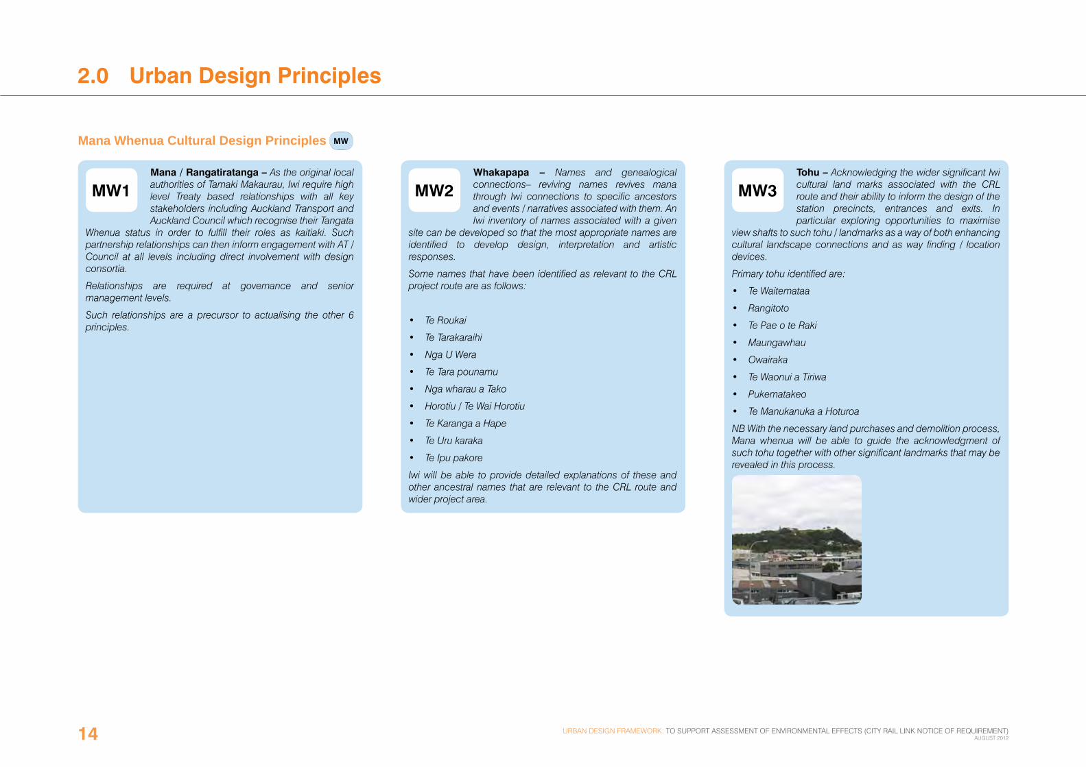
MW3Tohu – Acknowledging the wider significant Iwi cultural land marks associated with the CRL route and their ability to inform the design of the station precincts, entrances and exits. In particular exploring opportunities to maximise
view shafts to such tohu / landmarks as a way of both enhancing cultural landscape connections and as way finding / location devices.
Primary tohu identified are:
• Te Waitemataa
• Rangitoto
• Te Pae o te Raki
• Maungawhau
• Owairaka
• Te Waonui a Tiriwa
• Pukematakeo
• Te Manukanuka a Hoturoa
NB With the necessary land purchases and demolition process, Mana whenua will be able to guide the acknowledgment of such tohu together with other significant landmarks that may be revealed in this process.
Mana Whenua Cultural Design Principles MW
MW2Whakapapa – Names and genealogical connections– reviving names revives mana through Iwi connections to specific ancestors and events / narratives associated with them. An Iwi inventory of names associated with a given
site can be developed so that the most appropriate names are identified to develop design, interpretation and artistic responses.
Some names that have been identified as relevant to the CRL project route are as follows:
• Te Roukai
• Te Tarakaraihi
• Nga U Wera
• Te Tara pounamu
• Nga wharau a Tako
• Horotiu / Te Wai Horotiu
• Te Karanga a Hape
• Te Uru karaka
• Te Ipu pakore
Iwi will be able to provide detailed explanations of these and other ancestral names that are relevant to the CRL route and wider project area.
urban design framework: to support assessment of environmental effects (city rail link notice of requirement) august 201214

MW4Taiao – Exploring opportunities to bring natural landscape elements back into urban /modified areas eg. specific native trees, water / puna wai (springs) – promoting bird, insect and aquatic life to create meaningful urban eco systems
which connect with former habitats, mahinga kai (food gathering areas) and living sites.
Key iwi natural landscape elements identified:
• Use of Pakawera / basalt
• Puna / springs and streams
• Use of selected native plantings which have local cultural relevance to Iwi
MW5Mauri tu – Ensuring emphasis on maintaining or enhancing environmental health / life essence of the wider site – in particular focusing on the quality of wai / water (puna / springs), whenua /soil and air. In particular any puna or underground
waterways encountered should be carefully treated with Mana whenua assistance to ensure their mauri is respected and enhanced where possible. It is also important to minimise the disturbance to Papatuanuku through carefully planned ground works.
MW7Ahi kaa – need to explore opportunities to facilitate living presences for iwi / hapu to resume ahi-kaa and kaitiaki roles in and around the CRL route and new station precincts.
Acknowledging the post Treaty of Waitangi settlement environment where Iwi living presences can include customary, cultural and commercial dimensions including joint ventures with local authorities and private developers.
MW6Mahi toi – Harnessing the Creative dimension through drawing on names and local tohu to develop strategies to creatively re-inscribe iwi narratives into architecture, interior design, landscape, urban design and public art.
Iwi appointed designers and artists will be available to assist in such collaborative design projects.
urban design framework: to support assessment of environmental effects (city rail link notice of requirement) august 2012 15

2.0 Urban Design Principles
MC1Existing Networks - Structures of the CRL should not interrupt or adversely change the function of existing public open space, street networks and infrastructure.
2.3 Movement and Connections MC
The Importance of Good Design
good design brings comprehensive public benefits by integrating transport-specific requirements with broader objectives, such as strengthening our cultural identity and sense of place, creating highly regarded public spaces and increasing public access to transport, through design that is inclusive and seamless.
good design has the ability to positively transform how people feel and behave. in the case of transport infrastructure, it can increase patronage by providing places which feel safe and comfortable, are accessible and easy to use, connected to other community facilities and are great places to be. well-designed places also tend to be better respected and cared for, with lower incidences of vandalism and graffiti. great public structures and places can delight us and raise our spirits.
“Public transport facilities are, first and foremost, public spaces, and like any decent public spaces they need to marry the functional and the personal. Without function, a train station is just a collection of elevated footpaths, but without the personal, a station can be a barrier to travel. Good design brings down the barriers to public transport and allows us to shift between walking and cycling and public and private transport seamlessly. Small differences matter; good design in transport doesn’t require an edifice complex – sometimes it’s a bicycle cage other times it’s a deftly designed access ramp that connects form and function.”
Jim betts, secretary, victoria department of transport, australia
urban design framework: to support assessment of environmental effects (city rail link notice of requirement) august 201216

MC2Entrance Location - Station entrances should be clearly identifiable and conveniently located in relation to existing and anticipated main pedestrian routes and destinations.
MC3Intuitive Orientation - The location and nature of structures resulting from the CRL (station entrances in particular) should facilitate intuitive orientation and support a legible street network.
MC4Way Finding - Coherent signage should be utilised to aid intuitive orientation and way finding.
Orienting station entrances and exits to views and view shafts to significant landmarks can
also assist with way finding. (refer also to Mana Whenua Design Principle MW3 - Tohu)
MC5 Mode Integration - Spatial integration with bus stops as well as kiss and ride should be facilitated where reasonably practicably without imposing on the quality of public realm.
MC6 Bicycle Parking – Appropriate numbers of safe bicycle storage or parking should be provided in each station environment.
MC7 Street Crossings - Safe pedestrian street crossings should be facilitated in the immediate vicinity of station entrances. The provision of level street crossings is preferable over any grade separated solutions.
urban design framework: to support assessment of environmental effects (city rail link notice of requirement) august 2012 17

2.0 Urban Design Principles
PRL1Existing Streetscape – Structures of the CRL should be designed to contribute positively to the form and function of existing public open space.
PRL3Safe Environments – Structures resulting from the CRL should promote safe environments. The station entrances should release patrons into safe public spaces that are well lit at night, overlooked by other users (e.g. residents or
workers) and have sufficiently wide and unobstructed footpaths.
PRL4Reinstated Surfaces - The design and construction of reinstated streetscapes should be coherent with the wider area and/or recent public realm upgrades in the area.
PRL2Universal Access – Station environments should promote universal access (e.g. footpath ramps and smooth ground surfaces).
2.4 Public Realm and Landscape PRL
urban design framework: to support assessment of environmental effects (city rail link notice of requirement) august 201218

PRL5 Station Plazas - The design and construction of station plazas should be coherent with the wider area and/or recent public realm upgrades in the area.
Opportunities to re-inscribe Iwi cultural narratives into the wider design of Station plazas should be explored.
The plaza design and layout should promote flanking the public space with active frontages with building entrances and appropriate fenestration.
PRL6Public Art - Integration of art and design should foster local identity and character and reflect and / or interpret local characteristics like natural heritage and Mana Whenua cultural narratives, history, art and particular traits of the local
community. (refer also to Mana Whenua Design Principles MW6 - Mahi toi and MW7 - Ahi kaa)
PRL8Entrances within the Road Reserve - Designs for station entrances within the road reserve should be designed to consider the impacts upon other modes of traffic modes of traffic, including the expected pedestrian patronage.
PRL7 Landscape Planting – Plant species used in station environments and/or as part of landscape plantings should consider the opportunity to acknowledge the area’s pre-human ecology as and where appropriate. This may include species
which connect strongly with local Mana Whenua cultural narratives (refer also to Mana Whenua Design Principle MW4 - Taiao).
PRL9 Utility Structures - Above ground utility structures (e.g. vents, access services) should be designed to limit any negative effect on public realm. Where possible these structures should be integrated with other buildings.
PRL6Public Art - Integration of art and design should foster local identity and character and reflect and / or interpret local characteristics like natural heritage and Mana Whenua cultural narratives, history, art and particular traits of the local
community. (refer also to Mana Whenua Design Principles MW6 - Mahi toi and MW7 - Ahi kaa)
urban design framework: to support assessment of environmental effects (city rail link notice of requirement) august 2012 19

2.0 Urban Design Principles
BS1Built Heritage
Where built heritage is required for CRL station requirements, adaptive reuse strategies should be considered to preserve the building’s role in establishing the streetscape and urban
character.
BS2 Bulk, Scale and Massing
Bulk, scale and massing of structures resulting from the CRL should be sympathetic with the surrounding built urban form.
BS3Other Uses
Structures resulting from the CRL should promote mixed use environments. Station buildings may accommodate other uses, where practical and aligned with governing planning rules.
2.5 Existing and New Buildings/Structures BS
urban design framework: to support assessment of environmental effects (city rail link notice of requirement) august 201220
BS4Active Frontage
Structures resulting from the CRL should present an active frontage towards public spaces like streets, squares, pedestrian walkways, etc.
Impact of handling plant and machinery on the appearance of station buildings and public realm should be minimised. It is preferable to integrate these structures within new buildings. The building exterior should enhance the public realm.
BS5Weather Protection
Where practical, station entrances should provide some weather protection along their frontage (e.g. verandahs, awnings, canopies etc.) and these should be considered as part of the design.
BS7Identity
The design of the station entrances should provide an expression that reflects their respective context and local cultural identity. They could reflect, respond and/or interpret
local characteristics like natural or Mana Whenua heritage, history, art, particular traits of the local community and unique
architectural and urban forms of the area. (refer also to Mana Whenua Design Principles MW2 - Whakapapa and MW6 - Mahi toi).
BS6Adaptability
The design of structures resulting from the CRL should be able to adapt to change over time (e.g. change of uses, innovations in technology etc.) where reasonably practical and anticipate opportunities
(e.g. additional entrances) that may become possible in the future. The station design should not inhibit wider development opportunities (e.g. above or around station entrances).
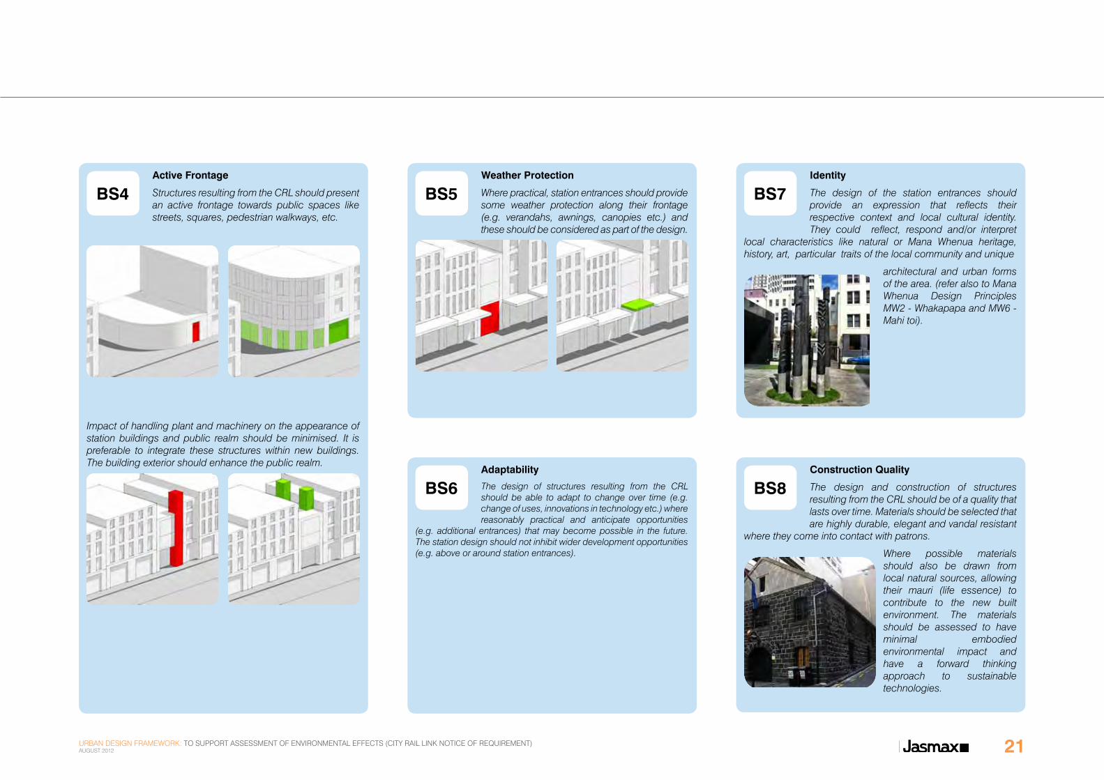
BS8Construction Quality
The design and construction of structures resulting from the CRL should be of a quality that lasts over time. Materials should be selected that are highly durable, elegant and vandal resistant
where they come into contact with patrons.
Where possible materials should also be drawn from local natural sources, allowing their mauri (life essence) to contribute to the new built environment. The materials should be assessed to have minimal embodied environmental impact and have a forward thinking approach to sustainable technologies.
urban design framework: to support assessment of environmental effects (city rail link notice of requirement) august 2012 21

3.0 Britomart
3.1 Existing Environment
the britomart area was historically a foreshore area which acted as a canoe landing area for hundreds of years prior to the establishment of auckland city in 1841. britomart, built on reclaimed land, was the first railway station in auckland.
Please refer to the Built Heritage and Archaeological Assessment for further detail regarding the history of the area.
the return of the building to a railway station has seen the precinct of victorian warehouses developed as a mixed use precinct with a focus on retail (figure 11). many of the early warehouses and other commercial buildings remain intact and have been recognised as significant or iconic heritage items in the city. they have been adapted and redeveloped to house boutique offices, galleries, high quality retail and cafes (figure 05).
the britomart transport centre is currently accessed via the converted auckland central post office building on queen street (figure 10). further station access is provided via a tunnel from qeii square, immediately opposite the main entrance of britomart transport centre (figure 06), and via a second station access from takutai square, to the west of the main station building.
the britomart transport centre will have increased passenger capacity as it becomes a ‘through station’ as well as a destination. construction of the rail link from britomart to aotea station will require above ground works around britomart, including qe ii square, the downtown shopping centre and albert street.
Figure 05: Historic buildings in the Britomart precinct
Figure 04: Attractive public realm at Britomart Transport Centre
Figure 03: Customs Street looking West towards Queen Street urban design framework: to support assessment of environmental effects (city rail link notice of requirement)
august 201222

Figure 06: Queen Elizabeth II Square with Station Entrance to Britomart Transport Centre
Figure 07: “Kauri” inspired columns in Britomart Transport Centre
Figure 08: ‘Barnes Dance’ crossing at Customs and Queen Street
urban design framework: to support assessment of environmental effects (city rail link notice of requirement) august 2012 23

3.0 Britomart
0 5m 10m 20m
50mN
PREPARED FOR
REV.
JOB No.
SCALE @ A1 1:
DRAWING No.
SCALE @ A3 1 :1 : 1250
27/04/2012 12:40:26 p.m.
City Rail Link - Britomart Station
March 2012
Auckland Transport
LOCATION PLAN
001
212005ASK-B
DRAFT
Plan
LOCATION PLAN
2500
QU
EEN
STR
EET
GALWAY STREETCUSTOMS STREET
TYLER STREET
QUAY STREET
ALBE
RT S
TREE
T
COM
MER
CE S
TREE
T
GO
RE S
TREE
TFORT STREET
MAR
T PL
ACE
BRITOMILLS LANE
W A T E R F R O N T A R E A
V I A D U C T H A R B O U R
E M I L YP L A C E
C O M M E R C I A L C O R E
Britomart Transport Centre
City Farmers’ Market
QEII Square
Ferry Terminals
TakutaiSquare
1
2
Figure 09: CRL initiatives in context of the Britomart area
LEGENDDestination
Approximate CRL alignment
Main retail street
Protected built heritage and character overlay areas(as identified in the Auckland City District Plan Central Area Section - Operative 2004 - Planning Overlay Map 6)
Open space initiative
Public realm improvement
Movement routes(thickness indicates hierarchy)
Initiative
urban design framework: to support assessment of environmental effects (city rail link notice of requirement) august 201224

3.2 Public Realm and Landscape the lower part of queen street is closed to the general traffic. it features co-located bus stops and forms part of the britomart transport centre as an integrated transit interchange (figure 06).
quay and customs street are both dominated by large amounts of vehicle traffic while also serving significant pedestrian patronage. multiple traffic lanes form barriers to pedestrian movement. street profiles with only limited street tree plantings provide poor amenity. these streets have been identified in the city centre master plan (2012) and Jan gehl’s public life survey (2010) for major overhauls to incentivise walking and cycling.
qeii square lacks activation, with queen street being the only street frontage and only a very limited number of building entrances oriented onto the square (figure 06). qeii square is located on a large city block between queen, albert, customs and quay streets. construction of the crl may require one or a number of vents in or near the location of qeii square.
at the time of writing this udf, relatively recent streetscape upgrades have been completed and further work is underway in the britomart area, resulting in significantly improved material palettes and street furniture (figure 04).
according to the central area thematic mapping (2008) the pre-human vegetation communities in the britomart area and surrounds are likely to have consisted of matai, kahikatea and totara forests. native trees of particular cultural significance to mana whenua should be selected.
Initiative 1: Reinstatement of Albert Street
0 5m 10m 20m
50mN
PREPARED FOR
REV.
JOB No.
SCALE @ A1 1:
DRAWING No.
SCALE @ A3 1 :1 : 1250
27/04/2012 12:40:26 p.m.
City Rail Link - Britomart Station
March 2012
Auckland Transport
LOCATION PLAN
001
212005ASK-B
DRAFT
Plan
LOCATION PLAN
2500
Street upgrades and public realm improvements should be considered when Albert Street is reinstated. The design and construction should utilise material palettes, planting schedules and street furniture that is coherent with recent streetscape upgrades around Britomart and the lower City Centre area.
The new rail tunnel curving around to Albert Street moves into the area of an historic headland Pa known as Nga U Wera. Here we move from the realm of Tangaroa (previous foreshore area) to Papatuanuku so this transition should be celebrated with a waharoa (carved lintel or gateway) threshold.
This initiative is a response to principles:
MW3 MW4 MW6 PRL1 PRL4 PRL7
Initiative 2: Integration of Utility Structures at QEII Square
0 5m 10m 20m
50mN
PREPARED FOR
REV.
JOB No.
SCALE @ A1 1:
DRAWING No.
SCALE @ A3 1 :1 : 1250
27/04/2012 12:40:26 p.m.
City Rail Link - Britomart Station
March 2012
Auckland Transport
LOCATION PLAN
001
212005ASK-B
DRAFT
Plan
LOCATION PLAN
2500
Above ground utility structures should be designed to minimise their negative effect on QEII Square. Where possible, these structures should be integrated within other buildings. Structures of the CRL should be respectful of existing qualities of public realm, contribute positively and present an active frontage towards the square.
This initiative is a response to principles:
MC1 PRL1 PRL9 BS4
urban design framework: to support assessment of environmental effects (city rail link notice of requirement) august 2012 25

3.0 Britomart
Figure 10: Britomart Transport Centre main station entrance.
Figure 11: Roukai Lane.
Figure 12: Auckland Waterfront - 1840’s
urban design framework: to support assessment of environmental effects (city rail link notice of requirement) august 201226

Initiative 3: Public Art, Identity & Cultural Landscape
Open space designs and the design of structures resulting from the CRL should consider the integration of public art that fosters local identity and character. The Britomart area is rich in heritage that could be interpreted in the form of public art.
Of particular mention are this area’s role as the birthplace of Auckland and the opportunity to celebrate Tangaroa the god from whom this area was reclaimed following the European settlement of Auckland in 1841.
For further and more in-depth information on heritage, please refer to the Built Heritage Assessment.
A further specific local characteristic is this area’s close proximity and its connection to the Waitemata Harbour and the historic Ferry Building.
Potential Mana Whenua Design Themes for Britomart
Building on the 2004 Ngati Whatua Maori Values Assessment work for Britomart Station, there are significant opportunities to celebrate the rich mana whenua heritage of the area including:
• Acknowledging the realm of Tangaroa / Tauranga waka (waka landing area)
• Te Roukai a former shellfish ground (mahinga kai)
• Te Tarakaraihi a historic site near the bottom of Albert Street.
• Acknowledging the Threshold to Papatuanuku as the rail tunnel is extended from the realm of Tangaroa
• A Pare / Waharoa (carved lintel or gateway) may be appropriate to acknowledge this transition
This initiative is a response to principles:
MW2 MW3 MW4 MW5 MW6 PRL6 BS7
Figure 13: Historic view, looking towards point Britomart (originally known as Te Rerenga Ora Iti) as seen from what is now called Shortland St (1859)
Figure 14: Historic Ferry Building with ferry wharf and Albert Street (1916)
Figure 15: Molly Macalister’s 1960’s bronze statue ‘Maori Chief’ on Queen St.
urban design framework: to support assessment of environmental effects (city rail link notice of requirement) august 2012 27

4.0 Aotea Station
4.1 Existing Environment
auckland’s city centre is the geographical and economic heart of the auckland metropolitan area. bounded by several major motorways and by the harbour coastline in the north, it is surrounded further out by mostly suburban areas. it is one of the most densely built-up areas of new Zealand.
the area is located in proximity to several early pa sites and walking tracks used by maori. the area of today’s city centre near aotea station was the site of the original european settlement of auckland, oriented along the coastline and then queen street.
Please refer to the Built Heritage and Archaeological Assessments for further detail regarding the history of the area.
the proposed aotea station is located in the heart of the city centre, below albert street, between victoria and wellesley streets, and it is anticipated to be the busiest train station in auckland. the station will be a catalyst for future commercial growth and continuing public realm upgrades, enhancing connections to major city attractions, destinations and precincts. aotea square, the town Hall, sky tower, auckland university of technology (aut), auckland city library and auckland council are a small selection of the many destinations that will be directly accessible from the aotea station.
auckland council has instigated several urban regeneration schemes in the areas surrounding the station location. these include the recent redevelopment of aotea square in 2010 and the conversion of darby and elliott streets into shared spaces in 2011-12 (figure 21, figure 22, figure 23, figure 25, figure 26).
Figure 16: Victoria Street looking West from Queen Street.
urban design framework: to support assessment of environmental effects (city rail link notice of requirement) august 201228

05moVe
deVelopment capacity: aotea quarter
Potential built form
Figure 17: Illustrative diagram from City Centre Master Plan (CCMP), showing the development potential within the Aotea Station environment. figure 19: low quality pedestrian environment at albert street.
Figure 18: Poor public realm on Albert Street and grade separated access lane.
urban design framework: to support assessment of environmental effects (city rail link notice of requirement) august 2012 29

4.0 Aotea Station
Figure 20: Undeveloped site at the corner of Victoria and Albert Streets. Figure 21: Darby Street looking West towards Albert Street. Figure 22: Queen Street concert on Darby Street.
urban design framework: to support assessment of environmental effects (city rail link notice of requirement) august 201230

Figure 23: Recent streetscape upgrade - shared surface at Elliott Street.
Figure 24: Recent streetscape upgrade - shared surface at Lorne Street.
Figure 25: Event at Aotea Square - Auckland Town Hall in the background.
Figure 26: Recent public realm upgrade - Aotea Square.
urban design framework: to support assessment of environmental effects (city rail link notice of requirement) august 2012 31

4.0 Aotea Station
Figure 27: CRL initiatives in context of the Aotea Station vicinity
0 5m10m 20m 50m
N
QUE
EN S
TREE
T
ALBE
RT S
TREE
T
HOBS
ON
STRE
ET
NELS
ON
STRE
ET VICTORIA STREET
WELLESLEY STREET
MAYORAL
DRIV
E
DARBY STREET
ELLI
OTT
STR
EET
FEDE
RAL
STRE
ET
DURHAM STREET W
A L B E R T P A R K
Aotea Square
Auckland Art Gallery
Auckland City Library
Skytower& Skycity Complex
Aotea Centre
C O M M E R C I A L C O R E
Cinema
The Civic Theatre
St. James Theatre
2
2
3
5
5
7
3
3
1
2
LEGENDDestination
Approximate CRL alignment
Main retail street
Protected built heritage and character overlay areas(as identified in the Auckland City District Plan Central Area Section - Operative 2004 - Planning Overlay Map 6)
Street crossing initiative
Public realm improvement
Approximate Station Location
Linkage initiative
Movement routes(thickness indicates hierarchy)
Initiative
urban design framework: to support assessment of environmental effects (city rail link notice of requirement) august 201232

4.2 Movement and Connections
the urban block layout of the area displays rectangular long blocks running north-south, in parallel with queen street. this layout provides only limited permeability to queen street.
wellesley and victoria streets are classified as district arterial roads in the auckland city district plan (central section) 2004 (operative at the time of writing this udf). albert street is classified as a collector road. albert street is dominated by large amounts of vehicle traffic. multiple traffic lanes form barriers to pedestrian movement. street profiles with only limited street tree plantings provide poor amenity (figure 16, figure 18).
numerous bus routes intersect with the crl at aotea station. at the time of writing this udf these transit links are dispersed throughout the area with buses routed through albert and wellesley streets.
wellesley and victoria streets offer the most direct connections to queen street, the city centre’s single most dominant street, and are anticipated to grow in their role as main pedestrian routes in the city centre. the ‘engine room’ area, as the mid-city area north of victoria street is called in the city centre masterplan (ccmp), is auckland’s most significant employment area, vital to the regional and national economy and is the location of choice for national and international corporate head offices. aotea square is a focal point for cultural and entertainment facilities, such as cinemas, theatres, the auckland convention centre, as well as numerous food and beverage outlets, and is a clear destination point (figure 25, figure 26).
long waiting times at street crossings throughout the city centre discourage walking. the ccmp calls for a pedestrian friendly city centre. the aotea station development is likely to increase pedestrian patronage significantly.
pedestrian access from mayoral drive to aotea square is currently unpleasant via an open car park and the ‘back of house’ area of bledisloe House.
the topography falls steeply from albert street to queen street.
Initiative 1: New Link from Mayoral Drive to Aotea Square
0 5m10m 20m 50m
NThe presence of a station entrance at the corner of Wellesley Street and Albert Street in close proximity to the high trip generating functions around Aotea Square will create a stronger desire line between these two points that could be recognised by an improved pedestrian connection. Currently this route is open to the public, but consists of a convoluted route across a public car park and alongside the vehicle access ramp to the underground Aotea Square car park.
This initiative is a response to principles:
MW3 MW4 MC3 MC4 PRL1
Initiative 2: Pedestrian Crossings
0 5m10m 20m 50m
NHigh capacity pedestrian street crossings should be facilitated at the intersections of Wellesley and Victoria Streets with Albert Street as well as a mid-block pedestrian crossing on Albert Street, all to minimise barriers to pedestrian movement.
This initiative is a response to principles:
MW3 MC3 MC7
urban design framework: to support assessment of environmental effects (city rail link notice of requirement) august 2012 33
4.0 Aotea Station
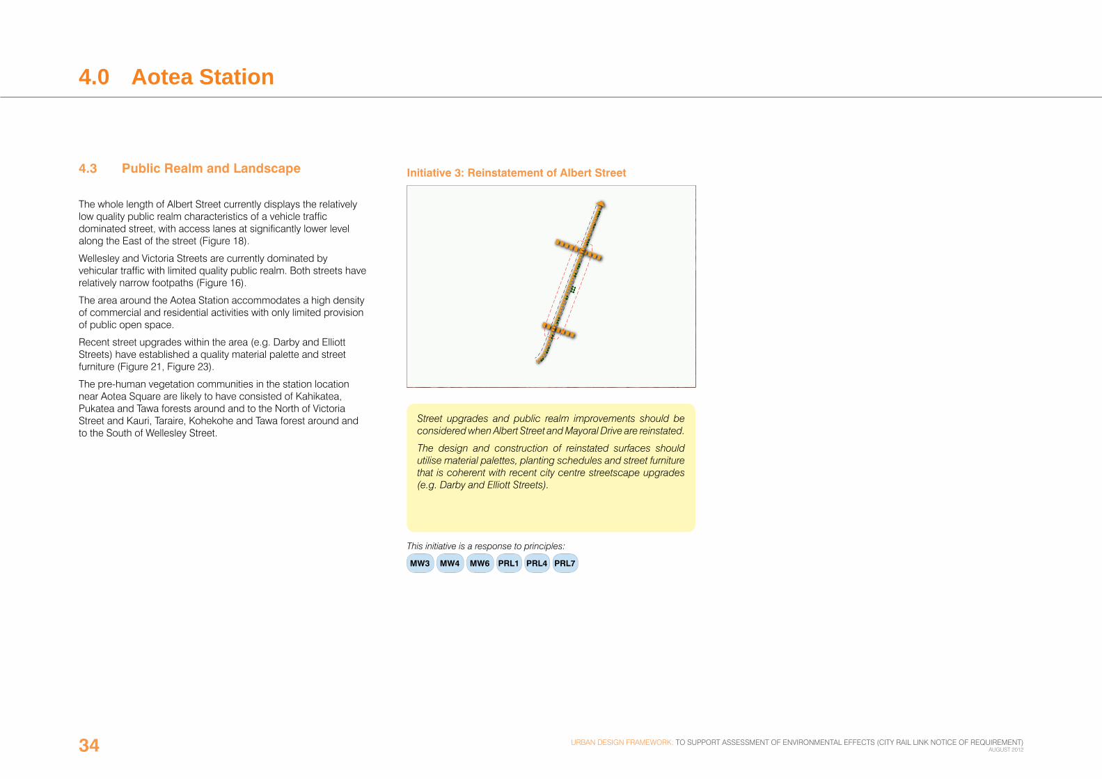
4.3 Public Realm and Landscape
the whole length of albert street currently displays the relatively low quality public realm characteristics of a vehicle traffic dominated street, with access lanes at significantly lower level along the east of the street (figure 18).
wellesley and victoria streets are currently dominated by vehicular traffic with limited quality public realm. both streets have relatively narrow footpaths (figure 16).
the area around the aotea station accommodates a high density of commercial and residential activities with only limited provision of public open space.
recent street upgrades within the area (e.g. darby and elliott streets) have established a quality material palette and street furniture (figure 21, figure 23).
the pre-human vegetation communities in the station location near aotea square are likely to have consisted of kahikatea, pukatea and tawa forests around and to the north of victoria street and kauri, taraire, kohekohe and tawa forest around and to the south of wellesley street.
Initiative 3: Reinstatement of Albert Street
0 5m10m 20m 50m
N
Street upgrades and public realm improvements should be considered when Albert Street and Mayoral Drive are reinstated.
The design and construction of reinstated surfaces should utilise material palettes, planting schedules and street furniture that is coherent with recent city centre streetscape upgrades (e.g. Darby and Elliott Streets).
This initiative is a response to principles:
MW3 MW4 MW6 PRL1 PRL4 PRL7
urban design framework: to support assessment of environmental effects (city rail link notice of requirement) august 201234

Initiative 4: Public Art, Identity & Cultural Landscape
Open space designs and the design of structures resulting from the CRL should consider the integration of public art that fosters local identity and character. The area around Aotea Station is rich in historic and natural heritage that could be interpreted in form of public art.
Items include the area’s pre-settlement ecology as a swamp, the historic tram route along Wellesley Street, the original area of the Auckland Markets and the Council Administration Centre from 1911.
Given the area’s proximity to several early Pa sites and walking tracks, discussions with Mana whenua will allow appropriate names, public art and landscape themes to be developed.
For further and more in-depth information on heritage, please refer to the Built Heritage Assessment.
Further specific local characteristics of this area are the current functions as Auckland’s cultural hub towards Aotea Square and as the city’s commercial heart around Victoria Street.
Potential Mana Whenua Design Themes for Aotea Station:
• Waitemataa view connection
• Horotiu Pa view connection up Victoria St to (Albert Park)
• Te Wai Horotiu (stream) connection
• Station entry and exit Waharoa opportunities
• Acknowledging the connection to Aotea square / cultural precinct with Iwi public art
• Nga wharau a Tako historic site
• Appropriate Native plantings acknowledging specific cultural narratives
• Commercial and cultural opportunities may also be explored as Iwi developments or joint venture projects
This initiative is a response to principles:
MW2 MW3 MW4 MW5 MW6 PRL6 BS7
Figure 28: Historic Auckland Markets around today’s Aotea Square.
Figure 29: Historic tram lines on Wellesley Street.
urban design framework: to support assessment of environmental effects (city rail link notice of requirement) august 2012 35
4.0 Aotea Station
4.4 Existing and New Buildings/Structures
the urban environment around aotea station displays a diverse mix of building typologies ranging from two storey terraces to multi-level high rise developments. building frontages at street level tend to correspond with the road reserve boundary.
there are protected built heritage items and character overlay areas (as identified in the auckland city district plan central area section - operative 2004 - planning overlay map 6) or coherent and identifiable groups of buildings at the immediate street corners of wellesley and victoria streets with albert street. they have both individual and group value. these buildings together with other built heritage in the area, are representative of the historic low-mid scale commercial buildings of auckland and add to the appeal of this part of the city centre that is otherwise dominated by modern high rise buildings. some of these buildings retain historic features, such as shop fronts.
Initiative 5: Built Heritage
0 5m10m 20m 50m
N
It would be preferable to minimise impact on the historic built environment through the station development. Should any buildings identifed in the Built Heritage Report be required as station entrances, this change should be managed, which may include adaptive reuse strategies.
This initiative is a response to principle:
MW7 PRL1 BS1
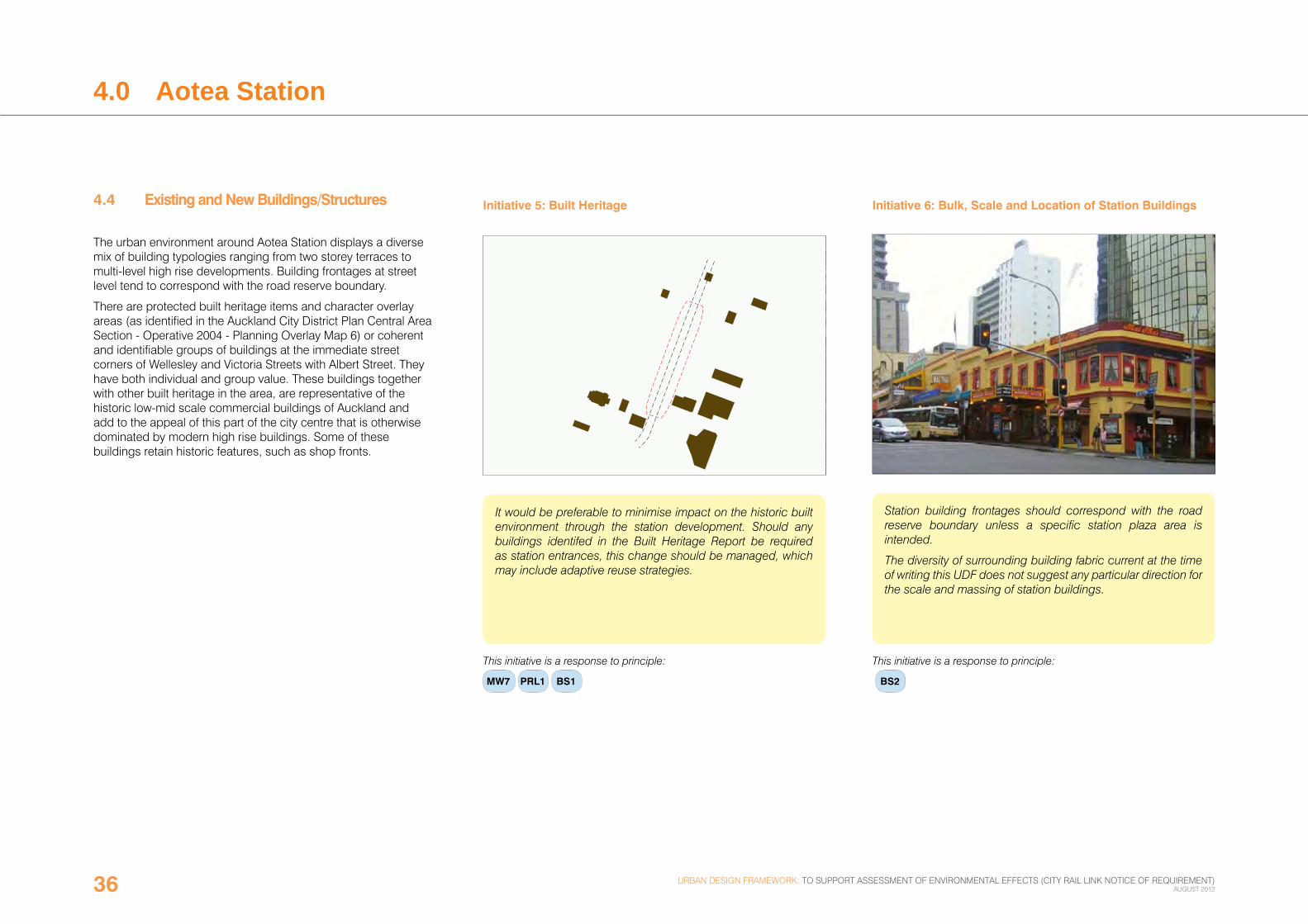
Initiative 6: Bulk, Scale and Location of Station Buildings .
Station building frontages should correspond with the road reserve boundary unless a specific station plaza area is intended.
The diversity of surrounding building fabric current at the time of writing this UDF does not suggest any particular direction for the scale and massing of station buildings.
This initiative is a response to principle:
BS2
urban design framework: to support assessment of environmental effects (city rail link notice of requirement) august 201236