SODIUM CARBONATE BRINE AND TRONA DEPOSITS IN SWEETWATER COUNTY, WYOMING · trona deposits in...
14
GEOLOGICAL SURVEY CIRCULAR 235 SODIUM CARBONATE BRINE AND TRONA DEPOSITS IN SWEETWATER COUNTY, WYOMING
Transcript of SODIUM CARBONATE BRINE AND TRONA DEPOSITS IN SWEETWATER COUNTY, WYOMING · trona deposits in...

GEOLOGICAL SURVEY CIRCULAR 235
SODIUM CARBONATE BRINE AND
TRONA DEPOSITS IN SWEETWATER
COUNTY, WYOMING


UNITED STATES DEPARTMENT OF THE INTERIOR
Douglas McKay, Secretary
GEOLOGICAL SURVEY W. E. Wrather, Director
GEOLOGICAL SURVEY CIRCULAR 235
SODIUM CARBONATE BRINE AND TRONA DEPOSITS IN
SWEETWATER COUNTY, WYOMING
By H. B. Lindeman
Washington, D. C., 1954
Free on application to the Geological Survey, Washington 25, D. C.

0 Heleno
0 Butte
0 Billings
I I
I I I
,--------------------~ I' I
-~~ 'i \
I I
--~
w y 0 M 0
N G Cosper
I
I I I r--I I
I I I
I Cheyenne
0
0salt Lak~ ~--- -r -----------------·-
100 I I
0 I I
100 Miles Denver
0
Figure 1. --Index map showing location of area of sodium carbonate brine and trona deposits, Sweetwater County, Wyo.

SODIUM CARBONATE BRINE AND TRONA DEPOSITS IN
SWEETWATER COUNTY, WYOMING
By H. B. Lindeman
Page
Introduction•••••••••••••••••••••••••• 1 Acknowledgments....................... 3 Brine............... . . . . . . . . . . . . . . . . . . 3
Green River area. • • • • • • • • • • • • • • • • • • • 3 Eden area. • • • • • • .• • • • • • • • • • • • • • • • • • • • 3
CONTENTS
Brine--Continued Westvaco area ••••••••••••••••••••••
Trona deposits ••••••••••••••••••••••• Economic factors•••••••••••••••••••••
Page
6 6 8
Literature cited..................... 10
ILLUSTRATIONS
Page
Figure 1. 2.
Index map showing location of area••••••••••••••••••••••••••••••••••••••• Facing 1 General map showing relationship of prospected or developed sodium
carbonate brine wells and trona deposits............................... 2 3. 4. 5.
Sodium carbonate brine wells, Grea~ River area........................... 4 Sodium carbonate brine wells, Eden area•••••••••••••••••••••••••••••••••• 5 Sodium carbonate brine wells and trona deposits, Westvaco area........... 7
6. Generalized sections from well-log data•••••••••••••••••••••••••••••••••• 9
INTRODUCTION
This report presents a short review of the historical background, the more irnpor-· tant physical and chemical aspects, and some of the factors which may affect development of the sodium carbonate brines and trona deposits known to exist underground in Sweetwater County, Wyo. The area (fig. 1) lies in the southwestern part of the State and extends westward from the town of Green River for a distance of 20 miles and north\>.'ard for 35 miles. By higm1ay, the area is about 175 miles northeast of Salt Lake City, 'C'tah; about 310 miles 1-rest of Cheyenne, Wyo.; and about 225 miles southeast of Pocatello, Idaho. Not all of the area is knorm to be underlain by brines or trona deposits, but to the date of this report they had been found at the locations shown on figure 2.
The sodium carbonate brines occur at the town of Green River and near Eden, north of Green River, and sodium carbonate brines
1
and thick beds of the mineral trona (Na2C03•NaHC03•2H20) occur northwest of Green River.
Deposits of sodium salts, whose existence in 't-~Jyoming was known in pioneer times, have been described by Chatard ( 1890), r1hose bulletin also contains an excerpt from a paper (vleeks, 1886) on glass-making materials and related soda deposits. The deposits discussed are dr,y or partly dr.y surface lakes and can, for the most part, be considered as sodium sulphate. A bulletin by Schultz (1909) on these and other deposits also contains a de~cription of sodium brines from wells drilled at the town of Green River. The geology has been further described by Sears and Bradley (1924).
In the past 16 years brine deposits, in addition to those mentioned in the preceding paragraph, have been found, and

25 N
110W 109 108 105 104W
24
N
22
21
20
17
111 w 110 106 105W
16 N
Townships are numbered north and west from the 6th Principal Meridian
5 0 20 Miles
Figure 2. --General map showing relationship of prospected or developed sodium carbonate brine and trona areas, . Sweetwater County, Wyo.
2

trona deposits have been discovered, part~ prospected, and partly developed in the area (Romano, 19.52) • Prospecting and developnent have proved the trona deposits to be of such remarkable quality, thickness, and extent as to constitute a major commercial mineral resource. Further prospecting and development of the brines will be necessary to establish their degree of economic importance.
ACKNOWLEDGMENTS
The writer is indebted to officials of the Union Pacific Railroad Co., Intermountain Chemical Corp., and the Wyoming Trona Corp. for making available certain information contained in this report.
BRINE
Brine is found at three localities (fig. 2) and further prospecting may prove its presence in adjacent areas. The three areas known to have potential producing characteristics are Green River (figs. 2, 3), Eden (figs. 2, 4), and Westvaco (figs. 2, .5). The Westvaco area also contains beds of the l'l".ineral trona.
Green River area
Before World War I, brine was discovered near the town of Green River (fig. 3). Brine pwnped from 13 wells drilled in the vicinity by the Western Alkali Corporation and Associates yielded sodium carbonate which was used in a local plant (Schultz, 1909). None of these wells was drilled to a depth greater than 300 feet.
In December 193.5 a well (MFS 1, £ig. 3) was drilled to a depth of 439 feet (fig. 6) in the Green River area by the Mountain Fuel Supply Co. A sample o£ brine {sp gr 1.046) from a depth of 162 feet was analyzed by the U. S. Geological Survey as follows:
Gral'l"..s per liter
Constituents: co3 ----------- 17.76 HC03----------- .5.09 Cl------------- 10 • .59
s~------------ .78 Ca------------- 0 ¥~------------- .02 K-------------- .16 Na------------- 22.72
B-------------- -----Total----- .57.12
Percent
31.00 8.90
18.50 1.38
.03
.28 39.91 Trace -100.00
3
Conventional combinations:
Grams per liter
Na2co3-------- 31.3.5 NaHC03-------- 6.97 NaCl---------- 17.4.5 Na2so4-------- .8.5 MgS04--------- .12 K2S04---------~
Total--- .57.09
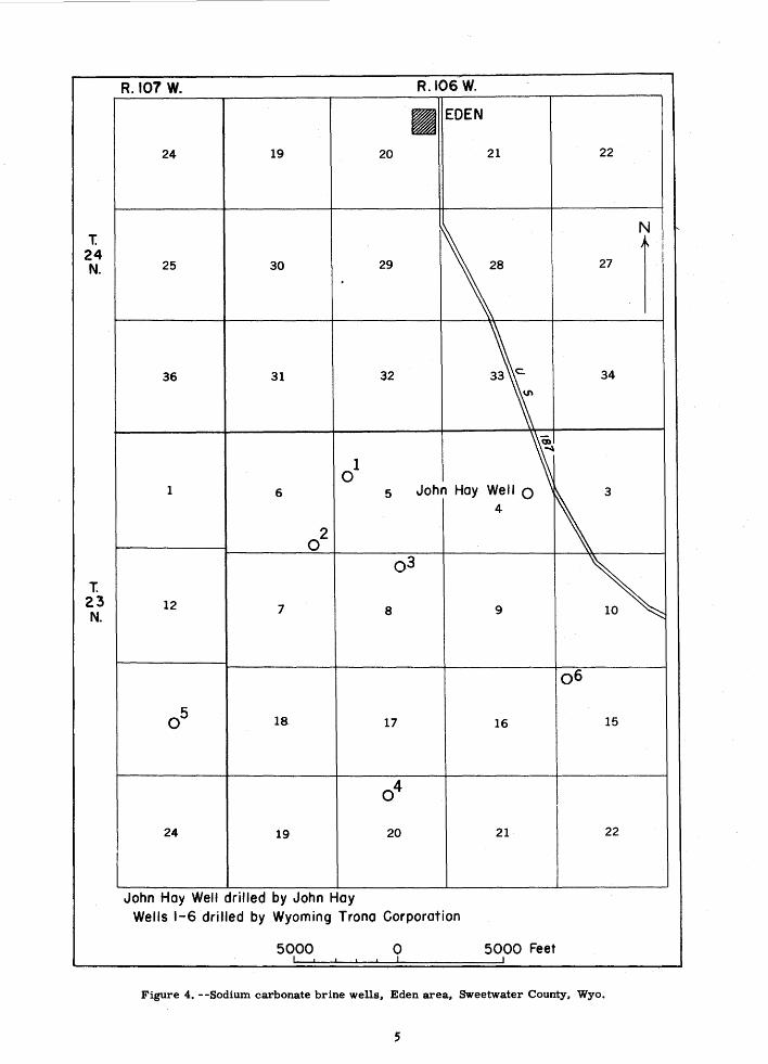
Eden area
Percent
.54.9.5 12.20 30 • .54 1.49
.21 ____&! 100.00
In 1938 soda brine was found at a depth of 4.50 to .500 feet in a well (John Hay, fig. 4) being drilled for 'tvater near Eden. The brine was cased off and the well was deepened to a fresh-water producing aquifer. As a result of the inform tion thus obtained, the Wyoming Trona Corp. drilled a well in 1949 (no. 1, fig. 4) for the purpose of testing the quality and quantity of the brine. At 477 feet the brine had sufficient artesian pressure to force it from a 4-inch pipe for a distance of approximately" 3 feet. After about 30 minutes the now diminished to an estimated 40 gallons per minute. The follow :ing analy"ses (in percent) of brine from this well were made by the U. S. Geological Survey:
Sample
Na2co3--------------NaHC03--------------Cl-----------------S04----------------Ca------------------
Mg-----------------K20-----------------
1 3.68 1.44
.017
.003
.ooo
.001
.023
2 4.20 -
• 73 .018 .002 .oo8 .OOJ .o.5o
Time taken (a.m.) -- 9 .3r;!/ 9 .3.5 Date -------- Sept. 1, 1949 Sept. 1, 1949 Depth (feet) ------- 477 477 Color -------------- Brown Amber Specific gravity at
2.5° c ------------- 1.0480
!/ Taken imrnedia tely after opening valve for testing.

I I I
-- - 15 - -- -- -
I I I I~ J¥~
~ ~
I ----14---· --
1 N
GREEN RIVER
I I I I
I --23-----
MFS 10
1
I
I
I I I
- -- -- - 26- - --1
I T. 18 N., R 107 W., 6th P.M.
1000 0
Wells I - 13 drilled by Western Alkali Corporation and Associates
Well MFS I drilled by Mountain Fuel Supply Company
Figure 3.--Sodium carbonate brine wells, Green River area, Sweetwater County, Wyo.
4
t 24 N.
T. 23 N.
R.107 W. R.I06W.
• EDEN
24 19 20 21 22
N
25 30 29 28 27
1 36 31 32 33 c. 34
""'
1 ~ 0 1 6 5 John Hoy 3
02
o.3
~ 12 7 8 9
o6
05 18. 17 16 15
04
24 19 20 21 22
John Hoy Welt drilled by John Hoy Wells 1-6 drilled by Wyoming Trona Corporation
5000 0 5000 Feet
Figure 4. --Sodium carbonate brine wells, Eden area, Sweetwater County, Wyo.
5

Before March 1952 six wells had been drilled in the area (fig. 4) by the Wyoming Trona Corp. and brine was found in all wells at deptl:s of 400 to 600 feet (fig. 6). There was an artesian flow of brine from several of the wells, but their productive capacity had not then been fullY determined.
A dark substance found in some of tls brine from these wells appears to come from a zone a few feet above the zone which contains the more abundant amber-colored brine. The exact stratigraphic location of the dark brown- and amber-urine zones has not been definitelY established. An analysis of the dark-colored brine ( sp gr 1.055) from the no. 1. well (fig. 4) was made by the Geological Survey with the following results:
Grams per liter
Solids (total dissolved at 180°)-- 70.01 Sodium carbonate (alkalinity)----- 47 .o5 Organic acids (organic matter)!/-- 7.70
Westvaco area
In 1944 the Westvaco Chlorine Products Corp., now tiE Intermountain Chemical Corp. drilled its nos. 1 and 2 wells in the West-' vaco area (C, D, fig. 5) for the purpose of testing the commercial possibilities of the brine and also to test the trona deposits lying about 800 feet below the brine horizon (fig. 6). Neither well could be made to produce more than 10 gallons of brine a minute and further testing was abandoned in favor of mining the trona beds. In several other wells drilled to test the trona beds in the area sodium carbonate brine was fomrl about 700 feet below the surface. Analyses of these brines are not available.
TRONA DEPOSITS
In January 1938 an oil test, John Hay no. 1 (N, fig. 5) drilled by the Mountain Fuel Supply Co. in the Westvaco area, resulted in the discovery of the first trona to be found at depth. Identification of the mineral was made by the Geological Survey in core samples, the occurrence being made public in several reports (Mendenhall, 1940; Smith, 1942; Harness and Coons, 1942). Northup~te, pirssonite, and gaylussite were also found and, in addition, two new minerals, shortite (Na2co3.2Caco3) and bradleyite (Na3Poh•MgC03), were discovered (Fahey, 1939, 1941).
!/ Complex naphthenic and resin acid s~ltsbp~obab~v formed by reaction of alkalme rme with petroleum.
6
As a result of this trona discovery, several companies became interested in the Westvaco area. Before March 1952 these . companies had drilled the following 10 test holes and obtained samples of trona from them: Mountain Fuel Supply Co., John Hay no. 1; Westvaco Chlorine Product Corp. (now Intermountain Chemical Corp.), Westvaco nos. 1, 3, and 4; Union Pacific Railroad, nos. 1, 2, 3, and 4; and Potash Comp~ of America, nos. 1 and 2. Two other wells, Union Pacific Railroad no. 5 and Westvaco no. 2, were not drilled deep enough to penetrate the trona deposits.
All of the wells (fig. 5) which were drilled to the necessary depth penetrated beds of trona as much as 11.6 feet in thickness in the Green River fonnation. The thick beds usually u1clude a few minor shale bands. Each well, with the exceptions noted previously, penetrated at least 1 trona bed of minable thickness. Since most of the wells penetrated more than 1 minable bed, it is believed tha. t well logs which show only 1 may be inaccurate because of solution of the trona during the drilling process. For this report the use of actual well and shaft logs was not admissible and wells in the Westvaco area are represented by a generalized log (fig. 6). Four well logs show only 1 bed of trona while the other logs show from 3 to ll beds, each 1 foot or more thick, separated by strata of shale of vacying thickness. The trona beds shown in each log do not correspond to the other beds in thickness, purity, or elevation. Prospect holes are widely separated, and ~~ere ha~ not been a sufficient number drilled to demonstrate the continuity of any one trona bed or to determine possible areas where there may be so maqy shale bands in the trona bed as to discourage mining.
In 1946 and 1947 visual information concerning the strata and deposits was obtained when the Westvaco Chlorine Products Corp. sank its no. 1 shaft (A, fig. 5). (See Romano, 1952) • The shaft was put down to a depth of 1,550 feet, 5o feet below a 10-foot bed of trona, the thickest found at that location. Several beds of trona were found in the shaft, but only the 10-foot bed and two others within a distance of 200 feet above it are of possible commercial importance. A detailed stratigraphic section of the shaft is not available for inclusion in this report.
In the mine the upper 3 to 4 feet of the 10-foot bed is found consistently to contain several bands of shale, the thickest about 3 inches, and mining is confined to the part below tre shale bands. Roof

-.J
T. 19 N.
T. 8 N
J 36
I
R.IIOW. R.I09 W.
-~~~ _r-_/ (.. /u, """'
UNION A,E __
...... Westvaco ~ ~ B~ ~,H ~ \ ~ ~ I
~ ..<)
I ~~ I
I -Q I ~ ''',
.....
~ I
I II \ ,.._F ...... ....... ......
I
3~ 1 , I \~~ I 31 I ~ ~ I
~ I I ~
I G I ~ ~\ ~ 6 / ~--- )-0- --f- -.dL Jo ---·- N --,--
I
3 Little America 0 U$30 J
- j c K
c~ II.
10,000 o 20,000 Feet I I II I I II I I I I I
N ~
r-~ -
36
I
I'.
~: M
1-
-
EX PLANATION
• Shafts
A- Westvaco no. I
B- Westvaco no. 2
0 Wells
C- Westvaco no. I 0- Westvaco no. 2 E- Westvaco no. 3 F- Westvaco no. 4
G -Union Pacific R.R. no. I
H -Union Pacific R.R. no. 2
I -Union Pacific R.R. no. 3
J -Union Pacific R.R. no. 4
K-Union Pacific R.R. no. 5
L -Potash Co. of America no. I
M'- Potash Co. of America no. 2
N-John Hoy no. I
Figure 5.--Sodi\D!l ca.rbcmate brine wells and trona_deposits, Westvaeo area., Sweetwater County, Wyo.

support in the workin6s is obtained by bolting the upper 3 to 4 feet of interspersed trona and shale to the overlying stratum. The trona bed varies in thickness within narrow limits throughout the mine and lies relatively horizontal on a bed of low-grade oil shale. Water has been found in small quantities in the mine workings where crevices infrequently occur. A relatively small area has been found in the course of mine development where the bed contains so maQY shale bands that mining is uneconomical. Except for initial shaft developrrent, mining has been neither difficult nor excessively costly. Shaft no. 2 (B, fig. 5) for orehoisting purposes was recently completed at a point 1,100 feet west of shaft no. 1 and a solution refiner,y for the production of soda ash has been built at the mine site.
The followmg approximate analysis of the trona ore was furnished by the Intermountain Chemical Corp.:
Percent
Na2C03-------------------- 45.30 NaHC03-------------------- 35.90 01------------------------ .09 S~----------------------- .OJ Fe------------------------ .05 Si02---------------------- 1.10 Comoined water------------ 15.40 Insolubles ------- Y J.50-15.oo
The insoluble fraction in the above analysis is composed of the following compounds, with approximate percents:
Percent
Si02---------------------- 27.0 GaO----------------------- 18.0 MgO----------------------- 1).0 C02----------------------- 25.0 R203---------------------- 6.0 K20----------------------- 4.5 Fe203--------------------- 1.8 Organic------------------- 2.0
The crude ore generally is light amber in color.
If it is assumed that all of the area within the dotted line on figure 5 contaL~s at least one minable bed of trona having a minimum thicla1ess of 7 feet, then an estimated 125 million tons of ore is contaL."l.ed within the bounds of that line. Also, if it may be assumed that a min:i..l'flUJl1 thic!mess of Jl feet of minable trona is contained in a second bed in that same area, th~n an additional 60 million tons of ore is available. The area is bounded by test wells tln t shmv
JOi. Depends on the amount of contained sha •
8
one or more minable trona beds v.rhich probably extend for a consinerable distance outside the enclosed area$ The Potash CompaQY of America drilled its no. 2 well (M, fig. 5) at some distance east of the area first prospected, and a minable bed of trona t.;as found.
ECONOMIC FACTORS
The deposits are favorably situated with respect to most of the factors which may influence their development: other basic mineral resources, transportation, fuel supplies, and water. Although not so near to markets as might be desired, the deposits are not unfavorably located in that respect.
The railroads, high~rays, main streams, land subdivisions, and wells are shown on the general map of the trona and brine region (fig. 2). The main line of the Union Pacific Railroad traverses the southern part of the area and divides near the western edge to form the Oregon Short Line Branch. U. S. Highway 30 also traverses the southern part of the area. Coal is available fron the neighboring Rock Springs and Kemmerer, W,yo., coal fields, and natural gas is produced from the Baxter basin and Church Buttes fields nearby in southwestern Wyoming.
Precipitation in the area is slight, and, because of low humidity and prevailing strong winds, conditions should be favorable for concentration of brines by solar evaporation. The Green River and its tributaries Blacks Fork and Sandy Creek are within . or near the area (figs. 2, 5) and the water may be made available for industrial use.
A considerable amount of oil shale, some of good quality, lies above, between, and below the trona beds. The log of the Union Pacific Railroad no. 2 well refers to a thin bed of gilsonite, and other logs shO"w the presence of bentonitic shales. The potash-bearing rock wyomingite is abundant in surface deposits near Rock Springs, Wyo. Extensive phosphate deposits exist a short distance to the west, in western Wyoming and eastern Idaho., where the phosphate industr.v is now well established. Important deposits of potassium, sodium, and magnesium salts are found in Utah. Ferrous and nonferrous smelting industries using ores produced locallY are established in Utah and Colorado.
A large part of the area containing the trona beds is owned by the Union Pacific Railroad. In general, the railroad owns ever,y odd-numbered section (square mile) for 20 miles on each side of its right-of-way and the State has title to sees. 16 and )6.

Eden a reo
o' 0 0 0 0 0 oo .!./1..0
--
:.....·_:_.
500'
1000'
1500'
Green River
Shale: sandy, gray, green, brown; minor sandstone
Artesian brine
area
Lime shell
2--:-~ Shale: sandy
Westvaco area
·~:;:::: Shale: sandy, gray, """-'----· green, brown;
minor sandstone
Sandstone; shaly sandstone; brine
.' ·.~~ Shale: sandy, green, .-:-. brown, gray; trona
and shortite crystals; oil shale
Trona beds
Shale; oil shale; trona and shortite crystals
Figure 6. --Generalized sections from well-log data. sodium carbonate brine and trona deposits~ Sweetwater County~ Wyo.
9

Some of the land in the rema.ini.."lg 16 sections in each township has passed from Federal ownership. Leasing of Federal land has already yielded a substantial income from rentals and royalties.
Minable trona was found in the easternmost well (M, fig. 5) several hundred feet above the elevation at which it was found in the other wells in the area. This fact gives rise to the speculation that further geologic investigation or drilling ~ indicate that trona beds can be reached at a shallower depth in the vicinity of the to'Wll of Green River.
Sodium carbonate, or its chief manufactured product, soda ash, is a basic chemical having wide application in industr,y. If the deposits are considered in relationship to the other minerals found in the surrounding territory it may be inferred that resources exist which could result in the growth of an extensive chemical industry in this part of the United States •
LITERATURE CITED
Chatard, T. M., 1890, Natural soda--its occurrence and utilization: u. s. Geol. Survey Bull. 60, p. 27-101.
Fahey, J. J., 1939, Shortite, a new carbonate of sodium and calcium: Am. Mineralogist, v. 24, no. 8, •p. 514-518.
1941, Bradleyite, a new mineral, -sc:xiium phospha. te-magnesium carbonate,
with X-ray analysis by George Tunell: Am. Mineralogist, v. 26, no. 11, p. 646-650.
Fahey, J. J., and Axelrod, J. M., 1950, Searlesite from the Green River formation of Wyoming: Am. Mineralogist, v. 35, nos. 11-12, •P· 1014-1020.
Harness, C. L., and Coons, A. T., 1942, Sodium carbonate: U. S. Bur. Mines Inf. Circ. 7212.
Mendenhall, W. c., 1940, Occurrence of a deposit of trona: Science, new ser., v. 91, no. 2349, p. 11-12.
Romano, C. A., 1952, Trona in southwestern Wyoming: Colorado School of Mines, The Mines Magazine, v. 42, no. 3, p. 69-70.
Schultz, A. R., 1909, Deposits of sodium salts in Wyoming: U. S. Geol. Survey Bull. 430-I, p. 570-589.
Sears, J. D., and Bradley, W. H., 1924, Reiations of the Wasatch and Green River formations in northwestern Colorado and southern Wyoming, with notes on oil shale in the Green River formation: U. S • Geol. Survey Prof. Paper 132-F, p. 93-107.
10
Smith, H. I., 1942, Trona in Wyoming: Am. Inst Min. Met. Eng. Tech. Pub. 1489.
Weeks, J. D., 1886, Glass materials: Min. Res. U. S., 1885, p. 550-555.
INT.-DUP. SEC., WASH., D.C •• 5'14 814