SKYLINE - City of San Diego Official Website · Amendment Date Approved by Planning Commission...
152
i
Transcript of SKYLINE - City of San Diego Official Website · Amendment Date Approved by Planning Commission...

i

SKYLINE-PARADISE HILLS COMMUNITY PLAN
Prepared by
City of San Diego Planning Department 202 C Street, MS 4A
San Diego, CA 92101
Printed on recycled paper.
This information, or this document (or portions thereof), will be made available in alternative formats upon request.
ii
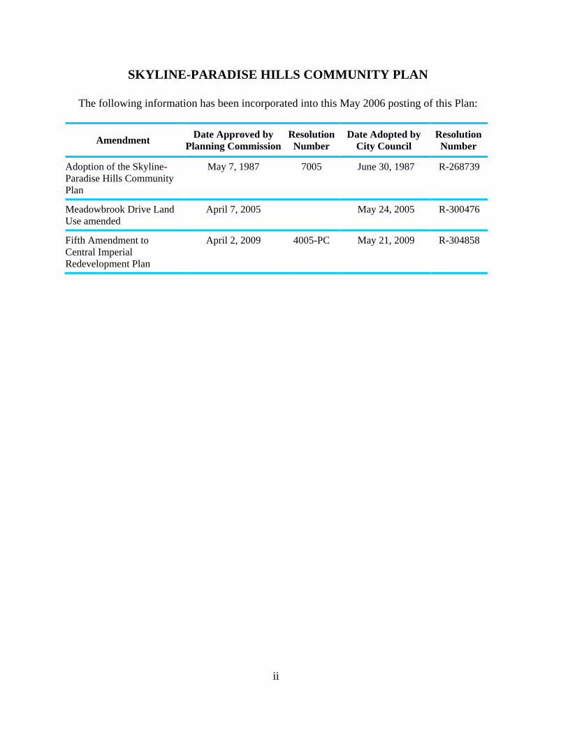
SKYLINE-PARADISE HILLS COMMUNITY PLAN
The following information has been incorporated into this May 2006 posting of this Plan:
Amendment Date Approved by
Planning Commission
Resolution
Number
Date Adopted by
City Council
Resolution
Number
Adoption of the Skyline-
Paradise Hills Community
Plan
May 7, 1987 7005 June 30, 1987 R-268739
Meadowbrook Drive Land
Use amended
April 7, 2005 May 24, 2005 R-300476
Fifth Amendment to
Central Imperial
Redevelopment Plan
April 2, 2009 4005-PC May 21, 2009 R-304858
MAYOR
Maureen O’Connor
CITY COUNCIL
Abbe Wolfsheimer
Bill Cleator
Gloria McColl
William Jones
Ed Struiksma
Mike Gotch
Judy McCarty
Celia Ballesteros
CITY ATTORNEY
John W. Witt
CITY MANAGER
John Lockwood
PLANNING COMMISSION
Ron Roberts, Chairperson
Paul Oquita, Vice Chairperson
Henry Empeno
Dan Guevara
Albert Kercheval
Yvonne Larson
Ralph Pesqueira
PLANNING COMMISSION
Michael Stepner, Acting Planning Director
Lee Okeson, Acting Assistant Planning Director
Allen M. Jones, Deputy Director
Mary Lee Balko, Principal Planner
Theresa R. Wilkinson, Project Planner
Rose M. Wong, Associate Planner
Jim Atkins, Graphic Designer
Donna Brinkerhoff, Word Processor
Corazon S. Nuval, Word Processor

iv
ACKNOWLEDGEMENTS
Skyline-Paradise Hills Community Planning Committee
Cathy Alegria, Chairperson
Tressia Sanders, Vice Chairperson
Artemio (Butch) Aquino, Secretary
Harriett Florence, Treasurer
Bobby Alegria
Avanell Blanchard
Bill Braham
Marjorie Braham
Donna Clark
Trudy Downs
Pearli Killens
Henry (Buddy) Miles
Al Mireles
LaQuita Robbins
Pat Sexton
Walt Sherman
Lynn Spears

THE CITY OF SAN DIEGO
WILLIAM D. JONES
DEPUTY MAYOR
Dear Neighbor:
When I took office, one of the top priorities on my agenda was the adoption of a complete and
comprehensive Skyline/Paradise Hills Community Plan. In the past, two adopted planning programs were
used for the South & North Bay Terraces communities, but no official community plan existed for guiding
planned development in the communities of Skyline, Paradise Hills, Lomita and Jamacha.
Now after years of research, continual mapping, countless hours of public meetings and field visits from
City staff and the Skyline/Paradise Hills Planning Committee, the City Council adopted the
Skyline/Paradise Hills Community Plan on June 30, 1987.
As San Diego continues to grow, planned development for its communities becomes even more important.
Our neighborhoods must be protected from those developments that are insensitive to the community’s
needs. This new community plan will help provide that protection.
The Skyline, Paradise Hills and Bay Terraces communities are unlike many of the inner-city areas of San
Diego. These communities are almost completely populated by single-family homes with a small sampling
of high-density multifamily units—very different than most of the urbanized portions of the City.
While most of the Skyline and surrounding communities are zoned for residential use, only a small portion
of the community is zoned for commercial use. In the past, owners of commercial property have developed
their land for residential use, leaving the community with a lack of commercial services. However, the
Skyline/Paradise Hills Community Plan has set forth several objectives to ensure that future developments
of commercial property will provide adequate facilities that offer a variety of foods and services to meet the
needs of the residents.
The Plan will also preserve the existing open space and the undeveloped park sites in the community.
Presently, Skyline, Paradise Hills and Bay Terraces have over 140 acres of open space, which preserve
existing natural canyons and hillsides. In addition, over 25 acres of natural and undeveloped land is being
set aside for the development of future parks including, Keiller Park, Skyview Park, Parkside Park and
Boone Neighborhood Park.
These communities are very unique. Present and future homeowners are blessed with picturesque views of
rolling hills, the Pacific Ocean, Coronado and San Diego Bay. In addition, residents can benefit from the
central locality, with easy access to downtown, City beaches and Balboa Park.
Skyline, Paradise Hills and Bay Terraces are some of the best communities to live in and I’m positive this
newly adopted Plan will preserve the beauty of our neighborhoods. I thank you for your interest and support
for preserving the quality of life in our neighborhoods we, as residents, deserve.
Best regards,
William D. Jones
Deputy Mayor

i
INTRODUCTION
Community Profile...............................................................................................................4
Scope and Purpose ...............................................................................................................6
Plan Format ..........................................................................................................................7
Legislative Framework ........................................................................................................8
PLAN SUMMARY
Planning Issues...................................................................................................................11
Goals and Objectives .........................................................................................................12
BACKGROUND
Community History ...........................................................................................................21
Planning History ................................................................................................................21
Alternative Land Use Plans ...............................................................................................24
PLAN ELEMENTS
Residential Element ...........................................................................................................29
Commercial Element .........................................................................................................38
Mixed Use Element ............................................................................................................49
Transportation Element ......................................................................................................78
Park and Recreation Element .............................................................................................91
Open Space Element ........................................................................................................103
Public Facilities Element .................................................................................................110
Cultural and Historical Resources Element .....................................................................107
URBAN DESIGN ELEMENT
Introduction ......................................................................................................................112
Residential Guidelines .....................................................................................................114
Commercial Guidelines ...................................................................................................118
General Guidelines ...........................................................................................................121
NEIGHBORHOOD ELEMENT
Introduction ......................................................................................................................132
Summary of Issues and Recommendations .....................................................................136
Recommendations ............................................................................................................137
General Plan Conformance ..............................................................................................143
Implementation ................................................................................................................150
Table 1 Residential Land Use (1986) ................................................................................... 28
Table 2 Housing Trend 1970—1986 .................................................................................... 28

ii
Table 3 1986 Land Use in Residential Zones (in acres) ....................................................... 31
Table 4 1986 Land Use in Commercial Zones (in acres) ..................................................... 37
Table 5 Community Neighborhood Parks and Joint Use ...................................................... 93
Table 6 Community Parks and Facilities .............................................................................. 94
Table 7 Neighborhood Parks and Facilities ......................................................................... 95
Table 8 Public School Enrollment ...................................................................................... 105
Table 9 Neighborhood Element Summary of Issues and Recommendations ..................... 136
Figure 1. Location Map .................................................................................................... 2
Figure 2. Neighboring Communities ................................................................................ 4
Figure 3. Phased Development Areas ............................................................................ 22
Figure 4. Existing Residential Development (1986) ...................................................... 29
Figure 5. Existing Residential Zones ............................................................................. 30
Figure 6. Recommended Residential Densities .............................................................. 32
Figure 7. Project First Class and Community Block Grant Target Area ....................... 38
Figure 8. Existing Commercial Zones ............................................................................ 40
Figure 9. Recommended Commercial Designations ...................................................... 43
Figure V-1 Areas of the Southeastern San Diego/Skyline-Paradise Hills CPIOZ .............51
Figure V-2 Southeastern San Diego/Skyline-Paradise Hills CPIOZ..................................54
Figure V-3 Proposed Land Use Designations for the SPH CIPOZ ....................................56
Figure 10. Existing Average Daily Traffic (1986) ........................................................... 76
Figure 11. Future Average Daily Traffic and Street Classifications ................................ 77
Figure 12. Public Transit Routes ...................................................................................... 79
Figure 13. The San Diego Trolley—East Line Location and Stations ............................. 80
Figure 14. Bicycle Routes ................................................................................................ 81
Figure 15. Bicycle Lane Classifications ........................................................................... 83
Figure 16. Parks ................................................................................................................ 89
Figure 17. Floodplains ...................................................................................................... 97
Figure 18. Designated Open Space .................................................................................. 98
Figure 19. Schools .......................................................................................................... 101
Figure 20. Public Facilities ............................................................................................. 104
Figure 21. Neighborhood Areas ..................................................................................... 131
Figure 22. General Plan Amendments ........................................................................... 145
Figure 23. Recommended Rezonings ............................................................................. 149
Figure 24. Skyline-Paradise Hills Community Plan Map .............................................. 151

Introduction
Community Profile
Scope and Purpose
Plan Format
Legislative Framework

2
Figure 1. Location Map

3
INTRODUCTION
COMMUNITY PROFILE
The Skyline-Paradise Hills community is located in the southeastern portion of the City of
San Diego. The community is bordered by the city of Lemon Grove and the Southeast San
Diego community planning area on the north; the South Bay Freeway and an unincorporated
area of San Diego County on the south; National City and the Southeast San Diego
community planning area on the west; and by an unincorporated area of San Diego County
on the east (Figure 1).
The Skyline-Paradise Hills community planning area is approximately 4,500 acres in area.
The community, as of July 1986, contained a population of about 59,700 persons residing in
approximately 18,000 dwelling units. The community contains six geographic areas
recognized as distinct neighborhoods. They are: Skyline, Paradise Hills, South Bay Terraces,
North Bay Terraces, Lomita and Jamacha. The neighborhood areas are shown on Figure 2.
The majority of new development within the community has occurred within North and
South Bay Terraces. The remaining neighborhoods are older portions of the community and
have had minimal development in recent years.
Skyline-Paradise Hills is a predominantly low-density residential community. Single-family,
detached housing is the dominant land use throughout the community with multifamily
residential development located primarily in the south-central portion of the South Bay
Terraces neighborhood. The majority of the multifamily development within the community
does not exceed a density of 30 dwelling units per acre.
There are no large community commercial centers within the Skyline-Paradise Hills
community planning area. Commercial services are provided by several small neighborhood
commercial centers scattered throughout the community and one strip commercial area. This
existing commercial development is not adequate to meet the demand and need of the
population. Residents rely heavily on commercial centers in adjacent communities due to the
lack of commercial services.
The geography of the community planning area includes hills and canyons affording views of
downtown San Diego, San Diego Bay, the city of Coronado and the Pacific Ocean. A major
geographic feature of the community is Paradise Valley, which runs on an east-west axis
through the middle of the community.

4
Figure 2. Neighboring Communities

5
SCOPE AND PURPOSE
The Skyline-Paradise Hills Community Plan (Plan) is a set of proposals that serves to guide
future development within the Skyline-Paradise Hills community planning area. The Plan
contains a series of goals and objectives established by the community which are consistent
with citywide policies.
Once the Plan is adopted by the City Council, any amendments, additions, or deletions will
require that the Planning Commission and City Council follow the same public hearing
procedures as were required in the initial adoption. The Plan establishes recommendations
for implementation and does not establish new regulations or legislation. Controls over
zoning, subdivisions, transportation, building construction and other developments must be
enacted separately as part of the implementation program. However, many of the Plan
recommendations are expected to be implemented simultaneously with the adoption of the
Plan through rezonings.
The Plan should not be considered a static document. It is intended to provide guidance for
the orderly growth of the Skyline-Paradise Hills community. The Plan will be continually
monitored and amended if necessary in response to City needs or unanticipated changes in
environmental, social or economic conditions of the community. It is anticipated that the
Skyline-Paradise Hills Planning Committee and other private citizen organizations will
provide assistance in monitoring the effectiveness of the Plan and recommending changes to
the Plan as conditions change.
Adoption of the Plan will necessitate rescinding the South Bay Terraces Community Plan
that was adopted by the City Council in 1978.

6
PLAN FORMAT
The Skyline-Paradise Hills Community Plan is divided into eight sections, each of which is
summarized below:
Introduction - This section briefly overviews the organization and framework within which
the Plan was developed.
Plan Summary - This section identifies key issues in the community along with the goals
developed by the Skyline-Paradise Community Planning Committee, which served as the
basis for recommendations in each Plan element.
Background - This section describes planning and development history, the planning area
and its regional context.
Plan Elements - The elements of the Plan are discussed in this section. The Plan elements
include an analysis of existing conditions, objectives and recommendations for the entire
community.
Urban Design Element - This section discusses the image and character of the community
and makes recommendations to guide future development and revitalize existing
development. These guidelines incorporate major recommendations of the Project First Class
Urban Design Program.
Neighborhood Element - This section identifies the individual neighborhoods of the
community, targeting neighborhood issues of concern.
General Plan Conformance - This section describes the extent to which the recommended
actions in this Plan will help to implement the goals and objectives of the City's Progress
Guide and General Plan (General Plan).
Implementation - This section identifies actions, additional studies and funding conditions
which are needed to implement the Plan recommendations.

7
LEGISLATIVE FRAMEWORK
The Skyline-Paradise Hills Community Plan was developed within the context of a
legislative framework consisting of federal, state and local levels. Some of the more
significant legislation is discussed below.
Section 65450 of the governmental Code of the state of California (State Planning and
Zoning Act) gives authority for the preparation of community plans and specifies the
elements which must appear in each plan. It also provides the means for adopting and
administering these plans.
Government Code Chapter 4.3 requires that local governments and agencies provide
incentives to developers to include affordable units in housing projects. The City has
prepared an ordinance which would establish an Affordable Housing Density Bonus,
providing an increase in maximum permitted density in a given zone to be granted for
projects in which at least a certain percentage of the total housing units are for low- or
moderate-income persons.
The California Environmental Quality Act of 1970 (CEQA) requires that environmental
reports be prepared for all community plans. Separate, detailed environmental reports
may also be required for many projects which implement this Plan.
The Regional Air Quality Strategy (RAQS) was developed in 1977 to achieve a level of
air quality in the San Diego Air Basin that would meet federal air quality standards set
forth in the National Clean Air Act. A major recommendation pertinent to this planning
effort is to include air quality considerations in all land use and transportation plans.
The citywide Zoning and Subdivision Ordinances regulate the development of land and
subdivision of land in preparation for development.
In addition to legislation, the City Council has adopted a number of policies to serve as
guidelines in the decision making process. Many of the policies relate directly to planning
issues and should be used in implementing Plan recommendations.
The Progress Guide and General Plan serves as a basis for the development of the Plan.
The General Plan sets forth goals standards and criteria for the provision of facilities that
are essential in the community and possess citywide importance.
The General Plan identifies the City of Villages strategy to focus growth into mixed-use
activity centers that are pedestrian-friendly districts linked to an improved transit system.
The strategy is designed to sustain the long-term economic, environmental, and social
health of the City and its many communities

8
Plan Summary
Planning Issues
Goals and Objectives

10
PLAN SUMMARY
PLANNING ISSUES
In the initial phase of development of this Plan, the Skyline-Paradise Hills Community
Planning Committee raised the following issues of concern to the community:
1. The desire to preserve the low-density, single-family character of the community;
2. The need for housing rehabilitation, including the removal of graffiti and litter, in some
areas of the community;
3. The lack of commercial retail and office facilities, including professional services;
4. The need for a centrally-located community commercial facility;
5. Retention and revitalization of existing commercial areas;
6. Improvement of public transportation;
7. The need for open space preservation (Paradise Canyon and the Encanto Expressway
right-of-way) and the establishment of development standards for areas abutting open
space;
8. Improvement of undeveloped park sites;
9. The need for establishment of urban design standards and criteria for residential and
commercial development and major street corridors.
10. The need to sustain the long-term economic, environmental, and social health of the City
and the Skyline-Paradise Hills Community through the incorporation of the City of
Villages Strategy.

11
GOALS AND OBJECTIVES
The issues listed above served as a general framework which guided the Committee and the
Planning Department in developing the goals and objectives of this Plan. The community
goals and objectives are summarized here to emphasize that the purpose of the Plan is to
implement the goals and objectives of the community through the guidance of public and
private development.
Primary Residential Goal: Preserve the low-density, single-family character of the
community.
Objectives:
1. Establish and maintain Skyline-Paradise Hills as an economically and socially balanced
community, accommodating gradual and orderly development consistent with the
existing community.
2. Ensure quality residential development designed in accordance with the urban design
principles established within this Plan.
3. Ensure that new development is compatible with existing neighborhoods and does not
overburden existing public facilities.
4. Create a range of housing opportunities and choices to provide quality housing for
people of all income levels and ages.
5. Achieve an overall mix of different housing types to add diversity to communities and
to increase housing supply with emphasis on the following.
a. Incorporating a variety of multi-family housing types in multi-family project
areas;
b. Incorporating a variety of single-family housing types in single-family
projects/subdivisions;
c. Building town homes and small lot single-family homes as a transition between
higher density homes and lower density single-family neighborhoods; and
d. Identifying sites that are suitable for revitalization and for the development of
additional housing.

12
Primary Commercial Goal: Ensure the availability of adequate commercial facilities
offering a variety of goods and services to meet the needs of existing and future residents.
Objectives:
1. Revitalize existing commercial facilities through property cleanup, maintenance (repair
and painting) and through utilization of the Project First Class Landscaping Program
wherever applicable.
2. Enhance pedestrian activity and accessibility to the Reo Drive and Imperial Avenue neighborhood commercial areas.
3. Develop a centrally located, community commercial center.
4. Require commercial areas to incorporate landscaping which complements surrounding
land use.
5. Promote the design of commercial areas so as to best utilize the existing transportation
system.
6. Prevent, to the extent feasible, the redevelopment of commercial sites for residential use,
except where a mix of residential and commercial development is proposed.
7. Increase the opportunities within the Central Imperial Redevelopment Project Area for
rehabilitation of existing commercial centers and development of new commercial areas
in the community through the integration of mixed land uses and compact building
design.
8. Focus more intense commercial and residential development in redevelopment areas,
including along transit corridors in support of the General Plan in a manner that is
pedestrian-oriented and preserves the vast majority of single-family neighborhoods.
9. Provide opportunities for community-specific mix of uses within the community.

13
Primary Village Goal: Provide for the long-term economic, environmental and social health
of the City and community through the adoption of the City of Villages Strategy to focus
growth into mixed-use activity centers that are pedestrian-friendly districts linked to an
improved transit system.
Objectives:
1. Determine the appropriate mix of the General Plan land uses within the community
planning area with attention to:
a. Surrounding neighborhood uses;
b. Uses that are missing from the community;
c. Community preferences; and
d. Public facilities and services
2. Provide opportunities for people to live, work and recreate in the same areas through the
integration of mixed residential, commercial and recreational uses.
3. Increase the opportunities within the Central Imperial Redevelopment Project Area for
rehabilitation of existing commercial centers and development of new commercial areas
in the community through the integration of mixed land uses and compact building
design.
4. Focus more intense commercial and residential development in redevelopment areas,
including along transit corridors in support of the General Plan in a manner that is
pedestrian-oriented and preserves the vast majority of single-family neighborhoods.
5. Provide opportunities for community-specific mix of uses within the community.

14
Primary Transportation Goal: Provide a transportation system that maximizes access to
community activity centers and to destinations within the metropolitan area, and minimizes
adverse environmental effects.
Objectives:
1. Improve existing street systems in conformance with Council Policy 600-4 to
accommodate residential and commercial growth.
2. Develop a system of bikeways to join parks and open space throughout the community.
3. Provide a safe and more accessible pedestrian circulation system, minimizing conflicts
with vehicular traffic.
4. Provide an efficient and high level of public transit within and surrounding the
community. Design and plan for land uses that will complement and make use of the new
San Diego Trolley East Line.
5. Visually enhance transportation corridors to improve the community’s image.
Primary Park and Recreation Goal: Provide a system of fully developed parks and
recreational facilities to meet the recreational needs of the community.
Objectives:
1. Provide a park system consistent with the City’s General Plan standards to the extent
feasible given existing constraints.
2. Coordinate the use of school recreational facilities for after normal hour usage.
3. Require the provision of private recreational facilities and usable open space in new,
larger residential developments.
4. Provide a safe environment in all parks to allow their use by the entire community.

15
Primary Open Space Goal: Provide an open space system that preserves existing canyons
and hillsides and ensures open space accessibility.
Objectives:
1. Develop specific open space areas for passive recreational uses such as hiking or bike
trails.
2. Provide a linkage system of pedestrian and bicycle facilities connecting parks and open
spaces.
3. Ensure that development located adjacent to open space areas is compatible with and
enhances open space areas.
4. Preserve visual and physical access to open space areas from public rights-of-way to
increase passive recreational use.
Primary Public Facilities Goal: Establish and maintain a high level of public facilities and
services to meet community needs.
Objectives:
1. Provide public facilities and services in accordance with City standards.
2. Maximize the use of existing public facilities for community activities.
3. Increase safety through measures such as the addition of street lighting.
Primary Cultural and Heritage Resources Goal: Preserve the cultural and heritage
resources of the Skyline-Paradise Hills community.
Objectives:
1. Protect the resource value of archaeological artifacts and paleontological remains within
the community.
2. Preserve buildings of architectural and historical interest in the community.

16
Primary Urban Design Goal: Enhance the community’s image through improvements to
the visual and physical character of the community.
Objectives:
1. Ensure that new development is compatible with existing neighborhoods in terms of bulk,
scale and design, and that it is sensitive to existing topography.
2. Improve the quality of design of new residential development.
3. Improve the appearance of existing commercial facilities to revitalize existing business
and stimulate the development of new business.
4. Orient development to encourage interest at the pedestrian scale in order to stimulate
pedestrian circulation.
5. Improve the streetscape in the vicinity of parks and recreation centers, public buildings
and high visibility streets in order to provide a sense of identity to activity centers and the
routes leading to them.

18
Background
Community History
Planning History
Alternative Land Use Plans

20
BACKGROUND
COMMUNITY HISTORY
The planning area’s recorded history begins with Father Junipero Serra’s visit in 1769.
In 1775, the entire South San Diego Bay region was claimed by the Spanish crown as pasture
land for the presidio of San Diego. These public lands included what is now National City,
Chula Vista, Skyline-Paradise Hills and lands further inland. They were given the name
Rancho del Ray or King’s Ranch, later changed to Rancho de la Nacion. These public lands
were transferred to private ownership in 1845 and used for lemon orchards and olive groves,
pasturing of cattle and cultivation of field crops.
In 1916, the Encanto area, including the Skyline portion of the community, was annexed to
the City, becoming the first territory added to the City’s original Pueblo lands. Paradise Hills,
consisting of 1,180 acres, was annexed in 1929. Annexations continued through the 1950s
and 1960s ending with the total acreage that comprises North and South Bay Terraces.
A large portion of the community’s single-family, detached housing development occurred
within the Skyline, Paradise Hills, Lomita and Jamacha neighborhoods prior to World War II
and during the 1950s and early I960s. Since 1969, new construction has been concentrated in
the North and South Bay Terraces neighborhoods. This development has been primarily
single-family homes with pockets of medium-density, multifamily housing.
PLANNING HISTORY
There have been two adopted planning programs carried out in the Skyline-Paradise Hills
community planning area. Both were limited in scope, covering only the North and South
Bay Terraces neighborhoods.
In January of 1969, the City of San Diego adopted the South Bay Terraces Development Plan
prepared by Peñasquitos, Inc. This plan covered approximately 860 acres of the South Bay
Terraces area and proposed a concept of higher-density development designed around
interior block recreational areas. This plan projected a housing mix of 1,420 detached
single-family homes and 6,750 multi-family units.
During 1976 and 1977, Peñasquitos, Inc. submitted a number of revisions to the 1969 Plan,
including adjustments to the housing mix, open space and circulation. The planning area was
increased, covering approximately 2,187 acres. These changes resulted in the development of
a comprehensive community plan for the North and South Bay Terraces neighborhoods.
In December of 1978, the City Council adopted this plan as the revised South Bay Terraces
Community Plan.
The Skyline-Paradise Hills Community Planning Committee was recognized by the City
Council in June of 1978. Since that time, the Planning Committee has worked with the
Planning Department in reporting the planning needs of the community and in contributing to
the community planning process for the Skyline-Paradise Hills community.

21
The Skyline-Paradise Hills Community Plan is the first community plan that addresses the
areas to the north and southwest of the South Bay Terraces planning area (i.e., the
neighborhoods of Skyline, Jamacha, Lomita and Paradise Hills). Development in these areas
had been guided by the City’s Zoning Ordinance and the General Plan prior to the adoption
of this Plan.
Project First Class
Project First Class is a comprehensive program of community development which was
approved by the City Council in May of 1984. The program was established to develop an
urban design program, to form a concentrated code enforcement program and to facilitate
other public and private improvements for Skyline-Paradise Hills, Southeast San Diego and
parts of Golden Hill. The intent of the program is to work toward a better environment
through economic development, attention to urban design, street and alleyway
improvements, building code enforcement, residential and commercial rehabilitation and the
establishment of quality housing. This Plan can be considered a step toward implementing
the intent of Project First Class.
Phased Development Areas
The General Plan recognizes two categories of phased development within the community:
urbanized and planned urbanizing. The urbanized area in the City includes most of the older
sections as well as the central portion of San Diego. The neighborhoods of Skyline, Jamacha,
Lomita and Paradise Hills are identified as urbanized areas in the General Plan. The planned
urbanizing area consists of the newly developing communities. The North and South Bay
Terraces neighborhoods are identified as planned urbanizing areas. These areas are shown
in Figure 3.
In general, urbanized areas require public and private reinvestment with an emphasis on
capital improvement programs and grant funding to provide needed community facilities, in
contrast to the reliance on developer financing and assessment districts in planned
urbanizing areas.
The majority of the North and South Bay Terraces neighborhoods has been developed, with
the exception of small parcels of land near Paradise Valley Road and Woodman Street. For
this reason, the Plan recommends that the planned urbanizing portion of the community be
redesignated as urbanized. It is anticipated that public facilities for the community can be
provided through the City’s Capital Improvement Program, grant funding, and private
investment.
Prospective Annexation Area
The General Plan identifies an area that borders the northeastern corner of the Skyline-
Paradise Hills community as a prospective annexation area and designates the area as
planned urbanizing. This Plan proposes that the area be redesignated as urbanized since most
of the area has been developed and the need to use developer fee financing and assessment
districts to fund public facilities is not expected. The Skyline-Paradise Hills Community Plan

22
Figure 3. Phased Development Areas

23
will be amended to include this area if it is annexed to the City. Appropriate land use
designations will be determined at that time. The prospective annexation area is shown on
Figure 3.
General Plan
The General Plan identifies the City of Villages strategy to focus growth into mixed-use
activity centers that are pedestrian-friendly districts linked to an improved transit system.
The strategy is designed to sustain the long-term economic, environmental, and social health
of the City and its many communities. Several blocks fronting on Imperial Avenue between
Woodman Street and 69th
Street are part of a larger Village vision for the Imperial Avenue
corridor.
ALTERNATIVE LAND USE PLANS
The following plan alternatives were considered in the preparation of the Plan. Because the
community is predominantly residential, the variations between alternatives largely pertain to
differences in residential densities and therefore, population. The impact of the nonresidential
alternatives is minimal, except to the extent that they vary the number of residential
dwelling units.
Residential Alternatives
Existing Plan Alternative
This alternative would continue the pattern of the existing South Bay Terraces Community
Plan (adopted in 1978) for the central sector of the community. This plan recommended that
the majority of the community be developed at 0-5 dwelling units per acre, with higher
residential densities up to 29 units per acre near major streets, proposed community shopping
centers and educational and recreational facilities. Current zoning allows higher densities
than those recommended in the plan, therefore, a rezoning program would be necessary to
achieve consistency between the zones and the 1978 plan designations.
There is no adopted community plan for the areas north and southwest of the South Bay
Terraces planning area. The General Plan designates the majority of these areas for
residential neighborhoods.
Existing Zoning Alternative
This approach would permit the most intense development of all the alternatives. Existing R-
3000 and R-1500 zoning would permit higher-density redevelopment in recently developed
single-family neighborhoods and in older stable single-family neighborhoods. Approximately
67 acres north of Alsacia, between Alta View Drive and Briarwood Road have been recently
developed with single-family residences; however, the area is zoned R-3000 which would
allow up to 29 units per acre. Approximately 40 acres south of Alsacia Street, between

24
Woodman Street and Briarwood Road are zoned R-1500, which would allow up to 29 units
per acre. Recent development is attached single-family at an average density of 12 units per
acre.
Transit Corridor Alternative
This alternative would identify the Imperial Avenue Trolley Corridor as a major public
transit corridor and establish gradients in permitted density determined by the distance from
the corridor. Highest-density development would be concentrated along Imperial Avenue,
while density would decrease as distance from Imperial Avenue increases. Factors other than
the distance from the transit corridor would also be considered in determining permitted
densities, such as the capability of the street system to accommodate traffic generated by
higher-density development and existing neighborhood development patterns. This approach
would require rezoning the primarily single-family area south of Imperial Avenue (currently
zoned R1-5000) to permit higher-density development. It also might preclude needed
commercial development in the commercially zoned properties along Imperial Avenue.
Density Bonus Alternative (Incentive Zoning)
For each of the residential alternatives examined, the concept of density bonuses could be
introduced in order to allow higher density in return for special project amenities that would
implement overall Plan goals. For example, such incentives could be awarded for extra
recreation facilities, day care centers or other amenities. However, in order for density
incentives to be successful and not overburden the community’s public services and
facilities, the bonus system should be applied only in those areas capable of accommodating
the development. Due to the low-scale type of development prevalent in the community,
additional controls would be necessary to ensure that existing stable neighborhoods that are
worthy of preservation are not detrimentally impacted.
Commercial Alternatives
Existing Plan Alternative
The 1978 South Bay Terraces Plan designated three sites at the corner of Woodman Street
and Alta View Drive for commercial development that were subsequently developed with
multifamily housing. This alternative would leave those areas designated for commercial
development. However, since the developments are relatively recent, redevelopment to
commercial use is unlikely to occur.
The General Plan identifies only one community commercial site (at Cardiff Street and
Jamacha Road) for the areas north and southeast of the South Bay Terraces planning area.
The Imperial Avenue commercial area is designated for residential neighborhoods. This
alternative would allow additional residential development in the commercial zones on
Imperial Avenue.

25
Existing Zoning Alternative
The existing zoning, like the existing Plan alternative, designates areas for commercial
development that have been developed with multifamily housing and are unlikely to
redevelop. In addition, the existing zoning alternative would allow continued residential
development in the remaining commercially zoned areas. Of the 134 acres of commercially
zoned land, just 66 acres remain available for commercial use. The existing commercial
zones, which allow residential development up to 29 units per acre, will not preserve an
adequate amount of commercial acreage to provide the necessary commercial services for the
community.
Consolidated Commercial Area Alternative
This alternative would attempt to consolidate commercial activity into larger commercial
centers by designating existing small, scattered or marginal commercial sites for another use
- most likely residential. Commercial uses could be concentrated at Imperial Avenue and
Lisbon/69th Street, Cardiff Street and Jamacha Road, Reo Drive, and Alta View and
Woodman. However, this alternative has the potential to further reduce the availability of
commercial services by encouraging redevelopment to residential use.
Open Space Alternatives
Existing Plan Alternative
The adopted South Bay Terraces Plan identifies Paradise Canyon as the only open space
system within the community. The General Plan identifies the Jamacha open space, along the
abandoned Encanto Expressway right-of-way, in addition to Paradise Canyon as designated
open space. Neither plan contains adequate implementation strategies to protect these
designated open space areas.
Existing Zoning Alternative
Existing zoning provides only minimal opportunities to preserve open space areas; the only
area zoned Rl-40,000 is the western section of Paradise Canyon. This alternative would
permit potential development of the slopes along Paradise Valley Road (adjacent to Paradise
Hills Park and Recreation Center), the area surrounding the former Sweetwater land fill site,
and those portions of the Jamacha open space system and Paradise Canyon that have not yet
been acquired by the City.

26
Plan Elements
Residential
Commercial
Mixed Use
Transportation
Parks and Recreation
Open Space
Public Facilities
Cultural and Historical Resources

28
RESIDENTIAL ELEMENT
PRIMARY RESIDENTIAL GOAL
Preserve the low density, single-family character of the community.
EXISTING CONDITIONS
Land Use and Zoning
The Skyline-Paradise Hills community contains 3,531 acres of residentially zoned land. This
is 96 percent of the total plan area excluding rights-of-way.
Single-family detached housing units make up the majority (77 percent) of the available
housing and occupy over 86 percent of all residential land. Multifamily housing makes up the
remaining 14 percent. Residential land use by housing type is shown on Table 1 and
Figure 4. TABLE 1
RESIDENTIAL LAND USE (1986)
Housing Type
Acreage
Percentage
of Total
Dwelling
Units
Percentage
of Total
Single-family 2,385 86 14,009 77
Multifamily 377 14 4,145 23
Totals 2,762 100 18,154 100
The community has experienced significant buildout of its available vacant land since 1970.
The change in number of housing units between 1970 and 1986 is shown on Table 2. As of
July 1986, the community contained 18,154 dwelling units. For the most part, new
development has occurred in the North and South Bay Terraces neighborhoods. The
neighborhoods of Skyline, Jamacha, Lomita and Paradise Hills have remained relatively
stable since 1970 and are developed predominantly with single-family residences.
The multifamily developments are primarily located in the south central area of South Bay
Terraces and the northern area of Paradise Hills.
TABLE 2
HOUSING TREND 1970 -1986
Housing Type
1970
%
1975
%
1980
%
1986
%
Change
1970-86
Single-family 6,838 83 8,550 85 10,798 78 14,009 77 7,171
Multifamily 1,428 17 1,548 15 2,984 22 4,145 23 2,717
Totals 8,266 100 10,098 100 13,782 100 18,154 100 9,888

29
Figure 4. Existing Residential Development (1986)

30
Figure 5. Existing Residential Zones

31
Table 3 indicates residential zoning and existing land use within the community.
TABLE 3
1986 LAND USE IN RESIDENTIAL ZONES (in acres)
Zone (Residential)
Total
Acres
Single-family
Multifamily
Commercial
Vacant
Land
Public/
Semipublic
R1-40000 60.98 0.00 0.00 0.00 34.75 26.23
R1-5000 2,948.05 2,208.71 27.76 0.42 490.51 212.22
R-3000 350.87 141.86 175.96 0.15 1.74 31.16
R-1500 166.24 32.42 124.13 0.00 9.69 0.00
R-1000 1.94 0.19 1.54 0.21 0.00 0.00
R-600 3.04 0.39 1.73 0.92 0.00 0.00
R-400 .20 0.00 .20 0.00 0.00 0.00
All Residential Zones 3,531.32 2,383.57 331.32 1.70 536.69 269.61
All Zones 3,665.48 2,384.62 376.92 38.34 575.59 281.40
Existing residential zoning in Skyline-Paradise Hills would permit approximately 36,000
dwelling units based on the maximum densities allowed by zone. In addition, existing
commercial zoning would permit approximately 3,900 units. However, the existing zoning
permits residential densities in excess of what can be reasonably expected for the community
given existing development. Current zoning permits multifamily development in areas that
have been recently developed with single-family housing, and permits higher densities in
older areas where the prevalent pattern of development is low-density, single-family.
Based on the existing land use and the maximum number of dwelling units permitted for
vacant property under the proposals of this Plan the projected number of housing units at
buildout is approximately 22,000.
Housing Tenure
Skyline-Paradise Hills has a greater owner occupancy rate than the citywide average. As of
1980, 72 percent of the units were owner occupied compared with the citywide owner
occupancy rate of 49 percent. The highest homeownership rates are in the older
neighborhoods of the community: Skyline, Jamacha, Lomita and the southern portion of
Paradise Hills. The northern portion of Paradise Hills (which includes a large area of Navy
housing) and North and South Bay Terraces have a higher concentration of rental units.
Income
As of 1980, the median family income in the community ranged from a low of $15,212 in the
older, established neighborhood of northern Paradise Hills to a high of $22,486 in the
southern Paradise Hills area. The planning area contains all or a part of ten census tracts, five
of which had a median income greater than the citywide median of $20,134.

32

33
Population
Between 1970 and 1980, the community population increased over 67 percent from 26,807
to 44,845 individuals. Between 1980 and 1986, the population increased an additional 33
percent to 59,684 people, which is well above the citywide increase in population of 15.7
percent for the same time period. As of the 1980 census, the average household size in the
Skyline-Paradise Hills planning area was 3.51 persons per household compared to 2.53
persons citywide. These figures show a decline in family size since 1970, when the
community average was 4.15 persons and the citywide average was 2.80 persons.
Ethnic Composition
The ethnic composition of the community, according to 1980 census data, consists of 47
percent whites, 24 percent blacks, 18 percent Asians or Pacific Islanders, and 11 percent of
other ethnic background. Twenty-one percent of the community is of Hispanic origin.
Minority categories have had the highest percentage increases of the total population in the
ten years between 1970 and 1980. The white population comprises approximately 47 percent
of the community versus 75 percent citywide, and experienced the lowest percentage
increase within this ten-year period.
Objectives
1. Establish and maintain Skyline-Paradise Hills as an economically and socially balanced
community, accommodating gradual and orderly development consistent with the
existing community.
2. Ensure quality residential development designed in accordance with the urban design
principles established within this Plan.
3. Ensure that new development is compatible with existing neighborhoods and does not
overburden existing public facilities.
Recommendations
1. The community should maintain its existing pattern of development of low-density,
single-family housing with isolated pockets of multifamily housing located primarily
within the south central area of South Bay Terraces and northern Paradise Hills.
2. Any planned residential developments in the R1-5000 zones should be restricted to a
density not to exceed the average density of all similarly zoned single-family property
within a 500-foot radius of the subject property, to ensure that the scale of new
development is compatible with established neighborhoods.
3. All designated open space areas should be rezoned to R1-40,000 or a similar zone to
preclude overdevelopment which is inconsistent with the topography.

34
4. Residential projects of greater than 30 units or greater than 20 dwelling units per net acre
are recommended to be developed or redeveloped under a planned residential
development permit or other special review to ensure compatibility with surrounding
structures, quality design of the project and its landscaping, and conformance with design
guidelines as specified within the Plan.
5. Multifamily developments should incorporate design features that will:
a. Increase the continuity, variety and quality of design within the development
including facade and setback variation such as recessed entryways, balconies, porches
or bay windows.
b. Ensure compatibility of new structures with existing neighborhoods, including
compatible window treatments, use of similar color, materials or building forms.
c. Recognize the surrounding topography and natural features to implement site plans
that minimize the requirement for high retaining walls or extensive cut and fill.
d. Provide private open space for each unit wherever possible. Open space areas should
be oriented to receive good sun penetration and should include shaded areas for
outdoor use in the warmest months.
6. School sites should be zoned at the density of surrounding residential development and
should be placed in the Institutional Overlay Zone. This will ensure adequate review
before the sites are considered for other than institutional or public use. If it is determined
that the site is not needed for public purposes, the site should be developed at the density
of the underlying residential zone in a manner compatible with the surrounding
neighborhood. Recommended rezonings to accomplish this are illustrated on Figure 23.
7. Reviews of conditional use permits for residential care facilities in the community should
include an analysis of whether there is a concentration of similar facilities in the
community and an evaluation of possible impacts to the surrounding single-family
neighborhoods. Additionally, residential care facilities should not be approved if they
will exceed an occupancy of six persons in a single-family zone or 12 persons in a
multifamily zone.
8. Because move-on housing has potential adverse visual impacts on existing
neighborhoods, it should be carefully regulated by requiring discretionary review of all
proposals for move-on housing.
9. The following density ranges are recommended to meet the community’s goals and
objectives:
a. Low-Density (0-10 dwelling units per net residential acre). The Plan designates the
majority of the community’s residential land (81 percent) at this density to maintain
the existing pattern and scale of development. This designation is intended to
accommodate detached units on individual lots (i.e., one unit per lot) except in those
locations where clustered residential developments are specifically called for in this
Plan. The Rl-5000 zone is recommended to implement this density designation.

35
b. Low-Medium Density (10-15 dwelling units per net residential acre). Approximately
nine percent of the community’s residential land is designated for this density,
primarily in the Paradise Hills neighborhood. The largest areas are the Navy housing
site south of Paradise Valley Road and an area bordered by Alleghany Street, Sea
Breeze Drive, Winchester Street and the City limits. The R-3000 zone is
recommended to implement this density designation.
c. Medium Density (15-30 dwelling units per net residential acre). Approximately six
percent of the community’s residential land is designated for this density, consisting
of several existing multifamily developments in the South Bay Terraces
neighborhood and one in the northwest corner of the North Bay Terraces
neighborhood. The R-1500 zone is recommended to implement this density
designation.
d. Medium-High Density (30-45 dwelling units per net residential acre). Two small
areas totaling less than six acres in the Paradise Hills neighborhood are designated for
a maximum of 45 units per net acre to reflect their existing uses. The areas are zoned
R-1000 and R-600.
10. The following recommendations address specific residential areas with unique site or
neighborhood characteristics that warrant special consideration:
a. An 18-acre site located north of the intersection of Goode Street and Manzana Way is
recommended to be rezoned to Rl-40,000 because a portion of the site lies on the
former Sweetwater Landfill. The site is owned by the San Diego Unified School
District and has been reserved for a possible elementary school. If the School District
determines that the site will not be used for a school, the portion of the site that is not
impacted by the landfill should be developed with a clustered residential development
at a density of eight to ten units per developable acre. The site should be designed to
complement the scale and architecture of adjacent residential development. A rezone
may be necessary to achieve this density depending on the amount of acreage
available for development; however, a community plan amendment would not be
required.
b. A 13.52-acre site located southwest of the intersection of Briarwood Road and Alta
View Drive, adjacent to the South Bay Freeway (SR-54), is designated for 0-10
dwelling units per net acre. Caltrans has planned a freeway interchange at Briarwood
and SR-54 which would require the southerly extension of Briarwood through this
site. If Caltrans determines that this site is not necessary for construction of the
interchange, a clustered development with a planned residential development permit
is recommended for this site because of the site configuration and the proximity to the
South Bay Freeway. Development plans should be reviewed for compatibility of
design with adjacent development, landscaping, visibility from the adjacent
residential developments and from the South Bay Freeway, and for traffic impacts on
the residential neighborhood to the northeast.

36
c. A vacant 3.6-acre site west of Woodman Street and south of Fowler Street is
designated for 0-10 units per net acre. This site should be evaluated to determine if it
qualifies for open space acquisition. If so, the site should be purchased by the City,
provided the surrounding property owners form an assessment district to maintain the
site as open space. If the site is developed for residential use, the maximum density
allowed under the R1-5000 zone should not be expected because of the site’s difficult
topography and shape, and the limited access to the site.
d. The area bordered by Alleghany Street, Sea Breeze Drive, Winchester Street and the
City limits is developed primarily with single-family residences, however, it is zoned
R-3000. Because of the stability of development in this area, it is anticipated that
future development will be primarily second unit additions to lots having existing
single-family homes. Future development in this area should be low-scale with
particular attention paid to surrounding building scale and potential view blockage.
e. Three small areas are designated for 10-15 units per acre: an existing duplex
development in the Jamacha neighborhood, an existing attached single-family
development in the South Bay Terraces neighborhood, and a mobile home park in the
southwestern corner of the Paradise Hills neighborhood. Any new development or
redevelopment in these areas should be low-rise townhouses, duplexes, or
low-density (courtyard-type) apartments.
f. A vacant 18-acre parcel is adjacent to Bay Terrace Community Park. Part of this site
is recommended to be purchased by the City to expand the park. The amount of
acreage necessary to expand the usable area of the park should be determined by the
Park and Recreation Department. The remainder of the site should be developed at a
density of 10-15 units per net acre.
g. A vacant 3.2-acre parcel at the northwest corner of Paradise Valley Road and
Woodman Street should be developed with 10-15 dwelling units per net acre. A
planned residential development permit should be required for this parcel to address
specific site-related issues. Because of the high visibility of this site at a major
intersection and the adjacent elementary school and single-family development,
design review is necessary to ensure that development is compatible with the
surrounding neighborhood. Access to this site should also be carefully reviewed to
minimize conflicts with the elementary school and the major roadways.

37
COMMERCIAL ELEMENT
PRIMARY COMMERCIAL GOAL
Ensure the availability of adequate commercial facilities offering a variety of goods and
services to meet the needs of existing and future residents.
EXISTING CONDITIONS
A very small percentage of the community is zoned for commercial development.
Approximately 134 acres or 3.5 percent of the community is commercially zoned (Table 4).
Historically, much of the area designated for commercial use has been developed with
residential uses. Forty-five acres or 33 percent of the commercially zoned land in the
community has been developed with multifamily housing. This residential development is
particularly evident in the South Bay Terraces neighborhood where 43 of the 85 acres
designated for commercial use have been developed with multifamily housing.
TABLE 4
1986 LAND USE IN COMMERCIAL ZONES (in acres)
Zone
Total
Acres
Amount in
Residential Use
Amount in
Commercial Use
Vacant
Land
Public/
Semipublic
C 5.14 0.88 2.58 0.00 1.68
CA 73.36 41.07 16.56 7.04 8.69
CA-RR 30.25 0.00 6.65 23.60 0.00
CN 20.93 0.50 10.75 8.26 1.42
CO 4.48 4.20 0.28 0.00 0.00
All Commercial Zones 134.16 46.65 36.82 38.90 11.79
All Zones 3,665.48 2,384.62 38.34 575.59 281.40
There are eleven existing commercial sites dispersed throughout the community.
The condition of these sites ranges from new or remodeled, well-maintained shopping
centers to older commercial strips and centers in need of revitalization. Two of the sites are
undeveloped.
The Project First Class Urban Design Program is a comprehensive plan for community
development and design for Council District Four, which includes the Skyline-Paradise Hills
community. Included in the design study is a planting program which will recommend
landscaping materials for street corridors in need of improvement. The landscape corridor
target areas have been modified slightly from the original study through the Community
Development Block Grant (CDBG) eligibility assessment. Three of the existing commercial
areas are located within these corridors. Figure 7 shows the location of these targeted
corridors and their relationship to the three adjacent commercial sites. The existing
commercial zones are illustrated on Figure 8.

38
Figure 7. Project First Class and Community Block Grant Target Area

39

40
Objectives
1. Revitalize existing commercial facilities through property cleanup, maintenance (repair
and painting) and through utilization of the Project First Class Landscaping Program
wherever applicable.
2. Enhance pedestrian activity and accessibility to the Reo Drive and Imperial Avenue
neighborhood commercial areas.
3. Develop a centrally located, community commercial center.
4. Require commercial areas to incorporate landscaping which complements surrounding
land use.
5. Promote the design of commercial areas so as to best utilize the existing transportation
system.
6. Prevent, to the extent feasible, the redevelopment of commercial sites for residential use,
except where a mix of residential and commercial development is proposed.
Summary of Commercial Recommendations
1. Revitalization and/or redevelopment is recommended for most commercial centers in the
community. Possible programs to expedite improvements to facilities, parking areas and
along the public right-of-way include:
a. Use of the City’s Capital Improvement Program (CIP).
b. Establishment of Business Improvement Districts (BID) and/or Assessment Districts.
c. Utilization of the Project First Class Landscaping Program.
d. Community Development Block Grant (CDBG) funding and related program
opportunities such as Demonstration Block or Building grants, improvement rebate
programs and low-interest loans.
2. The existing commercially designated sites should be maintained in order to ensure
needed commercial development within the community. The types of uses permitted in
the larger commercial sites should preclude residential development. These areas are
described under Specific Commercial Recommendations. The block between 68th
and
69th
Streets facing Imperial Avenue should be redeveloped consistent with the Mixed Use
Element to provide high quality residential and mixed-use commercial/residential
development. Additional residential units in this area are needed to provide additional
customers to support the existing underutilized commercial development in the area.
3. Where residential development is not specifically precluded, the density should not
exceed 15 units per net acre where adjacent use is single-family and/or in the Rl-5000
zone, due to the low scale of most residential development surrounding commercial sites.

41
4. Commercial areas should complement surrounding land uses. Mass and bulk of new
buildings should not appear to overpower adjacent structures. Compatible building
materials and colors should be used. Design criteria as recommended in the Urban
Design Element of the Plan should be followed for redevelopment of commercial sites.
a. Street and sidewalk improvements, including paving treatment to define pedestrian
walkways, lighting and street furniture.
b. A landscaping program within the public right-of-way to include planting of street
trees. Maintenance of the landscaping should be the responsibility of the individual
store sites.

42
SPECIFIC COMMERCIAL RECOMMENDATIONS
The following section describes existing commercial sites, proposed uses and
recommendations for improvements. Further discussion of design guidelines for commercial
developments can be found under the Urban Design Element of the Plan.
1. Reo Drive, Albemarle Street to Cumberland
Location: Paradise Hills Neighborhood
This 3.34-acre neighborhood site includes the east and west sides of Reo Drive between
Albemarle and Cumberland. The existing commercial development includes markets,
retail stores, restaurants, professional services and a postal substation.
Recommendations: This area is recommended for neighborhood commercial use.
Permitted uses should be those of the CN zone, with the exception of residential use.
A commercial revitalization program should be established to upgrade existing
development and to utilize the vacant lots to their full potential. The formation of a
Business Improvement District is recommended to promote and improve this area.
Any rehabilitation or redevelopment of this area should be sensitive to the adjacent
residential areas. Commercial buildings should remain single-story unless adjacent
development is two-story. If alleys are used for delivery or service access, they should be
well screened with fencing and landscaping to buffer nearby residences.
Where commercial uses back up to residential development, new infill or redeveloped
commercial buildings should be set to the back of the lot with parking provided in front
or at the sides of the building.
Diagonal on-site parking should be considered if parking is to be provided in front of the
building, to allow adequate area for auto circulation, a pedestrian walkway along the
storefronts, the replacement of the sidewalk in the public right-of-way and a landscaping
strip.
Flexibility in enforcement of the citywide landscaping ordinance may be necessary to
encourage revitalization. The enhancement of the existing palm tree theme with
additional landscaping and a walkway between the palm trees is recommended as an
alternative to complying with the citywide landscaping ordinance.
When significant owner commitment to improvement is demonstrated, the City should
give the area priority for capital improvement projects and available assistance programs.
Possible programs include:

43
Figure 9. Recommended Commercial Designations

44
If private efforts fail to revitalize this area, a publicly initiated redevelopment program should be
explored.
2. Reo Drive and Rancho Hills Commercial Center
Location: Paradise Hills Neighborhood
This neighborhood commercial site has a total of 6.58 acres. The site includes a service
station, a laundry/dry cleaner, a beauty shop and a market.
Recommendations: The site should be maintained for neighborhood commercial use.
Permitted uses should be those of the CN zone, with the exception of residential use. The
center is in need of revitalization to improve the physical setting and attract additional
tenants. The program should be oriented to both public and private investment. Public
improvements should include sidewalk repairs along the street. Private responsibility should
include general cleanup and landscaping and upgrading of the parking lot.
A coordinated signage program is recommended to enhance the identification of the center’s
commercial uses.
3. Saipan Drive, Alleghany to Potomac Streets
Location: Paradise Hills Neighborhood
This neighborhood site is located along the eastern length of the block and covers a total of
2.28 acres, all of which are developed for commercial use. These uses include storage garages,
two convenience markets, a laundromat, a music store and a self-service car wash.
Recommendations: Rehabilitation and diversity of uses is needed in this area to offer the
community a greater selection of merchandise. Rehabilitation of the area should include
standard design for store signage and a landscaping program to be financed by the private
enterprises. An additional landscaping buffer is needed between the commercial center and
the adjacent R-1500 zoned property. This center is within the target area of the Project First
Class landscaping program and should implement the planting recommendations along the
public right-of-way. The responsibility of maintenance of the landscaping should be assumed
by the business owners. The site should be rezoned to CN to ensure that uses do not conflict
with adjacent residential uses.
4. Woodman Street and Alta View Drive
Location: South Bay Terraces Neighborhood
Of the 32.98 acres of commercially zoned property at this intersection 21.42 acres, or 65
percent of the area, has been developed with multifamily residential use. The northeast
corner of the intersection has been developed as a neighborhood shopping center including a
major grocery store anchor, restaurants and services (dry cleaning,
insurance, etc.). The shopping center has been well developed using coordinated signage and
landscaping throughout the parking area.
Recommendations: The commercially zoned land that has been developed as multifamily
housing should be rezoned to reflect the present use.

45
5. Skyline Drive, Lausanne to Sychar Streets
Location: Skyline Neighborhood
Approximately 7.5 acres at this location are commercially zoned; however, 6.5 acres have
been designated for Skyview Park. Existing uses include a police substation, one operating
service station and one vacant service station.
Recommendations: This site should be maintained for commercial development and should
be rezoned to CN to ensure that uses do not conflict with adjacent residential uses. A
restaurant or professional building is recommended on the site of the vacant
service station.
6. Skyline Drive and Meadowbrook Drive
Location: North Bay Terraces/Skyline Neighborhood
In terms of size, this is the smallest neighborhood commercial site in the community,
covering 1.54 acres. It is less than one block in length with the businesses fronting
Meadowbrook Drive. The area has a range of commercial development including markets,
hair salons, medical care and a restaurant.
Recommendations: This site should remain zoned CN to ensure that uses do not conflict with
adjacent residential areas. Public and privately funded rehabilitation should be used in this
area.
This area would be improved by increased landscaping along the street, which is within the
Project First Class Landscape Program area. This program provides funding for landscaping
within the public right-of-way. Maintenance and graffiti removal should be assumed by
business owners. The block should apply for money allocated under Community Development
Block Grant funds including Demonstration Block funding for façade and signage
improvements and the incorporation of street furniture for pedestrian use.
7. Paradise Valley Road and Meadowbrook
Location: North Bay Terraces Neighborhood
This is one of the largest commercially zoned sites in the community, however, of the 29.35
acres, 21.73 have been developed as multifamily residential development. The remaining
7.62 acres are used for commercial services including markets, a restaurant and an auto
service center.
Recommendations: The existing shopping center is in need of landscaping within the center
and in the public right-of-way, signage control, parking lot resurfacing and a general cleanup
of surface graffiti and trash. Revitalization could include:
a. Implementation of signage design standards.
b. Incorporation of street furniture.

46
c. Landscaping the parking lot medians and areas fronting Meadowbrook and Paradise
Valley Road.
d. Cosmetic improvements such as removal of graffiti, and building repair and painting.
The majority of the site is within the Project First Class Landscaping program CDBG target
area. The center should utilize this program as an initial step to revitalization.
Uses that are permitted under the CA zone, excluding residential development, are
recommended in order to ensure needed commercial development within the neighborhood
and the community.
8. Paradise Valley Road and Woodman
Location: South Bay Terraces Neighborhood
Two sites at this intersection comprise the second largest commercially zoned area within the
community. The area consists of two parcels on either side of Woodman Street, totaling
23.03 acres. Both sites are vacant and zoned CA-RR.
Recommendations: It is important that both of these sites remain commercially zoned due to
the small amount of available commercial land in the community. The sites have excellent
exposure potential due to their location at an intersection of two major streets, Paradise
Valley Road and Woodman. Due to the higher elevations of adjacent properties and
development, design features should incorporate use of textural, decorative roofing materials
such as shake shingles or tile roofing on pitched roofs. Large areas of asphalt should be
avoided. Parking lots should incorporate landscaping including trees and shrubbery. Since
these sites are highly visible, additional landscaping treatment should be incorporated along
the public right-of-way and at the corner to include low-maintenance shrubbery and
groundcover. Signage that identifies the project should be incorporated with the landscaping
plan. Entryways should be well defined using alternative paving materials, landscaping
and/or signage. Recommended uses would include groceries, financial institutions, drug
stores, hardware or home furnishing stores, restaurants or other related enterprises.
9. Cardiff Street and Jamacha Road
Location: Skyline and Lomita Neighborhoods
This site covers 12.46 acres of CA-zoned land. This commercial center has been recently
remodeled, offering a number of merchandise and service facilities including restaurants, a
grocery store, laundry/cleaner and automotive service. The center provides a number of
needed services for the neighborhoods and the community.
Recommendations: Due to the center’s recent remodeling, very little rehabilitation is needed.
Private investment responsibility could include provision of additional landscaping on site.
10. Imperial Avenue, Ritchey to Foster Street
Location: Skyline and Jamacha Neighborhoods

47
This commercial area covers a total of 6.54 acres and is zoned C and CA. Land uses include
area designated for the Imperial Avenue Corridor Master Plan, Marie Widman Park, Encanto
park, a pet clinic, a boy’s club and Girl’s club, restaurants, a meat market, postal substation
and other small retail shops.
Recommendations. This area is within the Central Imperial redevelopment project area and
should be revitalized to enhance the trolley’s planned Orange Line. Measures should be taken
to encourage pedestrian use including incorporation of street furnishings (benches, bike
racks, etc.) or through alternative street materials or pedestrian islands in intersections.
Signage standards, façade improvements (including maintenance and general cleanup) and a
planting program should be considered as part of a development/redevelopment program.
East of 69th
Street, those parcels currently zoned C should be rezoned to CA. The Marie
Widman Park should be rezoned to R1-5000 or an open space zone. Special regulations
should preclude solely residential development east of 69th
Street.
Expansion of commercial uses into the area bordered by 69th Street, Jamacha Road, Pigeon
Street, and Foster Street and the existing commercial zone should be considered, however,
only with a planned commercial development. Discretionary review would be necessary to
ensure coordinated commercial uses that would enhance the trolley corridor. Circulation
design, possible street vacations and lot consolidation would also need to be addressed.
Mixed-use development should be allowed for the two parcels at the southwest corner of
Imperial Avenue and 69th
Street intersection

48
MIXED USE ELEMENT
Introduction
This Element builds upon City Council adopted policies set forth in the City of San Diego
General Plan. A series of policies are established in the General Plan that set the framework for
growth and new development within existing neighborhoods to be designed with a mixture of
land uses that promote increased housing opportunities, walkability, social interaction, and a
sense of place. This Element provides guidelines for implementation of the General Plan
policies, and sets a framework for new mixed use infill development in the Skyline-Paradise
Hills community.
The integration of commercial and residential uses is emphasized in villages and civic uses are
also an important component. Uses such as, and similar to, retail, professional/administrative
offices, commercial recreation facilities, and service businesses are allowed in villages. Areas
where mixed use development is anticipated within the Skyline-Paradise Hills community are
intended to enhance and create high quality, interactive urban neighborhoods by allowing for the
development of well-planned, suitable, and appropriate mixed-use developments. The mixed use
developments are also intended to support transit use, reduce dependence on the automobile,
establish a pedestrian-friendly orientation, and offer flexibility for redevelopment opportunities
while maintaining community character and providing a range of housing opportunities. Mixed
use refers to the combining of compatible commercial, retail, and/or office uses in the same
building (vertical mixed use) or on the same site (horizontal mixed use) as residential. This will
include higher density residential development to serve many market segments, along with a mix
of commercial, retail, civic, and recreational uses to serve the overall community.
Parts of the community, in particular areas along Imperial Avenue, are in need of enhancement.
These areas currently include commercial development that is aging and not well sustained by
the surrounding community. These areas, in addition to major areas in Southeastern San Diego
(SESD), to the west of Skyline-Paradise Hills, are identified as being in need of reinvestment and
redevelopment. Thus, the establishment of a Community Plan Implementation Overlay Zone
(CPIOZ) is necessary to accomplish the vision within this portion of the Skyline-Paradise Hills
community. This Element defines the vision, the design standards to implement that vision, and
the development review process for new development within mixed use designated land in
Skyline-Paradise Hills (SPH) CPIOZ.

49
Mixed Use Vision
The Mixed Use Element envisions a revitalized community that provides a wide range of
housing, shopping, and work opportunities conveniently joined together by the historic major
transportation corridor along Imperial Avenue. The Element is supported by existing public
infrastructure and amenities such as the Orange Line of the San Diego Trolley, the Encanto
Branch of South Las Chollas Creek, and Marie Widman Memorial Park. It builds on current
City of San Diego and Southeastern Economic Development Corporation (SEDC) planning
documents and regulations including, the City of San Diego General Plan, the Land
Development Code, the Central Imperial Redevelopment Plan, the Chollas Creek Enhancement
Plan, the Imperial Avenue Corridor Master Plan, the City of Villages Strategy, and SEDC’s
Multi Family Development Guidelines.
The Mixed Use Element incorporates the housing and land use policies adopted in the General
Plan, bringing together mixed-use residential, commercial, and retail uses, much as they were
when this community began in the 1920s, but updated to the 21st Century. The community of
Skyline-Paradise Hills includes a portion of the Encantada component, which is part of a larger
Transit Corridor/Village that extends to the west into the Encanto Community. Figure V-1
depicts the location of the Village in the Skyline-Paradise Hills Community. The Orange Line of
the San Diego Trolley, along with major bus routes, public roads, bikeways, and paths will tie
the Skyline-Paradise Hills Village to the Villages in Southeastern San Diego and to downtown
San Diego.
Encantada – This area is located in the eastern section of the Southeastern Economic
Development Corporations’s (SEDC’s) Imperial Avenue Corridor Master Plan area, primarily on
the south side of Imperial Avenue. In the Skyline-Paradise Hills Community, Encantada extends
from Woodman Street, east to 69th
Street. This area includes under-utilized commercial
properties and Marie Widman Memorial Park. The Encantada vision creates a unique, family-
friendly, mixed use community of transit-oriented retail, commercial and residential uses that
blend in the old and the new. Sited at the base of green canyon edges, Encantada promotes a
diverse offering of housing types and commercial spaces. Medium density residential uses are
planned, with neighborhood commercial, residential allowed uses proposed for the southwest
corner of the intersection of Imperial Avenue and 69th
Street. Commercial uses should be those
that support the neighboring multi-family and single-family developments.

50

51
Creation of pedestrian-oriented street fronts along Imperial Avenue is achieved, by limiting
traffic crossing points at sidewalks and encouraging pedestrian entries, porches, outdoor spaces
and courtyards to be accessed directly off of Imperial Avenue. Driveways on Imperial Avenue
are limited to reduce the amount of traffic crossing points at sidewalks and instead are provided
through dedicated driveways set away from pedestrian zones.
Objectives:
The principal objective for the Mixed Use Element in Skyline-Paradise Hills is to:
PROMOTE MIXED USE AND HIGH QUALITY RESIDENTIAL DEVELOPMENTS THAT
SUPPORT TRANSIT USE, REDUCE AUTOMOBILE DEPENDENCE, ESTABLISH A
PEDESTRIAN-FRIENDLY ORIENTATION, AND OFFER FLEXIBILITY FOR
REDEVELOPMENT OPPORTUNITIES WHILE MAINTAINING THE COMMUNITY
CHARACTER.
Although the Skyline-Paradise Hills CPIOZ is small and focused, the following additional
objectives are also included because the CPIOZ should be viewed in the context of the broader
community:
• Create a range of housing opportunities and choices to provide quality housing for people of
all income levels and ages.
• Achieve an overall mix of different housing types to add diversity to communities and to
increase housing supply with emphasis on the following:
• Incorporating a variety of multi-family housing types in multi-family project areas;
• Incorporating a variety of single-family housing types in single-family
projects/subdivisions;
• Building town homes and small lot single-family homes as a transition between higher
density homes and lower density single-family neighborhoods; and
• Identifying sites that are suitable for revitalization and for the development of additional
housing.
• Determine the appropriate mix of land uses within Skyline-Paradise Hills with attention to:
• Surrounding neighborhood uses;
• Uses that are missing from the community;
• Community preferences; and
• Availability of public facilities and services
• Provide opportunities for people to live, work and recreate in the same areas through the
integration of mixed residential, commercial and recreational uses.
• Increase the opportunities within Skyline-Paradise Hills for rehabilitation of existing
commercial centers and development of new commercial areas in the community through the
integration of mixed land uses and compact building design.

52
• Focus more intense commercial and residential development in redevelopment areas in
support of the Strategic Framework Element of the General Plan in a manner that is
pedestrian-oriented and preserves the vast majority of single-family neighborhoods.
• Provide opportunities for a community-specific mix of uses within the community.
• Increase community vitality and character through incorporation of Smart Growth design
principles in new developments including, but not limited to, a mix of land uses, compact
building design, walkable neighborhoods, and a provision of a range of housing opportunities
and choices.
• Encourage future development of a built environment that exists in a symbiotic relationship
with the cultural environment through incorporation of unique community features and local
architectural elements.
MIXED USE RECOMMENDATIONS
• Develop fronting on Imperial Avenue between 68th Street and 69th
Street with a mixture of
medium density residential and retail/commercial uses in a pedestrian-friendly setting that
ultimately includes mixed use on the north-eastern corner of the block between 68th
Street
and 69th
Street.
COMMUNITY PLAN IMPLEMENTATION OVERLAY ZONE (CPIOZ)
Within the Skyline-Paradise Hills Community Plan area Mixed Use development can be
implemented on certain parcels through the use of a Community Plan Implementation Overlay
Zone (CPIOZ) as provided by Municipal Code Chapter 13, Article 2, Division 14. CPIOZs
provide supplemental development regulations and guidelines that are tailored to specific sites
within community plan areas of the City. The intent of these regulations is to ensure that
development proposals are reviewed for consistency with the use and development criteria that
have been adopted.
Figure V-2 identifies the specific parcels located within the CPIOZ. All of the parcels are
CPIOZ Type B.
CPIOZ Type B
Development proposals on parcels identified as CPIOZ Type B require discretionary review to
determine if the development proposal is consistent with the community plan and the
supplemental development regulations and design guidelines. Development proposals on any
parcel identified as CPIOZ Type B shall be required to obtain discretionary approval pro-cessed
as a Site Development Permit, per Municipal Code Chapter 12, Article 6, Division 5.
Applications for development on a CPIOZ Type B parcel shall meet the purpose and intent of
these supplemental development regulations and design guidelines. Exceptions from these
regulations may be granted by the Planning Director in accordance with the procedures of the
Community Plan Implementation Overlay Zone (Municipal Code Article 2, Division 14).

53
Figure V-2 – 8.5x11

54
Applications for development on a CPIOZ Type B parcel will require a discretionary review
process and should address: 1) the design and compatibility of the project in relation to
surrounding development, including conformance with the design guidelines of the Mixed Use
Element. Projects may propose design solutions that differ from, but are of equal or higher
quality to the design concepts set forth in this Element; and, 2) the ability of the project to
support transit use, reduce dependence on the automobile, and establish a pedestrian-friendly
orientation.
The CPIOZ does not supersede a project from complying with the permitting requirements found
in Chapter 12, Article 6 of the Municipal Code. This includes projects that require a Planned
Development Permit (PDP), Site Development Permit (SDP), Conditional Use Permit (CUP),
Neighborhood Use Permit, Neighborhood Development Permit, limited uses, variances, or
projects involving environmentally sensitive lands (ESL).
Land Use Designation:
The proposed SPH CPIOZ includes parcels totaling approximately 5.5 acres of land. These
parcels will be developed pursuant to these Supplemental Development Regulations and design
guidelines, which allow a greater variety and intensity of uses than base zoning and provides
greater flexibility for creative site design. This will result in reduced automobile dependency,
increased pedestrian activity and transit use, and the creation of high quality, interactive
neighborhoods. The land use designation for the Skyline-Paradise Hills CPIOZ is shown on
Figure V-3.
The density range for the Residential 15-30 du/ac is from the currently adopted Skyline-Paradise
Hills Community Plan. The residential density range for Neighborhood Commercial (Residential
Permitted) is tailored to meet the specific community needs of Skyline-Paradise Hills.
Residential 15-30 du/ac – Provides for both single-family and multifamily housing within a
medium-density range.
Neighborhood Commercial (Residential Permitted) – Provides local convenience shopping, civic
uses, and services serving an approximately three-mile radius. Housing may be allowed only
within a mixed-use setting. This land use designation allows densities ranging from 15-44
dwelling units per acre.

55

56
SUPPLEMENTAL DEVELOPMENT REGULATIONS
The Development Regulations contained in the City of San Diego Land Development Code
apply to all development proposals in the SPH CPIOZ except as specifically modified in this
section.
Commercial Floor Area Ratio (FAR) Limitations
The Neighborhood Commercial (Residential Permitted) designated parcels at the northeast
corner of Imperial Avenue and 69th
Street are limited to a commercial FAR of 0.6.
Interior Water Use
Potable water conservation shall be achieved by projects within the SESD CPIOZ. New
residential and commercial/office/retail uses in the SESD CPIOZ shall achieve water savings by
implementing the following measures to reduce anticipated single-family and multi-family water
use to no more than 138.75, and 83.25 gallons per day per person, respectively (assuming 3.90
persons per household); and, commercial/retail/office water use to 30.4 gallons per day per
employee:
Toilets shall be high efficiency models (not exceed 1.28 gallons per flush);
Residential kitchen sink fixtures shall not exceed 2 gallons per minute;
Lavatories shall not exceed 1 gallon per minute;
Showerheads shall not exceed 1.8 gallons per minute; and,
Any dishwashers/washing machines provided by the developer shall meet US Environmental
Protection Agency Watersense labeling requirements.
Potable water conservation measures required above shall be demonstrated by the applicant on
plans submitted with the Site Development Permit Application for CPIOZ Type B parcels.
Parking
These parking requirements shall apply to development within the Skyline-Paradise Hills
CPIOZ.
• Section 142.0525 of the Municipal Code applies to projects with multiple dwelling units
within the SPH CPIOZ. The column headed Transit Area in Table 142-05C, shall establish
the automobile spaces required. Section 142.0530 of the Municipal Code applies to projects
with nonresidential development and mixed use development located within the SPH CPIOZ.
The column headed Minimum Required Within a Transit Area in Tables 142-05D, 142-05E,
and 142-05F shall establish the automobile spaces required.
• Tandem parking as described in Municipal Code
Section 132.0905 is allowable within the SPH CPIOZ.
Building Site Orientation and Design
• Buildings fronting on Imperial Avenue shall be
organized with primary entries oriented towards
Imperial Avenue.

57
• In the Encantada Area, all
development along Imperial Avenue
shall have a uniform setback of 20
feet from the edge of the curb. In
addition, in the Encantada Area,
buildings facing Imperial Avenue
shall maintain a uniform building
face setback as shown below.
• Between 68th Street and 69th
Street, on the south side of Imperial Avenue, development
massing shall allow for view openings/corridors between buildings to allow for views to the
canyon edges and natural landscaping to the south. A minimum ten-foot wide view corridor
from the street level shall be provided at a minimum of every 100 linear feet.
Architectural Design
• On-site parking shall be located behind or to the sides of buildings.
• Large parking areas shall be avoided. Parking areas shall be divided into a series of small
parking courts with direct access to adjacent dwelling units. Dwelling units shall have sight
lines out of the parking areas.

58
• At the street level, pedestrian scaled elements such as awnings, public plazas, planters,
building bases, and lattices shall be included. Development
projects shall include a minimum of three of the following
menu of streetscape elements:
1. Public plazas.
2. Planters (Street tree landscaping treatments are
required as a separate element).
3. Awnings.
4. Outdoor seating areas enclosed with a low fence
enclosures.
5. Lattices
6. Building entry canopies.
7. Freestanding, pedestrian scaled community
informational or wayfinding signs.
Informational or Wayfinding Signs
Public Plaza
Entry Canopy and Planters
Awnings and Outdoor Seating

59
• Between public sidewalks and primary building entries, designs shall include semi-private
outdoor spaces. For residential projects these shall include at least one of the following:
1. seating areas,
2. courtyards,
3. stoops,
4. latticed gateways,
5. raised planter areas.
For commercial and mixed-use projects, these spaces shall be defined by using at least one of
the following:
1. outdoor sitting/eating areas,
2. courtyards,
3. awnings,
4. entry shade structures,
5. raised planters.
• The street wall façade along public right-of-ways shall be architecturally modulated by
volumes that are 100 feet in width or less. Volumes along the street wall must be defined by
structural bays, and/or substantial reveals or offsets in the wall plane, and by changes in the
rhythmic pattern utilizing one or more of the following features:
1. Window openings or balconies;
2. Awnings, canopies, or entrances;
3. Arcades, columns or pilasters;
4. Materials and color; or
5. Other architectural features.
• To create unified appearance accessory structures shall be designed as an integral part of the
development’s architecture. They shall be similar in material, color, and detail to the main
buildings of the development.
• The street wall façade along public right-of-ways shall be architecturally modulated by
volumes that are 100 feet in width or less. Volumes along the street wall must be defined by

60
structural bays, and/or substantial reveals or offsets in the wall plane, and by changes in the
rhythmic pattern utilizing one or more of the following features:
1. Window openings or balconies;
2. Awnings, canopies, or entrances;
3. Arcades, columns or pilasters;
4. Materials and color; or
5. Other architectural features.
• Building facades that enclose stairwells shall include a minimum of one two-foot by two-
foot residential-type window per floor. Building facades enclosing elevator shafts shall use
architectural treatments to reduce the visual mass.
• Garage doors shall incorporate architectural detail that is consistent with the overall
development’s architectural design.
• Blank walls with rows of garage doors that face a public right-of-way are prohibited.
• Each dwelling unit’s entry shall include one or more of the following architectural elements:
1. porches,
2. stoops, or
3. roof canopies;
and, one or more of the following detailing
elements:
1. paint color,
2. trim,
3. materials,
4. ledges, or
5. awnings.
• Prefabricated metal stairs must include one or more of the following: screen walls, enhanced
railings, or accent colors.
• Roof lines shall be broken up and
varied within the overall horizontal
plane. Combinations of roof
heights that create variation are
required.

61
• Roof-mounted mechanical equipment visible from the public right-of-way shall be screened
in a manner consistent with the appearance of the building, including materials and color.
• Utility meters and equipment should be placed in locations that are not exposed to view from
the public right-of-way or they shall be suitably screened, including the use of landscape
materials. Screening devices shall be compatible with the architecture and color of the
adjacent buildings.
• Roof flashing and vents visible from the public right-of-way shall be painted to match
adjacent surfaces or concealed in a manner consistent with the building’s appearance.
Paseos
• At least one formal walkway (paseo) shall be provided connecting two or more of the
following: residential/commercial/mixed use structures, on-site parking, open space, and
public rights-of-way. The paseo shall be at least ten feet wide and shall include landscaping/
architectural elements to provide a shade canopy over at least 10 percent of the paseo.
10’ Wide Minimum Paseo
• Any provided paseos shall include two or more of the following:
1. landscape planters,
2. outdoor public seating spaces,
3. site walls and lighting,
4. benches.
• Commercial building facades exposed to any provided paseos shall have windows or fixed
glazing areas of at least 30 percent of the total surface area of the wall facing the paseo.
• Residential building facades shall have windows or fixed glazing areas of at least 20 percent
of the total surface area of the wall facing any provided paseo.

62
LANDSCAPING AND HARDSCAPING
• Tree grates shall be flush with adjacent paving and shall have a minimum 12‖ diameter tree
opening and shall have perforations that meet current ADA code.
Streetscape
• Street trees along trolley station frontage on the north and south sides of Imperial Avenue
shall be large specimen species or distinct from surrounding street and median trees to accent
the trolley station and adjacent plaza as a major community node and public gathering space.
• Driveways along Imperial Avenue shall not be allowed unless a secondary driveway access
is unavailable. Exceptions include driveways into major parking lots that serve two or more
parcels.
• The main entry to each dwelling unit shall be clearly visible from the nearest public right-of-
way.
Commercial Frontage (applies on the easternmost parcel fronting Imperial Avenue between 68th
Street and 69th
Street)
• Commercial frontage shall be broken up so that no single frontage shall exceed 100 feet.
• A minimum of 60 percent of the street facing
building façade shall be comprised of clear,
non-reflective windows or storefront glass
systems that allow views on indoor spaces.
Minimum 60 percent of the street facing building façade at the ground level shall allow views into the indoor spaces.
• Direct access into each storefront shall be provided
facing the public street. Access shall be provided for
retail shops located at grade.

63
• Recessed entrances shall not exceed 25
feet in width and the face of the entry
shall be within 15’ of the property line.
• Walls exposed to streets other than
Imperial Avenue or pedestrian passage ways between buildings shall have doors and/or
windows, or fixed glazing areas of at least 30 percent of the total surface area of the wall
facing these open spaces.
• Visible exterior security gates or bars are not allowed. Interior security systems or enclosures
shall not be visible from the exterior of the building during normal business hours.
• In addition to the commercial storefronts requirements listed within this section, storefronts
shall be comprised of a minimum of three of the following design elements:
1. Awnings;
2. 30‖ high max. storefront bulkhead or base faced with wood trim, brick or stone
veneer, ceramic or glass tile;
3. Transom windows to maximize natural daylight into the interior spaces;
4. Pedestrian scaled hanging signage affixed to the building façade; and/or
5. Outdoor seating area with a maximum 42‖ high fence enclosure.
• Commercial storefronts on street corner lots shall provide one or more of the following
elements:
1. Primary storefront entry;
2. Outdoor seating area;
3. Public Plaza;
4. Vertical circulation access for pedestrians; or
5. Location for public art or community informational kiosks.

64
LIGHTING
• Lighting for pedestrian corridors and streetscape sidewalks shall provide a minimum lighting
standard of 4,000 lumens per fixture. Fixture height shall not exceed 16 feet in height.
• Lighting for open space areas
and parking lots shall provide a
minimum lighting standard of
8,000 lumens per fixture and
shall not exceed 24 feet in
height.
• Lighting in parking areas shall be arranged to prevent direct glare into adjacent dwelling
units and onto neighboring uses/properties.
• Lighting fixtures on building facades shall be located to provide lighting to entries and public
spaces. Fixtures shall be pedestrian-scaled and shall be located no higher than 12’ above
street level. Fixtures shall not exceed 8,000 lumens per fixture.
WALLS AND FENCES
• Chain link fencing is not allowed.
DEVELOPMENT AND DESIGN GUIDELINES
Applicable design guidelines from the Urban Design Element of this Community Plan should be
applied to projects within the Skyline-Paradise Hills CPIOZ that require a discretionary review
process. The following Development and Design Guidelines are provided specifically for the
Skyline-Paradise Hills CPIOZ. These guidelines are intended to become the basis for more finite
site design, building architecture, and detailed landscape and environmental character design.
Building Siting
• Buildings should be sited and designed so that
windows of neighboring units do not overlook
private open spaces likely to be used for private
activities.
• The distance between units facing each other
across a common landscaped open space
should be sufficient for outdoor use and
gatherings but should not compromise the
privacy of individual dwelling units.

65
• Windows should be situated to allow occupants to have ―eyes on the street‖ for natural
surveillance.
Architectural Design
• Varied building heights shall be provided, both to provide visual interest and give the
appearance of a collection of smaller structures. Building heights at the development’s edge
shall be provided within the context of the project’s surroundings, the adjacent uses, and the
distance from adjacent buildings. The development’s building height shall create a transition
from the heights of adjacent existing residential development, rather than form abrupt height
changes.
• Architectural forms and materials should remain simple and unobtrusive.
• Exterior building colors for the Encantada Area and surrounding corridor should be chosen to
respond to the natural setting and historic background of the Encantada Area. The vision for
the Encantada Area should be more subdued. The natural setting of the canyon edges shall
also influence building colors and materials. Colors blend classic color combinations along
with colors that compliment the surrounding natural landscape and park. The figure below
provides color suggestions for both existing buildings and development projects within the
Encantada Area.
• Special care should be used in the design of corner buildings due to their high visibility. Use
building design to anchor a district, serve as landmarks and to provide a sense of enclosure
for the intersection.
• Courtyard doors or gates used at building entries should be attractively designed as an
important architectural feature of the building or development.
• Color should be used as an important design element in the development’s appearance. A
complementary color palette should be used within any development. Muted tones for the
predominant colors of the dwelling units and accessory
structures are suggested. Appropriate use of more than one
predominant paint color is encouraged. Compatible accent
colors are encouraged to enhance important building elements.
The color of shadow patterns, relief, decorative trim, and wood
frames should be distinctive yet compatible with the overall
color palette.
WRONG

66
• Materials such as brick, stone, copper, etc. should be left in their natural colors.
• Such materials should not appear thin and artificial. Veneer should turn corners and avoid
exposed edges.
• The design, selection and placement of all site furnishings, such as tables, benches, bollards,
and trash receptacles should be compatible with the overall site design and architectural
character of the development.
• Downspouts, mailboxes, electrical components and other miscellaneous details shall be
concealed or integrated into the building façade.
• Areas shall be provided around garages, tuck-under parking and underground parking
entrances for landscaping, including a few large areas to accommodate trees.
Open Space
• Residents of new developments should have access to useable open space for recreation and
social activities. Open spaces should be conveniently located for the majority of units.
• Open space areas should have well-defined edges, such as walkways, buildings, or
landscaping.
• Boundaries between private and common open spaces should be clearly defined by elements
such as low walls or plant materials.
• Private open space should be contiguous to the units it serves and should overlook the public
right-of-way or common open space.
• Informal outdoor gathering areas and pedestrian nodes that can function as community
gathering spaces should be created and incorporated into a project’s overall site design.
These areas should relate to the development’s common facilities, such as the play areas,
courtyards, laundry facilities, and community buildings.
Paseos
• Safe pedestrian paseo linkages should be provided between buildings and parking areas, open
spaces, and adjacent neighborhoods. Paseos should be proportionate to their length and
should be no less than 10’ 0‖ wide.
• Secondary building entries from paseos, rear parking lots, and from side street building
elevations are encouraged.
• Secondary commercial building entries off of a paseo should have a projection and/or
hanging identity sign that should project no more than three feet from the face of the
building.

67
Streetscape
• The identity of Imperial Avenue shall be reinforced by a pedestrian-oriented streetscape that
shall include sidewalks, street lighting and a landscaped parkway with street trees.
• Sidewalks should allow room for wheelchairs together with outdoor spaces for restaurants,
semi-public spaces, and planter areas.
• Cross circulation between vehicles and pedestrians should be minimized. A continuous,
clearly marked walkway should be provided from the parking areas to main entrances of
buildings. Walkways should be provided between residences, parking areas, and all site
facilities for safe access.
• Seating surfaces should be an appropriate
height above the finished grade and should
include arms or other vertical projections to
accommodate persons of limited mobility.
They should be located in areas that are
visible to street and sidewalk activities, but
do not impede pedestrian use of adjacent
walks.
• Seating should be designed in a way that discourages inappropriate use by skateboarders,
stunt bikers, urban campers, etc.
• Bicycle racks should be provided at community nodes such as
schools, libraries, retail developments and transit stops. They
should be located within public view, but should not impede
pedestrian use of adjacent walks.
• Waste receptacles should be provided in high traffic areas
such as parks, plazas, transit stops and retail developments in
conjunction with building entries and/or outdoor seating areas but should not impede
pedestrian use of adjacent walks.
• Service access and alleys should be visually minimized from Imperial Avenue and secondary
streets and should not be accessed directly from these streets.
• Streetscapes should incorporate art and varied textures as a design solution to discourage
graffiti and add interest.

68
Commercial Frontage
These guidelines apply to the mixed use parcels at the corner of Imperial Avenue and 69th
Street.
• The ground level of
buildings should be
developed to provide
visual interest to
pedestrians.
• For restaurant uses,
outdoor dining areas
should be incorporated in
order to create visual
interest within the
pedestrian walkway and to
stimulate pedestrian activity.
• All publicly visible facades of a building should be treated equally in terms of materials,
colors, and design details. The building should have a finished appearance on all visible
sides.
• Storefront design, materials and colors, at both existing and new buildings, should
complement the individual architectural character of each
building.
• Awnings or canopies should be used to reduce glare on
storefront glass and to shelter the pedestrian standing
near the storefront. Cantilever awnings and canopies can
also be used so as to keep the sidewalk as clear and
unobstructed as possible. Care should be taken to
preserve views down the street.
Adjacency/Compatibility
• New multi-family and mixed-use residential
development should be compatible with
residential development in the immediate area
through the use of complementary building
arrangements, buffers, step backs, and avoidance
of overwhelming building scale and visual
obstructions.

69
Parking
• Parking should be convenient for residents, customers and visitors and its visual impact from
neighboring properties and public rights of way should be softened or minimized.
Parking courts should be well designed, with consideration given to landscaping, urban
runoff management, lighting, building massing, and pedestrian/vehicular circulation.
• Parking areas should be located in the development’s interior and not along street frontages,
wherever possible. Driveway openings along street frontages should also be minimized.
• All parking areas should provide adequate lighting at nighttime utilizing fixtures that support
the scale, character and identity of the Imperial Avenue Corridor.
Landscaping and Hardscaping
• Street trees along commercial development frontage of Imperial Avenue, east of 68th
Street
should be planted in a naturalized groundcover in the parkway, to reinforce the park-like
setting of Encantada.
• Additional planting in new and existing medians should utilize the existing plant palette of
Platanus. Species should be California Sycamore (Platanus racemosa) not London Plane
Tree (Platanus acerifolia). Additional groundcover and shrubs should be low maintenance,
drought tolerant and, to reinforce the sense of traveling along a valley floor. Riparian plant
material such as Ribes and Juncus should also be used. Shrubs and groundcovers should be
of a type that can move in the breeze and does not need to have its size controlled by
hedging.
• Plant palette at plazas and parks should include a variety of low maintenance and low water
plant materials with seasonal flowers and/or foliage color. To emphasize the more informal,
town and country character of Encantada, plant palette should be naturalistic and include
native species. Hedging and other formal landscape devices are inappropriate. Outdoors
space definition, boundary articulation and landscape buffers should be achieved by
naturalistic mass planting wherever possible.
• Landscaping, such as plant materials, paving,
lighting, street furniture and signage should be used
as a tool to unify public spaces and development.
• Deep well watering should be used on all trees
planted in pavement to ensure deep root
development and reduce the possibility of sidewalk heaving by roots.
• Proposed new medians should be planted in a similar manner to the
enhanced existing medians.
• A paved maintenance strip should be maintained around the perimeter of
all traffic medians. Maintenance strips should be of uniform width and
not less than 18‖ including the curb.

70
• Median planting areas should be a minimum of 24‖ wide. If the median is too narrow to
accommodate maintenance strips and minimum width planting areas, entire surface should be
attractively paved. Medians should be designed to capture and allow urban runoff to infiltrate
into the ground during dry weather to the maximum extent feasible to reduce urban runoff
pollution. Where feasible, landscaped medians should be depressed and curb cuts established
to permit urban runoff infiltration into the landscaped area.
• To highlight their distinct characters, the plant palette for parkways, plazas, parks and other
public gathering spaces should vary between segments.
• Sidewalks should be of a single standard concrete mix so as to provide a uniform appearance
throughout, except where designated as enhanced paving, such as crosswalks, plazas, parks,
gateways, and enhanced street corners. Historic sidewalk stamps should be preserved and
incorporated into new developments to the extent feasible.
• A simple, uniform score joint pattern that is coordinated with the location of tree grates, light
poles, building entries and other design elements should be established to provide a cohesive
appearance.
• Landscape buffers or screening elements shall be provided that separate public-right-of ways,
alleys and adjacent properties from parking lots and help soften the visual impacts of parking
lot edges.
• Where appropriate, new landscaping should complement existing landscape materials,
location, and massing on adjacent developments.
• Use of landscaping is encouraged to define and accent specific areas such as building and
parking lot entrances and the main walkways to community facilities.
• Different landscape designs and plant materials should be used in the various courtyards and
common open space areas of the development to create an individual identity for each space.
• Landscape designs that emphasize water-efficient plants are encouraged. Water-intensive
landscaping, such as turf grass, should be concentrated in areas of active recreation or use.
• Vines and climbing plants on buildings, trellises, perimeter walls, and fences subject to
graffiti are encouraged, both to provide an attractive appearance and to minimize graffiti.
• To prevent water damage to foundations and building facades, an ―irrigation free zone‖
should occur at all building foundations by locating irrigation heads at least 12 inches from
the face of any building. The planting root balls of spreading shrubs can be placed just
outside this 12-inch zone and foliage can still spread into the irrigation free zone to soften
building foundations.

71
• Hardscape materials should be consistent with the architectural design or style of the
development. The use of interlocking pavers, scored concrete, or rough-textured concrete to
define site entries is strongly encouraged. Stamped concrete or colored concrete is not
recommended due to excessive maintenance and repair costs associated with its use.
• The use of dense plantings to establish a barrier adjacent to ground level multi-family
dwelling units is encouraged. Where appropriate, the use of thorny plants as barrier plantings
is encouraged to enhance security. Mature shrubs located adjacent to multi-family residential
buildings should generally be lower than the bottom of windows to maintain open sight lines.
Lighting
• Pedestrian lighting oriented for the public right-of-way and commercial properties should
compliment any existing lighting fixtures found within the medians. Differing solutions for
different areas of the CPIOZ are encouraged.
• Wherever possible pedestrian and vehicular lights should use the same pole to minimize
sidewalk clutter.
Security
• Crime Prevention Through Environmental Design (CPTED) strategies should be
incorporated into the site design, whenever possible. Contact the City of San Diego Police
Department, Neighborhood Policing Resource Team for more information.
Walls and Fences
• The design of walls and fences, as well as the materials used, should be consistent with the
overall development’s design. Fence and wall color should be compatible with the
development and adjacent properties.
• Natural materials, such as brick and stone, are encouraged for front yard retaining walls. If
poured-in-place concrete is used, it should be treated with a decorative pattern or an exposed
aggregate finish. Penetrable fencing material, such as wrought iron may be used in
combination with retaining walls in front yards. To maintain the dwelling unit’s strong visual
connection with the street, retaining walls in front yards should not exceed two feet in height.
• Wall design and selection of materials should consider maintenance issues, especially graffiti
removal and long-term maintenance. Concrete capstones on stucco walls are encouraged to
help prevent water damage from rainfall and moisture. Graffiti coatings are available in
several different product types, including sacrificial coating and non-sacrificial coating.
These should be used in graffiti prone areas.
• Individual dwelling unit patio and rear yard fences and walls visible from the development’s
open space should be no higher than 42 inches for security reasons. Outdoor privacy walls
between units, however, may be higher. To increase privacy, it is encouraged that the privacy
walls be solid.

72
Signage
• Wayfinding signage of a uniform size and graphic template should
be used in the Skyline-Paradise Hills CPIOZ to identify
neighborhood institutions, landmarks and nodes, roadways, transit
connections, and major roadways.
• All signage should have white or light colored type on a dark
background. Type style should be in a simple and legible style,
sized for optimal readability.
• Wherever possible, wayfinding, street identification and regulatory signs should be clustered
onto existing poles to minimize sidewalk clutter.
• Monument signs should be prominently located at neighborhood gateways.
• Monument signs should reflect the character of the neighborhood and be coordinated with
wayfinding graphics.
• Monument signs should be distinct but have common elements to identify the Imperial
Avenue Corridor west of I-805, Village Center at Market and Euclid, and Hilltop area.
• Signage contributes to a development’s identity as a unique environment. Professionally
designed, creative signage is strongly encouraged, especially for internal directions and
building identification.
• Building numbers and individual unit numbers should be
readily visible, in a consistent location, well lit at night,
and compatible with the overall design of a development.
• Exterior signs should be located within the base of the
building with concern for the appropriateness of location,
size, color, and lighting.
• Sign types should fit within the architectural details of the building they are placed on.
• Pedestrian-level display window signs applied directly to the glass should consist only of
lettering without an opaque background.
• Window signs should not obscure the display area. The color of letters should contrast with
the display background. Light colored letters or gold leafed letters with dark borders are
effective.
• For shops and businesses along Imperial Avenue, smaller pedestrian oriented window signs
are encouraged.

73
• Projection signs should complement the architecture of a building in respect to colors,
materials, and structure.
• All projecting signs should be externally lit. External light sources should be shielded from
viewers on the street to prevent glare. Flashing or moving signs are strongly discouraged.
Sustainable Design
• Sustainable design features should be incorporated into all projects. The Conservation
Element of the General Plan includes policies to implement sustainable design. Examples of
features that should be considered include: using low impact development features such as
porous asphalt or infiltration swales to reduce runoff pollution, minimizing energy use
through innovative site design and building orientation that address such factors as sun-shade
patterns, prevailing winds, landscape, and sun-screens; incorporating energy efficient
appliances and lighting; reusing building materials and reducing construction and demolition
waste, and using cool roofing materials or vegetated eco-roofs.
74
TRANSPORTATION ELEMENT
PRIMARY TRANSPORTATION GOAL
Provide a transportation system which maximizes access to community activity centers and to
destinations within the metropolitan area and minimizes adverse environmental effects.
EXISTING CONDITIONS
Street System
Skyline Drive and Paradise Valley Road provide the major east-west access to and from the
community. North-south access is provided primarily by Woodman Street and to a lesser extent
by Reo Drive, Briarwood Road, Meadowbrook Drive and Cardiff Street. In addition to the
surface street system, the community has access to the regional freeway system. There is direct
access to the South Bay Freeway (SR-54) via Reo Drive, Woodman Street, and Manzana Lane.
The existing traffic volumes, as of 1986, are shown on Figure 10.
The streets in San Diego are classified according to their function, width, and expected traffic
volume, as follows: freeways, primary arterials, major, collector and local streets.
Freeways are designed to carry high volumes of traffic at higher speeds over longer distances.
They are usually four lanes or more with access control and full grade separation at intersections.
Freeways are under the jurisdiction of the state of California Department of Transportation
(CALTRANS). State Route 54 (the South Bay Freeway), when fully improved, will serve this
purpose for Skyline-Paradise Hills.
Primary arterials are usually four lanes or more and are designed to carry through traffic and
provide a network connecting to the state Highway system. Access from abutting property is
generally restricted. There are no streets in the planning area that are performing or classified as
primary arterials.
Major streets are usually four lanes or more and are designed to carry through traffic without
restricting access to abutting property. The location of recommended major streets in the
planning area is shown on Figure 11.
Collector streets may be either two or four lanes. They are intended to provide for local traffic
movement and access to abutting property, and to function as a feeder of traffic to the major
street system. The locations of recommended two- and four-lane collector streets are shown on
Figure 11.
Local streets are usually two lanes and provide direct access to abutting property. All streets not
otherwise classified are local streets. Local streets are not shown on the Circulation Element
map.

75

76
Since portions of the community planning area were developed a number of years ago, many of
its streets are not designed according to the Council-approved street design standards (Council
Policy 600-4). The majority of these streets lack sufficient curb-to-curb width for their
classification for a portion or all of their length. These streets include Cardiff Street, Paradise
Valley Road, Jamacha Road, Reo Drive, Lisbon Street, Skyline Drive and Potomac Street.
Some major and collector streets in the community have accident rates which exceed citywide
averages. The citywide average accident rate for major streets in 1986 was 6.45 per million
vehicle miles. The following major street sections exceeded this rate in 1986:
Reo Drive, from Alleghany to the City limits
Woodman Street, from Imperial to Skyline
Woodman Street, from Alsacia to Alta View
The citywide average accident rate for collector streets in 1986 was 7.92 per million vehicle
miles. The following collector street sections exceeded this rate in 1986:
Alleghany Street, from Munda to Potomac (via Saipan)
Alsacia Street, from Alta View to Woodman
Alta View Drive, from Potomac to Alsacia
Brookhaven Road, from Paradise Valley Road to Meadowbrook (via Briarwood)
Cardiff Street, from Carlisle to San Vicente
San Vicente, from Cardiff to the City limits
Potomac, from Calle Tres Lomas to Paradise Valley Road
Rancho Hills Drive, from Reo to Landscape
Public Transportation
Public transportation is currently provided through bus service and a taxi-feeder service. The San
Diego Trolley East Orange Line operates along the San Diego and Arizona Eastern Railroad
right-of-way, adjacent to Imperial Avenue. These modes service different locations in the
community and tie in to one another to offer public transit mobility. Bus routes and the proposed
trolley extension service the community north of Paradise Valley Road and east of Woodman
Street. The remainder of the community south of Paradise Valley Road has access to bus lines
through a taxi-feeder service, as described below.
Bus Routes
Bus service within the community is furnished by the San Diego Transit Corporation. Four bus
routes (4, 11, 36A, 12) are provided offering local (urban) service. Local or urban routes service
main arterial streets making frequent stops to serve people traveling moderate distances within
the community, and to connect with other local routes.
The following information describes the service area of each route:

77
Route 4: Connects the northern portion of the community with downtown San Diego, Old Town,
Clairemont, and many points in between, including Mesa Community College.
Route 11: Connects the northern portion of the community with downtown San Diego,
Kensington, San Diego State University and intervening points.
Route 36A: Connects the extreme northern portion of the community with Lemon Grove, San
Diego State University and intervening points.
Route 12: Provides service from the northeastern portion of the community to the Euclid Avenue
Trolley Station.
Future improvements to fixed-route service include the extension of National City Transit Route
602 into Paradise Hills in September 1987.
Paratransit: DART
San Diego Transit Corporation currently contracts with private taxicab companies in order to
operate a taxi feeder service within the community (Figure 12). DART (Direct Access to
Regional Transit) is a demand responsive service available Monday through Saturday,
5:30 a.m. to 7:30 p.m. Residents call DART one hour in advance of their destination arrival time
for a taxi ride to one of three locations where they can transfer to San Diego Transit, National
City Transit, or Chula Vista Transit buses. DART can also be used for trips within the Paradise
Hills and South Bay Terraces neighborhoods. Regular riders can subscribe to their service so that
they do not have to call every day. DART currently carries approximately 200 riders per
weekday.
San Diego Trolley
The Skyline-Paradise Hills community is served by the Trolley’s Orange Line. The Orange Line
operates on the San Diego and Arizona Eastern Railroad right-of-way adjacent to Imperial
Avenue. Trolley stations are located at 62nd
Street in the Southeastern San Diego community and
Massachusetts Avenue in the city of Lemon Grove. Both of these locations are near the northern
boundary of the community and provide additional transit service to the community. Additional
stations are spaced at approximate 1-1/4 mile intervals.

78

79
Figure 13. The San Diego Trolley—East Line Location and Stations

80

81
Bikeways
The Bikeway Map, adopted by City Council in April 1982, designates a number of streets
within the Skyline-Paradise Hills community that are to be improved with bike routes,
however, none of these designated routes has been implemented.
Bike routes are classified into three types as shown on Figure 15:
Bike Path: A completely graded separated right-of-way designed for the exclusive
(Class I) use of bicycles.
Bike Lane: A restricted right-of-way for bicycles. Through travel by motor vehicles
(Class II) or pedestrians is not allowed, however, crossflows by pedestrians and
vehicles are allowed. Vehicle parking is allowed between the curb and the
bike lane.
Shared Bikeway: A shared right-of-way designated as such by signs placed on vertical
(Class III) posts or stenciled on the pavement.
Pedestrian Circulation
Within the community the necessity of pedestrian walkways is greatly dependent upon the
character and design of each neighborhood. A number of areas throughout the community
have sidewalks provided in a piecemeal fashion. Some are located in narrow public
rights-of-way causing congestion of pedestrian and vehicular traffic and visual clutter from
inconsistency.
A lack of adequate pedestrian walkways is particularly noticeable at the Reo Drive and
Meadowbrook/Paradise Valley Road commercial centers. Areas along the right-of-way that
could be used for pedestrians are being utilized as parking lanes between the street and store
frontage. Some areas of sidewalk paving are in need of repair.
Jamacha Road has insufficient walkways for pedestrian use. The narrow road combined with
peak pedestrian times associated with Keiller Middle School hours creates congestion and
potential safety hazards.
Objectives
1. Improve existing street systems in conformance with Council Policy 600-4 to
accommodate residential and commercial growth.
2. Develop a system of bikeways to join parks and open space throughout the community.
3. Provide a safe and more accessible pedestrian circulation system, minimizing conflicts
with vehicular traffic.

82

83
4. Provide an efficient and high level of public transit within and surrounding the
community. Design and plan for land uses that will complement and make use of the new
San Diego Trolley East Line.
5. Visually enhance transportation corridors to improve the community’s image.
6. Provide an efficient and high level of public transit within and surrounding the
community. Allow land uses that will complement and make use of the San Diego
Trolley Orange Line.

84
RECOMMENDATIONS
Street System
The future travel forecast for Skyline-Paradise Hills has projected traffic volume increases
for several streets within the community, however, no street facilities are recommended to be
upgraded in classification. The travel forecast recommends widening those streets that are
not yet fully improved and prohibiting on-street parking on some streets in order to
accommodate the increased volumes. The recommendations resulting from the travel forecast
are listed below.
1. Lisbon Street/Jamacha Road, between 69th Street and Meadowbrook Drive, currently
varies from 25 feet to 40 feet in width. It should be widened to a four-lane collector
street, 64 feet wide from curb-to-curb with a transition to two lanes east of
Meadowbrook. This widening will require the acquisition of additional right-of-way.
2. Jamacha Road, between Meadowbrook Drive and Glencoe Street, should be improved to
two-lane collector street standards, 40 feet wide from curb-to-curb. The current width
varies between 25 and 40 feet.
3. Meadowbrook Drive, which currently ends at Blackstone Court, should be extended to
Jamacha Road as a four-lane collector, with a left-turn lane and signal at Jamacha Road.
4. Skyline Drive should be widened to four-lane major street standards between 58th
Street
and 69th
Street with left-turn lanes at the major intersections. The current width varies
between 25 and 68 feet. The south side of Skyline Drive between Sienna Street and
Deerock Place should be widened to four-lane major street standards with a center
median as development occurs. The current street width is 32 feet.
5. Woodman Street should have a suitable transition from a four-lane major street with a
78-foot curb-to-curb width south of Skyline, to a two-lane collector street with a 40-foot
curb-to-curb width north of Skyline Drive.
6. The south side of Paradise Valley Road, between Woodman Street and Zest Street,
should be widened to major street standards, 82 feet from curb-to-curb. The current width
varies between 65 and 82 feet.
7. Paradise Valley Road, between the westerly City limits and Potomac Street, should be
widened to major street standards with an 82-foot curb-to-curb width. The current width
varies between 48 and 82 feet. This widening should be coordinated with the city of
National City to improve Plaza Boulevard/Paradise Valley Road within National City.
8. Briarwood Road, which currently ends at Alta View Drive, should be extended as a four-
lane collector street, 64 feet from curb-to-curb, to connect with Briarwood Road south of
SR-54 via an overpass. A freeway interchange at Briarwood and SR-54 is planned by
Caltrans, although construction has not been scheduled.

85
9. Reo Drive should be extended at its northern terminus (in National City) to connect to
Harbison Street. The section between Plumas Street and Harbison is recommended to be
constructed as a four-lane major street, 68 feet wide curb-to-curb, by the city of
National City.
10. Reo Drive, between Rancho Hills Drive and the South Bay Freeway (SR-54), should be
widened to 68 feet from curb-to-curb with parking prohibited at intersections to provide
separate left-turn lanes. The current width varies between 26 and 68 feet.
11. A new freeway interchange on SR-54 is planned by Caltrans to replace the existing
intersection of Reo Drive and SR-54, although construction has not been scheduled. The
new interchange would connect with the Valley Road interchange south of SR-54 in
National City. The existing Reo Drive intersection should be maintained until the new
facility is constructed.
These improvements have been determined by the City Engineering and Development
Department to provide an adequate level of service and keep future traffic congestion to a
minimum. Future congestion is anticipated on Potomac Street, between Alta View and
Saipan, on Parkside Avenue between the Valley Road/South Bay Freeway interchange and
Landscape Drive, and on Briarwood from Goode Street to the South Bay Freeway
interchange.
Public Transportation
Public transit needs should continue to be monitored in order to provide adequate transit
circulation within the community. Improvements to existing and future transit stops should
include covered waiting areas and street improvements to minimize conflicts between buses
or the trolley and other vehicular traffic movements.
Due to the existing inaccessibility of bus service to the area south of Paradise Valley Road
and the steady increase in patronage for taxi-feeder service, continued operation of DART
service is recommended. Future plans to expand DART include the addition of the area
bordered by National City to the west, Plaza Boulevard to the north, Woodman Street to the
east and Paradise Valley Road to the south.
An additional trolley stop should be considered along Imperial Avenue at 68th
or 69th
Street if
conditions warrant as a result of land use intensification or development of a project with the
ability to construct a transit station as part of the project. The specific proposals should be
reviewed by the City and MTDB, based on standard criteria for such evaluations. The site
evaluation criteria should include considerations such as the proposal’s impact on the overall
service of the line which may result in closing other stations in favor of the new one, the
proposal’s minimum effects on the existing transit line schedules and patronage, and the new
station's financing by private development.

86
Bikeways
The bikeway system should be implemented as shown on Figure 14 to provide access
throughout the community and to adjacent communities. In addition to those bikeways in the
master plan, priority should be given to development of bicycle paths within the Encanto
open space area, allowing alternative modes of transportation and passive recreational use of
open space corridors.
In developing the bikeway system, consideration should be given to possible negative
impacts on vehicular traffic lanes or on-street parking, as well as to any safety problems
which may exist for bicyclists.
Pedestrian Circulation
Pedestrian activity should be encouraged through improvement of the quality of the walking
environment. Street trees and increased landscaping, special lighting, seating areas,
pedestrian-scale signage, special paving materials and transparent building facades are
possible methods of orienting the street toward the pedestrian and are discussed more fully in
the Urban Design Element.
Providing sidewalks for new development should be reviewed according to the type of
development and surrounding neighborhood. Due to the semi-rural character of some
neighborhoods, sidewalks may not be desirable. An alternate treatment may be preferred to
the use of standard curbs, gutters and sidewalks, such as rolled curbs or sidewalks with more
natural appearing surfaces. (See Neighborhood Element for additional recommendations.)
Any new development or redevelopment/rehabilitation of the Reo Drive commercial area
should be required to replace the sidewalks in the public right-of-way that have been covered
with asphalt to accommodate parking.

87
PARK AND RECREATION ELEMENT
PRIMARY PARK AND RECREATION GOAL
Provide a system of fully developed parks and recreational facilities to meet the recreational
needs of the community.
EXISTING CONDITIONS
The planning area is served by three community parks and six neighborhood parks as shown
on Figure 16. These parks are population-based parks which are intended to serve the daily
recreational needs of the surrounding community.
According to the General Plan, community parks should serve a population of 18,000 to
25,000 within an approximate 1-1/2 mile radius. Ideally, they should have a minimum usable
area of 13 acres when located adjacent to a junior high school or 20 acres when not
so located.
Neighborhood park facilities should serve a population of 3,500 to 5,000 within an
approximate one-half mile radius. Ideally, they should have a minimum usable area of five
acres when located adjacent to an elementary school or ten acres if not so located.
Table 5 shows how the existing park facilities compare with General Plan park standards
based on population. According to General Plan standards, the existing population should be
served by approximately three community parks and 14 neighborhood parks. The planning
area is currently deficient in park acreage and in number of neighborhood parks based on
General Plan standards, and will have a shortfall of approximately 11 neighborhood parks
and 1.3 community parks when the community is built out.
General Plan standards are difficult to achieve in the urbanized areas of the City and should
be considered guidelines only. As in other urbanized areas, new development in Skyline-
Paradise Hills will not generate sufficient park fees to provide financing for acquisition and
development of additional facilities to meet General Plan standards. If existing park
deficiencies are to be mitigated, assessment districts must be considered, however, these
must be initiated by the community.
The General Plan addresses the problem of acquiring additional park land in urbanized areas:
―In older, already developed parts of the City, where recreation space is difficult to
acquire, efforts should be directed toward providing staff and facilities which
compensate for deficiencies in acreage. Land, equipment and supervision in varying
proportions can still add up to recreational opportunity and service to the residents.
If acreage is reduced, facility investment and leadership should be correspondingly
increased.‖

88

89
Table 5
COMMUNITY, NEIGHBORHOOD PARKS and JOINT-USE
Park Facility
Population-based
Size Requirement
(Gross Acres)
Actual Area
(Usable Acres)
Development
Status
Community Parks
Skyline P&R Center 10.51 8.41 developed
Paradise Hills P&R Center 40.84 14.29 developed
Bay Terrace P&R Center 12.09 9.67 developed
Neighborhood Parks
Keiller* 5.77 4.04 developed
Marie Widman 3.80 2.77 developed
Lomita 4.15 2.91 developed
Skyview 4.88 4.88 developed
Boone Parkside Area 4.69 3.75 developed
Joint-Use Facility
School of Creative and Performing
Arts (Penn Athletic Area)
10.54 10.54 developed
Penn Elementary 2.34 2.34 developed
Zamorano Elementary 2.00 2.00 developed
* Park site is adjacent to school joint-use field.
The facilities available at the community and neighborhood parks are shown on Tables 6
and 7 respectively.
In addition to population-based parks within Skyline-Paradise Hills, Martin Luther King
Community Park, which is located just outside the community on Skyline Drive, increases
park availability to residents of the community. There is also a privately-owned little league
ball field (Twin Hills Youth Park) in the southwestern portion of the community.
School sites in the community have the potential to serve as additional recreational facilities.
The athletic field, courts, playgrounds, auditoriums and other meeting facilities could be used
by the community after the normal school session has ended. Any use of school facilities
must be coordinated through the school district, and limitations may be placed on the use of
these facilities.
Two open space systems within the community also have the potential to increase
recreational opportunities for residents. Paradise Canyon and the Jamacha open space system
can be used for passive recreational purposes, such as hiking or bicycling, as recommended
in the Open Space Element of this Plan.

90
TABLE 6
COMMUNITY PARKS AND FACILITIES
* Park and Recreation Center
1. 27 acres of this 40-acre park are currently undeveloped and serve as a transition area to the federally-owned, open space
system located to the west of the park.
2. Facilities are planned and funded but not completed.
Name &
Neighborhood
Location
Total
Acres
Facilities
Picnic
Table
Tot
Lot
Indoor
Court
Outdoor Court Trails Pool
Parking
Spaces
Rec.
Bldg.
Play
Field
Skyline P&R*
Center (Skyline
Neighborhood)
10.10
• • • •
74
Paradise Hills
P&R* Center1
(Paradise Hills
Neighborhood)
40.43
• • •
26
Bay Terrace P&R
Center (South
Bay Terraces
Neighborhood)
12.09
• • • •
47
Martin Luther
King2 (Southeast
San Diego
Community)
34.53
• • • •
169
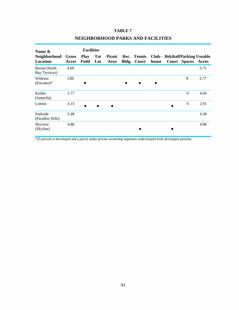
91
TABLE 7
NEIGHBORHOOD PARKS AND FACILITIES
Name &
Neighborhood
Location
Gross
Acres
Facilities
Picnic
Area
Rec.
Bldg.
Tennis
Court
Club-
house
Bsktball
Court
Parking
Spaces
Useable
Acres
Play
Field
Tot
Lot
Boone (North
Bay Terraces)
4.69
3.75
Widman
(Encanto)*
3.80
• • • • 8 2.77
Keiller
(Jamacha)
5.77
0 4.04
Lomita 4.15 • • • •
0 2.91
Parkside
(Paradise Hills)
5.48
4.38
Skyview
(Skyline)
4.88
• • 4.88
*25 percent is developed and a parcel under private ownership separates undeveloped from developed portions.

92
OBJECTIVES
1. Provide a park system consistent with General Plan standards to the extent feasible given
existing constraints.
2. Coordinate the use of school recreational facilities for after normal hour usage.
3. Require the provision of private recreational facilities and usable open space in new
larger residential developments.
4. Provide a safe environment in all parks to allow their use by the entire community.
RECOMMENDATIONS
1. The 10.54 acres, which are occupied by the School of Creative and Performing Arts
(SCPA), formerly known as the Penn Athletic Area, are leased to the City of San Diego
by the San Diego Unified School District. This lease has been renewed and is scheduled
to expire in 2032. If no longer used as a school, this site should be considered for
purchase by the City for the establishment of a neighborhood park.
2. Undeveloped neighborhood parks should be improved with playing fields, all-purpose
courts and picnic areas as funds become available.
3. An increase in park fees for new development is recommended.
4. The sale of City-owned properties in the community which are not needed or are not
suitable for public use should be explored as a method of obtaining funds for acquiring
additional park acreage and/or additional staff and facilities to compensate for existing
park deficiencies.
5. Because of the limited opportunities for acquisition of additional park sites, retention of
the Twin Hills Youth Park as a neighborhood serving recreation facility is recommended.
The park is encouraged to remain a privately-owned ball field; however, if the present
owners decide to discontinue this use, the City of San Diego should consider purchasing
the site.
6. All new multifamily residential developments should be required to provide private
recreational facilities and/or usable open space areas within the development.
7. The Police Department and Neighborhood Watch organizations should provide regular
patrols and surveillance over parks to ensure that they remain safe and free from
vandalism.
8. In cases where parks are adjacent to school recreational facilities, coordination with the
school district should be sought to allow the use of these facilities after normal school
hours

93
9. In the event that any school sites are declared surplus, first priority should be given to
acquisition or lease of the sites for park use.
10. Project First Class landscaping improvements should be targeted toward the approaches
to the community parks (Skyline, Bay Terraces and Paradise Hills) to emphasize these
parks as centers of community activity.
11. All City-owned park sites should be rezoned to an open space (OS) zone.

94
OPEN SPACE ELEMENT
PRIMARY OPEN SPACE GOAL
Provide an open space system which preserves existing canyons and hillsides and ensures
open space accessibility.
EXISTING CONDITIONS
Paradise Canyon is one of the principal open space systems proposed for the Skyline-
Paradise Hills community. It is located south of Skyline Drive, north of Paradise Valley
Road, between Division Street and Meadowbrook Drive. Comprising over 45 acres, most of
which is within the Hillside Review Overlay Zone, the open space consists of the valley floor
and the steep southern slopes of the canyon. The canyon is relatively undisturbed. The City
has acquired all land from Division Street extending 700 feet east of Woodman Street,
consisting of approximately 30 acres (Figure 18).
The Jamacha open space system (the abandoned Encanto Expressway right-of-way)
consisting of approximately 54 acres, is a second open space system within the community.
This undeveloped canyon runs parallel to Jamacha Road from Encanto park on the west to
Cardiff Street on the east. Single-family development lines the canyon’s southern rim and the
floor of the canyon along the foot of the northern canyon wall. Acquisition of this open space
system is approximately 80 percent complete.
The slopes along the south side of Paradise Valley Road, east of the City limits are owned by
the federal government and are a part of the open space system for naval housing. The City
owns approximately 27 acres of undisturbed slopes on Paradise Valley Road which are part
of Paradise Hills Community Park and serve as a transition area between the federal open
space and the park.
A 16-acre site in the Hillsborough residential development, south of Paradise Valley Road
and east of Briarwood Road, is maintained by a homeowners association as open space.
The community also contains two linear open space parks. One of these greenbelts provides
access to Parkside neighborhood park (not yet developed) and the other leads to Penn
Elementary School. A third open space site provides a landscaped buffer between Bell Junior
High School and a single-family neighborhood. The property developer has deeded these
sites to the City and has contributed funds for the rehabilitation necessary to bring the areas
up to City standards.
Views of undeveloped hillsides and canyons within the community as well as views toward
the mountains to the east, the Pacific Ocean, San Diego Harbor and the City skyline are
important assets to this community as they provide visual open space, and thus should be
protected. Hillside and canyon areas not within the designated open space system have been
identified as areas that require preservation to the extent possible through sensitive
development. These areas have been included in the Hillside Review Overlay Zone. The

95
guidelines for hillsides and canyons outlined in the Urban Design Element of this Plan are
intended to provide direction for any future development of these sites.
Four streambeds have been identified in the community. None are subject to the City’s
Floodway, Floodplain, or Floodplain Fringe zoning, however, all are subject to flooding, and
have been identified by the City flood hazard maps as areas within the 100-year floodplain
(Figure 17). These areas should be maintained as natural open space areas to be used as
possible linkages connecting open space and recreational areas to one another and to
residential and activity centers.
A local equestrian trail (The Encanto Trail) was proposed in the Equestrian Trails and
Facilities Plan adopted by the City Council in 1975. The trail was proposed to extend north
through the South Bay Terraces neighborhood and west through Paradise Canyon. The
feasibility of implementing this trail should be studied when the equestrian trails plan is
updated. The South Bay Terraces neighborhood is now an urbanized area that may no longer
be suitable for equestrian trails.
Objectives:
1. Develop specified open space areas for passive recreational uses such as hiking or bike
trails.
2. Provide a linkage system of pedestrian and bicycle facilities connecting parks and open
spaces.
3. Ensure that development located adjacent to open space areas is compatible with and
enhances open space areas.
4. Preserve visual and physical access to open space areas from public rights-of-way to
increase passive recreational use.

96

97

98
RECOMMENDATIONS
1. Paradise Canyon is the community’s highest priority in terms of retention. Those portions
of the canyon not yet acquired should be retained for open space purposes through the
planned residential development permit process or subdivision process and should be
rezoned to Rl-40,000. The canyon should remain in its natural state except for a five-acre
parcel located north of Boone Elementary School which will be developed as a
neighborhood park. Future development next to this open space system should be
designed to ensure that the natural environment remains undisturbed.
2. The Jamacha open space system is on the Open Space Retention List as part of the
Chollas Creek open space acquisition efforts. It is recommended that this open space be
partially developed with a bicycle trail along the canyon floor. The trail should provide a
link between the bikeways designated in the adopted Bikeway Map and connect
recreational facilities in the community. Figure 14 shows the linkage of bicycle trails and
this open space area.
3. The slopes on the south side of Paradise Valley Road between Potomac and Munda,
which are owned by the federal government, should remain in their natural state.
4. The community’s linear open space parks, although not part of a larger open space
system, are a unique resource in this community as they provide a pedestrian linkage
system to public facilities and, therefore, should continue to be maintained as open space.
5. Any development adjacent to open space areas should be designed in accordance with the
guidelines outlined in the Urban Design Element of this Plan.
6. All slopes which meet the criteria of the Hillside Review (HR) Overlay Zone should be
zoned HR and should be developed in accordance with the guidelines for Hillside and
Slope Development contained in the Urban Design Element.
7. Areas proposed for open space designation in this Plan should be rezoned to Rl-40,000 to
preclude development which is inconsistent with the topography.
8. All City-owned open space areas should be rezoned to an open space (OS) zone. Paradise
Canyon and the Jamacha Open Space System should be rezoned when the City's
acquisition process has been completed. All existing and future open space easements
should also be subject to an open space zone if brought under public ownership.

99
PUBLIC FACILITIES ELEMENT
PRIMARY PUBLIC FACILITIES GOAL
Establish and maintain a high level of public facilities and services to meet
community needs.
OBJECTIVES
1. Provide public facilities and services in accordance with City standards.
2. Maximize the use of existing public facilities for community activities.
3. Increase safety through measures such as the addition of street lighting at
appropriate locations.
DISCUSSION
Schools
Public education is provided by the San Diego Unified School District. Table 8 shows
schools within the community, existing and projected enrollment figures, and operating and
total enrollment capacities. Operating capacity represents the program demands on classroom
configuration at the school. It takes into account magnet and other special programs which
require smaller numbers of students per classroom. Total or as-built capacity represents the
maximum use of space based on 30 students per classroom. This method disregards special
program requirements and provides a maximum usage number for baseline purposes.
There are five magnet schools in the community. They are: Freese and Fulton Elementary
Schools, Keiller Middle School, Bell Junior High School and Morse Senior High School.
Magnet schools offer enriched or special programs and are attended by students outside the
school’s attendance area boundary. Encanto and Valencia Park Elementary Schools, located
in the Southeast San Diego community, also serve the area.
In September 1986, two new schools, Bethune Elementary and Zamorano Elementary, were
opened which alleviated over-enrollment in most of the community’s elementary schools.
Only Freese Elementary currently exceeds its operating capacity. However, according to
enrollment projections, Bethune, Zamorano and Boone Elementary Schools are expected to
exceed their total, or as-built, capacities by 1990.
Bell Junior High School currently exceeds its operating capacity based on the school’s
current programs. A site just north of Penn Elementary School has been reserved for an
additional junior high school. The beginning of construction is anticipated in 1990-1991.

100

101
TABLE 8
PUBLIC SCHOOL ENROLLMENT
School
October 1986
Enrollment
Estimated Projected
Enrollments Capacity 1986
1987 1990 Operating Total
Elementary
Bethune 953 1,048 1,134 * 960
Freese 717 737 807 654 930
Robert Lee 816 835 909 816 930
Paradise Hills 962 988 1,106 990 1,170
Penn 899 939 1,014 1,170 1,050
Boone 981 1,140 1,190 1,044 1,110
Fulton 635 743 839 720 900
Audubon 773 757 889 810 900
Perry 742 773 842 1,080 1,020
Zamorano 936 1,104 1,114 * 960
Middle School (6th
to 8th
grade)
Keiller 653 701 848 608 978
Junior High (7th
to 9th
grade)
Bell 2,303 2,435 1,618 1,665 2,730
Senior High
Morse 2,124 2,135 2,246 2,309 3,000
* Figures not available from the school district.
The San Diego Unified School District's Long-Range Facilities Master Plan, completed in
January 1987, presents strategies and financing methods for accommodating almost a
40 percent increase in student enrollment throughout the district by the year 2000. The Plan
recommends new school construction, multi-track year-round schools and double-session
kindergarten as the primary solution strategies; additional recommended strategies include
portable classrooms and boundary changes.
Multi-track year-round schools are recommended for all of the elementary schools in
Skyline-Paradise Hills by 1991. Double-session kindergarten is also recommended for all
elementary schools except Freese and Fulton, which are magnet schools. Keiller Middle
School and Bell Junior High are recommended for multi-track year-round school beginning
in 1988-1989. Morse High School is planned to accommodate student enrollment increases
by converting from grades 9-12 to 10-12 with the ninth grade moving to the new junior
high facility.

102
Alternative Uses for School Sites
School sites should be zoned at the density of surrounding residential development and
should be placed in the Institutional Overlay Zone. This will ensure adequate review before
the sites are considered for other uses. In the event that any school sites are declared surplus,
first priority should be given to acquisition or lease of the sites for park use. If a site is found
to be unnecessary or undesirable for park use or another public use, the site should be
developed at the density of the underlying residential zone in a manner compatible with the
surrounding neighborhood.
The Paradise Hills Elementary School site and the Audubon Elementary School site are
currently zoned R-3000. These sites should be rezoned to R1-5000 so that in the event the
sites are no longer needed for educational or other public use, they will be developed at a
density compatible with existing neighborhoods.
An 18-acre site south of Paradise Valley Road and east of Briarwood Road is owned by the
school district and has been reserved for a possible future elementary school site. Because the
site lies partially on the former Sweetwater Landfill, it is recommended that this parcel be
rezoned to R1-40,000. That area which is on the landfill site should remain undeveloped or
used for passive recreational use only. If the School District determines that the site will not
be used for a school, the portion of the site that is not impacted by the landfill should be
developed with a clustered residential development. A rezone may be necessary to achieve
this density depending on the amount of acreage available for development; however, a
community plan amendment would not be required.
Police
Police protection for the community is provided by the Southeastern Area Substation of the
San Diego Police department, located at Skyline Drive and Sychar (Figure 20). Service to the
community is in two police beats: Beat 411, the southern beat including Paradise Hills, South
Bay Terraces and the southern half of North Bay Terraces; and Beat 412, the northern beat
including Skyline, Lomita, Jamacha and the northern part of North Bay Terraces. During the
day, there is one designated one-person patrol unit per beat. In the evening, the designated
patrol increases to two-person coverage and the addition of two secondary units for each
beat.
The Police Department heads a neighborhood watch organization called ―Community Alert.‖
Its purpose is to involve residents with their own neighborhood in a self-protection program
against crime through an unofficial watch program.
Fire Protection
Fire protection in the community is provided by Engine Company 32, located at 484
Briarwood Road. There are many areas (demand zones) that cannot be reached by Engine 32
in six minutes or less. The six-minute response time is the Fire Department’s citywide
guideline for response to residential areas.

103

104
Due to the community’s location on the City limit boundary, fire protection in the
community is augmented by automatic aid agreements with five neighboring jurisdictions:
Spring Valley, Lemon Grove, La Mesa, Bonita-Sunnyside and National City. Under these
agreements, fire protection support is provided to an area by the nearest engine company,
regardless of district boundaries.
Even with automatic aid from these agencies, the six-minute response time is exceeded.
Providing a level of service that is consistent with the rest of San Diego will require the
addition of at least one new fire station and possibly the relocation of Engine Company 32.
The appropriate locations will be determined by a response time analysis of potential sites
within the community, conducted by the Fire Department.
Any new fire station proposed by the Fire Department should be reviewed by the Planning
Department for location, design issues and compatibility with the surrounding neighborhood.
Post Office
There are two postal substations within the community: one located on Reo Drive between
Albemarle and Cumberland and one on Imperial Avenue at Lisbon Street. There is
substantial patronage at this latter substation due to its accessibility to the Skyline
community, neighboring Southeast San Diego and the adjacent commercial uses. Parking and
traffic congestion in the parking lots and the adjacent streets is a problem. Any proposed
relocation or expansion of the Imperial Avenue postal substation should be reviewed by the
Planning Department. A location along the Trolley Corridor is recommended to minimize
impacts to residential neighborhoods. Planning Department review is recommended to
address issues such as compatibility with, and enhancement of, the Trolley Corridor,
landscaping, minimizing impacts on pedestrian circulation, patron and service access,
parking, lighting and noise impacts.
Recommendations for parking and circulation improvements for the Reo Drive substation are
discussed in the Commercial Element under Reo Drive.
Libraries
Library service is provided by the Paradise Hills branch library, located at 5922 Rancho Hills
Drive, and the Skyline branch library, located at 480 South Meadowbrook Drive. The
Paradise Hills library offers 17,300 volumes (as of Fiscal Year 1986) and has 3,875 square
feet of service area. The Skyline library offers 15,400 volumes and has 4,400 square feet of
floor area.
Standards set forth in the General Plan recommend that branch libraries serve 18,000 to
30,000 residents within a maximum service area radius of two miles. Branch libraries should
have an eventual capacity of 4.4 volumes or more per square foot of service area. The two
branch libraries meet these criteria. The City should continue the provision of library
facilities at the present level of service, with services expanded as the community reaches its
buildout population.

105
Water and Sewer Service
The sewer trunk lines serving the community are located along Jamacha Road, Plaza
Boulevard, Paradise Valley Road and Parkside Avenue. All sewage is processed at the Point
Loma Treatment Plant.
A new trunk line to replace the trunk line in Plaza Boulevard, also known as the Highland
Park Estates Trunk Sewer, is to be constructed in two phases. Phase I construction is
scheduled for Fiscal Year 1987. Phase II design is planned for Fiscal Year 1993 with
construction to commence in Fiscal Year 1994.
Gas and Electricity
San Diego Gas and Electric’s (SDG&E) Paradise Substation is located near Plaza Boulevard
and Woodman Street. Two 69,000 volt transmission lines are also located within the
community and require unobstructed access along the lines for patrol, maintenance, and
repair. The substation is indicated on Figure 20.
Landfills
There are two completed landfills in the planning area, which are illustrated on Figure 20.
They are the Paradise Landfill (located at Paradise Valley Road and Potomac Street) and the
Sweetwater Landfill (located south of Parkwood Drive east of Goode Street). Both contain
normal refuse and trash (no hazardous substances).
The Paradise Landfill, completed in 1967, is presently the site of the Paradise Hills Park and
Recreation Center. The landfill occupies 5.60 acres of the 13-acre property.
The Sweetwater Landfill was completed in 1960. Covering approximately 20 acres, the fill
contains over one million cubic yards of refuse. A privately-owned and maintained open
space area occupies the northern portion of this site. The San Diego Unified School District
owns the southern portion of the site, which they have designated for a playing field for a
possible future elementary school. This site should be rezoned to R1-40,000 as described in
the discussion of school sites.
As with all refuse landfills, there is the likelihood of methane gas leakage and some ground
settling. Due to the sensitivity of this land with respect to development, it is recommended
that these areas remain undeveloped or reserved for passive recreational uses only.
Alternative Uses for Public Facility Sites
The Institutional Overlay Zone should be applied to all publicly-owned land designated for
public facilities. This will ensure adequate review before the sites are considered for other
than institutional or public use.

106
CULTURAL AND HISTORICAL RESOURCES ELEMENT
PRIMARY CULTUAL AND HISTORICAL RESOURCES GOAL
Preserve the cultural and historical resources of the Skyline-Paradise Hills community.
EXISTING CONDITIONS
There are eight documented archaeological sites in the community planning area. The most
important sites (where artifacts such as blades, flakes, cobble tools, core tools and scraper
planes have been found) provide evidence of the tool-making procedure and the methods of
processing animal and plant materials used by an unidentified Indian culture group.
Three of these archaeological sites have been disturbed by either residential development or
off-road activity.
There are three documented paleontological sites in the community. All of the specimens
from these sites lived during the Pliocene Era, which began ten million years ago and ended
one million years ago. These sites have yielded many specimens, including mollusks, sharks,
manta rays, dolphins, baleen whales, a sea lion and many types of birds and bony fish. All
three sites have been disturbed by residential development.
Within the planning area there are outcrops of the San Diego Formation. This formation has
yielded fossil invertebrates and has a high potential for further marine vertebrate finds.
OBJECTIVES
1. Protect the resource value of archaeological artifacts and paleontological resources within
the community.
2. Preserve buildings of architectural and historical interest in the community.
RECOMMENDATIONS
1. Developments that might impact archaeological or paleontological sites should be
identified during the permit process. These impacts should be mitigated through the
environmental review process.
2. Structures within the community that are considered historic should be reviewed for
inclusion as a City landmark designation. These properties should take advantage of
available benefits such as property tax or investment tax credits.

107
Urban Design Element
Introduction
Residential Guidelines
Commercial Guidelines
General Guidelines

108
INTRODUCTION
Urban design addresses a wide range of issues, including the visual impact of new
development, the compatibility of new development with the existing community and the
natural landscape, and perceptions of image, identity and character within a community.
Other elements within this Plan address the location, timing, and sequence of development
and facilities. The Urban Design Element is vital to the cohesiveness between the other
elements of the Plan because it deals with the quality and form that new development will
take.
PRIMARY URBAN DESIGN GOAL
Enhance the community’s image through improvements to the visual and physical character
of the community.
EXISTING CONDITIONS
Skyline Paradise Hills is a predominantly urbanized community although the development of
remaining vacant parcels, as well as the redevelopment of existing properties, has the
potential to affect the quality of the community.
The landforms of the area consist of rolling hills and canyons with views of Coronado, San
Diego Bay, the Pacific Ocean, mountains to the east of the City and hillsides and canyons
within the community. Development has been relatively responsive to topography and has
produced neighborhoods of winding streets with structures oriented to take advantage of
views into canyons, open space and to points outside of the community. Streets, especially in
the western portion of the community, provide view corridors to the west. In many areas
throughout the community, backyards and side yards consist of or abut canyons and hillsides.
These steeper areas have remained free of development and provide smaller open space
systems which, although not physically accessible to the general public, do provide visual
open space to surrounding residents. Some of the newer residential development is repetitive,
however, and has left much of the land absent of vegetation. Barren hillsides and sparse
street tree planting are characteristic of many new neighborhoods.
Commercial development in the community is primarily older, small-scale and
neighborhood-oriented, with the exception of the shopping center at Woodman Street and
Alta View Drive. Many of the sites could be more fully utilized and improved with
coordinated design and landscaping. Because of the lack of additional commercial land
available, revitalization of these older commercial areas is essential to providing adequate
commercial services for the community.
Project First Class was established in 1984 as a comprehensive program of design guidelines,
landscape improvements, code enforcement and business development for the Fourth
Council District. The proposals presented in the Project First Class Urban Design Program
have been incorporated into the design guidelines of this Plan.

109
OBJECTIVES
1. Ensure that new development is compatible with existing neighborhoods in terms of
bulk, scale and design, and that it is sensitive to existing topography.
2. Improve the quality of design of new residential development.
3. Improve the appearance of existing commercial facilities to revitalize existing
businesses and stimulate the development of new business.
4. Orient development to encourage interest at the pedestrian scale in order to stimulate
pedestrian circulation.
5. Improve the streetscape in the vicinity of parks and recreation centers, public
buildings, and high visibility streets in order to provide a sense of identity to activity
centers and the routes leading to them.
RECOMMENDATIONS
The following urban design guidelines are intended to be applied to all new development and
rehabilitation of residential and commercial sites in the Skyline-Paradise Hills community.

110
RESIDENTIAL GUIDELINES
Building Scale
Height, bulk and scale of buildings are factors which contribute to continuity within
development and adaptability to the surrounding environment. If a community is to exhibit
physical character and identity, its development must occur with some consideration for how
development fits together and works with existing development and landforms.
New development should be compatible with the scale and character of the surrounding
development. Building scale should be related to the prevailing height, bulk and intensity
of use in the area, and to the wider effects upon the neighborhood, views and topography.
The transitions and visual relationships between new and older buildings should be
harmonious. A conscious effort to achieve balance and compatibility in design between
buildings is needed. This can be accomplished by repeating existing building lines and
surface treatment and by gradual transitions in height, bulk and density. Abrupt
differences in scale should be avoided.
Where new buildings are larger than existing structures, large surfaces should be
articulated and textured to reduce their apparent size and to reflect the pattern of existing
buildings.
Where lot consolidation takes place, special consideration should be given to adjacent
parcels to ensure that new development does not visually overwhelm neighboring areas.
Building bulk should be controlled through the use of ground level and upper level
setbacks, facade variation and architectural features recessed entryways, porches,
balconies, bay windows) which serve to break up building facades into smaller-scale
visual components. Long continuous building masses that create a wall effect shall
be avoided.
Small courtyard and cluster residences of 15-25 dwelling units are recommended for
multifamily residential development.
Any new development in the R-3000 zone should be low-scale with particular attention paid
to the bulk and scale of surrounding development, and to potential view blockage.
Site and Building Design
In new developments, repetitious use of identical style and type of dwellings should be
avoided. Larger projects in particular result in greater visual prominence of development.
Using a variety of structures can result in a more interesting appearance, and can also
produce a wider range of housing costs. Use of staggered setbacks, varied building

111
heights, widths, shapes, orientations and colors should be incorporated. Protected
courtyards, verandas, facades and porches are also encouraged to promote building
variety.
New residential development should be integrated with existing street and sidewalk
patterns rather than being designed as an enclave or complex apart from the
neighborhood. Sidewalks should be provided along at least one side of all private streets
and should link in a clear manner to existing pedestrian and bicycle ways. Sidewalks
should be provided between important shared facilities and to important off-site
designations such as transit stops.
The site’s design should provide clear, direct relationships between the buildings, streets
and the pedestrian circulation system. Buildings should be oriented toward the public
street, and each dwelling should visibly relate to the street. Units hidden on the back
portion of the site or behind another building should be avoided. Visible street entrances
or street-facing courtyards with dwellings entered from the courtyard are encouraged.
Usable open space should be provided for each unit. This may be in the form of a garden,
courtyard, terrace, or roof deck or other space which allows residents to have their own
territory outdoors.
When located on ground level, private open space should be screened from public view
by landscaping or privacy fencing.
Private open space should be oriented to receive good sun penetration and to provide
shade in the warm months.
Parking Areas for Residential Development
Off-street parking areas should be placed in unobtrusive locations and should be designed
to minimize their visual impact on the site and the surrounding neighborhood.
Parking lots should not be placed between the front of a residential building and the street.
Consideration should be given to prohibiting parking in the required front and side yard
areas.
For multifamily developments, a portion of the parking area should be enclosed by garages,
carports, or trellises. These areas should relate in design and scale to the residential units
and should not significantly block views from the street into the development.
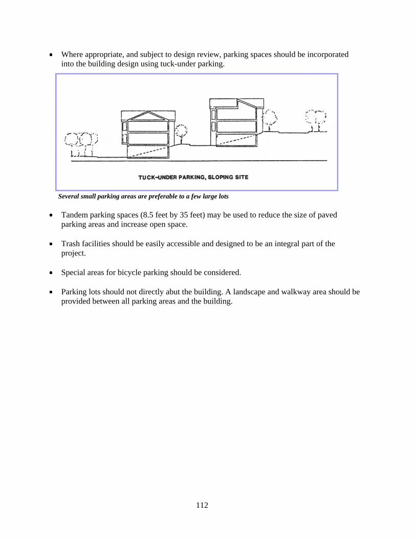
112
Where appropriate, and subject to design review, parking spaces should be incorporated
into the building design using tuck-under parking.
Several small parking areas are preferable to a few large lots
Tandem parking spaces (8.5 feet by 35 feet) may be used to reduce the size of paved
parking areas and increase open space.
Trash facilities should be easily accessible and designed to be an integral part of the
project.
Special areas for bicycle parking should be considered.
Parking lots should not directly abut the building. A landscape and walkway area should be
provided between all parking areas and the building.

113
Landscaping islands should be provided at regular intervals in parking areas. Tree canopies
and patterned paving are encouraged to soften large areas of paving.
Landscaping should be used to screen parking areas from the street and nearby residences.
To allow opportunities for surveillance of parking areas, shrub planting or low walls may
be used to partially screen parking while still allowing a line of site into the area.

114
COMMERCIAL GUIDELINES
Site Design and Parking
1. In older commercial areas where existing buildings are close to the property line, the
following guidelines shall apply.
a. Buildings should be placed within ten feet of the property line to maintain a
consistent street setback pattern and to enhance pedestrian activity.
b. If buildings are set back from the property line, the area between the building and the
public right-of-way should be fully landscaped, interrupted only by permitted
driveways. Decorative paving may be used to meet a portion of the landscaping
requirement.
c. Parking lots at the sides or rear of the building should not directly abut buildings. An
intervening area of at least five feet should be used for planting or a pedestrian
walkway of a different finish material than the parking lot.

115
d. Where parcels are served by an alley, curb cuts should be limited and the alley should
be used for access. This will increase the opportunity for on-street parking, pedestrian
circulation and landscaping.
e. Parking lots at the sides of the building should be set back from the public right-of-
way at least ten feet with this area fully landscaped.
f. Rows of parking spaces should not be continuous. Landscaped islands should be
provided at a minimum of every eight spaces.
g. New development or redevelopment should be pedestrian-oriented. Buildings on
shopping streets should develop a transparency with the pedestrian environment of
the sidewalk. This will help to avoid blank and solid walls at the sidewalk.
Transparency can be accomplished by the use of glass or other transparent materials.
h. Streetscape elements, including widened sidewalks, kiosks, street furniture, street
lighting and signage, should be used to enhance the appearance and function of
commercial developments. These elements should be compatible with the materials,
color and design of the structures and should be planned as a unifying element of the
commercial area.
i. Landscaped buffer areas should be provided between commercial and residential
uses.

116
2. In larger scale or auto-oriented commercial centers, the following guidelines shall apply:
a. Parking areas should be set back at least ten feet from the property line and the
intervening area fully landscaped.
b. Any walls or fences should be set back from the property line to permit landscaping
between the right-of-way and the wall or fence.
c. Parking lots should not directly abut the buildings. An intervening area of at least five
feet should be used for planting or a pedestrian walkway of a different finish than the
parking lot.
d. Rows of parking spaces should not be continuous. Landscaped islands at least four
feet wide should be provided at a minimum interval of every eight spaces.
e. Streetscape elements including kiosks, walkways, seating areas, lighting and signage
should be used to enhance the appearance and function of commercial developments.
These elements should be compatible with the materials, color and design of the
structures and should be planned as a unifying element of the commercial area.
f. Landscaped buffer areas should be provided between commercial and residential
uses.

117
GENERAL GUIDELINES
Pedestrian Activity
Streets should be designed and developed as pleasant places to walk as well as drive.
Pedestrian areas should be emphasized through the use of wider sidewalks, benches,
pedestrian scale signs, paving materials and landscaping.
Projects should front on the public street and provide identifiable pedestrian access from
the street into the project, even in areas where parking lots are located between the street
and the project.
All pedestrian pathways shall have adequate lighting and signing to provide for the safety
of the users.
Pedestrian linkages should be provided as appropriate between public activity areas
including schools, libraries, parks and open space areas, shopping areas and transit stops.
Such linkages could be in the form of linear parks, landscaped sidewalks or separate
pathways.
Streetscape
Landscaping should be used to tie buildings and site developments to existing streets and
sidewalks, visually anchoring buildings to the larger environment of the neighborhood.
Landscaping which de-emphasizes turf areas and utilizes native and drought resistant
plant materials is encouraged.
Street development should provide for trees and shrubs along sidewalks as well as
median strips and should utilize native or drought resistant plants where possible.
Landscaping should be placed in the median strips of streets wherever feasible.
Curb cuts should be minimized to allow more landscaping and parking along the streets.
Taller trees or other type of specialized planting program should be used to mark major
intersections and to add focus.
A strong sense of edge along public streets and private streets within planned
developments should be developed to spatially define streets. This can be accomplished
by the arrangement of street trees near the public right-of-way in a linear pattern. In
commercial areas, consistent building setbacks also help define the street.

118
The five-foot strip between sidewalks and private property lines often creates a
maintenance problem, particularly where residences back up to major streets such as
Paradise Valley Road. Landscaping and maintenance of these strips will do a great deal
to improve the visual quality of the community. A possible funding source for street tree
planting in this strip is the Project First Class landscaping program; however,
maintenance of the landscaping must be assured by a maintenance district or some other
assessment district.
Leftover small parcels along major streets and freeways should be conveyed to adjacent
owners with deed restrictions or some other mechanism to ensure they are maintained as
open space.
All street widenings and related improvements should have quality design standards. The
Planning Department should review all CIP projects and a landscape architect should be
consulted on an as-needed basis to improve the aesthetic quality and cohesiveness of
street improvements.
Fencing along streets that is used to screen or to enclose private yards should avoid
―walling off‖ the street. Shrubbery, trees, and architectural detailing should be used to
add visual interest.
Project First Class Landscape Improvement Program
A comprehensive landscape improvement program for neighborhoods and important street
corridors was initiated as part of the Project First Class Urban Design Program (Gerald Gast,
AIA, Tectonics, Kercheval and Associates, Inc., and Garrett Eckbo, FASLA, 1985). The
program was designed as a joint effort between the City and property owners. An investment
of $1,200,000 in Project First Class funds has been targeted for planting improvements in
centers of community activity—parks and recreation centers, public buildings and high
visibility streets—throughout Council District Four.

119
The City-funded landscape program is the initial step. It will require the cooperation of
private property owners to accomplish a long-range program. Citizens are encouraged to
continue the landscape effort with a neighborhood planting program. The establishment of
Landscape Maintenance Districts is recommended as a means of funding neighborhood
planting. A relatively small tax on property owners has the potential to provide substantial
benefits including higher property values as the neighborhood environment appreciates. An
alternative to the maintenance district would be owner participation agreements with adjacent
owners to assure the maintenance of landscaping placed in the right-of-way.
As part of the landscape program, planting guides should be established for neighborhood
areas and important street corridors. Appropriate plant species for each area should be
selected based on existing site conditions, existing plant materials and based on the existing
or desired character of each area. These species would be recommended for street tree
planting to establish landscaping themes providing an element of identification and
continuity within the neighborhood areas.
Centers of community activity such as community parks, libraries and schools should be
given priority for special landscaping programs.
The following streets should be given the highest priority for street planting
improvements:
- Skyline Drive
- Paradise Valley Road
- Reo Drive
- Imperial Avenue
• A community nursery is recommended as an element of the landscape program. The
nursery would be a source of plant material for community residents to purchase for their
homes. It would be managed for community benefit, employ local youth and enlist
volunteer help and retired persons. The nursery could also serve an educational function
by developing an arboretum illustrating gardening principles to community members. A
joint project with the Park and Recreation Department should be considered. The
Department already maintains a large nursery and could administer a community self-
serve project, perhaps as a pilot to be used in other areas.
Lighting
Street lighting should be of different illumination levels to reinforce circulation hierarchy
(public roads, private roads, parking areas, pedestrian walkways). Lighting should be
designed and located so as to not shine on adjacent properties.
Where low-level lighting is used, fixtures should be placed so that they do not produce
glare. Shatter-proof coverings should be used for all low-level lighting fixtures.
In addition to walkway lighting, peripheral lighting should be provided for multifamily
developments. Peripheral lighting provides security for surveillance of the units and

120
allows residents and visitors to see into their surroundings and determine if passage
through an area is safe.
Sign Standards
Signs should be designed for compatibility with the architecture of surrounding
development. Signs should not dominate the streetscape, but blend with it while
providing an element of interest.
Building mounted signs should not project above the roofline.
Multiple signs within a development should have a standardized format and design for
uniformity.
Freestanding signs should be pedestrian scale. These signs should be appropriately
landscaped and lit.
Screening
Trash receptacles should be screened. Refuse collection areas should be surrounded by a
solid wall or fence with a minimum height of four feet or the height of the container,
whichever height is greater. A six-foot solid wall or fence should be constructed between
the container and any adjoining residentially zoned property. Wherever possible, refuse
collection areas shall be directly accessible from alleys. All enclosures should be
constructed with finishes and colors that are harmonious to the architectural theme of the
primary buildings.
Service areas and loading docks should be screened. These areas should be located so
that they do not create visual clutter or problems with vehicular/pedestrian circulation.
Berms, bushes or low fencing should be used to screen parking lots that front roadways.
If fencing is used, walls should not be continuous; variation of surface relief, materials or
posts at regular intervals should be used and fencing should not be over four feet in
height to allow for protective surveillance.
• Rooftop mechanical equipment should be screened to protect existing and future views
from hillside developments.
Designing for Defensible Space
The concept of territorial and defensible space should be considered in designing public and
private improvements. This is accomplished without the building of fortresses and is
successful when a potential offender perceives that he is intruding on the domain of another,
and that he will be noticed if he intrudes. He is then more likely to be deterred from criminal
behavior. The neighborhood watch program successfully uses this premise.
Buildings and grounds should be designed to be self-policing so that residents may
participate in its security.

121
Smaller-scale courtyard developments are encouraged, as they are easier to self-police
than large complexes.
Windows should be positioned to allow residents to easily watch public spaces, parking
areas and entrances to dwellings.
Common open spaces and entryways should be visible from the street allowing clear
vision by neighbors and law enforcement officers.
Sidewalks or paths should be located between parking areas and residences, and between
the street and residences to allow natural surveillance over the entire path.
Night lighting along walkways, streets and at parking lots should be provided by using
fixtures that will shape and deflect light into a layer close to the ground. This will place
light where it is needed most and reduce interference with windows.
Parking areas may be buffered from the street with planting while allowing for
surveillance if low shrubs and ground covers are used.
Residences should be separated, by physical barriers or distance, from possible crime
generators such as bars, adult entertainment establishments, etc.
Residences should be separated, by physical barriers or distance, from region-serving
facilities which generate large volumes of pedestrian and vehicle traffic, such as post
offices, regional high schools, shopping centers, hospitals, health clinics and community
park and recreation centers.
If security fencing is used, attention should be given to its design. Fencing should be an
attractive architectural feature of a project and should be graffiti-resistant, such as in the
use of wrought iron fences integrated into the overall design of the project.
For buildings fronting a public street, two means of providing a street entrance are
encouraged:
1. Through a street-facing courtyard, with dwelling units entered from the courtyard.
2. Through visible street entrances.
Both configurations have proven to be the best means of providing security to sidewalks
and building entrances through natural surveillance opportunities.
Hillside and Slope Development
The community’s natural base of hillsides, canyons, ravines, streams and vegetation is an
important set of assets that should be protected in new development. Site plans should
utilize existing topography and preserve existing vegetation, ravines, watercourses and
topographic features.

122
Due to the high visibility of sloping sites, views of the slopes from surrounding
neighborhoods and public rights-of-way should be given strong consideration. Buildings
located near hillside rims should be sited in a staggered arrangement and screened with
planting to avoid a wall effect. Large expanses of flat areas such as parking lots should be
avoided. Multiple small parking lots are preferable.
The treatment of rooftops should be varied on sloping sites, rather than consisting of
extended horizontal lines. Rooflines should be used to emphasize the variety in shape and
flowing character of the hillside instead of masking it.
Planned residential development permits are recommended in areas where the natural
slope is 25 percent or greater.
As has already been done in many of the neighborhoods of Skyline-Paradise Hills,
housing should be designed to fit into the hillside, complementing the land’s natural
character, rather than altering the hillside to fit the structure.
The need for excessive level areas should be minimized through the use of multi-level
structures and split-level roads.
Street alignments should follow existing natural contours. Street width should be kept to
a minimum to avoid wide graded areas. Curvilinear designs, split-level roadways and
one-way streets may be employed to minimize disturbance of the site.
Graded slopes should be shaped to conform to existing landforms. Building sites should
be graded so that they appear to emerge from the slope. Slopes with a gradient of 25

123
percent or more should minimize flat areas. If slab-on-grade construction is necessary,
building floor elevations should be staggered.
Building and architectural techniques other than preparation of standard pads or cut and
fill grading should be used on sloping sites. Buildings should be sited to minimize the
requirement for high retaining walls or extensive cut and fill. Structures should minimize
the use of continuous footings and follow the natural slope of the land. Buildings on
sloped sites of ten percent or more should step with the grade at regular intervals.
Site design should adapt to the existing natural drainage system and should not alter
surface runoff and water table conditions. It should not impose drainage problems on
neighboring properties, nor should it increase the potential for soil erosion.
Existing vegetation should be preserved
as much as possible. Areas that have
been disturbed by construction should be
revegetated with drought tolerant plant
materials. New landscaping should
employ species similar in scale at
maturity to adjacent landscaping and
natural vegetation. Landscaping adjacent
to natural canyons or open areas should
be selected to be fire retardant while still
being sensitive to impacts on active
vegetation.
.

Neighborhood Element
Introduction
Summary of Issues and Recommendations
Recommendations

126
Figure 21. Neighborhood Areas

127
INTRODUCTION
The Skyline-Paradise Hills community plan area encompasses approximately 4,500 acres and
houses over 59,000 residents. It includes six neighborhoods, each with subtle differences in
physical and social characteristics. The delineation of these neighborhoods is based on
topographic features, boundaries such as major streets and type and pattern of development.
Density ranges throughout these neighborhoods have little variation due to the residential
community makeup, which consists of primarily single-family development and lower-
density multifamily development. Currently there are no community identification signs
within the planning area.
The following discussion outlines the existing conditions, issues and recommendations for
each neighborhood.
EXISTING CONDITIONS
Jamacha
The Jamacha neighborhood is located in the northern portion of the community plan area,
bordered by the San Diego City limits adjacent to Lemon Grove, the southern boundary of
the Jamacha open space system, and Imperial Avenue. Lisbon Street, Jamacha Road,
Imperial Avenue and Woodrow Avenue provide major access for the neighborhood.
Housing within this neighborhood is among the oldest in the community. Development
consists primarily of low-density single-family units, with scattered multifamily units
developed before the current R1-5000 zoning was established.
Commercial services in the neighborhood are limited to a commercial strip along Imperial
Avenue and a few commercial establishments north of Jamacha Road at Cardiff Street which
have recently been remodeled. The commercial strip is underdeveloped and would be
enhanced by landscaping.
There is one park site in the Jamacha neighborhood, Keiller Neighborhood Park, located on
the north side of Lisbon Street adjacent to Keiller Middle School. The primary open space in
the community is the City-owned Jamacha open space system (the abandoned Encanto
Expressway) running east-west parallel to Jamacha Road.
Skyline
The Skyline neighborhood is located in the northwestern portion of the community plan area.
It is bordered by Skyline Drive, Woodman Street, Imperial Avenue, the southern border of
the Jamacha open space system, Meadowbrook Drive and the San Diego City limits. These
roadways also provide major access for the neighborhood. This neighborhood is one of the
oldest in the community. Generally, housing is in good condition and is primarily single-

128
family. Views throughout the neighborhood range from internal hillside and canyon views on
the western side of the neighborhood to broader canyon and nearby City views on the eastern
side of the neighborhood.
There is very little commercial land in the neighborhood. The smallest commercial site in the
community is located in the eastern portion of the Skyline neighborhood at Skyline and
Meadowbrook Drives. This center is in need of revitalization. A second commercially zoned
site at the corner of Skyline Drive and Sychar Road is used for a neighborhood park and
police substation. A small portion of strip commercial land is located along Imperial Avenue.
A postal substation at the Imperial and Chester Street intersection is part of this commercial
development. This commercial area is underdeveloped in terms of maximizing land potential
for commercial use.
There are three park sites in the neighborhood: Encanto Neighborhood Park, Skyview Park
and Skyline Community Park.
Lomita
The Lomita neighborhood is located in the northeastern portion of the community plan area,
bordered by the San Diego City limits, the southern border of the Jamacha open space
system, Meadowbrook and Skyline Drives. These roadways along with San Vicente Street
and Cardiff Street provide major access for the neighborhood.
Housing within the neighborhood is among the oldest in the community. Development
consists of low-density single-family units. The neighborhood condition varies with a
number of units in need of refurbishing.
Commercial service is provided by a shopping center at Jamacha and Cardiff. This center has
been recently remodeled and repaved, and provides community commercial services such as
a grocery market, service station, fast food and sit-down restaurants.
There is one park in the neighborhood, Lomita Neighborhood Park, located adjacent to
Audubon Elementary School.
North Bay Terraces
The North Bay Terraces neighborhood is located in the central portion of the plan area,
bordered by Plaza Boulevard, Woodman Street, Skyline Drive, Meadowbrook Drive and
Paradise Valley Road. These roadways also provide major access for the neighborhood.
Development consists of primarily low-density single-family units with a small development
of multifamily housing in the southeast corner of the neighborhood. A majority of the new
residential development within the community occurs in this neighborhood area. Views
throughout the neighborhood take advantage of the existing hillsides and open space. The
area has one commercial center located at the northwest corner of the Paradise Valley Road

129
and Meadowbrook intersection. This commercial site is an older center and would be
improved by rehabilitation. The Skyline Hills branch library is also located at this corner.
A site has been designated for Boone Neighborhood Park although facilities have not been
planned. It will be centrally located and adjacent to the Paradise Canyon open space system
which runs east-west just south of Plaza Boulevard.
South Bay Terraces
The South Bay Terraces neighborhood is located in the southern portion of the plan area,
bordered by the South Bay Freeway, Paradise Valley Road, Potomac Street, Alta View
Drive, Dusk Drive and the City limits adjacent to San Diego County.
Access roads throughout this portion of the community include Woodman Street, Briarwood
Road and Alta View Drive. These roadways serve the western half of the neighborhood. The
eastern portion of the community relies primarily on local roadways, the South Bay Freeway
(SR-54) and Paradise Valley Road for access outside the neighborhood. Public transportation
is provided by transit routes 4 and 11 on Paradise Valley Road. The remainder of the
neighborhood is serviced by Direct Access to Regional Transit (DART).
Housing in this neighborhood is among the newest within the community and of a greater
mix of housing types, consisting of low-density single-family and lower-density multifamily
units. Views vary throughout the neighborhood with views toward the mountains and Spring
Valley in the southeastern area.
The neighborhood has one fully developed neighborhood commercial center located at
Woodman and Alta View Drive. In addition to this developed site, there are two undeveloped
sites within this neighborhood designated for commercial use. These sites are located on
Paradise Valley Road, east and west of Woodman Street.
There are two parks within the neighborhood; Penn Athletic Area and Bay Terrace Park and
Recreation Center. Areas of open space are limited to private project open space or open
space immediately adjacent to the South Bay Freeway.
Paradise Hills
Paradise Hills is located in the southwestern portion of the plan area. It is bordered by the
South Bay Freeway (SR-54), the San Diego City limit, Paradise Valley Road, Potomac
Street, Dusk Drive and Alta View Drive.
Major access roads in this portion of the community include Reo Drive, Dusk Drive, Paradise
Valley Road and Potomac. The neighborhood has no fixed-route transit service, but access to
transit lines 4, 11, 36 and 12 is provided through the Direct Access to Regional Transit
(DART) taxi system. The majority of the housing is single-family and two-family.
Multifamily housing includes a naval housing project near the northern boundary at Paradise
Valley Road and a mobile home park in the southwest corner of the neighborhood. The
neighborhood has commanding views of Coronado, downtown San Diego, the San Diego

130
Bay and the mountains. These residential developments are laced with small canyon and
hillside views, accommodated by curvilinear, local streets.
The area has two neighborhood shopping centers: one located on Reo Drive between
Albemarle and Cumberland and a second located at the Reo and Rancho Hills intersection.
The Paradise Hills branch library is located near this latter commercial site.
Paradise Hills has two major park sites within its boundaries. They are the Parkside
Neighborhood Park at the southern end and the Paradise Hills Community Park and
Recreation Center at Paradise Valley Road and Potomac Street. This park extends toward the
western community boundary by a band of undeveloped land. This area consists of
designated open space on land owned by the federal government for use by navy personnel,
and dictionary lots that have been purchased by the City and dedicated as part of Paradise
Hills Park and Recreation Center. A small privately owned ball field (Twin Hills Youth Park)
is located in the southwestern corner of the neighborhood.

131
TABLE 9
NEIGHBORHOOD ELEMENT
SUMMARY OF ISSUES AND RECOMMENDATIONS
Recommendations
Paradise
Hills
South
Bay
North
Bay Skyline Lomita Jamacha Preservation and
enhancement of open
space
Open space
along
Paradise
Valley Road
Paradise
Canyon Jamacha Open
Space
(Encanto
Expressway)
Improvements and/or
acquisition of park
sites
Develop
Parkside
Park
Acquire
vacant site
near
Tooma and
Casey.
Acquire
Penn
Neighborh
ood Park.
Develop
Boone
Park
Develop
Skyview Park
Develop
Keiller Park
Commercial
upgrading/
redevelopment
Reo Drive
between
Albemarle
and
Cumberland
Corner of
Rancho Hills
and Reo
Drive
Paradise
Valley
Road and
Meadowb
rook
Skyline and
Meadowbrook
Imperial from
Richey to
Jamacha
Imperial
Avenue from
Jamacha to
Foster
Housing
rehabilitation and/or
redevelopment
Northwest
corner
Scattered
throughout
neighborhood
Scattered
throughout
neighborhood
Scattered
throughout
neighborhood
Rezonings needed to
increase conformance
of land use to zoning
Yes Yes Yes Yes Yes Yes
Implementation of
landscaping
improvement
program of Project
First Class
Along
Paradise
Valley Road
Reo Drive
between
Albemarle
and
Cumberland
Along
Skyline,
Woodma
n and
Meadowb
rook
corridors
Cardiff,
Jamacha,
Meadowbrook
corridors
Along
Jamacha Road
Mixed-Use
Development
Corner of
Imperial and
69th
All neighborhoods:
1. Install identification signs at entry points into each neighborhood.
2. Implement urban design guidelines recommended for commercial and multifamily development.
3. Commercially designated land should be developed precluding residential

132
RECOMMENDATIONS
Jamacha
Most of the housing in Jamacha is in good condition and is well maintained. However, some
residences are in need of rehabilitation and should utilize the housing rehabilitation loan
programs available through the Housing Commission where appropriate.
Due to the semi-rural character of this neighborhood, the necessity of sidewalks in areas of
the neighborhood should be reviewed as projects are proposed. An alternate treatment may
be preferred to the use of standard curbs, gutters and sidewalks. This could include approval
of sidewalks with more natural appearing surfaces, rolled curbs and landscaping along the
rights-of-way.
Planting programs should be initiated for private properties and rights-of-way engaging the
assistance of volunteers or youth groups. This could be accomplished through a Landscape
Maintenance District with a relatively small fee on property owners.
The Jamacha open space system (the abandoned Encanto Expressway) should remain as
public open space for the neighborhood and community. Partial development of the open
space to include bike paths is recommended. Funding for this development could come from
allocations by the Park and Recreation Department or the City through state-funded
Transportation Development Assistance Grants. Keiller and Encanto Parks should be fully
developed as funds become available.
Community Identification Signs: The following locations are recommended for community
identification signs:
1. Southeast corner of Lisbon Street and Chester Street. Front of sign to face west.
2. Northeast corner of Woodrow Avenue and Shipley Court. Front of sign to face east.
3. Southeast corner of Meadowbrook and the Jamacha open space system. Front of sign to
face south.
4. Northwest corner of Jamacha Road and Cardiff. Front of sign to face east.
Skyline
Although most of the housing in the Skyline neighborhood is in good condition, some
housing is in need of rehabilitation and increased owner maintenance. The Housing
Commission rehabilitation loan programs should be used to assist homeowners with needed
improvements.
Mixed-use development should be allowed in accordance with the Skyline-Paradise Hills
CPIOZ.
Sidewalks are intermittently placed throughout the residential developments. Due to the
semi-rural character of this neighborhood, the necessity of sidewalks should be reviewed as
projects are proposed. An alternate treatment may be preferred to sidewalks and curbing.

133
This could include approval of sidewalks with more natural appearing surfaces such as rolled
curbs and landscaping along rights-of-way.
Skyview Neighborhood Park should be fully developed as funds become available.
Bike paths as recommended along Woodman, Sychar, Skyline and Meadowbrook should be
implemented along with consideration for a bike path within the Jamacha open space.
Community Identification Signs: Community identification signs are recommended for the
following major entry points:
1. Northeast corner of Woodman Street and Skyline Drive. Front of sign to face southwest.
2. Southeast corner of Woodman Street and Imperial Avenue. Front of sign to face west.
3. Northeast corner of Paradise Valley Road and Meadowbrook. Front of sign to face east.
Lomita
Several homes within the Lomita neighborhood have been recently upgraded and show signs
of increased maintenance and pride of ownership. A continuing improvement and
rehabilitation effort is needed in Lomita to maintain the area as a stable single-family
neighborhood. Homeowners should utilize the Housing Commissions loan programs where
appropriate. Planting programs should be initiated for private properties and rights-of-way,
engaging the assistance of volunteers or youth groups. This could be accomplished through a
Landscape Maintenance District with a relatively small fee on property owners.
Community Identification Signs: Community identification signs are recommended for the
following major entry points:
1. Southeast corner of San Vicente and Meadowbrook. Front of sign to face west.
2. On the west side of Cardiff Street across from Wade Street. Front of sign to face north.
North Bay Terraces
Some of the single-family housing in the northwest corner of the neighborhood is in need of
rehabilitation. The improvements needed include cleanup, graffiti removal and general
housing repair. This area is within the Community Development Block Grant target area and
is eligible for low-interest loans for home improvements.
The shopping center at Paradise Valley Road and Meadowbrook and the neighborhood
shopping area at Skyline and Meadowbrook are in need of revitalization. This revitalization
could include:
1. Implementation of signage design standards.
2. Incorporation of street furniture.
3. Landscaping the parking lot medians and areas fronting Meadowbrook and Paradise
Valley Road.

134
4. Cosmetic improvements such as removal of graffiti and building repair and painting.
This would require organization and support of owners and implementation through
available public funding to realize site improvement. Specific recommendations for
revitalization are in the Commercial Element of the Plan.
The Paradise Canyon open space should remain as passive recreational space. Development
of any kind within this canyon is discouraged. Boone Neighborhood Park should be
developed as funds become available.
Currently, there are a number of different materials and designs of fencing along Paradise
Valley Road. Project First Class funding could be used to provide low-maintenance
shrubbery or plant material for part or all of this fencing. Other materials such as concrete
cinderblock could be used for privacy fencing. Both of these materials would discourage
vandalism.
Community Identification Signs: The following locations are recommended for placement of
identification signage:
1. Southeast corner of Woodman Street and Skyline Drive. Front of sign to face north.
2. Northeast corner of Paradise Valley Road and Woodman Street. Front of sign to face
south.
3. Northeast corner of Deep Dell Road and Paradise Valley Road. Front of sign to face
south.
South Bay Terraces
Two sites within the neighborhood should be reviewed for purchase for park acreage as
money becomes available:
1. The Penn Athletic Area, which is located between Dusk and Alta View Drives south of
Potomac, currently leased to the City by the San Diego Unified School District.
2. A vacant 18.05-acre parcel immediately adjacent to Bay Terrace Park and Recreation
Center and Zamorano Elementary School. The site is located near Tooma and Casey
Streets.
Community Identification Signs: Placement of community identification signs at major entry
points is recommended for the following locations:
1. Southwest corner of Paradise Valley Road and Woodman Street. Front of sign to face
north.
2. Northeast corner of South Bay Freeway and Woodman Street. Front of sign to face south.
3. South of Paradise Valley Road at the City limits. Front of sign to face north.

135
Paradise Hills
The City-owned, designated open space south of Paradise Valley Road should remain as
undeveloped passive recreational space. Paradise Hills Community Park is fully developed
and Parkside Neighborhood Park is scheduled for capital improvements completion by the
Fall of 1988. As population needs change, the adequacy of park facilities should be reviewed
and revised for improvements.
Additional improvement programs should be reviewed by neighborhood residents, the
Community Recreation Council and the Park and Recreation Board. The privately owned
ball field in the southwestern corner of the neighborhood should be considered for purchase
and developed as a neighborhood park if the present owners decide to discontinue this use.
The commercial sites at Reo Drive between Cumberland and Albemarle and the Reo Drive
and Rancho Hills commercial center are in need of rehabilitation. Recommended
improvements include:
1. Street and sidewalk improvements.
2. Exterior rehabilitation.
3. Implementation of a landscaping program.
4. Common signage design.
5. Redesign of parking areas.
Infill commercial development should be sensitive to existing surrounding neighborhoods, as
described in the Commercial Element of the Plan.
Community Identification Signs: Placement of community identification signs at major entry
points of the community is recommended for the following locations:
1. Southwest corner of Paradise Valley Road and Potomac Streets. Front of sign facing
north.
2. Northeast corner of Reo Drive and the South Bay Freeway. Front of sign to face south.
3. South side of Paradise Valley Road at the City limits. Front of sign to face north.

General Plan Conformance

138
The Skyline-Paradise Hills Community Plan includes specific recommendations intended to
implement the goals of the General Plan. This section describes how the Plan serves to
implement many of the goals of the General Plan and describes amendments to the General
Plan that are needed as a result of Plan adoption.
RESIDENTIAL GOALS
The General Plan designates the majority of the Skyline-Paradise Hills community for
Residential Neighborhoods, which call for communities of primary residential use containing
dwelling units of various types and attendant community services. This Plan emphasizes the
maintenance and enhancement of existing stable residential neighborhoods, which is
consistent with the General Plan objectives for older communities which stress the
preservation of established communities, the conservation of the social-environmental
characteristics of the community and the rehabilitation of deteriorating neighborhoods.
COMMERCIAL GOALS
The recommendations in this Plan emphasize the rehabilitation of existing commercial
developments and the prevention of residential development on commercially zoned land due
to the very small amount of commercial acreage. These recommendations are necessary to
assure an adequate supply of commercial land and are consistent with the General Plan goal
of developing a system of commercial facilities that effectively meets the needs of the
residents.
The General Plan map will need to be amended to designate the Imperial Avenue commercial
area for Community Commercial use and to delete the Community Commercial designation
at Woodman Street and Alta View Drive.
CITY OF VILLAGES STRATEGY GOAL
The recommendations of this plan introduce a Community Plan Implementation Overlay
Zone (CPIOZ) to incorporate the Smart Growth principles of the City of Villages Strategy of
the General Plan. The CPIOZ provides for mixed use development and thus establishes a
plan for an important neighborhood commercial/residential area at the corner of Imperial
Avenue and 69th
Street. Ultimately a mixture of new residential and commercial uses will
replace an existing, underutilized commercial property with a mixed use development that in
intended to increase the vitality of this commercial area, and provide goods and services
easily accessible to residents and promote community identity consistent with General Plan
Policies EP-B.1, EP-B.6, and EP-B.8.
GENERAL PLAN CONFORMANCE

PARKS AND OPEN SPACE GOALS AND STANDARDS
The recommendations for park and open space acquisition and improvements are consistent
with the guidelines and standards for park development in the General Plan to the extent
feasible. It will not be possible to provide park site acreages according to General Plan
standards due to the developed nature of the community.
Design guidelines for areas within the Hillside Review Overlay Zone are established in the
Urban Design Element to guide development of privately-owned hillsides and canyons.
The General Plan map will need to be amended to add two areas as designated open space:
the slopes on the south side of Paradise Valley Road from the City limits east to the Paradise
Hills Park and Recreation Center, and a 34-acre site south of Paradise Valley Road.

140

Because the community is largely developed, most of the basic public facilities have been
provided. The Plan recognizes the need, however, for an additional fire station and possibly
an additional library as the community reaches full buildout to conform to General Plan
guidelines for these facilities.
URBAN DESIGN GOALS
This Plan establishes design guidelines that address building bulk and scale, compatibility of
new development with existing neighborhoods, streetscape elements, hillside development
and designing for safety. These guidelines will help to implement the urban design goal of
the General Plan when used in the review of projects requiring discretionary approval.
General Plan Amendments
Planned Area: Adoption of the Skyline-Paradise Hills Community Plan will necessitate
rescinding the South Bay Terraces Community Plan. Therefore, reference to the South Bay
Terraces planning area (No. 36) should be deleted and this area should be incorporated into
the Skyline-Paradise Hills planning area (No. 44) on the General Plan map.
Phased Development Areas: This Plan proposes that the area known as the South Bay
Terraces planning area, which is currently designated a planned urbanizing area, and a
prospective annexation area just east of the Skyline-Paradise Hills planning area be
designated urbanized, as the majority of the area is developed. These two areas are shown
on Figure 3.
Annexed Area: A 3.41-acre parcel located on the north side of the South Bay Freeway
(SR-54) just south of Tonawanda Drive was annexed to the City of San Diego in 1985.
The community plan boundaries have been adjusted to add this area to the Skyline-Paradise
Hills community. The General Plan map should show this area designated for Residential
Neighborhoods. This area should also be designated urbanized on the Phased Development
Areas map.
Land Use Designations: The following amendments to the land use designations on the
General Plan map will be necessary following adoption of the Skyline-Paradise Hills
Community Plan. The recommended General Plan Land Use map reflecting these
amendments is show as Figure 22.
1. Addition of a Community Commercial designation and removal of the Residential
Neighborhoods designation for the Imperial Avenue commercial area.
2. Deletion of the Community Commercial designation and addition of a Residential
Neighborhoods designation for the intersection of Woodman Street and Alta View Drive.
3. Addition of an Open Space designation and removal of the Residential Neighborhoods
designation for slopes on the south side of Paradise Valley Road from the City limits to
the Paradise Hills Park and Recreation Center.
4. Addition of an Open Space designation and removal of the Residential Neighborhoods
designation for a 34-acre site south of Paradise Valley Road.

142
PUBLIC FACILITIES
Because the community is largely developed, most of the basic public facilities have been
provided. The Plan recognizes the need, however, for an additional fire station and possibly
an additional library as the community reaches full buildout to conform to General Plan
guidelines for these facilities.
URBAN DESIGN GOALS
This Plan establishes design guidelines which address building bulk and scale, compatibility
of new development with existing neighborhoods, streetscape elements, hillside development
and designing for safety. These guidelines will help to implement the urban design goal of
the General Plan when used in the review of projects requiring discretionary approval.
GENERAL PLAN AMENDMENTS
Planned Area: Adoption of the Skyline-Paradise Hills Community Plan will necessitate
rescinding the South Bay Terraces Community Plan. Therefore, reference to the South Bay
Terraces planning area (No. 36) should be deleted and this area should be incorporated into
the Skyline-Paradise Hills planning area (No. 44) on the General Plan map.
Phased Development Areas: This Plan proposes that the area known as the South Bay
Terraces planning area, which is currently designated a planned urbanizing area, and a
prospective annexation area just east of the Skyline-Paradise Hills planning area be
designated urbanized, as the majority of the area is developed. These two areas are shown
on Figure 3.
Annexed Area: A 3.41-acre parcel located on the north side of the South Bay Freeway
(SR-54) just south of Tonawanda Drive was annexed to the City of San Diego in 1985.
The community plan boundaries have been adjusted to add this area to the Skyline-Paradise
Hills community. The General Plan map should show this area designated for Residential
Neighborhoods. This area should also be designated urbanized on the Phased Development
Areas map.
Land Use Designations: The following amendments to the land use designations on the
General Plan map will be necessary following adoption of the Skyline-Paradise Hills
Community Plan. The recommended General Plan Land Use map reflecting these
amendments is show as Figure 22.
1. Addition of a Community Commercial designation and removal of the Residential
Neighborhoods designation for the Imperial Avenue commercial area.
2. Deletion of the Community Commercial designation and addition of a Residential
Neighborhoods designation for the intersection of Woodman Street and Alta View
Drive.
3. Addition of an Open Space designation and removal of the Residential
Neighborhoods designation for slopes on the south side of Paradise Valley Road from
the City limits to the Paradise Hills Park and Recreation Center.
4. Addition of an Open Space designation and removal of the Residential Neighborhoods
designation for a 34-acre site south of Paradise Valley Road.

Implementation

145
Figure 23. Recommended Rezonings

146
IMPLEMENTATION
The Skyline-Paradise Hills Community Plan establishes goals and objectives to guide the
growth and revitalization of the community. However, adoption of this Plan will not resolve
issues by itself. Realization of the Plan’s goals requires a comprehensive program of
implementation actions and the coordinated involvement of private citizens, the Community
Planning Committee, the City of San Diego and other agencies to initiate and carry out those
actions. This section describes the actions necessary to implement the Plan.
Rezonings recommended to implement the plan are shown on Figure 23.
FINANCING OF PUBLIC AND PRIVATE IMPROVEMENTS
It is the responsibility of the community planning process to identify future public
improvements. The public improvements set forth in the Transportation, Public Facilities,
Parks, Open Space and Urban Design Elements of this document provide the combined list
of public improvements recommended for Skyline-Paradise Hills.
There are two primary methods of financing public improvements for an urbanized
community such as Skyline-Paradise Hills. The traditional or standard method of financing
public improvements is through the Capital Improvements Program, which is a six-year
program adopted annually by the City Council. Public improvements scheduled for the first
year of the Capital Improvements Program are the recipients of funds appropriated by the
City Council. Public improvements scheduled over the next five years are based upon funds
expected to be available.
A long-term financing program is the Public Facilities Financing Plan, the formulation of
which is undertaken upon the adoption of the Plan. A Public Facility Financing Plan for the
Skyline-Paradise Hills community would provide for the rehabilitation and construction of
the additional public facilities which will be needed as the community develops over the next
20 years and will identify the sources of financing for these facilities. This Public Facilities
Financing Plan is based on the public facilities recommended in this Plan.
A number of financing mechanisms are available to implement the variety of public and
private improvements and services called for in this Plan. The following are some of the
potential funding sources.
ISSUANCE OF SPECIAL BONDS AND ASSESSMENT DISTRICTS
Local governments have traditionally issued bonds to raise the capital needed to construct
major public improvements—sewer plants, water systems and public buildings.
Revenue bonds are backed by a reliable flow of future revenues from the facility or
enterprise they fund, such as the construction of parking facilities and other such public
facilities. Because revenue bonds are secured by the proceeds from the enterprise they fund,
they carry higher interest rates than general obligation bonds.

147

148
Lease revenue bonds are issued by a nonprofit corporation or special authority which
constructs a facility and leases it to the City. Lease payments provide the revenue to pay off
the bond and, when the bond is retired, the facility is turned over to the City. Some local
agencies have used this method to finance administrative centers, schools and parking
facilities.
The establishment of assessment districts is becoming a more frequently used mechanism to
finance certain improvements in the City. Special assessment bonds are a traditional tool for
financing sewer, water, street, sidewalk, street lighting, open space acquisition and similar
projects, which benefit property owners within a given area. This method of financing
improvements would entail the prospect of additional financial burdens on all property
owners within the assessment district. In particular, assessment districts could be considered
for use in the maintenance of landscaping, the establishment of special lighting districts and
special trash and graffiti removal efforts, to name a few.
Fees
Another potential mechanism for funding facilities and amenities would be the imposition of
special fees on new development within the area.
Unlike taxes which are levied to raise general revenue, fees are levied to finance a specific
activity, facility or service which confers a direct, identifiable benefit on those paying the fee.
There are several sources of authority for imposing fees. The Subdivision Map Act
authorizes a city to impose fees in lieu of dedications of land or improvements as a condition
of subdivision approval. There are several limitations on the imposition of in-lieu fees: 1. There must be an expressed or implied authorization for the item to be funded by the fee;
2. Usually, there must be an implementing ordinance; and
3. The fee must be reasonably related to the project being approved.
One important class of fees is development impact fees charged to new development at the
time the project is approved or a building permit is issued. An impact fee is usually charged
at a fixed rate per bedroom or per square foot. In addition to financing interim school
facilities, impact fees might be used to finance street improvements, sewer and water
systems, and public facilities serving new development. It is possible that fees could be
imposed in Skyline-Paradise Hills for all new development.
Standard citywide park fees are currently collected at both the subdivision map and building
permit stages. However, in many urbanized areas of the City these fees are not able to cover
all the park improvement costs necessary to upgrade park and recreation facilities. Therefore,
in order to provide adequate funding for park improvements, the City Council has selectively
adopted a special park fee ordinance for many communities. These fees are assessed, in lieu
of the standard citywide park fees, on residential development within the community and can
only be utilized within the community. The special park fees collected within the community
are significantly higher than the standard citywide park fees. A special park fee was adopted
for the South Bay Terraces community plan area in 1984.Under various statutory provisions,
local governments can charge fees for services such as police and fire protection and for
maintenance of existing facilities. In addition to specific state authorization, charter cities,

149
such as San Diego, have a broad implied constitutional authority to impose fees for
municipal facilities and services. Fees may also be imposed on new development by the
school district to fund improvements to existing school sites or the acquisition of new school
sites.
Business Improvement Districts
Business Improvement Districts are a mechanism by which business owners may assess
themselves, with the City's authorization and administration assistance, to raise money for
promotional and other activities which will benefit the business district. A Business
Improvement District (BID) is formed under the City’s authority but is done so only by
petition of business owners. Payments are made through a surcharge on the business
license fee.
Funds may be used for the following:
1. Acquisition, construction or maintenance of parking facilities for benefit of the area.
2. Decoration of public places.
3. Promotion of public events.
4. Furnishing of music in a public place.
5. General promotion of businesses in the district.
The formation of BIDs is recommended in several areas as specified in the Commercial
Element of this Plan.
Community Development Block Grant
This funding source is now being used in the City for commercial revitalization efforts and
housing rehabilitation. Its use is restricted to projects that primarily benefit low- and
moderate-income households. It is expected that block grant funding will continue to support
these projects.
Open Space Bonds
Extensive open space acquisition is currently being accomplished with open space bonds.
Efforts should continue to obtain these funds for the appropriate canyon and hillside areas in
Skyline-Paradise Hills. A matching fund program could be established to encourage the use
of assessment districts in combination with bond financing, if desired and initiated by local
property owners.

150
IMPLEMENTATION—SCHEDULE OF ACTIONS
Proposal
or Activity
Action
Timing
Responsibility for
Initiating Action
Financing
REVIEW AND
MONITOR PLAN
1. Monitor development activity
for conformance to the Plan;
2. Ensure that the City’s Capital
Improvement Program is
consistent with the goals and
recommendations of this Plan;
3. Review and update this
document when necessary.
Continuing Planning Department
Planning Committee
Private citizens
City
LAND USE
Development
Regulations
Rezone properties consistent
with the recommendations in the
Residential, Commercial and
Open Space Elements. Those
areas recommended for rezoning
are shown on Figure 23.
Immediate Planning Department City
RESIDENTIAL
Preservation of
existing
single-family
neighborhoods
1. Retain existing single-family
zoning.
2. Rezone existing single-family
neighborhoods from R-3000 and
R-1500 to R-5000 where
appropriate.
3. Require that all projects
involving discretionary approval
comply with existing
neighborhoods.
4. Continue concentrated code
enforcement in residential
neighborhoods as established
under Project First Class.
Immediate &
Continuing
Immediate
Continuing
Continuing
Planning Department
Planning Department
Planning Department
Code Enforcement
Team
City
City
City
Project First
Class Funds
Ensure quality new
development
Require that undeveloped
multifamily areas develop under
a PRD process.
Immediate Planning Department City
URBAN DESIGN Project Review
Utilize the Urban Design Element
to guide approval of all
discretionary projects.
Continuing Planning Department Applicant
Landscaping Plant street trees and provide
additional landscaping in private
and public projects.
As soon as
possible
Private citizens
New development
Project First
Class Funds,
CDBG
COMMERCIAL
REVITALIZATION
1. Initiate commercial revitalization
program through the formation of
Business Improvement Districts.
2. Establish loan/rebate program for
façade and storefront
improvements for Meadowbrook
and Paradise Valley Road, and
Saipan Drive Commercial Areas.
As soon as
possible
As soon as
possible
Business owners with
help of Econ. Dev.
Div. (Property Dept.)
Business owners with
help of Econ. Dev.
Div. (Property Dept.)
Business
Improvement
District Fees
CDBG

151
IMPLEMENTATION—SCHEDULE OF ACTIONS (continued)
Proposal
or Activity
Action
Timing
Responsibility for
Initiating Action
Financing
MIXED USE Provide mixed-use development
consistent with the CPIOZ
designation.
ASAP Property Owners and
SEDC
Property
Owners
PARKS 1. Review special park fee adopted
for South Bay Terraces
Community Plan and apply
throughout the Skyline-Paradise
Hills community.
2. Improve undeveloped park sites
(Keiller, Boone, Parkside and
Skyview).
3. Acquire Penn Athletic Area,
additional acreage for Bay
Terrace Park.
4. Ensure safety of parks through
Neighborhood Watch and
Police Department.
Immediate
Continuing
As soon as
possible
Continuing
Engineering and
Development
Department
Park and Recreation
Department
Park and Recreation
Department
Private citizens, Police
Department
City
CIP,
Special Park
Fees
CIP,
Special Park
Fees
City
OPEN SPACE Acquire additional open space to
complete the Paradise Canyon
and Jamacha open space systems.
Continuing Park and Recreation
Department
Open Space
Bonds
SCHOOLS Monitor school capacities. Ensure
adequate resources, physical
facilities and number of
instructors for student group sizes
comparable to schools outside the
community.
Continuing San Diego Unified
School District
School Fees
PUBLIC
FACILITIES
Adopt a financing plan indicating
timing and source of funding for
needed public improvements
such as:
a. additional fire station
b. expansion of library facilities
c. improved street lighting
d. neighborhood identification
signs
e. sidewalk improvements
f. construction and
maintenance of bike routes
g. roadway improvements
h. purchase of park sites
i. park improvements and
maintenance
j. street landscaping and
maintenance
Immediate Engineering and
Development
Department
City