Seventh Generation Accounting with NLCD GIS: Logging in Thurston County
19
What is Seven Generation Philosophy? Why is it so “American”? Present Day New York City
-
Upload
greg-schundler -
Category
Environment
-
view
332 -
download
0
Transcript of Seventh Generation Accounting with NLCD GIS: Logging in Thurston County

What is Seven Generation Philosophy? Why is it so “American”?
Present Day New York City

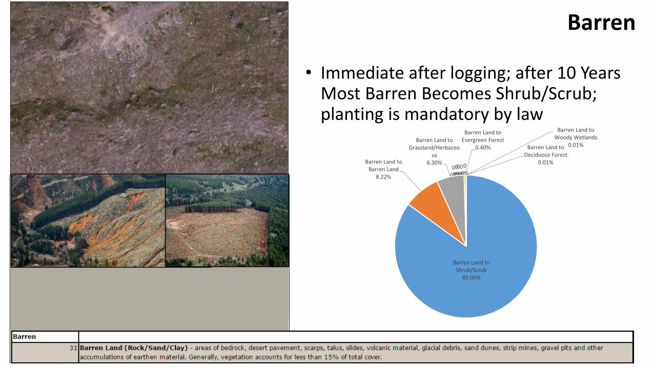
A Seven Generation* Sustainability Analysis for Use Anywhere with the NLCD Land Cover Change Data SetExample: Logging in Thurston County
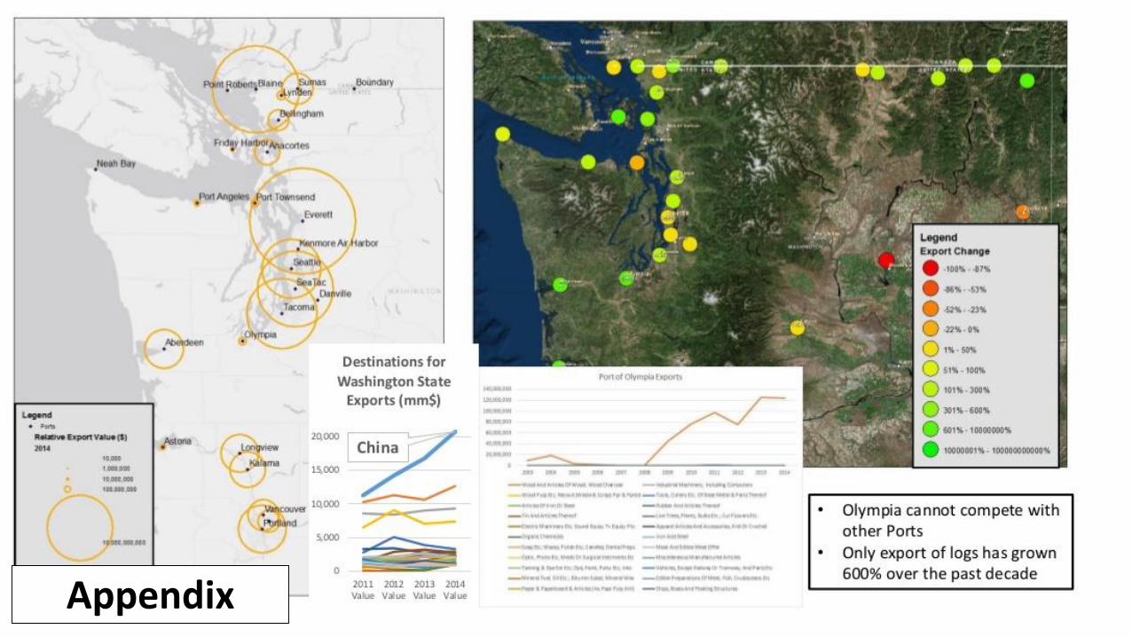
• Raw logs are 1% of Washington State's export value; “Forestry, Fishing, and Related Sectors” is 0.8% of Thurston County’s Employment; Private timberland occupies 65% of the Deschutes watershed’s land area and 25% of the County’s land area
• The loss of logs is detrimental to our rivers' health...we can see this in Thurston County/Olympia's Deschutes watershed, where the river temperature spikes where logging has occurred…At the Deschutes watershed workgroup, I got push back from the Weyerhauser rep that forestry practices are sustainable...So I went to the data and to the forest and developed a crude 7th Generation Accounting Model for Logging on private timberlands in Thurston County...business as usual plus 2 scenarios....
• Forests provide their export value in ecosystem services within 1-5 years, but logging takes 40+; ecosystem services are what nature does for us (usually for free); such as precipitation catching (evergreens emit aerosol components that actually precipitate clouds, Nature 2012), water table infiltration (forests help clean and and funnel water into the ground), species diversity, water cooling (for salmon and river life), wild mushrooms, or outdoor recreation…
• Business as usual would leave our descendants with 11% less forest; Decreasing logging by 50% would give them 5.7% more; and stopping logging altogether would give them 45.7% more..
*Google search results together support the estimation of about 20-30 years per generation depending on standard of living; I assume 200 years for ease

Logging is a Problem for the Deschutes River
Temperature differential between blue and green is a proposed scenario to expand mature vegetation buffers along the entire river
1) Sedimentation can destroy river habitat, cause landslides, erosion, create higher dredging costs2) “Unaccounted Sedimentation” is not from “natural causes” (white) or “human sources” (blue) -> is it from logging?

2001 Land Cover
2011 Land Cover
Analyzing Landcover ChangesNotice the increase in clearcuts
And the lag time for regrowth

Comparing Scale of Landcover to Landcover Changes
Logging rate outpaces Regrowth rate
Understanding Landcover Data GO TO www.mrlc.gov/viewerjs/To View Your Own Area’s Data!

Well, I don’t only think that the
biosphere is in trouble, I know it is. I
just have to look around in the
environment, in which I live.
In my own part of the part of the world,
I keep telling people, let us not cut
trees irresponsibly. Let us not destroy
especially the forested mountains.
Because if you destroy the forests on
these mountains, the rivers will stop
flowing and the rains will become
irregular and the crops will fail and you
will die of hunger and starvation. Now
the problem is, people don’t make
those linkages.
—Wangari Maathai in The 11th Hour

Evergreen 2001 Scrub 2001 Grassland 2001 Barren 2001
Evergreen 2011 76.3% 6.2% 0.4% 0.4%
Scrub 2011 8.3% 92.1% 57.6% 85.1%
Grassland 2011 11.7% 1.0% 35.3% 6.3%
Barren 2011 3.7% 0.3% 6.7% 8.2%
All other 0.1% 0.3% 0.0% 0.0%
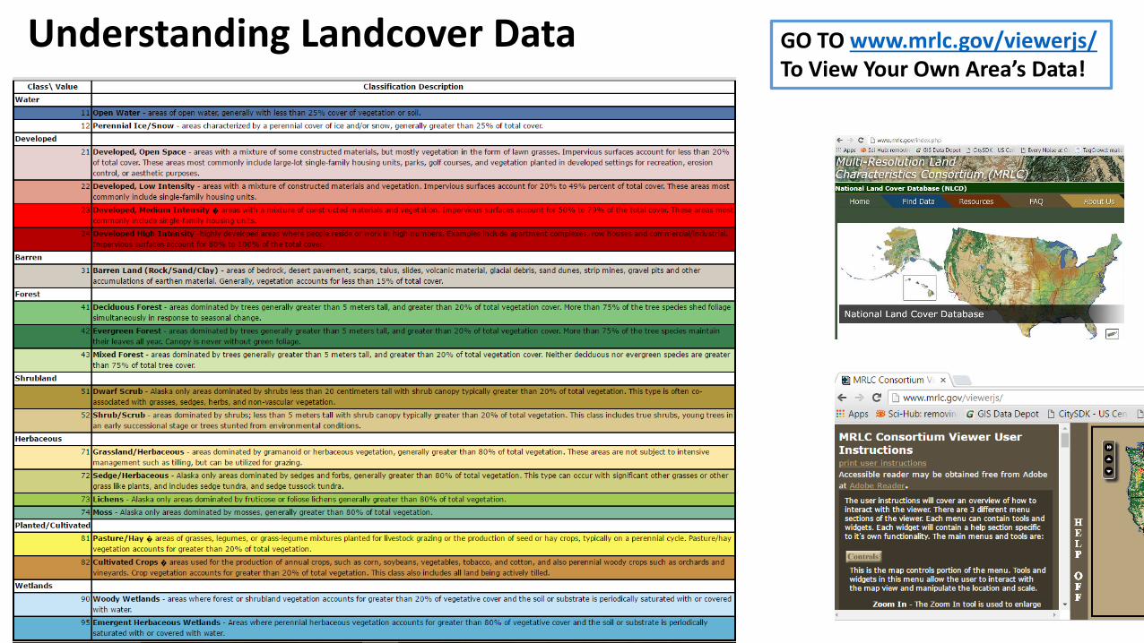
Ecosystem Holding Steady "Barren"=After Logging
Ecological Succession "Grassland"=Seedlings
Failed Replantings? "Scrub"=Juvenile Trees
Logging Extraction Evergreen=Mature Forest
Succession: "Barren" ->" Grassland" -> "Scrub" -> Evergreen
Ground Truthing and Understanding Landcover Changes in Context
Notice the similarities
Within Timberlands, Landcovers have a different meaning:Barren=Just LoggedGrassland=Seedlings?Scrub=Juvenile Trees?Evergreen Forest = Mature Forest?
What does the land cover change rate between the different land covers tell us about succession, extraction, and sustainability…..

Looking for Truth on the Ground…Montesano Drive 5/26/2016
Years 1-3?
Years 4-10?
Years 10-30?
Years 30-50?
Barren
• Immediate after logging; after 10 Years Most Barren Becomes Shrub/Scrub; planting is mandatory by law
00%
00%0
0%
00%
00%
Barren Land to Shrub/Scrub
85.06%
Barren Land to Barren Land
8.22%
Barren Land to Grassland/Herbaceo
us6.30%
Barren Land to Evergreen Forest
0.40%
Barren Land to Woody Wetlands
0.01%Barren Land to Deciduous Forest
0.01%

Grassland
• Evidence of succession to Shrub/Scrub, but some has stayed grassland.. grazing? Lack of planting?
Grassland/ Herbaceous to
Shrub/Scrub57.58%
Grassland/ Herbaceous to
Grassland/Herbaceous
35.27%
Grassland/ Herbaceous to
Barren Land6.70%
Grassland/ Herbaceous to
Evergreen Forest0.41%
Grassland/ Herbaceous to
Deciduous Forest0.05%

Shrub/Scrub• After 10 Years Most shrub/scrub stays
as Shrub/Scrub; trees are still growing and not registering as forest sometime in the 10 to 20 year time frame
Shrub/Scrub to Shrub/Scrub
92.10%
Shrub/Scrub to Evergreen Forest
6.22%
Shrub/Scrub to Grassland/Herbaceous
1.00%
Shrub/Scrub to Barren Land
0.33%
Shrub/Scrub to Deciduous Forest
0.27%
Shrub/Scrub to Pasture/Hay
0.04%
Shrub/Scrub to Mixed Forest0.01%
Shrub/Scrub to Open Water0.01%
Shrub/Scrub to Developed, Open
Space0.01%
Shrub/Scrub to Emergent Herbaceous
Wetlands0.01%
Shrub/Scrub to Woody Wetlands
0.00%
Shrub/Scrub to Developed, Low
Intensity0.00%

Evergreen Forest• Evergreen Forest after a few years is
considered mature by the satellite and gets the same designation as old growths do; 25% of Evergreen stock is logged per decade
Evergreen Forest to Evergreen Forest
76.26%
Evergreen Forest to Grassland/ Herbaceous
11.71%
Evergreen Forest to Shrub/ Scrub
8.25%
Evergreen Forest to Barren Land
3.72%
Evergreen Forest to Deciduous Forest
0.04% Evergreen Forest to Developed, Open
Space0.01%
Evergreen Forest to Developed, Low
Intensity0.01%
Evergreen Forest to Mixed Forest
0.00%
Evergreen Forest to Developed, Medium
Intensity0.00%

*Model is unrealistic: Shrub/Scrub is not Harvested and will grow back to Evergreen eventually
*Business as Usual Leaves us with 11.0% Less Forest for the 7th GenerationAnd Old Growths only on federal lands and some parks (if they stay protected)
*Decrease logging by 50% leaves us with 5.7% More for the 7th Generation; the other half? Robust stream buffers/Old growth stands, Climate risk mitigation, “value-add” wood products
*Stopping Logging Leaves us with 45.7% More Forest for the 7th Generation; and that forest will be Old Growth!
Results: “Business as Usual” and Alternatives for the 7th Generation
Logging in Thurston County:A Seven Generation* Sustainability Analysis
• Raw logs are 1% of Washington State's export value; “Forestry, Fishing, and Related Sectors” is 0.8% of Thurston County’s Employment; Private timberland occupies 65% of the Deschutes watershed’s land area and 25% of the County’s land area
• The loss of logs is detrimental to our rivers' health...we can see this in Thurston County/Olympia's Deschutes watershed, where the river temperature spikes where logging has occurred…At the Deschutes watershed workgroup, I got push back from the Weyerhauser rep that forestry practices are sustainable...So I went to the data and to the forest and developed a crude 7th Generation Accounting Model for Logging on private timberlands in Thurston County...business as usual plus 2 scenarios....
• Forests provide their export value in ecosystem services within 1-5 years; ecosystem services are what nature does for us (usually for free); such as precipitation catching (evergreens emit aerosol components that actually precipitate clouds, Nature 2012), water table infiltration (forests help clean and and funnel water into the ground), species diversity, water cooling (for salmon and river life), wild mushrooms, or outdoor recreation, I can tell you what the logging rate should be....
• Business as usual would leave our descendants with 11% less forest; Decreasing logging by 50% would give them 5.7% more; and stopping logging altogether would give them 45.7% more..
*Google search results together support the estimation of about 20-30 years per generation depending on standard of living; I assume 200 years for ease

Limitations,Further Research, and Final Thoughts
• Age of parcels not known (is there data for this?)
• Volatility shows growth and harvest cycles, but ecosystem thresholds and climate change effects not factored in (i.e. is there a point where the ecosystem can collapse or loose its growth capabilities under certain biophysical, climatic, or biodiversity thresholds?).
• We know that certain slopes are very difficult to grow back because of erosion; riparian buffers the same
• Further directions: compare regions, zoning designations, management regimes, use field data to average ages of land cover classes
• Life has an accelerating agenda. In the Northwest, disturbed forests want to become forests again, with the most momentum immediately following disturbance...Nature fills the void as quickly as possible with fast growing species (r-selection) and then as species succession proceeds (K-selection) maturation takes longer…. Its amazing to see how ready the Earth is to heal…will we let it?

Non-GIS Sources

Appendix
Appendix
![Thurston County Agricultural Land Pocket Gopher Evaluation · [THURSTON COUNTY AGRICULTURAL LAND POCKET GOPHER EVALUATION] March 30, 2014 3 Thurston County Agricultural Land Pocket](https://static.fdocuments.us/doc/165x107/5b00b2377f8b9a256b90627a/thurston-county-agricultural-land-pocket-gopher-evaluation-thurston-county-agricultural.jpg)