Sensitivity of U.S. Air Quality to Mid-Latitude Cyclone...
37
Sensitivity of U.S. Air Quality to Mid-Latitude Cyclone Frequency and Implications of 1980-2006 Climate Change Eric M. Leibensperger, Loretta J. Mickley, Daniel J. Jacob School of Engineering and Applied Sciences, Harvard University, Cambridge, Massachusetts, USA. Submitted to Atmospheric Chemistry and Physics Discussions: May 21, 2008 Revised and submitted for Atmospheric Chemistry and Physics: September 26, 2008
-
Upload
nguyentram -
Category
Documents
-
view
219 -
download
3
Transcript of Sensitivity of U.S. Air Quality to Mid-Latitude Cyclone...

Sensitivity of U.S. Air Quality to Mid-Latitude Cyclone Frequency and Implications of 1980-2006 Climate Change
Eric M. Leibensperger, Loretta J. Mickley, Daniel J. Jacob School of Engineering and Applied Sciences, Harvard University, Cambridge, Massachusetts, USA.
Submitted to Atmospheric Chemistry and Physics Discussions: May 21, 2008
Revised and submitted for Atmospheric Chemistry and Physics: September 26, 2008
Abstract
We show that the frequency of summertime mid-latitude cyclones tracking across eastern North
America at 40°-50°N (the southern climatological storm track) is a strong predictor of stagnation
and ozone pollution days in the eastern United States. The NCEP/NCAR Reanalysis, going back
to 1948, shows a significant long-term decline in the number of summertime mid-latitude
cyclones in that track starting in 1980 (-0.15 a-1). The more recent but shorter NCEP/DOE
Reanalysis (1979-2006) shows similar interannual variability in cyclone frequency but no
significant long-term trend. Analysis of NOAA daily weather maps for 1980-2006 supports the
trend detected in the NCEP/NCAR Reanalysis 1. A GISS general circulation model (GCM)
simulation including historical forcing by greenhouse gases reproduces this decreasing cyclone
trend starting in 1980. Such a long-term decrease in mid-latitude cyclone frequency over the
1980-2006 period may have offset by half the ozone air quality gains in the northeastern U.S.
from reductions in anthropogenic emissions. We find that if mid-latitude cyclone frequency had
not declined, the northeastern U.S. would have been largely compliant with the ozone air quality
standard by 2001. Mid-latitude cyclone frequency is expected to decrease further over the
coming decades in response to greenhouse warming and this will necessitate deeper emission
reductions to achieve a given air quality goal.

1. Introduction
Regional pollution episodes in the eastern U.S. develop under summertime stagnant conditions
with clear skies, a situation associated with weak high-pressure systems (Logan, 1989;
Vukovich, 1995; Hegarty et al., 2007). The pollution episode ends when the warm, stagnant air
mass is pushed to the Atlantic by the cold front of a passing mid-latitude baroclinic cyclone and
replaced with cooler, cleaner air (Merrill and Moody, 1996; Cooper et al., 2001; Dickerson et al.,
1995; Li et al., 2005). We show here with 1980-2006 data that interannual variability in the
frequency of these mid-latitude cyclones is a major predictor of the interannual variability of
pollution episodes, as measured by indices for stagnation and elevated surface ozone.
Greenhouse-driven climate change is expected to decrease mid-latitude cyclone frequency, and
we present evidence that such a decrease may have already taken place over the 1980-2006
period. As we show, this would have major implications for pollution trends in the eastern U.S.
and significantly offset the benefits of decreasing anthropogenic emissions.
Figure 1 illustrates the role of mid-latitude cyclones in ventilating the eastern U.S. with an
example from the summer of 1988. That summer experienced the worst regional air quality of
the 1980-2006 record (Lin et al., 2001). On June 14, the daily maximum 8-h average ozone
concentrations exceeded 100 ppb across most of the region, a result of accumulation over several
days of stagnant high-pressure conditions. Over the next two days, a mid-latitude cyclone moved
along a westerly track across southeastern Canada. The associated cold front swept the pollution
eastward to the North Atlantic, leaving much cleaner air with lower ozone concentrations in its
wake. The westerly track across southeastern Canada illustrated in Fig. 1 is typical of mid-

latitude cyclones traveling across North America. The frequency of these cyclones varies
considerably from year to year (Zishka and Smith, 1980; Whittaker and Horn, 1981).
General circulation model (GCM) simulations of greenhouse-forced 21st-century climate change
indicate a poleward shift in the preferential storm tracks (Yin, 2005) and a decrease in the
frequency of northern mid-latitude cyclones (Geng and Sugi, 2003; Yin, 2005; Lambert and
Fyfe, 2006; Meehl et al., 2007). These effects result from a shift and reduction of baroclinicity
forced by weakened meridional temperature gradients (Geng and Sugi, 2003; Yin, 2005). One
would expect an adverse effect on U.S. air quality. A GCM simulation by Mickley et al. (2004)
including pollution tracers found a 20% decrease in the frequency of summertime mid-latitude
cyclones ventilating the U.S. by 2050 and an associated increase in the frequency and intensity
of pollution episodes. Two subsequent studies of U.S. air quality in 21st-century climates, using
global chemical transport models driven by GCM output, confirmed the increase of ozone
pollution episodes due to decreased frequency of mid-latitude cyclones (Murazaki and Hess,
2006; Wu et al., 2008), but another study using a regional climate model did not (Tagaris, et al.,
2007).
Decreasing trends in mid-latitude cyclones over the past decades have been identified in the
observational record. A study by Zishka and Smith (1980) using observational weather maps for
North America found a significant decrease of 4.9 cyclones per decade in July and 9.0 cyclones
per decade in December for 1950-1977. Another study by Wang et al. (2006) using surface
pressure data for 1953-2002 identified a significant decreasing trend in cyclone activity along
eastern Canada during the winter. Similar trends have been found in studies using meteorological

reanalyses (i.e., assimilated meteorological data). Gulev et al. (2001) found a decrease of 12.4
cyclones per decade in the Northern Hemisphere and 8.9 cyclones per decade over the Atlantic
Ocean during winter 1958-1999. McCabe et al. (2001) found a significant decrease in cyclones at
mid-latitudes (30º-60ºN) and an increase at high-latitudes (60º-90ºN) during winter 1959-1997.
Previous studies have generally focused on winter, the season with the strongest climate change
signal. In this study we focus on summer, which is of most interest from an air quality
standpoint.
A large number of statistical studies have related air quality to local meteorological variables
such as temperature, humidity, wind speed, or solar radiation, often with the goal of removing
the effect of interannual meteorological variability in the interpretation of air quality trends
(Zheng et al., 2007; Bloomfield et al., 1996; Thomspon et al., 2001; Camalier et al., 2007; Gégo
et al., 2007). Ordóñez et al. (2005) found that the number of days since the last frontal passage
was a significant predictor of ozone air quality in Switzerland. Hegarty et al. (2007) related the
interannual frequency and intensity of sea level pressure patterns over eastern North America to
ozone, CO, and particulate matter concentrations. Mid-latitude cyclone frequency is an attractive
meteorological predictor for air quality on several accounts. First, it encapsulates to some extent
the information in the local meteorological predictors (temperature, solar radiation, wind speed),
while additionally providing direct information on boundary layer ventilation. Second, it
represents a non-local single metric to serve as explanatory variable for air quality on a regional
scale. Third, since mid-latitude cyclones are an important aspect of the general circulation of the
atmosphere, cyclone frequency can be expected to be robustly simulated by GCMs and thus
provide a useful and general metric for probing the effect of climate change on air quality.

2. Data and Methods
2.1 Detection and Tracking of Mid-Latitude Cyclones
Various metrics can be used to diagnose mid-latitude cyclone activity, including eddy kinetic
energy (Hu et al., 2004), temporal variability of sea-level pressure, temperature or meridional
wind (Harnik and Chang, 2003), the meridional temperature gradient, and the Eady growth rate
(Paciorek et al., 2002). Some studies have used the probability distribution of sea-level pressure
as a diagnostic of cyclone frequency (Murazaki and Hess, 2006; Lin et al., 2008; Racherla and
Adams, 2008). A problem with these metrics for application to air quality is that they potentially
convolve cyclone frequency and intensity, while air quality is most sensitive to cyclone
frequency (i.e., the frequency of cold frontal passages). For example, Owen et al. (2006) found
that both strong and weak warm conveyor belt effectively ventilate U.S. pollution, although at
different altitudes. In Sect. 3 we will show that mid-latitude cyclone is an excellent predictor of
pollution episodes.
We constructed long-term cyclone frequency statistics for eastern North America in June-August
using two different methods and three different data sets: (1) daily observed weather maps for
1980-2006 from the National Oceanic and Atmospheric Administration (NOAA) available from
the NOAA Central Library (http://www.lib.noaa.gov) with labeled cyclones and cold fronts; (2)
sea-level pressure data from the National Centers for Environmental Prediction/National Center
for Atmospheric Research (NCEP/NCAR) Reanalysis 1
(http://www.cdc.noaa.gov/cdc/data.ncep.reanalysis.html) (Kalnay et al., 1996; Kistler et al.,
2001) for 1948-2006 and from the NCEP/Department of Energy (NCEP/DOE) Reanalysis 2

(http://www.cdc.noaa.gov/cdc/data.ncep.reanalysis2.html) (Kanamitsu et al., 2002) for 1979-
2006. Reanalysis 2 is a newer version of Reanalysis 1 incorporating updated physical
parameterizations and various error fixes, but it does not cover as long a period. The reanalysis
datasets have a spatial resolution of 2.5ºx2.5º and a temporal resolution of six hours. The
previously mentioned studies of long-term mid-latitude cyclone trends (McCabe et al., 2001;
Gulev et al., 2001; Geng and Sugi, 2001) all used Reanalysis 1.
We generate cyclone tracks in the meteorological reanalyses by locating and following sea-level
pressure minima following the algorithm of Bauer and Del Genio (2006), which is an upgraded
version of the scheme by Chandler and Jonas (1999). For each 6-h time step the algorithm
searches for sea-level pressure minima extending 720 km or more in radius. The low-pressure
center is tracked through time by assuming that the strongest sea-level pressure minimum in the
next 6-h time step within 720 km is the same system. In order to remove spurious minima, the
system must be tracked for at least 24 hours and have a central pressure no higher than 1020 hPa.
Figure 2 shows 28-year July climatologies of cyclone density over North America. The
compilation of Zishka and Smith (1980) for 1950-1977, produced from 6-h weather maps, is
compared to the climatologies produced by applying the algorithm of Bauer and Del Genio
(2006) to Reanalysis 1 (1950-1977) and Reanalysis 2 (1979-2006). Patterns and magnitudes are
in good agreement, showing that the cyclone tracking algorithm applied to the reanalysis data
can reproduce the observed large-scale climatological distribution of mid-latitude cyclones.
Inspection of 1979-2006 vs. 1950-1977 climatologies in Reanalysis 1 indicates no difference

between these two periods in the large-scale cyclone patterns shown in Fig. 2, although there is a
significant trend as discussed in Sect. 4.
We see from Fig. 2 that cyclone density is maximum over east-central Canada, corresponding to
the two northern climatological cyclone tracks across North America previously identified by
Zishka and Smith (1980) and Whittaker and Horn (1981). These studies also identified a less
intense southern climatological track that begins in the central U.S. and moves northeastward
along the U.S.- Canada border before merging with the northern tracks along the east coast of
Canada. As we will see, it is this southern climatological track that is of most interest for U.S. air
quality.
Figure 3 shows individual cyclone tracks for June-August 1979-1981 over eastern North
America in Reanalyses 1 and 2. A cluster over the Great Lakes region represents the southern
climatological cyclone track. We will show in Sect. 3 that the frequency of cyclones moving
along this track, identified by the red box (70°-90°W, 40°-50°N), is a strong seasonal predictor
of the frequency of U.S. pollution episodes. By contrast, we find that the number of cyclones
passing through the northern climatological tracks (70°-90°W, 50°-60°N, green box in Fig. 3) is
not a successful predictor. We focus on the southern track in the rest of this paper.
Figure 4 shows the time series of the 1980-2006 summertime frequency of mid-latitude cyclones
in the southern climatological cyclone track (number of cyclones tracking through 70-90ºW, 40-
50ºN) from Reanalyses 1 and 2 as well as from our manual analysis of the NOAA weather maps.
We tallied a system as a cyclone in the NOAA weather maps if it was marked as a “Low” on the

map, contained a closed sea-level pressure contour, and was tracked for at least 24 hours. The
three datasets have comparable climatological statistics (11.9 ± 2.6 cyclones summer-1 in
Reanalysis 1, 11.8 ± 2.7 in Reanalysis 2, 12.7 ± 2.4 in NOAA weather maps). Reanalysis 1 and
the NOAA weather maps show a significant decreasing trend for 1980-2006 but Reanalysis 2
does not. We discuss these long-term trends in Sect. 4.
Figure 4 shows strong interannual correlations between cyclone frequencies diagnosed from the
three different data sets but also significant differences. Inspection of these differences for
individual years shows that although the diagnosis of cyclones in Reanalyses 1 and 2 generally
follows the cyclone identification in the daily weather maps, there are some differences in the
intensity and position of the sea-level pressure minima for the three different data sets. These
differences can result in displacement of the cyclone relative to the red box in Fig. 3 used to
identify the southern climatological track, and can occasionally affect cyclone detection. Cyclone
identification using the NOAA weather maps is closest to the actual observations but is subject
to case-by-case human interpretation. The cyclone tracking algorithm applied to the
meteorological reanalyses is more objective and can be applied to GCM fields (Sect. 4), but it is
subject to errors both in the reanalyses and in the tracking algorithm. We will use the three
datasets to overcome these problems in the reanalysis and weather map analyses.
2.2 Detection of Stagnation Episodes
We use stagnation frequency as a link to better understand the correlation between cyclone
frequency and pollution events. The number of stagnant days was calculated from Reanalyses 1
and 2 data for June-August 1980-1998 with the metric described by Wang and Angell (1999),

which is similar to the original version by Korshover and Angell (1982). A day is considered
stagnant if the daily mean sea-level pressure geostrophic wind is less than 8 m s-1, the daily mean
500 hPa wind is less than 13 m s-1, and there is no precipitation. Precipitation was identified with
daily gridded data (0.25°x0.25°) from the NOAA Climate Prediction Center
(http://www.cdc.noaa.gov/cdc/data.unified.html) extending to 1998. For our purposes, the 1980-
1998 period is sufficient to show the relationship between stagnation and ozone episodes. Figure
5 shows the mean number of stagnant days per summer for 1980-1998 from Reanalyses 1 and 2.
The frequency of stagnant days in both datasets is highest in a band stretching from Texas to
Ohio, as previously shown by Wang and Angell (1999).
2.3 Surface Ozone Data
We generated time series of daily maximum 8-h average ozone concentrations for June-August
1980-2006 from hourly observations of ozone concentrations retrieved from EPA’s Air Quality
System (AQS, http://www.epa.gov/ttn/airs/airsaqs/), representing a network of over 2000 sites in
the contiguous United States. The average number of sites providing ozone data since 1980 is
about 1000 per summer; this number has increased over time. The daily maximum 8-h average
ozone concentrations from all AQS sites were averaged onto the 2.5º x 2.5º grid of the NCEP
Reanalyses, producing a daily time series for 1980-2006 (Fig. 1 was produced from that time
series). The number of days with a daily maximum 8-h average ozone concentration greater than
84 ppb was tallied for each summer, creating a 27-year time series of the seasonal number of
ozone pollution days for each grid square corresponding to an exceedance of the 0.08 ppm U.S.
air quality standard. Spatial averaging causes an underestimate of the number of ozone pollution
days, but enhances statistical robustness by removing data extremes and improving continuity.

Spatial averaging also enables comparison to the identically gridded reanalysis products. Not
every grid square included measurements for all 27 years. A grid square was analyzed only if it
had 5 or more years of data.
Figure 6 shows the mean number of summertime ozone pollution episodes for 1980-2006 on the
2.5º x 2.5º grid. The highest values (>6 days) are in the New York City-Washington, D.C.
corridor, but high values (2-6 days) extend over much of the industrial Midwest and Northeast,
and in some areas of the Southeast.
2.4 GCM simulations
We conducted two simulations with the Goddard Institute for Space Studies (GISS) GCM 3
(Rind et al., 2007) to investigate the effect of 1950-2006 climate change on mid-latitude cyclone
frequencies. The first simulation was conducted for 1950-2006 using reconstructed time-
dependent concentrations of greenhouse gases, aerosol forcing, and solar radiation (Hansen et al.,
2002). The second (control) simulation was conducted in radiative equilibrium (greenhouse gas
and aerosol concentrations were held at their 1950 levels), also for 1950-2006. The GCM has a
horizontal resolution of 4º latitude x 5º longitude and 23 vertical layers extending from the
surface to 0.002 hPa in a sigma-pressure coordinate system (Rind et al., 2007). It uses a “qflux”
representation for ocean heat transport (Hansen et al., 1988), which allows temporal variation in
sea surface temperature and sea ice, but holds constant the horizontal heat transport fluxes in the
ocean to values derived from present-day sea surface temperature distributions.

Mid-latitude cyclones are detected and tracked from the GCM sea-level pressure output with the
same algorithm used for the reanalysis data (Sect. 2.1). The GCM cyclone climatology for 1950-
1977 (1979-2006 shows the same climatological patterns) is compared to the observational and
reanalyses data in Fig. 2. Agreement is excellent. The number of GCM cyclones passing through
the southern climatological track (red box in Fig. 3) is 10.8 ± 2.4 per summer for the 1980-2006
period, consistent with the reanalyses (Sect. 2.1).
3. Mid-latitude Cyclones as Predictors of Stagnation and Ozone Pollution
The data and methods of Sect. 2 provide totals for individual summers of the number of cyclones
passing through the southern climatological cyclone track (1948-2006 for Reanalysis 1, 1979-
2006 for Reanalysis 2, 1980-2006 for NOAA weather maps), as well as the numbers of
stagnation days (1980-1998) and ozone pollution days (1980-2006) in each 2.5ºx2.5º grid square
of the eastern United States. We use the linear Pearson correlation coefficient to correlate these
different variables on an interannual basis, and a Student’s t-test to determine the significance of
the correlation. To avoid the aliasing effects of long-term trends on the correlations, we removed
linear trends from all individual time series that had significant trends at the 95% level. Long-
term trends in ozone pollution days and mid-latitude cyclones will be discussed in Sect. 4.
Figure 7 (top panels) shows the interannual correlation between the number of stagnant days and
the number of mid-latitude cyclones derived from the reanalysis datasets. The correlation is
generally significant and negative, indicating that less frequent mid-latitude cyclones in a given
summer are associated with more frequent stagnant conditions. The negative correlation is
strongest in the northeastern and midwestern United States. This is because the cold fronts

associated with mid-latitude cyclones generally do not extend to the southern U.S. (see Fig. 1);
moist convection and inflow from the Gulf of Mexico are a more important ventilation pathways
in that region (Li et al., 2005).
The middle panels of Fig. 7 show the interannual correlation between the number of stagnant
days and the number of ozone pollution days. There is strong positive correlation throughout the
eastern U.S., with the exception of grid squares on the edge of the domain where wind direction
(i.e., advection of pollution from upwind) is a more important predictor (Camalier et al., 2007).
The bottom panels of Fig. 7 show the interannual correlation between the number of ozone
pollution days and the number of mid-latitude cyclones diagnosed from the reanalyses and from
the NOAA weather maps. There is widespread negative correlation, stronger in the Midwest and
Northeast than in the Southeast, consistent with the correlation of mid-latitude cyclones and
stagnation days seen in the reanalyses. We thus see that there is a clear cause-to-effect link, at
least in the Midwest and Northeast, between mid-latitudes cyclones, stagnation days, and ozone
pollution days. The frequency of mid-latitude cyclones can be used as an interannual predictor of
air quality. An important implication, from a climate change perspective, is that long-term trends
in cyclone frequency may be expected to drive corresponding trends in air quality.
4. Long-Term Trends in Mid-Latitude Cyclone Frequency and Ozone Pollution
Reanalysis 1 and the NOAA weather maps feature a statistically significant decreasing trend of
the number of cyclones in the southern climatological track between 1980 and 2006 (-0.15 a-1 for
Reanalysis 1, -0.14 a-1 for the NOAA weather maps, both with p < 0.01) (Fig. 4). Reanalysis 2
does not show a significant trend. Previously derived trends in mid-latitude cyclones have used
the longer record of the Reanalysis 1 data (McCabe et al., 2001; Gulev et al., 2001; Geng and
Sugi, 2001). The consistent trend that we see here between the NOAA daily weather maps and
Reanalysis 1 provides important corroboration with the earlier studies.
We used the entire 1948-2006 extent of Reanalysis 1 to extend our trend analysis and compare to
our GISS GCM simulations of the same period. Results in Fig. 8 show that the trend in
Reanalysis 1 is confined to 1980-2006. The 1948-1980 period shows strong interannual
variability but no trend. The GISS GCM simulation with historical changes in greenhouse gases,
aerosols, and solar forcing shows a 1980-2006 decreasing trend in the number of cyclones
frequency (-0.16 a-1, p < 0.01), consistent with Reanalysis 1 and the NOAA weather maps. It
shows no trend prior to 1980, consistent with Reanalysis 1. The GCM control simulation,
conducted in radiative equilibrium, with greenhouse gas and aerosol concentrations and solar
activity held at their 1950 levels, does not exhibit any significant trend over the 1950-2006
record. Thus we see that the 1980-2006 trend in cyclone frequency in the GISS GCM is driven
by increase in greenhouse gases.
Figure 9 shows the trend in the number of ozone pollution days in the Northeast (defined as the
New England and mid-Atlantic regions; see inset of Fig. 9). We focus on the Northeast because
of its high number of ozone pollution days (Fig. 6) and the strong relationship of these pollution
days to mid-latitude cyclone frequency (Fig. 7). The data in black represent the number of days
over the course of the summer where one of the 2.5º x 2.5º grid squares in the Northeast
experienced a daily maximum 8-h average ozone concentration exceeding 84 ppb. The number

of ozone pollution days decreased at a rate of 0.84 a-1 over the 1980-2006 period, a trend that can
be credited to reduction of anthropogenic emissions of ozone precursors including nitrogen
oxides (NOx ≡ NO + NO2) and volatile organic compounds (VOCs) (Lin et al., 2001; Gégo et al.,
2007). This improvement in ozone air quality occurred despite the concurrent decreasing trend of
mid-latitude cyclones diagnosed from Reanalysis 1 (also shown in Fig. 9) and the daily NOAA
daily weather maps. The detrended anomalies of the cyclone and ozone time series are strongly
anticorrelated, as previously shown in Fig. 7; the corresponding scatterplot is shown in the
bottom panel of Fig. 9. A reduced major axis linear regression of the detrended anomalies (Fig.
9) indicates a dependence of the number n of ozone pollution days on the number C of mid-
latitude cyclones, , of -4.6 for the time series derived from daily weather maps and -4.2
for Reanalysis 1. This points to a major effect of 1980-2006 climate change on the observed
ozone trends, as discussed below.
5. Effect of 1980-2006 Climate Change on Ozone Air Quality
A long-term decreasing trend in mid-latitudes cyclones over the 1980-2006 period, as indicated
by Reanalysis 1, the NOAA daily weather maps, and the GISS GCM simulation, would imply
increasing stagnation and thus a more favorable meteorological environment for ozone pollution
days. This could have offset some of the gains from decreases in anthropogenic emissions of
ozone precursors, so that the return from emission controls would have been less than expected.
Understanding such an effect is of great importance for the accountability of air quality policy
(National Research Council, 2004).

We estimate here how the 1980-2006 trend in mid-latitude cyclones as indicated by Reanalysis 1
and the NOAA weather maps may have affected the 1980-2006 trend in ozone air quality in the
Northeast. The observed trend in the number of ozone pollution days per summer, , is -
0.84 a-1 (Fig. 9). Let us assume that this observed trend is driven by trends in emissions E and in
the number of cyclones C. We can then decompose the observed total derivative into partial
derivatives:
(1a)
with
(1b)
(1c)
where describes the trend due to changing emissions in the absence of climate change,
and describes the trend due to climate change in the absence of change in emissions.
We previously derived from Reanalysis 1 (-4.6 for the weather map analysis) and
a-1 (-0.14 a-1) in Sect. 4. Thus the trend in number of ozone pollution days due to
climate change is a-1 (0.64 a-1). Replacing into Eq. (1a) yields a trend in the
number of ozone pollution days due to changing anthropogenic emissions, a-1 (-
1.5 a-1). The analysis thus indicates that decreasing mid-latitude cyclone frequency over the
1980-2006 period has offset the benefit of emission controls almost by half.
Figure 10 shows this result graphically for the cyclone trends from the NOAA weather maps and
from Reanalysis 1. The time series of the number of ozone pollution days observed in the

Northeast, as previously displayed in Fig. 9, is shown in black with the corresponding regression
line dn/dt = -0.84 a-1. The time series predicted from the number of mid-latitude cyclones (Fig. 9)
and the dependence, (-4.6), derived in Sect. 4 is shown in red, with the
corresponding regression line [dn/dt]C = 0.63 a-1 (0.64 a-1) representing the expected trend in
ozone pollution days from climate change had emissions remained constant. We see that the
frequency of ozone pollution days would have doubled over the 1980-2006 period as a result of
climate change, were it not for concurrent decreases in anthropogenic emissions. The green line
in Fig. 10 shows the trend in ozone pollution days that would have been realized from the
decrease in anthropogenic emissions in the absence of climate change, i.e., [dn/dt]E = dn/dt –
[dn/dt]C = -1.5 a-1 (-1.5 a-1). We see that the expected number of ozone pollution days would
have dropped to zero by 2001, instead of remaining a significant problem (expected value of 10)
by 2006.
6. Conclusions
We showed that the frequency of mid-latitudes cyclones tracking across eastern North America
in the 40º-50ºN latitudinal band (southern climatological track) is a strong predictor variable of
the frequency of summertime pollution episodes in the eastern United States. Cold fronts
associated with these cyclones effectively ventilate the U.S. boundary layer. We constructed
cyclone tracks using the algorithm of Bauer and Del Genio (2006) applied to assimilated
meteorological data from the NCEP/NCAR Reanalysis 1 (1948-2006) and the NCEP/DOE
Reanalysis 2 (1979-2006); the two reanalyses agree closely in the locations and frequencies of
cyclone tracks, and also agree well with cyclone statistics constructed directly from NOAA
weather maps. Statistical analysis of 1980-2006 summer data shows large interannual variability

in the number of cyclones in the southern climatological track (11.9 ± 2.6 for Reanalysis 1) and
reveals strong negative interannual correlations between the number of cyclones and both the
number of stagnation days and the number of ozone pollution days.
The frequency of mid-latitude cyclones in the 40º-50º N band is of particular interest as a
predictor variable for U.S. air quality. First, it encapsulates in a single synoptic-scale variable the
effects of known local predictor variables including temperature, wind speed, and solar radiation.
Second, mid-latitude cyclones are a feature of the general circulation of the atmosphere and are
therefore amenable to trend analysis and prediction using GCMs. They can thus be used to
diagnose and project the effects of climate change on U.S. air quality.
Greenhouse warming is expected to decrease mid-latitude cyclone frequencies (Geng and Sugi,
2003; Yin, 2005; Lambert and Fyfe, 2006; Meehl et al., 2007), and such a decrease has been
observed in climatological analyses of 1950-2000 data (Zishka and Smith, 1980; Gulev et al.,
2001; McCabe et al., 2001, Wang et al., 2006). We examined more specifically the historical
trend in the number of summer cyclones in the North American southern climatological track
(40º-50ºN) responsible for ventilating the eastern United States. The NCEP/NCAR Reanalysis 1
and the NOAA daily weather maps both show significant decreasing trends for 1980-2006, with
consistent slopes (-0.15 a-1 and -0.14 a-1, respectively). The NCEP/DOE Reanalysis 2 shows no
significant trend.
The NCEP/NCAR Reanalysis 1 starts in 1948. Analysis of the complete 1948-2006 record shows
no cyclone trend prior to 1980. We compared this result to a transient-climate simulation for

1950-2006 with the GISS GCM 3 including historical greenhouse and aerosol forcing. This
simulation shows a decrease in the number of cyclones for 1980-2006 (-0.16 a-1), and no trend
prior to 1980, consistent with Reanalysis 1. A control GCM simulation for 1950-2006 with no
greenhouse and aerosol forcing shows by contrast no trend over the whole period. The cyclone
trend for the 1980-2006 period can thus be attributed to greenhouse forcing.
A 1980-2006 decrease in cyclone frequency as indicated by the NCEP/NCAR Reanalysis 1 and
by the NOAA daily weather maps has important implications for the success and accountability
of emission control strategies directed at improving U.S. air quality. Our analysis of the surface
ozone data indicates a decrease in the observed number of summertime ozone pollution days in
the Northeast by 0.84 a-1 over the 1980-2006 period, from an expected value of 31 (1980) to 10
(2006). This decrease can be credited to reduction of anthropogenic emissions, but we find that
the benefit of these reductions may have been significantly offset by climate change. Taking the
relationship between the number of summertime cyclones and the number of ozone pollution
days from our correlation analysis, combined with the cyclone trend derived from either
Reanalysis 1 or the NOAA daily weather maps, we deduce that the number of ozone pollution
days would have doubled over the 1980-2006 period as a result of climate change if
anthropogenic emissions had remained constant. Correcting the observed decrease of ozone
pollution days for this climate trend, we find that the number of ozone pollution days would have
dropped to an expected value of zero by 2001 in the absence of climate change.
We conclude from this analysis that the decrease in mid-latitude cyclones over the 1980-2006
has offset half of the air quality gains in the Northeast U.S. that should have been achieved from
reduction of anthropogenic emissions over that period. This suggests that climate change has had
already a major effect on the accountability of emission control strategies over the past 2-3
decades, preventing achievement of the ozone air quality standard. It demonstrates the potential
of climate change to dramatically affect air quality on decadal scales relevant to air quality
policy. Future attention to this issue is necessary in view of the consistent predictions from
GCMs that 21st-century climate change will decrease the frequency of mid-latitude cyclones
(Lambert and Fyfe, 2006).
Our analysis has focused on ozone air quality because of the availability of long-term records
with high spatial density. We would expect mid-latitude cyclone frequency to also be a good
predictor of particulate matter (PM) air quality, which is similarly affected by stagnation, but
further analysis using PM observational records is necessary. Also, our analysis has focused on
the eastern U.S., but similar analyses would be of value for western Europe and China, where
mid-latitudes cyclones are also major agents for pollutant ventilation (Liu et al., 2003; Ordóñez
et al., 2005). We have found in the eastern U.S. that although mid-latitude cyclone frequency is a
good predictor of pollution episodes in the Northeast and Midwest, it is less effective in the
South. Other large-scale meteorological metrics should be sought there and in the West to enable
assessments of the effect of climate change on air quality.
Acknowledgments. This work was supported by the Electric Power Research Institute (EPRI),
the Environmental Protection Agency – Science To Achieve Results (EPA-STAR) Program, and
an EPA-STAR Graduate Fellowship to Eric Leibensperger. The EPA has not officially endorsed
this publication and the views expressed herein may not reflect those of the EPA. We thank Mike

Bauer for supplying and supporting the cyclone tracking procedure and Shiliang Wu for helpful
discussions.
REFERENCES:
Bauer, M., and Del Genio, A. D.: Composite analysis of winter cyclones in a GCM: Influence on climatological humidity, J. Clim., 19, 1652-1672, 2006.
Bloomfield, P., Royle, J. A., Steinberg, L. J., and Yang, Q.: Accounting for meteorological effects in measuring urban ozone levels and trends, Atmos. Environ., 30, 3067-3077, 1996. Camalier, L., Cox, W., and Dolwick, P.: The effects of meteorology on ozone in urban areas and their use in assessing ozone trends, Atmospheric Environment, 41, 7127-7137, 2007. Chandler, M., and Jonas, J.: Atlas of extratropical storm tracks (1961-1998), NASA Goddard Institute for Space Studies Technical Report, 1999.
Cooper, O. R., Moody, J. L., Parrish, D. D., Trainer, M., Ryerson, T. B., Holloway, J. S., Hubler, G., Fehsenfeld, F. C., Oltmans, S. J., and Evans, M. J.: Trace gas signatures of the airstreams within North Atlantic cyclones: Case studies from the North Atlantic Regional Experiment (NARE 1997) aircraft intensive, J. Geophys. Res.-Atmos., 106, 5437-5456, 2001.
Dickerson, R. R., Doddridge, B. G., Kelley, P., and Rhoads, K.P.: Large scale pollution of the atmosphere over the remote Atlantic Ocean – Evidence from Bermuda, J. Geophys. Res.-Atmos., 100, 8945-8952, 1995.
Gégo, E., Porter, P. S., Gilliland, A., and Rao, S. T.: Observation-based assessment of the impact of nitrogen oxides emissions reductions on ozone air quality over the eastern United States, J. Appl. Meteorol. Climatol., 46, 994-1008, 2007.
Geng, Q. Z., and Sugi, M.: Variability of the North Atlantic cyclone activity in winter analyzed from NCEP-NCAR reanalysis data, J. Clim., 14, 3863-3873, 2001.
Geng, Q. Z., and Sugi, M.: Possible change of extratropical cyclone activity due to enhanced greenhouse gases and sulfate aerosols - Study with a high-resolution AGCM, J. Clim., 16, 2262-2274, 2003.
Gulev, S. K., Zolina, O., and Grigoriev, S.: Extratropical cyclone variability in the Northern Hemisphere winter from the NCEP/NCAR reanalysis data, Clim. Dynam., 17, 795-809, 2001.
Hansen, J., Fung, I., Lacis, A., Rind, D., Lebedeff, S., Ruedy, R., Russell, G., and Stone, P.: Global climate changes as forecast by Goddard Institute for Space Studies 3-Dimensional model, J. Geophys. Res.-Atmos., 93, D8, 9341-9364, 1988.
Hansen, J., Sato, M., Nazarenko, L., Ruedy, R., Lacis, A., Koch, D., Tegen, I., Hall, T., Shindell, D., Santer, B., Stone, P., Novakov, T., Thomason, L., Wang, R., Wang, Y., Jacob, D., Hollandsworth, S., Bishop, L., Logan, J., Thompson, A., Stolarski, R., Lean, J., Willson, R., Levitus, S., Antonov, J., Rayner, N., Parker, D., and Christy, J.: Climate forcings in Goddard Institute for Space Studies SI2000 simulations, J. Geophys. Res.-Atmos, 107, D18, doi: 10.1029/2001JD001143, 2002.

Harnik, N., and Chang, E. K. M.: Storm track variations as seen in radiosonde observations and reanalysis data, J. Clim., 16, 480-495, 2003.
Hegarty, J., Mao, H., and Talbot, R.: Synoptic controls on summertime surface ozone in the northeastern United States, J. Geophys. Res.-Atmos., 112, D14306, doi: 10.1029/2006JD008170, 2007.
Hu, Q., Tawaye, Y., and Feng, S.: Variations of the Northern Hemisphere atmospheric energetics: 1948-2000, J. Clim., 17, 1975-1986, 2004.
Kalnay, E., Kanamitsu, M., Kistler, R., Collins, W., Deaven, D., Gandin, L., Iredell, M., Saha, S., White, G., Woollen, J., Zhu, Y., Chelliah, M., Ebisuzaki, W., Higgins, W., Janowiak, J., Mo, K. C., Ropelewski, C., Wang, J., Leetmaa, A., Reynolds, R., Jenne, R., and Joseph, D.: The NCEP/NCAR 40-year reanalysis project, B. Am. Meteorol. Soc., 77, 437-471, 1996.
Kanamitsu, M., Ebisuzaki, W., Woollen, J., Yang, S. K., Hnilo, J. J., Fiorino, M., and Potter, G. L.: NCEP-DOE AMIP-II reanalysis (R-2), B. Am. Meteorol. Soc., 83, 1631-1643, 2002.
Kistler, R., Kalnay, E., Collins, W., Saha, S., White, G., Woollen, J., Chelliah, M., Ebisuzaki, W., Kanamitsu, M., Kousky, V., van den Dool, H., Jenne, R., and Fiorino, M.: The NCEP-NCAR 50-year reanalysis: Monthly means CD-ROM and documentation, B. Am. Meteorol. Soc., 82, 247-267, 2001.
Korshover, J., and Angell, J. K.: A review of air stagnation cases in the eastern United States during 1981 - Annual Summary, Mon. Weather Rev., 110, 1515-1518, 1982.
Lambert, S. J., and Fyfe, J. C.: Changes in winter cyclone frequencies and strengths simulated in enhanced greenhouse warming experiments: results from the models participating in the IPCC diagnostic exercise, Clim. Dynam. 26, 713-728, 2006.
Li, Q. B., Jacob, D. J., Park, R., Wang, Y. X., Heald, C. L., Hudman, R., Yantosca, R. M., Martin, R. V., and Evans, M.: North American pollution outflow and the trapping of convectively lifted pollution by upper-level anticyclone, J. Geophys. Res.-Atmos. 110, D10301, doi: 10.1029/2004JD005039, 2005.
Lin, C. Y. C., Jacob, D. J., and Fiore, A.M.: Trends in exceedances of the ozone air quality standard in the continental United States, 1980-1998, Atmos. Environ., 35, 3217-3228, 2001.
Lin, J.-T., Patten, K. O., Hayhoe, K., Liang, X.-Z., and Wuebbles, D. J.: Effects of future climate and biogenic emissions changes on surface ozone over the United States and China, J. Appl. Meteorol. Climatol., 47, 1888–1909, 2008.
Liu, H. Y., Jacob, D. J., Bey, I., Yantosca, R. M., Duncan, B. N., and Sachse, G. W.: Transport pathways for Asian pollution outflow over the Pacific: Interannual and seasonal variations, J. Geophys. Res.-Atmos., 108, D20, 2003.
Logan, J. A.: Ozone in rural areas of the United States, J. Geophys. Res.-Atmos., 94, D6, 8511-8532, 1989.
McCabe, G. J., Clark, M. P., and Serreze, M. C.: Trends in Northern Hemisphere surface cyclone frequency and intensity, J. Clim., 14, 2763-2768, 2001.
Meehl, G. A., Stocker, T. F., Collins, W. D., Friedlingstein, P., Gaye, A. T., Gregory, J. M., Kitoh, A., Knutti, R., Murphy, J. M., Noda, A., Raper, S. C. B., Watterson, I. G., Weaver, A. J., and Zhao, Z.-C.: Global Climate Projections, in: Climate Change 2007: The Physical Science Basis, edited by: Solomon, S., Qin, D., Manning, M., Chen, Z., Marquis, M., Averyt, K. B., Tignor, M., and Miller, H. L., Cambridge University Press, Cambridge, U.K., 2007.
Merrill, J. T. and Moody, J. L.: Synoptic meteorology and transport during the North Atlantic Regional Experiment (NARE) intensive: Overview, J. Geophys. Res.-Atmos., 101, 28903-28921, 1996.
Mickley, L. J., Jacob, D. J., Field, B. D., and Rind, D.: Effects of future climate change on regional air pollution episodes in the United States, Geophys. Res. Lett., 31, L24103, doi: 10.1029/2004GL021216, 2004.
Murazaki, K., and Hess, P.: How does climate change contribute to surface ozone change over the United States?, J. Geophys. Res.-Atmos., 111, D05301, doi: 10.1029/2005JD005873, 2006.
National Research Council: Air Quality Management in the United States, National Academies Press, Washington, DC, 2004.
Ordóñez, C., Mathis, H., Furger, M., Henne, S., Huglin, C., Staehelin, J., and Prevot, A. S. H.: Changes of daily surface ozone maxima in Switzerland in all seasons from 1992 to 2002 and discussion of summer 2003, Atmos. Chem. Phys., 5, 1187-1203, 2005, http://www.atmos-chem-phys.net/5/1187/2005/.
Owen, R. C., Cooper, O. R., Stohl, A., and Honrath, R. E.: An analysis of the mechanisms of North American pollutant transport to the central North Atlantic lower free troposphere, J. Geophys. Res.-Atmos., 111, D23S58, doi: 10.1029/2006JD007062, 2006.
Paciorek, C. J., Risbey, J. S., Ventura, V., and Rosen, R. D.: Multiple indices of Northern Hemisphere cyclone activity, winters 1949-99, J. Clim., 15, 1573-1590, 2002.
Racherla, P. N., and Adams, P. J.: The response of surface ozone to climate change over the Eastern United States, Atmos. Chem. Phys., 8, 871-885, 2008, http://www.atmos-chem-phys.net/8/871/2008/.
Rind, D., Lerner, J., Jonas, J., and McLinden, C.: Effects of resolution and model physics on tracer transports in the NASA Goddard Institute for Space Studies general circulation models, J. Geophys. Res.-Atmos., 112, D09315, doi: 10.1029/2006JD007476, 2007.
Tagaris, E., Manomaiphiboon, K., Liao, K. J., Leung, L. R., Woo, J. H., He, S., Amar, P., and Russell, A. G.: Impacts of global climate change and emissions on regional ozone and fine particulate matter concentrations over the United States, J. Geophys. Res.-Atmos., 112, D14312, doi: 10.1029/2006JD008262, 2007.

Thompson, M. L., Reynolds, J., Cox, L. H., Guttorp, P., and Sampson, P. D.: A review of statistical methods for the meteorological adjustment of tropospheric ozone, Atmos. Environ., 35, 617-630, 2001.
Vukovich, F. M.: Regional scale boundary layer ozone variations in the eastern United States and their association with meteorological variations, Atmos. Environ., 29, 2259-2273, 1995.
Wang, J. X. L., and Angell, J. K.: Air Stagnation Climatology for the United States, NOAA/Air Resource Laboratory ATLAS No. 1, 1999.
Wang, X. L., Wan, W. H., and Swail, V. R.: Observed changes in cyclone activity in Canada and their relationships to major circulation regimes, J. Clim., 19, 896-915, 2006.
Whittaker, L. M., and Horn, L. H.: Geographical and seasonal distribution of North American cyclogenesis, 1958-1977, Mon. Weather Rev., 109, 2312-2322, 1981. Wu, S., Mickley, L. J., Leibensperger, E. M., Jacob, D. J., Rind, D., and Streets, D. G.: Effects of 2000-2050 global change on ozone air quality in the United States, J. Geophys. Res.-Atmos., 113, D06302, doi: 10.1029/2007JD008917, 2008.
Yin, J. H.: A consistent poleward shift of the storm tracks in simulations of 21st century climate, Geophys. Res. Lett., L18701, doi: 10.1029/2005GL023684, 2005.
Zheng, J., Swall, J. L., Cox, W. M., and Davis, J. M.: Interannual variation in meteorologically adjusted ozone levels in the eastern United States: A comparison of two approaches, Atmos. Environ., 41, 705-716, 2007.
Zishka, K. M., and Smith, P. J.: The climatology of cyclones and anticyclones over North America and surrounding ocean environs for January and July, 1950-77, Mon. Weather Rev., 108, 387-401, 1980.
Figure 1. Evolution of surface ozone concentrations in the eastern U.S. during the passage of a
mid-latitude cyclone (June 14-17, 1988). The top row shows instantaneous sea-level pressure
fields at 12Z from the NCEP/NCAR Reanalysis 1, while the bottom row shows daily maximum
8-h average ozone concentrations from monitoring sites of the U.S. Environmental Protection
Agency (http://www.epa.gov/ttn/airs/airsaqs/), The contour interval for sea level pressure is 2
hPa. The ozone data have been averaged on a 2.5º x 2.5º grid.

Figure 2. 28-year July climatologies of cyclone tracks across North America, counting all
cyclone tracks that pass through 5ºx5º grid squares. The Zishka and Smith (1980) climatology is
for 1950-1977 and based on monthly compilations of 6-h weather maps; the data shown here are
adapted from their Fig. 3. The NCEP/NCAR Reanalysis 1 and NCEP/DOE Reanalysis 2
climatologies are for 1950-1977 and 1979-2006, respectively. The GISS GCM climatology is for
1950-1977 in a transient-climate simulation including historical trends in greenhouse gases and
aerosols.
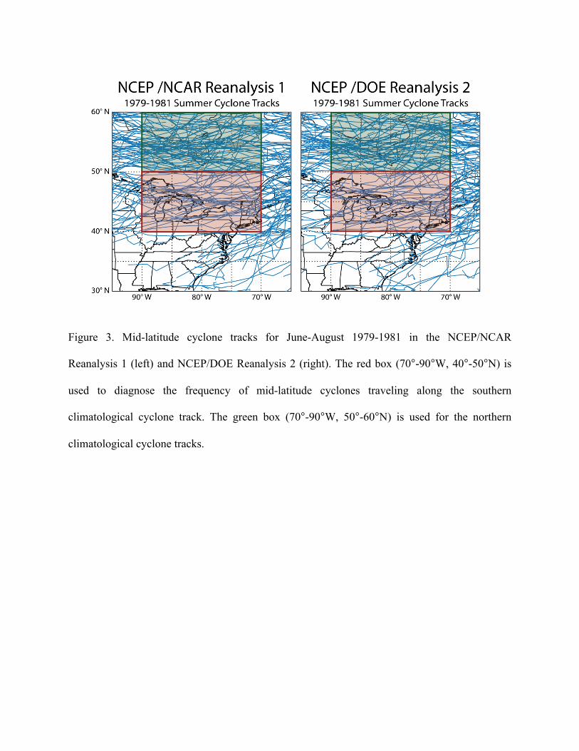
Figure 3. Mid-latitude cyclone tracks for June-August 1979-1981 in the NCEP/NCAR
Reanalysis 1 (left) and NCEP/DOE Reanalysis 2 (right). The red box (70°-90°W, 40°-50°N) is
used to diagnose the frequency of mid-latitude cyclones traveling along the southern
climatological cyclone track. The green box (70°-90°W, 50°-60°N) is used for the northern
climatological cyclone tracks.

Figure 4. June-August 1980-2006 time series of the number of mid-latitude cyclones passing
through the red box of Fig. 3, corresponding to the southern climatological cyclone track across
North America. Results are shown for three different data sets: NOAA daily weather maps
(black), NCEP/NCAR Reanalysis 1 (red) and NCEP/DOE Reanalysis 2 (green).

Figure 5. Seasonal mean number of June-August stagnant days in the 1980-1998 records from
NCEP/NCAR Reanalysis 1 (left) and NCEP/DOE Reanalysis 2 (right).

Figure 6. Seasonal average number of June-August ozone pollution days for the 1980-2006
period. A pollution day occurs when the mean daily maximum 8-h average ozone concentration
averaged over observational sites within a 2.5ºx2.5º grid square is greater than 84 ppb.

Figure 7. Interannual correlation coefficients (r) between the summer total numbers of mid-
latitude cyclones, stagnation days, and ozone pollution days for 1980-1998 (top and middle
panels) and 1980-2006 (bottom panels). The data are as described in Sect. 2. Numbers of
cyclones are from the NCEP/NCAR Reanalysis 1 (left), the NCEP/DOE Reanalysis 2 (middle),
and NOAA daily weather maps (right). Numbers of stagnation events are from the reanalyses
only.

Figure 8. Time series of the number of June-August mid-latitude cyclones tracking through 40º-
50ºN, 70º-90ºW (the southern climatological cyclone track, see Fig. 3) for 1948-2006. Results
from the NCEP/NCAR Reanalysis 1 (top) are compared to the GISS GCM 3 simulation
including historical radiative forcings (middle), and to a GISS GCM 3 simulation in radiative
equilibrium (bottom). The dashed lines show the long-term means for each time series to aid in
visual trend identification. Red dashed lines show 1980-2006 regressions for the top two panels,
where the trends are significant.


Figure 9. Long-term trends and correlations of the number of ozone pollution days in the
Northeast and the number of mid-latitudes cyclones in the southern climatological track. The top
panel shows the summer 1980-2006 time series of the number of ozone pollution days (black)
and the number of mid-latitude cyclones passing through the southern climatological track (red).
Ozone pollution days are defined by the occurrence of a daily maximum 8-h average ozone
concentration exceeding 84 ppb in one of the 2.5ox2.5o grid squares of the Northeast (inset).
Cyclone data are from the NCEP/NCAR Reanalysis 1 and are as in Fig. 4. Dashed lines show the
linear trends (p < 0.01). The bottom panel shows a scatterplot of the number of ozone pollution
days (n) vs. the number of mid-latitude cyclones in the southern climatological track (C), for
individual years in the 1980-2006 record and after removal of the long-term linear trend. The line
is the reduced major axis regression of the detrended data, which indicates a sensitivity =
-4.2.

Figure 10. 1980-2006 time series of the number of ozone pollution days in the northeast United
States (inset of Fig. 9). Observations are shown in black and are as in Fig. 9. The red line shows
the number of ozone pollution days predicted from the number of mid-latitude cyclones in the
NOAA weather maps (left) and in the NCEP/NCAR Reanalysis 1 (right) if anthropogenic
emissions had not changed over the period (i.e., from the dependence derived in Sect. 4).
Regression lines are shown and represent the observed trend (dn/dt, in black) and the trend
expected from climate change in the absence of change in anthropogenic emissions ([dn/dt]E, in
red). The green dashed line shows the trend expected from reductions in anthropogenic
emissions in the absence of climate change, [dn/dt]C = dn/dt – [dn/dt]E.