Self-guided QR-code Tours
16
www.fribourgregion.ch Estavayer-le-Lac Medieval town www.estavayer-payerne.ch Self-guided QR-code tour English version
-
Upload
region-du-leman-lake-geneva-region-genferseegebiet -
Category
Documents
-
view
234 -
download
1
description
Discover the rich heritage of our 2 historic cities, Estavayer-le-Lac and Payerne.
Transcript of Self-guided QR-code Tours

www.fribourgregion.ch
Estavayer-le-LacMedieval town
www.estavayer-payerne.ch
Self-guided QR-code tourEnglish version

Welcome
Estavayer-le-Lac
Once a thriving port, Estavayer-le-Lac today is a popular tourist resort thanks to its fantastic location on the southern shores of Lake Neuchâtel and right in the heart of the Grande Cariçaie nature reserve. With its temperate climate and beautiful beaches, the “City of Roses” attracts visitors from far and wide, particularly in the summer months. But its stunning medieval architecture, winding cobbled streets, covered carriage entrances and fountains are admired and enjoyed all year round. If you long to visit a destination that is authentic, scenic and steeped in history, then Estavayer-le-Lac is the place for you.
Tours and visitor trails
There are lots of ways to make the most of your visit to Estavayer-le-Lac. You could opt for a self-guided QR code tour, or take a leisurely stroll around the medieval city walls. Alternatively, you could hop on board the mini-train or explore the town with the help of an experienced guide. For more information and brochures, head to the tourist office.
QR codes
There are a total of 16 interpretive panels dotted around the town, each with a QR code. Simply scan the code using your smartphone to listen to the audio commentary for additional insights into Estavayer’s fascinating history. Enjoy your visit to Estavayer-le-Lac!
To be able to scan the QR codes from your mobile phone, you first need to download a QR code reader. There are several free iPhone and Android applications available.
Prehistoric settlement
Humans have inhabited the site of present-day Estavayer-le-Lac since Mesolithic times (8000-5500 BC), as confirmed by the remains of a dug-out canoe found under the château de Chenaux. By the late Bronze Age (1000-900 BC), a large village had colonised the lakeshore. The first correction of the Jura waters in 1879 uncovered the remnants of hundreds of pile dwellings that would have dotted this earlier settlement.
Throughout history, the popularity of these shores fluctuated with the lake’s water levels. In Roman times, for example, the population was forced to move to higher ground due to rising water levels. While few artefacts have been found within the confines of the medieval town, vestiges of human occupation dating from the first Iron Age and the Roman era have been unearthed along the Motte-Châtel esplanade.
Estavayer - a tale of three castles
The history of Estavayer is intertwined with that of its three seigneuries. Originally the dominion of three branches of the Estavayer family, the territory was occupied by the Royal House of Savoy, and later the city of Fribourg which turned the town into the centre of one of its bailiwicks. As a result, the town boasted three castles of which only one, the château de Chenaux, survives.
Given that there is no written record of Estavayer before 1000 AD, the origins of the medieval city remain shrouded in mystery. However, the fact that the town’s church is dedicated to Saint Lawrence, a martyr revered in
History
Self-guided QR-code tour.16 panels near historic siteswith audio commentaries

the early Middle Ages, would suggest that Estavayer had been a place of Christian worship since the end of the Roman era.
The earliest historical reference to an autonomous seigneury dates to the 12th century, with mention of Renaud, Lord of Estavayer, and his son, Conon. The Estavayer dynasty elected to build their fortress on the top of a rocky outcrop, known as “Motte-Châtel”, not far from the church. This was an excellent strategic location as the sugarloaf-shaped cliff was virtually unassailable.
Following the death of their father, Conon, brothers William and Renaud II shared feudal rights over the territory until 1240. While sovereignty over the surrounding villages was clearly assigned to one or the other, the town of Estavayer was their joint fiefdom. One generation later, Renaud’s descend-ants had split into a third branch. The three co-seigneurs decided that the ever-growing town could be better defended if each lord had his own family seat .
By the end of the 13th century, Estavayer had three castles: Motte-Châtel which remained in the hands of the older branch of the family; the Savoy-style château de Chenaux, built by the Estavayer-Chenaux branch on the north side of the town ; and the château de Savoie, built by the Estavayer-Cugy family around 1300 to the south of the town. The latter owes its name to the fact that huge debts forced the family to sell the property to the House of Savoy in 1349.
Chenaux is the only castle which has survived completely intact. The sole remaining vestige of the château de Savoie is its imposing square tower which is flanked by what would have been the outer walls of the main building. As for Motte-Châtel, by the end of the 13th century it had ceased to serve a defensive function and was subsequently demolished. The ruling family occupied the main part of the bailey before building a more comfortable residence, close to the church. The house, which dates from the early 14th century, has survived and is known as the “Maison des Sires”.
History
1. Collegiate Church of Saint Lawrence2. Castle of Chenaux3. Castle entrance
4. Dungeon5. et 6. Brickbuilt round towers
Humbert, Bastard of Savoy
In the early 15th century, the House of Savoy strengthened its foothold in La Broye. In 1403, Amadeus VIII, Duke of Savoy, gifted all incomes from the territory to his half-brother Humbert, nicknamed “the Bastard of Savoy”, so as to keep a firmer grip on the northern confines of his purlieu. Humbert embraced his new home, choosing Estavayer as his main residence. As well as two houses in town, Humbert acquired the château de Savoie in 1421. He also bought the château de Chenaux in 1432 from co-seigneur, Anselm of Estavayer, who had fallen on hard times and could no longer afford the castle’s upkeep.
Humbert reinforced the fortress and flanked it with imposing round towers. An architectural show of strength, this urban stronghold sent out a clear message to the denizens of Estavayer whose record as loyal subjects was, at best, patchy. Humbert died in 1443 before work on the interior of the for-tress was completed. He was buried in the Holy Trinity burial chapel of the
Hörttner, 1599
History
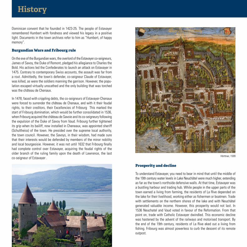
Dominican convent that he founded in 1423-25. The people of Estavayer remembered Humbert with fondness and viewed his legacy in a positive light. Documents in the town archives refer to him as “Humbert, of happy memory”.
Burgundian Wars and Fribourg rule
On the eve of the Burgundian wars, the overlord of the Estavayer co-seigneurs, James of Savoy, the Duke of Romont, pledged his allegiance to Charles the Bold. His actions led the Confederates to launch an attack on Estavayer in 1475. Contrary to contemporary Swiss accounts, the assault was far from a rout. Admittedly, the town’s defender, co-seigneur Claude of Estavayer, was killed, as were the soldiers manning the garrison. However, the popu-lation escaped virtually unscathed and the only building that was torched was the château de Chenaux.
In 1478, faced with crippling debts, the co-seigneurs of Estavayer-Chenaux were forced to surrender the château de Chenaux, and with it their feudal rights, to their creditors, their Excellencies of Fribourg This marked the start of Fribourg domination, which would be further consolidated in 1536, when Fribourg acquired the château de Savoie and its co-seigneury following the expulsion of the Duke of Savoy from Vaud. Fribourg further tightened its grip when its bailiff, now installed in Cheneaux, was appointed sheriff (Schultheiss) of the town. He presided over the supreme local authority, the town council. However, the Savoys, in their wisdom, had made sure that their interests would be defended by members of the minor nobility and local bourgeoisie. However, it was not until 1632 that Fribourg finally had complete control over Estavayer, acquiring the feudal rights of the older branch of the ruling family upon the death of Lawrence, the last co-seigneur of Estavayer .
Prosperity and decline
To understand Estavayer, you need to bear in mind that until the middle of the 19th century water levels in Lake Neuchâtel were much higher, extending as far as the town’s northside defensive walls. At that time, Estavayer was a bustling harbour and trading hub. While people in the upper parts of the town earned a living from farming, the residents of La Rive depended on the lake for their livelihood, working either as fishermen or boatmen. Trade with settlements on the northern shores of the lake and with Neuchâtel generated valuable income. However, this prosperity would not last. In 1536 Neuchatel and Vaud voted in favour of the Reformation. From that point on, trade with Catholic Estavayer dwindled. This economic decline was hastened by the advent of the railways and motorised transport. By the end of the 19th century, residents of La Rive eked out a living from fishing. Fribourg was almost powerless to curb the descent of its remote outpost.

1. The Banc des Halles
2. Collegiate Church of Saint Lawrence
3. Tithe house
4. Porte de Grandcour
5. Château de Chenaux
6. Motte-Châtel and Passage des Egralets
7. Maison des Sires
8. Place de Moudon and rifle houser
Historic sites and buildingsSelf-guided QR-code tour.16 panels near historic siteswith audio commentaries
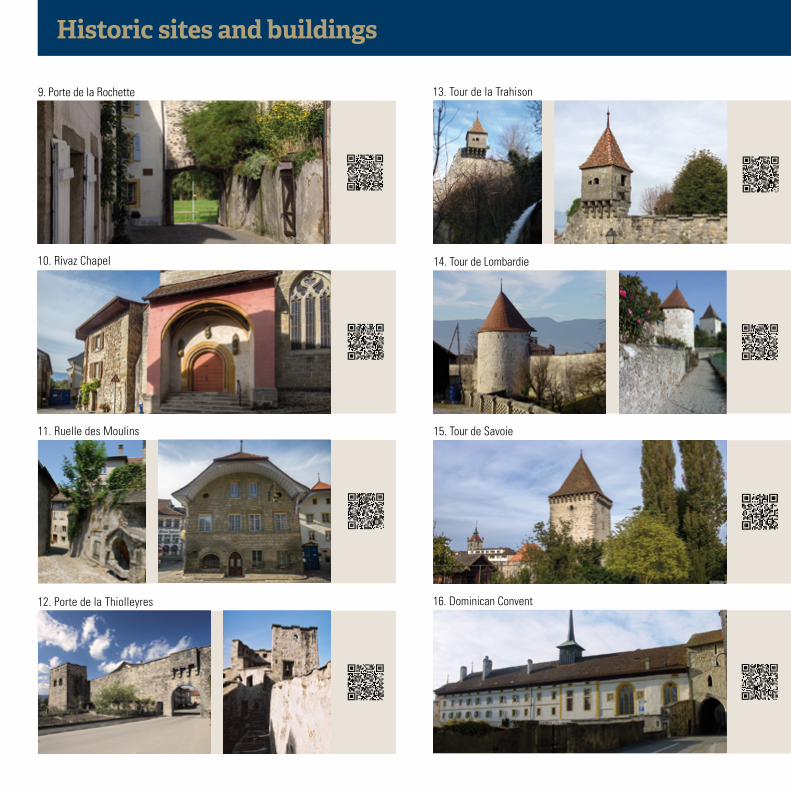
10. Rivaz Chapel
11. Ruelle des Moulins
12. Porte de la Thiolleyres
13. Tour de la Trahison
14. Tour de Lombardie
15. Tour de Savoie
16. Dominican Convent
9. Porte de la Rochette
Historic sites and buildings

Place deMoudon
Place del’Eglise
Grand -Rue
Grand-Rue
PlaceSt-Claude
Place deChenaux
Sentier
des Dominicaines
Pl. de la Chaussée
Rue du Musée
Rue de Forel
Placedes
Bastians
Rue de l’Hôtel de vil
le
Route du PortSentier des Lézards
Rue de la Thiolleyres
Rue de la Rochette
Rue du Camus
Placedu
Midi
Route du Port
Rue du Four
Rue des Granges
Rue de la Gare
1
2
3
4
5
6
7
8
14
15
16
9
1011
1213
Ruelle des Moulins
LesEgralets
1. Banc des mensonges
2. Collegiate Church of Saint Lawrence
3. Tithe house
4. Porte de Grandcour
5. Castle of Chenaux
6. Motte-Châtel and les Egralets
7. Maison des Sires
8. Place de Moudon and rifle houser
9. Porte de la Rochette
10. Rivaz Chapel
11. Ruelle des Moulins
12. Porte de la Thiolleyres
13. Tour de la Trahison
14. Tour de Lombardie
15. Tour de Savoie
16. Dominican convent
Historic sitesand monuments
CitytourSelf-guided QR-code tour.16 panels near historic siteswith audio commentaries

Publication details- Photo credits: O Rapin, S Chastellain, M Bourdilloud, DR, JC Juriens, L Chanez - Map: Swissgeo©Géomatics Ingénierie SA - Content: Daniel de Raemy (SBC-FR), Louis Joye, Lydie und Benoît Zimmermann- Bibliography: Aloys Lauper, Gilles Bourgarel, Anne-Catherine Page, Estavayer-le-Lac: le passé revisité, Pro Fribourg
no. 109, 1995; Henri Pillonel, Le Ruisseau des Moulins: les usiniers au fil de l’eau, Estavayer-le-Lac, 2000; Daniel de Raemy, Les Monuments d’Art et d’Histoire du canton de Fribourg, Volume VI: La ville d’Estavayer-le-Lac, pending; “Site of the Month”, ISOS, October 2002.
François Demotz, La Bourgogne, dernier des royaumes carolingiens, Lausanne, 2008 ; Germain Hausmann, «Payerne», Helvetia Sacra, T. 2, Basel, 1991 ; Jacques Villomet, 100 ans au service d’une cité, Payerne, 1991 ; Guide artistique de la Suisse, T. 4a, Berne, 2011 ainsi que les travaux et études en cours de Brigitte Pradervand.
Our region
Estavayer-le-Lac / Payerne Tourisme
Rue de l’Hôtel de Ville 16 1470 Estavayer-le-Lac T +41 (0)26 663 12 37
Place du Marché 10 1530 Payerne T +41 (0)26 660 61 61
F +41 (0)26 663 42 07 [email protected]
Grap
hic
desi
gn: A
nne
Mey
er, P
rinte
d in
Sw
itzer
land
, 201
4
Cudrefin
Portalban
Estavayer-le-Lac
Neuchâtel
Payerne
Berne
Moudon/Lausanne
Yverdon/Lausanne
Fribourg
Chevroux
Fribourg
Cheyres
La B
roye
Lac de MoratLac de Neuchâtel
FribourgEstavayer-le-Lac
Payerne
Lac de Bienne
St-Aubin
Avenches

PayerneConnecting earth and sky
www.estavayer-payerne.ch
Self-guided QR-code tourEnglish version

A hill in the heart of the plain
The first signs of civilisation on the hill at the heart of Payerne date back to the 3rd century AD. Away from the city of Aventicum, which was the capital of Roman Switzerland at the time, an influential family had a large villa built, which was to be a rich rural establishment. The town was later named Paterniacum after the Paterni family. At the end of the 6th century, Bishop Marius, maire saint and Bishop of Avenches, had a chapel built dedicated to the Virgin Mary. We don’t know the exact location of this early site of Christian worship that was consecrated on 24 June 587.
Cluniac site
In the 10th century, Payerne was an important royal estate of Upper Bur-gundy. This kingdom, one of the last of the Carolingian dynasty, originally stretched between the Jura and the Alps. From 888 to 1032 it was governed by the Rudolphian dynasty. The memory of the wife of Rudolph II of Burgundy, Bertha of Swabia, Queen consort of Burgundy, is still very much alive in Payerne’s consciousness. That said, we know very little about this woman who was probably the founder and benefactor of the monastery
History
Self-guided QR-code tour.16 panels near historic siteswith audio commentaries
Introduction to Payerne
The town of Payerne is situated at the entrance to the extensive flood plain of the River Broye in a rural wetland setting. The town centre is located on top of a hill formed by a former morainic mound, where the spires of the two medieval churches jut out above the skyline, pointing to the heavens. The large agricultural plain, which was recovered from marshland during the 19th and 20th centuries following corrective work on the River Broye, is also the site of Switzerland’s biggest military air base. In Payerne, agri-culture and aviation live side by side, leading the lines of communication to merge into an ongoing dialogue between the land and the skies.
QR-Codes
Throughout your visit, you can listen to audio commentary by scanning the QR codes featured on the information boards using your mobile phone.
You’ll find many free apps compatible with iPhone and Android systems on the internet which allow you to read QR codes. We hope you have an en-joyable visit !
Welcome
History
In the age of Reformation and revolution
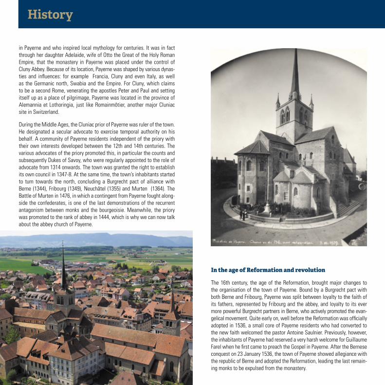
The 16th century, the age of the Reformation, brought major changes to the organisation of the town of Payerne. Bound by a Burgrecht pact with both Berne and Fribourg, Payerne was split between loyalty to the faith of its fathers, represented by Fribourg and the abbey, and loyalty to its ever more powerful Burgrecht partners in Berne, who actively promoted the evan-gelical movement. Quite early on, well before the Reformation was officially adopted in 1536, a small core of Payerne residents who had converted to the new faith welcomed the pastor Antoine Saulnier. Previously, however, the inhabitants of Payerne had reserved a very harsh welcome for Guillaume Farel when he first came to preach the Gospel in Payerne. After the Bernese conquest on 23 January 1536, the town of Payerne showed allegiance with the republic of Berne and adopted the Reformation, leading the last remain-ing monks to be expulsed from the monastery.
in Payerne and who inspired local mythology for centuries. It was in fact through her daughter Adelaide, wife of Otto the Great of the Holy Roman Empire, that the monastery in Payerne was placed under the control of Cluny Abbey. Because of its location, Payerne was shaped by various dynas-ties and influences: for example Francia, Cluny and even Italy, as well as the Germanic north, Swabia and the Empire. For Cluny, which claims to be a second Rome, venerating the apostles Peter and Paul and setting itself up as a place of pilgrimage, Payerne was located in the province of Alemannia et Lothoringia, just like Romainmôtier, another major Cluniac site in Switzerland.
During the Middle Ages, the Cluniac prior of Payerne was ruler of the town. He designated a secular advocate to exercise temporal authority on his behalf. A community of Payerne residents independent of the priory with their own interests developed between the 12th and 14th centuries. The various advocates of the priory promoted this, in particular the counts and subsequently Dukes of Savoy, who were regularly appointed to the role of advocate from 1314 onwards. The town was granted the right to establish its own council in 1347-8. At the same time, the town’s inhabitants started to turn towards the north, concluding a Burgrecht pact of alliance with Berne (1344), Fribourg (1349), Neuchâtel (1355) and Murten (1364). The Battle of Murten in 1476, in which a contingent from Payerne fought along-side the confederates, is one of the last demonstrations of the recurrent antagonism between monks and the bourgeoisie. Meanwhile, the priory was promoted to the rank of abbey in 1444, which is why we can now talk about the abbey church of Payerne.

History
Under the Bernese regime, Payerne became a place of political exception in the Vaud region. Thanks to its former Burgrecht link which united it with Berne, it was not the only bailiff from Berne who represented the authority of the governors of Berne in the town of Payerne, but an advocate elected from among the local bourgeoisie whose main function was chief of justice.
Towards the end of the 18th century, Payerne was swept along in the wave of revolutions. Not long after the Vaud Revolution, the town was designated capital of the new canton “Sarine et Broye”, which only lasted a few weeks. Payerne was then incorporated into the canton of Fribourg. In 1802, the inhabitants demanded to become part of the future canton of Vaud, which became independent in 1803.
The town, which is largely rural, saw developments in various areas throughout the 19th century. The major work on lowering the water level of the Jura significantly increased the farmable and habitable land on the banks of the Broye. Much of Payerne’s growth was thanks to the tobacco crops and the tobacco industry. The 400 employees working for Frossard produce various tobacco products, including the famous Vevey cigars.
The town is known well beyond its borders for its charcuterie and pork-based products, of which the famous Boutefas is a prime example. And the locals even proudly call themselves Caions rodzé, which means red pigs in the local dialect.
Development of aviation
On 28 September 1910, Payerne welcomed the first flight linking two Swiss towns. Ernest Failloubaz took off in his Blériot aircraft from Avenches, landing in Payerne nine minutes later, thereby paving the way for the development of aviation in the region. Today, Payerne’s military air base is one of the main air force centres of the Swiss military, with two barracks, a museum and a maintenance centre. Other civil industries linked to aviation and aerospace are also based nearby, such as the Solar Impulse solar-powered aircraft project and the S3 satellite launchers.
Pierre Willommet, 1737

Historic sites and buildings
1. Café du Marché
2. The Abbey Church
3. Castle courtyard, cloister courtyard
4. Bernese castle
5. Courthouse
6. Parish church
7. Banneret Fountain
8. Passage du Portail

Historic sites and buildings
10. Deer park
11. General Jomini statue
12. Barraud Tower, the defensive walls
13. Footbridge, the taming of the Broye
14. Vuary
15. Guillermaux road bridge, workers’ houses and Catholic church
16. Queen Bertha wine cellar
9. Rue des Blanchisseuses and porte de Berne

1. Café du Marché
2. The Abbey Church
3. Castle courtyard, cloister courtyard
4. Bernese castle
5. Courthouse
6. Parish church
7. Banneret Fountain
8. Passage du Portail
9. Rue des Blanchisseuses and porte de Berne
10. Deer park
11. General Jomini statue
12. Barraud Tower, the defensive walls
13. Footbridge, the taming of the Broye
14. Vuary
15. Guillermaux road bridge, workers’ houses and Catholic church
16. Cave de la reine Berthe
Grand-Rue
Placede la
ConcordeRue
de la
Gare
Place Général-Guisan
Av. Général Jomini
Av. de la Promenade
54
Parcaux biches
32
14
Rue de Lausann e
13
16
76
9
1011
Rue du Temple
1
12
15
8
Pl. duMarché
CitytourSelf-guided QR-code tour.16 panels near historic siteswith audio commentaries
Historic sitesand monuments

Publication details- Photo credits: O Rapin, S Chastellain, M Bourdilloud, DR, JC Juriens, L Chanez - Map: Swissgeo©Géomatics Ingénierie SA - Content: Daniel de Raemy (SBC-FR), Louis Joye, Lydie und Benoît Zimmermann- Bibliography: Aloys Lauper, Gilles Bourgarel, Anne-Catherine Page, Estavayer-le-Lac: le passé revisité, Pro Fribourg
no. 109, 1995; Henri Pillonel, Le Ruisseau des Moulins: les usiniers au fil de l’eau, Estavayer-le-Lac, 2000; Daniel de Raemy, Les Monuments d’Art et d’Histoire du canton de Fribourg, Volume VI: La ville d’Estavayer-le-Lac, pending; “Site of the Month”, ISOS, October 2002.
François Demotz, La Bourgogne, dernier des royaumes carolingiens, Lausanne, 2008 ; Germain Hausmann, «Payerne», Helvetia Sacra, T. 2, Basel, 1991 ; Jacques Villomet, 100 ans au service d’une cité, Payerne, 1991 ; Guide artistique de la Suisse, T. 4a, Berne, 2011 ainsi que les travaux et études en cours de Brigitte Pradervand.
Our region
Estavayer-le-Lac / Payerne Tourisme
Rue de l’Hôtel de Ville 16 1470 Estavayer-le-Lac T +41 (0)26 663 12 37
Place du Marché 10 1530 Payerne T +41 (0)26 660 61 61
F +41 (0)26 663 42 07 [email protected]
Grap
hic
desi
gn: A
nne
Mey
er, P
rinte
d in
Sw
itzer
land
, 201
4
Cudrefin
Portalban
Estavayer-le-Lac
Neuchâtel
Payerne
Berne
Moudon/Lausanne
Yverdon/Lausanne
Fribourg
Chevroux
Fribourg
Cheyres
La B
roye
Lac de MoratLac de Neuchâtel
FribourgEstavayer-le-Lac
Payerne
Lac de Bienne
St-Aubin
Avenches